Embed Size (px)
Citation preview

GEOL 190 - Modern Geologic/Geographic Mapping & Analysis Spring 2004 Guidelines for Projects
We believe that you will understand the surveying and GIS techniques we present in lectures more deeply if you use them to conduct independent research on a project of your own choosing. Still, it may seem daunting to learn new techniques and devise and conduct research using those techniques simultaneously. For this reason, we want to outline the character of the work we expect from you, provide some advice about the scope of your projects, and provide you with a clearer and more detailed timetable for work you submit to us. We have the following goals in having you undertake projects. First, such a project will induce you to gain more than a passing understanding of the surveying and GIS techniques we cover in class. Second, working on a project may provide you an opportunity to work with and understand in detail aspects of surveying and GIS that we covered quickly in class, to learn more about a particular technique that is important to work that you wish to undertake in your major or a field of interest (e.g. to apply these techniques in archeology, biology, land use planning, etc.), and to learn more about northern Ohio. Finally, we hope that you will use the presentation as an opportunity to improve your oral presentation skills and the paper as an opportunity to work on your skills in analytical reading and expository writing (the two cannot be separated). You may identify a person with whom you share interests and with whom you would be comfortable working throughout the semester, or you may chose to work individually. If you work with a partner, you will each be responsible for presenting 1/2 of each oral presentation and for submitting your own, independently written final paper. Below are the steps to be followed as you develop and carry out your project. The last page of this document has a copy of our grading rubric that outlines the criteria we will use to assess your projects. Research Question: Due March 19 With your partner or individually, we would like you to identify a question that you would like to answer. As we will outline in lectures, the techniques we cover in this class are well suited to address questions where (1) portraying and understanding the areal distribution of a parameter or characteristic provides significant insight to a phenomenon, (2) comparing the distribution of a parameter across a particular area at two different times provides insight to a phenomenon, or (3) devising a way to assess abstractly spatial distribution patterns in two different areas thereby enabling you to compare different areas provides insight to a phenomenon. You can focus on natural phenomena such as growth and succession of vegetation, erosion, faunal distributions, etc., or you can focus on social phenomena such as what factors appear to govern choice of housing locations, what are optimal locations for roads, what are the effects of differences in policy, etc. Your project will be easier to undertake and the final report you write will be easier to complete if you constrain as tightly as possible your topic, and generate a carefully-conceived question. Your research question and a paragraph of explanatory text (if necessary) should be typewritten and submitted to Laura by 4:30 pm on Friday March 19. Research Project Proposal: Due March 26 In your 1-2 page (double-spaced) research proposal, you will need to address several issues. First, state the research question in greater detail and provide the motivation for addressing this question, e.g., why is this particular question of importance or relevance? Second, describe the data sets that you will need to collect to address this problem and how you propose to gather these data sets. Third, describe the analyses you propose to carry out once the data has been collected, providing justification for the appropriateness of the analyses. It is also useful in a research proposal to provide a statement or two regarding your hypotheses or anticipated outcomes. We will provide you with feedback on your

proposals to assist you in refining your projects before you move forward into the data acquisition and analysis stages. Final Presentation and Report: Due May 12, May 14 (Draft Report) and May 20 (Final Report) Finally we ask that you prepare a final presentation (or if appropriate a joint final presentation) and an individual written report on your project. To provide you with the opportunity for direct feedback and to improve your final product, a draft of your final paper is due on Friday May 14th (the last day of classes). Reports should be typed (or printed), and should include an abstract, body, and reference list. The abstract should be about 250 words long, and should (i) introduce the paper's primary question or focus (without writing, "This paper will consider..."), (ii) outline your approach to the question, and (iii) present the conclusions you reached. The body of the paper should be 10 or fewer typewritten (double-spaced) pages. Separate sections labeled "introduction" and "conclusion" may help you to direct readers (i.e. us) to the salient points in the body of the paper. Well-written pieces introduce the question they intend to address and enumerate one or more conclusions at end of the paper. List references in a reference list in alphabetical order. Provide citations for all ideas and figures that are not your own. Feel free to consult with us for information on how to do so. On a technical note, please avoid footnotes. In many journals, citations take one of the following forms:
Snyder (1987, p. 157 ) stated that the U.S. Geological Survey use azimuthal stereographic projections to construct base maps for nearly all their maps of Antarctica.
or The U.S. Geological Survey uses azimuthal projections as base maps for all their maps of Antarctica (Snyder, 1987, p. 157).
The complete citation for Snyder's book or article should then appear in the reference list. Concerning the format of citations in the reference list, we have no preference. Please choose one format and use it for all references, however. This will help assure that you include complete citations. If you cite a textbook or monograph, please include in the citation the page numbers where the author discusses ideas that you cite (as we did above in citing Snyder's book Map Projections - A Working Manual). We learn things from papers that students submit, and often wish to follow up the ideas that students raise in their papers. Likewise, we hope to collect a library of data and research questions regarding the Old Woman Creek area for other students. Complete citations make it easier for us or for other students to follow the reasoning that you followed. A few suggestions on grammar: 1. Avoid passive-voiced sentence constructions like, "the map was completed by Van der Grinten (1904)...," or "these differences were analyzed to show ..." Writing is not any less objective if you say that you did something rather than saying that it "was done." Let the sentence's subject be the active agent. 2. Even though the insidious and all-pervasive they say that it is okay to split infinitives, we think it preferable not to split them. 3. Check your spelling and remember that a spell checker will not catch all errors. Use a dictionary if you must.

Geology 190 – Modern Geologic/Geographic Mapping and Analysis Final Project Evaluation Form - Spring 2004
Extra Credit (5 points)
____ Additional library session with Science librarian (5 pts.)
Rough Draft of Paper (20 points)
____ Draft is generally well organized (5 pts.) ____ Draft outlines problem effectively (5 pts.) ____ Draft describes data utilized, analytical approaches followed, & points toward conclusions (5 pts.) ____ References sufficient in number and content (5 pts.)
Oral Presentation of Project (30 points)
____ Presenters are professional & understand the material (5 pts.) ____ Both participants contribute materially to the presentation (5 pts.) ____ Presentation is organized, on topic, & reaches a conclusion or has a “take home message” (5 pts.) ____ Presentation has effective graphics & maps (5 pts.) ____ Presentation completed within time limits (12 minutes + 3-5 minutes for questions) (5 pts.)
Final Paper (50 points)
____ Introduction accurately reflects content, succinctly tells reader the problem to be considered, the methodology to be used, & compels the reader to continue on (6 pts.)
____ Main text is well written without errors in punctuation, spelling, or grammar (8 pts.) ____ Main text is well organized into appropriate sections & is concise (8 pts.) ____ Material is covered in sufficient depth to give the reader a full picture (8 pts.) ____ Figures are clear, with appropriate labels and captions (8 pts.) ____ Conclusion section is succinct & gives an accurate summary of arguments; could stand-alone (6
pts.) ____ References are properly cited with author name & date throughout text & in the reference section
(6 pts.)
Additional Comments:

Society for Creative Oceanographic Studies Request for Proposals (RFP)
Oceanography: The College of Wooster Lori Bettison-Varga
Society for Creative Oceanographic Studies (SCOS) will consider new proposals in Spring 2004 as part of the Oceanography course. The SCOS is a fictitious organization supporting creative oceanographic research and educational programming. The Society accepts proposals as a requirement for Geology 103 (oceanography) to encourage individual research by students, and to foster proposal writing experience for undergraduates. Furthermore, the Society encourages all investigators to discuss their proposal ideas with the Program Officer, Lori Bettison-Varga through e-mail or by individual appointment. All proposals with topics related to oceanography will be accepted, with a $50,000 maximum budget. Proposals must meet the following requirements: 1) Cover page: The first page of the proposal should include the following information - a. Title of proposal b. Student ID number c. Budget amount requested d. Time period of proposed work 2) Project Summary (page 2 of proposal). This summary should not exceed 300 words and the title of your proposal should be at the top of this page. 3) Sections: Make sure that the pages are numbered. Font: Times, 12 pt. Font (nothing larger or smaller will be accepted); 1” margins (top, bottom, right and left!).
I. Purpose of Study/Mission Statement (2-3 pages), II. Description of Research design (5-6 pages), III. References Cited, IV. Figures and Figure captions may be added and are not counted within page ranges
noted above, V. Budget (1 page maximum; use budget page provided), VI. Budget Justification (1 page maximum).
4) Proposals will be submitted electronically via blackboard, with one hardcopy delivered to LBV. 5) Schedule for proposal submissions:
February 20th: Proposal title and a one paragraph description of your idea is due in class.
March 5th: Proposal outline and reference list due in class. April 9th: Proposal due in drop box by 5 p.m. Bring hard copy to LBV’s office.
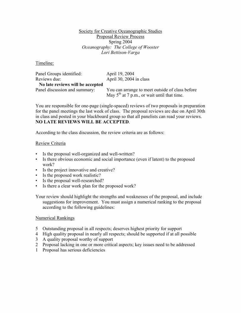
Society for Creative Oceanographic Studies Proposal Review Process
Spring 2004 Oceanography: The College of Wooster
Lori Bettison-Varga
Timeline: Panel Groups identified: April 19, 2004 Reviews due: April 30, 2004 in class No late reviews will be accepted Panel discussion and summary: You can arrange to meet outside of class before May 5th at 7 p.m., or wait until that time. You are responsible for one-page (single-spaced) reviews of two proposals in preparation for the panel meetings the last week of class. The proposal reviews are due on April 30th in class and posted in your blackboard group so that all panelists can read your reviews. NO LATE REVIEWS WILL BE ACCEPTED. According to the class discussion, the review criteria are as follows: Review Criteria • Is the proposal well-organized and well-written? • Is there obvious economic and social importance (even if latent) to the proposed
work? • Is the project innovative and creative? • Is the proposed work realistic? • Is the proposal well-researched? • Is there a clear work plan for the proposed work? Your review should highlight the strengths and weaknesses of the proposal, and include
suggestions for improvement. You must assign a numerical ranking to the proposal according to the following guidelines:
Numerical Rankings 5 Outstanding proposal in all respects; deserves highest priority for support 4 High quality proposal in nearly all respects; should be supported if at all possible 3 A quality proposal worthy of support 2 Proposal lacking in one or more critical aspects; key issues need to be addressed 1 Proposal has serious deficiencies

Special Notes Arrange each review so that the title of the proposal is centered at the top. Your name should be at the upper right-hand corner. The numerical ranking should be on a separate line at the end of the review. Panel Summary Panelists will meet and discuss proposals. It is important that all proposals be read by all panelists, even though each panelist is responsible for only two formal reviews. Your panel summary should address EACH proposal, with a summary of panelist comments about the proposal and an overall recommendation to the Society for Creative Oceanographic Studies: fund – top priority, fund – if money is available, do NOT fund.

Taconic Orogeny Prior to the tutorial: Everyone reads the required reading and the revised paper. "A" writes a five page paper based on the required readings, "B" critiques the paper, "A" revises the paper and puts a copy on "collaboration\geology\Courses\geo343s04\projects" by noon the day before the tutorial, and "C" prepares a list of questions based on the required reading and on "A"'s paper. At the tutorial "A" will begin by reading his/her paper, then "C" will initiate discussion. Required reading (Available on-line): Karabinos, Paul, Samson, Scott D.; Hepburn, J. Christopher; and Stoll, Heather M., 1998.
Taconian Orogeny in the New England Appalachians; collision between Laurentia and the Shelburne Falls Arc, Geology Boulder, March 1998, Vol. 26, Issue 3, pp.215-218.
Ratcliffe, Nicholas;Hames, Willis E.; Stanley, Rolfe S.; Karabinos, Paul; Samson, Scott D.; Hepburn, J. Christopher; and Stoll, Heather M., 1999. Taconian Orogeny in the New England Appalachians; collision between Laurentia and the Shelburne Falls Arc; discussion and reply, Geology Boulder, Vol. 27, Issue 4, pp.381-382.
Ratcliffe, Nicholas M.; Hames, Willis E.; and Stanley, Rolfe S., 1998. Interpretation of ages of arc magmatism, metamorphism, and collisional tectonics in the Taconian Orogen of western New England, American Journal of Science, Vol. 298, Issue 9, pp.791-797.
Further reading:(On course reserve in Hatch Library) Drake, A.A., Jr., Sinha, A.K., Laird, J., and Guy, R.E., 1989. The Taconic Orogen. In Hatcher, R.
D., Jr., Thomas, W. A., and Viele, G. W., eds., The Appalachian Ouachita Orogen in the United States. Boulder, Colorado: Geological Society of America, F-2: 101-177.
Rachel Beane, Bowdoin College This is an example of a weekly assignment in a tutorial-format class that was divided into groups of three students (A, B, and C) whose weekly ‘duties’ rotated.

Final Paper This course has focused on the geology and tectonics of Appalachians. For this final paper, you will take one (or more) of the papers that you have written previously for this course, and revise and expand it. The final paper should be approximately 8-10 pages, with all text double-spaced, 2.5cm margins all around, and a 12-point type-size. The paper needs to incorporate one reference to an article not previously required in this course. For the paper, please do not simply summarize the articles. Instead, consider interpreting one article in light of another, comparing two regions, integrating your knowledge of a subject, or developing an argument. Your paper should add to our understanding of the Appalachians. Option: If you wish, then you may elect to write on a subject, related to the Appalachian orogeny, but not covered in this course. This option is instead of revising and expanding a paper that you have previously written. If you elect this option, then please talk with me about your topic. As you write this final paper, please let me know how I may help you in the development of ideas or in the search for references for your paper. Please place a copy of your final paper on "collaboration\geology\Courses\geo343s04\projects" by noon the day before the tutorial. You should be prepared to read and discuss your paper during our tutorial. Your paper should include: Title: A few connected words that tell something about the paper. Introduction: Two - three paragraphs that capture your readers' attentions, and that orient them as to the subject and purpose of the paper. The introduction may highlight the basic geography and geology of the Appalachians, in order to place the rest of the paper in context. Body: Several paragraphs that are informative and that have a clear flow. Conclusion: One or two paragraphs that bring your paper to a close. References: A listing of the sources you have used to write the paper. Use the format as listed in your previous assignments. Take care to avoid plagiarizing the resources you use. Be sure to give the authors of the resources credit when you use their ideas or information, and if you borrow their exact words, then place those words in quotation. If you use ideas or quotes from classmates' papers, then be certain to reference those. For the references cited in the text, you should use parenthetical documentation in the form of (author, year). For example: The geologic history of the Appalachians provides a good example of a Wilson cycle (Hatcher, 1989). Or Hatcher (1989) states "Eastward the foreland fold and thrust belt consists of a belt of Alleghanian imbricate thrusts and folds." If you have questions regarding what constitutes plagiarism, then you might refer to the Sources web page. If you have further questions, then please ask.
Rachel Beane, Bowdoin College Final assignment for a tutorial-based course that emphasizes the reading and analysis of scientific articles.

Writing has been an emphasis of this course. For this final paper, I ask that you continue to focus on improving your writing. Before submitting your paper, please consider the following: Is the thesis precise and clear? Can you state the thesis? Does the thesis govern the paper? Analyze the internal organization. Does each paragraph establish and pursue a discrete topic? Does one paragraph lead to the next? Do thoughts follow from a topic sentence within each paragraph? Do sentences follow each other within the paragraph? Are transitions between thoughts/paragraphs/sections adequate? Are parts repetitious or unfocused? Examine the uses of evidence. How compelling is the evidence that you use? How strong is the evidence that the author presents? Have you fully cited all sources you have referenced. Check for grammatical, spelling, and punctuation errors I encourage you to peer-review each other's papers, considering the questions above, before you turn in your paper to me. I also encourage you to visit the Writing Project which offers drop-in writing conferences in evening workshops. Finally, as we have done during tutorial, I suggest that you read your paper out loud to ensure that what you want to communicate is communicated. The grading scheme I will use for this assignment is one that I have adapted from Robert Bain's essay "Reading Student Papers." Assuming a paper follows the assignment, then it will be graded as follows: A
Clear thesis that governs paper Strong interpretations Rich content, excellent detail, strong use of evidence Careful organization and development of ideas Clear, interesting and connected introduction and conclusion Artful transitions Memorable - leaves the reader satisfied and eager to reread the paper
B Clear thesis Substantial interpretations Substantial information Specific ideas logically ordered and developed around a clear organizing principle Interesting and connected introduction and conclusion Transitions are mostly smooth Pleasurable reading with few distractions
C Stated thesis Insubstantial interpretations Competent but thin information with vague generalities Adequate organization and development Perfunctory introduction and conclusion Bumpy transitions Few grammatical, spelling, and punctuation errors
D Lacks thesis Rudimentary treatment and development of subject Unclear and ineffective organization Overall impression of haste - not a revised piece of writing
F Superficial treatment of subject Lacks organization Below the acceptable level of college writing

Regional trends in the petrology and hydrothermal alteration in the Proterozoic iron deposits of the Mid-Atlantic iron belt
Kurt Friehauf – Kutztown University of Pennsylvania – July 2005
Introduction The Proterozoic igneous and metamorphic rocks of the Reading Prong belt host many small magnetite iron mines that fed the early American iron furnaces of the 1700’s and 1800’s. Mining in most of these districts ceased after World War II, so underground exposures are flooded and only small pits and partially reclaimed mine dumps remain. One of my research projects involves a regional comparison of the petrologic characteristics of the host rocks, hydrothermal alteration, and ore mineralogy of these deposits.
Individual mines in this belt are ideal for student projects in mineralogy and petrology classes because the sites are small, petrologically relatively simple, and within a few hours drive of the university. Each class studies one mine. To date, we’ve studied the Rittenhouse Gap mine (Pennsylvania), Richard-Teabo/Dover mine (New Jersey), and Lyon Mountain mine (New York) in 2000, 2002, and 2004, respectively.
Figure 1. Major iron oxide deposits of the Mid-Atlantic region.
Procedure
1.
2.
3.
4.
Class fieldtrip to mine site where students break up into groups of four and must devise rock classification scheme – students collect samples of each rock type for lab study
Students cut and describe rocks in slab and thin section
Students report results in mid-study as progress report formatted like typical mineral industry report
Different groups compare classification schemes

Optical Mineralogy Friehauf – Spring 2002
Lab # 4 Richard-Teabo mine fieldtrip
Name: Key
Dover Iron Mining District Fieldtrip – Classifying Rocks Introduction The purpose of this fieldtrip is to get you thinking about real-world rocks – not just ordinary GEL100 rocks, but rocks that have been altered by metamorphism and hydrothermal activity. So far in this class you’ve learned your way around a petrographic microscope – a handy tool for seeing far, far into a rock. You’ll ultimately need those microscopes to document the mineralogy and mineral intergrowths of these rocks. On this fieldtrip to the Dover mining district (Figure 1), you will survey the mine area, put together a rock classification scheme in the field, sample each of the rock types and each important variant in your scheme, and then study the samples in detail in the lab. Assignment Working in groups of 3-4 students, study the rand Teabo mines – part of the Mount Hope groudistrict. Use the map of the district provided sample locations. Break open a lot of rocks, sturocks using your hand lens, and create a classifdifferent rock types present. As with GEL100variation between rocks of a given designation. your rock types and the important variants. Yomonths, describe them using binocular microscosections for study using petrographic microsco
In designing your classification scheme, think afrom one another in GEL100 – mineralogy (minemineral associations), textural differences (grashape, foliation, lineation, etc.), and other, less
Warning: You will only be at this location on
Figure 1. Driving directions to Mount HopeHistorical Park, New Jersey http://parks.morris.nj.us/parks/directions/mhdir.htm
ocks in the mine dumps of the Richard p of mines in the Dover mining to record your observations and dy the mineralogy and textures of the ication scheme for naming the rocks, there will likely be some Carefully collect samples of each of u will cut these samples in the coming pes, and then cut your own thin
pes.
bout how you’ve distinguished rocks rals present, relative abundances, in size, grain size distribution, grain conventional characteristics.
ce so make the most of your time!

Assignment for the Field Trip to the Ordovician of Indiana
Mark Wilson, The College of Wooster
April 7, 2002 Geology 250: Invertebrate Paleontology
We will be leaving Scovel Hall at 6:00 a.m. to explore the sediments and rocks in the wonderful Cincinnati Group in southeastern Indiana. We are collecting from three localities within the Richmondian stage (Upper Ordovician) at the top of the Cincinnatian where the fossils are extraordinarily abundant and diverse. There is no better place in the world to see Ordovician marine life. Your job will be relatively straightforward: collect representative fossils from each of the three sections (keeping them separate!), prepare and identify these back in the Wooster lab, and then write a report describing the taxa found and their relative abundances, and then comparing the paleoecosystems represented by the three units. This field studies report will be due on the last day of classes (May 2nd) at 8:00 a.m. We will talk in the next few labs about preparing and identifying your fossils and structuring this report. Enjoy the trip. The fossils you collect are yours to keep, although if you find something of considerable scientific significance I’m sure you’ll do the right thing!
1

GEOLOGY 250 Invertebrate Paleontology
Field Studies Report Instructions (Reports are due May 2, 2002, at 8:00 a.m.) Mark Wilson, The College of Wooster
You have large collections of beautiful fossils from our field trip earlier this month, and you have nearly completed your identifications. Now it is time to construct your final report. Please divide your report into the following sections --
Introduction.--Tell the reader where you went, when you went and what you did. This shouldn’t be too hard since the information you need is in the field guide I gave you. This introduction is not to be more than a paragraph. Stratigraphy.--Briefly describe the rock units you collected from. I don’t expect much more here than what you find in the field guide and the Davis book. Systematic paleontology.--List here your identifications in the systematic fashion which characterizes all paleontological work. For example, if you identify the trepostome bryozoans Dekayia gracilis and Parvohallopora in your samples, list them as follows (with the localities):
Phylum BRYOZOA Class Stenolaemata Order Trepostomata
Parvohallopora (Stop #1)
Dekayia gracilis (Stops #1 and #3)
The only higher taxonomic levels you need to use are those in the yellow lab sheets. Try to identify most specimens to at least the genus level, but this will be impossible for some (especially bryozoans). For fossils you collected which are not represented in the lab, use the taxonomic levels from the Treatise. Don’t forget trace fossils.
Taphonomy.--Provide an assessment of the preservation of the fossils you collected from each locality. Are the shells broken or whole? Are there any signs of predation or biological erosion (borings)? Do the fossils appear to have been transported after death or are they preserved in place? Are some taxonomic groups preserved better than others? Why? Here you are telling the reader what may have happened between the living community and the fossil assemblage. Contrast the three collections.
Paleoecology.--Now the fun part. Interpret your fossil assemblages as reflections of the original living communities. What were the most common organisms? What were the most common feeding modes? What were the relationships between the organisms? What sort of substrate was present for each community? What sort of environment do you hypothesize for each community? I’m not looking for an I.S. thesis, so keep your discussions simple and short. It is important to cite evidence for your conclusions. If you go beyond the evidence to develop an idea, say so. Be sure to compare and contrast the three assemblages.
Turn your report in to me at the beginning of class on May 2nd. Have all the specimens you wish to be part of this project in your drawer with all the appropriate labels. I will then read your reports and match them with your specimens.
The paper will be graded according to the criteria on the reverse sheet. This summary will be completed by me and stapled to your papers when they are returned.

Invertebrate Paleontology
Field Studies Report Summary Sheet Spring 2002
NAME:______________________________
I. Organization of report (20%): Headings clear and appropriate: Introductory materials adequate: Logical flow within and between sections: II. Content of report (65%): Systematics are clear: Specimens adequately labeled: Accuracy of identifications: Breadth of material assessed: Evidence behind interpretations is clear: Creativity and innovation: III. Other (15%): Typographical errors: Spelling: Grammar:
FINAL GRADE: _______%

Peaks Island Project All of us participated in the field research for our class project on the geology of Peaks Island. In the week after our weekend field trip, we compiled our field data, annotated photos, and prepared rock samples. For the next three weeks, we will divide into groups to address different aspects of the project during our laboratories. Then, during the last week of the semester we will present our research through a short paper (abstract) and a presentation. Details of the abstract and presentation assignments are on the next two pages. Below are brief descriptions of the laboratory projects that focus on different aspects of the geology of Peaks Island. We’ll teach you the laboratory techniques that you need to complete the projects. By Monday November 8, I ask that you email your top three laboratory project choices to me ([email protected]).
Laboratory projects Geochemistry What can we interpret about the type of volcano and the composition of magma that formed the Cushing Formation as observed on Peaks Island? This group will plot geochemical data for five samples using the program Igpet, examine corresponding thin sections (microscope slides) for these samples, and compare the results with data from modern volcanoes. Cushing rocks What do the minerals and textures of the rocks tell us about the igneous Cushing Formation? We’ve made over 20 thin sections (microcope slides) of rock samples we took on Peaks Island. Each person who chooses this project will individually examine 1-2 thin sections using the petrographic and scanning electron microscopes. Then, we will combine this information to describe the range of rocks exposed on Peaks Island. Pyroclasts What might the length and width data from the pyroclasts tell us about deformation in the area? What are the compositions of the pyroclasts, and how do they compare with the matrix composition or compositions of non-pyroclastic volcanics on Peaks Island? This group will do a strain analysis of the clasts, and examine thin sections of the clasts using the petrographic and scanning electron microscopes. Dike What is the mineral and geochemical composition of the dike on Peaks Island? And, how does it compare to other local dikes? This group will examine the thin section of the dike sample using the petrographic and scanning electron microscopes, and will plot the geochemical data for the dike in relation to other dikes analyzed by previous Geo101 classes. GIS The field and laboratory data collected for this project need to be organized using a Geographic Information System (GIS). Those who choose this project will work with Joanne outside the normally scheduled lab (instead of coming to the scheduled labs) to use GIS to place the observed geologic contacts and sample localities on a digital map and create links for photos and other data.
Rachel Beane, Bowdoin College, 2004

Webpage Photos taken in the field will be annotated and incorporated into a web page that includes a map of the area. This project is ideal for someone who was in Scott’s or John’s groups. The accompanying write-up will focus on the field relations and variety of rocks found on the Peaks Island. Blue quartz What does the blue quartz found with the pyroclasts signify? This group will do a literature search for references and interpretations of blue quartz. They also will examine the blue quartz collected using the petrographic and scanning electron microscopes.
Peaks Island Abstract due Tuesday, December 7 Each of you will need to write a 500 word abstract of your project. This part of the project is your own individual work; it is not to be done in collaboration with others. It is due on December 7, the same day that you give your presentation. An abstract is a concise summary of research that precedes an article in a journal or that is placed in a volume distributed at a conference. Generally the abstract is designed to stand alone without referring to the paper or presentation. A well-prepared abstract will summarize the important points clearly, and help the reader decide whether to read the accompanying paper or attend the presentation. Concise writing is imperative: abstracts submitted to geology journals and conferences generally have word limits between 200 and 500 words. You are writing an extended abstract with a limit of 500 words. The extended abstract also should include one key figure or table and a references cited section. Your abstract should state the main objectives of the research and explain why it is important, describe the methods used, and summarize the results and conclusion. You should put as much specific information into your abstract as possible, including locations, mineral and rock names, significant chemistry, important texture and size information, and so forth. Examples of abstracts will be available in Druckenmiller 216.
Rachel Beane, Bowdoin College, 2004

Peaks Island Project - Power Point due December 2 - Group Presentation due December 7 After completing your research, it is time to share the findings with the other students in the class through a presentation. Effective presentations promote the exchange of ideas and information between many people, and they are a primary means by which geologists share their research at scientific meetings. For this presentation, each group will prepare a six minute Microsoft Power Point presentation. This should allow all groups to give their presentations on December 7, with a few minutes allowed for questions in between the presentation. Each group will be allowed 6 Power Point slides. Your presentation will be due December 2. You should put your final presentation on the Collaboration Server in folder Geology\Courses\geo101f04\drop_box. Choose your slides carefully to share all aspects of your research (for example field, petrographic, SEM, or geochemistry), as well as your conclusions and any insights your have made. Assuming a presentation follows the assignment, then it will be graded primarily as follows: A Strong research Conclusions are insightful and follow clearly from data Careful organization Photos, graphs, or illustrations in the slides substantiate the oral presentation Clear and artful presentation of information and ideas
B Substantial research Conclusions follow clearly from data Logical flow of information Slides support presentation Clear presentation of information and ideas
C Competent research Conclusions follow from data Adequate organization Slides relate to presentation Perfunctory presentation
D Rudimentary research Unclear how conclusions follow from data Unclear or ineffective organization Uncertain relation of slides to presentation Overall impression of haste
F Superficial research Lacks conclusions or conclusions don’t follow from data Lacks organization Slides absent or irrelevant Below the acceptable level of college work
Rachel Beane, Bowdoin College, 2004