Embed Size (px)
Citation preview
Guidelines for the scoping and environmental assessment of water resources projects
The environment and water resources projects Volume 1
October 1996 Version 1 Working document for region
CONTENTS
Page
1.0 INTRODUCTION 1
1.1 Definition of Scoping 1 1.2 The Role of the Agency and the Legal Background 1 1.3 Legal References 2 1.4 The Habitats Directive - 2 1.5 The Consultation Process 3
2.0 STRUCTURE OF SCOPING DOCUMENT 4
2.1 Executive Summary 4 2.2 Introduction 4
2.2.1 Purpose of Report 4 2.2.2 Future Planning 4 2.2.3. Need Analysis , 4 2.2.4 Legal Context 4
2.3 Identification of the Impacts of Activities 4 2.4 Mitigation measures 5 2.5 Draft Environmental Statement Headings 5 2.6 List of Consultees 5
3.0 STRUCTURE OF ENVIRONMENTAL STATEMENT 6
6 6 6 6 6 6 7 7 7 7 7
4.0 ENVIRONMENTAL ACTION PLAN 8
5.0 ENVIRONMENT AGENCY RESPONSE 9
Guidelines for the scoping and environmental assessment of water resources projects
3.1 3.2
Non Technical Summary The Environmental Statement 3.2.1 Introduction 3.2.2 Description of the Scheme 3.2.3 Development of Location 3.2.4 Identification and Evaluation of Impacts 3.2.5 Risks of Accidents and Hazardous Development 3.2.6 Mitigating Measures 3.2.7 Enhancement Opportunities 3.2.8 Monitoring 3.2.9 Appendices
The environment and water resources projects Volume 1 October 1996
APPENDIX 1
APPENDIX 2
APPENDIX 3
APPENDIX 4
GLOSSARY
Impact and Data. Considerations for Water Resources Developments
Potential Sources of Information and Investigations Required for Data Consideration
Proforma A: Impacts and Data Requirements
Relevant Legislation
10
24
29
30
31
Guidelines for the scoping and environmental assessment of water resources projects
The environment and water resources projects Volume 1 October 1996
1.0 INTRODUCTION
The following brief is to ensure standard criteria and format are used for the scoping and environmental assessment of water resources projects leading to the production of an environmental report or Environmental Statement. This volume is one of a series giving guidance on water resources projects.
The water resources projects will predominantly comprise drought orders and permits, time limited and permanent licences. Smaller projects, such as spray irrigation licences, will not require an environmental assessment. This document forms the basis for discussions between the Environment Agency North East Region, consultees and the applicant. The process aims to produce a thorough assessment.
Each section addresses consecutive elements of the assessment process. Section 2 outlines the structure for a scoping document, section 3 outlines the structure for an Environmental Statement and section 4 gives guidance on the role of an Environmental Action Plan.
Appendices 1 and 2 should be used in conjunction with the scoping process and cover a wide range of aspects. However, some projects may not require all of them to be included, whilst for others, the inclusion of additional factors may be appropriate.
Once scoping is completed, and if the need for an Environment Assessment is confirmed, part three of the brief should be used as the template for the Environmental Statement. Where a non-statutory assessment is undertaken, best practice dictates that section 3 should be followed as far as is practicable to produce an environmental report.
1.1 Definitions and Terminology
Environmental assessment is a process designed to identify and evaluate all potential impacts of proposals, and their mitigation and enhancement through appropriate site selection, design and working practice.
Formal Environmental Assessment is required by law for certain types of project which by virtue of their nature size or location are likely to give rise to significant impacts. A list of these projects and guidance on special procedures required has been issued by the DoE (1989). Formal Environmental Assessment is required for major projects and can only be requested for projects specified by the Environmental Assessment Regulations.
Environmental Report is the outcome from a non-statutory environmental assessment, this should ideally follow the outline for an Environmental Statement. The size of the project will determine the depth and coverage of the environmental report.
Guidelines for the scoping and environmental assessment of water resources projects
The environment and water resources projects Volume 1 October 1996
1

Environmental Statement is the document produced at the completion of the Formal Environmental Assessment.
Scoping is a crucial part of the environmental assessment process which helps to identify key issues of concern at an early stage, primarily through consultation with interested parties and ensures that they are subject to assessment at an appropriate level.
1.2 Legal Context
1.2.1 The Role of the Agency and the supporting legislation
The Environment Agency has advisory, operational and regulatory roles in environmental assessment. This means it can be a consultee for some projects, a developer for others as well as having powers to issue or refuse consents and licences for certain activities. In the context of this document the Environment Agency is only involved in the consenting, licensing and consultation process.
As a licensing body the Environment Agency is in a position to request reasonable information from an applicant prior to considering an application for abstraction. In addition the Environment Agency has a duty, with regard to its functions other than pollution control, to further the conservation and enhancement of flora, fauna, geological and physiographical features. This provides a route to obtaining information for projects which are not covered by the environmental assessment regulations, yet may still have a potentially detrimental effect upon the environment. In this respect the Environment Agency is acting as a competent authority and may require some form of informal environmental assessment from a developer. Section 37 (1) of the Environment Act states the Agency "may do anything which in its opinion is calculated to facilitate or is conducive or incidental to the carrying out of its functions".
Under EC directive 85/337 developers are required to carry out formal Environmental Assessment for projects likely to have a significant impact upon the environment. The Town and Country Planning (Assessment of Environmental Effects) Regulations 1988 No 1199 (SI 1199) implements this directive and requires a formal Environmental Assessment if planning permission is to be granted. Permitted development and activities which do not require planning permission are exempt from SI 1199 but may be covered by other sets of regulations with similar requirements.
The Environment Agency is a statutory consultee for certain types of development and consulted voluntarily or through agreement on a wider range of issues.
Many projects are not covered by the legislation outlined above. In such cases the Environment Agency asks applicants to ensure good practice by following the environmental assessment process to evaluate the potential impacts of the proposed
Guidelines for the scoping and environmental assessment of water resources projects
The environment and water resources projects Volume I October 1996
2
project.
1.2.2 The Habitats Directive
If the scoping and development of the environmental assessment is for a project (Drought Order or Drought Permit) in relation to a European site as defined by the Habitats Directive then the environmental assessment must provide sufficient information for the Environment Agency to assess:
(1) Whether the water resource project is likely to have a significant impact on the site.
(2) Whether there are implications for the site conservation objectives (i.e. the reasons for which the site was designated or classified).
(3) Whether it adversely effects the integrity of the site. The integrity of the site is the coherence of its ecological structure and function, across its whole area, that enables it to sustain the habitat, complex of habitat and/or the levels of populations of species for which it was classified.
The scope and content of the environmental assessment will depend on the location, size and significance of the proposed project.
1.2.3 Legal References
Legislation relevant to the scoping and environmental assessment of water resources projects is listed, together with references in Appendix 4.
1.3 The Consultation Process
Consultation is a two way process which lies at the heart of effective environmental assessment. Discussions with consultees should continue as the developer gathers information on issues, assesses that information, draws conclusions and produces a report. It is essential for key consultees to be involved repeatedly as the study develops, assisting the applicant or their agent in identifying impacts, assessing their significance and future requirements. This should be an open relationship resulting in a robust statement that is more likely to be supported by consultees.
Guidelines for the scoping and environmental assessment of water resources projects
The environment and water resources projects Volume 1 October 1996 3

2.0 STRUCTURE OF SCOPING DOCUMENT
2.1 Executive Summary
This will cover the key issues and should use non-technical language. A range of options should be considered including the'do nothing'option. /
2.2 Introduction
2.2.1 Purpose of report
This will state why the report has been produced and give the general background.
2.2.2 Future planning
This will put environmental assessment and scoping in the wider context of long term plans and processes.
2.2.3 Need analysis
This will outline the requirement for the scheme and alternatives (including do nothing) to solve the problem.
2.2.4 Legal context
The developer should include reference to the relevant legislation.
2.3 Identification of the Impacts of Activities
The main body of the report will deal with the identification of the impacts of various activities. Appendices 1,2 and 3 provide a framework to achieve this objective.
The following sequence can be used to arrive at the set of potential impacts which may arise from specific actions associated with developments.
development-^context-^primary change-impact consideration
where,
development denotes the nature of the action e.g abstraction
context is the situation of the development which defines the particular impact, e.g river
Guidelines for the scoping and environmental assessment of water resources projects
t he environment and water resources projects Volume 1
4 October 1996

primary change is the direct change or disturbance caused to the environment arising from the development and context e.g downstream water quality
impact consideration is the foreseeable potential consequence to, or reaction of, any aspect of the environment arising from the primary change, e.g instream ecology
These principles have been applied in the production of Appendix 1 where data considerations emerge as the features about which information is required for the purpose of assessing the impact consideration.
Potential sources of data and the nature of investigations and surveys which might be required are given in Appendix 2. The Proforma in Appendix 3 is provided to report the current work available and further work needed, together with timescales and responsibilities.
This should he regarded as a prompt where appropriate additional factors should be included.
NB. It is the applicant who is responsible for the provision of an Environmental Statement or Environmental report
2.4 Mitigation measures These should be developed in outline to the best available knowledge at the time and be assessed for potential adverse impacts.
2.5 Draft Environmental Statement headings These should be listed to give an outline of areas the statement will cover.
2.6 List of Consultees This should cover both statutory and non-statutory consultees.
Guidelines for the scoping and environmental assessment of water resources projects
The environment and water resources projects Volume 1 October 1996

3.0 STRUCTURE OF ENVIRONMENTAL STATEMENT
An Environmental Statement will normally consist of three separate documents:
Part I The Non-technical summary Part II The Environmental Statement Part III Appendices for the Environmental Statement
For small projects these three separate documents may be combined. Where a nonstatutory assessment is undertaken, best practice dictates that this section should be followed as far as is practicable to produce an environmental report.
3.1 Non-technical summary
This summary is a stand alone document which should summarise the Environmental Statement, in a very clear and concise manner using non-technical language. It should contain a synopsis of major conclusions, areas of controversy and issues to be resolved and options selected.
3.2 ' The Environmental Statement
The Environmental Statement is a public consultation document which should clearly and objectively describe and evaluate the project, the options within the scheme, impacts, mitigation measures, and enhancements proposed. The Environmental Statement should also outline the reason for the scheme being promoted instead of the alternatives.
3.2.1 Introduction.
This will cover the legislative background, policy, and consultation arrangements.
3.2.2 Description of the Scheme
To describe key processes and operational features of the proposed scheme, during construction, operation and maintenance. Outline the options (including do nothing) compare their environmental impacts and provide justification for the final choice.
3.2.3 Development Location
A general description of the natural, built and wider environment and its setting in a local/regional context. All descriptions should summarise the existing situation, important features and current trends. Any detailed survey data should be included in the technical appendices.
3.2.4 Identification and Evaluation of Impacts
Guidelines for the scoping and environmental assessment of water resources projects
The environment and water resources projects Volume 1 October 1996
6

This should include direct and indirect, secondary, cumulative, short, medium and long-term, permanent and temporary, positive and negative effects of the project. All assessment should be quantified where possible, showing the change from the base-levels and the range of uncertainty. Terminology used should be consistent and defined.
3.2.5 Risks of Accidents and Hazardous Development
When the proposed project involves materials which could be harmful to the environment in the event of an accident, the environmental assessment/statement should include preventative and response measures.
3.2.6 Mitigating Measures
Where adverse effects are identified, a description of the measures to be taken to avoid, reduce or remedy these effects should be included. The likely effectiveness and associated impacts of such measures should also be described.
3.2.7 Enhancement Opportunities r
Any opportunities for enhancement should be identified and assessed.
3.2.8 Monitoring
Details of environmental monitoring, auditing and quality assurance systems must be programmed.
3.2.9 Appendices
Appendices should include relevant baseline survey data, details of methodologies, copies of consultation correspondence, copies of all relevant engineering drawings or relevant parts of drawings, etc.
Guidelines for the scoping and environmental assessment of water resources projects
The environment and water resources projects Volume 1 October 1996

4.0 ENVIRONMENTAL ACTION PLAN
The environmental action plan should be produced as part of a contract document and should be a stand alone and site reference document. All key personnel will sign to indicate that they have read and understood the plan before commencing work on site. The environmental action plan must include the non-technical summary of the Environmental Statement and should emphasise environmental constraints, objectives, monitoring and targets. Any environmental specifications included in the contract document should have been copied to the environmental action plan.
Guidelines for the scoping and environmental assessment of water resources projects
The environment and water resources projects Volume 1
8 October 1996

5.0 ENVIRONMENT AGENCY REQUIREMENTS
5.1 The Environment Agency requires six bound, full colour, copies of the scoping report, environmental report or the Environmental Statement delivered to the Senior Water Resources Planner at Rivers House, Park Square. The final document will be considered to be in the public domain.
The Environment Agency reserves the right to respond publicly to any of the above documents.
Guidelines for the scoping and environmental assessment of water resources projects
The environment and water resources projects Volume 1 October 1996

APPENDIX 1 - Impact & Data Considerations for Water Resources Developments
Development
1. Abstraction
Context
1.1 Groundwater -borehole well rising GW
Primary Change
1.1.1 Construction & Testing
1.1.2 Permanent Works
Impact Considerations
Nuisance from construction plant
Visual intrusion
Subsidence
Aquifer integrity
Site drainage & containment
Effects on ecology
Archaeology
Groundwater levels
Visual intrusion
Data Considerations
Nearby properties Adjacent land use Present access condition
Landscape character Line of sight from surrounding properties
Drift geology data
Solid & drift geology data Hydrogeological data
Potential for discharge Pipeline routes Likely quality of pumping test water
Presence, of conservation sites Site & neighbourhood inventory
Schedule of Ancient Monuments, Sites & Monuments Record Presence of archaeological features
(See 1.1.3)
Landscape character Line of sight from surrounding properties
•I
Guidelines for the scoping and esvironmental assessment of water resources projects
The environment and water resources projects Volume 1 October 1996
10

Development
1. Abstraction
Context
1.1 Groundwater -borehole well rising GW
Primary Change
1.1.2 Permanent Works
1.1.3 Groundwater Levels or Piezometric heads
Impact Considerations
Access intrusion
Effects on ecology
Spring flow reduction
Protected right
Wetland/open water sites
Groundwater chemistry flux
Subsidence
Downstream flow regimes
Data Considerations
Nearby properties Present access condition Likely vehicular movements
Presence of conservation sites Site & neighbourhood inventory
Hydrogeological data Hydrological data Inventory of sites Inventory of site ecology Present amenity value
Borehole & well inventory Hydrogeological data
Hydrogeological data Hydrological data Inventory of sites Inventory of site ecology Present amenity value
Hydrogeological data Hydro geochemical data
Drift geology data, confining layer geology, nearby properties
(see 1.2.3)
Guidelines for the scoping and environmental assessment of water resources projects
The environment and water resources projects Volume 1 11
October 1996

Development
1. Abstraction
Context
1.2 River, Canal, Standing water
1.2 River, Canal, S t a n d i n g water
Primary Change
1.2.1 Construction & Testing .
1.2.1 Construction & Testing
1.2.2 Permanent Works
Impact Considerations
Nuisance from construction plant
Visual intrusion
Channel disturbance
Erosion
Fish migration
Angling
Recreation, amenity & navigation
Effects on ecology
Visual intrusion
Data Considerations
Nearby properties Adjacent land use Present access condition
Landscape character Line of sight from surrounding properties
Levels of natural turbidity Species tolerance in affected reach Construction programme Inventory of other users
Site geomorphology Local flow characteristics
Nature of fishery
Riparian rights Level of local activity
Rights of way Navigation rights Frequency of use
Conservation sites Site & neighbourhood inventory
Landscape character Line of sight from surrounding properties
October 1996
Guidelines for the scoping and environmental assessment of water resources projects
The environment and water resources projects Volume 1
12

Development
1. Abstraction
Context
1.2 River, Canal, S t a n d i n g water
Primary Change
1.2.2 Permanent Works
1.2.3 Downstream flow regimes
Impact Considerations
Access intrusion
Fish migration
Fish behaviour
Fish mortality at intake
Angling
Upstream drainage
Effects on ecology
Reduced flow/levels
Channel morphology
Change in saline limit
Data Considerations
Nearby properties Present access condition Likely vehicular movements
Nature of fishery
Species populations & preferences
Species vulnerability to entrainment Species distribution
Riparian rights Level of local activity
Upstream land use Riparian drainage characteristics Flood hydrology & channel hydraulics Inventory of marginal & riparian ecology
Conservation sites -Site & neighbourhood inventory
Hydrological time series (extended if necessary) Channel hydraulics data Present abstraction locations Actual & licensed abstractions
Areas of sensitive bed morphology Sediment dynamics
Present saline regime
Guidelines for the scoping and environmental assessment of water resources projects
The environment and water resources projects Volume 1 October 1996 13
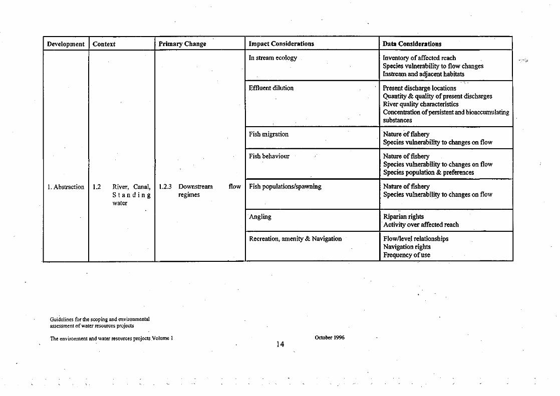
Development
1. Abstraction
Context
1.2 River, Canal, Standing water
Primary Change
1.2.3 Downstream flow regimes
Impact Considerations
In stream ecology
Effluent dilution
Fish migration
Fish behaviour
Fish populations/spawning
Angling
Recreation, amenity & Navigation
Data Considerations
Inventory of affected reach Species vulnerability to flow changes Instream and adjacent habitats
Present discharge locations Quantity & quality of present discharges River quality characteristics Concentration of persistent and bioaccumulating substances
Nature of fishery Species vulnerability to changes on flow
Nature of fishery Species vulnerability to changes on flow Species population & preferences
Nature of fishery Species vulnerability to changes on flow
Riparian rights Activity over affected reach
Flow/level relationships Navigation rights Frequency of use
Guidelines for the scoping and environmental assessment of water resources projects
The environment and water resources projects Volume 1 October 1996

Development
2. Discharge of raw water
2. Discharge of raw water
Context
2.1 -Rivers - Canals - Lakes (From any source)
2.1, -Rivers - Canals -.Lakes (From any source)
Primary Change
2.1.1 Construction & Testing
2.1.1 Construction & Testing
Impact Considerations
Nuisance from construction plant
Visual intrusion
Channel disturbance
Erosion
Pollution
Fish migration
Angling
Recreation, amenity & navigation
Effects on ecology
Data Considerations
Nearby properties Adjacent land use Present access condition
Landscape character Line of sight from surrounding properties
Levels of natural turbidity Species tolerance in affected reach Construction programme Inventory of other users
Site geomorphology Local flow characteristics
Inventory of possible contaminants
Nature of fishery
Riparian rights Level of local activity
Rights of way Navigation rights Frequency of use
Conservation sites Site & neighbourhood inventory
Guidelines for the scoping and environmental assessment of water resources projects
The environment and water resources projects Volume 1 15
October 1996

Development
2. Discharge of raw water
Context
2.1 -Rivers - Canals - Lakes (From any source)
Primary Change
2.1.2 Permanent Works
2.1.3 Downstream - flow regimes - (inc. emergency releases)
Impact Considerations
Visual intrusion''
Access intrusion
Noise intrusion
Fish migration
Fish behaviour
Angling
Increased flows/levels
Channel morphology
Change in saline limit
In stream ecology
Data Considerations
Landscape character Line of sight from surrounding properties
Nearby properties Present access condition Likely vehicular movements
Nearby properties nearby activities (susceptible)
Nature of fishery
Species populations & preferences
Riparian rights Level of local activity
Hydrological time series (extended if necessary) Channel hydraulic data Likely discharge velocities Potential for extreme discharge events
Areas of sensitive bed/bank morphology Sediment dynamics
Present saline regime
Inventory of affected reach Species vulnerability to flow changes Instream and adjacent habitats
I
Guidelines for the scoping arid environmental assessment of water resources projects
The environment and water resources projects Volume 1 October 1996

Development Context Primary Change "'Impact Considerations
Marginal ecology
Riparian ecology
Effluent dilution
Fish migration
Fish behaviour
Fish populations/spawning
Angling
Recreation, amenity & navigation
Data Considerations
Inventory of affected reach Species vulnerability to flow changes
Identification of vulnerable sites
Present discharge locations Quantity & quality of present discharges River quality characteristics Concentration of persistent and bioaccumulating substances.
Nature of fishery Species vulnerability to changes in flow
Nature of fishery Species vulnerability to changes on flow Species populations & preferences
Nature of fishery Species vulnerability to changes on flow
Riparian rights Activity over affected reach
Flow/level relationships Navigation rights Frequency of use
Guidelines for the scoping and environmental assessment of water resources projects
The environment and water resources projects Volume 1 17
October 1996

Development
2. Discharge of raw water
Context
2.1 -Rivers - Canals - Lakes
(From any source)
Primary Change
2.1.4 Downstream water quality
Impact Considerations
Physio chemical characteristics
In stream ecology
Marginal ecology
Riparian ecology
Data Considerations
Chemistry of donor source and recipient waters Chemical equilibrium of mixed waters Likely pollutant & nutrient transfer load Thermal regime of donor and recipient waters Suspended solid load of donor and recipient waters Toxicity and direct toxicity assessment
Inventory of affected reach Inventory of species sensitive to physico-chemical changes in stream and adjacent habitats.
Inventory of affected reach Inventory of species sensitive to physico-chemical changes
Inventory of vulnerable sites
Guidelines for the scoping and environmental assessment of water resources projects
The environment and water resources projects Volume 1 18
October 1996

Development
2. Discharge of raw water
Context
2.2 To groundwater from any source
Primary Change
2.1.5 Species Transfer
2.2.1 Construction & Testing
Impact Considerations
Ecosystem characteristics
Nuisance from construction plant
Visual intrusion
Subsidence
Aquifer integrity
Site drainage & containment
Data Considerations
Algal characteristics of donor and recipient waters Fisheries characteristics of donor and recipient waters Macroinvertebrate characteristics of donor and recipient waters Disease & parasite characteristics of donor and recipient waters Macroinvertebrate characteristics of donor and recipient waters Macrophyte characteristics of donor and recipient waters Alien species of donor catchment
Nearby properties Adjacent land use Present access condition
Landscape character Line of sight from surrounding property
Drift geology data
Solid & drift geology data Hydrogeological data
Potential for discharge Pipeline routes Likely quality of pumping test water
Guidelines for the scoping and environmental assessment of water resources projects
The environment and water resources projects Volume 1 October 1996

Development
2. Discharge of raw water
Context
2.2 To groundwater from any source
Primary Change
2.2.2 Permanent Works
2.2.3 Groundwater Levels
Impact Considerations
Effects on local ecology
Archaeology
Visual intrusion
Access intrusion
Effects on ecology
Change in spring flows
Protected rights
Change in wetland/open water sites
Data Considerations
Presence of conservation sites Site & neighbourhood inventory
Schedule of Ancient Monuments, Sites & Monuments register Presence of archaeological features
Landscape character Line of sight from surrounding properties
Nearby properties Present access condition Likely vehicular movements
Presence of conservation sites Site & neighbourhood inventory
Hydrogeological data Hydrological data Inventory of sites Inventory of site ecology Present amenity value
Borehole & well inventory Hydrogeological data
Hydrogeological data Hydrological data Inventory of sites Inventory of site ecology Present amenity value
Guidelines for the scoping and environmental assessment of water resources projects
The environment and water resources projects Volume 1 October 1996
20

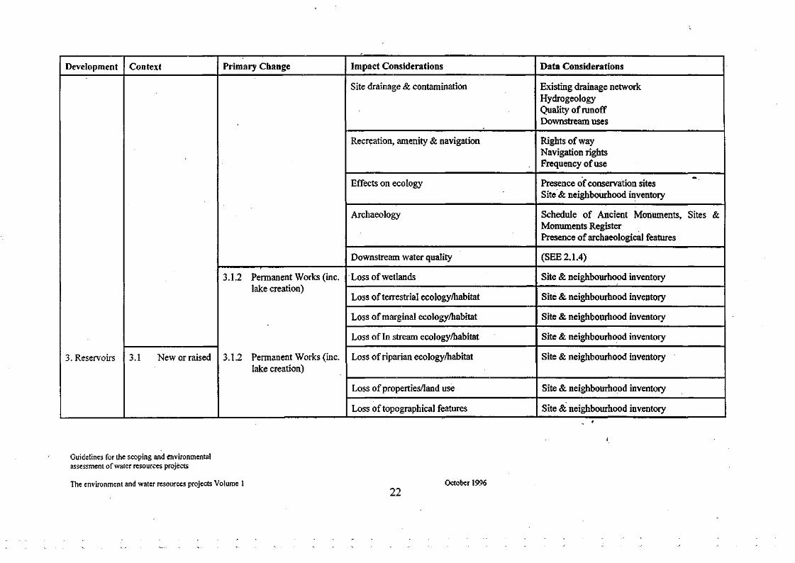
Development
3. Reservoirs
Context
3.1 New or raised
Primary Change
2.2.4 Water Quality
3.1.1 Construction
Impact Considerations
Subsidence
Downstream flow regimes
Physico chemical characteristics
Geochemical stability
Nuisance from construction plant
Visual instruction
Aquifer integrity
Data Considerations
Drift geology data Nearby properties
(SEE 1.2.3)
Chemistry of donor source Chemistry of recipient waters Chemical equilibrium of mixed waters Likely pollutant & nutrient transfer load Thermal regime of donor waters Thermal regime of recipient waters Suspended solid load of donor waters Suspended solid load of recipient waters Toxicity and Direct Toxicity Assessment
Hydro geochemistry data Hydro geochemical data
Nearby properties , Adjacent land use Access & likely traffic volume Present infrastructure
Landscape character Line of site
Solid & drift geology data Hydrogeological data
October 1996
Guidelines for the scoping and environmental assessment of water resources projects
The environment and water resources projects Volume 1
21
Development
3. Reservoirs
Context
3.1 New or raised
Primary Change
3.1.2 Permanent Works (inc. lake creation)
3.1.2 Permanent Works (inc. lake creation)
Impact Considerations
Site drainage & contamination
Recreation, amenity & navigation
Effects on ecology
Archaeology
Downstream water quality
Loss of wetlands
Loss of terrestrial ecology/habitat
Loss of marginal ecology/habitat
Loss of In stream ecology/habitat
Loss of riparian ecology/habitat
Loss of properties/land use
Loss of topographical features
Data Considerations
Existing drainage network Hydrogeology Quality of runoff Downstream uses
Rights of way Navigation rights Frequency of use
Presence of conservation sites Site & neighbourhood inventory
Schedule of Ancient Monuments, Sites & Monuments Register Presence of archaeological features
(SEE 2.1.4)
Site & neighbourhood inventory
Site & neighbourhood inventory
Site & neighbourhood inventory
Site & neighbourhood inventory
Site & neighbourhood inventory
Site & neighbourhood inventory
Site & neighbourhood inventory
I
Guidelines for the scoping and environmental assessment of water resources projects
The environment and water resources projects Volume 1 October 1996
22
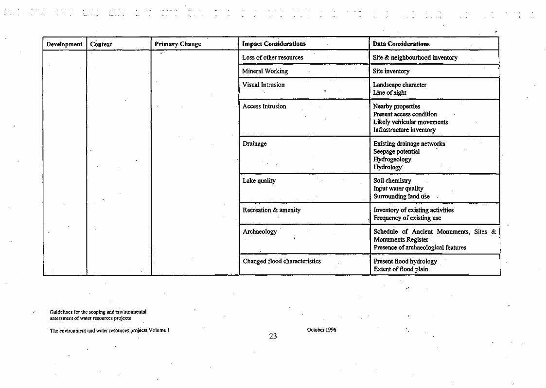
Development Context Primary Change Impact Considerations
Loss of other resources
Mineral Working
Visual Intrusion
Access Intrusion
Drainage
Lake quality
Recreation & amenity
Archaeology
Changed flood characteristics
Data Considerations
Site & neighbourhood inventory
Site inventory
Landscape character Line of sight
Nearby properties Present access condition Likely vehicular movements Infrastructure inventory
Existing drainage networks Seepage potential Hydrogeology Hydrology
Soil chemistry Input water quality Surrounding land use
Inventory of existing activities Frequency of existing use
Schedule of Ancient Monuments, Sites & Monuments Register Presence of archaeological features
Present flood hydrology Extent of flood plain
October 1996
Guidelines for the scoping and environmental assessment of water resources projects
The environment and water resources projects Volume 1 23
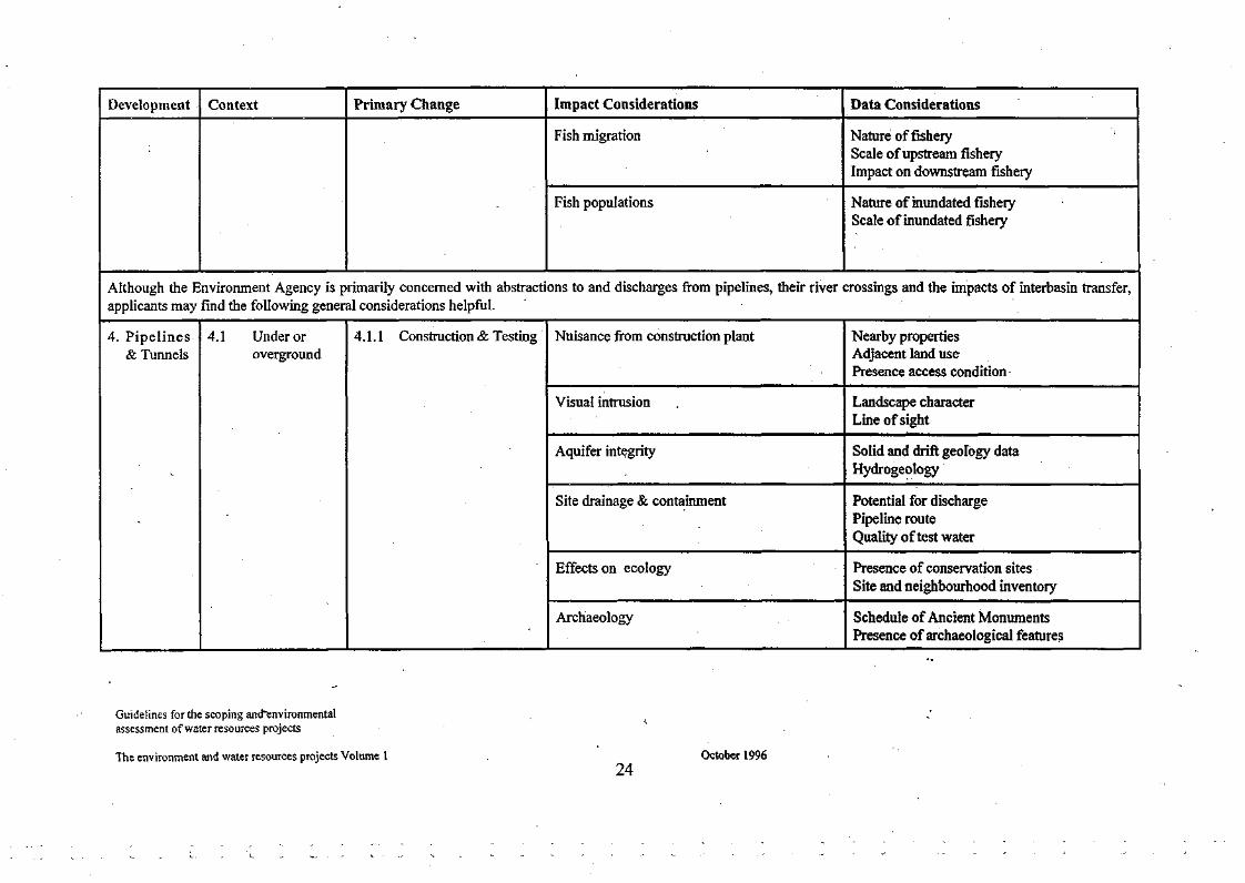
Development Context Primary Change Impact Considerations
Fish migration
Fish populations
Data Considerations
Nature of fishery Scale of upstream fishery Impact on downstream fishery
Nature of inundated fishery Scale of inundated fishery
Although the Environment Agency is primarily concerned with abstractions to and discharges from pipelines, their river crossings and the impacts of interbasin transfer, applicants may find the following general considerations helpful.
4. Pipelines & Tunnels
4.1 Under or overground
4.1.1 Construction & Testing Nuisance from construction plant
Visual intrusion
Aquifer integrity
Site drainage & containment
Effects on ecology
Archaeology
Nearby properties Adjacent land use Presence access condition
Landscape character Line of sight
Solid and drift geology data Hydrogeology
Potential for discharge Pipeline route Quality of test water
Presence of conservation sites Site and neighbourhood inventory
Schedule of Ancient Monuments Presence of archaeological features
Guidelines for the scoping and""environmental assessment of water resources projects
The environment and water resources projects Volume 1 October 1996 24

Development
4. Pipelines & Tunnels
Context
4.1 Under or overground
Primary Change
4.1.2 Permanent Works
Impact Considerations
Recreation & Amenity
Visual intrusion
Access intrusion
Effects on ecology
Data Considerations
Rights of way Frequency of use Inventory of sites
Landscape character Line of site
Nearby properties Present access condition Likely vehicular movements
Presence of conservation sites Site and neighbourhood inventory
Guidelines for the scoping and Environmental assessment of water resources projects
The environment and water resources projects Volume 1 25
October 1996

APPENDIX 2 - Potential Sources of Information and Investigations Required for Data Consideration
Data Considerations Potential Sources Investigation/Surveys
Data Considerations for Abstraction and Discharge
Land Use Adjacent land use Upstream land use Landscape character Likely vehicular movements Line of sight from surrounding properties Nearby properties Present access condition Rights of way
Water Quantity Present locations of abstraction Existing MAFs or RPO's Quantities requiring protection Flow/level relationships Local flow characteristics Hydrological time series (extended if necessary) Likely discharge velocities Potential for extreme discharge events
Land Use Maps, OS maps, MAFF, GIS, aerial photographs River Corridor Surveys & landscape appraisal ITE
Local Authorities, DoT -
Environment Agency Licensing databases
No derogation of protected rights Hydrometry
Flow data files / archives
Modelling of schemes Likely emergency discharges v flood flows
• - ; • •
Specialist contractor surveys Site visits and surveys (Environment Agency)
WR Assessment / modelling Hydrometry, site surveys Ecologically Acceptable Flows
Modelling - hydraulic & hydrological
October 1996 26
Guidelines for the scoping and environmental assessment of water resources projects
The environment and water resources projects Volume 1

Water Quality Present discharge locations Quantity & quality of present discharges River quality characteristics Thermal regime of recipient waters Chemistry of donor / recipient waters Levels of natural turbidity
Inventory of possible contaminants Likely pollutant & nutrient transfer load Chemical equilibrium of mixed waters Present saline regime
Biology, Conservation & Ecology Inventory of affected reach (In stream) Inventory of marginal & riparian ecology Site & neighbourhood inventory
Macroin vertebrate characteristics of recipient/donor waters
Algal characteristics of donor/recipient waters
Disease & parasite characteristics of recipient/donor waters
Inventory of species sensitive to physico-chemical changes
Conservation sites Inventory of vulnerable sites and species including Biodiversity targets
WQ Archive / consents
River Quality monitoring, routine stats
Catchment Quality Control Modelling Modelling Routine monitoring
RIVPACS, HabScore, River Corridor Surveys, River Habitat Surveys, Ecologically Acceptable Flows Phase 1 and 2 habitat surveys, Designated Sites
Environmental assessment Biology databases (macroinvertebrate scores)
Routine monitoring to species level Algal monitoring & modelling, linking to WQ Biological monitoring
Published research, IFIM
EN, County Trust Officers, Conservation Officers, GIS, DoE (Biodiversity targets)
Environmental assessment or specialist modelling
Modelling, monitoring of specifications, diet variations, speciation, algal monitoring & modelling. Survey of industrial users, discharges etc.
Lab assessment of chemical equilibria Additional monitoring of GW
Environmental assessment or specialist contractor surveys
Environmental assessment or specialist contractor surveys
Additional strategic monitoring
Specialist laboratory investigations
Physical and WQ modelling and assessment of impacts of fisheries & ecology
River Corridor & flood plain surveys
Guidelines for the scoping and environmental assessment of water resources projects
The environment and water resources projects Volume 1 October 1996
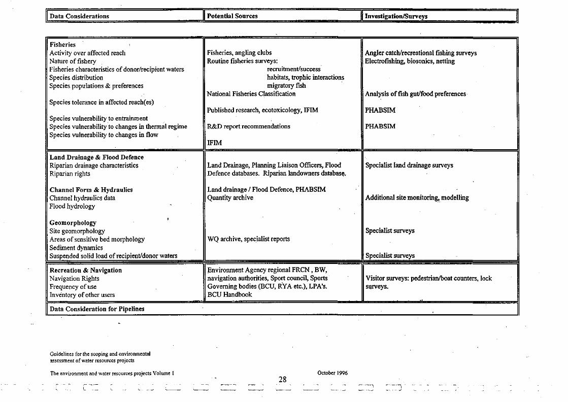
Data Considerations Potential Sources Investigation/Surveys
Fisheries Activity over affected reach Nature of fishery Fisheries characteristics of donor/recipient waters Species distribution Species populations & preferences
Species tolerance in affected reach(es)
Species vulnerability to entrainment Species vulnerability to changes in thermal regime Species vulnerability to changes in flow
Land Drainage & Flood Defence Riparian drainage characteristics Riparian rights
Channel Form & Hydraulics Channel hydraulics data Flood hydrology
9
Geomorphology Site geomorphology Areas of sensitive bed morphology Sediment dynamics Suspended solid load of recipient/donor waters
Recreation & Navigation Navigation Rights Frequency of use Inventory of other users
Data Consideration for Pipelines
Fisheries, angling clubs Routine fisheries surveys:
recruitment/success habitats, trophic interactions migratory fish
National Fisheries Classification
Published research, ecotoxicology, IFIM
R&D report recommendations
IFIM
Land Drainage, Planning Liaison Officers, Flood Defence databases. Riparian landowners database.
Land drainage / Flood Defence, PHABSIM Quantity archive
WQ archive, specialist reports
Environment Agency regional FRCN, BW, navigation authorities, Sport council, Sports Governing bodies (BCU, RYA etc.), LPA's. BCU Handbook
Angler catch/recreational fishing surveys Electrofishing, biosonics, netting
Analysis of fish gut/food preferences
PHABSIM
PHABSIM
Specialist land drainage surveys
Additional site monitoring, modelling
Specialist surveys
Specialist surveys
Visitor surveys: pedestrian/boat counters, lock surveys.
,-
Guidelines for the scoping and environmental assessment of water resources projects
The environment and water resources projects Volume 1
28
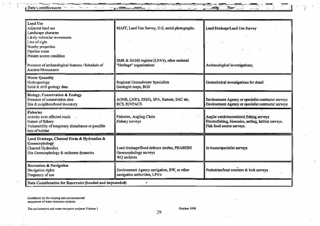
Land Use Adjacent land use Landscape character Likely vehicular movements Line of sight Nearby properties Pipeline route Present access condition
Presence of archaeological features / Schedule of Ancient Monuments
Water Quantity Hydrogeology Solid & drift geology data
Biology, Conservation & Ecology Presence of conservation sites Site & neighbourhood inventory
Fisheries Activity over affected reach Nature of fishery Vulnerability of temporary disturbance or possible loss of habitat
Land Drainage, Channel Form & Hydraulics & Geomorphology Channel Hydraulics Site .Geomorphology & sediment dynamics
Recreation & Navigation Navigation rights Frequency of use
MAFF, Land Use Survey, O.S, aerial photographs.
SMR & SAMS register (LPA's), other national "Heritage" organisations
Regional Groundwater Specialists Geologist maps, BGS
AONB, LNR's, SSSI's, SPA, Ramsar, SAC etc. RCS, RIVPACS
Fisheries, Angling Clubs Fishery surveys
Land drainage/flood defence studies, PHABSIM Geomorphology surveys WQ archives
Environment Agency navigation, BW, or other navigation authorities, LPA's
Land Drainage/Land Use Survey
Archaeological investigations;
Geotechnical investigations for detail
Environment Agency or specialist contractor surveys Environment Agency or specialist contractor surveys
Angler catch/recreational.fishing surveys Electrofishing, biosonics, netting, habitat surveys. Fish food source surveys.
In house/specialist surveys
Pedestrian/boat counters & lock surveys
Data Consideration for Reservoirs (bunded and impounded) •
Guidelines for the scoping and environmental assessment of water resources projects
The environment and water resources projects Volume 1 October 1996

Data Considerations
Land Use Adjacent land use Landscape character Likely vehicular movements Line of sight Nearby properties Pipeline route Access & traffic Rights
Presence of archaeological features/schedule of Ancient Monuments
Minerals inventory & plans
Water Quantity Hydrology of inundated water courses
Hydrogeology Solid & drift geology data Seepage potential
Water Quality Input WQ
Soil Chemistry and Water Interaction
Quality of runoff
Biology, Conservation & Ecology
Presence of conservation sites
Site & neighbourhood inventory .
In stream ecology
Guidelines for the scoping and environmental assessment of water resources projects
The environment and water resources projects Volume 1
Potential Sources
MAFF, Land Use Survey, Ordnance Survey, aerial photograph surveys
Local Authorities
SMR &SAMS register (LPA's), other national "Heritage" organisations.
CC Minerals Plans
Quantity archive
Regional Groundwater Specialists Geology maps, BGS
WQ Archive
Soil Survey, BGS
Pollution prevention
EN, AONB, LNR's SSSI's, SPA, Ramsar, SAC etc.
RCS, RIVPACS, HabScore
Routine surveys
October 1996
30
Investigation/Surveys
Land Drainage/Land Use Survey
Archaeological investigations; need Archaeologist as part of construction team
Hydrometry, modelling - hydraulic & hydrologic Geotechnics investigations for detail
Additional monitoring, modelling
Forward planning, sedimentation ponds ....
Specialist surveys & assessments

D a t a C o n s i d e r a t i o n s Potential sources ^„ .^stig^„_jSun v - J
Fisheries Scale & nature of inundated fishery Impact on migratory fish Scale & nature of upstream fishery
Nature of reservoir fishery
Loss of spawning grounds
Land Drainage etc. Present flood hydrology Extent of flood plain
Channel Form & Hydraulics Existing drainage networks, re-aligned channels
Geomorphology
Recreation & Navigation Downstream users
Routine fishery survey characteristics
Promoter/Environment Agency consent
Habitat surveys
Quantity archive, models FP mapping, modelling, historic flood records
Hydrometry, flooa* modelling
Environment Agency/Geomorphology surveys
Existing uses and assessment of potential impacts. Environment Agency navigation, BW etc., Sports Council, BCU, RYA, ARA etc.
Specialist surveys: eg. population characteristics '
Additional survey & modelling, monitoring of flood event.
Land drainage surveys
Specialist surveys
Evaluation of potential impacts arising from changed flow regimes or loss of navigation.
Guidelines for the scoping and environmental assessment of water resources projects
The environment and water resources projects Volume 1 31
October 1996

APPENDIX 3 - Proforma A: Impacts and Data Requirements
Development Context Location(s)
Primary change Impact consideration
Data consideration
•
Current work available Further work needed having made a professional judgement on the adequacy of data available
Time
-
Responsibility
Guidelines for the scoping and environmental assessment of water resources projects
The environment and water resources projects Volume 1 October 1996
32

APPENDIX 4 - RELEVANT LEGISLATION
Principal Legislation
In addition to the benefits of environmental assessment/appraisal outlined in the introduction, there are legal reasons for carrying it out. The law requires environmental assessment/appraisal to be a significant part of the Agency's work. The principal legislation is summarised below:-
• The Environment Act, 1995 - sections 4,7 - 9 and 37(1)
• EC Directive 85/337/EEC (1985). The assessment of the effects of certain public and private
projects on the environment.
• Statutory Instrument 1199 - The Town and Country Planning (Assessment of Environmental
Effects) Regulations 1988, as amended by Statutory Instrument 677 (1994)
• The General Permitted Development Order - Statutory Instrument 418 (1995), The Town and
Country Planning (General Permitted Development) Order 1995 (GPDO)
• Statutory Instrument 419 (1995) - Town and Country Planning (General Development
Procedure) Order 1995
• Statutory Instrument 417 (1995) - The Town and Country Planning (Environmental
Assessment and Permitted Development) Regulations 1995
. EC Habitats Directive 92/43/EEC
• Statutory Instrument 2716 (1994) Conservation (Natural Habitats and Conservation)
Regulations
• DoE (1994) Planning Policy Guidance : Nature Conservation PPG9
References:
1. DoE (1989) Environmental Assessment: A Guide to the Procedures DoE, Welsh Office
HMSO: London
2. NRA Bristol (1995) Scoping Guidance for the Environmental Assessment of Projects
3. NRA Bristol (1995) Further Guidance for the Environmental Assessment of Projects
4. Environment Agency (1996) Environmental Assessment: Scoping Handbook for Projects.
HMSO: London
Guidelines for the scoping and environmental assessment of water resources projects
The environment and water resources projects Volume 1
33 October 1996
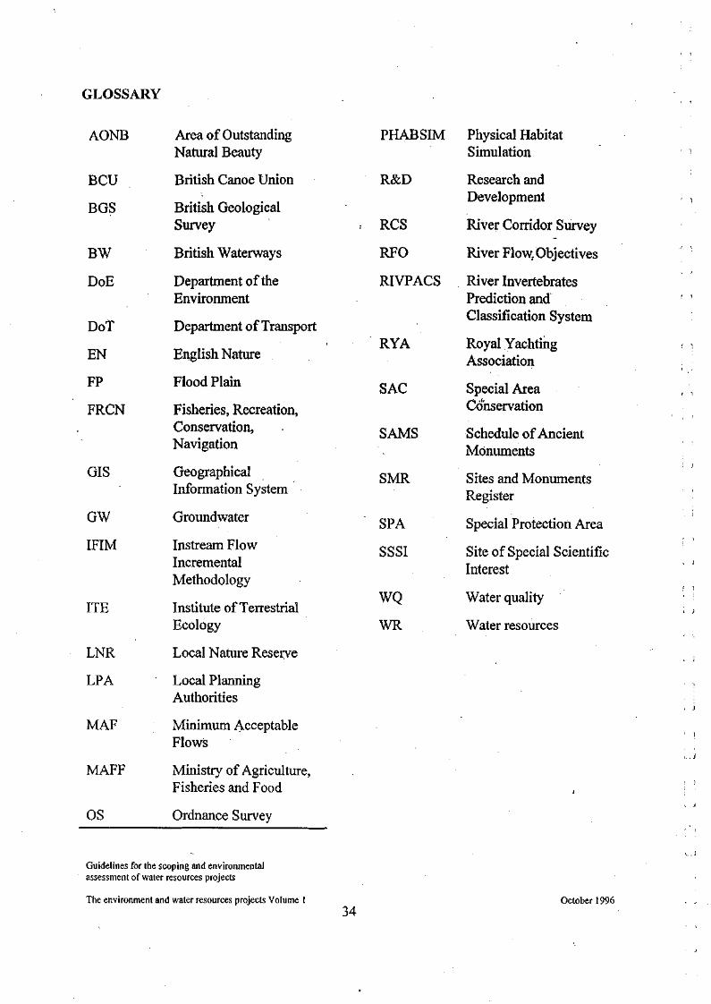
GLOSSARY
AONB
BCU
BGS
BW
DoE
DoT
EN
FP
FRCN
GIS
GW
IFIM
ITE
LNR
LP A
MAF
MAFF
OS
Area of Outstanding Natural Beauty
British Canoe Union
British Geological Survey
British Waterways
Department of the Environment
Department of Transport
English Nature
Flood Plain
Fisheries, Recreation, Conservation, Navigation
Geographical Information System
Groundwater
Instream Flow Incremental Methodology
Institute of Terrestrial Ecology
Local Nature Reserve
Local Planning Authorities
Minimum Acceptable Flows
Ministry of Agriculture, Fisheries and Food
Ordnance Survey
PHABSIM
R&D
RCS
RFO
RIVPACS
RYA
SAC
SAMS
SMR
SPA
SSSI
WQ
WR
Physical Habitat Simulation
Research and Development
River Corridor Survey
River Flow.Objectives
River Invertebrates Prediction and Classification System
Royal Yachting Association
Special Area Conservation
Schedule of Ancient Monuments
Sites and Monuments Register
Special Protection Area
Site of Special Scientific Interest
Water quality
Water resources