Embed Size (px)
Citation preview

CHAPTER 4:GUIDELINES FOR TRANSPORTATION FACILITIES IN LOCAL LAND USE DECISIONS
PURPOSE
Local land use decision-makers are more than ever faced with increasingly complicated decisions. With new initiatives inmany states to create comprehensive land use plans, it is ever more important that they have a general understanding of howtransportation issues are closely inter-related to those of land use planning. The purpose of this paper is to create a guide for localland use decision-makers which helps them make informed decisions about transportation facilities in conjunction with local land use.These guidelines can be used to form a strategy to preserve or improve the local transportation network and in particular improvesafety in their community. With a clear strategy, future decisions can be made more confidently and effectively.
INTRODUCTION
• Are transportation and development always incompatible?• Can viable developments be made without compromising the transportation network?• Do road improvements automatically attract uncontrolled development?• Can roads be safe and efficient at the same time?
These are some of the questions local land use officials across the country have to face each day. Combined with trafficproblems, limited rights of way, rising construction costs, and revenue shortfalls, the job of a local land use official seems impossible.A recent headline in the Washington Post read: More Lanes Better? Not Necessarily. Washington D.C. planners have found thateven when roads are expanded with great expense, congestion and safety are not necessarily improved. A further complication is
the growing trend for citizens to oppose road widening and expansion. In the Milwaukee area residents are protesting the WisconsinDOT’s efforts to expand to Wauwatosa Road in Mequon and Highway 164 in Pewaukee and Sussex.
Increasingly, the issue of transportation and land use planning is hard to ignore. Wisconsin’s Smart Growth Initiative requiresmunicipalities to adopt a comprehensive plan for their community. This comprehensive plan must contain a transportation elementthat provides "an integrated efficient and economical transportation system that affords mobility, convenience, and safety and thatmeets the needs of all citizens, including transit-dependent and disabled citizens."
Fortunately by understanding how land use and transportation work together, many problems can be mitigated throughcareful and innovative planning. With proper and thorough planning, development and transportation facilities can be designedtogether so that development is successful and the transportation system safe, effective and accessible to all citizens. With effectivetechniques, such as land use planning, site plan review standards, and corridor preservation, safety and efficiency of traffic flow canbe improved while encouraging the use and economic development of the land which abuts the public roadways.
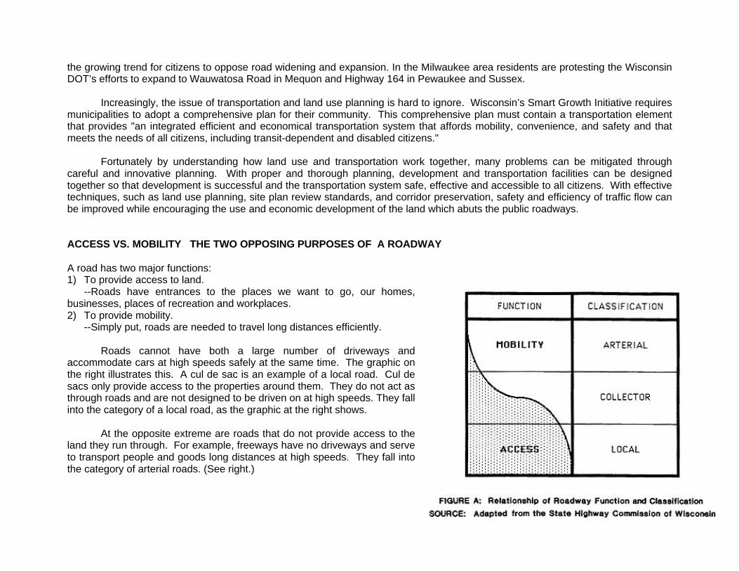
ACCESS VS. MOBILITY THE TWO OPPOSING PURPOSES OF A ROADWAY
A road has two major functions:1) To provide access to land.
--Roads have entrances to the places we want to go, our homes,businesses, places of recreation and workplaces.2) To provide mobility.
--Simply put, roads are needed to travel long distances efficiently.
Roads cannot have both a large number of driveways andaccommodate cars at high speeds safely at the same time. The graphic onthe right illustrates this. A cul de sac is an example of a local road. Cul desacs only provide access to the properties around them. They do not act asthrough roads and are not designed to be driven on at high speeds. They fallinto the category of a local road, as the graphic at the right shows.
At the opposite extreme are roads that do not provide access to theland they run through. For example, freeways have no driveways and serveto transport people and goods long distances at high speeds. They fall intothe category of arterial roads. (See right.)
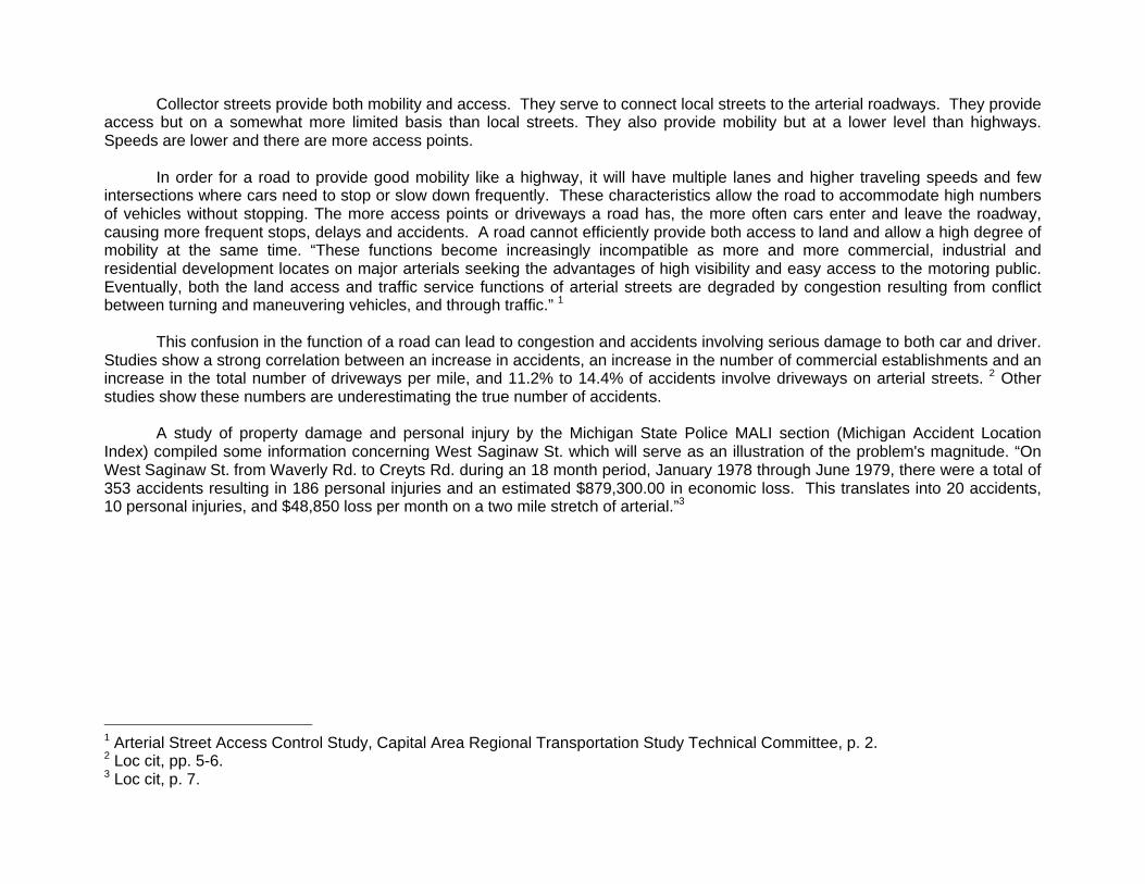
Collector streets provide both mobility and access. They serve to connect local streets to the arterial roadways. They provideaccess but on a somewhat more limited basis than local streets. They also provide mobility but at a lower level than highways.Speeds are lower and there are more access points.
In order for a road to provide good mobility like a highway, it will have multiple lanes and higher traveling speeds and fewintersections where cars need to stop or slow down frequently. These characteristics allow the road to accommodate high numbersof vehicles without stopping. The more access points or driveways a road has, the more often cars enter and leave the roadway,causing more frequent stops, delays and accidents. A road cannot efficiently provide both access to land and allow a high degree ofmobility at the same time. “These functions become increasingly incompatible as more and more commercial, industrial andresidential development locates on major arterials seeking the advantages of high visibility and easy access to the motoring public.Eventually, both the land access and traffic service functions of arterial streets are degraded by congestion resulting from conflictbetween turning and maneuvering vehicles, and through traffic.” 1
This confusion in the function of a road can lead to congestion and accidents involving serious damage to both car and driver.Studies show a strong correlation between an increase in accidents, an increase in the number of commercial establishments and anincrease in the total number of driveways per mile, and 11.2% to 14.4% of accidents involve driveways on arterial streets. 2 Otherstudies show these numbers are underestimating the true number of accidents.
A study of property damage and personal injury by the Michigan State Police MALI section (Michigan Accident LocationIndex) compiled some information concerning West Saginaw St. which will serve as an illustration of the problem's magnitude. “OnWest Saginaw St. from Waverly Rd. to Creyts Rd. during an 18 month period, January 1978 through June 1979, there were a total of353 accidents resulting in 186 personal injuries and an estimated $879,300.00 in economic loss. This translates into 20 accidents,10 personal injuries, and $48,850 loss per month on a two mile stretch of arterial.”3
1 Arterial Street Access Control Study, Capital Area Regional Transportation Study Technical Committee, p. 2.2 Loc cit, pp. 5-6.3 Loc cit, p. 7.
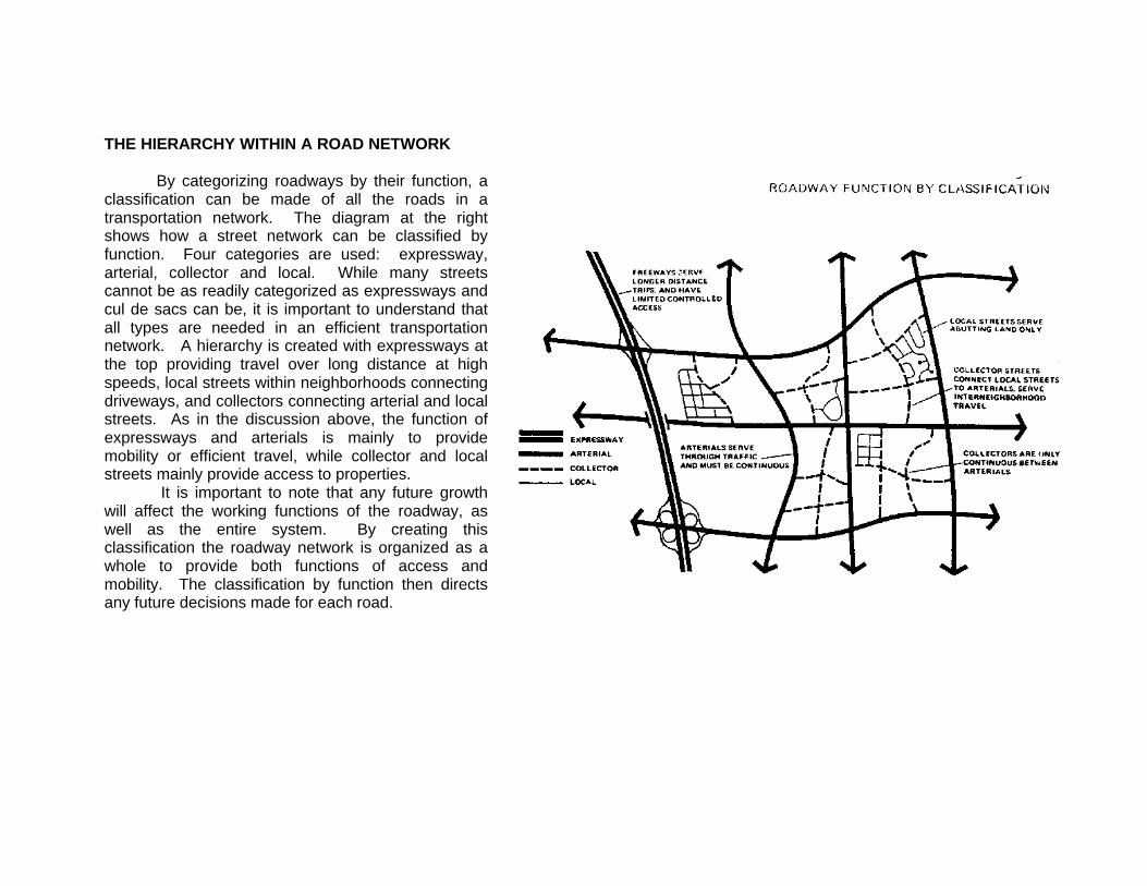
THE HIERARCHY WITHIN A ROAD NETWORK
By categorizing roadways by their function, aclassification can be made of all the roads in atransportation network. The diagram at the rightshows how a street network can be classified byfunction. Four categories are used: expressway,arterial, collector and local. While many streetscannot be as readily categorized as expressways andcul de sacs can be, it is important to understand thatall types are needed in an efficient transportationnetwork. A hierarchy is created with expressways atthe top providing travel over long distance at highspeeds, local streets within neighborhoods connectingdriveways, and collectors connecting arterial and localstreets. As in the discussion above, the function ofexpressways and arterials is mainly to providemobility or efficient travel, while collector and localstreets mainly provide access to properties.
It is important to note that any future growthwill affect the working functions of the roadway, aswell as the entire system. By creating thisclassification the roadway network is organized as awhole to provide both functions of access andmobility. The classification by function then directsany future decisions made for each road.
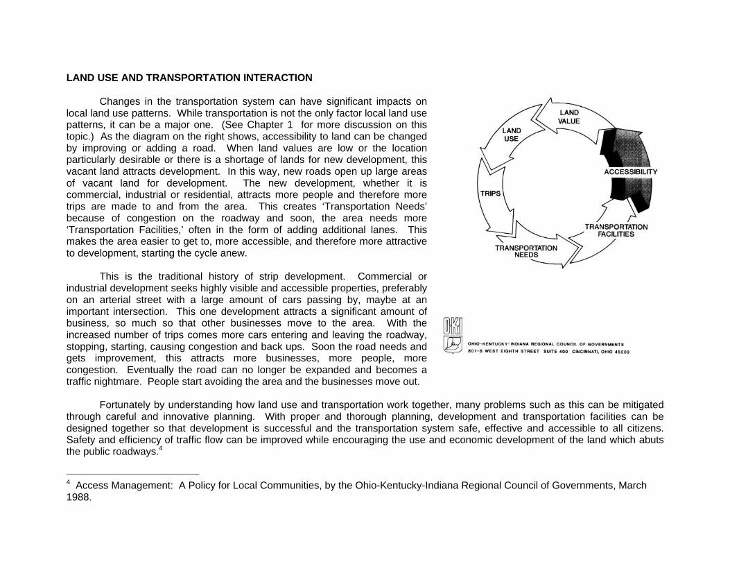
LAND USE AND TRANSPORTATION INTERACTION
Changes in the transportation system can have significant impacts onlocal land use patterns. While transportation is not the only factor local land usepatterns, it can be a major one. (See Chapter 1 for more discussion on thistopic.) As the diagram on the right shows, accessibility to land can be changedby improving or adding a road. When land values are low or the locationparticularly desirable or there is a shortage of lands for new development, thisvacant land attracts development. In this way, new roads open up large areasof vacant land for development. The new development, whether it iscommercial, industrial or residential, attracts more people and therefore moretrips are made to and from the area. This creates ‘Transportation Needs’because of congestion on the roadway and soon, the area needs more‘Transportation Facilities,’ often in the form of adding additional lanes. Thismakes the area easier to get to, more accessible, and therefore more attractiveto development, starting the cycle anew.
This is the traditional history of strip development. Commercial orindustrial development seeks highly visible and accessible properties, preferablyon an arterial street with a large amount of cars passing by, maybe at animportant intersection. This one development attracts a significant amount ofbusiness, so much so that other businesses move to the area. With theincreased number of trips comes more cars entering and leaving the roadway,stopping, starting, causing congestion and back ups. Soon the road needs andgets improvement, this attracts more businesses, more people, morecongestion. Eventually the road can no longer be expanded and becomes atraffic nightmare. People start avoiding the area and the businesses move out.
Fortunately by understanding how land use and transportation work together, many problems such as this can be mitigatedthrough careful and innovative planning. With proper and thorough planning, development and transportation facilities can bedesigned together so that development is successful and the transportation system safe, effective and accessible to all citizens.Safety and efficiency of traffic flow can be improved while encouraging the use and economic development of the land which abutsthe public roadways.4
4 Access Management: A Policy for Local Communities, by the Ohio-Kentucky-Indiana Regional Council of Governments, March1988.
14 GUIDELINES FOR TRANSPORTATION FACILITIES IN LOCAL LAND USE DECISIONS
The following guidelines, divided into four categories, are designed to aid local decision makers coordinate transportation andland use planning. Transportation planning should be coordinated with local land use in 4 particular areas: ComprehensivePlanning, Corridor Preservation, Preservation of Safety and Mobility on Arterials, and Subdivision Regulations and Site DesignReview Standards. Sound planning can provide for "an integrated efficient and economical transportation system that affordsmobility, convenience, and safety and that meets the needs of all citizens, including transit-dependent and disabled citizens..." asWisconsin’s Smart Growth Initiative requires. These guidelines incorporate ideas to improve safety and reduce congestion, plan forfuture transit facilities, and create pedestrian and bike friendly roadways. A strategy based on these guidelines can improve thetransportation network in a community and in particular improve safety for its travelers.
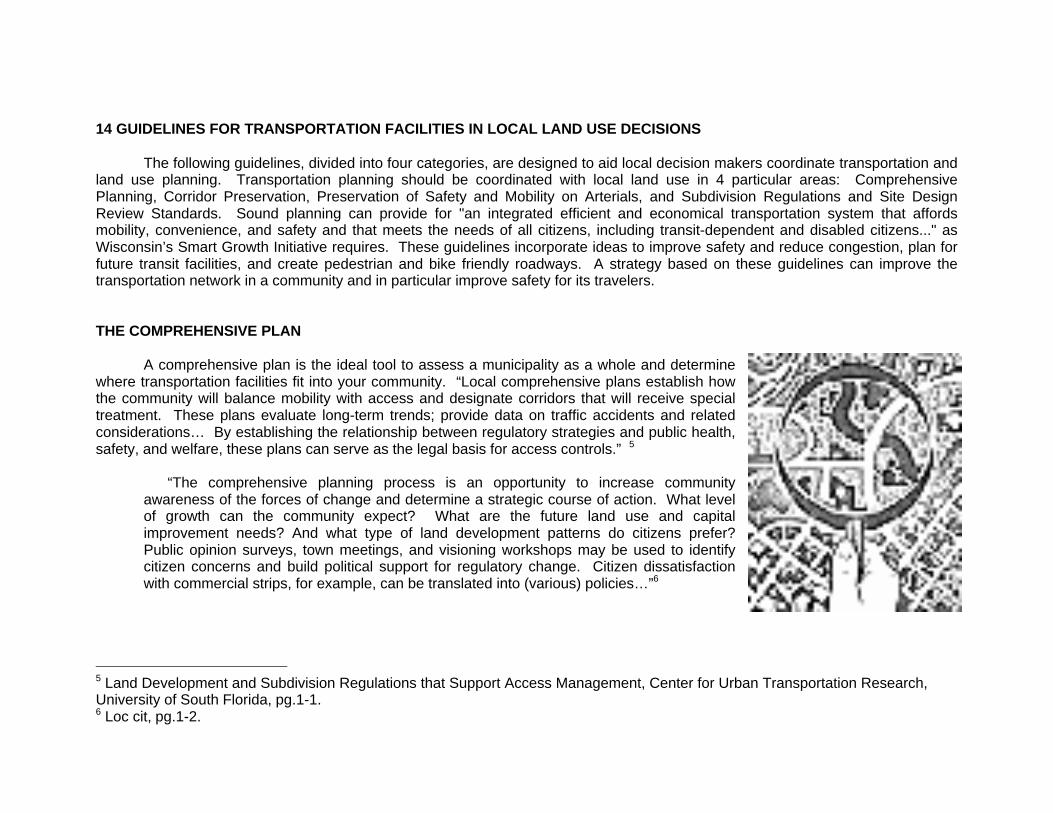
THE COMPREHENSIVE PLAN
A comprehensive plan is the ideal tool to assess a municipality as a whole and determinewhere transportation facilities fit into your community. “Local comprehensive plans establish howthe community will balance mobility with access and designate corridors that will receive specialtreatment. These plans evaluate long-term trends; provide data on traffic accidents and relatedconsiderations… By establishing the relationship between regulatory strategies and public health,safety, and welfare, these plans can serve as the legal basis for access controls.” 5
“The comprehensive planning process is an opportunity to increase communityawareness of the forces of change and determine a strategic course of action. What levelof growth can the community expect? What are the future land use and capitalimprovement needs? And what type of land development patterns do citizens prefer?Public opinion surveys, town meetings, and visioning workshops may be used to identifycitizen concerns and build political support for regulatory change. Citizen dissatisfactionwith commercial strips, for example, can be translated into (various) policies…”6
5 Land Development and Subdivision Regulations that Support Access Management, Center for Urban Transportation Research,University of South Florida, pg.1-1.6 Loc cit, pg.1-2.
1) Classify the Roads in Your Community
Where are the arterials in your community? Identify arterial and collector streetsso that rights of way can be properly determined, particularly in growth areas andareas in need of reconstruction. Allow for varying width and types of roads foreach different class. Be sure roads meet projected traffic demand and fit in withhierarchy of streets according to their function.
2) Define the Problem Areas of your Transportation Network
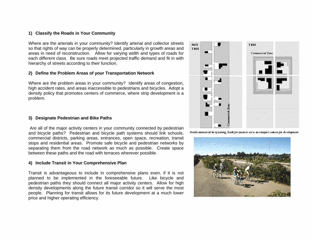
Where are the problem areas in your community? Identify areas of congestion,high accident rates, and areas inaccessible to pedestrians and bicycles. Adopt adensity policy that promotes centers of commerce, where strip development is aproblem.
3) Designate Pedestrian and Bike Paths
Are all of the major activity centers in your community connected by pedestrianand bicycle paths? Pedestrian and bicycle path systems should link schools,commercial districts, parking areas, entrances, open space, recreation, transitstops and residential areas. Promote safe bicycle and pedestrian networks byseparating them from the road network as much as possible. Create spacebetween these paths and the road with terraces wherever possible.
4) Include Transit in Your Comprehensive Plan
Transit is advantageous to include in comprehensive plans even, if it is notplanned to be implemented in the foreseeable future. Like bicycle andpedestrian paths they should connect all major activity centers. Allow for highdensity developments along the future transit corridor so it will serve the mostpeople. Planning for transit allows for its future development at a much lowerprice and higher operating efficiency.
PROMOTE CORRIDOR PLANNING AND PRESERVATION
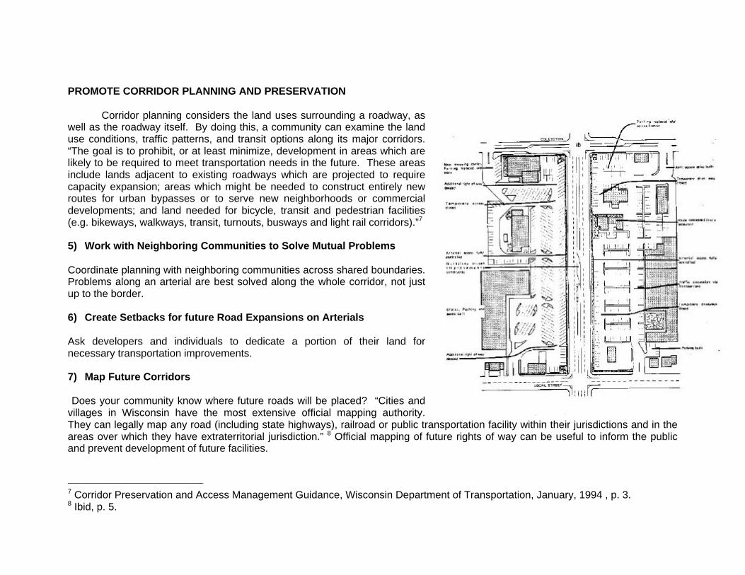
Corridor planning considers the land uses surrounding a roadway, aswell as the roadway itself. By doing this, a community can examine the landuse conditions, traffic patterns, and transit options along its major corridors.“The goal is to prohibit, or at least minimize, development in areas which arelikely to be required to meet transportation needs in the future. These areasinclude lands adjacent to existing roadways which are projected to requirecapacity expansion; areas which might be needed to construct entirely newroutes for urban bypasses or to serve new neighborhoods or commercialdevelopments; and land needed for bicycle, transit and pedestrian facilities(e.g. bikeways, walkways, transit, turnouts, busways and light rail corridors).”7
5) Work with Neighboring Communities to Solve Mutual Problems
Coordinate planning with neighboring communities across shared boundaries.Problems along an arterial are best solved along the whole corridor, not justup to the border.
6) Create Setbacks for future Road Expansions on Arterials
Ask developers and individuals to dedicate a portion of their land fornecessary transportation improvements.
7) Map Future Corridors
Does your community know where future roads will be placed? “Cities andvillages in Wisconsin have the most extensive official mapping authority.They can legally map any road (including state highways), railroad or public transportation facility within their jurisdictions and in theareas over which they have extraterritorial jurisdiction.” 8 Official mapping of future rights of way can be useful to inform the publicand prevent development of future facilities.
7 Corridor Preservation and Access Management Guidance, Wisconsin Department of Transportation, January, 1994 , p. 3.8 Ibid, p. 5.
PRESERVE SAFETY AND MOBILITY ON ARTERIALS WITH ACCESSMANAGEMENT TECHNIQUES
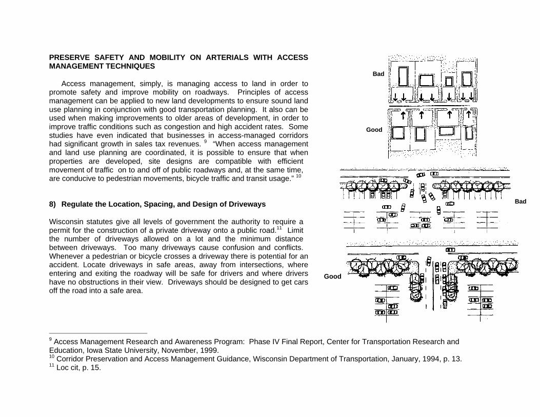
Access management, simply, is managing access to land in order topromote safety and improve mobility on roadways. Principles of accessmanagement can be applied to new land developments to ensure sound landuse planning in conjunction with good transportation planning. It also can beused when making improvements to older areas of development, in order toimprove traffic conditions such as congestion and high accident rates. Somestudies have even indicated that businesses in access-managed corridorshad significant growth in sales tax revenues. 9 “When access managementand land use planning are coordinated, it is possible to ensure that whenproperties are developed, site designs are compatible with efficientmovement of traffic on to and off of public roadways and, at the same time,are conducive to pedestrian movements, bicycle traffic and transit usage.” 10
8) Regulate the Location, Spacing, and Design of Driveways
Wisconsin statutes give all levels of government the authority to require apermit for the construction of a private driveway onto a public road.11 Limitthe number of driveways allowed on a lot and the minimum distancebetween driveways. Too many driveways cause confusion and conflicts.Whenever a pedestrian or bicycle crosses a driveway there is potential for anaccident. Locate driveways in safe areas, away from intersections, whereentering and exiting the roadway will be safe for drivers and where drivershave no obstructions in their view. Driveways should be designed to get carsoff the road into a safe area.
9 Access Management Research and Awareness Program: Phase IV Final Report, Center for Transportation Research andEducation, Iowa State University, November, 1999.10 Corridor Preservation and Access Management Guidance, Wisconsin Department of Transportation, January, 1994, p. 13.11 Loc cit, p. 15.
Bad
Good
Bad
Good
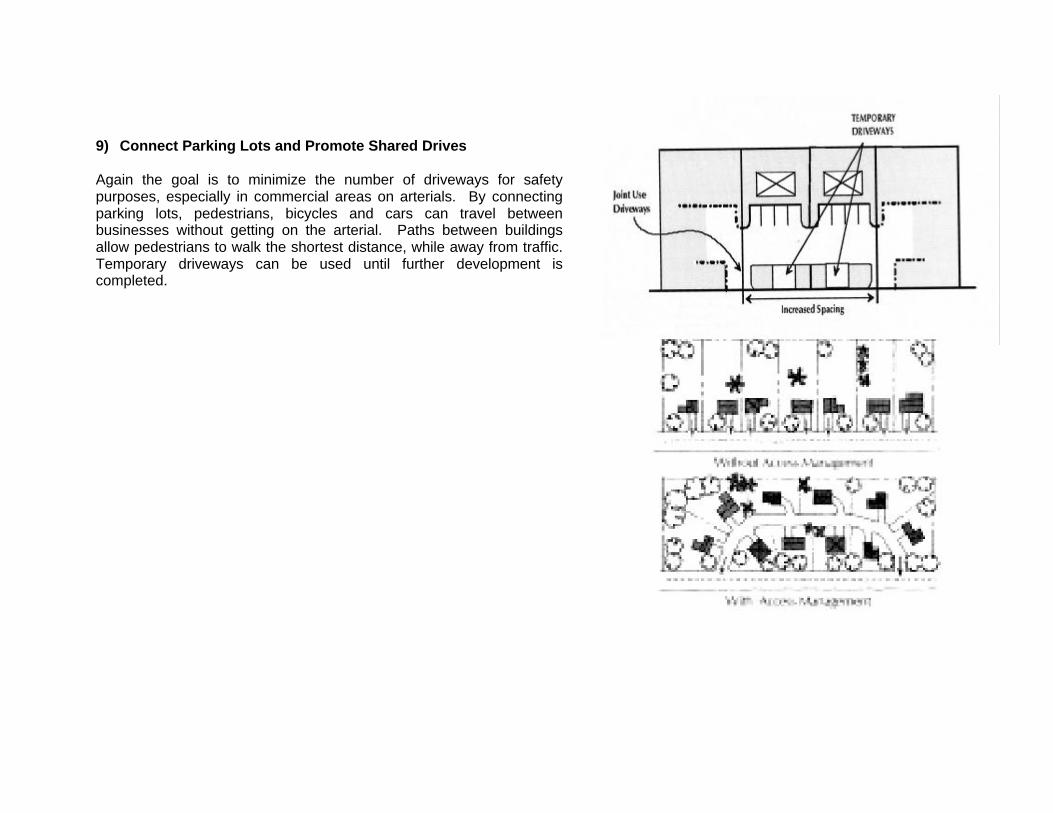
9) Connect Parking Lots and Promote Shared Drives
Again the goal is to minimize the number of driveways for safetypurposes, especially in commercial areas on arterials. By connectingparking lots, pedestrians, bicycles and cars can travel betweenbusinesses without getting on the arterial. Paths between buildingsallow pedestrians to walk the shortest distance, while away from traffic.Temporary driveways can be used until further development iscompleted.
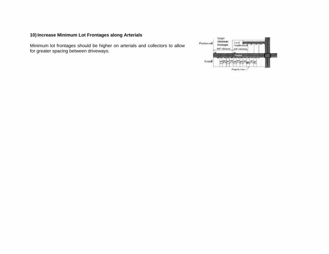
10) Increase Minimum Lot Frontages along Arterials
Minimum lot frontages should be higher on arterials and collectors to allowfor greater spacing between driveways.
CREATE SUBDIVISION REGULATIONS AND SITE PLAN REVIEW STANDARDS
“Subdivision regulations help ensure proper street layout in relation to existing or planned roadways; adequatespace for emergency access and utilities; adequate water, drainage, and sanitary sewer facilities; and appropriate sitedesign. The subdivision ordinance establishes the administrative review and evaluation procedure for processingconceptual, preliminary, and final plats; information that must be included on the plat; design principles and standardsfor lots, blocks, streets, public places, pedestrian ways, and utilities; required improvements, including streets,sidewalks, water, sewer and curbs and gutter; and financing and maintenance responsibilities. These regulations helpjustify decisions made and help developers have a clear idea of what is expected in the community.”12
Particular attention to safety and efficiency of the roadway network should be built into these regulations.
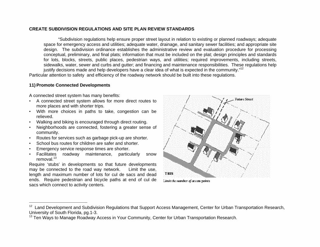
11) Promote Connected Developments
A connected street system has many benefits:• A connected street system allows for more direct routes to
more places and with shorter trips.• With more choices in paths to take, congestion can be
relieved.• Walking and biking is encouraged through direct routing.• Neighborhoods are connected, fostering a greater sense of
community.• Routes for services such as garbage pick-up are shorter.• School bus routes for children are safer and shorter.• Emergency service response times are shorter.• Facilitates roadway maintenance, particularly snow
removal.13
Require ‘stubs’ in developments so that future developmentsmay be connected to the road way network. Limit the use,length and maximum number of lots for cul de sacs and deadends. Require pedestrian and bicycle paths at end of cul desacs which connect to activity centers.
12 Land Development and Subdivision Regulations that Support Access Management, Center for Urban Transportation Research,University of South Florida, pg.1-3.13 Ten Ways to Manage Roadway Access in Your Community, Center for Urban Transportation Research.
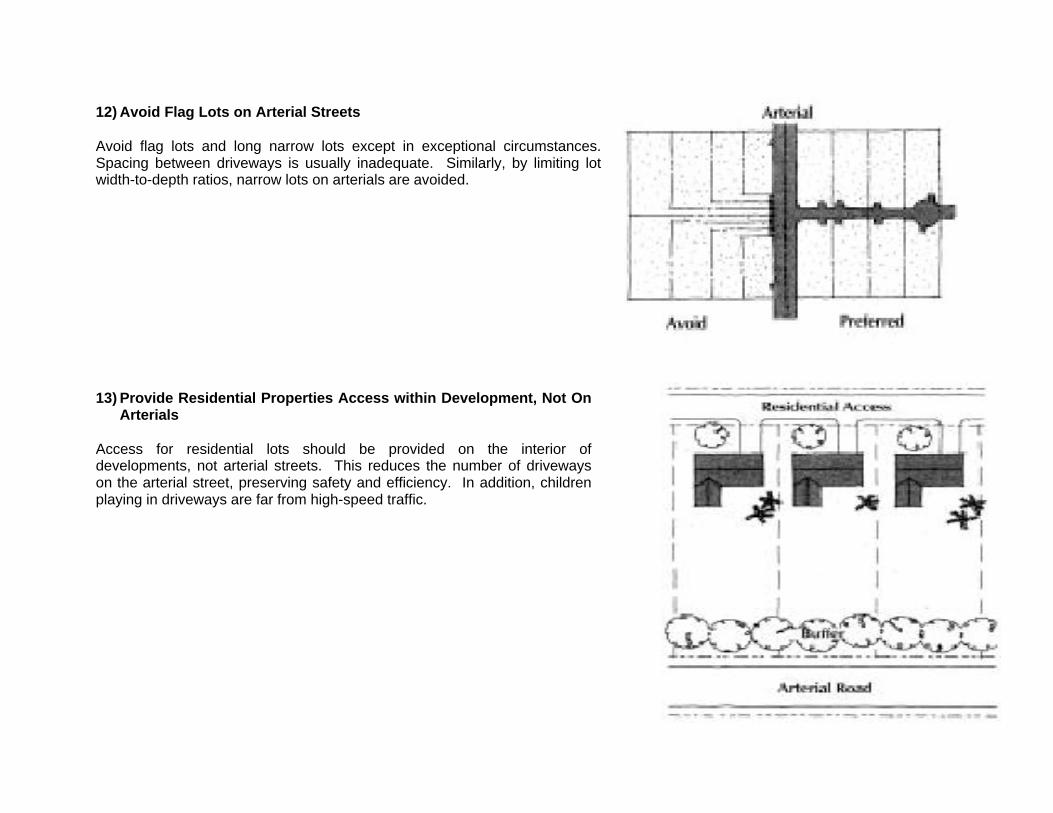
12) Avoid Flag Lots on Arterial Streets
Avoid flag lots and long narrow lots except in exceptional circumstances.Spacing between driveways is usually inadequate. Similarly, by limiting lotwidth-to-depth ratios, narrow lots on arterials are avoided.
13) Provide Residential Properties Access within Development, Not OnArterials
Access for residential lots should be provided on the interior ofdevelopments, not arterial streets. This reduces the number of drivewayson the arterial street, preserving safety and efficiency. In addition, childrenplaying in driveways are far from high-speed traffic.

14) Require Reviews of All Minor Replats
Provide for local planning department review of all minor splits or replats oflots. Little by little arterial streets become lined with driveways from smalldivisions of properties. By reviewing all minor splits and shared drivewayscan be encouraged.
BENEFITS OF INCLUDING TRANSPORTATION FACILITIES IN LOCAL LAND USE DECISIONS
The benefits of including transportation in comprehensive planning, corridor preservation, access management, andsubdivision regulations and site review standards are multiple:
• Congestion is reduced.• Options for future transit are created.• The need for capacity improvements is reduced before the end of a road's planned lifetime.• Roadway maintenance is facilitated.• Community image and business climate are enhanced by a good transportation system.• Routes for services such as garbage pick-up are shorter.• School bus routes are shorter and safer.• Emergency service response times are shorter. • Improve safety for automobiles, bicycles and pedestrians by reducing accidents.
Many communities are affected by the problems of strip commercial development, haphazard residential developments andthe traffic problems associated with them. Planning ahead for transportation facilities in local land use decisions has great assets,particularly, improved safety for citizens, and mitigates many of the problems associated with retrofitting transportation systems toland uses.
For More Information
The National Transportation Libraryhttp://www.bts.gov/NTL/
Access Management: A Policy for Local Communities, March, 1988, Prepared by the Ohio-Kentucky-Indiana Regional Council ofGovernmentshttp://www.bts.gov/ntl/data/plan-policy/access/00221.html
Access Management Classification and Spacing Standards, prepared forOregon Department of Transportation, by Robert D. Layton, Oregon State University, Department of Civil, Construction, andEnvironmental Engineering, and Vergil Stover, Consultant, 08/23/96http://www.bts.gov/ntl/data/plan-policy/access/00241.pdf
Arterial Street Access Control Study CAPITAL AREA REGIONAL TRANSPORTATION STUDY (CARTS)TECHNICAL COMMITTEE http://www.bts.gov/ntl/data/plan-policy/access/00222.html
Corridor Preservation and Access Management Guidance, Wisconsin Department of Transportation, January, 1994http://www.bts.gov/ntl/data/plan-policy/access/00223.html - size 49.6K
Land Development and Subdivision Regulations that Support Access Management (PDF file) [Served by Center for UrbanTransportation Research - University of South Florida] http://www.cutr.eng.usf.edu/research/land_dev.pdf
Model Land Development and Subdivision Regulations that Support Access Managementhttp://www.cutr.eng.usf.edu/research/land_reg.pdf
Oregon Department of Transportation—Access Management Overview [Served by Oregon Department of Transportation]http://www.odot.state.or.us/access2000.htm
Center for Transportation Research, University of South Florida http://www.cutr.eng.usf.edu
Ten Ways to Manage Roadway Access in Your Community, Center for Urban Transportation Researchhttp://www.cutr.eng.usf.edu/research/10ways.pdf
The Bike Federation
http://www.bikefed.org/design.htmhttp://www.bikefed.org/isteanews.htmhttp://www.bikefed.org/PDF/Select.PDF
Transportation for Livable Communities Networkhttp://www.tlcnetwork.org/
Planners Web, Planning Commissioners Journalhttp://www.plannersweb.com/access/accintro.html
Wisconsin Bicycle Planning Guidance, Wisconsin DOThttp://www.bts.gov/ntl/DOCS/wbpg.html
Costs for the State Bicycle Transportation and Pedestrian Walkways Plan, Washington State DOT,http://www.wsdot.wa.gov/ppsc/planning/pdf/bicycle.pdf
1998 FHWA Report: Implementing Bicycle Improvements at the Local Levelhttp://www.bikefed.org/local.htm
More Lanes Better? Not Necessarily by Alan Sipress, Washington Post, January 13, 2000http://www.washingtonpost.com/wp-srv/Wplate/2000-01/13/2201-011300-idx.html
http://www.accessmanagement.com
Center for Transportation Research and Education, Iowa State Universityhttp://www.ctre.iastate.edu