Embed Size (px)
Citation preview
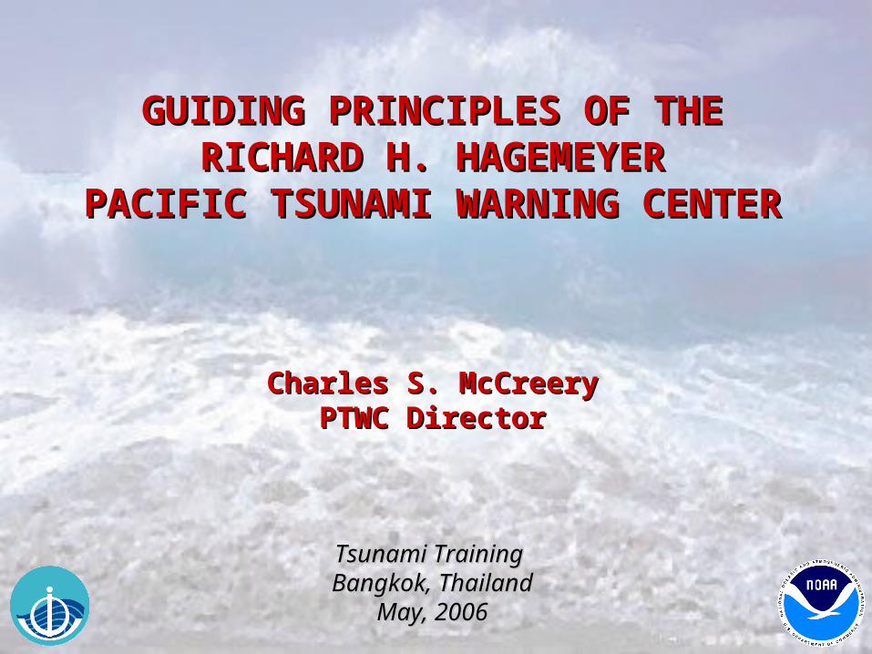
GUIDING PRINCIPLES OF THEGUIDING PRINCIPLES OF THERICHARD H. HAGEMEYERRICHARD H. HAGEMEYER
PACIFIC TSUNAMI WARNING CENTERPACIFIC TSUNAMI WARNING CENTER
Charles S. McCreeryCharles S. McCreeryPTWC DirectorPTWC Director
Tsunami Training Tsunami Training Bangkok, ThailandBangkok, Thailand
May, 2006May, 2006
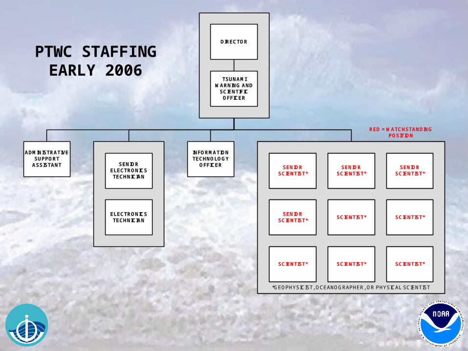
DIRECTOR
ADMINISTRATIVESUPPORT
ASSISTANT SENIORELECTRONICSTECHNICIAN
ELECTRONICSTECHNICIAN
SENIORSCIENTIST*
SCIENTIST*
SENIORSCIENTIST*
SENIORSCIENTIST*
SCIENTIST*
SCIENTIST*
SENIORSCIENTIST*
SCIENTIST*
TSUNAMIWARNING AND
SCIENTIFICOFFICER
INFORMATIONTECHNOLOGY
OFFICER
SCIENTIST*
*GEOPHYSICIST, OCEANOGRAPHER, OR PHYSICAL SCIENTIST
RED = WATCHSTANDINGPOSITION
PTWC STAFFING EARLY 2006
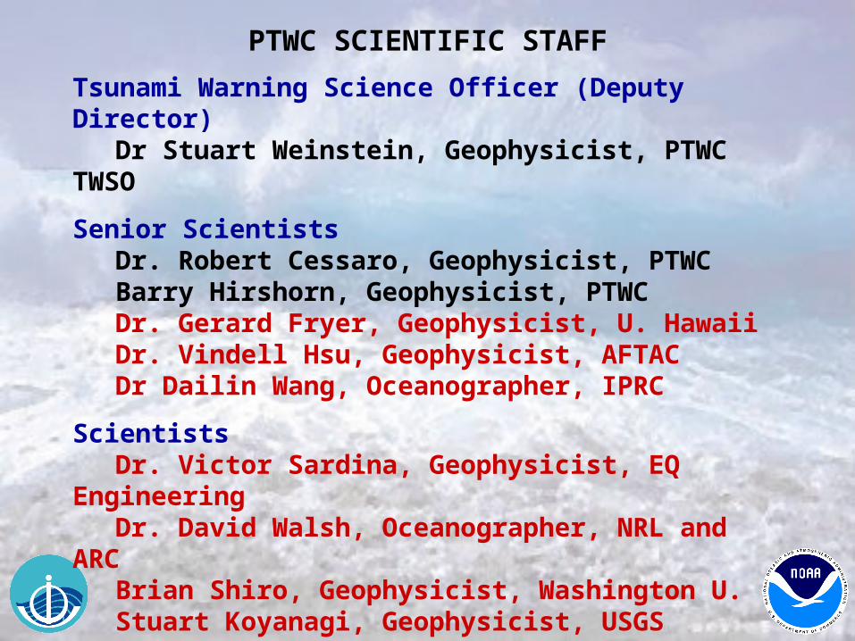
PTWC SCIENTIFIC STAFF
Tsunami Warning Science Officer (Deputy Director)Dr Stuart Weinstein, Geophysicist, PTWC TWSO
Senior ScientistsDr. Robert Cessaro, Geophysicist, PTWC
Barry Hirshorn, Geophysicist, PTWC Dr. Gerard Fryer, Geophysicist, U. Hawaii Dr. Vindell Hsu, Geophysicist, AFTAC Dr Dailin Wang, Oceanographer, IPRC
ScientistsDr. Victor Sardina, Geophysicist, EQ Engineering
Dr. David Walsh, Oceanographer, NRL and ARC Brian Shiro, Geophysicist, Washington U. Stuart Koyanagi, Geophysicist, USGS
Information Technology OfficerDr. Nathan Becker, Oceanographer, U. Hawaii
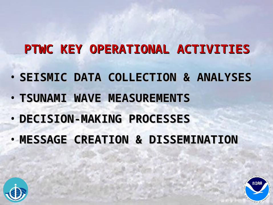
PTWC KEY OPERATIONAL ACTIVITIESPTWC KEY OPERATIONAL ACTIVITIES
• SEISMIC DATA COLLECTION & ANALYSESSEISMIC DATA COLLECTION & ANALYSES
• TSUNAMI WAVE MEASUREMENTSTSUNAMI WAVE MEASUREMENTS
• DECISION-MAKING PROCESSESDECISION-MAKING PROCESSES
• MESSAGE CREATION & DISSEMINATIONMESSAGE CREATION & DISSEMINATION
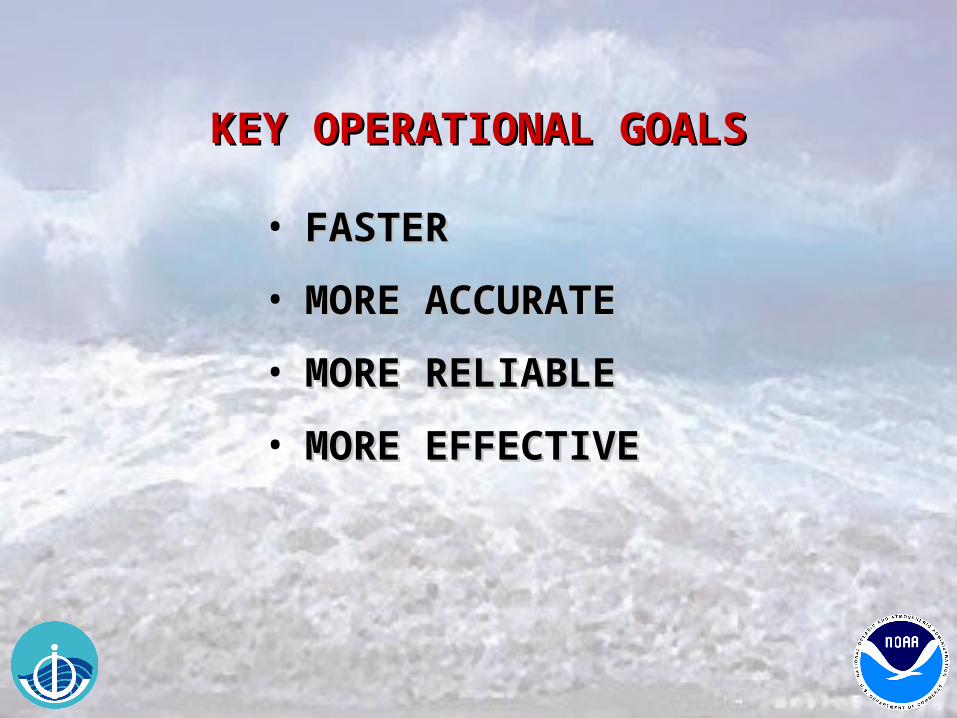
KEY OPERATIONAL GOALSKEY OPERATIONAL GOALS
• FASTERFASTER
• MORE ACCURATEMORE ACCURATE
• MORE RELIABLEMORE RELIABLE
• MORE EFFECTIVEMORE EFFECTIVE
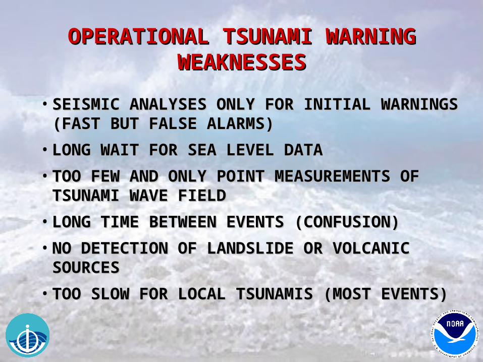
OPERATIONAL TSUNAMI WARNING OPERATIONAL TSUNAMI WARNING WEAKNESSESWEAKNESSES
• SEISMIC ANALYSES ONLY FOR INITIAL WARNINGS SEISMIC ANALYSES ONLY FOR INITIAL WARNINGS (FAST BUT FALSE ALARMS)(FAST BUT FALSE ALARMS)
• LONG WAIT FOR SEA LEVEL DATALONG WAIT FOR SEA LEVEL DATA
• TOO FEW AND ONLY POINT MEASUREMENTS OF TOO FEW AND ONLY POINT MEASUREMENTS OF TSUNAMI WAVE FIELDTSUNAMI WAVE FIELD
• LONG TIME BETWEEN EVENTS (CONFUSION)LONG TIME BETWEEN EVENTS (CONFUSION)
• NO DETECTION OF LANDSLIDE OR VOLCANIC NO DETECTION OF LANDSLIDE OR VOLCANIC SOURCESSOURCES
• TOO SLOW FOR LOCAL TSUNAMIS (MOST EVENTS)TOO SLOW FOR LOCAL TSUNAMIS (MOST EVENTS)
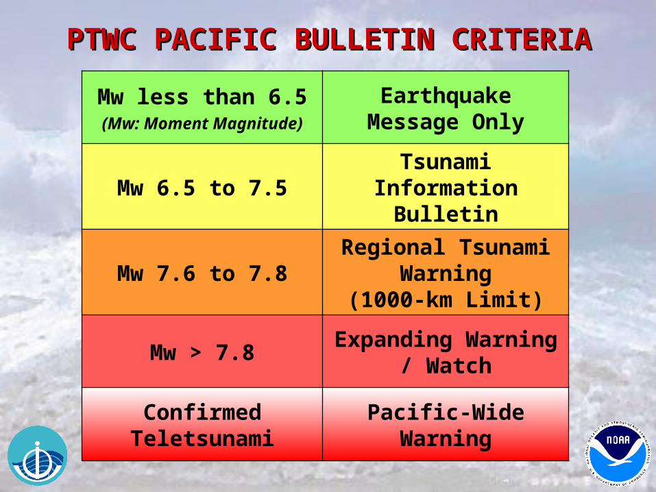
Mw less than 6.5(Mw: Moment Magnitude)
Earthquake Message Only
Mw 6.5 to 7.5Tsunami Information
Bulletin
Mw 7.6 to 7.8Regional Tsunami
Warning(1000-km Limit)
Mw > 7.8Expanding Warning /
Watch
Confirmed Teletsunami
Pacific-Wide Warning
PTWC PACIFIC BULLETIN CRITERIAPTWC PACIFIC BULLETIN CRITERIA
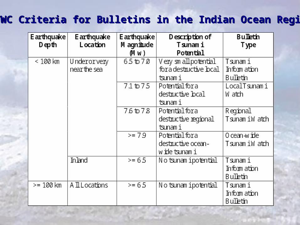
PTWC Criteria for Bulletins in the Indian Ocean RegionPTWC Criteria for Bulletins in the Indian Ocean Region
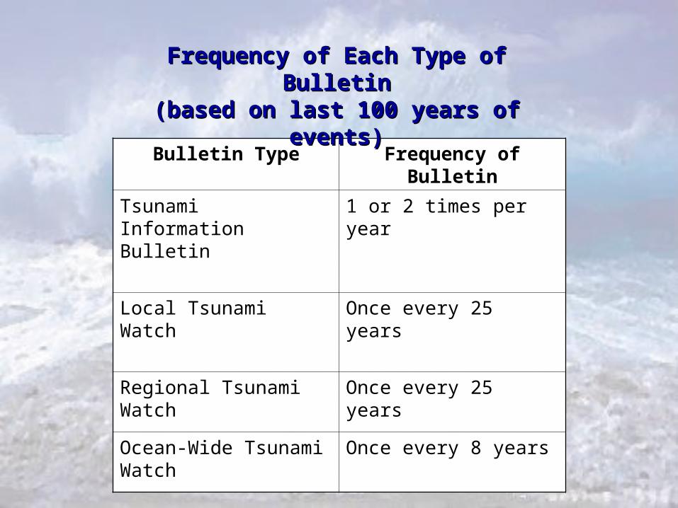
Bulletin Type Frequency of Bulletin
Tsunami Information Bulletin
1 or 2 times per year
Local Tsunami Watch Once every 25 years
Regional Tsunami Watch Once every 25 years
Ocean-Wide Tsunami Watch
Once every 8 years
Frequency of Each Type of BulletinFrequency of Each Type of Bulletin(based on last 100 years of events)(based on last 100 years of events)
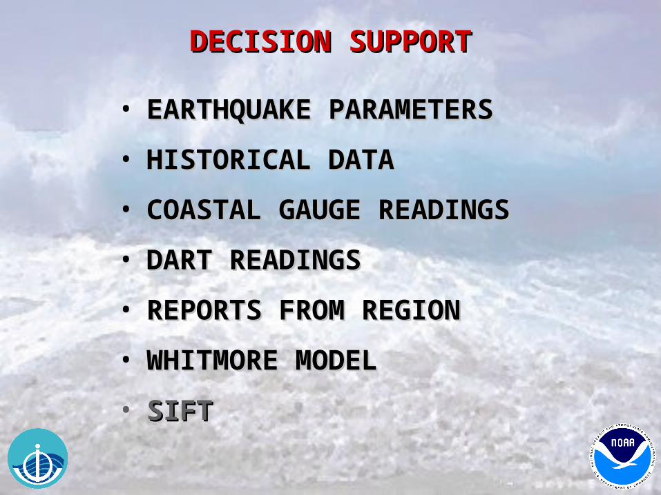
DECISION SUPPORTDECISION SUPPORT
• EARTHQUAKE PARAMETERSEARTHQUAKE PARAMETERS
• HISTORICAL DATAHISTORICAL DATA
• COASTAL GAUGE READINGSCOASTAL GAUGE READINGS
• DART READINGSDART READINGS
• REPORTS FROM REGIONREPORTS FROM REGION
• WHITMORE MODELWHITMORE MODEL
• SIFTSIFT
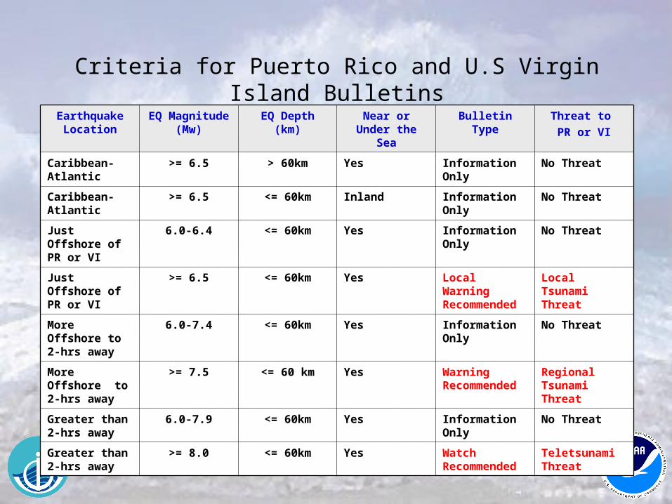
Earthquake Location
EQ Magnitude (Mw)
EQ Depth (km) Near or Under the Sea
Bulletin Type Threat to
PR or VI
Caribbean-Atlantic
>= 6.5 > 60km Yes Information Only
No Threat
Caribbean-Atlantic
>= 6.5 <= 60km Inland Information Only
No Threat
Just Offshore of PR or VI
6.0-6.4 <= 60km Yes Information Only
No Threat
Just Offshore of PR or VI
>= 6.5 <= 60km Yes Local Warning Recommended
Local Tsunami Threat
More Offshore to 2-hrs away
6.0-7.4 <= 60km Yes Information Only
No Threat
More Offshore to 2-hrs away
>= 7.5 <= 60 km Yes Warning Recommended
Regional Tsunami Threat
Greater than 2-hrs away
6.0-7.9 <= 60km Yes Information Only
No Threat
Greater than 2-hrs away
>= 8.0 <= 60km Yes Watch Recommended
Teletsunami Threat
Criteria for Puerto Rico and U.S Virgin Island Bulletins
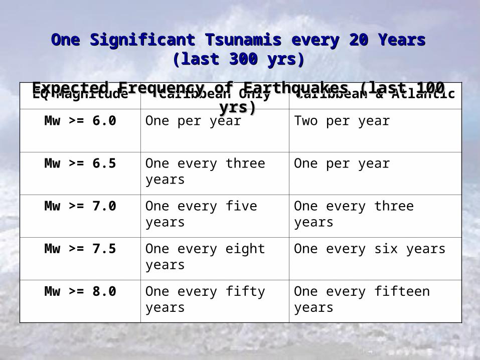
EQ Magnitude Caribbean Only Caribbean & Atlantic
Mw >= 6.0 One per year Two per year
Mw >= 6.5 One every three years One per year
Mw >= 7.0 One every five years One every three years
Mw >= 7.5 One every eight years One every six years
Mw >= 8.0 One every fifty years One every fifteen years
One Significant Tsunamis every 20 Years (last 300 yrs)One Significant Tsunamis every 20 Years (last 300 yrs)
Expected Frequency of Earthquakes (last 100 yrs)Expected Frequency of Earthquakes (last 100 yrs)
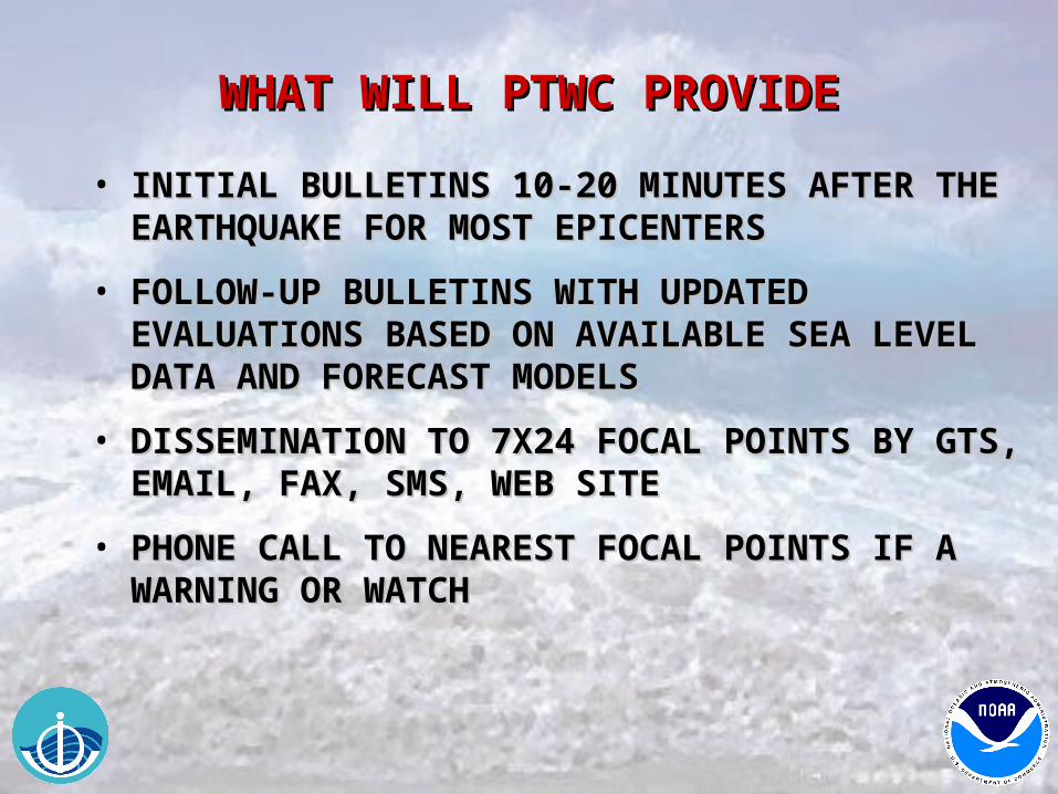
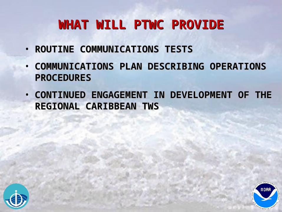
WHAT WILL PTWC PROVIDEWHAT WILL PTWC PROVIDE
• INITIAL BULLETINS 10-20 MINUTES AFTER THE INITIAL BULLETINS 10-20 MINUTES AFTER THE EARTHQUAKE FOR MOST EPICENTERSEARTHQUAKE FOR MOST EPICENTERS
• FOLLOW-UP BULLETINS WITH UPDATED FOLLOW-UP BULLETINS WITH UPDATED EVALUATIONS BASED ON AVAILABLE SEA LEVEL EVALUATIONS BASED ON AVAILABLE SEA LEVEL DATA AND FORECAST MODELS DATA AND FORECAST MODELS
• DISSEMINATION TO 7X24 FOCAL POINTS BY GTS, DISSEMINATION TO 7X24 FOCAL POINTS BY GTS, EMAIL, FAX, SMS, WEB SITEEMAIL, FAX, SMS, WEB SITE
• PHONE CALL TO NEAREST FOCAL POINTS IF A PHONE CALL TO NEAREST FOCAL POINTS IF A WARNING OR WATCHWARNING OR WATCH
WHAT WILL PTWC PROVIDEWHAT WILL PTWC PROVIDE
• ROUTINE COMMUNICATIONS TESTSROUTINE COMMUNICATIONS TESTS
• COMMUNICATIONS PLAN DESCRIBING COMMUNICATIONS PLAN DESCRIBING OPERATIONS PROCEDURESOPERATIONS PROCEDURES
• CONTINUED ENGAGEMENT IN DEVELOPMENT OF CONTINUED ENGAGEMENT IN DEVELOPMENT OF THE REGIONAL CARIBBEAN TWSTHE REGIONAL CARIBBEAN TWS
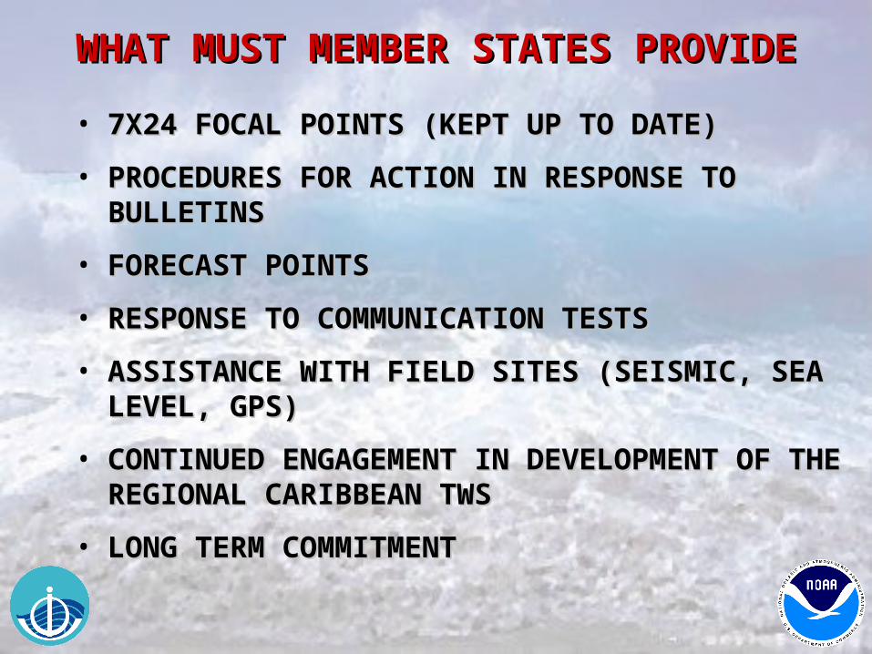
WHAT MUST MEMBER STATES PROVIDEWHAT MUST MEMBER STATES PROVIDE
• 7X24 FOCAL POINTS (KEPT UP TO DATE)7X24 FOCAL POINTS (KEPT UP TO DATE)
• PROCEDURES FOR ACTION IN RESPONSE TO PROCEDURES FOR ACTION IN RESPONSE TO BULLETINSBULLETINS
• FORECAST POINTSFORECAST POINTS
• RESPONSE TO COMMUNICATION TESTSRESPONSE TO COMMUNICATION TESTS
• ASSISTANCE WITH FIELD SITES (SEISMIC, SEA ASSISTANCE WITH FIELD SITES (SEISMIC, SEA LEVEL, GPS)LEVEL, GPS)
• CONTINUED ENGAGEMENT IN DEVELOPMENT OF CONTINUED ENGAGEMENT IN DEVELOPMENT OF THE REGIONAL CARIBBEAN TWSTHE REGIONAL CARIBBEAN TWS
• LONG TERM COMMITMENTLONG TERM COMMITMENT
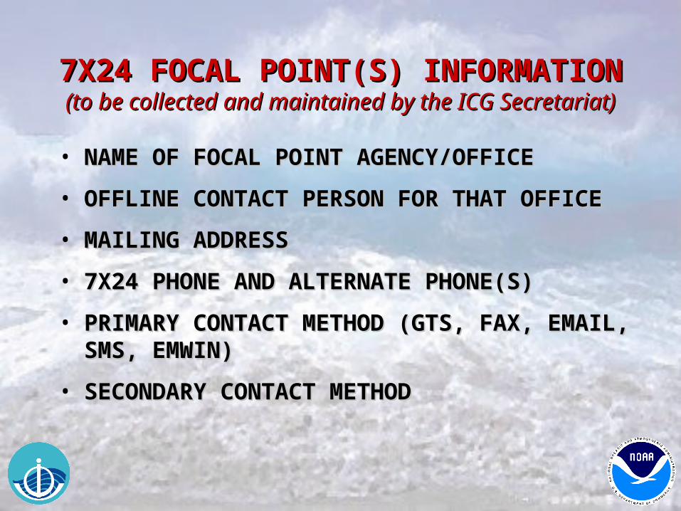
7X24 FOCAL POINT(S) INFORMATION7X24 FOCAL POINT(S) INFORMATION(to be collected and maintained by the ICG Secretariat)(to be collected and maintained by the ICG Secretariat)
• NAME OF FOCAL POINT AGENCY/OFFICENAME OF FOCAL POINT AGENCY/OFFICE
• OFFLINE CONTACT PERSON FOR THAT OFFICEOFFLINE CONTACT PERSON FOR THAT OFFICE
• MAILING ADDRESSMAILING ADDRESS
• 7X24 PHONE AND ALTERNATE PHONE(S)7X24 PHONE AND ALTERNATE PHONE(S)
• PRIMARY CONTACT METHOD (GTS, FAX, EMAIL, PRIMARY CONTACT METHOD (GTS, FAX, EMAIL, SMS, EMWIN)SMS, EMWIN)
• SECONDARY CONTACT METHODSECONDARY CONTACT METHOD
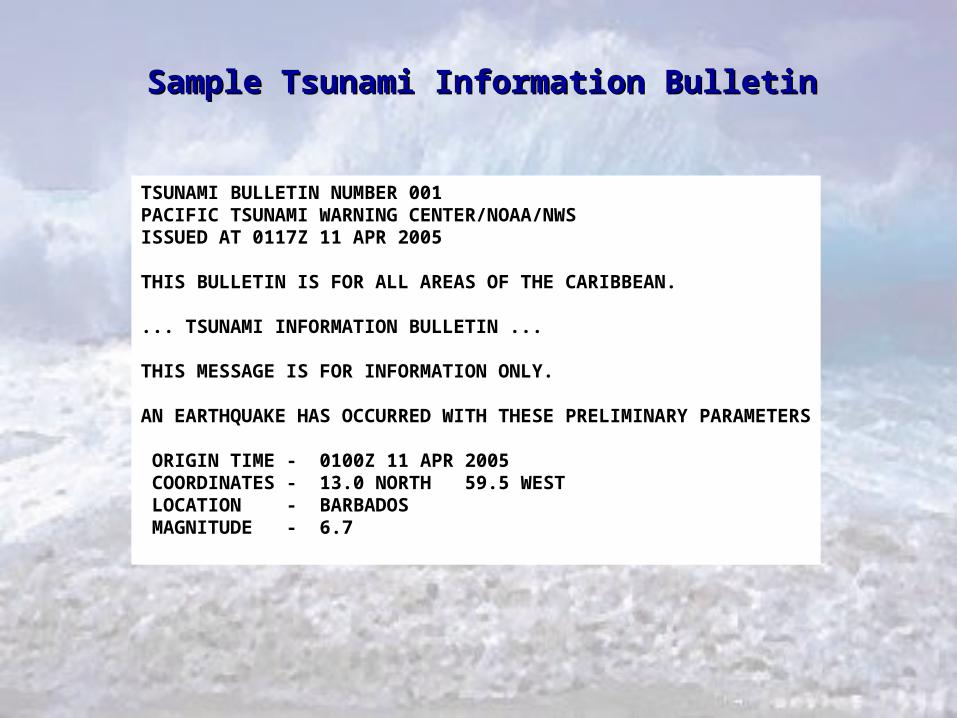
TSUNAMI BULLETIN NUMBER 001PACIFIC TSUNAMI WARNING CENTER/NOAA/NWSISSUED AT 0117Z 11 APR 2005
THIS BULLETIN IS FOR ALL AREAS OF THE CARIBBEAN.
... TSUNAMI INFORMATION BULLETIN ...
THIS MESSAGE IS FOR INFORMATION ONLY.
AN EARTHQUAKE HAS OCCURRED WITH THESE PRELIMINARY PARAMETERS
ORIGIN TIME - 0100Z 11 APR 2005 COORDINATES - 13.0 NORTH 59.5 WEST LOCATION - BARBADOS MAGNITUDE - 6.7
Sample Tsunami Information BulletinSample Tsunami Information Bulletin
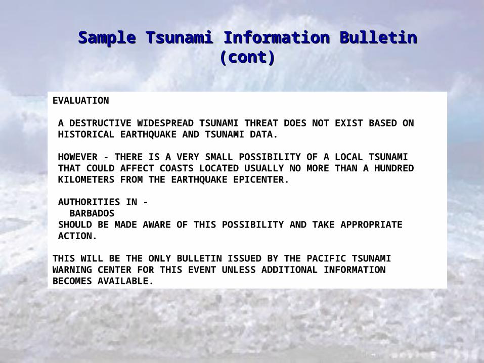
EVALUATION
A DESTRUCTIVE WIDESPREAD TSUNAMI THREAT DOES NOT EXIST BASED ON HISTORICAL EARTHQUAKE AND TSUNAMI DATA. HOWEVER - THERE IS A VERY SMALL POSSIBILITY OF A LOCAL TSUNAMI THAT COULD AFFECT COASTS LOCATED USUALLY NO MORE THAN A HUNDRED KILOMETERS FROM THE EARTHQUAKE EPICENTER.
AUTHORITIES IN - BARBADOS SHOULD BE MADE AWARE OF THIS POSSIBILITY AND TAKE APPROPRIATE ACTION. THIS WILL BE THE ONLY BULLETIN ISSUED BY THE PACIFIC TSUNAMIWARNING CENTER FOR THIS EVENT UNLESS ADDITIONAL INFORMATIONBECOMES AVAILABLE.
Sample Tsunami Information Bulletin (cont)Sample Tsunami Information Bulletin (cont)
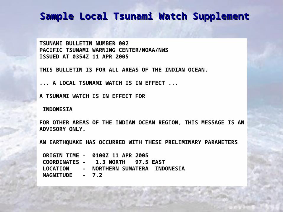
TSUNAMI BULLETIN NUMBER 002PACIFIC TSUNAMI WARNING CENTER/NOAA/NWSISSUED AT 0354Z 11 APR 2005
THIS BULLETIN IS FOR ALL AREAS OF THE INDIAN OCEAN.
... A LOCAL TSUNAMI WATCH IS IN EFFECT ...
A TSUNAMI WATCH IS IN EFFECT FOR
INDONESIA
FOR OTHER AREAS OF THE INDIAN OCEAN REGION, THIS MESSAGE IS ANADVISORY ONLY.
AN EARTHQUAKE HAS OCCURRED WITH THESE PRELIMINARY PARAMETERS
ORIGIN TIME - 0100Z 11 APR 2005 COORDINATES - 1.3 NORTH 97.5 EAST LOCATION - NORTHERN SUMATERA INDONESIA MAGNITUDE - 7.2
Sample Local Tsunami Watch SupplementSample Local Tsunami Watch Supplement
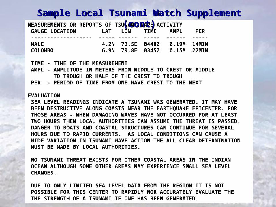
MEASUREMENTS OR REPORTS OF TSUNAMI WAVE ACTIVITY GAUGE LOCATION LAT LON TIME AMPL PER ------------------- ----- ------ ----- ------ ----- MALE 4.2N 73.5E 0448Z 0.19M 14MIN COLOMBO 6.9N 79.8E 0345Z 0.15M 22MIN TIME - TIME OF THE MEASUREMENT AMPL - AMPLITUDE IN METERS FROM MIDDLE TO CREST OR MIDDLE TO TROUGH OR HALF OF THE CREST TO TROUGH PER - PERIOD OF TIME FROM ONE WAVE CREST TO THE NEXT
EVALUATION SEA LEVEL READINGS INDICATE A TSUNAMI WAS GENERATED. IT MAY HAVE BEEN DESTRUCTIVE ALONG COASTS NEAR THE EARTHQUAKE EPICENTER. FOR THOSE AREAS - WHEN DAMAGING WAVES HAVE NOT OCCURRED FOR AT LEAST TWO HOURS THEN LOCAL AUTHORITIES CAN ASSUME THE THREAT IS PASSED. DANGER TO BOATS AND COASTAL STRUCTURES CAN CONTINUE FOR SEVERAL HOURS DUE TO RAPID CURRENTS. AS LOCAL CONDITIONS CAN CAUSE A WIDE VARIATION IN TSUNAMI WAVE ACTION THE ALL CLEAR DETERMINATION MUST BE MADE BY LOCAL AUTHORITIES. NO TSUNAMI THREAT EXISTS FOR OTHER COASTAL AREAS IN THE INDIAN OCEAN ALTHOUGH SOME OTHER AREAS MAY EXPERIENCE SMALL SEA LEVEL CHANGES. DUE TO ONLY LIMITED SEA LEVEL DATA FROM THE REGION IT IS NOT POSSIBLE FOR THIS CENTER TO RAPIDLY NOR ACCURATELY EVALUATE THE THE STRENGTH OF A TSUNAMI IF ONE HAS BEEN GENERATED.
Sample Local Tsunami Watch Supplement (cont)Sample Local Tsunami Watch Supplement (cont)
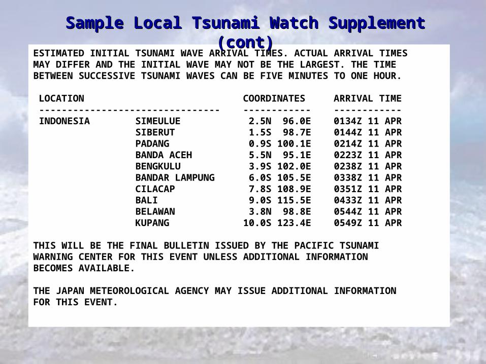
ESTIMATED INITIAL TSUNAMI WAVE ARRIVAL TIMES. ACTUAL ARRIVAL TIMESMAY DIFFER AND THE INITIAL WAVE MAY NOT BE THE LARGEST. THE TIMEBETWEEN SUCCESSIVE TSUNAMI WAVES CAN BE FIVE MINUTES TO ONE HOUR.
LOCATION COORDINATES ARRIVAL TIME -------------------------------- ------------ ------------ INDONESIA SIMEULUE 2.5N 96.0E 0134Z 11 APR SIBERUT 1.5S 98.7E 0144Z 11 APR PADANG 0.9S 100.1E 0214Z 11 APR BANDA ACEH 5.5N 95.1E 0223Z 11 APR BENGKULU 3.9S 102.0E 0238Z 11 APR BANDAR LAMPUNG 6.0S 105.5E 0338Z 11 APR CILACAP 7.8S 108.9E 0351Z 11 APR BALI 9.0S 115.5E 0433Z 11 APR BELAWAN 3.8N 98.8E 0544Z 11 APR KUPANG 10.0S 123.4E 0549Z 11 APR
THIS WILL BE THE FINAL BULLETIN ISSUED BY THE PACIFIC TSUNAMIWARNING CENTER FOR THIS EVENT UNLESS ADDITIONAL INFORMATIONBECOMES AVAILABLE.
THE JAPAN METEOROLOGICAL AGENCY MAY ISSUE ADDITIONAL INFORMATIONFOR THIS EVENT.
Sample Local Tsunami Watch Supplement (cont)Sample Local Tsunami Watch Supplement (cont)
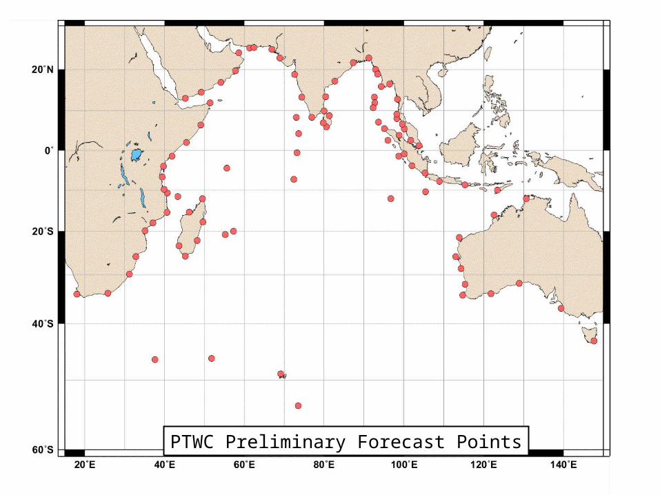
PTWC Preliminary Forecast Points
FORECAST POINTSFORECAST POINTS
• USED TO DETERMINE IF AN AREA IS IN A WATCHUSED TO DETERMINE IF AN AREA IS IN A WATCH
• TSUNAMI ETA’S FOR FORECAST POINTS GIVEN IN TSUNAMI ETA’S FOR FORECAST POINTS GIVEN IN BULLETINS IF AREA IS IN A WATCHBULLETINS IF AREA IS IN A WATCH
• PRELIMINARY ONES TAKEN FROM ATLAS – NEEDS PRELIMINARY ONES TAKEN FROM ATLAS – NEEDS REVIEW BY MEMBER STATESREVIEW BY MEMBER STATES
• SHOULD BE RECOGNIZABLE PLACESSHOULD BE RECOGNIZABLE PLACES
• NEED ADEQUATE COVERAGE OF COASTS - ONE NEED ADEQUATE COVERAGE OF COASTS - ONE EVERY FEW HUNDRED KILOMETERSEVERY FEW HUNDRED KILOMETERS
• NOT TOO MANY OR BULLETINS TOO LONGNOT TOO MANY OR BULLETINS TOO LONG
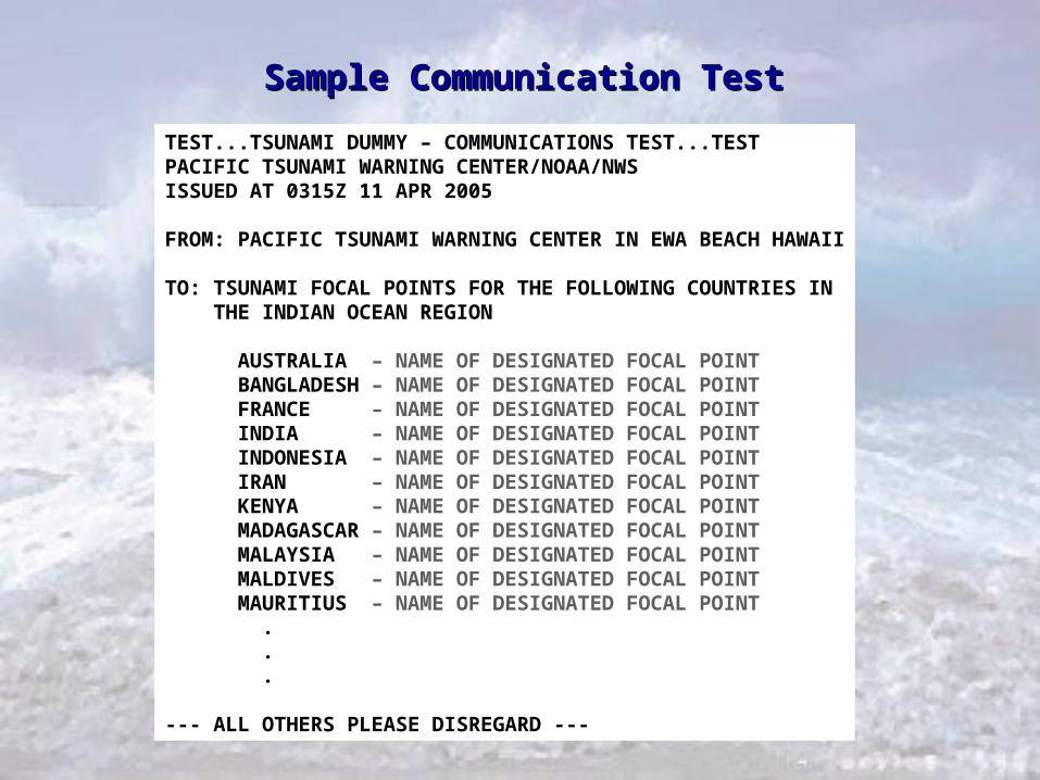
TEST...TSUNAMI DUMMY – COMMUNICATIONS TEST...TESTPACIFIC TSUNAMI WARNING CENTER/NOAA/NWSISSUED AT 0315Z 11 APR 2005
FROM: PACIFIC TSUNAMI WARNING CENTER IN EWA BEACH HAWAII
TO: TSUNAMI FOCAL POINTS FOR THE FOLLOWING COUNTRIES IN THE INDIAN OCEAN REGION
AUSTRALIA – NAME OF DESIGNATED FOCAL POINT BANGLADESH – NAME OF DESIGNATED FOCAL POINT FRANCE – NAME OF DESIGNATED FOCAL POINT INDIA – NAME OF DESIGNATED FOCAL POINT INDONESIA – NAME OF DESIGNATED FOCAL POINT IRAN – NAME OF DESIGNATED FOCAL POINT KENYA – NAME OF DESIGNATED FOCAL POINT MADAGASCAR – NAME OF DESIGNATED FOCAL POINT MALAYSIA – NAME OF DESIGNATED FOCAL POINT MALDIVES – NAME OF DESIGNATED FOCAL POINT MAURITIUS – NAME OF DESIGNATED FOCAL POINT . . .
--- ALL OTHERS PLEASE DISREGARD ---
Sample Communication TestSample Communication Test
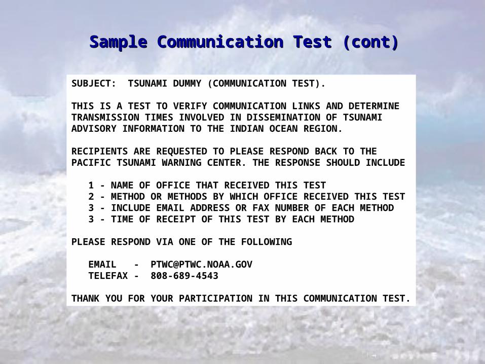
SUBJECT: TSUNAMI DUMMY (COMMUNICATION TEST).
THIS IS A TEST TO VERIFY COMMUNICATION LINKS AND DETERMINETRANSMISSION TIMES INVOLVED IN DISSEMINATION OF TSUNAMI ADVISORY INFORMATION TO THE INDIAN OCEAN REGION.
RECIPIENTS ARE REQUESTED TO PLEASE RESPOND BACK TO THEPACIFIC TSUNAMI WARNING CENTER. THE RESPONSE SHOULD INCLUDE
1 - NAME OF OFFICE THAT RECEIVED THIS TEST 2 - METHOD OR METHODS BY WHICH OFFICE RECEIVED THIS TEST 3 - INCLUDE EMAIL ADDRESS OR FAX NUMBER OF EACH METHOD 3 - TIME OF RECEIPT OF THIS TEST BY EACH METHOD
PLEASE RESPOND VIA ONE OF THE FOLLOWING
EMAIL - [email protected] TELEFAX - 808-689-4543
THANK YOU FOR YOUR PARTICIPATION IN THIS COMMUNICATION TEST.
Sample Communication Test (cont)Sample Communication Test (cont)
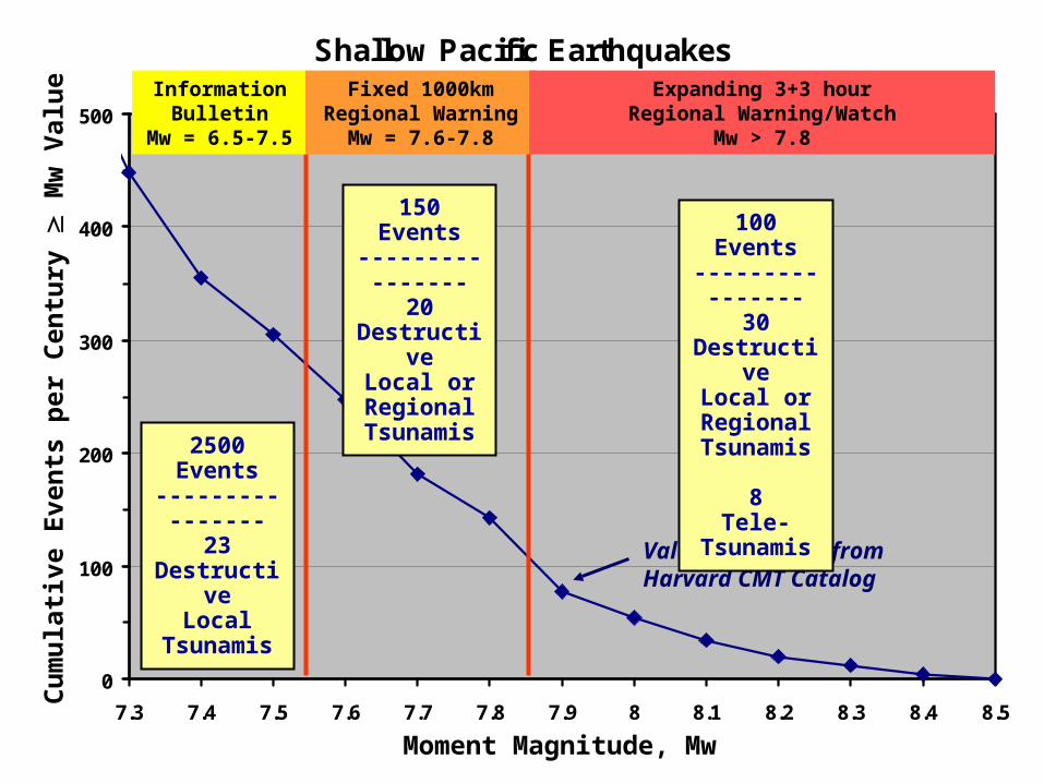
Shallow Pacific Earthquakes
0
100
200
300
400
500
7.3 7.4 7.5 7.6 7.7 7.8 7.9 8 8.1 8.2 8.3 8.4 8.5
Mw
Nu
mb
er
of
Ev
en
ts p
er
Ce
ntu
ry
Values projected from Harvard CMT Catalog
2500 Events
----------------23
DestructiveLocal
Tsunamis
Cu
mu
lati
ve E
ven
ts p
er C
entu
ry
Mw
Val
ue
Moment Magnitude, Mw
Information Bulletin
Mw = 6.5-7.5
Fixed 1000kmRegional Warning
Mw = 7.6-7.8
Expanding 3+3 hourRegional Warning/Watch
Mw > 7.8
150 Events----------------
20 Destructive
Local or Regional Tsunamis
100 Events----------------
30 Destructive
Local or Regional Tsunamis
8Tele-
Tsunamis
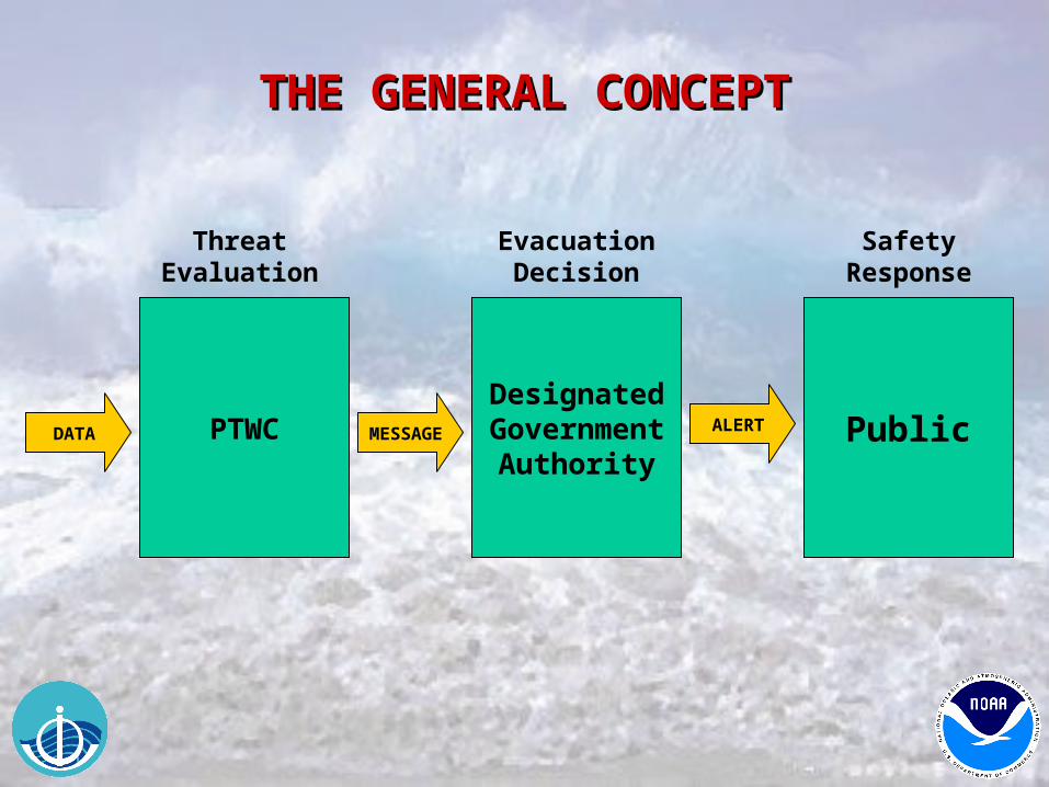
THE GENERAL CONCEPTTHE GENERAL CONCEPT
PTWCDesignatedGovernment
AuthorityPublic
Threat Evaluation
Evacuation Decision
DATA MESSAGE ALERT
Safety Response
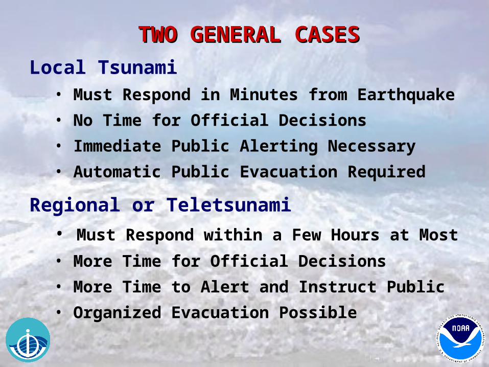
TWO GENERAL CASESTWO GENERAL CASES
Local Tsunami• Must Respond in Minutes from Earthquake
• No Time for Official Decisions
• Immediate Public Alerting Necessary
• Automatic Public Evacuation Required
Regional or Teletsunami
• Must Respond within a Few Hours at Most
• More Time for Official Decisions
• More Time to Alert and Instruct Public
• Organized Evacuation Possible
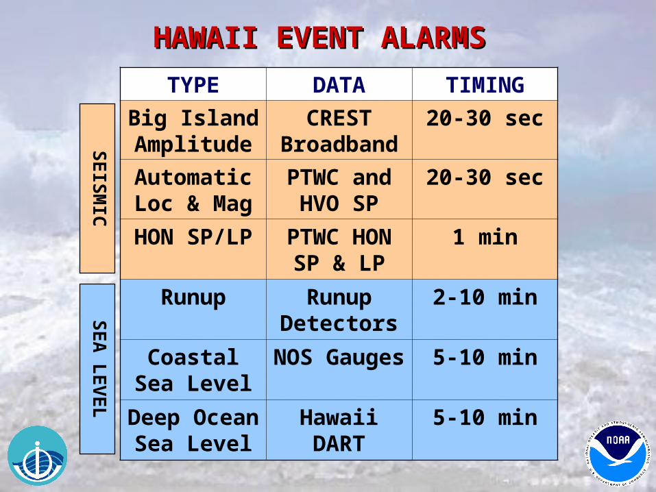
HAWAII EVENT ALARMS HAWAII EVENT ALARMS
TYPE DATA TIMING
Big Island Amplitude
CREST Broadband
20-30 sec
Automatic Loc & Mag
PTWC and HVO SP
20-30 sec
HON SP/LP PTWC HON SP & LP
1 min
Runup Runup Detectors
2-10 min
Coastal Sea Level
NOS Gauges
5-10 min
Deep Ocean Sea Level
Hawaii DART
5-10 min
SE
ISM
ICS
EA
LE
VE
L
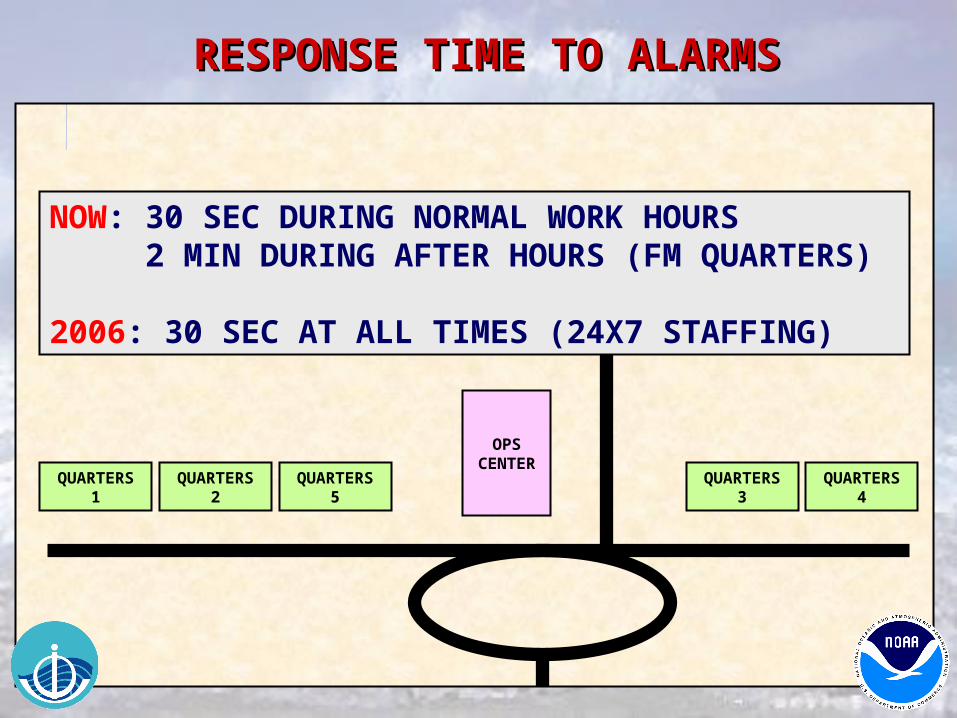
OPSCENTER
QUARTERS1
QUARTERS2
QUARTERS5
QUARTERS3
QUARTERS4
NOW: 30 SEC DURING NORMAL WORK HOURS 2 MIN DURING AFTER HOURS (FM QUARTERS)
2006: 30 SEC AT ALL TIMES (24X7 STAFFING)
RESPONSE TIME TO ALARMSRESPONSE TIME TO ALARMS
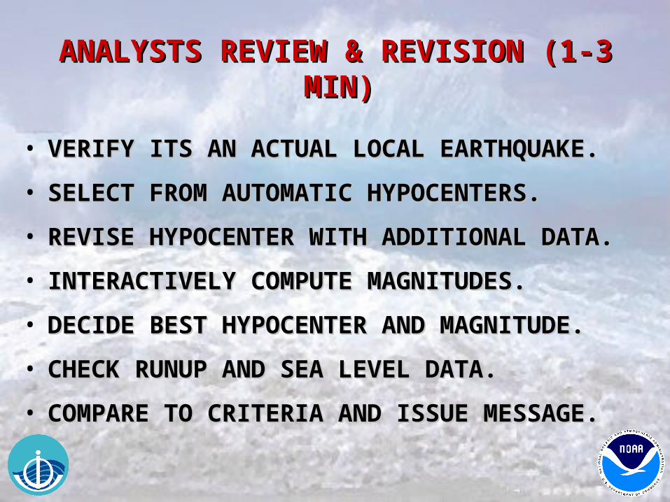
ANALYSTS REVIEW & REVISION (1-3 MIN) ANALYSTS REVIEW & REVISION (1-3 MIN)
• VERIFY ITS AN ACTUAL LOCAL EARTHQUAKE.VERIFY ITS AN ACTUAL LOCAL EARTHQUAKE.
• SELECT FROM AUTOMATIC HYPOCENTERS.SELECT FROM AUTOMATIC HYPOCENTERS.
• REVISE HYPOCENTER WITH ADDITIONAL DATA.REVISE HYPOCENTER WITH ADDITIONAL DATA.
• INTERACTIVELY COMPUTE MAGNITUDES.INTERACTIVELY COMPUTE MAGNITUDES.
• DECIDE BEST HYPOCENTER AND MAGNITUDE.DECIDE BEST HYPOCENTER AND MAGNITUDE.
• CHECK RUNUP AND SEA LEVEL DATA.CHECK RUNUP AND SEA LEVEL DATA.
• COMPARE TO CRITERIA AND ISSUE MESSAGE.COMPARE TO CRITERIA AND ISSUE MESSAGE.
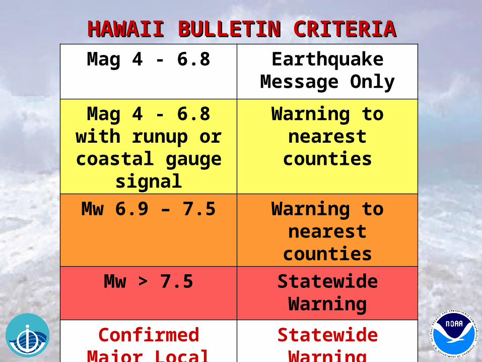
Mag 4 - 6.8 Earthquake Message Only
Mag 4 - 6.8 with runup or coastal
gauge signal
Warning to nearest counties
Mw 6.9 – 7.5 Warning to nearest counties
Mw > 7.5 Statewide Warning
Confirmed Major Local Tsunami
Statewide Warning
HAWAII BULLETIN CRITERIAHAWAII BULLETIN CRITERIA
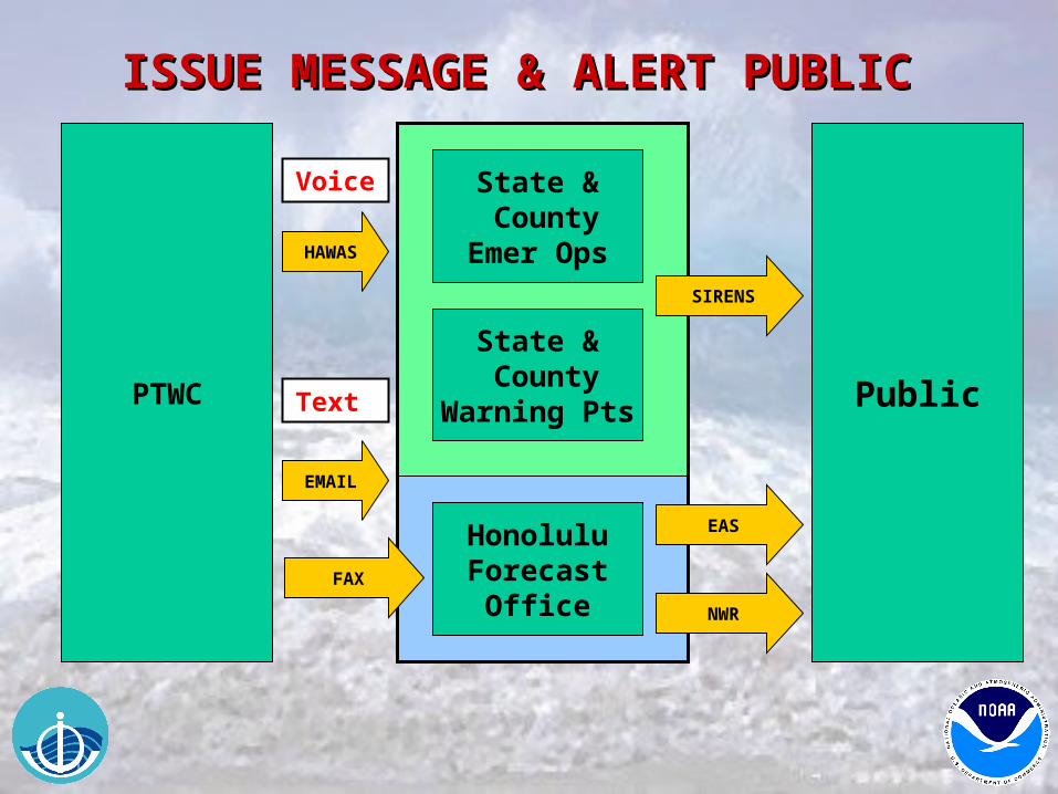
ISSUE MESSAGE & ALERT PUBLIC ISSUE MESSAGE & ALERT PUBLIC
Public
Voice
HAWAS
Text
State & County
Emer Ops
State & County
Warning Pts
HonoluluForecast
OfficeFAX
NWR
SIRENS
EAS
PTWC
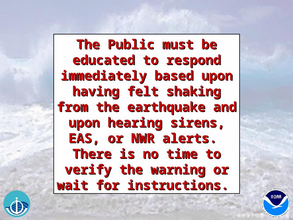
The Public must be The Public must be educated to respond educated to respond
immediately based upon immediately based upon having felt shaking from the having felt shaking from the
earthquake and upon earthquake and upon hearing sirens, EAS, or NWR hearing sirens, EAS, or NWR
alerts. There is no time to alerts. There is no time to verify the warning or wait for verify the warning or wait for
instructions. instructions.
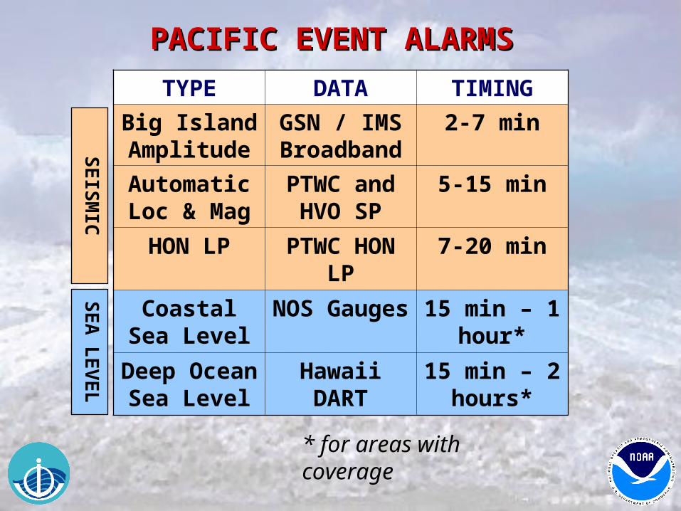
PACIFIC EVENT ALARMS PACIFIC EVENT ALARMS
TYPE DATA TIMING
Big Island Amplitude
GSN / IMS Broadband
2-7 min
Automatic Loc & Mag
PTWC and HVO SP
5-15 min
HON LP PTWC HON LP
7-20 min
Coastal Sea Level
NOS Gauges
15 min – 1 hour*
Deep Ocean Sea Level
Hawaii DART
15 min – 2 hours*
SE
ISM
ICS
EA
LE
VE
L
* for areas with coverage

OPSCENTER
QUARTERS1
QUARTERS2
QUARTERS5
QUARTERS3
QUARTERS4
NOW: 30 SEC DURING NORMAL WORK HOURS 2 MIN DURING AFTER HOURS (FM QUARTERS)
2006: 30 SEC AT ALL TIMES (24X7 STAFFING)
RESPONSE TIME TO ALARMSRESPONSE TIME TO ALARMS
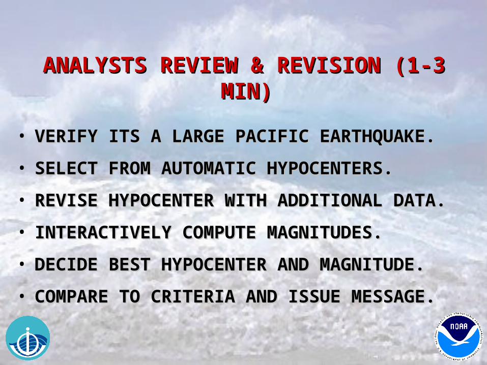
ANALYSTS REVIEW & REVISION (1-3 MIN) ANALYSTS REVIEW & REVISION (1-3 MIN)
• VERIFY ITS A LARGE PACIFIC EARTHQUAKE.VERIFY ITS A LARGE PACIFIC EARTHQUAKE.
• SELECT FROM AUTOMATIC HYPOCENTERS.SELECT FROM AUTOMATIC HYPOCENTERS.
• REVISE HYPOCENTER WITH ADDITIONAL DATA.REVISE HYPOCENTER WITH ADDITIONAL DATA.
• INTERACTIVELY COMPUTE MAGNITUDES.INTERACTIVELY COMPUTE MAGNITUDES.
• DECIDE BEST HYPOCENTER AND MAGNITUDE.DECIDE BEST HYPOCENTER AND MAGNITUDE.
• COMPARE TO CRITERIA AND ISSUE MESSAGE.COMPARE TO CRITERIA AND ISSUE MESSAGE.
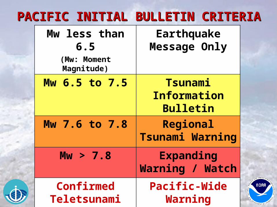
Mw less than 6.5(Mw: Moment Magnitude)
Earthquake Message Only
Mw 6.5 to 7.5 Tsunami Information
Bulletin
Mw 7.6 to 7.8 Regional Tsunami Warning
Mw > 7.8 Expanding Warning / Watch
Confirmed Teletsunami
Pacific-Wide Warning
PACIFIC INITIAL BULLETIN CRITERIAPACIFIC INITIAL BULLETIN CRITERIA
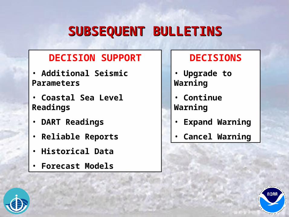
SUBSEQUENT BULLETINSSUBSEQUENT BULLETINS
DECISION SUPPORT
• Additional Seismic Parameters
• Coastal Sea Level Readings
• DART Readings
• Reliable Reports
• Historical Data
• Forecast Models
DECISIONS
• Upgrade to Warning
• Continue Warning
• Expand Warning
• Cancel Warning
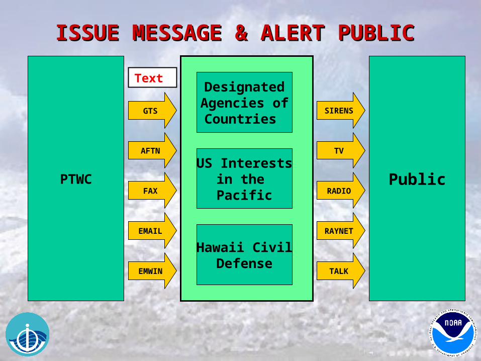
ISSUE MESSAGE & ALERT PUBLIC ISSUE MESSAGE & ALERT PUBLIC
Public
GTS
Text
Hawaii CivilDefense
US Interestsin the Pacific
DesignatedAgencies ofCountries
AFTN
RADIO
SIRENS
TV
PTWCFAX
EMWIN
RAYNET
TALK
Designated Agencies must Designated Agencies must be prepared with an be prepared with an
Operations Plan to respond Operations Plan to respond quickly and alert the public quickly and alert the public
when necessary based upon when necessary based upon the information received the information received
from PTWC and any from PTWC and any supplemental data or supplemental data or information they may information they may
receive. This could include receive. This could include advice from local experts. advice from local experts.
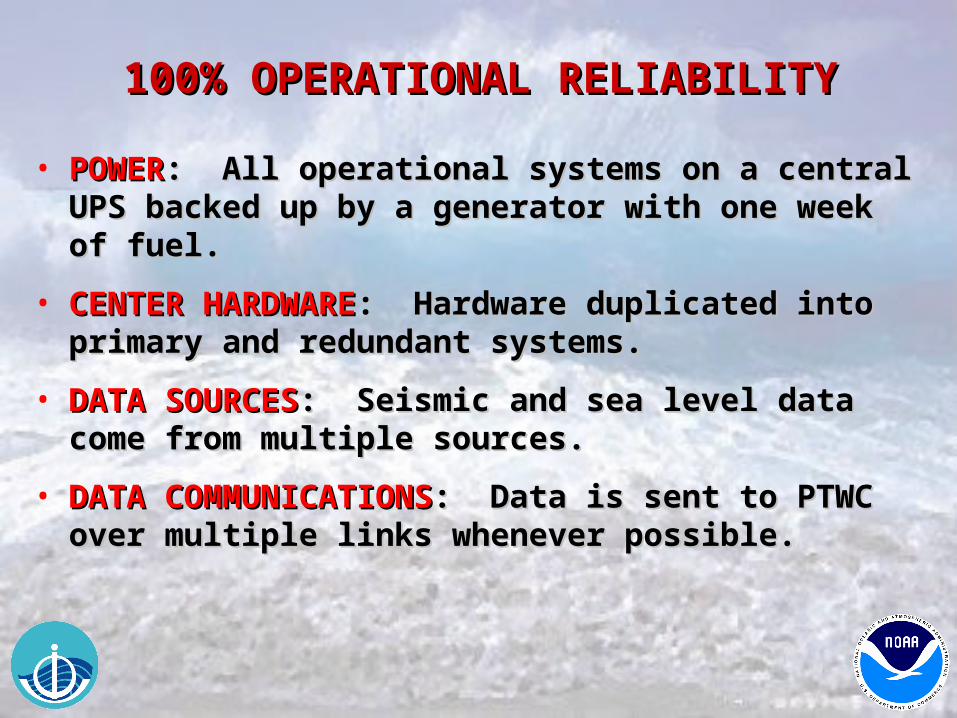
100% OPERATIONAL RELIABILITY100% OPERATIONAL RELIABILITY
• POWERPOWER: All operational systems on a central UPS : All operational systems on a central UPS backed up by a generator with one week of fuel.backed up by a generator with one week of fuel.
• CENTER HARDWARECENTER HARDWARE: Hardware duplicated into : Hardware duplicated into primary and redundant systems. primary and redundant systems.
• DATA SOURCESDATA SOURCES: Seismic and sea level data come from : Seismic and sea level data come from multiple sources. multiple sources.
• DATA COMMUNICATIONSDATA COMMUNICATIONS: Data is sent to PTWC over : Data is sent to PTWC over multiple links whenever possible.multiple links whenever possible.
100% OPERATIONAL RELIABILITY100% OPERATIONAL RELIABILITY
• DATA PROCESSINGDATA PROCESSING: Multiple algorithms for EQ : Multiple algorithms for EQ detection, alerting, locations, magnitudes, and model detection, alerting, locations, magnitudes, and model guidance.guidance.
• MESSAGINGMESSAGING: Multiple dissemination methods to reach : Multiple dissemination methods to reach designated contact points by multiple means.designated contact points by multiple means.
• DUTY PERSONSDUTY PERSONS: Two persons always on duty on the : Two persons always on duty on the Center compound.Center compound.
• BACKUP CENTERBACKUP CENTER: PTWC and WC/ATWC provide : PTWC and WC/ATWC provide backup service for each other.backup service for each other.

LONG TERM SUSTAINABILITYLONG TERM SUSTAINABILITY
• NATIONAL SUPPORTNATIONAL SUPPORT: National commitment to Center : National commitment to Center operations. As a part of the US National Weather operations. As a part of the US National Weather Service, certain resources and expertise are shared with Service, certain resources and expertise are shared with this organization that also does 24x7 monitoring of the this organization that also does 24x7 monitoring of the environment and issues advisories, watches, and environment and issues advisories, watches, and warnings.warnings.
• ORGANIZATIONAL SUPPORTORGANIZATIONAL SUPPORT: Organizations of : Organizations of stakeholders such as ITSU (international), NTHMP stakeholders such as ITSU (international), NTHMP (national), and TTRC (local) that include emergency (national), and TTRC (local) that include emergency managers, warning center operators, and scientists managers, warning center operators, and scientists provide authoritative sustained focus on tsunami provide authoritative sustained focus on tsunami issues.issues.
LONG TERM SUSTAINABILITYLONG TERM SUSTAINABILITY
• MULTI-FUNCTION SEISMICMULTI-FUNCTION SEISMIC: Seismic stations operated : Seismic stations operated by multiple organizations for multiple purposes by multiple organizations for multiple purposes including earthquake monitoring, volcano monitoring, including earthquake monitoring, volcano monitoring, and geophysical research.and geophysical research.
• MULTI-FUNCTION SEA LEVELMULTI-FUNCTION SEA LEVEL: Sea level stations : Sea level stations operated by multiple organizations for multiple operated by multiple organizations for multiple purposes including tides, storm surge, El Nipurposes including tides, storm surge, El Niño, and ño, and long-term sea level riselong-term sea level rise..
• MULTI-FUNCTION COMMUNICATIONSMULTI-FUNCTION COMMUNICATIONS: Data : Data communications methods shared when possible. communications methods shared when possible. Message disseminations over multi-purpose circuits Message disseminations over multi-purpose circuits such as GTS, AFTN, EMWIN.such as GTS, AFTN, EMWIN.
LONG TERM READINESSLONG TERM READINESS
• FREQUENT ALARMSFREQUENT ALARMS: Duty staff respond to one or two : Duty staff respond to one or two earthquakes per day on averageearthquakes per day on average
• FREQUENT BULLETINSFREQUENT BULLETINS: Bulletin criteria set so system : Bulletin criteria set so system is exercised regularly. is exercised regularly.
Pacific:Pacific: Mw >= 6.5Mw >= 6.5 ~2 events/month~2 events/monthHawaii:Hawaii: ml > 4.0ml > 4.0 ~1 event/month~1 event/month
• COMMUNICATION TESTSCOMMUNICATION TESTS: Monthly communication : Monthly communication tests with response required ensure communication tests with response required ensure communication links working and reinforce readiness.links working and reinforce readiness.
• EXERCISESEXERCISES: Tabletop and more realistic exercises : Tabletop and more realistic exercises expose weaknesses and provide practice.expose weaknesses and provide practice.
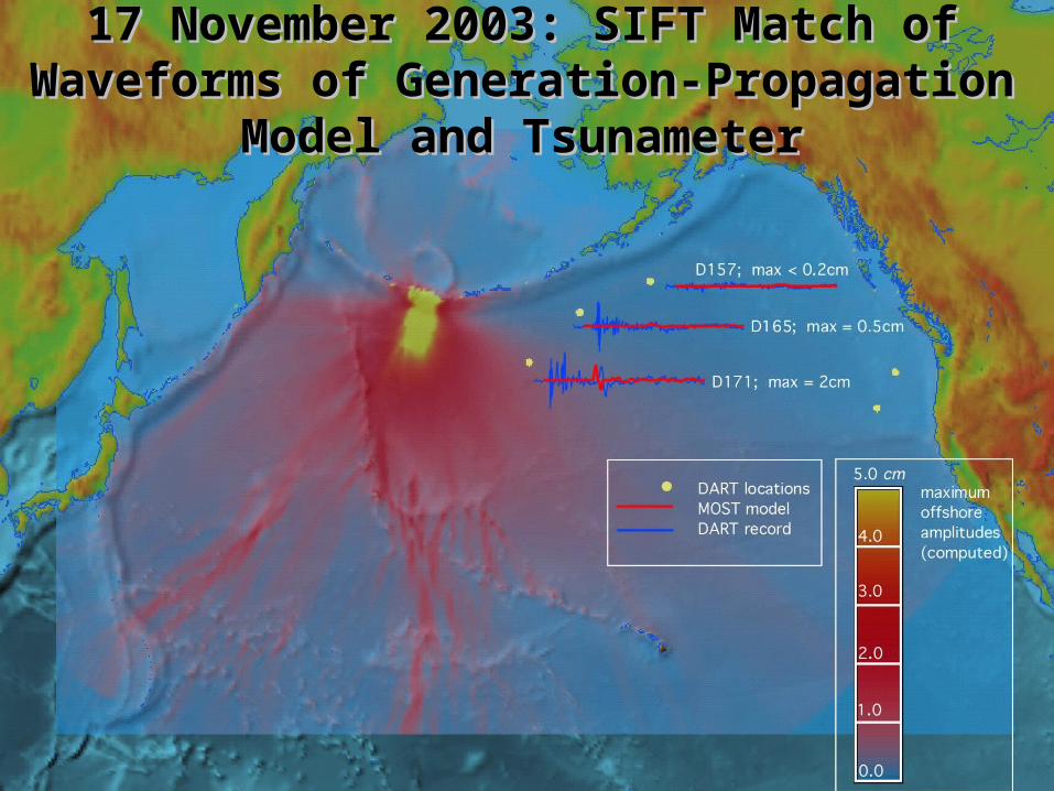
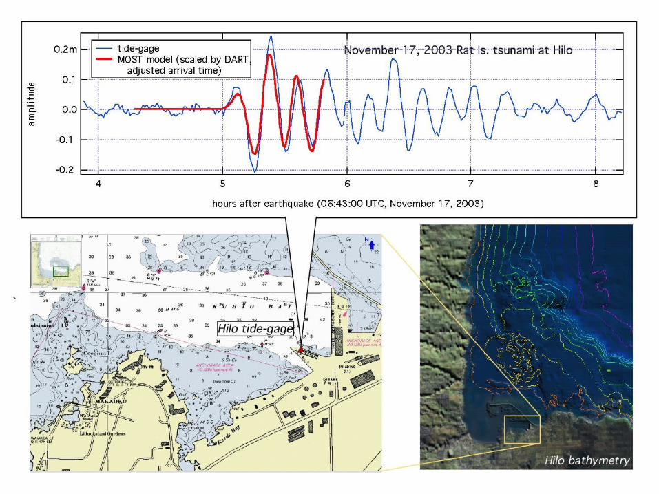
17 November 2003: SIFT Match of Waveforms of 17 November 2003: SIFT Match of Waveforms of Generation-Propagation Model and TsunameterGeneration-Propagation Model and Tsunameter
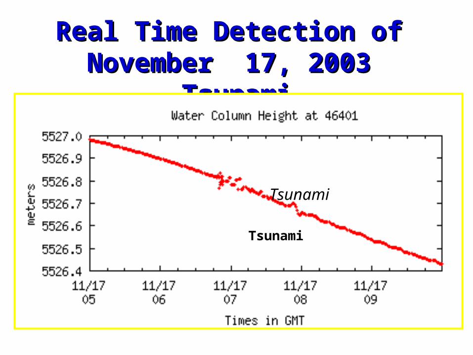
Real Time Detection of Real Time Detection of November 17, 2003 TsunamiNovember 17, 2003 Tsunami
Tsunami
TsunamiTsunami
Seismic
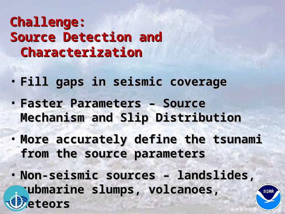
Challenge: Challenge: Source Detection and CharacterizationSource Detection and Characterization
• Fill gaps in seismic coverageFill gaps in seismic coverage
• Faster Parameters – Source Mechanism and Faster Parameters – Source Mechanism and Slip DistributionSlip Distribution
• More accurately define the tsunami from the More accurately define the tsunami from the source parameterssource parameters
• Non-seismic sources – landslides, Non-seismic sources – landslides, submarine slumps, volcanoes, meteorssubmarine slumps, volcanoes, meteors
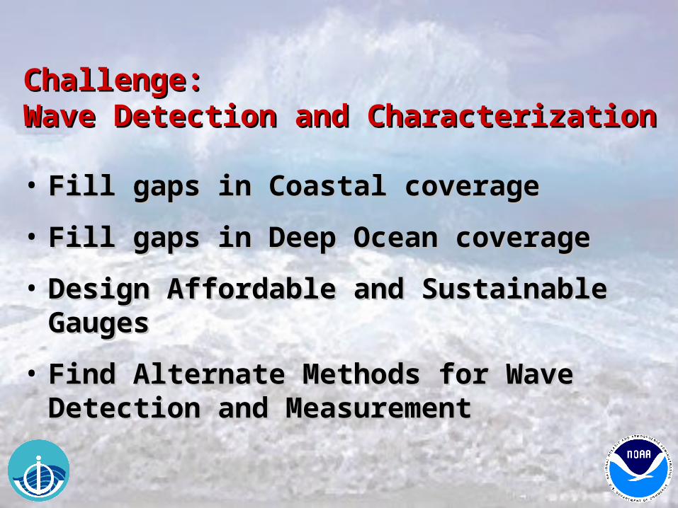
Challenge: Challenge: Wave Detection and CharacterizationWave Detection and Characterization
• Fill gaps in Coastal coverageFill gaps in Coastal coverage
• Fill gaps in Deep Ocean coverageFill gaps in Deep Ocean coverage
• Design Affordable and Sustainable GaugesDesign Affordable and Sustainable Gauges
• Find Alternate Methods for Wave Detection Find Alternate Methods for Wave Detection and Measurementand Measurement
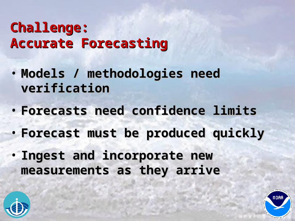
Challenge: Challenge: Accurate ForecastingAccurate Forecasting
• Models / methodologies need verificationModels / methodologies need verification
• Forecasts need confidence limitsForecasts need confidence limits
• Forecast must be produced quicklyForecast must be produced quickly
• Ingest and incorporate new measurements Ingest and incorporate new measurements as they arriveas they arrive
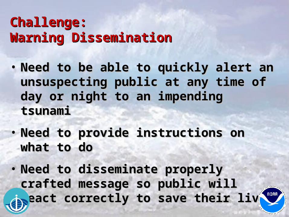
Challenge: Challenge: Warning DisseminationWarning Dissemination
• Need to be able to quickly alert an Need to be able to quickly alert an unsuspecting public at any time of day or unsuspecting public at any time of day or night to an impending tsunaminight to an impending tsunami
• Need to provide instructions on what to doNeed to provide instructions on what to do
• Need to disseminate properly crafted Need to disseminate properly crafted message so public will react correctly to message so public will react correctly to save their livessave their lives
THANK YOU THANK YOU