Embed Size (px)
Citation preview
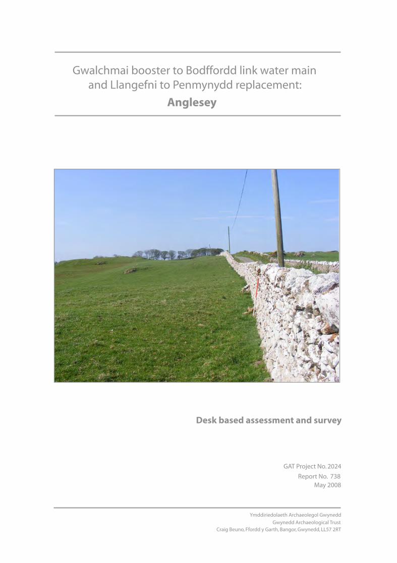
GAT Project No. 2024
Report No. 738 May 2008
Gwalchmai booster to Bodffordd link water main and Llangefni to Penmynydd replacement:
Ymddiriedolaeth Archaeolegol Gwynedd
Gwynedd Archaeological TrustCraig Beuno, Ffordd y Garth, Bangor, Gwynedd, LL57 2RT
Anglesey
Desk based assessment and survey

Report No. 738
Prepared forLaing O’Rourke
May 2008
By R.T.J. Evans
Ymddiriedolaeth Archaeolegol Gwynedd
Gwynedd Archaeological TrustCraig Beuno, Ffordd y Garth, Bangor, Gwynedd, LL57 2RT
Gwalchmai booster to Bodffordd link water main and Llangefni to Penmynydd replacement:
Anglesey

Contents
1. Introduction
2. Methodology
3. Location and topography
4. Archaeological background
5. History of ownership
6. Gazetter of sites
7. Discussion and recommendations
8. Summary of recommendations
9. Bibliography
Ymddiriedolaeth Archaeolegol Gwynedd
Gwynedd Archaeological TrustCraig Beuno, Ffordd y Garth, Bangor, Gwynedd, LL57 2RT
Gwalchmai booster to Bodffordd link water main and Llangefni to Penmynydd replacement:
Anglesey

Ymddiriedolaeth Archaeolegol Gwynedd
Gwynedd Archaeological TrustCraig Beuno, Ffordd y Garth, Bangor, Gwynedd, LL57 2RT
Gwalchmai booster to Bodffordd link water main and Llangefni to Penmynydd replacement:
Anglesey
Figures
Fig. 1. Areas of archaeological potential and map locationFig.2. Map 1: Pipeline route and location of archaeological sitesFig.3. Map 2: Pipeline route and location of archaeological sitesFig.4. Map 4: Pipeline route and location of archaeological sitesFig.5. Map 5: Pipeline route and location of archaeological sitesFig.6. Map 6: Pipeline route and location of archaeological sitesFig.7. Map 7: Pipeline route and location of archaeological sitesFig.8. Map 8: Pipeline route and location of archaeological sitesFig.9. Map 9: Pipeline route and location of archaeological sitesFig.10. Map 10: Pipeline route and location of archaeological sitesFig.11. Pipeline route and location of archaeological sites. Ordnance Survey County Series 25”. Anglesey(1888)Fig.12. Pipeline route and location of archaeological sites. Ordnance Survey County Series 25”. Anglesey. (1888)Fig. 13. Enclosure map 1812 of Bodffordd Area. The route of the new water main is shown in red. Not to Scale
Plate 1. Pipeline Route at BodfforddPlate 2. View of Bodwrog Church from the west showing route along area of rocky outcropPlate 3. Pipeline route approaching LlynfaesPlate 4. Bodffordd Windmill
Plates

GWALCHMAI BOOSTER TO BODFFORDD LINK WATER MAIN AND LLANGEFNI TO PENMYNYDD REPLACEMENT, ANGLESEY (G2024) Summary The route of a new link water main on Anglesey between Gwalchmai and Bodfford (NGR SH38907730 to SH43207670), and a replacement section between Llangefni and Penmynydd (NGR SH4616751 to SH51497448), and a minor section at Mona (NGR SH38897675) were investigated. Documentary, cartographic and aerial photographic evidence for historical and archaeological sites along the route were examined, and a walk over survey carried out. A possible prehistoric site that was previously unidentified south of Pen-yr-Allt, Penmynydd was noted. A post-medieval quarry and limekiln were identified. Changes to landscape usage and field patterns over times were also identified, as were a number of important buildings close to the route of the pipeline, including Bodwrog Church, Tregarnedd and the Penmynydd Almshouses. The majority of the route was found to be within areas of Medium or Medium/High archaeological potential. Two small lengths were identified as High potential. Two other lengths through built up areas were identified as Low potential. A programme of work designed to evaluate the areas of Medium and High potential is recommended, and two approaches consisting of a staged programme of geophysical survey/trial trenching/watching brief or of strip, map and sample is discussed. 1. INTRODUCTION Gwynedd Archaeological Trust has been asked by Laing O’Rourke to provide a desk-top assessment in advance of proposed improvements to the water main system on Anglesey. The scheme is in two parts: the Gwalchmai to Bodfordd Link Main and Llangefni to Penmynydd Replacement. The two pipeline routes measure approximately 6km each. This report includes a detailed desk-based assessment of the proposed route and the results of the walk over survey. 2. METHODOLOGY The desk-based assessment involved a study of the Historic Environment Register (HER) information for the study area. This included an examination of the core HER, and secondary information held within the record which includes unpublished reports, the 1:2500 County Series Ordnance Survey maps, and the National Archaeological Record index cards. The National Monuments Record (NMR) was checked for sites additional to the HER. Relevant manuscripts and maps within the Anglesey Record Office were consulted. Secondary sources were examined, including the Inventories of the Royal Commission on Ancient and Historical Monuments for Wales (RCAHMW), and works held at the University of Wales Bangor library. Indices to relevant journals, including county history and archaeology society journals and national society journals such as Archaeologia Cambrensis were checked. RAF aerial photographs taken between 1945 and 1947 were consulted at RCAHMW. Information about Listed Buildings and Scheduled Ancient Monuments was obtained from Cadw: Welsh Historic Monuments. The field survey assessment involved visiting the entire study area and assessing the sites identified during the desk-based study. Any additional sites noted were also assessed. The aims of this stage of the work are to: • verify the results of the desk based assessment • identify any further archaeological sites which may exist as above ground features • photograph and record the present condition of all sites noted. The field survey, involving a walk over of the entire route of the proposed pipeline, was carried out in very good weather on 13th, 15th and 16th May 2008. 2.1 Categories of Importance
1
The following categories were used to define the importance of the archaeological resource. Category A - Sites of National Importance. This category includes Scheduled Ancient Monuments and Listed Buildings of grade II* and above, as well as those sites that would meet the requirements for scheduling (ancient monuments) or listing (buildings) or both. Sites that are scheduled or listed have legal protection, and it is recommended that all Category A sites remain preserved and protected in situ. Category B - Sites of Regional Importance This category includes grade II Listed Buildings and sites which would not fulfil the criteria for scheduling, but which are nevertheless of particular importance within the region. Preservation in situ is the preferred option for Category B sites, but if damage or destruction cannot be avoided, appropriate detailed recording might be an acceptable alternative. Category C - Sites of District or Local Importance These sites are not of sufficient importance to justify a recommendation for preservation if threatened, but nevertheless merit adequate recording in advance of damage or destruction. Category D - Minor and Damaged Sites These are sites, which are of minor importance, or are so badly damaged that too little remains to justify their inclusion in a higher category. For these sites rapid recording either in advance or during destruction, should be sufficient. Category E - Sites needing further investigation Sites, the importance of which is as yet undetermined and which will require further work before they can be allocated to categories A-D, are temporarily placed in this category, with specific recommendations for further evaluation. By the end of the assessment there should be no sites remaining in this category. 2.2 Definition of field evaluation techniques Field evaluation is necessary to allow the reclassification of the category E sites, and to allow the evaluation of areas of land where there are no visible features, but for which there is potential for sites to exist. Two principal techniques can be used for carrying out the evaluation: geophysical survey and trial trenching. Geophysical survey This technique involves the use of a magnetometer, which detects variation in the earth’s magnetic field caused by the presence of iron in the soil. This is usually in the form of weakly magnetised iron oxides, which tend to be concentrated in the topsoil. Features cut into the subsoil and back-filled or silted with topsoil contain greater amounts of iron and can therefore be detected with the gradiometer. Strong readings can be produced by the presence of iron objects, and also hearths or kilns. Other forms of geophysical survey are available, of which resistivity survey is the other most commonly used. However, for rapid coverage of large areas, the magnetometer is usually considered the most cost-effective method. It is also possible to scan a large area very rapidly by walking with the magnetometer, and marking the location of any high or low readings, but not actually logging the readings for processing. Trial trenching
2
Buried archaeological deposits cannot always be detected from the surface, even with geophysics, and trial trenching allows a representative sample of the development area to be investigated. Trenches of an appropriate size can also be excavated to evaluate category E sites. These trenches typically measure between 20m and 30m long by 2m wide. The turf and topsoil is removed by mechanical excavator, and the resulting surface cleaned by hand and examined for features. Anything noted is further examined, so that the nature of any remains can be understood, and mitigation measures can be recommended. 2.3 Definition of Mitigatory Recommendations Below are the measures that may be recommended to mitigate the impact of the development on the archaeology. None: No impact so no requirement for mitigatory measures. Detailed recording: This requires a full photographic record and measured survey prior to commencement of works. Archaeological excavation may also be required depending on the particular feature and the extent and effect of the impact. Basic recording: Requiring a photographic record and full description prior to commencement of works. Strip, Map and Sample: The technique of Strip, Map and Sample involves the examination of machine-stripped surfaces to identify archaeological remains. The stripping is undertaken under the supervision of an archaeologist. Stripping and removal of the overburden is undertaken in such as manner as to ensure damage does not take place to surfaces that have already been stripped, nor to archaeological surfaces that have not yet been revealed. Stripping is undertaken in as careful a manner as possible, to allow for good identification of archaeological features. A small team of archaeologists will be responsible for subsequently further cleaning defined areas where necessary. Complex sites which cannot be avoided will need to be fully excavated. Watching brief: This is a formal programme of observation and investigation conducted during any operation carried out for non-archaeological reasons. This will be within a specified area or site on land, inter-tidal zone or underwater, where there is a possibility that archaeological deposits may be disturbed or destroyed. The programme will result in the preparation of a report and ordered archive. Avoidance: Features, which may be affected directly by the scheme, or during the construction, should be avoided. Occasionally a minor change to the proposed plan is recommended, but more usually it refers to the need for care to be taken during construction to avoid accidental damage to a feature. This is often best achieved by clearly marking features prior to the start of work. Reinstatement: The feature should be re-instated with archaeological advice and supervision. 3. LOCATION AND TOPOGRAPHY The island of Anglesey is tilted from the north-east to south-west, and thus the natural ridges and drainage pattern, enhanced by the last glaciation, follows this directional trend to give a corrugated effect of ridges of harder rock separated by shallow valleys. The study area crosses one of these ridges at Cefn Poeth (SH 743494), west of which the eastern end of Malltraeth marsh is overlooked. The route crosses the Afon Ceint, canalised in the 18th century, which along with the Afon Cefni comprise the
3
two main tributaries running into Malltraeth Marsh from the higher ground to the north and east. West of Llangefni the pipeline route overlooks Cors Bodwrog to the west and north on a limestone ridge, where significant outcropping is observed, before descending slightly towards Bodfordd, where a more undulating landscape of improved fields is seen. The solid and drift geology of the route consists of Pre-Cambrian metamorphic rocks around Penmynydd, with some Ordovician rocks and carboniferous limestone, changing to schists and gneisses of the Mona Complex west of Llangefni. These include significant outcropping, particularly west of Llangefni (Smith and George 1961). Soils consist of brown earths of the Arfon and Pentraeth series with occasional gleying (Jones 1972, 141). East of Llangefni these have been described as some of the most fertile on the island (Roberts 1958, 41-2). The route is in two main sections, consisting of the Gwalchmai to Bodfford Link Main, with two short additional links associated with it at Gwalchmai and Mona, and the Llangefni to Penmynydd replacement main. The route follows a height of approximately 100m OD at the Penmynydd reservoir, falling away sharply at the ridge at Cefn Poeth to between 20m OD and 30m OD before reaching the moat at Tregarnedd at 15m OD, overlooked by the hill promontory of Bryn Cefni. At Bryn Ala the route lies at approximately 75m OD, falling to 50m OD at Bodffordd, following a course through the rocky outcrops to the north and west of Cors Bodwrog (Fig. 1). 4. ARCHAEOLOGICAL BACKGROUND 4.1 Llangefni to Penmynydd Replacement Much of the pipeline route lies along the old turnpike route from the Menai ferry to Holyhead, created in 1765, on which tolls were collected until Thomas Telford built a completely new turnpike in association with the building of the Menai Bridge in the early years of the 19th century (Pritchard 1972, 65). It commences in the east at the Penmynydd water treatment works, heading south across the B5420 road and passing the Penmynydd Almshouses (SH513742), which lie at right angles to it. These were built in 1620 under the will of Lewis Rogers, and consist of a single storey linear range, symmetrically planned with advanced central gabled porch and gabled end projections. They were built of local rubble limestone and the advanced gabled centre has a rounded doorway with a keystone in the shape of a shield, above which is a weathered central panel with the date and initials IP HS/ 1620 (Anglesey Archives WPE/6/292-3). The houses in the range are grade II* listed buildings. The route follows a westward course through undulating fields to the south of the B5420 through hedged fields of probable 19th century date, passing south of Cae Helig (SH508743), crossing a minor road south of the former Horeb Independent chapel. The regular pattern of enclosed fields in this section suggests that they were formally laid out in the 19th century, probably by the Bulkeley estate of Baron Hill, Beaumaris, the major landowner in this area (UWB Baron Hill 6569). Centred on SH 50217447, aerial photographs dated to 1945 suggest the presence of an enclosure of possible prehistoric date (RAF 106G/UK/655 13th Aug 1945, frame 4062), although on more modern images the evidence is less clear. The fields west of Horeb are rather larger than those seen further east, where the pipeline route passes north of Cefn Poeth. It then crosses a steep ridge before heading slightly north westward meeting the minor road heading to Pentre Berw south of Ceint Fawr. After crossing the Afon Ceint the route then passes to the north of a standing stone (PRN 2737, NGR SH 48427463). It is possible that there may be prehistoric archaeology in this area associated with this site, as areas around standing stones are often associated with other funerary and ritual features (Lynch 1991, 32). The route passes north of Hirdrefaig (PRN 11105, SH 48047485), a grade II listed farmhouse of post medieval date, though possibly the site of an earlier settlement, Hirdrefaig being believed to be a medieval bond township (Jones -Pierce 1951, 23). The house is early 18th century in date with late 18th century alterations, ‘L’ shaped in plan, an earlier south wing having been demolished (RCAHMW 1937, 79). A small lime kiln and quarry was noted north west of Hirdrefaig at SH 47897511. The route passes north of Tre-garnedd, to the south of which lies Capel Carnedd Maes Lidr (PRN 2675, SH 47307510), the site of a medieval chapel and a medieval township, giving the ‘Tre’ part of the place name (Jones-Pierce 1951). The route then turns south westward past the site of a burnt mound and associated pit (PRN 16,073, SH 46907500) which was excavated in advance of the construction of the Bryn Cefni Industrial Park (Smith 2002).
4
The route passes north of Llwyn Ednyfed (Tregarnedd) before reaching the water treatment works at Parc Bryn Cefni, a moated enclosure of medieval date, the construction of which is traditionally associated with a descendant of Ednyfed Fychan, Gruffydd ap Rhys, in the 14th century, although it may have been Gruffydd’s father, Rhys, who was responsible for its construction (Carr 1992). It is the only known moated site on Anglesey, and is a Scheduled Ancient Monument (PRN 2727, SH 46867464, SAM Ref: A047). The enclosed area, about 100m square has surviving ramparts on its north-west and south-west sides, although partially covered by more recent farm buildings. The ‘garnedd’ part of the place name comes from a prehistoric burial mound (PRN 2733), described as ‘an extensive pile of stones, surrounded by a circle of stones about 86 yards in diameter [and] removed in 1822’ (Lewis 1833). A possible location of this at SH 46807470 was identified during investigations associated with the construction of phase 2 of the Bryn Cefni Industrial Park (Kenney 2002, Fig. 1). 4.2 Gwalchmai Booster to Bodffordd Link Main The route in this area follows the boundary between an upland area to the north with exposed rock outcrops and Cors Bodwrog to the south. It passes to the south of Bodwrog Church (PRN 6912, SH 40027763), a grade II* listed building. The church is late 15th century in style, rebuilt in Henry VII's reign (1485-1509) when Wales was quiet and there was consequently a great deal of building activity. Richard Bulkeley was Archdeacon of Anglesey in 1500 and would have been concerned with the re-building of the church and was probably a benefactor. The east and two side windows are original, whilst the middle side windows are 17th or 18th century. Restored in mid-late C19, the church lies in an irregular enclosure, which has been straightened on the south and north sides. It is unclear whether the churchyard was originally curvilinear or rectilinear in form as it appears to be a rectangle with rounded corners. This could imply that the churchyard was originally curvilinear and that the main sides had been straightened out (Davidson 2000, 25). No traces are visible of any external boundaries however, but it is possible that the route of the pipeline could cut an earlier enclosure on the southern side. The route beyond the church heading towards the junction of the road with the main road at Llynfaes follows the interface between the upland zone and the bog, but at Llynfaes at the road junction the area is characterised by small enclosed fields. The medieval landscape was dominated by large open fields lying close to the settlements, and each of the fields was divided into strips for cultivation. Further from the settlements, usually on poorer land, lay paddocks and large common areas for grazing, many of these not being enclosed until the time of the enclosure movement in the 18th century, and are associated with development of Llynfaes along the 1765 turnpike road from Holyhead to the Menai ferry (Pritchard 1972, 65). Although the township of Bodffordd dates from medieval times (Carr 1982, 69), the development of the nucleated settlement at Bodffordd along the old post road to the Menai ferry can be attributed to similar circumstances as at Llynfaes, evidence for which is provided by an enclosure map of 1812 (Fig.2, Bangor Archives, Tynygongl 186) which shows enclosed fields to the north of the turnpike road at the junction of the road to Mona past Heneglwys church and evidence for the early development of Bodfford. This area was described by Samuel Lewis in 1833 as ‘bleak and exposed…consisting chiefly of swampy flats and rocky promontories (Lewis 1833). Settlement had probably shifted from its medieval centre around Heneglwys church (PRN 5283) about 1km to the south, to the more advantageous position along the post road. 4.3 Mona Water Booster Station A small section of pipe centred on SH 40087523 and to be joined to the Mona pumping station from the Mona- Bodffordd minor road crosses a field boundary across improved fields with little other archaeological evidence. This boundary appears to be of 19th century in date, and the field pattern demonstrates that the hedgerows predate the construction of the road. The road is not marked on the 3rd edition 25 inch Ordnance Survey map published in 1920, and was probably diverted to its current location from further west as a result of the expansion of Mona airfield by the RAF in 1942. 5. HISTORY OF LAND OWNERSHIP The majority of the land in the section of the pipeline route east of Llangefni was the property of the Bulkeley family of Baron Hill, Beaumaris by the 18th century. Estate maps survive for this area from the early part of the 19th century shows that the field systems were much the same as they are today,
5
indicating that agricultural improvements were already well advanced. Hirdrefaig was the property of the Lloyd family of Tregaian, but no early plans were of this property have been located. The almshouses at Penmynydd, a charity set up by Lewis Rogers in 1620 and administered by the parish of Penmynydd have a significant amount of surviving documentation associated with them, although the land is described on the tithe map of 1843 as being owned by Lord Bulkeley. A number of plans of the almshouses survive, including a late 18th century plan indicating that the current extent of the property results from the acquisition of land from Lord Bulkeley in order to provide gardens for the houses (Anglesey Archives WPE/6/293), which indicates that the boundaries to the property were similar to today. West of Llangefni much of the land is the property of the Bulkeley family also, however there are a significant number of other landowners, including the Marquis of Anglesey and a number of smaller landowners, the latter being particularly in the region of Bodffordd. Some estate maps survive for this area also, including evidence that some of the land had been encroached upon on the road between Bodwrog church and Llanfaes (UCNWB Baron Hill B6553). However the best evidence comes from an enclosure map of 1812 (UCWB Tynygongl 186, Fig. 2), which show the junction of the road between Telford’s Holyhead road at Mona and the old Menai Ferry to Holyhead Road at Bodffordd (B5109). This indicates that Bodffordd had developed little by this time, although on the north side of the road in addition to four houses a number of plots had been laid out, the property of Gethin Williams and Edward Hughes, both clergymen, and John Hughes. This suggests that the development of the village of Bodffordd along the road was shortly to take place. Earlier settlement would have been located closer to the church at Heneglwys. 6. GAZETTEER OF SITES AND RECOMMENDATIONS FOR MITIGATION The sites noted below are either those recorded on the Gwynedd HER as lying within a 500m corridor around the proposed pipeline route, or are potential sites identified during the walk-over survey. PRN numbers refer to site identification numbers on the Gwynedd HER, and the ‘site status’ gives information as to whether the site is a Scheduled Ancient Monument or a Listed Building, and its grading within that category. The majority of sites listed below will not be impacted upon directly. They are, however, listed here to ensure their presence is recognised in case of any required route changes, and also to inform on the potential for archaeology within their vicinity. Further discussion of mitigation recommendations for the pipeline is given in section 7 below. PRN 6912 BODWROG CHURCH Assessment of Importance A Impact: None
Mitigation: Avoidance Site Status Reference
LB II*
A simple church of continuous nave and chancel built in the late 15th century with some restoration in the 19th century. The churchyard is irregular in form with a stone walled boundary with the road to the south. The wall has been straightened on the north and south sides and may originally have been curvilinear. Easting: 4002 Northing: 7763 PRN 2140 ROMAN COINS FINDSPOT Assessment of Importance C Impact: None
Mitigation: Avoidance Site Status Reference
A find of Roman Coins was made at this spot Easting: 4100 Northing: 7800 PRN 7653 BELAN CHAPEL Assessment of Importance C Impact: None
Mitigation: Avoidance Site Status Reference
A 19th century nonconformist chapel. Easting: 4145 Northing: 7808
6
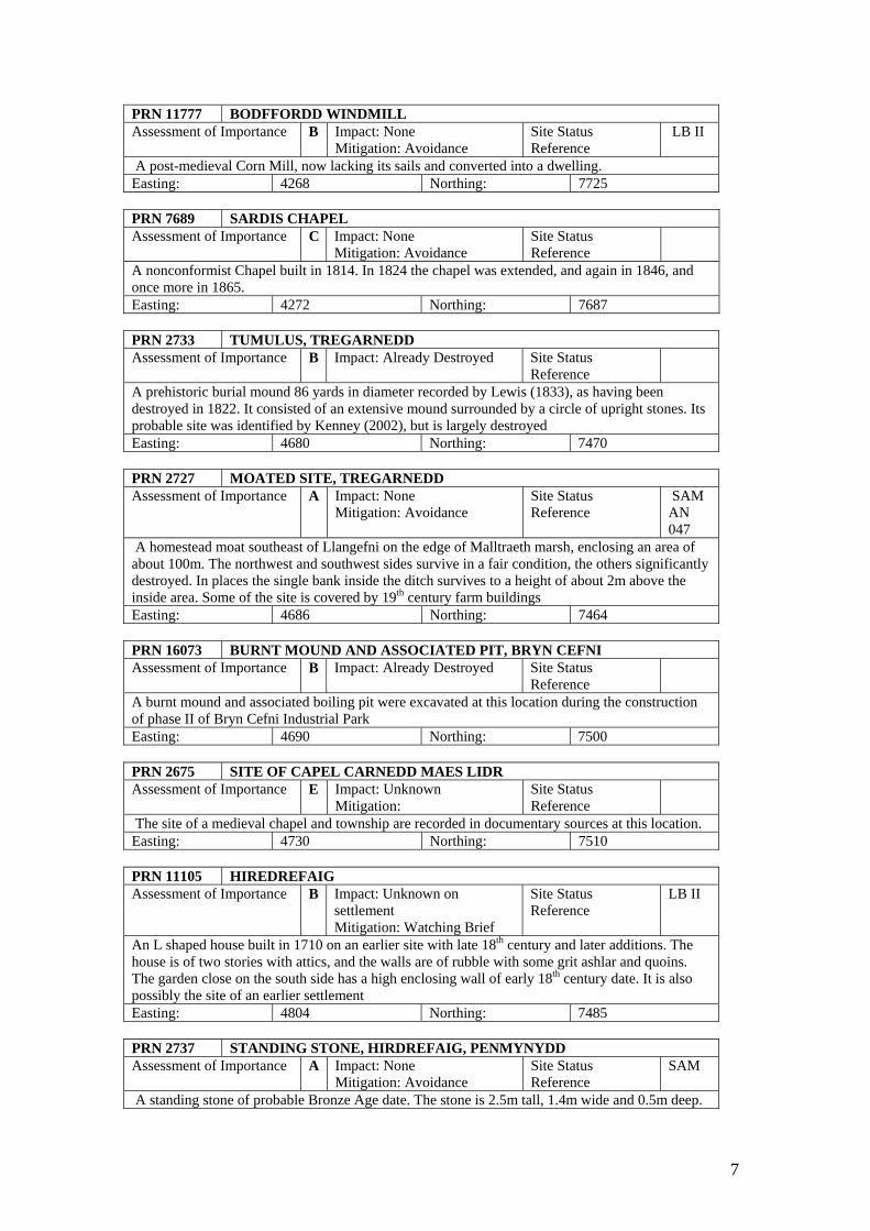
PRN 11777 BODFFORDD WINDMILL Assessment of Importance B Impact: None
Mitigation: Avoidance Site Status Reference
LB II
A post-medieval Corn Mill, now lacking its sails and converted into a dwelling. Easting: 4268 Northing: 7725 PRN 7689 SARDIS CHAPEL Assessment of Importance C Impact: None
Mitigation: Avoidance Site Status Reference
A nonconformist Chapel built in 1814. In 1824 the chapel was extended, and again in 1846, and once more in 1865. Easting: 4272 Northing: 7687 PRN 2733 TUMULUS, TREGARNEDD Assessment of Importance B Impact: Already Destroyed Site Status
Reference
A prehistoric burial mound 86 yards in diameter recorded by Lewis (1833), as having been destroyed in 1822. It consisted of an extensive mound surrounded by a circle of upright stones. Its probable site was identified by Kenney (2002), but is largely destroyed Easting: 4680 Northing: 7470 PRN 2727 MOATED SITE, TREGARNEDD Assessment of Importance A Impact: None
Mitigation: Avoidance Site Status Reference
SAM AN 047
A homestead moat southeast of Llangefni on the edge of Malltraeth marsh, enclosing an area of about 100m. The northwest and southwest sides survive in a fair condition, the others significantly destroyed. In places the single bank inside the ditch survives to a height of about 2m above the inside area. Some of the site is covered by 19th century farm buildings Easting: 4686 Northing: 7464 PRN 16073 BURNT MOUND AND ASSOCIATED PIT, BRYN CEFNI Assessment of Importance B Impact: Already Destroyed Site Status
Reference
A burnt mound and associated boiling pit were excavated at this location during the construction of phase II of Bryn Cefni Industrial Park Easting: 4690 Northing: 7500 PRN 2675 SITE OF CAPEL CARNEDD MAES LIDR Assessment of Importance E Impact: Unknown
Mitigation: Site Status Reference
The site of a medieval chapel and township are recorded in documentary sources at this location. Easting: 4730 Northing: 7510 PRN 11105 HIREDREFAIG Assessment of Importance B Impact: Unknown on
settlement Mitigation: Watching Brief
Site Status Reference
LB II
An L shaped house built in 1710 on an earlier site with late 18th century and later additions. The house is of two stories with attics, and the walls are of rubble with some grit ashlar and quoins. The garden close on the south side has a high enclosing wall of early 18th century date. It is also possibly the site of an earlier settlement Easting: 4804 Northing: 7485 PRN 2737 STANDING STONE, HIRDREFAIG, PENMYNYDD Assessment of Importance A Impact: None
Mitigation: Avoidance Site Status Reference
SAM
A standing stone of probable Bronze Age date. The stone is 2.5m tall, 1.4m wide and 0.5m deep.
7
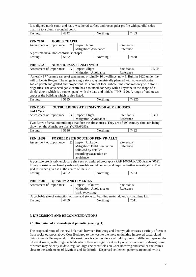
It is aligned north-south and has a weathered surface and rectangular profile with parallel sides that rise to a bluntly rounded point. Easting: 4842 Northing: 7463 PRN 7830 HOREB CHAPEL Assessment of Importance C Impact: None
Mitigation: Avoidance Site Status Reference
A post-medieval non-conformist chapel Easting: 5082 Northing: 7438 PRN 12525 ALMSHOUSES, PENMYNYDD Assessment of Importance A Impact: Slight
Mitigation: Avoidance Site Status Reference
LB II*
An early 17th century range of tenements, originally 10 dwellings, now 5. Built in 1620 under the will of Lewis Rogers. The range is single storey, symmetrically planned with advanced central gabled porch and gabled end projections. It is built of local rubble limestone masonry with stone ridge tiles. The advanced gable centre has a rounded doorway with a keystone in the shape of a shield, above which is a sunken panel with the date and initials: IPHS 1620. A range of outhouses opposes the building which is also listed. Easting: 5135 Northing: 74225 PRN11003 and 12525
OUTBUILDINGS AT PENMYNYDD ALMSHOUSES
Assessment of Importance B Impact: Slight Mitigation: Avoidance
Site Status Reference
LB II
Two Rows of small outbuildings that face the almshouses. They are of 19th century date, not being shown on the Almshouse plan (WPE/6/293). Easting: 5136 Northing: 7422 PRN 19699 POSSIBLE SITE SOUTH OF PEN-YR-ALLT Assessment of Importance E Impact: Unknown
Mitigation: Field Evaluation followed by detailed recording/excavation or avoidance
Site Status Reference
A possible prehistoric enclosure site seen on aerial photographs (RAF 106G/UK/655 Frame 4062). It may consist of enclosed yards and possible round houses, and requires further investigation. The grid reference given is at the centre of the site. Easting: 4002 Northing: 7763 PRN 19700 QUARRY AND LIMEKILN Assessment of Importance C Impact: Unknown
Mitigation: Avoidance or basic recording
Site Status Reference
A probable site of extraction of lime and stone for building material, and a small lime kiln Easting: 4789 Northing: 7511 7. DISCUSSION AND RECOMMENDATIONS 7.1 Discussion of archaeological potential (see Fig. 1) The proposed route of the new link main between Bodwrog and Penmynydd crosses a variety of terrain from rocky outcrops above Cors Bodwrog to the west to the more undulating improved pastureland rising towards Penmynydd. In the west there is clear evidence of field systems of different types on the different zones, with irregular fields where there are significant rocky outcrops around Bodwrog, some of which may be early in date, regular large enclosed fields on Cors Bodwrog and smaller enclosures close to the settlements of Llynfaes and Bodffordd. Dispersed settlement patterns are noted, with a
8
later concentration at Llynfaes and Bodffordd, which develop along the old post road, turnpiked in 1765. Bodffordd can be shown not to have developed significantly before 1812 (UCNWB Tynygongl 186), and to have been in the possession of numerous small landowners and this would have encouraged a piecemeal development. One possible new prehistoric site was identified on the proposed route south of Penyr-Allt at SH40027763, observed on historic aerial photographs (RAF 106G/UK/655 Frame 4062 May 1945). It is quite possible that there are other unidentified sites of prehistoric archaeology, particularly as there are a number of sites and finds known close to the pipeline route and also just outside the area of assessment, such as the Penmynydd standing stone (PRN 2737), the possible enclosure on Cors Bodwrog (PRN 2110) and the find of a stone axe at Ceint-Bach, Penmynydd (PRN 2742). Prehistoric archaeology was also identified during the development of the Bryn Cefni Industrial Park (Kenney 2002, PRN 16073). Medieval archaeology may also be found in the vicinity of Tregarnedd and Hirdrefaig. Previous work on Anglesey, such as the A55 trunk road route (Davidson 1996), and the water main replacement between Gwalchmai and Bodedern (Davidson 1998, 53), where a large number of prehistoric burnt mounds and other settlement evidence was noted, suggests that the probability of finding prehistoric and medieval archaeology on the route of the pipeline is medium to high, despite the limited number of previously recorded sites. The areas where the pipeline crosses open fields, but where there is a relatively low density of archaeological sites in the vicinity, are therefore considered to be of Medium potential, and this applies to the pipeline between Gwalchmai and Bodffordd, with the exception of the section close to Bodwrog church. The density of sites increases, however, in the vicinity of the eastern route, and the pipeline east of Llangefni is therefore considered to be of Medium to High potential. Where an archaeological site lies close to the line of the route, and if it is thought that the nature of the site increases the likelihood of archaeological remains in the immediate area, the area is raised to High potential,. This occurs in two locations – by the church of Bodwrog (PRN 6912), where extra-mural burials may occur, and by the potential prehistoric enclosure (PRN 19699), where there is an increased chance of prehistoric activity. Where the pipeline route runs through built-up areas, the potential is considered Low. This occurs in Bodffordd and Llangefni. 7.2 Discussion of Mitigation With the exception of tracks, roads and boundaries no known archaeological sites are to be affected by the proposed scheme. However, there is a reasonable probability that sites exist below ground within the route corridor. In order to lessen the risk of impact upon the construction timetable, it is important that these are located prior to the start of construction, and that suitable mitigation is undertaken so that construction can proceed unhindered. There are several methods of identifying underground archaeology. Those to be considered here are:
• Geophysical survey • Trial Excavation • Strip, map and sample • Watching brief.
The above methods fall into two general approaches. The first is a phased approach, in which information is built up by successive phases of investigation. This approach is typified by use of the following techniques:
• Geophysical survey • Trial Excavation • Excavation (if sites are located) • Watching Brief.
Geophysical survey (usually magnetometer survey) works best on large areas of land and over relatively stable geological areas. It is, however, a relatively inexpensive technique, and can help
9
pinpoint areas of archaeological activity. It would be of no use in a strategy based around strip, map and sample, but it is helpful in a strategy involving trial excavation, where trench location would be informed by the results of the magnetometer survey. Trial excavation is a sampling technique where trenches are excavated within the development area (in this case along the easement corridor). The number of trenches to be excavated is variable, but the higher the number the less the risk of missing archaeology. Studies have shown that a minimum of 5% of the area needs to be trenched to ensure the majority of sites are recovered. The technique is good at identifying large sites with dense concentrations of features, such as late prehistoric and Roman settlements, or concentrations of burnt stone, but is less successful at identifying sites with low concentrations of features such as Neolithic structures or prehistoric pit groups. A watching brief involves the archaeological monitoring of construction works. This method is only used on its own in areas of Low potential as it carries the highest risk to delays during the construction programme. It can be used successfully following trial trenching, where trenching has not located any archaeological sites of significance. The second approach is to undertake a programme of strip, map and sample. This requires the removal of all plough soil and sub-soils down to layers capable of preserving archaeological features. The work is undertaken under archaeological supervision. The advantage of this technique is that all archaeological features will be found, so it removes all risk. It is best undertaken during the construction programme and when re-instatement is not immediately required. This limits duplication of costs, as the stripping and re-instatement would be undertaken as part of the construction process. This method typically results in the identification of a large number of features such as drains, ditches, former field boundaries, the holes caused by the removal of trees, and casual pits etc. It is not always easy to identify the nature of the feature without excavation, therefore the cost of strip, map and sample includes the initial assessment of these features, but it does not include the cost of full excavation should the features prove to be archaeologically significant. If a site of archaeological significance is found during the strip, map and sample process then a new design and cost estimate will be required for that site. Recommendations for the different levels of potential are given below: High Potential Strip, Map and Sample Medium Potential Strip Map and Sample or
Geophysical survey/Trial Trenching/WB Low Potential Watching Brief 8. SUMMARY OF RECOMMENDATIONS The table below summarises the above discussion. The location of the areas is shown on fig. 1. Where mitigation options suggest Trial excavations this includes the recommendation for a preceding geophysical survey. Eastern Route: Llangefni to Penmynydd Replacement AREA LOCATION DESCRIPTION ARCHAEOLOGICAL
POTENTIAL Area 6; Fig. 7
Bryn Cefni Industrial Estate (NGR SH46167511 to SH46947510: 1.08km)
This length follows the existing road through the industrial estate and does not cross undeveloped land. A burnt mound and associated boiling pit were excavated at this location during the construction of phase II of Bryn Cefni Industrial Park (NGR SH46907500; GAT Project G1522); no further archaeological features were identified.
LOW Mitigation options:
• No further work recommended
10
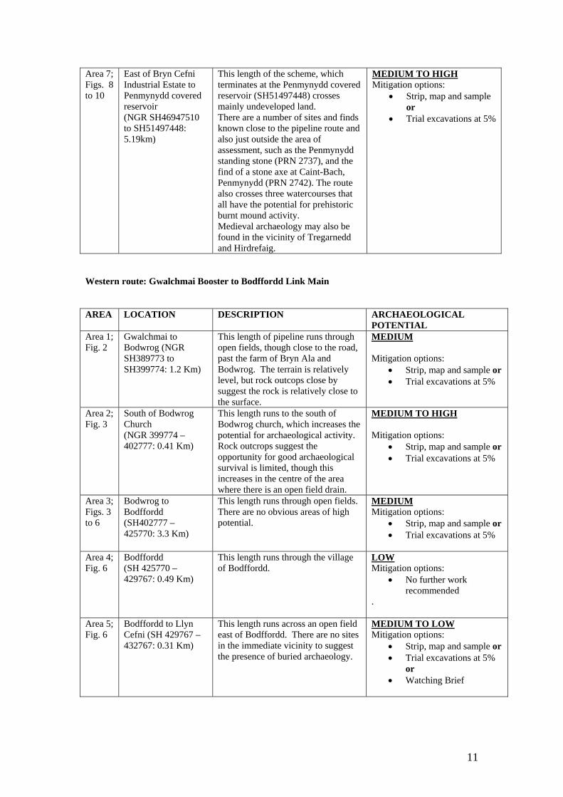
Area 7; Figs. 8 to 10
East of Bryn Cefni Industrial Estate to Penmynydd covered reservoir (NGR SH46947510 to SH51497448: 5.19km)
This length of the scheme, which terminates at the Penmynydd covered reservoir (SH51497448) crosses mainly undeveloped land. There are a number of sites and finds known close to the pipeline route and also just outside the area of assessment, such as the Penmynydd standing stone (PRN 2737), and the find of a stone axe at Caint-Bach, Penmynydd (PRN 2742). The route also crosses three watercourses that all have the potential for prehistoric burnt mound activity. Medieval archaeology may also be found in the vicinity of Tregarnedd and Hirdrefaig.
MEDIUM TO HIGH Mitigation options:
• Strip, map and sample or
• Trial excavations at 5%
Western route: Gwalchmai Booster to Bodffordd Link Main AREA LOCATION DESCRIPTION ARCHAEOLOGICAL
POTENTIAL Area 1; Fig. 2
Gwalchmai to Bodwrog (NGR SH389773 to SH399774: 1.2 Km)
This length of pipeline runs through open fields, though close to the road, past the farm of Bryn Ala and Bodwrog. The terrain is relatively level, but rock outcops close by suggest the rock is relatively close to the surface.
MEDIUM Mitigation options:
• Strip, map and sample or • Trial excavations at 5%
Area 2; Fig. 3
South of Bodwrog Church (NGR 399774 – 402777: 0.41 Km)
This length runs to the south of Bodwrog church, which increases the potential for archaeological activity. Rock outcrops suggest the opportunity for good archaeological survival is limited, though this increases in the centre of the area where there is an open field drain.
MEDIUM TO HIGH Mitigation options:
• Strip, map and sample or • Trial excavations at 5%
Area 3; Figs. 3 to 6
Bodwrog to Bodffordd (SH402777 – 425770: 3.3 Km)
This length runs through open fields. There are no obvious areas of high potential.
MEDIUM Mitigation options:
• Strip, map and sample or • Trial excavations at 5%
Area 4; Fig. 6
Bodffordd (SH 425770 – 429767: 0.49 Km)
This length runs through the village of Bodffordd.
LOW Mitigation options:
• No further work recommended
.
Area 5; Fig. 6
Bodffordd to Llyn Cefni (SH 429767 – 432767: 0.31 Km)
This length runs across an open field east of Bodffordd. There are no sites in the immediate vicinity to suggest the presence of buried archaeology.
MEDIUM TO LOW Mitigation options:
• Strip, map and sample or • Trial excavations at 5%
or • Watching Brief
11
9. Bibliography Cartographic sources Ordnance Survey 1:2500 1st Edition 1888 Ordnance Survey 1:2500 2nd Edition 1900 Ordnance Survey 1:2500 3rd Edition 1920 Anglesey Archives WPE/6/292 Penmynydd Alms Houses and Gardens WPE/6/293 Rough Plan of the Alm House in the Parish of Penmynydd, Anglesey (not dated, probably late 18th century) WPE/14/19 Tithe Map of the Parishes of Llanfihangel Esciefog and Llanffinan Copy Tithe Maps of the Parishes of Bodwrog, Heneglwys, Llangefni and Penmynydd University Archives, Bangor Baron Hill S6541 Map of the Parish of Bodwrog Baron Hill B6553 Plan of Part of Cae Bulkeley in the Parish of Bodwrog, Anglesey shewing Ty Croes Quillet, situate in Cae Pella (not dated) Baron Hill 6569 A Survey of the Property belonging to Sir Richard Bulkeley Williams Bulkeley Bart. In the Parishes of Penmynydd and Llanffinan (not dated, probably early 19th century) Tynygongol 186 Plan of Rhos-yr-Hen Eglwys Common in the County of Anglesey (with the Allotments thereon) 1812 Aerial Photographs located at the National Monuments Record, Aberystwyth East of Llangefni 106G/UK/655 Frames 3112, 4114, 4115, 4116, 4061, 4062, 4063 (13 Aug 1945) 3G/TUD/UK/172 Frames 2416, 2417 (9 May 1946) CPE/UK/1996 Frames 1416, 2416, 2417 (13 April 1947) Bodffordd to Gwalchmai 106G/UK/655 Frames 4154, 4155, 4193, 4194, 4195, 4196 (13 Aug 1945) Gwalchmai Area 106G/UK/655 Frames 4192, 4193 (13 Aug 1945) Spot near Mona 106G/UK/655 Frames 3150, 3151, 3152, 4156, 4157, 4158 (13 Aug 1945) Modern aerial photographs were also viewed online at Google Earth Published Sources Carr, A.D. 1982. Medieval Anglesey (Llangefni) Carr, A.D. 1992. ‘Tregarnedd’, Trans. Anglesey Antiquarian Society and Field Club, 21-50. Davidson, A. 1998 ‘Excavations and watching brief during water main replacement, Gwalchmai to Bodedern, Anglesey’, Archaeology in Wales 38, 51-4. Jones, G.T. 1972. ‘Soils’ in M. Richards (ed.) 1972 An Atlas of Anglesey, 141. Lewis, S. 1833 A Topographical Dictionary of Wales
12
13
Lynch, F.M. 1991. Prehistoric Anglesey (2nd Edition, Llangefni) Pritchard, R.T. 1972. ‘Roads’ in M. Richards (ed.) 1972 An Atlas of Anglesey, 65. RCAHMW, 1937. Inventory of Ancient and Historical Monuments on Anglesey Richards, M. (ed.) 1972. An Atlas of Anglesey (Llangefni) Roberts, E. 1958. The County of Anglesey: Soils and Agriculture, Memoirs of the Geological Survey of Great Britain (HMSO) Smith, B. and George, T.N. 1961. British Regional Geology. North Wales (London) Unpublished Sources Davidson, A. 1996. A55 Bryngwran to Holyhead [East Section] (G1367) Unpublished GAT Report No. 204 Davidson, A. 2000. Historic Gazetteer of Churches-Diocese of Bangor. Unpublished GAT Report No. 390 GAT, 1998. Bryn Cefni Industrial Park Extension. Archaeological Assessment and Evaluation (G1552) Unpublished GAT Rep. No. 302 Jones-Pierce, T. 1951. ‘Medieval settlement on Anglesey’, Trans. Anglesey Antiquarian Society and Field Club, 1-32. Kenney, J. 2002. Bryn Cefni Industrial Park, Phase II, plots 8 and 9 (G1723) Unpublished GAT Rep. No. 433 Smith, G. 2002. Excavation of a Middle Bronze Age Burnt Mound and Associated Pit at Bryn Cefni Industrial Park, Llangefni, Anglesey 2001 (G1723) Unpublished GAT Rep. No. 463
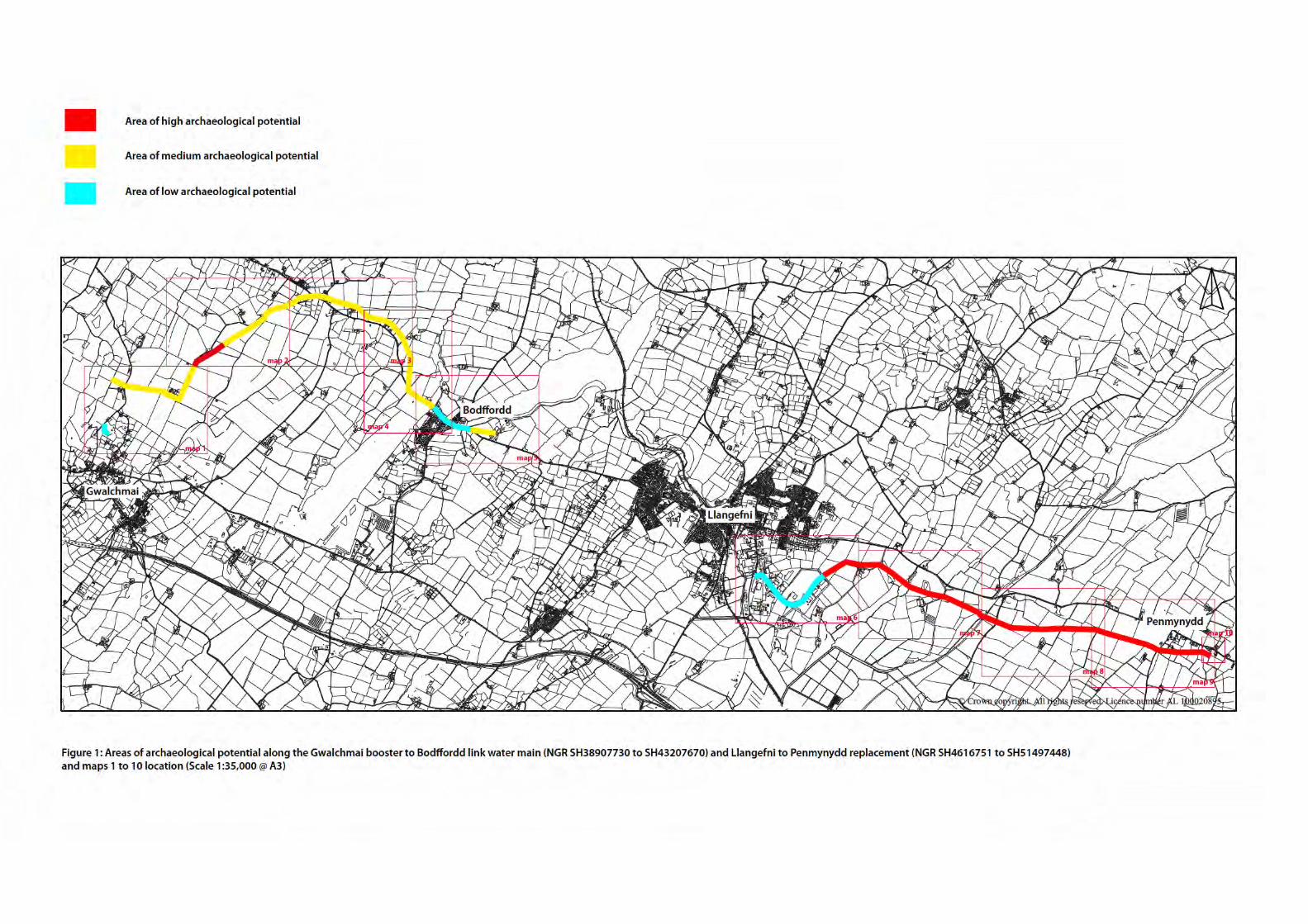
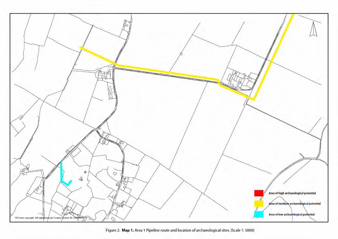
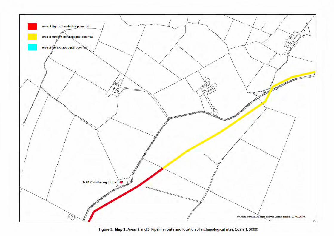
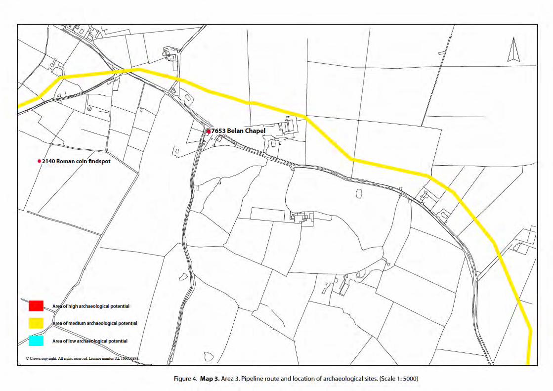
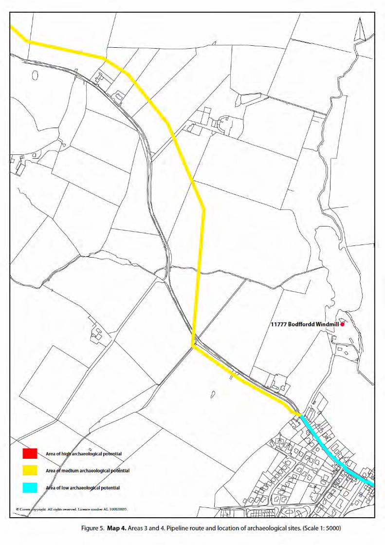
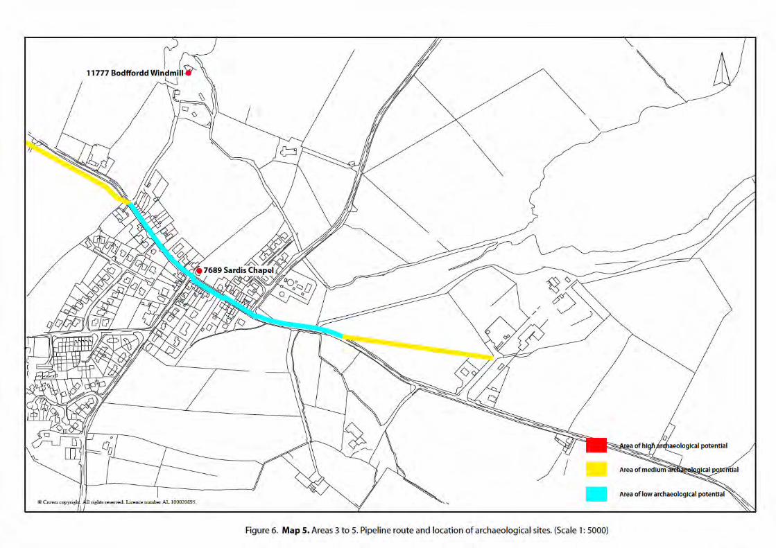
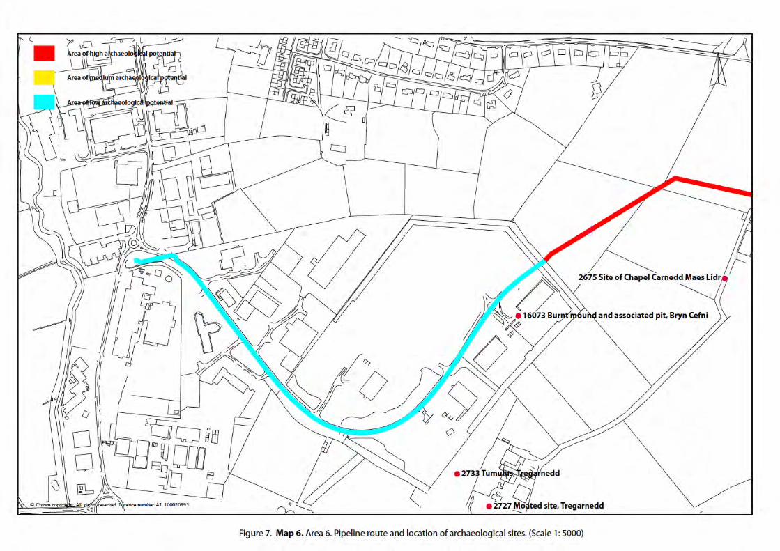
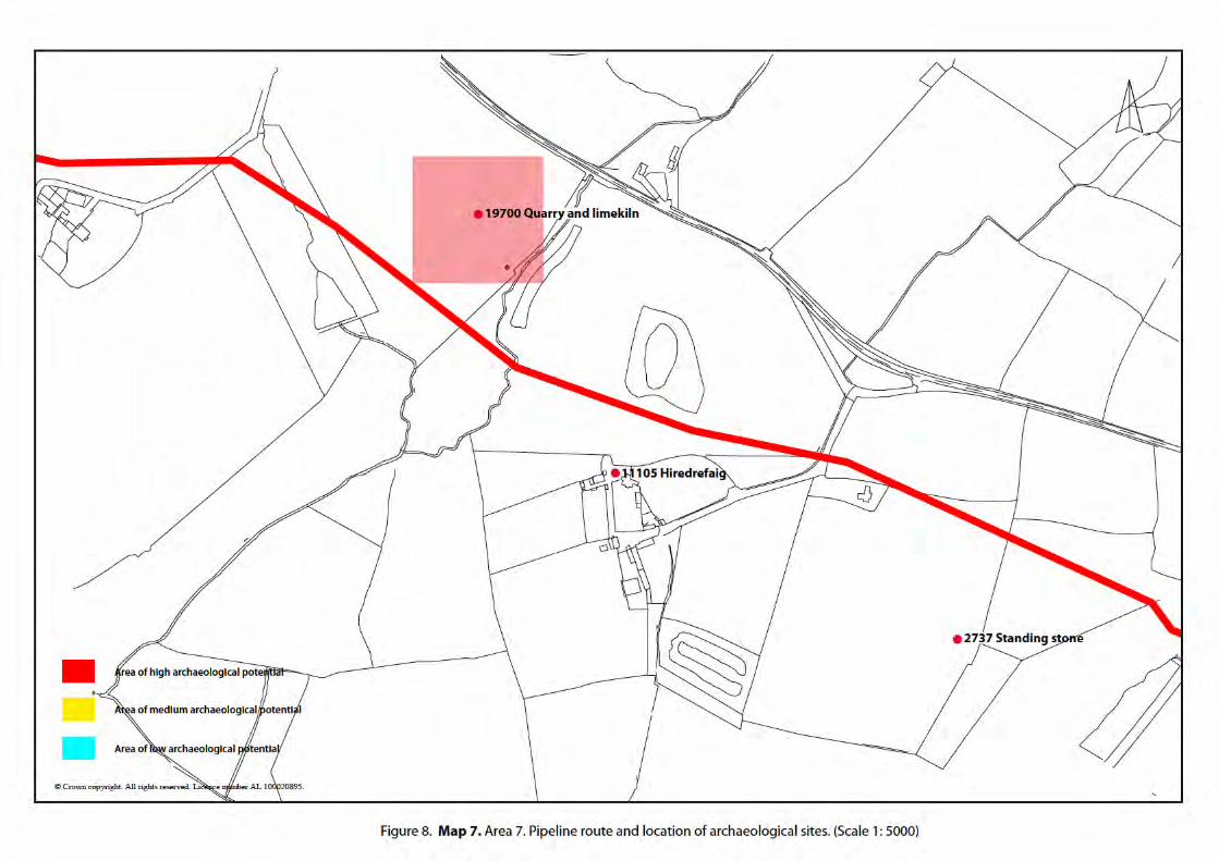
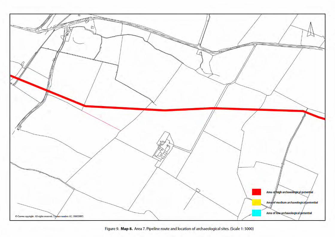
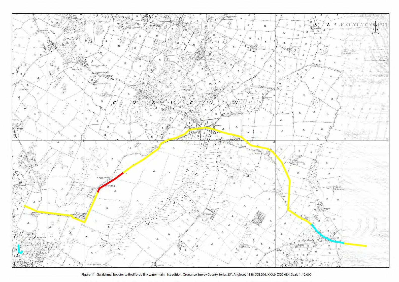
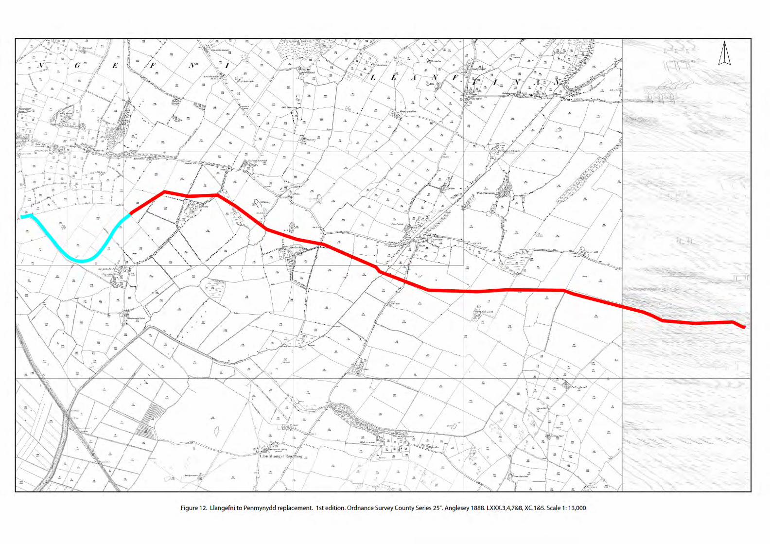
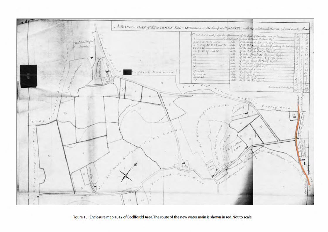
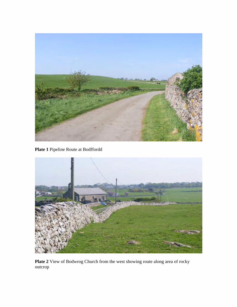
Plate 1 Pipeline Route at Bodffordd
Plate 2 View of Bodwrog Church from the west showing route along area of rocky outcrop
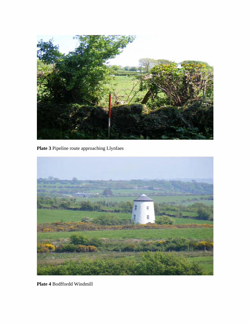
Plate 3 Pipeline route approaching Llynfaes
Plate 4 Bodffordd Windmill


YMDDIRIEDOLAETHARCHAEOLEGOL
GWYNEDD
GWYNEDDARCHAEOLOGICALTRUST
Craig Beuno, Ffordd y Garth, Bangor, Gwynedd. LL57 2RT
Ffon: 01248 352535. Ffacs: 01248 370925. email:[email protected]