Embed Size (px)
Citation preview
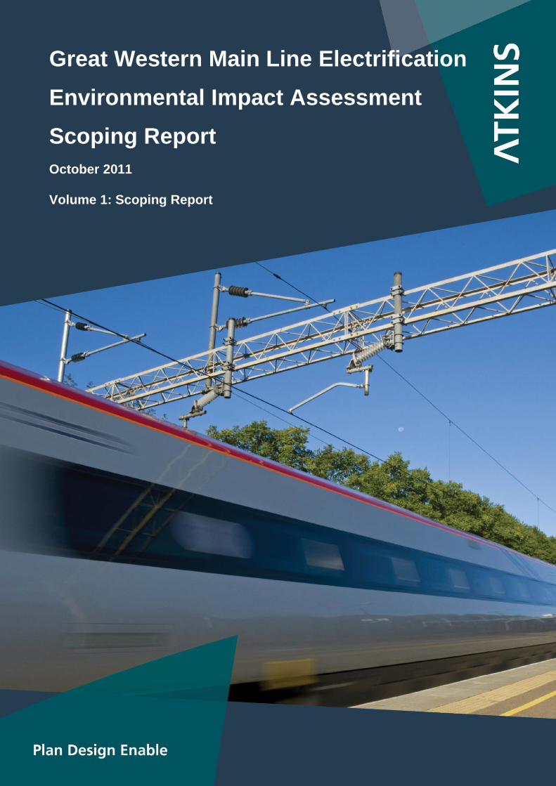
Great Western Main Line Electrification
Environmental Impact Assessment
Scoping Report
October 2011
Volume 1: Scoping Report

5106599-ENV-ATK-SCO-002
Great Western Main Line Overhead Line Electrification Environmental Impact Assessment
Scoping Report Volume 1: Scoping Report
October 2011
Notice
This report was produced by Atkins Limited for Network Rail for the specific purpose of EIA for the electrification of the Great Western Main Line.
This report may not be used by any person other than Network Rail‘s express permission. In any event, Atkins accepts no liability for any costs, liabilities or losses arising as a result of the use of or reliance upon the contents of this report by any person other than Network Rail.
Document History
JOB NUMBER: 5106599 DOCUMENT REF: 5106599-ENV-ATK-SCO-002
A01 Final JB/team AS SW PW 31/10/11
P02 Final draft JB/team AS SW PW 14/10/11
P01 Draft for Comment JB/team AS SW 16/09/11
Revision Purpose Description Originated Checked Reviewed Authorised Date

Great Western Main Line Electrification: Environmental Impact Assessment
Environmental Scoping Report
5106599-ENV-ATK-SCO-002 2
Great Western Main Line Electrification: Environmental Impact Assessment
Environmental Scoping Report
5106599-ENV-ATK-SCO-002 3
Contents
Volume 1: Scoping Report
Section Page
1. Introduction 15
1.1 Background 15
1.2 Permitted Development 15
1.3 Purpose of the Scoping Report 15
1.4 Consultation 16
1.5 Report Content and Structure 16
2. Scheme and Surroundings 18
2.1 Scheme Extent 18
2.2 Description of the Route 18
2.3 Planning Authorities 20
3. Scheme Description 21
3.1 Nature of the Scheme 21
3.2 Construction of the Scheme 26
3.3 Access 30
4. Approach to Environmental Impact Assessment 32
4.1 General EIA Methodology and Processes 32
4.2 Design Development and Environmental Mitigation 33
5. Planning Policy Context 34
5.1 Introduction 34
5.2 National Policy 34
5.3 Regional Policy 35
5.4 Local Policy Context 35
6. Socio-Economic Effects 37
6.1 Introduction 37
6.2 Consultation 37
6.3 Overview of Baseline Conditions and Study Area 37
6.4 Potential Impacts 40
6.5 Proposed Scope of Assessment / Methodology 41
6.6 Potential Mitigation 42
7. Landscape and Visual Effects 43
7.1 Introduction 43
7.2 Consultation 43
7.3 Overview of Baseline Conditions and Study Area 44
7.4 Potential Impacts 45
7.5 Proposed Scope of Assessment / Methodology 45
7.6 Potential Mitigation 50
8. Historic Environment 51
8.1 Introduction 51
8.2 Consultation 51
Great Western Main Line Electrification: Environmental Impact Assessment
Environmental Scoping Report
5106599-ENV-ATK-SCO-002 4
8.3 Overview of Baseline Conditions and Study Area 51
8.4 Potential Impacts 52
8.5 Proposed Scope of Assessment and Methodology 53
8.6 Potential Mitigation 57
9. Land Contamination 59
9.1 Introduction 59
9.2 Consultation 59
9.3 Overview of Baseline Conditions and Study Area 59
9.4 Proposed Scope of Assessment/Methodology 61
9.5 Potential Impacts 63
9.6 Potential Mitigation 65
10. Water Resources and Hydrogeology 66
10.1 Introduction 66
10.2 Consultation 66
10.3 Overview of Baseline Conditions and Study Area 66
10.4 Potential Impacts 69
10.5 Proposed Scope of Assessment / Methodology 70
10.6 Flood Risk Assessment (FRA) Report Scope 71
10.7 Potential Mitigation 73
11. Ecology and Nature Conservation 74
11.1 Introduction 74
11.2 Consultation 74
11.3 Overview of Baseline Conditions and Study Area 74
11.4 Potential Impacts 75
11.5 Proposed Scope of Assessment / Methodology 77
11.6 Potential Mitigation 81
12. Microclimate 83
12.1 Introduction 83
12.2 Consultation 83
12.3 Overview of Baseline Conditions and Study Area 83
12.4 Potential Impacts 83
12.5 Proposed Scope of Assessment / Methodology 83
12.6 Potential Mitigation 83
13. Traffic Effects 84
13.1 Introduction 84
13.2 Consultation 84
13.3 Overview of Baseline Conditions and Study Area 85
13.4 Potential Impacts 85
13.5 Proposed Scope of Assessment / Methodology 86
13.6 Potential Mitigation 88
14. Air Quality and Climate Change 89
14.1 Introduction 89
14.2 Consultation 89
14.3 Overview of Baseline Conditions and Study Area 89
14.4 Potential Impacts 94
Great Western Main Line Electrification: Environmental Impact Assessment
Environmental Scoping Report
5106599-ENV-ATK-SCO-002 5
14.5 Proposed Scope of Assessment / Methodology 95
14.6 Potential Mitigation 96
15. Noise and Vibration 97
15.1 Introduction 97
15.2 Consultation 97
15.3 Overview of Baseline Conditions and Study Area 97
15.4 Potential Impacts 98
15.5 Proposed Scope of Assessment / Methodology 99
15.6 Potential Mitigation 99
16. Electromagnetic Effects 101
16.1 Introduction 101
16.2 Consultation 101
16.3 Overview of Baseline Conditions and Study Area 101
16.4 Potential Impacts 101
16.5 Proposed Scope of Assessment / Methodology 102
16.6 Potential Mitigation 102
17. Cumulative Effects 103
17.1 Introduction 103
17.2 Cumulative Effects within the Scheme 103
17.3 Cumulative Effects with Other Proposals 103
18. Draft Content of the Environmental Statement 104
18.1 Environmental Statement Structure 104
18.2 Environmental Statement Content 104
List of Tables
Table 6.1 – Study Area Population 37
Table 6.2 – Study Area Economic Activity Rates (Aged 16-64), 2010 38 Table 6.3 – Study Area Unemployment Rates (Aged 16-64), 2010 38
Table 6.4 – Study Area Qualification Levels (Aged 16-64), 2010 39
Table 6.5 – Study area Median Gross Annual Pay, 2010 39
Table 6.6 – Index of Multiple Deprivation, 2010 40
Table 6.7 – Assessment Criteria for Socio-Economic Impacts 42
Table 7.1 – Proposed Scope of the Landscape and Visual Assessment Work 47
Table 8.1 – Description of Asset Value 55
Table 8.2 – Broad Criteria for assessing the Scale of Beneficial and Adverse Change 55 Table 8.3 – Determination of Environmental Effect 57
Table 9.1 – Estimation of the Level of Risk by Comparison of Consequence and Probability 63
Table 11.1 – Ecological Study Areas 75
Table 13.1 - Environmental Impacts of Traffic and Potential Mitigation 88
Table 14.1 - Air Quality Criteria 90
Table 14.2 - Summary of Air Quality Baseline Conditions 92
Great Western Main Line Electrification: Environmental Impact Assessment
Environmental Scoping Report
5106599-ENV-ATK-SCO-002 6
Volume 1: Appendices
Appendix A – Overhead Line Electrification: Examples of Support Types 4
Appendix B - Planning Policy 9
B.1 Planning Policy 10
Appendix C - Landscape and Visual Impact 19
C.1 Landscape and Visual Impact 20
Appendix D – Land Contamination 26
D.1 Land Contamination 27
Appendix E – Air Quality 44
E.1 Air Quality Baseline 45
List of Tables
Table B.1 – Summary of Landscape Baseline Information 20
Table B.2 – Likely Scope of Landscape and Visual Impacts 23
Table C.1 – Summary of Published Geology for Phases 1 to 7 27
Table C.2 – Groundwater Source Protection Zones 30
Table C.3 - Surface Water Features within 250m of Phases 1 to 7 31
Table D.4 – Potential Sources of Contamination within 250m of Phases 1 to 7 34
Table E.1 – Annual Mean Concentration of Nitrogen Dioxide Measured at RBWM Continuous Analyser 45
Table E.2 – Mapped Background Concentrations 45
Table E.3 – Mapped Background Concentrations 46
Table E.4 – Annual Mean Concentrations of Nitrogen Dioxide Measured in Reading 47
Table E.5 – Concentrations of PM10 Measured in Reading 47
Table E.6 – Mapped Background Concentrations for Reading 47
Table E.7 – Annual Mean Concentrations of Nitrogen Dioxide Measured in West Berkshire 48
Table E.8 – Mapped Background Concentrations 48
Table E.9 – Mapped Background Concentrations 49
Table E.10 – Mapped Background Concentrations 49
Table E.11 – Pollutant Concentrations Measured at Oxford City Council Continuous Analysers 50
Table E.12 – Mapped Background Concentrations 50
Table E.13 – Mapped Background Concentrations 51
Table E.14 – Mapped Background Concentrations 51
Table E.15 – Mapped Background Concentrations 52
Table E.16 – Annual Mean Concentrations of Nitrogen Dioxide Measured at BCC Continuous Analysers 53
Table E.17 – Mapped Background Concentrations 53
Table E.18 – Pollutant Concentrations Measured at SGC Continuous Analyser 54
Table E.19 – Mapped Background Concentrations 54
List of Figures
Figure A 1 Single Track Cantilever 5
Figure A 2 Double Track Cantilever 5
Figure A 3 Headspan 6
Figure A 4 Portal 6
Figure A 5 Back to Back Cantilever 7

Great Western Main Line Electrification: Environmental Impact Assessment
Environmental Scoping Report
5106599-ENV-ATK-SCO-002 7
Volume 2: Figures
5106599-ENV-ATK-001 GWML Electrification Scheme Route Plan
5106599-ENV-ATK-002 GWML Electrification Environmental Designations Map Sheets 1 to 39
5106599-ENV-ATK-003 GWML Electrification Flood Zones Sheets 1 to 39
5106599-ENV-ATK-004 GWML Electrification Areas of Outstanding Natural Beauty
5106599-ENV-ATK-005 GWML Electrification National Character Areas

Great Western Main Line Electrification: Environmental Impact Assessment
Environmental Scoping Report
5106599-ENV-ATK-SCO-002 8
Great Western Main Line Electrification: Environmental Impact Assessment
Environmental Scoping Report
5106599-ENV-ATK-SCO-002 9
Abbreviations
Term Meaning / Definition
1D One Dimensional
2D Two Dimensional
3D Three Dimensional
AAP Area Action Plan
AADT Annual Average Daily Traffic
AAWT Annual Average Weekday Traffic
AC Alternating Current
aep Annual Exceedance Probability
AM Ancient Monument
AOD Above Ordnance Datum (height ‗above sea level‘)
AONB Area of Outstanding Natural Beauty
AQMA Air Quality Management Area
BAP Biodiversity Action Plan
BAT Best Available Techniques. BAT includes both the technology used and the way in which the installation is designed, built operated and decommissioned. It is defined as, ―the most effective and advanced stage in the development of activities and their methods of operation which indicates the practical suitability of particular techniques for providing in principle the basis for emission limit values designed to prevent and, where that is not practicable, generally to reduce emissions and the impact on the environment as a whole.”
BGL Below Ground Level
BGS British Geological Survey
CLR Contaminated Land Report
CSM Conceptual Site Model (for contamination pathways)
DC Direct Current
DCLG Department for Communities and Local Government
DCO Development Consent Order
DECC Department of Energy and Climate Change
DEFRA Department for Environment, Food and Rural Affairs
DfT Department for Transport
DMRB Design Manual for Roads and Bridges, published by the Highways Agency
DPD Development Plan Document
EcIA Ecological Impact Assessment
Great Western Main Line Electrification: Environmental Impact Assessment
Environmental Scoping Report
5106599-ENV-ATK-SCO-002 10
Term Meaning / Definition
EH English Heritage
EIA Environmental Impact Assessment
EMC Electromagnetic compatibility
EMF Electromagnetic Field
ES Environmental Statement
EQS Environmental Quality Standard
EU European Union
GB Great Britain
GQA General Quality Assessment
GRIP Guide to Railway Investment Projects (Network Rail‘s investment process, made up of eight key stages from initial output definition through to final project close out)
GWML Great Western Main Line
GWR Great Western Railway
HDV Heavy Duty Vehicle
HER Historic Environment Record
HGV Heavy Goods Vehicle
HOOB High Output Operations Base
HOPS High Output OLE Installation System
HST High Speed Train
IBA Important Bird Area
IEEM Institute for Ecology and Environmental Management
IEMA Institute of Environmental Management and Assessment
IPD Interim Planning Document
IPPC Integrated Pollution Prevention and Control
IRS Integrated Regional Strategy
JRB Joint Regional Board
JSP Joint Structure Plan
LAQM TG Local Air Quality Management Technical Guidance
LCA Landscape Character Area
LCT Landscape Character Type
LDD Local Development Document
LDF Local Development Framework
LI Landscape Institute
Great Western Main Line Electrification: Environmental Impact Assessment
Environmental Scoping Report
5106599-ENV-ATK-SCO-002 11
Term Meaning / Definition
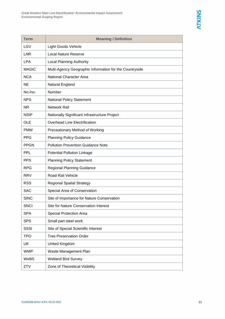
LGV Light Goods Vehicle
LNR Local Nature Reserve
LPA Local Planning Authority
MAGIC Multi-Agency Geographic Information for the Countryside
NCA National Character Area
NE Natural England
No./no. Number
NPS National Policy Statement
NR Network Rail
NSIP Nationally Significant Infrastructure Project
OLE Overhead Line Electrification
PMW Precautionary Method of Working
PPG Planning Policy Guidance
PPGN Pollution Prevention Guidance Note
PPL Potential Pollution Linkage
PPS Planning Policy Statement
RPG Regional Planning Guidance
RRV Road Rail Vehicle
RSS Regional Spatial Strategy
SAC Special Area of Conservation
SINC Site of Importance for Nature Conservation
SNCI Site for Nature Conservation Interest
SPA Special Protection Area
SPS Small part steel work
SSSI Site of Special Scientific Interest
TPO Tree Preservation Order
UK United Kingdom
WMP Waste Management Plan
WeBS Wetland Bird Survey
ZTV Zone of Theoretical Visibility
Great Western Main Line Electrification: Environmental Impact Assessment
Environmental Scoping Report
5106599-ENV-ATK-SCO-002 12
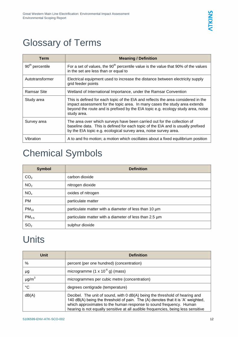
Glossary of Terms
Term Meaning / Definition
90th percentile For a set of values, the 90
th percentile value is the value that 90% of the values
in the set are less than or equal to
Autotransformer Electrical equipment used to increase the distance between electricity supply grid feeder points
Ramsar Site Wetland of International Importance, under the Ramsar Convention
Study area This is defined for each topic of the EIA and reflects the area considered in the impact assessment for the topic area. In many cases the study area extends beyond the route and is prefixed by the EIA topic e.g. ecology study area, noise study area.
Survey area The area over which surveys have been carried out for the collection of baseline data. This is defined for each topic of the EIA and is usually prefixed by the EIA topic e.g. ecological survey area, noise survey area.
Vibration A to and fro motion; a motion which oscillates about a fixed equilibrium position
Chemical Symbols
Symbol Definition
CO2 carbon dioxide
NO2 nitrogen dioxide
NOx oxides of nitrogen
PM particulate matter
PM10 particulate matter with a diameter of less than 10 µm
PM2.5 particulate matter with a diameter of less than 2.5 µm
SO2 sulphur dioxide
Units
Unit Definition
% percent (per one hundred) (concentration)
μg microgramme (1 x 10⁻⁶
g) (mass)
μg/m3 microgrammes per cubic metre (concentration)
°C degrees centigrade (temperature)
dB(A) Decibel. The unit of sound, with 0 dB(A) being the threshold of hearing and 140 dB(A) being the threshold of pain. The (A) denotes that it is ‗A‘ weighted, which approximates to the human response to sound frequency. Human hearing is not equally sensitive at all audible frequencies, being less sensitive
Great Western Main Line Electrification: Environmental Impact Assessment
Environmental Scoping Report
5106599-ENV-ATK-SCO-002 13
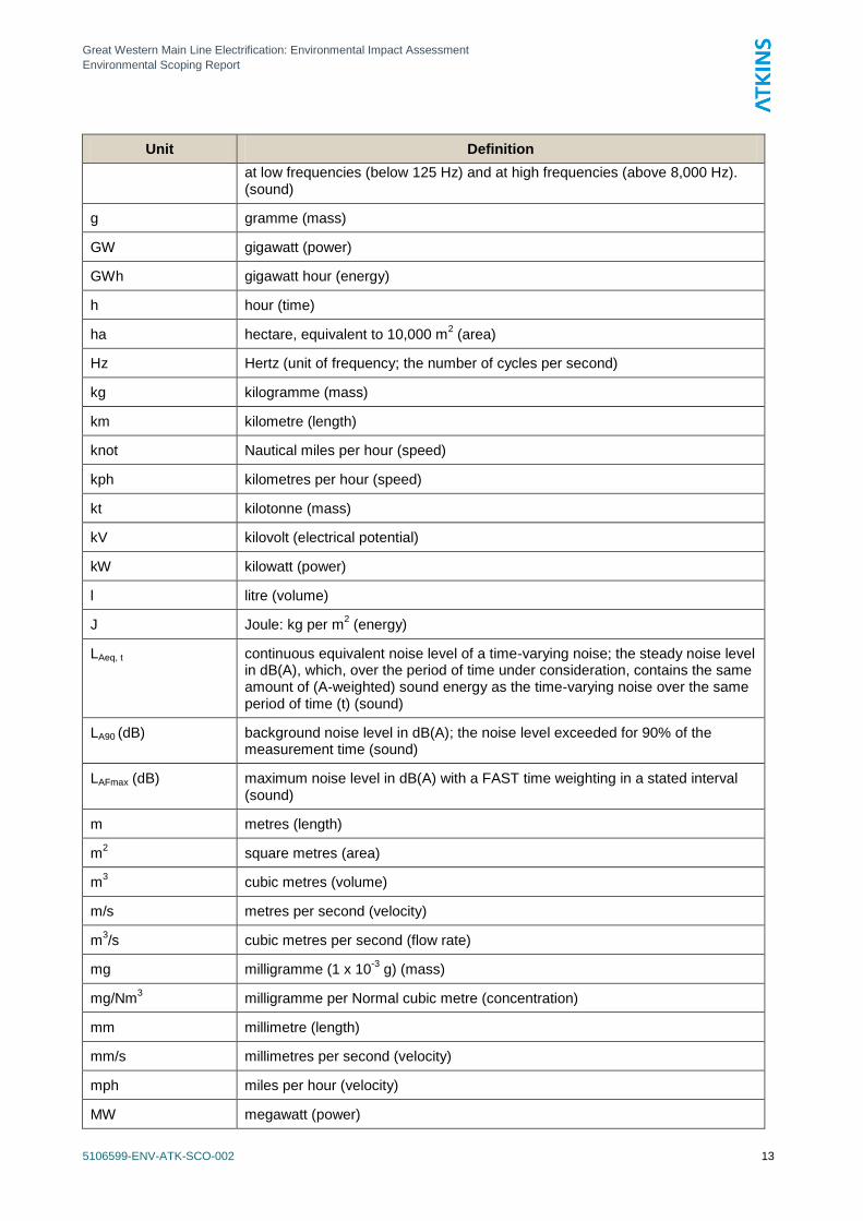
Unit Definition
at low frequencies (below 125 Hz) and at high frequencies (above 8,000 Hz). (sound)
g gramme (mass)
GW gigawatt (power)
GWh gigawatt hour (energy)
h hour (time)
ha hectare, equivalent to 10,000 m2 (area)
Hz Hertz (unit of frequency; the number of cycles per second)
kg kilogramme (mass)
km kilometre (length)
knot Nautical miles per hour (speed)
kph kilometres per hour (speed)
kt kilotonne (mass)
kV kilovolt (electrical potential)
kW kilowatt (power)
l litre (volume)
J Joule: kg per m2 (energy)
LAeq, t continuous equivalent noise level of a time-varying noise; the steady noise level in dB(A), which, over the period of time under consideration, contains the same amount of (A-weighted) sound energy as the time-varying noise over the same period of time (t) (sound)
LA90 (dB) background noise level in dB(A); the noise level exceeded for 90% of the measurement time (sound)
LAFmax (dB) maximum noise level in dB(A) with a FAST time weighting in a stated interval (sound)
m metres (length)
m2 square metres (area)
m3 cubic metres (volume)
m/s metres per second (velocity)
m3/s cubic metres per second (flow rate)
mg milligramme (1 x 10⁻³
g) (mass)
mg/Nm3 milligramme per Normal cubic metre (concentration)
mm millimetre (length)
mm/s millimetres per second (velocity)
mph miles per hour (velocity)
MW megawatt (power)
Great Western Main Line Electrification: Environmental Impact Assessment
Environmental Scoping Report
5106599-ENV-ATK-SCO-002 14
Unit Definition
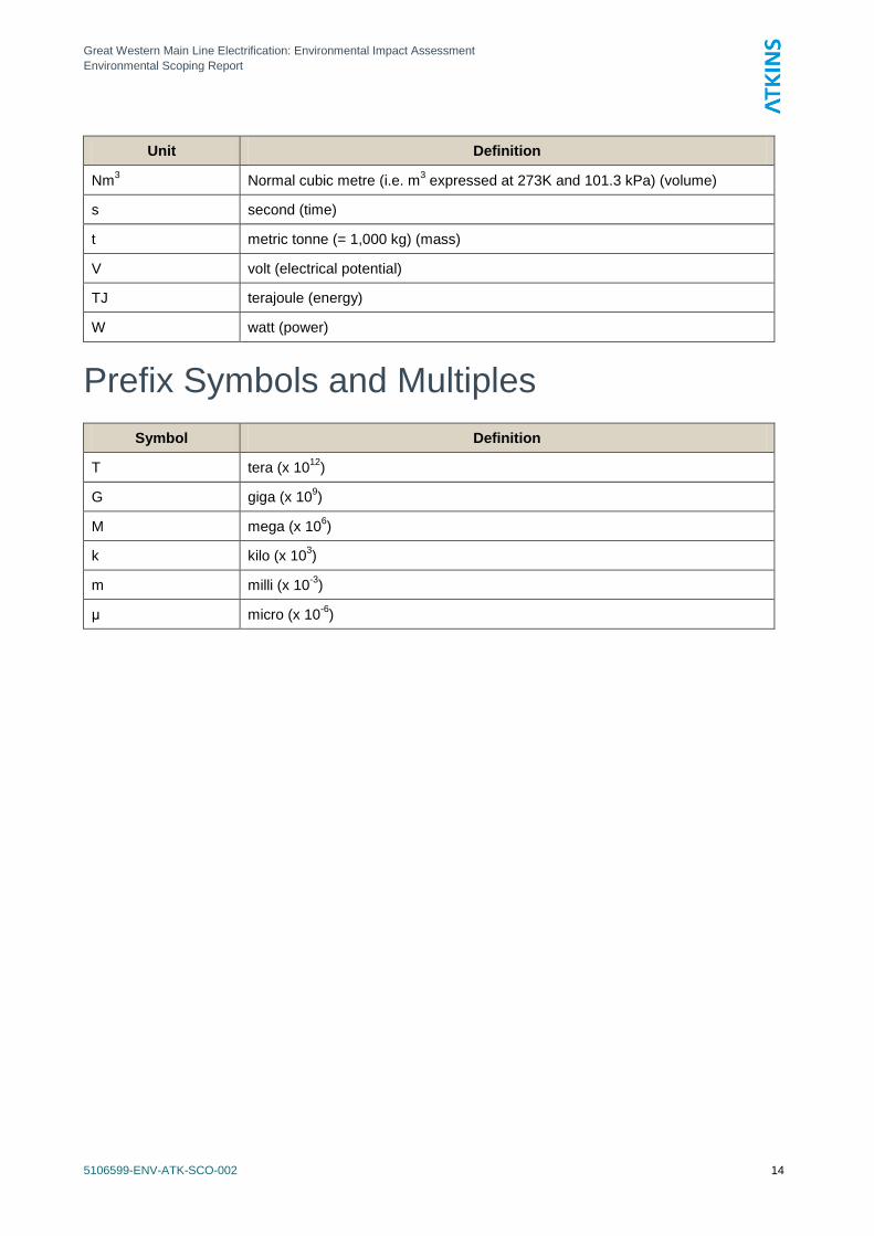
Nm3 Normal cubic metre (i.e. m
3 expressed at 273K and 101.3 kPa) (volume)
s second (time)
t metric tonne (= 1,000 kg) (mass)
V volt (electrical potential)
TJ terajoule (energy)
W watt (power)
Prefix Symbols and Multiples
Symbol Definition
T tera (x 1012
)
G giga (x 109)
M mega (x 106)
k kilo (x 103)
m milli (x 10-3
)
μ micro (x 10-6
)
Great Western Main Line Electrification: Environmental Impact Assessment
Environmental Scoping Report
5106599-ENV-ATK-SCO-002 15
1. Introduction
1.1 Background
1.1.1 The Department for Transport published the document ‗Britain‘s Transport Infrastructure: Rail
Electrification‘ in July 2009. This sets out the commitment of the UK Government to install 25kV
Overhead Line Electrification (OLE) along more of the rail network in Britain.
1.1.2 This Scheme is to electrify the Great Western Main Line (GWML) between Maidenhead in the
east and Bristol (and in due course Cardiff) in the west, including spurs north to Oxford and
south-west to Newbury. Electrification of the GWML between Stockley Junction, near Heathrow,
and the London terminus at Paddington has already been undertaken. Electrification between
Stockley Junction and Maidenhead will be undertaken as part of the Crossrail project.
1.1.3 The electrification would be undertaken on the existing route of the GWML and would not require
the construction of any new railway route.
1.1.4 The electrical power for the project would be provided from the National Grid.
1.2 Permitted Development
1.2.1 The Scheme would be undertaken by Network Rail, using its Permitted Development Rights
under the powers of Part 11 of the Town and Country Planning (General Permitted Development)
Order 1995, as amended. The Rights allow Network Rail to undertake development authorised
by a local or private Act of Parliament, or an order approved by both Houses of Parliament. This
means that Planning Consent could be required for permanent works that extend beyond the
existing railway and the Limits of Deviation of the original authorising Acts. Listed Building
Consent will still be required for works that require physical change to Listed Buildings or their
curtilages. The Permitted Development approach also entails the obtaining of Prior Approval
Consents from the various planning authorities to erect, construct, alter or extend any building,
bridge, aqueduct, pier or dam, or the formation, laying out or alteration of a means of access to
any highway used by vehicular traffic.
1.2.2 Although substantial parts of the Scheme are not expected to give rise to significant
environmental effects in terms of the Town and Country Planning (Environmental Impact
Assessment) Regulations 2011 (―the EIA Regulations‖), nor is the Scheme one that requires a
Development Consent Order from the Infrastructure Planning Commission, Network Rail have
undertaken to provide Environmental Impact Assessment of the entire Scheme. This approach
has been adopted in order to provide robust and consistent supporting documentation for use
with the various Planning, Listed Building, Conservation Area Consent, and Prior Approval
Consent applications that will be required along the length of the Scheme. As the EIA is being
undertaken in any event Network Rail has not requested a formal screening opinion under the
EIA Regulations regarding the Environmental Impact Assessment for this Scheme.
1.3 Purpose of the Scoping Report
1.3.1 The purpose of the Scoping Report is to describe how the EIA of the Scheme will be undertaken,
set out the topics that will be assessed and the geographic and spatial scope within which they
will be considered. The report also sets out an overview of the methods that are intended to be
used in the EIA to determine the potential significant environmental effects that will occur
temporarily during the Scheme construction and occur permanently because of its physical
presence and operation.
1.3.2 The key objectives in undertaking the EIA scoping are to:
Great Western Main Line Electrification: Environmental Impact Assessment
Environmental Scoping Report
5106599-ENV-ATK-SCO-002 16
set out the overall approach to the EIA;
identify the environmental topics to be assessed;
identify any topics that do not need to be assessed i.e. can be ‗scoped out‘;
define the technical, spatial and temporal scope of individual assessments;
define the methodologies to be used in the topic assessments including baseline studies;
set out the methodology for predicting environmental impacts and evaluating their
significance; and
set out the general approach for incorporating mitigation into the Scheme, whether it is
through modifications to the design or the addition of other environmental or sustainability
measures.
1.3.3 The scope of works detailed in this scoping report is not exhaustive and it is recognised that
environmental issues are very likely to evolve as the proposals are prepared due to the detailed
work that will be carried out as part of the EIA and design development processes.
1.3.4 Network Rail will be willing to provide further information or discuss in more detail any aspects of
the scoping report with the statutory consultees.
1.4 Consultation
1.4.1 No specific consultation has been undertaken to inform this scoping process, but it is expected
that there will be some feedback from consultees following the distribution of the Scoping Report.
The intentions for consultation during the EIA process have been included within each of the topic
assessment chapters.
1.4.2 Network Rail have already begun the general consultation process for the Scheme by means of a
series of high-level discussions with Members of Parliament and senior executives and, in some
cases, Members of the local authorities through which the Scheme would pass, as well as
English Heritage. Network Rail has met Chief Executives, Leaders of Councils and Heads of
Planning at a town planning and communications briefing in summer 2011. More recently, in
September 2011, Network Rail Communications team have met with each of the Local
Authorities to discuss the electrification project and the benefits to their area. Network Rail has
also had discussions with the Infrastructure Planning Commission, who confirmed that the
Permitted Development approach would be appropriate for this Scheme, and that an Application
for a Development Consent Order would not be required.
1.5 Report Content and Structure
1.5.1 In arranging the content of this Scoping Report, and therefore also of the Environmental
Statements that will follow, the aim has been to set the chapters in a sequence that presents
information to the reader in a logical order. This also facilitates cross reference between chapters
with related content.
1.5.2 The drawings have been provided in a separate volume, which is also intended to facilitate cross
reference.
1.5.3 Following this Introduction, the Scoping Report content is:
Scheme and Surroundings
Scheme Description
Approach to Environmental Assessment
Great Western Main Line Electrification: Environmental Impact Assessment
Environmental Scoping Report
5106599-ENV-ATK-SCO-002 17
Planning Policy Context
Social Impact Assessment
Landscape and Visual Assessment
Historic Environment
Water Resources and Hydrogeology
Land Contamination
Ecology and Nature Conservation
Microclimate
Traffic Effects
Air Quality
Noise and Vibration
Electromagnetic Effects
Cumulative Impacts
Content of the Environmental Statement
Great Western Main Line Electrification: Environmental Impact Assessment
Environmental Scoping Report
5106599-ENV-ATK-SCO-002 18
2. Scheme and Surroundings
2.1 Scheme Extent
2.1.1 The extent of the Scheme is indicated on Figure 2.1 and on the Figures in Volume 2 of the
Report.
2.1.2 The Scheme comprises the following rail lines:
Western end of Maidenhead Station to Wootton Bassett Junction
Didcot Parkway to Oxford
Reading to Newbury
Wootton Bassett Junction to Bristol Temple Meads
Wootton Bassett Junction to Bristol Parkway
Bristol Temple Meads to Bristol Parkway via Stapleton Road
2.1.3 The intention is that the electrified route will be operational by December 2016.
2.1.4 The environmental assessment of the line from Bristol Parkway to Cardiff will be the subject of a
further study. The intention is that this section of electrification would be operational by
December 2017.
2.2 Description of the Route
2.2.1 From Maidenhead Station the Main Line heads south-of west above the local roads, before
passing into cutting though the suburb of Cox Green and under the A404(M). West of
Maidenhead, the Main Line continues on a straight through shallow cuttings in a gently undulating
agricultural landscape. To the north, the A4 runs through a string of villages below the higher
ground of Knowl Hill, with the Thames Valley beyond. To the south, the M4 runs through wooded
farmland, with the suburban heathland around Wokingham rising beyond. As the land falls to the
Loddon Valley, the line rises on embankment to pass through Twyford and then across the two
arms of the river and flooded gravel workings, which include a nature reserve. The line then
passes into substantial cutting and curves westwards through the eastern suburbs of Reading,
returning onto embankment as the line enters the Thames Valley. The effects of electrification of
the Main Line through Reading and the start of the line to Newbury are assessed as part of the
improvement project for the Reading Station Area.
2.2.2 West of Reading, the Main Line continues on a series of curves on alternating cuttings and
embankments to follow the tightly enclosed Thames floodplain and so pass through the hilly
landscape of the Chilterns, much of which is designated as an AONB. Within the valley the line
passes through Tilehurst, Pangbourne and Goring and runs alongside the Beale Wildlife Park,
crossing the River twice on either side of Goring. The Line then leaves the river and the Chilterns
and heads north-west across the gentle landscape south of the Thames as it passes through
Didcot and then curves west onto a long straight across open low-lying farmland towards
Wantage.
2.2.3 South-west of Reading, the line to Newbury emerges from a cutting through the western suburbs
south of Reading West Station to follow the north side of the Kennet Valley, passing extensive
flooded gravel pits with various leisure uses before going under the M4 and through the large
aggregate depot at Theale. The line continues close to and north of the river and the associated
Kennet and Avon Canal, as the floodplain gradually narrows between the Chilterns to the north
and the wooded commons between Aldermaston and Greenham to the south. The line passes
Great Western Main Line Electrification: Environmental Impact Assessment
Environmental Scoping Report
5106599-ENV-ATK-SCO-002 19
through Aldermaston Wharf, Woolhampton and Thatcham before reaching Newbury. It passes
more areas of flooded gravel pits and associated wildlife and leisure interests, as well as often
being close to the leisure and heritage features of the Canal.
2.2.4 The line to Oxford branches off at Didcot and heads north along the floodplain of the River
Thames (or Isis), often on embankment, crossing the serpentine course of the river at Appleford-
on-Thames and near Abingdon. The line then stays west of the river past Kennington, crossing
to the east side on the approach to central Oxford. The electrification proposals would extend
some 1.6 km beyond the station, past Jericho.
2.2.5 The Main Line passes north of Wantage and continues westwards through the gentle and
relatively open landscape of the Vale of the White Horse. The chalk scarp of the Lambourn
Downs rises to the south, with the landmark of the White Horse evident on the slopes above
Uffington. There are numerous shallow cuttings and embankments along this length as the line
curves around Shrivenham en route to Swindon. The Main Line enters the large urban area of
Swindon in cutting and goes under the A419 and local roads, before passing through the station
and central area at or above ground level, with bridges over the local roads. The route is
bounded by industrial and commercial uses for long stretches, but there are some substantial
areas of housing close to the route, mainly in eastern Swindon. After going under the M4 the line
then runs mostly in cutting through the gently undulating landscape to the junction on the south
side of Royal Wootton Bassett. The northern escarpment of the North Wessex Downs is some 2
to 4 km away to the south.
2.2.6 West of Royal Wootton Bassett, the electrification proposal would apply to both lines to the west:
the direct route to Wales via the Severn Tunnel and Bristol Parkway and the line to Bristol
Temple Meads via Bath.
2.2.7 The line to Wales swings slightly north from Royal Wootton Bassett and goes under the M4 again
before heading west along the fringe of the Cotswolds, initially along the north side of the valley
of the Grittenham Brook past Brinkworth and then across the Avon Valley past Great Somerford.
The route continues with varying degrees of cuttings and earthworks as it heads past
Hullavington into the undulating agricultural landscape of the Cotswolds, entering the AONB
approximately where there is a tunnel near Alderton. After passing between Acton Turville and
Badminton, the Main Line then enters the 4 km long Chipping Sodbury Tunnel, passing under Old
Sodbury before emerging into a series of cuttings that now form the southern extents of Chipping
Sodbury.
2.2.8 The Main Line runs at a relatively high level through the hilly landscape north of Bristol, resulting
in large embankments through the local valleys at Coalpit Heath and Winterbourne and either
side of the M4 crossing and large bridges over the watercourses, including the River Frome.
Bristol Parkway Station is set higher than most of the housing and business park development
around Stoke Gifford, after which the Main Line then curves north around the east side of the rail
junction at Filton, where this part of the electrification proposal would finish.
2.2.9 The Main Line to Bristol Temple Mead runs west from Royal Wootton Bassett through a series of
large embankments and cuttings through the hillsides north of Lyneham before entering the more
gentle terrain of the Avon Valley. Much of the route south-westwards through the valley is on
embankment, until the cutting into rising ground east of Chippenham. After the station, the line
curves southwards through Chippenham on substantial embankments before swinging west
again at Thingley Junction and passing through Corsham mostly in cutting. The line then enters
Box Tunnel, which runs for 2.9 km under Rudloe and the MoD base on Box Hill before entering
the narrow valley of By Book at Box, where the line enters the Cotswolds AONB. The Brook is
crossed three times - either side of the short Middlehill Tunnel and once again to the west – as
the line follows the valley of the Brook to reach the River Avon.
2.2.10 The floor of the Avon Valley provides the route to Bristol through this attractive and often densely
settled landscape, which is particularly hilly around Bath and near Keynsham, without the need
Great Western Main Line Electrification: Environmental Impact Assessment
Environmental Scoping Report
5106599-ENV-ATK-SCO-002 20
for long tunnels. The line crosses the River Avon at Batheaston and runs beside the A4 bypass
across the river floodplain and then curves southwards beside the Kennet and Avon Canal to
pass through Bathwick. Through central Bath the line runs on embankments and structures
above the local road network, including substantial bridges over the River Avon either side of the
station, before heading west through the suburbs of Westmoreland and Twerton, where there is a
short tunnel. The line then returns to the floodplain fields beside the river before passing though
residential Saltford in cutting and the northern and mostly industrial edge of Keynsham. The line
comes close to the river again where the valley becomes narrow and wooded at Brislington,
before entering the curved 0.9 km tunnel under Broom Hill and emerging beside the river
opposite Conham River Park. The line then curves west in cuttings through the St Anne‘s area of
Bristol before crossing the River Avon and then its navigation branch (The Floating Harbour)
before passing through the junction with the line to Bristol Parkway, beyond which are extensive
rail yards. The last part of the line to be electrified would be into Bristol Temple Meads station,
which extends over the Floating Harbour at its north end and the River Avon at its south end,
going just beyond the station.
2.2.11 The electrification proposal would also include the link line to Bristol Parkway, which runs north
from the junction east of Bristol Temple Meads Station around the eastern side of central Bristol
and then up through the northern suburbs. The first part of the line is tightly enclosed between
business parks and housing and passing under the local roads, before the land drops as the line
crosses the valley of the River Frome on embankment and bridges over the local roads and the
M32. The line then returns to cutting as it climbs northwards through the largely residential areas
of Lockleaze and Northville to Filton Junction, where the electrification work would link
northwards across the junction towards Patchway Station and eastwards around the junction to
Bristol Parkway Station.
2.3 Planning Authorities
2.3.1 The Scheme would pass through the following local authorities:
Royal Borough of Windsor and Maidenhead (Unitary)
Wokingham (Unitary)
Reading (Unitary)
West Berkshire (Unitary)
South Oxfordshire (Oxfordshire CC)
Vale of White Horse (Oxfordshire CC)
Oxford (Oxfordshire CC)
Swindon (Unitary)
Wiltshire (Unitary)
Bath and NE Somerset (Unitary)
Bristol City (Unitary)
South Gloucestershire (Unitary)
2.3.2 The boundaries of each of these authorities are included in the Figures in Volume 2.
2.3.3 This Scoping Report is intended to cover the whole Scheme, across all the local authorities listed
above. The intention is to structure the reporting of the consequent environmental impact
assessment in the ES so that each planning authority can receive an Environmental Statement
that relates to its area of jurisdiction, as set out in Chapter 19 of this Scoping Report.
Great Western Main Line Electrification: Environmental Impact Assessment
Environmental Scoping Report
5106599-ENV-ATK-SCO-002 21
3. Scheme Description
3.1 Nature of the Scheme
Overview
3.1.1 The Scheme to provide electrification of the GWML between Maidenhead in the east and Bristol
in the west, including spurs north to Oxford and south-west to Newbury, can be summarised as
including provision of the following main elements:
OLE system and Supports
Bridge Works
Track Works
High Output Operations Base
Power Supply infrastructure
3.1.2 The following report sections provide generic descriptions of these principal elements of the
Scheme.
3.1.3 The extent of the Scheme is shown on the drawings in Volume 2 of this Report. These drawings
include locations for the main proposed items of additional infrastructure, such as electrical
feeder stations and switching stations. As with all information on these drawings, this information
is based on the current understanding of the Scheme and its setting at this scoping stage of the
study, using readily available information. This detail will be checked and updated during the
environmental assessment.
3.1.4 The EIA will provide an assessment of the physical effects of electrification of the GWML and the
Oxford and Newbury spurs during both the construction and operation phases.
3.1.5 Network Rail has a statutory right to run trains and to intensify the service as necessary. Service
patterns on the GWML and Oxford and Newbury spurs are not dependent on the electrification
Scheme and could be amended without the electrification being undertaken.
3.1.6 The EIA will assess the replacement of the majority of the existing diesel rolling stock with stock
which can be electrically operated over the lines to be electrified as follows:
London Paddington to Newbury
London Paddington to Oxford
London Paddington to Bristol and Cardiff
3.1.7 The EIA assumes that train services to the West Country, Cross Country services along the
Oxford spur, Chiltern Railway services north from Oxford towards London Marylebone and local
services beyond Newbury will remain diesel operated.
3.1.8 The environmental assessment of the electrification works within the extents of Reading station
will have already been covered under the Reading Station Area Redevelopment Project and will
not be the subject of further assessment as part of this EIA commission.
OLE Supports
3.1.9 The Scheme is intended to supply trains with 25 kV AC electrical power from continuous
overhead conductor wires suspended above each track. Power is collected using sprung
pantographs on top of the train power units, which maintain contact with the underside of the
conductor wire. The pantographs can be lowered when the train is operating under diesel power.
This method of main line railway electrification is already widely used in the UK on routes such as
Great Western Main Line Electrification: Environmental Impact Assessment
Environmental Scoping Report
5106599-ENV-ATK-SCO-002 22
the East Coast Main Line and the West Coast Main Line. It is better suited to high travel speeds
than the third-rail DC electrification system used on suburban lines in south-east England;
however, it does entail the addition of a significant amount of visible infrastructure to the railway
corridor.
3.1.10 OLE supports are required to support the overhead electrified lines and therefore are required
along the entire length of the electrified scheme. The OLE supports are generally installed
approximately 50m to 72m apart; this distance can vary depending on factors such as ground
conditions and the location of structures. The contact wire (the lower of the two) is normally 4.7m
above track level, supported from the upper suspension wire. The height above the contact wire
of the top of the support (at the support) is approx 1.2m. Depending on the location of the OLE
supports, they may be either:
A cantilever OLE support over one or two tracks, which has a mast on one side.
A headspan, which provides a support cable across between posts on both sides of the track
or tracks.
A portal structure, which provides a rigid support across between posts on both sides of the
track or tracks.
3.1.11 The foundations or footings for the support masts could be piled, using a range of piling
techniques including percussive or drilled, or they could be formed on ground bearing concrete
pads. The piled footings can be expected to be 4m to 6m in depth in general, but piling as deep
as 10m may be necessary at some points where ground conditions require. The height of the
mast would vary depending on the type installed at each location, but is generally around 7m.
3.1.12 The positions of the OLE supports along the line can be varied to suit local conditions, such as
the position of structures and stations along the route and the visual sensitivity of particular parts
of the route. Although the conductor cable is kept straight by hangers extending down from the
support cable, the support cable itself sags between the support masts. Careful location of the
OLE supports can therefore be used to minimise the clearance needed under existing structures
in some locations, so avoiding the need for alteration to the clearance under the structures.
3.1.13 The OLE system also requires the provision of an auto transformer feeder conductor to complete
the electrical circuit. These can be either provided within a cable trough alongside the line or as a
cable suspended above, inside or on the outside of the OLE supports. For this Scheme, the
intention is to mount the return cable on top of the OLE supports, approximately 1.5m in from the
mast, to minimise the impact of electrification on the adjacent trees. This arrangement means
that the required height clearance is not increased, that the return cable does not cause
interference with the existing or proposed communications cables alongside the tracks, and that
the proximity of the electrical fields around the conductor and return cables tends to provide some
mitigation of the potential for interference with other electromagnetic installations in the vicinity of
the railway.
3.1.14 The maximum length of conductor cable that can be provided as a continuous length is about
1500m. Continuity between lengths is provided by arranging for there to be an overlap of about
200m.The point at which such overlaps are provided can be varied to suit local aesthetic
considerations, as it adds to the complexity of the OLE appearance, but only within the 1500m
overall limit.
3.1.15 Generic illustrations of different types of OLE support are provided in Appendix A. The
Environmental Statement will include a more detailed description of the OLE system, assisted by
a series of diagrams and visualisations.
Communications Infrastructure
3.1.16 The scheme will include the provision of fibre optic cables that will be laid in existing or new cable
routes with signalling or HV cables. The fibre optic cables will be used to enable control and data
Great Western Main Line Electrification: Environmental Impact Assessment
Environmental Scoping Report
5106599-ENV-ATK-SCO-002 23
communications between electrical distribution substations, remotely operational OLE switches
and to the Electrical Control Room at Crewe.
Bridge Works
3.1.17 In order to install OLE along the Scheme there needs to be sufficient clearance above the track to
provide a safe installation. This means that a significant proportion of the bridges along the route
would need to be altered to achieve the necessary clearance or to overcome any safety risk
posed to users of the bridge if OLE was installed without any bridge alteration. The solution for
each of these amended structures has been determined by the constraints that each structure
poses, following a process of optioneering by Network Rail to identify the best option at each
bridge. The chosen option in each case reflects a range of considerations, including safety, the
appearance and heritage value of the structure, the potential impacts on neighbours and users of
the bridge, and the buildability and therefore cost associated with the works.
3.1.18 The general types of bridge work that would be required across the Scheme are:
Demolitions and reconstructions, either whole or partial.
Jacking to raise the height of a structure to increase clearance.
Parapet works – usually increasing the height of the parapet to ensure users of the bridge are
a safe distance from live OLE.
OLE attachments, such as attaching OLE supports to the underside of a bridge or tunnel, or
attaching supports to a viaduct structure.
3.1.19 At this scoping stage, the structures that are expected to be subject to demolition and
reconstruction are:
Wokingham
Duffield Road Keepers [Bridge No.3258]
West Berkshire
Padworth Lane [Bridge No.4440]
Boundary Road, Greenham Road, Winchcombe Road, A239, [Bridge No.5255]
Newbury Station Footbridge [Bridge No.5305]
Rockingham Road [Bridge No.5333]
South Oxfordshire
Goring Station [Bridge No.4460]
Stock Bridge [Bridge No.5112]
Fulscot [Bridge No. 5168]
Foxhall Lane [Bridge No.5341]
Wantage Road A338 [Bridge No.6028H]
Vale of White Horse
Appleford Road (B4016) [Bridge No.5518T]
Culham Thame Lane [Bridge No.5657H]
Wantage Road, Hanneys, Crossing [Bridge No.6078]
Challow Road A417 [Bridge No.6367]
Great Western Main Line Electrification: Environmental Impact Assessment
Environmental Scoping Report
5106599-ENV-ATK-SCO-002 24
Shrivenham [Bridge No.7137]
Bourton Church [Bridge No.7169]
Bourton [Bridge No.7215]
Oxford City
Oxford Hinksey Lake Footbridge [Bridge No.6219H]
Oxford Footbridge [Bridge No.6249]
Oxford Walton Well Road [Bridge No.6408]
Swindon
Roman Road [Bridge No.7508Q]
Pipebridge [Bridge No. 7562]
Wiltshire
Hay Lane [Bridge No.8030]
Swindon Road [Bridge No.8137H]
Templars Farm [Bridge No.8242]
Broad Town Road [Bridge No.8268H]
Callow Hill [Bridge No.8529Q]
Accommodation Bridge [Bridge No.8558]
Road [Bridge No.8675H]
Wootton Bassett Road, Dauntsey, [Bridge No.8759H]
Overbridge Near Dauntsey [Bridge No.8830H]
Dauntsey Road [Bridge No.8849]
Beyond Dauntsey [Bridge No.8867]
Green Bridge [Bridge No.9304]
Pig Lane [Bridge No.9569]
Fosse Way [Bridge No.9647]
Aqueduct [Bridge No.9648Q]
Thingley Road [Bridge No.9664]
Accommodation Bridge [Bridge No.9664T]
Corsham Station Footbridge [Bridge No.9828]
Corsham Aqueduct [Bridge No.9844]
Accommodation Bridge [Bridge No.9927Q]
Shockerwick Footbridge [Bridge No.10246]
Aqueduct [Bridge No.10374T]
Aqueduct [Bridge No.10539H]
Great Western Main Line Electrification: Environmental Impact Assessment
Environmental Scoping Report
5106599-ENV-ATK-SCO-002 25
South Gloucestershire
Overbridge [Bridge No.9944T]
Accommodation [Bridge No.9958]
Overbridge [Bridge No.10632]
Overbridge [Bridge No.10971]
Accommodation Bridge [Bridge No.11115]
Pearsons Brick Yard [Bridge No.11132Q]
Bath and North East Somerset
Hampton Row Footbridge [Bridge No.10565]
Brook Lane Overbridge [Bridge No.10776]
Bristol City
Bath Road [Bridge No.11849]
3.1.20 There are seven bridges on the route that have been excluded from the scope of the EIA,
because advance works need to be undertaken on these bridges before the EIA process will be
completed. Initial assessments have been undertaken of the potential environmental impacts of
these works. These bridges are:
Sharps Road [Bridge No. 2745] (Royal Borough of Windsor and Maidenhead)
Shackles [Bridge No. 4346] (West Berkshire)
Tandem Public Footbridge [Bridge No.6059] (Vale of White Horse)
Sulhamstead Hill / Tile Mill [Bridge No.4267] (West Berkshire)
Beenham (A340) Basingstoke Road [Bridge No.4459] (West Berkshire)
Beenham Lockside Crescent [Bridge No.4471] (West Berkshire)
Frouds Lane [Bridge No.4552] (West Berkshire)
Track Works
3.1.21 The track works required would be either:
Lowering of the track to provide the required headroom where it is considered inappropriate
or impractical to change or raise the height of the structure, or
Slewing (sideways realignment) of the track to pass under a point where the headroom is
greater, such as under the centre of an arch.
3.1.22 Such changes in the track may be localised in their purpose, but they may need to be extended
over a considerable distance, in order to ensure that the overall track alignment remains within
the strict constraints on the vertical and horizontal tolerances required to maintain safety and
passenger comfort at the required operating speeds. These works can extend for hundreds of
metres, depending on the nature of the change and the operating speed, and therefore may not
be an appropriate solution near to stations or viaducts, for instance, where the consequences of
such realignment may be too disruptive or expensive to take forward.
High Output Operations Base
3.1.23 A High Output Operations Base (HOOB) to support the Scheme would be developed on the
existing Transfer Sidings and rail land at Swindon. This would be the base from which the
Great Western Main Line Electrification: Environmental Impact Assessment
Environmental Scoping Report
5106599-ENV-ATK-SCO-002 26
installation of much of the OLE equipment would be undertaken, by use of the High Output OLE
Installation System (HOPS). This is a train-based system that can install piled and concrete
foundations, masts and other steelwork, ancillary conductors, SPS and above-track conductors.
The system also records all as-built information required.
3.1.24 The principal elements of the HOOB would be:
the main depot building and staff accommodation in temporary cabins.
a main access off Ocotal Way, which is expected to use the existing entrance.
parking for road vehicles.
three storage silos (sand, aggregate & cement) with pipes, shuts and conveyors
storage of about 30-40,000 litres of diesel fuel for the train and around 20 x 25 litre cans of
lubricants/oils for servicing and maintenance of the HOPS train at any one time (a rough
average taken from all other HOOB depots).
3.1.25 The HOOB would not be a permanent element of the Scheme, but would need to be operational
for at least four years; it would be constructed and commissioned early in the project programme,
so that the High Output trains can be used throughout the construction process.
3.1.26 The Environmental Statement will contain drawings of the proposed Swindon HOOB layout.
Power Supply
3.1.27 The power for the Scheme would be provided from the national grid via new Feeder Stations at
two locations within the Scheme; Didcot and Thingley Junction near Melksham. .
3.1.28 The Feeder Stations would be approximately 45m by 45m, although the exact layout will vary by
site. They would be on sites of approximately 0.2 ha, including access roads, parking and
storage areas, located within or adjacent to existing Network Rail infrastructure. Outline plans for
each Feeder Station would be provided in the Environmental Statements. The assessment of the
environmental effects of the cable routes leading to the Feeder Stations would be undertaken by
National Grid as part of their consents process.
3.1.29 To regulate the supply of power along the network, there would be 22 Switching Stations
provided within the Scheme (and one within the Reading Station Improvement Project area).
These would be located adjacent to or within the railway corridor and would require vehicle
access from the local road network.
3.1.30 The Switching Station site areas would vary in size, depending on site and operational
requirements. The majority will either be approximately 6m by 6m or between 25/27m by 10m.
A small number will exceptionally be between 44 and 56m by 10m. The equipment would be
approximately 3m in height. Outline locations and dimensions for the Switching Stations would
be provided in the Environmental Statements.
3.2 Construction of the Scheme
Overview
3.2.1 The main construction works for the Scheme that could be expected to have an adverse impact
on the environment would be:
Ground Investigation Surveys
Provision of new Road Rail Access Points where required
Construction and operation of the HOOB
Vegetation clearance
Great Western Main Line Electrification: Environmental Impact Assessment
Environmental Scoping Report
5106599-ENV-ATK-SCO-002 27
Bridge demolition and reconstruction
Bridge jacking and associated changes to the bridge approaches
Other bridge works, including changes to parapets
Providing clearance at other structures, such as station canopies etc.
Track lowering or slewing (moving the horizontal track alignment) at overbridges where other
solutions are not possible or acceptable
Foundation installation, including piling and mass concrete
Drilling and attachment of OLE structures and small part steelwork to existing structures such
as viaducts, tunnels and overbridges
Installation of OLE supports and small part steelwork
Installation of OLE conductors
Installation of concrete cable troughing and immunisation cable
Installation and operation of electrical supply buildings and cable routes
3.2.2 The Environmental Statements will include descriptions of all of these processes and the typical
range of equipment that would be used to undertake the work. An indicative high-level
construction programme will also be provided along with the expected durations of the different
construction processes at any one location. A general description of some of the works specific
to OLE projects is described below.
Installation of Overhead Line Equipment
3.2.3 The principal means of installing OLE on the GWML will be through use of the HOPS described
above..
3.2.4 The HOPS will be based at a High Output Operations Base (HOOB) at Swindon. As well as
stabling for the System the HOOB will be a logistics base whereby the System is re-loaded with
materials for the following night and maintained. Also the site will provide accommodation for a
significant amount of staff working on the project. This approach to logistics/material supply
reduces the environmental impact significantly as it greatly reduces the number of road journeys
required versus more conventional techniques and reduces the requirement to utilise RRV
access points.
3.2.5 The HOPS would be used to carry out the majority of the installation works (currently assumed as
more than 80%). However, there will be places, such as stations, complex junctions and sidings,
where the System does not represent the optimum means of installation. In these cases
additional equipment would be required, which is likely to include, as a minimum:
Road-rail cranes
Road cranes
Road-rail mobile elevating working platforms (MEWP‘s)
Road-rail wiring vehicles
Concrete mixers
Road-rail excavators.
Great Western Main Line Electrification: Environmental Impact Assessment
Environmental Scoping Report
5106599-ENV-ATK-SCO-002 28
Bridge Works
Bridge Demolitions and Reconstructions
3.2.6 These works would necessitate bridge closures. The Environmental Statements will include
details of road closure lengths and periods, where these have been determined; roads that
require alteration as part of the reconstruction may typically be closed for up to 20 weeks. The
affected bridges would first be dismantled as much as is required and then rebuilt to increase the
clearance of the structures to allow installation of the OLE. Such an approach would provide full
clearance as well as extend the life of the bridge and therefore reduce future maintenance.
3.2.7 The equipment required for bridge demolition and reconstruction is likely to include but not be
limited to:
Road saws
Pneumatic breakers
All terrain teleloaders
Jacking equipment
Road Surfacing Equipment: planers, pavers and rollers
13 tonne wheeled excavators
Hydraulic Breakers
Dumpers
Kerb lifters
Core drills
Concrete pumps
Lighting and Lighting Towers
Generators
Cranes
Road Lorries
Scaffolding and Scaffold Towers
Bridge Jacking
3.2.8 This would require raising the height of an existing bridge to create the required clearance for the
OLE. The deck of the bridge would be maintained as far as possible and would typically be
placed on the existing abutments, with new cill beams installed on the abutments to achieve the
required increase in height.
3.2.9 The equipment required for bridge jacking is likely to include but not be limited to:
Road cranes
Compressors
Mag drills
Concrete pokers
Dumpers
Lighting
Great Western Main Line Electrification: Environmental Impact Assessment
Environmental Scoping Report
5106599-ENV-ATK-SCO-002 29
Generators
Heavy Duty Support Trestles
Road Diversion and Traffic Management equipment
Heavy Duty Hydraulic Jacks
Welding Equipment
RRV‘s
Road Surfacing Equipment: planers, pavers and rollers.
Parapet works
3.2.10 Parapet works would be required to keep members of the public a safe distance from the
proposed railway overhead electric cables where the height of the parapet does not comply with
the required height. Different construction and aesthetic techniques would be necessary for each
bridge to achieve the specified protection requirements, whilst retaining the character of the
bridge. The height increase would be addressed by adding copings to some bridges while other
solutions would involve increasing the height of existing masonry or providing metallic plates.
3.2.11 The equipment required for parapet works may include but will not be limited to the following:
13 tonne wheeled excavators
Compressors
Mag drills
Impact wrench
Loose lifting tackle
Paddle mixer
Lighting
Generators
Telehandler
Scaffolding
OLE Bridge Attachments
3.2.12 Some structures over the railway (overbridges and tunnels) would require attachments to be
drilled onto them to support the OLE under the structures. Depending on the type, clearance and
length of the structure, the attachment solution and construction method would vary. Where a
bridge or viaduct supporting the railway (underbridge) is of sufficient length that one or more
supports are required to support the OLE, supports would be required to be attached to the
underbridge structure.
Track Lowering and Slewing
3.2.13 Track lowering is achieved by either removing some of the ballast and/or by lowering the track
formation level underneath the ballast. As part of the optioneering process the impact of track
lowering on the effective drainage of the track formation has been considered; this is of particular
importance where the track runs across floodplains.
3.2.14 Track slewing is achieved by a graduated sideways movement of the track over the affected
length, which may require some short lengths to be added into or removed from the welded rail
sections if there is a change in curvature. In extreme cases, dismantling and reconstructing or
Great Western Main Line Electrification: Environmental Impact Assessment
Environmental Scoping Report
5106599-ENV-ATK-SCO-002 30
replacing the affected length of track may be needed, which can also include amending the
extent and levels of the ballast and/or the underlying formation.
3.2.15 The equipment required to lower or slew the track may include but will not be limited to the
following:
Track renewal plant
Engineering trains carrying materials to and from site
Tracked excavators
20 tonne RRV excavators
Dumpers
Plain line tampers
Stressing equipment
Welding equipment
Lifting equipment
Lighting
Generators
Compactors
3.2.16 The length of track lowering required will be confirmed for each location in the Scheme
description for the Environmental Statements; on other schemes the typical track length affected
has varied between approximately 250m and 350m, with the deepest point of the lowering being
under the constraining structure. At some locations, the amount of additional clearance required
would be so small that clearance can be achieved simply by replacing the existing concrete
sleepers with steel sleepers, providing the line speed and operational limitations allow.
Works at Stations
3.2.17 For stations with canopies over each platform, the canopies and associated structures may need
to be amended to provide adequate clearance for the OLE equipment. For Bristol Temple Meads
Station, which has roofs over several platforms, the intention would be to support the OLE using
cables attached to the roof structure, as has already been achieved at major main line stations
such as Paddington, St Pancras and York. This should help to minimise the potential for adverse
impacts on the station structure and appearance, not least because the main station is also a
listed building.
Vegetation Clearance
3.2.18 In order to facilitate construction of the Scheme, a significant amount of vegetation removal would
need to be undertaken; the operational parameters for this clearance and the principal affected
locations will be set out in the Environmental Statements. In order to ensure a safe clearance
distance from the live OLE, a clearance of at least 2.75m is required. Specific areas of
vegetation removal will also be needed to allow for installation of the cable trough and the OLE
support foundations.
3.3 Access
3.3.1 Much of the construction of the Scheme will be undertaken from the railway, using the High
Output Train or using other equipment and plant brought in by rail. The remaining equipment,
workers and materials will be brought to site by road. A number of road-rail access points will be

Great Western Main Line Electrification: Environmental Impact Assessment
Environmental Scoping Report
5106599-ENV-ATK-SCO-002 31
required to construct the scheme, usually utilising existing Network Rail access points. Details of
these access points would be provided in the Environmental Statements.
3.3.2 Alterations to bridges and stations would generally be undertaken using road-based transport.
Great Western Main Line Electrification: Environmental Impact Assessment
Environmental Scoping Report
5106599-ENV-ATK-SCO-002 32
4. Approach to Environmental Impact
Assessment
4.1 General EIA Methodology and Processes
4.1.1 EIA is a systematic and structured process for identifying and assessing the potential
environmental impacts (both beneficial and adverse) of a proposed development. It is an iterative
process that runs in parallel with the design of the proposals thereby allowing environmental
information to be fed back into (and to influence) the design process. It also ensures that
opportunities for mitigation and enhancement to avoid, reduce or offset environmental impacts
are identified and incorporated (where practicable) into the design at the earliest opportunity.
4.1.2 The requirements for EIA are defined by EC Directive 85/337/EEC, as amended and set out in
the Infrastructure Planning (Environmental Impact Assessment) Regulations 2009. Schedule 4 of
the Regulations set out the information required to be included within the Environmental
Statement. The main output of the EIA process is the Environmental Statement (ES), which
reports on the findings of the individual topic assessments and considers the overall impact of the
proposed development on its receiving environment. This document ensures that relevant
competent authorities, statutory bodies, general public and other interested parties understand
the scale and importance of the likely effects.
4.1.3 The ES must report the likely significant effects of the Scheme on the environment. Although
there is no statutory definition of what constitutes a significant effect, much of this is based on
accepted EIA good practice and professional judgement, and it is clear that the primary purpose
of identifying the likely significant effects of a Scheme is to inform the decision-maker so that a
balanced decision in respect of the development can be reached.
4.1.4 The way in which the importance of an impact is determined and hence whether a residual effect
is likely to occur will vary for each topic, but in broad terms it may be understood as the product of
the degree of change (or the magnitude of the impact) relative to the baseline environment and
will have regard to the sensitivity or value of the receptor or resource that is affected.
Legislative Framework
4.1.5 The legislative framework for EIA is set by European Directive 85/337/EEC on the assessment of
the effects of certain public and private projects on the environment, as amended by Directive
97/11/EC and Directive 2003/35/EC. The implementing Regulations relevant to the proposed
project are The Town and Country Planning (Environmental Impact Assessment) (England and
Wales) Regulations 2011 (SI 2011 No. 1824). These regulations are referred to as the ‗EIA
Regulations‘. Circular 02/99 has also been referred to.
4.1.6 Circular 02/99 states: ―…the Secretary of State's view is that, in general, EIA will be needed for
Schedule 2 developments in three main types of case:
for major developments which are of more than local importance;
for developments which are proposed for particularly environmentally sensitive or vulnerable
locations;
for developments with unusually complex and potentially hazardous environmental effects.‖
4.1.7 The Scheme is being promoted by Network Rail using permitted development rights under Part
11 of the Town and Country Planning (General Permitted Development) Order, 1995, as
amended (GPDO). Schemes promoted under this part of the GPDO do not require an EIA to
accompany the required submissions for prior approval of location, design and external
Great Western Main Line Electrification: Environmental Impact Assessment
Environmental Scoping Report
5106599-ENV-ATK-SCO-002 33
appearance of the proposed relevant elements. However, to ensure that the Scheme will not
have any unmitigated significant environmental effects, the Scheme is being assessed to the
requirements of the EIA Regulations.
4.2 Design Development and Environmental Mitigation
4.2.1 In the EIA the initial assessment of a potential impact and its significance will:
take into account any methods to reduce the impact that are already incorporated into the
design (e.g. noise controls, emission abatement etc);
assume that standard ‗good practice‘ will be applied, including production of management
plans (environmental, construction, waste, transport, etc) and the development of an
Environmental Management System; and
assume that regulatory and legislative requirements will be complied with, including operating
permit requirements, emission standards, British Standards, Duty of Care etc.
4.2.2 Where, even after the application of the above, a significant adverse effect is identified, specific
/specialist mitigation measures to minimise, reduce, offset, enhance or avoid such effects will
need to be proposed and stated. In general, mitigation measures will not need to be proposed for
beneficial impacts or those of negligible significance.
4.2.3 Where specific mitigation measures are required or proposed the significance of effects after
these mitigation measures have been implemented will need to be assessed, to identify what is
called the ‗residual impact‘. Where no mitigation measures are required or proposed the residual
impact will be unchanged from the original impact assessment.
4.2.4 Mitigation Measures are those that are required above and beyond what would be normally be
expected or required for this type of Project. .

Great Western Main Line Electrification: Environmental Impact Assessment
Environmental Scoping Report
5106599-ENV-ATK-SCO-002 34
5. Planning Policy Context
5.1 Introduction
5.1.1 This section covers the National, Regional and Local planning policies considered to be of
relevance to the Scheme, which will inform the EIA.
5.1.2 The Scheme lies within the following local planning authority areas:
Royal Borough of Windsor and Maidenhead
Wokingham
Reading
West Berkshire (GWML and Newbury spur)
Oxfordshire County Council (GWML and Oxford spur)
South Oxfordshire (GWML and Oxford spur)
Vale of White Horse (GWML and Oxford spur)
Oxford City (Oxford spur)
Swindon
Wiltshire
Bath and North East Somerset
Bristol City (GWML and Bristol Patchway to Bristol Temple Meads link)
South Gloucestershire(GWML and Bristol Patchway to Bristol Temple Meads link)
5.2 National Policy
5.2.1 At a national level, Planning Policy Guidance Notes (PPGs) and subsequent Planning Policy
Statements (PPSs), published by the Department of Communities and Local Government and its
predecessor departments, contain the overarching policy guidance for England. In view of the
nature of the Scheme and the proposed location of development, the EIA will have regard to the
key national policy documents identified below:
PPS1: Delivering Sustainable Development (2005)
PPG2: Green Belts (1995)
PPS4: Planning for Sustainable Economic Growth (2009)
PPS5: Planning for the Historic Environment (2010)
PPS7: Sustainable Development in Rural Areas (2004)
PPS9: Biodiversity & Geological Conservation (2005)
PPS10: Planning for Sustainable Waste Management (2011)
PPG 13: Transport (2001)
PPG 17: Planning for Open Space, Sport and Recreation (2002)
PPS23: Planning and Pollution Control (2004)
PPG24: Planning & Noise (1994)
Great Western Main Line Electrification: Environmental Impact Assessment
Environmental Scoping Report
5106599-ENV-ATK-SCO-002 35
5.2.2 PPS25: Development and Flooding (2010)
Draft National Planning Policy Framework (2011)
5.2.3 The Government aims to streamline national planning policy and is currently consulting on a draft
National Planning Policy Framework that is intended to replace all current PPSs and PPGs. The
Government‘s intended approach is a ―Presumption in Favour of Sustainable Development‖,
which would support the ―Plan for Growth‖ as part of the Growth Review. The programme for the
NPPF is currently unclear but it is expected to come into force early in 2012. As such, the
Scheme will be assessed against the prevailing National Policy Guidance as at October 2011.
5.3 Regional Policy
5.3.1 It is proposed that the regional tier of planning policy, Regional Spatial Strategies (RSSs) be
revoked through the Localism Bill. However, until the Localism Bill completes its passage
through Parliament (expected late 2011), RSSs remain extant. Should regional policy still be
extant when the Environmental Statement is being prepared, the following documents will be
reviewed:
South East Regional Spatial Strategy (2009)
Draft South West Plan (2006)
5.3.2 However it is expected that the Scheme will be assessed against a development plan excluding
regional policy.
5.4 Local Policy Context
5.4.1 The relevant local planning policies will be identified in the ES. The ES will identify relevant
policy for the following authorities:
Royal Borough of Windsor and Maidenhead
Wokingham
Reading
West Berkshire (GWML and Newbury spur)
Oxfordshire County Council (GWML and Oxford spur)
South Oxfordshire (GWML and Oxford spur)
Vale of White Horse (GWML and Oxford spur)
Oxford City (Oxford spur)
Swindon
Wiltshire
Bath and NE Somerset
Bristol City (GWML and Bristol Patchway to Bristol Temple Meads link)
South Gloucestershire (GWML and Bristol Patchway to Bristol Temple Meads link)
5.4.2 Additionally, in the absence of an adopted RSS in the south west, the relevant saved policies
from the following Structure Plan documents will be identified:
Avon
Somerset

Great Western Main Line Electrification: Environmental Impact Assessment
Environmental Scoping Report
5106599-ENV-ATK-SCO-002 36
Gloucestershire
Wiltshire and Swindon
5.4.3 A more detailed assessment of the Scheme against the relevant policies will be included in the
relevant specialist sections of the ES.
Great Western Main Line Electrification: Environmental Impact Assessment
Environmental Scoping Report
5106599-ENV-ATK-SCO-002 37
6. Socio-Economic Effects
6.1 Introduction
6.1.1 This chapter presents the proposed approach to the socio-economic assessment for the scheme.
It includes a discussion of baseline conditions, preliminary identification of potential socio-
economic impacts and the proposed methodology for assessment of the construction and
operational phases of the scheme. The approach to mitigation measures is also discussed.
6.1.2 Cumulative impacts and potential combinations of various effects due to other planned
developments are not addressed in this chapter; however any such impacts will be identified and
considered in the ES.
6.2 Consultation
6.2.1 No consultation has yet been undertaken as part of the socio-economic scoping.
6.3 Overview of Baseline Conditions and Study Area
6.3.1 This section considers the baseline socio-economic context for the Scheme study area. The list
of local authorities that comprises the socio-economic study area was detailed in Section 2.4.
Socio-economic baseline
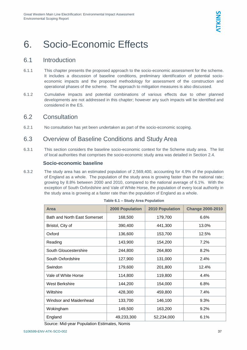
6.3.2 The study area has an estimated population of 2,569,400, accounting for 4.9% of the population
of England as a whole. The population of the study area is growing faster than the national rate;
growing by 8.8% between 2000 and 2010, compared to the national average of 6.1%. With the
exception of South Oxfordshire and Vale of White Horse, the population of every local authority in
the study area is growing at a faster rate than the population of England as a whole.
Table 6.1 – Study Area Population
Area 2000 Population 2010 Population Change 2000-2010
Bath and North East Somerset 168,500 179,700 6.6%
Bristol, City of 390,400 441,300 13.0%
Oxford 136,600 153,700 12.5%
Reading 143,900 154,200 7.2%
South Gloucestershire 244,800 264,800 8.2%
South Oxfordshire 127,900 131,000 2.4%
Swindon 179,600 201,800 12.4%
Vale of White Horse 114,800 119,800 4.4%
West Berkshire 144,200 154,000 6.8%
Wiltshire 428,300 459,800 7.4%
Windsor and Maidenhead 133,700 146,100 9.3%
Wokingham 149,500 163,200 9.2%
England 49,233,300 52,234,000 6.1%
Source: Mid-year Population Estimates, Nomis
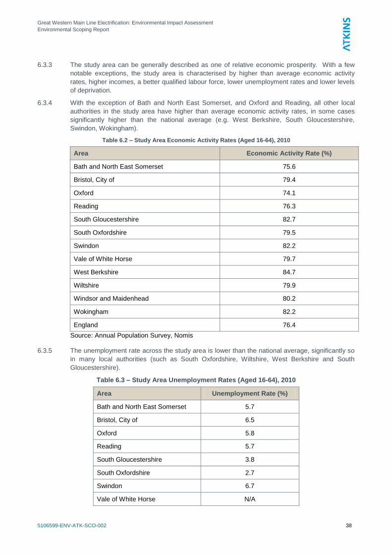
Great Western Main Line Electrification: Environmental Impact Assessment
Environmental Scoping Report
5106599-ENV-ATK-SCO-002 38
6.3.3 The study area can be generally described as one of relative economic prosperity. With a few
notable exceptions, the study area is characterised by higher than average economic activity
rates, higher incomes, a better qualified labour force, lower unemployment rates and lower levels
of deprivation.
6.3.4 With the exception of Bath and North East Somerset, and Oxford and Reading, all other local
authorities in the study area have higher than average economic activity rates, in some cases
significantly higher than the national average (e.g. West Berkshire, South Gloucestershire,
Swindon, Wokingham).
Table 6.2 – Study Area Economic Activity Rates (Aged 16-64), 2010
Area Economic Activity Rate (%)
Bath and North East Somerset 75.6
Bristol, City of 79.4
Oxford 74.1
Reading 76.3
South Gloucestershire 82.7
South Oxfordshire 79.5
Swindon 82.2
Vale of White Horse 79.7
West Berkshire 84.7
Wiltshire 79.9
Windsor and Maidenhead 80.2
Wokingham 82.2
England 76.4
Source: Annual Population Survey, Nomis 6.3.5 The unemployment rate across the study area is lower than the national average, significantly so
in many local authorities (such as South Oxfordshire, Wiltshire, West Berkshire and South
Gloucestershire).
Table 6.3 – Study Area Unemployment Rates (Aged 16-64), 2010
Area Unemployment Rate (%)
Bath and North East Somerset 5.7
Bristol, City of 6.5
Oxford 5.8
Reading 5.7
South Gloucestershire 3.8
South Oxfordshire 2.7
Swindon 6.7
Vale of White Horse N/A
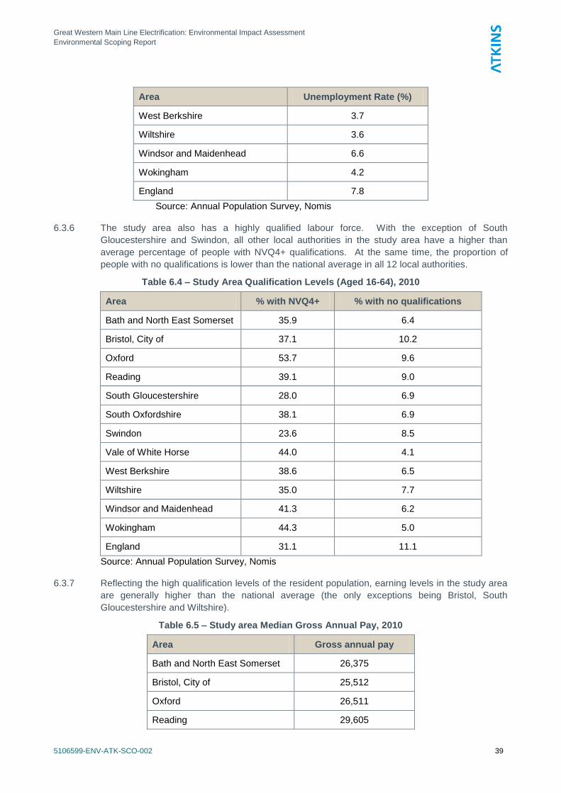
Great Western Main Line Electrification: Environmental Impact Assessment
Environmental Scoping Report
5106599-ENV-ATK-SCO-002 39
Area Unemployment Rate (%)
West Berkshire 3.7
Wiltshire 3.6
Windsor and Maidenhead 6.6
Wokingham 4.2
England 7.8
Source: Annual Population Survey, Nomis
6.3.6 The study area also has a highly qualified labour force. With the exception of South
Gloucestershire and Swindon, all other local authorities in the study area have a higher than
average percentage of people with NVQ4+ qualifications. At the same time, the proportion of
people with no qualifications is lower than the national average in all 12 local authorities.
Table 6.4 – Study Area Qualification Levels (Aged 16-64), 2010
Area % with NVQ4+ % with no qualifications
Bath and North East Somerset 35.9 6.4
Bristol, City of 37.1 10.2
Oxford 53.7 9.6
Reading 39.1 9.0
South Gloucestershire 28.0 6.9
South Oxfordshire 38.1 6.9
Swindon 23.6 8.5
Vale of White Horse 44.0 4.1
West Berkshire 38.6 6.5
Wiltshire 35.0 7.7
Windsor and Maidenhead 41.3 6.2
Wokingham 44.3 5.0
England 31.1 11.1
Source: Annual Population Survey, Nomis
6.3.7 Reflecting the high qualification levels of the resident population, earning levels in the study area
are generally higher than the national average (the only exceptions being Bristol, South
Gloucestershire and Wiltshire).
Table 6.5 – Study area Median Gross Annual Pay, 2010
Area Gross annual pay
Bath and North East Somerset 26,375
Bristol, City of 25,512
Oxford 26,511
Reading 29,605
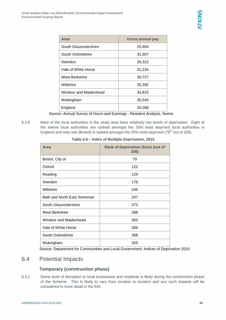
Great Western Main Line Electrification: Environmental Impact Assessment
Environmental Scoping Report
5106599-ENV-ATK-SCO-002 40
Area Gross annual pay
South Gloucestershire 25,904
South Oxfordshire 31,507
Swindon 26,322
Vale of White Horse 31,234
West Berkshire 30,727
Wiltshire 25,392
Windsor and Maidenhead 34,815
Wokingham 35,545
England 26,268
Source: Annual Survey of Hours and Earnings - Resident Analysis, Nomis
6.3.8 Most of the local authorities in the study area have relatively low levels of deprivation. Eight of
the twelve local authorities are ranked amongst the 25% least deprived local authorities in
England and only one (Bristol) is ranked amongst the 25% most deprived (79th out of 326).
Table 6.6 – Index of Multiple Deprivation, 2010
Area Rank of Deprivation Score (out of 326)
Bristol, City of 79
Oxford 122
Reading 129
Swindon 178
Wiltshire 245
Bath and North East Somerset 247
South Gloucestershire 272
West Berkshire 288
Windsor and Maidenhead 303
Vale of White Horse 306
South Oxfordshire 308
Wokingham 325
Source: Department for Communities and Local Government, Indices of Deprivation 2010
6.4 Potential Impacts
Temporary (construction phase)
6.4.1 Some level of disruption to local businesses and residents is likely during the construction phase
of the Scheme. This is likely to vary from location to location and any such impacts will be
considered in more detail in the EIA.
Great Western Main Line Electrification: Environmental Impact Assessment
Environmental Scoping Report
5106599-ENV-ATK-SCO-002 41
6.4.2 The Scheme will support temporary jobs during the construction phase, primarily in the form of
construction workers. No estimates of construction jobs are possible at this early stage, however,
as detailed construction costs were not available at the time of this Scoping Report. The ES will
include data on the likely level of employment generation during construction.
6.4.3 English Partnerships‘ Best Practice Note 15 (2003) states that construction jobs should be
treated with caution as they are unlikely to be the main rationale for a project. Construction jobs
should however be recorded as a supplementary output, particularly if they are likely to create
work for the unemployed in high priority regeneration areas.
Permanent (operational phase)
6.4.4 The Scheme is not expected to create additional direct jobs during its operational phase. A small
number of new jobs could be created for the maintenance of the OLE system or as a result of
more frequent train services, but the impact is expected to be small.
6.4.5 Other likely impacts to arise as part of the operational phase of the Scheme include cost
efficiency and reduced costs of maintenance of the electric trains compared to the diesel trains
that are currently used.
6.4.6 A relevant aspect of the Scheme could be the reduction of carbon emissions and noise pollution,
which could benefit local residents and businesses in terms of air quality and therefore quality of
life. Noise and air quality issues are covered under separate chapters of this Scoping Report.
6.4.7 Finally, the Scheme could have a positive impact on economic growth across the electrified route,
stimulating local and regional economies outside of London by providing businesses with better
infrastructure and transport links. It could improve the image and perception of cities across its
route strengthening their status as desirable business locations which are well connected to
London. It could also boost business and investor confidence, acting as a catalyst for further
investment in the provision of quality infrastructure.
6.5 Proposed Scope of Assessment / Methodology
6.5.1 The methodology for the evaluation of the socio-economic impacts of the Scheme is based on
previous experience of similar schemes (e.g. Liverpool to Manchester Overhead Line
Electrification) and our professional judgement while statutory requirements and Government
advice is also taken into account. These include:
Circular 02/99: Environmental Impact Assessment, Department for the Environment,
Transport and the Regions, 1999;
Environmental Impact Assessment: Guide to Procedures, Department for Communities and
Local Government, 2000;
Environmental Impact Assessment: A Guide to Good Practice and Procedures: A
Consultation Paper June 2000, Department for Communities and Local Government, 2000;
and
Amended Circular on Environmental Impact Assessment: A Consultation Paper June 2006,
Department for Communities and Local Government, 2006.
6.5.2 The assessment will consider how the Scheme will affect each local authority‘s socio-economic
baseline conditions, during both construction and operational phases. Given the nature of the
Scheme, both quantitative and qualitative impacts will be considered including:
Impact on employment and access to jobs;
Impact on business competitiveness and connectivity;
Possible disruption to businesses during the construction phase;
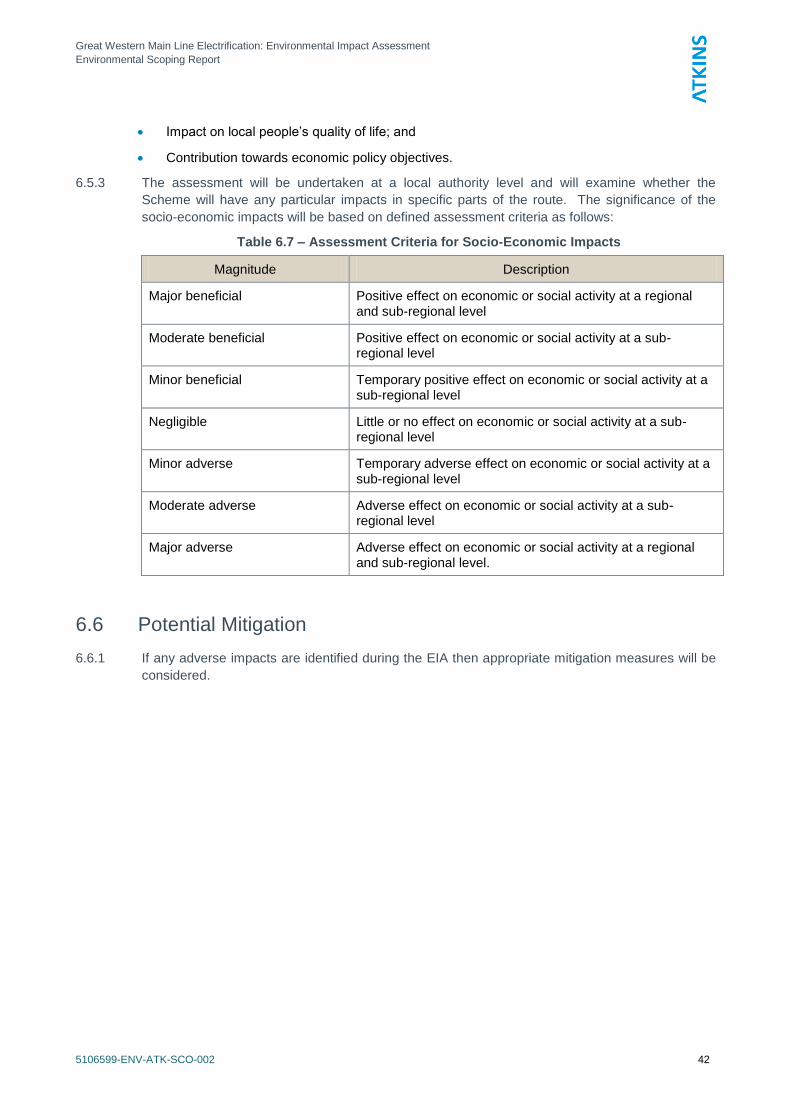
Great Western Main Line Electrification: Environmental Impact Assessment
Environmental Scoping Report
5106599-ENV-ATK-SCO-002 42
Impact on local people‘s quality of life; and
Contribution towards economic policy objectives.
6.5.3 The assessment will be undertaken at a local authority level and will examine whether the
Scheme will have any particular impacts in specific parts of the route. The significance of the
socio-economic impacts will be based on defined assessment criteria as follows:
Table 6.7 – Assessment Criteria for Socio-Economic Impacts
Magnitude Description
Major beneficial Positive effect on economic or social activity at a regional and sub-regional level
Moderate beneficial Positive effect on economic or social activity at a sub-regional level
Minor beneficial Temporary positive effect on economic or social activity at a sub-regional level
Negligible Little or no effect on economic or social activity at a sub-regional level
Minor adverse Temporary adverse effect on economic or social activity at a sub-regional level
Moderate adverse Adverse effect on economic or social activity at a sub-regional level
Major adverse Adverse effect on economic or social activity at a regional and sub-regional level.
6.6 Potential Mitigation
6.6.1 If any adverse impacts are identified during the EIA then appropriate mitigation measures will be
considered.
Great Western Main Line Electrification: Environmental Impact Assessment
Environmental Scoping Report
5106599-ENV-ATK-SCO-002 43
7. Landscape and Visual Effects
7.1 Introduction
7.1.1 This chapter presents the proposed approach to the landscape and visual assessment (LVIA) of
the Great Western Main Line Electrification Scheme. It includes a discussion of baseline
conditions, preliminary identification of potential impacts and their effects; the proposed impact
assessment methodology for consideration of the construction and operational phases of the
project, and potential requirements for mitigation.
7.1.2 Landscape and visual impacts encompass a range of issues, including the features and elements
that form the physical landscape, the way in which these features are perceived and the
importance attached to them.
7.1.3 Landscape assessment is the systematic description and analysis of the physical features and
elements of the landscape, how their composition forms distinct areas of character, appraisal of
the importance and the potential effect of development proposals on the landscape. The
elements may include landform, field and settlement patterns, building styles, road and transport
patterns, vegetation cover and land use.
7.1.4 Visual assessment is the description and analysis of the views experienced by receptors from
residential properties, public buildings, public open spaces, public rights of way, open access
areas, transport corridors and places of work, and the potential effect of development proposals
on these receptors.
7.1.5 The nature of landscape and visual impacts is closely related to other topics such as ecology,
cultural heritage and arboriculture. Each of these topics can influence the landscape character of
an area, or contribute to the importance and sensitivity of landscape or visual receptors. The
scope of the LVIA has been developed in accordance with these topics to ensure that there will
be no overlap or double counting of impacts.
7.1.6 Impacts on the setting of designated heritage assets are not included in the scope of this chapter;
these are addressed in Chapter 8 of this report and will be taken forward in the corresponding
chapter of the ES. Due to the close links between these topics there will be detailed liaison
between the technical disciplines during the EIA stage.
7.1.7 The scope of the LVIA will include reference to the sensitivity of existing woodland and the
anticipated direct impacts of the project; however, this will focus on woodland areas as a
landscape element that contributes to landscape character and will not include a full arboricultural
assessment and report in accordance with BS 5837:2005 (Trees in Relation to Construction).
7.1.8 Principles and good practice for undertaking LVIA are set out in the Landscape Institute (LI) and
the Institute of Environmental Management (IEMA) ‗Guidelines for Landscape and Visual Impact
Assessment‘ (GLVIA). Reference has been made to the guidelines for the preparation of this
scoping report.
7.2 Consultation
7.2.1 No consultation has been undertaken as part of the scoping exercise for the LVIA; however,
where appropriate, the relevant officer for landscape would be consulted at the earliest possible
stage of the EIA. This consultation would aim to build on this scoping report and develop an
agreed approach to the scope and content of the EIA. The consultation process would also be
used to agree the selection of representative viewpoints that would be used in the assessment of
the Scheme.
Great Western Main Line Electrification: Environmental Impact Assessment
Environmental Scoping Report
5106599-ENV-ATK-SCO-002 44
7.3 Overview of Baseline Conditions and Study Area
Study Area
7.3.1 The study area for landscape and visual effects has been used to establish the appropriate
distance / extent that it is relevant to identify and analyse baseline information and the likely
impacts of the project. This has led to the development and definition of the spatial scope and
survey area for the LVIA and will be used in the EIA to define the limits of the desk study and site
survey work and subsequently, the assessment stages.
Spatial Scope
7.3.2 The visual envelope (VE) of a scheme extends to the whole of the area from which the project
could be visible. This area will be contained by vegetation, topography or built form. The VE is a
useful starting point for assessing impacts however not all locations where the project is visible
will result in significant effects that would form a material consideration of an EIA.
7.3.3 Having reviewed the different elements of the project, a study area of 1 km (centred on the
project and forming a study corridor) is considered appropriate to assess the likely significant
landscape and visual impacts. However in specific locations where, for example, important
landscape designations are present, this distance may be extended to ensure that the LVIA is
comprehensive and robust. These extended survey areas will be determined as part of the
baseline stage of the EIA.
Temporal scope
7.3.4 The key dates for the project are as follows:
2013 – start of construction for Maidenhead to Bristol Parkway / Bristol Temple Meads.
December 2016 - Opening year Maidenhead to Bristol Parkway and Bristol Temple Meads.
7.3.5 Based on these dates, the LVIA will be undertaken for the following scenarios:
During the construction period, assuming a maximum visibility or maximum perceived change
situation (i.e. when construction activity is at its peak for any given view).
A winter‘s day in the opening year of the project (i.e. at completion of the main works in a
specific area with any agreed noise/visual screens and mounds in place but before any
planted mitigation is sufficiently established to take effect).
A summer‘s day in the fifteenth year after opening (i.e. when the planted mitigation measures
can be assumed to be substantially effective). This is usually a reflection of the near fully
mitigated scenario under normal conditions.
7.3.6 The study area (for scoping) has been defined as a 1 km wide corridor centred along the route
corridor.
Baseline conditions
Landscape character and landscape designations
7.3.7 Published landscape character guidance provides an independent view of the defining
characteristics of an area and contributes to the baseline position for determining importance of
landscape features and elements, as well as assessing the nature and magnitude of impacts.
Landscape character has been considered by reference to existing landscape studies at national,
regional and local levels.
7.3.8 Landscape designations contribute to an understanding of the condition and importance of a
landscape as well as identifying the type of visual receptors and amenity uses that will be taking
place in a particularly location.
Great Western Main Line Electrification: Environmental Impact Assessment
Environmental Scoping Report
5106599-ENV-ATK-SCO-002 45
7.3.9 The table in Appendix C sets out a summary of the published landscape character assessments
and also landscape designations that are relevant to the Scheme.
Visual Amenity
7.3.10 Receptors subject to potential visual impacts will include views and visual amenity experienced
by residents, recreational users (including visitors and tourists) and road users. These visual
receptor types will be included in the EIA against the following sensitivity categories:
High Sensitivity: Residential properties. Users of Public Rights of Way or other recreational
trails (e.g. National Trails, footpaths, bridleways etc.). Users of recreational facilities where
the purpose of that recreation is enjoyment of the countryside.
Moderate Sensitivity: Outdoor workers. Users of scenic roads, railways or waterways or
users of designated tourist routes. Schools and other institutional buildings, and their outdoor
areas.
Low Sensitivity: Indoor workers. Users of main roads (e.g. trunk roads) or passengers in
public transport on main arterial routes. Users of recreational facilities where the purpose of
that recreation is not related to the view (e.g. intensive sports facilities).
7.4 Potential Impacts
7.4.1 This section provides a summary of the potential impacts of the project in terms of its construction
and operation.
7.4.2 The table in Appendix C identifies the separate activities and elements of the project, the sources
of potential impact, what the likely impacts would be and which receptors are likely to be affected.
7.5 Proposed Scope of Assessment / Methodology
7.5.1 The following best practice documents on landscape character and visual impact assessment will
be considered in developing the methodology for the LVIA:
The Guidelines for Landscape and Visual Impact Assessment, Second Edition, the
Landscape Institute and the Institute of Environmental Management and Assessment, 2002;
Landscape Character Assessment, the Countryside Agency, 2002;
Photography and photomontage in landscape and visual impact assessment, Landscape
Institute Advice Note 01/11 (2011).
7.5.2 The GLVIA defines landscape and visual impacts as follows:
―Landscape and visual assessments are separate, although linked, procedures…―
―Landscape effects derive from changes in the physical landscape, which may give rise to
changes in its character and how this is experienced. This may in turn affect the perceived
value ascribed to the landscape…..‖
―Visual effects relate to the changes that arise in the composition of available views as a
result of changes to the landscape, to people‘s responses to the changes, and to the overall
effects with respect to visual amenity‖.
7.5.3 The LVIA will aim to examine the existing baseline conditions and potential impacts during the life
of the project and following the implementation of mitigation proposals. In order to establish the
degree of impact the assessment will establish the baseline conditions through a process of
detailed desk study and site survey.
Great Western Main Line Electrification: Environmental Impact Assessment
Environmental Scoping Report
5106599-ENV-ATK-SCO-002 46
Baseline conditions
Desk Study
7.5.4 The desk study will identify potentially sensitive landscape resources (features and elements) by
reference to OS maps, aerial photography, existing landscape character studies and relevant
planning policy. Analysis of these resources will contribute to an understanding of landform,
location of key public rights of way and national cycle network routes and the extent and type of
vegetation and land use. This analysis will also enable the identification of potentially important
and sensitive visual receptors such as footpaths, other rights of way, residential properties, etc.
Site Survey
7.5.5 Site survey work will be undertaken to confirm and identify key public rights of way, residential
properties, public highways and other public amenity areas that contribute to the landscape
character of the area and/or would have potential views of the project.
7.5.6 Where practicable, site survey work will be completed at the optimal time to account for the worst
case scenario for the proposed scheme (i.e. on a day with clear visibility during seasons where
screening from vegetation is minimal). The survey work will contribute to an understanding of the
existing landscape character and the location and nature of visual receptors, as well as
supplement the available information collected during the desk study. The site survey will also
establish the nature and likely effects of the potential mitigation measures.
7.5.7 A series of representative photographs will be captured during the site visits. The method for
capture and presentation of photographs will be in accordance with Landscape Institute Advice
Note 01/2011 (Photography and photomontage in landscape and visual assessment).
7.5.8 Site survey work will be completed by experienced landscape architects. Where possible a team
of two will complete the site survey work as this facilitates discussion and consensus on the main
elements and key features of the landscape and also the sensitivity of visual receptors.
Assessment
7.5.9 The assessment methodology will also set out the process for the prediction of landscape and
visual effects and the appraisal of their significance through the construction and operational
phases of the project. This will include an assessment of the sensitivity of the agreed viewpoints
and the use of illustrative material to assess the impact of the proposed development on each
view as well as sensitivity of other key visual receptors where viewpoints cannot be obtained.
7.5.10 The establishment of thresholds of significance of effect is recognised as a valid way of
standardising the conclusions of the LVIA. The significance of effect will depend not only on the
magnitude of the impact but also on the sensitivity of the location or receptor. Each of these
terms will be clearly defined in the EIA.
Scope of Assessment
7.5.11 The proposed scope of the LVIA has been determined to ensure a clear and concise approach to
the assessment of impacts and to ensure that the LVIA remains focused on the most relevant
issues and significant effects.
7.5.12 The preliminary spatial scope for the collation of baseline information is defined above. For the
assessment stage it is necessary to refine the scope so as to focus only on the key impacts and
significant effects.
7.5.13 In the context of the entire length of the project and generally small scale of the proposed
Scheme elements, it has been considered appropriate to scope out specific sections of the route
and elements of the works.
7.5.14 The proposed scope of the LVIA is summarised in the following table.
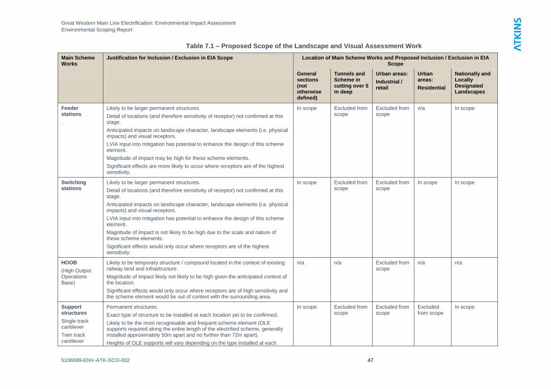
Great Western Main Line Electrification: Environmental Impact Assessment
Environmental Scoping Report
5106599-ENV-ATK-SCO-002 47
Table 7.1 – Proposed Scope of the Landscape and Visual Assessment Work
Main Scheme Works
Justification for Inclusion / Exclusion in EIA Scope Location of Main Scheme Works and Proposed Inclusion / Exclusion in EIA Scope
General sections (not otherwise defined)
Tunnels and Scheme in cutting over 5 m deep
Urban areas:
Industrial / retail
Urban areas:
Residential
Nationally and Locally Designated Landscapes
Feeder stations
.
Likely to be larger permanent structures.
Detail of locations (and therefore sensitivity of receptor) not confirmed at this stage.
Anticipated impacts on landscape character, landscape elements (i.e. physical impacts) and visual receptors.
LVIA input into mitigation has potential to enhance the design of this scheme element.
Magnitude of impact may be high for these scheme elements.
Significant effects are more likely to occur where receptors are of the highest sensitivity.
In scope Excluded from scope
Excluded from scope
n/a In scope
Switching stations
Likely to be larger permanent structures.
Detail of locations (and therefore sensitivity of receptor) not confirmed at this stage.
Anticipated impacts on landscape character, landscape elements (i.e. physical impacts) and visual receptors.
LVIA input into mitigation has potential to enhance the design of this scheme element.
Magnitude of impact is not likely to be high due to the scale and nature of these scheme elements.
Significant effects would only occur where receptors are of the highest sensitivity.
In scope Excluded from scope
Excluded from scope
In scope In scope
HOOB
(High Output Operations Base)
Likely to be temporary structure / compound located in the context of existing railway land and infrastructure.
Magnitude of impact likely not likely to be high given the anticipated context of the location.
Significant effects would only occur where receptors are of high sensitivity and the scheme element would be out of context with the surrounding area.
n/a n/a Excluded from scope
n/a n/a
Support structures
Single track cantilever
Twin track cantilever
Permanent structures.
Exact type of structure to be installed at each location yet to be confirmed.
Likely to be the most recognisable and frequent scheme element (OLE supports required along the entire length of the electrified scheme, generally installed approximately 50m apart and no further than 72m apart).
Heights of OLE supports will vary depending on the type installed at each
In scope Excluded from scope
Excluded from scope
Excluded from scope
In scope
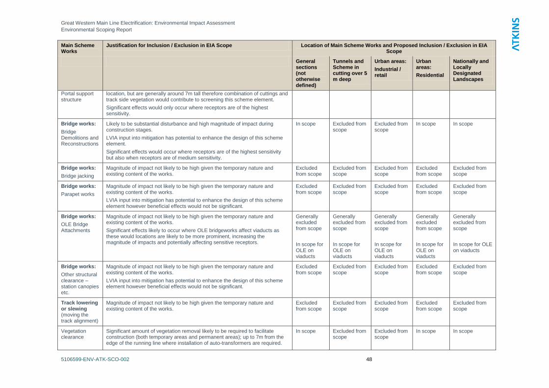
Great Western Main Line Electrification: Environmental Impact Assessment
Environmental Scoping Report
5106599-ENV-ATK-SCO-002 48
Main Scheme Works
Justification for Inclusion / Exclusion in EIA Scope Location of Main Scheme Works and Proposed Inclusion / Exclusion in EIA Scope
General sections (not otherwise defined)
Tunnels and Scheme in cutting over 5 m deep
Urban areas:
Industrial / retail
Urban areas:
Residential
Nationally and Locally Designated Landscapes
Portal support structure
location, but are generally around 7m tall therefore combination of cuttings and track side vegetation would contribute to screening this scheme element.
Significant effects would only occur where receptors are of the highest sensitivity.
Bridge works:
Bridge Demolitions and Reconstructions
Likely to be substantial disturbance and high magnitude of impact during construction stages.
LVIA input into mitigation has potential to enhance the design of this scheme element.
Significant effects would occur where receptors are of the highest sensitivity but also when receptors are of medium sensitivity.
In scope Excluded from scope
Excluded from scope
In scope In scope
Bridge works:
Bridge jacking
Magnitude of impact not likely to be high given the temporary nature and existing content of the works.
Excluded from scope
Excluded from scope
Excluded from scope
Excluded from scope
Excluded from scope
Bridge works:
Parapet works
Magnitude of impact not likely to be high given the temporary nature and existing content of the works.
LVIA input into mitigation has potential to enhance the design of this scheme element however beneficial effects would not be significant.
Excluded from scope
Excluded from scope
Excluded from scope
Excluded from scope
Excluded from scope
Bridge works:
OLE Bridge Attachments
Magnitude of impact not likely to be high given the temporary nature and existing content of the works.
Significant effects likely to occur where OLE bridgeworks affect viaducts as these would locations are likely to be more prominent, increasing the magnitude of impacts and potentially affecting sensitive receptors.
Generally excluded from scope
In scope for OLE on viaducts
Generally excluded from scope
In scope for OLE on viaducts
Generally excluded from scope
In scope for OLE on viaducts
Generally excluded from scope
In scope for OLE on viaducts
Generally excluded from scope
In scope for OLE on viaducts
Bridge works:
Other structural clearance – station canopies etc.
Magnitude of impact not likely to be high given the temporary nature and existing content of the works.
LVIA input into mitigation has potential to enhance the design of this scheme element however beneficial effects would not be significant.
Excluded from scope
Excluded from scope
Excluded from scope
Excluded from scope
Excluded from scope
Track lowering or slewing (moving the track alignment)
Magnitude of impact not likely to be high given the temporary nature and existing content of the works.
Excluded from scope
Excluded from scope
Excluded from scope
Excluded from scope
Excluded from scope
Vegetation clearance
Significant amount of vegetation removal likely to be required to facilitate construction (both temporary areas and permanent areas); up to 7m from the edge of the running line where installation of auto-transformers are required.
In scope Excluded from scope
Excluded from scope
In scope In scope
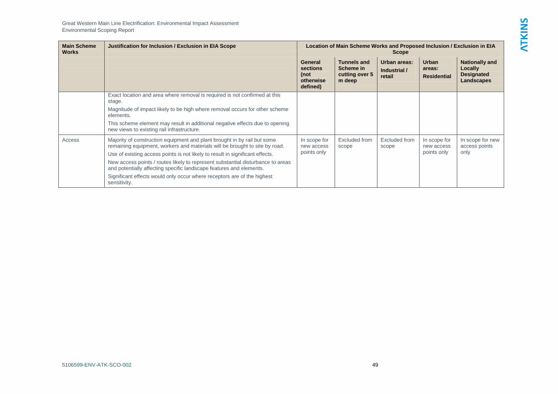
Great Western Main Line Electrification: Environmental Impact Assessment
Environmental Scoping Report
5106599-ENV-ATK-SCO-002 49
Main Scheme Works
Justification for Inclusion / Exclusion in EIA Scope Location of Main Scheme Works and Proposed Inclusion / Exclusion in EIA Scope
General sections (not otherwise defined)
Tunnels and Scheme in cutting over 5 m deep
Urban areas:
Industrial / retail
Urban areas:
Residential
Nationally and Locally Designated Landscapes
Exact location and area where removal is required is not confirmed at this stage.
Magnitude of impact likely to be high where removal occurs for other scheme elements.
This scheme element may result in additional negative effects due to opening new views to existing rail infrastructure.
Access
Majority of construction equipment and plant brought in by rail but some remaining equipment, workers and materials will be brought to site by road.
Use of existing access points is not likely to result in significant effects.
New access points / routes likely to represent substantial disturbance to areas and potentially affecting specific landscape features and elements.
Significant effects would only occur where receptors are of the highest sensitivity.
In scope for new access points only
Excluded from scope
Excluded from scope
In scope for new access points only
In scope for new access points only
Great Western Main Line Electrification: Environmental Impact Assessment
Environmental Scoping Report
5106599-ENV-ATK-SCO-002 50
7.6 Potential Mitigation
7.6.1 At this early stage of the project the scope of, and requirement for, mitigation measures cannot
be confirmed with certainty. The potential for mitigation will be addressed in the EIA. Typical
landscape measures that could be implemented to mitigate for construction and operational
effects of the project are outlined below. The mitigation measures will be considered during the
assessment work, and, where possible will be incorporated into the ongoing design and
development of the detailed design of the project. These measures relate to both the
Construction and Operation Stages.
Avoid
Minimise, within Network Rail operational requirements, tree and vegetation clearance –
adaptation of the design to minimise the area of trees and vegetation to be lost to the project
through consideration of final options. This could be achieved through amendments to the
final siting of scheme elements or through engineering design (such as use of retaining
solutions for earthworks rather than re-grading so as to minimise clearance).
Where night time lighting is required (including temporary lighting used during construction)
then this should be designed to minimise adverse impacts through careful siting of fixtures,
and the use of the luminaires which minimise glare and light spill.
Reduce
Where permanent structures are proposed (including bridge reconstruction) the design of
these should consider the local vernacular and standard designs should be adapted to reflect
local building style and material. In some locations, it may be possible to enhance the
surrounding environment through innovative and more modern design of such scheme
elements; this would be particularly relevant to urban areas.
Re-use
Re-use vegetation potentially lost – where possible translocation of material should be
considered and receptor sites outside of the working areas should be identified.
Re-use of felled material – the project should aim to eliminate or minimise the volume of
materials leaving site. Arisings from tree felling and vegetation clearance can be chipped
and utilised in landscape management. Larger material can be windrowed along woodland
boundaries to contribute to biodiversity value.
Re-use and enhancement of landscape features – where features such as boundary walls
are removed to facilitate components of the project (for example access), ensure a strategy is
put in place to retain materials in order that they can be re-built following removal of
temporary access.
Replace
Replacement of lost trees and vegetation – replacement of trees and shrubs could be
undertaken, within Network Rail operational requirements.
Great Western Main Line Electrification: Environmental Impact Assessment
Environmental Scoping Report
5106599-ENV-ATK-SCO-002 51
8. Historic Environment
8.1 Introduction
8.1.1 This chapter presents the proposed approach to the assessment of potential impacts on the
historic environment that may result from the construction and operation of the Scheme. It
includes a brief discussion of baseline conditions, preliminary identification of potential impacts on
the historic environment, and the proposed methodology for the assessment of the construction
and operational phases of the Project. The approach to possible mitigation measures is also
discussed.
8.1.2 Cumulative impacts and potential combinations of various effects due to other planned
developments are not discussed; however these will be identified and considered in the ES.
8.2 Consultation
8.2.1 The preparation of this scoping report has not been informed by consultation with any statutory
bodies. NR have commenced general engagement with key stakeholders including English
Heritage to convey an understanding of the general nature of the Scheme and establish issues
that may need to be addressed in the development of the Scheme and during the development of
the Environmental Assessment.
8.3 Overview of Baseline Conditions and Study Area
8.3.1 The Scheme involves the electrification of the rail line from Maidenhead to Bristol and other lines
linking to Oxford, Newbury and the route to South Wales. Much of the Scheme runs along the
course of the Great Western Railway main line from London to Bristol Temple Meads via Bath.
This mid-19th century railway line was designed and developed by Isambard Kingdom Brunel and
is widely considered to be a historically important railway. It, and other notable lines such as the
earlier Liverpool to Manchester Railway, represent an important stage in the industrial, social and
economic development of the UK and also had an effect on the development of transport
infrastructure across the world.
8.3.2 In broad terms, the scheme runs along the following stretches of railway, which vary in terms of
their age and historic importance:
Western end of Maidenhead station to Bristol Temple Meads via Bath - part of Brunel‘s
original Great Western Railway (GWR) main line from London Paddington to Bristol;
Didcot Parkway to Oxford - part of a separate GWR line to the Midlands built in 1843-4 and
designed by Brunel;
Reading to Newbury - part of the Berkshire and Hampshire line, designed by Brunel for the
GWR and opened in 1847;
Bristol Temple Meads to Bristol Patchway via Stapleton Road - part of the Bristol and
South Wales Union Railway, opened in 1858 and also designed by Brunel;
Swindon to Bristol Patchway - the South Wales and Bristol Direct Line, opened in 1903 by
GWR to improve journey times to Bristol and south Wales.
8.3.3 The original line from London to Bristol Temple Meads via Bath has been developed and altered
considerably since its construction and opening. Brunel‘s broad gauge tracks have gone and
much of the original associated infrastructure has been replaced by equipment suited to the
operation of 20th and 21
st century railways. Along its length, however, are numerous examples of
Great Western Main Line Electrification: Environmental Impact Assessment
Environmental Scoping Report
5106599-ENV-ATK-SCO-002 52
railway architecture and engineering associated with Brunel‘s original design and the early
modification of the route. Many, but not all, of these features have been statutorily designated.
8.3.4 The other stretches of railway affected by the Scheme are more typical examples of railway
engineering that reflect the development of the GWR system from the mid 19th century through to
the early 20th century. These lines also contain a number of statutorily designated assets. All of
the lines were connected with the GWR company and consequently many of them reflect
Brunel‘s design influence and most were designed by him.
8.3.5 The Scheme also runs through a number of historic urban areas and stretches of historic
landscape outside of major settlements. Notable examples include Bath, with its World Heritage
Site, and the Railway district in Swindon.
8.3.6 In total, the Scheme would run through, over or under approximately 39 listed structuresi
including:
twenty-three over and under bridges (mainly Grade II but with two Grade II* structures in
Bath);
four viaducts, including the Grade II* New Road Viaduct at Chippenham;
six tunnelsii including the Grade II* listed Box Hill Tunnel western portal; and
six stations including the Grade I listed Bristol Temple Meads and Grade II* listed Bath Spa
station.
8.3.7 In addition to these structures there are approximately 290 other listed structures within about
100m of the Scheme centreline, as well as seven Registered Parks and Gardens, ten Scheduled
Monuments, and one Registered Battlefield. There are also a number of Conservation Areas.
There may also be other designated heritage assets in the vicinity of offline works but the
locations of these works are currently unknown.
8.3.8 The Figures in Volume 2 show the locations of all known designated heritage assets within and
alongside the Scheme extents excluding offline works.
8.4 Potential Impacts
Construction Impacts
8.4.1 The construction of the proposed scheme could adversely affect built heritage and archaeology in
a number of ways. Impacts that have the potential to result in significant environmental effects,
and hence require consideration in the EIA, include:
Physical alteration of designated heritage assets, mainly listed bridges and stations within
the route corridor. The scale of change could vary from small scale additions of OLE
equipment through to demolition and reconstruction. The loss or major alteration of any such
structure could be a significant issue.
Physical change within and around the Bath World Heritage Site (WHS) that could affect
its Outstanding Universal Value. Given the importance of the WHS, this is potentially a
significant issue.
Physical alteration or demolition of undesignated structures that may be of historic
interest along the route corridor, e.g. 19th century bridges relating to early phases in the
line‘s development.
Alteration to the setting of designated heritage assets within the route corridor and
within c. 100m of the proposed OLE works and around any offline works, e.g.
conservation areas, listed buildings, registered parks and gardens etc. This includes impacts
associated with temporary and offline works such as sub-stations and the HOOB.
Great Western Main Line Electrification: Environmental Impact Assessment
Environmental Scoping Report
5106599-ENV-ATK-SCO-002 53
Physical impacts on archaeological remains that may be located within offline works
e.g. temporary access and construction compounds, substations and grid connections
(particularly if underground), the HOOB, and electrical supply installation including Feeder
stations and distribution substations.
8.4.2 The following impacts are not considered to have the potential to result in significant
environmental effects, and consequently it is proposed that they are scoped out of the EIA:
Physical impacts on any archaeological remains within the railway corridor. Given the
scale of past disturbance within the railway, corridor it is highly unlikely that significant pre-
railway archaeological remains have survived and it is proposed to scope out this issue.
Physical impacts on items of railway infrastructure within the railway corridor. Whilst it
is possible that historically significant items of historic railway infrastructure e.g. signal posts,
signage, trackside markers etc may survive within the current railway corridor, impacts on
these features (if they survive) would not result in significant environmental effects.
Consequently, it is proposed to scope these out of the assessment and to address these
issues through a programme of recording and construction best practice.
Impacts on the setting of undesignated heritage assets within or outwith the railway
corridor. Whilst the scheme may affect the setting of such assets, the resultant effects
would not be significant given the relative importance of these assets and the likely scale of
impact (see 8.5.4 for impact assessment criteria).
Operational Impacts
8.4.3 The operation of the railway line would result in no additional impacts beyond the current
situation. Any adverse impacts would be as a result of the physical construction of the scheme,
not its daily operation.
8.5 Proposed Scope of Assessment and Methodology
8.5.1 As discussed above the EIA would assess the following potential impacts:
Physical alteration of designated heritage assets
Physical change within and around the Bath World Heritage Site (WHS)
Physical alteration or demolition of undesignated structures that may be of historic interest
Alteration to the setting of designated heritage assets within the route corridor and within a c.
100m of the proposed OLE works and around any offline works
Physical impacts on archaeological remains that may be located within off-line works
8.5.2 The following stages of work would be undertaken to assess these potential impacts:
Preparation an short overall histories of the routes, with an emphasis on their original
construction sequence; engineering priorities and constraints and later alterations and
additions. This would be illustrated by maps of construction sequence, alterations and other
key factors. This will provide important baseline information to support the assessment
process. The document would be summarised in the main ES and supplied in a stand-alone
appendix.
Preparation of Statements of Significance for the following routes: GWR main line from
London to Bristol Temple Meads via Bath; the Didcot Parkway to Oxford line; the Reading to
Newbury line; the South Wales and Bristol Direct Line (‗Badmington Line‘); and Bristol
Temple Meads to Bristol Patchway part of mid to late 19th century Bristol and South Wales
Union Railway. These statements will be based on the definition of significance set out in
PPS 5: ‗Planning for the Historic Environment‘ (DCLG 2010), using the methodology set out
Great Western Main Line Electrification: Environmental Impact Assessment
Environmental Scoping Report
5106599-ENV-ATK-SCO-002 54
in ‗Conservation Principles, Policies and Guidance (EH, 2008). This will include a high-level
assessment of the relative significance of the generic components that make up the
individual lines such as over- and under-bridges, viaducts, tunnels and stations. The
document will be summarised in the main ES and supplied in a stand-alone appendix.
Identification of all structures along the routes that may be of historic significance and an
initial assessment of their significance.
Preparation of descriptions and individual statements of significance for all historic structures
that may be physically affected by the Scheme. These statements will be based on the
PPS5 definition of significance and the recently revised English Heritage publication: ‗Listing
Selection Guide: Transport Buildings‘. The statements will have a level of detail that reflects
guidance in PPS5 i.e. ―...proportionate to the importance of the heritage asset and no more
than is sufficient to understand the potential impact of the proposal on the significance of the
heritage asset‖. The principal output from this exercise will be a record for all structures and
buildings along the extent of the Scheme. This will be summarised in the main ES chapter
and supplied as an appendix to ES. Assessment of impacts on designated and
undesignated structures of historic interest along the route line using the criteria and scoring
set out below. The assessment will be reported in the main ES with supplementary
appendices as required.
Assessment of any impacts on the setting of designated heritage assets within 100m of the
scheme. This study area is sufficient to identify likely significant impacts given the scale and
nature of the proposed OLE equipment. This assessment will be undertaken with reference
to the Landscape and Visual Impact Assessment. The assessment will use the criteria and
scoring set out below and will be reported in the main ES with supplementary appendices as
required.
Assessment of any impacts on the setting of designated heritage assets within appropriate
study areas around off-line works associated with Scheme. The study areas will need to be
determined depending on the scale and nature of off-line works. This assessment would be
undertaken with reference to the Landscape and Visual Impact Assessment. The
assessment would use the criteria and scoring set out below and would be reported in the
main ES with supplementary appendices as required.
Assessment of potential impacts on archaeological remains within the footprint of off-line
development. This will include an appropriate level of desk-based assessment depending on
the location and scale of development. The assessment will use the criteria and scoring set
out below and will be reported in the main ES with supplementary appendices as required.
Assessment of potential impacts on the Bath WHS undertaken in accordance with the
recently published ICOMOS guidelines (ICOMOS, 2011: ‗Guidance on Heritage Impact
Assessments for Cultural World Heritage Properties‘). This will be summarised in the main
ES Chapter and reported in an appendix.
Assessment of the overall impact of the Scheme on the heritage value of the GWML in
narrative form. This will be presented in the main ES Chapter.
8.5.3 During the EIA, Network Rail will also consult the relevant conservation officers, archaeological
officers and English Heritage officers to ascertain their views on the potential impacts and the
design / mitigation proposals.
Impact Assessment Methodology and Scoring Mechanism
8.5.4 The following methodology for assessing and scoring impacts and effects will be adopted. This
approach is based on the concept that the environmental effect of the proposals, in relation to an
individual asset, is determined through identifying the asset‘s value and then assessing the
impact that the proposal would have on the significance of the asset (i.e. the attributes that
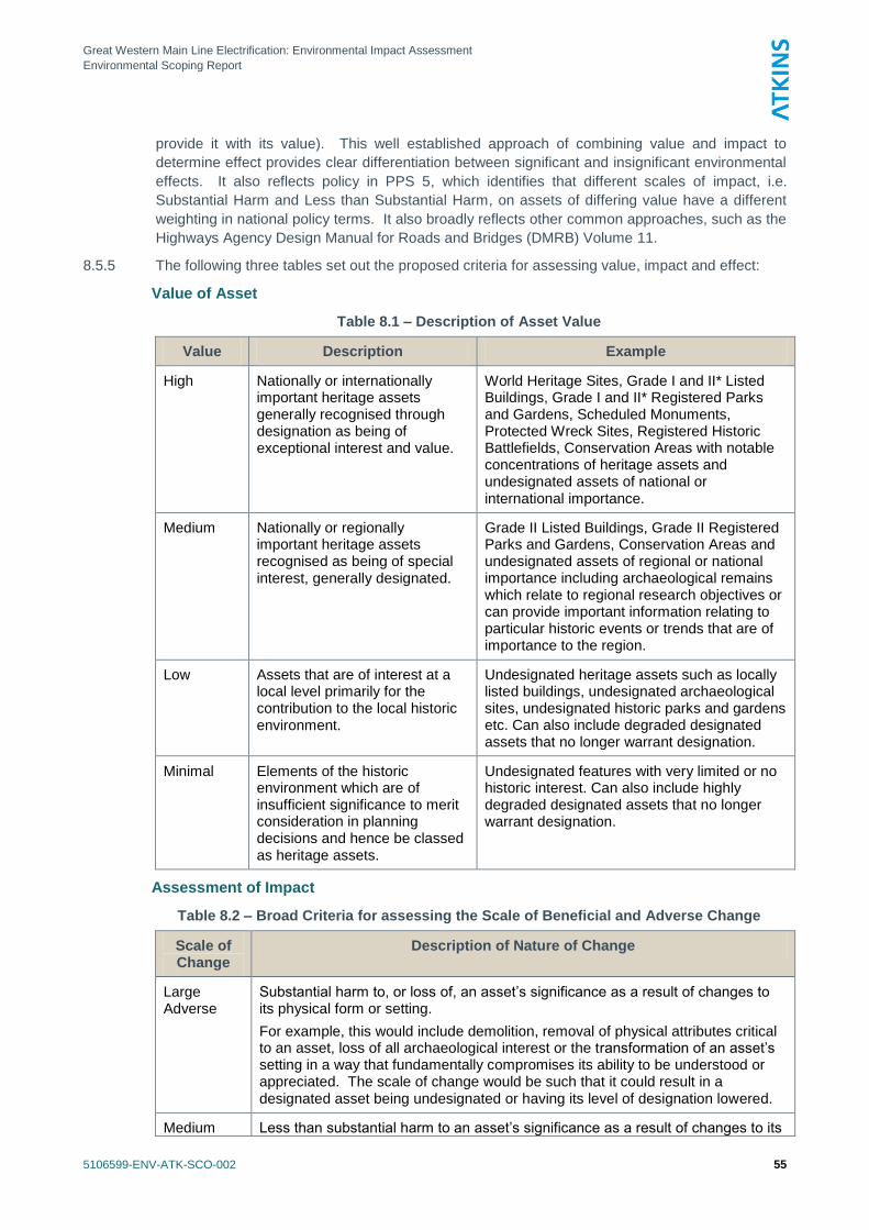
Great Western Main Line Electrification: Environmental Impact Assessment
Environmental Scoping Report
5106599-ENV-ATK-SCO-002 55
provide it with its value). This well established approach of combining value and impact to
determine effect provides clear differentiation between significant and insignificant environmental
effects. It also reflects policy in PPS 5, which identifies that different scales of impact, i.e.
Substantial Harm and Less than Substantial Harm, on assets of differing value have a different
weighting in national policy terms. It also broadly reflects other common approaches, such as the
Highways Agency Design Manual for Roads and Bridges (DMRB) Volume 11.
8.5.5 The following three tables set out the proposed criteria for assessing value, impact and effect:
Value of Asset
Table 8.1 – Description of Asset Value
Value Description Example
High Nationally or internationally important heritage assets generally recognised through designation as being of exceptional interest and value.
World Heritage Sites, Grade I and II* Listed Buildings, Grade I and II* Registered Parks and Gardens, Scheduled Monuments, Protected Wreck Sites, Registered Historic Battlefields, Conservation Areas with notable concentrations of heritage assets and undesignated assets of national or international importance.
Medium Nationally or regionally important heritage assets recognised as being of special interest, generally designated.
Grade II Listed Buildings, Grade II Registered Parks and Gardens, Conservation Areas and undesignated assets of regional or national importance including archaeological remains which relate to regional research objectives or can provide important information relating to particular historic events or trends that are of importance to the region.
Low Assets that are of interest at a local level primarily for the contribution to the local historic environment.
Undesignated heritage assets such as locally listed buildings, undesignated archaeological sites, undesignated historic parks and gardens etc. Can also include degraded designated assets that no longer warrant designation.
Minimal Elements of the historic environment which are of insufficient significance to merit consideration in planning decisions and hence be classed as heritage assets.
Undesignated features with very limited or no historic interest. Can also include highly degraded designated assets that no longer warrant designation.
Assessment of Impact
Table 8.2 – Broad Criteria for assessing the Scale of Beneficial and Adverse Change
Scale of Change
Description of Nature of Change
Large Adverse
Substantial harm to, or loss of, an asset‘s significance as a result of changes to its physical form or setting.
For example, this would include demolition, removal of physical attributes critical to an asset, loss of all archaeological interest or the transformation of an asset‘s setting in a way that fundamentally compromises its ability to be understood or appreciated. The scale of change would be such that it could result in a designated asset being undesignated or having its level of designation lowered.
Medium Less than substantial harm to an asset‘s significance as a result of changes to its
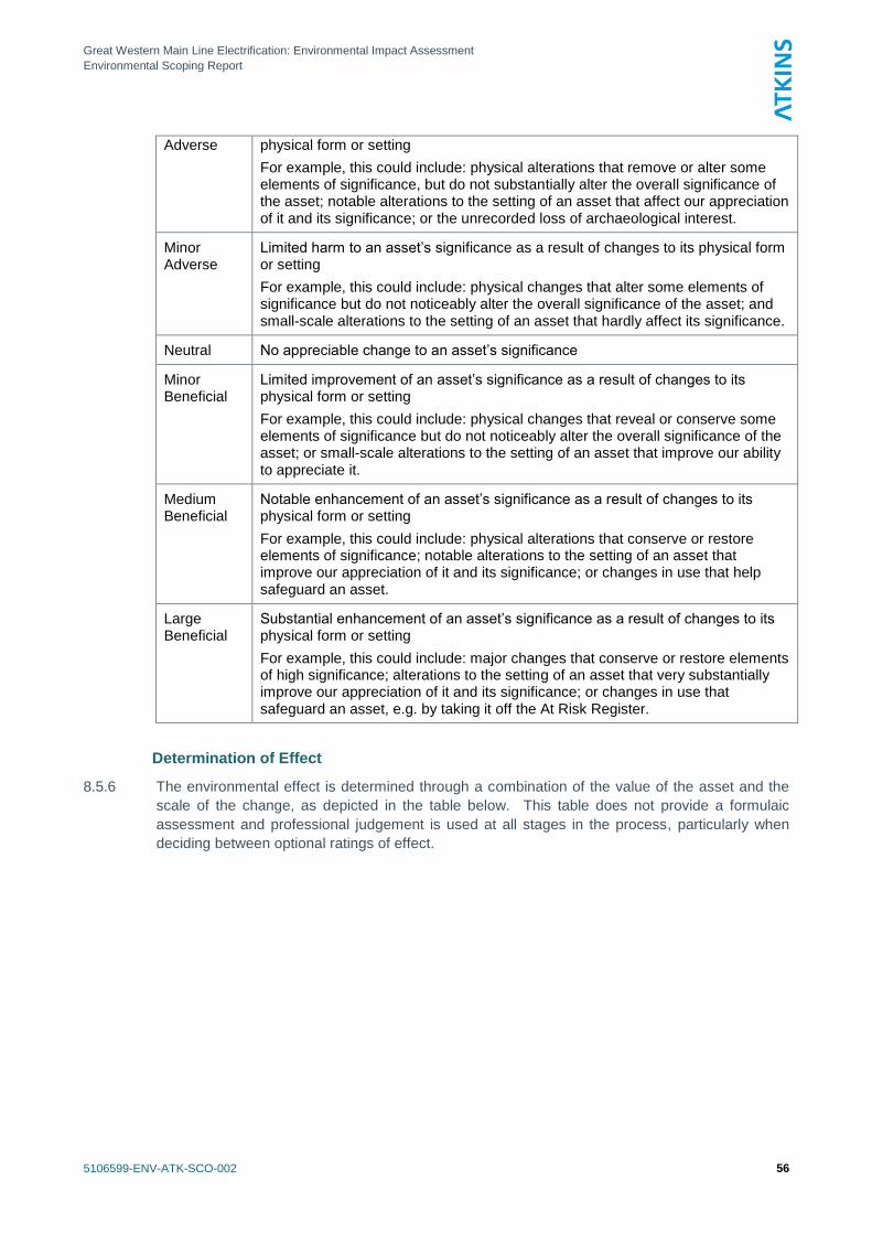
Great Western Main Line Electrification: Environmental Impact Assessment
Environmental Scoping Report
5106599-ENV-ATK-SCO-002 56
Adverse physical form or setting
For example, this could include: physical alterations that remove or alter some elements of significance, but do not substantially alter the overall significance of the asset; notable alterations to the setting of an asset that affect our appreciation of it and its significance; or the unrecorded loss of archaeological interest.
Minor Adverse
Limited harm to an asset‘s significance as a result of changes to its physical form or setting
For example, this could include: physical changes that alter some elements of significance but do not noticeably alter the overall significance of the asset; and small-scale alterations to the setting of an asset that hardly affect its significance.
Neutral No appreciable change to an asset‘s significance
Minor Beneficial
Limited improvement of an asset‘s significance as a result of changes to its physical form or setting
For example, this could include: physical changes that reveal or conserve some elements of significance but do not noticeably alter the overall significance of the asset; or small-scale alterations to the setting of an asset that improve our ability to appreciate it.
Medium Beneficial
Notable enhancement of an asset‘s significance as a result of changes to its physical form or setting
For example, this could include: physical alterations that conserve or restore elements of significance; notable alterations to the setting of an asset that improve our appreciation of it and its significance; or changes in use that help safeguard an asset.
Large Beneficial
Substantial enhancement of an asset‘s significance as a result of changes to its physical form or setting
For example, this could include: major changes that conserve or restore elements of high significance; alterations to the setting of an asset that very substantially improve our appreciation of it and its significance; or changes in use that safeguard an asset, e.g. by taking it off the At Risk Register.
Determination of Effect
8.5.6 The environmental effect is determined through a combination of the value of the asset and the
scale of the change, as depicted in the table below. This table does not provide a formulaic
assessment and professional judgement is used at all stages in the process, particularly when
deciding between optional ratings of effect.
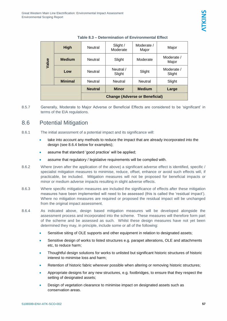
Great Western Main Line Electrification: Environmental Impact Assessment
Environmental Scoping Report
5106599-ENV-ATK-SCO-002 57
Table 8.3 – Determination of Environmental Effect
Valu
e
High Neutral Slight /
Moderate Moderate /
Major Major
Medium Neutral Slight Moderate Moderate /
Major
Low Neutral Neutral /
Slight Slight
Moderate / Slight
Minimal Neutral Neutral Neutral Slight
Neutral Minor Medium Large
Change (Adverse or Beneficial)
8.5.7 Generally, Moderate to Major Adverse or Beneficial Effects are considered to be ‗significant‘ in
terms of the EIA regulations.
8.6 Potential Mitigation
8.6.1 The initial assessment of a potential impact and its significance will:
take into account any methods to reduce the impact that are already incorporated into the
design (see 8.6.4 below for examples);
assume that standard ‗good practice‘ will be applied;
assume that regulatory / legislative requirements will be complied with.
8.6.2 Where (even after the application of the above) a significant adverse effect is identified, specific /
specialist mitigation measures to minimise, reduce, offset, enhance or avoid such effects will, if
practicable, be included. Mitigation measures will not be proposed for beneficial impacts or
minor or medium adverse impacts resulting in slight adverse effects.
8.6.3 Where specific mitigation measures are included the significance of effects after these mitigation
measures have been implemented will need to be assessed (this is called the ‗residual impact‘).
Where no mitigation measures are required or proposed the residual impact will be unchanged
from the original impact assessment.
8.6.4 As indicated above, design based mitigation measures will be developed alongside the
assessment process and incorporated into the scheme. These measures will therefore form part
of the scheme and be assessed as such. Whilst these design measures have not yet been
determined they may, in principle, include some or all of the following:
Sensitive siting of OLE supports and other equipment in relation to designated assets;
Sensitive design of works to listed structures e.g. parapet alterations, OLE and attachments
etc, to reduce harm;
Thoughtful design solutions for works to unlisted but significant historic structures of historic
interest to minimise loss and harm;
Retention of historic fabric wherever possible when altering or removing historic structures;
Appropriate designs for any new structures, e.g. footbridges, to ensure that they respect the
setting of designated assets;
Design of vegetation clearance to minimise impact on designated assets such as
conservation areas.

Great Western Main Line Electrification: Environmental Impact Assessment
Environmental Scoping Report
5106599-ENV-ATK-SCO-002 58
8.6.5 Additionally, the design process will seek to identify opportunities to deliver conservation works to
listed and unlisted structures along the line of the scheme.
8.6.6 Other non-design based mitigation may include some or all of the following:
Recording of historic structures along the lines, at an appropriate level, prior to works
commencing. This would be undertaken in accordance with English Heritage guidance
(‗Understanding Historic Buildings‘, 2006);
Provision of interpretation or information along the routes and/or online;
Identification and recording of any surviving historic railway infrastructure near to construction
locations along the route.
Great Western Main Line Electrification: Environmental Impact Assessment
Environmental Scoping Report
5106599-ENV-ATK-SCO-002 59
9. Land Contamination
9.1 Introduction
9.1.1 This chapter presents the proposed approach to the assessment of land contamination (also
called land quality) for the Scheme. A preliminary review of ground conditions, including geology,
designated geological sites and potential sources/presence of land contamination, has been
carried out to develop the baseline conditions and sensitivity and enable preliminary identification
of potential effect of the Scheme on land contamination/quality. The proposed methodology for
assessment of the construction and operational phases of the Scheme is presented and the
approach to mitigation measures discussed.
9.1.2 Cumulative impacts and potential combinations of various effects because of other planned
developments are not discussed herein but will be identified and considered in the ES as
relevant.
9.2 Consultation
9.2.1 No consultation has been carried out with the Local Authorities through whose area the Scheme
passes or the Environment Agency at this stage.
9.3 Overview of Baseline Conditions and Study Area
Geology
9.3.1 An overview of the published geology for is the Scheme is presented in Appendix D, based on
information from the British Geological Survey (BGS) online mapping resourceiii.
Hydrogeology
9.3.2 Hydrogeology is discussed in detail in the Water Resources and Hydrogeology Chapter.
However, groundwater is a potential receptor for land contamination and, as such, has been
reviewed in this Chapter for completeness.
9.3.3 Superficial Deposits are classed as Unproductive Strata, Secondary A Aquifers (mainly the Sand
and Gravel Deposits) or Secondary (Undifferentiated) Aquifers. The majority of the Reading to
Swindon section of the Scheme and the Newbury spur are underlain by Secondary A Aquifers.
9.3.4 Solid strata are classed as Unproductive Strata, Secondary A Aquifers or a Principal Aquifers.
Chalk underlying the route from Maidenhead to Didcot is classified as a Principal Aquifer. Clay
under the route from Swindon to Bristol includes Unproductive Strata, undifferentiated Triassic
Rocks which are Secondary A Aquifers and Limestone, which is a Principal Aquifer.
9.3.5 Principal Aquifers have high intergranular and/or fracture permeability and usually provide a high
level of water storage. They can support water supply and/or river base flow on a strategic scale.
Secondary A Aquifers have permeable layers that are capable of supporting water supplies at a
local rather than strategic level and can form an important source of base flow to rivers.
Unproductive Strata are rock layers or Superficial Deposits with such low permeability that they
have negligible significance for water supply or river base flow.
9.3.6 The Scheme would pass through a number of areas designated by the Environment Agency as
Groundwater Source Protection Zones (SPZ). Those relevant to the Scheme are identified in the
Table in the Appendix D.
Great Western Main Line Electrification: Environmental Impact Assessment
Environmental Scoping Report
5106599-ENV-ATK-SCO-002 60
Hydrology
9.3.7 Hydrology is discussed in detail in the Water Resources and Hydrogeology Chapter. However,
surface water is a potential receptor to land contamination and, as such, has been reviewed in
this Chapter for completeness.
9.3.8 Surface water features, including small brooks, tributaries, rivers, streams and ponds that lie
close to the Scheme. Those which cross the route or are located within 250m will be considered
relevant for the baseline condition.
9.3.9 Surface water features located within 250m of the project are summarised in Appendix D. These
will be identified from available topographic maps.
Existing Potential Contamination (Baseline)
9.3.10 The railway line is currently operational and was fully operational along most of the length of the
Scheme in the 19th Century. It is possible that in some areas, for example, the industrial centres
of Reading and Bristol, contamination may exist beneath the track that precedes construction of
the railway.
9.3.11 Reference will be made to Industry Profile for Railway Landiv, which provides information on
general sources of contamination associated with operational railway land. The Industry Profile
considers running lines and lineside, electrical substations, engineering and freight depots and
waste.
9.3.12 Historically, the construction of railways involved moving large amounts of material for
embankments, cuttings, bridges and structures. Fill was used extensively and sourced locally.
Therefore embankments are likely to be constructed of Made Ground comprising a mixture of
natural reworked materials, industrial wastes such as slag, clinker and ash and material
(potentially contaminated) of unknown origin from the local area.
9.3.13 Track ballast historically included crushed steel slag and steam locomotive ash. This material
could still be present below modern ballast layers. Track ballast can potentially be contaminated
with diesel and oil from leaks. This is especially likely to be the case in stations and sidings
where wagons can be standing for significant periods. Asbestos may be present from historical
use in pipework and ducting. Creosote may be present from sleepers. Herbicides may be
present from past use on trackside margins.
9.3.14 In addition, there may be other sources of contamination adjacent to and not necessarily
associated with railway operation, which have migrated or could migrate to the railway area,
specifically landfills or other potentially contaminative activities. Contaminants can migrate in
windblown, soil-derived dust, entrained in surface water run-off, in groundwater and as vapours
and ground (landfill) gas. Therefore, in addition to the railway itself, specific existing sources of
contamination located within 250m of the route corridor will be identified.
9.3.15 Details of landfills will be obtained from the Environment Agency websitev. Potential hazards to
the railway, including landfills, will be identified in the Network Rail Hazard Directoryvi and
additional potentially contaminative land uses will be identified using online mapping resourcesvii
.
In addition, the High Output Operations Base (HOOB), to be located at Swindon Transfer Yard is
close to (within 100m) a former chemical works, a gas works and a number of brick works, which
were present from the late 1800s to the early 1900sviii
and historical contamination may be
present from these activities.
9.3.16 Existing potential sources of contamination within 250m of the Scheme are summarised in
Appendix D.
Existing Potential Receptors (Baseline)
9.3.17 The railway is currently operational and there is assumed to be only very limited public access to
the track via the public footpaths that cross the track. Therefore, the only existing baseline
Great Western Main Line Electrification: Environmental Impact Assessment
Environmental Scoping Report
5106599-ENV-ATK-SCO-002 61
human receptors of relevance to this assessment are considered to be track and railway
maintenance workers.
9.3.18 Baseline controlled waters receptors include groundwater and the numerous surface
watercourses located adjacent to and flowing beneath the Scheme.
9.3.19 Existing rail infrastructure is a baseline property receptor.
9.4 Proposed Scope of Assessment/Methodology
Introduction
9.4.1 Government good practice guide for environmental impact assessmentix
states that the following
potential environmental effects should be considered with respect to soil:
a) Physical effects of the development, for example changes in topography, soil compaction,
soil erosion, ground stability, etc.
b) Effects on geology as a valuable resource, for example, sterilisation of mineral resources,
loss or damage to regionally important geological sites, geological Special Site of Scientific
Interest (SSSIs), etc.
c) Effects on soils as a valuable resource, for example, loss or damage to soils with good
agricultural quality.
d) Effects associated with ground contamination that may already exist on a site, for example
introducing/changing pathways and receptors.
e) Effects associated with the potential for polluting substances used (during
construction/operation) to cause new land contamination issues on a site, for example
introducing/changing the source of contamination.
f) Effects associated with re-use of soils and waste disposal of soils, for example, re-use of
site-sourced materials on or off a site, disposal of site-sourced materials off-site, importation
of materials to the site, etc.
9.4.2 The Scheme is not likely to affect land that is subject to mineral resources or sites of geological
importance. It is not likely to have implications for topography, soil erosion or ground stability.
The potential environmental effects with regard to soils and geology and waste are related to land
contamination (d and e) and the implications of soil quality for reuse of soils (f).
9.4.3 Government objectives with respect to land contamination are set out in the Department for
Environment Food and Rural Affairs (DEFRA) Circular 01/2006x and form the basis of the
‗suitable for use‘ approach to the assessment and remediation of land which is contaminated.
The ‗suitable for use‘ approach consists of three elements:
ensuring the land is suitable for its current use. This is afforded through the ‗Contaminated
Land‘ regime (Part 2A of the Environmental Protection Act 1990xi).
ensuring that land is made suitable for any new use and planning permission is given for that
new use through Annex 2 of Planning Policy Statement (PPS) 23xii
. It should be noted that
PPS23 is programmed for withdrawal, although the schedule for this and any replacement to
PPS23 is not known at this time.
limiting requirements for remediation to the work necessary to prevent unacceptable risks to
human health or the environment.
9.4.4 It should be noted that this Circular is being revised currently, although the overall principles are
likely to remain unchanged.
Great Western Main Line Electrification: Environmental Impact Assessment
Environmental Scoping Report
5106599-ENV-ATK-SCO-002 62
9.4.5 Land use for this Scheme is not changing and is already ‗suitable for use‘. However, the Scheme
will include installation of OLE support foundations, bridge works, track lowering, electrical supply
installation (feeder stations and switching stations), structural (station canopies, signal gantries)
and vegetation clearance and construction of the HOOB, all of which will include excavation of
the ground. There is the potential for the following:
disturbance of existing contamination and introduction of new receptors and pathways (as
per item (d) above);
introduction of polluting substances during construction (as per item (e) above); and
generation of excavated material which will require managing sustainably and in accordance
with current waste management legislation (as per item (f) above).
9.4.6 The approach to assessing the potential impacts of the Scheme will be undertaken by assessing
the changes in the baseline, construction and operation phases in two stages, as described
below.
Stage 1: Risk Assessment
9.4.7 Land contamination risk assessment is based on guidance in the Contaminated Land Report
(CLR)xiii
published by DEFRA and the Environment Agency in 2004 and in the Government‘s
Good Practice Guide to Environmental Impact Assessment. These documents provide a
technical framework for the application of a risk management process as follows:
develop a preliminary Conceptual Site Model (CSM) by desk study review of available
documentary information to identify: the potential sources of contamination and associated
contaminants from past and current potentially contaminative activities on and adjacent to a
site; receptors to such contamination, for example, humans, controlled waters (all
groundwater and most surface water; flora and fauna of statutory and non-statutory
conservation designations and property (domestic animals, domestic produce, crops,
livestock, game and fish and buildings/infrastructure) and pathways between the two. Where
all three (source-receptor-pathway) are present or are likely to be present, they are termed a
potential pollutant linkage (PPL).
risk assessment, either qualitative or quantitative should relevant data be available.
9.4.8 Potential risks are determined and assessed based on the likelihood and consequence using the
principles given in the National House Building Council/ Environment Agency report R&D66xiv
.
This provides guidance on development and application of the consequence and probability
matrix (as presented in Table 10.6) to risk assessment and broad definitions of consequence.
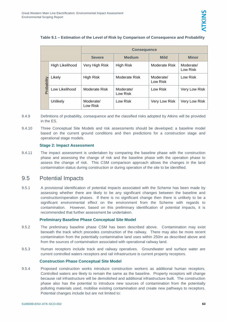
Great Western Main Line Electrification: Environmental Impact Assessment
Environmental Scoping Report
5106599-ENV-ATK-SCO-002 63
Table 9.1 – Estimation of the Level of Risk by Comparison of Consequence and Probability
Consequence
Severe Medium Mild Minor
Pro
ba
bili
ty
High Likelihood Very High Risk High Risk Moderate Risk Moderate/ Low Risk
Likely High Risk Moderate Risk Moderate/ Low Risk
Low Risk
Low Likelihood Moderate Risk Moderate/ Low Risk
Low Risk Very Low Risk
Unlikely Moderate/ Low Risk
Low Risk Very Low Risk Very Low Risk
9.4.9 Definitions of probability, consequence and the classified risks adopted by Atkins will be provided
in the ES.
9.4.10 Three Conceptual Site Models and risk assessments should be developed; a baseline model
based on the current ground conditions and then predictions for a construction stage and
operational stage models.
Stage 2: Impact Assessment
9.4.11 The impact assessment is undertaken by comparing the baseline phase with the construction
phase and assessing the change of risk and the baseline phase with the operation phase to
assess the change of risk. This CSM comparison approach allows the changes in the land
contamination status during construction or during operation of the site to be identified.
9.5 Potential Impacts
9.5.1 A provisional identification of potential impacts associated with the Scheme has been made by
assessing whether there are likely to be any significant changes between the baseline and
construction/operation phases. If there is no significant change then there is unlikely to be a
significant environmental effect on the environment from the Scheme with regards to
contamination. However, based on this preliminary identification of potential impacts, it is
recommended that further assessment be undertaken.
Preliminary Baseline Phase Conceptual Site Model
9.5.2 The preliminary baseline phase CSM has been described above. Contamination may exist
beneath the track which precedes construction of the railway. There may also be more recent
contamination from the potentially contaminative land uses within 250m as described above and
from the sources of contamination associated with operational railway land.
9.5.3 Human receptors include track and railway operatives. Groundwater and surface water are
current controlled waters receptors and rail infrastructure is current property receptors.
Construction Phase Conceptual Site Model
9.5.4 Proposed construction works introduce construction workers as additional human receptors.
Controlled waters are likely to remain the same as the baseline. Property receptors will change
because rail infrastructure will be demolished and additional infrastructure built. The construction
phase also has the potential to introduce new sources of contamination from the potentially
polluting materials used, mobilise existing contamination and create new pathways to receptors.
Potential changes include but are not limited to:
Great Western Main Line Electrification: Environmental Impact Assessment
Environmental Scoping Report
5106599-ENV-ATK-SCO-002 64
The potential for mobilising contaminants by excavation and stockpiling material. This would
increase the risk to controlled water receptors through leaching and run-off. Earthworks
could provide opportunity for run-off to contain suspended solids if not managed properly.
The potential for creation of new pathways to groundwater by piling.
The potential for construction of below ground structures to create preferential pathways for
the migration of existing contamination.
The potential for exposure of human receptors by generation of contaminated dust released
by the construction works.
The potential for exposure of construction workers to existing contamination because of
direct contact with the material.
The potential for release of potentially polluting substances used during the construction
phase, for example, spillages of oil or fuel from equipment.
The potential that construction of below ground structures and installation of new below-
ground service routes create preferential pathways for the migration of landfill gases/leachate
onto the site.
9.5.5 Based on this preliminary identification of potential impacts, changes could occur and further,
more detailed assessment is required.
Operational Phase Conceptual Site Model
9.5.6 On completion of the OLE works, the site will continue its current operation as a railway. The
operational phase CSM is based on the site being operated for this purpose only.
9.5.7 Historic contamination is likely to remain undisturbed except at construction/demolition locations
and as such these risks will remain. The conversion of the railway from diesel to electric may
lead to a reduction in contamination because of a reduction in the potential for leaks and spillages
of fuels during the operation of the works.
9.5.8 Construction workers will no longer be present and operational phase human receptors will be
the same as the baseline and include track and railway operatives and possibly the public.
Controlled waters receptors will be the same as the baseline (groundwater and surface water).
9.5.9 Property receptors will comprise rail infrastructure as for the baseline, but include new structures
at various locations along the route and the majority of existing structures. Therefore, there are
additional property receptors which could potentially be at risk.
9.5.10 Construction of new below ground structures and installation of new below-ground service routes
within 250m of the landfills and potentially contaminative activities will present preferential
pathways for the migration of landfill gases/leachate and there will be a new pathway and
potential increase in risk from the baseline.
9.5.11 Based on this preliminary identification of potential impacts, changes could occur and further,
more detailed assessment is required.
Summary
9.5.12 Based on this preliminary identification of potential impacts, changes could occur and further,
more detailed assessment is required. Consultations will be carried out with the Local Authorities
through whose area the Scheme passes and the Environment Agency to obtain land
contamination/land quality information and their views on the Scheme and mitigation expected.
9.5.13 Existing available information will be examined in more detail to better understand the Baseline
Phase CSM for each phase and Local Authority Area. The Scheme details will be available and
the Construction and Operation Phase CSMs can be better developed.
Great Western Main Line Electrification: Environmental Impact Assessment
Environmental Scoping Report
5106599-ENV-ATK-SCO-002 65
9.5.14 Changes in contamination sources, receptors, pathways and land contamination risks between
the Construction and Baseline Phase CSMs and Operation and Baseline Phase CSMs will be
examined and assessed in more detail to better identify impacts and effects following the
methodology described herein. This will enable appropriate mitigation to be identified.
9.6 Potential Mitigation
9.6.1 Potential mitigation measures to be implemented will be confirmed after further detailed
assessment. The Scheme will be designed to ensure construction works will not pose a risk to
human health or the environment. Intrusive ground investigations would be undertaken, where
necessary, at the locations of proposed new structures to inform foundation design, health and
safety risk assessments, waste classification and potential reuse of materials. Such
investigations will also provide information on existing contamination.
9.6.2 Good site practices should be adhered to during construction. Measures could include:
management of potential risks to construction workers through health and safety legislation,
such as the Control of Substances Hazardous to Health (COSHH) Regulationsxv
, which
require the employer to carry out an assessment of the risks associated with exposure to
hazardous substances and then to prevent and if this is not reasonably practicable, to
adequately control such exposures;
working methods during construction to ensure that surface water cannot run-off from the
works and any stockpiles into adjacent surface watercourses;
implementation of appropriate dust control measures;
storage of fuel away from surface watercourses in accordance with Environment Agency
Pollution Prevention Guidance Notes (PPGN) notes PPGN2xvi
and PPGN6xvii
;
development of a methodology to address what remedial actions will be undertaken and how
such actions will be validated and recorded if unsuspected contamination is encountered
during the works.
9.6.3 The measures listed above are a small selection of those adopted as standard as part of site
practices on all development sites and will be detailed in a Construction Environmental
Management Plan. At this stage, no mitigation measures have been identified above and beyond
what would be normally be expected or required for this type of Project.
9.6.4 At this stage, no additional mitigation measures have been identified for the Operation Phase and
an environmental management plan will be in place to address protection of human health and
the environment.
Great Western Main Line Electrification: Environmental Impact Assessment
Environmental Scoping Report
5106599-ENV-ATK-SCO-002 66
10. Water Resources and Hydrogeology
10.1 Introduction
10.1.1 This chapter presents the proposed approach to the water resources and water quality
assessment for the proposed Great Western Mainline (GWML) Scheme. It includes a discussion
of baseline conditions and sensitivity, preliminary identification of potential effects on the water
environment, and the proposed methodology for assessment of the construction and operational
phases of the project.
10.1.2 Cumulative impacts and potential combinations of various effects due to other planned
developments are not discussed; however these will be identified and considered in the EIA.
10.2 Consultation
10.2.1 No consultation has been carried out with the Environment Agency with respect to impacts to the
water environment from the proposed scheme. It is recommended however that consultations
should be sought to agree methodologies where intrusive works are planned over Principal
Aquifers. Consultation with the Environment Agency is also recommended with regards to
confirming potential flood risk issues.
10.3 Overview of Baseline Conditions and Study Area
10.3.1 The overall baseline conditions within the study area are summarised below.
Study Area Topography
10.3.2 The topography along the alignment of the railway lines ranges from approximately 20 m above
Ordnance Datum (AOD) to approximately 130 m AOD. The variation in height is over a distance
of 240km and therefore no steep slopes are anticipated along the route.
10.3.3 Along the route between Maidenhead and Swindon the topography varies from 50 m AOD in
Maidenhead, 65 m AOD in Didcot to approximately 100 m AOD in Swindon, again this is over a
distance of 85km and therefore does not create any significant steep slopes.
10.3.4 The topography along the route between Swindon and Bristol Temple Mead starts at an elevation
of approximately 100 m AOD in Swindon and Royal Wootton Bassett but steadily declines to
approximately 20 m AOD in Bath and Bristol. The decline in topography is less steep along the
route from Swindon to Bristol Patchway than towards Temple Meads with a decline from
approximately 100 m AOD 60 m AOD at Bristol Patchway. As would be expected the topography
between Bristol Temple Meads and Bristol Patchway steadily increases from 20 m AOD at
Temple Meads to 60 m AOD at Patchway.
10.3.5 The link between Reading and Newbury steadily increases from 45 m AOD in Reading to
approximately 80 m AOD in Newbury. There is very little variation in the topography on the link
from Didcot Parkway to Oxford between 55 m AOD and 65 m AOD.
10.3.6 In summary while the topography varies along the route between 20 m AOD to 130 m AOD the
gradient is consistently very shallow.
10.3.7 Some sections of the route are in cuttings, whilst other sections are built up on embankments,
there are a number of tunnels, including the Sodbury Tunnel, which cut through areas of more
elevated topography.
10.3.8 The railway lines pass over numerous surface watercourses and over and under numerous
roadways.
Great Western Main Line Electrification: Environmental Impact Assessment
Environmental Scoping Report
5106599-ENV-ATK-SCO-002 67
Study Area Geology
10.3.9 The superficial deposits along the route are recorded to comprise Sand and Gravel and Clay, Silt
and Sand. There are superficial deposits along the route from Maidenhead to Swindon
consisting of Sand and Gravel and Clay, Silt and Sand. Similar superficial deposits are present
along the route from Reading to Newbury. The superficial deposits along those railway routes
are associated with the River Thames and the River Kennet respectively.
10.3.10 The underlying solid geology along the route between Maidenhead and Swindon consists mainly
of chalk and undifferentiated, mudstone, sandstone and limestone. From Swindon to Bristol
there is a change in the bedrock geology from chalk to include the Kellaways Formation and
Oxford Clay Formation (comprising mudstone, siltstone and sandstone), changing to an area of
sandstone and limestone as the route moves toward Bath and Bristol. Within Bath and Bristol the
geology is mainly Triassic Rocks (Undifferentiated) which include sandstone and conglomerate,
interbedded substrates with inliers of limestone.
10.3.11 The geology between Didcot Station and Oxford Station is a combination of mudstone, sandstone
and clay. Between Reading Station and Newbury Station the geology is chalk in Reading with
clay, silt, sand and gravel as the route moves away from Reading and towards Newbury.
Study Area Hydrogeology
10.3.12 The Chalk deposits underlying the route from Maidenhead to Swindon are classified by the
Environment Agency as a Principal Aquifer. The geology from Swindon to Bristol includes;
unproductive strata in the clay, the undifferentiated Triassic Rocks are classified as a Secondary
A Aquifer and the Limestone formations are designated as Principal Aquifers.
10.3.13 Small areas of superficial deposits, generally relating to Sand and Gravel deposits are also
classed as Secondary A Aquifers. There are also some Secondary (undifferentiated) deposits.
The remainder of the superficial deposits are classified as unproductive strata.
10.3.14 Principal Aquifers are deposits that have high intergranular and / or fracture permeability, which
usually provide a high level of water storage. They can support water supply and/or river base
flow on a strategic scale.
10.3.15 Secondary A Aquifers have permeable layers which are capable of supporting water supplies at a
local rather than strategic scale and can form an important source of base flow to rivers.
10.3.16 Unproductive strata are rock layers or drift deposits with such low permeability that they have
negligible significance for water supply or river base flow.
10.3.17 The route passes through a number of areas designated by the Environment Agency as
Groundwater Source Protection Zones (SPZ). The various SPZs along the route will be shown
on the plans accompanying the Environmental Statement.
10.3.18 SPZ1s are source catchment protection zones defined by the Environment Agency as the 50 day
travel time from any point below the water table to the source. SPZ2s are the outer protection
zones defined as areas that have a 400 day travel time from a point below the water table.
SPZ3s are a catchment protection zones and are defined as the area around a source within
which all groundwater recharge is presumed to be discharged at the source.
10.3.19
Study Area Hydrology
10.3.20 The route crosses a number of surface watercourses, including small brooks, tributaries and main
rivers. An initial outline list of named water bodies close to or crossed by the route of the railway
are summarised below. This list relates only to those watercourses or features identified and
named on available web-based mapping. There may be additional ponds, reservoirs and canals
that may be identified through field investigations or consultation with the Environment Agency.
Great Western Main Line Electrification: Environmental Impact Assessment
Environmental Scoping Report
5106599-ENV-ATK-SCO-002 68
River Thames
Jubilee River
River Loddon
River Kennet
River Ock
River Cole
River Ray
River Avon
River Frome
River Cherwell
Kennet & Avon Canal
River Endborne
10.3.21 The flood maps provided by the Environment Agency (identify some areas are at risk of flooding
from rivers without defences as a result of the above surface water features. The affected areas
include areas which could be flooded from a river by a flood that has a 1 per cent (1 in 100) or
greater chance of happening each year, and areas that could be affected by extreme flooding
from rivers or sea. These outlying areas are likely to be affected by a major flood, with up to a
0.1 per cent (1 in 1000) chance of occurring each year. Railway lines are generally built up
above natural ground level and on bridges or culverts to allow passage across water courses and
therefore while the flood maps may identify parts of the route as being located within a flood plain
the railway infrastructure may however be higher than the river flood level.
Conservation Sites
10.3.22 No designated conservation sites (Ramsar Sites, Special Protection Areas (SPA), Special Areas
of Conservation (SAC) and Environmentally Sensitive Areas (ESA)) have been identified within
2km of the route electrification. However there are several Sites of Special Scientific Interest
(SSSI) that have been identified within 2 km of the route alignment which have the potential to be
impacted by changes to the water environment.
10.3.23 The listed SSSIs have been identified along the following routes.
10.3.24 The Maidenhead to Swindon route passes within 2km of the following SSSIs; Great Thrift Wood,
Bray Meadows, Lodge Wood and Sandford Mill, Sulham & Tidmarsh Woods & Meadows,
Hartslock, Holies Down, Lardon Chase, Moulsford Downs and Fernham Meadows.
10.3.25 The Didcot to Oxford route passed within 2km of one SSSI; Iffley Meadows.
10.3.26 The following SSSIs were identified as being within 2 km of the route between Reading and
Newbury; Old Copse, Beenham, Aldermaston Gravel Pits, Woolhampton Reed Bed which runs
proximal to the line, River Kennet, Thatcham Reed Beds and Bowdown & Chamberhouse
Woods.
10.3.27 From Swindon to Bristol Patchway Winterbourne Railway Cutting, Wootton Bassett Mud Spring,
Harries Ground and Rodbourne SSSIs were located within 2km of the route.
10.3.28 The following SSSIs are located within 2 km of the route from Swindon to Bristol Temple Mead-
Wootton Bassett Mud Spring, Sutton Lane Meadows, Kellaways-West Tytherton, the River Avon,
Corsham Railway Cutting, Box Mine, Hampton Rocks Cutting, Newton St Loe, Stidham Farm,
Cleeve Wood, Hanham and Bickley Wood.
Great Western Main Line Electrification: Environmental Impact Assessment
Environmental Scoping Report
5106599-ENV-ATK-SCO-002 69
10.4 Potential Impacts
10.4.1 The potential impacts as a result of the scheme in terms of water quality and groundwater and
surface water flow have been identified below following the review of the baseline data above.
10.4.2 The groundwater receptors which have the potential to be impacted by the scheme include the
Principal Aquifers of the Chalk and limestone formations and the Secondary A Aquifers of the
Triassic Rocks and the superficial sand and gravel deposits.
10.4.3 The surface water receptors include those watercourses identified and detailed in the baseline
conditions section of this report and comprise those features passing under or adjacent to the
railway line.
10.4.4 The following sections set out the potential impacts such a scheme may have in terms of water
quality and groundwater and surface water flow.
Water Quality
10.4.5 The deliberate or accidental discharge of polluting material into controlled waters is an offence
under the Environmental Permitting Regulations 2010 (as amended) if undertaken without
consent and could lead to major adverse impacts without mitigation.
10.4.6 The proposed development has the potential to negatively impact water quality through the
introduction of pollutants from the construction process incorporating suspended solids into the
runoff which would then discharge to the water courses or to groundwater. This could impact on
existing water uses for amenity, water abstraction and habitats and potentially impact the flora
and fauna in local water courses.
10.4.7 Construction materials could pose a potential groundwater or surface water quality risk should
they become entrained in runoff and discharged to the surrounding water environment. The
implementation of piled foundations may also create potential pathways for contamination to
migrate from surface / near surface deposits to impact on water quality in the underlying aquifers.
10.4.8 There are areas of sand and gravel deposits which overlay the natural geology along the route.
Whilst construction materials have the potential to generate a source of contamination to enter
the groundwater system, the implementation of the required design standards and best practice
should ensure a neutral resultant impact on the groundwater environment.
10.4.9 Works adjacent to watercourses and water bodies have the potential to discharge material
generated from and for the works into the watercourses causing pollution events. Where works
adjacent to watercourses and water bodies are to be carried out, best practice mitigation
measures should be implemented to ensure no significant contamination of receptors. In
particular, under the terms of the Environmental Permitting Regulations and the Land Drainage
Byelaws the prior written consent of the Environment Agency is required for any works, in, under,
over or within 8 metres of the bank top of a "main river" watercourse. A flood defence consent
would be required for any works within the water course or re-culverting of the current
watercourses.
10.4.10 There is potential that the electrification of the railway line would reduce the number of diesel
trains utilising the route and the potential for leakages and spillages which would provide a very
slight beneficial impact on the water quality of the surrounding area.
Groundwater Flow
10.4.11 The impact on groundwater recharge has been considered and the potential for the scheme to
reduce infiltration to groundwater is low as there is unlikely to be any change to the potential for
infiltration or runoff from the scheme to the underlying bedrock. There is unlikely to be any
change to the current track and only minor modifications in small areas.
Great Western Main Line Electrification: Environmental Impact Assessment
Environmental Scoping Report
5106599-ENV-ATK-SCO-002 70
10.4.12 Areas which become compacted as a result of construction vehicles can result in infiltration to
groundwater being inhibited. However, this is likely to occur over the short term within only small
areas of the wider recharge catchment, with runoff likely to find its way to the perimeter areas
which are less compacted and allow infiltration to take place.
10.4.13 Proposed shallow or piled foundations should have limited impact in terms of the groundwater
flow regime of the surrounding area as foundations are likely to be small in area and therefore
unlikely to present a blockage to groundwater flow or cause a backing up effect.
10.4.14 Based on the above assumptions it is expected that there would be a neutral impact on the
groundwater flow as a result of the scheme, however further more detailed assessment may be
required to confirm this.
Surface Water Flow
10.4.15 The proposed works are not likely to increase the area of impermeable land associated with the
railway or alter the fundamental structure of the embankments, ground level features or the
culverts or bridges along the route.
10.4.16 During the proposed works where temporary ground compaction occurs, due to vehicle
movements etc, this can prevent natural infiltration of rainwater and could lead to localised
surface water flooding either on-site or lead to flooding of adjacent land areas or properties.
Therefore temporary mitigation measures should be employed to ensure additional runoff is
managed and mitigated.
10.4.17 Some areas along the railway route are at risk of flooding from rivers. This should be taken into
account during design of the proposed works.
10.5 Proposed Scope of Assessment / Methodology
10.5.1 A review of the baseline conditions and the proposed development suggests that the proposed
impact on the surrounding water environment would be limited and it is expected that any
negative impacts from the scheme could be mitigated. Therefore should further assessment be
required it would be carried out in line with the following methodology and would expand on this
scoping report. Assessment criteria would be based on the methodology for appraising the
impact of projects (plan level appraisal) set out in the DfT‘s Transport Analysis Guidance (TAG)
Unit 3.3.6xviii
and the specific guidance for the water environment sub-objective set out in TAG
Unit 3.3.11xix
. Although this methodology has been developed for the assessment of road and
bridge projects it can be used to assess the impacts of other developments such as this rail
scheme.
10.5.2 The methodology takes into account the importance, magnitude and significance of predicted
impacts on the water environment. Importance is based on the value of the feature or resource,
where the magnitude of a potential impact is estimated based on the likely effects and is
independent of the importance of the feature.
10.5.3 The severity of a specific potential effect is then derived by considering both the importance and
sensitivity of the feature and the magnitude of the impact (impacts must be quantified where
possible, also estimating the change from the baseline conditions and the range of uncertainty).
The significance of the impacts must be identified. This will be addressed in the Derivation of
Significance of Potential Effects as a function of the sensitivity of the receptor and magnitude of
impact.
10.5.4 In applying this methodology, significant effects would be those of low severity or above. Effects
of negligible severity are termed insignificant. If an adverse significant effect is identified, whether
it is of low, medium or high severity, then mitigation measures will be developed to reduce or
mitigate this effect. When beneficial impacts are identified, then opportunities for further
environmental enhancement can be considered.
Great Western Main Line Electrification: Environmental Impact Assessment
Environmental Scoping Report
5106599-ENV-ATK-SCO-002 71
10.5.5 The assessment of a potential impacts and their significance will:
Take into account any methods to reduce the impact that are already incorporated into the
design;
Assume that standard ‗good practice‘ will be applied (e.g. production of management plans
(environmental, construction, waste, transport etc) and the development of an EMS; and
Assume that regulatory / legislative requirements will be complied with (e.g. operating permit
requirements, emission standards, British Standards, Duty of Care etc.).
10.5.6 Further assessment using the method outlined above is still required and will include:
Identifying the existing geology, hydrogeology, hydrology and surface water resources within
each local authority and determining the areas which are most at risk to establish where
mitigation methods would be required;
Determining potential environmental objections the Environment Agency may hold to the
proposed project;
The scoping assessment indicates that the proposed development could have a potential
impact on the Principal and Secondary A Aquifers present below the route. Further detailed
assessment is required to fully understand the potential impacts;
A number of surface water features have also been identified which the route passes over, or
is located in close proximity to. Further assessment is required to understand the potential
impacts if any the development may have on these features;
The above preliminary assessment indicates that there is unlikely to be an impact on
groundwater flow below the alignment of the route, however further assessment should be
undertaken to confirm this; and
The route passes through areas which are recorded to be at risk from flooding. However, the
proposed works for the scheme are highly unlikely to have an impact on the flood risk in the
area. If any track lowering is in an area at risk of flooding then more detailed assessment will
be required.
10.6 Flood Risk Assessment (FRA) Report Scope
10.6.1 A FRA should consider all types of flooding to satisfy the following three key objectives:
To assess flood risk to the proposed development and to demonstrate whether any residual
risk to the development and its user would be acceptable;
To assess the potential impact of the proposed development on flood risk elsewhere and to
demonstrate that the development would not increase flood risk elsewhere; and
To satisfy the requirements of national planning, should the scheme not be Permitted
Development.
10.6.2 Flood risk should be considered alongside other spatial planning matters such as transport,
housing, economic growth, natural resources, regeneration, biodiversity, the historic environment
and the management of other hazards. Policies should recognise the positive contribution that
avoidance and management of flood risk can make to the development of sustainable
communities, including improved local amenities and better overall quality of life.
10.6.3 A FRA should be carried out to an appropriate degree at all levels of the planning process. It
should assess the risks of all forms of flooding to and from the development, taking into account
climate change, and should inform the application of the sequential approach if appropriate.
Great Western Main Line Electrification: Environmental Impact Assessment
Environmental Scoping Report
5106599-ENV-ATK-SCO-002 72
10.6.4 Both the PPS25 ―Development and Flood Risk – Practice Guide‖xx and the CIRIA report C624
―Development and Flood Risk – Guidance for the Construction Industry‖xxi recommend a phased
approach with three levels of assessment as defined below:
10.6.5 Level 1: Screening study to identify whether there are any flooding or surface water management
issues related to a development site that may warrant further consideration. The screening study
will ascertain whether a Level 2 or 3 FRA is required.
10.6.6 Level 2: Scoping study to be undertaken if the Level 1 FRA indicates that the site may lie within
an area that is at risk of flooding, or that the site may increase flood risk due to increased run-off.
This study should confirm the sources of flooding which may affect the site.
10.6.7 Level 3: Detailed study to be undertaken if the Level 2 study concludes that quantitative analysis
is required to assess the flood risk related to the development site.
10.6.8 We will prepare a Level 1 study initially. It will be based on readily available existing information,
including the area specific Strategic Flood Risk Assessment (SFRA), Environment Agency Flood
Maps and Standing Advice. The following work and assessments will be carried out to support
this study:
Review of the site information and likely extent of any flood risk at the site;
Identify whether there are any flooding or surface water management issues related to the
development site that may warrant further consideration;
Identification and scoping of other flood risks as required by PPS25, i.e. surface water
disposal, groundwater flooding and infrastructure failure; and
Assess whether further assessment is required i.e. a Level 2 or 3 FRA.
Great Western Main Line Electrification: Environmental Impact Assessment
Environmental Scoping Report
5106599-ENV-ATK-SCO-002 73
10.7 Potential Mitigation
10.7.1 A number of potential mitigation measures could be implemented into the design and
construction phase of the works to enable some risks to groundwater and surface water to be
managed. However these cannot be confirmed without further detailed assessment.
10.7.2 The scheme will be designed to ensure construction works should not cause pollution to the
water environment. Intrusive ground investigations will be undertaken to inform the design of the
lowered sections of the proposed scheme relative to groundwater elevations.
10.7.3 The following legislation and guidance should be followed in order to mitigate the scheme
construction impacts on the water environment:
During construction good working practices for site activities should be adopted and carried
out in accordance with the Water Resources Actxxii
;
The Environment Agency‘s Pollution Prevention Guidance (PPG) should be followed;
Environment Agency (2001) Piling and Penetrative Ground Improvement Methods on Land
Affected by Contamination;
Guidance on Pollution Prevention, National Groundwater & Contaminated Land Centre report
NC/99/73; and
Environment Agency (2002) Piling into Contaminated Sites.
10.7.4 Accidental spills should be mitigated during the construction phase by:
Provision of oil spill clean-up equipment, drip trays under mobile plant; daily visual
inspections of the ground for evidence of contamination, suitable bunding for oils or
chemicals used on site and refuelling should only occur in designated areas.
Preparation of incident response plans; and
Machinery and equipment should be stored in designated areas.
10.7.5 Consultation should be carried out with the Environment Agency should there be a requirement to
pile within a groundwater SPZ and piling methodologies developed in line with best practice and
the Environment Agency‘s PPG documents.
10.7.6 No mitigation measures have been identified during the operational phase of the scheme with
respect to the water environment.
10.7.7 For all local authority areas, work should be carried out in line with the mitigation measures,
legislation and guidance identified above.
10.7.8 Where (even after the application of the above) a significant adverse effect is identified, specific /
specialist mitigation measures to minimise, reduce, offset, enhance or avoid such effects may
need to be proposed and stated. In general, mitigation measures will not need to be proposed for
beneficial impacts or those of negligible significance.
10.7.9 Where specific mitigation measures are required or proposed the significance of effects after
these mitigation measures have been implemented will need to be assessed (this is called the
‗residual impact‘).
10.7.10 Where no mitigation measures are required or proposed the residual impact will be unchanged
from the original impact assessment.
Great Western Main Line Electrification: Environmental Impact Assessment
Environmental Scoping Report
5106599-ENV-ATK-SCO-002 74
11. Ecology and Nature Conservation
11.1 Introduction
11.1.1 This chapter presents the proposed approach to the ecology and nature conservation
assessment for the Scheme. It includes a discussion of baseline conditions and sensitivity,
preliminary identification of potential effects on ecological receptors, and the proposed
methodology for assessment of the construction and operational phases of the Project. The
approach to mitigation measures is also discussed.
11.1.2 Cumulative impacts and potential combinations of various effects due to other planned
developments are not discussed herein; however these will be identified and considered in the
ES.
11.2 Consultation
11.2.1 No consultations have been carried out for this scoping report. In terms of statutory sites of
nature conservation importance, consultation would be undertaken with Natural England to
determine any concerns they may have and to discuss the likely effects and appropriate
mitigation. European designated sites would be dealt with in accordance with The Conservation
of Habitats and Species Regulations 2010 (as amended). Other consultation would be carried
as required depending on the results of the preliminary impact assessment.
11.3 Overview of Baseline Conditions and Study Area
11.3.1 The scoping study has looked at the proximity of ecologically sensitive sites to the Scheme in
order to establish an overview of the baseline conditions for the purpose of assessing the
impacts. The Scheme was taken to include the Great Western Main Line between Maidenhead
and Bristol Temple Meads stations, including the spurs to Oxford and Newbury stations and both
routes between Swindon and Bristol via Bath and Bristol Parkway. Feeder stations at Didcot and
Thingley Junction have been included in the study area, along with proposed switching station
locations.
11.3.2 Details of designated sites and notable habitats were acquired from internet-based resource
MAGIC (Multi Agency Geographical Information for the Countryside).
11.3.3 The sites and habitats included in the scoping study are:
Internationally designated sites, including Special Area of Conservation (SAC), Special
Protection Area (SPA), and Wetlands of International Importance (Ramsar sites).
Nationally designated sites, including Sites of Special Scientific Interest (SSSI).
Locally designated sites, including Local Nature Reserves (LNR).
Habitats of Principal Importance for the Conservation of Biodiversity in England listed under
Section 41 of the Natural Environment and Rural Communities Act 2006. The list (including
56 habitats and 943 species) has been drawn up in consultation with Natural England and
draws upon the UK Biodiversity Action Plan (UK BAP) List of Priority Habitats.
11.3.4 The scoping area extends up to 5 km from the railway. Information on ecologically sensitive sites
and habitats was sought from this area. Dependant on the designation and notable features,
sites and habitats information was compiled from within three scoping area zones: within 500m of
the railway, within 1km, and within 5 km according to the following table.
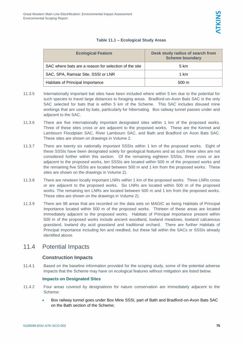
Great Western Main Line Electrification: Environmental Impact Assessment
Environmental Scoping Report
5106599-ENV-ATK-SCO-002 75
Table 11.1 – Ecological Study Areas
Ecological Feature Desk study radius of search from Scheme boundary
SAC where bats are a reason for selection of the site 5 km
SAC, SPA, Ramsar Site, SSSI or LNR 1 km
Habitats of Principal Importance 500 m
11.3.5 Internationally important bat sites have been included where within 5 km due to the potential for
such species to travel large distances to foraging areas. Bradford-on-Avon Bats SAC is the only
SAC selected for bats that is within 5 km of the Scheme. This SAC includes disused mine
workings that are used by bats, particularly for hibernating. Box railway tunnel passes under and
adjacent to the SAC.
11.3.6 There are five internationally important designated sites within 1 km of the proposed works.
Three of these sites cross or are adjacent to the proposed works. These are the Kennet and
Lambourn Floodplain SAC, River Lambourn SAC, and Bath and Bradford on Avon Bats SAC.
These sites are shown on drawings in Volume 2.
11.3.7 There are twenty six nationally important SSSIs within 1 km of the proposed works. Eight of
these SSSIs have been designated solely for geological features and as such these sites are not
considered further within this section. Of the remaining eighteen SSSIs, three cross or are
adjacent to the proposed works, ten SSSIs are located within 500 m of the proposed works and
the remaining five SSSIs are located between 500 m and 1 km from the proposed works. These
sites are shown on the drawings in Volume 2).
11.3.8 There are nineteen locally important LNRs within 1 km of the proposed works. Three LNRs cross
or are adjacent to the proposed works. Six LNRs are located within 500 m of the proposed
works. The remaining ten LNRs are located between 500 m and 1 km from the proposed works.
These sites are shown on the drawings in Volume 2).
11.3.9 There are 98 areas that are recorded on the data sets on MAGIC as being Habitats of Principal
Importance located within 500 m of the proposed works. Thirteen of these areas are located
immediately adjacent to the proposed works. Habitats of Principal Importance present within
500 m of the proposed works include ancient woodland, lowland meadows, lowland calcareous
grassland, lowland dry acid grassland and traditional orchard. There are further Habitats of
Principal Importance including fen and reedbed, but these fall within the SACs or SSSIs already
identified above.
11.4 Potential Impacts
Construction Impacts
11.4.1 Based on the baseline information provided for the scoping study, some of the potential adverse
impacts that the Scheme may have on ecological features without mitigation are listed below.
Impacts on Designated Sites
11.4.2 Four areas covered by designations for nature conservation are immediately adjacent to the
Scheme:
Box railway tunnel goes under Box Mine SSSI, part of Bath and Bradford-on-Avon Bats SAC
on the Bath section of the Scheme;
Great Western Main Line Electrification: Environmental Impact Assessment
Environmental Scoping Report
5106599-ENV-ATK-SCO-002 76
Thatcham Reed Beds SSSI, which includes part of the Kennet and Lambourne Floodplain
SAC; Woolhampton Reedbed SSSI, and the River Kennet SSSI are immediately adjacent to
the Newbury section of the Scheme.
11.4.3 Potential impacts on bats from the Bath and Bradford-on-Avon SAC are discussed in 11.4.8
below. Other direct impacts on designated sites are not expected.
11.4.4 Other internationally or nationally designated sites within 1 km of the site may be subject to
indirect impacts, and these may include:
Contaminated run-off reaching designated sites downstream of the Scheme, which may have
a detrimental effect on water quality and species assemblages within wetland sites or
watercourses;
Loss of lineside vegetation that acts as a buffer for sites outside but adjacent to the Scheme;
Noise or visual disturbance of species within adjacent sites due to construction staff,
machinery, and lighting.
Impacts on Habitats of Principal Importance
11.4.5 There are thirteen locations where Habitats of Principal Importance are present adjacent to the
Scheme and at some locations this could include lineside vegetation, particularly in undisturbed
areas where habitats such as calcareous grassland have had time to develop.
11.4.6 Where Habitats of Principal Importance are present on the lineside, there may potentially be
small scale and localised loss of habitat due to the works. However, this impact is not expected
to cause significant damage to the habitat in the context of the Scheme.
11.4.7 The indirect impacts that may affect designated sites may similarly affect adjacent habitats,
including run-off to watercourses, loss of buffer vegetation, and disturbance.
Impacts on Protected and Notable Species
11.4.8 Other than Bath and Bradford-on-Avon Bats SAC, no SAC where bats are a reason for selection
is present within 5 km of the Scheme. At Box Mine SSSI (a part of Bath and Bradford-on-Avon
Bats SAC), the Box railway tunnel passes within 500m of the entrances to the disused
mineworkings that are used as a hibernation roost by bats, including greater horseshoe bat,
lesser horseshoe bat and Bechstein‘s bat. For this scoping study, there is no available evidence
to show whether bats use the railway tunnel and associated air shafts for roosting or whether the
tunnel is in some way connected to the mineworkings. Therefore, at this stage it cannot be
confirmed whether there may be a potential risk that works may kill, injure or disturb roosting bats
within the tunnel, or may disturb bats within adjacent underground spaces. The works may also
disrupt the fight routes used by bats accessing the mineworkings or tunnel or travelling to
foraging areas.
11.4.9 Works to other tunnel or bridge structures may result in the killing, injury or disturbance of bat
using the structure for roosting, or nesting birds; and may result in the loss of potential bat
roosting or bird nesting habitat.
11.4.10 Localised removal of lineside vegetation may kill, injure or disturb hazel dormice where they are
present, or may affect nesting birds; and may cause small scale loss of potential dormouse or
breeding bird habitat.
11.4.11 Localised earthworks may result in killing, injury or disturbance of great crested newts, where
suitable breeding ponds are present within approximately 250 m. Similarly, there may be impacts
on reptiles where suitable habitat exists, badger setts, or potentially interesting flora and
invertebrate assemblages.
11.4.12 Piling works may cause disturbance of wildlife, particularly of badgers within a sett if situated
within approximately 100 m of the works.
Great Western Main Line Electrification: Environmental Impact Assessment
Environmental Scoping Report
5106599-ENV-ATK-SCO-002 77
11.4.13 The works may cause noise or visual disturbance of notable animals using habitats on or
adjacent to line, including the presence of construction staff, machinery, and lighting. This
disturbance may potentially affect habitat such as flight paths for birds and bats.
Operational Impacts
11.4.14 The Scheme may cause localised disruption to bat commuting routes where lineside vegetation is
cleared, and there may be a potential risk of collision with overhead lines or supports by bats or
birds.
11.4.15 There may be localised impacts, which could include any of the construction impacts described
above, due to maintenance works during the operation phase of the Scheme.
11.5 Proposed Scope of Assessment / Methodology
Desk Study
11.5.1 The desk study would include the searches to identify statutory designated sites of nature
conservation importance and Habitats of Principal Importance within the study area.
11.5.2 Further information on locally-designated Sites of Importance for Nature Conservation (or site
covered by equivalent local non-statutory designations) will be requested from relevant local
biological records centres for within 500m of the Scheme. Details of protected and notable
species will be requested from record centres and species-interest groups from within 500 m of
sites where significant works are to be undertaken, such as bridges or tunnel works, track
lowering or slewing, feeder stations, switching stations, site compounds or the HOOB. In
particular, further information on the locations of bat roosts at Box Mine SSSI will be sought from
Natural England and the local bat group.
11.5.3 A review of Ordnance Survey maps will be undertaken in order to identify any ponds within 250 m
of the works areas. Great crested newts travel large distances between ponds and terrestrial
refuges. Generally the terrestrial habitat of great crested newts can extend to include habitats up
to 500 m from a breeding pond (Great Crested Newt Mitigation Guidelines. English Nature,
2001). However if suitable terrestrial habitat is present great crested newts are more likely to
stay within 250 m of their breeding pond (An assessment of the efficiency of capture techniques
and the value of different habitats for great crested newt Triturus cristatus. Cresswell &
Whitworth, English Nature Research Report No. 576, 2004). Land within 250 m of a breeding
pond may need to be evaluated for their suitability to support great crested newt populations.
11.5.4 Video footage of the rail corridor where available and photos of the structures requiring works,
together with information gathered during the desk study, will be reviewed to produce a targeted
survey programme (see below).
Walk-over Ecology Survey
11.5.5 Preliminary ecological walkover surveys will be carried out at sites where significant works are
planned, such as those described above. The walkover survey will follow the ‗Extended Phase 1‘
methodology set out in Guidelines for Baseline Ecological Assessment (Institute of Environmental
Assessment, 1995) at these locations and other locations where review of desk study information
has indicated the requirement for survey. The surveys would aim to identify key ecological
receptors and allow appropriate measures to be identified for the environmental management
plan or for suitable mitigation to be designed.
11.5.6 Extended Phase 1 Habitat surveys provide information on the habitats in the survey area and
assess the potential for notable fauna to occur in or adjacent to the working area. With respect to
legally protected species, this includes searching for the following ecological features:
Great Western Main Line Electrification: Environmental Impact Assessment
Environmental Scoping Report
5106599-ENV-ATK-SCO-002 78
Potential roosting sites for bats from the ground, particularly in the structures and
immediately adjacent trees. These would be given a rating of bat roosting potential from
negligible to high (or confirmed evidence of bats);
Suitable habitat for water voles, otters and white-clawed crayfish, and if present, searching
for evidence of these species within watercourses up to 30 m from the site;
Signs of badger activity including setts, tracks, snuffle holes and latrines;
An assessment of land for its potential to be used by reptiles and amphibians (in particular
great crested newts);
Suitable habitat for dormice, particularly within adjacent hedgerow features and broadleaved
woodland;
Signs of bird nests in the immediate vicinity of the overbridge and any suitable nesting
habitats in the wider survey area; and
The presence of invasive plant species such as Japanese knotweed and giant hogweed.
These are invasive plant species listed on Schedule 9 of the Wildlife and Countryside Act
1981 (as amended) and are subject to strict legal control.
Protected Species Surveys
11.5.7 Further surveys for protected species will follow the recommended methodology in current best
practice guidelines (Peay, 2003; English Nature, 2001; Natural England, 2011; Bright, Morris &
Mitchell-Jones, 2006; Bat Conservation Trust, 2007; Strachan & Moorhouse, 2006; Harris,
Cresswell & Jefferies, 1989; National Rivers Authority, 1993).
Great Crested Newt
11.5.8 Detailed field surveys to determine the presence or absence of great crested newts from ponds
within 250 m of the works is not considered necessary for the majority of the Scheme, although
the location of suitable ponds will be identified as part of the desk study, in order to assess the
potential impact of the Scheme on great crested newts. Further detailed survey for this species
may be required where potentially significant impacts are expected based on the results of the
desk study or walkover surveys. However, the use of a Precautionary Method of Working during
construction may mean that such surveys are not required.
Reptiles
11.5.9 Detailed field survey to identify habitat that may potentially support reptiles is not considered
necessary for the majority of the Scheme, although important and potential areas for reptiles will
be identified as part of the desk study or walkover surveys. Further detailed survey for reptiles
may be required where potentially significant impacts are expected based on the results of the
desk study or walkover surveys. However, the use of a Precautionary Method of Working during
construction may mean that such surveys are not required.
Hazel Dormouse
11.5.10 Habitat with potential to support dormice will be identified during the desk study and walkover
surveys. It is not considered necessary to accurately locate such habitat for the majority of the
Scheme due to the likely localised impacts. However, where potentially significant impacts on
dormice are identified, further presence or absence survey may be required.
Bats
11.5.11 Following the desk study and Extended Phase 1 Habitat survey, detailed survey would be
undertaken on bridges or tunnels requiring significant works and which are identified as having
medium or high potential for bats. It may also be appropriate to undertake further survey of
Great Western Main Line Electrification: Environmental Impact Assessment
Environmental Scoping Report
5106599-ENV-ATK-SCO-002 79
bridges or tunnels with low potential for bats, depending on the characteristics of the structure,
the adjacent habitat and the precise nature of the works proposed.
11.5.12 This would comprise more detailed inspections from scaffold or a Mobile Elevated Working
Platform (MEWP). The results of these surveys would determine whether further surveys would
be required (i.e. dusk emergence and dawn re-entry surveys).
11.5.13 Emergence and re-entry surveys, if required, would need to be carried out early in 2012 (March
to April) due to the proposed works programme.
Badger
11.5.14 Suitable sites for badgers may potentially exist throughout the Scheme, and therefore advance
survey for evidence of badgers will be restricted to sites where the potential impact on badgers is
considered to be significant. Pre-clearance and pre-construction surveys of the sites of
significant works will be carried out as part of the mitigation.
Otter, Water Vole and White-clawed Crayfish
11.5.15 The existing line crosses numerous watercourses that could provide suitable habitat for these
species. However, since the works are mostly localised and restricted to existing railway land,
detailed survey for these species is not deemed to be necessary. Further detailed survey for
these species may be required where potentially significant impacts are expected based on the
results of the desk study or walkover surveys.
Invasive Plant Species
11.5.16 The locations of invasive plant species such as Japanese knotweed or giant hogweed will be
recorded during the walkover surveys. It is not considered necessary to map in detail stands of
invasive species throughout the Scheme.
Survey Limitations
11.5.17 Ecological field surveys will be limited by factors that affect the presence of plants and animals
such as the time of year of the survey, migration patterns and behaviour. Therefore the field
surveys must be carried out at the correct time of year to provide confident results that conform to
the best practise guidelines for ecological survey.
Nature Conservation Evaluation Criteria
11.5.18 The impact assessment will use a standard methodology based on IEEM guidance (Institute for
Ecology and Environmental Management, 2006) in order to determine whether residual effects
are significant or not.
11.5.19 In order to determine the significance of effects, a value will be assigned to ecological features
that may potentially be affected by the Scheme identified during the desk study or field surveys.
The assessment will use accepted criteria as a means of determining the value of a defined area
of land which are set out in A Nature Conservation Review (Ratcliffe, 1977), and include
attributes such as diversity, rarity and naturalness. In urban areas, the Ratcliffe criteria are often
expanded to bring in ‗social criteria‘ such as wildlife corridors, accessibility to the public, presence
or absence of other green spaces in the local area (Natural Assets: non-statutory site of
importance for nature conservation, Collis & Tyldesley, 1993). The evaluation will also take into
account existing designations, assigned biodiversity value, and potential value.
11.5.20 Following IEEM (2006) guidelines, the valuation will assess the importance of the feature in a
geographic context on the following scale:
International;
National;
Regional;
Great Western Main Line Electrification: Environmental Impact Assessment
Environmental Scoping Report
5106599-ENV-ATK-SCO-002 80
County;
District ;
Local (parish); or
Negligible.
11.5.21 In general, habitats and species will be evaluated together in the geographic context. If a
particularly valuable species is identified at the site, then this may be evaluated separately.
Impact Assessment Methodology
11.5.22 The assessment of the potential impacts of the proposed Scheme will take into account both on-
site impacts and those that may occur to adjacent and more distant ecological features. Impacts
can be positive or negative. Negative impacts can include:
Direct loss of wildlife habitats;
Fragmentation and isolation of habitats;
Disturbance to species from noise, light or other visual stimuli;
Changes to key habitat features;
Changes to the local hydrology, water quality and/or air quality.
11.5.23 Negative and positive impacts on nature conservation features will be characterised based on
predicted changes as a result of the proposed activities. In order to characterise the impacts on
each feature, the following parameters will be taken account of:
The magnitude of the impact;
The spatial extent over which the impact would occur;
The temporal duration of the impact;
Whether the impact is reversible and over what timeframe;
The timing and frequency of the impact.
11.5.24 Positive and negative impacts will be identified that would be ‗significant‘, based on the integrity
and the conservation status of the ecological feature. Impacts are unlikely to be significant where
features of local value or sensitivity are subject to small scale or short-term impacts. However,
where there are a number of small scale impacts that are not significant alone, it may be that,
cumulatively, these may result in an overall significant impact.
11.5.25 The integrity of ‗defined‘ sites, described below, will be used in this assessment to determine
whether the impacts of the proposals on a designated site are likely to be significant:
The integrity of a site is the coherence of the ecological structure and function across its whole area that enables it to sustain the habitat, complex of habitats and/or the levels of populations of the species for which it was classified.
11.5.26 The conservation status of habitats and species within a defined geographical area, described
below, will be used in this assessment to determine whether the impacts of the proposals on non-
designated habitats and species are likely to be significant:
For habitats, conservation status is determined by the sum of influences acting on the habitat and its typical species, that may affect its long term distribution, structure and functions as well as the long term survival of its typical species within a given geographical area; and
For species, conservation status is determined by the sum of influences acting on the species concerned that may affect the long term distribution and abundance of its population within a given geographical area.
Great Western Main Line Electrification: Environmental Impact Assessment
Environmental Scoping Report
5106599-ENV-ATK-SCO-002 81
11.5.27 In addition to determining the significance of an impact on any ecological features, the EcIA will
also identify any legal requirements for mitigation measures or policy implications. This refers to
policies as set out in Local Development Plans and/or Local Development Frameworks.
Construction and Operational Phase Assessments
11.5.28 The assessment of the impacts of the construction and operational phase of the works will use
the same methodology as described in this section.
11.6 Potential Mitigation
11.6.1 Mitigation refers to measures that should be adopted during the lifetime of the Scheme, including
during the design and construction periods and beyond. Mitigation measures would be used to
avoid, reduce, repair, reinstate, restore, ‗rescue‘ and off-set adverse impacts. In addition, where
possible, opportunities to provide ecological enhancements would be incorporated within the
proposed Scheme. Enhancement refers to measures that improve biodiversity within land
acquired for the Scheme but not specifically for the purposes of ecological mitigation.
11.6.2 The following paragraphs set out the ecological mitigation and enhancement measures that may
be required, as the ecological issues are currently understood. The results of the impact
assessment may determine that some of these mitigation measures are not required or that
additional measures are required.
Advance Works
11.6.3 Mitigation measures that may be required in advance of the start of construction:
The results of further surveys for bats would determine whether a licence would be required
from Natural England, or whether the works to structures suitable for roosting bats should
proceed under a Precautionary Method of Working;
Precautionary Methods of Working to minimise the impacts on great crested newts or reptiles
as appropriate, based on the results of the desk study and Extended Phase 1 Habitat Survey;
Removal of vegetation suitable for nesting birds as required outside the bird nesting season
(mid February-August) if possible;
Pre-clearance and pre-construction surveys for badgers where significant impacts on
badgers are predicted;
Control of invasive plant species, where present within a works area;
Protection measures for retained woodland, trees and grassland.
Construction
11.6.4 Mitigation measures that may be required during the construction period:
Programming of construction to avoid or minimise impacts on sensitive ecological features, in
particular bats at Box Hill SSSI;
Strict control of construction lighting to minimise light-spill into adjacent habitat areas;
Protection of adjacent habitats against pollution and dust;
Minimisation of construction noise reaching adjacent habitat;
Appropriate checks of vegetation to be removed, if required during the bird nesting season
within the bird nesting season, to determine the presence of nesting birds.
11.6.5 Precautionary Methods of Working would be written into the Environmental Statement, together
with an auditable process to ensure methods are implemented.
Great Western Main Line Electrification: Environmental Impact Assessment
Environmental Scoping Report
5106599-ENV-ATK-SCO-002 82
11.6.6 An Environmental Manager will oversee the undertaking of mitigation measures for ecological
features during construction, with the advice of a suitably qualified ecological advisor. The
Ecologist should provide ecological advice and support from the outset of the provision of the
detailed design until the completion of construction, including aftercare and any ecological
monitoring required. Supervision of site activities by a suitably qualified ecologist may be
required as determined by the EcIA and this provision should be coordinated by the
Environmental Manager.
11.6.7 The Ecologist should produce a plan of ecological mitigation and management that should
provide details of the mitigation required in advance of, and during construction, and the
management of retained and created habitat post-construction.
11.6.8 All proposed mitigation measures should be agreed in consultation with Natural England and the
Environment Agency.
Great Western Main Line Electrification: Environmental Impact Assessment
Environmental Scoping Report
5106599-ENV-ATK-SCO-002 83
12. Microclimate
12.1 Introduction
12.1.1 This chapter sets out the proposed approach to dealing with the effects of the GWML
Electrification Scheme on the microclimate along the route. Microclimate is principally concerned
with the effects of a proposal on physical human comfort, such as changes in shading, wind
exposure, solar gain and so on.
12.2 Consultation
12.2.1 No consultation has been undertaken for the scoping assessment.
12.3 Overview of Baseline Conditions and Study Area
12.3.1 The existing railway that would be upgraded by the Scheme does has some influence in the
microclimate along its route, mainly due to the creation of shading and wind funnelling by the
various railway buildings and structures and by some of the higher embankments. The effects
are highly local to the railway and are most apparent in the urban areas, particularly at and
around the stations and where roads and paths pass under the railway.
12.4 Potential Impacts
12.4.1 The Scheme would add a large number of OLE supports and associated equipment along the
route, as well as buildings and structures for the switching stations, feeder stations and the
HOOB. The OLE would not be substantial enough to affect local wind conditions and would cast
only light shadows, mostly to the north of the line, which would only extend beyond the railway
boundary at locations where the boundary is close to the tracks, and only during the winter
months. The proposed buildings and structures not would be in locations with general public
access, therefore the limited effects of shading and wind funnelling they would cause would only
be apparent to railway workers and would be no different in this respect to other places of work in
or near railway buildings. The changes proposed to existing railway structures and station
buildings would not noticeably change the extent of shadowing or the degree of solar gain or wind
funnelling.
12.4.2 Construction of the Scheme is not expected to introduce any temporary structures or machinery
that would create additional noticeable effects on the microclimate for members of the public.
There may need to be some temporary diversions of footpath or footway routes during the works
to some of the bridges that may change the degree of shading or wind funnelling experienced by
users, for periods of up to about 20 weeks. However, such temporary changes could be adverse
or beneficial and are likely to be outweighed by other factors affecting the human environment
close to construction works, such as noise, dust and visual impact.
12.5 Proposed Scope of Assessment / Methodology
12.5.1 As significant impacts are not expected from the existence and operation of this Scheme, it s
proposed to exclude this topic from the scope of the EIA.
12.6 Potential Mitigation
12.6.1 As significant effects are not expected, specific mitigation measures are not considered
necessary, beyond the application of normal good practice during construction.
Great Western Main Line Electrification: Environmental Impact Assessment
Environmental Scoping Report
5106599-ENV-ATK-SCO-002 84
13. Traffic Effects
13.1 Introduction
13.1.1 This chapter sets out the proposed approach to dealing with the permanent and temporary
effects of the GWML Electrification Scheme on road traffic.
13.1.2 As a detailed programme of structures work is not available at this time, a number of assumptions
have been made about the type of works required at each structure. We will discuss any
changes to these assumptions with Network Rail accordingly as the structures programme is
provided.
13.1.3 Once the scale of the full programme is known, including the number of structures affected and
the level of works required at each structure, the methodology set out below can be scaled up or
down accordingly.
13.1.4 It is assumed that traffic effects associated with the Scheme will need to be assessed only where
road closures are required adjacent to the structure construction. It has also been assumed that
construction related traffic for smaller structures work will generate only minimal additional traffic
to the local road networks and will not necessitate investigation.
13.1.5 Based on the initial information about the works required on the structures, we have assumed
that a number of the structures will require associated road closures, based on the fact that:
Several bridges or footbridges would require reconstruction;
Several bridges or footbridges would require bridge jacking; and
Two electrical feeder stations and a HOOB would be constructed
13.1.6 The focus of the assessment will be on the traffic effects associated with the proposed works to:
Road bridges;
Footbridges that are not located at a rail station;
Tunnels;
Aqueducts;
Pipe bridges;
Electrical feeder stations.
13.1.7 It has been assumed that access for the purposes of construction for the items below would, in
some cases, be wholly via the railway and that closures of roads leading to these works would
not be required. Where this is the case, these would be excluded these from the scope of the
traffic assessment:
Changes to station canopies;
Changes to footbridges and signal supports within stations;
Track lowering and track slewing;
Parapet works.
13.2 Consultation
13.2.1 No consultation has been undertaken with local authorities for the purposes of this scoping
report. However we may require early engagement with the relevant highway authorities to
Great Western Main Line Electrification: Environmental Impact Assessment
Environmental Scoping Report
5106599-ENV-ATK-SCO-002 85
determine road widths, public transport routes and traffic flows if Network Rail doesn‘t have this
information.
13.2.2 Once further details are available from Network Rail on the programme of structures work we will
liaise and meet local highway authorities to discuss the traffic effects associated with each of the
bridge closures and construction access requirements once initial proposals are put together.
13.3 Overview of Baseline Conditions and Study Area
13.3.1 The existing transport network including road layouts, traffic flows and public transport routes
(local bus network), adjacent to each relevant structure, will form the baseline of the traffic effect
comparison.
13.4 Potential Impacts
Potential Construction Impacts
13.4.1 Although it is assumed that most of the construction equipment will be delivered by rail, some
equipment would have to be delivered by road using the road-rail access points. In addition, a
proportion of the materials required for construction and the workforce will arrive by road through
the road-rail access points.
13.4.2 In order to fully understand the traffic effects of construction for each structure, we will need to
identify:
The types of vehicles required to access the site by road;
The number of construction related vehicles required to access the sites by road
13.4.3 These should include trips generated by delivery of construction equipment and materials by
road, as well as the number of trips generated by the workforce. The anticipated ranges of
equipment that could be used for the various types of work required to construct the Scheme are
set out in Chapter 3 of this Scoping Report.
13.4.4 Consideration of the traffic effects from other types of activities may also need to be investigated
if they are likely to have significant impacts on the existing road networks, including track lowering
and slewing work, and the removal and storage of materials. However, it is anticipated that most
of the road traffic to support these works will be associated with the HOOB.
13.4.5 Each site will need construction site access either utilising the existing road network (preferred
option) or through the creation of temporary access for all construction materials, plant and
labour. The detailed work programme will confirm the works required at each structure and how
much equipment and material can be delivered to site by rail.
13.4.6 Although at this stage the programme is not clear it is estimated that a few dozen structures
along the GWML would require road closures of some kind. Our initial estimate of the length of
road closures is as follows:
Bridge demolitions and reconstructions could require closures of around 20 weeks each.
Bridge jacking, track lowering and parapet works could require shorter and/or partial
closures.
13.4.7 The resulting closures would have a knock-on effect on traffic and pedestrian movements and
would require that temporary or more long-term diversions be put in place. The following should
be considered in the establishment of diversion routes:
Diversion routes would need to be considered for general traffic and cyclists.
Great Western Main Line Electrification: Environmental Impact Assessment
Environmental Scoping Report
5106599-ENV-ATK-SCO-002 86
Diversion routes would need to be considered for buses and other large vehicles, so that they
can be diverted away from any roads that have width or height restrictions.
Diversion routes would need to be put in place for pedestrians to ensure the most direct safe
route is provided, including those that may result from any footbridge closures.
Potential operational impacts
13.4.8 Traffic effects are only foreseen for the construction phase; no effects are foreseen for the
operational phase, unless there are permanent road closures put in place resulting from the
Scheme, or whether any new access points created continue to be used once the Scheme is
operational.
13.5 Proposed Scope of Assessment / Methodology
13.5.1 This section sets out our proposed approach to undertaking the assessment the traffic effects in
relation to each of structure during construction.
Traffic Effects Impact Assessment
Desktop Research to Determine Transport Networks around Structures
13.5.2 We will undertake a detailed desktop review of the transport networks around each of the
relevant structures (i.e. those that are anticipated to require associated road closures). This will
encompass the road hierarchy, rail services, bus services and the walking and cycle network.
This will be important for understanding the impact on these networks of any road closures,
access schemes or diversionary routes and also the impact of any construction vehicles
generated by the sites. It will also assist in determining the extent to which the construction
workforce will be able to travel to work by public transport.
13.5.3 The output will be a series of drawings indicating existing transport networks and services
Identification of Road–Rail Access Points to Work Sites
13.5.4 We will identify the existing and potential access points to each of the work sites using Network
Rail‘s latest Hazard Directory.
13.5.5 The output will be a drawing of existing and potential access point locations at the relevant
structures (without design of any new accesses). Commentary on potential issues associated
with creating any new vehicular accesses will be included in reporting.
Appraisal of Construction Traffic Issues
13.5.6 The peak numbers of vehicles per day requiring access to each work site will be determined or
estimated, along with the types of vehicles involved. We will then identify any constraints in
terms of the existing and potential accesses (for example this may preclude access by certain
types of vehicles). We will identify the most appropriate route for these construction vehicles to
the work site from the main road network and any constraints along this route. We will comment
on the ability of the surrounding road network to accommodate the potential flows of construction
vehicles.
13.5.7 The output will be drawings of construction routes including commentary on issues associated
with accessing individual work sites and the preferred routes for construction vehicles.
Appraisal of Road and Footpath Closures and Diversion Routes
13.5.8 We will prepare a schedule of road and footpath / footbridge closures required to facilitate
construction at each of the relevant sites and identify the most appropriate diversion routes for
general traffic including buses and heavy goods vehicles where appropriate. We will comment on
the ability of the surrounding road network to accommodate the potential flows along the
Great Western Main Line Electrification: Environmental Impact Assessment
Environmental Scoping Report
5106599-ENV-ATK-SCO-002 87
diversion routes (based on the level of existing traffic and the length of time closures will be in
place).
13.5.9 The output will be drawings indicating diversion routes, along with commentary on potential
impacts of diverted traffic on diversion routes.
Consult Local Highway Authorities
13.5.10 We have assumed that it will be necessary and appropriate to meet the local highway authorities
where construction works are expected to have a significant effect on road traffic.
13.5.11 The output will be a report summarising issues raised. Outcomes from the meetings will affect
our commentary on potential construction works and impacts including geographical scope of our
work.
Site Visits to Affected Environmentally Sensitive Sites
13.5.12 A site visit will be undertaken to affected structures that are considered to be environmentally
sensitive to understand the site context, including opportunities and constraints associated with
the existing traffic and transport network.
13.5.13 A site visit programme will be devised in advance. It is assumed that these 3-4 structures could
be visited per day. We propose that the following tasks will be undertaken as part of the site
visits:
Photograph and observe general traffic conditions in the vicinity;
Identify current or foreseen transport related issues (traffic queuing, pinchpoints, pedestrian
safety issues);
Determine potential scope of impact assessment (for example whether traffic capacity at
nearby junctions will be an issue);
Identify and photograph all existing and potential road-rail access points in the vicinity, and
the vehicle types by which these would be accessible by based on current physical
constraints.
13.5.14 We will devise a survey sheet for completion by staff visiting the site, to maintain consistency.
This could be agreed with by Network Rail and potentially could include ad-hoc items required by
other members of the assessment team. We would consider that the photographic record would
be of use to other members of the team.
13.5.15 We will seek agreement from Network Rail using the Hazard Directory, as to which Road-Rail
access points are likely to be required in advance of visiting the sites.
13.5.16 The outputs of this task will be site data compilation including completion of survey sheets and
collation of any photographic evidence.
Undertake Traffic Surveys of Affected Sites
13.5.17 If suitable traffic data are not available from the local highway authority for each of the relevant
environmentally sensitive sites, we will undertake a traffic survey. This survey will record the
traffic flows on a weekday during 0700-1900 hours to understand that existing level of traffic on
the roads or footbridges / footpaths crossing the railway. Where the works would affect roads
that are considered busy enough, the traffic surveys may extend to including turning movements
at adjacent junctions, flows on potential construction access or diversionary routes and queues of
traffic.
Undertake Link and Junction Capacity Assessments
13.5.18 Where appropriate, we will undertake assessments of link and junction capacity to account for the
potential impact of flows of construction vehicles and/or traffic following diversionary routes.

Great Western Main Line Electrification: Environmental Impact Assessment
Environmental Scoping Report
5106599-ENV-ATK-SCO-002 88
Manual link capacity assessments would be undertaken. Junction capacity assessments for an
average junction per site would be undertaken using traffic modelling software programmes such
as ARCADY, PICADY or LinSIG.
13.5.19 If any existing highway models are available from the local highway authorities we would utilise
these where appropriate.
Data / Information Required
13.5.20 To further refine our scope for the Traffic Effects we would need to consider the following data
once they become available:
The detailed programme of work to be undertaken on each structure
The number and type of road based vehicles accessing each site
The number of employees working on each site
Details of road widths and height restrictions at each site and the surrounding transport
network in order to plan for suitable diversion and recommended construction vehicle routes.
Any available traffic models from highway authorities
Existing public transport routes e.g. bus networks, public rights of way and cycling networks
13.6 Potential Mitigation
13.6.1 In the methodology above we have identified a number of activities that could have an
environmental impact. These are listed below together with details for potential mitigations
highlighted in Table 13.1:
The impacts of the delivery of equipment and materials to the site by road;
The impact of the workforce arriving to site by car; and
The impact of traffic movements on diversion routes, including buses, HGVs, cyclists.
Table 13.1 - Environmental Impacts of Traffic and Potential Mitigation
Environmental Impact Identified
Potential Mitigation
Road based delivery of equipment and materials
Prepare preferred construction traffic routes in advance that avoid requiring construction of new accesses
Rationalisation of trips to site through prior consolidation; reducing unnecessary trips
Workforce arriving by car Initial transport assessment will determine extent to which workforce can arrive by public transport or other non-car
modes
Diversion routes Diversions to be prepared that avoid heritage areas, narrow roads and low bridges.
Great Western Main Line Electrification: Environmental Impact Assessment
Environmental Scoping Report
5106599-ENV-ATK-SCO-002 89
14. Air Quality and Climate Change
14.1 Introduction
14.1.1
This chapter presents the proposed approach to the air quality assessment for the Scheme. It
includes a discussion of baseline conditions and sensitivity, preliminary identification of potential
effects on air quality, and the proposed methodology for assessment of the construction and
operational phases of the Project. The approach to mitigation measures is also discussed.
14.1.2 Cumulative impacts and potential combinations of various effects due to other planned
developments are not discussed; however these will be identified and considered in the EIA.
14.1.3 The scheme may have an effect on air quality due to the reduction of diesel emissions associated
with the electrification works. During construction, air quality may also be affected by dust
emissions and/or NOx and PM10 emissions associated with vehicle and plant equipment.
14.2 Consultation
14.2.1 No formal consultation has been undertaken at this stage. Publicly available data on air quality
for each local authority has been consulted for the determination of baseline conditions.
14.3 Overview of Baseline Conditions and Study Area
Air quality Criteria
14.3.1 Mandatory air quality criteria (known as Limit Values) to protect public health have been set by
the European Union. These criteria are specified in the European Union Air Quality Directives
and have been transposed into UK legislation under The Air Quality Standards Regulations 2010
(SI 2010 No. 1001). The Limit Values are legally binding and compliance with them is the
responsibility of central Government.
14.3.2 The UK Government has produced a national air quality strategy, which was last reviewed and
published in 2007. The strategy sets out the UK‘s air quality objectives (in the most part these
are the same as the European Limit Values) and recognises that action at national, regional and
local level may be needed, depending on the scale and nature of the air quality problem. Part IV
of the Environment Act 1995 requires local authorities in the UK to review air quality in their area
and designate air quality management areas if improvements are necessary. Where an air
quality management area is designated, local authorities are also required to work towards the
Strategy‘s objectives prescribed in regulations for that purpose.
14.3.3 The Government‘s air quality objectives are included in legislation under the Air Quality (England)
Regulations 2000 (SI 2000/928) and the Air Quality (England) (Amendment) Regulations 2002
(SI 2002/3043). The objectives apply only at locations with relevant exposure: ―where members
of the public are likely to be regularly present and are likely to be exposed for a period of time
appropriate to the averaging period of the objective‖. The AQS objectives do not apply in the
workplace or internal environment.
14.3.4 Air quality criteria relevant to the GWML scheme are summarised in Table 14.1. The pollutants of
most concern in the UK in terms of compliance with air quality criteria are nitrogen dioxide and
PM10, exceedances of which are mainly associated with road traffic emissions.
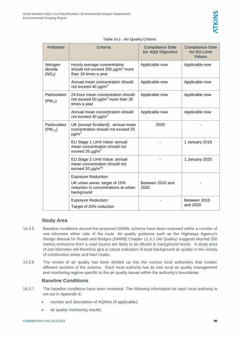
Great Western Main Line Electrification: Environmental Impact Assessment
Environmental Scoping Report
5106599-ENV-ATK-SCO-002 90
Table 14.1 - Air Quality Criteria
Pollutant Criteria Compliance Date for AQS Objective
Compliance Date for EU Limit
Values
Nitrogen dioxide (NO2)
Hourly average concentration should not exceed 200 µg/m
3 more
than 18 times a year
Applicable now Applicable now
Annual mean concentration should not exceed 40 µg/m
3
Applicable now Applicable now
Particulates
(PM10)
24-hour mean concentration should not exceed 50 µg/m
3 more than 35
times a year
Applicable now Applicable now
Annual mean concentration should not exceed 40 µg/m
3
Applicable now Applicable now
Particulates (PM2.5)
UK (except Scotland): annual mean concentration should not exceed 25 µg/m
3
2020
-
EU Stage 1 Limit Value: annual mean concentration should not exceed 25 µg/m
3
- 1 January 2015
EU Stage 2 Limit Value: annual mean concentration should not exceed 20 µg/m
3*
- 1 January 2020
Exposure Reduction:
UK urban areas: target of 15% reduction in concentrations at urban background
Between 2010 and 2020
-
Exposure Reduction:
Target of 20% reduction
- Between 2010 and 2020
Study Area
14.3.5 Baseline conditions around the proposed GWML scheme have been reviewed within a corridor of
one kilometre either side of the route. Air quality guidance such as the Highways Agency‘s
Design Manual for Roads and Bridges (DMRB) Chapter 11.3.1 (Air Quality) suggests beyond 200
metres emissions from a road source are likely to be diluted to background levels. A study area
of one kilometre will therefore give a robust indication of local background air quality in the vicinity
of construction areas and haul routes.
14.3.6 The review of air quality has been divided up into the various local authorities that contain
different sections of the scheme. Each local authority has its own local air quality management
and monitoring regime specific to the air quality issues within the authority‘s boundaries.
Baseline Conditions
14.3.7 The baseline conditions have been reviewed. The following information for each local authority is
set out in Appendix E:
number and description of AQMAs (if applicable);
air quality monitoring results;
Great Western Main Line Electrification: Environmental Impact Assessment
Environmental Scoping Report
5106599-ENV-ATK-SCO-002 91
mapped background concentrations;
identification of sensitive receptors for human health; and
number and description of sensitive ecological sites.
14.3.8 A summary of baseline conditions for each authority is set out in Table 14.2 below.
Local Air Quality Management
14.3.9 A local authority is required to periodically review and assess the present and likely future air
quality against the AQS objectives. Where a local authority anticipates non-compliance with one
or more AQS objective, it must designate an AQMA and implement an Action Plan to reduce
pollution levels. Local authorities in England are required to report findings to DEFRA (or GLA if
a London local authority) according to a set timetable.xxiii
14.3.10 Information regarding the location, number and description of the local authorities‘ AQMAs can be
found in the annual Review and Assessment reports and/or on DEFRA‘s air quality archive
websitexxiv
.
Air Quality Monitoring
14.3.11 To determine whether or not AQS objectives are being met a local authority will undertake routine
monitoring of ambient pollutant concentrations. Measurements of pollutant concentrations can be
made by deploying analytical instruments that measure continuously and record average
concentrations over specified time intervals. Simpler sampling devices, such as diffusion tubes,
absorb pollutants over a longer time period and are subsequently analysed at a laboratory to
given an average concentration for the sampling period.
14.3.12 Data from monitoring surveys can be collected from a number of sources:
the local authorities‘ websites and/or review and assessment reports;
DEFRA‘s air quality archivexxv
(if the monitoring is included within the national AURN
network); or
Kings College London Airxxvi
(if monitoring is included within the LAQN network)
Mapped Baseline Concentrations
14.3.13 Estimates of mapped background concentrations in the UK are available on DEFRA‘s websitexxvii
.
The background estimates have been produced for one kilometre grid squares throughout the UK
for all years between 2008 and 2020. Average background concentrations relating to the route
corridor within each local authority area have been extracted and are presented for each local
authority.
Sensitive Ecological Receptors
14.3.14 The EU has set a Limit Value for annual mean concentrations of oxides of nitrogen (NOx) to
protect sensitive vegetation. This is included in the Air Quality Limit Value Regulations (SI
2001/2315). The Limit Value for annual mean NOx for the protection of vegetation is 30 μg/m3.
14.3.15 UK Statutory Nature Conservation Agencies‘ (in England, Natural England) policy is to apply the
30 μg/m3 criterion on a precautionary basis, as a benchmark, in all internationally designated
conservation sites (including Special Protection Areas and Special Areas of Conservation) and in
Sites of Special Scientific Interest.
14.3.16 Mapping provided by Network Rail on the SDI mapping portal has been used to identify sensitive
ecological sites within one kilometre of the route alignment within each local authority area.
Information from Natural England‘s ―nature on the map‖ websitexxviii
has been used together with
information from the UK Air Pollution Systemxxix
to discern the sensitivity of sites to changes in
NOx emissions.
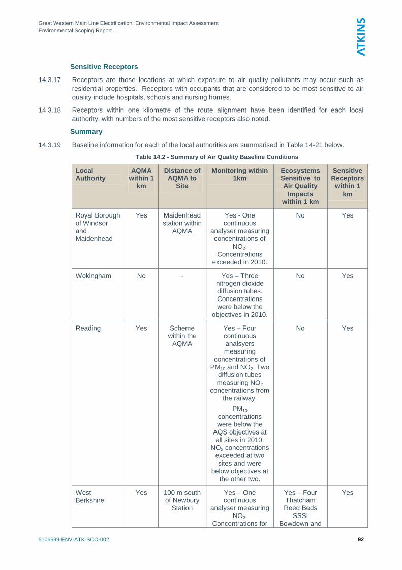
Great Western Main Line Electrification: Environmental Impact Assessment
Environmental Scoping Report
5106599-ENV-ATK-SCO-002 92
Sensitive Receptors
14.3.17 Receptors are those locations at which exposure to air quality pollutants may occur such as
residential properties. Receptors with occupants that are considered to be most sensitive to air
quality include hospitals, schools and nursing homes.
14.3.18 Receptors within one kilometre of the route alignment have been identified for each local
authority, with numbers of the most sensitive receptors also noted.
Summary
14.3.19 Baseline information for each of the local authorities are summarised in Table 14-21 below.
Table 14.2 - Summary of Air Quality Baseline Conditions
Local Authority
AQMA within 1
km
Distance of AQMA to
Site
Monitoring within 1km
Ecosystems Sensitive to Air Quality
Impacts within 1 km
Sensitive Receptors
within 1 km
Royal Borough of Windsor and Maidenhead
Yes Maidenhead station within
AQMA
Yes - One continuous
analyser measuring concentrations of
NO2. Concentrations
exceeded in 2010.
No Yes
Wokingham No - Yes – Three nitrogen dioxide diffusion tubes. Concentrations were below the
objectives in 2010.
No Yes
Reading Yes Scheme within the
AQMA
Yes – Four continuous analsyers measuring
concentrations of PM10 and NO2. Two
diffusion tubes measuring NO2
concentrations from the railway.
PM10
concentrations were below the
AQS objectives at all sites in 2010.
NO2 concentrations exceeded at two sites and were
below objectives at the other two.
No Yes
West Berkshire
Yes 100 m south of Newbury
Station
Yes – One continuous
analyser measuring NO2.
Concentrations for
Yes – Four Thatcham Reed Beds
SSSI Bowdown and
Yes
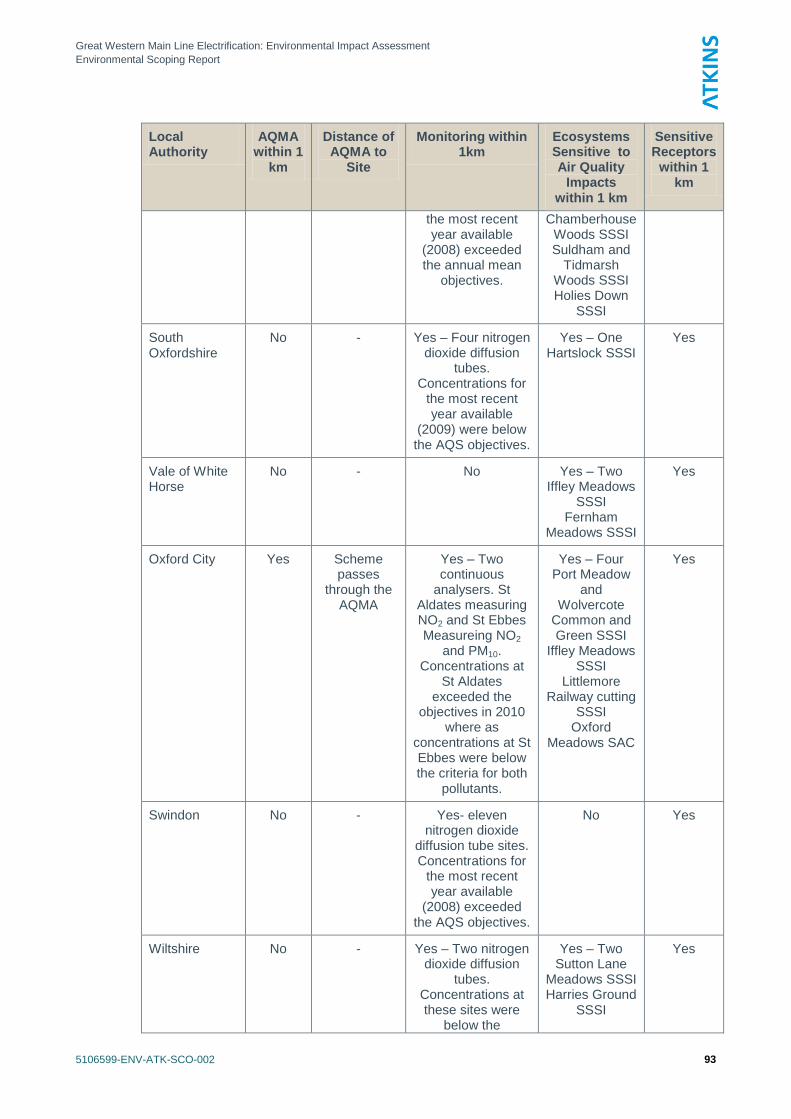
Great Western Main Line Electrification: Environmental Impact Assessment
Environmental Scoping Report
5106599-ENV-ATK-SCO-002 93
Local Authority
AQMA within 1
km
Distance of AQMA to
Site
Monitoring within 1km
Ecosystems Sensitive to Air Quality
Impacts within 1 km
Sensitive Receptors
within 1 km
the most recent year available
(2008) exceeded the annual mean
objectives.
Chamberhouse Woods SSSI Suldham and
Tidmarsh Woods SSSI Holies Down
SSSI
South Oxfordshire
No - Yes – Four nitrogen dioxide diffusion
tubes. Concentrations for
the most recent year available
(2009) were below the AQS objectives.
Yes – One Hartslock SSSI
Yes
Vale of White Horse
No - No Yes – Two Iffley Meadows
SSSI Fernham
Meadows SSSI
Yes
Oxford City Yes Scheme passes
through the AQMA
Yes – Two continuous
analysers. St Aldates measuring NO2 and St Ebbes Measureing NO2
and PM10. Concentrations at
St Aldates exceeded the
objectives in 2010 where as
concentrations at St Ebbes were below the criteria for both
pollutants.
Yes – Four Port Meadow
and Wolvercote
Common and Green SSSI
Iffley Meadows SSSI
Littlemore Railway cutting
SSSI Oxford
Meadows SAC
Yes
Swindon No - Yes- eleven nitrogen dioxide
diffusion tube sites. Concentrations for
the most recent year available
(2008) exceeded the AQS objectives.
No Yes
Wiltshire No - Yes – Two nitrogen dioxide diffusion
tubes. Concentrations at these sites were
below the
Yes – Two Sutton Lane
Meadows SSSI Harries Ground
SSSI
Yes
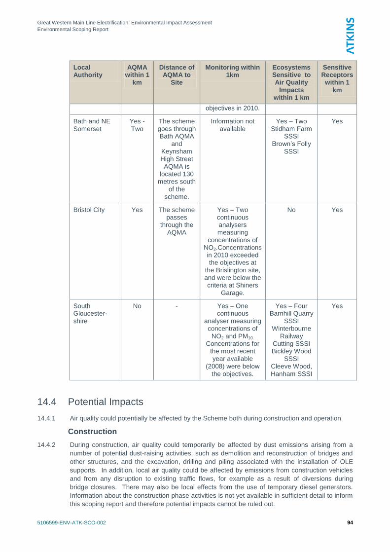
Great Western Main Line Electrification: Environmental Impact Assessment
Environmental Scoping Report
5106599-ENV-ATK-SCO-002 94
Local Authority
AQMA within 1
km
Distance of AQMA to
Site
Monitoring within 1km
Ecosystems Sensitive to Air Quality
Impacts within 1 km
Sensitive Receptors
within 1 km
objectives in 2010.
Bath and NE Somerset
Yes - Two
The scheme goes through Bath AQMA
and Keynsham High Street AQMA is
located 130 metres south
of the scheme.
Information not available
Yes – Two Stidham Farm
SSSI Brown‘s Folly
SSSI
Yes
Bristol City Yes The scheme passes
through the AQMA
Yes – Two continuous analysers measuring
concentrations of NO2.Concentrations in 2010 exceeded the objectives at
the Brislington site, and were below the criteria at Shiners
Garage.
No Yes
South Gloucester-shire
No - Yes – One continuous
analyser measuring concentrations of
NO2 and PM10.
Concentrations for the most recent year available
(2008) were below the objectives.
Yes – Four Barnhill Quarry
SSSI Winterbourne
Railway Cutting SSSI Bickley Wood
SSSI Cleeve Wood, Hanham SSSI
Yes
14.4 Potential Impacts
14.4.1 Air quality could potentially be affected by the Scheme both during construction and operation.
Construction
14.4.2 During construction, air quality could temporarily be affected by dust emissions arising from a
number of potential dust-raising activities, such as demolition and reconstruction of bridges and
other structures, and the excavation, drilling and piling associated with the installation of OLE
supports. In addition, local air quality could be affected by emissions from construction vehicles
and from any disruption to existing traffic flows, for example as a result of diversions during
bridge closures. There may also be local effects from the use of temporary diesel generators.
Information about the construction phase activities is not yet available in sufficient detail to inform
this scoping report and therefore potential impacts cannot be ruled out.
Great Western Main Line Electrification: Environmental Impact Assessment
Environmental Scoping Report
5106599-ENV-ATK-SCO-002 95
14.4.3 In the absence of effective mitigation, sensitive receptors (including residential properties and
ecological sites) within 100 metres of any dust-raising activities could be affected by nuisance
dustxxx
. In addition, properties within 200 metres of any roads with any significant changes to
traffic flows could be affected by changes in vehicle emissions.
Operation
14.4.4 Nitrogen dioxide concentrations can be elevated alongside rail lines with a large number of diesel
locomotive movement; the emissions can be equivalent to those from a busy road. Once the
electrification of the network is complete, receptors within 30 metres of the railway line could be
affected by an improvement in local air quality as a result of reduced pollutant emissions from
railway locomotives (DEFRA TG(09)).
14.5 Proposed Scope of Assessment / Methodology
Baseline
14.5.1 The baseline section of the EIA will use the information collated during this scoping exercise and
will update it where further data are available. The same sources of data that were used to
inform this scoping report will again be used for the EIA. Monitoring data will be compared with
the air quality criteria described in the baseline section of this scoping report.
Construction
14.5.2 A qualitative assessment of the potential impacts of construction dust will be undertaken, with
reference to best practice guidance produced by the GLA and the London Boroughsxxxi
. Although
the guidance is for London it is useful in the context of schemes elsewhere when considering
assessment, planning and management of control measures. The assessment would identify
residential and other sensitive properties and ecological sites that could be at risk of being
affected i.e. within 100 metres of construction activities. It would consider the types of activities
to be carried out and their duration, with reference to distance to receptors and direction, in the
context of prevailing meteorological conditions.
14.5.3 Additional construction traffic and any disruption to existing traffic which may cause an effect on
air quality and greenhouse gas emissions would be assessed quantitatively using the screening
method outlined in Volume 11, Section 3, Part 1 of the Highways Agency‘s DMRBxxxii
, and the
associated DMRB Screening Tool (Annex C & D of DMRB 11:3:1, available at
http://www.dft.gov.uk/ha/standards/tech_info/index.htm).
14.5.4 The significance of the findings of the assessment will be considered with reference to GLA‘s
Best Practice Guidance for construction impacts, and to EPUK‘s guidancexxxiii
for development
control.
Operation
14.5.5 It is difficult to accurately assess the expected change in air pollutant concentrations through a
modelling approach, therefore, the number of properties within 30 m of the edge of the railway
tracksxxxiv
that have been electrified will be counted, as these can be assumed to have an
improvement in air quality.
14.5.6 Should suitable emission factors be available for the diesel trains currently used on the railway
line, calculations of emissions could be made using ADMS roads, following guidance by
DfTxxxvxxxvi
.
Great Western Main Line Electrification: Environmental Impact Assessment
Environmental Scoping Report
5106599-ENV-ATK-SCO-002 96
14.6 Potential Mitigation
Construction
14.6.1 During the construction phase, standard mitigation measures for the control of construction phase
should be put in place. It is not possible at this stage to determine whether additional measures
would be necessary; this will be considered further in the EIA. Where appropriate, mitigation
measures would be considered with reference to GLA guidance, for the appropriate level of risk
presented by the site.
Operation
14.6.2 Mitigation measures are not considered necessary for air quality once the Scheme is operational,
as the Scheme itself is a major intervention that will provide improvements in local air quality in
the vicinity.
Great Western Main Line Electrification: Environmental Impact Assessment
Environmental Scoping Report
5106599-ENV-ATK-SCO-002 97
15. Noise and Vibration
15.1 Introduction
15.1.1 This chapter presents the proposed approach to the noise and vibration assessment of the
Scheme. It includes a discussion of baseline conditions and sensitivity, preliminary identification
of potential noise and vibration effects, and the proposed methodology for assessment of the
construction and operational phases of the Project. Mitigation measures are also discussed.
15.1.2 Cumulative impacts and potential combinations of various effects arising from other planned
developments are not discussed. However, these will be identified and considered in the
Environmental Statement.
15.2 Consultation
15.2.1 No consultation has been undertaken at this stage.
15.3 Overview of Baseline Conditions and Study Area
15.3.1 At this stage no measurements of baseline conditions have been made. Experience of similar rail
bridge alterations and other work in connection with the Crossrail project has shown that the
existing ambient noise level is generally dominated by the noise from trains. What this means is
that for much of the time noise sensitive properties are subject to a certain level of noise of an
urban or a rural character depending upon their location. During the passage of a train, however,
the level of noise is increased.
15.3.2 The level of noise from a train depends on a number of factors, including distance from the
railway, the speed of the train and topography.
15.3.3 Measurements taken in connection with the Crossrail project are indicative of the noise climate in
areas next to railway lines. For example, line-side measurements taken in Acton at a distance of
some 10 metres from the nearest track of a four-track main line gave maximum noise levels
(taken using the fast weighting) in the range 86 to 93 dB LAmaxF, giving five minute equivalent
continuous noise levels in the range of 70 to 74 dB LAeq, 5mins, the background noise levels ranging
from 48 to 60 dB LA90, 5mins. At this location, the background levels during the night were higher
than those measured during the day, the reason for this being freight locomotives near the
measurement site. Although these locomotives were stationary, their diesel engines were idling.
15.3.4 Daytime measurements taken in Slough for Crossrail in an urban environment, but in situations
where freight locomotives were not idling showed similar results. For example, at a distance of
some 32 metres, eight five minute measurements taken at various times gave maxima ranging
from 76 to 89 dB LAmax when trains passed during the measurement periods (during the one
measurement period when no trains passed the maximum was 55 dB LAmax). The corresponding
range of equivalent continuous noise levels was 55 to 68 dB LAeq , with the value when no trains
passed being 46 dB LAeq. For all nine measurement periods, the background noise level ranged
from 42 to 45 dB LA90.
Great Western Main Line Electrification: Environmental Impact Assessment
Environmental Scoping Report
5106599-ENV-ATK-SCO-002 98
15.4 Potential Impacts
Construction Noise and Vibration
15.4.1 Construction noise is a temporary phenomenon that is exceedingly unlikely to give rise to any
permanent effect, although it can cause annoyance to residents.
15.4.2 Construction vibration is also a temporary phenomenon. While it is possible for vibration to
damage buildings it takes a very high level of vibration to do soxxxvii
.
15.4.3 BS5228, paragraph 6.1xxxviii
indicates that ―Vibrations, even of very low magnitude, can be
perceptible to people and can interfere with the satisfactory conduct of certain activities…‖.
However it goes on to state that vibration nuisance is more likely than vibration damage.
15.4.4 Inspection of the typical vibration values given in Table D.6 of BS5228 Part 2 suggests that it is
very unlikely that vibration from rotary bored piling will give rise to damage (this or a similar type
of procedure is expected for the erection of OLE supports). However, residents may become
alarmed if they think that vibration will in fact cause damage to their homes even if this is
improbable.
15.4.5 Should the construction works give rise to substantial changes in road traffic flows, for instance,
where a bridge closure is required during demolition and reconstruction, then there may be some
localised changes in the levels of road traffic noise.
15.4.6 A review has been carried out of the noise sections of the local planning policies for Bath and
North East Somerset Council, Bristol City Council, Oxford City Council, Reading Borough
Council, South Gloucestershire Council, South Oxfordshire Council, Swindon Council, Vale of the
White Horse Council, West Berkshire Council, Wiltshire Council, the Royal Borough of Windsor
and Maidenhead and Wokingham Borough Council. Although the wording of these policies
varies greatly, all seek to oppose developments that will give rise to unacceptable levels of noise.
Operational Noise and Vibration
15.4.7 Electrical equipment, such as transformers at the feeder substations, may give rise to noise. This
is caused by the heating of the circuitry twice during each cycle of the alternating current, creating
hums or buzzes. Where two or more transformers (or similar items) are located at the same site,
such as at the proposed switching stations, there may be interference between the sound waves
these emit, which may make the resultant noise more apparent. These noise effects can cause
annoyance to residents.
15.4.8 It is considered that the noise and vibration arising from operation of trains can be scoped out.
The reason for this is that modern diesel locomotives and train sets are almost exclusively
equipped with diesel-electric transmission. A diesel locomotive is thus effectively an electric
locomotive with its own power supply. In general terms, therefore, it may be expected that the
noise and vibration effects of the electric motors driving the wheels will be similar whether the
power to operate the motors is obtained from overhead line electrification equipment or from a
diesel engine and generator. In both cases it may be expected that blowers will be used to cool
the traction motors where a high output is required (e.g. at starting) and any vibration effect
arising from the traction motors and axles may be expected to be similar.
15.4.9 The difference between the diesel-electric locomotive and the ―straight‖ electric locomotive is that
the former is fitted with a diesel engine and generating equipment while the latter collects current
from the OLE line by means of a pantograph. Experience has shown that the noise from current
collection is relatively low when compared with the noise from a diesel locomotive engine. Diesel
locomotive engine noise is relatively high, especially when the locomotive is starting a train or
otherwise working hard. Accordingly it is considered that in normal traffic an electric locomotive
will be quieter than a diesel locomotive. In addition, the internal combustion engine of a diesel
locomotive ―ticks over‖ when stationary whereas an electric locomotive has no such noise.
Great Western Main Line Electrification: Environmental Impact Assessment
Environmental Scoping Report
5106599-ENV-ATK-SCO-002 99
15.4.10 For a given power output, an electric locomotive may be expected to be lighter (a decrease of
11% has been quoted by the DfT) than a diesel electric locomotive of the same power (although
a certain amount of weight is required to give the adhesion required to haul a train). It may thus
be expected that vibration arising from track features such as the gaps between rails, and the
frogs at points and crossing, will be less in the case of electric traction than in the case of diesel
traction.
15.4.11 It is understood that proposals have been put forward for the use of trains capable of using
electric power when running under the overhead power lines but using diesel propulsion when
the overhead lines are not available. It is improbable that mechanical or hydraulic transmission
would be used in this case as the electric motors would already be provided so that diesel-electric
transmission is the obvious solution. The comparison between diesel-electric locomotive and
―straight‖ electric locomotive expressed above may thus to apply in the same way to multiple unit
trains where the power units are spread throughout the train.
15.4.12 It would appear improbable that the diesel engines would be left idling when the train is travelling
―under the wires‖ as this would be a waste of fuel.
15.4.13 Where the clearance under structures is increased by substituting for the original track a different
type (e.g. by using track slabs for normally ballasted track) then it is possible that the vibration
levels (and the internal noise levels thereby induced) in properties nearby may be affected.
However, studies previously carried out have indicated that the levels of vibration are not
generally higher when slab track is substituted, although owing to the variation in type and
condition of the trains activating the track this is not easy to prove conclusively.
15.5 Proposed Scope of Assessment / Methodology
Construction Noise and Vibration
15.5.1 It is proposed to address the construction noise and vibration aspects by means of the methods
laid down in British Standard BS5228:2009 ―Code of practice for noise and vibration control on
construction and open sites‖ (Part 1 Noise and Part 2 Vibration). This can be done either by
spreadsheet based calculations or using proprietary software that enacts the methods laid down
in BS5228. Background noise assessments will be undertaken at construction sites where major
works are proposed.
Operational Noise and Vibration
15.5.2 While it is considered that, in general, electrification will almost certainly improve the noise and
vibration climate, it may be advisable to take baseline noise and vibration measurements where it
is considered that residents might aver that the situation has deteriorated. It would be almost
impossible to recreate the pre-electrification noise and vibration climate once electrification has
been carried out, so that the acquisition of baseline data will be a prudent precaution.
15.6 Potential Mitigation
General
15.6.1 Noise and vibration can be mitigated at source, along the transmission path and at the receiver.
In general, the most effective mitigation is that carried out at source since it benefits all receivers.
It is therefore advisable to select those methods and items of equipment which make the least
noise and vibration.
15.6.2 Noise can be attenuated by the use of noise barriers or enclosures. For the reasons stated
above, those which are close to the source are most effective. Since the effectiveness of a
barrier is related to the path difference, that is, the difference between the direct ―source-receiver‖
path and the indirect ―source-barrier edge-receiver‖ path, geometrical considerations show that,
Great Western Main Line Electrification: Environmental Impact Assessment
Environmental Scoping Report
5106599-ENV-ATK-SCO-002 100
for a given height of barrier, the closer it is placed to the source or to the receiver, the better.
Thus, if a barrier close to the source is not possible, a barrier close to the receiver should be
considered.
Control of Construction Noise and Vibration
15.6.3 Construction noise may be attenuated by careful selection of equipment, the use of noise barriers
placed close to the machines and, where feasible, noise enclosures to surround noisy operations.
15.6.4 The recommendations made in Appendix B of British Standard BS5228 should be observed. For
example, hydraulic or screw methods of piling should be preferred to percussive piling methods,
where possible noise sources should be positioned as far as possible from sensitive noise
receivers.
15.6.5 Construction site staff should be made aware, by toolbox talks and similar methods, of the need
to minimise noise on site.
15.6.6 Where possible, machinery giving rise to vibration should be isolated at source using resilient
mountings. However, where piling is being undertaken then this is unlikely to be feasible.
Control of Operational Noise and Vibration
15.6.7 As stated above, it is considered that electrification will lead to an overall reduction in operation
noise and vibration. However, if track lowering in tunnels is to be effected by installing track
panels then it would be necessary to ensure that these will have sufficient resilience not to
increase the noise and vibration arising at adjoining residential properties.
15.6.8 Transformers and other electrical equipment should be installed with due regard to possible noise
effects arising from electrical noise.
Great Western Main Line Electrification: Environmental Impact Assessment
Environmental Scoping Report
5106599-ENV-ATK-SCO-002 101
16. Electromagnetic Effects
16.1 Introduction
16.1.1 This chapter presents the proposed approach to the assessment of electromagnetic effects
resulting from the electrification of the railway on third parties. It includes a brief discussion of
background electromagnetic conditions, preliminary identification of potential effects on
neighbours, and the proposed methodology for assessment for the operational phase of the
Project. The approach to mitigation measures is also discussed.
16.1.2 The scope excludes the national grid supply points and only addresses the impact on third
parties. The electromagnetic compatibility of railway sub-systems is not subject to this EIA.
Furthermore, the effect of third party emissions on the railway is also excluded.
16.1.3 The construction phase of the project is not addressed as there would be no electromagnetic
impact until the electrification system is energised.
16.1.4 Cumulative impacts and potential combinations of various effects due to other planned
developments are not discussed; however these will be identified and considered in the ES if any
relevant developments are identified.
16.2 Consultation
16.2.1 No consultation has been undertaken in relation to EMC. However due to the potential sensitivity
of some sites there may be a need for consultation, particularly with the MoD at Corsham.
16.3 Overview of Baseline Conditions and Study Area
16.3.1 The modern world is a complex electromagnetic environment. Electromagnetic Compatibility
(EMC) is about ensuring that electrical and electronic equipment works as intended and does not
disturb other equipment which might reasonably be expected to operate in the same
environment. It is the discipline of being ―electrical good neighbours‖.
16.3.2 Electrification of the railway introduces further complexity to the electromagnetic environment with
the potential to disturb sensitive and safety critical equipment across a wide range of frequencies.
16.3.3 In addition to electrical equipment, strong electromagnetic fields (EMF) can have an impact on
human health. The effects of EMF are highly localised and are most likely to affect people in
buildings that are immediately above or adjacent to the OLE. Electricity substations and
transformers are also sources of strong electromagnetic fields.
16.4 Potential Impacts
16.4.1 Electrification of the railway has the potential to affect the operation of equipment adjacent to the
railway. Hospitals, universities and military establishments have sensitive equipment which can
be affected at power (50Hz) and high frequencies. Power supplies can be disturbed under fault
conditions.
16.4.2 The impacts from EMF relate to health. The railway is required to comply with relevant standards
which generally will not be a problem.
Great Western Main Line Electrification: Environmental Impact Assessment
Environmental Scoping Report
5106599-ENV-ATK-SCO-002 102
16.5 Proposed Scope of Assessment / Methodology
16.5.1 A desk based survey of the route will be undertaken to identify any potentially sensitive sites
alongside the railway, generally within a 20m corridor. These sites will include hospitals,
universities, military establishments, emergency services radio and commercial VHF/radio
transmitters. In addition, any buildings within 10m of the railway in which levels of EMF may be
above those prescribed in relevant standards will be identified.
16.5.2 In particularly sensitive areas, site measurements may be recommended at key locations to
ascertain the characterisation of the electromagnetic environment before and after the project to
demonstrate that the project has not worsened the situation.
16.5.3 The project will need to ascertain separation distances between the railway and the lower levels
of the MoD installation at Corsham to make a judgement on any effects the railway might have.
Since it is a sensitive site it will probably be difficult to get clarity on what systems might be at
ground or basement level so cooperation with MoD will be needed to close out any EMC risks.
16.6 Potential Mitigation
16.6.1 Standard designs of railway electrification should be adopted to minimise the emissions from the
electrified railway.
16.6.2 The earthing and earth bonding of the railway should be compliant with relevant standards.
16.6.3 To comply with the EMC Regulations 2006, the project should comply with the processes detailed
in Network Rail standard NR/L2/SIG/30041; EMC Assurance Process for Network Rail.
16.6.4 Increasing the separation between threat and victim systems is likely to mitigate the effect of any
interference. However in some cases it may be necessary to replace sensitive victim equipment
with less sensitive equipment meeting modern EMC standards.
16.6.5 The overhead electrical power system and the associated supply provides effective EMC
mitigation through the EMFs caused by the electrical current flow in the +25kV OLE contact
system being counteracted by the electrical current flow in the -25kV autotransformer feeders. In
addition, Return Screen Conductors (RSC) with direct connections (cross bonding) to the return
current rails minimises the potential of induced voltages and limits the rise of earth potentials
during normal service and faulted conditions.
16.6.6 This mitigation, together with the application of Network Rail‘s earthing and bonding standards
ensure that limits within BS EN 50122-1 are adhered to, and thereby reducing the impact of EMC
to railway sensitive infrastructure and third party sensitive infrastructure beyond the railway
boundary.
Great Western Main Line Electrification: Environmental Impact Assessment
Environmental Scoping Report
5106599-ENV-ATK-SCO-002 103
17. Cumulative Effects
17.1 Introduction
17.1.1 The assessment of Cumulative Effects would cover two aspects:
Cumulative Effects within the Scheme
Cumulative Effects with Other Proposals.
17.2 Cumulative Effects within the Scheme
17.2.1 The ES would report on the overall impact of the Scheme, taking into account all of the impacts
identified in each of the topic technical assessments.
17.2.2 This will summarise the interrelationship between the different specialist topics and the potential
for synergistic effects where several low or moderate impacts could combine to cause a
significant impact. This might include, for example, impacts associated with ecology, landscape
and noise in a particular location. Information sharing between the technical assessment teams
will facilitate understanding of the wider impacts of the Scheme and the development of mitigation
that addresses multiple issues.
17.3 Cumulative Effects with Other Proposals
17.3.1 The ES will report on the assessment of significant cumulative environmental impacts that arise
from the construction and operational phases. These are where environmental impacts arising
from different, unrelated, developments may, in combination with this Scheme, result in
significant impacts over a wider area. A typical example might be road traffic impacts from two
schemes which, when considered in isolation, would have a minimal impact on the local road
network, but when considered together could result in significant impacts.
17.3.2 Given the scale and nature of the Scheme, the geographic scope of the cumulative impacts
assessment has been set at a nominal radius of 2 km of the Scheme. The assessment will use
information provided by local councils, utility companies and developers. The proposed
developments will comprise those that, at the time of writing, are:
already permitted, but not yet built;
programmed for completion during or after the Scheme construction programme.
17.3.3 The identification of environmental impacts from each of these proposals will draw on publicly
available information. The assessment of any cumulative impacts will be qualitative in nature
given the differences in the detail and content of this available information, but will draw on the
professional judgement and expert opinion of the technical specialists within the EIA team.
Great Western Main Line Electrification: Environmental Impact Assessment
Environmental Scoping Report
5106599-ENV-ATK-SCO-002 104
18. Draft Content of the Environmental
Statement
18.1 Environmental Statement Structure
18.1.1 The GWML Electrification ES is anticipated to comprise:
Volume 1: Main Report – providing a detailed description of the Scheme and its construction,
a description of the main alternatives considered and the reasons why these were rejected, a
detailed description of all the technical disciplines assessments, including proposed
mitigation and residual impact.
Volume 2: Detailed Topic data and supporting calculations;
Volume 3: Plans and Figures;
A Non-Technical Summary (NTS) of the main report, which can also be made available as a
separate document.
18.1.2 The ES will also be supported by a Flood Risk Assessment
18.1.3 As this Scheme would pass through 12 local planning authorities, it is intended to structure
Volumes 1, 2 and 3 so that common elements of the Scheme and EIA process description are
provided in the first part of the volume, with topic assessments that are relevant to the
geographical extent of each planning authority provided in the second part of each volume. This
will then avoid the need to provide a large ES covering the whole Scheme to each of the planning
authorities. The content of Volume 4, the NTS, will be structured so that the environmental
effects for each of the planning authorities is distinct.
18.2 Environmental Statement Content
18.2.1 The proposed content of the Environmental Impact Assessment (EIA) has been developed
following a review of previous assessments undertaken for similar projects, a review of the
relevant planning policy and Atkins‘ previous experience of similar developments.
18.2.2 The EIA will assess the potential significant impacts associated with the proposal. The individual
EIA subjects/topics proposed include the following:
Background, Introduction and Context
The Site and its Setting
Description of Development
Alternatives
Planning Policy Context
Social Impact Assessment
Landscape and Visual Assessment
Historic Environment
Water Resources and Hydrogeology
Land Contamination
Ecology and Nature Conservation
Great Western Main Line Electrification: Environmental Impact Assessment
Environmental Scoping Report
5106599-ENV-ATK-SCO-002 105
Traffic Effects
Air Quality
Noise and Vibration
Cumulative Impacts
18.2.3 Together, these subjects will form the Environmental Statement document.
18.2.4 Each topic assessment will consider the impacts during the construction and operation phase of
the Scheme. Each topic will be discussed under a separate chapter within which the following
matters will be addressed where relevant:
Introduction
Planning Context
Assessment Methodology
Baseline Conditions
Incorporated Enhancement and Mitigation
Identification and Evaluation of Key Impacts
Residual Impacts
Summary
18.2.5 It is proposed that the following topics are ‗scoped out‘ of the assessment:
Microclimate
Electromagnetic Effects
18.2.6 For topics or aspects of topics where assessment is not proposed, information will be provided to
explain why assessment is not considered necessary.
Great Western Main Line Electrification: Environmental Impact Assessment
Environmental Scoping Report
5106599-ENV-ATK-SCO-002 106
Endnotes
i Exact number of listed structures will be confirmed during development of ES ii Generally only the tunnel portals are listed
iii http://www.bgs.ac.uk/opengeoscience/?Accordion1=1#maps
iv Department of the Environment, 1995: Industry Profile – Railway Land
v www.environment-agency.gov.uk accessed 5
th to 8
th September 2011
vi http://hazards.on-trac.co.uk accessed 5
th to 8
th September 2011
vii http://maps.google.co.uk accessed 5
th to 8
th September 2011
viii www.oldmaps.co.uk accessed on 7
th September 2011
ix Department for Communities and Local Government, 2006: Environmental Impact Assessment: A Guide to
Good Practice and Procedure, A consultation paper x Department of Food and Rural Affairs, 2006: Circular 01/2006: Environmental Protection Act, 1990,
Contaminated Land xi Environmental Protection Act 1990: Part 2A Contaminated Land
xii Office of the Deputy Prime Minister, 2004: Planning Policy Statement 23: Planning and Pollution Control:
Annex 2. Development on Land Affected by Contamination xiii
Department of Food and Rural Affairs & Environment Agency, 2004: Model Procedures for the Management of Land Contamination, Contaminated Land Report 11 xiv
National House-Building Council & Environment Agency, 2008: Guidance on the Safe Development of Housing on Land Affected by Contamination (R&D66) xv
Control of Substances Hazardous to Health Regulations 2002 (as amended), SI 2002/2677 xvi
Environment Agency, 2010: Pollution Prevention Guidelines 2: Above Ground Oil Storage Tanks xvii
Environment Agency 2010: xvii
BS7385 Evaluation and measurement for vibration in buildings — Part 2: Guide to damage levels from groundborne vibration xvii
BS5228 Code of practice for noise and vibration control on construction and open sites – Part 2: Vibration Pollution Prevention Guidelines 6: Working at Construction and Demolition Sites xviii
The Water Environment Sub-Objectives, Tag Unit 3.3.6, June 2003, Department for Transport, Transport Analysis Guide (TAG) xix
The Water Environment Sub-Objectives, Tag Unit 3.3.11, June 2003, Department for Transport, Transport Analysis Guide (TAG) xx
Communities and Local Government, Planning Policy Statement 25: Development and Flood Risk – Practice Guide (Dec 2009) xxi
Construction Industry Research and Information Association (CIRIA), January 2004, CIRIA C624: Development and Flood Risk xxii
The Water Resources Act 1991 (Amendment) (England and Wales) Regulations 2009: Statutory instruments 3104 2009 xxiii
DEFRA Local Air Quality Management Policy Guidance (PG09), February 2009 (http://www.defra.gov.uk/environment/quality/air/air-quality/laqm/guidance/policy/) xxiv
http://aqma.defra.gov.uk/ xxv
http://uk-air.defra.gov.uk/ xxvi
http://www.londonair.org.uk/LondonAir/Default.aspx xxvii
http://laqm.defra.gov.uk/review-and-assessment/tools/background-maps.html xxviii
http://www.natureonthemap.naturalengland.org.uk/ xxix
http://www.apis.ac.uk/ xxx
Office of the Deputy Prime Minister (ODPM), (2005), Minerals Policy Statement 2 (MPS2), Controlling and Mitigating the Environmental Effects of Minerals Extraction in England, Annex 1: Dust, ODPM, London xxxi
Greater London Authority (GLA), (2006); The Control of Dust and Emissions from Construction and Demolition: Best Practice Guidance, GLA, London. xxxii
Highways Agency‘s Design Manual for Roads and Bridges (DMRB), volume 11, Section 3, Part 1, May 2007 xxxiii
Development Control: Planning for Air Quality (2010 Update) EPUK, April 2010 xxxiv
Local Air Quality Management Technical Guidance LAQM.TG(09), Defra, February 2009 xxxv
www.dft.gov.uk/webtag/documents/expert/unit3.3php

Great Western Main Line Electrification: Environmental Impact Assessment
Environmental Scoping Report
5106599-ENV-ATK-SCO-002 107
xxxvii BS7385 Evaluation and measurement for vibration in buildings — Part 2: Guide to damage levels from
groundborne vibration xxxviii
BS5228 Code of practice for noise and vibration control on construction and open sites – Part 2: Vibration


Euston Tower 286 Euston Road London NW1 3AT Phone: 020 7121 2363 Fax: 020 7121 2111 www.atkinsglobal.com