Embed Size (px)
Citation preview
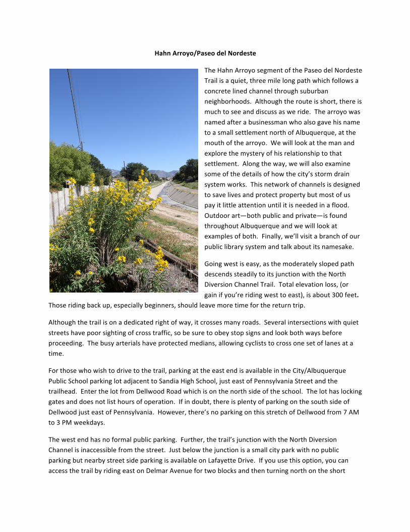
HahnArroyo/PaseodelNordeste
TheHahnArroyosegmentofthePaseodelNordesteTrailisaquiet,threemilelongpathwhichfollowsaconcretelinedchannelthroughsuburbanneighborhoods.Althoughtherouteisshort,thereismuchtoseeanddiscussasweride.ThearroyowasnamedafterabusinessmanwhoalsogavehisnametoasmallsettlementnorthofAlbuquerque,atthemouthofthearroyo.Wewilllookatthemanandexplorethemysteryofhisrelationshiptothatsettlement.Alongtheway,wewillalsoexaminesomeofthedetailsofhowthecity’sstormdrainsystemworks.Thisnetworkofchannelsisdesignedtosavelivesandprotectpropertybutmostofuspayitlittleattentionuntilitisneededinaflood.Outdoorart—bothpublicandprivate—isfoundthroughoutAlbuquerqueandwewilllookatexamplesofboth.Finally,we’llvisitabranchofourpubliclibrarysystemandtalkaboutitsnamesake.
Goingwestiseasy,asthemoderatelyslopedpathdescendssteadilytoitsjunctionwiththeNorthDiversionChannelTrail.Totalelevationloss,(orgainifyou’reridingwesttoeast),isabout300feet.
Thoseridingbackup,especiallybeginners,shouldleavemoretimeforthereturntrip.
Althoughthetrailisonadedicatedrightofway,itcrossesmanyroads.Severalintersectionswithquietstreetshavepoorsightingofcrosstraffic,sobesuretoobeystopsignsandlookbothwaysbeforeproceeding.Thebusyarterialshaveprotectedmedians,allowingcycliststocrossonesetoflanesatatime.
Forthosewhowishtodrivetothetrail,parkingattheeastendisavailableintheCity/AlbuquerquePublicSchoolparkinglotadjacenttoSandiaHighSchool,justeastofPennsylvaniaStreetandthetrailhead.EnterthelotfromDellwoodRoadwhichisonthenorthsideoftheschool.Thelothaslockinggatesanddoesnotlisthoursofoperation.Ifindoubt,thereisplentyofparkingonthesouthsideofDellwoodjusteastofPennsylvania.However,there’snoparkingonthisstretchofDellwoodfrom7AMto3PMweekdays.
Thewestendhasnoformalpublicparking.Further,thetrail’sjunctionwiththeNorthDiversionChannelisinaccessiblefromthestreet.JustbelowthejunctionisasmallcityparkwithnopublicparkingbutnearbystreetsideparkingisavailableonLafayetteDrive.Ifyouusethisoption,youcanaccessthetrailbyridingeastonDelmarAvenuefortwoblocksandthenturningnorthontheshort

paveddrainagethattakesyourighttothepath.DelmarAvenueisonelongblocknorthofCandelariaRoadandLafayetteDriveisthreeblockswestofCarlisleBoulevard.
ParkingisavailablecurbsideatMontgomeryParkandalsointheparkinglotforErnaFergussonLibrary.Bothoftheselocationsareaboutmidwaybetweenthetwoendpoints.
Citybusescarrybikeracksandwithcarefulplanningtheycangetyoutothetrailandthenhome.The#13onComancheRoadandthe#7onCandelariaRoad—bothcommuterrouteswithlimitedschedules--canbringyoutobusstopsonPennsylvaniaStreetneartheeastendofthetrail.Fromeitherbusstop,youhavelessthan1/2mileridealongPennsylvania’sbikelanestothetrailhead.The#5onCarlisleBoulevardwillgetyouclosetothewestend.Formoredetailsseethecity’sbusinformationathttp://www.cabq.gov/transit/bus-routes-and-schedules.
Toreachtheeastendofthetrailbybicycle,usePennsylvaniaStreetwhichhasbikelanesandconnectswithmanybikewaystothenorth,southandeast.ToreachthewestendoftheHahnArroyo,usetheNorthDiversionChannelTrail/PaseodelNortdeste.TheHahnArroyotrailturnseastfromtheNorthDiversionChannelabout.4milesnorthofComancheRoadandabout.3milessouthofMontgomeryBoulevard.Formoredetails,seethecity’sbikewaymap:http://www.cabq.gov/bike/documents/bike-map.pdf/view.
JunctionofHahnArroyoandPennsylvaniaStreet.
ThestartofthetrailissignedonthewestsideofPennsylvaniaStreetandis0.2milesnorthofCandelariaRoadand0.2milessouthofComancheRoad.ThesignatthestartofthetrailnotesyouareenteringPaseodelNordesteTrail.ThisisanextensionofthePaseodelNordesteTrailthatincludespartoftheNorthDiversionChannel(NDC)trail.WetreattheentireNDCasaseparatetour.
HahnArroyowasbuiltinthe1970’sbytheAlbuquerqueMetropolitanArroyoFloodControlAuthority,(AMAFCA).AMAFCAisapoliticalsubdivisionoftheStateofNewMexico,createdbythestatelegislaturein1963.ItspurposeistoprovidefloodcontrolforthegreaterAlbuquerqueareabybuildingandmaintainingfloodcontrol
0.0/3.1Miles
Shade,Tables&Chairs-ParkingAreaNorthofSandiaHighSchool
LookingEast–TheTrailheadAndSandiaHighAreOnTheRight
structures.TheAuthorityisgovernedbyanelectedboard
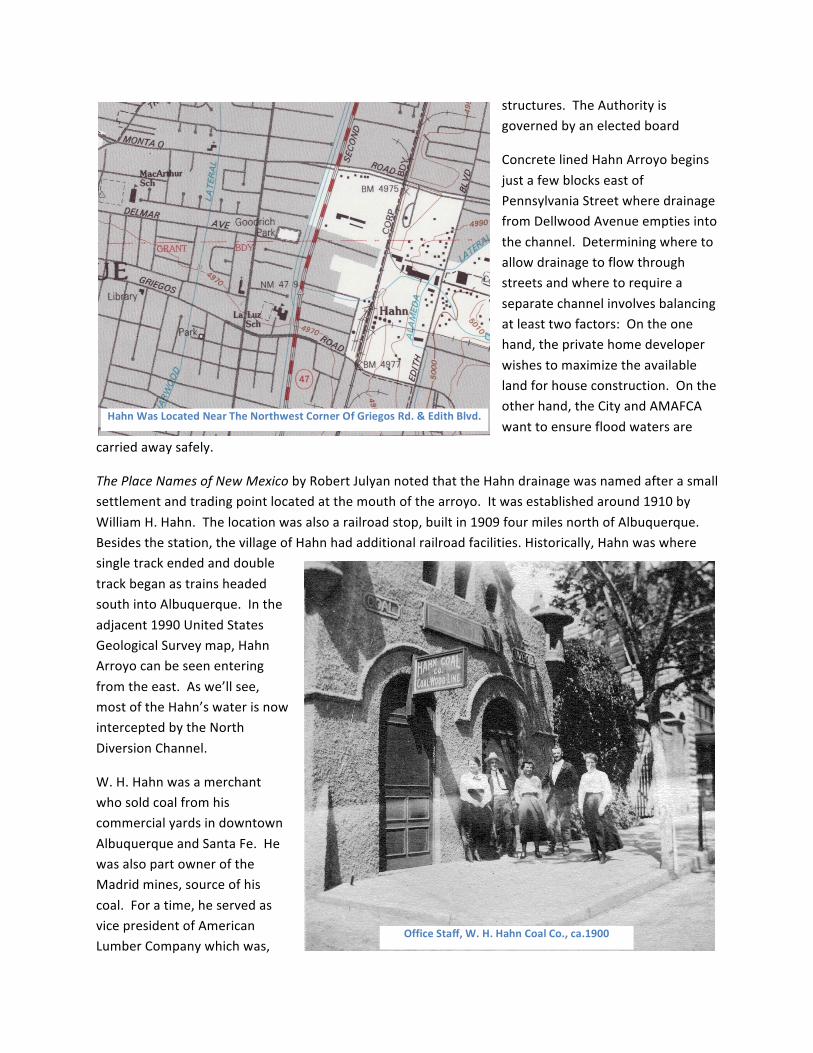
ConcretelinedHahnArroyobeginsjustafewblockseastofPennsylvaniaStreetwheredrainagefromDellwoodAvenueemptiesintothechannel.Determiningwheretoallowdrainagetoflowthroughstreetsandwheretorequireaseparatechannelinvolvesbalancingatleasttwofactors:Ontheonehand,theprivatehomedeveloperwishestomaximizetheavailablelandforhouseconstruction.Ontheotherhand,theCityandAMAFCAwanttoensurefloodwatersare
carriedawaysafely.
ThePlaceNamesofNewMexicobyRobertJulyannotedthattheHahndrainagewasnamedafterasmallsettlementandtradingpointlocatedatthemouthofthearroyo.Itwasestablishedaround1910byWilliamH.Hahn.Thelocationwasalsoarailroadstop,builtin1909fourmilesnorthofAlbuquerque.Besidesthestation,thevillageofHahnhadadditionalrailroadfacilities.Historically,HahnwaswheresingletrackendedanddoubletrackbeganastrainsheadedsouthintoAlbuquerque.Intheadjacent1990UnitedStatesGeologicalSurveymap,HahnArroyocanbeseenenteringfromtheeast.Aswe’llsee,mostoftheHahn’swaterisnowinterceptedbytheNorthDiversionChannel.
W.H.HahnwasamerchantwhosoldcoalfromhiscommercialyardsindowntownAlbuquerqueandSantaFe.HewasalsopartowneroftheMadridmines,sourceofhiscoal.Foratime,heservedasvicepresidentofAmericanLumberCompanywhichwas,
OfficeStaff,W.H.HahnCoalCo.,ca.1900
HahnWasLocatedNearTheNorthwestCornerOfGriegosRd.&EdithBlvd.

alongwiththerailroad,oneofthelargestemployersinearlyAngloAlbuquerque.ForabriefperiodheownedaCadillacdealership.Around1917,HahnmovedtoLosAngeles.Somewhatsurprisingly,weknowlittleaboutwhyhestartedthevillagethatbearshisnameandwhatkindofbusinessheranthere.Theformersettlementisnowcoveredwithindustrialdevelopment.Asistrueforallofthesetours,readersarewelcometoaddcommentsandanyonewhocanshedlightonW.H.Hahn’srelationshiptothesettlementisinvitedtoposttheinformation.
JusteastofLouisianaBoulevard.
ThestructureextendingupwardfromthefloorofthechannelisaflowgaugeinstalledbytheUnitedStatesGeologicalSurvey,(USGS),in1978.Itisnotcurrentlyinuse.Amoremodernapparatushasbeen
placedinHahnArroyojusteastofMonroeStreet,onthenorthsideofthechannel.Thenewergaugerecordswaterdepthandflowrateandiscapableoftransmittingdatabysatellite,allowingtheUSGStoobserveflowsinrealtime.Unfortunately,datafromtheHahngaugeisnotavailableontheUSGSrealtimewebsite,
WaterWatch,(http://waterwatch.usgs.gov/?m=real&w=map&r=nm).TheUSGShasinstalledaraingaugeupstreamintheHahnwatershed,allowingtheagencytobuildamodelofhowrainfallandrunoffinteract.Thisinformationcanthenbeusedtoaidinthedesignandmodificationofthisandotherarroyos.ToddKelleyoftheUSGSnotedthatrecordflowinHahnoccurredinJune,1999,whenthewaterlevelreachedfivefeetandwasclosetooverflowingitschannel.Flowrateatthattimewas6230cubicfeetpersecond.Consistentwiththeisolatednatureofourthunderstorms,Toddnotedthatthisrecordflowwasalocalizedevent,withnoothermeasuredsitesreachingrecordflow.
Besidesmeasuringwaterflow,thegaugecontainsequipmenttomeasurewaterquality.TheUnitedStatesEnvironmentalProtectionAgency,(EPA),requiresthecitytomonitorwaterflowingintotheRioGrandeandensurethatitmeetscertainpuritystandards.
0.5/2.6Miles
USGSFlowGage-JustEastOfLouisianaBlvd.
LouisianaBoulevard.
AprotectedmedianallowssafecrossingofLouisianaBoulevard.
CaliforniaStreet.
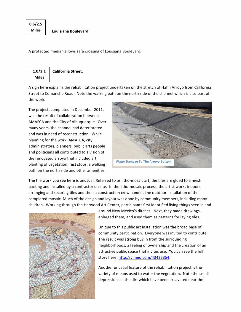
AsignhereexplainstherehabilitationprojectundertakenonthestretchofHahnArroyofromCaliforniaStreettoComancheRoad.Notethewalkingpathonthenorthsideofthechannelwhichisalsopartofthework.
Theproject,completedinDecember2011,wastheresultofcollaborationbetweenAMAFCAandtheCityofAlbuquerque.Overmanyyears,thechannelhaddeterioratedandwasinneedofreconstruction.Whileplanningforthework,AMAFCA,cityadministrators,planners,publicartspeopleandpoliticiansallcontributedtoavisionoftherenovatedarroyothatincludedart,plantingofvegetation,reststops,awalkingpathonthenorthsideandotheramenities.
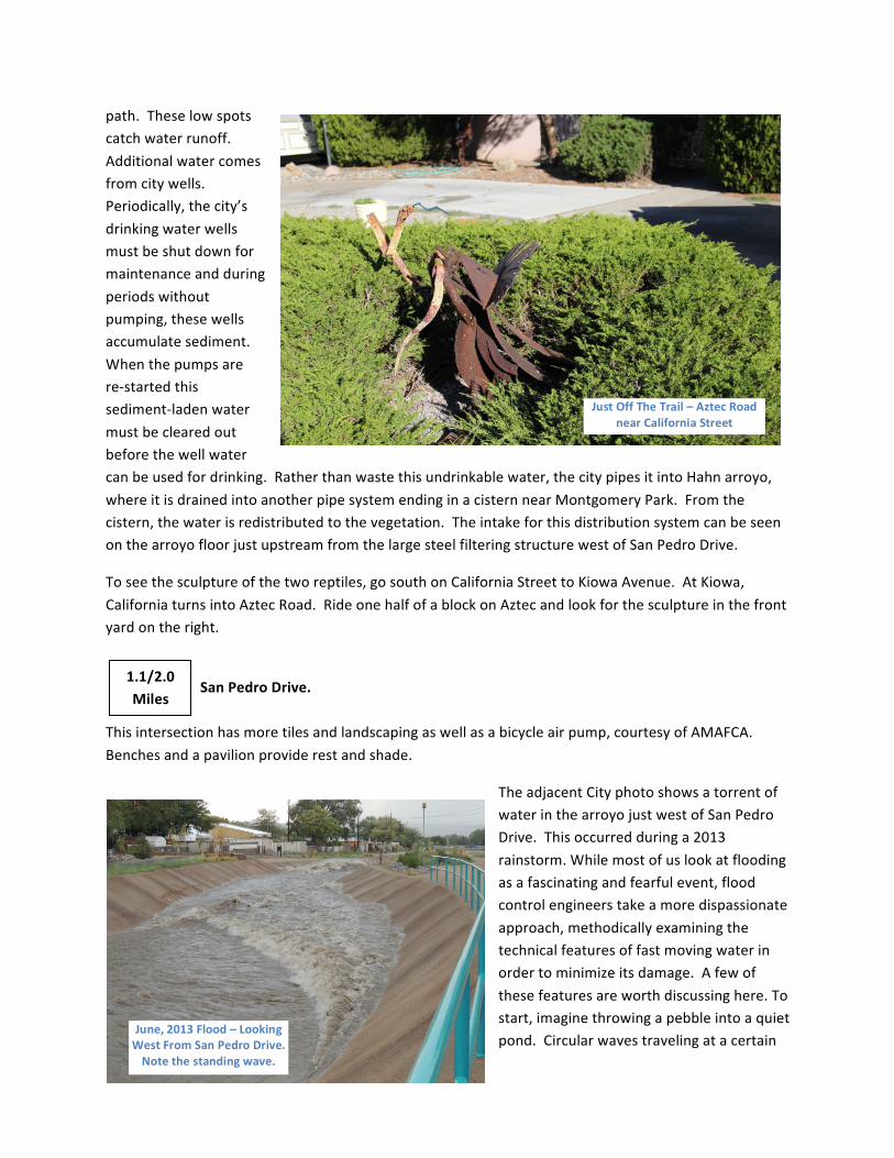
Thetileworkyouseehereisunusual.Referredtoaslitho-mosaicart,thetilesaregluedtoameshbackingandinstalledbyacontractoronsite.Inthelitho-mosaicprocess,theartistworksindoors,arrangingandsecuringtilesandthenaconstructioncrewhandlestheoutdoorinstallationofthecompletedmosaic.Muchofthedesignandlayoutwasdonebycommunitymembers,includingmanychildren.WorkingthroughtheHarwoodArtCenter,participantsfirstidentifiedlivingthingsseeninand
aroundNewMexico’sditches.Next,theymadedrawings,enlargedthem,andusedthemaspatternsforlayingtiles.
Uniquetothispublicartinstallationwasthebroadbaseofcommunityparticipation.Everyonewasinvitedtocontribute.Theresultwasstrongbuyinfromthesurroundingneighborhoods,afeelingofownershipandthecreationofanattractivepublicspacethatinvitesuse.Youcanseethefullstoryhere:http://vimeo.com/43425354.
Anotherunusualfeatureoftherehabilitationprojectisthevarietyofmeansusedtowaterthevegetation.Notethesmalldepressionsinthedirtwhichhavebeenexcavatednearthe
0.6/2.5Miles
1.0/2.1Miles
WaterDamageToTheArroyoBottom
FishMosaicnearSanPedroDrive
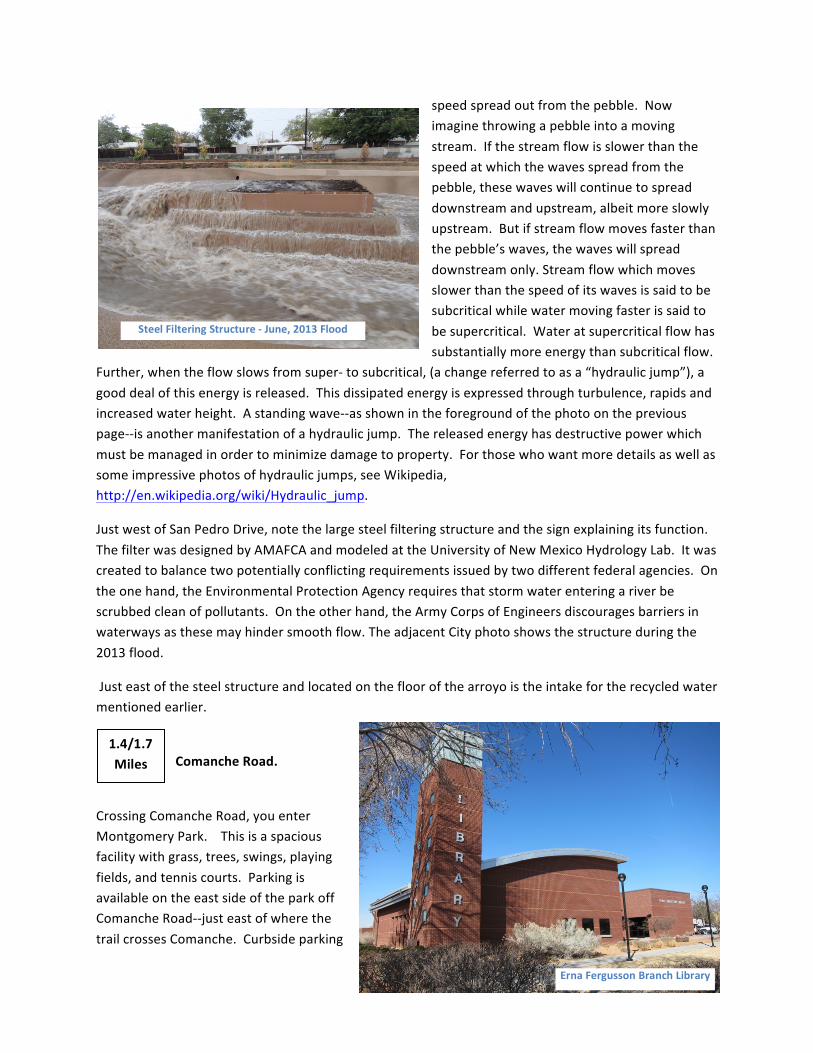
path.Theselowspotscatchwaterrunoff.Additionalwatercomesfromcitywells.Periodically,thecity’sdrinkingwaterwellsmustbeshutdownformaintenanceandduringperiodswithoutpumping,thesewellsaccumulatesediment.Whenthepumpsarere-startedthissediment-ladenwatermustbeclearedoutbeforethewellwatercanbeusedfordrinking.Ratherthanwastethisundrinkablewater,thecitypipesitintoHahnarroyo,whereitisdrainedintoanotherpipesystemendinginacisternnearMontgomeryPark.Fromthecistern,thewaterisredistributedtothevegetation.TheintakeforthisdistributionsystemcanbeseenonthearroyofloorjustupstreamfromthelargesteelfilteringstructurewestofSanPedroDrive.
Toseethesculptureofthetworeptiles,gosouthonCaliforniaStreettoKiowaAvenue.AtKiowa,CaliforniaturnsintoAztecRoad.RideonehalfofablockonAztecandlookforthesculptureinthefrontyardontheright.
SanPedroDrive.Thisintersectionhasmoretilesandlandscapingaswellasabicycleairpump,courtesyofAMAFCA.Benchesandapavilionproviderestandshade.
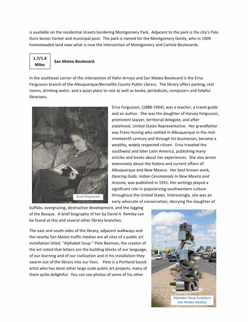
TheadjacentCityphotoshowsatorrentofwaterinthearroyojustwestofSanPedroDrive.Thisoccurredduringa2013rainstorm.Whilemostofuslookatfloodingasafascinatingandfearfulevent,floodcontrolengineerstakeamoredispassionateapproach,methodicallyexaminingthetechnicalfeaturesoffastmovingwaterinordertominimizeitsdamage.Afewofthesefeaturesareworthdiscussinghere.Tostart,imaginethrowingapebbleintoaquietpond.Circularwavestravelingatacertain
JustOffTheTrail–AztecRoadnearCaliforniaStreet
June,2013Flood–LookingWestFromSanPedroDrive.Notethestandingwave.
1.1/2.0Miles
speedspreadoutfromthepebble.Nowimaginethrowingapebbleintoamovingstream.Ifthestreamflowisslowerthanthespeedatwhichthewavesspreadfromthepebble,thesewaveswillcontinuetospreaddownstreamandupstream,albeitmoreslowlyupstream.Butifstreamflowmovesfasterthanthepebble’swaves,thewaveswillspreaddownstreamonly.Streamflowwhichmovesslowerthanthespeedofitswavesissaidtobesubcriticalwhilewatermovingfasterissaidtobesupercritical.Wateratsupercriticalflowhassubstantiallymoreenergythansubcriticalflow.
Further,whentheflowslowsfromsuper-tosubcritical,(achangereferredtoasa“hydraulicjump”),agooddealofthisenergyisreleased.Thisdissipatedenergyisexpressedthroughturbulence,rapidsandincreasedwaterheight.Astandingwave--asshownintheforegroundofthephotoonthepreviouspage--isanothermanifestationofahydraulicjump.Thereleasedenergyhasdestructivepowerwhichmustbemanagedinordertominimizedamagetoproperty.Forthosewhowantmoredetailsaswellassomeimpressivephotosofhydraulicjumps,seeWikipedia,http://en.wikipedia.org/wiki/Hydraulic_jump.
JustwestofSanPedroDrive,notethelargesteelfilteringstructureandthesignexplainingitsfunction.ThefilterwasdesignedbyAMAFCAandmodeledattheUniversityofNewMexicoHydrologyLab.Itwascreatedtobalancetwopotentiallyconflictingrequirementsissuedbytwodifferentfederalagencies.Ontheonehand,theEnvironmentalProtectionAgencyrequiresthatstormwaterenteringariverbescrubbedcleanofpollutants.Ontheotherhand,theArmyCorpsofEngineersdiscouragesbarriersinwaterwaysasthesemayhindersmoothflow.TheadjacentCityphotoshowsthestructureduringthe2013flood.
Justeastofthesteelstructureandlocatedonthefloorofthearroyoistheintakefortherecycledwatermentionedearlier.
ComancheRoad.
CrossingComancheRoad,youenterMontgomeryPark.Thisisaspaciousfacilitywithgrass,trees,swings,playingfields,andtenniscourts.ParkingisavailableontheeastsideoftheparkoffComancheRoad--justeastofwherethetrailcrossesComanche.Curbsideparking
ErnaFergussonBranchLibrary
1.4/1.7Miles
SteelFilteringStructure-June,2013Flood
isavailableontheresidentialstreetsborderingMontgomeryPark.Adjacenttotheparkisthecity’sPaloDuroSeniorCenterandmunicipalpool.TheparkisnamedfortheMontgomeryfamily,whoin1909homesteadedlandnearwhatisnowtheintersectionofMontgomeryandCarlisleBoulevards.
SanMateoBoulevard.
InthesoutheastcorneroftheintersectionofHahnArroyoandSanMateoBoulevardistheErnaFergussonbranchoftheAlbuquerque/BernalilloCountyPublicLibrary.Thelibraryoffersparking,restrooms,drinkingwater,andaquietplacetorestaswellasbooks,periodicals,computersandhelpfullibrarians.
ErnaFergusson,(1888-1964),wasateacher,atravelguideandanauthor.ShewasthedaughterofHarveyFergusson,prominentlawyer,territorialdelegate,andafterstatehood,UnitedStatesRepresentative.HergrandfatherwasFranzHuningwhosettledinAlbuquerqueinthemid-nineteenthcenturyandthroughhisbusinesses,becameawealthy,widelyrespectedcitizen.ErnatraveledthesouthwestandlaterLatinAmerica,publishingmanyarticlesandbooksaboutherexperiences.ShealsowroteextensivelyaboutthehistoryandcurrentaffairsofAlbuquerqueandNewMexico.Herbestknownwork,DancingGods:IndianCeremonialsInNewMexicoandArizona,waspublishedin1931.HerwritingsplayedasignificantroleinpopularizingsouthwesternculturethroughouttheUnitedStates.Interestingly,shewasanearlyadvocateofconservation,decryingtheslaughterof
buffalo,overgrazing,destructivedevelopment,andtheloggingoftheBosque.AbriefbiographyofherbyDavidA.Remleycanbefoundatthisandseveralotherlibrarybranches.
Theeastandsouthsidesofthelibrary,adjacentwalkwaysandthenearbySanMateotrafficmedianareallsitesofapublicartinstallationtitled,“AlphabetSoup.”PeteBeeman,thecreatoroftheartnotedthatlettersarethebuildingblocksofourlanguage,ofourlearningandofourcivilizationandinhisinstallationtheyswarmoutofthelibraryintoourlives.PeteisaPortlandbasedartistwhohasdoneotherlargescalepublicartprojects,manyofthemquitedelightful.Youcanseephotosofsomeofhisother
ErnaFergusson
AlphabetSoupSculptureSanMateoMedian
1.7/1.4Miles
workhere:http://petebeeman.com/Projects/projectPublic1.html.
JusteastofMonroeStreet.T
TheUSGSflowgaugementionedearlierisonthearroyo’snorthwall.Notethetransmittingequipment.
WashingtonStreet.
Travelingfromwesttoeast,WashingtonStreetisthestartofthe“presidentstreets,”aserieswhichendsatSanMateoBoulevard.However,beforeJuly1,1952,streetsnamedafterpresidentswerescatteredallaroundthecity.AlbuquerquecitygovernmentchosetheJulydatetorenameapproximately650streetsandalsotoinstituteour4quadrantgridsystem,(NE,NW,SE,andSW).Thismassiveundertakingwasdeemednecessarybecauseearlierstreetnaminghadbeenuncoordinated,asmanybuilderscreatedwidelyscatteredhousingdevelopmentsintheNortheastHeights.Inherbook,AtriscoToZenaLona–ASnappySurveyOfSelectedAlbuquerqueStreetNames,JudyNickellprovidedmanydetailsofthisre-namingandnotedthatthiswasthebiggeststreetnamechangeinU.S.history.CarlisleBoulevard.NotetherampinthearroyojusteastofCarlisleBoulevard.Theincreasedgradeacceleratestheflowof
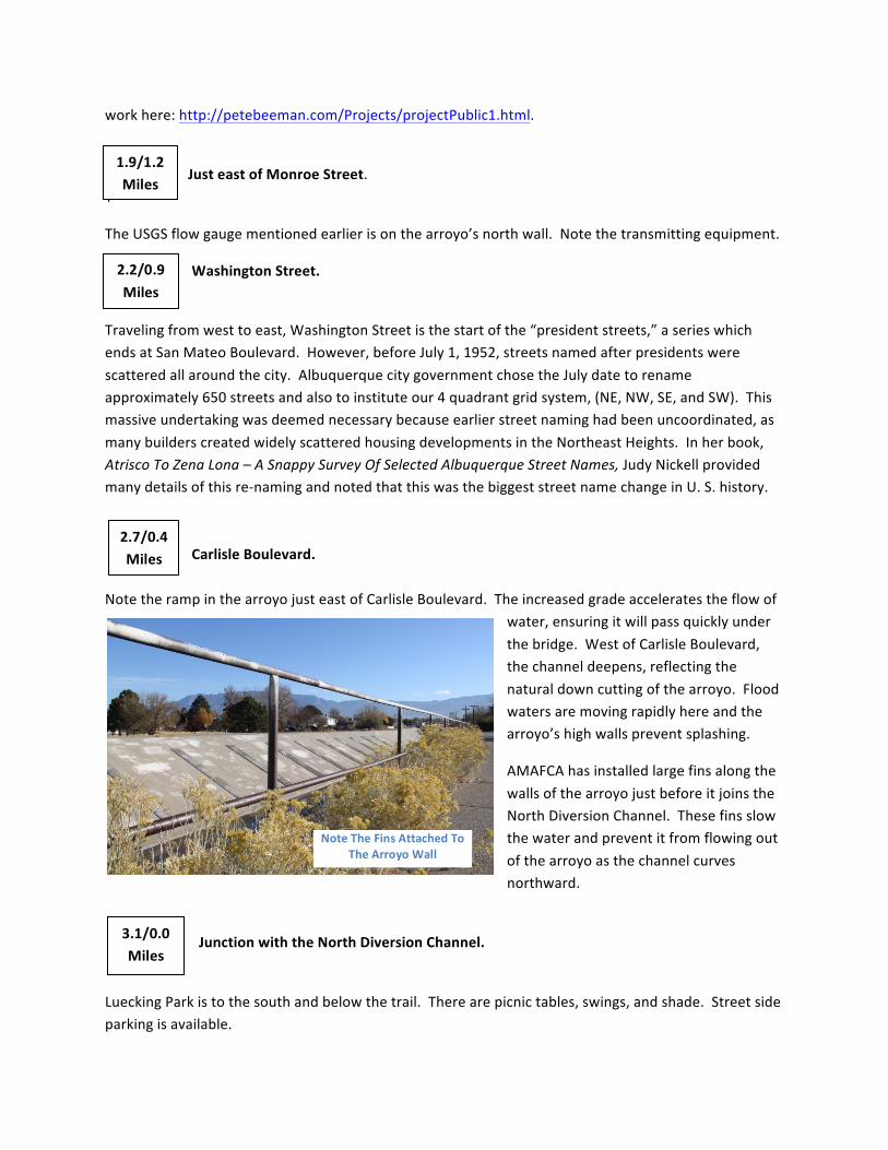
water,ensuringitwillpassquicklyunderthebridge.WestofCarlisleBoulevard,thechanneldeepens,reflectingthenaturaldowncuttingofthearroyo.Floodwatersaremovingrapidlyhereandthearroyo’shighwallspreventsplashing.
AMAFCAhasinstalledlargefinsalongthewallsofthearroyojustbeforeitjoinstheNorthDiversionChannel.Thesefinsslowthewaterandpreventitfromflowingoutofthearroyoasthechannelcurvesnorthward.
JunctionwiththeNorthDiversionChannel.
LueckingParkistothesouthandbelowthetrail.Therearepicnictables,swings,andshade.Streetsideparkingisavailable.
NoteTheFinsAttachedToTheArroyoWall
2.2/0.9Miles
2.7/0.4Miles
3.1/0.0Miles
1.9/1.2Miles
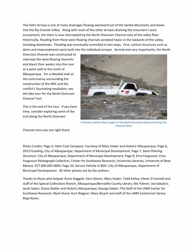
TheHahnArroyoisoneofmanydrainagesflowingwestwardoutoftheSandiaMountainsanddownintotheRioGrandeValley.Alongwithmostoftheotherarroyosdrainingthemountain’swestescarpment,theHahnisnowinterceptedbytheNorthDiversionChanneleastofthevalleyfloor.Historically,floodingfromthesewest-flowingchannelswreakedhavocinthelowlandsofthevalley,includingdowntown.Floodingwaseventuallycontrolledintwoways.First,controlstructuressuchasdamsandimpoundmentswerebuiltintotheindividualarroyos.Secondandveryimportantly,theNorthDiversionChannelwasconstructedtointerceptthewest-flowingchannelsanddiverttheirwatersintotheriveratapointwelltothenorthofAlbuquerque.ForadetailedlookatthecontroversysurroundingtheconstructionoftheNDCandtheconflict’sfascinatingresolution,seethebiketourfortheNorthDiversionChannelTrail.
Thisistheendofthetour.Ifyouhavetime,considerexploringsomeofthetrailalongtheNorthDiversion
Channelsinceyouarerightthere.
PhotoCredits:Page3,HahnCoalCompany:CourtesyofMaryHuberandHistoricAlbuquerque;Page6,2013Flooding:CityofAlbuquerque,DepartmentofMunicipalDevelopment;Page7,SteelFilteringStructure:CityofAlbuquerque,DepartmentofMunicipalDevelopment;Page8,ErnaFergusson:ErnaFergussonPhotographCollection,CenterforSouthwestResearch,UniversityLibraries,UniversityofNewMexico.PCT000-045-0005;Page10,ServiceVehicleinNDC:CityofAlbuquerque,DepartmentofMunicipalDevelopment.Allotherphotosarebytheauthors.
Thankstothosewhohelped:KevinDaggett;VernGlover;MaryHuber;ToddKelley;EileenOConnellandstaffoftheSpecialCollectionsBranch,Albuquerque/BernalilloCountyLibrary;MoPalmer;JoeSabatini;JanetSaiers:DianeShallerandHistoricAlbuquerque;GeorgeSieber;TheStaffoftheUNMCenterforSouthwestResearch;MarkStone;KurtWagner;MaryWyantandstaffoftheUNMCentennialLibraryMapRoom.
AServiceVehicleWasCaughtInTheNorthDiversionChannelDuringTheFloodOf2013