Embed Size (px)
Citation preview
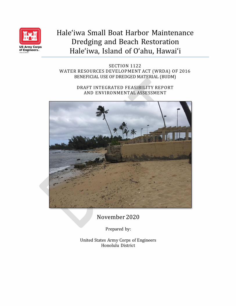
Haleʻiwa Small Boat Harbor Maintenance Dredging and Beach Restoration
Haleʻiwa, Island of Oʻahu, Hawaiʻi
SECTION 1122 WATER RESOURCES DEVELOPMENT ACT (WRDA) OF 2016
BENEFICIAL USE OF DREDGED MATERIAL (BUDM)
DRAFT INTEGRATED FEASIBILITY REPORT AND ENVIRONMENTAL ASSESSMENT
November 2020
Prepared by:
United States Army Corps of Engineers Honolulu District

This page left blank intentionally.

Section 1122 Beneficial Use of Dredged Material Page i
Feasibility Study, Haleʻiwa, Oʻahu, Hawaii
Executive Summary
This report presents the evaluation of beneficial uses for dredged material resulting from the routine
maintenance dredging of the federal channel at Haleʻiwa Small Boat Harbor. Beneficial use of dredged
material can provide benefits to the navigation, coastal storm risk management, recreation, and
environmental missions. Despite general perceptions of the pristine sand beaches of Hawaiʻi, sand is
relatively scarce. The study area contains one of the most visited beaches outside of Waikiki, Haleʻiwa
Beach Park, and therefore is a high-value opportunity for receipt of beach grade sand dredged in
accordance with authority granted under Section 1122 of Water Resources Development Act (WRDA) of
2016, as amended.
This study evaluated alternatives for beneficial use based on economic, engineering, environmental and
other factors. The Recommended Plan maximized both economic and ecosystem restoration benefits
making it the National Economic Development (NED) Plan and the National Ecosystem Restoration
(NER) Plan. Beneficial use of dredged material for the purposes of beach restoration is strongly
supported by local stakeholders including the State of Hawaiʻi Department of Land and Natural
Resources (DLNR) Office of Conservation and Coastal Lands (OCCL) and Division of Boating and
Ocean Recreation (DOBOR), as well as the City and County of Honolulu Department of Parks and
Recreation. The non-federal sponsor for this project is the State of Hawaii as represented by DLNR
OCCL and DOBOR.
The Recommended Plan, Alternative 4, consists of beneficial use from the Federal Navigation Channel
maintenance dredging to 13 ft mean lower low water (MLLW), a shoaling deposit caused by a state
owned breakwater, hereafter referred to as State Breakwater Settling Basin, and the Offshore Sand
Borrow Area. This plan involves the beneficial use of dredged material from these locations for the
purposes of restoring aquatic habitat and reducing storm damage to property and infrastructure. The
dredged material from these locations that is beach suitable will be used to nourish the beach which is
part of the Haleʻiwa Beach Shore Protection Project (HBSPP), adjacent to Haleʻiwa Beach Park (HBP).
Dredging from these locations will yield approximately 26,071cubic yards (cy) of beach suitable sand
and will be used to restore 4.4ac of beach. The fine-grained dredged material from the Federal
Navigation Channel that is not suitable for beach restoration, approximately 2,000 cy, will be
transported by scow and taken to the South Oʻahu Ocean Dredged Material Disposal Site (ODMDS).
The beach is part of the federally authorized HBSPP, and nourishment with dredged material will help
restore the beach to its original extent. This will produce both NER and NED benefits in the form of
restored habitat for the green sea turtle, recreational benefits, and storm damage reduction benefits. The
Recommended Plan is both the NER and NED plan and provides a net increase of 1.87 average annual
habitat units and an economic benefit of $18,525,000 with a Benefit-Cost Ratio BCR of 3.85.
The Recommended Plan has an estimated total project first cost (Constant Dollar Cost at FY20 price
levels) of $3,068,000. This cost represents the incremental total project cost over the Base Plan, which
would be maintenance dredging of the federal channel and disposing of dredged material at the South
Oʻahu ODMDS. The fully funded total project cost for the Recommended Plan is $3,261,000 including
escalation to the midpoint of construction. The non-federal share of the project components is
estimated at $1,798,800 and will be funded by the local sponsor. The federal share of the project
components is estimated at $1,269,200.

Section 1122 Beneficial Use of Dredged Material Page ii
Feasibility Study, Haleʻiwa, Oʻahu, Hawaii
List of Abbreviations and Acronyms
AAHU Average Annual Habitat Unit
AAC Average Annual Cost
BCR Benefit Cost Ratio
BU Beneficial Use
BUDM Beneficial Use of Dredged Material
CAA Clean Air Act
CAP Continuing Authorities Program
CE/ICA Cost Effective/Incremental Cost
Analysis
CEQ Council for Environmental Quality
CWA Clean Water Act
CY Cubic yards
CZMA Coastal Zone Management Act
DLNR Department of Lands and Natural
Resources
DMMP Dredged Material Management Plan
DOBOR Division of Boating and Ocean
Recreation
DPS Distinct Population Negments
EA Environmental Assessment
EC Engineering Circular
EFH Essential Fish Habitat
EO Executive Order
ER Engineering Regulation
ESA Endangered Species Act
EPA Environmental Protection Agency
FEP Fishery Ecosystem Plans
FONSI Finding of No Significant Impact
FWCA Fish and Wildlife Coordination Act
GNF General Navigation Feature
HBP Haleʻiwa Beach Park
HSBH Haleʻiwa Small Boat Harbor
HBSPP Haleʻiwa Beach Shore Protection
Project
HU Habitat Unit
HTRW Hazardous Toxic Radioactive Waste
IFR/EA Integrated Feasibility
Report/Environmental Assessment
IWR Institute for Water Resources
MBTA Migratory Bird Treaty Act
MLLW Mean Lower Low Water
MSA Magnuson-Stevens Fishery
Conservation Management
MUS management unit species
NED National Economic Development
NEPA National Environmental Policy Act
NER National Ecosystem Restoration
NFS Non-Federal Sponsor
NHPA National Historic Preservation Act
NMFS National Marie Fisheries Service
NOAA National Oceanic Atmospheric
Administration
NPDES National Pollutant Discharge
Elimination System
NRHP National Register of Historic
Places
OCCL Office of Conservation and Coastal
Lands
ODMDS Ocean Dredged Material Disposal
Site
O&M Operations and Maintenance
OMRR&R Operations, Maintenance, Repair,
Rehabilitation and Replacement
PPA Project Partnership Agreement
S&A Supervision and Administration
SLC Sea level change
SLR Sea level rise
TSP Tentatively Selected Plan
U.S. United States
USACE U.S. Army Corps of Engineers
USFWS U.S. Fish and Wildlife Service
USC United States Code
WRDA Water Resources Development Act
UNITS
Acres ac
Cubic Yards cy
Feet ft

Section 1122 Beneficial Use of Dredged Material Page ii
Feasibility Study, Haleʻiwa, Oʻahu, Hawaii
Pertinent Data
Recommended Plan
Sand Placement
Placement Amount (cy) 26,071 Length of Placement Area (ft) 1,000
Width of Placement Area (ft) 200
Economic Information
Item Amount ($)
Total Design and Construction Costs 3,068,000
Total Annual National Economic Development Cost (50 years) 93,000 Annual Benefits 531,000 Average Net Annual Benefits 483,000 Benefit to Cost Ratio 3.85
Note: Totals may not sum due to rounding.
Conversion Table for SI (Metric) Units
Multiply By To Obtain
Cubic Yards (cy) 0.7646 Cubic Meters
Acre (ac) 0.4049 Hectare Feet (ft) 0.3048 Meters Feet Per Second 0.3048 Meters Per Second Inches 2.5400 Centimeters
Knots (international) 0.5144 Meters Per Second Miles (U.S. Statute) 1.6093 Kilometers Miles (Nautical) 1.8520 Kilometers Miles Per Hour 1.6093 Kilometers Per Hour
Pounds (mass) (lb) 0.4536 Kilograms *To obtain Celsius (C) temperature readings from Fahrenheit (F) readings, use the followin g formula: C = (5/9)(F-32)

Section 1122 Beneficial Use of Dredged Material Page iii
Feasibility Study, Haleʻiwa, Oʻahu, Hawaii
TABLE OF CONTENTS
1.0 Introduction .................................................................................................................. 2
1.1 Authority ................................................................................................................... 2
1.2 Study Purpose and Scope ........................................................................................... 2
1.3 Location and Study Area ............................................................................................ 4
1.4 Description of Federal Projects................................................................................... 5
1.4.1 Haleʻiwa Small Boat Harbor ................................................................................ 5
1.4.2 Haleʻiwa Beach Shore Protection Project ............................................................. 6
1.5 Historical Dredging of Haleʻiwa Small Boat Harbor .................................................... 8
1.6 Study Participants and Coordination ........................................................................... 8
1.7 Related Studies and Reports ....................................................................................... 8
2.0 Affected Environment-Existing Conditions .................................................................. 10
2.1 Physical Setting ....................................................................................................... 10
2.1.1 Climate............................................................................................................. 10
2.1.2 Geology and Geomorphology............................................................................ 10
2.1.3 Land Use .......................................................................................................... 11
2.1.4 Soils ................................................................................................................. 11
2.1.5 Benthic Substrate .............................................................................................. 11
2.1.6 Bathymetry and Nearshore Bottom Conditions .................................................. 12
2.1.7 Tides, Water Levels, and Sea Level Change....................................................... 13
2.1.8 Littoral Sand Transport ..................................................................................... 17
2.1.9 Winds............................................................................................................... 17
2.1.10 Waves .............................................................................................................. 18
2.2 Social and Economic Resources ............................................................................... 20
2.2.1 Haleʻiwa Small Boat Harbor.............................................................................. 20
2.2.2 Haleʻiwa Beach Park ......................................................................................... 20
2.2.3 Demographics................................................................................................... 24
2.2.4 Socioeconomic and Environmental Justice......................................................... 24
2.3 Biological Resources ............................................................................................... 24
2.3.1 Wetlands .......................................................................................................... 24
2.3.2 Terrestrial Habitats ........................................................................................... 25
2.3.3 Aquatic Species and Habitats ............................................................................ 25

Section 1122 Beneficial Use of Dredged Material Page iv
Feasibility Study, Haleʻiwa, Oʻahu, Hawaii
2.3.4 Endangered and Threatened Species .................................................................. 27
2.3.5 Fish and Essential Fish Habitat.......................................................................... 28
2.3.6 Essential Fish Habitat Designation .................................................................... 29
2.3.7 Vegetation ........................................................................................................ 31
2.3.8 Birds ................................................................................................................ 31
2.4 Air Quality .............................................................................................................. 31
2.5 Water Quality .......................................................................................................... 31
2.6 Aesthetic Quality ..................................................................................................... 31
2.7 Noise....................................................................................................................... 32
2.8 Hazardous and Toxic Substances.............................................................................. 32
2.9 Historical and Archeological Resources.................................................................... 32
3.0 Plan Formulation......................................................................................................... 34
3.1 Purpose and Need .................................................................................................... 34
3.2 Problems ................................................................................................................. 34
3.3 Opportunities and Constraints .................................................................................. 35
3.3.1 Opportunities .................................................................................................... 35
3.3.2 Constraints (Factors to avoid)............................................................................ 36
3.4 Objectives ............................................................................................................... 36
3.4.1 Federal Planning Objectives .............................................................................. 36
3.4.2 Specific Planning Objectives ............................................................................. 37
3.5 Future Without Project Condition ............................................................................. 37
3.5.1 Navigation........................................................................................................ 37
3.5.2 Haleʻiwa Beach Park ......................................................................................... 37
3.5.3 Biological Environment .................................................................................... 37
3.6 Formulation of Measures ......................................................................................... 38
3.6.1 Dredging, Transport, and Placement Methods .................................................... 38
3.6.2 Beneficial Uses of Dredged Material ................................................................. 38
3.6.3 Other Dredged Material Placement Options ....................................................... 39
3.6.4 Dredging Locations .......................................................................................... 39
3.6.5 Preliminary Screening of Measures ................................................................... 41
3.6.6 Array of Alternatives Considered ...................................................................... 43
4.0 Comparison of Alternatives ......................................................................................... 44
4.1 Alternative Plan Descriptions ................................................................................... 44

Section 1122 Beneficial Use of Dredged Material Page v
Feasibility Study, Haleʻiwa, Oʻahu, Hawaii
4.1.1 Alternative 1- No Action Alternative ................................................................. 44
4.1.2 Alternative 2 – Beneficial Use of Dredged Material from Federal Channel to 12 ft
MLLW Depth ................................................................................................................ 45
4.1.3 Alternative 2A - Beneficial Use of Dredged Material from Federal Channel to 13 ft MLLW Depth ................................................................................................................ 46
4.1.4 Alternative 3– Beneficial Use of Dredged Material from Federal Channel to 13 ft MLLW and Settling Basin.............................................................................................. 48
4.1.5 Alternative 4: Beneficial Use of Dredged Material from Federal Channel to 13 ft MLLW, Settling Basin, and Offshore Sand Borrow Area................................................. 50
4.2 Preliminary Screening of Alternative Plans ............................................................... 52
4.3 Base Plan Costs ....................................................................................................... 53
4.4 Costs of Alternatives................................................................................................ 53
4.4.1 Operations and Maintenance Costs .................................................................... 53
4.4.2 Alternative Costs .............................................................................................. 53
4.5 Ecological Outputs................................................................................................... 55
4.6 Economic Benefits................................................................................................... 56
4.7 Cost Effectiveness Incremental Cost Analysis........................................................... 57
4.8 Evaluation of Alternatives ........................................................................................ 59
4.9 Plan Selection .......................................................................................................... 61
5.0 Recommended Plan ..................................................................................................... 62
5.1 Plan Description ...................................................................................................... 62
5.1.1 Plan Components .............................................................................................. 62
5.2 Detailed Cost Estimate of the Recommended Plan .................................................... 65
5.3 Summary of Significance ......................................................................................... 65
5.3.1 Institutional Significance................................................................................... 65
5.3.1 Public Significance ........................................................................................... 66
5.3.1 Technical Significance ...................................................................................... 67
5.4 Residual Risk .......................................................................................................... 68
5.5 Integration of Environmental Operating Principles .................................................... 68
5.6 Summary of Accounts.............................................................................................. 69
5.6.1 National Economic Development ...................................................................... 69
5.6.2 Regional Economic Development...................................................................... 69
5.6.3 Environmental Quality ...................................................................................... 69
5.6.4 Other Social Effects .......................................................................................... 70

Section 1122 Beneficial Use of Dredged Material Page vi
Feasibility Study, Haleʻiwa, Oʻahu, Hawaii
6.0 Environmental Impacts ................................................................................................ 71
6.1 Physical Environment .............................................................................................. 71
6.1.1 Water Quality ................................................................................................... 71
6.1.2 Air Quality ....................................................................................................... 71
6.1.3 Aesthetic Quality .............................................................................................. 71
6.1.4 Noise................................................................................................................ 72
6.1.5 Human Activity ................................................................................................ 72
6.2 Biological Resources ............................................................................................... 72
6.2.1 Terrestrial Habitat ............................................................................................. 72
6.2.2 Federal and State Threatened and Endangered Species ....................................... 72
6.2.3 Fishery Resources and Essential Fish Habitat..................................................... 73
6.3 Coastal Zone Resource Management ........................................................................ 73
6.4 Historical and Archaeological Resources .................................................................. 73
6.5 Environmental Justice and Protection of Children ..................................................... 73
6.6 Cumulative and Long-term Impacts.......................................................................... 73
6.7 Summary of Mitigation Measures............................................................................. 74
6.7.1 No Action Plan ................................................................................................. 74
6.7.2 Recommended Plan .......................................................................................... 74
6.8 Plan Selection .......................................................................................................... 74
7.0 Public and Agency Involvement .................................................................................. 75
7.1 Public/Scoping Meetings.......................................................................................... 75
7.2 Federal and State Agency Coordination .................................................................... 75
7.2.1 Pre-Consultation Agency Coordination.............................................................. 75
7.3 Status of Environmental Compliance (Compliance Table) ......................................... 75
7.3.1 Relationship to Environmental Laws and Compliance ........................................ 75
7.4 Views of the Non-Federal Sponsor ........................................................................... 80
8.0 Plan Implementation Requirements .............................................................................. 81
8.1 Non-Federal Responsibilities.................................................................................... 81
8.2 Federal Responsibilities ........................................................................................... 81
8.3 In-Kind Contributions .............................................................................................. 81
8.4 Cost Sharing ............................................................................................................ 81
8.5 Project Partnership Agreement ................................................................................. 83
8.6 Operations and Maintenance .................................................................................... 83

Section 1122 Beneficial Use of Dredged Material Page vii
Feasibility Study, Haleʻiwa, Oʻahu, Hawaii
8.7 Monitoring and Adaptive Management..................................................................... 84
8.8 Mitigation................................................................................................................ 84
8.9 Implementation Schedule ......................................................................................... 84
8.10 Real Estate Considerations ................................................................................... 84
8.11 Risk and Uncertainty ............................................................................................ 85
8.12 Local Betterments ................................................................................................ 85
8.13 Monitoring ........................................................................................................... 85
9.0 Conclusions and Recommendations ............................................................................. 86
9.1 Conclusions ............................................................................................................. 86
9.2 Recommendations ................................................................................................... 86
10.0 References and Prior Studies ....................................................................................... 87

Section 1122 Beneficial Use of Dredged Material Page viii
Feasibility Study, Haleʻiwa, Oʻahu, Hawaii
List of Tables Table 1. USACE dredging history of Haleʻiwa Harbor .............................................................. 8 Table 2. Water level data for Haleʻiwa Harbor ........................................................................ 13 Table 3. Shoaling volume and rate ......................................................................................... 20
Table 4. Resource categories and mitigation goals (USFWS, August 2020). ............................ 26 Table 5 Bottomfish MUS species ........................................................................................... 28 Table 6 Crustaceans MUS species .......................................................................................... 29 Table 7 Pelagic MUS species ................................................................................................. 29
Table 8 EFH designation for Bottomfish MUS ....................................................................... 30 Table 9 EFH designation for Crustaceans MUS ...................................................................... 30 Table 10 EFH designation for Pelagics MUS .......................................................................... 30 Table 11. Preliminary measures considered ............................................................................ 42
Table 12. Final array of alternatives ....................................................................................... 43 Table 13. Alternative 2 dredged material volume and uses ...................................................... 45 Table 14. Alternative 2A dredged material volume and uses ................................................... 47 Table 15. Alternative 3 dredged material volume and uses ...................................................... 49
Table 16. Alternative 4 dredged material volume and uses ...................................................... 51 Table 17. Base Plan Costs for All Alternatives........................................................................ 53 Table 18. Alternative costs..................................................................................................... 54 Table 19. Habitat outputs ....................................................................................................... 55
Table 20. Economic Benefits ................................................................................................. 57 Table 21. Cost Effectiveness and Incremental Cost Analysis ................................................... 58 Table 22. Alternative comparison criteria ............................................................................... 60 Table 23. Total project cost of the Recommended Plan ........................................................... 65
Table 24: Summary of relevant federal statutory authorities .................................................... 80 Table 25. Cost share allocation............................................................................................... 83 Table 26: Design and implementation schedule ...................................................................... 84
List of Figures Figure 1. Project location ......................................................................................................... 4 Figure 2. Project location and study area .................................................................................. 5
Figure 3. Haleʻiwa Small Boat Harbor federal project ............................................................... 6 Figure 4. Photo of Haleʻiwa Beach Park, circa 1970, depicting the historic extent of beach and tombolo (Sea Engineering Inc., 2019) ...................................................................................... 7
Figure 5. Bathymetry and topography, Haleʻiwa Beach park. (Sea Engineering, Inc., 2019) ..... 12 Figure 6. Extreme water levels at Honolulu Harbor, Oʻahu ...................................................... 14
Figure 7. Sea level trend for Honolulu, Hawaiʻi (NOAA, 2020) ............................................... 15 Figure 8. Interannual variation at Honolulu Harbor NOAA tide station.................................... 16 Figure 9. Relative sea level change curves at Honolulu Harbor NOAA tide station .................. 17
Figure 10. Wind rose from WIS station 82508 ........................................................................ 18 Figure 11. Wave height rose from CDIP buoy 106 .................................................................. 19 Figure 12. Wave period from CDIP buoy 106 ......................................................................... 19 Figure 13. Erosion near WWII monument circa 2019 (SeaEngineering, 2019) ......................... 22
Figure 14. Beach in front of seawall and comfort station. Note exposed reef rock and root balls. Photo from 2017 (SeaEngineering, 2019) ............................................................................... 22

Section 1122 Beneficial Use of Dredged Material Page ix
Feasibility Study, Haleʻiwa, Oʻahu, Hawaii
Figure 15. National Wetlands Inventory for Hale’iwa Beach Park and vicinity. ....................... 25
Figure 16: Haleʻiwa Beach Park erosion. ................................................................................ 35 Figure 17. Dredging locations ................................................................................................ 41 Figure 18. Alternative 1: No action alternative (Federal Navigation Channel shown in green) . 44
Figure 19. Alternative 2: Beneficial use of dredged material at Haleʻiwa Beach Park................ 46 Figure 20. Alternative 2A: additional dredging area to 13 ft .................................................... 47
Figure 21. Alternative 2A: Beneficial use of dredged material at Hale ʻiwa Beach Park. ............ 48 Figure 22. Alternative 3: beneficial use beach restoration area................................................. 50 Figure 23. Alternative 4: beneficial use beach restoration area................................................. 52 Figure 24. Cost versus outputs graphs .................................................................................... 59 Figure 25. Recommended Plan components............................................................................ 64
Appendices:
A: Coastal Appendix B: Environmental Appendix
C: Economic Appendix D: Cost Engineering Appendix

Section 1122 Beneficial Use of Dredged Material Page 2
Feasibility Study, Haleʻiwa, Oʻahu, Hawai i̒
1.0 INTRODUCTION
This chapter provides information on the study authority, area of concern, study participants, previous studies that contributed to this product and tasks remaining to be completed prior to the
report being finalized.
1.1 Authority
This feasibility study is being conducted under authority granted by Section 1122 of the Water Resources Development Act (WRDA) of 2016 (Public Law (PL) 114-322), as amended. Section 1122 of WRDA 2016 requires U.S. Army Corps of Engineers (USACE) establish a pilot
program to carry out 10 projects for the beneficial use of dredged material, including projects for the purposes of— (1) Reducing storm damage to property and infrastructure; (2) promoting public safety; (3) protecting, restoring, and creating aquatic ecosystem habitats; (4) stabilizing stream systems and enhancing shorelines; (5) promoting recreation; (6) supporting risk
management adaptation strategies; and (7) reducing the costs of dredging and dredged material placement or disposal. In general, Section 1122 provides that projects under the pilot program will be cost shared in
accordance with the cost sharing requirements for projects carried out under the Section 204 Continuing Authorities Program (CAP). However, for projects under the pilot program that utilize dredged material from federal navigation projects, Section 1122(e)(2) provides that the incremental costs above the Federal Standard for transporting and depositing such dredged
material will be borne entirely by the Federal Government. If such pilot projects involve additional activities other than transportation and placement of dredged material, such as wetland plantings or mechanical shaping of dunes and beach berms, those costs shall be shared in accordance with the cost sharing requirements of Section 204. If additional material is dredged
from a federal navigation project solely for purposes of a pilot project, the costs associated with the additional dredging will be cost-shared with the non-federal sponsors (NFS) of the pilot project in accordance with Section 204. If a pilot project relies on dredged material from a non-federal navigation project, the dredging and transportation costs will be 100% non-federal; all
other costs associated with the pilot project will be cost-shared in accordance with Section 204.
1.2 Study Purpose and Scope
This study examines the feasibility and environmental effects of implementing beneficial use of
dredged material (BUDM) measures at Haleʻiwa, Oʻahu, Hawaiʻi. Haleʻiwa is located on the
central north coast of the island of Oʻahu, approximately 25 miles northwest of Honolulu. The project area is shown below in Figure 1. The study area is in Hawaiʻi’s Second Congressional District, which has the following Congressional delegation: Senator Mazie Hirono (D); Senator
Brian Schatz (D); and, Representative Tulsi Gabbard (D-Honolulu). Engineering Pamphlet (EP) 1105-2-58 “Continuing Authority Program” describes the policy requirements associated with projects conducted under this authority. This feasibility document
describes the planning process to demonstrate consistency with applicable policy requirements.

Section 1122 Beneficial Use of Dredged Material Page 3
Feasibility Study, Haleʻiwa, Oʻahu, Hawai i̒
Engineer Regulation (ER) 200-2-2, “Procedures for Implementing NEPA” and ER 1105-2-100, directs the contents of environmental assessments (EAs). This document and its appendices
present the information required by both regulations as an integrated feasibility report and EA. Compliance with the requirements of the Council on Environmental Quality regulations for implementing the National Environmental Policy Act of 1969 (42 United States Code (USC) 4321 et seq.) will be met upon completion of the final decision document. Additionally, this
document augments the National Environmental Policy Act (NEPA) requirement to ensure
compliance with the Hawaiʻi Revised Statutes Chapter 343, Environmental Impact Statements. This Integrated Feasibility Report and EA (IFR/EA) documents the study and coordination conducted to determine whether the Federal Government should participate in BUDM measures
by dredging suitable materials from Haleʻiwa Small Boat Harbor (HSBH) and other suitable areas in the vicinity for placement at the Haleʻiwa Beach Shore Protection Project (HBSPP) that
is adjacent to Haleʻiwa Beach Park (HBP), Oʻahu, Hawaiʻi. Studies of potential BUDM measures considered a wide range of alternatives and the environmental consequences of those alternatives but focused mainly on actions that would provide efficient and effective benefits to navigation,
coastal storm risk management, recreation, and ecosystem restoration to the study area. The implementation of BUDM measures is growing in interest not just for USACE, but also for other groups interested in the benefits that these measures can provide. The measures proposed
by this report generate notable National Economic Development (NED) and National Ecosystem Restoration (NER) benefits. The non-federal sponsor for this project is the State of Hawaii as represented by DLNR. Both
DOBOR and OCCL are branches of DLNR, and have stated their intention to serve as cost-share sponsors for the BUDM project at Haleʻiwa Beach. The City and County of Honolulu owns and maintains HBP. This partnership of federal and non-federal interests in BUDM helps ensure that
the selected plan will effectively serve both local and national needs.

Section 1122 Beneficial Use of Dredged Material Page 4
Feasibility Study, Haleʻiwa, Oʻahu, Hawai i̒
Figure 1. Project location
1.3 Location and Study Area
The project is located on the northeastern shore of the island of Oʻahu, approximately 30 miles
north of Honolulu, Hawaiʻi (Figure 1). The study area (Figure 2) encompasses the federally authorized HSBH and HBSPP, and the HBP. It is located near the mouth of the Anahulu River (21° 35’ 49.24” N, 158° 05’ 47.50 W”). The study area also includes a 0.3 acres (ac) shoaling deposit caused by state owned breakwater (State Breakwater Settling Basin) located immediately
to the east of the state breakwater on Aliʻi Beach, and a 1.7 ac offshore sand deposit (Offshore
Sand Borrow Area) located 3,400 feet (ft) northwest of HBP.
↑N
Hawaiʻi
Oʻahu

Section 1122 Beneficial Use of Dredged Material Page 5
Feasibility Study, Haleʻiwa, Oʻahu, Hawai i̒
Figure 2. Project location and study area
1.4 Description of Federal Projects
The federal projects include the HSBH and the HBSPP.
1.4.1 Haleʻiwa Small Boat Harbor
Haleʻiwa Small Boat Harbor is located at the mouth of the Anahulu River. The State of Hawaiʻi constructed the outer breakwater for the Harbor in 1955. The harbor was authorized on 26 March 1964 and 25 October 1974 under Section 107 of the River and Harbor Act of 1960, as amended.
The project was the first joint federal-state harbor constructed on Oʻahu. The original federal project, which was completed in November 1966, consisted of the entrance channel and revetted mole. The stub breakwater and wave absorber were added in 1975. The current federal general navigation features of HSBH consist of an entrance channel 740 ft long, 100 – 120 ft wide, with
an authorized depth of -12 ft MLLW; a revetted mole that is 1,310 ft long; a stub breakwater that is 80 ft long; and a wave absorber that is 140 ft long (Figure 3). Non-federal project features include 64 berths, 26 moorings, 2 loading docks, and 3 ramps. The NFS for the harbor is the
State of Hawaiʻi, DLNR, DOBOR.
Oʻahu

Section 1122 Beneficial Use of Dredged Material Page 6
Feasibility Study, Haleʻiwa, Oʻahu, Hawai i̒
Figure 3. Haleʻiwa Small Boat Harbor federal project
1.4.2 Haleʻiwa Beach Shore Protection Project
The federally authorized HBSPP is adjacent to HBP, and is less than one mile from HSBH (Figure 2). The HBSPP was authorized by the River and Harbor Act of 1965 (Public Law 89-298) and was constructed in 1965 for the purpose of restoring the eroded public beach at HBP. The shoreline protection project consists of a sand beach (1,600 ft long and 140-265 ft wide), an
offshore breakwater (160 ft long), and a terminal groin (500 ft long) at the southern end Haleʻiwa Beach.
In December 1969, the USACE conducted emergency repairs on the groin and offshore breakwater in response to damages caused by severe storms and placed approximately 12,000 cy

Section 1122 Beneficial Use of Dredged Material Page 7
Feasibility Study, Haleʻiwa, Oʻahu, Hawai i̒
of sand on the beach. Figure 4 shows the shoreline of HBP in the year following the sand placement, in which a tombolo has formed between the beach and the offshore breakwater. A tombolo is a deposit of sand that forms between an island or detached breakwater and a
shoreline, due to wave refraction and diffraction. Storms in January 1974 and November 1976 caused damages requiring emergency repairs for the project, in 1975 and 1978, respectively. The project authorization states that the NFS is responsible for ongoing maintenance of the project and that the USACE may conduct emergency repairs to the project in accordance with PL 84-99.
The NFS for the HBSPP is the State of Hawaiʻi, Department of Transportation.
Figure 4. Photo of Haleʻiwa Beach Park, circa 1970, depicting the historic extent of beach and
tombolo (Sea Engineering Inc., 2019)
Regular maintenance of the HBSPP has been limited; Haleʻiwa Beach is known to be erosive
with current rates of erosion at an average of 2.2 ft per year (University of Hawaiʻi, 2010). Recent erosion has exposed underlying beach rock, impacting recreation uses of the beach in the suitability of sandy habitat for sea turtle nesting. Additionally, the erosion has undermined the retaining wall associated with the comfort station. The City and County of Honolulu completed repairs of the damaged seawall in 2020.

Section 1122 Beneficial Use of Dredged Material Page 8
Feasibility Study, Haleʻiwa, Oʻahu, Hawai i̒
1.5 Historical Dredging of Haleʻiwa Small Boat Harbor
HSBH has been dredged twice since initial construction: (1) 7,214 cubic yards (cy) in 1999 and (2) approximately 6,500 cy in 2009 (Table 1). Both times, the material was disposed upland.
In 2018, the USACE developed the HSBH Dredge Material Management Plan, identifying South
Oʻahu Ocean Dredged Material Disposal Site as the Federal Standard. The Federal Standard is defined in USACE regulations as the least costly dredged material disposal or placement alternative identified by USACE that is consistent with sound engineering practices and meets all federal environmental requirements. It is also USACE policy to fully consider all aspects of the dredging and placement operations while maximizing benefits to the public. Beneficial use
options for the dredged material should be given full and equal consideration with other alternatives.
Table 1. USACE dredging history of Haleʻiwa Harbor
Year Type of Work Type of Disposal Volume (cy) Total Cost Unit Cost
1999 maintenance upland 7,200 $208,000 $29.00 2009 maintenance upland 4,556 $1,300,000 $252.00
1.6 Study Participants and Coordination
The Honolulu District, USACE was primarily responsible for conducting studies for BUDM
measures at Haleʻiwa. The studies that provide the basis for this report were conducted with the assistance of many individuals and agencies, including the City and County of Honolulu, United
States Fish and Wildlife Service (USFWS), the State of Hawaiʻi Historic Preservation Officer,
the State of Hawaiʻi Department of Fish and Game, the State of Hawaiʻi Department of Health, the State of Hawaiʻi DLNR, and many members of the interested public who contributed information and constructive criticism to improve the quality of this report.
1.7 Related Studies and Reports
The following reports provided pertinent information that was critical to the decision making and
feasibility study process. Additional referenced reports are provided in Chapter 10 of this document.
1) Concept Designs for Selected Beach Parks. Volume 1 Haleʻiwa Beach Park. May 2019. Prepared for City and County of Honolulu.
This report was prepared by Sea Engineering, Inc for the City and County of Honolulu. It presents the results of a coastal engineering study of HBP and concept design of alternatives. Key components of the study include wave, current, and circulation field studies; sand source investigations; concept structure and beach design. This report
presents five alternative designs with estimated construction estimates.
2) Hawaiʻi RSM: Advance Planning for the Beneficial Reuse of Dredged Material at Haleʻiwa Harbor, Island of Oʻahu, Hawaiʻi

Section 1122 Beneficial Use of Dredged Material Page 9
Feasibility Study, Haleʻiwa, Oʻahu, Hawai i̒
This USACE Regional Sediment Management Technical Note (RSM-TN) brings together the information necessary to prepare for the next maintenance dredging event at HSBH. It describes previous maintenance dredging and sediment budgets, evaluates
sediment quality data, and projects future sediment volumes and shoaling rates. Additionally, this RSM-TN identifies environmental coordination requirements and permits and documents discussions with the NFS and other stakeholders to identify stockpile, beneficial reuse, and disposal options.
3) Potential Regional Sediment Management (RSM) Projects in the Haleʻiwa Region, O a̒hu, Hawaiʻi. May 2014. U.S. Army Corps of Engineers. ERDC/CHL-CHETN-XIV-37
This report describes opportunities for regional sediment management in the Haleʻiwa Region. Specifically, it describes opportunities to beneficial reuse of sediment for beach restoration, reducing shoaling within the HSBH, and reducing loss of sand from existing beaches. This report describes the need and interest for using dredged sand to restore the
beach at HBP.
4) Regional Sediment Budgets for the Haleʻiwa Region, Oʻahu, Hawaiʻi. June 2014. U.S. Army Corps of Engineers. ERDC/CHL-CHETN-XIV-38 This report reviews the development of a conceptual regional sediment budget for the
Haleʻiwa Region as part of the Regional Sediment Management Program. It describes the
sources and deposition areas for sediment in the Haleʻiwa Region. A relevant conclusion of this study is that beach nourishment of Haleʻiwa beach could be used to address the erosion happening within this cell. However, the strong transport from north to south in
this region would require tightening of the permeable groin and construction of new retention structures to aid in keeping the nourished sand within the cell.

Section 1122 Beneficial Use of Dredged Material Page 10
Feasibility Study, Haleʻiwa, Oʻahu, Hawai i̒
2.0 AFFECTED ENVIRONMENT-EXISTING CONDITIONS
The following sections describe the existing conditions for the study area and include HBP,
HSBH, and the nearshore areas of the Pacific Ocean in the vicinity of Haleʻiwa Beach. This section includes discussions of the physical, environmental, and social resources that are most pertinent to the plan formulation, future without project condition, and the environmental impact of the developed plans. Discussions of additional resources that were evaluated as part of the full
EA (as required by NEPA) are included in Appendix B.
2.1 Physical Setting
2.1.1 Climate
The island of Oʻahu has a tropical wet and dry/savanna climate with pronounced dry season in the high summer months. Generally, it experiences mild and fairly uniform temperatures
throughout the year. Honolulu’s mean annual temperature is 76F with a maximum of 93F and
a minimum of 56F. In general, the west side of the island is much drier than the east side.
It is anticipated that climate change and increasing global temperatures will influence key processes that will affect the coastal system. Most pertinent to this project, climate change is anticipated to accelerate sea level rise (SLR). Rising sea levels will escalate the threat to coastal infrastructure and property. SLR is described further in Section 2.1.7.
2.1.2 Geology and Geomorphology
The island of Oʻahu is made of two volcanoes: Waiʻanae and Koʻolau. Waiʻanae, the older of the
two volcanoes, makes up the west part of the island. The shield of Waiʻanae volcano formed
between 3.8 and 2.95 million years ago. A caldera is located near the center of the Waiʻanae
Range and rift zones extend to the northwest and southeast. The northwest coast of Oʻahu extends from Kahuku Pt. to Haleʻiwa, and is characterized by
massive winter surf, long sandy beaches, rocky points, and patches of exposed beach rock. The beach rock is particularly exposed in the winter, when foreshore slopes steepened, and large quantities of sand are moved by high surf from the water’s edge toward the back of the beach. During relatively calm summer conditions, the beaches are flat and wide. Sand at the shoreline is
mostly coarse grained and calcareous, a signature of the high energy waves that impact this coast in the winter. A fringing reef of variable width and depth is present offshore. The coastal plain is variable in width and is composed largely of fossiliferous limestone and unconsolidated sand.
Shoreline Change
The shoreline of Oʻahu is dominated by erosion processes. Compared with Kauaʻi and Maui,
Oʻahu has lost the greatest total length of beach to erosion (5.4 miles). An analysis of shoreline
change rates indicated the maximum long-term erosion rate to be -4.3 +/- 2.6 ft/yr at Haleʻiwa Beach (USACE, 2014). This is the highest erosion measured in the north Oʻahu region. At these
average rates, 4,300 square ft (0.1 ac) of beach would be lost each year.
Section 1122 Beneficial Use of Dredged Material Page 11
Feasibility Study, Haleʻiwa, Oʻahu, Hawai i̒
2.1.3 Land Use
Currently, almost one third of Oʻahu’s land area is located in the State Land Use Urban District.
Over the last 50 years, an estimated 26,000 ac of agricultural land, almost 7% of the total land area, has been converted to urban land to address the growing demand for housing. Land use in
the study area consists primarily of open water and sand beach cover types. Adjacent land uses include urban, wetland, and grassland habitats.
2.1.4 Soils
The soil of the study area consists primarily of sand beaches and the Jaucus soil series. The
Jaucus series consists of very deep, excessively drained, very rapidly permeable soils on vegetated beach areas along the seacoast. The adjacent back beach areas of HBP that are vegetated with turf grasses and other vegetation
are designated as the Mamala cobbly silty clay loam. This soil series consists of shallow, well drained soils that formed from alluvium deposited over coral limestone and consolidated calcareous sand.
2.1.5 Benthic Substrate
Haleʻiwa Small Boat Harbor and Navigation Channel
Substrate within HSBH and the navigation channel vary from sand to silts. Based on the 2008 Sampling and Analysis Report for Maintenance Dredging (MRC, 2008), sediment samples from the northern part of the navigation channel were the only samples with a least 85% sand or larger
material and considered suitable for beach use. Samples from this area had nearly 100% sand and gravel fractions. Samples from other areas indicated much lower sand fractions. Chemical analysis indicated that all sediments from HSBH would have no restrictions on placement.
Approximately, 2,400 cy of sandy, beach quality material is expected to be located at the front of the navigation channel. The middle and back areas of the navigation channel and HSBH are anticipated to be a mix of silt and silty sand.
State Breakwater Settling Basin Area
The 0.3 ac sand shoaling deposit caused by a state owned breakwater, referred to as the State Breakwater Settling Basin, is located immediately to the east of the state breakwater and consists primarily of beach quality sand that has migrated through the breakwater as a result of wind and
wave energy. Offshore Sand Borrow Area
The 1.7- ac Offshore Sand Borrow Area was identified by Sea Engineering Inc, (2019). The
deposit appears to be an extension of a relict stream bed to the west of Aliʻi Beach Park and may be at the confluence of that streambed and one extending from the Anahulu River, now used as an entrance channel for HSBH. Grain size analysis (discussed in Appendix A) indicates that it is similar to the beach sand currently at HBSPP. It is estimated that approximately 20,000 cy of
sand could be recovered by dredging 15 inches of sand throughout this area.

Section 1122 Beneficial Use of Dredged Material Page 12
Feasibility Study, Haleʻiwa, Oʻahu, Hawai i̒
2.1.6 Bathymetry and Nearshore Bottom Conditions
The offshore bottom in the vicinity of Hale i̒wa Beach is composed of distinct areas of reef and
sand. The shallower portions are made up of fossil and living reef, which create surf breaks and dissipate nearshore wave energy. The HSBH Channel is likely an ancient stream bed from the
Anahulu River with depths as great as 90 ft further out in Waialua Bay. The nearshore topography of Hale i̒wa Beach is show in Figure 5. The backshore has typical
elevations of +8ft and +10 ft Mean Low Lower Water (MLLW), while sea floor elevations were
-3 to -4 ft MLLW 100 to 200 ft from shore.
Figure 5. Bathymetry and topography, Haleʻiwa Beach park. (Sea Engineering, Inc., 2019)

Section 1122 Beneficial Use of Dredged Material Page 13
Feasibility Study, Haleʻiwa, Oʻahu, Hawai i̒
2.1.7 Tides, Water Levels, and Sea Level Change
Tides
Tides in Hawaiʻi are semi diurnal with pronounced diurnal inequalities (i.e. two high and low tides each 24-hour period with different elevations). Water level data established for a temporary HSBH tidal station is shown below.
Table 2. Water level data for Haleʻiwa Harbor
Datum Elevation (MLLW) Elevation (Mean Sea Level)
Mean Higher High Water 1.9 ft 1.0 ft
Mean High Water 1.6 ft 0.7 ft Mean Sea Level 0.9 ft 0.0 ft Mean Low Water 0.3 ft -0.6 ft Mean Lower Low Water 0.0 ft -0.9 ft
Hawaiʻi is subject to periodic extreme tidal levels due to large scale oceanic eddies that propagate through the islands. These eddies produced tide levels up to 0.5 to 1 ft higher than normal for periods of up to several weeks.
Water Levels
Water level plays a critical role in design of coastal projects, particularly in those locations where waves are depth limited. The super-elevation of water level near the coast can be a controlling factor in determining the amount of wave energy affecting the harbor and shorelines. It can
significantly affect coastal processes such as harbor seiching (oscillating waves can resonate within a harbor or other enclosed body of water) , wave breaking, wave generated currents, wave runup and inundation, and sediment transport.
Water level is a combination of many factors that can occur over different temporal and spatial scales. Longer-term water level increases may be due to sea level change (SLC), and/or annual or decadal anomalies such as El Niño/La Niña or the Pacific Decadal Oscillation. These phenomena will be discussed in the next section. Shorter-term effects on nearshore still water
level are astronomic tide (presented above), storm surge (which includes wind setup and localized increase due to low pressure), and wave setup. Wave runup can be added to the still water level in areas where inundation along the shoreline or overtopping of a structure is a concern.
Extreme water levels calculated at the Honolulu Harbor tide gauge (Figure 6) can be viewed as a generalized representation of still water level conditions at HSBH. However, since wave and
storm exposure can vary dramatically on different coasts of Oʻahu, actual still water level probabilities at HSBH are likely different than those shown below. Figure 6 shows that the 1% annual exceedance probability still water level is 2.5 ft (0.76 m) above Mean Sea Level for the
period between 1983 -2001. This type of short-term water surface elevation in combination with longer-term increases such as SLR will cause increasing erosion, wave runup, and threats to habitat, recreation and coastal infrastructure at HBP.

Section 1122 Beneficial Use of Dredged Material Page 14
Feasibility Study, Haleʻiwa, Oʻahu, Hawai i̒
Figure 6. Extreme water levels at Honolulu Harbor, Oʻahu
Sea Level Change
Relative SLC is the local change in sea level relative to the elevation of the land at a specific
point on the coast, including the lowering or rising of land through geologic processes such as subsidence and glacial rebound. Relative SLC is a combination of both global and local SLC caused by changes in estuarine and shelf hydrodynamics, regional oceanographic circulation patterns (often caused by changes in regional atmospheric patterns), hydrologic cycles (river
flow), and local and/or regional vertical land motion (subsidence or uplift). Thus, relative SLC is variable along the coast.
At Honolulu Harbor (on the south coast of Oʻahu), relative sea level has risen at an average rate of 0.0049 ft/year (1.51mm/yr) over the 114-year period of record for the long-term NOAA tide station at this location (Figure 7). This is equivalent to an increase of 0.50 ft over the past
century. This long-term trend of relative SLR exacerbates hazards such as coastal erosion, impacts from seasonal high waves, and coastal inundation due to storm surge and tsunamis. It has also increased the impact of short-term fluctuations such as extreme tides along coastlines of
Oʻahu.

Section 1122 Beneficial Use of Dredged Material Page 15
Feasibility Study, Haleʻiwa, Oʻahu, Hawai i̒
Figure 7. Sea level trend for Honolulu, Hawaiʻi (NOAA, 2020)
Multi-decadal tradewind shifts in the Pacific (1950-1990 had weak tradewinds, while 1990-present have shown strong tradewinds) are likely related to the Pacific Decadal Oscillation (Merrifield et al., 2012), a recurring pattern of ocean-atmosphere climate variability centered over the mid-latitude Pacific basin. These low frequency tradewind changes can contribute on
the order of 1 cm variations in sea level in the tropical Pacific. Multi-decadal variations such as these can lead to linear trend changes over 20-year time scales that are as large as the global SLC
rate, and even higher at individual tide gauges, such as Honolulu, Hawaiʻi (Merrifield, 2011 and Merrifield et al., 2012). In addition, higher frequency interannual variations in Pacific water levels can be caused by the effect of the El Niño Southern Oscillation (ENSO); the climate phenomenon in the Pacific
evidenced by alternating periods of ocean warming and high air pressure in the western Pacific (El Niño) and cooler sea temperatures accompanied by lower air pressure in the western Pacific (La Niña). In fact, it is the largest interannual variability of sea level around the globe occurs in the tropical Pacific, due to these climate patterns (Widlansky et al., 2015). Additionally, and
throughout the tropical Pacific, prolonged interannual sea level inundations are also found to become more likely with greenhouse warming and increased frequency of extreme La Niña events, thus exacerbating the coastal impacts of the projected global mean SLR (Widlansky et al., 2015).
These phenomena are documented here to emphasize the large variability in sea level that is experienced in the tropical Pacific, and to indicate that sea level trends reported by the nearest
NOAA tide gage at Honolulu, Hawaiʻi are affected by this variability. Figure 8 shows the interannual variation of monthly mean sea level at Honolulu Harbor and the 5-month running average, with average seasonal cycle and linear sea level trend have been removed. Variability of up to +/- 0.5 ft (+/- 0.15 m) in the trend is comparable to the relative SLC over the past century.

Section 1122 Beneficial Use of Dredged Material Page 16
Feasibility Study, Haleʻiwa, Oʻahu, Hawai i̒
Figure 8. Interannual variation at Honolulu Harbor NOAA tide station
To incorporate the direct and indirect physical effects of projected future SLC on design, construction, operation, and maintenance of coastal projects, the USACE has provided guidance in the form of ER 1110-2-8162 (USACE, 2013). ER 1100-2-8162 provides both a methodology and a procedure for determining a range of SLC estimates based on global SLC rates, the local
historic SLC rate, the construction (base) year of the project, and the design life of the project. Three estimates are required by the guidance, a Baseline (or “Low”) estimate, which is based on historic SLC and represents the minimum expected SLC, an Intermediate estimate (NRC Curve I), and a High estimate (NRC Curve III) representing the maximum expected SLC. These
projections are shown in Figure 9, with annotations for year 2024 (estimated project start year), 2074 (50-year planning horizon) and 2124 (100-year adaptation horizon).

Section 1122 Beneficial Use of Dredged Material Page 17
Feasibility Study, Haleʻiwa, Oʻahu, Hawai i̒
Figure 9. Relative sea level change curves at Honolulu Harbor NOAA tide station
2.1.8 Littoral Sand Transport
A 2014 analysis of regional sediment budgets for the Haleʻiwa Region (USACE, 2014)
quantifies the movement of littoral sediment along the various reaches of shoreline in the vicinity of Haleʻiwa Beach and HSBH. Some of the pertinent conclusions for this analysis are
summarized below
• A portion of the sand from Haleʻiwa Beach is being directed offshore into the channel at
the harbor entrance, a phenomenon that may have been amplified by the construction of Haleʻiwa Harbor. Some of this sand may be staying within the littoral system, but based
on increased erosion rates in recent years, it is likely that some of this sand will be moved into deep water by the offshore current in the channel and will be lost from the system.
• The remainder of sand leaving Haleʻiwa Beach is ending up in the harbor channel in the
lee of the breakwater and nearby areas. This is likely adding to maintenance dredging.
• Nourishment of Hale i̒wa Beach could address the erosion happening in this area.
However, the strong transport from north to south in this region, and the transport mechanisms out of the area would require tightening the permeable groin and
construction of some form of new retention structures.
2.1.9 Winds
The prevailing wind direction in the Hawaiian Islands is the northeasterly trade wind. During the summer period (May through September) the trades are prevalent 80 to 95% of the time. During
winter/spring months (October through April), the trade wind frequency is 50% to 80% in terms of average monthly values. Locally generated low-pressure systems known as Kona lows

Section 1122 Beneficial Use of Dredged Material Page 18
Feasibility Study, Haleʻiwa, Oʻahu, Hawai i̒
situated to the west of the island chain can generate winds from a southerly to southwesterly direction, but this condition is relatively infrequent.
Figure 10 shows a wind rose diagram from a Wave Information Study (WIS) Hindcast station
located off the north shore of Oʻahu.
Figure 10. Wind rose from WIS station 82508
2.1.10 Waves
The Hawaiian Island chain is subject to a wide variety of incident wave conditions. Consistent tradewinds generate local wind waves while distant storms in the North and South Pacific Ocean
generate significant swell energy that travels thousands of miles before reaching Hawaiʻi's coastline. Nearshore exposure to these wave conditions is highly dependent on location as well as shoreline orientation, due to the significant wave sheltering by adjacent islands and land features such as peninsulas and headlands. Refraction due to wave propagation over rapid changes in bathymetry also greatly affects wave climate in the islands.
HSBH and Haleʻiwa Beach are exposed to north swell during the winter months and refracted
tradewind waves year round. Measured directional wave data is available for Buoy106 of the
Coastal Data Information Program (CDIP), which is located about five miles north of Haleʻiwa.
A wave rose plot from this buoy data is shown in Figure 11, and a wave period rose plot is shown in Figure 12. These plots show that longer period swell arrives from the west-northwest to north directions, while trade wind generated shorter-period seas arrive from north-northeast
through northeast.

Section 1122 Beneficial Use of Dredged Material Page 19
Feasibility Study, Haleʻiwa, Oʻahu, Hawai i̒
Figure 11. Wave height rose from CDIP buoy 106
Figure 12. Wave period from CDIP buoy 106

Section 1122 Beneficial Use of Dredged Material Page 20
Feasibility Study, Haleʻiwa, Oʻahu, Hawai i̒
2.2 Social and Economic Resources
2.2.1 Haleʻiwa Small Boat Harbor
HSBH is located at the mouth of the Anahulu River and the head of Waialua Bay. It is described
in detail in section 1.4.1. The federal project for this harbor was authorized under Section 107 of
the River and Harbor Act of 1960, and was completed in 1966. The NFS is the State of Hawaiʻi, DLNR, DOBOR. Haleʻiwa Harbor offers amenities to boaters as well as many recreation opportunities including
sport fishing, sailing, whale watching, and shark cage encounters. It has 64 berths and 26
moorings. Historic Dredging
Historic dredging requirements and survey data were used to estimate shoaling rates in
anticipation of future dredging (Table 3). Shoaling rates are calculated as the shoaled volume divided by the years of accumulation. Between the dredging events of 1999 and 2009, approximately 4,900 cy of material shoaled into
the federal channel. This equates to an average shoaling rate of 490 cy/yr over this period. Comparatively, based on recent hydrosurveys in 2011, 2014, and 2016, the shoaling rate averaged about 177 cy/yr. Based on this range of shoaling rates, it is assumed that a rate of 250 cy/yr is a reasonable average for future shoaling.
The next anticipated dredging year is 2022. By this time approximately 4,400 cy of material may need to be dredged. The 2009 dredging indicated that the outer material is mostly sand, inner material is mostly silt, and middle material is a mixture of sand and silt. If the harbor needs to be
dredged every 10 to 15 years, over the next 20 years (2020 to 2040), the harbor will be dredged twice with a total dredged volume of approximately 5,000 cy.
Table 3. Shoaling volume and rate
Year Type of Work Shoaling Volume (cy) Shoaling Rate (cy/yr)*
1999 Maint. dredging 7,214 219 2009 Maint. dredging 4,900 490 2011 Hydrosurvey 311 155 2014 Hydrosurvey 800 160
2018 Hydrosurvey 1600 200 *Equal to shoaled volume/yr since last dredging
2.2.2 Haleʻiwa Beach Park
Haleʻiwa Beach Park is a 15.7- ac park located in the town of Haleʻiwa. It is adjacent to 2,500 ft
of beach shoreline between HSBH and Puaʻena Point. The backshore facilities at HBP are
protected by a 550 ft of vertical wall, and include a comfort station, World War II monument,
pavilion, promenade, and a playground. A 160 ft long rubblemound breakwater, part of the HBSPP discussed in section 1.4.2) is located offshore of the wall.

Section 1122 Beneficial Use of Dredged Material Page 21
Feasibility Study, Haleʻiwa, Oʻahu, Hawai i̒
The northern portion of the park has experienced significant erosion and the vertical wall has become undermined, leading to sinkhole formation on the landward side (Figure 5 and Figure 13). The wall and sink holes were repaired; however, the risks of undermining and collapse still
remain. The erosion has greatly reduced the recreation value of the beach (Figure 14). A report by Sea Engineering, Inc. (2019) gave Haleʻiwa Beach a High Erosion Hazard Priority Rating,
compared with other beaches of Oʻahu. An analysis of shoreline change rates indicated the maximum long-term erosion rate to -4.3 +- 2.6 ft/yr at Haleʻiwa Beach (USACE, 2014). Utilizing a conversion factor of 0.4 cy per square
foot (cy/sq ft) of shoreline change, the volume change rate for Haleʻiwa Beach is 980 cy/yr.
Southern Groin
The southern part of Haleʻiwa Beach abuts a rock rubblemound groin that separates the beach
park from the outflows of Loko Ea wetland and Anahulu Stream. This profile groin has a crest elevation of 12 ft MLLW near Kamehameha Hwy and follows the profile of the topography seaward a distance of approximately 500 ft to its offshore end, which has an elevation of +3.5 ft
MLLW. The groin is considered to be in good condition; however, sand has been observed passing through it in the swash zone. It should also be noted that the nearshore bottom of the beach toe is muddy in the southern portion of the park.
Beach and Nearshore
The beach is widest adjacent to the groin, where the park is approximately 250 ft wide. The backshore is sandy and sparsely vegetated. This area is frequented by beachgoers and paddlers because it provides easy access to the water. There are no signs of erosion in this area.
The beach and park become narrower toward the north, with the narrowest part of the park being just south of a World War II monument. Erosion scarps are present in the vicinity of this monument. The root balls of palm trees are also exposed due to erosion on the upper beach in
this area. Fossil reef is found beyond the beach toe, with little sand offshore. The park widens north of the monument and opens up to a grassy backshore with shade trees, basketball and volleyball courts, soccer fields, playground facilities, a pavilion, comfort stations,
and shower facilities.

Section 1122 Beneficial Use of Dredged Material Page 22
Feasibility Study, Haleʻiwa, Oʻahu, Hawai i̒
Figure 13. Erosion near WWII monument circa 2019 (SeaEngineering, 2019)
Figure 14. Beach in front of seawall and comfort station. Note exposed reef rock and root
balls. Photo from 2017 (SeaEngineering, 2019)
Section 1122 Beneficial Use of Dredged Material Page 23
Feasibility Study, Haleʻiwa, Oʻahu, Hawai i̒
The backshore in this area is separated from the shoreline by a vertical wall that was built in the 1950s. The vertical wall extends along approximately 550 ft of shoreline. Severe loss of sand fronting the wall has resulted in its undermining. The wall shows signs of settling, spalling, and
cracking with sinkholes directly behind it. Repairs to this wall were completed in 2019. However, continued wave action and scour of beach sand will likely cause additional damage to this wall in the future.
Offshore Breakwater
A rock rubble mound breakwater was constructed offshore to stabilize the shoreline as part of harbor development. The breakwater is approximately 160 ft long and is situated about 210 ft offshore of the seawall. The elevation of the breakwater crest is approximately +5.0ft MLLW.
Historic photos indicate a wide historic beach was present behind this breakwater that was nourished multiple times through 1974. At present, little or no sand beach is fronting the seawall in this area, and sharp slippery reef rock is exposed (Figure 5).
Northern Shoreline
The shoreline north of the seawall is sandy and has a curved (crenulate) shape for approximately 150 ft, as a result of diffraction around a small rocky headland. That shoreline reach contains an erosion scarp at the top of the beach. After turning toward Puaʻena Point, the shoreline becomes
composed of limestone outcrops. Recreation
The North Shore of Oʻahu, from Kaʻena Point to Kahuku Point, is famous for the huge waves
from strong Pacific Northern swell during the winter months and includes the area known as the “7-mile miracle” for the numerous world-class big wave surf breaks between Haleʻiwa and Sunset Beach. The north shore beaches host world championship surf contests in the winter and
are among the most popular recreation sites for visitors and Oʻahu residents. The area generally has flat and wide beaches in the summer with relatively calm waters. In the winters, beaches are steeper and narrower. However, shoreline change is highly variable along the shoreline with
some areas accreting sand in winter months and eroding in summer months with shifts in predominant wave direction. The primary recreational activities at HBP include surfing, swimming, paddle boarding, sea
turtle watching, and other general beach activities. Many of the beaches along the North Shore t provide similar recreational activities to HBP, two examples are Mokule ʻia Beach to the west of Haleiwa and Kawela Bay Beach Park to the east. In the with-project condition, HBP would have greater capacity to allow for more visitors to visit the park at the same time and would provide
better environmental quality for the sea turtles, thus improving the experience of those there to watch the sea turtles. In the without project condition, the reduced capacity at HBP would reduce the total number of visitors in attendance at one time and overall, which could lead to many choosing to visit alternative sites. This could put these alternate sites at or over capacity,
particularly during peak seasons, diminishing the recreational value of visits or leaving some visitors unable to recreate there at all and be forced to seek out non-beach related activities. The without project condition also does not improve the environmental quality of HBP, so visitors who wish to watch the sea turtles may have a less satisfactory experience as a result.

Section 1122 Beneficial Use of Dredged Material Page 24
Feasibility Study, Haleʻiwa, Oʻahu, Hawai i̒
2.2.3 Demographics
Haleʻiwa is a community and census-designated place in the Waialua District of the island of
Oʻahu, City and County of Honolulu. Based on the 2010 census, the population of this census-designated place is 3,970. Approximately one fifth of the population (20.9%) is aged 16 years or younger. The
demographic makeup of the population is primarily Asian (33.6%), multi-racial (29.3%), White (24.7%), or Native Hawaiian/Other Pacific Islander (10.4%). The most common racial or ethnic group living below the poverty line is Asian, followed by multi-racial groups, then White.
2.2.4 Socioeconomic and Environmental Justice
In 2017, median household income is $62,423 slightly higher than the median income for the entire U.S. ($57,652). Approximately 8% of the population live below the poverty line, a number that is lower the national average of 13.4%. The largest demographic living in poverty are Females aged 25-34.
In 2017, employment in Haleʻiwa, Hawaiʻi grew at a rate of 9.96% from 1,580 to 1,730 employees. The most common job groups are office and administrative support, management, construction and extraction occupations, and sales. Compared to other places, Hale i̒wa has a
high number of residents working in farming, fishing, and forestry occupations; and life, physical, and social science occupations.
2.3 Biological Resources
2.3.1 Wetlands
No wetlands are present at Haleʻiwa Beach or the dredging areas. The National Wetlands Inventory (Figure 15) classifies the near shore areas in the vicinity of Haleʻiwa Beach as Marine Intertidal Unconsolidated Bottom, Sand (M2USN); this is not a wetland habitat but an intertidal beach that lacks wetland vegetation. The offshore areas are a deep-water cover type classified as
Marine Subtidal Reef, Coral (M1RF1L). Other offshore areas, including the proposed offshore dredging area, is classified as Subtidal Unconsolidated Bottom (M1UBL). Some wetlands located adjacent to the study area include Lokoea, consisting of Palustrine
emergent, scrub/shrub, and unconsolidated bottom wetlands, as well as the Anahulu River, consisting of estuarine unconsolidated bottom wetlands.

Section 1122 Beneficial Use of Dredged Material Page 25
Feasibility Study, Haleʻiwa, Oʻahu, Hawai i̒
Figure 15. National Wetlands Inventory for Hale’iwa Beach Park and vicinity.
2.3.2 Terrestrial Habitats
HBP consists primarily of sand beach that is used by a wide variety of fish and wildlife species. Sea turtles depend on the sand beach habitat for nesting. Migratory shorebirds use the beach
habitat for nesting and foraging.
2.3.3 Aquatic Species and Habitats
Aquatic habitats likely to be present in the study area are described below.
Coral Reefs
Coral reefs are present in the offshore areas of Haleʻiwa Beach and the HSBH. Coral reefs
provide habitat for nearshore fisheries, protect coasts from waves and storms, and support tourism and fishing industries worth billions of dollars.
Hawaiʻi’s coral reefs have experienced recent bleaching events. The heatwaves of 2014 and 2015 caused unprecedented bleaching with up to 50% of Hawaiian reefs impacted by bleaching.

Section 1122 Beneficial Use of Dredged Material Page 26
Feasibility Study, Haleʻiwa, Oʻahu, Hawai i̒
Combined with other factors like population density, increased coastal development, land-based sources of pollution, increased sediments in the water, damage by tourists and divers, groundings, poor water quality from runoff and sewage treatment, and overfishing; climate
change is critically affecting coral reefs and the benefits thereof. Other effects from climate change like SLR and larger and stronger storms will also contribute to reef degradation. U.S. Fish and Wildlife Service (USFWS) completed a biologic survey (June 2020) of the
nearshore waters within the project area. The draft Fish and Wildlife Coordination Act (FWCA) Report (August 2020) characterizes the coral reef habitat, adjacent to HBP, as “Resource Category 3”. The draft report notes “this coral reef area should be considered medium to high value due to the marine resources documented in this survey. However, this reef has been
classified as Category 3…while most Hawaiian coral reefs are rated at Category 2.” Coral reefs are also designated as Special Aquatic Sites under the Clean Water Act (CWA). Special Aquatic Sites are defined by 40 CFR 203.03 (m) as “geographic areas, large or small, possessing special ecological characteristics of productivity, habitat, wildlife protection, or other important and
easily disrupted ecological values. These areas are generally recognized as significantly influencing or positively contributing to the general overall environmental health or vitality of the entire ecosystem of a region.”
Table 4. Resource categories and mitigation goals (USFWS, August 2020).
Resource
Category
Designation Criteria Mitigation Planning Goal
1 High value for evaluation species and unique and irreplaceable.
No loss of existing habitat value.
2 High value for evaluation species and
scarce or becoming scarce.
No net loss of in-kind habitat
value.
3 High to medium value for evaluation species and abundant
No net loss of habitat value while minimizing loss of in-kind
habitat value.
4 Medium to low value for evaluation species. Minimize loss of habitat value.
Designations of Resource Category 3 and Special Aquatic Site require USFWS to recommend ways to mitigate losses via measures to avoid or minimize significant adverse impacts. In the
event of unavoidable losses, measures to rectify immediately, reduce, or eliminate losses commensurate with project permitting/implementation will be recommended under the FWCA. Aquatic Mammals
Several types of aquatic mammals including whales, dolphins, seals, and sharks are found in Hawaiian waters. Each year, thousands of Humpback whales (Megaptera novaeangliae) come to
Hawaiian waters to mate, give birth, and nurse their calves. Hawaiʻi’s humpback whale season runs from November through May, with January through March being the peak whale-watching months.
Section 1122 Beneficial Use of Dredged Material Page 27
Feasibility Study, Haleʻiwa, Oʻahu, Hawai i̒
Hawaiian monk seals (Neomonachus schauinslandi) are among the most critically endangered mammals in the world. Only about 1,200 seals are alive today. Most seals live in the Northwestern Hawaiian Islands. Monk seals frequently haul-out on shorelines to rest and molt.
Female seals also haul-out on shore for up to seven weeks to give birth and nurse their pups.
Other common species include pilot and false killer whales, as well as bottlenose and spinner dolphins.
Green Sea Turtles
Green sea turtles (Chelonia mydas) inhabiting the Hawaiian Islands are among the best known in the Pacific in terms of their nearshore benthic foraging pastures and associated underwater
habitats (National Marine Fisheries Service (NMFS, 1997). Important resident areas have been
identified along the coastlines of Oʻahu. Green turtles that have grown large enough (ca. 30-35 cm) to reside in the nearshore benthic environment have a nearly exclusive herbivorous diet consisting of selected macroalgae and sea grasses. Green sea turtle nesting occurs on beaches throughout the Hawaiian archipelago, but over 90%
occurs at French Frigate Shoals, Northwest Hawaiian Islands (NMFS, 1997). Green sea turtles have been identified as a target species that would benefit from beach habitat created as part of this project.
2.3.4 Endangered and Threatened Species
The Endangered Species Act (ESA) of 1973 (16 USC § 1531 et seq.) established protection and conservation of threatened and endangered species and the ecosystems upon which they depend. Section 7 of the ESA requires all federal agencies to consult with USFWS and NMFS, as applicable, before initiation any action that may affect a listed species. The USACE defines the
project ESA action area as the marine and terrestrial construction footprints and a 50-yard buffer surrounding these footprints wherein USACE has considered direct and indirect effects to listed species and their designated critical habitat.
ESA-listed species under NMFS jurisdiction that are known to occur, or could reasonably be expected to occur in the ESA action area include the following:
• Green sea turtles (Chelonia mydas) Central North Pacific Distinct Population Segment, threatened
• Hawksbill sea turtles (Eretmochelys imbricata), endangered
• Hawaiian insular false killer whale (Pseudora crassidens), endangered
• Blue whales (Balaenoptera musculus), endangered
• Fin whales (Balaenoptera physalus), endangered
• Sei whales (Balaenoptera borealis), endangered
• Sperm whales (Physeter macrocephalus), endangered
• Oceanic whitetip shark (Carcharhinus longimanus), proposed threatened
• Giant manta ray (Manta birostris), proposed threatened
• Hawaiian monk seal (Monachus schauinslandi), endangered

Section 1122 Beneficial Use of Dredged Material Page 28
Feasibility Study, Haleʻiwa, Oʻahu, Hawai i̒
Hawaiian monk seal marine critical habitat is designated within the ESA action area. There is no terrestrial critical habitat designated within the ESA action area.
ESA-listed species under USFWS jurisdiction that are known to occur, or could reasonably be expected to occur in the ESA action area include the following:
• Hawaiian hoary bat (Lasiurus cinereus semotus), endangered
• Hawaiian petrel (Pterodroma sandwichensis), endangered
2.3.5 Fish and Essential Fish Habitat
Essential Fish Habitat (EFH) consists of those habitats necessary for spawning, breeding, feeding, or growth to maturity of species managed by the Regional Fishery Management
Councils, as described in a series of Fishery Management Plans, pursuant to the Act. The Magnuson-Stevens Fishery Conservation and Management Act (MSA; 16 USC 1801 et seq.) requires federal agencies to consult with the NMFS regarding any action that may adversely affect EFH.
The USACE reviewed the Western Pacific Region Fishery Management Council (Council) Fishery Ecosystem Plans (FEP) for the Hawaii Archipelago (2009; Amendment 4, 2016; Amendment 5, 2019) and for Pelagics (2009) for the EFH designations for currently federally
managed fishery species. Fisheries may comprise a group or complex of species. These fishery species are collectively referred to as management unit species (MUS). EFH is currently designated within the project area for the following federally managed MUS:
Bottomfish MUS Prior to Amendment 5 to the Hawaii FEP, the Bottomfish Fishery complex included 14 species/species assemblages. Per Amendment 5, the number of Bottomfish Fishery species was reduced to 7 deep bottomfish and 1 non-deep bottomfish. Per Amendment 5 to the Hawaii FEP,
Table 5 identifies relevant species in the Bottomfish MUS within the review area.
Table 5 Bottomfish MUS species
Scientific name Common name Depth Range
Aprion virescens gray jobfish 0-240m
Hyporthodus quernus sea bass 0-360m
Aphareus rutilans silver jaw jobfish 40-360m
Etelis carbunculus squirrelfish snapper 80-520m
Etelis coruscans longtail snapper 80-480m
Pristipomoides
filamentosus pink snapper 40-400m
Pristipomoides seiboldii pink snapper 40-360m
Pristipomoides zonatus snapper 40-360m
Crustaceans MUS
Prior to Amendment 5, the Crustacean Fishery complex included 4 species/species assemblages. Per Amendment 5, the number of Crustacean Fishery species was reduced to 2 crustacean

Section 1122 Beneficial Use of Dredged Material Page 29
Feasibility Study, Haleʻiwa, Oʻahu, Hawai i̒
species: deepwater shrimp, Heterocarpus spp. and Kona crab, Ranina ranina. However, deepwater shrimp occur in waters deeper than the depths of the review area and are considered no further in this assessment. Per Amendment 5 to the Hawaii FEP, Table 6 identifies species of
the Hawaii crustacean MUS within the review area.
Table 6 Crustaceans MUS species Scientific name English common name
Ranina ranina Kona crab
Pelagics MUS
Per the Pelagics FEP, Table 7 identifies species of the pelagics fishery MUS in the review area.
Table 7 Pelagic MUS species Scientific name Common name Scientific name Common name
TUNAS BILLFISHES
Thunnus alalunga* albacore Tetrapturus audax* striped marlin
T. obesus* bigeye tuna T. angustirostris shortbill spearfish T. albacares* yellowfin tuna Xiphias gladius* swordfish T. thynnus northern bluefin
tuna
Istiophorus
platypterus
sailfish
Katsuwonus pelamis* skipjack tuna Makaira mazara* blue marlin Euthynnus affinis kawakawa M. indica black marlin
Auxis spp. Scomber spp.
Allothunus spp.
other tuna relatives
SHARKS OTHER PELAGICS
Alopias pelagicus pelagic thresher shark
Coryphaena spp. mahimahi (dolphinfish)
A. superciliousus bigeye thresher shark
Lampris spp. moonfish
A. vulpinus common thresher
shark
Acanthocybium
solandri
wahoo
Carcharhinus falciformis
silky shark Gempylidae oilfish family
C. longimanus oceanic whitetip shark
Bramidae pomfret family
Prionace glauca* blue shark Ommastrephes bartamii
neon flying squid
Isurus oxyrinchus shortfin mako shark Thysanoteuthis
rhombus
diamondback squid
I. paucus longfin mako shark Sthenoteuthis oualaniensis
purple flying squid
Lamna ditropis salmon shark
Source: Pelagics FEP (Western Pacific Region Fishery Management Council, 2009)
2.3.6 Essential Fish Habitat Designation
The combined EFH for all federally managed fisheries in the Hawaii Archipelago and including the pelagic fishery is the water column from the surface to 1,000m depth extending from the shoreline out 200 nautical miles, to the Exclusive Economic Zone, all bottom habitat from the
shoreline to a depth of 400m, and the outer reef slopes at depths between 400m to 700m, per the

Section 1122 Beneficial Use of Dredged Material Page 30
Feasibility Study, Haleʻiwa, Oʻahu, Hawai i̒
Hawaii FEP, Amendment 5 (Western Pacific Region Fishery Management Council, 2019). Fishery-specific EFH designations for the fisheries listed above are as follows:
Bottomfish MUS EFH
Amendment 5 retained the EFH designation described in Amendment 4 of the Hawaii FEP for Bottomfish and Crustacean MUS in the Hawaii Archipelago. Accordingly, the EFH designation for non-deep and deep Bottomfish fishery species is:
Table 8 EFH designation for Bottomfish MUS
Life Stage:
Egg Post-hatch pelagic Post-settlement Sub-Adult / Adult
No
n-D
eep
B
ott
om
fish
MU
S
Water column from surface to 240m depth extending from the
shoreline out 50 mi
Water column from surface to 240m depth extending from the
shoreline to EEZ boundary
Water column from surface to 240m depth, including all bottom
habitat, extending from the shoreline to 240m isobath
Water column from surface to 240m depth, including all bottom
habitat, extending from the shoreline to 240m isobath
Deep
B
ott
om
fish
MU
S
Water column from
surface to 400m depth extending from the
shoreline out 50 mi
Water column from
pelagic surface to 400m depth extending from
the shoreline to EEZ boundary
Water column from 80
to 400m depth, including all bottom
habitat, extending from the shoreline to 400m isobath
Water column from 80
to 400m depth, including all bottom
habitat, extending from the shoreline to 400m isobath
Source: Hawaii FEP, Amendment 4 (Western Pacific Region Fishery Management Council, 2016)
Crustaceans MUS EFH
The EFH designation for Crustaceans fishery species is:
Table 9 EFH designation for Crustaceans MUS
Cru
staceans
MU
S
Life Stage:
Eggs and Larvae Juveniles/adults
The water column from the shoreline to the outer limit of the EEZ down to a
depth of 150m
All bottom habitat from
the shoreline to a depth of 100m
Source: Hawaii FEP, Amendment 4 (Western Pacific Region Fishery Management Council, 2016)
Pelagics MUS EFH
The following EFH designation for Pelagics MUS has not changed since the publishing of the Pelagics FEP:
Table 10 EFH designation for Pelagics MUS
Pela
gic
s M
US
Life Stage:
Eggs and Larvae Juveniles/adults
The (epipelagic zone) water column down to a depth of
200 m extending from the shoreline to the outer limit of the EEZ
The water column to
1,000m depth extending from shoreline to outer limit of the
EEZ
Source: Pelagic FEP (Western Pacific Region Fishery Management Council, 2009)

Section 1122 Beneficial Use of Dredged Material Page 31
Feasibility Study, Haleʻiwa, Oʻahu, Hawai i̒
Based on the depth and distances from shore, EFH for the fisheries listed above is designated,
at least in part, across USACE’s EFH review area for the proposed action. There is no
designated Habitat Area of Particular Concern in or near the project area for any of the
federally managed fishery species. Based on the National Oceanic and Atmospheric
Administration Office of Coast Survey reported Maritime Limits and Boundaries, the
approximate area of cumulative EFH designations for the Hawaii Archipelago and Pelagic
Fishery, from the shoreline to the EEZ, measures over 16 million acres of the Pacific Ocean.
2.3.7 Vegetation
Vegetation in the study area is limited as the cover type is primarily beach habitat, previously dredged areas, high wave energy near-shore areas, and deep-water areas.
2.3.8 Birds
Brown Booby (Sula leucogaster) and the Laysan Albatross (Phopebastria immutabalis) are listed as Birds of Conservation concern and may be present in the project area. Brown booby are
found in tropical oceans including those around Hawaiʻi. Laysan albatross are pelagic birds of the open Pacific Ocean. Breeding populations of Laysan albatross are found on Oʻahu.
2.4 Air Quality
There are no non-attainment areas within the State of Hawaiʻi due to the low number of emissions sources and consistent wind activity.
2.5 Water Quality
The project area includes nearshore and deep-water marine environments. Water is generally
consistent nearshore marine waters. HBP is identified on the state 303(d) List of Impaired Marine Waters for Total Nitrogen (TN), Total Phosphorus (TP), and Chlorophyll a (Hawaiʻi State Department of Health, 2018).
2.6 Aesthetic Quality
Visual resources are defined as the natural and manufactured features that comprise the aesthetic qualities of an area. These features form the overall impressions that an observer receives of an area or its landscape character. Landforms, water surfaces, vegetation, and manufactured features
are considered characteristic of an area if they are inherent to the structure and function of a landscape.
The study area is moderately urbanized, including residential and public lands. Areas adjacent to the study area consist of relatively undeveloped land. Development increases with proximity to
the town of Haleʻiwa. The visual aesthetics of these areas is typical of suburban and recreational
environments.

Section 1122 Beneficial Use of Dredged Material Page 32
Feasibility Study, Haleʻiwa, Oʻahu, Hawai i̒
2.7 Noise
Noise in the study area is mainly generated by human activity, including vehicular traffic and agriculture with some recreational-related noise.
2.8 Hazardous and Toxic Substances
Hazardous, toxic and radioactive waste (HTRW) are not anticipated in the study area. Sediments within the dredged navigation channel were chemically analyzed for pH, percent solids,
ignitability, total organic carbon (TOC), total and water soluble sulfides, oil and grease, total recoverable petroleum hydrocarbons (TRPH), cyanides, toxicity characteristic leaching procedure (TCLP), metals, pesticides, polycholorinated biphenyls (PCBs), polycyclic aromatic hydrocarbons (PAHs), semi-volatile and halogenated volatile organic compounds (SVOCs and
HVOCS), total petroleum hydrocarbons (TPH); and benzene, toluene, ethylbenzene, and xylene (BTEX). The most recent chemical analysis occurred in November 2008 and determined that there would be no restrictions on use placed on dredged material from HSBH.
HBP is a recreational area with low impact adjacent land uses (parkland, undeveloped); therefore, it is considered unlikely that any HTRW is present. The Offshore Sand Borrow Area deposit is an open water marine environment and is also considered unlikely to have any HTRW present. The proposed State Breakwater Settling Basin is adjacent to the navigation channel and
is considered to have chemical characteristics consistent with that of the navigation channel.
2.9 Historical and Archeological Resources
Research was conducted at the Hawaiʻi State Historic Preservation Division library to determine the presence or absence of potential historic properties within or adjacent to the study area. Additionally, publicly available aerial photographs were examined to determine the potential for marine historic resources.
Aerial photographs provide reasonably good visibility for the relatively shallow areas proposed for dredging. Overall, the historically dredged HSBH channel is unlikely to contain marine historic properties. Aerial photos indicate that the offshore area consists strictly of sand deposits
with no indication of anomalous features. Furthermore, the small literature available regarding
shipwrecks in Hawaiʻi indicates no known historical wrecks within or near the study area. Based on records at the Hawaiʻi State Historic Preservation Division, no traditional Hawaiian historic properties are known to exist within the terrestrial portion of the study area. Despite this,
the region is archaeologically active, containing a number of known sites in the general vicinity. There are two important cultural locales north of HBP, which include McAllister’s Site 234 (Kahakakau Kanaka) and Site 235 (Curative Stone). East of the study area is Loko Ea Fishpond
(Site 233), known to contain subsurface deposits along its perimeter. Lo ʻi deposits (State Inventory of Historic Places (SIHP) 50-80-04-7152) have been recorded just south of HSBH, apparently associated with a cluster of former Land Claim Award parcels. A potential pre-Contact cultural layer (SIHP 50-80-04-5916) was also recorded in this general area. Finally,
Hawaiian skeletal remains (SIHP 50-10-04-7561) were recovered from the area of the former

Section 1122 Beneficial Use of Dredged Material Page 33
Feasibility Study, Haleʻiwa, Oʻahu, Hawai i̒
Haleʻiwa Hotel (current Haleʻiwa Joe’s), adjacent to HSBH. Thus, the evidence indicates that
although no traditional Hawaiian historic properties are known to exist within the terrestrial
portion of the study area, there is a relatively high potential for such properties to exist in the general area in the form of subsurface deposits, to include traditional human burials. It is important to note that the strand along the immediate shoreline often consists of exposed
beach-rock (limestone or sandstone), and that it is alternately exposed and then recovered with sand on an annual or semi-annual basis, weather depending. Judging from photographs dating to the 1950s, the original shoreline appears to have been much further out and the historical trend thus appears to be retrograde.
One “architectural” resource is present within the study area. The built components of HBP are contributing properties within a discontinuous “Art Deco Parks” historic distric t established in June 9, 1988 (SIHP No. 50-80-04-1388). Other properties within the historic district, are located
throughout Oʻahu and include Ala Wai Park Clubhouse, Ala Moana Beach Park, Mother Waldron Playground, and Kawananakoa Playground.
Section 1122 Beneficial Use of Dredged Material Page 34
Feasibility Study, Haleʻiwa, Oʻahu, Hawai i̒
3.0 PLAN FORMULATION
This chapter provides information on the purpose and need for the proposed federal action and establishes that there is federal interest in taking part in this cost-shared project with the NFS.
3.1 Purpose and Need
This project intends to beneficially use dredged material from a federally authorized navigation project for the combined purposes of restoring aquatic ecosystem habitats, reducing storm damage to property and infrastructure, and promoting recreation.
This project is needed to restore the beach that is part of the federally authorized HBSPP to its original extent. This beach is part of a federal project, which provides a variety of benefits and services. Erosion of the beach has reduced the quality and extent of beach habitat available for aquatic life, including green sea turtles. Additionally, storm and wave driven erosion is
impacting the beach and facilities of HBP. Beach erosion has exposed existing infrastructure and facilities to potential damages from storms and scour. The existing seawall, which protects a comfort station and other park amenities, was undermined so severely it needed to be rehabilitated by the local municipality in 2019 at a cost of approximately $2 million (Figure 16).
Even with these repairs, undermining of the seawall will likely continue. In addition, erosion of the beach has resulted in decreases to the recreation uses of this beach. The project is also needed in order to identify opportunities for beneficial use of dredged
material taken from the HSBH. Dredging of the material in the federal channel is necessary for the Operations and Maintenance (O&M) of the general navigation features (GNF) in the harbor. The beneficial use of the dredged materials will help to counteract the impacts of erosion, restore habitat for green sea turtles, protect the existing facilities and infrastructure, and improve
recreational uses of HBP. Currently, all sediments dredged from HSBH are taken to the South
Oʻahu Ocean Dredged Material Disposal Site (ODMDS) or taken to a landfill.
3.2 Problems
The following statements identify the key problems affecting the study area:
• The northern portion of the beach at the HBSPP is experiencing significant erosion that has reduced its area from the original extent of the federally authorized HBSPP project.
• Without restoration of the federally authorized shore protection project, facilities and infrastructure at HBP including the comfort station and historic monument are at risk of undermining and damage from storm events.
• Beach erosion has impacted the suitability and availability of habitat for green sea turtles by decreasing the extent of beach available for turtle nesting.
• Beach erosion has adversely impacted the recreational uses of HBSPP and HBP.
• Sand passing through the state breakwater, on the east end of Alʻli beach is contributing
to increased maintenance requirements with HSBH navigation channel.

Section 1122 Beneficial Use of Dredged Material Page 35
Feasibility Study, Haleʻiwa, Oʻahu, Hawai i̒
• Beach nourishment across Hawaiʻi is limited by the availability of beach quality sand. The volume of sand available within the limit of the federally authorized navigation
channel is insufficient to fully restore the federally authorized shore protection project.
Figure 16: Haleʻiwa Beach Park erosion.
3.3 Opportunities and Constraints
Opportunities are instances in which the implementation of a plan has the potential to positively address an issue or impact a resource. Constraints are restrictions that limit the planning process over and above those instituted specifically by laws, policies, and guidance.
3.3.1 Opportunities
• Reduce coastal storm damages at Haleʻiwa Beach and HBP over the 50-year period of
analysis.
• Restore habitat for green sea turtles and other species that utilize similar habitat at
Haleʻiwa Beach over the 50-year period of analysis.
• Enhance the value of recreational opportunities at Haleʻiwa Beach and HBP over the 50-
year period of analysis.
• Expand beneficial use capabilities by dredging areas outside of the navigation channel.
• Provide protection to culturally and historically significant structures including the comfort station and the World War II Memorial.

Section 1122 Beneficial Use of Dredged Material Page 36
Feasibility Study, Haleʻiwa, Oʻahu, Hawai i̒
• Partner with state, county, and local partners to carryout projects that beneficially reuse
dredge material.
3.3.2 Constraints (Factors to avoid)
• Borrow areas will be constrained to HSBH and a previously-identified deposit of beach grade sand located offshore of Hale i̒wa Beach. The authority that governs this study is
primarily focused on utilizing materials dredged from federal navigation projects. Though there are allowances for utilizing material from outside federal projects, all borrow areas should be in the vicinity of the area receiving the material.
• Additional activities other than transportation and placement of dredged material shall be
shared in accordance with the cost-sharing requirements of Section 204, Water Resources Development Act of 1992, as amended.
• Placement of material should not be placed in such a fashion as to create coastal storm
damage measures such as dunes.
• Dredged material must be of suitable textural and chemical characteristics to be used for beach placement, in accordance with State law.
3.4 Objectives
Objectives guide the formulation process and assist in evaluating an alternative’s effectiveness. Planning objectives conceptually follow the problems and opportunities, as described above, and represent a desired positive outcome.
3.4.1 Federal Planning Objectives
The federal objective of water and related land resources planning is to contribute to NED consistent with protecting the nation’s environment, in accordance with national environmental statutes, applicable executive orders (EOs), and other federal planning requirements. The federal
objective may be considered more of a national goal. Water and related land resources project plans shall be formulated to alleviate problems and take advantage of opportunities in ways that contribute to the study planning objectives and, consequently, to the federal objective. Contributions to NED outputs and increases in the net value of the national output of goods and
services, expressed in monetary units, and are the direct net benefits that accrue in the planning area. Ecosystem restoration is one of the primary missions of the USACE Civil Works program. The
USACE’s objective in ecosystem restoration planning is to contribute to NER. Contributions to NER outputs are increases in the net quantity and/or quality of desired ecosystem resources. Per WRDA 2016 Sec 1122 (b)(3), projects will be selected solely on the basis of (a) the
environmental, economic and social benefits of the projects, both non-monetary and monetary, and (b) the need for a diversity of project types and geographical project locations.

Section 1122 Beneficial Use of Dredged Material Page 37
Feasibility Study, Haleʻiwa, Oʻahu, Hawai i̒
It is anticipated that this project will be multi-purpose, providing both NED and NER benefits by reducing storm damage to property and infrastructure, reducing the costs of dredging and dredged material placement, restoring aquatic ecosystem habitats, stabilizing and enhancing
shorelines, and promoting recreation.
3.4.2 Specific Planning Objectives
The study-specific planning objectives are those that are specific to the problems and
opportunities that exist within the study area. The study-specific planning objectives consist of the following:
• Incorporate BUDM as a strategy for the maintenance of navigation of HSBH over the 50-
year period of analysis, from 2021 to 2070.
• Increase aquatic ecosystem habitats at HBP over the 50-year period of analysis, from 2021 to 2070.
• Reduce risk of coastal storm damage to existing public infrastructure and structures of
HBP over the 50-year period of analysis, from 2021 to 2070.
• Restore the federally authorized HBSPP to support recreational uses over the 50-year period of analysis, from 2021 to 2070.
3.5 Future Without Project Condition
The Future Without Project Condition assumes that a federal project for the BUDM would not be completed in the project area.
3.5.1 Navigation
Without the federal project for beneficial use of dredged material, the maintenance dredging for the federal GNF would be disposed of in accordance with the DMMP. The beach suitable material would not be placed at HBSPP and the federally authorized project at HBSPP would remain unimproved. The navigation channel will accumulate sediment at an average rate of 250
cy/yr. By 2022, it is anticipated that approximately 4,400 cy of shoaling will need to be dredged from the navigation channel to achieve design depths.
3.5.2 Haleʻiwa Beach Park
Under the Future Without Project Condition, HBP would continue to lose an average of 4.3
linear ft (4,300 sq ft) of beach due to scour and erosion each year. This will continually reduce the recreational uses of HBP. The City and County of Honolulu will likely need to continue to repair damage that occurs to the seawall, comfort station, and monument. Recreational uses of parts of the beach will continue to be impacted as scour and sand loss exposes reef rock.
3.5.3 Biological Environment
As a result of continued beach erosion, the extent of beach habitat that could support sea turtle nesting, migratory shorebirds, and other aquatic life will continue to decrease over the next fifty years.

Section 1122 Beneficial Use of Dredged Material Page 38
Feasibility Study, Haleʻiwa, Oʻahu, Hawai i̒
3.6 Formulation of Measures
A management measure is a feature or activity that can be implemented to address either single or multiple planning objectives. Measures are combined to form project alternatives. ER 1105-2-100-E-15 (d) states that “all dredged material management studies include an assessment of potential beneficial uses for environmental purposes including fish and wildlife habitat creation,
ecosystem restoration and enhancement and/or hurricane and storm damage reduction.” The following measures were considered as part of plan formulation for this project.
3.6.1 Dredging, Transport, and Placement Methods
Preliminary analysis after consideration of 33 CFR 335.1 et seq, as well as EM 1110-2-5025, evaluated three of five transportation methods: truck haul, hydraulic pipeline, and barge (scow); rail haul and belt conveyor were not analyzed. Table 5-4 of EM 1110-2-5025 outlines the steps the project team utilized to identify its transport route. Dredged material transportation involves
three major operations in transportation of dredged material - loading, transportation and unloading. Costs associated with these operations include site improvements. Examples of site improvements and access improvements are provided in chapter 4.10 of EM 1110-2-5025, and additional improvements specific to barge haul in chapter 5.9.2.3.
• Hydraulic dredging – This method of dredging would be an efficient way to dredge and transport material from the dredging locations (using a suction dredge and pipeline) to the placement locations in a sand/water slurry, without having to load the material onto
trucks or barges.
• Mechanical dredging – This method of dredging is the typical method used for the navigation channel. It would require using a crane and clamshell or hydraulic excavator to dig the dredged material, and then barging and/or trucking the material to the
placement location. A crane may be necessary to place the material at the placement location if barging is used.
• Truck Hauling – This method of dredged material transportation would involve loading
dredged material onto trucks in HSBH for transport to HBSPP.
• Barge Haul via Scow – This is the existing transportation means identified in the Base
Plan for the Federal Standard, with disposal at the South Oʻahu ODMDS. For beach nourishment purposes under Section 1122, this transportation means requires site access improvements (i.e. a barge access zone) and those costs are accounted for in project costs for economic evaluation. The navigational depth requirement is -10 MLLW for the barge to effectively place the material at the site without re-handling. The existing condition is
approximately -3 MLLW. Consideration was given to light loading, and actively loading and unloading at high tide; however, it is more efficient and, therefore, more cost effective to make the site access improvements for the scow.
3.6.2 Beneficial Uses of Dredged Material
• Beach Nourishment of HBSPP - For this option, clean, sandy material would be placed on Haleʻiwa Beach in the area of greatest erosion, which is immediately in front of the
seawall by the comfort station. Placement of this material would restore aquatic habitat as

Section 1122 Beneficial Use of Dredged Material Page 39
Feasibility Study, Haleʻiwa, Oʻahu, Hawai i̒
well as ecologically related beach habitat. Suitable sandy dredged material could be used to restore the HBSPP to provide a variety of benefits. The benefits would be in the form of improved habitat for sea turtle, rehabilitation of recreational uses of the beach, and
include improved protection of facilities from wave and storm damage. Only beach grade sand would be suitable for nourishment.
• Wetland Habitat Creation –Dredged material could be used to create and restore
wetlands and other aquatic habitat in the vicinity of the project area. The dredged material would need to be placed in a suitable low energy environment or protected with an engineered structure to create conditions suitable for the establishment of aquatic and emergent vegetation.
3.6.3 Other Dredged Material Placement Options
• Stockpiling - Dredged material could be stockpiled at HBSPP. This material would be turned over to the City & County of Honolulu. The City & County of Honolulu is responsible for the maintenance of the HBP and is interested in using the sand to address
the erosion problem around the comfort station. This could be accomplished by working with the state to nourish the beach fronting the structures (using a combination of offshore sand and dredged material). For this option, the City & County of Honolulu would be responsible for all necessary environmental requirements related to the final
placement of this material such as HEPA and NEPA.
• Upland Placement - Historically, dredged material from HBSBH was moved to upland
placement locations. A landfill located in west Oʻahu is a potential location for upland placement. This landfill is the only landfill on Oʻahu that accepts construction and demolition material, including sediment. The dredged material could be used to cap
sections of the landfill. The distance to the landfill is approximately 35 miles from the project site. This is a viable option, but does not achieve beneficial reuse goals; however, it may be used for the portion of the dredged material that does not meet the requirements for beach nourishment or other uses.
• South Oʻahu Ocean Dredged Material Disposal Site - Silty dredged material that does not meet physical and chemical requirements for beach sand could be taken to the south
Oʻahu ODMDS. This site is located 3 miles south of Pearl Harbor and 46 miles from HSBH. In water depths range from 1,300 to 1,650 ft at the south Oʻahu ODMDS.
3.6.4 Dredging Locations
Of the dredging locations proposed in this report, the Federal Navigation Channel within HSBH is the only location within a “navigation project” (federal or non-federal). The State Breakwater Settling Basin and the Offshore Sand Borrow Area are both located outside traditional “navigation projects.”
• Haleʻiwa Small Boat Harbor - This is the primary sources of dredged material and is a Federal Navigation Channel with regular O&M requirements. Approximately 2,000 cy of
material from this area are anticipated to meet the requirements for use as beach sand. Other finer grained materials will need to be disposed of at different locations.
Section 1122 Beneficial Use of Dredged Material Page 40
Feasibility Study, Haleʻiwa, Oʻahu, Hawai i̒
• State Breakwater Settling Basin – This measure would involve dredging and beneficial
use from a 0.3 ac area (State Breakwater Settling Basin) adjacent to the State of Hawaiʻi breakwater within the HSBH, but outside of the Federal Navigation Channel. This activity may reduce sedimentation rates in the navigation channel and HSBH and would produce 2,200 cy of beach suitable material. This shoaling has been caused by sand that
has been transported over the state breakwater by wind and wave action.
• Offshore Sand Borrow Area - A 16.5 ac area, located 3,500 ft offshore of Hale i̒wa
Beach, is estimated to have 200,000 cy of beach suitable sand. It is possible that economic efficiencies may be gained if this project is done together with the dredging of
the Federal Navigation Channel.
The deposit appears to be an extension of a relict stream bed to the west of Aliʻi Beach
Park and may be at the confluence of that streambed and one extending from Anahulu
River, now used as an entrance channel for HSBH. Sediment grain size analysis indicates that it is similar to the beach sand currently at Haleʻiwa Beach. The 16.5 ac Offshore
Sand Borrow Area is estimated to contain in excess of 200,000 cy of sand. A portion of this area could be dredged to obtain the quantity of sand needed to fully restore HBP.
• Barge Access Zone – An access zone would be excavated along the southern groin of the HBSPP to facilitate offloading of scows directly to the HBSPP (Figure 17). The access zone would be 50 ft wide, approximately 450 ft long, and would be dredged to a depth of -10 MLLW. The scow barge would travel from the harbor channel to the access zone
along a direct path of approximately 450 ft, in an area with existing depths of 10 ft MLLW or greater. Excavation of this access zone is anticipated to produce approximately 4,733 cy of beach suitable dredged material. This construction improvement would eliminate the need to load dredged material on dump trucks for transportation to beach
nourishment locations and is necessary as part of the least cost placement method as evaluated according to EM 1110-2-5025.

Section 1122 Beneficial Use of Dredged Material Page 41
Feasibility Study, Haleʻiwa, Oʻahu, Hawai i̒
Figure 17. Dredging locations
3.6.5 Preliminary Screening of Measures
The preliminary measures were evaluated and screened prior to the development of alternatives (Table 11).

Section 1122 Beneficial Use of Dredged Material Page 42
Feasibility Study, Haleʻiwa, Oʻahu, Hawai i̒
Table 11. Preliminary measures considered
Measure Preliminary Screening and Evaluation
Carried
Forward
A) Dredging Methods
A1) Hydraulic dredge
Not Acceptable - This would be the least cost alternative if all the material
being removed was suitable for beach placement; however, there are materials
that require disposal at the South Oʻahu ODMDS. Due to the remaining need
of disposal at the South Oʻahu ODMDS, a hydraulic pipeline is not by itself a
complete disposal solution and would require a mechanical dredge plant in
addition to re-handling operations and considerations, such as those outlined in
Par. 5.9.2.1 of EM 1110-2-5025
No
A2) Mechanical dredge
Acceptable - Mechanical dredging can be used to dredge all areas including both the areas with beach suitable sand and fine sediments. Mechanical
dredging will be used to fill scows with sediment and take them to the
appropriate locations
Yes
A3) Truck hauling
Not Acceptable - This was determined to be the most expensive method for
material transportation due to the double handling of material (offload from
barge to dewatering area, and then transport using truck). The estimated cost of
de-watering and transporting material via dump truck ($10-$13 cy); as well as
the site improvements necessary for dewatering, site access roads, ramps, etc.
further increase the costs of this alternative
No
A3) Barge haul via scow
Acceptable - For beach nourishment purposes under Section 1122, this
transportation method requires site access improvements (i.e. a barge access
zone) and those costs are accounted for in project costs for economic
evaluation. This was determined to be the most cost-effective method for
dredged material transportation
Yes
B) Beneficial Uses
B1) Nourish beach at HBSPP Only beach grade sand would be suitable for nourishment Yes
B2) Used to restore nearby
wetland habitat
No suitable locations for wetland creation were identified and therefore this
measure has been screened out No
C) Other Placement Options
C1) Stockpiling Not Acceptable - This was not acceptable to local sponsors No
C2) Upland placement
This is a viable option but does not achieve beneficial reuse goals, however no
feasible opportunities for upland placement of material have been identified
during this study
No
C3) Open-water placement
This is a viable option for dredged material placement but does not achieve
beneficial reuse goals; however, it may be used for the portions of the material
that does not meet the requirements for beach nourishment
No
C4) Trucking to placement
locations
This is a measure for transporting dredged material to HBSPP. This would
require unloading dredged material in the harbor, dewatering it, loading it onto
trucks, and transporting it to HBSPP. This was determined to not be more
expensive than the option to excavate an access channel near HBSPP to allow
direct unloading of sediments onto the beach
No
D) Dredging Locations
D1) Haleʻiwa Small Boat
Harbor This is a federal O&M requirement Yes
D2) State Breakwater Settling
Basin
This area is not part of the Federal Navigation Channel; however, this measure
would reduce shoaling in HSBH and provide a source for beach quality sand. Yes
D3) Offshore Sand Borrow
Area
This area is not part of the Federal Navigation Channel and as such, dredging and transportation costs for this material would be 100% non-federally funded.
However, this area contains abundant beach suitable sand, and it is possible
that economic efficiencies may be gained if this project is done together with
the dredging of the federal harbor
Yes

Section 1122 Beneficial Use of Dredged Material Page 43
Feasibility Study, Haleʻiwa, Oʻahu, Hawai i̒
D4) Barge Access Zone
This area is not part of the Federal Navigation Channel; however, it was
determined to provide the most cost-efficient method of dredged material
transport and placement
Yes
3.6.6 Array of Alternatives Considered
The measures developed in the previous section were combined to create a final array of five
alternatives (Table 12).
Table 12. Final array of alternatives
Alternative Description
Cubic Yards of Dredged
Material for
Beneficial
Use
Alternative 1: No action alternative
• No federal actions for beneficial use of dredged
material
• O&M dredging of the Federal Navigation Channel
would occur on its current cycle and sediment
would be disposed of per the Federal Standard
0
Alternative 2: Beneficial Use From
Federal Navigation Channel to 12 ft
Depth
• Mechanically dredging of the HSBH within the
Federal Navigation Channel to the authorized depth
of 12 ft
• Beach suitable material transported to HBSPP for
partial beach nourishment
• Includes dredging of Barge Access Zone to allow
for direct placement onto Haleʻiwa Beach
7,166
Alternative 2A: Beneficial Use From
Federal Navigation Channel to 13 ft
Depth
• All activities described in Alternative 2
• One (1) ft of additional dredging in the parts of the
Federal Navigation Channel with sandy material
8,871
Alternative 3: Beneficial Use From
Federal Navigation Channel to 13 ft
and State Breakwater Settling Basin
• All activities described in Alternative 2a
• Additional mechanical dredging and beneficial use
from a 0.3 ac area (State Breakwater Settling Basin)
11,071
Alternative 4: Beneficial Use From
Federal Navigation Channel to 13 ft,
State Breakwater Settling Basin, and
Sand Borrow Area
• All activities described in Alternative 3
• Additional mechanical dredging and beneficial use
of dredged sediments from Offshore Sand Borrow
Area
26,071

Section 1122 Beneficial Use of Dredged Material Page 44
Feasibility Study, Haleʻiwa, Oʻahu, Hawai i̒
4.0 COMPARISON OF ALTERNATIVES
4.1 Alternative Plan Descriptions
4.1.1 Alternative 1- No Action Alternative
No federal actions for beneficial use of dredged material would be implemented using dredged
sediments from Haleʻiwa Harbor. O&M dredging of the Federal Navigation Channel (Figure 18) would occur on its current cycle and sediment would be disposed of per the Federal Standard .
The Federal Standard for sediment is open water placement at the south Oʻahu ODMDS. Under the No Action Alternative, conditions in the project area are anticipated to develop as
described in the Future Without Project Condition (Section 3.5 ). Specifically, no beneficial use of dredged material for beach restoration would occur leading to continued beach erosion at HBP and likely increases in storm damage to the public infrastructure located there. The No Action Alternative serves as the basis against which the project alternatives are compared.
Alternative 1 also serves as the Base Plan for O&M of HSBH. Under the Base Plan, O&M dredging of the Federal Navigation Channel would occur, and sediments would be disposed of per the Federal Standard. The next dredging maintenance cycle is anticipated to occur in 2022.
Under the Base Plan, approximately 4,400 cy will be dredged from the federal channel and taken offshore to the South Oʻahu ODMDS or disposed of upland.
Figure 18. Alternative 1: No action alternative (Federal Navigation Channel shown in green)

Section 1122 Beneficial Use of Dredged Material Page 45
Feasibility Study, Haleʻiwa, Oʻahu, Hawai i̒
4.1.2 Alternative 2 – Beneficial Use of Dredged Material from Federal
Channel to 12 ft MLLW Depth
Alternative 2 consists of mechanically dredging the HSBH within the Federal Navigation Channel to its authorized depth of – 12 ft MLLW, and beneficially using the beach-suitable dredged material to partially restore the beach at the HBSPP (Figure 19).
Under this alternative, 4,433 cy of shoaling would be dredged from the Federal Navigation Channel. An estimated 2,433 c y of the dredged material anticipated to be of sandy texture, and suitable for beach placement. This beach-suitable dredged material would be transported from
the HSBH to HBSPP (approximately 1,700 ft) for beach nourishment. The most efficient method for transporting these sediments to the HBSPP for beneficial use involves excavating a Barge Access Zone adjacent to the groin on the south end of HBP, to a
depth of 10 ft MLLW. This Barge Access Zone will allow for scow unloading directly to the beach. This was determined to be a more cost-effective method of transport and placement compared to trucking via roads. Excavation of the Barge Access Zone is anticipated to produce an additional 4,733 cy of beach suitable sand, resulting in a total of 7,166 cy of beach suitable
sand (Table 13). The 7,166 cy of beach suitable sand will be used to restore 1.2 ac of beach south of the comfort station. This beach is part of the federally authorized project, and nourishment with dredged material will help restore the beach to its original extent. This will produce both NER and NED benefits in the form of restored habitat for the green sea turtle, recreational
benefits, and storm damage reduction benefits. The remainder of silt or silty sand dredged from the Federal Navigation Channel, approximately 2,000 cy, would be placed in a scow and taken to
the South Oʻahu ODMDS.
Under Section 1122, the costs of beneficial use projects in excess of the Base Plan will be 100% federally funded.
Table 13. Alternative 2 dredged material volume and uses
Alt 2:
Plan Components
Dredged Material Placement
Beach Suitable/
Beneficial Use (cy)
Fed Standard
ODMDS (cy)
Federal Navigation
Channel to 12 ft 2,433 2,000
Barge Access Zone 4,733 -
TOTAL 7,166 2,000

Section 1122 Beneficial Use of Dredged Material Page 46
Feasibility Study, Haleʻiwa, Oʻahu, Hawai i̒
Figure 19. Alternative 2: Beneficial use of dredged material at Haleʻiwa Beach Park.
4.1.3 Alternative 2A - Beneficial Use of Dredged Material from Federal
Channel to 13 ft MLLW Depth
Alternative 2A consists of all the activities described in Alternative 2 (dredging and beneficial use from Federal Navigation Channel to 12 ft MLLW), with one ft of additional mechanical dredging in parts of the Federal Navigation Channel with sandy material to a total depth of 13 ft MLLW (Figure 18). The purpose of this additional foot of dredging is to increase the volume of
beach-suitable sandy material available for beach nourishment, and it is conducted solely for the purpose of the pilot project. Under this alternative, the additional one foot of dredging is anticipated to produce an additional
1,705 cy of beach suitable sand material that will be used for nourishment of the HBSPP. This increases the total volume of dredged material available for beach nourishment to 8,871 cy (Table 14). The 8,871 cy of beach suitable sand will be used to restore 1.6 ac of beach south of the comfort station (Figure 21). This beach is part of the federally authorized project, and
nourishment with dredged material will help restore the beach to its original extent. This will produce both NER and NED benefits in the form of restored habitat for the green sea turtle, recreational benefits, and storm damage reduction benefits. The remainder of silt or silty sand dredged from the navigation channel, approximately 2,000 cy, would be placed in a scow and
taken to the South Oʻahu ODMDS.
Under Section 1122, the costs of the additional dredging of the Federal Navigation Channel solely for the purpose of the pilot project must be cost-shared with the non-federal sponsor 65%

Section 1122 Beneficial Use of Dredged Material Page 47
Feasibility Study, Haleʻiwa, Oʻahu, Hawai i̒
federal/35% non-federal. All other of beneficial use components of the project in excess of the Base Plan will be 100% federally funded in accordance with paragraph 8 of the Implementation Guidance for Section 1122(a)-(h) of WRDA 2016, Beneficial Use of Dredged Material.
Table 14. Alternative 2A dredged material volume and uses
Alt 2A:
Plan Components
Dredged Material Placement
Beach Suitable/
Beneficial Use (cy)
Fed Standard
ODMDS (cy)
Federal Navigation Channel
to 12 ft 2,433 2,000
Additional Federal Navigation Channel to 13 ft 1,705 -
Barge Access Zone 4,733 -
TOTAL 8,871 2,000
Figure 20. Alternative 2A: additional dredging area to 13 ft

Section 1122 Beneficial Use of Dredged Material Page 48
Feasibility Study, Haleʻiwa, Oʻahu, Hawai i̒
Figure 21. Alternative 2A: Beneficial use of dredged material at Haleʻiwa Beach Park.
4.1.4 Alternative 3– Beneficial Use of Dredged Material from Federal
Channel to 13 ft MLLW and Settling Basin
Alternative 3 consists of all the activities described in Alternative 2A (dredging and beneficial use from Federal Navigation Channel to 13ft MLLW), with additional mechanical dredging and
beneficial use of dredged sediments from a 0.3 ac area (State Breakwater Settling Basin)
adjacent to the State of Hawaiʻi breakwater within the HSBH, but outside of the federal navigation channel (Figure 22Error! Reference source not found.). Under this alternative, excavation of the 0.3 ac State Breakwater Settling Basin is anticipated to produce an additional 2200 cy of beach suitable sand that will be used for nourishment of the
HBSPP. This increases the total volume of dredged material available for beach nourishment to 11,071 cy (Table 15) that will be used to restore 2.1 ac of beach south of the comfort station at HBP (Figure 22). This beach is part of the federally authorized project, and nourishment with dredged material will help restore the beach to its original extent. This will produce both NER
and NED benefits in the form of restored habitat for the green sea turtle, recreational benefits, and storm damage reduction benefits. As in alternative 2A, the remainder of silt or silty sand from the navigation channel dredging, approximately 2,000 cy, would be placed in a scow and
taken to the south Oʻahu ODMDS.

Section 1122 Beneficial Use of Dredged Material Page 49
Feasibility Study, Haleʻiwa, Oʻahu, Hawai i̒
The 6,000 sq. ft proposed State Breakwater Settling Basin would be excavated to a depth of eight ft below mean low water in a shoaled area west of the federal stub breakwater. Once created, this State Breakwater Settling Basin will act a sink for sand originating from Aliʻi beach, preventing
it from migrating into the federal navigation channel. Creation of this State Breakwater Settling Basin would reduce the rate of shoaling in the HSBH and federal navigation channel. Furthermore, the dredged material from this area is anticipated to be beach quality sand and therefore would be beneficially used at the HBSPP.
Under Section 1122, the costs for dredging a non-federal navigation project must be 100% funded by the non-federal partner. The additional dredging of the navigation channel solely for the purpose of the pilot project, as described in Alternative 2A, must be cost-shared 65% federal/
35% non-federal. All other of beneficial use components of the project in excess of the Base Plan will be 100% federally funded in accordance with paragraph 8 of the Implementation Guidance for Section 1122(a)-(h) of WRDA 2016, Beneficial Use of Dredged Material. .
Table 15. Alternative 3 dredged material volume and uses
Alt 3:
Plan Components
Dredged Material Placement
Beach Suitable/
Beneficial Use (cy)
Fed Standard
ODMDS (cy)
Federal Navigation Channel to 12 ft 2,433 2,000
Additional Federal Navigation
Channel to 13 ft 1,705 -
Barge Access Zone 4,733 -
State Breakwater Settling Basin 2,200 -
TOTAL 11,071 2,000

Section 1122 Beneficial Use of Dredged Material Page 50
Feasibility Study, Haleʻiwa, Oʻahu, Hawai i̒
Figure 22. Alternative 3: beneficial use beach restoration area
4.1.5 Alternative 4: Beneficial Use of Dredged Material from Federal
Channel to 13 ft MLLW, Settling Basin, and Offshore Sand
Borrow Area
Alternative 4 consists of all the activities described in Alternative 3 (dredging and beneficial use from Federal Navigation Channel to 13 ft MLLW and State Breakwater Settling Basin), with additional mechanical dredging and BUDM from an offshore sand deposit (Offshore Sand Borrow Area) located 3,400 ft offshore of HBSPP (Figure 23).
Under this alternative, excavation of the Offshore Sand Borrow Area is anticipated to produce an additional 15,000 cy of beach suitable sand that will be used for nourishment of the HBSPP. This measure increases the total volume of dredged material available for beach nourishment to
26,071 cy (Table 16) and allows for 4.4 ac of beach restoration south of the comfort station at HBP (Figure 23). This beach is part of the federally authorized project, and nourishment with dredged material will help restore the beach to its original extent. This will produce both NER and NED benefits in the form of restored habitat for the green sea turtle, recreational benefits,
and storm damage reduction benefits. As in Alternative 3, the remainder of silt or silty sand from the navigation channel dredging, approximately 2,000 cy, would be placed in a scow and taken
to the south Oʻahu ODMDS.

Section 1122 Beneficial Use of Dredged Material Page 51
Feasibility Study, Haleʻiwa, Oʻahu, Hawai i̒
The Offshore Sand Borrow Area is 16.5 ac in size, is located depth of depth of approximately 60 ft, and is 3,400 ft offshore of HBSPP (Figure 23). This area will function as a borrow pit for the procurement of large quantities of beach suitable sand. The dredging of sand from this area and
placement at HBP would require the use of a barge mounted crane and clamshell dredge. The sand would be dewatered during excavation using an environmental clamshell bucket, placed on a scow, and barged to the access channel where it would be mechanically placed on the beach.
Under Section 1122, the costs associated with dredging the Offshore Sand Borrow Area and the State Breakwater Settling Basin must be 100% non-federally funded, as both are outside the federal navigation channel. The additional dredging of the navigation channel solely for the purpose of the pilot project, as described in Alternative 2A, must be cost-shared 65% federal/
35% non-federal All other of beneficial use components of the project in excess of the Base Plan will be 100% federally funded in accordance with paragraph 8 of the Implementation Guidance for Section 1122(a)-(h) of WRDA 2016, Beneficial Use of Dredged Material. It is anticipated that this alternative will have the greatest ecological and economic benefits and would create
significant cost efficiencies for federal and non-federal partners that would not be realized if the components of this project were implemented as individual projects.
Table 16. Alternative 4 dredged material volume and uses
Alt 4:
Plan Components
Dredged Material Placement
Beach Suitable/
Beneficial Use (cy)
Fed Standard
ODMDS (cy)
Federal Navigation Channel to 12 ft 2,433 2,000
Additional Federal Navigation
Channel to 13 ft 1,705 -
Barge Access Zone 4,733 -
State Breakwater Settling Basin 2,200 -
Offshore Sand Borrow Area 15,000 -
TOTAL 26,071 2,000

Section 1122 Beneficial Use of Dredged Material Page 52
Feasibility Study, Haleʻiwa, Oʻahu, Hawai i̒
Figure 23. Alternative 4: beneficial use beach restoration area.
4.2 Preliminary Screening of Alternative Plans
The alternatives noted above were also evaluated as separate alternatives in which the Barge Access Zone (described in Alternative 2) measure was replaced with a measure in which dredged
material was transported to the HBSPP using trucks. Under these alternatives, dredge sediment would need to be unloaded and dewatered at a dock within the federal harbor, reloaded onto trucks, and transported to the beach via existing roads. Preliminary cost analysis determined that these alternatives were more expensive and resulted in less beach nourishment and less benefits,
than those that incorporated the access channel measure. For this reason, they were screened out of further analysis.
Preliminary analysis after consideration of 33 CFR 335.1 et seq, as well as EM 1110-2-5025, evaluated three of five transportation methods: truck haul, hydraulic pipeline, and barge (scow); rail haul and belt conveyor were not analyzed. EM 1110-2-5025 outlines the steps the project delivery team (PDT) utilized to identify its transport route. Dredged material transportation
involves three major operations in transportation of dredged material - loading, transportation and unloading. Costs associated with these operations include site improvements. Examples of

Section 1122 Beneficial Use of Dredged Material Page 53
Feasibility Study, Haleʻiwa, Oʻahu, Hawai i̒
site improvements and access improvements are provided in chapter 4.10 of EM 1110-2-5025, and additional improvements specific to barge haul in chapter 5.1.1.
4.3 Base Plan Costs
The Base Plan is the cost necessary to carry out the dredging and disposal for the construction, operation, or maintenance of an authorized federal water resources project that is the source of the sediments in the most cost- effective way, consistent with economic, engineering, and
environmental criteria. Under the Section 1122 authority, cost-sharing requirements are carried out under the Section 204 Authority of WRDA 1992 (33 U.S.C. 2326). Under the Section 204 authority, the costs of
beneficial use of sediment projects are limited solely to project costs that are in excess of the Base Plan or the least cost, environmentally acceptable disposal costs without the project. As a result, the costs used for evaluation and comparison purposes are the incremental first costs of the project construction over the first cost associated with disposing of the sediments as
described in the Base Plan (Section 4.1.1). The Base Plan dredging quantity is based on the anticipated O&M dredging requirements for the HSBH Federal Navigation Channel at the next dredging cycle 2022. Specifically, 4,433 cy of
material dredged from the Federal Navigation Channel and transported to the South Oʻahu ODMDS.
The Base Plan costs for each alternative are presented in Table 17:
Table 17. Base Plan Costs for All Alternatives
Volume of
Maintenance
Dredging (cy)
Base Plan Costs
Base Plan 4,433 $1,162,000
4.4 Costs of Alternatives
4.4.1 Operations and Maintenance Costs
O&M costs for this project are anticipated to be minimal. The proposed project does not include any constructed structures that the NFS will be responsible for maintaining.
4.4.2 Alternative Costs
After determining the Base Plan cost for each alternative, the PDT determined the costs associated with using that material to construct each of the alternatives (Table 18). These costs estimates include contingency and are used for plan comparison and evaluation.
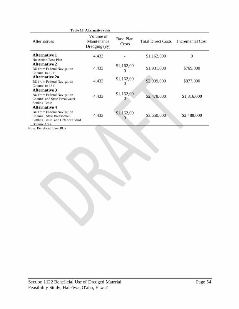
Section 1122 Beneficial Use of Dredged Material Page 54
Feasibility Study, Haleʻiwa, Oʻahu, Hawai i̒
Table 18. Alternative costs
Alternatives
Volume of
Maintenance
Dredging (cy)
Base Plan
Costs Total Direct Costs Incremental Cost
Alternative 1 No Action/Base Plan
4,433 - $1,162,000 0
Alternative 2 BU from Federal Navigation
Channel to 12 ft 4,433
$1,162,00
0 $1,931,000 $769,000
Alternative 2a BU from Federal Navigation
Channel to 13 ft 4,433
$1,162,000
$2,039,000 $877,000
Alternative 3 BU from Federal Navigation
Channel and State Breakwater
Settling Basin
4,433 $1,162,00
0 $2,478,000 $1,316,000
Alternative 4 BU from Federal Navigation
Channel, State Breakwater
Settling Basin, and Offshore Sand
Borrow Area
4,433 $1,162,00
0 $3,650,000 $2,488,000
Note: Beneficial Use (BU)
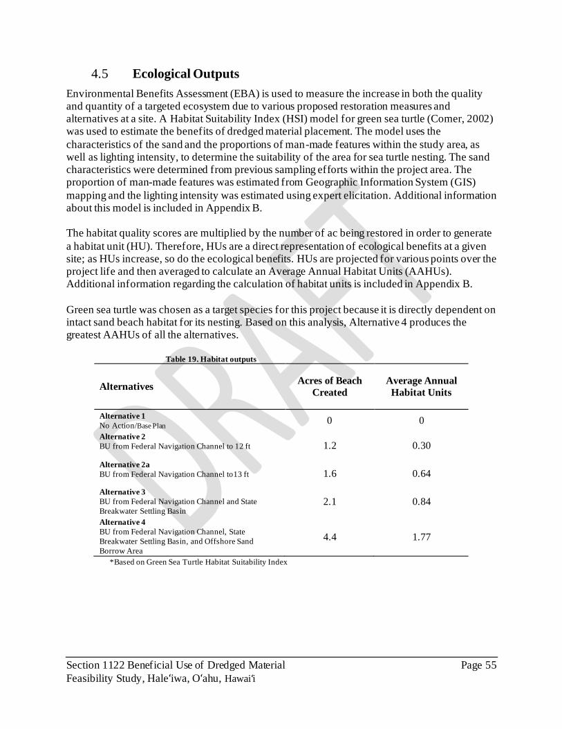
Section 1122 Beneficial Use of Dredged Material Page 55
Feasibility Study, Haleʻiwa, Oʻahu, Hawai i̒
4.5 Ecological Outputs
Environmental Benefits Assessment (EBA) is used to measure the increase in both the quality and quantity of a targeted ecosystem due to various proposed restoration measures and alternatives at a site. A Habitat Suitability Index (HSI) model for green sea turtle (Comer, 2002) was used to estimate the benefits of dredged material placement. The model uses the
characteristics of the sand and the proportions of man-made features within the study area, as well as lighting intensity, to determine the suitability of the area for sea turtle nesting. The sand characteristics were determined from previous sampling efforts within the project area. The proportion of man-made features was estimated from Geographic Information System (GIS)
mapping and the lighting intensity was estimated using expert elicitation. Additional information about this model is included in Appendix B. The habitat quality scores are multiplied by the number of ac being restored in order to generate
a habitat unit (HU). Therefore, HUs are a direct representation of ecological benefits at a given site; as HUs increase, so do the ecological benefits. HUs are projected for various points over the project life and then averaged to calculate an Average Annual Habitat Units (AAHUs). Additional information regarding the calculation of habitat units is included in Appendix B.
Green sea turtle was chosen as a target species for this project because it is directly dependent on intact sand beach habitat for its nesting. Based on this analysis, Alternative 4 produces the greatest AAHUs of all the alternatives.
Table 19. Habitat outputs
Alternatives Acres of Beach
Created
Average Annual
Habitat Units
Alternative 1
No Action/Base Plan 0 0
Alternative 2
BU from Federal Navigation Channel to 12 ft 1.2 0.30
Alternative 2a
BU from Federal Navigation Channel to13 ft 1.6 0.64
Alternative 3
BU from Federal Navigation Channel and State
Breakwater Settling Basin 2.1 0.84
Alternative 4
BU from Federal Navigation Channel, State
Breakwater Settling Basin, and Offshore Sand
Borrow Area
4.4 1.77
*Based on Green Sea Turtle Habitat Suitability Index

Section 1122 Beneficial Use of Dredged Material Page 56
Feasibility Study, Haleʻiwa, Oʻahu, Hawai i̒
4.6 Economic Benefits
The economic benefits were determined through the calculation of NED benefits of each alternative that were then compared against the incremental costs (i.e. costs in excess of the Base Plan) of each alternative to calculate the Benefit-Cost Ratio (BCR) for each alternative. NED benefits include benefits from navigation, recreation, and coastal storm reduction measures
annualized across the 50-year study duration. NED costs include mobilization/demobilization and dredging costs for each alternative, as well as interest during construction and annual O&M costs associated with the project. Detailed information about the economics evaluation are included in Appendix C.
Net NED benefits are calculated as average annual benefits less average annual costs, while the BCR is the ratio of average annual benefits to average annual costs. A BCR greater than one indicates a project is economically justified.
The expected (most likely) average annual benefits and average annual costs for each alternative are presented in Table 20. Since each alternative produces a BCR greater than one, all alternatives are economically justified. Alternative 4 is the plan that provides the greatest net
benefits. Due to the high value of recreation benefits associated with these alternatives additional BCRs were calculated for each alternative with recreation benefits removed from the calculation as
shown in (Table 20). According to Section 3.7 b (7) of the Planning Guidance Notebook, budget policy generally precludes using Civil Works resources to implement recreation-oriented projects in the Civil Works program. An exception is where a project is formulated for other primary purposes and average annual recreation benefits are less than 50% of the average annual benefits
required for justification (i.e. the recreation benefits that are required for justification are less than an amount equal to 50 percent of project costs).Since each alternative produces a BCR greater than 0.51 without recreational benefits, all alternatives are compliant with budgeting policy and Alternative 4 remains the plan that provides the greatest NED benefits.
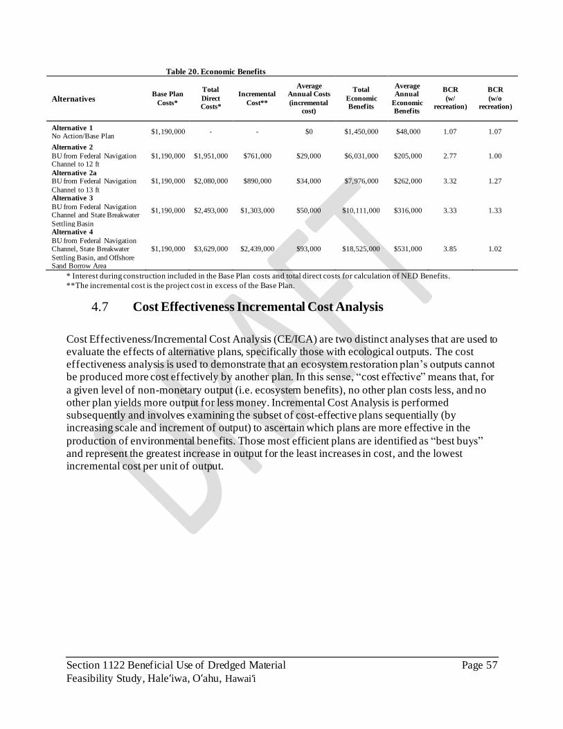
Section 1122 Beneficial Use of Dredged Material Page 57
Feasibility Study, Haleʻiwa, Oʻahu, Hawai i̒
Table 20. Economic Benefits
Alternatives Base Plan
Costs*
Total
Direct Costs*
Incremental
Cost**
Average Annual Costs
(incremental cost)
Total
Economic Benefits
Average Annual
Economic Benefits
BCR
(w/ recreation)
BCR
(w/o recreation)
Alternative 1 No Action/Base Plan
$1,190,000 - - $0 $1,450,000 $48,000 1.07 1.07
Alternative 2
BU from Federal Navigation Channel to 12 ft
$1,190,000 $1,951,000 $761,000 $29,000 $6,031,000 $205,000 2.77 1.00
Alternative 2a BU from Federal Navigation
Channel to 13 ft
$1,190,000 $2,080,000 $890,000 $34,000 $7,976,000 $262,000 3.32 1.27
Alternative 3
BU from Federal Navigation Channel and State Breakwater
Settling Basin
$1,190,000 $2,493,000 $1,303,000 $50,000 $10,111,000 $316,000 3.33 1.33
Alternative 4
BU from Federal Navigation Channel, State Breakwater
Settling Basin, and Offshore Sand Borrow Area
$1,190,000 $3,629,000 $2,439,000 $93,000 $18,525,000 $531,000 3.85 1.02
* Interest during construction included in the Base Plan costs and total direct costs for calculation of NED Benefits.
**The incremental cost is the project cost in excess of the Base Plan.
4.7 Cost Effectiveness Incremental Cost Analysis
Cost Effectiveness/Incremental Cost Analysis (CE/ICA) are two distinct analyses that are used to evaluate the effects of alternative plans, specifically those with ecological outputs. The cost effectiveness analysis is used to demonstrate that an ecosystem restoration plan’s outputs cannot be produced more cost effectively by another plan. In this sense, “cost effective” means that, for
a given level of non-monetary output (i.e. ecosystem benefits), no other plan costs less, and no other plan yields more output for less money. Incremental Cost Analysis is performed subsequently and involves examining the subset of cost-effective plans sequentially (by increasing scale and increment of output) to ascertain which plans are more effective in the
production of environmental benefits. Those most efficient plans are identified as “best buys” and represent the greatest increase in output for the least increases in cost, and the lowest incremental cost per unit of output.

Section 1122 Beneficial Use of Dredged Material Page 58
Feasibility Study, Haleʻiwa, Oʻahu, Hawai i̒
Table 21. Cost Effectiveness and Incremental Cost Analysis
Alternatives
Average
Annual
Habitat
Units
(AAHUs)
Incremental
increase in
AAHUs*
Average
Annual
Cost
(AAC)
Incremental
increase in
AAC*
Cost/AAHU Incremental
cost/AAHU*
Cost
Effective
Alternative 1
No Action/Base Plan 0 0 - - - - Best Buy
Alternative 2
BU from Federal
Navigation Channel to 12 ft
0.30 0.30 $29,000 $29,000 $96,666 $96,666 Cost
Effective
Alternative 2a
BU from Federal
Navigation Channel to13 ft
0..64 0.34 $34,000 $5,000 $53,125 $14,706 Cost
Effective
Alternative 3
BU from Federal
Navigation Channel and
State Breakwater Settling
Basin
0..84 0.2 $50,000 $16,000 $59,523 $80,000 Cost
Effective
Alternative 4 BU from Federal
Navigation Channel, State
Breakwater Settling Basin,
and Offshore Sand Borrow
Area
1.77 0.93 $93,000 $43,000 $52,542 $46,236 Best Buy
*Incremental Net AAHU’s and AAC’s represent the incremental increase in cost/AAHU from the previous cost-effective
alternative.
Cost effectiveness/Incremental Cost Analysis indicates that Alternative 4 and Alternative 1 are
“best buy” plans. While the no action plan and the plan that provides the greatest outputs are
always considered “best buy” plans, Alternative 4 provides the lowest cost/unit of all the
alternatives (

Section 1122 Beneficial Use of Dredged Material Page 59
Feasibility Study, Haleʻiwa, Oʻahu, Hawai i̒
Table 21). This is visualized by graphing cost per unit and considering the slope of a line drawn from the origin to the alternatives; the Alternative 4 point would have a lower slope than all other alternatives Figure 24. The incremental analysis boxplot was not included because Alternative 4
is the only “best buy” besides the no action alternative. However, as described above, Alternative 4 has a lower cost per unit than the other alternatives; so, the incremental cost increase needed to achieve the level of output is justified by the lower cost/unit.
Figure 24. Cost versus outputs graphs
4.8 Evaluation of Alternatives
All USACE water resources development projects must be evaluated in terms of acceptability;
completeness; effectiveness; and efficiency. Ecosystem restoration alternatives are also evaluated based on CE/ICA of the possible restoration alternatives and significance of ecosystem outputs. Generally, projects must be formulated to reasonably maximize benefits to the national economy,
to the environment, or to the sum of both. Each alternative plan shall be formulated in consideration of criteria described in the Economic and Environmental Principles and Guidelines for Water and Related Land Resources Implementation Studies (P&G):
• Completeness – Completeness is the extent to which the alternative plans provide and
account for all necessary investments or other actions to ensure the realization of the planning objectives, including actions by other federal and non-federal entities. For this project, a complete alternative must account for all O&M dredging needs and provide for beneficial uses of dredged material.
• Effectiveness – Effectiveness is the extent to which the alternative plans contribute to achieve the planning objectives. For this project, effectiveness relates to the provision of habitat units and economic benefits produced through the project alternatives.
Alt 2 Alt 2a
Alt 4
Alt 3

Section 1122 Beneficial Use of Dredged Material Page 60
Feasibility Study, Haleʻiwa, Oʻahu, Hawai i̒
• Efficiency – Efficiency is the extent to which an alternative plan is the most cost-effective means of achieving the objectives. For this project, efficiency is determined
through the CE/ICA process.
• Acceptability – Acceptability is the extent to which the alternative plans are acceptable in terms of applicable laws, regulations, and public policies.
The project alternatives have been compared based on the criteria of completeness, effectiveness, efficiency and acceptability (Table 22). Alternatives 2 through 4 all fully achieve the completeness criteria. Alternative 4 is most effective at delivering project outputs as it provides the greatest ecological and economic benefits. Alternative 4 is the most efficient plan, as it is a
“best buy”, meaning that it represented the greatest increase in output for the cost. Comparatively, Alternative 4 provides much greater outputs than Alternatives 2 or 3, and is more efficient than Alternative 3 because it has lower incremental cost per unit. Alternative 4 also provides the greatest economic benefit at a BCR of 3.85.
Table 22. Alternative comparison criteria
Alternatives Completeness Effectiveness Efficiency Acceptability
Alternative 1 No Action/Base Plan
No No Yes Yes
Alternative 2 BU from Federal
Navigation Channel to 12 ft
Yes. This Alternative would fully achieve
goals for ecosystem restoration, coastal
storm damage reduction, and
beneficial use
Yes. This alternative
provides significant ecological benefits,
but to a lesser extent than Alternative 4
Yes, This is a cost effective plan
Yes. This project is
supported by the NFS and is
anticipated to have public support.
Alternative 2a
BU from Federal Navigation Channel
to13 ft
Yes. This Alternative
would fully achieve goals for ecosystem
restoration, coastal storm damage
reduction, and beneficial use.
Yes. This alternative provides significant
ecological benefits, but to a lesser extent
than Alternative 4
Yes, This is a cost effective plan
Yes. This project is supported by the
NFS and is anticipated to have
public support.
Alternative 3
BU from Federal Navigation Channel and
State Breakwater Settling Basin
Yes. This Alternative would fully achieve
goals for ecosystem restoration, coastal
storm damage reduction, and
beneficial use.
Yes. This alternative
provides significant ecological benefits,
but to a lesser extent than Alternative 4
Yes, This is a cost effective plan
Yes. This project is
supported by the NFS and is
anticipated to have public support.
Alternative 4 BU from Federal
Navigation Channel, State Breakwater
Settling Basin, and Offshore Sand Borrow
Area
Yes. This Alternative
would fully achieve goals for ecosystem
restoration, coastal storm damage
reduction, and beneficial use.
Yes. This alternative delivers the greatest
NER and NED benefits.
Yes. This plan is determined to be
cost effective and has a BCR of 3.85.
Yes. This project is supported by the
NFS and is anticipated to have
public support.

Section 1122 Beneficial Use of Dredged Material Page 61
Feasibility Study, Haleʻiwa, Oʻahu, Hawai i̒
4.9 Plan Selection
Based on the plan evaluation and comparison process detailed above, Alternative 4 was selected as the Recommended Plan as it maximized both ecological and economic benefits, it represents the combined NER/NED plan.

Section 1122 Beneficial Use of Dredged Material Page 62
Feasibility Study, Haleʻiwa, Oʻahu, Hawai i̒
5.0 RECOMMENDED PLAN
5.1 Plan Description
The Recommended Plan is Alternative 4: Beneficial Use from the Federal Navigation Channel to 13 ft, Settling Basin, and the Offshore Sand Borrow Area. This plan involves BUDM for the purposes of restoring aquatic habitat and reducing storm damage to property and infrastructure.
Dredged material will be obtained from the HSBH Federal Navigation Channel, the State Breakwater Settling Basin that is part of the HSBH, and an Offshore Sand Borrow Area (Figure 25). The beach suitable dredged material from these locations will be used to nourish the beach that is part of the federally authorized HBSPP. Dredging from these locations will yield
approximately 26,071 cy of beach suitable sand and will be used to restore 4.4 ac of beach. The fine-grained dredged material from the Federal Navigation Channel that is not suitable for beach
restoration, approximately 2,000 cy, will be transported by scow and taken to the south Oʻahu ODMDS. This beach is part of the federally authorized project, and nourishment with dredged material will
help restore the beach to its original extent. This will produce both NER and NED benefits in the form of restored habitat for the green sea turtle, recreational benefits, and storm damage reduction benefits.
All dredging will be completed by using a clam shell dredge to excavate material from the proposed areas and load scows for transportation to the HBSPP. The scows will be unloaded directly to the beach at the HBSPP. Scows will use a barge access zone, excavated as part of this project, to move adjacent to the HBSPP for unloading. The dredged material will be unloaded
directly onto the beach and is not anticipated to require dewatering. The beach sand would be graded to a typical cross section.
5.1.1 Plan Components
The Recommended Plan contains six major components, which are listed below.
O&M Navigation Channel Dredging – Dredging of the Federal Navigation Channel to twelve ft (12 ft) depth to meet O&M requirements. This dredging will produce approximately 4,433 cy of sediment. Approximately 2,433 cy is anticipated to be beach suitable and will be transported
to the HBSPP for beach restoration. The remaining 2,000 cy will be transported to the south Oʻahu ODMDS for open-water placement.
Barge Access Zone – A Barge Access Zone will be excavated near the southern groin at the HBSPP to allow for efficient transport and unloading of dredged material to the HBSPP. The Barge Access Zone will be excavated to a depth of ten ft (10’) below MLLW perpendicular to the south groin of the HBSPP. Scows will use this Barge Access Zone to move adjacent to the
HBSPP for unloading. Excavation of the Barge Access Zone is anticipated to produce 4,733 cy of beach suitable sand that will be used for beach restoration at the HBSPP. The Barge Access

Section 1122 Beneficial Use of Dredged Material Page 63
Feasibility Study, Haleʻiwa, Oʻahu, Hawai i̒
Zone is necessary as part of the least cost placement method as evaluated according to EM 1110-2-5025.
Additional Navigation Channel Deepening – The seaward portion of the Federal Navigation Channel with sandy substrate will be dredged by an additional foot, to thirteen ft (13 ft) depth. This will produce an additional 1,705 cy of beach suitable sand that will be used for beach restoration at the HBSPP.
State Breakwater Settling Basin – A 0.3 ac area adjacent to, but outside of, the Federal Navigation Channel will be excavated to a depth of eight ft (8’) below MLLW to create the State Breakwater Settling Basin. Dredging of this area is anticipated to produce 2,200 cy of beach
quality sand that will be used for beach restoration at the HBSPP. Offshore Sand Borrow Area – An Offshore Sand Borrow Area will be dredged to provide additional beach suitable sand for beach restoration. This 16.5 ac Offshore Sand Borrow area is
outside of HSBH and the Federal Navigation Channel; and is located 3,400 ft offshore at a depth of 60 ft. This area will function as a borrow area for the procurement of approximately 15,000 cy of beach suitable sand. The dredging of sand from this area and placement at the HBSPP would require the use of a barge-mounted crane and clamshell dredge. The sand would be dewatered
during excavation using an environmental clamshell bucket, placed on a scow, and barged to the access channel where it would be mechanically placed on the beach. Beneficial-Use of Dredged Material – Beach suitable sand dredged from the Federal
Navigation Channel, State Breakwater Settling Basin, and the Offshore Sand Borrow Area will be transported to the HBSPP for beach restoration. Beach restoration is anticipated to restore an aquatic ecosystem, reduce storm damage to public property and infrastructure, and also promote recreation.
It is anticipated that this beneficial-use project would be constructed in FY23 (calendar year 2024). This coincides with the existing FY22 request for design funds to develop plans and specification for maintenance dredging of the harbor, and the planned request for maintenance
dredging construction funds in the FY23 budget. Section 1122 funds for the incremental costs of design and construction would need to be received on a concurrent FY22/FY23 schedule with maintenance dredging (O&M) funds.

Section 1122 Beneficial Use of Dredged Material Page 64
Feasibility Study, Haleʻiwa, Oʻahu, Hawai i̒
Figure 25. Recommended Plan components.

Section 1122 Beneficial Use of Dredged Material Page 65
Feasibility Study, Haleʻiwa, Oʻahu, Hawai i̒
5.2 Detailed Cost Estimate of the Recommended Plan
Based on FY20 price levels, the estimated project first cost is $3,068,000 (Table 23). This represents the incremental cost over the Base Plan cost. The fully funded total project cost, escalated to the estimated midpoint of construction (2024), is $3,261,000.
Table 23. Total project cost of the Recommended Plan
ITEM
Project First Cost (FY20 Price
Level)
Total Project Cost-Fully Funded
Construction (Total Project) $3,650 $3,890
Base Plan Cost ($1,162) ($1,239)
Preconstruction, Engineering and Design
(PED) $100 $101
Construction Supervision and
Administration (S&A) $300 $327
Additional PED and S&A (non-federal)* $150 $152
Lands, Easements, Rights-of-way,
Relocations and Disposals $0 $0
Monitoring $30 $30
Total Project Cost (1000s) $3,068 $3,261
* Project Cost represents the incremental cost over the Base Plan for O&M
* Additional PED and S&A associated with the non-federal project components (State Breakwater Settling Basin
and Offshore Sand Borrow Area), this includes environmental compliance, sediment sampling, hydrographic
surveys, development of plans and specifications, and administration during construction. These components are 100% non-federally funded.
5.3 Summary of Significance
5.3.1 Institutional Significance
Institutional significance represents the importance of the project outputs to federal, state, regional, local, and Tribal governments or private entities. Sources of institutional recognition include laws, EOs, rules and regulations, treaties, policy statements, ordinances, planning documents, resolutions and other policy statements of entities with jurisdiction in the study area.
The State of Hawaiʻi DLNR’s Coastal Erosion Management Plan (COEMAP, 2013) proposes several goals and recommendations that are consistent with the purpose of this project. This plan
identifies the Coastal Lands Program at DLNR as the lead agency for coastal erosion management and beach conservation. The Coastal Lands Program supports restoration of beach and dune ecosystems and encourages landowners to consider beach restoration over hard shoreline armoring. A goal of the Coastal Lands Program, as stated in the COEMAP, is to
implement beach and dune restoration with sand nourishment as a viable management option in
Hawaiʻi and to streamline and coordinate the permitting necessary to achieve this goal and improve interagency coordination and coordination. A recommendation of the COEMAP is to enhance interagency coordination to improve and standardize the permitting process for coastal restoration and to plan for beach nourishment as part of restoration solutions.

Section 1122 Beneficial Use of Dredged Material Page 66
Feasibility Study, Haleʻiwa, Oʻahu, Hawai i̒
This project demonstrates institutional significance because it is consistent with the goals and recommendations for beach restoration and shoreline management as described in the COEMAP
(2013) and pursued by the State of Hawaiʻi DLNR. Furthermore, HBP was a federally authorized beach restoration project and a historically important site that was added to the State Register of
Historic Places on June 9, 1988.
5.3.1 Public Significance
Public significance represents the importance of the project to some segment of the general
public. The north shore of Hawaiʻi is a popular location for tourism, attracting more than half of the State’s seven million visitors annually (Hawaii.com, 2020). Local life and tourism are largely supported by the beaches located in this area.
As described in the COEMAP (2013): “Beach loss incurs costs to all aspects Hawaiian life. The local populace of Hawaiʻi throngs to the beaches for the enjoyment of open access, socializing, exercise, being
along, and being together. The beaches are among the principle reasons many Hawaiians call these islands home. Tourism in the state is closely tied to the quality of Hawaiian beaches. As visitors find access difficult to shorelines lined by seawalls and crowded with development, they come to realize that our beaches are degraded, that coastal vistas are
no longer pristine, and the fulfilling opportunities to experience the Hawaiian shore depicted by the visitor industry are rare. Beaches are critical component of the tourism infrastructure, like all infrastructure they must be maintained.”
In 1997, the visitor economy provided 171,900 jobs in the State, accounted for $13 billion in tourism expenditures and supported a payroll of $3.5 billion (COEMAP, 2013). However, beach
loss can have serious impacts to the visitor economy of Hawaiʻi. Beach narrowing and loss, and shoreline hardening, severely restricts public access to State of Hawaiʻi conservation land and natural resources. Public access to beaches and the ocean is a right that is preserved by the State
of Hawaiʻi constitution. Beach loss and narrowing, and coastal dune grading that accompanies coastal development causes environmental and ecological damage to natural resources and habitats. Coastal hardening can also produce coastal water quality impacts through increased
turbulence and turbidity.
Haleʻiwa Beach Park supports recreational uses and provides access to the ocean. It is used by surfers, kayakers, sunbathers and for a variety of other aquatic recreational uses. In addition to beach access, HBP provides multiple amenities to visitors including play fields and a comfort station. The comfort station was closed in 2019 due to damages resulting from wave energy. The
City and County of Honolulu completed repairs of this seawall in 2020 and have expressed interest and support for beach nourishment for HBP. The North Shore Sustainable Communities Plan (City and County of Honolulu, 2010) specifically recommends pursuing management actions consistent with the Recommended Plan and includes the following guideline for coastal
land use: “Place sand from channel, stream, and harbor mouth dredging projects on local beaches
in accordance with Hawaiʻi Revised Statutes Chapter 205A.”

Section 1122 Beneficial Use of Dredged Material Page 67
Feasibility Study, Haleʻiwa, Oʻahu, Hawai i̒
HBP was a federally authorized beach restoration project. Additionally, HBP is a historically important site that was added to the State Register of Historic Places on June 9, 1988.
5.3.1 Technical Significance
Significance based on technical recognition means that the resource qualifies as significant based on its technical merits, which are based on scientific knowledge, judgment or critical resource characteristics. Technical significance should be described in terms of one or more of the
following criteria: scarcity, representativeness, status trends, connectivity, limiting habitat, and biodiversity. Scarcity - The Hawaiian Islands are the most isolated archipelago in the world, situated in the
middle of the Pacific Ocean more than 3,200 kilometers (2,000 miles) from the nearest continent.
Due to its extreme isolation and climactic conditions, Hawaiʻi is characterized by high levels of endemism in both its native animals and plants, with over 10,000 species found nowhere else on earth (DLNR, 2010). Although comprising less than 0.2% of the land area of the United States (U.S.), the Hawaiian Islands hold more than 30% of the nation’s federally listed species, including 317 taxa of plants and animals listed by the USFWS as endangered or threatened, 12
taxa proposed as endangered and 105 taxa as candidates for listing. Unique and varied habitats are also found across the islands. This project is anticipated to benefit green sea turtles, a state and federal threatened species.
Representativeness – Based on the habitat model presented Section 4.5 , beach restoration at the HBSPP will create beach habitat that is representative of other beach habitat in the area and support use by green sea turtles.
Status and Trends - The Hawaiʻi DLNR, COEMAP (2013), describes impacts of beach loss
across Hawaiʻi. Chronic coastal erosion resulting from shoreline hardening has caused 10.7 miles
of beach narrowing and 6.4 miles of beach lost on Oʻahu. This equates to approximately 24% of Oʻahu’s original sandy shoreline. This results in environmental and ecological impacts as beaches are important habitat for seabirds, turtles, seals, and other animals and plants.
The National Assessment of Shoreline Change – Historical Shoreline Change in the Hawaiian Islands (USGS, 2011) found that HBP had the highest rate of beach erosion on the North Shore
of Oʻahu. Furthermore, SLR will reduce habitat for nesting seabirds, native passerines, monk seals, and sea turtles, and alter coastal habitats throughout Hawaiʻi (DLNR, 2016). Beach restoration, as proposed by the Recommended Plan, will help to mitigate these trends and replace
habitat that was previously lost.
Connectivity – Oʻahu is part of an archipelago that makes up the Hawaiian Islands. As a series of separate land bodies, the Hawaiian Islands are inherently dependent on the connectivity between the habitats at these various islands.

Section 1122 Beneficial Use of Dredged Material Page 68
Feasibility Study, Haleʻiwa, Oʻahu, Hawai i̒
Limiting Habitat – Beach habitat in the Hawaiian Islands is especially important to Hawaiian monk seals and green sea turtles. This type of habitat is at risk of alteration or loss as SLR-induced flooding becomes more frequent and beach erosion worsens.
Biodiversity - Mature islands, such as Oʻahu and Kauaʻi in the Main Hawaiian Islands (MHI) and Nihoa and Necker in the Northwestern Hawaiian Islands (NWHI) are the most diverse, with habitat types ranging from estuaries and sandy beaches to rocky beaches and fringing and barrier reefs to lagoons with patch or pinnacle reefs. Although thousands of Hawaiian species have yet to be described, the estimated number of native species is thought to include more than 14,000
terrestrial, 100 freshwater, and 6,500 marine taxa. For more than 70 million years, the evolution of new species vastly exceeded losses to extinction. Marine species in Hawaiʻi include over 1,200 species of fishes, with around 500 species adapted
to live on coral reefs, and the rest adapted to the pelagic open surface waters, mesopelagic or bathypelagic zones (middle or deep waters), estuaries, or sandy bottoms. At the top of the food chain are the apex predators such as the many sharks and large predatory reef and pelagic fishes of Hawaiʻi. Over 5,000 marine invertebrates are known from Hawaiʻi and include over 100 species
of hard, soft, and precious corals as well as hundreds of types of snails, crabs, shrimps and small numbers of worms, jellyfish, sponges, starfish, and tunicates. Five marine turtles occur in Hawaiʻi; two are common residents that nest on Hawaiʻi’s beaches and three others are more occasional visitors. All sea turtles are listed as threatened or endangered under the ESA.
Approximately 26 species of marine mammals, mostly cetaceans, are considered resident or occasional visitors to Hawaiʻi. These include the humpback whale, which migrates during the winter months to Hawaiian waters to breed and give birth each year before returning to feed in Alaskan waters during spring and summer, false killer whale, and the spinner dolphin and
bottlenose dolphin. Humpback whales, false killer whales, and Hawaiian monk seals are common marine mammals in Hawaiʻi and are listed as endangered under the ESA. All marine mammals are protected by the Marine Mammal Protection Act.
5.4 Residual Risk
Implementation of the Recommended Plan will not eliminate beach erosion or risks associated
with storm damage to infrastructure at HBP. It is anticipated that, based on projected erosion rates, the placed beach sand would persist for 26 years.
5.5 Integration of Environmental Operating Principles
The following environmental operating principles were integrated into the planning process:
Foster sustainability as a way of life throughout the organization: This project contributes to a more sustainable coastal ecosystem.
Proactively consider environmental consequences of all USACE activities and act
accordingly: Environmental consequences were considered throughout the planning process and every effort was made to avoid, minimize, or mitigate all anticipated impacts. Construction of

Section 1122 Beneficial Use of Dredged Material Page 69
Feasibility Study, Haleʻiwa, Oʻahu, Hawai i̒
the Recommended Plan would improve the beach habitat of HBP. It is not anticipated that there will be some impacts to historical/archeological resources.
Create mutually supporting economic and environmentally sustainable solutions: The Recommended Plan is the NED/NER plan. Therefore, it provides the maximum amount of benefits to the nation and increases the net quality and quantity of desired ecosystems resources. The project was formulated in a way that makes it sustainable, requiring very little in
maintenance, and avoids long-term environmental impacts wherever possible. Continue to meet our corporate responsibility and accountability under the law for
activities undertaken by USACE, which may impact human and natural environments: A
full EA was conducted as required by the NEPA. In addition, the principles of avoidance, minimization, and mitigation were enacted to the extent possible. Consider the environment in employing a risk management and systems approach
throughout the life cycles of projects and programs: For this study, a systems approach was utilized to examine the interaction between coastal processes and the proposed habitat restoration.
Leverage scientific, economic and social knowledge to understand the environmental
context and effects of USACE actions in a collaborative manner: The USACE worked closely with the non-federal partner throughout this study. The NFS has an abundance of institutional knowledge about the environment surrounding the stream.
Employ an open, transparent process that respects the views of individuals and groups
interested in USACE activities: USACE made every effort to be responsive to stakeholder concerns. Public input was solicited and used for both environmental and economic analysis
purposes.
5.6 Summary of Accounts
5.6.1 National Economic Development
The Recommended Plan is the NED plan and provides the greatest amount of net annual benefits to the nation.
5.6.2 Regional Economic Development
Economic benefits that accrue to the region, but not necessarily the nation, include increased visitation and tourism to the beach and amenities at HBP.
5.6.3 Environmental Quality
The Recommended Plan is the NER plan and provides the greatest increase for the investment of
net quality and quantity of desired ecosystems resources.

Section 1122 Beneficial Use of Dredged Material Page 70
Feasibility Study, Haleʻiwa, Oʻahu, Hawai i̒
5.6.4 Other Social Effects
The project contributes to the human environment by improving the beach at HBP, a publicly accessible area that is used for recreation. It provides a benefit to the local population as well as visitors to the area.

Section 1122 Beneficial Use of Dredged Material Page 71
Feasibility Study, Haleʻiwa, Oʻahu, Hawai i̒
6.0 ENVIRONMENTAL IMPACTS
This chapter provides an overview of anticipated environmental impacts. The environmental consequences of the various alternatives were evaluated in comparison to the No Action
Alternative. While this consequence analysis focuses on the Recommended Plan, the impacts of the other alternatives are similar to the Recommended Plan unless otherwise noted. For the full EA, see Appendix B which provides further detail regarding the existing conditions, the Future Without Project Condition, and discussion of environmental impacts of the array of alternatives.
6.1 Physical Environment
6.1.1 Water Quality
6.1.1.1 No Action Plan There is not expected to be any significant change in water quality under the No Action Plan.
6.1.1.2 Recommended Plan Temporary impacts to water quality will be expected from the construction of the Recommended
Plan due to turbidity resulting from dredging and placement activities. The turbidity effects are expected to be temporary, limited to the duration of construction, and less than significant. At this time, USACE lacks the project-specific detail necessary to characterize and evaluate the proposed discharge of dredged material into navigable waters of the U.S. under Section 404 of
the Clean Water Act. Obtaining a Water Quality Certification pursuant to Section 401 of the Clean Water Act from the State during the feasibility phase is not practicable. The USACE will coordinate this project with the State Department of Health Clean Water Branch and confirm USACE’s intent to apply for and obtain a Section 401 WQC prior to construction. A 404 (b) 1
Short Form Evaluation is included in Appendix B.
6.1.2 Air Quality
6.1.2.1 No Action Plan The No Action Plan would have no effect on the air quality of the region. The region would continue to remain in attainment with EPA National Air Attainment Quality Standards.
6.1.2.2 Recommended Plan Air quality may be affected during the construction period due to resultant suspended
particulates from equipment movement and material excavation and placement, as well as emissions from equipment. Any degraded air quality conditions that may be caused by the project are believed to be transient, highly localized, and likely to entirely dissipate at the end of the construction phase. The USACE and its contractors will comply with all applicable air
quality regulations and policies of the landowner, local authorities, and the state and federal governments. Impacts to air quality are expected to be less than significant.
6.1.3 Aesthetic Quality
6.1.3.1 No Action Plan The project area will continue to be recreational in nature.

Section 1122 Beneficial Use of Dredged Material Page 72
Feasibility Study, Haleʻiwa, Oʻahu, Hawai i̒
6.1.3.2 Recommended Plan Aesthetic quality is expected to be improved after construction is complete. Most of the project will be located on recreational lands that are open to the general public. The changes in
aesthetics for the general public will be immediately noticeable on Haleʻiwa Beach due to an increased size of the beach and will be visible to passersby. Effects to aesthetics are expected to be less than significant.
6.1.4 Noise
6.1.4.1 No Action Plan Existing activities will continue to generate a wide variety of noise.
6.1.4.2 Recommended Plan There is no expected adverse change in noise after construction. During construction, any
adverse change in noise is expected to be less than significant.
6.1.5 Human Activity
6.1.5.1 No Action Plan Human activity will continue at current levels into the foreseeable future.
6.1.5.2 Recommended Plan There is not expected to be any significant change in human activity in the project area as a result of construction of this project.
6.2 Biological Resources
6.2.1 Terrestrial Habitat
6.2.1.1 No Action Plan There is not expected to be any significant change in terrestrial habitat under the No Action Plan, as no future development projects are proposed for the area.
6.2.1.2 Recommended Plan There will be a minor impact to some terrestrial habitat due to the construction of the project features. The impacts to terrestrial habitat will result from the deposition of dredged material to
increase the beach area at Haleʻiwa. Any impacts to terrestrial habitat are expected to be less than significant.
6.2.2 Federal and State Threatened and Endangered Species
6.2.2.1 No Action Plan There are not any significant changes expected in either the presence or habitat of listed species under the No Action Plan.
6.2.2.2 Recommended Plan The Recommended Plan may affect, but is not likely adversely affect the hawksbill sea turtle, the
green sea turtle, and the Hawaiian monk seal and its designated critical habitat through the

Section 1122 Beneficial Use of Dredged Material Page 73
Feasibility Study, Haleʻiwa, Oʻahu, Hawai i̒
dredging of material and placement in the nearshore habitat. The Recommended Plan is expected to have no negative effect on any other threatened or endangered species, but is anticipated to have positive impacts on green sea turtles by restoring beach habitat that can be used for
spawning.
6.2.3 Fishery Resources and Essential Fish Habitat
6.2.3.1 No Action Plan The No Action Plan will have no effect on fishery resources and essential fish habitat.
6.2.3.2 Recommended Plan The Recommended Plan will have no effect on fishery resources and essential fish habitat.
6.3 Coastal Zone Resource Management
The State of Hawaiʻi Office of Planning is responsible for ensuring natural resources are managed and protected under the Coastal Zone Management Act (CZMA). The actions of the four alternatives are consistent with the CZMA and Hawaiʻi’s Ocean Research Management Plan (ORMP). In particular, they are consistent with Appropriate Coastal Development, Marine
Resources, Coral Reef, and Community and Place-based Ocean Management Projects.
6.4 Historical and Archaeological Resources
There are expected to be no adverse impacts to cultural resources under the Recommended Plan. Since there will be no significant ground-disturbing activities, any potential coastal archaeological sites (none have been documented in the study area) would not be impacted. Due
to the replenishment of sand along the shoreline, there may be beneficial effects due to a reduction in erosional threat under the Recommended Plan. The Recommended Plan will not impact the architectural components of the Art Deco Parks historic district (SIHP No. 50-80-04-1388) present at HBP.
6.5 Environmental Justice and Protection of Children
EO 12898, “Federal Actions to Address Environmental Justice in Minority Populations and Low-Income Populations”, requires federal agencies to identify and address any disproportionately high and adverse human health effects of its programs and activities on
minority and low-income populations. The study area does not have specific populations of disproportionately low income or minority populations identified within its boundaries. Therefore, the Recommended Plan would not be
expected to have an impact on low income or minority populations.
6.6 Cumulative and Long-term Impacts
Federal law (33 Code of Federal Regulations 230 et seq.) and Engineer Regulation 200-2-2, “Procedures for Implementing NEPA,” require that NEPA documents assess cumulative impacts, which are the impact on the environment resulting from the incremental impacts of the action
when added to other past, present, and reasonably foreseeable future actions. The Council on Environmental Quality regulations defines a cumulative impact as “the impact on the

Section 1122 Beneficial Use of Dredged Material Page 74
Feasibility Study, Haleʻiwa, Oʻahu, Hawai i̒
environment which results from the incremental impact of the action when added to other past, present, and reasonably future actions regardless of what agency (federal or non-federal) or person undertakes such other actions. Cumulative impacts can result from individually minor,
but collectively significant actions taking place over a period of time.” NEPA guidance (40 CFR 1508.25) identifies resources that would be considered in a cumulative impacts analysis that should be evaluated in an EIS or EA. For an action to have a cumulative
action on a resource, the action must have a direct or indirect effect on that resource, unless that resource is in declining or in a significantly impaired condition. Only one other project was found to be in effect in the project area that should be considered under the cumulative impact analysis. The City and County of Honolulu repaired the seawall along the beach in 2020 and
there are plans to repair the comfort station at Haleʻiwa Beach.
When taken in conjunction with the City and County of Honolulu’s project, the Recommended Plan would have a beneficial effect on recreation and the visual aesthetics of the project area. These two projects would provide for a long-term safer environment as the wider beach and reinforced wall would protect the area adjacent to the beach where visitors congregate and park.
6.7 Summary of Mitigation Measures
6.7.1 No Action Plan
There would be no mitigation measures associated with the No Action Plan.
6.7.2 Recommended Plan
Mitigation measures include avoidance, minimization, employment of best construction practices, and items included in any potential Programmatic Agreement or Memorandum of
Agreement developed with the State of Hawaiʻi regarding impacts to historical/archaeological resources.
6.8 Plan Selection
After thorough consideration of the environmental and economic effects of both the No Action
Plan and Tentatively Selected Plan (TSP), the TSP was identified as the Recommended Plan. Any adverse effects resulting from implementation of the Recommended Plan will be temporary and less than significant or fully mitigated.

Section 1122 Beneficial Use of Dredged Material Page 75
Feasibility Study, Haleʻiwa, Oʻahu, Hawai i̒
7.0 PUBLIC AND AGENCY INVOLVEMENT
This chapter provides an overview of efforts to engage the public and other agencies throughout the course of this study. The status of compliance with relevant laws and policies is shown in
Table 24.
7.1 Public/Scoping Meetings
While public feedback was solicited throughout the study process, a formal 30-day public review period will be conducted, starting December 8, 2020. Feedback from that review period will be incorporated into the study consistent with USACE policy.
7.2 Federal and State Agency Coordination
The project was presented to representatives of state and federal agencies on June 19, 2019. The
agencies included the Hawaiʻi State Department of Health, NMFS, USFWS, and USACE. During this day-long meeting, the potential physical and environmental effects and benefits of the project were discussed, and a conceptual model was mapped out. Several potential models were discussed, but the Comer (2002) green sea turtle model was the consensus for the model to
use with the most potential to effectively compare the alternatives.
7.2.1 Pre-Consultation Agency Coordination
The USACE met with USFWS, NMFS, State of Hawaii Department of Health and State of Hawaii CZM Office to present the initial scope of the study. The main concern was conversion
of existing nearshore intertidal habitat to terrestrial beach habitat and consequently concern regarding the longevity of benefits of the beach nourishment efforts to justify the habitat conversion. Additionally, USACE requested technical assistance from the Services regarding potential impacts to fish and wildlife resources, threatened and endangered species and EFH
within the project area in April, 2019. No response was received. A formal request for FWCA consultation was submitted to USFWS by USACE on August 27, 2019. A draft Fish and Wildlife Service Coordination Act Report (CAR) was provided to USACE on September 30, 2020 (Appendix B). The USACE will initiate consultation pursuant to Section 7 of the ESA and
the EFH provisions of the Magnuson Stevens Fishery Conservation and Management Act, as appropriate, prior to drafting the final report/NEPA document. The results of those future consultations will be included in Appendix B.
7.3 Status of Environmental Compliance (Compliance Table)
7.3.1 Relationship to Environmental Laws and Compliance
The following sections detail the status of compliance with project-applicable laws.
7.3.1.1 National Environmental Policy Act of 1969 (42 USC 4321 et seq.) The NEPA requires that environmental consequences and project alternatives be considered before a decision is made to implement a federal project. The NEPA established the requirements for preparation of an Environmental Impact Statement for projects potentially

Section 1122 Beneficial Use of Dredged Material Page 76
Feasibility Study, Haleʻiwa, Oʻahu, Hawai i̒
having significant environmental impacts and an EA for projects with no significant environmental impacts. This EA was prepared to address impacts and propose avoidance and minimization steps for the proposed project, as discussed in the Council on Environmental
Quality regulations on implementing NEPA (40 Code of Federal Regulations 1500 et seq.). This document presents sufficient information regarding the generic impacts of the proposed construction activities to guide future studies and is intended to satisfy all NEPA requirements.
In accordance with NEPA and USACE regulations and policies, the EA and unsigned Finding of No Significant Impact (FONSI) were released for public and agency review, and the EA was made available on the Honolulu District website to the interested public prior to the implementation of this proposed action.
7.3.1.2 CWA of 1972 (33 USC 1251 et seq.) The objective of the Federal Water Pollution Control Act of 1972, as amended by the CWA (PL 92-500, 33 U.S.C. 1251 et seq.), is to restore and maintain the chemical, physical, and biological integrity of the Nation's waters.
The USACE, under the direction of Congress, regulates the discharge of dredged and fill materials into waters of the U.S., including wetlands. The USACE does not issue itself permits for construction activities affecting waters of the U.S. but must meet the legal requirements of
the Act. At this time, USACE lacks the project-specific detail necessary to characterize and evaluate the proposed discharge of dredged material into navigable waters of the U.S. under Section 404 of
the Clean Water Act. Obtaining a Water Quality Certification pursuant to Section 401 of the Clean Water Act from the State during the feasibility phase is not practicable. The USACE will coordinate this project with the State Department of Health Clean Water Branch and confirm the USACE’s intent to apply for and obtain a Section 401 WQC prior to construction.
7.3.1.3 Rivers and Harbors Act of 1899 (33 USC 403 et seq.) Section 10 of the Rivers and Harbors Act of 1899 prohibits the obstruction or alteration of navigable waters of the U.S. without a permit from the USACE. Generally, navigable waters are those waters of the U.S. subject to the ebb and flow of the tide shoreward to the mean high water mark, and/or are presently used, or have been used in the past, or may be susceptible to use to
transport interstate or foreign commerce.
7.3.1.4 Endangered Species Act of 1973 (16 USC 1531 et seq.) The ESA protects threatened and endangered species by requiring federal agencies, in consultation with the USFWS and/or the NMFS, to ensure that actions they authorize, fund, or carry out are not likely to jeopardize the continued existence of any listed species or result in the
destruction or adverse modification of designated critical habitat of such species. The law also prohibits any action that causes a "taking" of any listed species of endangered fish or wildlife. The USACE has preliminarily determined that the proposed project may affect but is not likely
adversely affect the hawksbill and green sea turtle and the Hawaiian monk seal and would not adversely modify any marine critical habitat designated for the Hawaiian monk seal. The project

Section 1122 Beneficial Use of Dredged Material Page 77
Feasibility Study, Haleʻiwa, Oʻahu, Hawai i̒
is not expected to have an effect on any other federally listed threatened or endangered species or their critical habitat.
The USACE will prepare a biological evaluation to document the USACE’s assessment of potential impacts to listed species and designated critical habitat and will initiate Section 7 ESA consultation with the USFWS, as appropriate, prior to the final report/NEPA document.
7.3.1.5 Fish and Wildlife Coordination Act (16 USC 661 et seq.) The FWCA requires dederal agencies that are impounding, diverting, channelizing, controlling, or modifying the waters of any stream or other water body to consult with the USFWS and the appropriate State fish and game agency to ensure that wildlife conservation receives equal consideration in the development of such projects.
A charette and planning site visit were held on June 18 and 19, 2019 to introduce the project to the state and federal agencies. A formal request for FWCA consultation was submitted to the USFWS by the USACE on August 27, 2019. An initial draft CAR was provided to the USACE
on August 18, 2020, and a second draft was provided on September 30, 2020 (Appendix B).
7.3.1.6 Magnuson-Stevens Fishery Conservation and Management Act Fishery Conservation Reauthorization Act of 2006, as amended, (16 USC 1801 et seq.)
The Magnuson-Stevens Fishery Conservation and Management Act provides for the conservation and management of all fishery resources between three (3) and 200 nautical miles
offshore. The 1996 amendments to this Act require regional fisheries management councils, with assistance from the NMFS, to delineate EFH in Fishery Management Plans for all managed species. Essential Fish Habitat is defined as an area that consists of “waters and substrate necessary for spawning, breeding, feeding or growth to maturity” for certain fish species. Federal
action agencies that carry out activities that may adversely impact EFH are required to consult with the NMFS regarding potential adverse effects of their actions on EFH. Construction activities in the marine and intertidal environments will occur in EFH designated
for federally managed fisheries. The USACE is preparing an EFH assessment to evaluate potential effects to EFH and will consult with NMFS, as appropriate and prior to the final report/NEPA document.
7.3.1.7 Marine Mammal Protection Act of 1972, as amended (16 USC 1361 et seq.)
The Marine Mammal Protection Act (MMPA) provides protection to marine mammals in both State waters (within three nautical miles from the coastline) and the ocean waters beyond. As specified in the MMPA, the USFWS is responsible for the management of polar bears, walrus,
and sea otters; the NMFS is responsible for all other marine mammals. The dredging and placement equipment utilized under the Recommended Plan may cause marine mammals to temporarily move away from the project area, but not likely to entirely leave Waialua Bay. The increased turbidity caused by dredging activities, though temporary, may affect feeding activities
of marine mammals in Waialua Bay. The USACE will coordinate this project with NMFS

Section 1122 Beneficial Use of Dredged Material Page 78
Feasibility Study, Haleʻiwa, Oʻahu, Hawai i̒
pursuant to and in order to satisfy the requirements of the MMPA prior to the final report/NEPA document.
7.3.1.8 Migratory Bird Treaty Act of 1918, as amended (16 USC 703 et seq.)
The importance of migratory non-game birds to the nation is embodied in numerous laws, EOs, and partnerships. The Migratory Bird Treaty Act (MBTA) demonstrates the federal commitment
to conservation of non-game species. Amendments to the Act adopted in 1988 and 1989 direct the Secretary to undertake activities to research and conserve migratory non-game birds. EO 13186 directs federal agencies to promote the conservation of migratory bird populations, including restoring and enhancing habitat. Migratory Non-Game Birds of Management Concern
is a list maintained by the USFWS. The list helps fulfill the primary goal of the USFWS to conserve avian diversity in North America. The USFWS Migratory Bird Plan is a draft strategic plan to strengthen and guide the agency’s Migratory Bird Program. Recommended Plan would not adversely affect migratory birds and is in compliance with the applicable laws and policies.
7.3.1.9 National Historic Preservation Act of 1966, as amended (54 USC Chapter 3001 et seq.)
Federal agencies are required under Section 106 of the National Historic Preservation Act (NHPA) of 1966, as amended, to “take into account the effects of their undertakings on historic properties” and consider alternatives “to avoid, minimize, or mitigate the undertaking’s adverse effects on historic properties” [(36 CFR 800.1(a-c)] in consultation with the State Historic
Preservation Officer (SHPO) and appropriate federally recognized Indian Tribes (Tribal Preservation Officers – THPO)[(36 CFR 800.2(c)]. There are other applicable cultural resource laws, rules, and regulations that will inform how investigations and evaluations will proceed throughout the study and implementation phases (e.g., Archeological and Historic Preservation
Act of 1974, NEPA, Native American Graves Protection and Repatriation Act, and ER 1105-2-100). In accordance with Section 106 of the NHPA, the USACE will consult with the Hawaii SHPO,
the Office of Hawaiian Affairs, and other appropriate consulting parties. USACE has made a finding of “no historic properties affected” and does not anticipate the need for a Memorandum of Agreement or Programmatic Agreement.
7.3.1.10 EO 13690, Floodplain Management EO 11988 , enacted May 24, 1977, in furtherance of the NEPA of 1969, as amended (42 U.S.C. 4321 et seq.), the National Flood Insurance Act of 1968, as amended (42 U.S.C. 4001 et seq.), and the Flood Disaster Protection Act of 1973 (PL 93-234, 87 Star.975). The purpose of the EO 11988 was to avoid to the extent possible the long- and short-term adverse impacts associated
with the occupancy and modification of floodplains and to avoid direct or indirect support of floodplain development wherever there is a practicable alternative. These orders state that each agency shall provide and take action to reduce the risk of flood loss,
to minimize the impacts of floods on human safety, health, and welfare, and to restore and

Section 1122 Beneficial Use of Dredged Material Page 79
Feasibility Study, Haleʻiwa, Oʻahu, Hawai i̒
preserve the natural and beneficial values served by floodplains in carrying out its responsibilities for (1) acquiring, managing, and disposing of federal lands and facilities; (2) providing federally undertaken, financed, or assisted construction and improvements; and (3)
conducting federal activities and programs affecting land use, including but not limited to water and related land resources planning, regulating, and licensing activities. The Federal Emergency Management Agency Digital Flood Insurance Rate Map of the study area was analyzed to establish the locations of the 100-year flood zones. The Recommended Plan would not increase
the risk of flood to the surrounding community. The proposed action would remain in compliance with EO 11988.
7.3.1.11 Clean Air Act of 1963, as amended (42 USC 85 et seq.) Federal agencies are required by the Clean Air Act (CAA) of 1963 to review all air emissions
resulting from federally-funded projects or permits to ensure conformity with the State Implementation Plans in non-attainment areas. The Haleʻiwa area is currently in attainment for all air emissions; therefore, the proposed project would be compliant with the CAA.
7.3.1.12 EO 13112, Invasive Species EO 13112 recognizes the significant contribution native species make to the well-being of the nation’s natural environment and directs federal agencies to take preventative and responsive action to the threat of the invasion of non-native species. The EO establishes that federal agencies “will not authorize, fund, or carry out actions that it believes are likely to cause or
promote the introduction or spread of invasive species in the U.S. or elsewhere unless, pursuant to guidelines that it has prescribed, the agency has determined and made public its determination that the benefits of such actions clearly outweigh the potential harm caused by invasive species; and that all feasible and prudent measures to minimize risk of harm will be taken in conjunction
with the actions.” Construction activities will implement Best Management Practices to ensure that the spread of the non-native species outside of the project area is avoided/minimized.

Section 1122 Beneficial Use of Dredged Material Page 80
Feasibility Study, Haleʻiwa, Oʻahu, Hawai i̒
Table 24: Summary of relevant federal statutory authorities
Federal Statutory Authority Compliance Status
Archaeological and Historic Act of 1974* Full Compliance
CAA, as amended* Full Compliance CWA of 1977, as amended* Full Compliance CZMA of 1982* Full Compliance ESA of 1973, as amended* Full Compliance
Fish and Wildlife Coordination Act, as amended* Full Compliance Marine Mammal Protection Act* Full Compliance Marine Protection, Research, and Sanctuaries Act of 1972* Full Compliance MBTA of 1918* Full Compliance
Magnuson-Stevens Fishery Conservation and Management Act* Full Compliance NEPA of 1969, as amended* Full Compliance NHPA of 1966, as amended* Full Compliance Protection of Wetlands (EO 11990)* Full Compliance
Rivers and Harbors Act of 1899* Full Compliance * Full compliance will be attained upon completion of the public review process and/or further coordinatio n with responsible
agencies. Note: This list is not exhaustive.
7.4 Views of the Non-Federal Sponsor
This project will involve a partnership between the State of Hawaiʻi DOBOR, OCCL, and the
City and County of Honolulu. The non-federal sponsor for this project will be the State of
Hawaiʻi as represented by DLNR (DOBOR and OCCL). The City and County of Honolulu owns
and maintains the HBP. These partners are all supportive of the project and have provided
feedback throughout the planning process. Written documentation is available to support the
non-federal commitment.
Section 1122 Beneficial Use of Dredged Material Page 81
Feasibility Study, Haleʻiwa, Oʻahu, Hawai i̒
8.0 PLAN IMPLEMENTATION REQUIREMENTS
8.1 Non-Federal Responsibilities
The State of Hawaiʻi DOBOR and OCCL will act as NFS for this project. The City and County of Honolulu, Department of Parks and Recreation will act as a non-federal partner, but will not
provide cost-share. In order to implement the Recommended Plan, the NFS and partner would be responsible for the following:
• Provide all lands, easements, rights-of-way, relocations, and disposal areas;
• Provide cash contributions during the period of implementation indicated in Table 25;
• Fund the annual O&M necessary to keep the project in its design function;
• Satisfy all provisions of the project partnership agreement (PPA) regarding NFS responsibilities in project implementation;
• The NFS will provide cost share of project components as required in accordance with Section 1122; and
• NFS will pay 100% of the dredge and transport costs associated with dredging the State
Breakwater Settling Basin and Offshore Sand Borrow Area including all costs associated with that dredging (e.g. environmental compliance, sediment sampling, hydrographic surveys, development of plans and specifications, supervision and administration during construction, etc.).
8.2 Federal Responsibilities
In order to implement the Recommended Plan, the USACE will provide the federal share of the project cost. The USACE will be responsible for providing the federal portion of design and construction funds as indicated in Table 25, as well as implementing all components of the project as described in the Recommended Plan. The USACE would provide the following:
• Review and certification of Real Estate provisions;
• Design and construction;
• Contracting for project construction; and
• Supervision and administration of project construction.
8.3 In-Kind Contributions
In-Kind Contribution is defined as work contributed by the NFS toward implementation of a project in lieu of payment of a portion of the sponsor’s cash contributions toward implementation
of the project. A NFS may receive credit toward its required cost share for the value of in-kind contributions it provides, if those in-kind contributions are determined to be integral to the project. In-kind contributions are not anticipated towards NFS share of the implementation of the project.
8.4 Cost Sharing
In general, Section 1122 provides that projects under this pilot program will be cost-shared in accordance with the cost sharing requirements for projects carried out under the Section 204 CAP with some exceptions. Under Section 204, the incremental cost of design and implementation of a beneficial use project above the Base Plan will be cost-shared with the NFS
Section 1122 Beneficial Use of Dredged Material Page 82
Feasibility Study, Haleʻiwa, Oʻahu, Hawai i̒
at 65% federal cost/35% non-federal cost. Under this authority the feasibility phase is 100% federally funded. The specific exceptions to this under Section 1122 are provided in a “Memorandum for the Commanding General of the U.S. Army Corps of Engineers. Subject:
Implementation Guidance for Section 1122(a)-(h) of WRDA 2016, Beneficial Use of Dredged Material”, dated January 3, 2018 and are outlined below:
• For projects under the Section 1122 pilot program that utilize dredged material from
Federal navigation projects, Section 1122(e)(2) provides that the incremental cost above the Federal Standard for transporting and depositing such dredged material will be borne entirely by the Federal Government.
• If such pilot projects involve additional activities other than transportation and placement
of dredged material, such as wetland plantings or mechanical shaping of dunes and beach berms, those costs shall be shared in accordance with the requirements of Section 204.
• If additional material is dredged from a federal navigation project solely for the purposes of a pilot project, the costs associated with the additional dredging will be cost-shared
with the NFS of the pilot project in accordance with the requirements of Section 204.
• If a pilot project relies on dredged material from a non-federal navigation project, the dredging and transportation costs will be 100% non-federal; all other costs associated
with the pilot project will be cost-shared in accordance with Section 204. Based on this guidance, the project components would be cost-shared as followed:
• Navigation Channel Dredging and Beneficial Use – All incremental costs above the
Base Plan associated with dredging of the Federal Navigation Channel to 12 ft and beneficial use, including transport and placement of the dredged material to HBP, would be 100% federal cost. This includes excavation of the Barge Access Zone to allow for direct placement of dredged material onto the beach.
• Additional Dredging for the Purpose of the Pilot Project – The costs associated with dredging of the Federal Navigation Channel to 13 ft depth will be cost shared 65%
federal/35% non-federal, because this is considered to be “additional material dredged from a Federal Navigation Channel solely for the purposes of the pilot project”.
• State Breakwater Settling Basin and Offshore Sand Borrow Area – The costs associated with dredging and transportation of the State Breakwater Settling Basin and Offshore Sand Borrow Area will be at 100% non-federal cost and all other costs associated with the pilot project will be cost-shared in accordance with Section 204.
As previously described, the NFS will be required to provide all costs associated with non-federal Offshore Sand Borrow Area and the State Breakwater Settling Basin. This includes all costs associated with that dredging to include environmental compliance, sediment sampling,
hydrographic surveys, development of plans and specifications, supervision and administration during construction, etc. An estimate of total cost allocation is provided in Table 25. The Recommended Plan has an estimated total project first cost (Constant Dollar Cost at FY20
price levels) of $3,068,000. This represents the incremental cost over the Base Plan cost. The fully funded total project cost for the Recommended Plan is $3,261,000 including escalation to the midpoint of construction 2024. The non-federal share of the project components is estimated at $1,798,800 and will be funded by the local sponsor. The federal share of the project

Section 1122 Beneficial Use of Dredged Material Page 83
Feasibility Study, Haleʻiwa, Oʻahu, Hawai i̒
components is estimated at $1,269,200 (Table 25).
Table 25. Cost share allocation
Item Total Cost Federal Share %
Non-Federal Share %
Incremental Cost of Federal
Navigation Channel Beneficial
Use*
$769,000 $769,000 100% $0.00 0%
Federal Navigation Channel dredging (12 ft) and beneficial use
$1,931,000 - - - -
Base Plan Cost -$1,162,000 - - - -
Additional Federal Navigation
Channel Dredging to 13 ft $108,000 $70,200 65% $37,800 35%
State Breakwater Settling Basin
Dredging and Transport $439,000 $0 0% $439,000 100%
Offshore Borrow Area Dredging
and Transport $1,172,000 $0 0% $1,172,000 100%
Planning Engineering and
Design $100,000 $100,000 100% $0 0%
Construction Management
(S&A) $300,000 $300,000 100% $0 0%
Additional PED and S&A*** $150,000 $0 0% $150,000 100%
Monitoring $30,000 $30,000 100% $0 0%
LERRDs $0 $0 - $0 -
Total Project Cost $3,068,000 $1,269,200 41% $1,798,800 59%
Note: The total construction cost is based on Alternative 4, which has a total construction cost of 3,068,000.
*The cost of Federal Navigation Channel dredging and beneficial use represents the cost in excess of the Base Plan.
**Additional PED and S&A associated with the non-federal project components (State Breakwater Settling Basin and
Offshore Borrow Area), this includes environmental compliance, sediment sampling, hydrographic surveys, development
of plans and specification, and administration during construction. The costs of these components are the responsibility
of the non-federal sponsor.
8.5 Project Partnership Agreement
Upon approval of a final feasibility report, a PPA would be created. A PPA is a legally binding agreement between the Federal Government (USACE) and a NFS for the construction of the Project. The PPA would describe the project and responsibilities of the USACE and the NFS in
the sharing of the costs and project execution.
8.6 Operations and Maintenance
This federal action (implementation of a pilot project for BUDM and beach restoration) will not have an associated O&M requirement. As described in Section 5.0 Recommended Plan, dredged material will be placed at the HBSPP as a one-time event. Based on historical erosion rates, it is
anticipated that the placed material will be eroded from the cell over a period of approximately 26 years. This estimate does not take into consideration a major hurricane, tsunami, or the effects of SLR. Section 1122 of WRDA 2016 does not identify specific O&M requirements for the pilot project.

Section 1122 Beneficial Use of Dredged Material Page 84
Feasibility Study, Haleʻiwa, Oʻahu, Hawai i̒
8.7 Monitoring and Adaptive Management
In accordance with Section 2039(a) of the Water Resources Development Act of 2007, a monitoring and adaptive management plan must be developed for ecosystem restoration projects. The monitoring and adaptive management plan is intended to detail how the success of ecosystem restoration measures will be measured.
The Recommended Plan includes restoration of the Haleʻiwa Beach on the Island of Oʻahu,
Hawaiʻi. This monitoring and adaptive management plan will address these beach restoration measures. Beach monitoring will be conducted at scheduled intervals following construction and will have a yearly cost $7,500. The monitoring and adaptive management plan is included in
Appendix B.
8.8 Mitigation
Mitigation measures are not required for this project.
8.9 Implementation Schedule
The schedule shown in Table 26 details major activities to be accomplished during the design
and implementation phase and assumes funding and resource availability. A lack of either funding or resources may cause significant changes to this schedule.
Table 26: Design and implementation schedule
Item Date
Submit Final Decision Document April 2021 Decision Document Approval May 2021 Initiate Design and Implementation Phase June 2021 PPA approval by Pacific Ocean Division August 2021
Execute Project Partnership Agreement September 2021 Construction Contract Award March 2023 Project Completion March 2024
8.10 Real Estate Considerations
The NFS will acquire all lands, easements, rights-of-way, and disposal areas and perform any
necessary relocations prior to construction. No real estate action is needed for project implementation. The agreement between the U.S. and
the State of Hawaiʻi (State) for local cooperation in connection with emergency repairs to shore
protection structures under PL 84-99, Haleʻiwa Beach, Oʻahu, Hawaiʻi, dated August 8, 1977, allows for all lands, easements, and rights-of-way necessary for the authorized emergency work. The state further gave the U.S. Government the right to enter upon lands that the state owns or controls for the purpose of operating, repairing, and maintaining the Project.

Section 1122 Beneficial Use of Dredged Material Page 85
Feasibility Study, Haleʻiwa, Oʻahu, Hawai i̒
8.11 Risk and Uncertainty
In any planning decision, it is important to account for the risk and uncertainty that is invariably present. For this study, there are several risk and uncertainty categories that were identified and evaluated during the planning process including, but not limited to: coastal storm damages, material prices and recreational usage. Further information on these calculations can be found in
the Appendix A and Appendix C. Two main project risks were considered that may affect the design and implementation of this project:
1. Risk: Low Risk. The suitability of sediments for beach nourishment will not be confirmed until additional sampling is completed, although the proposed areas are considered very likely to contain suitable sand.
Consequence: Low Consequence. The volume of sand suitable for beach nourishment may decrease resulting in a decrease in the acreage of beach restoration. This is not anticipated to significantly, adversely effect the anticipated benefits to NED or NER.
2. Risk: Medium Risk. Bedrock or other debris may be encountered during dredging of the barge access zone. Consequence: Medium Consequence. The feasibility of dredging the Barge Access Zone
could be in question if materials other than sand are encountered. If hard material is unable to be avoided to obtain adequate barge access depths, a lan- based option for dredged material transport would be considered. Preliminary cost estimates indicate that the increase in costs for this option would be minimal.
8.12 Local Betterments
The project does not include any local betterments.
8.13 Monitoring
A monitoring plan was developed for this project and is included in the Appendix B. Performance criteria for the ecosystem restoration plan are based on the design of project. The
purpose of the monitoring plan is to ensure that the project continues to provide increased benefits for sea turtles and water birds by increasing habitat availability and improving habitat suitability for species. Compliance with design-based performance criteria shall be documented during each monitoring event that will occur approximately 1, 3, 5, and 10 years after
construction is completed.

Section 1122 Beneficial Use of Dredged Material Page 86
Feasibility Study, Haleʻiwa, Oʻahu, Hawai i̒
9.0 CONCLUSIONS AND RECOMMENDATIONS
9.1 Conclusions
The proposed construction of the Recommended Plan would provide the greatest NER benefits and greatest NED benefits in the most cost effective manner within the constraints of the 1122 authority. The project would result in the restoration of approximately 4.3 ac of beach habitat at HBP with minimum adverse impacts.
9.2 Recommendations
I recommend that Alternative 4: Beneficial Use from the Federal Navigation Channel to 13 ft, State Breakwater Settling Basin, and the Offshore Sand Borrow Area be constructed generally in accordance with the plan herein, and with such modifications thereof as in the discretion of the
Chief of Engineers may be advisable at an estimated total federal cost of $3.068 million and $0 annually for federal maintenance.
Date:________________________ _____________________________ Eric. S Marshall Lieutenant Colonel, U.S. Army District Engineer

Section 1122 Beneficial Use of Dredged Material Page 87
Feasibility Study, Haleʻiwa, Oʻahu, Hawai i̒
10.0 REFERENCES AND PRIOR STUDIES
City and County of Honolulu. 2019. Concept Designs for Selected Beach Parks. Prepared by Sea Engineering inc.
City and County of Honolulu. 2010. North Shore: Sustainable Communities Plan. Department of Planning and Permitting
Comer, KE (2002) Habitat Suitability Index models for nesting sea turtles at the U.S. Naval Station Guantanamo Bay, Cuba. M.A. Thesis. San Diego State University. San Diego, CA. 104 pp.
Hawaiʻi State Department of Health (HSDOH). 2018. State of Hawaiʻi Water Quality Monitoring and Assessment Report.
Department of Land and Natural Resources (DLNR). 2010. Hawaiʻi Statewide Assessment of Forest Conditions Resource Strategy.
Department of Land and Natural Resources (DLNR). 2013. Hawaiʻi Coastal Erosion Management Plan (COEMAP). https://dlnr.hawaii.gov/occl/coastal-lands/
Department of Land and Natural Resources (DLNR). 2016. Hawaiʻi State Wildlife Action Plan
Hawaiʻi Climate Change Mitigation and Adaptation Commission. 2017. Hawaiʻi Sea Level Rise
Vulnerability Adaptation Report. Prepared by Tetra Tech, Inc. and the Stat of Hawaiʻi Department of Land and Natural Resources, Office of Conservation and Coastal Lands. Marine Research Consultants, Inc. (MRC). 2008. Sampling and Analysis Report for
Maintenance Dredging of Haleʻiwa and Waianae Small Boat Harbors. Merrifield, Mark A. and Mathew E. Maltrud. 2011. Regional Sea Level Trends Due to A Pacific
Trade Wind Intensification. Geophysical Research Letters, 38, L21605, doi:10.1029/2011GL059576. Merrifield, Mark A.; Philip R. Thompson, and Mark Lander. 2012. Multidecadal Sea Level
Anomalies and Trends in the Western Tropical Pacific. Geophysical Research Letters, 39, L13602, doi:10.1029/2012GL05232. National Marine Fisheries Service (NMFS). 1997. Recovery Plan for U.S. Pacific Populations of
the Green Turtle (Chelonia mydas). National Oceanic and Atmospheric Administration (NOAA). 2020. Relative Sea Level Trend:
1612340 Honolulu, Hawaiʻi. https://tidesandcurrents.noaa.gov/sltrends/sltrends_station.shtml?id=1612340 . Accessed September 3rd, 2020.

Section 1122 Beneficial Use of Dredged Material Page 88
Feasibility Study, Haleʻiwa, Oʻahu, Hawai i̒
United States Geologic Service (USGS). 2011. National Assessment of Shoreline Change: Historical Shoreline Change in the Hawaiian Islands.
Unites States Army Corps of Engineers (USACE). 2014. Regional Sediment Budgets for
Haleʻiwa Region, Oʻahu, Hawaii. Widlansky, Mathew J., Axel Timmermann, and Wenju Cai. 2015. Future Extreme Sea Level Seesaws in the Tropical Pacific. Science Advances, 1, no.8, e1500560,
DOI:10.1125/sciadv.1500560.