Embed Size (px)
Citation preview

ELSEVIER Tectonophysics 251 (1995) 229-250
TECTONOPHYSICS i
Origin and motion history of the Philippine Sea Plate
Robert Hall a, Jason R. Ali b, Charles D. Anderson c, Simon J. Baker a
Department of Geological Sciences, University College London, Gower Street, London, WCI E 6BT, UK b Oceanography Department, Southampton University, Southampton, S09 5NH, UK
c Department of Geological Sciences, University of California, Santa Barbara, CA 93106, USA
Received 23 March 1994; accepted 21 March 1995
Abstract
The Philippine Sea Plate is the one major plate whose Tertiary motion is poorly constrained and whose origin is problematical. Its southern boundary is the Sorong Fault system which is part of a major left-lateral fault system at the northern margin of the Australian plate. The southern part of the plate in eastern Indonesia has been neglected in most syntheses but includes some of the oldest rocks within the plate which are separated from remnant arcs of the Daito Ridge province of the northern Philippine Sea by the West Philippine Central Basin. The east Indonesian islands of the Halmahera-Waigeo region contain a good Mesozoic and Tertiary stratigraphic record indicating a long arc history for the southern part of the plate. New palaeomagnetic data from these islands define two sub-areas: an area forming part of the Philippine Sea Plate north of the Sorong Fault, and an area within the Sorong Fault system. The area north of the fault records a long-term clockwise rotation history whereas that within the fault zone records local rotations interpreted as due to deformation at the plate edge. Rocks of Philippine Sea Plate origin within both areas record similar latitudinal shifts. The rotation of the area north of the Sorong Fault is considered to represent the motion of the southern part of the Philippine Sea Plate. The new data indicate large Tertiary clockwise rotations similar to earlier suggestions for other parts of the plate but record a discontinuous and more complex motion history than previously suggested. For the southern part of the plate there was 40 ° rotation with northward translation between 0 and 25 Ma, no significant rotation between 25 and 40 Ma, and there was 50 ° rotation with southward translation between 40 and 50 Ma. We show that the new palaeomagnetic data form part of a single set with earlier palaeomagnetic data from elsewhere in the plate. The translation history of the southern part of the plate in eastern Indonesia can be reconciled with northward motions recorded elsewhere and can be used to determine rotation poles for the plate (15°N, 160°E for the interval 5-25 Ma, and 10°N, 150°E for the interval 40-50 Ma). Reconstructions based on these poles predict that at ~ 45 Ma the Palau-Kyushu Ridge had a WNW-ESE orientation which is very different from that postulated by many models used to explain the widespread boninite volcanism in the Izu-Bonin-Marianas forearc at this time. The long arc history of the southern part of the plate and the reconstructions based on the rotation poles calculated from the palaeomagnetic data favour an origin for the West Philippine Basin by spreading in a backarc basin.
I. Introduct ion
Many of the ideas of island arc initiation and evolution, backarc and forearc evolution, and arc magmatic processes have been based on interpreta-
tions of the tectonics of the Philippine Sea Plate (Fig. 1). The history of plate motions in the western Pacific is also critical to understanding the growth of Southeast Asia and the origin of marginal basins at the eastern Eurasia margin, both from the point of
0040-1951//95//$09.50 © 1995 Elsevier Science B.V. All rights reserved SSDI 0040-1951(95)00038-0

230 R. Hall et al. / Tectonophysics 251 (1995) 229-250
Sulu Sea
EURASIAN
PLATE /
Benham Rise
5 1
Celebes Sea
Banda Sea
Basin
in~ .~
Amami Plateau
~ o m~ ' ' ' . . . . . . . (~ ~
. . ' , ' . ' . . . . ' I~
~ j . ' .
20
PACIFIC
PLATE
Ogasawara Plateau
Parece ~ ! i t \ \ ~ l ~ , ~ _~ . ' ~ -a. "~" • ~
Basin ~ ~it I1~1~"-t ~ ~
H
/ C~
30*N
20*N
IO°N
East Morotai Plateau
HALMAHERA
130"E PLATE
CAROLINE < PLATE
,~ Melanesian Trench I

R. Hall et al. / Tectonophysics 251 (1995) 229-250 231
view of the kinematics and the forces acting. A key element in understanding the tectonic evolution of the western Pacific is the Philippine Sea Plate. How- ever, the plate is surrounded by subduction zones which separate it from the oceanic ridge system, it lacks a hot-spot track, and it lacks an accreting boundary. Consequently, even its present motion with respect to other major plates is difficult to determine (Seno et al., 1993) and it is the one major plate whose history of motion is poorly known. Therefore its origin also remains controversial.
Palaeomagnetism may provide a means of solving: some of the problems of the Philippine Sea Plate motion and origin. Tertiary inclination data from land and ocean drilling have consistently indicated northward translation of the plate (see review by Haston and Fuller, 1991). However, the interpreta-- tion of declination data is less clear. The only ocean drilling declination results are from ODP Leg 126 (Koyama et al., 1992) which suggest large clockwise rotations since the mid-Tertiary. Land studies have also reported declination shifts implying large clock- wise rotations but the interpretation of all these results has been disputed since all sampling sites have been at the eastern edge of the plate where local tectonic rotations are a potential explanation. There, phases of backarc spreading have signifi- cantly altered the plate's shape since the Eocene and distinguishing local tectonic (Larson et al., 1975; McCabe and Uyeda, 1983) from plate-wide move- ments (Haston and Fuller, 1991; Fuller et al., 1991) has proved controversial. Thus, although in principle palaeomagnetic data may offer a means of solving the problem of the motion history of the Philippine Sea Plate no widely accepted solution has yet emerged.
One area of the plate which offers a potential source of new information is its southern termination in eastern Indonesia but this southern part of the Philippine Sea Plate has largely been ignored in tectonic syntheses. Interpretation of marine magnetic anomalies in the West Philippine Basin (Mrozowski et al., 1982; Hilde and Lee, 1984) indicate that the early Tertiary opening of the central West Philippine
Sea has separated the Daito Ridge province of the northern part of the basin from the largely submarine southern part of the plate (Fig. 1). The northern and southern regions of the West Philippine Basin should therefore include the oldest rocks of the plate and DSDP studies support this suggestion. The northern region is entirely submarine but in the south the Indonesian islands between Halmahera and Waigeo (Fig. 2) constitute the largest area of land within the plate: ~ 5 X 10 4 km 2 spread over ~ 25 x 10 4 km 2.
Because these islands include a relatively com- plete upper Mesozoic and Tertiary sequence of rocks, we have been able to carry out palaeomagnetic sam- piing over a wide stratigraphic range with the aim of unravelling motion histories. Palaeomagnetic data from older sequences can be interpreted with confi- dence if there are results from younger rocks. These rocks are spread over a large area so it is also possible to distinguish the effects of rotations caused by local deformation at the plate edge from those recording movement of the entire plate. In this paper we report the principal results of these studies. We argue that these new palaeomagnetic data provide a clear indication of rotation of the whole plate. They can also be used to determine poles of rotation for the entire plate which can account for our new and earlier palaeomagnetic data, and other evidence of motion of the plate, for example, results of magnetic anomaly skewness studies. The calculated poles of rotation can then be used to reconstruct the 'position and shape of the plate and these reconstructions offer some insights into the possible origin of the plate.
2. Present tectonic setting
Eastern Indonesia includes the junction between the Australian and Philippine Sea Plates with a com- plex of small plates forming the Eurasian and South- east Asian margins (Fig. 2). The Philippine,, arcs, a complex of modern and ancient island arc arid conti- nental fragments, terminate southwards in the Molucca Sea Collision Zone where the opposed Halmahera and Sangihe Arcs are actively converg-
Fig. 1. Tectonic setting of the Philippine Sea Plate. The shaded area of the West Philippine Basin is the area produced by spreading after anomaly 20 (~ 45 Ma); anomaly identifications in the West Philippine Basin are from Hilde and Lee (1984).
232 R. Hall et al.// Tectonophysics 251 (1995) 229-250
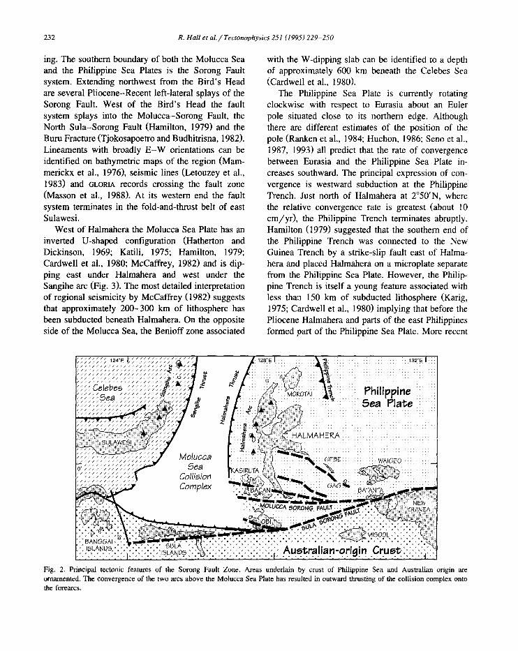
ing, The southern boundary of both the Molucca Sea and the Philippine Sea Plates is the Sorong Fault system. Extending northwest from the Bird's Head are several Pliocene-Recent left-lateral splays of the Sorong Fault. West of the Bird's Head the fault system splays into the Molucca-Sorong Fault, the North Sula-Sorong Fault (Hamilton, 1979) and the Buru Fracture (Tjokosapoetro and Budhitrisna, 1982). Lineaments with broadly E - W orientations can be identified on bathymetric maps of the region (Mam- merickx et al., 1976), seismic lines (Letouzey et al., 1983) and ~LORtA records crossing the fault zone (Masson et al., 1988). At its western end the fault system terminates in the fold-and-thrust belt of east Sulawesi.
West of Halmahera the Molucca Sea Plate has an inverted U-shaped configuration (Hatherton and Dickinson, 1969; Katili, 1975; Hamilton, 1979; Cardwell et al., 1980; McCaffrey, 1982) and is dip- ping east under Halmahera and west under the Sangihe arc (Fig. 3). The most detailed interpretation of regional seismicity by McCaffrey (1982) suggests that approximately 200-300 km of lithosphere has been subducted beneath Halmahera. On the opposite side of the Molucca Sea, the Benioff zone associated
with the W-dipping slab can be identified to a depth of approximately 600 km beneath the Celebes Sea (Cardwell et al., 1980).
The Philippine Sea Plate is currently rotating clockwise with respect to Eurasia about an Euler pole situated close to its northern edge. Although there are different estimates of the position of the pole (Ranken et al., 1984; Huchon, 1986; Seno et al., 1987, 1993) all predict that the rate of convergence between Eurasia and the Philippine Sea Plate in- creases southward. The principal expression of con- vergence is westward subduction at the Philippine Trench. Just north of Halmahera at 2°50'N, where the relative convergence rate is greatest (about 10 cm/yr) , the Philippine Trench terminates abruptly. Hamilton (1979) suggested that the southern end of the Philippine Trench was connected to the New Guinea Trench by a strike-slip fault east of Halma- hera and placed Halmahera on a microplate separate from the Philippine Sea Plate. However, the Philip- pine Trench is itself a young feature associated with less tha:a 150 km of subducted lithosphere (Karig, 1975; Cardwell et al., 1980) implying that before the Pliocene Halmahera and parts of the east Philippines formed part of the Philippine Sea Plate. More recent
I
'0/'7
Fig. 2. Principal tectonic features of the Sorong Fault Zone. Areas underlain by crust of Philippine Sea and Australian origin are ornamented. The convergence of the two arcs above the Molucca Sea Plate has resulted in outward thrusting of the collision complex onto the forearcs.
R. Hall et al. / Tectonophysics 251 (1995) 229-250 233
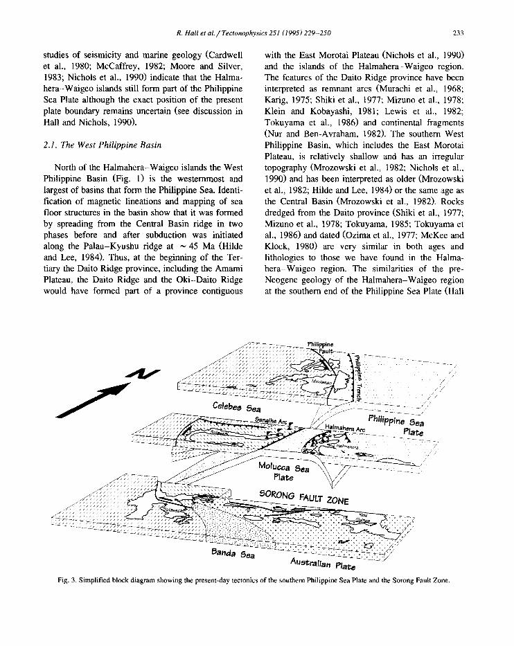
studies of seismicity and marine geology (Cardwell et al., 1980; McCaffrey, 1982; Moore and Silver, 1983; Nichols et al., 1990) indicate that the Halma- hera-Waigeo islands still form part of the Philippine Sea Plate although the exact position of the present plate boundary remains uncertain (see discussion in Hall and Nichols, 1990).
2.1. The West Philippine Basin
North of the Halmahera-Waigeo islands the West Philippine Basin (Fig. 1) is the westernmost and largest of basins that form the Philippine Sea. Identi- fication of magnetic lineations and mapping of sea floor structures in the basin show that it was formed by spreading from the Central Basin ridge in two phases before and after subduction was initiated along the Palau-Kyushu ridge at ~ 45 Ma (Hilde and Lee, 1984). Thus, at the beginning of the Ter- tiary the Daito Ridge province, including the Amami Plateau, the Daito Ridge and the Oki-Daito Ridge would have formed part of a province contiguous
with the East Morotai Plateau (Nichols et al., 1990) and the islands of the Halmahera-Waigeo region. The features of the Daito Ridge province have been interpreted as remnant arcs (Murachi et al., 1968; Karig, 1975; Shiki et al., 1977; Mizuno et al., 1978; Klein and Kobayashi, 1981; Lewis et al., 1982; Tokuyama et al., 1986) and continental fragments (Nur and Ben-Avraham, 1982). The southern West Philippine Basin, which includes the East Morotai Plateau, is relatively shallow and has an irregular topography (Mrozowski et al., 1982; Nichols et al., 1990) and has been interpreted as older (Mrozowski et al., 1982; Hilde and Lee, 1984) or the same ;age as the Central Basin (Mrozowski et al., 1982). Rocks dredged from the Daito province (Shiki et al., 1977; Mizuno et al., 1978; Tokuyama, 1985; Tokuyama et al., 1986) and dated (Ozima et al., 1977; McKee and Klock, 1980) are very similar in both ages and lithologies to those we have found in the Halma- hera-Waigeo region. The similarities of the pre- Neogene geology of the Halmahera-Waigeo region at the southern end of the Philippine Sea Plate,, (Hall
f
~ ~ P h i l i p p i n e ~ i ~ ~ ~ u ~
- / / / / i / / / i / / / / / / / ~ / /
9a
t,e "~7 - - %
/ /
~ust, ralian Plate
Fig. 3. Simplified block diagram showing the present-day tectonics of the southern Philippine Sea Plate and the Sorong Fault Zone.

234 R. Hall et el.~ Tectonophysics 251 (1995) 229-250
and Nichols, 1990; Hall et al., 1995c) indicate an early arc history and favour the remnant arc interpre- tation of the Daito Ridge province.
3. Geology of the southern part of the Philippine Sea Plate
The Sorong Fault system (Hamilton, 1979) is a major left-lateral fault zone juxtaposing arc/ophio- litic rocks of the Philippine Sea Plate and continental crust of the Australian Plate (Hall et al., 1991). The Sorong Fault has its type locality in the northern Bird's Head region of New Guinea (Visser and Hermes, 1962; Tjia, 1973; Dow and Sukamto, 1984) and we use the term "Sorong Fault Zone" for the region extending from the Bird's Head to Sulawesi,
including the islands of the North Moluccas (Fig. 2). The summary of the geology (Fig. 4) of the region which follows concentrates on areas underlain by rocks of ophiolitic and arc origin largely within the region north of the Sorong Fault which today form part of the Philippine Sea Plate. Similar rocks are found within strands of the Sorong Fault further south.
3.1. Ophiolitic basement
Ophiolitic rocks, associated with arc-related sedi- mentary rocks, form the basement of east Halmahera and Waigeo, and many of the small islands between these two larger islands, including Gag and Gebe. Similar rocks form the basement of northern and central Obi, within the Sorong Fault Zone. The
Quaternary
Pliocene
Miocene
Oligocene
Eocene
Paleocene
Cretaceous
Jurassic
Triassic
Palaeozoic
'v ~v~r~ ~ol~an o~',,' V~Vl
:~:v:v:v:v:v:v:v: ~ v .......... ." v , v .v v .v .v .v .v .v .~I
~SE~ Ll 'mest;n;s
Black Shales ~Mlcaceous Ssts
AUSTRALIAN O R I G I N
v v , v v | v vA ro Vo l can l csV v
t~ . Vo~can~o,ast,cs ; ' ; v" Arc Volcanics v ' v v: . . . . . . v . . . . . . :v
I l l l t l l l l J I I
i estones II I I ' l ' l I I I I
ARC COLLISION i:~3,';::Pillow Basalts i:::;;~;::: I Philippine Sea Plate ~-',:~,:,: & Turbidites ??."S~' .+?:.?:i:::;:~:::::;?:::;?:;:;:~:;:::::~?::~,:.::,:.::~ Arc Volcanism . . . , . . . . . . . . . . . . . . . , ,
:Shallow Water ~ed[ments -
v . ~ : ~ : ~ v . . . . . ~ . v v v v v v v
:: Volcaniclastics ~ "v v . v . v . v v . v . v v . v v v .v.v.v .~.v v .v
v v v v v v v v v cvv . v v
v" Arc Volcanlcs vVv v v v v v v v v v
Present Halmahera Arc Volcanism
MOVEMENT ON SORONG FAULT STRANDS
Neogene Halmahera Arc Volcanism
MOLUCCA SEA SUBDUCTION BEGINS
AUSTRALIA-PHILIPPINE SEA PLATE
PACIFIC PLATE REORGANISATION
Arc Volcanism
Arc Volcanism
Arc Volcanism
Supra~subduction Zone Igneous Activity
PHILIPPINE S E A PLATE
ORIGIN Fig. 4. Schematic stratigraphic summary of the Sorong Fault Zone based on references in the text and our work, with the principal events in the history of the Philippine Sea Plate recorded in the region.

R. Hall et al. / Tectonophysics 251 (1995) 229-250 235
ophiolites include ultramafic rocks, through cumu- lates and microgabbros, to volcanic rocks, although volcanic rocks are relatively uncommon. Compo- nents of each level of an intact ophiolite, with the exception of sheeted dykes, are present in east Halmahera (Hall et al., 1988a, 1991). The chemistry and mineralogy of the plutonic components of the ophiolite indicate formation in an arc setting (Bal- lantyne, 1990, Ballantyne, 1991a, b). Burgath et al. (1983) reported dykes in central Halmahera, associ- ated with pillow lavas. Ophiolitic dykes on Gag may form part of a sheeted complex (Pieters et al., 1979). Dykes intrude ophiolitic microgabbros on Obi and may represent the lower part of a dyke complex. Volcanic rocks in the east Halmahera ophiolite in- clude boninitic rocks, arc tholeiites and amyg- daloidal basalts (Ballantyne, 1991b) of ocean island character. Radiolarian cherts are common as float in areas of ophiolitic rock exposure; where they are found in situ they are typically faulted among do- lerites and basalts. There are also metamorphic rocks,
including foliated amphibolites and rare blueschists. Ar-Ar dating of amphiboles from arc-related ig- neous rocks intruding the ophiolite (Ballantyne, 1990) and fossils from the oldest associated sedimentary rocks (Hall et al., 1988a, 1991, unpubl, results) indicate a Cretaceous or greater age for the ophiolitic rocks. The oldest K-Ar date obtained is 142 -+, 4 Ma from patchily altered dolerite dykes on Gag (F'ig. 5), similar to the only previous date from Gag of 148 + 2 Ma (Pieters et al., 1979). The nature of the alteration is typical of sub-seafloor metamorphism anti sug- gests that these dates record alteration soon after ophiolite formation. Similar ages have been obtained from dykes on Obi. These data therefore suggest a Jurassic age for the ophiolites.
3.2. Cre taceous -Midd le Eocene volcanici ty
The ophiolitic rocks are associated with predomi- nantly volcanic, volcaniclastic rocks and limestones deposited in an island arc setting. In many areas
160
150
140
130
120
110
100
90
80
70
60
50
40
30
OPHIOLITIC ROCK~
v v v v v v v v v v v v v . . . . . . . . . . ~i~{~: gq ~ Kapadiri
Formation
METAMORPHIC VOLCANIC PLUTONIC ROCK5 ROCK5 ROCK5
t Gowonli Formation
I (Halmahera) i~ Leleobasso Formation
Tanjung Boreas : : ~ : ~ ! ~ Formation ,,~, ~ ~ :~:, (Waigeo) ~ ~;~ ~ ~ vvvv
v vv vvvvvvv v v v ~ vvvvvvvvvvvvvvvvv vvvvv~vvv vvvvv ~ vvvvvvvvvvvvvvvv~
~ lntervals of arc-related sedimentary deposition P r i m a r y K-Ar ages
Reset K-Ar a g e s
Ar-Ar plateau ages
iii!!~i! ! i i i : ! ! i ~
v v v v v vv ,vvvvvvvvvvvvvvvvvvvvvvvVVvvvvv ~ v v v v v ~ v ~ I . . . . . Sagea Formation ~ . . . . . ~ . . . . . . . .
Halmahera) (
t-- ~-- tfh - ~ _ ~ ~. ~ ~ ~ ~ ~ < < °7 ~ ~ ~ ~ ~ ~ ~ < ~ ~ ~ ~
c~ ~o~ az
~ ~ A M P L E No.
Fig. 5. Summary of isotopic dating of rocks of Middle Eocene and greater age of Philippine Sea Plate origin in the Sorong Fault Zone. Also shown are intervals of arc volcanism and volcaniclastic sedimentation dated biostratigraphically.

236 R. Hall et al. / Tectonophysics 251 (1995) 229-250
there are coherent sequences of volcanic and sedi- mentary rocks which locally are faulted within the ophiolites. The oldest of these are Lower Creta- ceous-Middle Eocene. They are interpreted to be younger than, and to rest unconformably upon, a basement of ophiolitic rocks since ophiolitic frag- ments are present in Upper Cretaceous and younger formations.
These sequences are dominated by basaltic and andesitic volcanic rocks, andesitic breccias and con- glomerates, volcaniclastic sandstones containing vol- canic debris, red mudstones and pelagic and rede- posited limestones. They are interpreted as the fill of basins situated near to a single long-lived or intermit- tently active arc. The chemistry of the volcanic rocks indicates an island arc origin. Interbedded mudstones and limestones contain abundant microfossils and nannofossils allowing precise dating. On Waigeo one formation contains Lower Cretaceous calpionellids and well-dated sequences on Halmahera and Obi are Upper Cretaceous. In southeast Halmahera there are similar Lower-Middle Eocene formations which have been metamorphosed to greenschist facies.
Arc-related plutonic rocks intrude the ophiolite complex and include diorites and rare granitic rocks. Isotopic dating indicates arc activity from the Early Cretaceous (Fig. 5). Arc cumulate rocks from north Obi yielded a K-Ar age of 100 + 4 Ma close to an Ar-Ar plateau age of 99 _.+ 5 Ma from similar cumu- lates on Bacan (Malaihollo, 1993). Ar-Ar plateau ages from northeast Halmahera (Ballantyne, 1990) indicate two periods of diorite magmatism in the Late Cretaceous partly overprinted by early Tertiary metamorphic events. Dates of 87 + 7 and 74 + 2 Ma are regarded as ages of magmatic crystallisation. A foliated amphibolite has a similar plateau age to the younger diorites suggesting that locally metamor- phism accompanied the igneous activity. Ar-Ar and K-Ar ages from ophiolitic rocks record early Ter- tiary thermal overprints and K-Ar ages of fresh volcanic rocks from Halmahera, Bacan and Obi indi- cate that arc activity continued until the Middle Eocene (Fig. 5).
locally dip steeply. In contrast, younger rocks are not strongly deformed except in areas of localised late Neogene deformation. In east Halmahera older rocks are overlain by Upper Eocene and younger marginal to shallow marine sequences, including conglomer- ates, sandstones, siltstones, mudstones, coals and limestones. The source of most of the non-carbonate debris was the ophiolites and Upper Cretaceous vol- canic and volcaniclastic rocks. Reworking of ophi- olitic and early Tertiary rocks and association with laterites (extensively developed on Gebe) suggest significant sub-aerial erosion.
In most places the Upper Eocene and Oligocene are represented by a deep-water basinal sequence. Throughout much of the western Halmahera islands Upper Eocene-Lower Oligocene rocks are pillow basalt and flows of island arc chemistry. Hemipelagic mudstones and siltstones occur between the lavas. Sequences containing interbedded sediments can be precisely dated by foraminifera and nannofossils, and elsewhere pillow basalts have been dated using iso- topic methods. Thick volcaniclastic turbidites associ- ated with debris flows and red mudstones, locally with pelagic limestones, typically overlie the lavas and these are also well exposed in western coasts. In most areas the sequences are sub-horizontal and cut by extensional faults, some of which are syn-deposi- tional. Volcaniclastic rocks similar to the turbidites in lithology and age are well exposed in east Halma- hera, Waigeo, and Obi. On Waigeo they are de- formed by large scale open folds. On Obi the se- quences are folded and locally steeply dipping. In all areas, the basaltic rocks and the sediments are vari- ably altered. Some are very fresh whereas others contain sheet silicates, silica and zeolites filling veins and amygdales and locally replacing igneous miner- als, glass or clasts. The secondary mineralogy indi- cates low-temperature metamorphism from zeolite up to lower greenschist facies. The lack of fabric development suggests a regional, static metamor- phism, due to burial. There is also widespread but local hydrothermal alteration associated with Neo- gene volcanism.
3.3. Upper Eocene-Oligocene volcanicity 3.4. Neogene shelf carbonates
Throughout the region Upper Cretaceous and Middle Eocene rocks are folded and faulted, and
In the Early Miocene there was an important change in the character of sedimentation marking a

R. Hall et al. / Tectonophysics 251 (1995) 229-250 237
major regional unconformity. In areas close to the Sorong Fault the Oligocene rocks are folded, locally metamorphosed, and unconformably overlain by Neogene rocks. In some areas there are coarse con- glomerates of fluviatile origin containing ophiolite debris succeeded by limestones. Elsewhere, massive and well-bedded limestones of reefal or reef-derived material with rare clastic intervals form part of a shelf carbonate sequence which rests directly on Paleogene or older rocks. By the Middle Miocene shallow-water carbonate deposition prevailed throughout the whole region, with the exception of northernmost parts of northwest Halmahera and Mo- rotai, implying that the period of deformation was followed by uplift and erosion preceding deposition of carbonates just below sea level. Our new palaeon- tological and isotopic dates can be used to date the major regional unconformity. Fig. 6 summarises the evidence from the region and shows the ages of the youngest rocks beneath the unconformity and the oldest rocks above the unconformity. The uncon- formity cannot be older than ~ 27 Ma and cannot be younger than ~ 20 Ma. Dating of critical sequences (Fig. 6) suggest a single unconformity at ~ 22 Ma is the simplest explanation, although multiple uncon- formities with ages close to 25 Ma cannot be ruled out.
3.5. Late Neogene volcanicity
Late Neogene volcanic activity marks the begin- ning of eastward subduction of the Molucca Sea Plate beneath Halmahera (Hall, 1987; Hall et al., 1988b). Volcanism began rather earlier than sug- gested by previous authors (Hall, 1987; Hall et al., 1988b; Nichols and Hall, 1991). The oldest K-Ar ages from volcanic rocks suggest that the Halmahera Arc became active at approximately 11 Ma. Volcan- ism began earliest in the south on Obi and extended progressively northwards producing a Neogene vol- canic arc similar in position and extent to the present Halmahera arc. By the end of the Miocene an arc extended from Obi, through Bacan, into north Halmahera. To the west of the arc turbidites and debris flows were deposited below steep W-facing submarine slopes containing material derived from a terrain of volcanic arc rocks and reef limestones. To the east of the arc an extensive basin developed
(Nichols and Hall, 1991; Nichols et al., 1991) con- taining similar debris but deposited in much shal- lower water.
4. Late Pliocene to Recent tectonics and volcanic- ity
Movement on strands of the Sorong Fault system caused localised intense deformation during the Pliocene. Volcanic activity may have been renewed (Nichols and Hall, 1991). There is a hiatus or uncon- formity dated as ~ 3 Ma between older Ne, ogene and overlying Upper Pliocene sedimentary rocks which can be recognised on seismic sections and identified from biostratigraphic data. On Obi and in southwest Halmahera sedimentary rocks were thrust west over the Neogene arc and forearc. The present Halmahera arc is built unconformably upon the Neo- gene arc rocks and adjacent sedimentary basins.
5. Interpretation of the geology
The ophiolites represent the products of the earli- est stages of subduction-related magmatism. As in many other ophiolites a two-stage history is implied by the evidence of peridotite remelting and the supra-subduction zone chemistry of plutonic and some volcanic rocks, explained by formation of the ophiolites in a setting in which the underlying mantle had previously been depleted by extraction of MORB (Ballantyne, 1990, 1991a, b). The ophiolites are therefore interpreted as formed in an early Mesozoic intra-oceanic arc and are overlain by Lower Creta- ceous-Middle Eocene island arc rocks. These have equivalents in New Guinea (Dow and Sukamto, 1984; Pigram and Davies, 1987), parts of the eastern Philippines (Rangin, 1991), and ridges of the north Philippine Sea (Tokuyama, 1985; Hall and Nichols, 1990; Hall et al., 1995c). Thus, the northern and southern Philippine Sea Plate, the eastern Philippines (which must have formed part of the plate until ~ 5 Ma when subduction began at the Philippine Trench), and rocks of New Guinea, which we argue elsewhere formed part of the Philippine Sea Plate before 25 Ma (Ali and Hall, 1995-this issue), all have a pre-Eocene arc history.

238 R. Hall et al. / Tectonophysics 251 (1995) 229-250
The Middle Eocene regional unconformity may marks the major change in Pacific Plate motion at ~ 42 Ma (Clague and Jarrard, 1973). Middle Eocene and older rocks are overlain by Upper Eocene shal- low-water limestones and a largely Oligocene, but ranging from Upper Eocene to Lower Miocene, arc sequence including basaltic lavas and volcaniclastic turbidites (Hall et al., 1991). We interpret these sequences to represent various parts of an exten- sional intra-oceanic arc including arc and backarc
settings active from the Late Eocene to the Early Miocene.
The second regional unconformity is dated at ~ 25 Ma and fragments of Australian and Philippine Sea Plate origin have a common stratigraphic history during the Neogene (Hall et al., 1988b, 1991, un- publ. results). We interpret the unconformity to be the result of collision between a Philippine Sea arc and the Australian continental margin. Arc-conti- nent collision at the north Australian margin during
" 5
HALMAHERA MOROTAI NE A R M SE A R M NW A R M
KA,51RUTA 5OUTH OBI WAIOEO NORTH BACAN BACAN ,
E LL - ~ ~ Z E LL ~., '~E LLI '~
25 ~%~, L~ ",
35 ~ ~ ~
Age Ma
40
Vv~ ̧ ¸,
v~v/' LL]
v v v
£b - -
~ z ~ LLI
£b UJ
Pre-Collieion Rocks
Arc Lavas and Arc- derived Volcanogenic Turbidites
Poet-Collieion Rocke
Shallow Marine containing arc Limesgones Sandstones volcanic ctasts
Fig. 6. Ages of individual samples from formations above and below the Miocene unconformity in different parts of the Sorong Fault Zone. Samples plotted are those which are the youngest below the unconformity and the oldest above the unconformity in each of the sub-areas. The age for each sample includes errors (for isotopic dates) or is the range within which the sample age falls (for palaeontological dates). Thus, for example no rocks from the Rumai Formation on Waigeo can be da~d more precisely than Oligocene. The volcanic rocks are all beneath the unconformity; all other rocks are above the unconformity. Dates for the Morotai and Mayalibit formations are isotopic ages of volcanic clasts within sedimentary rocks deposited above the unco~aformity. A single non-diachronous unconformity is the simplest hypothesis and is consistent with the age ranges determined. Biostratigraphic dates converted to numerical ages using the time scale of Harland et al. (1990).

R. Hall et a l . / Tectonophysics 251 (1995) 229-250 239
the Tertiary is not a new suggestion although the timing of collision is still the subject of considerable debate. Pigram and Symonds (1991) reviewed sug- gested collision ages which range from Eocene to Late Miocene; for eastern New Guinea they argue for a collision unconformity at ~ 30 Ma. Some of this debate reflects the still incomplete knowledge of the geology of northern New Guinea whereas an- other part of the debate centres upon the interpreta- tion of what is known of the stratigraphic record. We believe that much of the evidence from this complex region can be understood in terms of pre-25 Ma intra-oceanic arc tectonics, a ~ 25 Ma arc-continent collision, and post-25 Ma strike-slip tectonics (Ali and Hall, 1995-this issue). Continued northward movement of Australia during the Neogene occurred without subduction. The boundary between the Philippine Sea Plate and Australia was the left-lateral strike-slip Sorong Fault system. Neogene conver-
gence caused by westward movement of the Philip- pine Sea Plate resulted in subduction of the Molucca Sea Plate, first to the west beneath the Sangihe arc and later beneath Halmahera.
6. Summary of new palaeomagnetic results
Since 1989 we have drilled 254 palaeomagnetic sites in eastern Indonesia in rocks of Jurassic to late Neogene age and 63 of these sites have yielded results. All sites north of the Sorong Fault were drilled in rocks which are currently part of the Philippine Sea Plate. Other sites drilled in rocks of Philippine Sea Plate origin are parts of crustal blocks now within the Sorong Fault system (Fig. 7). Details for the sites north of the Sorong Fault are in Hall et al. (1995b) and for sites within the Sorong Fault system are in Ali and Hall (1995-this issue). We
Molucc~ Sea
1 Philippine • ~ea Plate
~HERA
KAI GEBE WAIGEO 0°
- _ . . . . . . . . . -
. . . . . M,SOOL 2 128oE i Australian Plate 132°E 1,,
Declination Change and Northward Latitudinal Shift
,',] ',:J~o~;7~,~'~ / Oligocene-Late Eocene
Fig. 7. Distribution of the palaeomagnetic data from Tertiary rocks in east Indonesia described in this work. Results from Obi are discussed by Ali and Hall (1995-this issue). Arrows show net declination and numbers show the net latitude shift; negative numbers indicate southward motion.

to
Tab
le 1
Sum
mar
y of
pal
aeom
agne
tic
resu
lts
from
Cre
tace
ous
and
Ter
tiar
y ro
cks
in e
aste
rn I
ndon
esia
isl
ands
of
Hal
mah
era,
Bac
an,
Obi
and
Wai
geo.
Bio
stra
tigr
aphi
c ag
es c
onve
rted
to
num
eric
al a
ges
usin
g th
e ti
me
scal
e of
Har
land
et
al.
(199
0)
Age
D
atin
g F
orm
atio
n R
ock
type
L
atit
ude
Lon
gitu
de
No.
of
Dir
ecti
on b
I
c D
~
0%5
K
f P
olar
ity
~ m
etho
d ~
site
s
Nor
th o
f So
rong
Fau
lt Z
one
2.2
5:07
R
K
ayas
a A
ndes
ite
1 °42
.49'
N
127°
31.2
5' E
!
C
26.9
18
9.8
1.9
1063
.8
R
2.2
+ 0.
7 R
K
ayas
a A
ndes
ite
1 °42
.49'
N
127°
31.2
5' E
1
C
27.0
17
6.7
7.4
83.6
R
5
5:1
F S
aola
t C
alci
silt
ite
1°15
.55'
N
128°
43.6
2'E
1
C
- 4.
2 5.
5 4.
2 33
2.6
N
5 5:
1 F
Sao
lat
Cal
cisi
ltit
e 1°
15.5
5'N
12
8°43
.62'
E
1 C
-
10.2
9.
1 7.
3 51
.2
N
7 5:
2 R
W
eda
Gro
up
And
esit
e 1 °
41.0
8'N
12
7°31
.90'
E
1 C
38
.4
192.
2 9.
0 23
8.7
R
7 5:
2 R
W
eda
Gro
up
And
esit
e 1 °
41.0
8' N
12
7°31
.90'
E
1 C
35
.7
192.
2 3.
2 25
6.2
R
27 5
:2
R
Taw
ali
Bas
alt
2 ° 1
5.50
'N
128°
46.0
0' E
1
C
27.5
22
2.3
4.8
253.
3 R
29
5:6
N
T
awal
i S
ilts
tone
1 °
24.5
0' N
12
8038
.60
' E
1 C
-
33.1
41
.6
4.1
159.
6 N
29
+6
L
R
umai
S
ilt/
san
dst
on
e 0°
17.5
1'S
13
1°20
.37'
E
2 C
14
.8
221.
9 37
.1
47.3
R
32
.35:
3 F
&N
T
awal
i B
asal
t 0°
21.4
0'S
12
7°15
.00'
E
7 C
24
.2
218.
9 12
.8
23.2
R
32.3
5:3
F&
N
Taw
ali
Bas
alt
0°23
.60'
S
127°
6.40
'E
1 C
18
.9
221.
1 5.
3 16
2.3
R
33.3
5:0.
3 F
&N
T
awal
i S
ilts
tone
0°
19.2
0'S
12
7°6.
50'E
2
C
23.9
21
7.9
6.1
236.
8 R
33.3
5:0.
3 F
&N
T
awal
i B
asal
t 0°
19.2
0'S
12
7°6.
50'E
2
C
33.1
23
1.2
5.0
88.0
R
40
5:2
M
S
agea
S
ilts
tone
00
32.9
4 ' N
12
802.
64 ' E
4
S -
24.1
39
.1
19.5
23
.1
N
47
5:3
F
Way
amli
C
alca
reni
te
1°15
.55'
N
128°
43.6
2'E
5
C
-3.7
26
4.3
15.9
24
.0
R&
N
74.5
5:4
F G
owon
li
Mud
ston
e 0°
26.2
6'N
12
8°38
.10'
E
4 C
-1
5.5
35
8.6
5.0
338.
3 N
78
.55:
4.5
F&
N
Gau
Lim
esto
ne
Mud
ston
e 1°
12.2
7'N
12
8°15
.92'
E
1 C
-4
.0
1.4
7.7
63.1
N
Wit
hin
Soro
ng F
ault
Zon
e
I 1
+ 1
R
Woi
A
ndes
ite
I°34
.50'
S
127°
49.9
0'E
4
C
41.9
14
.2
4.3
452.
7 N
11.3
5:3
R
Woi
B
asal
t fl
ows
1°30
.90'
S
127°
56.9
0'E
9
S -2
6.1
33
2.9
4.1
161.
1 N
12
.5 +
2.5
F
&N
W
oi
San
dsto
ne
1 °34
.50'
S
1270
49.9
0 ' E
1
C
13.8
20
0.4
10.8
32
.4
R
30.5
i 3
N
Ang
gai
Riv
er
San
dsto
ne
1 °22
.20'
S
127o
42.8
0 ' E
11
C
-
23.6
30
1.1
8.8
27.7
N
74 ±
9
F L
eleo
bass
o M
udst
one
1 °25
.50'
S
1270
24.8
0 ' E
3
C
- 22
. I
355.
5 19
.8
39.6
R
&N
R =
K-A
r m
etho
d; F
= f
oram
inif
era;
N =
nan
nofo
ssil
s; L
= l
iter
atur
e; M
= m
etam
orph
ic a
ge,
brac
kete
d by
bio
stra
tigr
aphi
c da
tes
from
for
mat
ion
and
un
met
amo
rph
ose
d r
ocks
ab
ove.
b C
= t
ilt-
corr
ecte
d di
rect
ion;
S =
in-
situ
dir
ecti
on.
~ In
clin
atio
n (°
).
d D
ecli
nati
on (
°).
e C
ircl
e of
95%
con
fide
nce
abou
t th
e si
te m
ean.
f
Pre
cisi
on p
aram
eter
.
g N
= n
orm
al;
R =
rev
erse
d.
g~
t-o
t,o
t,o
t,o

R. Hall et al. / Tectonophysics 251 (1995) 229-250 241
summarise below the results from sites in Cretaceous and Tertiary rocks (Table 1) in the area including Halmahera, Bacan, Obi and Waigeo.
6.1. Declinations
Declination data define two sub-areas: an area north of the Sorong Fault and an area within the Sorong Fault system (Fig. 7). The area north of the Sorong Fault is currently part of the Philippine Sea Plate and includes rocks of Philippine Sea Plate origin only. The sub-area within the fault zone in- cludes fragments of Australian and Philippine Sea Plate origin (Fig. 2).
Within the Sorong Fault system Oligocene and
Neogene rocks of Philippine Sea Plate origin record both counter-clockwise rotations and clockwise rota- tions (Fig. 7) which we interpret as block movements within the left-lateral fault system resulting from movement on the Sorong Fault. This interpretation is discussed by Ali and Hall (1995-this issue'). The magnetisation in Cretaceous rocks is either a normal polarity remanence indicating either negligible net rotation and low southerly formation latitudes, or a reverse polarity remanence showing ~ 180 ° net rota- tion and low northerly formation latitudes.
North of Sorong Fault system there is a record of long-term, but discontinuous, clockwise rotation (Fig. 8). Upper Neogene rocks have small declination deflections. The rotations are consistent with those
100
80 !
-,6o + A ~ 40 + -
~ 2 0 ~ ~ - -
:::, 10 15 20 25 30 35 40 45 50 55 60 E~ -20 - I - - -0~- - Age M a
-40
-60
-80 i i i North of ! 40 5orong Fault
• I More than 3 sites in locality mean 30 ~ • • 3 or fewer sites in locality mean l/ - - - W ~ h i r l • th¢
I 5orong Fault Zone
2o } 6-.
1 0 -
--~, ~ ~ I . . . . ~; I lO] 15 20 25 3 0 ~ 5 40 50 55
-10 ~ J Age Ma
.20 ' -30
60
Fig. 8. (A) Observed declinations for Tertiary rocks of east Indonesia sampled in this work; positive values indicate clockwise rotations. (B) Latitude changes calculated from inclination data for the same samples. Positive latitudes are north of the equator. Some lavas record higher inclinations than associated sedimentary rocks; this is attributed to sampling of lava sequences erupted in a short time span, thus failing to fully average out secular variation in the geomagnetic field.

242 R. Hall et a l . / Tectonophysics 251 (1995) 229 250
expected from angular velocities and rotation poles calculated for the Philippine Sea Plate for the present day (Ranken et al., 1984; Huchon, 1986; Seno et al., 1987, 1993). Rocks of ages between ,-, 25 and ~ 40 Ma all show clockwise declination deflections of ~ 40 °. We interpret results from Lower Miocene- Upper Eocene rocks as indicating approximately 40 ° of clockwise rotation after ~ 25 Ma and no signifi- cant rotation between ~ 25 and ~ 40 Ma. Lower Eocene sites have declinations indicating 90 ° of rota- tion. We interpret Lower Eocene declinations as indicating ~ 50 ° of clockwise rotation between ~ 40 and 50 Ma. The magnetisation in Cretaceous rocks is similar to that within the Sorong Fault system being either a normal polarity remanence indicating either negligible net rotation and a low southerly formation latitude, or a reverse polarity remanence showing ~ 180 ° net rotation and a low northerly formation latitude. We interpret these results to indicate rota- tions between the Late Cretaceous and the Early Eocene of ~ 90 ° but do not use these data in our tectonic interpretations. More data from pre-Eocene rocks is needed before they can be interpreted with any confidence.
6.2. Inclinations
Although they have different rotation histories, rocks of similar ages in these two sub-areas have similar inclinations. Cretaceous palaeolatitudes are all close to equatorial ( < 11 + 4°); whether they are N or S depends on interpretation of the rotation history, as noted above. Inclinations of Lower Eocene rocks indicate similar equatorial latitudes ( 2 _ 8 °) interpreted to be Northern Hemisphere. All other Tertiary rocks formed at low southerly latitudes (Fig. 8). The data indicate that throughout the Late Creta- ceous and early Tertiary this part of the Philippine Sea Plate remained at low equatorial latitudes, al- though permitting the possibility of movements across the equator. However, our data indicate a significant southward movement of the present southern part of the plate between ~ 50 and ~ 40 Ma. Between ~ 40 and ~ 25 Ma, during the inter- val of no rotation, we interpret there to have been no significant latitudinal shift. After ~ 25 Ma, there was northward movement of ~ 10-15 ° during the Neogene, accompanying the rotation of rocks through
the region. Although they also indicate northward motion with decreasing age, young Neogene lavas at a number of sites record significantly higher inclina- tions than associated sediments, although they record similar declinations. Demagnetisation experiments indicate that the remanence of the lavas is primary. We attribute this to sampling within thick lava se- quences erupted in a short time span, thus failing to average out geomagnetic secular variation.
6.3. Implications of the new palaeomagnetic data
We consider that the palaeomagnetic data from the area north of the Sorong Fault system record the Tertiary motion history of the Philippine Sea Plate. As discussed above, the area north of the Sorong Fault is currently part of the Philippine Sea Plate. The spreading history of the West Philippine Sea recorded by marine magnetic anomalies show that this region should form one of the oldest parts of the plate as indicated also by the geological evidence summarised above.
Rocks of Upper Eocene and Oligocene age on different islands within this extensive area all have similar inclinations and declinations. The magnetisa- tion in these rocks is undoubtedly primary. This is indicated by magneto-mineralogical studies, positive fold tests, and localities at which sites of both normal and reversed polarities have been identified. The consistent declination shifts observed throughout the area north of the Sorong Fault indicate that the region has behaved as a coherent unit since at least the end of the Eocene. The area close to the present- day southern boundary of the Philippine Sea Plate, the Sorong Fault, includes sites with local rotation histories different from those north of the fault which Ali and Hall (1995-this issue) interpret as recording deformation at the plate edge. We suggest that in eastern Indonesia, unlike areas at the present eastern edge of the plate, the distinction between local and plate-wide rotations is clear.
This study has provided important new inclination information from a previously neglected part of the Philippine Sea Plate and has more than doubled the declination data set for the plate. The new data provide strong support for Tertiary rotation of a single plate although the rotation history is more complex than previously inferred. We propose that

R. Hall et a l . / Tectonophysics 251 (1995) 229-250 243
this region has formed part of the Philippine Sea Plate since at least the Late Cretaceous. We now outline how these new data can be integrated with pre-existing data in a coherent way.
7. Calculating rotation poles for the Philippine Sea Plate
In order to determine whether the new and pre-ex- isting palaeomagnetic data are part of a single set we adopted a simple forward modelling approach. Has- ton and Fuller (1991) have summarised most previ- ous data from the plate to which we have added information from ODP Legs 125 and 126 (Koyama et al., 1992; Haston et al., 1992). A northward change of latitude with decreasing age is evident in all sites, and it is also clear that similar relative latitude shifts have been experienced by different sites. We therefore used subsets of the data from different areas within the plate to estimate a simple linear trend of northward movement with time, yield- ing an estimate of ~ 0.5°/Ma. The amounts of rotation chosen were those indicated by our own declination data, i.e. 90 ° clockwise since 50 Ma. We then attempted to find a single rotation pole for the plate which could account for the observed latitude shifts. Such a pole therefore effectively describes Philippine Sea Plate motion relative to present-day magnetic north.
7.1. Present-day rotation pole
It is a simple matter to show that the palaeomag- netic data cannot be accounted for by rotation about the present Eurasia (EU)-Philippine Sea Plate (PH) pole. The present pole is situated somewhere near, or north of, the northern edge of the plate (Ranken et al., 1984; Huchon, 1986; Seno et al., 1987, 1993). Rotation about these poles cannot account for the observed inclination shifts before ~ 5 Ma as all result in relatively small changes in latitude. As a second step we therefore used the E U - P H pole and rotation rates of Seno et al. (1987) for the period 0 -5 Ma. Using the other EU-PH poles makes no sub- stantial difference to the model. We then searched for a pole which accounted for the data set for the interval 5-50 Ma. We found that rotation poles that
account for the palaeomagnetic data for the interval 5-25 Ma lie on a path trending broadly northeast from Guam. Poles on this path also account for most of the data from the plate for the interval 25-50 Ma although they do not account for the southward motion interpreted from our own data for this inter- val. This method only produces a set of poles, since for a given rotation, the further the pole is from the Philippine Sea Plate, the greater the distance moved by a point at the southern part of the plate. Poles which are in this set but very far from the plate are therefore geologically and kinematically unreason- able since they would result in the plate originating very far east in the Pacific basin.
7.2. Importance of the Miocene unconformity
In order to provide a limit on possible pole: posi- tions we therefore introduced the single geological condition in the model. We propose, as explained above, that the Lower Miocene regional unconform- ity in eastern Indonesia represents collision of the Philippine Sea Plate arc with Australia and any pole must permit the Halmahera-Waigeo region to arrive at the Australian margin at ~ 25 Ma. As step three we therefore searched for poles to satisfy this geo- logical condition, and best fit the palaeomagnetic data for the interval 5-25 Ma. This resulted in a rotation pole within a very small area (approximately + 5 ° for both latitude and longitude) with the best pole near to 15°N and 160°E. The Neogene pole suggested by Packham (1990) is near to our calcu- lated path but that suggested by Koyama et al. (1992), near to Palau, does not satisfy the palaeo- magnetic data.
7.3. Pre-25 Ma pole
Our data indicate no rotation of the plate between ~ 25 and 40 Ma. The Halmahera-Waigeo region moved south at some time between ~ 40 and 50 Ma whereas palaeomagnetic investigations elsewhere in the Philippine Sea Plate (Louden, 1977; Keating and Herrero, 1980; Kinoshita, 1980; Bleil, 1981; Ko- dama et al., 1983; Hirooka et al., 1985; Haston and Fuller, 1991; Haston et al., 1992; Koyama et al., 1992) report northward motions. The rotation pole at 15°N and 160°E cannot account for this difference

244 R. Hall et al. / Tectonophysics 251 (1995) 229-250
but a movement of the pole from its Neogene posi- tion could. As a fourth step we therefore searched for poles for the interval 40-50 Ma which would allow northward motion of the northern part of the plate and southward motion for the southern part of the plate. Only a small shift from the Neogene position was required and a best fit pole position for the interval 40-50 Ma is 10°N and 150°E (with an error of approximately + 5 ° for both latitude and longi- tude); additional results from Eocene and older rocks would help to locate this more precisely.
Finally, in order to account for the effects of opening of the various sub-basins in the plate (West Philippine, Parece Vela, Shikoku, Mariana Trough) we calculated opening poles for these sub-basins (discussed in Hall et al., 1995a) and used the poles calculated for the whole plate to make reconstruc- tions using the ATLAS program (Cambridge Pale- omap Services, 1993). This program also permits calculation of finite rotation poles which map any site on the plate from a past position to its present position. Using these poles allows a complete com- parison of predicted and observed rotations and lati- tudes for different sites within the plate with time; we believe that these show that the new and the pre-existing palaeomagnetic data are part of single set consistent with an origin in a single plate.
8. Reconstructions
The motion history of the Philippine Sea Plate deduced from this study places important constraints on reconstructions of the western Pacific region. In order to reconstruct the Philippine Sea Plate itself, the demonstration that rotation of a single plate relative to magnetic north can satisfy the palaeomag- netic data is an important first step. To go further, and include the Philippine Sea Plate in regional reconstructions requires a knowledge of relative mo- tions between it and other major plates, such as Eurasia and Australia. Because the Philippine Sea Plate is isolated by subduction zones from the other plates there is no direct way of determining these motions. However, since there has been little Ceno- zoic motion of Eurasia (e.g. Livermore et al., 1984; Gordon and Jurdy, 1986) whichever reference frame is used (hot spot or palaeomagnetic) the rotation pole
between the Philippine Sea Plate and magnetic north can be considered as an approximation to a Philip- pine Sea Plate-Eurasia rotation pole. Other plates can then be incorporated in a global model through known links to Eurasia. To make regional recon- structions we use the Eurasia-Philippine Sea Plate pole of Seno et al. (1993) for the period 0-5 Ma. The plate is known to have changed motion between 3 and 5 Ma (Seno and Maruyama, 1984; Huchon, 1986; Jolivet et al., 1989) and the poles derived in this work have been used for the period 5-50 Ma. Fig. 9 shows three stages in the history of the Philippine Sea Plate based on the rotation poles calculated in this work. The poles used to open the sub-basins and the details of the reconstruction meth- ods are described in more detail by Hall et al. (1995a).
8.1. Implications of the reconstructions
Several authors have argued for major (50-100 ° ) clockwise rotations of the entire plate. These inter- pretations were based on magnetic anomaly skew- ness in the West Philippine Basin (Louden, 1977; Shih, 1980) and palaeomagnetic data from the east- ern margin of the plate (see Haston and Fuller, 1991) but have been disputed for a number of reasons. These include the low resolution provided by anomaly skewness studies, conflict with interpreta- tions based on Shikoku Basin seamount data (Vaquier and Uyeda, 1967), and possibility of local tectonic effects due to subduction at the eastern plate edge (e.g. McCabe and Uyeda, 1983).
We consider that in eastern Indonesia plate-edge tectonic effects can be clearly separated from the plate-wide motions. The eastern Indonesia data indi- cate a large clockwise rotation of the whole plate, however, the now much larger set of declination data indicates that rotation was not continuous and some- what lower than the largest estimates previously suggested. One important implication of the new data is that a significant component of the declina- tion shifts observed in the eastern Philippine Sea cannot be accounted for by opening of backarc basins within the plate and we suggest that this is the result of local tectonic effects at the edge of the plate.
As we have argued elsewhere (Hall et al., 1995a) the rotation model is consistent with the limits im-

b r
Rot
atio
n P
ole
~ R
ota
tio
n
Pol
e 5-
25
Ma
2o
5-25
M
a 2o
10
°N 1
5 O°E
R
otat
ion
Pol
e ~i
~ ~
40
-50
M
a
lO°S
i
20~ff
~6[~
E H
C~
f12
I
4~N
Fig.
9.
Rec
onst
ruct
ions
of
the
posi
tion
and
app
roxi
mat
e sh
ape
of t
he P
hilip
pine
Sea
Pla
te a
t 10
, 25
and
45
Ma.
No
atte
mpt
has
bee
n m
ade
to d
etai
l th
e co
mpl
ex c
hara
cter
of
the
wes
tern
pla
te b
ound
ary.
The
kno
wn
exte
nt o
f th
e pr
esen
t pl
ate
is s
how
n in
bla
ck a
nd w
hite
; su
bduc
ted
area
s ar
e sh
aded
. A
t ~
45 M
a su
bduc
tion
beg
an a
t th
e no
rthe
ast
mar
gin
of
the
plat
e. A
t ~
40 M
a th
e pl
ate
ceas
ed r
otat
ing
rapi
dly
abou
t th
e po
le s
how
n. T
he W
est
Phili
ppin
e C
entr
al B
asin
was
ope
ning
. A
ll ot
her
mar
gina
l ba
sins
wer
e cl
osed
; th
e ch
arac
ter
of t
he s
outh
ern
boun
dary
of
the
plat
e is
unc
erta
in.
Bet
wee
n 40
and
25
Ma
ther
e w
as n
o ro
tati
on a
nd t
here
was
sub
duct
ion
of I
ndia
n O
cean
lit
hosp
here
at
the
sout
hern
ed
ge o
f th
e pl
ate.
At
~ 25
Ma
the
plat
e be
gan
rota
ting
abo
ut t
he p
ole
show
n. S
ubdu
ctio
n ce
ased
at
the
sout
hern
edg
e w
hich
sub
sequ
entl
y be
cam
e th
e So
rong
Fau
lt s
trik
e-sl
ip
boun
dary
. T
he M
aria
na T
roug
h w
as c
lose
d, t
he S
hiko
ku B
asin
was
beg
inni
ng t
o op
en a
nd t
he P
arec
e V
ela
Bas
in w
as p
artl
y op
en.
At
10 M
a th
e pl
ate
was
con
tinu
ing
to r
otat
e ab
out
the
pole
sho
wn.
The
Mol
ucca
Sea
, w
hich
bef
ore
15 M
a w
as p
art
of t
he P
hilip
pine
Sea
Pla
te,
form
ed a
sep
arat
e pl
ate
by 1
0 M
a. A
ltho
ugh
Aus
tral
ia w
as m
ovin
g no
rth,
rota
tion
of t
he P
hilip
pine
Sea
Pla
te a
llow
ed t
he s
outh
ern
boun
dary
to
rem
ain
a st
rike
-slip
sys
tem
.
e~
t,j
t.~
I t~
k~

246 R. Hall et a l . / Tectonophysics 251 (1995) 229-250
posed by both skewness and seamount studies. Seno and Maruyama (1984) proposed Tertiary reconstruc- tions of the Philippine Sea Plate based upon retreat- ing trench and anchored slab models for the eastern plate boundary. In their reconstructions they rejected clockwise rotation of the whole plate, accounted for part of the rotations in the eastern part of the plate by a retreating trench model, but dismissed the anomaly skewness data as "not well substantiated" since they could not be reconciled with their model. We also favour a retreating trench model for the eastern margin of the plate and believe this is compatible with clockwise rotation of the whole plate. Our model results in much smaller discrepancies between observed and predicted rotations at eastern plate edge and is in good agreement with rotations sug- gested by anomaly skewness data. Our model pre- dicts small rotations for the Shikoku basin seamounts which are within probable error limits of the tech- nique used by Vaquier and Uyeda (1967) to infer no rotation.
The implications of these reconstructions for for- mer parts of the plate now detached from it (e.g. the east Philippines) and more generally for Southeast Asia is beyond the scope of this paper (instead see Hall, 1995) but there are some important implica- tions for boundaries with Australia and the Pacific. The model predicts that there was a strike-slip boundary throughout the Neogene between the Aus- tralian and Philippine Sea Plates. Fig. 9 shows how this is possible; rotation of the Philippine Sea Plate has allowed the strike-slip system to move north at the same rate as Australia. It is important to note that this strike-slip plate boundary was not a component of the model but is a feature of the reconstructions based upon the calculated poles of rotation. How- ever, independent geological evidence is entirely consistent with this prediction of the model. There is currently no evidence for active subduction along the north Australian margin between western New Guinea and Sulawesi although there is abundant evidence of strike-slip motion in the Sorong Fault system and its continuation further east. Further- more, geological evidence from eastern Indonesia indicates no Neogene record of subduction at this margin. Ali and Hall (1995-this issue) discuss some of the implications of the new data for the interpreta- tion of New Guinea.
The model indicates that the Sorong Fault was initiated at ~ 25 Ma by collision of a Philippine Sea Plate arc with the north Australian margin. Our data indicate no rotation of the plate between ~ 25 and 40 Ma, consistent with the geological evidence for a convergent plate boundary between the Philippine Sea Plate and Australia during this interval. Upper Eocene and Oligocene arc volcanic rocks are found throughout this part of eastern Indonesia consistent with subduction of Indian Ocean lithosphere beneath the southern Philippine Sea Plate. In contrast, a simpler, continuous, rotation model (e.g. Haston and Fuller, 1991) predicts a strike-slip boundary between Australia and the Philippine Sea Plate at this time.
At ~ 45 Ma the Izu-Bonin-Mariana forearc was the site of boninite generation over a distance of at least 2500 km (Crawford, 1989; Pearce et al., 1992; Taylor, 1992). Some models (e.g. Casey and Dewey, 1984; Stern and Bloomer, 1992; Pearce et al., 1992) have suggested that the unusually high heat flow required for boninite formation was provided by the initiation of subduction at a former N-S transform fault (Hilde et al., 1977) within the Pacific ocean basin. This became the Palau-Kyushu Ridge after the change in Pacific plate motion at ~ 43 Ma. In contrast, our reconstruction predicts that at this time the Palau-Kyushu Ridge had a very different orien- tation, approximately WNW-ESE, indicating that this model for boninite genesis needs to be modified or rejected.
8.2. Origin of the Philippine Sea Plate
The West Philippine Basin is the oldest basin in the Philippine Sea Plate and has been attributed to backarc spreading (e.g. Karig, 1975) or to trapping of normal ocean crust (e.g. Uyeda and Ben-Avra- ham, 1972) in a backarc position when subduction started on its eastern margin. Despite much discus- sion the origin of the plate remains uncertain and reviews of the development of the basin continue to reach different conclusions (Hilde and Lee, 1984; Seno and Maruyama, 1984; Byrne and DiTuilio, 1992). We suggest that the geological similarities between the probable remnant arcs of the Daito Ridge province and the southern Philippine Sea Plate, and the evidence of a Mesozoic and early Tertiary arc history for the Halmahera-Waigeo region

R. Hall et al . / Tectonophysics 251 (1995) 229-250 247
strongly favour the backarc spreading hypothesis. Hypotheses suggesting a trapped oceanic origin have so far failed to deal with the evidence of this older arc history. Our 45 Ma reconstruction (Fig. 9) sug- gests that the Daito Ridge province would corre- spond to the remnant arc system produced by sub- duction at a SE- or E-facing arc system. The earlier (pre-45 Ma) episode of spreading in the Central Basin (Hilde and Lee, 1984) would therefore have occurred in a back arc setting behind the active arc in the Halmahera-Waigeo region. Closing the West Philippine Basin initially using the anomalies identi- fied by Hilde and Lee (1984) and continuing at the same rate until the Daito Ridge province fits against the Halmahera-Waigeo arc suggests backarc spread- ing began at ~ 70 Ma. This estimate is consistent with the arc volcanic record of the area. More specu- latively the stratigraphic gap in the history of arc activity in the Paleocene could correspond to the major early phase of spreading in the West Philip-- pine Basin and possibly a genuine decline in arc: activity at this time. Pre-Tertiary reconstructions are very problematical and raise many currently unan- swerable questions given the fragmentary geological and palaeomagnetic record in the region. However, our geological data do suggest that the early Tertiary arc was built upon a Cretaceous arc which in turn was constructed upon ophiolitic crust formed in an arc setting.
Timing of changes in rates and poles of rotation coincide with regional unconformities marking major events at the plate margins. There is a regional unconformity at ~ 45 Ma marking plate reorganisa- tion in the Pacific and a major rotation of ~ 50 ° occurred between 50 and 40 Ma. The second major rotation of ~ 40 ° began after collision of Australia and the Philippine Sea Plate arc at ~ 25 Ma. The very limited palaeomagnetic data suggest that the pre-Tertiary movement history could also have in- cluded major rotations, which has perhaps been a long-term characteristic of small buffer plates at the western Pacific margin.
Acknowledgements
We thank F.T. Banner, T.R. Charlton, E.M. Finch, M. Fuller, E.A. Hailwood, H.Y. Ling, J.A. Malai-
hollo, G.J. Nichols and S.J. Roberts for discussions and their contributions to the Sorong Fault Project. This work was supported by grants from NERC (GR3/7149), the Royal Society and the University of London SE Asia Geological Research Group. Logistical assistance was provided by GRDC, Ban- dung and Directors including H.M.S. Hartono, M. Untung, R. Sukamto and I. Bahar. We thank C.C. Rundle and NERC Isotope Geoscience Laboratories, Keyworth for assistance with K-Ar dating. Geo- chemical work was carried out at Royal Holloway, London University under the direction of M.F. Thirl- wall. Reconstructions were made using the Cam- bridge Paleomap ATLAS program.
References
Ali, J.R. and Hall, R., 1995. Evolution of the boundary between the Philippine Sea Plate and Australia: palaeomagnetic evi- dence from eastern Indonesia. Tectonophysics, 251: 251-275, this issue.
Ballantyne, P.D., 1990. The ophiolitic basement rocks of the Halmahera region, eastern Indonesia: Petrology, mineralogy, geochemistry and igneous and metamorphic histoIT. Ph.D. Thesis. Univ. London, London, 269 pp.
Ballantyne, P.D., 1991a. Petrology and geochemistry of the plu- tonic rocks of the Halmahera ophiolite, eastern Indonesia, an analogue of modern oceanic forearcs. Geol. Soc. London Spec. Publ., 60: 179-202.
Ballantyne, P.D., 1991b. Petrological constraints upon the prove- nance and genesis of the East Halmahera ophiolite. J. South- east Asian Earth Sci., 6: 259-269.
Bleil, U., 1981. Paleomagnetism of DSDP Leg 60 sediments and igneous rocks from the Mariana region. Init. Rep. DSDP, 60: 855-876.
Burgath, K., Mohr, M. and Simandjuntak, W., 1983. New discov- eries of blueschist metamorphism and mineral occurrences in the Halmahera-Gag ophiolite belt, East Indonesia. Dir. Miner. Resour. Indones. Bull,, 13: 1-19.
Byme, T. and DiTullio, L., 1992. Evidence for changing plate motions in southwest Japan and reconstructions of the Philip- pine Sea plate. Island Arc, 1: 148-165.
Cambridge Paleomap Services, 1993. A'rLAS version 3.3. Cam- bridge Paleomap Serv., Cambridge.
Cardwell, R.K., lsacks, B.L. and Karig, D.E., 1980. The spatial distribution of earthquakes, focal mechanism solutions, and subducted lithosphere in the Philippine and northeastern In- donesian islands. In: D.E. Hayes (Editor), The Tectonic and Geologic Evolution of South-east Asian Seas and Islands. Am. Geophys. Union Geophys. Monogr., 23: 1-35.
Casey, J.F. and Dewey, J.F., 1984. Initiation of subduction zones along transform and accreting plate boundaries, triple junction

248 R. Hall et al. / Tectonophysics 251 (1995) 229-250
evolution and forearc spreading centres - implications for ophiolitic geology and obduction. Geol. Soc. London Spec. Publ., 13: 269-290.
Clague, D.A. and Jarrard, R.D., 1973. Tertiary Pacific plate motion deduced from the Hawaiian-Emperor Chain. Geol. Soc. Am. Bull., 84: 1135-1154.
Crawford, A.J. (Editor), 1989. Boninites. Unwin-Hyman, London, 465 pp.
Dow, D.B. and Sukamto, R., 1984. Western Irian Jaya: the end-product of oblique plate convergence in the late Tertiary. Tectonophysics, 106: 109-139.
Fuller, M., Haston, R., Lin Jin-Lu, Richter, B., Schmidtke, E. and Almasco, J., 1991. Tertiary paleomagnetism of regions around the South China Sea. J. Southeast Asian Earth Sci., 6: 161-184.
Gordon, R.G. and Jurdy, D.M., 1986. Cenozoic plate motions. J. Geophys. Res., 91: 12,389-12,406,
Hall, R., 1987. Plate boundary evolution in the Halmahera region, Indonesia. Tectonophysics, 144: 337-352.
Hall, R., 1995. Reconstructing Cenozoic SE Asia. In: R. Hall and D. Blundell (Editors) Tectonic evolution of SE Asia. Geol. Soc. London Spec. Publ., in press.
Hall, R. and Nichols, G.J., 1990. Terrane amalgamation in the Philippine Sea margin. Tectonophysics, 181: 207-222.
Hall, R., Audley-Charles, M.G., Banner, F.T., Hidayat, S. and Tobing, S.L., 1988a. The basement rocks of the Halmahera region, east Indonesia: a Late Cretaceous-Early Tertiary fore- arc. J. Geol. Soc. London, 145:65-84
Hall, R., Audley-Charles, M.G., Banner, F.T., Hidayat, S. and Tobing, S.L., 1988b. Late Paleogene-Quaternary Geology of Halmahera, Eastern Indonesia: initiation of a volcanic island arc. J. Geol. Soc. London, 145: 577-590.
Hall, R., Nichols, G.J., Ballantyne, P.D., Charlton, T. and All, J., 1991. The character and significance of basement rocks of the southern Molucca Sea region. J. Southeast Asian Earth Sci., 6: 249-258.
Hall, R., Fuller, M., Ali, J.R. and Anderson, C.D., 1994. The Philippine Sea Plate: Magnetism and reconstructions. In: B. Taylor and J.H. Natland (Editors), Active Margins and Marginal Basins: A Synthesis of Western Pacific Drilling Results. Am. Geophys. Union Geophys. Monogr., 88: 371- 404.
Hall, R., Ali, J.R. and Anderson, C.D., 1995a. Tertiary motion of the Philippine Sea Plate: palaeomagnetic evidence from east- ern Indonesia. Tectonics, in press.
Hall, R., Ballantyne, P.D., Hakim, A.S. and Nichols, G.J., 1995b. Basement rocks of Halmahera, eastern Indonesia: implications for the early history of the Philippine Sea. Proc. 5th Circum- Pacific Conf., Hawaii 1990, in press.
Hamilton, W., 1979. Tectonics of the Indonesian region. US Geol. Surv. Prof. Pap., 1078, 345 pp.
Harland, W.B., Armstrong, R.L., Cox, A.V., Craig, L.E., Smith, A.G. and Smith, D.G., 1990. A Geologic Time Scale 1989. Cambridge Univ. Press, Cambridge, 263 pp.
Hastun, R.B. and Fuller, M., 1991. Paleomagnetic data from the Philippine Sea Plate and their tectonic significance. J, Geo- phys. Res., 96: 6073-6078.
Haston, R.B., Stocking, L.B. and Ali, J.R., 1992. Palaeomagnetic
data from holes 782A, 784A and 786A, Leg 125. Proc. ODP Sci. Results, 125: 535-545.
Hatherton, T. and Dickinson, W., 1969. The relationship between andesitic volcanism and seismicity in Indonesia, the Lesser Antilles, and other island arcs. J. Geophys. Res., 74: 5301- 5310.
Hilde, T.W.C. and Lee, C-S., 1984. Origin and evolution of the West Philippine Basin: a new interpretation. Tectonophysics, 102: 85-104.
Hilde, T., Uyeda, S. and Kroenke, L., 1977. Evolution of the western Pacific and its margin. Tectonophysics, 38: 145-165.
Hirooka, K., Takahasi, T., Sakai, H. and Nakajima, T., 1985. Paleomagnetic evidence of the northward drift of the Izu peninsula, central Japan, In: N. Nasu et al. (Editors), Forma- tion of Active Ocean Margins. Terra, Tokyo, pp. 775-787.
Huchon, P., 1986. Comment on "Kinematics of the Philippine Sea Plate". Tectonics, 5: 1355-1383.
Jolivet, L., Huchon, P. and Rangin, C., 1989. Tectonic setting of the western Pacific marginal basins. Tectonophysics, 160: 23-47.
Karig, D.E., 1975. Basin genesis in the Philippine Sea. Init. Rep. DSDP, 31: 857-879.
Katili, J.A., 1975. Volcanism and plate tectonics in the Indonesian island arcs. Tectonophysics, 26: 165-188.
Keating, B.H. and Herrero, E., 1980. Paleomagnetic studies of basalts and andesites from DSDP Leg 59. Init. Rep. DSDP, 59: 533-544.
Kinoshita, H., 1980, Paleomagnetism of sediment cores from DSDP Leg 58, Philippine Sea. Init. Rep. DSDP, 58: 765-768.
Klein, G., deV. and Kobayashi, K., 1981. Geological summary of the Shikoku Basin and northwestern Philippine Sea, Leg 58, DSDP/IPOD drilling results. Oceanol. Acta, Suppl. Proc. 26th Int. Geol. Congr. Paris, pp. 181-192.
Kodama, K., Keating, B.H. and Helsley, C.E., 1983. Paleomag- netism of the Bonin Islands and its tectonic significance. Tectonophysics, 95: 25-42.
Koyama, M., Cisowski, S.M. and Pezard, P., 1992. Paleomagnetic evidence for northward drift and clockwise rotation of the Izu-Bonin forearc since the Early Oligocene. Proc. ODP Sci. Results, 126: 353-370.
Larson, E.E., Reynolds, R.L., Ozima, M., Aoki, Y., Kinoshita, H., Zasshu, S., Kawai, N., Nakajima, T., Hirooka, K., Merril, R. and Levi, S., 1975. Paleomagnetism of Miocene volcanic rocks of Guam and the curvature of the southern Mariana island arc. Geol. Soc. Am. Bull., 86: 346-350.
Letouzey, J., De Clarens, J., Guignard, J. and Berthon, J-L., 1983. Structure of the North Banda-Molucca area from multichan- nel seismic reflection data. Proc. Indones. Pet. Assoc. 12th Annu. Conv., pp. 143-156.
Lewis, S.D., Hayes, D.E. and Mrozowski, C.L., 1982. The origin of the West Philippine Basin by inter-arc spreading. In: G.R. Balce and A.S. Zanoria (Editors), Geology and Tectonics of the Luzon-Marianas Region. Philipp. SEATAR Comm. Spec. Publ., 1: 31-51.
Livermore, R.A., Vine, F.J. and Smith, A.G., 1984. Plate motions and the geomagnetic field, II, Jurassic to Tertiary. Geophys. J.R. Astron. Soc., 79: 939-961.

R. Hall et al . / Tectonophysics 251 (1995) 229-250 249
Louden, K.E., 1977. Paleomagnetism of DSDP sediments, phase shifting of magnetic anomalies and rotations of the West Philippine Basin. J. Geophys. Res., 82: 2989-3002.
Malaihollo, J.A.F., 1993. The geology and tectonics of the Bacan region, eastern Indonesia. Ph.D. Thesis. Univ. London, Lon- don, 406 pp.
Mammerickx, J., Fisher, R.L., Emmel, F.J. and Smith, S.M., 1976. Bathymetry of the east and southeast Asian seas. Geol. Soc. Am., Map Chart Ser., MC-17.
Masson, D.G., Dwiyanto, B., Kallagher, H., Milsom, J.S. Nichols, G.J., Parsons, L. and Sikumbang, N., 1988. Active margin tectonics in eastern Indonesia - a study with GLORIA and underway geophysics. Inst. Oceanogr. Sci. Cruise Rep., 202, 20 pp.
McCabe, R. and Uyeda, S., 1983. Hypothetical model for the bending of the Mariana arc, In: D.E., Hayes (Editor), The Tectonic and Geologic Evolution of Southeast Asian Seas and Islands, 2. Am. Geophys, Union Geophys. Monogr., 27: 281- 293.
McCaffrey, R., 1982. Lithospheric deformation within the Molucca Sea arc-arc collision: evidence from shallow and intermediate earthquake activity, J. Geophys. Res., 87: 3663-3678.
McKee, E.M. and Klock, P.R., 1980. K - A r ages of basalt sills from Deep Sea Drilling Project sites 444 and 446, Shikoku Basin and Daito Basin, Philippine Sea. Init. Rep. DSDP, 58: 921 - 922.
Mizuno, A., Okuda, Y., Niagumo, S., Kagami, H. and Nasu, N., 1978. Subsidence of the Daito Ridge and associated basins, north Philippine Sea. In: J.S. Watkins, L. Montadert and P.W. Dickerson (Editors), Geological and Geophysical Investiga- tions of Continental Margins. Am. Assoc. Pet. Geol. Mem., 29: 239--243.
Moore, G.F. and Silver, E.A., 1983. Collision processes in the Northern Molucca Sea. In: D.E. Hayes (Editor), The Tectonic and Geologic Evolution of Southeast Asian Seas and Islands, 2. Am. Geophys. Union Geophys. Monogr., 27: 360-372.
Mrozowski, C.L., Lewis, S.D. and Hayes, D.E., 1982. Complexi- ties in the tectonic evolution of the West Philippine Basin. Tectonophysics, 82: 1-24.
Murachi, S., Den, M., Asano, S. Hotta, H., Yoshii, T., Asanuma, T., Hagiwara, K., Ichikawa, K., Sato, R., Ludwig, W.J., Ewing, J.l., Edgar, N.T. and Houtz, R.E., 1968. Crustal struc- ture of the Philippine Sea. J. Geophys. Res., 73: 3143-3171.
Nichols, G.J. and Hall, R., 1991. Basin formation and Neogene sedimentation in a backarc setting, Halmahera, eastern Indone- sia. Mar. Pet. Geol., 8: 50-61.
Nichols, G.J., Hall, R., Milsom, J.S. Masson, D., Parson, L., Sikumbang, N., Dwiyanto, B. and Kallagher, H., 1990. The southern termination of the Philippine Trench. Tectono- physics, 183: 289-303.
Nichols, G.J., Kusnama and Hall, R., 1991. Sandstones of arc and ophiolitic provenance in a backarc basin, Halmahera, eastern Indonesia. Spec. Publ. Geol. Soc. London, 57: 291-303.
Nur, A. and Ben-Avraham, Z., 1982. Oceanic plateaus, the frag- mentation of continents, and mountain building. J. Geophys. Res., 87: 3644-3661.
Ozima, M, Kaneoka, I. and Ujiie, H., 1977. 4°Ar-39Ar age of
rocks and the development mode of the Philippine Sea. Na- ture, 267: 816-818.
Packham, G.H., 1990. Plate motions and Southeast Asia: some tectonic consequences for basin development. SEAPEX Proc., 9: 55-68.
Pearce, J.A., van der Laan, S.R., Arculus, R.J., Murton, B.J., Ishii, T., Peate, D.W. and Parkinson, I.J., 1992. Boninite and harzburgite from Leg 125 (Bonin-Mariana forearc): a case study of magma genesis during the initial stages of subduction. Proc. ODP Sci. Results, 125: 623-656.
Pieters, P.E., Ryburn, R.J. and Trail, D.S., 1979. Geological reconnaissance in lrian Jaya, 1976 and 1977. Geol. Res. Dev. Cent. Indones., Rep. 1979/19 (unpubl.).
Pigram, C.J. and Davies, H.L., 1987. Terranes and the accretion history of the New Guinea orogen. BMR J. Aust. Geol. Geophys., 10: 193-211.
Pigram, C.J. and Symonds, P.A., 1991. A review of the timing of the major tectonic events in the New Guinea Orogen. J. Southeast Asian Earth Sci., 6: 307-318.
Rangin, C., 1991. The Philippine Mobile Belt: a complex plate boundary. J. Southeast Asian Earth Sci., 6: 307-318.
Ranken, B., Cardwell, R.K. and Karig, D.E., 1984. Kinematics of the Philippine Sea Plate. Tectonics, 3: 555-575.
Seno, T. and Maruyama, S., 1984. Paleogeographic reconstruction and origin of the Philippine Sea. Tectonophysics, 102: 53-84.
Seno, T., Moriyama, T., Stein, S.A., Woods, D.F. and Demets, C.R., 1987. Redetermination of Philippine Sea Plate motion. Seismol. Soc. Jpn. Prog. Abstr., 1: 86.
Seno, T., Stein, S.A. and Gripp, A.E., 1993. A model for the motion of the Philippine Sea plate consistent with NUVEL-I and geological data. J. Geophys. Res., 98: 17,941-17,948.
Shih, T-C., 1980. Marine magnetic anomalies from the western Philippine Sea: implications for the evolution of marginal basins, In: D.E. Hayes (Editor), The Tectonic and Geologic Evolution of Southeast Asian Seas and Islands. Am. Geophys. Union Geophys. Monogr., 23: 49-75.
Shiki, T., Misawa, Y., Konda, I and Nishimura, A., 197"7. Geol- ogy and geohistory of the northwestern Philippine Sea, with special reference to the results of the recent Japanese research cruises. Mem. Fac. Sci. Kyoto Univ. Geol. Mine~Fal., 43: 67-78.
Stern, R.J. and Bloomer, S.H., 1992. Subduction zone infancy: examples from the Eocene Izu-Bonin-Mariana and Jurassic California arcs. Geol. Soc. Am. Bull., 104: 1621-1636.
Taylor, B., 1992. Rifting and the volcanic tectonic evolution of the Izu-Bonin-Mariana arc. Proc. ODP Sci. Results, 126: 627-651.
Tjia, H.D., 1973. Irian Fault zone and Sorong melange. Sains Malays., 2: 13-30.
Tjokosapoetro, S. and Budhitrisna, T., 1982. Geology and tecton- ics of the northern Banda Arc. Geol. Res. Dev. Cent. Bull. Indones., 6: 1-17.
Tokuyama, H., 1985. Dredged igneous rocks from the Amami Plateau. In: T. Shiki (Editor), Geology of the Northern Philip- pine Sea. Tokai Univ. Press, Shinjuku, pp. 50-56.
Tokuyama, H. Kagami, H. and Nasu, N., 1986. Marine geology and subcrustal structure of the Shikoku Basin and the Daito

250 R. Hall et al. / Tectonophysics 251 (1995) 229-250
Ridges region in the northern Philippine Sea. Bull. Ocean Res. Inst. Univ. Tokyo, 22, 169 pp.
Uyeda, S. and Ben-Avraham, Z., 1972. Origin and development of the Philippine Sea. Nature Phys. Sci., 240: 176-178.
Vaquier, V. and Uyeda, S., 1967. Palaeomagnetism of nine
seamounts in the western Pacific and three volcanoes in Japan. Bull. Earthquake Res. Inst. Tokyo Univ., 45: 815-848.
Visser, W.A. and Hermes, J.J., 1962. Geological results of the exploration for oil in Netherlands New Guinea. K. Ned. Mijnbouwkd. Genoot. Verh. Geol. Ser., 20, 265 pp.