Embed Size (px)
Citation preview

HARDROCK PROJECT Final Environmental Impact Statement / Environmental Assessment Summary
Prepared for: Greenstone Gold Mines GP Inc. 365 Bay St, Suite 500 Toronto, ON M5H 2V1
Prepared by: Stantec Consulting Ltd. 1-70 Southgate Drive Guelph ON N1G 4P5
File No. 160961111 June 2017
HARDROCK PROJECT FINAL FEDERAL ENVIRONMENTAL IMPACT STATEMENT / PROVINCIAL ENVIRONMENTAL ASSESSMENT SUMMARY
STANTEC
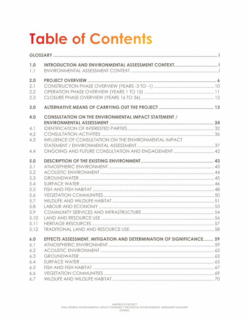
GLOSSARY ................................................................................................................................. I
1.0 INTRODUCTION AND ENVIRONMENTAL ASSESSMENT CONTEXT .................................. I 1.1 ENVIRONMENTAL ASSESSMENT CONTEXT ........................................................................I
2.0 PROJECT OVERVIEW ..................................................................................................... 6 2.1 CONSTRUCTION PHASE OVERVIEW (YEARS -3 TO -1) ................................................. 10 2.2 OPERATION PHASE OVERVIEW (YEARS 1 TO 15) ......................................................... 11 2.3 CLOSURE PHASE OVERVIEW (YEARS 16 TO 36) ............................................................ 12
3.0 ALTERNATIVE MEANS OF CARRYING OUT THE PROJECT ........................................... 13
4.0 CONSULTATION ON THE ENVIRONMENTAL IMPACT STATEMENT / ENVIRONMENTAL ASSESSMENT .................................................................................. 24
4.1 IDENTIFICATION OF INTERESTED PARTIES ....................................................................... 32 4.2 CONSULTATION ACTIVITIES ............................................................................................ 36 4.3 INFLUENCE OF CONSULTATION ON THE ENVIRONMENTAL IMPACT
STATEMENT / ENVIRONMENTAL ASSESSMENT ............................................................... 37 4.4 ONGOING AND FUTURE CONSULTATION AND ENGAGEMENT ................................. 42
5.0 DESCRIPTION OF THE EXISTING ENVIRONMENT ......................................................... 43 5.1 ATMOSPHERIC ENVIRONMENT ...................................................................................... 43 5.2 ACOUSTIC ENVIRONMENT ............................................................................................. 44 5.3 GROUNDWATER .............................................................................................................. 45 5.4 SURFACE WATER .............................................................................................................. 46 5.5 FISH AND FISH HABITAT ................................................................................................... 48 5.6 VEGETATION COMMUNITIES .......................................................................................... 50 5.7 WILDLIFE AND WILDLIFE HABITAT ................................................................................... 51 5.8 LABOUR AND ECONOMY .............................................................................................. 53 5.9 COMMUNITY SERVICES AND INFRASTRUCTURE ........................................................... 54 5.10 LAND AND RESOURCE USE ............................................................................................ 56 5.11 HERITAGE RESOURCES .................................................................................................... 57 5.12 TRADITIONAL LAND AND RESOURCE USE ..................................................................... 58
6.0 EFFECTS ASSESSMENT, MITIGATION AND DETERMINATION OF SIGNIFICANCE ........ 59 6.1 ATMOSPHERIC ENVIRONMENT ...................................................................................... 59 6.2 ACOUSTIC ENVIRONMENT ............................................................................................. 62 6.3 GROUNDWATER .............................................................................................................. 63 6.4 SURFACE WATER .............................................................................................................. 65 6.5 FISH AND FISH HABITAT ................................................................................................... 67 6.6 VEGETATION COMMUNITIES .......................................................................................... 69 6.7 WILDLIFE AND WILDLIFE HABITAT ................................................................................... 70

HARDROCK PROJECT FINAL FEDERAL ENVIRONMENTAL IMPACT STATEMENT / PROVINCIAL ENVIRONMENTAL ASSESSMENT SUMMARY
STANTEC
6.8 LABOUR AND ECONOMY .............................................................................................. 72 6.9 COMMUNITY SERVICES AND INFRASTRUCTURE ........................................................... 74 6.10 LAND AND RESOURCE USE ............................................................................................ 75 6.11 HERITAGE RESOURCES .................................................................................................... 77 6.12 TRADITIONAL LAND AND RESOURCE USE ..................................................................... 78 6.13 HUMAN AND ECOLOGICAL HEALTH ............................................................................ 80 6.14 SUMMARY OF RESIDUAL EFFECTS, SIGNIFICANCE, AND KEY COMMITMENTS .......... 82
7.0 CUMULATIVE EFFECTS ................................................................................................111
8.0 EFFECTS OF THE ENVIRONMENT ON THE PROJECT ....................................................111
9.0 EFFECTS OF POTENTIAL ACCIDENTS OR MALFUNCTIONS .........................................112
10.0 PROPOSED FOLLOW-UP AND MONITORING PROGRAMS ........................................112
11.0 BENEFITS OF THE PROJECT..........................................................................................113 11.1 ENVIRONMENT ............................................................................................................... 114 11.2 SOCIO-ECONOMIC ...................................................................................................... 114
12.0 CONCLUSION .............................................................................................................115
Table 3-1: List of Criteria and Indicators Used in the Comparative Analysis .................. 15 Table 3-2: Summary of Preferred Alternative Methods ..................................................... 17 Table 4-1: Consultation Opportunities Related to Key Environmental
Assessment Milestones ......................................................................................... 26 Table 4-2: Summary of Consultation Activities ................................................................... 36 Table 4-3: Influence of Consultation and Engagement on the Final
Environmental Impact Statement / Environmental Assessment ................... 39 Table 6-1: Summary of Residual Effects and Significance ............................................... 83 Table 6-2: Summary of Key Commitments ....................................................................... 108
Figure 1-1: Project Location ..................................................................................................... 5 Figure 2-1: Site Plan Ultimate Footprint ................................................................................... 9 Figure 2-2: Overall Project Development Schedule ........................................................... 10

HARDROCK PROJECT FINAL FEDERAL ENVIRONMENTAL IMPACT STATEMENT / PROVINCIAL ENVIRONMENTAL ASSESSMENT SUMMARY
STANTEC i
Glossary
Term Definition
Aboriginal Fishery As per the Fisheries Act, an Aboriginal fishery is one where fish is harvested by an Aboriginal organization or any of its members for the purpose of using the fish as food, for social or ceremonial purposes or for purposes set out in a land claims agreement entered into with the Aboriginal organization
Acid Rock Drainage The acidic water that is created when sulphide minerals are exposed to air and water and produce sulphuric acid.
Acute Effect An adverse effect on an animal or human receptor with symptoms that develop quickly, due to a short-term exposure, often at relatively high concentrations. Toxicological responses for acute effects in animal receptors often include death, although relevant toxicological responses to (or symptoms of) acute exposure in human receptors would more typically be sub-lethal. In human receptors, symptoms are usually short-term in duration and subside after the exposure is terminated.
Air Contaminant Emissions For stationary sources, the release or discharge of a pollutant from a facility or operation into the ambient air either by means of a stack, vent or as a fugitive dust, mist or vapour.
Alternative Methods Different ways of carrying out the same activity, including different technologies, locations designs and methods of operation.
Alternatives To Are functionally different ways of approaching or dealing with a problem or opportunity.
Aquatic Protection Values Values developed by the Ministry of Environment and Climate Change to protect aquatic biota from migration of impacted groundwater to surface water.
Archaeological Resources Any physical remnants recovered from the ground surface or below its surface which show evidence of manufacture, alteration or use by humans.
Architectural and/or Historical Resources
Any human-made standing structure or cultural landscape that provides information on a person, place, or event from the past or that may have intrinsic value due to some element of its design, construction, or use.
Attenuation The reduction of sound intensity by various means (e.g., air, humidity and porous materials).
Barrier In an acoustical sense, an obstacle composed of a berm, wall or fence that is free of gaps within or below of its extent and of sufficient mass to prevent transmission of sound through it.
Baseline Conditions Pre-project environmental conditions.
HARDROCK PROJECT FINAL FEDERAL ENVIRONMENTAL IMPACT STATEMENT / PROVINCIAL ENVIRONMENTAL ASSESSMENT SUMMARY
STANTEC ii
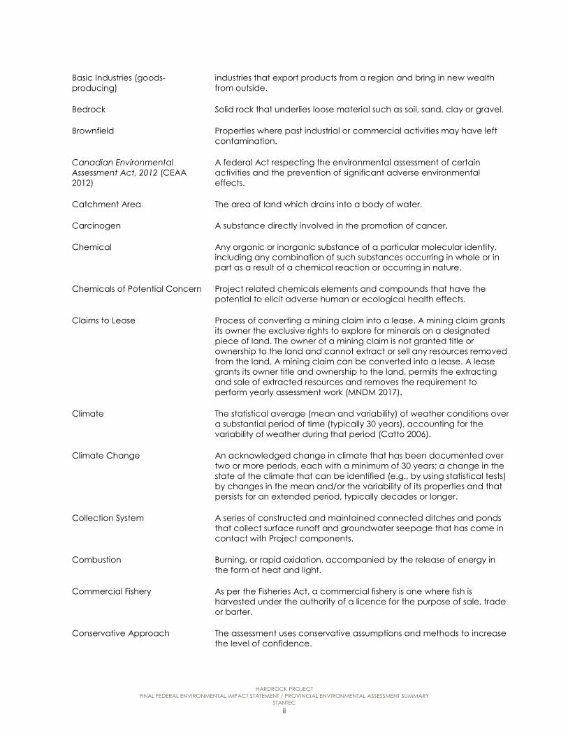
Basic Industries (goods-producing)
industries that export products from a region and bring in new wealth from outside.
Bedrock Solid rock that underlies loose material such as soil, sand, clay or gravel.
Brownfield Properties where past industrial or commercial activities may have left contamination.
Canadian Environmental Assessment Act, 2012 (CEAA 2012)
A federal Act respecting the environmental assessment of certain activities and the prevention of significant adverse environmental effects.
Catchment Area The area of land which drains into a body of water.
Carcinogen A substance directly involved in the promotion of cancer.
Chemical Any organic or inorganic substance of a particular molecular identity, including any combination of such substances occurring in whole or in part as a result of a chemical reaction or occurring in nature.
Chemicals of Potential Concern Project related chemicals elements and compounds that have the potential to elicit adverse human or ecological health effects.
Claims to Lease Process of converting a mining claim into a lease. A mining claim grants its owner the exclusive rights to explore for minerals on a designated piece of land. The owner of a mining claim is not granted title or ownership to the land and cannot extract or sell any resources removed from the land. A mining claim can be converted into a lease. A lease grants its owner title and ownership to the land, permits the extracting and sale of extracted resources and removes the requirement to perform yearly assessment work (MNDM 2017).
Climate The statistical average (mean and variability) of weather conditions over a substantial period of time (typically 30 years), accounting for the variability of weather during that period (Catto 2006).
Climate Change An acknowledged change in climate that has been documented over two or more periods, each with a minimum of 30 years; a change in the state of the climate that can be identified (e.g., by using statistical tests) by changes in the mean and/or the variability of its properties and that persists for an extended period, typically decades or longer.
Collection System A series of constructed and maintained connected ditches and ponds that collect surface runoff and groundwater seepage that has come in contact with Project components.
Combustion Burning, or rapid oxidation, accompanied by the release of energy in the form of heat and light.
Commercial Fishery As per the Fisheries Act, a commercial fishery is one where fish is harvested under the authority of a licence for the purpose of sale, trade or barter.
Conservative Approach The assessment uses conservative assumptions and methods to increase the level of confidence.

HARDROCK PROJECT FINAL FEDERAL ENVIRONMENTAL IMPACT STATEMENT / PROVINCIAL ENVIRONMENTAL ASSESSMENT SUMMARY
STANTEC iii
Consultation Two-way communication to share information and viewpoints, understand comments and interests, and address or resolve issues.
Contact Water Water that comes into contact with mine activies including the open pit, waste rock storage area runoff, ore milling and processing runoff and the Tailings Management Facility.
Contingency A provision for an unforeseen event or circumstance.
Criteria Air Contaminant Substances that are identified by government agencies as being the primary chemicals of concern associated with combustion sources. They include total particulate matter (PM), particulate matter less than 10 microns (PM10), particulate matter less than 2.5 microns (PM2.5), sulphur dioxide, nitrogen oxides, and carbon monoxide.
Crown land Land belonging to the Province of Ontario. It does not include:
(a) land, the surface rights, mining rights or the mining and surface rights of which are under lease or licence of occupation from the Crown;
(b) land in the actual use or occupation of the Crown, the Crown in right of Canada, or of a department of the Government of Canada or a ministry of the Government of Ontario;
(c) land the use of which is withdrawn or set apart or appropriated for a public purpose; or
(d) land held by a ministry of the Government of Ontario (“terre de la Couronne”).
Crown timber Timber on public lands or timber that is the property of the Crown under the management of the Minister on lands other than public lands.
Cultural Impact Assessment Project-specific traditional land and resource use study.
Cumulative Effects An assessment of cumulative effects is required under CEAA 2012 and is defined as the environment effects that are likely to result from a project in combination with other physical activities that have or will be carried out.
Cyanidation A technique for extracting gold from ore by converting the gold to a water-soluble complex.
Cyanide Detoxification The process of removing cyanide from tailings using a sulphur dioxide/air oxidation process.
Cyclone Separation A method of removing particulates from an air, gas, or liquid, without the use of filters, through vortex separation.
Dewatering To remove groundwater or surface water from an area for construction purposes.
Direct Employment labour that is hired directly by the Project
Dissolved Oxygen The amount of gaseous oxygen (O2) dissolved in an aqueous solution. Oxygen dissolves into water by diffusion from the surrounding air, by aeration and as a waste product of photosynthesis.

HARDROCK PROJECT FINAL FEDERAL ENVIRONMENTAL IMPACT STATEMENT / PROVINCIAL ENVIRONMENTAL ASSESSMENT SUMMARY
STANTEC iv
Drawdown The change in water level (between the static water level and the surface of the cone of depression) caused by pumping a groundwater well.
Dust Any airborne, finely divided solid or liquid material including particulate matter of all size ranges.
Ecological Risk Assessment A scientific method used to examine the nature and magnitude of risks from the exposure of plants and animals to contaminants in the environment.
Effluent The wastewater discharged to a receiving water body.
Effluent Treatment Plant A facility used to complete the treatment of mine contact water during operations.
Enhanced Forest Resource Licence
An eFRLU is defined as a “transitional area for First Nations seeking a longer term forest license”( Four Rivers Matawa Environmental Services Group 2015) such as a Sustainable Forest License which allows for 20 years of tree harvesting
Emissions Technically, all solid, liquid, or gaseous discharges from a processing facility, but normally referring to Air Emissions (with solids referred to as residue and liquids as effluent).
Environment The environment is broadly defined under the Canadian Environmental Assessment Act, 2012 as the components of the Earth and includes:
land, water and air, including all layers of the atmosphere;
all organic and inorganic matter and living organisms; and
the interacting natural systems that include components referred to in a) and b).
Environmental Assessment (EA) Environmental assessment is a study, which assesses the potential environmental effects (positive or negative) of a proposal. Key components of an environmental assessment include consultation with government agencies and the public; consideration and evaluation of alternatives; and, the management of potential environmental effects. Conducting an environmental assessment promotes good environmental planning before decisions are made about proceeding with a proposal.
Environmental Assessment Act An Ontario Act that provides for the protection, conservation and wise management in Ontario of the environment.
Follow-up and Monitoring Programs
A follow-up program is a requirement under section 2 (1) of CEAA 2012 and is designed to verify the accuracy of the effects assessment and the effectiveness of mitigation measures to reduce or eliminate adverse effects of a designated Project. The goal of the monitoring is to determine the mitigation or compensation measures to minimize adverse effects are properly implemented.
HARDROCK PROJECT FINAL FEDERAL ENVIRONMENTAL IMPACT STATEMENT / PROVINCIAL ENVIRONMENTAL ASSESSMENT SUMMARY
STANTEC v
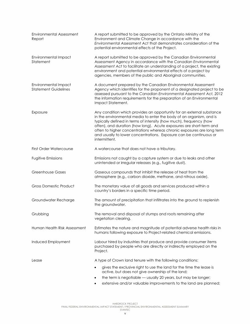
Environmental Assessment Report
A report submitted to be approved by the Ontario Ministry of the Environment and Climate Change in accordance with the Environmental Assessment Act that demonstrates consideration of the potential environmental effects of the Project.
Environmental Impact Statement
A report submitted to be approved by the Canadian Environmental Assessment Agency in accordance with the Canadian Environmental Assessment Act to facilitate an understanding of a project, the existing environment and potential environmental effects of a project by agencies, members of the public and Aboriginal communities.
Environmental Impact Statement Guidelines
A document prepared by the Canadian Environmental Assessment Agency which identifies for the proponent of a designated project to be assessed pursuant to the Canadian Environmental Assessment Act, 2012 the information requirements for the preparation of an Environmental Impact Statement.
Exposure Any condition which provides an opportunity for an external substance in the environmental media to enter the body of an organism, and is typically defined in terms of intensity (how much), frequency (how often), and duration (how long). Acute exposures are short-term and often to higher concentrations whereas chronic exposures are long term and usually to lower concentrations. Exposure can be continuous or intermittent.
First Order Watercourse A watercourse that does not have a tributary.
Fugitive Emissions Emissions not caught by a capture system or due to leaks and other unintended or irregular releases (e.g., fugitive dust).
Greenhouse Gases Gaseous compounds that inhibit the release of heat from the atmosphere (e.g., carbon dioxide, methane, and nitrous oxide).
Gross Domestic Product The monetary value of all goods and services produced within a country’s borders in a specific time period.
Groundwater Recharge The amount of precipitation that infiltrates into the ground to replenish the groundwater.
Grubbing The removal and disposal of stumps and roots remaining after vegetation clearing.
Human Health Risk Assessment Estimates the nature and magnitude of potential adverse health risks in humans following exposure to Project-related chemical emissions.
Induced Employment Labour hired by industries that produce and provide consumer items purchased by people who are directly or indirectly employed on the Project.
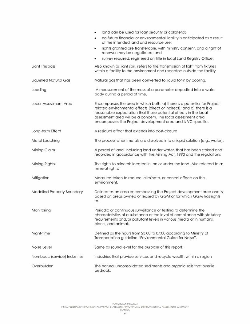
Lease A type of Crown land tenure with the following conditions:
• gives the exclusive right to use the land for the time the lease is active, but does not give ownership of the land;
• the term is negotiable — usually 20 years, but may be longer; • extensive and/or valuable improvements to the land are planned;
HARDROCK PROJECT FINAL FEDERAL ENVIRONMENTAL IMPACT STATEMENT / PROVINCIAL ENVIRONMENTAL ASSESSMENT SUMMARY
STANTEC vi
• land can be used for loan security or collateral; • no future financial or environmental liability is anticipated as a result
of the intended land and resource use; • rights granted are transferable, with ministry consent, and a right of
renewal may be negotiated; and • survey required: registered on title in local Land Registry Office.
Light Trespass Also known as light spill, refers to the transmission of light from fixtures within a facility to the environment and receptors outside the facility.
Liquefied Natural Gas Natural gas that has been converted to liquid form by cooling.
Loading A measurement of the mass of a parameter deposited into a water body during a period of time.
Local Assessment Area Encompasses the area in which both: a) there is a potential for Project-related environmental effects (direct or indirect); and b) there is a reasonable expectation that those potential effects in the local assessment area will be a concern. The local assessment area encompasses the Project development area and is VC-specific.
Long-term Effect A residual effect that extends into post-closure
Metal Leaching The process when metals are dissolved into a liquid solution (e.g., water).
Mining Claim A parcel of land, including land under water, that has been staked and recorded in accordance with the Mining Act, 1990 and the regulations
Mining Rights The rights to minerals located in, on or under the land. Also referred to as mineral rights.
Mitigation Measures taken to reduce, eliminate, or control effects on the environment.
Modelled Property Boundary Delineates an area encompassing the Project development area and is based on areas owned or leased by GGM or for which GGM has rights to.
Monitoring Periodic or continuous surveillance or testing to determine the characteristics of a substance or the level of compliance with statutory requirements and/or pollutant levels in various media or in humans, plants, and animals.
Night-time Defined as the hours from 23:00 to 07:00 according to Ministry of Transportation guideline “Environmental Guide for Noise”.
Noise Level Same as sound level for the purpose of this report.
Non-basic (service) Industries industries that provide services and recycle wealth within a region
Overburden The natural unconsolidated sediments and organic soils that overlie bedrock.

HARDROCK PROJECT FINAL FEDERAL ENVIRONMENTAL IMPACT STATEMENT / PROVINCIAL ENVIRONMENTAL ASSESSMENT SUMMARY
STANTEC vii
Overprinting The covering of an existing area by the construction of a Project component.
Paleontological Resources Works of nature consisting of or containing any remains, trace, or imprint of a multi-cellular plant, animal, or bacteria preserved in the Earth’s crust dating to any geological time period.
Particulate Matter (PM) A particle in solid or liquid phase that is suspended in air.
Person-year A person-year is equivalent to 2,080 hours in one year and can consist of one person working full-time or many people working part-time. One person-year is also equivalent to one full-time equivalent job.
Potable Water Water suitable for drinking.
Progressive Rehabilitation Rehabilitation done continually and sequentially during the entire period that a project or mine hazard exists.
Project Development Area The combined Project footprint of all facility components, as well as the anticipated area of physical disturbance associated with all phases of the Project.
Provincial Water Quality Objectives (PWQO)
Document published by the Ontario Ministry of Environment and Energy (1994) that establishes permitted levels of contaminants/ parameters in water in order to protect aquatic life and recreation.
Receptor A human, plant, bird or animal, or environmental component that could come to harm when exposed to a hazard.
Recreational fishery As per the Fisheries Act, a recreational fishery is one where fish is harvested under the authority of a licence for personal use of the fish or for sport.
Regional Assessment Area Provides the broad contextual boundary within which project-specific effects were characterized. It includes land that may be relevant to the assessment of any wider-spread direct and indirect effects of the Project. It is also the area within which there is a potential for cumulative and socio-economic effects. The regional assessment area encompasses the Project development area and the local assessment area, and is Valued Component-specific.
Residual Environmental Effects Environmental effects occurring from the Project remaining after mitigation.
Determination of Significance A conclusion as to whether the designated project is likely to cause significant adverse environmental effects taking into account the implementation of appropriate mitigation measures.
Sky Glow Refers to the illumination of the sky and/or clouds by light sources on the surface of the earth such as street lighting, and haze in the atmosphere that replaces the natural night-time sky with a translucent to opaque lighted dome.
Sound A wave motion in air, water, or other media. It is the rapid oscillatory compression changes in a medium that propagate to distant points. It is
HARDROCK PROJECT FINAL FEDERAL ENVIRONMENTAL IMPACT STATEMENT / PROVINCIAL ENVIRONMENTAL ASSESSMENT SUMMARY
STANTEC viii
characterized by changes in density, pressure, motion, and temperature as well as other physical properties. Not all rapid changes in the medium are due to sound (e.g., wind distortion on a microphone diaphragm).
Sound Level Generally, sound level refers to the weighted sound pressure level obtained by frequency weighting, usually A- or C-weighted, and expressed in decibels. Also identified as noise level in this report.
Sound Pressure Level Logarithmic ratio of the root mean square sound pressure to the sound pressure at the threshold of human hearing (i.e., 20 micropascals).
Stack A chimney, smokestack, or vertical pipe that discharges flue gas or used air.
Surface Rights Every right to land other than the mining rights.
Tailings Crushed or ground rock and process effluents that are generated in a mine processing plant.
Tailings Management Facility An engineered facility to store mine waste in the form of tailings from the ore milling and processing plant.
Terms of Reference A provincial document that is prepared in accordance with the EAA that provides a framework for the preparation of the EA.
Till Material that is composed of a gravel and clay mixture.
Total Suspended Particulate Airborne particles that are less than 100 micrometers in size. They are used as a parameter to assess air quality.
Tourism operator A person or business that combines two or more travel services (e.g. transport, accommodation, entertainment) and sells them as a single product. For purposes of this project, Tourist Operators generally includes five categories: fishing, hunting, outdoors, touring and winter activities.
Toxicity Reference Value A toxicological index (typically expressed as a dose, concentration, or slope factor) that is not expected to cause an unacceptable level of effect in a receptor. The toxicity reference value is compared to exposure to qualify or quantify the health risk to a receptor.
Traditional Knowledge Encompasses both traditional ecological knowledge and traditional land and resource use knowledge.
Traditional Land and Resource Use
Aboriginal community’s use of land, water and resources, within a traditional territory, lands or occupancy area.
Transformer Station Part of an electricity generation, transmission and distribution system where voltage is transformed from high to low using transformers.
Valued Component Components or attributes of the biophysical and socio-economic environment that are important for ecological, scientific, social, cultural, economic, historical, archaeological or aesthetic reasons.
Watercourse Any flowing water including rivers, streams and overland flow paths.

HARDROCK PROJECT FINAL FEDERAL ENVIRONMENTAL IMPACT STATEMENT / PROVINCIAL ENVIRONMENTAL ASSESSMENT SUMMARY
STANTEC ix
Watershed A catchment basin or area including all of the land that is drained by a watercourse and its tributaries. Watershed boundaries are defined by heights of land. Boundaries are set where a height of land causes water to flow away from the watercourse.
Wildlife In keeping with Environment and Climate Change Canada, the term is generally applied to birds and mammals, and sometimes defined to include reptiles and amphibians. Generally it excludes fish, invertebrates and plants.
Zone of Influence The area of land within or adjacent to a construction site that potentially may be affected by vibrations emanating from a construction activity where the peak particle velocity measured at the point of reception is equal to or greater than 5 mm/sec at any frequency.

HARDROCK PROJECT FINAL FEDERAL ENVIRONMENTAL IMPACT STATEMENT / PROVINCIAL ENVIRONMENTAL ASSESSMENT SUMMARY
STANTEC - 1 -
1.0 INTRODUCTION AND ENVIRONMENTAL ASSESSMENT CONTEXT
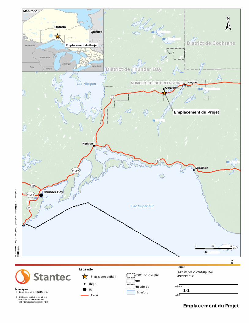
Greenstone Gold Mines GP Inc. (GGM, the Proponent) proposes to construct, operate and ultimately decommission/close a new open pit gold mine, process plant, and associated ancillary facilities, collectively known as the Hardrock Project (the Project). At full capacity, the Project will process up to 30,000 tonnes per day of ore. The Project is located approximately 275 kilometres northeast of Thunder Bay, in the Municipality of Greenstone, Ward of Geraldton (Figure 1-1).
GGM, a Canadian-based mining company, is a 50/50 joint venture partnership formed on March 9, 2015 between Premier Gold Mines Limited (Premier) and Centerra Gold Inc. GGM is focused on the development of the Hardrock Project located in the Geraldton-Beardmore Greenstone belt in Ontario, Canada. Prior to the formation of GGM, Premier acquired the Hardrock mining claim from Lac Properties in 2008. The property is a brownfield site that was actively mined during the 1930s-1970s, by two mines known as the MacLeod-Mosher and Hardrock Mines (using underground mining methods).
This document is the Summary of the Final Environmental Impact Statement / Environmental Assessment Report for the Hardrock Project as required by the “Guidelines for the Preparation of an Environmental Impact Statement” (Environmental Impact Statement Guidelines) prepared by the Canadian Environmental Assessment Agency for the Hardrock Project pursuant to the Canadian Environmental Assessment Act, 2012. An environmental impact statement is a document prepared by the Proponent to facilitate an understanding of a project, the existing environment and potential environmental effects of a project by agencies, members of the public and Aboriginal communities.
1.1 Environmental Assessment Context
The Project is subject to federal and provincial environmental regulatory requirements. The Final Environmental Impact Statement / Environmental Assessment is intended to meet the requirements of the Canadian Environmental Assessment Act, 2012 and the Ontario Environmental Assessment Act.
Federal Environmental Assessment
A federal environmental assessment is regulated under Canadian Environmental Assessment Act, 2012 and is administered by the Canadian Environmental Assessment Agency. Under Canadian Environmental Assessment Act, 2012, “designated” projects included in the Regulations Designating Physical Activities require a federal environmental assessment; the Project is a Designated Project pursuant to:

HARDROCK PROJECT FINAL FEDERAL ENVIRONMENTAL IMPACT STATEMENT / PROVINCIAL ENVIRONMENTAL ASSESSMENT SUMMARY
STANTEC - 2 -
• section 16(b): “The construction, operation, decommissioning and abandonment of a new metal mill with an ore input capacity of 4,000 t/d or more”, and
• section 16(c): “The construction, operation, decommissioning and abandonment of a new rare earth element mine or gold mine, other than a placer mine, with an ore production capacity of 600 t/d or more”.
A Project Description Report and Addendum was submitted to the Canadian Environmental Assessment Agency on April 23, 2014 and August 01, 2014 respectively. The Project description was based on an early Project concept, which was updated and refined for the Final Environmental Impact Statement / Environmental Assessment through consultation, consideration of alternatives, and advancements in Project engineering. The Canadian Environmental Assessment Agency reviewed the Project Description and confirmed that a federal environmental assessment would be required and delegated to GGM the preparation of and environmental impact statement. The Canadian Environmental Assessment Agency released the Environmental Impact Statement Guidelines on August 5, 2014 which specify the nature, scope and extent of the information required in the environmental impact statement. On February 12, 2016, the Agency provided an addendum update to the Environmental Impact Statement Guidelines for the Project. The updated revision to the Environmental Impact Statement Guidelines describe the changes to the Agency’s list of Aboriginal groups with which GGM is expected to engage for the environmental assessment. Documentation related to the federal environmental assessment is available on the Canadian Environmental Assessment Registry Internet Site at http://www.ceaa-acee.gc.ca/050/details-eng.cfm?evaluation=80068.
Other federal agencies are also providing specialized knowledge through the environmental assessment process.
Provincial Environmental Assessment
The Ministry of the Environment and Climate Change is responsible for regulating the provincial environmental assessment process. In Ontario, mining development projects carried out by private sector proponents are not subject to provincial individual environmental assessment requirements unless required by a designating regulation or if the proponent voluntarily agrees to undertake an individual environmental assessment. On August 28, 2014, Premier (now GGM, as described in Section 1.0) signed a Voluntary Agreement with the Ministry of the Environment and Climate Change to complete the requirements of a provincial individual environmental assessment and to satisfy the conditions of section 6(2) (c) and 6.1(3) of the provincial Environmental Assessment Act. The decision to undertake a Voluntary Agreement was based on a number of factors, including:
• the evolution of planning and identification of the number of streamlined environmental assessment processes applicable the Project;
• improved transparency and clarity through the integration and coordination of provincial and federal environmental assessment requirements; and
HARDROCK PROJECT FINAL FEDERAL ENVIRONMENTAL IMPACT STATEMENT / PROVINCIAL ENVIRONMENTAL ASSESSMENT SUMMARY
STANTEC - 3 -
• feedback received from consultation events and through discussions with Aboriginal communities and agencies.
A final Terms of Reference was submitted to the Ministry of the Environment and Climate Change on January 2, 2015, and an editorial amendment was submitted on March 31, 2015.
The final Terms of Reference was approved with amendments on June 24, 2015 and provides the framework for the individual environmental assessment, outlines key steps, methods and requirements to undertake an environmental assessment process and prepare an Environmental Impact Statement / Environmental Assessment compliant with the provincial Environmental Assessment Act.
Other provincial agencies have also provided technical evaluations of the Project based on their particular mandates through the environmental assessment process.
Coordinated Federal – Provincial Approach
The environmental assessment process was refined, in consultation with the Canadian Environmental Assessment Agency and the Ministry of the Environment and Climate Change, to address both federal and provincial environmental assessment requirements, and align where practical the provincially approved Terms of Reference and the federally issued Environmental Impact Statement Guidelines. Every reasonable attempt was made to coordinate key milestone consultation activities and promote opportunities for stakeholders to be effectively engaged. Federal and provincial environmental assessment information was disseminated simultaneously to limit duplication and streamline reviews, particularly with the submission of a Draft Environmental Impact Statement / Environmental Assessment in February 2016.
The main objective was to use a single body of information that addresses both provincial and federal processes, culminating in one single federal environmental impact statement and provincial environmental assessment document or Environmental Impact Statement / Environmental Assessment. This coordination was guided by the Canada-Ontario Agreement on Environmental Assessment Cooperation.
The content of this Final Environmental Impact Statement / Environmental Assessment addresses the requirements of both the approved Terms of Reference and the Environmental Impact Statement Guidelines and will serve as the basis for review by the relevant federal and provincial agencies. The Environmental Impact Statement Guidelines specify content which must be adhered to in order to satisfy the requirements of the Canadian Environmental Assessment Act, 2012. In many cases this information is also required under the provincial environmental assessment process. Concordance tables demonstrate how the Final Environmental Impact Statement / Environmental Assessment addresses the requirements of both the approved Terms of Reference and the Environmental Impact Statement Guidelines.
Following submission of the Final Environmental Impact Statement / Environmental Assessment, the provincial and federal environmental assessment review and decision-making processes will be initiated according to specific federal and provincial requirements.
_̂
Emplacement du Projet
Nipigon
District de Thunder Bay
District de Cochrane
MUNICIPALITÉ DE GREENSTONE Longlac
Marathon
Geraldton
Lac Supérieur
Lac Nipigon
Lac Esnagami
Lac White
Lac O’Sullivan
Wabakimi Lake
Lac Long
Lac Pagwachuan
UV17
UV11
UV11-17
UV61
UV102
UV11-17Thunder Bay
1:1,600,000
0 25 50Km
W:\active\60960865\drawing\MXD\Final_EA\Plain_LanguageSummary\160961111_Fr_Fig_1_1_ProjectLocation_20170627.mxd
Modifié: 2017-06-27 Par: dharvey
_̂ Em pla c em ent du Pro jet
Ville/Villa geVilleAuto ro ute
Fro ntière Ca na d a /Éta ts-UnisLim ites du d istric tLim ites m unic ipa lesPla n d 'ea u
±
Juin 2017160961111
Client/Pro jetGreensto ne Go ld Mines GP Inc (GGM)Pro jet Ha rd ro c k
Illustra tio n no1-1
Titre
Emplacement du Projet
Systèm e d e c o o rd o nnées: NAD 1983 UTM Zo ne 16N
Les d éta ils c a rto gra phiques d e b a se o nt été pro d uitsso us lic enc e a ve c le Ministère d es Ric hesses na turellesd e l'O nta rio , l’Im prim eur d e la Reine po ur l’ O nta rio ©
_̂Emplacement du Projet
Manitoba
QuébecOntario
Wisconsin
Minnesota
Iowa New YorkIllinois
Michigan
Remarques1.
2.
Légende

HARDROCK PROJECT FINAL FEDERAL ENVIRONMENTAL IMPACT STATEMENT / PROVINCIAL ENVIRONMENTAL ASSESSMENT SUMMARY
STANTEC - 6 -
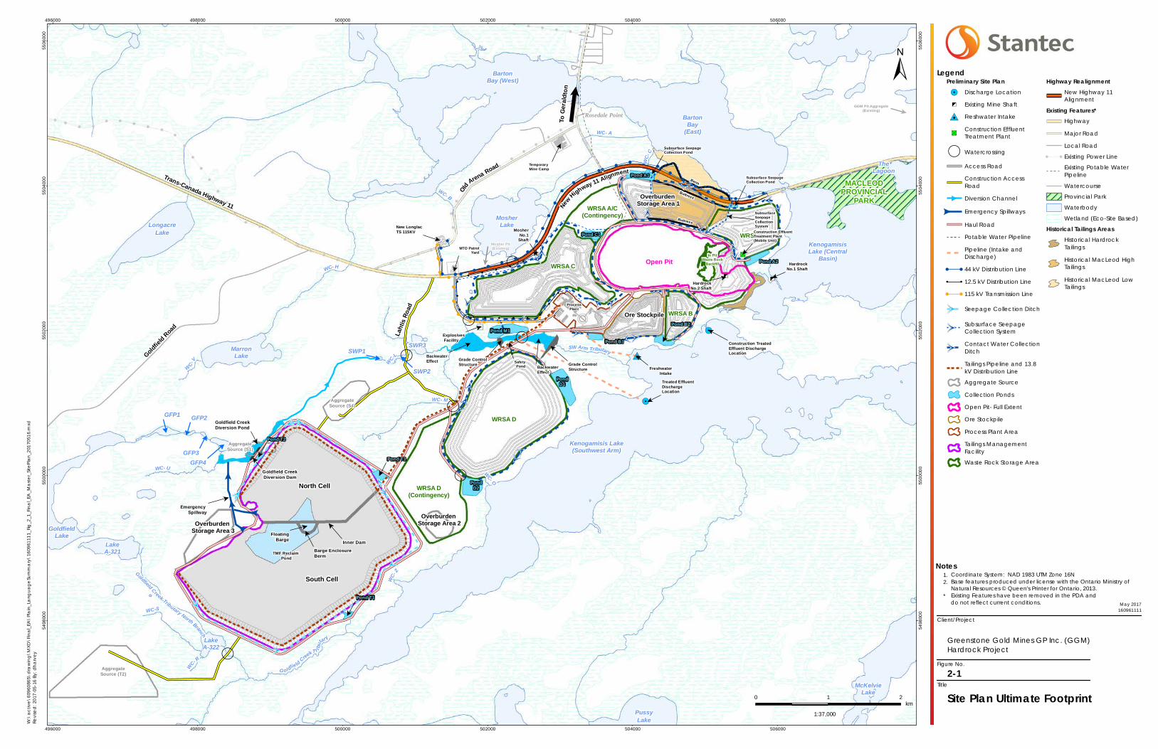
2.0 PROJECT OVERVIEW
Key Project components are as follows:
• open pit
• waste rock storage areas (designated as WRSA A, WRSA B, WRSA C and WRSA D)
• topsoil and overburden storage areas
• ore stockpile
• crushing plants and mill feed ore storage area
• process plant
• tailings management facility
• water management facilities for contact water including collection ditches and ponds
• power plant and associated infrastructure
• liquefied natural gas plant
• explosives facility
• buildings and supporting infrastructure
• water supply and associated infrastructure
• sewage treatment plant
• effluent treatment plant
• lighting and security
• site roads and parking areas
• watercourse crossings and habitat compensation/offsets
• Goldfield Creek diversion
• onsite pipelines
• fuel and hazardous materials
• aggregate sources
• temporary camp

HARDROCK PROJECT FINAL FEDERAL ENVIRONMENTAL IMPACT STATEMENT / PROVINCIAL ENVIRONMENTAL ASSESSMENT SUMMARY
STANTEC - 7 -
The location of Project components within the Project development area are shown on Figure 2-1. The Project development area described throughout the Final Environmental Impact Statement / Environmental Assessment has been refined since the baseline studies and Draft Environmental Impact Statement / Environmental Assessment. The Project development area is approximately 2,200 hectares and encompasses the Project footprint and is the anticipated area of physical disturbance associated with the construction, operation and closure of the Project.
In order to develop the Project, the relocation of existing infrastructure currently located within the Project development area, including a portion of Highway 11, a Ministry of Transportation Patrol Yard, and Hydro One Networks Inc. facilities is required. Utilities within the Ministry of Transportation right-of way of Highway 11 (e.g., Hydro One, Union Gas, Greenstone Municipal Services, Bell Canada, and Ministry of Transportation) will be relocated along the new Highway 11 alignment.
!!
!!
!
!
!
!
!
!
!
!
!
!
2
2
2
2 2
2
2
2
2
2 2
2
2
2
2
2 2
2
2
2
2
2
2
2
<
<<
<
2
2
2
22
2
2
!
!
!!
!
!!
! !!
!
!
!
!
!! !
!
!!
!
!
!!
!
! ! ! ! !
!
2
2
2
2
!
!
!
!
!
!
!!
!
! ! ! ! !
!
!
!
#0
!5
,
,
,
,
,
,
45
45
,
45
"S
!5
45
45
45
PondD1
PondD2
Pond M1
Pond C1
Pond A1
Pond A2
Pond B1
$
Pond B2
$
Pond T3
$
Pond T1
$
Pond T2
WRSA C
WRSA A
WRSA D
WRSA D(Contingency)
WRSA B
WRSA A/C(Contingency)
In PitWaste Rock
Backfill
AggregateSource (S4)
AggregateSource (S1)
AggregateSource (T2)
$
New LonglacTS 115KV
$
Construction TreatedEffluent DischargeLocation
$
HardrockNo.1 Shaft
$Hardrock
No.2 Shaft
$
Treated EffluentDischargeLocation
$
FreshwaterIntake
$
MosherNo.1
Shaft
$
MTO PatrolYard
$
SafetyPond
$ SubsurfaceSeepageCollectionSystem
$
Subsurface SeepageCollection Pond
$
Subsurface SeepageCollection Pond
$
TemporaryMine Camp
Old Arena Road
Goldfiel
d RoadTrans-Canada Highway 11
WC- M
WC-LWC
- Z
WC- C
WC-V
WC- B
WC- O
Goldfield Creek Tributary North Branch
WC- R
WC-S
WC- U
G ol dfie ld CreekT r ibu
tary
WC- A
SW Arm Tributary
WC- H
TheLagoon
SWP3"
SWP1
"
GFP1
"
GFP3 "
GFP4
LakeA-321
LakeA-322
MosherLakeLongacre
Lake
MarronLake
GoldfieldLake
McKelvieLake
PussyLake
BartonBay (West)
BartonBay
(East)
Kenogamisis Lake(Southwest Arm)
"
SWP2
"
GFP2
KenogamisisLake (Central
Basin)
Buttress
Berm
New
Highway 11 Alignment
Ore Stockpile
Open Pit
Overburden Storage Area 1
Overburden Storage Area 2Overburden
Storage Area 3
$
Mosher Pit(Existing)
$
Explosives Facility
ProcessPlant
$
Emergency Spillway
TMF Reclaim Pond
$
Barge EnclosureBerm
$Floating
Barge
North Cell
South Cell
$GGM Pit Aggregate
(Existing)
$
Inner Dam
Rosedale PointToGe
r ald t
on
$
Goldfield CreekDiversion Dam
$
Construction EffluentTreatment Plant (Mobile Unit)
$
Goldfield CreekDiversion Pond
Buttress
$
BackwaterEffect
$
BackwaterEffect
$
Grade ControlStructure
$
Grade ControlStructure
$
Lahti
s Roa
d
MACLEODPROVINCIAL
PARK
496000
496000
498000
498000
500000
500000
502000
502000
504000
504000
506000
506000
5498
000
5498
000
5500
000
5500
000
5502
000
5502
000
5504
000
5504
000
5506
000
5506
000
Client/Project
Figure No.
Title
Site Plan Ultimate Footprint2-1
Greenstone Gold Mines GP Inc. (GGM)Hardrock Project
May 2017160961111
Notes
Legend
1.2.*
Coordinate System: NAD 1983 UTM Zone 16NBase features produced under license with the Ontario Ministry of Natural Resources © Queen's Printer for Ontario, 2013.Existing Features have been removed in the PDA and do not reflect current conditions.
0 1 2km
1:37,000
W:\a
ctive
\609
6086
5\dr
awing
\MXD
\Fina
l_EA\
Plain_
Lang
uage
Summ
ary\
1609
6111
1_Fig
_2_1
_Fina
l_EA_
Maste
r_Site
Plan_
2017
0516
.mxd
Revis
ed: 2
017-0
5-16 B
y: dh
arve
y
± Preliminary Site Plan!5 Discharge Location45 Existing Mine Shaft#0 Freshwater Intake
"SConstruction EffluentTreatment Plant
, WatercrossingAccess RoadConstruction AccessRoadDiversion Channel
< Emergency SpillwaysHaul RoadPotable Water PipelinePipeline (Intake andDischarge)
! ! 44 kV Distribution Line! ! 12.5 kV Distribution Line! ! 115 kV Transmission Line
2 Seepage Collection Ditch
2Subsurface SeepageCollection System
2Contact Water CollectionDitchTailings Pipeline and 13.8kV Distribution LineAggregate SourceCollection PondsOpen Pit- Full ExtentOre StockpileProcess Plant AreaTailings ManagementFacilityWaste Rock Storage Area
Highway RealignmentNew Highway 11Alignment
Existing Features*HighwayMajor RoadLocal Road
! ! Existing Power LineExisting Potable WaterPipelineWatercourseProvincial ParkWaterbodyWetland (Eco-Site Based)
Historical Tailings AreasHistorical HardrockTailingsHistorical MacLeod HighTailingsHistorical MacLeod LowTailings

HARDROCK PROJECT FINAL FEDERAL ENVIRONMENTAL IMPACT STATEMENT / PROVINCIAL ENVIRONMENTAL ASSESSMENT SUMMARY
STANTEC - 10 -
The overall Project development schedule is shown on Figure 2-2.
Figure 2-2: Overall Project Development Schedule
The following sections provide a summary of the works to be completed in each of the Project phases.
2.1 Construction Phase Overview (Years -3 to -1)
During construction (approximately 29 months), it is expected that the construction labour force will consist of an average of 650 construction workers (inclusive of construction workers plus other labour) and will peak at 975 workers.
Construction activities will primarily be scheduled to take place during daytime hours. The construction of Project components includes the following:
• site preparation including progressive removal of existing infrastructure, timber harvesting, clearing and grubbing, soil stripping, grading, blasting (if required), and leveling of the Project development area as needed in preparation for planned infrastructure
• management of contaminated soil from existing conditions
• removal of topsoil, overburden and waste rock
• open pit development
• stockpiling of ore
-5 0 5 10 15 20 25 30 35 40
Construction
Operation
Active Closure
Post-Closure
Years
Closure

HARDROCK PROJECT FINAL FEDERAL ENVIRONMENTAL IMPACT STATEMENT / PROVINCIAL ENVIRONMENTAL ASSESSMENT SUMMARY
STANTEC - 11 -
• development and implementation of water management facilities (i.e., contact water collection ponds and ditches, construction effluent (or wastewater) treatment plant, sewage treatment plant, potable water infrastructure)
• watercourse crossings
• Goldfield Creek diversion
• placement of waste rock in WRSA B and WRSA D
• Phase 1 (south cell) of the tailings management facility
• buildings and installation of equipment associated with the mine’s operation
• temporary camp and connection to the municipal sanitary sewer system and potable water
• development of aggregate sources
• linear facilities (e.g., roads, onsite pipelines and piping, 115 kilovolt transmission and 44 kilovolt distribution lines and substation)
• Highway 11 realignment
• relocation of Hydro One Networks Inc. infrastructure
• ancillary facilities (e.g., fuel supply, and storage and distribution)
• construction treated effluent discharge location into the Southwest Arm of Kenogamisis Lake
• the mill and initial commissioning during the final months of construction.
2.2 Operation Phase Overview (Years 1 to 15)
The Project will operate seven days per week for 365 days per year on a continuous basis (i.e., 24-hours per day). Project operation will directly employ an average of 450 people per year with a peak of an estimated 545 people in Years 3 to 6. Project operation include open pit operation, mill throughput, services and administration.
Operation of the open pit will include drilling, blasting, loading and hauling of ore and waste rock to designated areas. Blasting will only occur during the daytime and loading and hauling of ore and waste rock will occur both day and night. As the open pit expands over time, there will be progressive vegetation clearing, overburden stripping and hauling of waste rock to the designated waste rock storage areas.
Portions of the historical MacLeod tailings located within the footprint of the open pit will be excavated and removed to the new tailings management facility in Years 2 to 4 of operation. Portions of historical Hardrock tailings, up to the 30 metre setback from the high-water mark of Kenogamisis Lake, will also be excavated and removed to the tailings management facility starting in Year 2.
HARDROCK PROJECT FINAL FEDERAL ENVIRONMENTAL IMPACT STATEMENT / PROVINCIAL ENVIRONMENTAL ASSESSMENT SUMMARY
STANTEC - 12 -
Milling is anticipated in two phases; Phase 1 will progressively ramp up the production rate to 24,000 tonnes per day of ore during approximately the first two years of operation with Phase 2 progressively increasing production up to 30,000 tonnes per day starting during approximately the third year. Ore processing will include crushing and milling, with gold extraction completed using a combination of gravity separation and cyanidation for gold recovery, followed by an in-plant cyanide detoxification using the sulfur dioxide/air oxidation process. Gold doré bars will be produced at the end of the process. It is projected that the “Life of Mine” or the time in which the ore reserves will be extracted is approximately 15 years.
Tailings (crushed or ground rock generated in the process plant) will be pumped via a pipeline (approximately 4 kilometres) to an engineered tailings management facility for permanent storage. The tailings management facility is also designed to provide reclaim (recycled) water to the process plant which will meet up to 90 percent (%) of the water required for processing ore. The tailings management facility is designed to accept 140,000 kilotonnes of tailings, with an additional allowance of 5,000 kilotonnes of historical MacLeod tailings located in the footprint of the open pit and portions of the Hardrock tailings, for a total of 145,000 kilotonnes. The surface area of the tailings management facility is expected to cover 518 hectares and will be designed in two cells, with the north cell having a surface area of 162 hectares and the south cell having a surface area of 356 hectares. The ultimate height of the containment dam surrounding the tailings management facility will be approximately 35 metres above surrounding ground level.
At the end of the operation phase, the mining will yield an approximated total of 139 million tonnes of ore at an average grade of 1 gram of gold per tonne. Total gold production over the Life of Mine is approximately 4.2 million ounces.
2.3 Closure Phase Overview (Years 16 to 36)
Planning for closure is an integral part of the Project design. The Final Environmental Impact Statement / Environmental Assessment includes a Conceptual Closure Plan that will be used as the basis for additional consultation for the development of the Closure Plan submitted to Ministry of Northern Development and Mines for approval prior to the start of construction activities.
After operation is complete, the Project development area will be rehabilitated and the Project will progress toward a closed out condition. Active closure measures will be completed in the first five years following completion of operation and will include removal and decommissioning of Project infrastructure not required for long-term closure, and rehabilitation of the Project development area in accordance with the requirements of Ontario Regulation 240/00. GGM will carry out a vegetation test plotting study during operation. The study will evaluate the most effective revegetation approach for various application areas and the results will be used to update and inform revegetation.
Filling of the open pit will represent the main closure activity. To reduce the filling time, water will be pumped into the open pit from the tailings management facility, contact water collection ponds, and potentially from the Southwest Arm of Kenogamisis Lake in a controlled manner. It is anticipated to take approximately 16 years to fill the open pit. The ultimate water level of the pit

HARDROCK PROJECT FINAL FEDERAL ENVIRONMENTAL IMPACT STATEMENT / PROVINCIAL ENVIRONMENTAL ASSESSMENT SUMMARY
STANTEC - 13 -
lake will be approximately 331.0 metres elevation, which is approximately 1.0 metres higher than the recorded peak water level in Kenogamisis Lake. This elevation difference will provide a gentle gradient to allow water to flow from the pit lake through a channel that will be constructed from the southeastern portion of the open pit to the Southwest Arm of Kenogamisis Lake. Ongoing monitoring and maintenance activities will be carried out throughout the closure phase until the closure objectives have been satisfied. Once the pit lake water quality has been demonstrated to meet acceptable regulatory criteria, the Project would be moved to a closed out status as defined in Ontario Regulation 240/00.
3.0 ALTERNATIVE MEANS OF CARRYING OUT THE PROJECT
Both the federal and provincial Environmental Impact Statement / Environmental Assessment processes require that project alternatives be considered when planning a project. The alternatives assessment looked at technologies, methods, designs, and siting options for components of the Project. The assessment considered how alternatives would affect environmental, economic and technical factors. Potential effects were identified to compare the advantages and disadvantages of proceeding with each alternative and to select the preferred alternative for each Project component.
The process to identify and evaluate a reasonable range of alternative methods for each Project component involved a three-step process. In accordance with section 3.1.4 of the Ministry of the Environment and Climate Change Code of Practice: Preparing and Reviewing Environmental Assessments in Ontario, the evaluation process used progressively more technical detail at each stage to narrow down the range of alternatives and ultimately select a preferred “alternative method” for each Project component. The three-step process included:
Step 1 – Long List of Alternative Methods
• Develop a “Long List” of Potential Alternatives by identifying potentially feasiblealternative methods for each Project component.
Step 2 – Initial Screening of Alternative Methods
• Confirm screening questions to identify ‘fatal flaws’ (such as environmental, economic ortechnical issues) that would affect the ability to feasibly implement the Project.
• Complete an Initial Screening to remove alternatives with fatal flaws from furtherconsideration, and identify the alternatives that would be compared in Step 3(Comparative Analysis).

- 14 -
• Develop a set of criteria and indicators (Table 3-1) with which to consider the potentialfor effects of alternatives, accounting for the natural, social, economic, cultural and builtenvironment.
• Define the key assumptions for how each alternative would be implemented, includingconsidering standard mitigation measures that would be applied to each alternative toavoid or limit effects.
• Assess the potential for effects based on each criterion/indicator for each Project phase(construction, operation, and closure), by considering how each alternative would beimplemented and how it would result in changes to the indicators and criteria.
• Compare each alternative to determine which alternative demonstrates the greatestbalance of advantages to disadvantages, based on the potential for environmentaleffects using the indicators and criteria.
Step 1 identified all reasonably possible technologies and methods for each Project component, based on industry standards as a starting point for the evaluation process. This step identified the full range of possible approaches for each Project component.
In Step 2, the initial screening considered the key environmental effects and limitations of each alternative method. The initial screening used a general (or landscape level) assessment of the existing environment, considering major constraints (e.g., waterbodies, existing buildings and infrastructure, ensuring a safe environment around the Project) and a high-level review of effects on the environment (i.e., natural, social, economic, cultural and built environment), to identify any fatal flaws. Only alternatives with substantial merit and possibility for implementation were forwarded for further consideration in Step 3 (Comparative Analysis).
Step 3 included the completion of the comparative analysis, which compared alternatives to select a preferred method for each Project component. The comparative analysis looked at the potential effects of each alternative for a set of environmental components and other technical considerations (criteria and indicators) that were developed based on federal and provincial Environmental Impact Statement / Environmental Assessment requirements and input from stakeholders, government agencies and Aboriginal communities. The preferred alternative for each Project component was selected based on which alternative had the greater balance of advantages to disadvantages. The preferred alternative for each Project component is listed in Table 3-2.
Tailings management facility and waste rock storage area alternatives were assessed separately based on Environment and Climate Change Canada’s Guidelines for the Assessment of Alternatives for Mine Waste Disposal. The results of this assessment process are also summarized in Table 3-2 below.
HARDROCK PROJECT FINAL FEDERAL ENVIRONMENTAL IMPACT STATEMENT / PROVINCIAL ENVIRONMENTAL ASSESSMENT SUMMARY
STANTEC
Step 3 – Comparative Analysis of Alternative Methods

HARDROCK PROJECT FINAL FEDERAL ENVIRONMENTAL IMPACT STATEMENT / PROVINCIAL ENVIRONMENTAL ASSESSMENT SUMMARY
STANTEC - 15 -
Table 3-1: List of Criteria and Indicators Used in the Comparative Analysis
Criteria Indicators
NATURAL ENVIRONMENT
Atmospheric Environment Change in ambient air quality parameters
Climate change as measured by change in greenhouse gas emissions
Acoustic Environment Change in noise or vibration levels
Groundwater Change in groundwater quantity or flow
Change in groundwater quality
Surface Water Change in surface water quantity or flow
Change in surface water quality
Fish and Fish Habitat Change in fish habitat
Change in fish
Vegetation communities
Change in abundance of vegetation species of interest
Change in abundance or condition of upland vegetation communities
Change in wetland function or connectivity
Wildlife and Wildlife Habitat
Change in movement, health or mortality risk of wildlife
Change in wildlife habitat
SOCIAL ENVIRONMENT
Community Services and Infrastructure
Change in capacity of housing and accommodation
Change in capacity of health and emergency services and infrastructure
Change in the capacity of recreation and entertainment services and infrastructure
Change in the capacity of provincial and municipal services and infrastructure
Health and Safety Health and safety of mine workers
Health and safety of local residents
ECONOMIC ENVIRONMENT
Cost
Capital cost
Operational/maintenance cost
Rehabilitation/closure cost
Labour and Economy Change in labour
Change in economy
Technical Feasibility Ability to implement /commonly used technology in similar applications
Effectiveness/reliability
CULTURAL ENVIRONMENT
Heritage Resources Change in archaeological sites
Change in architectural or historical resources
Change in Aboriginal communities’ cultural practices

HARDROCK PROJECT FINAL FEDERAL ENVIRONMENTAL IMPACT STATEMENT / PROVINCIAL ENVIRONMENTAL ASSESSMENT SUMMARY
STANTEC - 16 -
Table 3-1: List of Criteria and Indicators Used in the Comparative Analysis
Criteria Indicators
Traditional Land and Resource Use
Change in Aboriginal communities’ traditional land uses (including hunting, fishing, trapping and harvesting)
BUILT ENVIRONMENT
Land and Resource Use
Change in recreational land and resource use
Change in navigation
Change in commercially-based land and resources uses

HARDROCK PROJECT FINAL FEDERAL ENVIRONMENTAL IMPACT STATEMENT / PROVINCIAL ENVIRONMENTAL ASSESSMENT SUMMARY
STANTEC - 17 -
Table 3-2: Summary of Preferred Alternative Methods
Project Component Long List of Methods Identified for Assessment Preferred Alternative
Waste Rock Storage Areas (assessed through a separate Multiple Accounts Analysis)
Locations: • WRSA-1 • WRSA-2 • WRSA-3 • WRSA-4 Disposal Methods: • In-pit storage of non-segregated waste rock • Combined above ground and in-pit storage of non-
segregated waste rock • Co-disposal of waste rock and tailings • Segregation of waste rock due to acid rock
drainage/metals leaching potential
• WRSA-4 with combined above ground and in-pit storage of non-segregated waste rock
Tailings Management Facility (assessed through a separate Multiple Accounts Analysis)
Locations: • TMF-1 • TMF-2 • TMF-3A • TMF-4 • TMF-8 • TMF-9 Disposal Methods: • Cyclone separation with sand embankment and slimes
impoundment storage • Co-disposal of waste rock and tailings • Dry stacking of filtered tailings • Surface disposal of paste tailings • Surface disposal of thickened tailings • Impoundment disposal of conventional tailings • Impoundment disposal of thickened tailings Dam Construction Methods: • Upstream • Downstream • Centerline
• TMF-8 with conventional impoundment disposal and downstream construction

HARDROCK PROJECT FINAL FEDERAL ENVIRONMENTAL IMPACT STATEMENT / PROVINCIAL ENVIRONMENTAL ASSESSMENT SUMMARY
STANTEC - 18 -
Table 3-2: Summary of Preferred Alternative Methods
Project Component Long List of Methods Identified for Assessment Preferred Alternative
Process Plant Process Plant Location: • onsite • offsite Ore Processing: • cyanidation and gravity separation • flotation • gravity separation • thiosulphate/alpha-cyclodextrin Process Water Supply: • reclaim from the tailings management facility • dewatering historical underground workings • surface water
• onsite location • cyanidation for gold recovery, supplemented with
gravity separation • process water supply from reclaim water recycled
from the tailings management facility and site contact water collection system, and groundwater from historical underground workings
Ore Stockpile, Crushing Plant and Mill Feed Ore Storage Area
Ore stockpile, crushing plant and mill feed ore storage area locations: • onsite near the process plant • offsite
• onsite ore stockpile, crushing plant and storage area
Goldfield Creek Diversion Goldfield Creek diversion options: • Option 1 • Option 2 • Option 3 • Option 4A • Option 4B • Option 5 • Option 5A • Option 6
• Goldfield Creek diversion Option 6 (diversion northeast to Southwest Arm Tributary)

HARDROCK PROJECT FINAL FEDERAL ENVIRONMENTAL IMPACT STATEMENT / PROVINCIAL ENVIRONMENTAL ASSESSMENT SUMMARY
STANTEC - 19 -
Table 3-2: Summary of Preferred Alternative Methods
Project Component Long List of Methods Identified for Assessment Preferred Alternative
Highway 11 Realignment Highway 11 Realignment options: • Route 1A • Route 1B • Route 1C • Route 1D • Route 1D (optimized) • Routes 2, 3 and 4 • Route 5 • Route 6
• Route 1D (optimized) (revised alignment based on Route 1D to address safety concerns and improve sight distance)
Historical Tailings and Other Contaminated Soil
Historical Tailings within the Project development area: • no removal of existing tailings • removal of existing tailings where required to facilitate
construction • entire removal of existing tailings within the Project
development area Contaminated Soils within the Project development area: • manage onsite or remove for management as required • leave in place
• removal of existing tailings where feasible • manage onsite or remove for management as
required
Aggregate Sources Aggregate Sources: • use existing quarries/pits • use mined waste rock for crushed aggregate
production • create new aggregate sources
• use a combination of existing quarries or pits, mined waste rock and new aggregate sources

HARDROCK PROJECT FINAL FEDERAL ENVIRONMENTAL IMPACT STATEMENT / PROVINCIAL ENVIRONMENTAL ASSESSMENT SUMMARY
STANTEC - 20 -
Table 3-2: Summary of Preferred Alternative Methods
Project Component Long List of Methods Identified for Assessment Preferred Alternative
Contact Water Collection, Treatment and Discharge
Open Pit Contact Water: • direct to historical underground workings • pump to surface ponds for treatment Waste Rock Storage Area and Process Plant Area Contact Water: • collect runoff locally and treat through central
collection ponds and ditches and/or the effluent treatment plant prior to discharge
• direct to historical underground workings • direct to tailings management facility for storage and
management • treatment method - coagulation/filtration, reverse
osmosis, ion exchange, lime precipitation, biological treatment, engineered wetland
• open pit contact water directed to historical underground workings for storage and dewatering
• collect runoff locally and treat through central collection ponds and/or effluent treatment plant prior to discharge. Coagulation and filtration was selected as the preferred treatment method.
Sewage Treatment Plant for the Mine Site
Sewage Treatment Method: • sewage treatment plant with surface water discharge • septic tank(s) and tile field(s) • lagoons • connection to the municipal system • trucking domestic sewage offsite to a licensed
treatment plant
• sewage treatment plant with surface water discharge
Potable Water Supply Potable Water Supply: • groundwater wells • surface water • Geraldton municipal potable water system
• connection to the Geraldton municipal potable water system
Explosives Management Explosives Management: • onsite management • transport from existing facilities
• manage explosives onsite

HARDROCK PROJECT FINAL FEDERAL ENVIRONMENTAL IMPACT STATEMENT / PROVINCIAL ENVIRONMENTAL ASSESSMENT SUMMARY
STANTEC - 21 -
Table 3-2: Summary of Preferred Alternative Methods
Project Component Long List of Methods Identified for Assessment Preferred Alternative
Power Source and Associated Infrastructure
Primary Power: • natural gas-fuelled power plant • onsite diesel or fuel generation • connection to the existing grid • renewable energy Temporary Power: • connection to the existing grid • temporary diesel generators
• natural gas-fuelled power plant for primary power source
• 44 kilovolt tie-in to existing transmission line and temporary generation for temporary and backup power
Waste Management Non-hazardous Solid Waste: • truck offsite • establish new landfill • onsite incineration Hazardous Waste: • truck offsite • onsite disposal
• truck non-hazardous and hazardous waste offsite to licensed disposal facilities
Mining Equipment Fuel Type and Source
Fuel Type for Mining Equipment: • full diesel • a blend of diesel and liquefied natural gas • full gasoline Fuel Source for Mining Equipment: • liquefied natural gas (trucking) • liquefied natural gas (plant) • diesel (trucking)
• use diesel for the short term • potential use a blend of liquefied natural gas and
diesel, and a liquefied natural gas plant with trucked diesel for the long term

HARDROCK PROJECT FINAL FEDERAL ENVIRONMENTAL IMPACT STATEMENT / PROVINCIAL ENVIRONMENTAL ASSESSMENT SUMMARY
STANTEC - 22 -
Table 3-2: Summary of Preferred Alternative Methods
Project Component Long List of Methods Identified for Assessment Preferred Alternative
Infrastructure and Support Facilities
Site Access: • western access • eastern access • north access Buildings and Support Facilities: • onsite facilities • offsite facilities Temporary Camp Location: • near Old Arena Road • directly west of the open pit • outside Geraldton and the Project development area • no camp
• permanent site access via the western leg of existing Highway 11
• establish buildings and support facilities onsite • temporary camp located near Old Arena Road
and Michael Power Boulevard • sewage treatment for the temporary camp
through a connection to the municipal system
Hydro One Networks Inc. Transformer Station, Transmission/ Distribution Lines and Operations Centre Relocation
Hydro One Networks Inc. Transformer Station Location: • Study Area 1 / Option 1 • Study Area 1 / Option 1A/B • Study Area 1 / Option 1C • Study Area 1 / Option 1D • Study Area 2 / Option 2 • Study Area 2 / Option 2A • Study Area 3 / Location east of Kenogamisis Lake • Study Area 4 / Location further west of mine site
• Hydro One Networks Inc. Longlac Transformer Station north and west of Old Arena Road near Mosher Lake
Ministry of Transportation Patrol Yard
Ministry of Transportation Patrol Yard Relocation (if required): • west of Project • east of Project
• Ministry of Transportation Patrol Yard west of the Project development area on Highway 11

HARDROCK PROJECT FINAL FEDERAL ENVIRONMENTAL IMPACT STATEMENT / PROVINCIAL ENVIRONMENTAL ASSESSMENT SUMMARY
STANTEC - 23 -
Table 3-2: Summary of Preferred Alternative Methods
Project Component Long List of Methods Identified for Assessment Preferred Alternative
Closure Open Pit Closure: • natural filling with water • enhanced filling with water • backfill with waste rock Storage and Stockpile Closure: • cover and vegetate • no cover Tailings Management Facility Closure: • cover and vegetate • water cover Buildings and Infrastructure Closure: • removal and disposal • reuse
• open pit enhanced filling with water • cover and vegetate waste rock storage areas,
overburden storage areas and stockpile to the extent possible
• cover and vegetate the tailings management facility to the extent possible
• buildings and infrastructure removal and disposal

HARDROCK PROJECT FINAL FEDERAL ENVIRONMENTAL IMPACT STATEMENT / PROVINCIAL ENVIRONMENTAL ASSESSMENT SUMMARY
STANTEC - 24 -
The preferred alternatives collectively form the Project, and were carried forward for the environmental effects assessment. A detailed analysis of potential effects resulting from the Project and identification of mitigation measures was undertaken for the individual valued components in the Final Environmental Impact Statement / Environmental Assessment.
4.0 CONSULTATION ON THE ENVIRONMENTAL IMPACT STATEMENT / ENVIRONMENTAL ASSESSMENT
GGM recognizes the importance of consultation with stakeholders (including members of the public, community organizations, local businesses and other interested parties), government agencies and Aboriginal communities as an integral part of the Project. Active participation through consultation during the planning and preparation of the Final Environmental Impact Statement / Environmental Assessment has helped to achieve an open and transparent process, build trust, enhance awareness and understanding of the Project, and shape the Project.
GGM’s consultation plan has been designed to reflect key requirements from both the federal and provincial environmental assessment processes, which provide guidance for consultation with stakeholders, government agencies and Aboriginal communities. GGM has provided information on the process being followed, and has worked to gather, consider and incorporate
comments on the process, the Project, and the studies being conducted, into the Final Environmental Impact Statement / Environmental Assessment.
GGM understands that consultation on the Project is an iterative and ongoing process. To ensure that ample consultation opportunities on the Project were offered, GGM focused consultation with relevant stakeholders, government agencies and Aboriginal communities on key environmental assessment milestones. These milestones also align with the requirements of the Terms of Reference
Public Open House - Geraldton
Public Open House – Longlac

HARDROCK PROJECT FINAL FEDERAL ENVIRONMENTAL IMPACT STATEMENT / PROVINCIAL ENVIRONMENTAL ASSESSMENT SUMMARY
STANTEC - 25 -
approval. The key environmental assessment milestones where GGM provided Project information and consultation opportunities include:
• development of community specific Aboriginal consultation plans for the preparation of an environmental assessment
• development of the methodology, evaluation and results of baseline studies and supporting technical assessments
• development of the evaluation methodology for the assessment of alternatives, including a list of criteria and indicators
• the evaluation and conclusion of the alternatives assessment, including the identification of potential effects and the development of appropriate mitigation and management measures
• assessment and evaluation of the preferred Project (including the development of mitigation and monitoring measures to address any potential effects)
• the conclusion of the assessment and evaluation of the preferred Project (including potential effects, and appropriate effects management measures).
GGM took a proactive approach to resolve comments, and regulatory and technical issues in a collaborative manner with stakeholders, government agencies and Aboriginal communities through the Environmental Impact Statement / Environmental Assessment process. This involved providing numerous public consultation opportunities, ongoing communication and correspondence, the development of a Government Review Team and Aboriginal Review Team meetings/webinars (which focused on information sharing for a broad list of reviewers at key environmental assessment milestones) and more focused meetings with agencies and aboriginal communities based on specific interests or areas of comments.
A summary of the information made available at key environmental assessment milestones is provided in Table 4-1 below.

HARDROCK PROJECT FINAL FEDERAL ENVIRONMENTAL IMPACT STATEMENT / PROVINCIAL ENVIRONMENTAL ASSESSMENT SUMMARY
STANTEC - 26 -
Table 4-1: Consultation Opportunities Related to Key Environmental Assessment Milestones
Environmental Assessment Milestone
Documents Available for Review Consultation Activities on Key Environmental Assessment Milestone
Consultation Approach
Circulated to Aboriginal communities: • drafts of the Hardrock Project Consultation Plan (individualized per
community, and updated based on consultation)
• Aboriginal Community Meetings
Baseline Studies Circulated to government agencies and Aboriginal communities (April/May 2015): • environmental baseline methodologies • publicly available 2014 Baseline Reports (posted on the Project
website, or shared directly with Aboriginal communities, government agencies and the Project distribution list): − hydrology − hydrogeology − soils − surface water − fish and fish habitat − terrestrial − climate and air quality − acoustics − archaeology − cultural heritage − socio-economics − metal bioavailability − geochemistry
• Baseline Report summaries (English and Ojibway) • Public Information Centre material on baseline and alternatives
assessment methodology • comments and responses on Baseline Reports • presentation material from Government Review Team baseline
webinars • presentation material from Aboriginal Review Team baseline
webinars • presentation on historical impacts to Kenogamisis Lake
• Public Information Centres • Stakeholder Meetings • Government Review Team Webinars • Government Technical Meetings • Aboriginal Review Team Webinars • Aboriginal Community Meetings • Correspondence with stakeholders,
government agencies and Aboriginal communities

HARDROCK PROJECT FINAL FEDERAL ENVIRONMENTAL IMPACT STATEMENT / PROVINCIAL ENVIRONMENTAL ASSESSMENT SUMMARY
STANTEC - 27 -
Table 4-1: Consultation Opportunities Related to Key Environmental Assessment Milestones
Environmental Assessment Milestone
Documents Available for Review Consultation Activities on Key Environmental Assessment Milestone
Publicly available in January 2016 (posted on the Project website, or shared directly with Aboriginal communities, government agencies and the Project distribution list through website link): • 2015 Baseline Reports:
− air quality monitoring − archaeological stage 2 − fish and fish habitat − hydrogeology − hydrology − geochemistry − soils − surface water quality − terrestrial
Publicly available in February 2016 (posted on the Project website, or shared directly with Aboriginal communities, government agencies and the Project distribution list through website link and/or hardcopy): • Hardrock Project Draft Environmental Impact Statement /
Environmental Assessment, including baseline data throughout the main report, and Baseline Reports in Appendix E
Provided directly to government agencies: • Government Review Team meeting minutes from baseline webinars
(sent to participating agencies) Provided directly to Aboriginal communities: • biophysical fieldwork documents in April 2014 (provided to Aroland
First Nation, Ginoogaming First Nation, Long Lake #58 First Nation, Métis Nation of Ontario and Red Sky Métis Independent Nation for comment)
• Aboriginal Review Team meeting minutes from baseline webinars • minutes from community-specific presentations on baseline data
results, alternatives assessment methodology, and results (Aroland First Nation, Ginoogaming First Nation and Long Lake #58 First Nation)

HARDROCK PROJECT FINAL FEDERAL ENVIRONMENTAL IMPACT STATEMENT / PROVINCIAL ENVIRONMENTAL ASSESSMENT SUMMARY
STANTEC - 28 -
Table 4-1: Consultation Opportunities Related to Key Environmental Assessment Milestones
Environmental Assessment Milestone
Documents Available for Review Consultation Activities on Key Environmental Assessment Milestone
Alternatives Assessment Methodology
Publicly available (posted on the Project website, or shared directly with Aboriginal communities, government agencies and the Project distribution list): • Public Information Centre material on baseline and alternatives
assessment methodology • presentation material from Government Review Team alternatives
assessment methodology webinar • presentation material from Aboriginal Review Team alternatives
assessment methodology webinar • list of criteria and indicators (from Government Review
Team/Aboriginal Review Team webinars) • updated list of criteria and indicators, plus rationale for their
selection (in response to comments) • initial screening results and rationale for the selection of alternatives
(from Government Review Team/Aboriginal Review Team webinars) • table of comments and responses to the alternatives assessment
methodology Provided directly to government agencies: • Government Review Team meeting minutes from alternatives
assessment methodology and baseline results webinar (sent to participating agencies)
• responses to comments on the alternatives assessment methodology (Environment and Climate Change Canada, Ministry of the Environment and Climate Change, Ministry of Tourism, Culture and Sport)
Provided directly to Aboriginal communities: • Aboriginal Review Team meeting minutes to attendees for the
alternatives assessment methodology webinar (Animbiigoo Zaagi'igan Anishinaabek and Red Sky Métis Independent Nation)
• Public Information Centres • Stakeholder Meetings • Government Review Team Webinars • Government Technical Meetings • Aboriginal Review Team Webinars • Aboriginal Community Meetings • Correspondence with stakeholders,
government agencies and Aboriginal communities

HARDROCK PROJECT FINAL FEDERAL ENVIRONMENTAL IMPACT STATEMENT / PROVINCIAL ENVIRONMENTAL ASSESSMENT SUMMARY
STANTEC - 29 -
Table 4-1: Consultation Opportunities Related to Key Environmental Assessment Milestones
Environmental Assessment Milestone
Documents Available for Review Consultation Activities on Key Environmental Assessment Milestone
Alternatives Assessment Results
Publicly available (posted on the Project website, or shared directly with Aboriginal communities, government agencies and the Project distribution list): • presentation material from Government Review Team alternatives
assessment results webinar • presentation material from Aboriginal Review Team alternatives
assessment results webinar • updated list of criteria and indicators (from Government Review
Team/Aboriginal Review Team webinars) • comparative analysis tables (from Government Review Team/
Aboriginal Review Team webinars) • tailings management facility alternative assessment methodology
and results (from Government Review Team/Aboriginal Review Team webinars)
Provided directly to government agencies: • Government Review Team meeting minutes from alternatives
assessment results webinar (sent to participating agencies) • responses to comments on the alternatives assessment results
(Ministry of Northern Development and Mines, Ministry of Natural Resources and Forestry, Ministry of Transportation)
Provided directly to Aboriginal communities: • Aboriginal Review Team meeting minutes to attendees for the
alternatives assessment results webinar (Constance Lake First Nation, Métis Nation of Ontario and Red Sky Métis Independent Nation)
• minutes from community-specific presentations on baseline data results (Aroland First Nation, Ginoogaming First Nation and Long Lake #58 First Nation)
• responses to comments on the alternatives assessment results (Long Lake #58 First Nation, Métis Nation of Ontario)
• Public Information Centres • Stakeholder Meetings • Government Review Team Webinars • Government Technical Meetings • Aboriginal Review Team Webinars • Aboriginal Community Meetings • Correspondence with stakeholders,
government agencies and Aboriginal communities
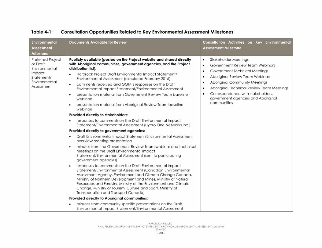
HARDROCK PROJECT FINAL FEDERAL ENVIRONMENTAL IMPACT STATEMENT / PROVINCIAL ENVIRONMENTAL ASSESSMENT SUMMARY
STANTEC - 30 -
Table 4-1: Consultation Opportunities Related to Key Environmental Assessment Milestones
Environmental Assessment Milestone
Documents Available for Review Consultation Activities on Key Environmental Assessment Milestone
Preferred Project or Draft Environmental Impact Statement/ Environmental Assessment
Publicly available (posted on the Project website and shared directly with Aboriginal communities, government agencies, and the Project distribution list): • Hardrock Project Draft Environmental Impact Statement/
Environmental Assessment (circulated February 2016) • comments received and GGM’s responses on the Draft
Environmental Impact Statement/Environmental Assessment • presentation material from Government Review Team baseline
webinars • presentation material from Aboriginal Review Team baseline
webinars Provided directly to stakeholders: • responses to comments on the Draft Environmental Impact
Statement/Environmental Assessment (Hydro One Networks Inc.) Provided directly to government agencies: • Draft Environmental Impact Statement/Environmental Assessment
overview meeting presentation • minutes from the Government Review Team webinar and technical
meetings on the Draft Environmental Impact Statement/Environmental Assessment (sent to participating government agencies)
• responses to comments on the Draft Environmental Impact Statement/Environmental Assessment (Canadian Environmental Assessment Agency, Environment and Climate Change Canada, Ministry of Northern Development and Mines, Ministry of Natural Resources and Forestry, Ministry of the Environment and Climate Change, Ministry of Tourism, Culture and Sport, Ministry of Transportation and Transport Canada)
Provided directly to Aboriginal communities: • minutes from community-specific presentations on the Draft
Environmental Impact Statement/Environmental Assessment
• Stakeholder Meetings • Government Review Team Webinars • Government Technical Meetings • Aboriginal Review Team Webinars • Aboriginal Community Meetings • Aboriginal Technical Review Team Meetings • Correspondence with stakeholders,
government agencies and Aboriginal communities

HARDROCK PROJECT FINAL FEDERAL ENVIRONMENTAL IMPACT STATEMENT / PROVINCIAL ENVIRONMENTAL ASSESSMENT SUMMARY
STANTEC - 31 -
Table 4-1: Consultation Opportunities Related to Key Environmental Assessment Milestones
Environmental Assessment Milestone
Documents Available for Review Consultation Activities on Key Environmental Assessment Milestone
• minutes from community-specific presentations on What GGM has Heard (Aroland First Nation, Animbiigoo Zaagi'igan Anishinaabek, and Long Lake #58 First Nation)
• Aboriginal Review Team meeting minutes on What GGM has Heard and how Environmental Assessment comments have influenced the Final Environmental Impact Statement/ Environmental Assessment
• responses to comments on the Draft Environmental Impact Statement/Environmental Assessment (Aroland First Nation, Biigtigong Nishnaabeg, Constance Lake First Nation, Ginoogaming First Nation, Long Lake #58 First Nation and Métis Nation of Ontario)
To be made publicly available: • Hardrock Project Final Environmental Impact Statement/
Environmental Assessment

HARDROCK PROJECT FINAL FEDERAL ENVIRONMENTAL IMPACT STATEMENT / PROVINCIAL ENVIRONMENTAL ASSESSMENT SUMMARY
STANTEC - 32 -
4.1 Identification of Interested Parties
During the preparation of the Final Environmental Impact Statement / Environmental Assessment, GGM has consulted with a wide range of stakeholders, government agencies and Aboriginal communities. The list of stakeholder, government and Aboriginal contacts used for engagement and consultation on the Project is based on the initial list identified early in the Project, which has been carried forward during the preparation of the Environmental Impact Statement / Environmental Assessment with others added or deleted upon request. Generally interested parties can be classified into three main groups:
Stakeholders:
For this Project, stakeholders are considered local and regional members of the public, or organizations affiliated with representing certain interests of members of the public. An initial list of stakeholders was prepared by obtaining a mailing list of all local residents and registered business owners within the Municipality of Greenstone. Other organizations, such as recreational clubs were identified through desktop research efforts using relevant websites such as the Municipality of Greenstone website, which provides information on local resources and organizations. Other stakeholders self-identified during the environmental assessment process, such as in response to Project notices or at Public Information Centres.
Government Agencies:
Government agencies and their representatives are considered individuals and organizations operating at the federal, provincial and municipal levels of government. The process of identifying relevant government agencies to participate in the environmental assessment process for the Project began prior to the submission of the Draft Terms of Reference and Project Description to the Ministry of the Environment and Climate Change and the Canadian Environmental Assessment Agency.
As the primary government agencies with regulatory jurisdiction on Environmental Impact Statement / Environmental Assessment approval at the federal and provincial levels, the Canadian Environmental Assessment Agency and Ministry of the Environment and Climate Change have served as a liaison with other relevant agencies whose technical expertise and regulatory authorities intersect with components of the Project, including future permits and approvals that will be required. Based on an understanding of other mining projects in the region, GGM developed an initial list of government agencies to begin consulting with, including Ministry of Northern Development and Mines, Ministry of Natural Resources and Forestry and Fisheries and Oceans Canada, and later confirmed which agencies should be consulted with based on direction provided by Canadian Environmental Assessment Agency and Ministry of the Environment and Climate Change. Over time, the list has been revised, based on the self-identified consultation preferences of various government agencies.

HARDROCK PROJECT FINAL FEDERAL ENVIRONMENTAL IMPACT STATEMENT / PROVINCIAL ENVIRONMENTAL ASSESSMENT SUMMARY
STANTEC - 33 -
Aboriginal Communities:
GGM acknowledges and respects that Aboriginal communities have a unique and traditional relationship with the land. GGM recognizes the need and importance to consult with communities to build meaningful, positive, transparent and sustainable relationships.
Effective and meaningful communication requires building trust between the Project team and Aboriginal communities, enhancing awareness of the Project, and providing flexible consultation opportunities, issues resolution and feedback. GGM has adhered to direction provided by the Crown in the Environmental Impact Statement Guidelines and the approved Term of Reference for the Project, as well as direction provided by the Canadian Environmental Assessment Agency and Ministry of the Environment and Climate Change throughout the environmental assessment process. Opportunities have included ongoing discussions regarding Aboriginal views on potential valued components for inclusion in the environmental assessment, the incorporation of traditional knowledge and traditional land and resource use information related to potential or established rights, effects of changes to the environment on Aboriginal peoples, potential positive and adverse environmental and socio-economic effects of the Project, and measures to mitigate these effects.
Federal Direction on Aboriginal Consultation
The federal Environmental Impact Statement Guidelines outline the guiding principles for public participation and Aboriginal engagement in the Environmental Impact Statement / Environmental Assessment. In its final Environmental Impact Statement Guidelines dated August 2014, and an addendum issued on February 12, 2016, the Canadian Environmental Assessment Agency provided direction on GGM’s consultation with Aboriginal communities.
The direction from the Canadian Environmental Assessment Agency identified that GGM is required to “hold meetings with the following potentially affected Aboriginal groups and facilitate these meetings by making key environmental assessment summary documents (baseline studies, EIS, key findings, plain language summaries) accessible” (Environmental Impact Statement Guidelines):
• Animbiigoo Zaagi’igan Anishinaabek
• Aroland First Nation
• Ginoogaming First Nation
• Long Lake #58 First Nation
• Métis Nation of Ontario
For the above communities, GGM is required to “ensure there are sufficient opportunities for individuals and groups to provide oral input in the language of their choice, and ensure that these Aboriginal groups’ views are heard and recorded” (Environmental Impact Statement Guidelines Addendum).
HARDROCK PROJECT FINAL FEDERAL ENVIRONMENTAL IMPACT STATEMENT / PROVINCIAL ENVIRONMENTAL ASSESSMENT SUMMARY
STANTEC - 34 -
The Canadian Environmental Assessment Agency also identified that “there are additional Aboriginal groups that are expected to be less affected by the project and its related effects” (Environmental Impact Statement Guidelines Addendum). GGM is required to “make key EA summary documents (draft/final EIS, key findings, plain language summaries) accessible to these Aboriginal groups and ensure their views are heard, and recorded” (Environmental Impact Statement Guidelines Addendum). These Aboriginal communities include:
• Biinjitiwaabik Zaaging Anishinaabek
• Bingwi Neyaashi Anishinaabek
• Constance Lake First Nation
• Eabametoong First Nation
• Marten Falls First Nation
• Biigtigong Nishnaabeg (formerly known as Ojibways of the Pic River First Nation)
• Pays Plat First Nation
• Pic Mobert First Nation
• Red Sky Métis Independent Nation
Provincial Direction on Aboriginal Consultation
Provincial direction on Aboriginal consultation was provided in a letter from the Ministry of the Environment and Climate Change dated November 17, 2014. The Provincial Crown has indicated that three communities “hold or claim Aboriginal or treaty rights” that “may be adversely impacted by the Project”:
• Aroland First Nation
• Ginoogaming First Nation
• Long Lake #58 First Nation
Ministry of the Environment and Climate Change delegated aspects of consultation with these three communities to GGM, generally including:
• providing Project information to Aboriginal communities and following up with those communities to confirm they received the information
• gathering information on potential impacts to Aboriginal and/or Treaty rights
• providing potentially affected communities with opportunities to comment about the Project, considering and responding to those comments, and where appropriate discussing potential mitigation strategies with the communities

HARDROCK PROJECT FINAL FEDERAL ENVIRONMENTAL IMPACT STATEMENT / PROVINCIAL ENVIRONMENTAL ASSESSMENT SUMMARY
STANTEC - 35 -
• maintaining a record of all consultation activities.
The Ministry of the Environment and Climate Change also indicated that in addition to GGM’s “consultation obligations and delegation of procedural aspects with the Aboriginal communities discussed above, the Environmental Assessment Act also requires consultation with people and/or groups who may have an interest in the Project”. The Ministry of the Environment and Climate Change identified that consultation activities should include, “at a minimum notifying communities about the Project at key milestones, providing information about the Project, considering comments provided by the communities and providing responses, and maintaining a Consultation Record for each community”:
• Animbiigoo Zaagi'igan Anishinaabek
• Biigtigong Nishnaabeg (formerly known as Ojibways of the Pic River First Nation)
• Biinjitiwaabik Zaaging Anishinaabek (formerly known as Rocky Bay First Nation)
• Bingwi Neyaashi Anishinaabek (formerly known as Sand Point First Nation)
• Constance Lake First Nation
• Eabametoong First Nation
• Greenstone Métis Council
• Marten Falls First Nation
• Pays Plat First Nation
• Red Sky Métis Independent Nation
The approved Terms of Reference for the Project outlines the consultation plan that GGM used to initiate consultation with Aboriginal communities. Building on this, community specific consultation plans have been developed.
Approach to Aboriginal Consultation
The fourteen Aboriginal communities identified above were consulted separately on the Project, and given the opportunity to tailor the consultation approach to meet their individual needs and interests. Communities also received communications and notices as part of the general consultation process and were invited to participate in public consultation events with stakeholders.
GGM has continued to consult in an open and transparent manner, reporting back to communities on what is heard. GGM has considered, addressed or incorporated the input received into the Final Environmental Impact Statement / Environmental Assessment and Project design, where appropriate. A key component of consultation has been the cyclical review and revision of Project documentation with a focus on continuous improvement. This means that as
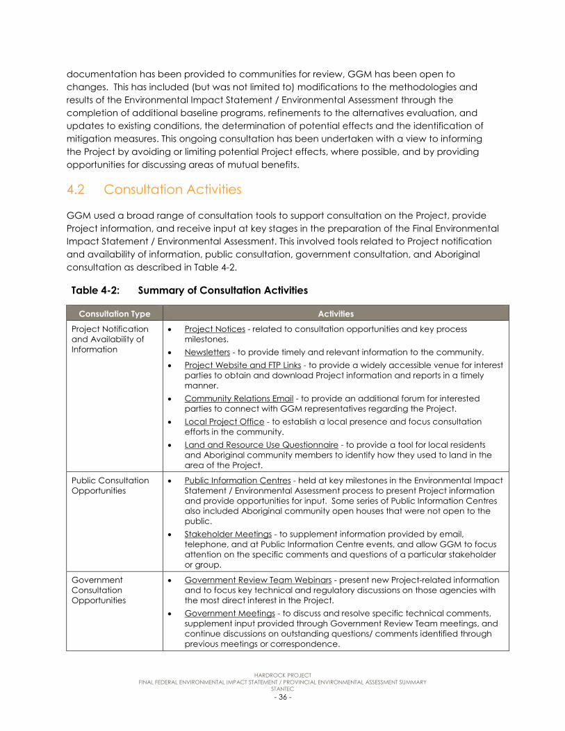
HARDROCK PROJECT FINAL FEDERAL ENVIRONMENTAL IMPACT STATEMENT / PROVINCIAL ENVIRONMENTAL ASSESSMENT SUMMARY
STANTEC - 36 -
documentation has been provided to communities for review, GGM has been open to changes. This has included (but was not limited to) modifications to the methodologies and results of the Environmental Impact Statement / Environmental Assessment through the completion of additional baseline programs, refinements to the alternatives evaluation, and updates to existing conditions, the determination of potential effects and the identification of mitigation measures. This ongoing consultation has been undertaken with a view to informing the Project by avoiding or limiting potential Project effects, where possible, and by providing opportunities for discussing areas of mutual benefits.
4.2 Consultation Activities
GGM used a broad range of consultation tools to support consultation on the Project, provide Project information, and receive input at key stages in the preparation of the Final Environmental Impact Statement / Environmental Assessment. This involved tools related to Project notification and availability of information, public consultation, government consultation, and Aboriginal consultation as described in Table 4-2.
Table 4-2: Summary of Consultation Activities
Consultation Type Activities
Project Notification and Availability of Information
• Project Notices - related to consultation opportunities and key process milestones.
• Newsletters - to provide timely and relevant information to the community. • Project Website and FTP Links - to provide a widely accessible venue for interest
parties to obtain and download Project information and reports in a timely manner.
• Community Relations Email - to provide an additional forum for interested parties to connect with GGM representatives regarding the Project.
• Local Project Office - to establish a local presence and focus consultation efforts in the community.
• Land and Resource Use Questionnaire - to provide a tool for local residents and Aboriginal community members to identify how they used to land in the area of the Project.
Public Consultation Opportunities
• Public Information Centres - held at key milestones in the Environmental Impact Statement / Environmental Assessment process to present Project information and provide opportunities for input. Some series of Public Information Centres also included Aboriginal community open houses that were not open to the public.
• Stakeholder Meetings - to supplement information provided by email, telephone, and at Public Information Centre events, and allow GGM to focus attention on the specific comments and questions of a particular stakeholder or group.
Government Consultation Opportunities
• Government Review Team Webinars - present new Project-related information and to focus key technical and regulatory discussions on those agencies with the most direct interest in the Project.
• Government Meetings - to discuss and resolve specific technical comments, supplement input provided through Government Review Team meetings, and continue discussions on outstanding questions/ comments identified through previous meetings or correspondence.

HARDROCK PROJECT FINAL FEDERAL ENVIRONMENTAL IMPACT STATEMENT / PROVINCIAL ENVIRONMENTAL ASSESSMENT SUMMARY
STANTEC - 37 -
Table 4-2: Summary of Consultation Activities
Consultation Type Activities
Aboriginal Consultation Opportunities
• GGM Participation in Cultural Impact Assessments - to provide communities with the information required to make an informed decision regarding the advanced exploration phase.
• Development of Community-Specific Consultation Plans - to identify the various approaches available for consulting with communities and to meet their specific preferences and needs for engagement.
• Support for the Completion of Traditional Knowledge Studies - so that GGM will have a strong understanding of the historical uses of the land that may be affected by the Project.
• Summary Document and Translated Documents - to accommodate the transfer of sometimes technical or complex information in a simplified form to help community members understand and review Project material.
• Support for Aboriginal Technical Review Teams - to provide third-party review capacity and a forum for technical discussions focused on community topics of interest.
• Aboriginal Review Team Webinars - to provide opportunities to present new Project-related information to all interested communities and discuss comments raised, supplement input provided through other Aboriginal community meetings, and continue discussions on outstanding questions/comments identified through previous meetings or correspondence.
• Aboriginal Community Meetings - to provide information in a timely manner to, and to collect information on and understand the comments and feedback from local Aboriginal communities.
4.3 Influence of Consultation on the Environmental Impact Statement / Environmental Assessment
Consultation has been carried out related to key aspects of the Project, including baseline studies, the identification and evaluation of alternatives, assessment of environmental effects, and the overall design of the Project. The range of comments identified during consultation is described in the Final Environmental Impact Statement / Environmental Assessment.
Opportunities to provide input on the Environmental Impact Statement / Environmental Assessment have been regularly provided during the preparation of the Environmental Impact Statement / Environmental Assessment. These efforts have been summarized in the Final Environmental Impact Statement / Environmental Assessment, with correspondence logs and records provided. Consultation has been an iterative and ongoing process during the development of the Environmental Impact Statement / Environmental Assessment, with input from stakeholders, government agencies and Aboriginal communities. Generally, this input has been collected and considered at the key environmental assessment milestones during each phase of Environmental Impact Statement / Environmental Assessment preparation in the following manner:
• Baseline Methodologies and Results - opportunities have been provided to review baseline work plans and reports. Based on discussions resulting from these reviews, GGM received input on the scope, methodology and results of the baseline studies. Comments were

HARDROCK PROJECT FINAL FEDERAL ENVIRONMENTAL IMPACT STATEMENT / PROVINCIAL ENVIRONMENTAL ASSESSMENT SUMMARY
STANTEC - 38 -
considered and responded to, and where appropriate, additional baseline work was completed and incorporated into the Final Environmental Impact Statement / Environmental Assessment. Any updates to the baseline reports were incorporated into the assessment of each valued component through refinements to existing conditions, which where relevant resulted in refinements to the conclusions of the effects assessment.
• Alternatives Assessment Methodologies and Results – opportunities have been provided to review and comment on the alternatives assessment approach through presentations and documentation provided to stakeholders, government agencies and Aboriginal communities. Comments received were considered and responded to, including related to the scoping of valued components/criteria, the methods used to identify the potential for effects and related comparative advantages and disadvantages, and the final results confirming the preferred alternatives. Based on input provided, the valued components/ criteria list was revised to address the comments and interests raised, and the analysis was updated to provide additional detail and respond to input related to revisions or enhancements to the evaluation.
• EA Methodology and Results - comments related to the environmental effects assessment methodology and results have been considered by GGM. This has included addressing specific technical input on the analysis methods and results of the effects assessments, and has also included considering more general comments on various environmental components and potential effects. GGM has reviewed comments to confirm whether they relate to identified valued components (or whether valued components would need to be added or re-scoped to address comments), and whether each valued component assessment was appropriately scoped to address the identified areas of interest. Where necessary, comments were discussed with commenters to clarify questions or confirm how the assessment could be enhanced to address the comments before updates were applied to the Final Environmental Impact Statement / Environmental Assessment. Where a comment did not result in a change to the scope of, or assessment on a valued component, a technical rationale has been provided to the commenter to describe and support this.
• Mitigation Measures - through consultation activities and public and Aboriginal review of the Draft Environmental Impact Statement / Environmental Assessment, GGM provided opportunities for interested parties to review the results of the valued components -specific effects assessments, which included the identification of mitigation measures and conclusions on residual effects. Comments related to the effectiveness of mitigation measures or suggestions for additional measures were addressed through direct responses to rationalize the approach taken, or through refinements to the identified mitigation measures to address the input provided. Updates to mitigation measures also resulted in revisiting the residual effects conclusions to confirm if updates were appropriate.
• The Project - questions or input regarding the Project Description, including the Project alternatives, have been considered throughout the development of the Environmental Impact Statement / Environmental Assessment. The Project has evolved based on input provided and as Project details have been refined and optimized through ongoing feasibility work. Changes to the Project have been applied to the evaluation of alternatives and

HARDROCK PROJECT FINAL FEDERAL ENVIRONMENTAL IMPACT STATEMENT / PROVINCIAL ENVIRONMENTAL ASSESSMENT SUMMARY
STANTEC - 39 -
subsequently the Project Description, and any relevant changes have been incorporated into the valued components-specific effects assessments to confirm potential effects, appropriate mitigation measures and residual effects.
A summary of the key changes/refinements made to the Final Environmental Impact Statement / Environmental Assessment based on the results of consultation and engagement are provided in Table 4-3.
Table 4-3: Influence of Consultation and Engagement on the Final Environmental Impact Statement / Environmental Assessment
Environmental Impact
Statement / Environmental
Assessment Item
Influence of Consultation
Baseline Studies • The scope of baseline studies has included key data sources and comments identified for consideration in the Environmental Impact Statement / Environmental Assessment. This information has been used throughout the environmental assessment process to inform the evaluation of alternatives and the assessment of Project effects.
• 2015 baseline results have been incorporated into the Environmental Impact Statement / Environmental Assessment. Fieldwork will continue to be completed as the Project progresses and will be used to inform permitting/long-term monitoring phases.
• Baseline studies and the analysis in the Environmental Impact Statement / Environmental Assessment have been refined to include additional information or clarification to respond to questions.
• Traditional knowledge and traditional land and resource use information provided by communities has been incorporated into relevant baseline reports to characterize existing conditions linked to Aboriginal use of the area.
Identification of Alternatives
• The ‘long list’ of alternatives for the initial screening has been expanded to account for additional alternatives identified for consideration.
• The results of the initial screening have been refined to include consideration of new alternatives in the comparative analysis.
• The rationale for the screening of alternatives has been refined to include additional environmental rationale.
Alternatives Assessment Methodology and Results
• The list of criteria and indicators has been revised to include additional consideration of key aspects of the environment.
• The climate change indicator specifically identified related to greenhouse gases, and source water protection was considered in the rationale for the selection of the groundwater indicators.
• The results of the comparative analysis have been updated to consider the range of environmental effects identified as key areas of interest.
• Further detail has been included in the description of the comparative analysis results to address environmental interests in the decision-making process, and provide additional rationale for the selection of preferred alternatives.
• Traditional knowledge and traditional land and resource use information provided by communities has been incorporated into the assessment of each alternative to identify the potential for effects on Aboriginal communities in selecting preferred Project components. Where location-specific information was not provided, the alternatives assessment took a conservative approach that assumed that

HARDROCK PROJECT FINAL FEDERAL ENVIRONMENTAL IMPACT STATEMENT / PROVINCIAL ENVIRONMENTAL ASSESSMENT SUMMARY
STANTEC - 40 -
Table 4-3: Influence of Consultation and Engagement on the Final Environmental Impact Statement / Environmental Assessment
Environmental Impact
Statement / Environmental
Assessment Item
Influence of Consultation
communities would potentially use areas anticipated to be disturbed by the Project for traditional purposes.
Environmental Effects Assessment
• Key comments that influenced the Environmental Impact Statement / Environmental Assessment are discussed in each of the valued component chapters of the Environmental Impact Statement / Environmental Assessment. Further information provided through the completion of supplemental baseline reports has been incorporated into the assessment for each valued component.
• The effects of historical mining activities have been characterized through baseline studies and considered as part of the environmental effects assessment and cumulative effects assessment to clearly delineate between existing contributions to water quality and Project effects.
• New data sources have been identified and considered through the effects assessment process for valued components.
• The rationale for the selection of measurable parameters used in the effects assessment has been updated for valued components.
• As part of the information sharing throughout the consultation process, Project-related information was provided by Aboriginal communities in the form of traditional knowledge and traditional land and resource use studies and other forms of information sharing. An overview of the consultation/traditional knowledge input that influenced the effects assessment between the Draft and Final Environmental Impact Statement / Environmental Assessment has been included in the effects assessment.
• Traditional knowledge and traditional land and resource use information provided by communities has been incorporated into the assessment of effects on traditional land and resource use, including linkages to the environmental effects assessment for each other valued component as appropriate.
Project Design • Setbacks from waterbodies - Removed infrastructure, where possible, from the 120 metre (m) reserve for surveyed claim to lease areas. Increased setbacks from Southwest Arm Tributary (including the Goldfield Creek Diversion) for Project infrastructure including waste rock storage area (WRSA) D and B.
• Refinements to the size and configuration of the TMF – Avoided unnecessary disturbance of watercourses and fish habitat, including avoiding the infilling of Lake A-322. Shifted location of TMF reclaim pond away from the dams and Kenogamisis Lake.
• Modifications to the TMF construction and operation sequence - Addressed regulatory closure objectives and requests from Aboriginal communities to plan for closure and carry out progressive rehabilitation by developing the TMF in two separate cells. Incorporated seeding of the surface of the TMF to develop a vegetated cover to improve aesthetics, reduce the potential for surface erosion, and reduce the interaction between runoff and the tailings surface.
• Addition of long-term geotechnical stability measures for historical tailings - Identification of stability measures (i.e., buttress, berms and subsurface seepage collection) for the historical MacLeod tailings and logistics for handling and transfer of historical tailings to the TMF.

HARDROCK PROJECT FINAL FEDERAL ENVIRONMENTAL IMPACT STATEMENT / PROVINCIAL ENVIRONMENTAL ASSESSMENT SUMMARY
STANTEC - 41 -
Table 4-3: Influence of Consultation and Engagement on the Final Environmental Impact Statement / Environmental Assessment
Environmental Impact
Statement / Environmental
Assessment Item
Influence of Consultation
• Confirmation of the need and location of the temporary camp - Refinement of the location to the south side of Old Arena Road, farther from an existing residential area.
• Removal of temporary sewage treatment plant (STP) effluent discharge to Barton Bay - The temporary camp will be connected to the municipal wastewater system.
• Siting of water management facilities - Siting of the seepage, contact water, and subsurface seepage collection systems (i.e., ponds and ditching) to collect seepage and runoff from Project components.
• Identification of contingency WRSAs - Identified in the event that the foundation conditions of primary WRSAs are deemed not suitable for anticipated capacities. May also be used in the event that waste rock volumes are higher than expected or increase based on refinements to ore processing as mining advances.
• Refinements to the WRSA deposition schedule - Updated the waste rock deposition approach to maintain the front nine holes and clubhouse of the existing public golf course for as long as possible.
• Refinements to the WRSAs - Increased setbacks from the Goldfield Creek diversion and Kenogamisis Lake. Redesigned a portion of WRSA A located over the historical MacLeod tailings for use as overburden storage and provided an enhanced cover to increase runoff and reduce infiltration through the historical MacLeod tailings thereby reducing potential effects on water quality from the historical tailings.
• Identifications of aggregate sources - Identification of aggregate sources in proximity to Project activities to provide aggregate and till materials for construction and ongoing maintenance activities (i.e., reducing haul distance).
• Refinements made to watercourse diversion - Maintained existing flow through the northern portion of Goldfield Lake. Reduced the overall environmental effects on flow regimes, water transfer between subwatersheds, fish and fish habitat. Created a diversion pond (over 7 hectares), over 2.5 kilometres of channel and two backwater areas to manage flow and sediment control. Fluvial geomorphology studies were conducted as a result of consultation input, and contributed to the design of the backwater areas.
• Identification of additional and backup power sources for the Project during both construction and operation - Power for construction activities was confirmed, and will be from a temporary grid connection and/or temporary diesel generators. Five generating sets will be used to meet average and peak power demands of 48.5 megawatts during operation. Two generating sets will provide standby capacity.
• Change in location of the temporary construction treated effluent discharge location - The location of the temporary construction treated effluent discharge was moved from the Central Basin to the Southwest Arm of Kenogamisis Lake.
• Confirmation of preferred freshwater intake and treated effluent discharge locations - The location for the freshwater intake and treated effluent discharge was confirmed.
• The future locations of provincial facilities have been refined - Adjustments to the location of the Ministry of Transportation (MTO) Patrol Yard were made in consultation with the MTO. Adjustments to the locations of the Hydro One Networks Inc. access road and transmission/ distribution line avoided a wetland.
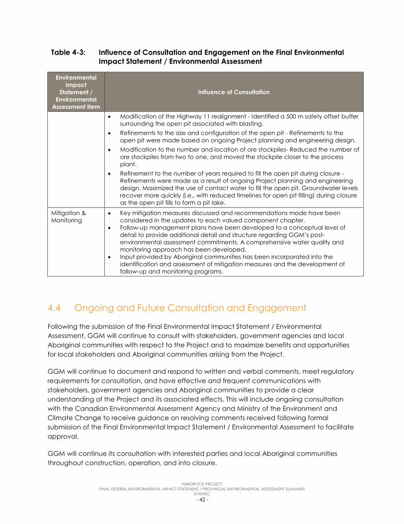
HARDROCK PROJECT FINAL FEDERAL ENVIRONMENTAL IMPACT STATEMENT / PROVINCIAL ENVIRONMENTAL ASSESSMENT SUMMARY
STANTEC - 42 -
Table 4-3: Influence of Consultation and Engagement on the Final Environmental Impact Statement / Environmental Assessment
Environmental Impact
Statement / Environmental
Assessment Item
Influence of Consultation
• Modification of the Highway 11 realignment - Identified a 500 m safety offset buffer surrounding the open pit associated with blasting.
• Refinements to the size and configuration of the open pit - Refinements to the open pit were made based on ongoing Project planning and engineering design.
• Modification to the number and location of ore stockpiles- Reduced the number of ore stockpiles from two to one, and moved the stockpile closer to the process plant.
• Refinement to the number of years required to fill the open pit during closure - Refinements were made as a result of ongoing Project planning and engineering design. Maximized the use of contact water to fill the open pit. Groundwater levels recover more quickly (i.e., with reduced timelines for open pit filling) during closure as the open pit fills to form a pit lake.
Mitigation & Monitoring
• Key mitigation measures discussed and recommendations made have been considered in the updates to each valued component chapter.
• Follow-up management plans have been developed to a conceptual level of detail to provide additional detail and structure regarding GGM’s post-environmental assessment commitments. A comprehensive water quality and monitoring approach has been developed.
• Input provided by Aboriginal communities has been incorporated into the identification and assessment of mitigation measures and the development of follow-up and monitoring programs.
4.4 Ongoing and Future Consultation and Engagement
Following the submission of the Final Environmental Impact Statement / Environmental Assessment, GGM will continue to consult with stakeholders, government agencies and local Aboriginal communities with respect to the Project and to maximize benefits and opportunities for local stakeholders and Aboriginal communities arising from the Project.
GGM will continue to document and respond to written and verbal comments, meet regulatory requirements for consultation, and have effective and frequent communications with stakeholders, government agencies and Aboriginal communities to provide a clear understanding of the Project and its associated effects. This will include ongoing consultation with the Canadian Environmental Assessment Agency and Ministry of the Environment and Climate Change to receive guidance on resolving comments received following formal submission of the Final Environmental Impact Statement / Environmental Assessment to facilitate approval.
GGM will continue its consultation with interested parties and local Aboriginal communities throughout construction, operation, and into closure.

HARDROCK PROJECT FINAL FEDERAL ENVIRONMENTAL IMPACT STATEMENT / PROVINCIAL ENVIRONMENTAL ASSESSMENT SUMMARY
STANTEC - 43 -
5.0 DESCRIPTION OF THE EXISTING ENVIRONMENT
The following section provides a description of the existing environment which may potentially change as a result of the construction, operation and closure of the Project. Environmental studies of the physical, biological and social environments have been conducted on and around the Project development area. The environment as it exists in its current state has been used to determine baseline conditions. This “environmental baseline” is the basis for determining incremental changes and predicted environmental effects associated with the Project.
A description of the existing environment is provided for the atmospheric environment; acoustic environment; groundwater; surface water; fish and fish habitat; vegetation communities; wildlife and wildlife habitat; labour and economy; community services and infrastructure; land and resource use; heritage resources; and traditional land and resource use. These components or attributes of the biophysical and socio-economic environment are referred to in the environmental assessment as “valued components” as they are considered important for ecological, scientific, social, cultural, economic, historical, archaeological or aesthetic reasons.
5.1 Atmospheric Environment
The following description of the atmospheric environment is provided for climate and meteorological conditions, air quality, greenhouse gases and lighting.
Climate and Meteorological Conditions
The climate is typical of that for Northern Ontario with seasonal temperature variations occurring due to short summers and cold winters. Based on 30 years (1981 to 2010) of data collected at the Greenstone Regional Airport, the daily average temperature varies from -18.6 to 17.2 degrees Celsius (ºC) with an annual average temperature of 0.6ºC. Annual average total precipitation for the area is 764.6 millimetres with an annual average relative humidity in the morning of 83.6%. Annual average wind speed is 11.2 kilometres per hour with the most frequent wind direction on an annual basis from the west.
Air Quality
The Project is located in a rural location of northern Ontario where air quality is primarily influenced by the Ward of Geraldton and traffic on Highway 11. Measured levels of nitrogen dioxide, sulphur dioxide, and inhalable particulate matter were below their applicable provincial criteria. The maximum measured concentrations of total suspended particulate and all metals with Ministry of the Environment and Climate Change air quality criteria were well below their applicable criteria. The maximum measured concentrations of all volatile organic compounds with Ministry of the Environment and Climate Change air quality criteria were well below their applicable criteria.

HARDROCK PROJECT FINAL FEDERAL ENVIRONMENTAL IMPACT STATEMENT / PROVINCIAL ENVIRONMENTAL ASSESSMENT SUMMARY
STANTEC - 44 -
Greenhouse Gases
Global emissions for greenhouse gases increased from 38.6 million kilotonnes in 2005 to 44.8 million kilotonnes in 2012. Over that same period greenhouse gas emissions for Canada and Ontario decreased from 747 million kilotonnes to 718 million kilotonnes and from 211 million kilotonnes to 171 million kilotonnes respectively. In 2014, total greenhouse emissions for Canada was 732 million kilotonnes and 170 million kilotonnes for Ontario (global emissions for the year 2012 were not available). Canada’s contribution to global greenhouse gas emissions is 1.6%.
Lighting
A baseline assessment of night-time light conditions was conducted in June 2014. Lighting measurements of sky glow were consistent with a rural area where the lighting environment is considered ‘low brightness’. Stars appear large and close in the night sky and in the absence of haze the Milky Way can be seen to the horizon.
5.2 Acoustic Environment
The major contributors to baseline acoustical environment are traffic noise from Highway 11, Michael Power Boulevard and the natural environment. Baseline sound levels were dominated by traffic noise during the daytime and natural environment during the night-time. For receptor locations greater than 200 metres from a major roadway, the existing ambient sound levels are dominated by the natural environment during both the daytime and night-time hours. No “non-traffic anthropogenic sources” were found to be major contributors to the acoustic environment, and no tonal or excessive low frequency noise was encountered during field studies.
The baseline conditions of the receptor area are characteristic of a Class 2 and Class 3 acoustical environment. In a Class 2 acoustical environment anthropogenic noise dominates the daytime acoustical environment while sound from natural environment dominates the night-time acoustical environment. In a Class 3 acoustical environment, sound from the natural environment, with little or no road traffic, dominates the acoustical environment during both daytime and night-time.

HARDROCK PROJECT FINAL FEDERAL ENVIRONMENTAL IMPACT STATEMENT / PROVINCIAL ENVIRONMENTAL ASSESSMENT SUMMARY
STANTEC - 45 -
5.3 Groundwater
Groundwater includes domestic, commercial, and industrial groundwater-source water supplies, and the groundwater component of freshwater ecosystems. The following description for groundwater is provided for existing groundwater flow and velocity, and groundwater quality.
Groundwater Flow and Velocity
Groundwater flow is strongly influenced by topography, which results in localized groundwater flow from topographic highs and local groundwater discharge to wetland areas or surface water features. Groundwater levels in overburden and shallow bedrock are generally found at 1 metre to 2 metres below ground surface. Overall the regional groundwater flow within the
overburden is toward the southeast toward Kenogamisis Lake.
Groundwater flow from the historical MacLeod tailings generally flows southeast to a wetland, a pond and a watercourse and north to Barton Bay. There is limited flow from the historical MacLeod tailings to the south and southwest due to a groundwater flow divide created by a topographic high in the bedrock surface. Groundwater flow within the area of the historical Hardrock tailings is to the east, toward the Central Basin and Southwest Arm of Kenogamisis Lake.
Horizontal groundwater velocities within the area of the historical tailings are estimated to range from 1 metre/year to 20 metres/year (geometric mean of 6 metre/year). Within the area of the open pit and waste rock storage areas, horizontal groundwater velocities range from 0.002 m/year to 136 metres/year (geometric mean of 1 metre/year) in overburden. However, flow estimated for bedrock in the area of the open pit and waste rock storage areas ranges from 0.002 metres/year to 13,600 metres/year (geometric mean of 2 metres/year). The extreme range in groundwater velocity in bedrock compared with overburden is due to the very low porosity (0.1%) of the bedrock relative to overburden (30%).
Groundwater Quality
Average groundwater concentrations in the overburden and shallow bedrock background monitoring well exceeded the Ontario Drinking Water Quality Standards for colour, dissolved organic carbon, hardness, iron, and manganese. Elevated concentrations of hardness, iron, manganese, and colour are typical of groundwater in Ontario and are reflective of the natural mineralization and geochemical processes in the area. Groundwater quality was below all Ontario Drinking Water Quality Standards health based standards (i.e., standards for microbiological, chemical and radiological parameters to ensure the highest quality of drinking water).
Groundwater Sampling

HARDROCK PROJECT FINAL FEDERAL ENVIRONMENTAL IMPACT STATEMENT / PROVINCIAL ENVIRONMENTAL ASSESSMENT SUMMARY
STANTEC - 46 -
The only parameter with average concentrations above the Ontario Provincial Water Quality Objective was iron in both the overburden and bedrock.
The average overburden background groundwater quality concentrations at a given monitoring well were within the aquatic protection value.
Average concentrations in groundwater associated with the historical Little Long Lac tailings exceeded the Ontario Drinking Water Quality Standards for sulphate, arsenic, cadmium and. Compared to the aquatic protection value, the concentration of arsenic, cadmium, cobalt, nickel and silver exceeded the criteria. Arsenic is the only parameter associated with the historical tailings that consistently exceeded the Ontario Drinking Water Quality Standards, aquatic protection value and Ontario Provincial Water Quality Objective.
Average concentrations in groundwater associated with the historical MacLeod tailings exceeded the Ontario Drinking Water Quality Standards for dissolved organic carbon, total dissolved solids, hardness, sulphate, arsenic, iron, and manganese. Compared to the aquatic protection value, the concentration of arsenic and cobalt exceeded the criteria. Arsenic is the only parameter associated with the historical tailings that consistently exceeded the Ontario Drinking Water Quality Standards, aquatic protection value and Ontario Provincial Water Quality Objective.
Average concentrations in groundwater associated with the historical Hardrock tailings exceeded the Ontario Drinking Water Quality Standards dissolved organic carbon, total dissolved solids, hardness, colour, sulphate, aluminum, arsenic, cadmium, iron and manganese. Groundwater within the historical tailings had concentrations of cyanide(Free), arsenic, cadmium, cobalt, nickel, and silver that exceeded the aquatic protection value.
5.4 Surface Water
Surface water encompasses fresh water resources, including lakes and streams. The following description for surface water is provided for existing hydrology and surface water quality.
Hydrology
The Project is located in the Kenogamisis River watershed, adjacent to Kenogamisis Lake. Kenogamisis Lake is a long, narrow and shallow lake consisting of four distinct basins, with water flowing from the Southwest Arm into the Central (or MacLeod) Basin then into the Northeast Arm (or Outflow Basin). The Barton Bay Basin receives discharges and runoff from historical mine operations and effluent discharge from the Geraldton municipal sewage treatment plant. Water from Barton Bay enters the Central Basin from the north. Some runoff from historical tailings occurs in the Central Basin as well but to lesser extent
Data Logger
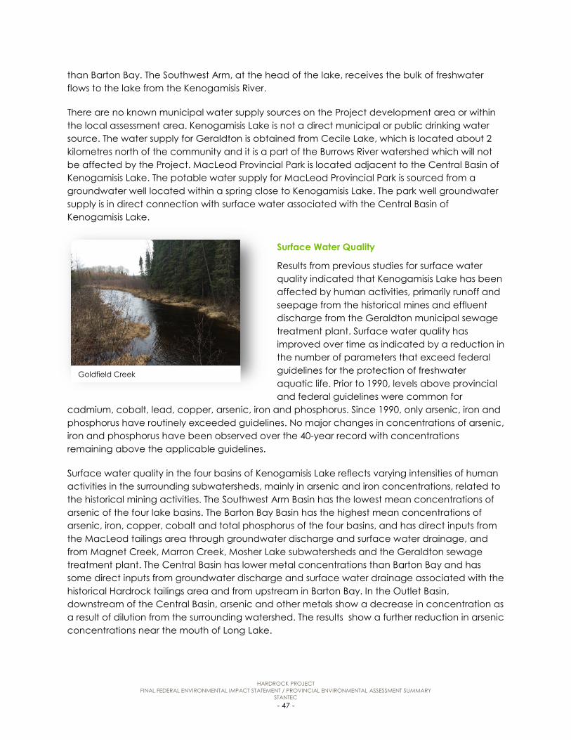
HARDROCK PROJECT FINAL FEDERAL ENVIRONMENTAL IMPACT STATEMENT / PROVINCIAL ENVIRONMENTAL ASSESSMENT SUMMARY
STANTEC - 47 -
than Barton Bay. The Southwest Arm, at the head of the lake, receives the bulk of freshwater flows to the lake from the Kenogamisis River.
There are no known municipal water supply sources on the Project development area or within the local assessment area. Kenogamisis Lake is not a direct municipal or public drinking water source. The water supply for Geraldton is obtained from Cecile Lake, which is located about 2 kilometres north of the community and it is a part of the Burrows River watershed which will not be affected by the Project. MacLeod Provincial Park is located adjacent to the Central Basin of Kenogamisis Lake. The potable water supply for MacLeod Provincial Park is sourced from a groundwater well located within a spring close to Kenogamisis Lake. The park well groundwater supply is in direct connection with surface water associated with the Central Basin of Kenogamisis Lake.
Surface Water Quality
Results from previous studies for surface water quality indicated that Kenogamisis Lake has been affected by human activities, primarily runoff and seepage from the historical mines and effluent discharge from the Geraldton municipal sewage treatment plant. Surface water quality has improved over time as indicated by a reduction in the number of parameters that exceed federal guidelines for the protection of freshwater aquatic life. Prior to 1990, levels above provincial and federal guidelines were common for
cadmium, cobalt, lead, copper, arsenic, iron and phosphorus. Since 1990, only arsenic, iron and phosphorus have routinely exceeded guidelines. No major changes in concentrations of arsenic, iron and phosphorus have been observed over the 40-year record with concentrations remaining above the applicable guidelines.
Surface water quality in the four basins of Kenogamisis Lake reflects varying intensities of human activities in the surrounding subwatersheds, mainly in arsenic and iron concentrations, related to the historical mining activities. The Southwest Arm Basin has the lowest mean concentrations of arsenic of the four lake basins. The Barton Bay Basin has the highest mean concentrations of arsenic, iron, copper, cobalt and total phosphorus of the four basins, and has direct inputs from the MacLeod tailings area through groundwater discharge and surface water drainage, and from Magnet Creek, Marron Creek, Mosher Lake subwatersheds and the Geraldton sewage treatment plant. The Central Basin has lower metal concentrations than Barton Bay and has some direct inputs from groundwater discharge and surface water drainage associated with the historical Hardrock tailings area and from upstream in Barton Bay. In the Outlet Basin, downstream of the Central Basin, arsenic and other metals show a decrease in concentration as a result of dilution from the surrounding watershed. The results show a further reduction in arsenic concentrations near the mouth of Long Lake.
Goldfield Creek

HARDROCK PROJECT FINAL FEDERAL ENVIRONMENTAL IMPACT STATEMENT / PROVINCIAL ENVIRONMENTAL ASSESSMENT SUMMARY
STANTEC - 48 -
In Kenogamisis Lake, the majority of metals were present at levels below federal and provincial guidelines. The exceptions were aluminum, arsenic, copper, iron and phosphorus. Arsenic was higher than the 5 µg/L guideline in some samples from background creeks and lakes, reflecting some natural sources and a higher portion of samples reflecting elevated inputs to Kenogamisis Lake in runoff from the historical MacLeod tailings and Hardrock tailings. Other considerations for sources and their relative importance to arsenic concentrations to Kenogamisis Lake are groundwater inputs, especially from the historical Hardrock and MacLeod tailings area and considerations of flow in combination with concentrations (i.e., calculation of loadings from the various arsenic sources).
The surface water quality monitoring results for background creeks and lakes are generally below the federal and provincial guidelines with some exceptions. Levels above federal and provincial guidelines for background creeks (i.e., Dionne Creek, Magnet Creek, South Magnet Creek, McKelvie Creek, Burrows Creek, Goldfield Creek and Goldfield Creek Tributary) include aluminum, arsenic, iron, zinc and phosphorus. Levels above federal and provincial guidelines for background lakes (i.e., Lake A-323, Lake A-322, Goldfield Lake, Marron Lake, Gamsby Lake and Wildgoose Lake) include aluminum, arsenic, copper, iron, mercury, phosphorus and zinc. However, arsenic and iron are naturally elevated in background waterbodies with arsenic concentrations generally higher in creeks than lakes.
5.5 Fish and Fish Habitat
Fish assessed as part of the environmental assessment includes fish that are part of a commercial, recreational or Aboriginal fishery and those fish that support a commercial, recreational or Aboriginal fishery (often, but not exclusively, as prey species including invertebrates). Fish habitat means waters on which fish depend directly or indirectly in order to carry out their life processes. The following description is provided for fish habitat and fish communities.
Fish Habitat
Kenogamisis Lake provides good habitat for coolwater species. Shallow bays and stream inlets commonly support emergent and submerged aquatic vegetation, which provide good cover, rearing and feeding habitat for a variety of fish species. These areas also provide potential spawning habitat for Yellow Perch and Northern Pike. Important Walleye spawning areas have been documented where the Kenogamisis River and Magnet Creek flow into Kenogamisis Lake. These areas also likely provide important spawning and feeding areas for benthivores (e.g., Lake
Kenogamisis Lake - Netting

HARDROCK PROJECT FINAL FEDERAL ENVIRONMENTAL IMPACT STATEMENT / PROVINCIAL ENVIRONMENTAL ASSESSMENT SUMMARY
STANTEC - 49 -
Whitefish, White Sucker and Shorthead Redhorse). Kenogamisis Lake supports a recreational fishery.
Goldfield Lake provides good habitat to a variety of coolwater fish species. Similar to Kenogamisis Lake, Goldfield Lake has numerous shallow areas that support emergent and submerged aquatic vegetation and also has a deeper basin that provides cooler water temperatures. The shoreline is undeveloped. Goldfield Lake supports a recreational and Aboriginal fishery for Walleye, Northern Pike and Lake Whitefish.
Mosher Lake provides good habitat for Yellow Perch, Northern Pike and a variety of small bodied fish. Bait fish collection and angling occur in the lake.
Fish Communities
Field studies conducted between September 2013 and September 2016 resulted in capture of more than 6,000 individual fish, consisting of 25 species. No species identified were listed as federal or provincial Species at Risk.
Game and sustenance fish species, including Walleye, Lake Whitefish, Northern Pike, Yellow Perch, White Sucker and Burbot were present in Kenogamisis and Goldfield lakes. Of these, Walleye is believed to be the most sought after by local anglers. Northern Pike and Yellow Perch were present in most waterbodies in the Project area with a maximum depth greater than 3 metres. Smaller, shallower lakes and ponds typically had lower fish species diversity and abundance than larger lakes.
Numerous small bodied fish species were also captured including Spottail Shiner, Trout-perch and Blacknose Shiner. These species likely provide important forage for larger piscivorous fish. Brook Stickleback were widely distributed throughout the Project area and were often found in marginal habitats where few other fish species were present.
Fish Species of Interest to Aboriginal Communities
Fish species identified as having traditional value or interest to Aboriginal communities include Bass, Burbot, Northern Pike, Yellow Perch, Walleye, Salmon, Rainbow Smelt, Lake Sturgeon, Suckers, Trout and Lake Whitefish.
Walleye
Invertebrate Data Collection
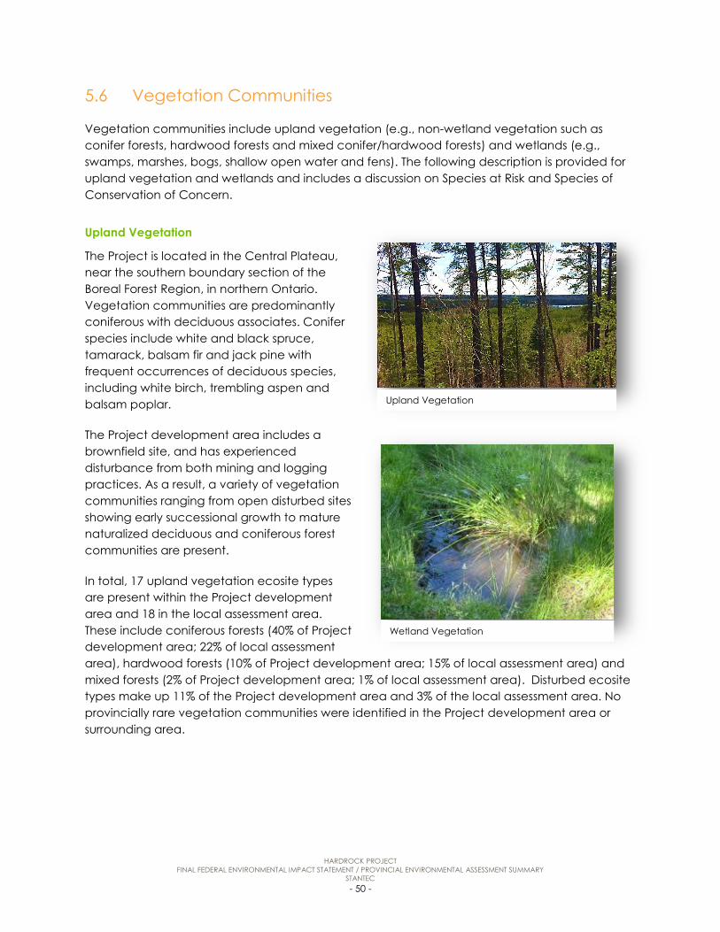
HARDROCK PROJECT FINAL FEDERAL ENVIRONMENTAL IMPACT STATEMENT / PROVINCIAL ENVIRONMENTAL ASSESSMENT SUMMARY
STANTEC - 50 -
5.6 Vegetation Communities
Vegetation communities include upland vegetation (e.g., non-wetland vegetation such as conifer forests, hardwood forests and mixed conifer/hardwood forests) and wetlands (e.g., swamps, marshes, bogs, shallow open water and fens). The following description is provided for upland vegetation and wetlands and includes a discussion on Species at Risk and Species of Conservation of Concern.
Upland Vegetation
The Project is located in the Central Plateau, near the southern boundary section of the Boreal Forest Region, in northern Ontario. Vegetation communities are predominantly coniferous with deciduous associates. Conifer species include white and black spruce, tamarack, balsam fir and jack pine with frequent occurrences of deciduous species, including white birch, trembling aspen and balsam poplar.
The Project development area includes a brownfield site, and has experienced disturbance from both mining and logging practices. As a result, a variety of vegetation communities ranging from open disturbed sites showing early successional growth to mature naturalized deciduous and coniferous forest communities are present.
In total, 17 upland vegetation ecosite types are present within the Project development area and 18 in the local assessment area. These include coniferous forests (40% of Project development area; 22% of local assessment area), hardwood forests (10% of Project development area; 15% of local assessment area) and mixed forests (2% of Project development area; 1% of local assessment area). Disturbed ecosite types make up 11% of the Project development area and 3% of the local assessment area. No provincially rare vegetation communities were identified in the Project development area or surrounding area.
Wetland Vegetation
Upland Vegetation

HARDROCK PROJECT FINAL FEDERAL ENVIRONMENTAL IMPACT STATEMENT / PROVINCIAL ENVIRONMENTAL ASSESSMENT SUMMARY
STANTEC - 51 -
Wetland Ecosites
Wetland vegetation community types are common to the Boreal Forest Region. Wetland ecosites include swamp, marsh, bog and fen communities. Many of these wetland ecosites contain a shallow open water component.
In total, 12 wetland ecosite types were present within the Project development area and 11 in the local assessment area. These include swamp communities (35% of Project development area; 21% of local assessment area), bog (less than 1% of Project development area; 0% in the local assessment area), fen (1% of Project development area; 3% of local assessment area) and marsh (less than 1% of Project development area; less than 1% of local assessment area) types. No provincially rare wetland communities were identified in the Project development area or surrounding area.
One notable wetland community was identified that partially overlaps the Project development area. This fen-dominated wetland is located adjacent to the northeast limit of the tailings management facility. The fen portion of this wetland occupies a shallow basin that covers about 40 hectares. Conifer swamp communities are located east and west of the fen. Vegetation cover in the fen included tree, shrub and herbaceous/moss cover. Tree cover included tamarack, black spruce and white cedar, and canopy height was generally less than 10 metres. This fen supports habitat for a butterfly Species of Conservation Concern (taiga alpine butterfly) and areas of seepage from adjacent uplands. Although the Sparse Treed Fen ecosite is not listed as provincially rare, this fen and adjacent wetland community types are considered a sensitive feature due to its size, potential habitat for the taiga alpine butterfly, dependence on nutrient-rich groundwater, and its general wetland functions.
Species at Risk and Species of Conservation of Concern
Species at Risk and Species of Conservation Concern are protected under federal or provincial legislation. No plant Species at Risk or Species of Conservation Concern were identified in the Project development area or surrounding area during field investigations.
Plant Species of Interest to Aboriginal Communities
Plant species identified as having traditional value or interest to Aboriginal communities are balsam fir, bear root, birch, birch mushroom, black ash, black spruce, blueberries, bull rush, cedar, chaga, chanterelle, currant, ferns, highbush cranberry, juniper, Labrador tea, lowbush cranberry, maple, mint, mountain ash, mushrooms, pin cherry, raspberries, Saskatoon berry, shaggy mane, strawberries, sweetgrass, white spruce, will (white and red), wild rice, weekay (sweet flag) and yarrow.
5.7 Wildlife and Wildlife Habitat
Wildlife includes birds, mammals, reptiles, amphibians, and insects, as well as Species at Risk and Species of Conservation Concern. The following description is provided for wildlife species organized by key wildlife groups and wildlife habitat.

HARDROCK PROJECT FINAL FEDERAL ENVIRONMENTAL IMPACT STATEMENT / PROVINCIAL ENVIRONMENTAL ASSESSMENT SUMMARY
STANTEC - 52 -
Wildlife Species
A total of 196 wildlife species were recorded during the baseline surveys.
Seventeen mammal species were observed during baseline surveys: moose, black bear, grey wolf, red fox, lynx, pine marten, ermine, little brown myotis, northern myotis, silver-haired bat, hoary bat, striped skunk, snowshoe hare, woodchuck, red squirrel, least chipmunk, and beaver. Two of these are Species at Risk: little brown myotis and northern myotis. An additional six species of mammals were documented within the Project development area through the 2016 small mammal trapping program: red-backed vole, masked shrew, meadow vole, deer mouse, short-tailed shrew, and smoky shrew.
137 bird species, of which 120 are assumed to be breeding locally, were recorded during baseline surveys. Twelve of these species are Species at Risk or Species of Conservation Concern: bald eagle, peregrine falcon, bank swallow, barn swallow, Canada warbler, eastern whip-poor-will, common nighthawk, eastern wood-pewee, olive-sided flycatcher, American white pelican, red-necked grebe, and short-billed dowitcher.
Six amphibian species were recorded during baseline surveys: boreal chorus frog, wood frog, spring peeper, gray tree frog, American toad, and Jefferson/blue-spotted salamander. Two reptile species were recorded during baseline surveys: western painted turtle and eastern garter snake. None of the amphibian or reptile species recorded during field surveys are Species at Risk or Species of Conservation Concern.
28 insect species were recorded during baseline field investigations, including eight odonata species (i.e., dragonflies and damselflies) and 20 butterfly species. One of these species is a Species of Conservation Concern: the taiga alpine butterfly.
Wildlife Species of Interest to Aboriginal Communities
Wildlife species identified as having traditional value or interest to Aboriginal communities are bald eagle, beaver, black bear, caribou, deer, waterfowl/ducks, geese, ruffled grouse, lynx, marten, mink, moose, muskrat, otter, prairie chicken, rabbit, great grey owl, cougar, wolf, American white pelican and wolverine.
Wildlife Habitat
Field surveys confirmed the presence and use of habitats within the local assessment are for breeding birds, stopover and foraging, moose foraging, western painted turtle overwintering, amphibian breeding and taiga alpine butterfly breeding. In addition, waterfowl nesting habitat,
Blackburnian Warbler
HARDROCK PROJECT FINAL FEDERAL ENVIRONMENTAL IMPACT STATEMENT / PROVINCIAL ENVIRONMENTAL ASSESSMENT SUMMARY
STANTEC - 53 -
moose late winter cover and bat maternity roost habitat (natural and anthropogenic) are conservatively considered to be present.
Total breeding habitat for Canada warbler identified in the local assessment area is 3,015 hectares of which only 139 hectares is confirmed breeding habitat, with the remainder classified as potential breeding habitat. In the case of common nighthawk, 411 hectares of habitat is identified as potential with no confirmed breeding habitat identified. Total breeding habitat identified for eastern wood-pewee is 665 hectares of which only eight hectares was confirmed breeding habitat; the remaining was classified as potential breeding habitat. Sixteen barn swallow nests in three buildings were documented in the local assessment area, and twenty-four hectares of foraging habitat occurs within the local assessment area. One known bald eagle nest and one known woodland raptor nest occur within the local assessment area and there is 3,015 hectares of potential nesting habitat. There is 442 hectares of American white pelican staging and foraging habitat identified in the local assessment area which is restricted to Kenogamisis Lake.
Other wildlife habitat throughout the Project development area and local assessment area include, waterfowl nesting habitat, moose foraging habitat, moose later winter cover, habitat for woodland caribou, natural bat maternity roost habitat, potential anthropogenic bat maternity roost habitat, turtle overwintering habitat, amphibian breeding habitat, and Taiga alpine butterfly habitat.
5.8 Labour and Economy
The following description is provided for labour and employment, and the local and regional economies.
Labour and Employment
Baseline economic conditions indicate that the economy of the local area has been in decline, with the number of people in the labour force decreasing by 9.8% between 2006 and 2011, and the unemployment rate increasing by 3.3 percentage points. In comparison, the size of the labour force in the regional area decreased by 4% over the same period. In 2011, the rate of unemployment in the local area was more than twice the Ontario average, while the 2011 unemployment rate in the regional area was only slightly higher than that for the province. Within the local area, there are higher rates of unemployment in Aboriginal communities than in non-Aboriginal communities.
Approximately 23% of people in the local area who were employed or had been employed during 2011 were employed in basic industries (i.e., goods-producing industries: agriculture, forestry, fishing, and hunting; mining, quarrying, and oil and gas extraction; construction; manufacturing; and utilities). Employment in non-basic industries (i.e., trade, services, and public services such as education and healthcare) accounted for the remaining 77% of local employment in 2011. Employment figures for the regional area where similar with over 80% of total employment in non-basic industries. Provincially, the figures were 19.5% and 80.5% for basic and non-basic industries, respectively. Among the basic industries, the largest number of

HARDROCK PROJECT FINAL FEDERAL ENVIRONMENTAL IMPACT STATEMENT / PROVINCIAL ENVIRONMENTAL ASSESSMENT SUMMARY
STANTEC - 54 -
employed workers in the local area in 2011 had experience in the “agriculture, forestry, fishing and hunting” category.
Local and Regional Economies
The Greenstone Economic Development Corporation (Community Futures Development Corporation) has identified mineral exploration and mining as a key component of anticipated economic growth in the Greenstone region. Greenstone has been preparing for economic development related to the minerals sector. The municipality has worked with local organizations to increase the participation of local companies in supplying goods and services to exploration and development projects.
Forestry has traditionally been an important component of the Greenstone economy. However, the industry has recently experienced a major downturn, and at one point all four mills in the municipality were closed, with the first closing in 2007. The decline of the forestry industry resulted in job losses for more than 700 residents of Greenstone in 2010.
Construction was a major industry for Greenstone in 2010. Construction employment has increased as a result of infrastructure projects and mineral exploration and it is expected that
increased mineral exploration will lead to increased demand for construction workers as mining projects become operational and the need for associated infrastructure development grows.
Tourism was listed as key growth sectors in the Greenstone region by the Greenstone Economic Development Corporation. Outdoor recreation activities, including fishing, hunting and camping, are the main tourism products promoted for Greenstone and the surrounding area.
5.9 Community Services and Infrastructure
The following description is provided for housing and temporary accommodations, policing and fire services, health services, recreation and entertainment facilities, and municipal services and infrastructure and education.
Housing and Temporary Accommodations
According to a 2011 housing analysis of the District of Thunder Bay, population decline in the Municipality of Greenstone has led to a surplus of housing in some communities.
Aerial Image - Geraldton

HARDROCK PROJECT FINAL FEDERAL ENVIRONMENTAL IMPACT STATEMENT / PROVINCIAL ENVIRONMENTAL ASSESSMENT SUMMARY
STANTEC - 55 -
Temporary accommodations and operators are typically small in scale, such as bed-and-breakfasts, and many are geared toward tourism associated with hunting and fishing (e.g., fly-in outfitters). Greenstone has over 40 hotels/motels/resorts/tourism operators ranging from hotels and motels to seasonal camps and fly-in accommodations, which provide 280 rooms.
Policing and Fire Services
Police service in the Municipality of Greenstone is provided by the Ontario Provincial Police Greenstone Detachment based in Geraldton. In addition to servicing the surrounding communities the Greenstone Detachment provides support to the Aboriginal Policing Services in Greenstone as requested. The Anishinaabek Police Service provides policing services to 16 First Nations communities across Ontario which includes detachments in Aroland First Nation and Ginoogaming First Nation.
The Greenstone Fire Department has six sector fire stations located in Beardmore, Geraldton, Longlac, Nakina, Caramat and Jellicoe that are staffed by approximately 120 volunteer firefighters.
Health Facilities
Geraldton District Hospital provides health services to approximately 8,000 residents of Greenstone and the surrounding Aboriginal communities. The hospital has 23 acute-care beds, 26 long-term care beds and a 24-hour emergency department. The NorWest Community Health Centres in Longlac provide primary care services and health promotion programs to that community, Caramat, the Long Lake #58 First Nation and Ginoogaming First Nation. Physicians from the Geraldton Medical Group provide scheduled services for the Nakina Clinic which services the far north and surrounding Aboriginal communities.
Recreation and Entertainment Facilities
The Municipality of Greenstone has three community centres one each in Beardmore, Nakina and Geraldton. There is also a Sportsplex in Longlac. Winter outdoor activities include cross-country skiing and snowmobiling, snowshoeing and ice fishing. Warm weather activities include fishing, baseball, hiking, kayaking, canoeing and camping at the four municipal parks. Golf is available at the Kenogamisis Golf Club, an 18-hole golf course owned by GGM who leases it to the Municipality of Greenstone.
Transportation
Airports include Greenstone Regional Airport, located in the Ward of Geraldton and R. Elmer Ruddick Nakina Airport, located in Nakina. Both airports owned and operated by the Municipality of Greenstone.
The main roads in the local area are Highway 11 and Michael Power Boulevard (which becomes Highway 584 north of Geraldton). Highway 11 is the responsibility of the Ministry of Transportation. Several local roads, including Lahtis Road and Hardrock Road, that intersect highways within the
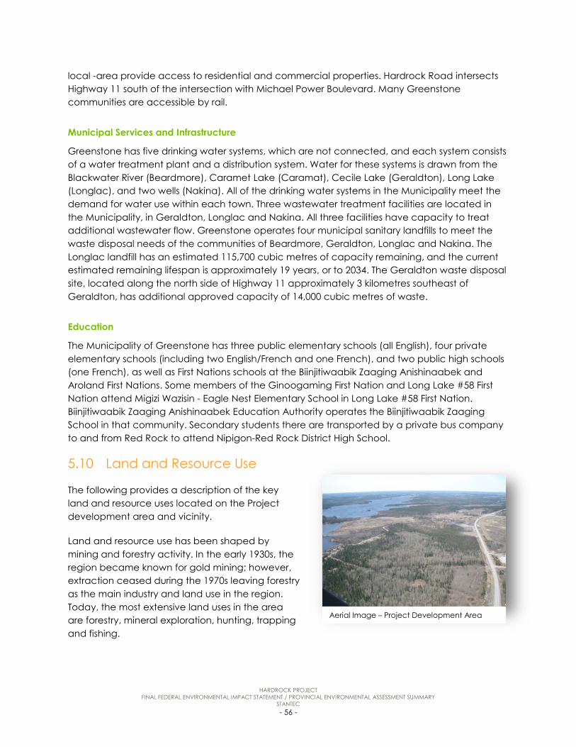
HARDROCK PROJECT FINAL FEDERAL ENVIRONMENTAL IMPACT STATEMENT / PROVINCIAL ENVIRONMENTAL ASSESSMENT SUMMARY
STANTEC - 56 -
local -area provide access to residential and commercial properties. Hardrock Road intersects Highway 11 south of the intersection with Michael Power Boulevard. Many Greenstone communities are accessible by rail.
Municipal Services and Infrastructure
Greenstone has five drinking water systems, which are not connected, and each system consists of a water treatment plant and a distribution system. Water for these systems is drawn from the Blackwater River (Beardmore), Caramet Lake (Caramat), Cecile Lake (Geraldton), Long Lake (Longlac), and two wells (Nakina). All of the drinking water systems in the Municipality meet the demand for water use within each town. Three wastewater treatment facilities are located in the Municipality, in Geraldton, Longlac and Nakina. All three facilities have capacity to treat additional wastewater flow. Greenstone operates four municipal sanitary landfills to meet the waste disposal needs of the communities of Beardmore, Geraldton, Longlac and Nakina. The Longlac landfill has an estimated 115,700 cubic metres of capacity remaining, and the current estimated remaining lifespan is approximately 19 years, or to 2034. The Geraldton waste disposal site, located along the north side of Highway 11 approximately 3 kilometres southeast of Geraldton, has additional approved capacity of 14,000 cubic metres of waste.
Education
The Municipality of Greenstone has three public elementary schools (all English), four private elementary schools (including two English/French and one French), and two public high schools (one French), as well as First Nations schools at the Biinjitiwaabik Zaaging Anishinaabek and Aroland First Nations. Some members of the Ginoogaming First Nation and Long Lake #58 First Nation attend Migizi Wazisin - Eagle Nest Elementary School in Long Lake #58 First Nation. Biinjitiwaabik Zaaging Anishinaabek Education Authority operates the Biinjitiwaabik Zaaging School in that community. Secondary students there are transported by a private bus company to and from Red Rock to attend Nipigon-Red Rock District High School.
5.10 Land and Resource Use
The following provides a description of the key land and resource uses located on the Project development area and vicinity.
Land and resource use has been shaped by mining and forestry activity. In the early 1930s, the region became known for gold mining; however, extraction ceased during the 1970s leaving forestry as the main industry and land use in the region. Today, the most extensive land uses in the area are forestry, mineral exploration, hunting, trapping and fishing.
Aerial Image – Project Development Area

HARDROCK PROJECT FINAL FEDERAL ENVIRONMENTAL IMPACT STATEMENT / PROVINCIAL ENVIRONMENTAL ASSESSMENT SUMMARY
STANTEC - 57 -
Forestry, recreation, transportation, mineral exploration, aggregate extraction, urban land uses, trapping and potentially hunting also occur in the Project development area. Land and resource use areas and facilities in the local area include:
• MacLeod Provincial Park, which includes a campground, walking trail, cross-country skiing trails, and public beach;
• Ward of Geraldton, which includes a municipal park, public boat launches and public beaches, among other urban land uses;
• Crown land campsite;
• Kenogamisis Lake Resort (guide outfitter);
• snowmobile trails;
• canoe routes along the Kenogamisis River;
• planned forest harvest areas and forest access roads;
• trapline areas;
• Bear Management Areas; and
• Bait Harvesting Areas.
5.11 Heritage Resources
Heritage resources are human and natural resources created by activities from the past that remain to inform present and future societies of that past. Heritage resources include archaeological, architectural and historical, and paleontological resources. The description is provided for archaeological resources and architectural or historical resources.
Archaeological Resources
The Project development area has potentially been occupied from 7000 BC until the present day by Aboriginal populations, and beginning in the 19th century, Euro-Canadian inhabitants. No archaeological sites were documented during the 2014 and 2015 archaeological field work conducted within the Project development area to evaluate whether areas of archaeological potential would yield any archaeological sites.
Architectural or Historical Resources
There are 17 properties within the Project development area containing architectural and/or historical resources. The resources were primarily residential development dating to early mining
Archaeology Test Pit

HARDROCK PROJECT FINAL FEDERAL ENVIRONMENTAL IMPACT STATEMENT / PROVINCIAL ENVIRONMENTAL ASSESSMENT SUMMARY
STANTEC - 58 -
activities. Two of the structures were initially constructed as commercial buildings and used as mine offices; both have been converted for residential use. The only potential architectural and/or historical resource relating to early mining activities was the MacLeod-Cockshutt Mining Headframe. The only potential architectural and/or historical landscape was the Kenogamisis Golf Club.
5.12 Traditional Land and Resource Use
Traditional land and resource use includes traditional activities, sites and resources identified by First Nations and Métis communities. Project effects on traditional land and resource use were confirmed through consultation activities, review of Project-specific traditional knowledge and traditional land and resource use studies, and existing literature.
Plant Harvesting
Aboriginal communities harvest native plants for food, medicinal and cultural purposes. In general, plants are gathered throughout the local area including shoreline of Kenogamisis Lake and the surrounding waterbodies.
Fish Harvesting
Aboriginal communities fish in the lakes, rivers and streams in the local area. Fish species include Bass, Burbot, Northern Pike, Yellow Perch, Walleye, Salmon, Rainbow Smelt, Lake Sturgeon, Suckers, Trout, Whitefish. Some communities rely on locally caught fish as a main part of their diet.
Hunting and Trapping
Aboriginal communities hunt and trap in the local area and region harvesting a variety of big game, small mammals, waterfowl and other birds. Hunting and trapping continues to be an important traditional activity practiced by Aboriginal communities in the region for both economic and cultural purposes. Trapping areas identified by Aboriginal community members occur throughout the region. Mammals (e.g., moose, rabbit, marten) and birds (e.g., geese, grouse) are found within and are hunted and trapped in this area by Aboriginal community members.
Cultural or Spiritual Practices
Cultural sites (including trails and travelways), sacred areas (including burial sites, ceremonial activities and places of recognized spiritual power), communal gathering areas and habitation sites are used by Aboriginal communities within the regional area. Aboriginal communities continue to use traditional gathering places in the region to come together for socializing, harvesting or ceremonial purposes.
Long Lake #58 First Nation and the Métis Nation of Ontario identified cultural sites along the shoreline of the Southwest Arm of Kenogamisis Lake in the local assessment area. Long Lake #58

HARDROCK PROJECT FINAL FEDERAL ENVIRONMENTAL IMPACT STATEMENT / PROVINCIAL ENVIRONMENTAL ASSESSMENT SUMMARY
STANTEC - 59 -
First Nation confirmed there are a total of four land use sites within the Project development area. GGM and Long Lake #58 First Nation have agreed upon a path forward for these sites. The Métis Nation of Ontario reported a tent or temporary structure near the south shore of Mosher Lake and a route connecting Highway 11 with Mosher Lake, both conservatively assumed to be located within the Project development area. Aroland First Nation confirmed they use snowmobile trails, which are operated by the Ontario Federation of Snowmobile Clubs and maintained by the Greenstone Snowmobile Club, in the Project development area for hunting. Geraldton Snowmobile Club has confirmed that the trail along Lahtis Road is no longer maintained.
6.0 EFFECTS ASSESSMENT, MITIGATION AND DETERMINATION OF SIGNIFICANCE
The potential interactions between Project activities and the environment were considered for each valued component, for the construction, operation, and closure phases of the Project. If a measurable change was considered likely, the change was evaluated to determine the associated likely environmental effect. Design features incorporated into the Project design or planning to prevent environmental effects were considered in the evaluation for change and effect.
For each valued component, spatial boundaries (or geographic areas) were established for the assessment of potential Project-related environmental effects and cumulative environmental effects. Spatial boundaries are selected to reflect the geographic extent over which Project-related environmental effects are likely to occur. Local and regional assessment areas where identified for each valued component as part for the environmental effects assessment.
Opportunities to further mitigate the likely environmental effects were identified and the residual effect (i.e., the effect after mitigation) determined. Residual adverse effects were further considered for their significance.
A summary of anticipated potential effects, mitigation and predicted residual effects including significance is provided for each valued component.
6.1 Atmospheric Environment
Potential Effects Prior to Mitigation
The potential environmental effects of the Project on the atmospheric environment, prior to mitigation, include:
• change in ambient air quality
• climate change (as measured by change in greenhouse gases)

HARDROCK PROJECT FINAL FEDERAL ENVIRONMENTAL IMPACT STATEMENT / PROVINCIAL ENVIRONMENTAL ASSESSMENT SUMMARY
STANTEC - 60 -
• change in lighting.
Potential air quality topics associated with the Project include airborne particulate matter or dust (including metal substances), emissions from the combustion of diesel and natural gas and from mining and ore processing. These air contaminants are referred to collectively as “parameters of potential concern”.
During Project construction, emissions of air parameters of potential concern may result from site preparation activities and the construction of Project components. These emissions would include particulate and combustion gases from construction equipment, and particulate (dust) emissions caused by such things as the operation of heavy earth-moving equipment and wind erosion. Many of the construction activities would not occur continuously (i.e., intermittent), nor would all activities occur concurrently at any given time. Construction activities would occur during daytime hours over the duration of the construction phase.
During Project operation, emissions of air parameters of potential concern may result from the combustion of diesel fuel in mining equipment, natural gas combustion in the power plant, and other stationary equipment used during operation.
Active closure emissions are expected to be less than construction emissions (as no ore extraction or tailings management facility construction would be occurring). The post-closure phase is expected to generate negligible air emissions.
A greenhouse gas is any gas that contributes to potential climate change. Common greenhouse gases include carbon dioxide, methane, and nitrous oxide. Construction, operation and closure activities will result in greenhouse gas emissions from the combustion of diesel fuel.
Lighting sources from the Project construction and operation phases will include stationary perimeter lighting sources associated with the process plant, power plant, fuel storage areas and site buildings, and from mobile sources such as mining and construction equipment and portable lighting equipment used during site preparation and construction of onsite component. Lighting during active closure is expected to be similar or less in magnitude than that for construction.
Mitigation and Commitments
For construction and closure, mitigation measures include the use of dust suppressants (e.g., water); limiting vehicle speeds; regular maintenance of equipment; reducing haul routes where possible; a no idling policy; use of temporary electrical grid connection to reduce the need for diesel generators; use of high efficiency equipment where possible; and where feasible, portable lighting equipment will be located so it is not visible to nearby receptors (for example, residences).
In addition to the mitigation measures proposed for construction and closure, for operation, mitigation measures include dust collection systems for crushing operations; using wet scrubbers to control dust emissions from the grinding operations; managing fugitive dust generated during

HARDROCK PROJECT FINAL FEDERAL ENVIRONMENTAL IMPACT STATEMENT / PROVINCIAL ENVIRONMENTAL ASSESSMENT SUMMARY
STANTEC - 61 -
the transport of historical tailings; and using mobile equipment that meets applicable Transport Canada off-road vehicle emissions requirements and various fugitive dust emission controls.
The design of exterior of lighting systems for Project operation will be based on widely accepted standards and guidelines, including direction of light to limit visibility at residences. The use of existing topography and tree cover along onsite roadways is expected to reduce visibility of lights from operational vehicles within the Project development area.
GGM has committed to the implementation of an Air Quality Management and Monitoring Plan and a Greenhouse Gas Management Plan designed to reduce emissions to the atmospheric environment from the Project.
Residuals Effect and Determination of Significance
Emissions of parameters of potential concern will occur during Project construction and closure primarily due to the combustion of diesel fuel from construction equipment. These activities are minor and are not predicted to result in emissions that exceed provincial air quality regulations or national objectives.
Results of the air dispersion modelling for operation indicate that there would be an increase in parameters of potential concern above baseline conditions that will extend beyond the Project development area, but be within regulatory limits and objectives at all outside modelled property boundary receptor locations (non-GGM owned/leased land) with the exception of infrequent 24-hour average of particulate matter close to the modelled property boundary (e.g., no more than 6 days in 5-years, or 0.3% of the time). At inside modelled property boundary receptors (primarily GGM owned/leased land), infrequent exceedances of particulate matter and manganese were predicted during the first two years of operation, and at the Kenogamisis Golf Club during operation. Residual concentrations of benzene and benzo(a)pyrene from vehicle tailpipe emissions also exceeded applicable criteria at inside and outside modelled property boundary receptors as the baseline levels of both benzene and benzo(a)pyrene are above applicable air quality criteria. These infrequent and minor increases above applicable regulatory criteria were further evaluated in the human and ecological risk assessment. Overall, they represent a negligible human health risk.
The Project’s contribution to total Ontario annual greenhouse gas emissions is less than 1% (approximately 0.06% in construction, 0.1% in phase 1 of operation, and 0.2% in phase 2).
During construction, operation, and active closure it is predicted that changes to ambient lighting will extend beyond the Project development area and into the local assessment area.
Residual adverse effects on the atmospheric environment are determined to be not significant.
Table 6-1 provides a description of residual effects remaining following mitigation and the significance of residual effects.

HARDROCK PROJECT FINAL FEDERAL ENVIRONMENTAL IMPACT STATEMENT / PROVINCIAL ENVIRONMENTAL ASSESSMENT SUMMARY
STANTEC - 62 -
6.2 Acoustic Environment
Potential Effects Prior to Mitigation
The potential environmental effects of the Project on the acoustic environment, prior to mitigation, include:
• change in noise levels
• change in vibration levels.
Typical sources of noise during construction and active closure include trucks and trailers, portable air compressors and welders, bulldozers, front-end loaders, excavators, graders, gravel and rock trucks, scrapers, compactors, mobile cranes and concrete pumps. The main noise-generating sources associated with operation include blasting in the open pit, process plant equipment such as rock breakers, feeders, and conveyors, and moving sources such as trucks, excavators, and dozers, as well as power generation.
During construction and active closure, sources of vibration include construction vehicles, typical machinery for a mining site and roadway realignment work. The main vibration-generating sources associated with Project operation include equipment such as rock breakers and feeders, and moving sources such as trucks, excavators, and bulldozers and blasting within the open pit.
Mitigation and Commitments
For construction and active closure, mitigation includes the installation of muffler systems on construction and other mobile equipment and equipment will be properly maintained.
For operation, mitigation measures include the installation of muffler systems on construction and other mobile equipment, selecting equipment and/or designing acoustical enclosures to limit overall noise emissions, setting limits on the overall noise emissions transferring through doors for building enclosures and using air inlet and discharge silencers for exhaust stacks associated with diesel or natural gas-fuelled generators.
In addition to noise mitigation measures, GGM will advise nearby residents of major noise generating activities, implement a complaint response procedure to address noise complaints should they arise, conduct blasting primarily on weekdays, typically mid-day where possible and endeavor to avoid blasting on statutory holidays. Where possible, major construction activities will be scheduled to take place during daytime hours (i.e., 07:00 hour to 19:00 hour) to avoid sensitive night-time periods. GGM will implement a Noise and Vibration Management Plan for the Project.
Residuals Effect and Determination of Significance
Noise levels within the local assessment area will increase primarily due to the operation of equipment and blasting within the open pit; however, the predicted noise emission levels at

HARDROCK PROJECT FINAL FEDERAL ENVIRONMENTAL IMPACT STATEMENT / PROVINCIAL ENVIRONMENTAL ASSESSMENT SUMMARY
STANTEC - 63 -
points of reception and points of interest will comply with applicable guideline criteria and thresholds.
The predicted vibration levels at points of reception and points of interest will comply with applicable guideline criteria and thresholds.
With the application of mitigation measures incorporated in the acoustic models, the residual Project effects on the acoustic environment for all phases of the Project are predicted to be not significant.
6.3 Groundwater
Potential Effects Prior to Mitigation
The potential environmental effects of the Project on groundwater, prior to mitigation, include:
• change in groundwater quantity and/or flow
• change in groundwater quality.
During construction groundwater quantity and/or flow will primarily be affected by the lowering of groundwater levels through the dewatering of the historical underground workings and open pit and aggregate source areas, and the diversion of Goldfield Creek.
The disturbance and movement of soil previously affected by historical mining and removal of a portion of the historical MacLeod and Hardrock tailings during construction and relocation to the new tailings management facility, will result in reduced loading of parameters of potential concern (e.g., arsenic) to the environment and improved water quality. Similarly, the removal and management of soils previously affected by historical mining activities has the potential to improve groundwater quality by reducing loading of parameters of potential concern (i.e., arsenic) to the environment. Also, dewatering of the historical underground workings and local dewatering for the installation of building and tailings management facility dam foundations has the potential to alter groundwater flow paths near areas of historical mining operations. This has the potential to result in changes to groundwater flow and discharge, with groundwater being redirected to the dewatering locations where it can be collected and treated prior to discharge to the environment.
During operation, groundwater quantity and/or flow will primarily be affected by the lowering of water levels through dewatering of the historical underground workings and open pit. During closure, surface water runoff from the Project is directed to the open pit and as the open pit fills with water, groundwater levels will slowly rise and changes to groundwater flow direction and discharge locations are expected. Closure of water management facilities will result in the removal of contact water collection systems that may result in groundwater originating from the waste rock storage areas and the tailings management facility, overburden storage areas, and historical tailings discharging to the natural environment. At closure, the removal and rehabilitation of the ore stockpile, rehabilitation for the waste rock storage areas and the tailings

HARDROCK PROJECT FINAL FEDERAL ENVIRONMENTAL IMPACT STATEMENT / PROVINCIAL ENVIRONMENTAL ASSESSMENT SUMMARY
STANTEC - 64 -
management facility have the potential to change groundwater recharge rates which will affect groundwater flow patterns.
Mitigation and Commitments
For construction, mitigation measures include limiting the construction footprint to the extent possible to reduce the potential for reductions in groundwater recharge; the use of standard management practices for drainage control and excavation and open pit dewatering; the installation of a subsurface seepage collection system around the base of the historical MacLeod high tailings; placement of an enhanced cover system over the remaining tailings, installation of contact water collection ditches around the overburden storage area, ore stockpile and waste rock storage areas, and the installation of seepage collection ditches around the tailings management facility.
The subsurface seepage collection system for the MacLeod High tailings will address both short-term seepage anticipated during construction and long term seepage (operation and closure/post-closure). For operation, mitigation measures include progressive rehabilitation of the Project development area to reduce infiltration into the waste rock storage areas and the tailings management facility, cyanide detoxification to reduce cyanide concentrations and precipitate metals to improve water quality within the tailings management facility, and collecting and treating groundwater generated from the dewatering of the underground workings and open pit prior to discharging into Kenogamisis Lake.
In addition to these proposed mitigation measures, the removal of approximately 22% of the historical MacLeod tailings and 77% of the historical Hardrock tailings and their placement within the new tailings management facility will reduce chemical loading to groundwater and surface water and result in an improvement to groundwater quality. Further reductions in loading from the historical MacLeod high tailings will result from the installation of an enhanced cover designed to reduce infiltration and increase runoff, and the collection of seepage within the subsurface seepage collection system.
Progressive rehabilitation of the Project development area will continue into closure. Additionally, the acceleration of the open pit filling at closure to return groundwater levels to baseline conditions in a shorter timeframe will be undertaken resulting in a refilling time of approximately 16 years.
In addition to the mitigation measures to reduce potential environmental effects, other commitments include the implementation of the Water Management and Monitoring Plan.
Residual Effects and Determination of Significance
Dewatering of the open pit is predicted to result in a lowering of groundwater levels within the local assessment area. This effect will occur primarily during the construction and operation phases, and to a lesser extent during closure as the open pit fills and groundwater levels recover. However, there are no water supply users within the area of the zone of influence (identified by the 1.0 metre drawdown contour) for the shallow overburden and bedrock aquifer and these

HARDROCK PROJECT FINAL FEDERAL ENVIRONMENTAL IMPACT STATEMENT / PROVINCIAL ENVIRONMENTAL ASSESSMENT SUMMARY
STANTEC - 65 -
lands are owned or under lease by GGM. Furthermore, residences within this area are serviced by the municipal water supply system as they are located within an area of historical mining where water quality has been affected in baseline conditions. The adverse residual environmental effects of the Project on a change in groundwater quantity and/or flow are determined to be not significant.
The removal of a portion of historical MacLeod and Hardrock tailings, placement of an enhanced cover system over the remaining MacLeod High historical tailings and installation of a subsurface seepage collection system, installation of a seepage collection system for the Waste Rock Storage Areas, overburden and ore stockpiles and the tailings management facility, and open pit dewatering are predicted to result in a positive effect on groundwater quality. Arsenic loading to surface water features due to groundwater discharge is predicted to decrease by 99% during operation and 59% during closure, despite the changes due to new Project infrastructure (waste rock storage areas and tailings management facility).
Residual adverse effects on the groundwater quality are determined to be not significant.
Table 6-1 provides a description of residual effects remaining following mitigation and the significance of residual effects.
6.4 Surface Water
Potential Effects Prior to Mitigation
The potential environmental effects of the Project on surface water, prior to mitigation, include:
• change in surface water quantity
• change in surface water quality.
Surface water quantity and drainage patterns could be directly affected by construction activities including site preparation, installation of watercourse crossings, overprinting of some small watercourses including overprinting/diverting of Goldfield Creek, trenches and excavations, and the development of water management infrastructure. These construction activities and the continued expansion of Project facilities (such as the open pit) have the potential to change surface runoff and infiltration characteristics and alter existing drainage patterns and catchment areas. In addition, potential changes in groundwater quantity could alter groundwater discharge to surface water features which in turn could affect surface water quantity. During operation, the development of the waste rock storage areas and tailings management facility, as well as water intakes to meet mill demand could potentially affect surface water quantity, in the absence of mitigation. During closure, water quantity has the potential to be affected by the rehabilitation of the Project development area, including the closure of water management facilities, and the re-establishment of drainage patterns. As the open pit fills, groundwater levels will slowly rise and alter groundwater flow directions and discharge locations, and subsequently affect surface water quantity.

HARDROCK PROJECT FINAL FEDERAL ENVIRONMENTAL IMPACT STATEMENT / PROVINCIAL ENVIRONMENTAL ASSESSMENT SUMMARY
STANTEC - 66 -
Surface water quality could be affected by erosion and sedimentation and contact water during construction. During operation surface water quality could be affected by the discharge of treated sanitary and mine effluent to surface water features. During closure discharge of water from the pit lake, contact water collection ponds and the tailings management facility once the open pit is filled could potentially affect surface water.
Mitigation and Commitments
Throughout every Project phase, Project effluent will be reduced by reusing contact water in Project processes.
For construction, mitigation measures include maintaining existing drainage patterns with the use of culverts, attenuate peak discharge to the environment through use of Project water storage, dewatering of the historical underground workings and starter open pit, the use of standard industry practices for erosion and sediment control, and the treatment of dewatering water from the historical underground workings and and the starter open pit prior to discharging to the environment.
Water from the seepage collection ponds will be pumped to the construction effluent treatment plant for treatment prior to discharge during construction and either to the process plant to meet mill demand or the permanent effluent treatment plant during operation.
For operation, mitigation measures include implementing progressive rehabilitation, the design and operation of the tailings management facility with no discharge to the environment during normal operating and climatic conditions, collection of runoff and groundwater seepage from the open pit, and recycling of contact water for ore processing. Excess water will be pumped to pond M1 and then to the Southwest Arm of Kenogamisis Lake following treatment as needed. Also, a sewage treatment plant will be used to treat effluent during Project operation.
During closure, collected surface water runoff will be directed to the open pit to accelerate pit filling. Water quality in the pit lake is expected to stratify, improving the quality of water discharging from the pit lake to the Southwest Arm of Kenogamisis Lake. Constructed wetland can also be implemented during closure as contingency if needed.
In addition to the mitigation measures to reduce potential environmental effects, other commitments include the implementation of a Water Management and Monitoring Plan.
Residual Effects and Determination of Significance
At the Kenogamisis Lake outlet, water quantity changes will be reduced and mitigated to levels considered not significant. The residual effects on surface water quantity for Barton Bay, Southwest Arm, Central Basin and the Outlet Basin are not significant as the predicted changes in mean annual flows are within ±5% compared with baseline conditions. The predicted increase in flow and water levels for Southwest Arm Tributary due to the Goldfield Creek diversion will be mitigated through the design of the new diversion channel to accommodate the higher flow

HARDROCK PROJECT FINAL FEDERAL ENVIRONMENTAL IMPACT STATEMENT / PROVINCIAL ENVIRONMENTAL ASSESSMENT SUMMARY
STANTEC - 67 -
rate for Southwest Arm Tributary along with existing flood capacity in the Southwest Arm Tributary.
The changes in water quality associated with the Project are not significant as they will not result in water quality that exceeds regulated effluent criteria, will occur only at the local subwatershed scale and will not exist at the local assessment area boundary. Water quality at the effluent mixing zone boundary will meet the Provincial Water Quality Objective and interim Provincial Water Quality Objective and will meet the intent of the Ministry of the Environment and Climate Change’s Policy 2 objectives. The Project will have a positive effect through the rehabilitation measures to address the historical MacLeod and Hardrock tailings, including removal of portions of the historical MacLeod and Hardrock tailings and installation of an enhanced cover system and a subsurface seepage collection system for the historical MacLeod high tailings. These measures will result in a reduction in arsenic concentrations and metal loadings to Barton Bay and Central Basin during operation and closure.
Table 6-1 provides a description of residual effects remaining following mitigation and the significance of residual effects.
6.5 Fish and Fish Habitat
Potential Effects Prior to Mitigation
The potential environmental effects of the Project on fish and fish habitat, prior to mitigation, include:
• lethal and sub-lethal effects on fish
• permanent alteration of fish habitat
• loss of fish habitat.
Fish mortality may occur as result of construction activities such as destruction of fish eggs by equipment during instream work, the transport of sediment into fish habitat, the use of explosives in or near water, and dewatering work areas which has the potential to strand, entrain and impinge fish. During operation fish mortality could result from entrainment and impingement of fish on the water intake structure in Kenogamisis Lake, entry of deleterious materials into fish habitat through minor spills or leaks from vehicles, equipment, storage containers/facilities, and the maintenance or replacement of in-water structures.
Potential effects during active closure will be similar to those during construction with the exception of blasting which will not occur beyond the operation phase.
Construction and closure activities may result in the permanent alteration or loss of fish habitat by altering characteristics such as sediment composition, riparian vegetation, and in-stream cover or through direct loss as in the case of infilling of Goldfield Creek during the construction phase. During operation, the discharge of treated effluent or groundwater discharge could lead

HARDROCK PROJECT FINAL FEDERAL ENVIRONMENTAL IMPACT STATEMENT / PROVINCIAL ENVIRONMENTAL ASSESSMENT SUMMARY
STANTEC - 68 -
to permanent alteration of fish habitat. The placement of material or structures in water can lead to the direct loss of fish habitat.
Mitigation and Commitments
Mitigation measures for fish mortality include undertaking all instream activities in isolation of open or flowing water to maintain the natural flow of water downstream and avoid introducing sediment into the watercourse, and in water works to be conducted within timing window for Northwestern Ontario restricts in-water work from April 1 to June 20 for spring spawning species (e.g., Northern Pike and Walleye).
GGM will implement a Blasting and Explosives Management Plan for the Project to reduce risk of lethal or sub-lethal effects on fish.
More than half of the 6.58 ha of fish habitat that will be altered or lost is comprised of golf course pond and poor quality habitat such as roadside ditches. Fish habitat that is altered or lost will be offset by creating new habitat within the Goldfield Creek diversion. A conservative approach will be taken, whereby a greater area of new habitat will be created than the area lost or altered.
Residual Effects and Determination of Significance
Effects on the sustainability and productivity of fish resources within the local assessment area are not anticipated. Overall, there will be no net loss of areas for fishing as a result of the Project.
An overall improvement in water quality is predicted for Kenogamisis Lake, with reduced concentrations of many parameters on a lake-wide basis. Discharge of treated effluent and non-point source contributions will result in localized, Project-related increases in concentrations of parameters of potential concern to levels that exceed water quality objectives and have the potential to cause sub-lethal effects on fish. However due to the geographic range of fish, long-term exposure to these parameters is not anticipated, especially given the overall predictions of improved water quality on a lake-wide basis.
The release of phosphorus and nitrogen from treated effluent discharge and airborne particulate from blasting may alter fish habitat, however the predicted 3% increase in total phosphorus for the Southwest Arm is smaller than that required to cause a change in trophic status and therefore is not anticipated to result in changes to fish sustainability and productivity. Changes beyond the mixing zone and in other basins of the lake are expected to be negligible with respect to fish habitat.
Residual adverse effects on fish and fish habitat are determined to be not significant.
Table 6-1 provides a description of residual effects remaining following mitigation and the significance of residual effects.

HARDROCK PROJECT FINAL FEDERAL ENVIRONMENTAL IMPACT STATEMENT / PROVINCIAL ENVIRONMENTAL ASSESSMENT SUMMARY
STANTEC - 69 -
6.6 Vegetation Communities
Potential Effects Prior to Mitigation
The potential environmental effects of the Project on vegetation communities, prior to mitigation, include:
• change in abundance of vegetation communities
• change in function, connectivity and quality of vegetation communities
• change in abundance of plant species of interest.
Site preparation can remove upland and wetland vegetation communities in the Project development area, which will result in direct effects on the vegetation species of interest (includes plant species of interest to Aboriginal communities) during construction. Construction will alter local topography and drainage patterns and therefore wetlands in the local area that are not directly affected by construction will likely be indirectly affected by changes in surface water flow. The Project has been designed to avoid direct effects on the sparse treed fen community. The Project will fragment some vegetation communities by introducing a large non-vegetated area into the landscape. Operation and closure will not result in any additional vegetation removal. During operation, there is the potential for wetlands to experience indirect effects due to groundwater changes as a result of dewatering. During construction, operation and closure there is the potential for indirect effects on vegetation species of interest within 30 metres of Project components from dust deposition due to Project activities. Invasive and exotic (e.g., non-native) plant species can displace native vegetation in some cases during construction and closure. No interaction with species at risk or species of conservation concern is anticipated.
Mitigation and Commitments
Vegetation clearing activities will be restricted to the Project development area. Progressive rehabilitation of the Project development area which will commence at the end of construction. GGM will also implement a Biodiversity Management and Monitoring Plan designed to mitigate direct and indirect adverse effects on vegetation and wetlands during all phases of the Project, including controlling of invasive species and protection of the sensitive community.
A number of mitigation measures have already been incorporated in the Project to eliminate or reduce environmental effects of the Project which also serve to address vegetation communities effects. These mitigation measures include those measures outlined for air quality, groundwater and surface water. Other mitigation measures include using mechanical vegetation removal practices where possible, using clean, coarse fill material for grading to reduce the potential for introducing or spreading non-native, or invasive plant species, the reestablishment of drainage patterns, to the extent feasible and following standard forestry practices to remove all merchantable timber inside the Project development area.

HARDROCK PROJECT FINAL FEDERAL ENVIRONMENTAL IMPACT STATEMENT / PROVINCIAL ENVIRONMENTAL ASSESSMENT SUMMARY
STANTEC - 70 -
Also, where there is interest, GGM will provide opportunities to local Aboriginal communities for harvesting of plants for traditional purposes prior to construction and incorporate plant species of interest to local Aboriginal communities into the Closure Plan as feasible.
Residual Effects and Determination of Significance
The Project will result in the permanent removal of upland and wetland vegetation communities within the Project development area. The removal of upland vegetation will occur as a single event during construction.
The Project will result in a long-term shift of wetland communities to other wetland community types due to the changes in surface water flow and groundwater drawdown, for example along the Southwest Arm Tributary. Following active closure the wetland system in the regional assessment area will include the same distribution of wetland types, including isolated, palustrine, riverine and lacustrine, as it did before the Project. The removal is not predicted to threaten the long-term viability of vegetation community types in the regional area including those of interest to Aboriginal communities. The Project may alter the quality of vegetation communities within 30 m of the Project development area through dust deposition and the introduction of invasive species.
The changes predicted in function, connectivity and quality of vegetation communities are predicted to be not significant given the large, highly variable mosaic of connected vegetation communities across the regional assessment area. Given the resilience of the landscape, relatively small changes restricted to the Project development area are not predicted threaten the function of landscape connections or wetland systems, or to threaten the long-term viability and quality of wetlands and other vegetation communities in the regional assessment area.
Table 6-1 provides a description of residual effects remaining following mitigation and the significance of residual effects.
6.7 Wildlife and Wildlife Habitat
Potential Effects Prior to Mitigation
The potential environmental effects of the Project on wildlife and wildlife habitat, prior to mitigation, include:
• change in habitat
• change in mortality risk
• change in movement.
Project construction can result in the removal of wildlife habitat. Construction and operation activities are also expected to affect habitat, but indirectly as the result of sensory disturbance (primarily noise and vibration), and to a lesser extent other effects such as edge effects, dust deposition and drying. Indirect effects may cause wildlife to avoid or underutilize habitats near

HARDROCK PROJECT FINAL FEDERAL ENVIRONMENTAL IMPACT STATEMENT / PROVINCIAL ENVIRONMENTAL ASSESSMENT SUMMARY
STANTEC - 71 -
the Project. Post-closure activities, such as revegetating areas where disturbance or removal of vegetation has occurred, will restore some wildlife habitat to the Project development area. During construction, vegetation and overburden clearing is the primary effect mechanism, followed by traffic and adverse human-wildlife encounters which may result in the direct mortality of wildlife. During operation, traffic in the Project development area is the primary effect mechanism which may result in the direct mortality of wildlife as well as potential wildlife interactions with the tailings management facility. The presence of the open pit and other Project components, may act as barriers to wildlife movement. Other Project features such as ditches, site roads and powerline corridors also have the potential to alter wildlife movement. Wildlife may be reluctant to cross these features because of high levels of human activity, sensory disturbance, or because the features are too high or wide to physically move across.
Mitigation and Commitments
Mitigation of potential Project effects on wildlife and wildlife habitat will be accomplished through the implementation of a Biodiversity Management and Monitoring Plan and the progressive restoration of vegetation communities and wildlife habitat. The implementation measures that reduce the size of movement barriers (by limiting the size of clearing areas) and that limit behavioral disruptions (by reducing the intensity of sensory disturbance) will reduce effects on wildlife. Additionally, mitigation measures proposed for other valued components (e.g., vegetation communities) or as part of other construction and environmental management plans (e.g., noise abatement) will directly or indirectly reduce effects on wildlife.
Residual Effects and Determination of Significance
The Project will result in the direct removal of species at risk habitats, species of conservation concern habitats, and significant wildlife habitat and habitats of importance to Aboriginal communities, government agencies and stakeholders in the Project development area. There will also be a change in wildlife habitat as a result of indirect loss or alteration due to sensory disturbance. It is expected that effects on wildlife habitats will be partially reversed following the cessation of operation when wildlife habitat considered lost as a result of avoidance due to sensory disturbance will be regained. Some wildlife habitat will also be restored through the implementation of the Closure Plan, however other wildlife habitats, particularly those that are associated with wetlands and forest habitats will have some irreversible loss of habitat. Mortality risk is predicted to be similar to baseline conditions. In addition, the Project is predicted to disrupt existing wildlife movement patterns in the local area. However, changes in movement are not expected to affect the long-term persistence or viability of wildlife in the regional area. Following closure, it is anticipated that new movement patterns will be established as sensory disturbance abates and progressive rehabilitation of vegetation communities and wildlife habitat within the Project development area progresses.
Residual adverse effects on wildlife and wildlife habitat are determined to be not significant.
Table 6-1 provides a description of residual effects remaining following mitigation and the significance of residual effects.
HARDROCK PROJECT FINAL FEDERAL ENVIRONMENTAL IMPACT STATEMENT / PROVINCIAL ENVIRONMENTAL ASSESSMENT SUMMARY
STANTEC - 72 -
6.8 Labour and Economy
Potential Effects Prior to Mitigation
The potential environmental effects of the Project on labour and economy, prior to mitigation, include:
• change in labour
• change in economy.
The Greenstone Economic Development Corporation has identified mineral exploration and mining as a key component of anticipated economic growth in the Greenstone region. Labour conditions in the local assessment area will be affected by direct, indirect and induced employment during all Project phases. The hiring of local workers is expected to reduce the local unemployment rate but could reduce the availability of skilled and unskilled workers in the local assessment area for other employers. The labour force within both the local and regional assessment areas is expected to expand due to in-migration of Project workers, particularly during the operation phase.
The Project will affect the economy through Project purchases of labour, goods and services from businesses in the regional and local assessment area, including Aboriginal-owned businesses, resulting in increased employment, income, and municipal government revenue. Businesses in the regional and local assessment area stand to benefit from successful bids to supply the Project with goods and services. Land clearing and other Project activities, primarily during construction, have the potential for adversely affecting other economic activities in the regional and local assessment area, including the tourism and forest industries. The Project development area will overlap an area that is currently used for tourism purposes, including the MacLeod-Cockshutt Mining Headframe, the Discover Geraldton Interpretive Centre, and the Kenogamisis Golf Club. The Project development area is also situated in an area that is managed for forestry activities under the Kenogami Forest Management Plan.
Mitigation and Commitments
It is expected that the Project will result in positive effects on labour by employing local and Aboriginal workers and reducing the unemployment rate in the local assessment area. There will also be a positive effect on the local and regional economies because of purchases of labour, goods and services. These positive effects do not require mitigation, but GGM commits to implementing various mechanisms for enhancing Project benefits.
An agreement has been signed between the Municipality of Greenstone and GGM to support the Municipality’s future plans with respect to the MacLeod-Cockshutt Mining Headframe and the Discover Geraldton Interpretive Centre and addresses effects on tourism resulting from removal of these facilities. With respect to the golf course, GGM has committed to avoid using the Project area that overprints the golf clubhouse and the front nine holes unless needed.

HARDROCK PROJECT FINAL FEDERAL ENVIRONMENTAL IMPACT STATEMENT / PROVINCIAL ENVIRONMENTAL ASSESSMENT SUMMARY
STANTEC - 73 -
GGM will post job qualifications in advance and identify available training programs and providers so that local residents and Aboriginal peoples can acquire the necessary skills and qualify for potential employment. GGM has and will continue to work with local and Aboriginal businesses to enhance the opportunity to participate in the supply of goods and services for construction and operation. The Project’s labour and training framework will be implemented which includes partnerships with Aboriginal communities and education institutes, information sharing (e.g., skills databases) and employment preparation and training.
GGM will also help mitigate the effects of Project closure by helping employees establish a skills inventory that should be retained for active closure, supporting re-training to establish transferable skills, providing opportunities for voluntary redundancies during ramp-down (e.g., early retirement), providing redundancy payments and providing job assistance.
GGM has consulted with the Ministry of Natural Resources and Forestry and the enhanced Forest Resource Licence holder to address, to the extent possible, access to the Project development area and the Crown timber allocated within the forest management plan that will be removed as part of site preparation. As per discussions held to date, GGM is completing an Overlapping Agreement with the enhanced Forest Resource Licence holder to harvest the trees under the pulp mill license.
Residual Effects and Determination of Significance
The overall Project effect is positive given the direct, indirect, and induced effects of Project expenditures, and such things as the consequent increases in the size of the labour force, household incomes, taxes and reductions in the unemployment rate. While Project closure will result in adverse effects on labour, on local and regional businesses, and on municipal government revenues, they are a normal part of the mining life cycle and skills acquired through training and employment during Project operation are highly transferable. Key benefits in the local assessment area during Project operation are as follows:
• the unemployment rate (16.5% in 2011) is estimated to be reduced by more than six percentage points (to the equivalent of 9.7% in 2011)
• Project spending on wages and salaries (including benefits) during operation is estimated to be $48 million per year
• expenditures on goods and services is estimated to be approximately $480 million during Project construction, operation, and active closure
• property taxes will be paid to the Municipality of Greenstone.
Project effects on tourism are predicted to be at or near baseline conditions and short term, with GGM having addressed tourism infrastructure in the agreement with the municipality. The Project development area overlaps 0.2% of planned harvesting area within the Forestry Management Unit. Project effects on the forest land base are expected to be low in the long term because merchantable timber will be salvaged and forest management plans can be adjusted to maintain sustainable harvests.
Residual adverse effects on labour and economy are determined to be not significant.

HARDROCK PROJECT FINAL FEDERAL ENVIRONMENTAL IMPACT STATEMENT / PROVINCIAL ENVIRONMENTAL ASSESSMENT SUMMARY
STANTEC - 74 -
Table 6-1 provides a description of residual effects remaining following mitigation and the significance of residual effects.
6.9 Community Services and Infrastructure
Potential Effects Prior to Mitigation
The potential environmental effects of the Project on community services and infrastructure, which also applies to services and infrastructure used by Aboriginal community members, prior to mitigation, include:
• change in capacity of housing and accommodation
• change in capacity of municipal and provincial services and infrastructure
• change in capacity of transportation services and infrastructure
An increase in population in the local assessment area is expected as a result of the Project, which has potential to place additional demands on local availability of housing and accommodation, municipal and provincial services and infrastructure such as health and emergency services, policing services, power, water, sewer and waste services.
Mitigation and Commitments
A temporary camp will be in place for construction, and potentially early operation, when some construction activities may be ongoing. The temporary camp will have the capacity to house an anticipated average of 450 people to a maximum of 600 during peak construction, so non-local construction workers can be housed during their on-site rotation. The temporary camp will include dining services and a basic recreation area, to reduce effects on local recreation services.
GGM will maintain communication with relevant agencies and organizations, including municipal authorities, health agencies and school boards, to provide Project information, to identify and address potential Project-related implications for services and infrastructure, and to support responsible organizations in planning for, adapting to, or benefitting from changing demand as a result of the Project.
Demands on emergency response services will be managed by having Project rescue vehicles and trained First Responders at the worksite. Demands on police services due to Project activities will be managed by controlling access to the Project site through the use of a security gate and guard house, and by employing onsite security staff.
GGM has developed a Waste Management Plan, to limit demands on local landfills. A third-party sewage disposal contractor will provide portable washroom facilities during early construction until the STP and sewage discharge line is set up and during active closure when facilities are decommissioned. GGM will provide Project information to the Municipality and local service providers to prepare for increased waste, water, or sewer infrastructure demand.

HARDROCK PROJECT FINAL FEDERAL ENVIRONMENTAL IMPACT STATEMENT / PROVINCIAL ENVIRONMENTAL ASSESSMENT SUMMARY
STANTEC - 75 -
In order to reduce effects on transportation services and infrastructure during construction, GGM will implement standard construction procedures and a Traffic Management Plan to reduce traffic delays during construction of realigned Highway 11. The Traffic Management Plan will be developed during ongoing planning and engineering design to address traffic staging in order to reduce delays.
Residual Effects and Determination of Significance
Construction workers can be accommodated at the temporary camp. The non-local workforce during operation and closure is expected to reside in the local assessment area at existing accommodations. Population decline in the area has led to an abundant supply of housing and will be available to house Project employees.
Site preparation activities during construction will lead to the removal of some existing recreation facilities in the local assessment area. The future of the municipal facilities that will be removed rests with the Municipality and an agreement has been signed between the Municipality and GGM to support the Municipality’s future plans with respect to affected facilities. With respect to the golf course, GGM has committed to preserve the golf clubhouse and the front nine holes unless this area is needed.
It is predicted that increased demand on municipal and provincial services and infrastructure (e.g., health and emergency services, policing services, power, water, sewer and waste services) should not result in demands on services or infrastructure above and beyond current capacity such that standards of service are routinely and persistently reduced below current levels for an extended period.
The change in capacity of transportation services and infrastructure will be at or near to baseline conditions.
Residual adverse effects on community services and infrastructure are determined to be not significant.
Table 6-1 provides a description of residual effects remaining following mitigation and the significance of residual effects.
6.10 Land and Resource Use
Potential Effects Prior to Mitigation
The potential environmental effects of the Project on land and resource use, prior to mitigation, include:
• change in recreational land and resource use
• change in commercially-based land and resource use
• change in navigation

HARDROCK PROJECT FINAL FEDERAL ENVIRONMENTAL IMPACT STATEMENT / PROVINCIAL ENVIRONMENTAL ASSESSMENT SUMMARY
STANTEC - 76 -
Project construction will result in access restrictions and the removal of recreational areas within the Project development area. Project operation may affect recreational land and resource users due to sensory disturbance to people and wildlife species of interest to hunters.
Access to trapline, guide outfitting and bait harvesting areas may be restricted or altered by the Project. The Project overlaps areas of Crown timber that would be cleared as part of site preparation and construction. Sensory disturbance may also affect commercially-based land and resource users.
None of the watercourses in the Project development area or local assessment area are listed on the Navigation Protection Act schedule of navigable waters and navigation has not been confirmed within the Project development area through consultation input, traditional knowledge studies or observation made during fieldwork. However, it is it is conservatively assumed that navigation is possible in the Project development area on Goldfield Creek, the Southwest Arm Tributary (downstream of Southwest Arm Tributary Pond 3 [SWP3]), and SWP3.
Mitigation and Commitments
In discussions with GGM, the Greenstone Snowmobile Club indicated that the Geraldton loop to Jellicoe that follows Lahtis Road was not open during the 2015 season and the snowmobile club do not have plans to maintain the trail at the present time. GGM is assisting the Greenstone Snowmobile Club with labour and equipment to improve existing trails and sponsorship for trail signage.
Where possible in accessible areas (e.g., along cleared rights-of-way), GGM will leave trees and other vegetation in place to buffer the view of Project components, reducing the change in viewshed and muffling nuisance noise. Also, GGM will remove construction-related buildings, access roads and laydown areas following construction and initiate revegetation as soon as practical after Project components are no longer needed. GGM will maintain access to mining claims located on the peninsula east of the Project development area and use established watercourse crossings and avoid obstructions to navigation.
In addition to the mitigation measures to reduce potential environmental effects, GGM is committed to maintaining alternate access within the Project development area to the Southwest Arm of Kenogamisis Lake during construction and operation.
Residual Effects and Determination of Significance
Residual effects on recreational and commercially-based land and resource use include direct loss of areas within the Project development area, and changes in access to sites within the local assessment area. Sensory disturbance may also affect wildlife resources and recreational/commercial users. Residual effects on the availability of recreational and commercially-based land and resource use areas are likely to be partially reversed following active closure when access restrictions to portions of the Project development area are lifted.

HARDROCK PROJECT FINAL FEDERAL ENVIRONMENTAL IMPACT STATEMENT / PROVINCIAL ENVIRONMENTAL ASSESSMENT SUMMARY
STANTEC - 77 -
The Project will create obstacles to navigation and access to waterways in the Project development area will be restricted during construction and operation due to safety concerns. Although there has been no confirmed use of Goldfield Creek for navigation, the diversion will change the channel alignment but permit navigation by small vessels such as canoes or kayaks, with obstacles (e.g. beaver dams and vegetation obstructions), between Goldfield Lake and the Southwest Arm of Kenogamisis Lake following closure.
Residual adverse effects on land and resource use are determined to be not significant.
Table 6-1 provides a description of residual effects remaining following mitigation and the significance of residual effects.
6.11 Heritage Resources
Potential Effects Prior to Mitigation
The potential environmental effects of the Project on heritage resources, prior to mitigation, include:
• loss of archaeological resources (either Aboriginal or European) determined to have cultural heritage value or interest
• loss of, change in access to, or change in cultural heritage value or interest of architectural or historical resources determined to have cultural heritage value or interest.
Since areas of archaeological potential in the Project development area will have been investigated prior to the construction phase and any chance finds or deeply buried archaeological resources (if they exist) will be documented during construction activities, it is not anticipated that archaeological resources will be affected during the operation or closure phases.
Potential effects on architectural and/or historical resources may include removal due to construction, isolation due to the positioning of Project components during construction, land use change due to the Project, and vibration from construction processes during the construction phase.
Mitigation and Commitments
GGM has developed an Archaeology and Heritage Resources Management Plan.
Key construction and operation staff will be trained in the recognition of basic archaeological artifacts such as Aboriginal material culture (e.g., clay ceramics, lithic artifacts, and faunal remains), and Euro-Canadian material culture (e.g., refined ceramics, glassware, construction debris, and personal effects). If an archaeological resource is discovered, all work will cease within a 20 metre radius of the archaeological resource. GGM will follow established protocols and conduct archaeological assessments, as applicable.
HARDROCK PROJECT FINAL FEDERAL ENVIRONMENTAL IMPACT STATEMENT / PROVINCIAL ENVIRONMENTAL ASSESSMENT SUMMARY
STANTEC - 78 -
A buffer zone of 60 metres will be implemented to isolate cultural heritage resources from Project activities including construction, operation, and closure. Documentation and salvage will be undertaken where retention or relocation is not feasible. Documentation creates a public record of the structure or structures, which provides researchers and the general public with a land use history, construction details, and photographic record of the resource. Through the selective salvage of identified heritage attributes and other materials, some of the cultural heritage value or interest of each property will be retained.
Commemoration will be undertaken in order to create a record of past occupation and past mining activity involving the associated architectural and/or historical resources. Previously conducted documentation and salvage mitigation will form the basis for commemoration. Identified architectural and/or historical resources will be considered for commemoration, dependent upon Project-specific mitigation measures. An agreement has been signed between the Municipality and GGM to support future plans with respect to the Municipality’s identified architectural and/or historical resources. GGM also encourages the participation of interested stakeholders during these discussions.
Residual Effects and Determination of Significance
Effects on archaeological resources will be avoided, having carried out archaeological assessment programs in areas of archaeological potential prior to ground disturbance activities in the construction phase. Additional areas of Stage 2 archaeological assessment will be undertaken where refinements to the Project development area have been made. Furthermore, protocols to protect archaeological resources will be implemented in the event of a chance find. Therefore, no residual adverse effects on archaeological resources are anticipated.
With the implementation of mitigation measures for architectural and/or historical resources, no residual environmental effects on architectural and/or historical resources are anticipated.
6.12 Traditional Land and Resource Use
Potential Effects Prior to Mitigation
The potential environmental effects of the Project on traditional land and resource use, prior to mitigation, include:
• change to availability of plant species and access to plant harvesting sites and activities
• change to availability of fish species and access to fishing areas and activities
• change to availability of hunted and trapped species and access to hunting and trapping areas and activities
• change to cultural or spiritual practices, sites or areas

HARDROCK PROJECT FINAL FEDERAL ENVIRONMENTAL IMPACT STATEMENT / PROVINCIAL ENVIRONMENTAL ASSESSMENT SUMMARY
STANTEC - 79 -
Mitigation and Commitments
A number of mitigation measures have already been incorporated in the Project to eliminate or reduce environmental effects of the Project which also serve to address traditional land and resource use effects. These mitigation measures include, minimizing the Project footprint and those measures outlined for air quality, groundwater, surface water, fish and fish habitat, vegetation communities, wildlife and wildlife habitat and land and resource use.
Where there is interest, GGM will provide opportunities to local communities for harvesting of plants for traditional purposes prior to construction and incorporate plant species of interest to Aboriginal communities into the Closure Plan as feasible. GGM recognizes that Aboriginal communities are interested in participating in a moose health (i.e., tissue sampling) monitoring study in the region. Given the large ranges of these animals and mandate of the Ministry of Natural Resources and Forestry, GGM will participate in a government-led study with local Aboriginal communities during Project operation.
For spiritual or cultural sites (including trails and travelways, sacred areas, communal gathering areas and habitation sites within the Project development area), mitigation may include one or more of the following measures:
• Detailed recording and mapping of spiritual or cultural sites in partnership with Aboriginal community representatives; a decision is then made about the relative importance of the site and, if warranted, how best to maintain and control access.
• Where there is interest, provide opportunities to local communities for harvesting of plants for traditional purposes prior to construction.
• Through Project design the length and location of roads have been considered in order to reduce potential access restrictions.
• A Pipe Ceremony will be held prior to commencement of construction under the direction of local Aboriginal communities.
In addition to the mitigation measures to reduce potential environmental effects, GGM is committed to maintaining alternate access within the Project development area to the Southwest Arm of Kenogamisis Lake during construction and operation.
Residual Effects and Determination of Significance
It is predicted that residual effects on traditional land and resource use may include reduced access to land and availability of resources for the pursuit of traditional activities such as plant harvesting, fishing, hunting, trapping, and cultural or spiritual practices and sites.
Lahtis Road will be closed during construction and operation due to safety reasons. Harvesting areas and cultural or spiritual sites or areas will not likely be directly disturbed in the local assessment area, although there will be a change in access patterns for use of sites located southwest of the Project development area (however this area may be accessed via Goldfield

HARDROCK PROJECT FINAL FEDERAL ENVIRONMENTAL IMPACT STATEMENT / PROVINCIAL ENVIRONMENTAL ASSESSMENT SUMMARY
STANTEC - 80 -
Road), and along the shoreline of the Southwest Arm of Kenogamisis Lake. At closure, Lahtis Road is anticipated to be re-opened to the Goldfield Creek diversion. While access to the Project development area will be limited for the lifetime of the Project, traditional land and resource use sites and areas, except for Lahtis Road, within the local assessment area and regional assessment area will continue to be accessible. Furthermore, GGM is committed to maintaining alternate access within the Project development area to the Southwest Arm of Kenogamisis Lake during construction and operation.
The residual environmental effects from the Project on traditional land and resource use are determined to be not significant because they do not result in the long-term loss of availability of traditional use resources or access to lands relied on for traditional use practices or the permanent loss of traditional use sites and areas in the local assessment area and regional assessment area. The ability of Aboriginal communities to maintain traditional land and resource use outside of the Project development area will be maintained with some access changes, as GGM is committed to maintaining alternate access within the Project development area to the Southwest Arm of Kenogamisis Lake during construction and operation. Within the Project development area, residual environmental effects to cultural or spiritual sites and areas are considered adverse and are expected during construction of the Project because of removal of cultural and spiritual sites. Once removed, cultural and spiritual sites cannot be renewed or returned to baseline conditions.
Table 6-1 provides a description of residual effects remaining following mitigation and the significance of residual effects.
6.13 Human and Ecological Health
Potential Effects Prior to Mitigation
The potential environmental effects of the Project on human and ecological health, prior to mitigation, include:
• change in human health
• change in ecological health
Atmospheric emissions (vehicle exhaust and rock and ore dust) and water discharges (treated effluent discharge and seepage) from Project activities can increase chemicals of potential concern concentrations in ambient air, soil and water. This can lead to increases of these chemicals in various environmental media including vegetation, wild meat and fish tissue. Potential changes in air, water and country food quality may affect the health of human receptors engaged in hunting, trapping, and traditional and recreational activities within the local assessment area.
Similar to the mechanisms identified for human health, atmospheric emissions and water discharges (treated effluent discharge and seepage) from Project activities will add chemicals of potential concern to the environment potentially resulting in increased concentrations in
HARDROCK PROJECT FINAL FEDERAL ENVIRONMENTAL IMPACT STATEMENT / PROVINCIAL ENVIRONMENTAL ASSESSMENT SUMMARY
STANTEC - 81 -
ambient air, soil, surface water and sediment. In turn, these changes may affect the health of ecological receptors.
Mitigation and Commitments
A number of mitigation measures have already been incorporated in the Project to eliminate or reduce environmental effects of the Project which also serve to address human and ecological health effects. These mitigation measures include, but are not limited to, the use of dust suppressants (e.g., water), dust collectors and protective covers, a Water Management and Monitoring Plan including surface water runoff control practices, water treatment, historical tailings reclamation, progressive rehabilitation and a Soil Management Plan.
Residual Effects and Determination of Significance
When predicted human or ecological health risks are less than the target benchmark, adverse health effects are not expected and correspondingly a change to human or ecological health is not expected. Due to a strong conservative bias that arises from implicit conservative assumptions in risk assessment methodologies, if predicted human or ecological health risks exceed the target benchmark, it does not necessarily indicate an adverse health effect is expected or that a change to health will occur; rather, this prompts a more in-depth review of assumptions and conservatism outlined in the human health and ecological risk assessment to determine whether the assumptions are unreasonably precautionary.
With the implementation of mitigation measures for air and surface water, the potential increase in health risk as a result of the Project is negligible. The human health and ecological risk assessment results indicate that:
• health and ecological risks for most chemicals of potential concern and most species will not exceed regulatory thresholds and where exceedances are predicted, they are due to baseline conditions, or
• where Future Case inhalation exposures are predicted to exceed the regulatory thresholds, the predicted exceedances are based on single events and do not represent continuous exposures that would represent potential concerns for human health or ecological risks.
In light of the results of the human health and ecological risk assessment and the planned mitigation measures, the residual environmental effects of the Project on a change in human health and a change in ecological health, during all phases of the Project, are rated not significant. Follow-up programs for surface water and air emissions will serve to confirm the risk assessment predictions and this conclusion.

HARDROCK PROJECT FINAL FEDERAL ENVIRONMENTAL IMPACT STATEMENT / PROVINCIAL ENVIRONMENTAL ASSESSMENT SUMMARY
STANTEC - 82 -
6.14 Summary of Residual Effects, Significance, and Key Commitments
Table 6-1 presents a summary of potential environmental effects, mitigation measures, residual adverse effects and significance. Results are provided for each Valued Component including pathways to other Valued Components and the phase of the Project during which the effect is predicted to occur. The Project will also result in beneficial effects; these are summarized in the table.
GGM will undertake the Project in accordance with the Final Environmental Impact Statement / Environmental Assessment, including meeting the key commitments identified during consultation (summarized in Table 6-2), as the Project is implemented. GGM will continue to work with stakeholders, government agencies and local Aboriginal communities as the Project advances, to meet these commitments and continue to address input through subsequent Project phases.
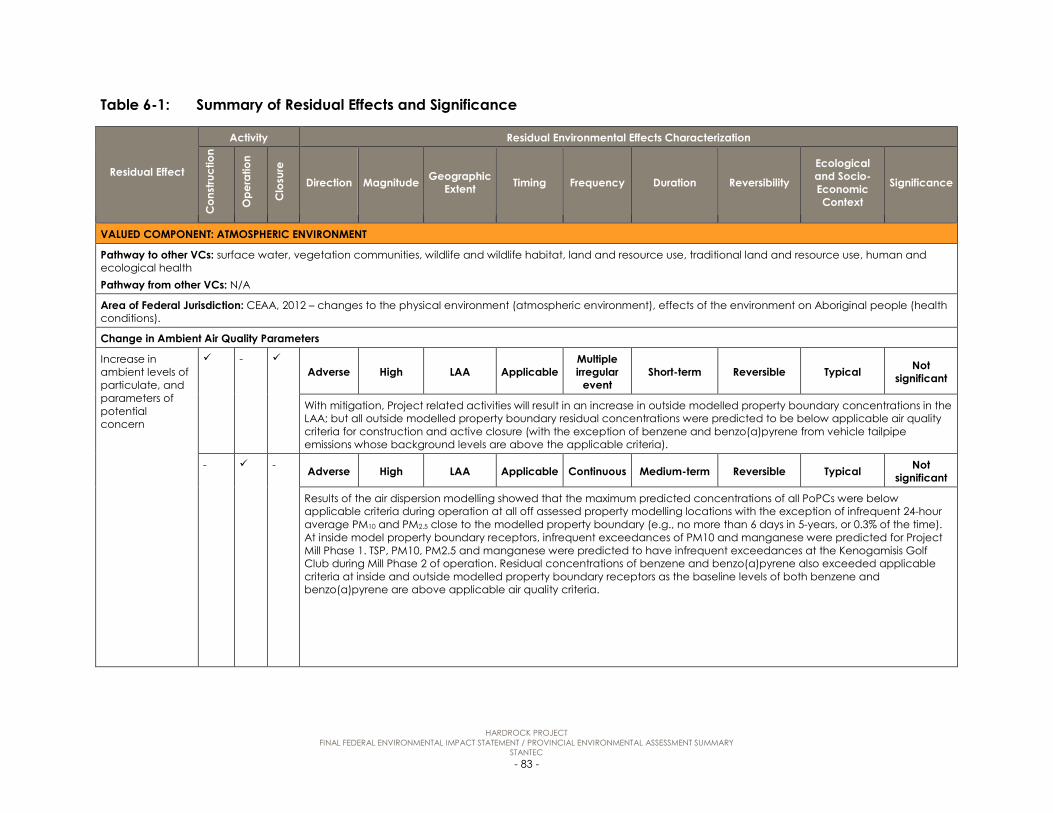
HARDROCK PROJECT FINAL FEDERAL ENVIRONMENTAL IMPACT STATEMENT / PROVINCIAL ENVIRONMENTAL ASSESSMENT SUMMARY
STANTEC - 83 -
Table 6-1: Summary of Residual Effects and Significance
Residual Effect
Activity Residual Environmental Effects Characterization
Con
stru
ctio
n
Ope
ratio
n
Clo
sure
Direction Magnitude Geographic Extent Timing Frequency Duration Reversibility
Ecological and Socio-Economic Context
Significance
VALUED COMPONENT: ATMOSPHERIC ENVIRONMENT
Pathway to other VCs: surface water, vegetation communities, wildlife and wildlife habitat, land and resource use, traditional land and resource use, human and ecological health Pathway from other VCs: N/A
Area of Federal Jurisdiction: CEAA, 2012 – changes to the physical environment (atmospheric environment), effects of the environment on Aboriginal people (health conditions).
Change in Ambient Air Quality Parameters
Increase in ambient levels of particulate, and parameters of potential concern
- Adverse High LAA Applicable
Multiple irregular
event Short-term Reversible Typical Not
significant
With mitigation, Project related activities will result in an increase in outside modelled property boundary concentrations in the LAA; but all outside modelled property boundary residual concentrations were predicted to be below applicable air quality criteria for construction and active closure (with the exception of benzene and benzo(a)pyrene from vehicle tailpipe emissions whose background levels are above the applicable criteria).
- - Adverse High LAA Applicable Continuous Medium-term Reversible Typical Not significant
Results of the air dispersion modelling showed that the maximum predicted concentrations of all PoPCs were below applicable criteria during operation at all off assessed property modelling locations with the exception of infrequent 24-hour average PM10 and PM2.5 close to the modelled property boundary (e.g., no more than 6 days in 5-years, or 0.3% of the time). At inside model property boundary receptors, infrequent exceedances of PM10 and manganese were predicted for Project Mill Phase 1. TSP, PM10, PM2.5 and manganese were predicted to have infrequent exceedances at the Kenogamisis Golf Club during Mill Phase 2 of operation. Residual concentrations of benzene and benzo(a)pyrene also exceeded applicable criteria at inside and outside modelled property boundary receptors as the baseline levels of both benzene and benzo(a)pyrene are above applicable air quality criteria.
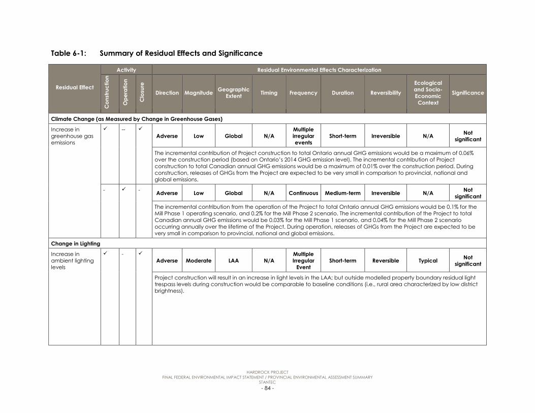
HARDROCK PROJECT FINAL FEDERAL ENVIRONMENTAL IMPACT STATEMENT / PROVINCIAL ENVIRONMENTAL ASSESSMENT SUMMARY
STANTEC - 84 -
Table 6-1: Summary of Residual Effects and Significance
Residual Effect
Activity Residual Environmental Effects Characterization
Con
stru
ctio
n
Ope
ratio
n
Clo
sure
Direction Magnitude Geographic Extent Timing Frequency Duration Reversibility
Ecological and Socio-Economic Context
Significance
Climate Change (as Measured by Change in Greenhouse Gases)
Increase in greenhouse gas emissions
-- Adverse Low Global N/A
Multiple irregular events
Short-term Irreversible N/A Not significant
The incremental contribution of Project construction to total Ontario annual GHG emissions would be a maximum of 0.06% over the construction period (based on Ontario’s 2014 GHG emission level). The incremental contribution of Project construction to total Canadian annual GHG emissions would be a maximum of 0.01% over the construction period. During construction, releases of GHGs from the Project are expected to be very small in comparison to provincial, national and global emissions.
- - Adverse Low Global N/A Continuous Medium-term Irreversible N/A Not significant
The incremental contribution from the operation of the Project to total Ontario annual GHG emissions would be 0.1% for the Mill Phase 1 operating scenario, and 0.2% for the Mill Phase 2 scenario. The incremental contribution of the Project to total Canadian annual GHG emissions would be 0.03% for the Mill Phase 1 scenario, and 0.04% for the Mill Phase 2 scenario occurring annually over the lifetime of the Project. During operation, releases of GHGs from the Project are expected to be very small in comparison to provincial, national and global emissions.
Change in Lighting
Increase in ambient lighting levels
- Adverse Moderate LAA N/A
Multiple Irregular
Event Short-term Reversible Typical Not
significant
Project construction will result in an increase in light levels in the LAA; but outside modelled property boundary residual light trespass levels during construction would be comparable to baseline conditions (i.e., rural area characterized by low district brightness).

HARDROCK PROJECT FINAL FEDERAL ENVIRONMENTAL IMPACT STATEMENT / PROVINCIAL ENVIRONMENTAL ASSESSMENT SUMMARY
STANTEC - 85 -
Table 6-1: Summary of Residual Effects and Significance
Residual Effect
Activity Residual Environmental Effects Characterization
Con
stru
ctio
n
Ope
ratio
n
Clo
sure
Direction Magnitude Geographic Extent Timing Frequency Duration Reversibility
Ecological and Socio-Economic Context
Significance
- - Adverse Moderate LAA N/A
Multiple Irregular
Event Short-term Reversible Typical Not significant
With mitigation, the Project will result in an increase in light levels in the LAA; but outside modelled property boundary residual light trespass levels were predicted to be comparable in extent to baseline conditions (i.e., rural area characterized by low district brightness) and to be below the applicable CIE guidelines for the duration of operation.
VALUED COMPONENT: ACOUSTIC ENVIRONMENT
Pathway to other VCs: fish and fish habitat, wildlife and wildlife habitat, land and resource use, traditional land and resource use Pathway from other VCs: N/A
Area of Federal Jurisdiction: CEAA, 2012 – changes to the physical environment (atmospheric environment), effects of the environment on Aboriginal people (health conditions).
Change in Noise Levels
Increase in sound levels
Adverse Low LAA Applicable Continuous Medium-term Reversible Typical Not
significant
Predicted Project noise emission levels at PoRs and PoIs comply with applicable guideline criteria and thresholds selected for assessment.
Change in Vibration Levels
Increase in vibration levels
- Adverse Low LAA Applicable
Multiple Regular Event
Medium-term Reversible Typical Not significant
Predicted Project vibration levels at PoRs and PoIs comply with applicable guideline criteria and thresholds selected for assessment.

HARDROCK PROJECT FINAL FEDERAL ENVIRONMENTAL IMPACT STATEMENT / PROVINCIAL ENVIRONMENTAL ASSESSMENT SUMMARY
STANTEC - 86 -
Table 6-1: Summary of Residual Effects and Significance
Residual Effect
Activity Residual Environmental Effects Characterization
Con
stru
ctio
n
Ope
ratio
n
Clo
sure
Direction Magnitude Geographic Extent Timing Frequency Duration Reversibility
Ecological and Socio-Economic Context
Significance
VALUED COMPONENT: GROUNDWATER
Pathway to other VCs: surface water, vegetation communities, community services and infrastructure, human and ecological health Pathway from other VCs: surface water
Area of Federal Jurisdiction: CEAA, 2012 – changes to the physical environment (groundwater), effects of changes to the environment on Aboriginal people (health conditions).
Change in Groundwater Levels and/or Flow
Decrease in groundwater levels and change in flow direction due to a change in recharge and temporary dewatering for foundations and installation of infrastructure
- - Adverse Low PDA N/A Continuous Short-term Reversible Typical Not significant
Changes in recharge and temporary dewatering during construction will result in a reduction of groundwater levels of less than 5 m based on typical foundation depths below ground surface and will be less than 1 m beyond the PDA.
Decrease in groundwater levels and change in flow direction in overburden and bedrock due to dewatering of historical underground workings and open pit, aggregate sources S1 and T2
Adverse Moderate LAA/RAA N/A Continuous Long-term Irreversible Typical Not
significant
Changes in recharge, dewatering of the historical underground workings and open pit, and completion of the Goldfield Creek diversion will result in a reduction of groundwater levels of greater than 5 m within the PDA, reducing to less than 5 m within the LAA/RAA during operation. At closure, the reduction in groundwater levels is less than 1 m.
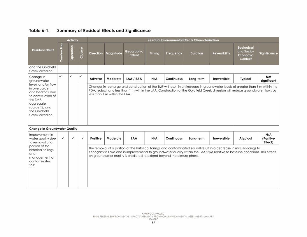
HARDROCK PROJECT FINAL FEDERAL ENVIRONMENTAL IMPACT STATEMENT / PROVINCIAL ENVIRONMENTAL ASSESSMENT SUMMARY
STANTEC - 87 -
Table 6-1: Summary of Residual Effects and Significance
Residual Effect
Activity Residual Environmental Effects Characterization
Con
stru
ctio
n
Ope
ratio
n
Clo
sure
Direction Magnitude Geographic Extent Timing Frequency Duration Reversibility
Ecological and Socio-Economic Context
Significance
and the Goldfield Creek diversion
Change in groundwater levels and/or flow in overburden and bedrock due to construction of the TMF, aggregate source T2, and the Goldfield Creek diversion
Adverse Moderate LAA / RAA N/A Continuous Long-term Irreversible Typical Not
significant
Changes in recharge and construction of the TMF will result in an increase in groundwater levels of greater than 5 m within the PDA, reducing to less than 1 m within the LAA. Construction of the Goldfield Creek diversion will reduce groundwater flows by less than 1 m within the LAA.
Change in Groundwater Quality
Improvement in water quality due to removal of a portion of the historical tailings and management of contaminated soil:
Positive Moderate LAA N/A Continuous Long-term Irreversible Atypical N/A
(Positive Effect)
The removal of a portion of the historical tailings and contaminated soil will result in a decrease in mass loadings to Kenogamisis Lake and in improvements to groundwater quality within the LAA/RAA relative to baseline conditions. This effect on groundwater quality is predicted to extend beyond the closure phase.

HARDROCK PROJECT FINAL FEDERAL ENVIRONMENTAL IMPACT STATEMENT / PROVINCIAL ENVIRONMENTAL ASSESSMENT SUMMARY
STANTEC - 88 -
Table 6-1: Summary of Residual Effects and Significance
Residual Effect
Activity Residual Environmental Effects Characterization
Con
stru
ctio
n
Ope
ratio
n
Clo
sure
Direction Magnitude Geographic Extent Timing Frequency Duration Reversibility
Ecological and Socio-Economic Context
Significance
Improvement in groundwater quality due to groundwater discharge from TMF, WRSAs, and/or historical tailings
- Positive Moderate LAA N/A Continuous Long-term Irreversible Atypical N/A
(Positive Effect)
The Project will result in improved groundwater quality in some areas of the PDA near the historical tailings, but a slight decrease in groundwater quality in areas near the WRSAs and TMF. For parameters predicted to increase in concentrations relative to baseline conditions they are expected to remain below the regulatory limits at the point of discharge. No existing or foreseeable groundwater users are located in the areas with groundwater quality that exceeds the ODWQS. The change in water quality will begin during operation and continue throughout and beyond closure.
VALUED COMPONENT: SURFACE WATER
Pathway to other VCs: groundwater, fish and fish habitat, vegetation communities, wildlife and wildlife habitat, land and resource use, traditional land and resource use, human and ecological health Pathway from other VCs: groundwater, atmospheric environment
Area of Federal Jurisdiction: CEAA, 2012 – changes to the physical environment (surface water), effects of changes to the environment on Aboriginal people (health conditions). Federal decision – Metal Mining Effluent Regulations.
Change in Surface Water Quantity
Change in surface water quantity
Positive / Adverse Low LAA N/A Continuous Long-term Reversible/
irreversible Typical Not significant
It is predicted that the Project is likely to cause reduction in surface water quantity at the LAA boundary during construction, operation and closure due to sequestration of water to tailings pore spaces and open pit filling period, but increase after the pit lake begins to discharge to slightly above baseline conditions. Changes in surface water quantity at the LAA boundary for Kenogamisis Lake system is considered long-term, as there will be continuous discharge from the open pit lake to the Southwest Arm of Kenogamisis Lake extended beyond active closure, and effects on Goldfield Creek, Southwest Arm Tributary and first order watercourses overprinted by the Project components are expected to extend beyond active closure. Predicted changes in water quantity for Kenogamisis Lake system at the LAA boundary are considered as within the range of natural variability.

HARDROCK PROJECT FINAL FEDERAL ENVIRONMENTAL IMPACT STATEMENT / PROVINCIAL ENVIRONMENTAL ASSESSMENT SUMMARY
STANTEC - 89 -
Table 6-1: Summary of Residual Effects and Significance
Residual Effect
Activity Residual Environmental Effects Characterization
Con
stru
ctio
n
Ope
ratio
n
Clo
sure
Direction Magnitude Geographic Extent Timing Frequency Duration Reversibility
Ecological and Socio-Economic Context
Significance
Change in Surface Water Quality
Change in surface water quality due to treated effluent discharge, contact water, groundwater discharge, seepage and removal of a portion of historical tailings
- Positive Low LAA N/A Continuous Long-term Irreversible Atypical N/A
(positive effect)
All PoPCs above the PWQO/Interim PWQO in baseline are predicted to improve in water quality and all PoPCs meeting the PWQO/ Interim PWQO in baseline remain below the PWQO/Interim PWQO. At the Kenogamisis Lake outlet water quality effects are even further reduced and mitigated with Policy 1 PoPCs maintaining Policy 1 status and Policy 2 PoPCs (only arsenic) undergoing water quality improvement relative to baseline conditions, meeting the intent of the Policy 2 objective. For predicted water quality changes within the Kenogamisis Lake system at the LAA boundary, parameters with concentrations change within the range of natural variability.
Change in surface water quality due to effluent discharge from the open pit
Positive/ Adverse Moderate LAA N/A Continuous Long-term Irreversible Atypical
N/A (positive effect)
The direction of changes in surface water quality at the LAA boundary within the Kenogamisis Lake system are expected to be positive for parameters with concentrations predicted to reduce during closure; and adverse for parameters with concentrations predicted to increase during closure. For predicted water quality changes within the Kenogamisis Lake system at the LAA boundary, parameters with concentration changes within the range of natural variability are considered low; parameters with concentration changes exceeding the natural variability of baseline condition but is within the PWQO and CWQG-FAL limits. Duration of changes in water quality within the LAA related to pit lake discharge is considered long-term, extending throughout and beyond post-closure.
VALUED COMPONENT: FISH AND FISH HABITAT
Pathway to other VCs: land and resource use, traditional land and resource use, human and ecological health Pathway from other VCs: acoustic environment, surface water
Area of Federal Jurisdiction: CEAA, 2012 – effects on VCs (fish and fish habitat), effects of changes to the environment on Aboriginal people (health conditions). Federal decisions – Authorization for Works Affecting Fish Habitat, Metal Mining Effluent Regulations.

HARDROCK PROJECT FINAL FEDERAL ENVIRONMENTAL IMPACT STATEMENT / PROVINCIAL ENVIRONMENTAL ASSESSMENT SUMMARY
STANTEC - 90 -
Table 6-1: Summary of Residual Effects and Significance
Residual Effect
Activity Residual Environmental Effects Characterization
Con
stru
ctio
n
Ope
ratio
n
Clo
sure
Direction Magnitude Geographic Extent Timing Frequency Duration Reversibility
Ecological and Socio-Economic Context
Significance
Lethal and Sub-lethal Effects on Fish
Sub-lethal effects on fish due to PoPC inputs from treated effluent and non-point sources
Adverse Low LAA N/A Continuous Medium-Term Reversible Typical Not significant
Concentrations of PoPCs in the mixing zone will not be acutely lethal to fish. The magnitude of sub-lethal effects is considered low because, due to the geographic range of fish, long-term exposure is not anticipated, especially given the overall predictions of improved water quality on a lake-wide basis. Furthermore, baseline data from Barton Bay, where concentrations of arsenic are currently higher than those predicted for all other basins as a result of the Project, do not indicate adverse effects on fish or other aquatic species tested. Concentrations will be above applicable guidelines at some locations, but the sustainability and productivity of CRA fisheries will not be affected.
Permanent Alteration of Fish Habitat
Permanent alteration of fish habitat due to nutrient inputs from treated effluent and non-point sources
- Adverse Low LAA Applicable Continuous Medium-term Reversible Typical Not significant
The alteration to fish habitat is predicted to be less than applicable guidelines, legislated requirements and/or federal and provincial management objectives. Predicted concentrations are lower than the Interim PWQO and the predicted 3% increase in total phosphorus for the Southwest Arm is smaller than that required to cause a change in trophic status, as defined in the Lakeshore Capacity Assessment Handbook. Effects on sustainability and productivity of CRA fish populations within the LAA are not anticipated.
Loss of Fish Habitat
With implementation of the Draft Fisheries Offset Plan, no residual effects on fish habitat will occur as a result of loss of fish habitat. The majority of habitat loss will occur during the construction phase and the offsetting strategy will also be implemented during this time period. No further habitat losses are identified for the operation and closure phases beyond those that will occur during construction.
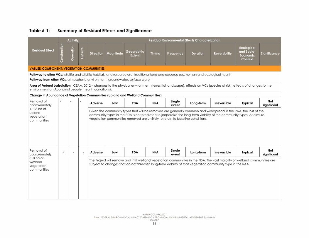
HARDROCK PROJECT FINAL FEDERAL ENVIRONMENTAL IMPACT STATEMENT / PROVINCIAL ENVIRONMENTAL ASSESSMENT SUMMARY
STANTEC - 91 -
Table 6-1: Summary of Residual Effects and Significance
Residual Effect
Activity Residual Environmental Effects Characterization
Con
stru
ctio
n
Ope
ratio
n
Clo
sure
Direction Magnitude Geographic Extent Timing Frequency Duration Reversibility
Ecological and Socio-Economic Context
Significance
VALUED COMPONENT: VEGETATION COMMUNITIES
Pathway to other VCs: wildlife and wildlife habitat, land resource use, traditional land and resource use, human and ecological health Pathway from other VCs: atmospheric environment, groundwater, surface water
Area of Federal Jurisdiction: CEAA, 2012 – changes to the physical environment (terrestrial landscape), effects on VCs (species at risk), effects of changes to the environment on Aboriginal people (health conditions).
Change in Abundance of Vegetation Communities (Upland and Wetland Communities)
Removal of approximately 1,133 ha of upland vegetation communities
- - Adverse Low PDA N/A Single event Long-term Irreversible Typical Not
significant
Given the community types that will be removed are generally common and widespread in the RAA, the loss of the community types in the PDA is not predicted to jeopardize the long-term viability of the community types. At closure, vegetation communities removed are unlikely to return to baseline conditions.
Removal of approximately 810 ha of wetland vegetation communities
- - Adverse Low PDA N/A Single event Long-term Irreversible Typical Not
significant
The Project will remove and infill wetland vegetation communities in the PDA. The vast majority of wetland communities are subject to changes that do not threaten long-term viability of that vegetation community type in the RAA.

HARDROCK PROJECT FINAL FEDERAL ENVIRONMENTAL IMPACT STATEMENT / PROVINCIAL ENVIRONMENTAL ASSESSMENT SUMMARY
STANTEC - 92 -
Table 6-1: Summary of Residual Effects and Significance
Residual Effect
Activity Residual Environmental Effects Characterization
Con
stru
ctio
n
Ope
ratio
n
Clo
sure
Direction Magnitude Geographic Extent Timing Frequency Duration Reversibility
Ecological and Socio-Economic Context
Significance
Change in Function, Connectivity, and Quality of Vegetation Communities
Wetland communities altered/ converted to other wetland or upland community types due to changes in surface water flow
Adverse Low LAA Applicable Single
event Long-term Irreversible Typical Not significant
Changes in surface water flow/drainage will increase the variability of the flow regime for retained wetlands and the area of wetlands in the PDA will decrease. Change in surface water flow is not expected to threaten the long-term viability of a vegetation community type in the RAA.
Vegetation affected by dust deposition
Adverse Low LAA N/A Continuous Medium-term Reversible Typical Not
significant
Dust deposition is predicted to occur within 30 m of the PDA boundary. The change in abundance of vegetation communities is not expected to result in the loss of long-term viability of that vegetation
Vegetation affected by invasive species
Adverse Low LAA N/A Continuous Medium-term Irreversible Typical Not
significant
The Project may alter the quality of vegetation communities within 30 m of the PDA through the introduction of invasive species. The change in abundance of vegetation communities is not expected to result in the loss of long-term viability of that vegetation community type in the RAA.
Vegetation affected by fragmentation
- - Adverse Low LAA N/A Single Event Long-term Irreversible Typical Not
significant
The Project may alter the quality of vegetation communities along the edge of the PDA. The area of the communities affected by edge effects and fragmentation is relatively small in the large landscape context and is not predicted to result in the loss of long-term viability of a vegetation community type in the RAA.

HARDROCK PROJECT FINAL FEDERAL ENVIRONMENTAL IMPACT STATEMENT / PROVINCIAL ENVIRONMENTAL ASSESSMENT SUMMARY
STANTEC - 93 -
Table 6-1: Summary of Residual Effects and Significance
Residual Effect
Activity Residual Environmental Effects Characterization
Con
stru
ctio
n
Ope
ratio
n
Clo
sure
Direction Magnitude Geographic Extent Timing Frequency Duration Reversibility
Ecological and Socio-Economic Context
Significance
Wetlands that may experience a loss of wetland function as a result of groundwater drawdown
- Adverse Moderate LAA N/A Continuous Long-term Reversible Typical Not
significant
During operation, open pit dewatering is predicted to alter groundwater levels and wetland communities dependent on those groundwater levels. The reduction in groundwater levels will be small relative to other hydrologic components that support the wetland such as stream flow and lake levels. The area of wetland communities potentially affected is relatively small and is not predicted to result in the loss of long-term viability of the wetland vegetation community types in the RAA.
Change in Abundance of Plant Species of Interest
Removal of plant species of interest to Aboriginal communities
- - Adverse Low PDA N/A Single event Long-term Irreversible Typical Not
significant
The Project will remove vegetation communities that support plant species of interest to Aboriginal communities. The removal of portions of the vegetation communities that support plant species of interest is not expected to threaten the long-term viability of a species of interest in the RAA.
VALUED COMPONENT: WILDLIFE AND WILDLIFE HABITAT
Pathway to other VCs: land resource use, traditional land and resource use, human and ecological health Pathway from other VCs: atmospheric environment, acoustic environment, surface water, vegetation communities
Area of Federal Jurisdiction: CEAA, 2012 – changes to the physical environment (terrestrial landscape), effects on VCs (migratory birds and species at risk), effects of changes to the environment on Aboriginal people (health conditions).

HARDROCK PROJECT FINAL FEDERAL ENVIRONMENTAL IMPACT STATEMENT / PROVINCIAL ENVIRONMENTAL ASSESSMENT SUMMARY
STANTEC - 94 -
Table 6-1: Summary of Residual Effects and Significance
Residual Effect
Activity Residual Environmental Effects Characterization
Con
stru
ctio
n
Ope
ratio
n
Clo
sure
Direction Magnitude Geographic Extent Timing Frequency Duration Reversibility
Ecological and Socio-Economic Context
Significance
Change in Habitat
The direct loss of SAR habitats, SOCC habitats, SWHs and habitats of importance to stakeholders as a result of site clearing during construction. Change in wildlife habitat as a result of indirect loss or alteration due to sensory disturbance (habitat avoidance or under-utilization of habitat due to human activity)
Adverse Moderate LAA Applicable Continuous Long-term Irreversible Typical Not
significant
It is predicted that vegetation clearing and sensory disturbance will result in habitat loss or alteration or a reduction in habitat patch size for the wildlife habitats assessed. For barn swallow breeding habitat and American white pelican stopover and foraging habitat there will be no net loss of habitat and common nighthawk breeding habitat is expected to increase upon closure. The loss of habitat is unlikely to affect the long-term persistence or viability of wildlife in the RAA. It is expected that effects on all wildlife habitats will be partially reversed following the cessation of operation when wildlife habitat considered lost as a result of avoidance due to sensory disturbance will be regained. Some wildlife habitat will also be restored through the implementation of the Closure Plan (a Conceptual Closure Plan is provided in Appendix I), however other wildlife habitats, particularly those that are associated with wetlands and forest habitats will have some irreversible loss of habitat.
Change in Mortality Risk
Increase in mortality risk to wildlife
Adverse Low LAA Applicable Continuous Medium- term Reversible Typical Not significant
Throughout construction, operation and active closure, an increased risk of mortality to wildlife within the LAA as a result of Project activities is anticipated. With the implementation of the mitigation measures, the residual adverse effect on wildlife mortality is predicted to be within the normal variability of baseline conditions and is not expected to affect the long-term persistence or viability of wildlife within the RAA. Mitigation measures are expected to limit the effects on migratory bird mortality.

HARDROCK PROJECT FINAL FEDERAL ENVIRONMENTAL IMPACT STATEMENT / PROVINCIAL ENVIRONMENTAL ASSESSMENT SUMMARY
STANTEC - 95 -
Table 6-1: Summary of Residual Effects and Significance
Residual Effect
Activity Residual Environmental Effects Characterization
Con
stru
ctio
n
Ope
ratio
n
Clo
sure
Direction Magnitude Geographic Extent Timing Frequency Duration Reversibility
Ecological and Socio-Economic Context
Significance
Change in Movement
Disruption of existing wildlife movement patterns within and across the LAA
Adverse Low RAA Applicable Continuous Long-term Reversible Typical Not
significant
There will be an adverse effect on wildlife (e.g. amphibians, turtles, furbearers and large mammal) movement throughout construction, operation and active closure as the Project is expected to disrupt wildlife movement patterns. However, wildlife (particularly large mammals) are expected to shift their movement patterns during the life of the mine to areas of available habitat elsewhere within the RAA. Following active closure, new movement patterns may be established as sensory disturbance abates and revegetation of the PDA progresses, although for some species (e.g., species requiring more developed security cover [trees]) this may take decades. The predicted change in movement is not expected to affect the long-term persistence or viability of wildlife in the RAA.
VALUED COMPONENT: LABOUR AND ECONOMY
There are no pathways associated with labour and economy from or to other VCs.
Area of Federal Jurisdiction: CEAA, 2012 – effects of changes to the environment on Aboriginal people (socio-economic conditions).
Change in Labour
Direct employment during construction
- - Positive Low LAA / RAA N/A Continuous Short-term Reversible Moderate Diversity
N/A
Direct employment during the construction phase is expected to create on average, 650 PYs of employment each year over approximately two years providing a net positive effect. Given the small construction labour force in the LAA (125 workers in 2011) and the high rate of unemployment (16.5% in 2011) and the very large construction labour force in the RAA (3,535 workers), this effect is expected to be low in magnitude.
Direct employment during operation
- - Positive Moderate LAA / RAA N/A Continuous Medium-term Reversible Moderate Diversity
N/A
During the operation phase, the Project will directly employ, on average, 450 workers providing a net positive effect. The positive effect is anticipated to be high in magnitude in the LAA, where the Project would increase the size of the labour force by 10% (compared to 2011 levels) and reduce the unemployment rate by over six percentage points (compared to 2011).

HARDROCK PROJECT FINAL FEDERAL ENVIRONMENTAL IMPACT STATEMENT / PROVINCIAL ENVIRONMENTAL ASSESSMENT SUMMARY
STANTEC - 96 -
Table 6-1: Summary of Residual Effects and Significance
Residual Effect
Activity Residual Environmental Effects Characterization
Con
stru
ctio
n
Ope
ratio
n
Clo
sure
Direction Magnitude Geographic Extent Timing Frequency Duration Reversibility
Ecological and Socio-Economic Context
Significance
Loss of direct employment from end of operation
- - Adverse Moderate LAA / RAA N/A
Multiple Irregular events
Long-term Irreversible Moderate Diversity
Not significant
The closure of the Project after its final year of operation will result in the loss of 450 direct full time positions (average mining operational labour).
Direct employment from closure activities
- - Positive Low LAA / RAA N/A Continuous Short-term Reversible Unknown N/A
Activities relating to the closure of the Project will result in approximately 40 PYs of employment per year over the planned 5-year active closure phase. Given the small labour force required for active closure activities in relation to the workforce in the LAA, the magnitude is expected to be low.
Change in Economy
Local and regional businesses: Project expenditures
- - Positive Low LAA / RAA N/A Continuous Short-term Reversible Moderate
Diversity
N/A (positive effect)
During construction, Project expenditure on goods and services in the RAA is estimated to be approximately $355 million, of which $110 million will be spent on goods and services in the LAA. Project spending is expected to have a positive effect on local and regional businesses by creating 810 PYs of employment for businesses in the LAA and another 1,330PYs for businesses elsewhere in the RAA.
- - Positive Moderate LAA / RAA N/A Continuous Medium-term Reversible Moderate
Diversity
N/A (positive effect)
During operation, Project expenditure on goods and services in the RAA will be approximately $135 million per year, of which $25 million will be spent in the LAA. An additional $40 million in sustaining capital will be spent in the RAA ($20 million in the LAA) during operation. In total, Project spending during operation (including sustaining capital) is expected to create 8,265 indirect and induced PYs of employment in the RAA, of which 7,033 will be in the LAA.

HARDROCK PROJECT FINAL FEDERAL ENVIRONMENTAL IMPACT STATEMENT / PROVINCIAL ENVIRONMENTAL ASSESSMENT SUMMARY
STANTEC - 97 -
Table 6-1: Summary of Residual Effects and Significance
Residual Effect
Activity Residual Environmental Effects Characterization
Con
stru
ctio
n
Ope
ratio
n
Clo
sure
Direction Magnitude Geographic Extent Timing Frequency Duration Reversibility
Ecological and Socio-Economic Context
Significance
- Positive Low LAA / RAA N/A Continuous Short-term Reversible Unknown
N/A (positive effect)
- During active closure, Project purchases and expenditures on goods and services within the RAA ($35 million) are expected to generate 75 PYs of employment.
Local and regional businesses: loss of Project expenditures
- - Adverse Low LAA / RAA N/A Continuous Long-term Irreversible Unknown Not
significant
Loss of Project expenditures at local and regional businesses will result in an adverse residual environmental effect. When measured against the current labour force in non-basic industries, this effect will be low in magnitude the LAA.
Loss of revenue and employment for the tourism industry
- - Adverse Low LAA Applicable Continuous Short-term Reversible Moderate Diversity
Not significant
It is expected that site preparation activities during construction, particularly the removal of the MacLeod-Cockshutt Mining Headframe and Discover Geraldton Interpretive Centre, and effects on the Kenogamisis Golf Club, will result in a residual adverse effect on the tourism industry in terms of small losses of revenues and employment
Reduction in economic activities associated with forestry
- - Adverse Low LAA N/A Continuous Long-term Irreversible Moderate
Diversity Not
significant
Project construction will cause a reduction in the forested land base and loss of area associated with forest management activities in the Forest Management Unit (FMU), which has the potential to affect forest harvesting activities and employment.
Increase in Municipal government revenues
- - Positive Moderate LAA N/A Continuous Long-term Reversible Moderate
Diversity
N/A (positive effect)
GGM will pay taxes to the Municipality of Greenstone while the Project is operating, although the exact amount of annual tax has not yet been negotiated. As a result, the Project is expected to have a positive effect on municipal government revenues during operation.

HARDROCK PROJECT FINAL FEDERAL ENVIRONMENTAL IMPACT STATEMENT / PROVINCIAL ENVIRONMENTAL ASSESSMENT SUMMARY
STANTEC - 98 -
Table 6-1: Summary of Residual Effects and Significance
Residual Effect
Activity Residual Environmental Effects Characterization
Con
stru
ctio
n
Ope
ratio
n
Clo
sure
Direction Magnitude Geographic Extent Timing Frequency Duration Reversibility
Ecological and Socio-Economic Context
Significance
Decrease in Municipal government revenues
- - Adverse Moderate LAA N/A Continuous Long-term Irreversible Unknown Not
significant
The loss of tax revenues from the Project for the Municipality of Greenstone during closure will cause an adverse residual environmental effect.
VALUED COMPONENT: COMMUNITY SERVICES AND INFRASTRUCTURE
Pathway to other VCs: N/A Pathway from other VCs: groundwater
Area of Federal Jurisdiction: CEAA, 2012 – effects of changes to the environment on Aboriginal people (socio-economic conditions).
Change in Capacity of Housing and Accommodation
Additional demands on housing and accommodations
- - Adverse Low LAA/RAA N/A Continuous Short-term Reversible Moderate Capacity
Not significant
Taking into consideration proposed mitigation and management measures, it is predicted that the Project is likely to cause a decrease in capacity of housing and accommodations. The change in capacity of housing and accommodations will be at or near to baseline conditions. During construction, the average labour force will consist of 650 workers (with a peak at 975 workers). Workers will be housed at the temporary camp and will therefore not require housing accommodations elsewhere. The Municipality has an adequate number of temporary accommodations to absorb additional demand from workers that may live outside of the temporary camp.
- Adverse Low LAA/RAA N/A Continuous Medium-term Reversible Moderate Capacity
Not significant
Taking into consideration proposed mitigation and management measures, it is predicted that the Project is likely to cause a decrease in capacity of housing and accommodations. The change in capacity of housing and accommodations will be at or near to baseline conditions. During operation, the predicted in-migrant workforce (350 workers) and their families are estimated to total 1,050 people that may move to the LAA/RAA. However, with the surplus in vacant housing due to trending population declines, the Municipality is expected to be able to absorb the increase in workers without putting pressure on housing and accommodations.

HARDROCK PROJECT FINAL FEDERAL ENVIRONMENTAL IMPACT STATEMENT / PROVINCIAL ENVIRONMENTAL ASSESSMENT SUMMARY
STANTEC - 99 -
Table 6-1: Summary of Residual Effects and Significance
Residual Effect
Activity Residual Environmental Effects Characterization
Con
stru
ctio
n
Ope
ratio
n
Clo
sure
Direction Magnitude Geographic Extent Timing Frequency Duration Reversibility
Ecological and Socio-Economic Context
Significance
Change in Capacity of Municipal and Provincial Services and Infrastructure (police, fire, medical, recreation, education, water/sewer, power and waste)
Additional demands on health services and infrastructure
Adverse Low LAA/RAA N/A Continuous Long-term Reversible Low Capacity Not
significant
Taking into consideration proposed mitigation and management measures, it is predicted that the Project is likely to cause additional demands on health services and infrastructure. The change in capacity of health services and infrastructures will be at or near to baseline conditions after proposed mitigation and management.
Additional demands on police services
Adverse Low LAA/RAA N/A Continuous Long-term Reversible Moderate
Capacity Not
significant
Taking into consideration proposed mitigation and management measures, it is predicted that the Project is likely to cause additional demands on police services. The change in capacity of police services will be at or near to baseline conditions after proposed mitigation and management.
Additional demands on fire services
Adverse Low LAA/ RAA N/A Continuous Long-term Reversible Moderate
Capacity Not
significant
Taking into consideration proposed mitigation and management measures, it is predicted that the Project is likely to cause additional demands on fire services. The change in capacity of fire services will be at or near to baseline conditions after proposed mitigation and management.
Additional demands on power and municipal servicing
Adverse Low LAA/ RAA N/A Continuous Long-term Reversible Low Capacity Not
significant
Taking into consideration proposed mitigation and management measures, it is predicted that the Project is likely to cause additional demands on power and municipal servicing including water and waste services and infrastructure. change in capacity of power and municipal servicing will be at or near to baseline conditions after proposed mitigation and management. The Municipality confirmed there is sufficient capacity to connect the temporary camp to the municipal sanitary sewer system. The Municipality also confirmed adequate capacity within the Geraldton municipal water system to provide potable water for the mine site and temporary camp. Other Project design plans, including the potential use of generators as a power source during construction, a sewage treatment plant at the mine site, and the use of a natural gas-fuelled power plant during operation will reduce effects on provincial and municipal services and infrastructure.

HARDROCK PROJECT FINAL FEDERAL ENVIRONMENTAL IMPACT STATEMENT / PROVINCIAL ENVIRONMENTAL ASSESSMENT SUMMARY
STANTEC - 100 -
Table 6-1: Summary of Residual Effects and Significance
Residual Effect
Activity Residual Environmental Effects Characterization
Con
stru
ctio
n
Ope
ratio
n
Clo
sure
Direction Magnitude Geographic Extent Timing Frequency Duration Reversibility
Ecological and Socio-Economic Context
Significance
Removal of recreation a services and infrastructure
- - Adverse Low PDA N/A Single event Long-term Irreversible Low Capacity Not
significant
Taking into consideration proposed mitigation and management measures, the Project will cause the removal of the Kenogamisis Golf Course (holes 10-18), MacLeod-Cockshutt Mining Headframe and the Discover Geraldton Interpretive Centre. The change in capacity of recreation services and infrastructure will be at or near to baseline conditions after proposed mitigation and management. An Agreement has been signed between the Municipality and GGM to support the Municipality’s future plans with respect to these facilities. With respect to the golf course, GGM has committed to avoid using the contingency WRSA A/C to preserve the golf clubhouse and the front nine holes unless needed.
Additional demand on recreation services and infrastructure
Adverse Low LAA/ RAA N/A Continuous Long-term Reversible Moderate
Capacity Not
significant
Taking into consideration proposed mitigation and management measures, it is predicted that the Project is likely to cause additional demands on recreation services and infrastructure. The change in capacity of recreation services and infrastructure will be at or near to baseline conditions after proposed mitigation and management.
Additional demands on education services and infrastructure
Adverse Low LAA/ RAA N/A Continuous Long-term Reversible Moderate
Capacity Not
significant
Taking into consideration proposed mitigation and management measures, it is predicted that the Project is likely to cause additional demands on education services and infrastructure. The change in capacity of provincial and municipal services and infrastructure will be at or near to baseline conditions after proposed mitigation and management. Schools in the LAA/RAA have physical capacity to accommodate new students and GGM will provide Project information to school boards to help them prepare for potential increases in demand.
Change in Capacity of Transportation Services and Infrastructure
Additional demands on transportation infrastructure
Adverse Low LAA/ RAA N/A Continuous Long-term Reversible Moderate
Capacity Not
significant
Taking into consideration proposed mitigation and management measures, it is predicted that the Project is likely to cause additional demands on transportation infrastructure. The change in capacity of transportation services and infrastructure will be at or near to baseline conditions after proposed mitigation and management. Since the Highway 11 realignment will be constructed prior to closure of the existing Highway 11 alignment, access to the area will be uninterrupted and existing infrastructure will be able to accommodate Project-related traffic increases.

HARDROCK PROJECT FINAL FEDERAL ENVIRONMENTAL IMPACT STATEMENT / PROVINCIAL ENVIRONMENTAL ASSESSMENT SUMMARY
STANTEC - 101 -
Table 6-1: Summary of Residual Effects and Significance
Residual Effect
Activity Residual Environmental Effects Characterization
Con
stru
ctio
n
Ope
ratio
n
Clo
sure
Direction Magnitude Geographic Extent Timing Frequency Duration Reversibility
Ecological and Socio-Economic Context
Significance
VALUED COMPONENT: LAND AND RESOURCE USE
Pathways to other VCs: human and ecological health Pathways from other VCs: atmospheric environment, acoustic environment, surface water, fish and fish habitat, vegetation communities, wildlife and wildlife habitat
Area of Federal Jurisdiction: CEAA, 2012 – effects of changes to the environment on Aboriginal people (socio-economic conditions), changes to the physical environment (terrestrial landscape), effects on VCs (navigation). Federal decision – Approval of Works in Navigable Waters.
Change in Recreational Land and Resource Use
Decrease in the availability of hunting areas and wildlife
Adverse Moderate LAA N/A Continuous Medium-term Reversible Typical
Not significant
The removal of wildlife habitat and the imposition of access restrictions to the PDA at the start of construction will result in the loss of areas for hunting. Also, the Project may cause sensory disturbance, and disruption of wildlife movement corridors thereby reducing the availability of wildlife resources. The decrease in the availability of hunting areas or wildlife resources is predicted to reduce the ability to undertake hunting in the PDA (access restrictions) and within the LAA due to sensory disturbance (predicted not to extend beyond 200 m of the PDA).
Decrease in the availability of fishing areas or fishing resource
Adverse Moderate LAA N/A Continuous Medium-term Reversible Typical Not
significant
The removal of the public access points and closure of Lahtis Road may result in the loss of access to ice fishing areas in the Southwest Arm. Although there is potential for fishing to occur in the PDA, there are no documented fishing areas and fishing is not known to occur within the PDA. The loss of access to launches for ice fishing huts is predicted to reduce the ability to undertake fishing activities.
Loss of recreation areas or change in access
Adverse Moderate LAA N/A Continuous Long-term Reversible Typical
Not significant
The Project will result in the loss of access to the Southwest Arm of Kenogamisis Lake through the closure of Lahtis Road and the removal of roads within the Hardrock and MacLeod Townsites during construction and operation. Crown land recreational areas, including the campsite and two access points to Kenogamisis Lake will also be removed from the PDA. The closure of Lahtis Road located within the PDA may result in the reduced access to recreational areas in the LAA.

HARDROCK PROJECT FINAL FEDERAL ENVIRONMENTAL IMPACT STATEMENT / PROVINCIAL ENVIRONMENTAL ASSESSMENT SUMMARY
STANTEC - 102 -
Table 6-1: Summary of Residual Effects and Significance
Residual Effect
Activity Residual Environmental Effects Characterization
Con
stru
ctio
n
Ope
ratio
n
Clo
sure
Direction Magnitude Geographic Extent Timing Frequency Duration Reversibility
Ecological and Socio-Economic Context
Significance
Removal of 10.6 km of snowmobile trails and 1.4 km of hiking trails
- - Adverse Low PDA N/A Single Event Medium-term Reversible Typical Not
significant
The removal of trails within the PDA is predicted to reduce the ability to undertake hiking and snowmobiling in the PDA. The loss of trails is restricted to the PDA. Based on discussions with the Greenstone Snowmobile Club, removal the snowmobile trail within the PDA will not remove access to other trails within the LAA that are currently in use.
Sensory disturbance to land and resource users
Adverse Moderate LAA N/A Continuous Long-term Irreversible Typical
Not significant
Recreational users in the LAA may be affected by sensory disturbance resulting from changes to the viewscape. The effect is characterized as moderate in magnitude because the residual effect is predicted to change the land user experience in proximity to the PDA. The visual landscape will be altered permanently.
Change in Commercially-based Land and Resource Use
Decrease in availability of trapping, guide outfitting and bait harvesting tenure areas
Adverse Moderate LAA N/A Continuous Long-term Reversible Typical Not significant
The removal of wildlife habitat and the imposition of access restrictions at the start of construction will result in the loss of areas for trapping, guide outfitting and bait harvesting tenure areas from the PDA. Change in access to harvesting areas due to closure of Lahtis Road may extend into the LAA. The construction, operation and active closure of the Project may cause sensory disturbance and disruption of wildlife movement corridors thereby reducing the availability of wildlife resources. A change in the availability of fish resources is not predicted. Some licence holders may not be able to access harvesting areas previously accessed via Lahtis Road, which may decrease the ability to use of land for trapping and guiding in the LAA.

HARDROCK PROJECT FINAL FEDERAL ENVIRONMENTAL IMPACT STATEMENT / PROVINCIAL ENVIRONMENTAL ASSESSMENT SUMMARY
STANTEC - 103 -
Table 6-1: Summary of Residual Effects and Significance
Residual Effect
Activity Residual Environmental Effects Characterization
Con
stru
ctio
n
Ope
ratio
n
Clo
sure
Direction Magnitude Geographic Extent Timing Frequency Duration Reversibility
Ecological and Socio-Economic Context
Significance
Sensory disturbance to commercial land and resource users
Adverse Moderate LAA Applicable Continuous Long-term Irreversible Typical Not significant
Commercial land and resource users in the LAA may be affected by sensory disturbance resulting from changes to the viewscape. The effect is characterized as moderate in magnitude because the residual effect is predicted to change the land user experience in proximity to the PDA.
Loss of timber harvesting land base
- - Adverse Low PDA N/A Single Event
Long-Term Irreversible Typical Not significant
The PDA overlaps approximately 342 ha of planned harvesting area within the Kenogami FMU for the period from 2011 to 2021. This represents less than 1% of the total planned harvesting area within the FMU. During construction, Crown timber will be removed from future forest management activity and alter the sequence of planned forest management activities in the Kenogami FMU until such time as a mature forest is in place. Removal of timber will reduce the ability of timber harvesting.
Change in Navigation
Change in navigation on watercourses affected by the Project
Adverse Low LAA Applicable Continuous Long-term Irreversible Atypical Not significant
Navigation has not been confirmed within the PDA through consultation input, TK and TLRU studies or observations made during fieldwork, however it is it is conservatively assumed that navigation is currently possible in the PDA on Goldfield Creek, the Southwest Arm Tributary, and SWP3. Although there has been no confirmed use of Goldfield Creek for navigation, the diversion will change the channel alignment but permit navigation by small vessels such as canoes or kayaks, with obstacles (e.g. beaver dams and vegetation obstructions), between Goldfield Lake and the Southwest Arm of Kenogamisis Lake following closure. In addition, the Project will create obstacles to navigation and access to waterways in the PDA will be restricted during construction and operation due to safety concerns.

HARDROCK PROJECT FINAL FEDERAL ENVIRONMENTAL IMPACT STATEMENT / PROVINCIAL ENVIRONMENTAL ASSESSMENT SUMMARY
STANTEC - 104 -
Table 6-1: Summary of Residual Effects and Significance
Residual Effect
Activity Residual Environmental Effects Characterization
Con
stru
ctio
n
Ope
ratio
n
Clo
sure
Direction Magnitude Geographic Extent Timing Frequency Duration Reversibility
Ecological and Socio-Economic Context
Significance
VALUED COMPONENT: HERITAGE RESOURCES
There are no pathways associated with heritage resources from or to other VCs.
Area of Federal Jurisdiction: CEAA, 2012 – effects of changes to the environment on Aboriginal people (physical and cultural heritage).
Loss of Archaeological Resources (either Aboriginal or European) determined to have Cultural Heritage Value or Interest
With the proposed mitigation measures, no residual effects on archaeological resources for all phases of the Project are anticipated.
Loss of, Change in Access to, or Change in Cultural Heritage Value or Interest of Architectural or Historical Resources determined to have Cultural Heritage Value or Interest
With the proposed mitigation measures, no residual effects on Euro-Canadian architectural and/or historical resources for all phases of the Project are anticipated.
VALUED COMPONENT: TRADITIONAL LAND AND RESOURCE USE
Pathways from other VCs: atmospheric environment, acoustic environment, surface water, fish and fish habitat, vegetation communities, wildlife and wildlife habitat, land and resource use, heritage resources Pathways to other VCs: human and ecological health
Area of Federal Jurisdiction: CEAA, 2012 – changes to the physical environment (terrestrial landscape), effects of changes to the environment on Aboriginal people (current us of lands and resources for traditional purposes).
Change to Availability of Plant Species and Access to Plant Harvesting Sites and Activities
Change to availability of plant species and access to plant harvesting areas and activities
Adverse Moderate LAA N/A Continuous Medium/Long-term
Irreversible Typical Not significant
The clearing of vegetation within the PDA during construction will result in the removal of plant species of interest to Aboriginal communities and plant harvesting sites resulting in a decrease in the availability of plant harvesting areas relative to baseline conditions. The removal of vegetation communities is not predicted to threaten the long-term viability of a vegetation community type in the RAA, including the LAA. Patterns of access to harvesting areas in the LAA may be altered by access restrictions to the PDA, including the closure of Lahtis Road. Access changes may affect harvesting sites located southwest of the PDA (however this area may be accessed via Goldfield Road), and along the shoreline of the Southwest Arm of Kenogamisis Lake. The removal of plant species of interest to Aboriginal communities and plant harvesting sites within the PDA, and changes in patterns of access to harvesting sites are predicted to alter plant harvesting activities in the LAA without threatening the long-term viability of vegetation communities.

HARDROCK PROJECT FINAL FEDERAL ENVIRONMENTAL IMPACT STATEMENT / PROVINCIAL ENVIRONMENTAL ASSESSMENT SUMMARY
STANTEC - 105 -
Table 6-1: Summary of Residual Effects and Significance
Residual Effect
Activity Residual Environmental Effects Characterization
Con
stru
ctio
n
Ope
ratio
n
Clo
sure
Direction Magnitude Geographic Extent Timing Frequency Duration Reversibility
Ecological and Socio-Economic Context
Significance
Change to Availability of Fish Species and Access to Fishing Areas and Activities
Change to availability of fish species and access to fishing areas and activities
Adverse Low LAA N/A Continuous Medium-term Reversible Typical Not significant
Access restrictions and infilling of watercourses containing fish will result in the loss of availability of potential areas for fishing within the PDA resulting in a decrease in the availability of potential fishing areas relative to baseline conditions (although fishing potential within the PDA is limited and habitat that is altered or lost is limited and will be offset by creating new habitat within the Goldfield Creek realignment). Patterns of access to fishing areas in the LAA may be altered by the closure of Lahtis Road and restrictions to watercourses potentially used to access the PDA. These changes are predicted to result in a decrease in access to areas for fishing located southwest of the PDA (although this area may be accessed via Goldfield Road), in the Southwest Arm Tributary, and along the shoreline of the Southwest Arm of Kenogamisis Lake. The removal of areas for fishing potential within the PDA and reduced access to areas for fishing beyond the PDA is not predicted to reduce the ability to fish since overall, there will be no net loss of areas for fishing as a result of the Project, and more than half of the fish habitat that will be altered or lost is comprised of golf course pond and poor quality habitat such as roadside ditches and ephemeral drainage areas.
Change to Availability of Hunted and Trapped Species and Access to Hunting and Trapping Areas and Activities
Change to availability of hunted and trapped species and access to hunting and trapping areas and activities
Adverse Moderate LAA N/A Continuous Medium-term Irreversible Typical Not
significant
During construction, clearing of the PDA is anticipated to result in a loss of wildlife habitat, including hunting and trapping areas identified by Aboriginal communities that will reduce but not eliminate opportunities for hunting and trapping relative to baseline conditions. Patterns of access to hunting and trapping in the LAA may be altered by access restrictions to the PDA, including the closure of Lahtis Road. Access changes may affect hunting and trapping areas located southwest of the PDA (however this area may be accessed via Goldfield Road), and along the shoreline of the Southwest Arm of Kenogamisis Lake. The removal of wildlife habitat, including hunting and trapping areas identified by Aboriginal communities within the PDA and alteration of patterns of access is predicted to reduce but not eliminate opportunities for hunting and trapping relative to baseline conditions. The loss of habitat is not predicted to affect the long-term persistence or viability of wildlife in the RAA, including the LAA.

HARDROCK PROJECT FINAL FEDERAL ENVIRONMENTAL IMPACT STATEMENT / PROVINCIAL ENVIRONMENTAL ASSESSMENT SUMMARY
STANTEC - 106 -
Table 6-1: Summary of Residual Effects and Significance
Residual Effect
Activity Residual Environmental Effects Characterization
Con
stru
ctio
n
Ope
ratio
n
Clo
sure
Direction Magnitude Geographic Extent Timing Frequency Duration Reversibility
Ecological and Socio-Economic Context
Significance
Change to Cultural or Spiritual Practices, Sites or Areas
Change in availability of or access to cultural or spiritual practices, sites or areas:
Adverse Moderate LAA N/A Continuous Medium-term Reversible Atypical Not significant
Development in the PDA and access restrictions during construction, operation and active closure will result in a decrease in areas for cultural practices relative to baseline conditions. Patterns of access to cultural or spiritual sites, or areas in the LAA may be altered by access restrictions to the PDA, including the closure of Lahtis Road. These changes are predicted to result in changes in access to areas located southwest of the PDA (however this area may be accessed via Goldfield Road), and along the shoreline of the Southwest Arm of Kenogamisis Lake. Continued use of the LAA for cultural and spiritual practices, sites and areas will still be possible, but due to changes to access conditions to sites in the LAA located southwest of the PDA (although this area may be accessed via Goldfield Road), and along the shoreline of the Southwest Arm of Kenogamisis Lake, continued use of these areas may entail a greater level of effort. The residual environmental effect will alter but not eliminate the ability to use the LAA for cultural and spiritual practices, sites and areas.
Removal of cultural or spiritual sites or areas
- - Adverse High PDA N/A Single event
Long-term Irreversible Atypical Not significant
Relative to baseline conditions, there would be a removal of cultural sites and areas in the PDA. LLFN confirmed there are a total of four “land use” sites within the PDA. GGM and LLFN have agreed upon a path forward for these sites. MNO reported a tent or temporary structure near the south shore of Mosher Lake and a route connecting Highway 11 with Mosher Lake, both conservatively assumed to be located within the PDA. Based on the layout of the PDA, Mosher Lake will remain accessible during all phases of the Project. he residual environmental effect will eliminate TLRU at sites located within the PDA (LLFN “land use” sites and MNO land route and tent or temporary structure).

HARDROCK PROJECT FINAL FEDERAL ENVIRONMENTAL IMPACT STATEMENT / PROVINCIAL ENVIRONMENTAL ASSESSMENT SUMMARY
STANTEC - 107 -
Table 6-1: Summary of Residual Effects and Significance
Residual Effect
Activity Residual Environmental Effects Characterization
Con
stru
ctio
n
Ope
ratio
n
Clo
sure
Direction Magnitude Geographic Extent Timing Frequency Duration Reversibility
Ecological and Socio-Economic Context
Significance
HUMAN AND ECOLOGICAL HEALTH
Pathway to other VCs: N/A Pathway from other VCs: atmospheric environment, groundwater, surface water, fish and fish habitat, vegetation communities, wildlife and wildlife habitat, land and resources use, traditional land and resource use
Area of Federal Jurisdiction: CEAA, 2012 – effects of changes to the environment on Aboriginal people (health conditions).
Change in Human Health
Change in human health risk
Adverse Low LAA N/A Continuous Long-Term Irreversible Atypical Not
significant
Taking into account proposed air quality and water quality mitigation and management measures, it is predicted that the Project is likely to cause a negligible increase in human health risk.
Change in Ecological Health
Change in ecological health
Adverse Low LAA N/A Continuous Long-Term Irreversible Atypical Not
significant Taking into account proposed air quality and water quality mitigation and management measures, it is predicted that the Project is likely to cause a negligible increase in ecological health risk.
NOTES: PDA- Project development area LAA – local assessment area RAA – regional assessment area Residual effect anticipated.
– No residual effect anticipated.
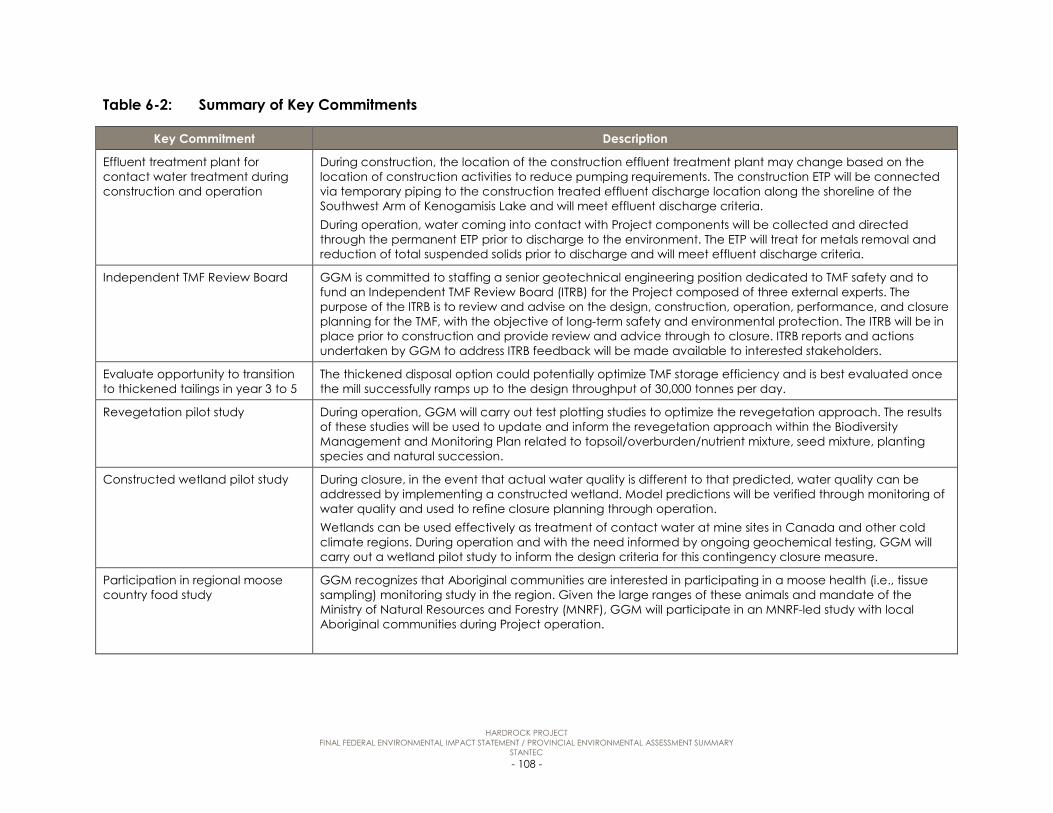
HARDROCK PROJECT FINAL FEDERAL ENVIRONMENTAL IMPACT STATEMENT / PROVINCIAL ENVIRONMENTAL ASSESSMENT SUMMARY
STANTEC - 108 -
Table 6-2: Summary of Key Commitments
Key Commitment Description
Effluent treatment plant for contact water treatment during construction and operation
During construction, the location of the construction effluent treatment plant may change based on the location of construction activities to reduce pumping requirements. The construction ETP will be connected via temporary piping to the construction treated effluent discharge location along the shoreline of the Southwest Arm of Kenogamisis Lake and will meet effluent discharge criteria. During operation, water coming into contact with Project components will be collected and directed through the permanent ETP prior to discharge to the environment. The ETP will treat for metals removal and reduction of total suspended solids prior to discharge and will meet effluent discharge criteria.
Independent TMF Review Board GGM is committed to staffing a senior geotechnical engineering position dedicated to TMF safety and to fund an Independent TMF Review Board (ITRB) for the Project composed of three external experts. The purpose of the ITRB is to review and advise on the design, construction, operation, performance, and closure planning for the TMF, with the objective of long-term safety and environmental protection. The ITRB will be in place prior to construction and provide review and advice through to closure. ITRB reports and actions undertaken by GGM to address ITRB feedback will be made available to interested stakeholders.
Evaluate opportunity to transition to thickened tailings in year 3 to 5
The thickened disposal option could potentially optimize TMF storage efficiency and is best evaluated once the mill successfully ramps up to the design throughput of 30,000 tonnes per day.
Revegetation pilot study During operation, GGM will carry out test plotting studies to optimize the revegetation approach. The results of these studies will be used to update and inform the revegetation approach within the Biodiversity Management and Monitoring Plan related to topsoil/overburden/nutrient mixture, seed mixture, planting species and natural succession.
Constructed wetland pilot study During closure, in the event that actual water quality is different to that predicted, water quality can be addressed by implementing a constructed wetland. Model predictions will be verified through monitoring of water quality and used to refine closure planning through operation. Wetlands can be used effectively as treatment of contact water at mine sites in Canada and other cold climate regions. During operation and with the need informed by ongoing geochemical testing, GGM will carry out a wetland pilot study to inform the design criteria for this contingency closure measure.
Participation in regional moose country food study
GGM recognizes that Aboriginal communities are interested in participating in a moose health (i.e., tissue sampling) monitoring study in the region. Given the large ranges of these animals and mandate of the Ministry of Natural Resources and Forestry (MNRF), GGM will participate in an MNRF-led study with local Aboriginal communities during Project operation.
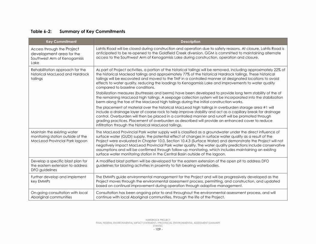
HARDROCK PROJECT FINAL FEDERAL ENVIRONMENTAL IMPACT STATEMENT / PROVINCIAL ENVIRONMENTAL ASSESSMENT SUMMARY
STANTEC - 109 -
Table 6-2: Summary of Key Commitments
Key Commitment Description
Access through the Project development area for the Southwest Arm of Kenogamisis Lake
Lahtis Road will be closed during construction and operation due to safety reasons. At closure, Lahtis Road is anticipated to be re-opened to the Goldfield Creek diversion. GGM is committed to maintaining alternate access to the Southwest Arm of Kenogamisis Lake during construction, operation and closure.
Rehabilitation approach for the historical MacLeod and Hardrock tailings
As part of Project activities, a portion of the historical tailings will be removed, including approximately 22% of the historical Macleod tailings and approximately 77% of the historical Hardrock tailings. These historical tailings will be excavated and moved to the TMF in a controlled manner at designated locations to avoid effects to water quality, reducing the loadings to Kenogamisis Lake and improvements to water quality compared to baseline conditions. Stabilization measures (buttresses and berms) have been developed to provide long term stability of the of the remaining MacLeod high tailings. A seepage collection system will be incorporated into the stabilization berm along the toe of the MacLeod high tailings during the initial construction works. The placement of material over the historical MacLeod high tailings in overburden storage area #1 will include a drainage layer of coarse rock to help improve stability and act as a capillary break for drainage control. Overburden will then be placed in a controlled manner and runoff will be promoted through grading practices. Placement of overburden as described will provide an enhanced cover to reduce infiltration through the historical MacLeod tailings.
Maintain the existing water monitoring station outside of the MacLeod Provincial Park lagoon
The MacLeod Provincial Park water supply well is classified as a groundwater under the direct influence of surface water (GUDI) supply, the potential effect of changes in surface water quality as a result of the Project were evaluated in Chapter 10.0, Section 10.4.3 (Surface Water) and demonstrate the Project will not negatively impact MacLeod Provincial Park water quality. The water quality predictions include conservative assumptions and will be confirmed through follow-up monitoring, which includes maintaining an existing surface water monitoring station in the Central Basin outside of the lagoon.
Develop a specific blast plan for the eastern extension to address DFO guidelines
A modified blast pattern will be developed for the eastern extension of the open pit to address DFO guidelines for blasting activities in proximity to fish bearing waterbodies.
Further develop and implement key EMMPs
The EMMPs guide environmental management for the Project and will be progressively developed as the Project moves through the environmental assessment process, permitting, and construction, and updated based on continual improvement during operation through adaptive management.
On-going consultation with local Aboriginal communities
Consultation has been ongoing prior to and throughout the environmental assessment process, and will continue with local Aboriginal communities, through the life of the Project.

HARDROCK PROJECT FINAL FEDERAL ENVIRONMENTAL IMPACT STATEMENT / PROVINCIAL ENVIRONMENTAL ASSESSMENT SUMMARY
STANTEC - 110 -
Table 6-2: Summary of Key Commitments
Key Commitment Description
Optimize noise reduction methods during detailed design of WRSA A considering MPP
The inclusion of air and noise/vibration monitoring for the Geraldton area and MacLeod Provincial Park has been considered in Appendix M7 (Conceptual Air Quality Management Plan) and Appendix M10 (Conceptual Noise and Vibration Management and Monitoring Plan) to validate Final EIS/EA predictions. Adaptive management (contingency) measures such as the use of specialized back-up alarms and bed liners on the trucks operating at WRSA A are provided in the Management Plans. The development plan for WRSA A will take into account strategies to limit potential noise disturbance on MacLeod Provincial Park and other nearby residents. This may include reducing night-time work during the camping season on the east portion of the WRSA and/or the establishment of rock berms.
Document and salvage program for heritage resources
Documentation and salvage will be undertaken where retention or relocation of heritage resources is not feasible, as is the case with Euro-Canadian architectural and/or historical resources. Documentation creates a public record of the structure or structures, which provides researchers and the general public with a land use history, construction details, and photographic record of the resource. Documentation activities will be performed by a heritage professional with experience in historical documentation and familiar with Euro-Canadian historical background and material culture. This person will preferably be a member of the Canadian Association of Heritage Professionals.
Cyanide Management GGM intends to become a signatory to the International Cyanide Management Code, and will abide by code criteria for the safe and responsible use, transport and management of cyanide products.

HARDROCK PROJECT FINAL FEDERAL ENVIRONMENTAL IMPACT STATEMENT / PROVINCIAL ENVIRONMENTAL ASSESSMENT SUMMARY
STANTEC - 111 -
7.0 CUMULATIVE EFFECTS
In accordance with the federal EIS Guidelines, a cumulative effects assessment is only required for Valued Components upon which the Project may result in adverse residual effects. Valued Components that would not be affected by the Project or would be affected positively are omitted from the cumulative effects assessment.
Two conditions must be met to initiate an assessment of cumulative environmental effects on a valued component:
• the Project is assessed as having adverse residual environmental effect on a valued component
• the residual effects from the Project overlap spatially or temporally with residual effects of other physical activities on a valued component.
Residual environmental effects were identified for a number of Valued Components that met these two conditions (atmospheric environment, groundwater, surface water, fish and fish habitat, vegetation communities, wildlife and wildlife habitat, labour and economy, community services and infrastructure, land and resource use and traditional land and resource use). All adverse residual effects were determined to be not significant, however they were carried forward to a cumulative effects assessment in accordance with the federal EIS Guidelines.
Several past, present and reasonably foreseeable projects, related to mining and exploration, forestry, aggregate extraction, transportation, energy and municipal development are located in the vicinity of the Project.
Based on the characterization of the residual cumulative effects (i.e., after mitigation has been applied) of the Project, in combination with the effects associated with other future projects in the regional assessment area, no significant residual adverse cumulative effects are predicted as a result of the Project.
8.0 EFFECTS OF THE ENVIRONMENT ON THE PROJECT
The Project has been designed and will be carried out to withstand environmental conditions by applying standard engineering principles and practices, and by following various codes and standards from the National Building Code of Canada and other sources.
There are no environmental attributes that, during the life of the Project, are anticipated to have the potential to result in:
• a substantial change to the Project construction schedule (e.g., a delay resulting in the construction period being extended by one season)

HARDROCK PROJECT FINAL FEDERAL ENVIRONMENTAL IMPACT STATEMENT / PROVINCIAL ENVIRONMENTAL ASSESSMENT SUMMARY
STANTEC - 112 -
• a substantial change to the Project operation schedule (e.g., an interruption in servicing such that production targets cannot be met)
• damage to Project infrastructure resulting in increased safety risk
• damage to Project infrastructure requiring repairs that cannot be technically or economically implemented.
GGM will use an adaptive management approach to its operation throughout the life of the Project to monitor any observed effects of the environment and adapt the Project components or operation and closure as necessary, so as to prevent any significant adverse effect on the Project. Accordingly, the effects of the environment on the Project are rated not significant.
9.0 EFFECTS OF POTENTIAL ACCIDENTS OR MALFUNCTIONS
The Project is inherently designed to prevent accidents and malfunctions primarily through adherence to accepted design codes and standards. Most accidental events that could be expected to occur are small spills that are easily cleaned up onsite with little or no environmental consequences. Emergency response and contingency plans will be advanced and implemented to effectively respond to accidents and malfunctions to reduce the magnitude and duration of adverse environmental and social effects.
In the unlikely event of a major industrial accident at the site involving a large scale environmental release, a significant adverse effect is possible for some valued components. Some accidental events are predicted to be of potentially high consequence with very low probability. However, significant adverse residual effects from Project-related accidents and malfunctions are not likely and management planning addresses these risks.
10.0 PROPOSED FOLLOW-UP AND MONITORING PROGRAMS
GGM is committed to minimizing environmental effects through the implementation of mitigation measures, monitoring and adaptive management for the Project within environmental management and monitoring plans for construction and operation. The goal of the environmental monitoring program is to confirm that the Project is implemented as proposed and that mitigation measures to reduce environmental effects are effectively implemented, and to provide action plans and emergency response procedures. A number of monitoring and reporting commitments have been proposed to validate the conclusions of the environmental assessment, and to determine if adaptive management measures may be required.

HARDROCK PROJECT FINAL FEDERAL ENVIRONMENTAL IMPACT STATEMENT / PROVINCIAL ENVIRONMENTAL ASSESSMENT SUMMARY
STANTEC - 113 -
GGM is committed to the continual improvement of its environmental management and performance. As part of the GGM Adaptive Management Framework, the environmental management and monitoring plans will be assessed regularly to verify implementation and the continued suitability, adequacy and effectiveness of the Plan. The review will identify elements of the environmental management and monitoring plans in need of revision, and evaluate performance against established performance objectives.
The environmental management and monitoring plans guide environmental management for the Project and are progressively developed as the Project moves through the environmental assessment process, permitting, and construction, and updated based on continual improvement during operation through adaptive management. Environment management and monitoring plans that are provided in the Final Environmental Impact Statement / Environmental Assessment include:
• Water Management and Monitoring Plan
• Conceptual Waste Rock Management Plan
• Conceptual Emergency Response Plan
• Conceptual Waste Management Plan
• Conceptual Erosion and Sediment Control Plan
• Conceptual Greenhouse Gas Management and Monitoring Plan
• Conceptual Air Quality Management and Monitoring Plan
• Conceptual Spill Prevention and Response Plan
• Conceptual Soil Management Plan
• Conceptual Noise and Vibration Management and Monitoring Plan
• Conceptual Explosives and Blasting Management Plan
• Conceptual Aquatic Management and Monitoring Plan
• Conceptual Biodiversity Management and Monitoring Plan
• Conceptual Archaeology and Heritage Resources Management Plan
11.0 BENEFITS OF THE PROJECT
GGM is committed to developing the Project in a sustainable manner contributing to a healthy environment, economy and local communities. The following is a high-level overview of the predicted environmental, economic and social benefits of the Project.

HARDROCK PROJECT FINAL FEDERAL ENVIRONMENTAL IMPACT STATEMENT / PROVINCIAL ENVIRONMENTAL ASSESSMENT SUMMARY
STANTEC - 114 -
11.1 Environment
The environmental studies completed in support of the Final Environmental Impact Statement / Environmental Assessment have improved the overall understanding of the existing environment within the Project development area, and in particularly the effects of historical mining activity on the environment. The following environmental benefits are anticipated as a result of the Project.
• Removal of portions of the historical MacLeod and Hardrock tailings: Historical tailings are currently contributing to existing water quality effects in Kenogamisis Lake through runoff and groundwater discharge. As part of Project activities, a portion of the historical tailings will be removed, including 22% of the historical MacLeod tailings and 77% of the historical Hardrock tailings. These historical tailings will be excavated and moved to the tailings management facility, reducing the loadings to Kenogamisis Lake and resulting in improvements to water quality compared to baseline conditions.
• Enhanced cover for the historical MacLeod High tailings: A portion of the historical MacLeod high tailings area has been designed as a storage area for overburden. An enhanced cover system that incorporates a layer of rock over the existing tailings to help improve stability and provide a drainage layer will be installed. The overburden will be stockpiled and sloped in a manner that promotes runoff and reduces infiltration with a layer of overburden remaining in perpetuity. The enhanced cover system will reduce infiltration through the historical MacLeod tailings and subsequent groundwater discharge, thereby decreasing loadings to Kenogamisis Lake compared to baseline conditions.
• Subsurface seepage collection system for historical MacLeod High tailings: A subsurface seepage collection system will be implemented to collect both short-term seepage anticipated during construction and highway embankment preloading, and long-term seepage (operation and closure/post-closure) from the historical MacLeod high tailings.
• Open Pit Dewatering: During operation 100% of the groundwater originating from beneath the historical tailings, waste rock storage areas A and B, 59% from WRSA C, and 94% from the ore stockpile will be directed to the open pit where it will be collected and either reused to support mill demand, or be treated through the effluent treatment plant before discharging to the Southwest Arm of Kenogamisis Lake. This change in groundwater flow direction during operation will reduce the current loading to Kenogamisis Lake associated with the historical tailings, and is predicted to have a positive effect on water quality over time in Kenogamisis Lake, in particular Barton Bay and Central Basin.
11.2 Socio-Economic
GGM is dedicated to establishing productive local partnerships that contribute to achieving development goals identified by the community, to address local priorities and concerns, and to have communities derive benefits from the Project. The following economic and/or social benefits are anticipated as a result of the Project.

HARDROCK PROJECT FINAL FEDERAL ENVIRONMENTAL IMPACT STATEMENT / PROVINCIAL ENVIRONMENTAL ASSESSMENT SUMMARY
STANTEC - 115 -
• Increased employment: On average, the Project will create the equivalent of 1,225 jobs in Ontario in each of the 23 years from construction through active closure. Of these, 385 jobs per year would be directly associated with the Project. The equivalent of another 350 jobs will result elsewhere in Canada during each year of the Project’s life.
• Increased government revenue: The Project will directly and indirectly create $242 million in revenues (undiscounted) for the Government of Ontario. This is equivalent to an average of about $11 million per year. Total revenues for the Government of Canada would amount to $215 million, or an average of $10 million per year.
• Increased provincial and federal economic activity: The Project will directly and indirectly increase economic activity, as measured in terms of Gross Domestic Product, by $3.1 billion in revenues (undiscounted) for Ontario. This is equivalent to an average of about $142 million per year. The Project’s total contribution to the Gross Domestic Product in Canada will amount to $6.3 billion over the life of the Project, or an average of $286 million per year.
• Increased labour force capacity: GGM will identify and promote local residents and Aboriginal communities to acquire the necessary skills to help them qualify for Project employment, particularly during the operation phase of the Project.
• Reduced unemployment: Hiring of local workers could reduce the local unemployment rate by up to six percentage points.
• Increased personal and family income: Project employment will provide relatively high income for workers and their families, especially for residents of the Municipality of Greenstone, District of Thunder Bay, and local Aboriginal communities.
• Increased income for regional businesses: Project purchases of goods and services will provide expansion and diversification opportunities for businesses in the Municipality of Greenstone and District of Thunder Bay, and businesses operated by local Aboriginal communities. GGM has and will continue to work with local and Aboriginal-owned businesses on Project contract opportunities regarding the supply of goods and services, particularly for the operation phase.
12.0 CONCLUSION
Taking into account the findings of the environmental assessment, including implementing the identified mitigation measures, it has been concluded that the Project is not predicted to cause significant adverse environmental effects, including effects from accidents and malfunctions, effects of the environment on the Project and cumulative effects.