Embed Size (px)
Citation preview
HARRIS RANCH SUPPLEMENTAL CULTURAL RESOURCES
SURVEY
Archaeological and Historical Survey Report Archaeological Survey of Idaho
SAIC 405 S 8th Street, Suite 301
Boise, Idaho 83702 (208) 344-5001
for
LeNir, Ltd.
4940 E Mill Station Drive Suite 101-B
Boise, Idaho 83716 (208) 344-1131
December 2006
Harris Ranch Supplemental Cultural Resources Survey
ARCHAEOLOGICAL AND HISTORICAL SURVEY REPORT ARCHAEOLOGICAL SURVEY OF IDAHO
All surveys completed for review under Section 106 of the National Historic
Preservation Act must include textual or checked responses to each element below. A failure to include all elements and required attachments will result in a rejection of the report for review purposes until the missing data are supplied. Surveys not 106
related must include all elements except those specified for 106. A. KEY INFORMATION
1. Project name: Harris Ranch Archaeological Survey
2. Report number or associated federal project number (if appropriate): none
3. Agency name (if 106-related): none 4. Report author (and principal investigator if different): Chris Wildt and Lorraine Gross
(P.I.), Science Applications International Corporation (SAIC)
5. Date: November 16, 2006
6. Counties: Ada
7. Township, range, section (each township and associated sections listed separately): Area A - T3N, R3E, Section 17 Area B - T3N, R3E, Section 21 Area C - T3N, R3E, Section 28
8. Acres Surveyed: Approximately 163 acres at a 20-meter or less transect interval in three areas:
• Area A, situated between two previously surveyed areas, is approximately 50 acres. • Area B, the west half of the SW quarter of the section, is 80 acres. • Area C, in the SW quarter of the section and bounded by Old HWY 21 to the
southwest and the beginning of the slope to the northeast, is approximately 33 acres.
B. PROJECT DESCRIPTION (for 106-related surveys) 1. The project consists of a pedestrian survey of approximately 163 acres of previously un-
surveyed land owned by the Harris Family Limited Partnership, and the revisiting of 13 sites and isolates recorded in 1996.
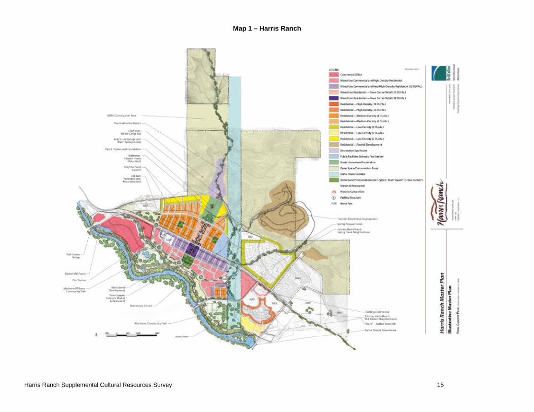
Description of Area of Potential Effects (APE) with reference to attached map: 2. Map 1 shows the location of the project area relative to the Harris Ranch development. Map 2
shows the project area, area surveyed, and recorded archaeological sites. 3. Project acres: Approximately: 163 Acres
4. Owner(s) of land in project area: Harris Family Limited Partnership.
C. STATEMENT OF OBJECTIVES FOR SURVEY The purpose of the survey is twofold: 1) to identify historic properties/archaeological resources within three previously unsurveyed parcels of the Harris Ranch property totaling 163 acres
abutting previously surveyed land; and 2) to revisit and determine the condition of previously recorded cultural resources within the greater Harris Ranch property boundaries.
D. LOCATION AND GENERAL ENVIRONMENTAL SETTING
1. USGS topographic map(s): Boise South and Lucky Peak, Idaho 7.5 Minute, 1:24.000.
2. Setting The project area lies just outside the city limits of Boise City, Ada County, Idaho, on privately owned property. The entire development totals approximately 1500 acres (Figure 1), most of which is owned by the Harris Family Limited Partnership. The project lies in Township 3 North, Range 3 East, in portion of Sections 17, 19, 20, 21, 28, 29, 30. The three parcels making up the project area extend from the Boise River on the south into the near foothills of the Boise Front Range on the north and northeast. The northernmost parcel in the project area is less than one-half mile east of Table Rock, a prominent topographical feature and the source of sandstone used in many Boise buildings. It connects a parcel to the north with the remaining body of the previously surveyed area to the south. The second, eastern parcel includes a portion of Squaw Creek and abuts the eastern edge of the previously surveyed area. The third parcel lies adjacent to Highway 21 along the eastern edge of the overall property boundary. The Boise River Valley is almost flat, sloping from the foot of the hills southwest to the River. Occasional, small terraces step gradually down to the river. The Boise River, which flows from east to west through the Boise River Valley, has a flow regulated and/or affected by a series of water control features located upstream. Anderson Ranch, Arrowrock and Lucky Peak Dams impound large reservoirs for flood control, power generation and irrigation. Approximately two miles upstream from the eastern project boundary Diversion Dam channels water into New York Canal on the south side of the river, which delivers water to Lake Lowell for irrigation storage and distribution. Water is also diverted at this point to Penitentiary Canal on the north side of the river. Barber Dam, at the southeastern project edge, provides power sold to Idaho Power Company. A small diversion dam two-thirds of a mile downstream from Barber Dam diverts water into Ridenbaugh Canal on the south side of the river, which brings water into the City of Boise. A number of intermittent drainages emerge from the foothills and flow towards the Boise River, but only Squaw Creek and Warm Springs Creek are of any size. Elevations range from a high of about 3500 feet above mean sea level (msl), at the top of one knoll to a low of 2750 feet msl at the Boise River. The project area includes a portion of the foothills, and their characteristic terrain is evident: hills with moderately steep slopes topped by both wide and narrow ridges, and narrow, moderately to steeply sloping drainages that terminate at the Boise River Valley floor. The project area is transected from east to west by Warm Springs Avenue which becomes State Highway 21, connecting Boise with Idaho City 38 miles to the northeast. Eckert Road crosses the Boise River between the small diversion dam for Ridenbaugh Canal, and Barber Park (on the south side of the river), and intersects Warm Springs Avenue. Eckert Road has been redirected to the east from its 1996 route, intersecting Warm Springs Avenue/Highway 21 s little way to the east. Barber Road also crosses the project area north of Warm Springs Avenue. The project excludes a number of areas that fall within the original perimeter boundaries. The Golden Dawn Trailer Park at the southeast project area was excluded from the project area, as were three parcels with houses near Penitentiary Canal. Warm Springs Avenue/Highway 21 as it passes through the project was not surveyed. The Idaho Power powerline corridor that roughly bisects the project from north to south was surveyed later as part of Idaho Power Company projects (refer to Figure 1). Vegetation varies throughout the project area depending on topographic setting. The hillsides are typical habitat for sagebrush steppe vegetation, and include native grasses, big and low sage, and
Harris Ranch Supplemental Cultural Resources Survey 2006 2
disturbance vegetation such as cheat grass. By the stream, grasses, and forbs provide dense ground cover. In places near the river trees, such as cottonwoods and willows, and brush create an impenetrable mass. The project area, including the three parcels surveyed in 2006, can be described as varying between somewhat disturbed and extremely disturbed. The valley in this area was the location of the Barber Mill and the associated town. Both were subsequently razed and most traces removed, leaving some trash and an altered landscape. Historic development probably affected every portion of the valley bottom, except where the river and water table caused the land to be too marshy to be useful. Producer’s Lumber Company operations and other industrial development occupy much of the land in Parcel 23. A modern corral and barn overlie what may be a historic foundation in Parcel 18. Cattle grazing and/or cultivation have occurred at some time on all relatively flat areas. The foothills are less disturbed and are undeveloped at this time. However, this portion of the project area has been subject to historic activity as well as modern actions such as grazing and recreation. Two-track roads lead into the foothills and modern trash can be seen in places. Alcoves in sandstone outcrops in the foothills may have modern fire rings or holes dug in them. Ground visibility varies from 100 percent in badly disturbed contexts to zero in areas of dense vegetation. The 2006 survey was conducted in the fall so visibility was generally good. However, dense vegetation in the drainages and close to the river obscured up to 75 percent of the ground surface. Those areas which were surveyable using intensive methods had visibility averaging about 75 percent. The brushy areas near the Boise River roughly coincided with areas too wet to survey.
E. PRE-FIELD RESEARCH
1. Sources of information checked: [ ] Overviews [ ] Historical records/maps (list) [X] National Register [ ] General Land Office (GLO) original survey plats at
Boise BLM office. [X] Archaeological site records/maps [ ] Individuals/groups with special knowledge (list)
[X] Architectural site records/maps [X] Survey records [ ] Other (list): Previous survey work in project area [ ] Ethnographic studies 2. Summary of previous studies in the general area: Archaeological survey was completed for most of the project area in 1996 (SAIC 1996). This survey located 11 archaeological sites and isolates, and re-recorded two archaeological sites. In addition further data recording occurred at two of the sites located in 1996 (SAIC 1999): the Penitentiary Canal and the Barber Mill Site. Prior to the 1996 and 1999 projects, most of the cultural resource investigations conducted in the vicinity of the project area were surveys. The results of these investigations are varied, but in most cases the studies encountered limited numbers of prehistoric resources and a low density of sites. The most common prehistoric site types are lithic scatters or rockshelters located in rock outcrops, and most sites lack datable materials. Because there have been so few scientifically conducted excavations in the vicinity of the project area, no cultural chronology specific to the Boise area has been generated. Interpretations of local sites are based on the more general Great Basin chronologies, as described previously. Local settlement and subsistence systems are based on scant ethnographic and archaeological data, in addition to borrowed models constructed for the Snake River Valley.
Prior to 1983, a majority of the cultural resource surveys conducted in southwest Idaho focused on prehistoric, rather than historic resources (Corbyn 1988). Where historic resources were
Harris Ranch Supplemental Cultural Resources Survey 2006 3
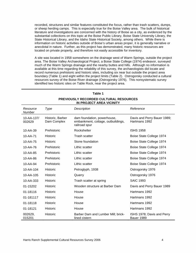
recorded, structures and similar features constituted the focus, rather than trash scatters, dumps, or sheep herding camps. This is especially true for the Boise Valley area. The bulk of historical literature and investigations are concerned with the history of Boise as a city, as evidenced by the substantial collections on this topic at the Boise Public Library, Boise State University Library, the State Historical Library, and the Idaho State Historical Society, among others. While there is information on historic activities outside of Boise’s urban areas proper, it is generally narrative or anecdotal in nature. Further, as this project has demonstrated, many historic resources are located on private property, and therefore not easily accessible for inventory. A site was located in 1958 somewhere on the drainage west of Warm Springs, outside the project area. The Boise Valley Archaeological Project, a Boise State College (1974) endeavor, surveyed much of the Warm Springs drainage and the nearby buttes and hills. Although no information is available at this time regarding the reliability of this survey, the archaeologists did locate and record numerous prehistoric and historic sites, including six near but outside the project area boundary (Table 1) and eight within the project limits (Table 2). Ostrogorsky conducted a cultural resources survey of the Boise River drainage (Ostrogorsky 1976). This nonsystematic survey identified two historic sites on Table Rock, near the project area.
Table 1
PREVIOUSLY RECORDED CULTURAL RESOURCES IN PROJECT AREA VICINITY
Resource Number
Type Description Reference
10-AA-137/ 002629
Historic, Barber Dam Complex
dam foundation, powerhouse, embankment, cottage, outbuildings, railroad spur
Davis and Perry Bauer 1989; Hartmans 1992
10-AA-39 Prehistoric Rockshelter ISHS 1958
10-AA-71 Historic Trash scatter Boise State College 1974
10-AA-75 Historic Stone foundation Boise State College 1974
10-AA-76 Prehistoric Lithic scatter Boise State College 1974
10-AA-85 Prehistoric Lithic scatter Boise State College 1974
10-AA-86 Prehistoric Lithic scatter Boise State College 1974
10-AA-94 Prehistoric Lithic scatter Boise State College 1974
10-AA-104 Historic Petroglyph, 1938 Ostrogorsky 1976
10-AA-105 Historic Quarry Ostrogorsky 1976
10-AA-333 Historic Trash scatter at spring SAIC 1993
01-15202 Historic Wooden structure at Barber Dam Davis and Perry Bauer 1989
01-18116 Historic House Hartmans 1992
01-181117 Historic House Hartmans 1992
01-18118 Historic House Hartmans 1992
01-18121 Historic House Hartmans 1992
002629, 015201
Historic Barber Dam and Lumber Mill; brick-lined cistern
ISHS 1978; Davis and Perry Bauer 1989
Harris Ranch Supplemental Cultural Resources Survey 2006 4
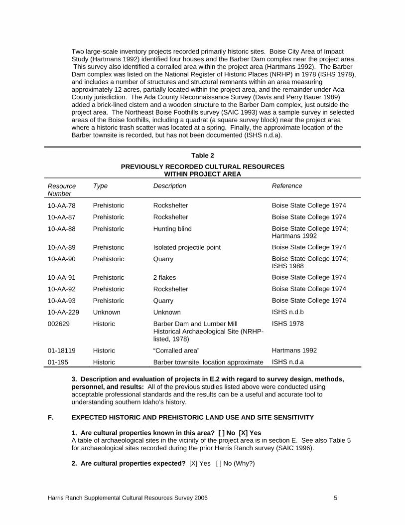
Two large-scale inventory projects recorded primarily historic sites. Boise City Area of Impact Study (Hartmans 1992) identified four houses and the Barber Dam complex near the project area. This survey also identified a corralled area within the project area (Hartmans 1992). The Barber Dam complex was listed on the National Register of Historic Places (NRHP) in 1978 (ISHS 1978), and includes a number of structures and structural remnants within an area measuring approximately 12 acres, partially located within the project area, and the remainder under Ada County jurisdiction. The Ada County Reconnaissance Survey (Davis and Perry Bauer 1989) added a brick-lined cistern and a wooden structure to the Barber Dam complex, just outside the project area. The Northeast Boise Foothills survey (SAIC 1993) was a sample survey in selected areas of the Boise foothills, including a quadrat (a square survey block) near the project area where a historic trash scatter was located at a spring. Finally, the approximate location of the Barber townsite is recorded, but has not been documented (ISHS n.d.a).
Table 2 PREVIOUSLY RECORDED CULTURAL RESOURCES
WITHIN PROJECT AREA
Resource Number
Type Description Reference
10-AA-78 Prehistoric Rockshelter Boise State College 1974
10-AA-87 Prehistoric Rockshelter Boise State College 1974
10-AA-88 Prehistoric Hunting blind Boise State College 1974; Hartmans 1992
10-AA-89 Prehistoric Isolated projectile point Boise State College 1974
10-AA-90 Prehistoric Quarry Boise State College 1974; ISHS 1988
10-AA-91 Prehistoric 2 flakes Boise State College 1974
10-AA-92 Prehistoric Rockshelter Boise State College 1974
10-AA-93 Prehistoric Quarry Boise State College 1974
10-AA-229 Unknown Unknown ISHS n.d.b
002629 Historic Barber Dam and Lumber Mill Historical Archaeological Site (NRHP-listed, 1978)
ISHS 1978
01-18119 Historic “Corralled area” Hartmans 1992
01-195 Historic Barber townsite, location approximate ISHS n.d.a 3. Description and evaluation of projects in E.2 with regard to survey design, methods, personnel, and results: All of the previous studies listed above were conducted using acceptable professional standards and the results can be a useful and accurate tool to understanding southern Idaho’s history.
F. EXPECTED HISTORIC AND PREHISTORIC LAND USE AND SITE SENSITIVITY
1. Are cultural properties known in this area? [ ] No [X] Yes A table of archaeological sites in the vicinity of the project area is in section E. See also Table 5 for archaeological sites recorded during the prior Harris Ranch survey (SAIC 1996). 2. Are cultural properties expected? [X] Yes [ ] No (Why?)
Harris Ranch Supplemental Cultural Resources Survey 2006 5
Based on the previous survey (SAIC 1996), there is a good probability that additional sites may be located. These sites may range across the entire range of time periods specified in item 3 below, because of the known history of the Boise River Valley. However, balancing this is the knowledge that the area has been highly disturbed over the past 150 years as the Boise River Valley was developed by miners, ranchers, farmers and the associated support infrastructure. 3. What cultural themes/contexts are expected within the survey area? Check at least one theme in first two columns and at least one time period in the third column.
Theme Time Period [X] Prehistoric Archaeology [X] Military [X] Prehistoric
[X] Agriculture [ ] Mining Industry [X] Historic Native American [ ] Architecture [X] Native Americans [X] Exploration: 1805-1860
[ ] Civilian Conservation Corps [ ] Politics/Government [X] Settlement: 1855-1890 [ ] Commerce [ ] Public Land Mngt/Conserv. [X] Phase I Statehood: 1890-1904 [X] Communication [ ] Recreation/Tourism [X] Phase II Statehood: 1904-1920
[ ] Culture and Society [X] Settlement [X] Interwar: 1920-1940 [ ] Ethnic Heritage [X] Timber Industry [X] Pre-Modern: 1940-1958
[ ] Exploration/Fur Trapping [X] Transportation [X] Modern: 1958-present [X] Industry [ ] Other (list)
4. Brief description of where cultural properties associated with expected themes might be found with respect to landforms, water, vegetation, slope, fauna, and historical documentation: Based on the previous survey, the project area encompasses landforms that have a moderate probability for archaeological sites. These landforms include proximity to a source of permanent water (the Boise River) and smaller drainages (e.g., Squaw Creek) that are desired habitat for various game animals, and therefore also hunters of such animals, and roads that have been historically used for recreation, emigration, settlement, and agriculture. Portions of the project area have been heavily disturbed through the construction of a canal and associated roads as well as through cultivation, lessening the likelihood of locating intact cultural deposits.
G. FIELD METHODS
1. Areas examined and type of coverage: (Describe actual methods used including transect interval and transect routes as shown on attached map. Justify any non-intensive survey.):
Two archaeologists conducted intensive pedestrian archaeological survey in September and October, 2006. The archaeologists’ goals were to: rigorously and systematically inspect all areas to be surveyed; locate and delineate archaeological resources observable using surface survey techniques; document thoroughly the archaeological resources according to the requirements of the Idaho SHPO and record information about resource age, function, environmental context, and integrity.
The surveyors walked transects covering the entire project area at intervals of approximately 20 meters. Rodent burrows, road cuts, livestock wallows and ant hills within the APE were closely examined for evidence of subsurface cultural deposits. There was no subsurface testing, and no collection of artifacts on this project. In addition to the survey of new parcels just described, previously recorded archaeological sites and isolates were visited to determine: 1) if they could be relocated; 2) if the condition or description of the resource had changed; and 3) to reassess the previous NRHP evaluation.
1. Description of ground surface conditions: Ground visibility varies from 100 percent in badly disturbed contexts to zero in areas of dense vegetation. The 2006 survey was conducted in the fall so visibility was generally good. However,
Harris Ranch Supplemental Cultural Resources Survey 2006 6
dense vegetation in the drainages and close to the river obscured up to 75 percent of the ground surface. Those areas which were surveyable using intensive methods had visibility averaging about 75 percent. The brushy areas near the Boise River roughly coincided with areas too wet to survey.
2. Areas not examined and reasons why: (Key to map.): None
4. Names of personnel participating in the survey in the field: Tyrone Corn; Chris Wildt
5. Dates of survey: September-October 2006
6. Problems encountered: None
H. RESULTS
1. Cultural properties (including previously recorded) in this area.
1.1 Revisited sites and isolates.
HR-1 and HR-5
The two isolates, HR-1 and HR-5, lie in potentially disturbed contexts where subsurface deposits are unlikely to yield undisturbed cultural material. HR-5 may be the remnants of a larger site, 10-AA-90 recorded in the course of two earlier surveys (Boise State University 1974; ISHS 1988). Through recording of these two resources - object type, material, context and location, the isolates have contributed as much information as they can to the regional data base. The lack of associated cultural materials and subsurface deposits, as well as concerns regarding the contextual integrity of the isolates, further reduces their ability to yield significant information. Based on these factors, the isolates fail to meet any of the criteria for eligibility to the NRHP. Furthermore, neither was relocated during the current survey.
HR-2
This probable campsite with a prehistoric component appears to have poor integrity, as it has been adversely affected by cattle grazing, erosion exacerbated by range fires, and recreational vehicle traffic. However, it has a diverse historic artifact assemblage, includes dateable material (in the form of amethyst glass), may represent a site from around the turn of the century in Boise, and may include relatively undisturbed subsurface deposits. Buried cultural material could provide valuable insights into the growing community centered on Boise, and could contribute significant information to our understanding of this time. For this reason, HR-2 is considered to be potentially eligible for the NRHP under criterion d.
HR-2 - prehistoric
This lithic scatter component of a historic campsite is sparse, but 50 percent of the assemblage is formed tools. This site has the potential to contain subsurface deposits that could have cultural material. Should there be cultural material present, the site would have the ability to make a significant contribution to our understanding of aboriginal use, either prehistoric or ethnographic, of this area. This capacity is particularly important because of the relative scarcity of such sites in undisturbed condition. Because of this possibility, HR-2 is potentially eligible for the NRHP under criterion d.
HR-3
HR-3 lies in the general location indicated in the archaeological records as the Barberton/Barber townsite. The small trash scatter recorded as HR-3 is only a remnant of what probably lies almost entirely underneath the Golden Dawn Trailer Park directly to the west. The town was dismantled in 1935, and in the ensuing years the field where this site is located has been repeatedly plowed
Harris Ranch Supplemental Cultural Resources Survey 2006 7
and grazed by cattle. The remains are highly fragmented and, with the exception of amethyst glass, non-diagnostic. Because this site lacks integrity, and is a poor example of the remains of Barber, it is not able to make a significant contribution to our understanding of the history of Barber or Boise. For this reason, the site is not considered to be eligible for the NRHP.
HR-4
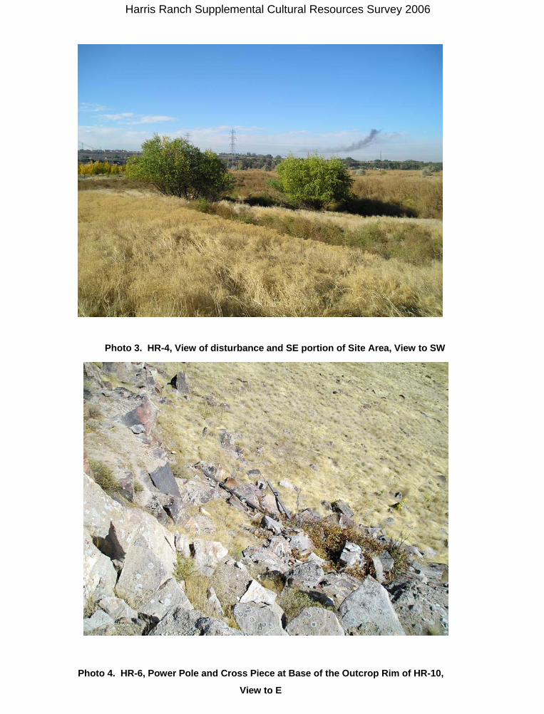
As originally recorded in 1996, this site had two parts. The foundation at Locus A that may have been the remains of the horse barn used for the Barber Mill was in poor condition, although it may have had the potential for undisturbed, buried deposits within the foundations and directly outside them. The Locus B consisted of a large dump that appeared relatively undisturbed, and that may have been the main dump from the town of Barber. In 2006 this site was found to be mostly obliterated and the remainder badly disturbed. Because it no longer has the potential to address research questions and add to our understanding of history, this site is considered not eligible for the NRHP under any criterion.
HR-6
HR-6 represents a small portion of a historic telephone line across the low Boise Foothills. Only seven poles remain within the project area, with an unknown number extending to the northwest. The poles have been removed near ground level, and a scant artifact assemblage accompanies the stumps. This site lacks integrity and context. For these reasons, it is not considered eligible for the NRHP.
HR-7
HR-7 consists of the remains of the Barber Mill. Portions of this site have been previously recorded as 002629, Dam Complex (outlines are not well-defined); 015201, brick-lined cistern (located east of the access road, outside this project area); 015202, wooden structure (also east of the access road and outside this project area); and 10-AA-137, Barber Dam. The latter appears to include only the dam and powerhouse on the east side of the road, although the accompanying photographs include the mill buildings described for HR-7. In any case, HR-7 is part of the historic Barber Mill which was listed on the NRHP on February 11, 1978. For that reason, although the site is in poor condition and has been affected by site clearing and decay, the buildings, foundation, and associated debris piles are also considered NRHP eligible.
HR-8
This site is a portion of the Penitentiary Canal, built with convict labor in 1908 and 1909, and is still in use (Paul Deveau, personal communication). It is in fair condition, with some original of headgates and diverters still in place. However, repairs are made on an as-needed basis, with most recent changes made in the 1990s. The Idaho State Penitentiary played an important part in the early history of Idaho and Boise, and the activities of its inmates are well-documented, including the construction of the canal. The canal is an example of the prison’s attempt to be self-sufficient, as well as providing an example of the results of convict labor. However, it is in poor to fair condition. Its integrity has been compromised by the addition of modern headgates and diverting features. The canal no longer goes to its original destination, ending just past the Harris Ranch project area. Because of its condition, it is not a good example of the irrigation canals and system in the Boise River drainage. For these reasons, the site is not considered to be eligible for the NRHP.
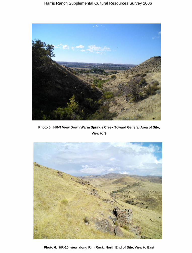
HR-9
This site is the location of a series of developments, the last of which was known as Kelly Hot Springs. There is almost no identifiable trace left of this interesting bit of Boise history. The springs have been diverted, the structures destroyed, and the historic debris disturbed by modern activities. A series of floods, the latest in the late 1950s and early 1980s (Michael Wardle, personal communication 1996), have washed out much of the area and altered the landscape. A
Harris Ranch Supplemental Cultural Resources Survey 2006 8
flood control levee built at an unknown date was presumably created by bulldozing much of what might have been left of the site, as evidenced by the historic and modern debris embedded in the berm. The site was previously recorded as 001571, as part of the 1989 Ada County Reconnaissance Survey (Davis and Perry Bauer 1989). At that time it was described as “Non-existent - ruins” with “Non-existent - poor” integrity. Because the site has been destroyed, there is no potential for in situ buried cultural materials. Thus, it is not considered eligible for the NRHP.
HR-9 prehistoric
This site is known anecdotally as the location of a winter camp, as well as the gathering spot for the Boise Valley Shoshone before they were removed to reservations (cf. Witherell 1989:13, 34; ISHS 1976:Attachments). Nearby landmarks such as the quarry area near the Old Penitentiary, Table Rock and Castle Rock have also been identified as historic Native American camp or village sites. Although this area was intensively surveyed, no evidence for use by traditional Native Americans was located. The area has been radically altered by natural and human-caused actions, which could have obscured any artifacts and/or features.
HR-10
HR-10 is a quarry site located in an area known to have had a high density of prehistoric sites. These sites today appear to be largely destroyed or obscured by disturbance. HR-10 has a moderately dense concentration of debitage, and has the potential for subsurface cultural material. Based on this possibility, the site may be able to contribute significant information toward our understanding of the prehistory of the Boise River Valley and foothills. Upon revisiting this site in 2006, it is now apparent that it extends over 3.75 acres, with the west end of the site crossing the project boundary. Originally considered potentially eligible, this site is now considered to be eligible for the NRHP under criterion d.
HR-11
This site may represent a homestead or work camp from around the turn of the century in Boise and may include relatively undisturbed subsurface deposits. Although the site is in poor condition because of impacts from cattle and erosion, it has the potential to contain undisturbed subsurface deposits. Buried cultural material, if present, could contribute significant information to our understanding of the function of this site and of the time period. For this reason, HR-11 is considered to be potentially eligible for the NRHP under criterion d.
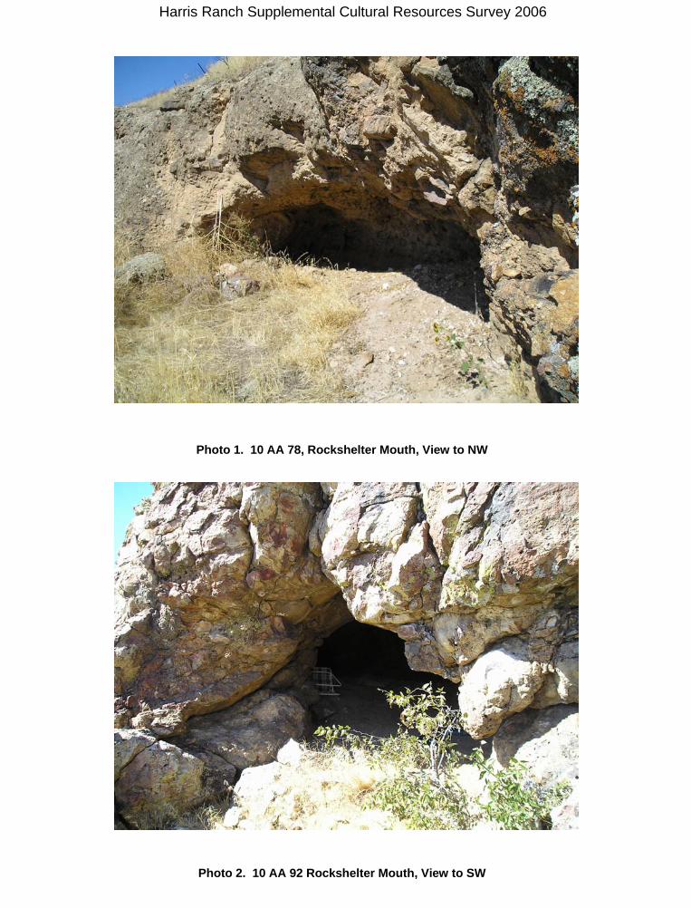
10-AA-78
This site was previously recorded as a low-density lithic scatter in a rockshelter. SAIC found no evidence of cultural material in 1996, perhaps indicating that the site has been vandalized. In 2006, again no evidence of site material was located. Because the integrity of the site has been compromised to such an extent that it appears to have been destroyed, this site has a low potential to make a significant contribution to our understanding of prehistory in the area. For this reason, it is not considered eligible for the NRHP.
10-AA-92
10-AA-92 is a rockshelter situated amidst the concentration of sites recorded in the course of the Boise Valley Archaeological Survey (Boise State College 1974). The majority of the sites have been destroyed or were so well obscured by the dense vegetation that they were not relocated during the Harris Ranch Survey. This site, too, has been adversely affected by recreational use and vandalism, as evidenced by modern trash, a modern fire ring, and a looter’s pit mapped in 1974. However, there are still flakes present, and there is the possibility of undisturbed cultural deposits, especially in the eastern chamber. If undisturbed deposits exist, this could be an important source of information, as stratified cultural deposits in dry caves have been known to contain important cultural information.
Harris Ranch Supplemental Cultural Resources Survey 2006 9
Reexamination of this site located more extensive cultural deposits. Originally considered potentially eligible, this site is now considered to be eligible for the NRHP under criterion d.
H.1.2 Newly recorded sites
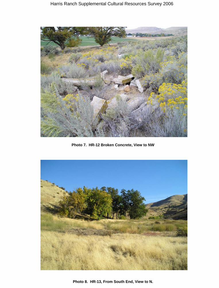
HR-12 – New Site
This locus consists of the remains of a probable habitation site. Broken concrete, a gas stove, and a milled lumber-treaded walkway are the largest remains. The context of this site is very disturbed, and it is not considered eligible for the NRHP.
HR-13 – New Site
This locus consists of the remains of a probable habitation site. Although a relatively recent occupation consisted of a trailer located here for a number of years, additional refuse indicates an older historic occupation. The context of this site is very disturbed, and it is not considered eligible for the NRHP.
2. Summary of important characteristics of properties listed above: (Consider property type, integrity, age, cultural affinity of occupants, function, depth, and size.) The sites located during this and previous surveys are generally characterized by extensive disturbance. Only the prehistoric sites located on the ridge near the rock outcrops retain some measure of integrity. Even though these sites are disturbed they may retain enough subsurface or intact deposits to remain eligible for the NRHP under criterion d.
3. Recommendations for NRHP eligibility of each cultural property: (Specify both appropriate NRHP criteria and contexts listed in F. Justify on attached site forms.) Refer to table 3. 4. Recommendations for further investigations needed to evaluate cultural properties: No further work is recommended under the aegis of this project.
5. Cultural properties noted but not formally recorded: (Key to map.) None
I. CONCLUSIONS AND RECOMMENDATIONS
1. Brief summary of relevance of cultural properties to contexts listed under F, discussing potential contributions to these contexts: The recording of the two “new” historic sites is the limit of the information they can provide to the historic record.
2. Discussion of potential threats to the integrity of the cultural properties and recommendations for future investigations or protective actions: Site HR-10 that is now considered to be NRHP eligible is not in any danger from the development of Harris Ranch. This site is already vulnerable to visitors hiking in the foothills and in the vicinity of Table Rock. It also has already been used as a modern campsite. It is likely that education programs planned by Harris Ranch will actually make people aware that archaeological deposits should not be disturbed.
3. For 106-related surveys, discussion of relationship of each cultural property to direct and indirect project impacts. Specifically state project's effect (no effect, no adverse effect, or adverse effect) upon each cultural property: [ ] Not applicable (not 106-related). No eligible historic properties will be impacted by the Harris Ranch development
4. For 106-related surveys affecting cultural properties, discussion of avoidance or mitigation options for each property: Not applicable. No development is planned that will impact historic properties, i.e., NRHP-eligible sites.
Harris Ranch Supplemental Cultural Resources Survey 2006 10
5. For 106-related surveys, recommendations for additional information gathering or
survey, avoidance measures, monitoring, mitigation, and future management: [X] None
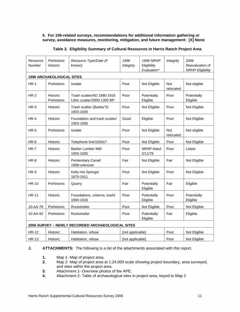
Table 3. Eligibility Summary of Cultural Resources in Harris Ranch Project Area
Resource Number
Prehistoric Historic
Resource Type/Date (if known)
1996 Integrity
1996 NRHP Eligibility Evaluation*
Integrity 2006 Reevaluation of NRHP Eligibility
1996 ARCHAEOLOGICAL SITES
HR-1 Prehistoric Isolate Poor Not Eligible Not relocated
Not eligible
HR-2 Historic Prehistoric
Trash scatter/AD 1880-1916 Lithic scatter/3300-1300 BP
Poor Potentially Eligible
Poor Potentially Eligible
HR-3 Historic Trash scatter (Barber?)/ 1903-1936
Poor Not Eligible Poor Not Eligible
HR-4 Historic Foundation and trash scatter/ 1903-1936
Good Eligible Poor Not Eligible
HR-5 Prehistoric Isolate Poor Not Eligible Not relocated
Not eligible
HR-6 Historic Telephone line/1920s? Poor Not Eligible Poor Not Eligible
HR-7 Historic Barber Lumber Mill/ 1903-1935
Poor NRHP-listed 2/11/78
Poor Listed
HR-8 Historic Penitentiary Canal/ 1908-unknown
Fair Not Eligible Fair Not Eligible
HR-9 Historic Kelly Hot Springs/ 1870-1911
Poor Not Eligible Poor Not Eligible
HR-10 Prehistoric Quarry Fair Potentially Eligible
Fair Eligible
HR-11 Historic Foundations, cisterns, trash/ 1900-1916
Poor Potentially Eligible
Poor Potentially Eligible
10-AA-78 Prehistoric Rockshelter Poor Not Eligible Poor Not Eligible
10-AA-92 Prehistoric Rockshelter Poor Potentially Eligible
Fair Eligible
2006 SURVEY – NEWLY RECORDED ARCHAEOLOGICAL SITES
HR-12 Historic Habitation, refuse [not applicable] Poor Not Eligible
HR-13 Historic Habitation, refuse [not applicable] Poor Not Eligible J. ATTACHMENTS: The following is a list of the attachments associated with this report.
1. Map 1- Map of project area. 2. Map 2- Map of project area at 1:24,000 scale showing project boundary, area surveyed,
and sites within the project area. 3. Attachment 1- Overview photos of the APE. 4. Attachment 2- Table of archaeological sites in project area, keyed to Map 2
Harris Ranch Supplemental Cultural Resources Survey 2006 11
Idaho State Historical Society, Boise. Idaho State Historical Society (ISHS). n.d.b. 10-AA-229. Idaho Archaeological Site Survey. Form on file
at Idaho State Historical Society, Boise. Idaho State Historical Society (ISHS). 1958. 10-AA-39. Idaho Archaeological Survey. Form on file at
Idaho State Historical Society, Boise. Idaho State Historical Society (ISHS). 1976. 10-AA-137. Idaho Archaeological Site Survey. Attachments
include depositions taken during investigations into identification of Castle Rock as a Traditional Cultural Property. Form on file at Idaho State Historical Society, Boise.
Meatte, D.S. 1990. Prehistory of the Western Snake River Basin. Occasional Papers of the Idaho Museum of Natural History, Number 35. Pocatello.
Munsey, Cecil. 1970. The Illustrated Guide to Collecting Bottles. Hawthorn Books, New York. Ostrogorsky, Michael. 1976. Boise River Drainage Archaeological Survey: Progress Reports 1-10.
Prepared for the Idaho State Historical Society. Perry, Barbara E. 1985. Arrowrock Dam is Built. Idaho Yesterdays Spring 1974:15-16. Polk, Michael R., Bradford R. Cole, and S. Alan Skinner. 1984. A Cultural Resources Overview, Survey ,
and Evaluation of the Veterans Administration Medical Center, Boise Idaho. Submitted to the National Park Service, Interagency Archaeological Services Division, San Francisco, in partial fulfillment of the requirements of Contract No. 8000-3-0017. AR Consultants, Cultural Resources Report 84-11.
Rock, Jim. 1981. Glass Bottles: Basic Identification. Klamath National Forest, Region 5. Rock, Jim. 1987. A Brief Commentary on Cans. Cultural Resource Management. Rosenberg, Robert G. and D. Peter Kvietok. 1981. A Guide to Historic Artifacts. High Plains
Consultants,, Laramie. Sappington, Robert Lee. 1981. The Archaeology of the Lydle Gulch Site (10-AA-72): Prehistoric
Occupation in the Boise River Canyon, Southwestern Idaho. University of Idaho Anthropological Research Manuscript Series, No. 66, Moscow. Prepared for the U.S. Army Corps of Engineers, DWAC68-77-C-0085 and DWAC-68-77-C-0121.
Schalk, Randall F. and Greg C. Cleveland. 1983. A Chronological Perspective on Hunter-Gatherer Land Use Strategies in the Columbia Plateau. In Cultural Resource Investigations for the Lyons Ferry Fish Hatchery Project, Near Lyons Ferry, Washington. Edited by Randall F. Schalk, pp. 11-56. Laboratory of Archaeology and History, Project Report No. 8. Washington State University, Pullman.
Science Applications International Corporation (SAIC). 1993. Cultural Resources Inventory of the Hagerman Area. Prepared for Idaho Power Company Relicensing.
Science Applications International Corporation (SAIC). 1993. Northeast Boise Foothills Cultural Resources Survey. Prepared for Ada County Historic Preservation Council. Boise, Idaho.
Science Applications International Corporation (SAIC). 1994a. Cultural Resources Survey Technical Support Document. Idaho Training Environmental Impact Statement. Prepared for U.S. Air Force, AFCEE.
Science Applications International Corporation (SAIC). 1994b. Hulls Grove Nature Preserve and Camels Back Park Cultural Resource Survey. Prepared for Jensen-Belts Associates and City of Boise - Boise Parks and Recreation.
Science Applications International Corporation (SAIC). 1994c. Military Reserve Cultural Resource Survey. Prepared for Jensen-Belts Associates and City of Boise - Boise Parks and Recreation.
Science Applications International Corporation (SAIC). 1996. Harris Ranch Cultural Resources Survey, City of Boise Ada County, Idaho. Prepared for Harris Ranch.
Science Applications International Corporation (SAIC). 1999. Historical Investigations at Barber Mill and the Penitentiary Canal, City of Boise, Ada County, Idaho. Prepared for Harris Family Ranch, LLP.
Simonis, Don. n.d.. Condensed/Evaporated Milk Cans - Chronology for Dating Historical Sites. U.S. Department of Interior, Bureau of Land Management.
State Historic Preservation Office 1995. Idaho Comprehensive Historic Preservation Plan: A View to the Future. Idaho State Historical Society.
Steward, Julian H. 1938. Basin-Plateau Aboriginal Sociopolitical Groups. Smithsonian Institution Bureau of American Ethnology Bulletin 120. United States Government Printing Office, Washington 1938. Reprint 1970 University of Utah Press, Salt Lake City.
Thomas, David Hurst. 1981. How to Classify the projectile Points from Monitor Valley, Nevada. Journal
Harris Ranch Supplemental Cultural Resources Survey 2006 13
Harris Ranch Supplemental Cultural Resources Survey 2006 14
of California and Great Basin Anthropology 3(1):7-43. Tibbitts, John C. 1967. A Guide for Insulator Collectors. The Keystone Press, Sacramento, California. Tibbitts, John C. 1968. A Guide for Insulator Collectors, Volume 2. The Keystone Press, Sacramento,
California Tibbitts, John C. 1969. A Guide for Insulator Collectors, Volume 3. The Keystone Press, Sacramento,
California Toulouse, Julian Harrison. 1971. Bottle Makers and Their Marks. Thomas Nelson Inc. and Thomas
Nelson & Sons, Nashville, Tennessee and Ontario, Canada. University of Utah. 1990. User’s Guide: Instructions and Computer Codes for Use with the IMACS
(Intermountain Archaeological Computer System) Site Form. Revised version; originally published 1982. University of Utah, Bureau of Land Management, U.S. Forest Service.
Warden’s Report. 1907-1908. Annual Idaho State Penitentiary Warden’s Report. On file at Old Historical Museum Site, Old Penitentiary, Boise.
Warden’s Report. 1908-1909. Annual Idaho State Penitentiary Warden’s Report. On file at Old Historical Museum Site, Old Penitentiary, Boise.
Warden’s Report. 1918. Annual Idaho State Penitentiary Warden’s Report. On file at Old Historical Museum Site, Old Penitentiary, Boise.
Webster, Gary S. 1978. Dry Creek Rockshelter: Cultural Chronology in the Western Snake River Region of Idaho. Tebiwa, Miscellaneous Papers of the Idaho State University Museum of Natural History, No. 15
Webster, Gary and Kristina Peterson. 1974. Excavation of a Prehistoric Site in Western Idaho. Boise State University.
Wells, Merle William. 1968. Boise. Chamber of Commerce, Boise. Witherell, Jim. 1989a. History Along the Greenbelt. An Idaho Centennial Project of the Ada County
Centennial Committee. Witherell, Jim. 1989b. The Log Trains of Southern Idaho. Sundance Publications, Denver. Young, Jack. 1984. Class II Cultural Resources Inventory of the Owyhee, Bruneau and Jarbidge
Resource Areas, Boise District, BLM. Prepared for the BLM, Boise District.
Supplemental Cultural Resources Survey 15
Map 1 – Harris Ranch
Harris Ranch
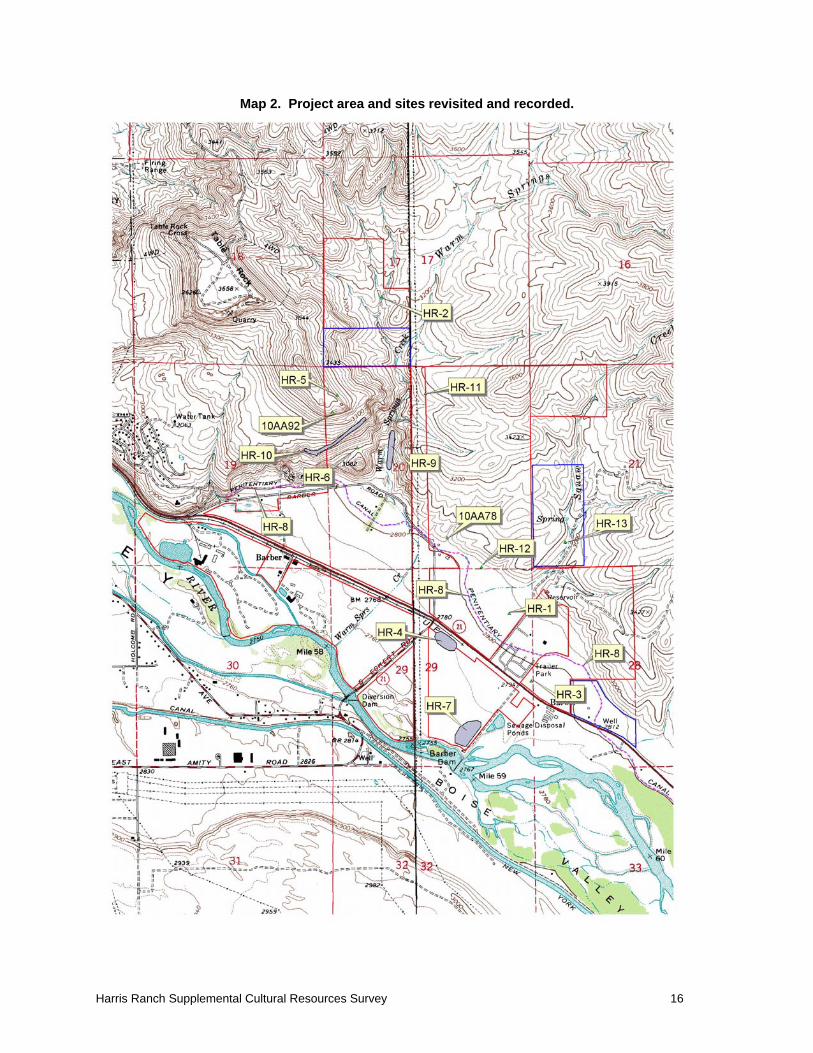
Map 2. Project area and sites revisited and recorded.
Harris Ranch Supplemental Cultural Resources Survey 16
Attachment 1- Overview photos of the sites and survey areas.
Harris Ranch Supplemental Cultural Resources Survey 17

Attachment 2 – Table of Archaeological Sites in Project Area
Harris Ranch Supplemental Cultural Resources Survey 18
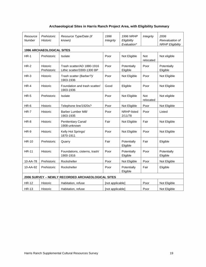
Archaeological Sites in Harris Ranch Project Area, with Eligibility Summary
Resource Number
Prehistoric Historic
Resource Type/Date (if known)
1996 Integrity
1996 NRHP Eligibility Evaluation*
Integrity 2006 Reevaluation of NRHP Eligibility
1996 ARCHAEOLOGICAL SITES
HR-1 Prehistoric Isolate Poor Not Eligible Not relocated
Not eligible
HR-2 Historic Prehistoric
Trash scatter/AD 1880-1916 Lithic scatter/3300-1300 BP
Poor Potentially Eligible
Poor Potentially Eligible
HR-3 Historic Trash scatter (Barber?)/ 1903-1936
Poor Not Eligible Poor Not Eligible
HR-4 Historic Foundation and trash scatter/ 1903-1936
Good Eligible Poor Not Eligible
HR-5 Prehistoric Isolate Poor Not Eligible Not relocated
Not eligible
HR-6 Historic Telephone line/1920s? Poor Not Eligible Poor Not Eligible
HR-7 Historic Barber Lumber Mill/ 1903-1935
Poor NRHP-listed 2/11/78
Poor Listed
HR-8 Historic Penitentiary Canal/ 1908-unknown
Fair Not Eligible Fair Not Eligible
HR-9 Historic Kelly Hot Springs/ 1870-1911
Poor Not Eligible Poor Not Eligible
HR-10 Prehistoric Quarry Fair Potentially Eligible
Fair Eligible
HR-11 Historic Foundations, cisterns, trash/ 1900-1916
Poor Potentially Eligible
Poor Potentially Eligible
10-AA-78 Prehistoric Rockshelter Poor Not Eligible Poor Not Eligible
10-AA-92 Prehistoric Rockshelter Poor Potentially Eligible
Fair Eligible
2006 SURVEY – NEWLY RECORDED ARCHAEOLOGICAL SITES
HR-12 Historic Habitation, refuse [not applicable] Poor Not Eligible
HR-13 Historic Habitation, refuse [not applicable] Poor Not Eligible
Harris Ranch Supplemental Cultural Resources Survey 19
Harris Ranch Supplemental Cultural Resources Survey 2006
Photo 1. 10 AA 78, Rockshelter Mouth, View to NW
Photo 2. 10 AA 92 Rockshelter Mouth, View to SW
Harris Ranch Supplemental Cultural Resources Survey 2006
Photo 3. HR-4, View of disturbance and SE portion of Site Area, View to SW
Photo 4. HR-6, Power Pole and Cross Piece at Base of the Outcrop Rim of HR-10,
View to E
Harris Ranch Supplemental Cultural Resources Survey 2006
Photo 5. HR-9 View Down Warm Springs Creek Toward General Area of Site,
View to S
Photo 6. HR-10, view along Rim Rock, North End of Site, View to East
Harris Ranch Supplemental Cultural Resources Survey 2006
Photo 7. HR-12 Broken Concrete, View to NW
Photo 8. HR-13, From South End, View to N.
Harris Ranch Supplemental Cultural Resources Survey 2006
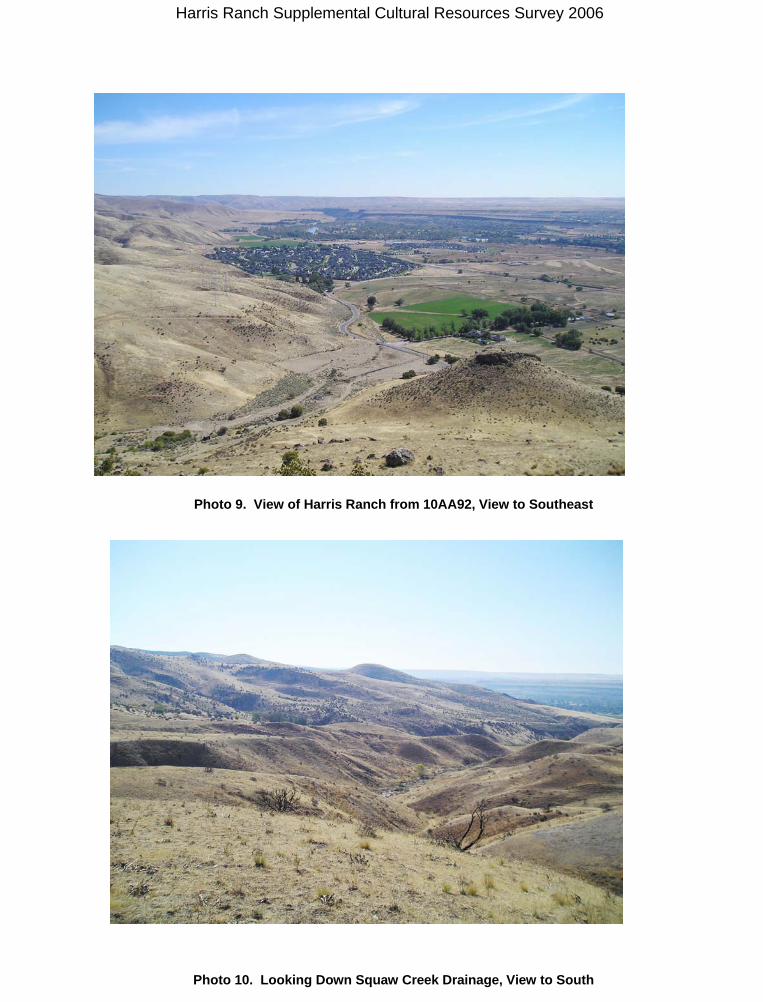
Photo 9. View of Harris Ranch from 10AA92, View to Southeast
Photo 10. Looking Down Squaw Creek Drainage, View to South