Embed Size (px)
Citation preview

Has
EO
foun
d its
cus
tom
ers?
Global Vegetation Monitoring Unit
GLC2000 Land Cover Classification
Has
EO
foun
d its
cus
tom
ers?
Global Vegetation Monitoring Unit
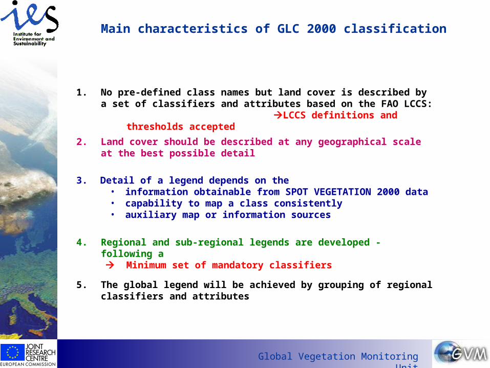
Main characteristics of GLC 2000 classification
1. No pre-defined class names but land cover is described by a set of classifiers and attributes based on the FAO LCCS:
LCCS definitions and thresholds accepted
4. Regional and sub-regional legends are developed - following a Minimum set of mandatory classifiers
3. Detail of a legend depends on the • information obtainable from SPOT VEGETATION 2000 data • capability to map a class consistently• auxiliary map or information sources
5. The global legend will be achieved by grouping of regional classifiers and attributes
2. Land cover should be described at any geographical scale at the best possible detail

Has
EO
foun
d its
cus
tom
ers?
Global Vegetation Monitoring Unit
Rationale for the approach
regional or sub-regional maps can be produced with detailed legend
legends can be formed according to user needs and purpose
no need to force a regional land cover in a predefined global class name
links possible to the national and local data, if all coded with LCCS
follow a standardized classification approach
enlarge the potential applications and user group
address different geographical scale
Requirement : • mandatory minimum set of land cover classifiers to be followed
in order to achieve a uniform and consistent global map
Has
EO
foun
d its
cus
tom
ers?
Global Vegetation Monitoring Unit
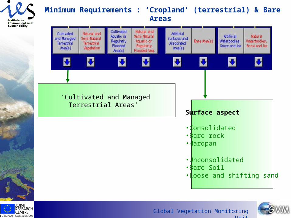
Minimum Requirements : ‘Cropland’ (terrestrial) & Bare Areas
‘Cultivated and Managed Terrestrial Areas’
Surface aspect
•Consolidated•Bare rock•Hardpan
•Unconsolidated•Bare Soil•Loose and shifting sand
Has
EO
foun
d its
cus
tom
ers?
Global Vegetation Monitoring Unit
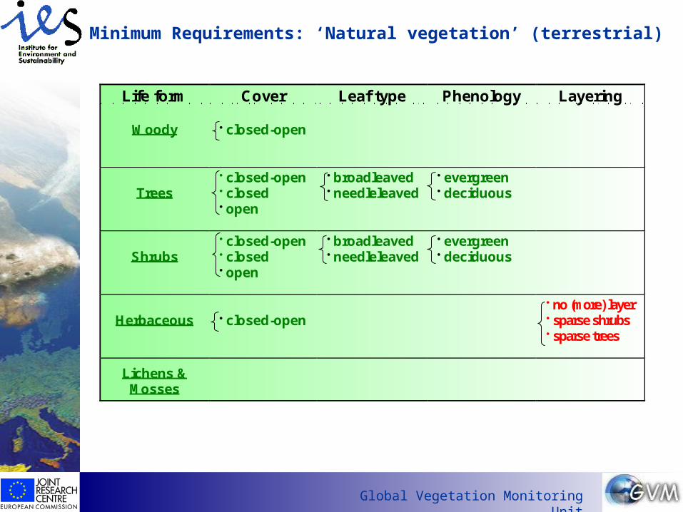
Life form Cover Leaf type Phenology Layering
Woody closed-open
Trees closed-open closed open
broadleaved needleleaved
evergreen deciduous
Shrubs closed-open closed open
broadleaved needleleaved
evergreen deciduous
Herbaceous closed-open no (more) layer sparse shrubs sparse trees
Lichens &Mosses
Minimum Requirements: ‘Natural vegetation’ (terrestrial)
Has
EO
foun
d its
cus
tom
ers?
Global Vegetation Monitoring Unit
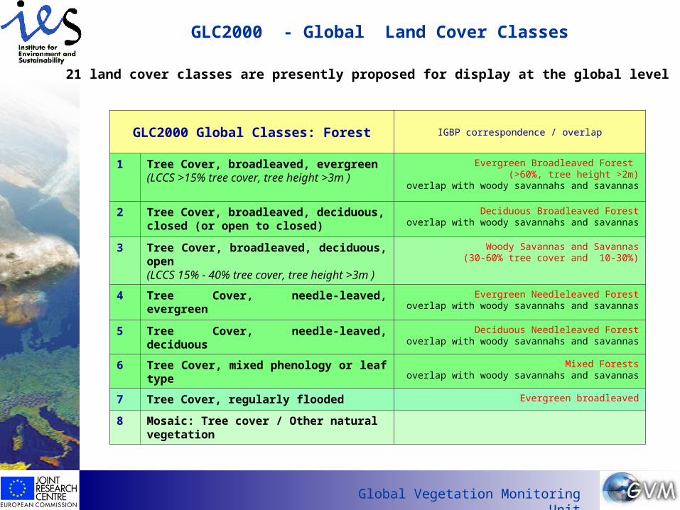
GLC2000 - Global Land Cover Classes
GLC2000 Global Classes: Forest IGBP correspondence / overlap
1 Tree Cover, broadleaved, evergreen(LCCS >15% tree cover, tree height >3m )
Evergreen Broadleaved Forest (>60%, tree height >2m)
overlap with woody savannahs and savannas
2 Tree Cover, broadleaved, deciduous, closed (or open to closed)
Deciduous Broadleaved Forestoverlap with woody savannahs and savannas
3 Tree Cover, broadleaved, deciduous, open(LCCS 15% - 40% tree cover, tree height >3m )
Woody Savannas and Savannas(30-60% tree cover and 10-30%)
4 Tree Cover, needle-leaved, evergreen Evergreen Needleleaved Forestoverlap with woody savannahs and savannas
5 Tree Cover, needle-leaved, deciduous Deciduous Needleleaved Forestoverlap with woody savannahs and savannas
6 Tree Cover, mixed phenology or leaf type Mixed Forestsoverlap with woody savannahs and savannas
7 Tree Cover, regularly flooded Evergreen broadleaved
8 Mosaic: Tree cover / Other natural vegetation
21 land cover classes are presently proposed for display at the global level

Has
EO
foun
d its
cus
tom
ers?
Global Vegetation Monitoring Unit
GLC2000 - Global Land Cover Classes: Non-forest
GLC2000 Global Classes: Non-Forest IGBP correspondence /overlap
9 Shrub Cover, closed-open, evergreen(with or without sparse tree layer)
Shrubland- Open- closed
10 Shrub Cover, closed-open, deciduous (with or without sparse tree layer)
Savannas
11 Herbaceous Cover, closed-open Grasslands
12 Sparse Herbaceous or sparse shrub cover
13 Lichens & Mosses
14 Regularly flooded shrub and/or herbaceous cover
Persistent Wetlands
15 Cultivated and managed areas Croplands
16 Mosaic: Cropland / Tree Cover Cropland / Other Vegetation Mosaic
17 Mosaic: Cropland / Other natural vegetation / Tree cover
18 Bare Areas Barren or sparsely vegetated
19 Water Bodies (natural & artificial) Water
20 Snow and Ice (natural & artificial) Snow & Ice
21 Artificial surfaces and associated areas Urban and built-up areas

Has
EO
foun
d its
cus
tom
ers?
Global Vegetation Monitoring Unit
Example of aggregating regional classes to global legend: South-AsiaGlobal Classes Sub-regional Classes
Example: South Asia
Tree Cover, broadleaved, evergreen 1. Tropical Evergreen; 2. Subtropical Evergreen;3. Temperate Evergreen; 4. Semi evergreen; 5. Junipers;
Tree Cover, broadleaved, deciduous, closed 1. Tropical Moist deciduous; 2. Tropical Dry Deciduous;
Tree Cover, broadleaved, deciduous, open 1. Northern Tropical Thorn Forest; 2. Southern Tropical Thorn Forest;
Tree Cover, needle-leaved, evergreen Temperate Conifer Forest;
Tree cover, needle-leaved, deciduous Subtropical Conifer Forest;
Tree Cover Regularly flooded Mangrove & Swamp Forest;
Shrub Cover, closed-open, deciduous Thorn Scrub/ Desert
Herbaceous cover, closed-open 1. Slope Grassland; 2. Plain Grassland;3. Desert Grassland; 4. Alpine Meadow;
Herbaceous Cover, closed-open with sparse trees Savannah;
Sparse Herbaceous or Sparse Shrub Cover 1.Rangeland; 2.Sparse Vegetation;
Cultivated and Managed Areas 1. Coastal Vegetation; 2. Rain fed Agriculture;3. Irrigated Agriculture; 4. Intensive Agriculture;5. Flood Plains; 6. Current Jhum;
Mosaic: Tree Cover/ Other Natural Vegetation Abandoned Jhum (Shifting Cultivation)
Bare Areas 1. Bare Rock; 2. Barren; 3. Desert;
Water Bodies (Artificial and Natural) 1. Water Bodies; 2. Swamp; 3. Salt Pans;
Snow and Ice (Natural and Artificial) Snow;
Has
EO
foun
d its
cus
tom
ers?
Global Vegetation Monitoring Unit
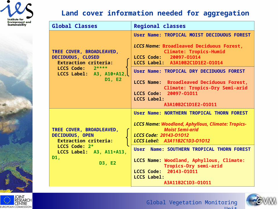
Land cover information needed for aggregation
Global Classes Regional classes
TREE COVER, BROADLEAVED, DECIDUOUS, CLOSED
Extraction criteria:LCCS Code: 2****LCCS Label: A3, A10+A12,
D1, E2
User Name: TROPICAL MOIST DECIDUOUS FOREST
LCCS Name: Broadleaved Deciduous Forest, Climate: Tropics-Humid
LCCS Code: 20097-O1O14LCCS Label: A3A10B2C1D1E2-O1O14
User Name: TROPICAL DRY DECIDUOUS FOREST
LCCS Name: Broadleaved Deciduous Forest, Climate: Tropics-Dry Semi-arid
LCCS Code: 20097-O1O11LCCS Label: A3A10B2C1D1E2-O1O11
TREE COVER, BROADLEAVED, DECIDUOUS, OPEN
Extraction criteria:LCCS Code: 2*LCCS Label: A3, A11+A13, D1, D3, E2
User Name: NORTHERN TROPICAL THORN FOREST
LCCS Name: Woodland, Aphyllous, Climate: Tropics-Moist Semi-arid
LCCS Code: 20143-O1O12LCCS Label: A3A11B2C1D3-O1O12
User Name: SOUTHERN TROPICAL THORN FOREST
LCCS Name: Woodland, Aphyllous, Climate: Tropics-Dry semi-arid
LCCS Code: 20143-O1O11LCCS Label: A3A11B2C1D3-O1O11

Has
EO
foun
d its
cus
tom
ers?
Global Vegetation Monitoring Unit
Issues to be decided
Proposal: Display at the global level the two classes for broadleaved deciduous tree cover
a) closed: >>> forest typeb) open: >>>> open forests & woodland formations
Rationale: display large tropical and sub-tropical dry forest-woodland formations in Africa, SE-Asia & S-America separate from the mainly closed temperate and boreal deciduous forests
• some Mediterranean forests would be in the open class• the open boreal coniferous and mixed forests are not concerned by
this separation.
Has
EO
foun
d its
cus
tom
ers?
Global Vegetation Monitoring Unit
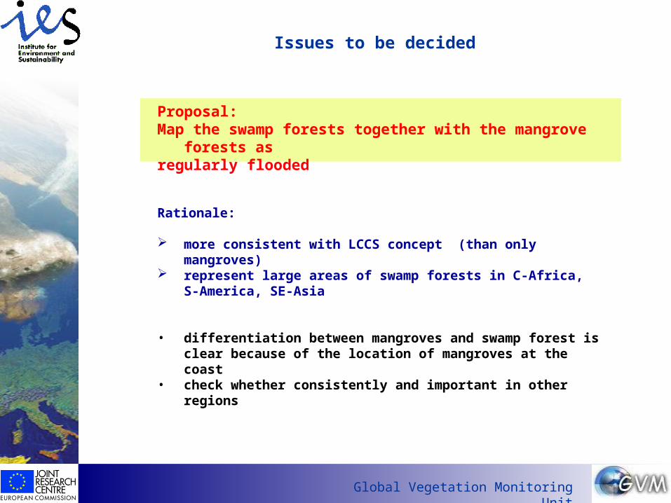
Issues to be decided
Proposal: Map the swamp forests together with the mangrove forests as regularly flooded
Rationale:
more consistent with LCCS concept (than only mangroves) represent large areas of swamp forests in C-Africa, S-America, SE-
Asia
• differentiation between mangroves and swamp forest is clear because of the location of mangroves at the coast
• check whether consistently and important in other regions

Has
EO
foun
d its
cus
tom
ers?
Global Vegetation Monitoring Unit
Issues to be decided
Map burnt areas as a separate class
Rationale: No decision can be made on whether to assign these areas in the boreal or
humid tropical zone to trees, shrubs, grass or mixtures
Proposal:
I. Burning is an annual and regular process• Map burnt areas along with the non-burnt class:
burnt savannah (herbaceous cover) remains herbaceous cover
II. Burning is a single event or occurring in long intervals If post-fire vegetation unknown > assign to shrub or sparse vegetation introduce a class ‘natural vegetation, burnt’?

Has
EO
foun
d its
cus
tom
ers?
Global Vegetation Monitoring Unit
Issues to be decided
Proposal: Make a difference between natural grassland and pasture at the global level?

Has
EO
foun
d its
cus
tom
ers?
Global Vegetation Monitoring Unit
Issues to be decided
Mosaics: Are the present mosaic classes appropriate?
Mosaic Tree cover & other natural vegetationMosaic Cropland & Tree coverMosaic Cropland & Other natural vegetation & Trees
Has
EO
foun
d its
cus
tom
ers?
Global Vegetation Monitoring Unit
Issues to be decided
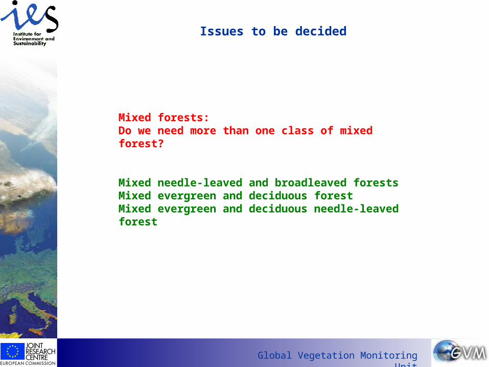
Mixed forests: Do we need more than one class of mixed forest?
Mixed needle-leaved and broadleaved forestsMixed evergreen and deciduous forestMixed evergreen and deciduous needle-leaved forest
Has
EO
foun
d its
cus
tom
ers?
Global Vegetation Monitoring Unit
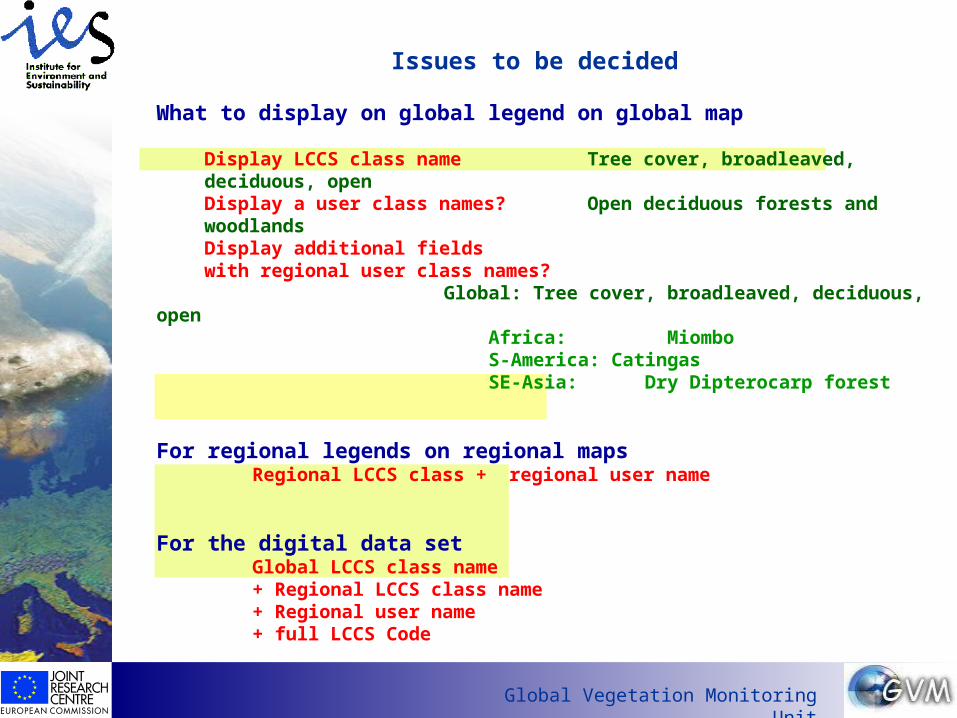
Issues to be decided
What to display on global legend on global map
Display LCCS class name Tree cover, broadleaved, deciduous, openDisplay a user class names? Open deciduous forests and woodlandsDisplay additional fields with regional user class names?
Global: Tree cover, broadleaved, deciduous, open Africa: Miombo S-America: Catingas SE-Asia: Dry Dipterocarp forest
For regional legends on regional mapsRegional LCCS class + regional user name
For the digital data setGlobal LCCS class name + Regional LCCS class name + Regional user name + full LCCS Code

Has
EO
foun
d its
cus
tom
ers?
Global Vegetation Monitoring Unit
The End…