Embed Size (px)
Citation preview
Offshore Special Area of Conservation: Hatton Bank
SAC Selection Assessment
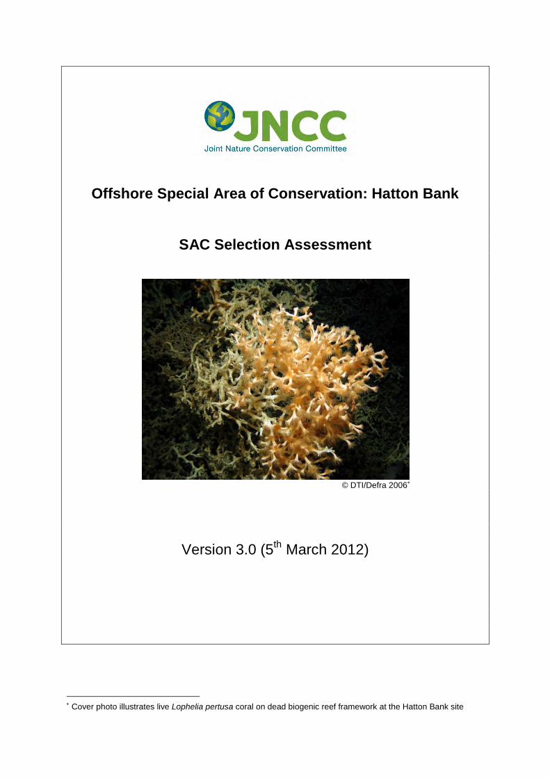
© DTI/Defra 2006∗
Version 3.0 (5th March 2012)
∗ Cover photo illustrates live Lophelia pertusa coral on dead biogenic reef framework at the Hatton Bank site
Introduction This document provides detailed information about the Hatton Bank site and evaluates its interest features according to the Habitats Directive selection criteria and guiding principles. The advice contained within this document is produced to fulfil requirements of JNCC under Part 2 of the Offshore Marine Conservation (Natural Habitats, & c.) Regulations 2007 (as amended in 2010), relating to the conservation of natural habitat types and habitats of species through identification of Special Areas of Conservation (SACs) in UK offshore waters. Under these Regulations, JNCC has an obligation to provide certain advice to the Scottish Government to enable Ministers and Competent Authorities to fulfil their obligations under the Regulations. This document includes information required under Regulation 7 of the Offshore Marine Conservation (Natural Habitats, & c.) Regulations 2007 (as amended in 2010), to enable the Secretary of State to transmit to the European Commission the list of sites eligible for designation as Special Areas of Conservation (SACs). JNCC have been asked by the Scottish Government to provide this information. Sites eligible for designation as offshore marine SACs are selected on the basis of the criteria set out in Annex III (Stage 1) to the Habitats Directive and relevant scientific information. Sites are considered only if they host a Habitats Directive Annex I habitat or Annex II species. Moreover, sites for Annex II species that are highly mobile must contain a clearly identifiable area that presents physical and biological factors essential to these species’ life and reproduction in order to be eligible. Socio-economic factors are not taken into account in the identification of sites to be proposed to the European Commission. In addition to information on the Annex I habitats and/or Annex II species hosted within the site, this document contains i) a chart of the site, ii) its name, location and extent, and iii) the data resulting from application of the criteria specified in Annex III (Stage 1) to the Habitats Directive. This is in line with legal requirements outlined under Regulation 7. JNCC has adhered to the format established by the Commission for providing site information. This format is set out in the ‘Natura 2000 Standard data form’ (CEC, 1995) (prepared by the European Topic Centre for Biodiversity and Nature Conservation on behalf of the European Commission to collect standardised information on SACs throughout Europe).
Hatton Bank SAC Selection Assessment: Version 3.0 Page 3 of 29 05/03/2012 jncc.defra.gov.uk
Document version control Version and issue date Amendments made Issued to and date HattonBank_SelectionAssessment_3.0.doc (05/03/2012)
Updated to Possible SAC throughout Public Consultation
HattonBank_SelectionAssessment_2.0.doc (12/12/2011)
Updated to draft SAC throughout Scottish Government
HattonBank_SelectionAssessment_1.2.doc (November 2011)
Contact details updated, references updated, dates updated, Annex III selection criteria updated, site map updated, Figures 1-5 and appendix II updated with new reef data.
N/A
HattonBank_SelectionAssessment_1.1.doc (April 2009)
Lower resolution multibeam data from Spanish IEO ECOVUL/ARPA survey (2005-2007) added to data maps (Figure 2 and Appendix II).
N/A
HattonBank_SelectionAssessment_1.0.doc (January 2009)
UK Annex I reef resource figures updated
UK Marine Biodiversity Policy Steering Group (January 2009)
HattonBank_SelectionAssessment_0.5.doc (Sept 2008)
Comments from AR, PP and VB-S incorporated New site map (finalised coordinates, site area and centroid), fishing closure boundary comparison maps (2), survey maps (4) Spanish IEO survey data incorporated
JNCC Committee (December 2008)
Further information This document is available as a pdf file on JNCC’s website for download if required (jncc.defra.gov.uk). Please return comments or queries to: Marine Protected Sites Team Joint Nature Conservation Committee Monkstone House Peterborough Cambs PE1 1JY Email: [email protected] Tel: +44 (0)1733 866833 Fax: +44 (0)1733 555948 Website: jncc.defra.gov.uk/marineprotectedareas
Hatton Bank SAC Selection Assessment: Version 3.0 Page 4 of 29 05/03/2012 jncc.defra.gov.uk
Hatton Bank: SAC Selection Assessment
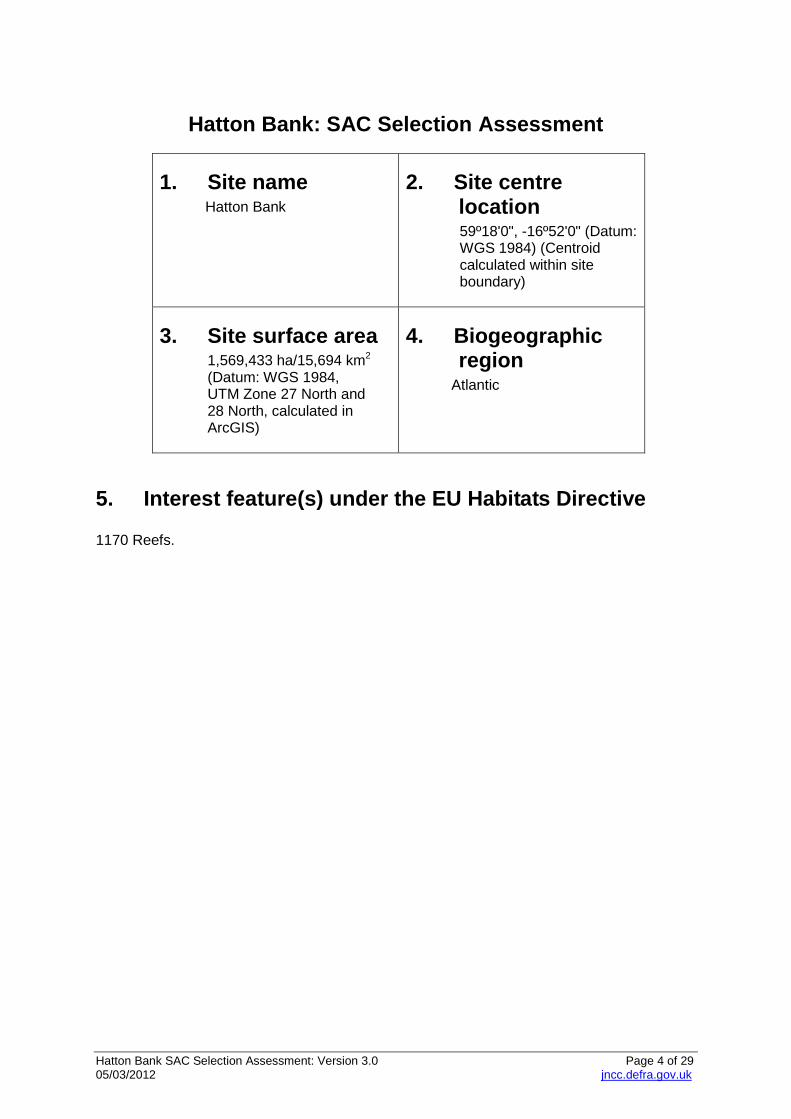
1. Site name Hatton Bank
2. Site centre location
59º18'0", -16º52'0" (Datum: WGS 1984) (Centroid calculated within site boundary)
3. Site surface area 1,569,433 ha/15,694 km2
(Datum: WGS 1984, UTM Zone 27 North and 28 North, calculated in ArcGIS)
4. Biogeographic region
Atlantic
5. Interest feature(s) under the EU Habitats Directive 1170 Reefs.
Hatton Bank SAC Selection Assessment: Version 3.0 Page 5 of 29 05/03/2012 jncc.defra.gov.uk
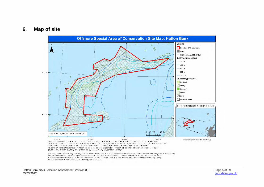
6. Map of site
Hatton Bank SAC Selection Assessment: Version 3.0 Page 6 of 29 05/03/2012 jncc.defra.gov.uk
7. Site summary Hatton Bank is a large volcanic bank, situated in the Atlantic North-West Approaches, towards the western extent of the UK Continental Shelf. It is an elongate, arc-shaped bank, stretching nearly 500km in length, and forming a submerged topographic high rising from the surrounding deep water. The water depth across the bank ranges from less than 500m on the northern part of the bank, to over 1000m at the base (Durán Muñoz et al, 2008). At the south-eastern tip of the bank, an igneous complex called Lyonesse forms a topographic high, rising to 520m below sea level, some 350m shallower than the surrounding bank (Hitchen et al, 2001; Howell et al, 2007). The vast size and topographic complexity of the Hatton Bank supports a wide diversity of biological communities, each associated with different geomorphological structures and substratum types (Howell et al, 2007). Much of the seabed on Hatton Bank comprises coarse sandy sediment; however the bank also supports extensive areas of Annex I bedrock reef (particularly on the ridges along the top of the bank), as well as many areas of Annex I stony reef. Iceberg ploughmarks, a variant of stony reef, shaped by the movement of icebergs during the last ice age, have been recorded at this site. The hard substrata provided by the boulders, cobbles and bedrock reef at the site support a rich diversity of epifauna, including scleractinian corals, stylasterids (‘lace’ corals), antipatharians (‘black’ corals), soft corals, cup corals and gorgonian sea fans; a range of sponges, including glass sponges; sessile sea cucumbers; anemones and brachiopods (Howell et al 2007). Also present are elaborate cold water coral reefs, frequently associated with topographically distinct features, including pinnacles and mounds tens of metres in height and hundreds of metres in width (Howell et al, 2007) (See Figure 6). Their intricate structure is formed by both Lophelia pertusa and Madrepora oculata species, which in association with the surrounding dead coral framework, support a range of associated fauna, including soft corals, scleractinian corals, antipatharians, and bamboo corals; encrusting sponges; ascidians (sea squirts); bryozoans; and a range of feather stars; basket stars and sea stars (Narayanaswamy et al, 2006; Howell et al, 2007). These biogenic reefs have also been found primarily in the southern region (including Lyonesse) and across the north-west Hatton Bank outcrops (Durán Muñoz et al, 2008). Hatton Bank occurs within the Atlantic North-West Approaches Regional Sea (JNCC, 2004; Defra, 2004); no other sites have as yet been recommended to Defra for designation in this biogeographic area. Within the adjacent Regional Sea (Rockall Trough and Bank) the Darwin Mounds cSAC/SCI supports Lophelia pertusa reefs which also occur at the Hatton Bank site; however, the biogenic reefs at the Darwin Mounds have developed on a sandy mound substratum which has a distinctive structure, unrecorded elsewhere in the UK. Additionally, Hatton Bank and the Darwin Mounds are subject to different oceanographic influences due to both their differing physical structure and the distance between the two sites (around 400km). Furthermore, the Hatton Bank site contains areas of stony and bedrock reef which sustain different biological communities to those found at the Darwin Mounds. Also within the Rockall Trough and Bank Regional Sea, the North West Rockall Bank cSAC has been recommended to Defra for its biogenic Lophelia pertusa reef and stony reef. This candidate SAC was subject to public consultation in 2009 and submitted to the Europe commission in 2010. East Rockall Bank pSAC and Anton Dohrn seamount pSAC are also recommended by JNCC to Defra for their Annex I reef (biogenic, stony and bedrock). On account of their geographic location, the Hatton Bank reefs are influenced by different water
Hatton Bank SAC Selection Assessment: Version 3.0 Page 7 of 29 05/03/2012 jncc.defra.gov.uk
masses, and therefore the biological communities can be expected to be significantly different to those on Rockall, and to the seamount communities found on Anton Dohrn. More detailed site descriptions are presented below: SAC Notable characteristics of Reef interest feature Darwin Mounds cSAC/SCI
Cold water coral reefs composed principally of the scleractinian coral, L. pertusa growing on (hundreds of) cone-shaped sandy mounds at a depth of approximately 1000m. The site covers an area of around 100 km². There are two main ‘dense’ fields referred to as Darwin Mounds East and Darwin Mounds West. The corals provide a habitat for various species of larger invertebrates such as sponges and brisingiids. The mounds support significant populations of the xenophyophore, Syringammina fragilissima
North West Rockall Bank cSAC/pSCI
Iceberg ploughmarks containing cobbles and boulders provide Annex I stony reef habitat. Associated biological communities include Reteporella sp., Caryophyllia sp., serpulid worms and a large variety of sponge species. Interspersed with the stony reef, Annex I biogenic reef occurs as L. pertusa reef. Associated species include erect sponges, C. cidaris and stands of M. oculata. Cobble rubble surrounds the living reefs in many places, and supports fauna such as the squat lobster, Munida rugosa, the holothurian, Stichopus tremulus, ophiuroids and encrusting yellow sponges.
East Rockall Bank pSAC
Bedrock, stony and cold water coral biogenic reef in the deep circalittoral to bathyal zone. Bedrock and stony reef supports assemblages of stylasterid lace corals and lobose sponges. Parasitic cones in the north of the site support sediment in-filled dead L. pertusa framework and live cold water coral reef, with antipatharians and gorgonians. Two canyon features cut into the flanks of the site and these are characterised by xenophyophores and decapod shrimps, with one canyon also supporting an abundance of caryophyllid corals and sea pens.
Anton Dohrn Seamount pSAC
Hard bedrock reef of low topographic complexity, stony reef, and biogenic Lophelia pertusa reef in the deep circalittoral to bathyal zone (~500-1000m). Bedrock and boulder reef habitat on the seamount flanks support assemblages of holothurians, brittlestars, encrusting sponges, caryophyllid corals and lamellate sponges. Bedrock reef on parasitic cones and radial ridges supports relatively dense aggregations of gorgonians, antipatharians, Lophelia pertusa and soft corals. Biogenic reef is formed by live Lophelia pertusa reef and sediment in-filled dead L. pertusa frameworks.
Hatton Bank SAC Selection Assessment: Version 3.0 Page 8 of 29 05/03/2012 jncc.defra.gov.uk
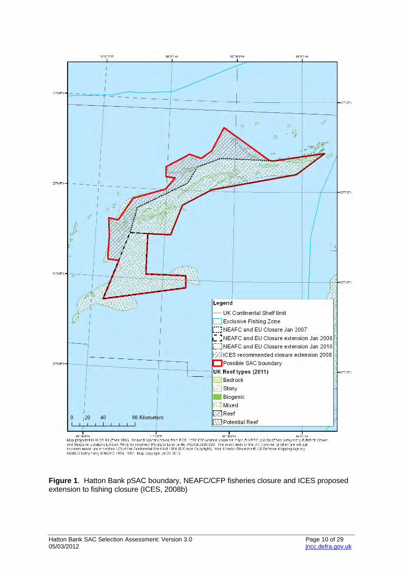
8. Site boundary The Hatton Bank proposed SAC boundary is based on best available information as at November 2011. Due to the size of the Hatton Bank formations and the limited number of scientific surveys undertaken in this area, survey data is not comprehensive across the entire Hatton Bank area; however, there is sufficient up-to-date information with which to delineate a scientifically valid SAC boundary. JNCC has reviewed scientific literature on reef distribution on Hatton Bank, which included historical records of cold water coral presence (Lophelia pertusa and Madrepora oculata) (cited in ICES, 2007a) as well as geomorphological and biological data gathered during surveys by: i DTI Strategic Environmental Assessment in Region 7 (SEA 7) in 2005 and 2006
(Narayanaswamy et al, 2006; Howell et al, 2007) and ii The Spanish Instituto Español de Oceanografía (IEO) during the 2005-2007
ECOVUL/ARPA interdisciplinary research project on Hatton Bank (Durán Muñoz et al, 2008).
Data on Spanish demersal fishing activity provided by the Observer Program of the Spanish Institute of Oceanography (IEO) has been published by ICES (Durán Muñoz et al, 2007 cited in ICES, 2007a) (see Appendix I). This information is taken to indicate where presence of biogenic reef is unlikely or any pre-existing cold water corals are likely to have been destroyed1. The combination of geomorphological, biological and fisheries data (described in more detail in Sections 11 and 12) has provided a sufficiently robust basis for identifying likely locations of Annex I biogenic, stony and bedrock reef. The proposed SAC boundary incorporates all known intact Annex I cold water coral reefs on Hatton Bank, as well as extensive areas of Annex I stony reef and bedrock reef2. In 2007, the North East Atlantic Fisheries Commission and EU Common Fisheries Policy closed part of Hatton Bank to bottom trawling and fishing with static gear, including bottom set gill-nets and longlines (NEAFC Recommendation IX- 2007; EC Regulation No 41/2006) in order to protect vulnerable marine ecosystems (particularly cold water corals) from disturbance. The boundary of this closed area was extended southwards and south-eastwards in 2008 (NEAFC Recommendation IX-2008; EC Regulation No 40/2008), as advised by ICES in 2007 (ICES, 2007b) (see Figure 1). In 2008, the ICES-NAFO Joint Working Group on Deep Water Ecology (WGDEC) reviewed new survey data provided by 2005-2007 ECOVUL/ARPA interdisciplinary research project (Durán Muñoz et al, 2008) which found evidence of Lophelia pertusa biogenic reefs and bedrock reefs on the north-western part of Hatton Bank, outside the existing fishing closure (ICES 2008a) (see Appendix II for more detail). In response to these findings, ICES formally advised an extension to the existing fishing closure (ICES, 2008b), as illustrated in Figure 1. 1 By combining demersal fishing effort and seabed survey data along the western edge of Hatton Bank, Durán Muñoz et al. (2008) highlighted that Spanish demersal fishing grounds were preferentially positioned over the deeper soft sediment deposits around the slopes of the bank (>1000m depth) rather than on shallower bedrock or biogenic reef substrata. 2 The ‘potential bedrock reef’ layer shown in the maps in this document has been derived from a combination of British Geological Survey seabed map data and survey data on Hatton Bank referenced herein. As the BGS seabed maps have a coarse resolution at this distance from the coast, on their own they can not be accurately relied on to provide the full extent of reef features.
Hatton Bank SAC Selection Assessment: Version 3.0 Page 9 of 29 05/03/2012 jncc.defra.gov.uk
Following a consultation in 2009, NEAFC and the EU widened the Hatton Bank closure north-westwards in line with the ICES 2008 recommendation. This became formalised in January 2010, with the fishing closure now in force until 31 December 2012 following a further consultation in early January 2011 and 2012 (NEAFC Recommendation XIV, 2011; EC Regulation 1288/2009; and NEAFC Recommendation VIII, 2012). The Hatton Bank proposed SAC boundary extends north-west in parallel with the most recent advice on vulnerable marine ecosystem protection from ICES (see Figure 1). The resultant boundary is a relatively simple polygon, defined by degrees, minutes and seconds. The boundary adheres to the revised JNCC guidance on defining site boundaries for SACs away from the coast (JNCC, 2008b), adjusted in light of representations made to JNCC’s ‘Consultation on the first seven possible offshore Special Areas of Conservation (SACs)’ (JNCC, 2008a). JNCC’s SAC boundary guidelines have always stated that where interest features are at risk from bottom trawling, a margin should be included in the proposed boundary to ensure their protection (JNCC, 2008b). The majority of the site (and all known occurrences of Annex I reef) are within the 1000m bathymetric contour. Fishing vessels which are bottom trawling in the region need a minimum towline length of twice the depth of water in which they are fishing (SERAD, 2001). Therefore, assuming a ratio of 2:1 fishing warp length to depth, a margin of 2000m from the reefs should be incorporated within the SAC boundary. A margin of at least 2km in diameter is already included along most of the perimeter of the boundary, although there are a small number of points where reef has been recorded within less than 2km of the boundary. Given that the vast majority of Annex I reef records on Hatton Bank are well within the 2km margin, a modification of the SAC boundary which is inconsistent with the closure proposed by ICES is not recommended by JNCC. However, it is important to clarify that the proposed boundary is for the SAC. Any further management measures which may be required under the Offshore Marine Conservation (Natural Habitats, & c.) Regulations 2007 will be determined by Competent Authorities in consultation with JNCC, and may require different boundaries to the SAC site boundary.
Hatton Bank SAC Selection Assessment: Version 3.0 Page 10 of 29 05/03/2012 jncc.defra.gov.uk
Figure 1. Hatton Bank pSAC boundary, NEAFC/CFP fisheries closure and ICES proposed extension to fishing closure (ICES, 2008b)
Hatton Bank SAC Selection Assessment: Version 3.0 Page 11 of 29 05/03/2012 jncc.defra.gov.uk
9. Assessment of interest feature(s) against selection criteria
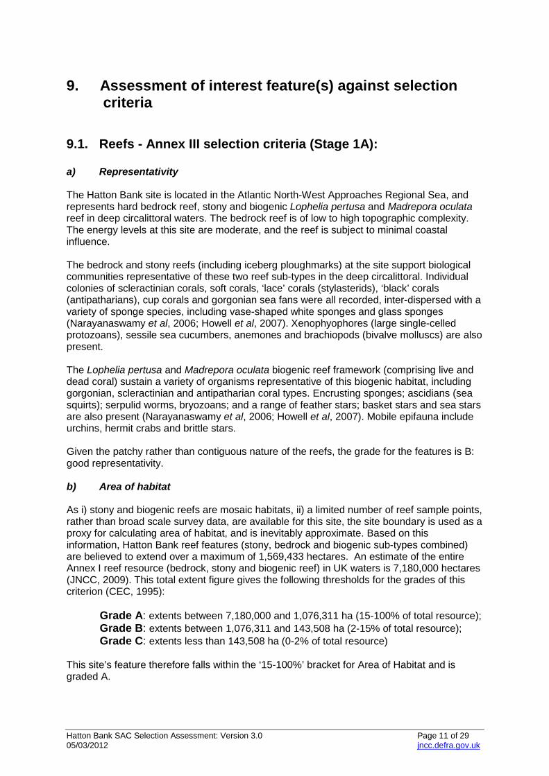
9.1. Reefs - Annex III selection criteria (Stage 1A): a) Representativity The Hatton Bank site is located in the Atlantic North-West Approaches Regional Sea, and represents hard bedrock reef, stony and biogenic Lophelia pertusa and Madrepora oculata reef in deep circalittoral waters. The bedrock reef is of low to high topographic complexity. The energy levels at this site are moderate, and the reef is subject to minimal coastal influence. The bedrock and stony reefs (including iceberg ploughmarks) at the site support biological communities representative of these two reef sub-types in the deep circalittoral. Individual colonies of scleractinian corals, soft corals, ‘lace’ corals (stylasterids), ‘black’ corals (antipatharians), cup corals and gorgonian sea fans were all recorded, inter-dispersed with a variety of sponge species, including vase-shaped white sponges and glass sponges (Narayanaswamy et al, 2006; Howell et al, 2007). Xenophyophores (large single-celled protozoans), sessile sea cucumbers, anemones and brachiopods (bivalve molluscs) are also present. The Lophelia pertusa and Madrepora oculata biogenic reef framework (comprising live and dead coral) sustain a variety of organisms representative of this biogenic habitat, including gorgonian, scleractinian and antipatharian coral types. Encrusting sponges; ascidians (sea squirts); serpulid worms, bryozoans; and a range of feather stars; basket stars and sea stars are also present (Narayanaswamy et al, 2006; Howell et al, 2007). Mobile epifauna include urchins, hermit crabs and brittle stars. Given the patchy rather than contiguous nature of the reefs, the grade for the features is B: good representativity. b) Area of habitat As i) stony and biogenic reefs are mosaic habitats, ii) a limited number of reef sample points, rather than broad scale survey data, are available for this site, the site boundary is used as a proxy for calculating area of habitat, and is inevitably approximate. Based on this information, Hatton Bank reef features (stony, bedrock and biogenic sub-types combined) are believed to extend over a maximum of 1,569,433 hectares. An estimate of the entire Annex I reef resource (bedrock, stony and biogenic reef) in UK waters is 7,180,000 hectares (JNCC, 2009). This total extent figure gives the following thresholds for the grades of this criterion (CEC, 1995): Grade A: extents between 7,180,000 and 1,076,311 ha (15-100% of total resource); Grade B: extents between 1,076,311 and 143,508 ha (2-15% of total resource); Grade C: extents less than 143,508 ha (0-2% of total resource) This site’s feature therefore falls within the ‘15-100%’ bracket for Area of Habitat and is graded A.
Hatton Bank SAC Selection Assessment: Version 3.0 Page 12 of 29 05/03/2012 jncc.defra.gov.uk
c) Conservation of structure and functions Degree of conservation of structure Given the extensive nature of the reefs at Hatton Bank, the conservation of their structure varies across the site. While the biological and physical structure of much of the Lophelia pertusa reef is intact, considerable areas of broken coral rubble (for example, at the north flank of the northern part of the bank) have been discovered. While fringing rubble areas are likely to be a natural part of reef habitat dynamics, very high densities of coral rubble suggest damage to a previous reef habitat rather than natural degradation. Direct evidence of human activity (trawl marks and discarded fishing gear) was also observed in the northern and southern sections of the site (Howell et al, 2007). Assuming no further damage has occurred to the features, the grading is II: structure well conserved. Degree of conservation of functions The prospects of the reefs to maintain their structure in the future, taking into account unfavourable influences and reasonable conservation effort, are good. NEAFC and the European Commission initially closed part of the Hatton Bank SAC to demersal fishing, at the recommendation of ICES (NEAFC Recommendation IX-2007; EC Regulation No 41/2006), however, this was not a permanent or comprehensive closure and covered just part of the area proposed as a SAC. The closure has subsequently been extended to enforce the same limits as those of the SAC, and is currently in force until the 31st December 2012 (NEAFC Recommendation VIII, 2012). Regulations are in place to manage oil and gas activity in and around SACs in the UK Continental Shelf Designated Area, and the laying of submarine cables and pipelines also requires regulatory consent. The site is distant from terrestrial sources of pollution. The grading is II: good prospects. Restoration possibilities Restoration methods in the offshore area focus on the removal of impacts which should allow recovery where the habitat has not been removed. Individual Lophelia pertusa colonies can develop over tens of years (Bell and Smith, 1999; Roberts, 2002), however substantial biogenic reef structures have been found to be thousands of years old (Friewald et al, 2004) and are particularly sensitive to physical damage, especially if the hard substrata on which they grow are also removed or subject to sediment deposition (Shelton, 1980; Mortensen, 2001). Similarly, the iceberg ploughmark structures would not recover from significant structural damage as these features are the outcome of long-term geological and oceanographic processes. Therefore, the grade is III: restoration difficult or impossible. Overall grade When the grade II for the first sub-criterion and grade II for the second sub-criterion are combined, the overall grade for the criterion is B: good conservation.
Hatton Bank SAC Selection Assessment: Version 3.0 Page 13 of 29 05/03/2012 jncc.defra.gov.uk
d) Global assessment The suggested grades for Stage 1A criteria a) to c) are B, A and B respectively. Given these evaluations, and taking into account the rarity of the Lophelia pertusa reef sub-type in UK waters, the Global Assessment grade is B (‘good conservation value’). Summary of scores for Stage 1a criteria
Area of habitat
Representativity (a)
Relative surface (b)
Structure and function (c)
Global assessment (d)
Hatton Bank
B A B B
9.2. Harbour porpoise (Phocoena phocoena)
a) Size and density of the population of the species present on the site Harbour porpoise (Phocoena phocoena) is found throughout the majority of UK continental shelf waters, with very few sightings off the continental shelf area (Reid et al, 2003; SCANS-II, 2008). There are no records of the species within the proposed boundaries of Hatton Bank (Evans et al, 2003; Reid et al, 2003, CODA, 2009), although survey effort in this area is very limited. Based on available information, the species is not considered a feature of the site. However, there have been some sightings to the southeast of the site and as they are highly mobile, the assessment may change if new data become available.
9.3. Bottlenose dolphin (Tursiops truncatus)
a) Size and density of the population of the species present on the site This species is found in many parts of UK waters, on the continental shelf and further offshore (Evans et al, 2003; Reid et al, 2003; SCANS-II, 2008). There are no records of bottlenose dolphin occurrences within the proposed boundary (Reid et al, 2003; CODA, 2009) therefore the species is not considered a feature of the site. However, the amount of survey effort in the area is very limited. The species has been sighted to the south of the area on the Rockall Bank (Reid et al, 2003; CODA, 2009). Additionally, dolphin click trains (potentially bottlenose dolphins) have been recorded in the vicinity of the site (CODA, 2009). Consequently, this assessment may change if new data becomes available.
9.4. Grey seals (Halichoerus grypus)
a) Size and density of the population of the species present on the site There are no records of grey seal occurrences within the proposed boundary and therefore the species is not considered a feature of the site. This assessment may be revised at a later date depending on the outcome of data analyses to be commissioned by JNCC that will enable a more detailed assessment of the importance of areas for seals at sea.
Hatton Bank SAC Selection Assessment: Version 3.0 Page 14 of 29 05/03/2012 jncc.defra.gov.uk
9.5. Harbour (common) seals (Phoca vitulina)
a) Size and density of the population of the species present on the site There are no records of harbour seal occurrences within the proposed boundary and therefore the species is not considered a feature of the site. This assessment may be revised at a later date depending on the outcome of data analyses to be commissioned by JNCC that will enable a more detailed assessment of the importance of areas for seals at sea.
10. Sites to which this site is related None
11. Supporting scientific documentation The supporting scientific documentation for Hatton Bank comes from two main survey programmes. The first is the DTI Strategic Environmental Assessment (SEA) process. The earliest survey commissioned by the DTI took place in 2005, and involved multibeam survey of the central part of Hatton Bank, followed by biological groundtruthing at 13 stations using video and still photography (Narayanaswamy et al, 2006). The second survey involved collaboration between the DTI and JNCC to achieve the aims of both the SEA process and the process of identifying and characterising areas of Annex I habitat for possible inclusion as Special Areas of Conservation (Howell et al, 2007). This survey took place in 2006, and resulted in the acquisition of multibeam data for six distinct areas of Hatton Bank, with biological groundtruthing at 42 stations (using video and still photography) of five of these areas. The high quality digital still images that resulted from both of these surveys allowed the biological communities present in the area to be characterised, and key species identified. Both DTI surveys revealed areas of bedrock, stony and biogenic reef. A second survey programme, ‘ECOVUL/ARPA’, was undertaken by Spanish Instituto Español de Oceanografía (IEO) on Hatton Bank between 2005-2007. This study focused on investigating vulnerable deep‐sea habitats between the 1000-1500 m depths on the western and north-western flanks of bank. Both multibeam survey and high resolution seismic profiles of large areas of the western flank of the bank were conducted, supported by biological survey in the form of bottom trawl, dredge and box core sampling. These recent surveys are supplemented by historic records of cold water coral occurrence on Hatton Bank, which have been collated by the ICES Working Group on Deep Water Ecology (ICES, 2005; ICES 2007a). These include records from fisheries surveys, fishing charts and more recent geological surveys.
12. Site overview and conservation interest A number of published papers document the occurrence of Lophelia pertusa corals on Hatton Bank. These have been collated and reviewed by the ICES Working Group on Deep Water Ecology (ICES, 2005; ICES, 2007a). Records include those from fishing charts, including the presence of ‘coral trees’ at 457m to 604m water depth on Hatton Bank, noted on Close’s 1939 chart (Wilson, 1979). Frederiksen et al. (1992) documented the presence of
Hatton Bank SAC Selection Assessment: Version 3.0 Page 15 of 29 05/03/2012 jncc.defra.gov.uk
a variety of corals on ridges and rough bottomed areas of Hatton Bank, including reef-building corals (Lophelia pertusa and Madrepora oculata), soft corals (Paragorgia sp.), sea fans (Paramuricea sp.), bamboo corals (Isididae) and black corals (Antipatharia). It should be noted that these records relate to the presence of Lophelia pertusa colonies, and this may not form a biogenic reef in every case. In parallel, geophysical survey of Hatton Bank in 2000 revealed features consistent with Lophelia pertusa reef (D. Long, pers. comm. cited in ICES, 2005), and further surveys identified mound-like elevations (Friewald, pers. comm. cited in ICES, 2005) from which dredge hauls brought up large quantities of coral including live Lophelia pertusa and Madrepora oculata. Video and photographic survey of Hatton Bank as part of the SEA 2005 and SEA-SAC 2006 focused predominantly on topographic features revealed by geophysical survey (for example, ridges, rock outcrops and pinnacles). As anticipated, cold water coral species, such as Lophelia pertusa and Madrepora occulata (as well as coral rubble) were often associated with these elevated features where they can access current-transported organic matter and zooplankton (Freiwald et al, 2004) (Figure 6). The 2006 SEA-SAC cruise (at the southern end of Hatton Bank) also revealed the presence of highly diverse biogenic reef on numerous pinnacles and mounds on Hatton Bank (Stewart and Davies, 2007), examples of which have never previously been recorded west of Rockall Bank. The IEO ECOVUL/ARPA survey (Durán Muñoz et al, 2008) on the north-western slope of Hatton Bank also revealed extensive areas of cold water coral occurrence associated with outcrops, ridges and mounds (Sayago‐Gil et al, 2006; Sayago‐Gil et al, 2007). Extensive multibeam data collected by the IEO along this north-western flank is presented in Figure 2. Although co-ordinates of coral records from this survey are not yet available from the IEO, the presence of Lophelia pertusa and associated communities on the north-western flanks of Hatton Bank is clearly outlined in Durán Muñoz et al. (2008). There is little known about the hydrography of Hatton Bank, or how this influences the distribution of biological communities. Three water masses have been identified at different depths at the edge of the bank (Howell et al, 2007). North Atlantic Central Water forms the upper part of the water column, a mixture of Eastern North Atlantic Water and sub-Arctic Intermediate Water occurs at intermediate depths, and deeper water (>1500m) consists of low salinity Labrador Sea Water overlying North Atlantic Deep Water (Inall and Sherwin, 2006 cited in Howell et al, 2007).
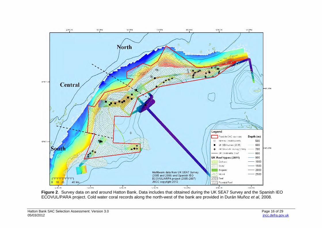
Hatton Bank SAC Selection Assessment: Version 3.0 Page 16 of 29 05/03/2012 jncc.defra.gov.uk
Figure 2. Survey data on and around Hatton Bank. Data includes that obtained during the UK SEA7 Survey and the Spanish IEO ECOVUL/PARA project. Cold water coral records along the north-west of the bank are provided in Durán Muñoz et al, 2008.
Hatton Bank SAC Selection Assessment: Version 3.0 Page 17 of 29 05/03/2012 jncc.defra.gov.uk
For the purposes of describing the site ecology in more detail (based principally on the SEA 2005, SEA-SAC 2006 and Spanish ECOVUL/ARPA data), the Hatton Bank pSAC can be divided into three regions: North, Central and South.
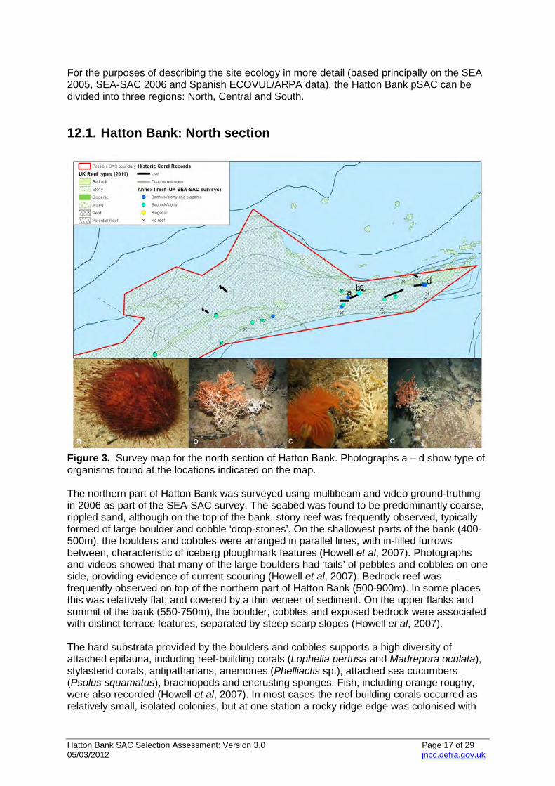
12.1. Hatton Bank: North section
Figure 3. Survey map for the north section of Hatton Bank. Photographs a – d show type of organisms found at the locations indicated on the map. The northern part of Hatton Bank was surveyed using multibeam and video ground-truthing in 2006 as part of the SEA-SAC survey. The seabed was found to be predominantly coarse, rippled sand, although on the top of the bank, stony reef was frequently observed, typically formed of large boulder and cobble ‘drop-stones’. On the shallowest parts of the bank (400-500m), the boulders and cobbles were arranged in parallel lines, with in-filled furrows between, characteristic of iceberg ploughmark features (Howell et al, 2007). Photographs and videos showed that many of the large boulders had ‘tails’ of pebbles and cobbles on one side, providing evidence of current scouring (Howell et al, 2007). Bedrock reef was frequently observed on top of the northern part of Hatton Bank (500-900m). In some places this was relatively flat, and covered by a thin veneer of sediment. On the upper flanks and summit of the bank (550-750m), the boulder, cobbles and exposed bedrock were associated with distinct terrace features, separated by steep scarp slopes (Howell et al, 2007). The hard substrata provided by the boulders and cobbles supports a high diversity of attached epifauna, including reef-building corals (Lophelia pertusa and Madrepora oculata), stylasterid corals, antipatharians, anemones (Phelliactis sp.), attached sea cucumbers (Psolus squamatus), brachiopods and encrusting sponges. Fish, including orange roughy, were also recorded (Howell et al, 2007). In most cases the reef building corals occurred as relatively small, isolated colonies, but at one station a rocky ridge edge was colonised with
Hatton Bank SAC Selection Assessment: Version 3.0 Page 18 of 29 05/03/2012 jncc.defra.gov.uk
dense corals (Lophelia pertusa, Madrepora oculata) and soft corals, forming a biogenic reef. The bedrock supports a diverse range of epifauna, similar to that found on the large boulders, including small colonies of reef-building corals (Lophelia pertusa and Madrepora occulata), stylasterid corals (Pliobothrus sp.), cup corals (Caryophyllia sp.), encrusting, cup and globose sponges, sessile sea cucumbers (Psolus squamatus), anemones (Phelliactis sp.) and brachiopods (Howell et al, 2007). On the steeper areas of bedrock, large sea fans (Callogorgia verticillata) and spiral antipatharian corals (Stichopathes sp.) were also present (Howell et al, 2007). The surrounding sandy sediment supports a range of mobile epifauna, such as urchins (Alveriosoma sp, Cidaris cidaris, Echinus acutus), sea cucumbers (Stichopus tremulus), small ophiuroids, cerianthid anemones, hermit crabs, and fish (Chimaera monstrosa, grenadiers and blue-mouth red fish [Helicolenus dactylopterus]) (Howell et al, 2007). All of the stations sampled by the SEA surveys on the north flank of the northern part of the bank (550-750m) had extensive areas of dead coral framework, in some cases associated with areas of dense coral rubble (Howell et al, 2007). Live coral colonies were also frequently observed on the tips of the dead coral, but not at sufficient densities to be form a live biogenic reef. Along the western flanks of the north part of the Bank, multibeam data collected by the IEO shows an uneven relief along the curve of the bank (Durán Muñoz et al, 2008) at around 700-1740 m depth (See Figure 2). Seismic data indicates the presence of hard outcrops on the bank (probably basalt), which are progressively covered by sediments. From benthic trawl/dredge samples within this area, IEO confirmed that these outcrops act as a suitable substratum for settlement of cold water corals: live colonial scleractinians (small colonies of Solenosmilia variabilis) and dead octocorals skeletons were found (Durán Muñoz et al, 2008). Information obtained from IEO surveys in 2005 also corroborates the evidence for coral presence within the area (Durán Muñoz et al, 2007): fishing hauls carried out in the area as part of cooperative and multidisciplinary surveys yielded live fragments of Lophelia pertusa, Madrepora oculata, gorgonians and black corals) as well as dead fragments with high associated biodiversity. These north-western outcrops areas are far from habitual fishing grounds and do not appear to have been disturbed by demersal activity (Durán Muñoz et al, 2008).
Hatton Bank SAC Selection Assessment: Version 3.0 Page 19 of 29 05/03/2012 jncc.defra.gov.uk
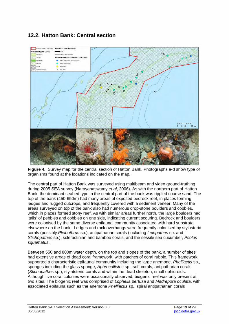
12.2. Hatton Bank: Central section
Figure 4. Survey map for the central section of Hatton Bank. Photographs a-d show type of organisms found at the locations indicated on the map. The central part of Hatton Bank was surveyed using multibeam and video ground-truthing during 2005 SEA survey (Narayanaswamy et al, 2006). As with the northern part of Hatton Bank, the dominant seabed type in the central part of the bank was rippled coarse sand. The top of the bank (450-650m) had many areas of exposed bedrock reef, in places forming ledges and rugged outcrops, and frequently covered with a sediment veneer. Many of the areas surveyed on top of the bank also had numerous drop-stone boulders and cobbles, which in places formed stony reef. As with similar areas further north, the large boulders had ‘tails’ of pebbles and cobbles on one side, indicating current scouring. Bedrock and boulders were colonised by the same diverse epifaunal community associated with hard substrata elsewhere on the bank. Ledges and rock overhangs were frequently colonised by stylasterid corals (possibly Pliobothrus sp.), antipatharian corals (including Leiopathes sp. and Stichopathes sp.), scleractinian and bamboo corals, and the sessile sea cucumber, Psolus squamatus. Between 550 and 800m water depth, on the top and slopes of the bank, a number of sites had extensive areas of dead coral framework, with patches of coral rubble. This framework supported a characteristic epifaunal community including the large anemone, Phelliactis sp., sponges including the glass sponge, Aphrocallistes sp., soft corals, antipatharian corals (Stichopathes sp.), stylatsterid corals and within the dead skeleton, small ophiuroids. Although live coral colonies were occasionally observed, biogenic reef was only present at two sites. The biogenic reef was comprised of Lophelia pertusa and Madrepora oculata, with associated epifauna such as the anemone Phelliactis sp., spiral antipatharian corals
Hatton Bank SAC Selection Assessment: Version 3.0 Page 20 of 29 05/03/2012 jncc.defra.gov.uk
(Stichopathes sp.), encrusting sponges, glass sponges (Aphrocallistes sp.), octocorals, crinoids and gorgonians also present (Narayanaswamy et al, 2006). The western flanks of this central section feature elongate and parallel ridges between 2-7 km in length and 5 km apart. These ridges extend over more than 40 km at depths of between 700-1600 m (as revealed by multibeam data) (Durán Muñoz et al, 2008). Their height varies between 5-45 m, with maximum downslope gradients of up to 17º. Dozens of small mounds (carbonate reefs) have been identified on the crest of these ridges (Durán Muñoz et al, 2008). The carbonate mounds are located on hard surfaces (basalt), and analyses of the trawl dredge samples confirm coldwater coral settlement. Small colonies of live cold water corals were found in these samples (scleractinians and black corals) as well as skeletons of dead specimens (scleractinians, octocorals, etc.) with a rich associated biodiversity, together with remains of cirripeds and molluscs (Durán Muñoz et al, 2008). Considerable amounts of dead coral were found both near and far from regular fishing grounds. Further south along the western flanks (though still in the Central Area) multibeam data revealed an area of irregular topography approximately 600 km2 in size, between 800-1600m water depth (Durán Muñoz et al, 2008). An elongate morphological outcrop feature (probably basalt) was discovered covered in live cold water corals (Solenosmilia sp.). This area also contained significant amounts of dead coral skeletons (colonial scleractinians), with high associated biodiversity.
Hatton Bank SAC Selection Assessment: Version 3.0 Page 21 of 29 05/03/2012 jncc.defra.gov.uk
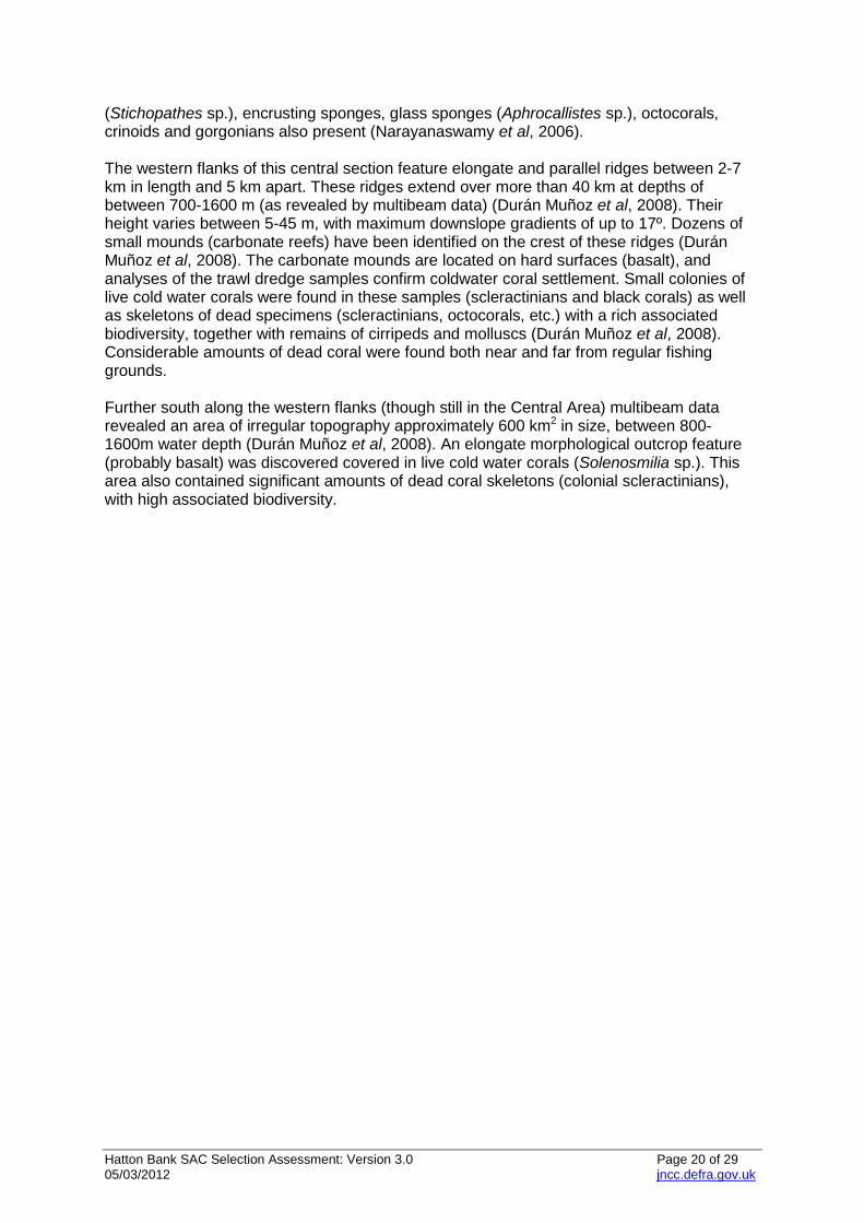
12.3. Hatton Bank: South section
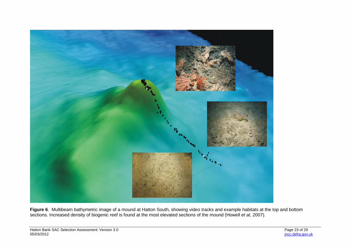
Figure 5. Survey map for the south section of Hatton Bank. Photographs a-d show type of organisms found at the locations indicated on the map. Hatton Bank gently deepens at its southern end, with the summit lying at around 800m water depth. This area was surveyed as part of the SEA-SAC survey in 2006, with four large areas imaged by multibeam, three of which were ground-truthed using video photography. Sites sampled on the top of the bank and on the upper slopes in this area (800-900m) were predominantly covered by sandy sediment with abundant xenophyophores, with areas of biogenic reef that corresponded with ridge features or mounds/pinnacles (Howell et al, 2007) (Figure 6). The ridge and pinnacles also had extensive areas of dead coral framework, characterised by a diverse range of epifauna, including soft corals, scleractinian corals (Madrepora oculata, Caryophyllia sp.), encrusting sponges, antipatharians (Stichopathes sp., Parantipathes sp., Leiopathes sp.), gorgonians (Callogorgia sp.), bamboo corals (Acanella sp., Isidella sp. and Keratoisis sp.), and soft corals. Feather stars, sea stars and basket stars were also frequently observed, and hydroids, bryozoans (Retiporella sp.), ascidians, and sponges, such as the glass sponge Aphrocallistes sp., frequently colonised the dead coral framework. Small areas of bedrock were sometimes visible on the ridge features, supporting a range of sessile epifauna including large axinellid sponges. Fish (Lepidon eques and rockfish [Sebastes sp.]) were also recorded. Chimera monstrosa, grenadiers (probably Coryphaenoides rupestris) and eel-like fish (possibly Lycodonus flagellicauda) are associated with areas of sandy substratum in the region (Howell et al, 2007). On the south-eastern tip of Hatton Bank, a volcanic rock outcrop known as Lyonesse was investigated (see area‘d’ in Figure 5). This igneous centre forms a dome, covered with a veneer of sediment, through which igneous rocks outcrop forming pinnacles that stand 100-140m above the surrounding sea floor (Stewart and Davies, 2007). Five sites in water
Hatton Bank SAC Selection Assessment: Version 3.0 Page 22 of 29 05/03/2012 jncc.defra.gov.uk
depths of 500-700m were surveyed using video. The seabed was typically coarse sand, with extensive areas of bedrock and boulder reef. The rock was colonised by encrusting fauna such as sponges, sessile sea cucumbers (Psolus squamatus), serpulid worms, saddle oysters and occasional anemones. A diverse range of corals including scleractinians (Lophelia pertusa and Madrepora oculata), antipatharian corals (Stichopathes sp., Leiopathes sp.), stylasterid corals, soft corals (Anthomastus grandiflorus) and gorgonians were also frequently observed. Extensive areas of dead coral framework and coral rubble were also observed, with characteristic associated epifauna as described above, although no live biogenic reef was observed.
Hatton Bank SAC Selection Assessment: Version 3.0 Page 23 of 29 05/03/2012 jncc.defra.gov.uk
Figure 6. Multibeam bathymetric image of a mound at Hatton South, showing video tracks and example habitats at the top and bottom sections. Increased density of biogenic reef is found at the most elevated sections of the mound (Howell et al, 2007).
Hatton Bank SAC Selection Assessment: Version 3.0 05/03/2012
13. References BELL, N. & SMITH, J. 1999. Coral growing on North Sea oil rigs. Nature, 402, p. 601. CODA. 2009. Cetacean Offshore Distribution and Abundance: Final report. SMRU, Gatty Marine Laboratory, St Andrews. COMMISSION OF THE EUROPEAN COMMUNITY (CEC). 1995. Natura 2000 Standard Data Form: Explanatory Notes. Brussels: European Commission DG Environment. COMMISSION OF THE EUROPEAN COMMUNITY (CEC). 2006 COUNCIL REGULATION (EC) No 41/2006 of 21 December 2006 fixing for 2007 the fishing opportunities and associated conditions for certain fish stocks and groups of fish stocks, applicable in Community waters and, for Community vessels, in waters where catch limitations are required. Brussels: Official Journal of the European Union. COMMISSION OF THE EUROPEAN COMMUNITY (CEC). 2008 COUNCIL REGULATION (EC) No 40/2008 of 16 January 2008 fixing for 2008 the fishing opportunities and associated conditions for certain fish stocks and groups of fish stocks, applicable in Community waters and, for Community vessels, in waters where catch limitations are required. Brussels: Official Journal of the European Union [online]. Available from: http://eur-lex.europa.eu/LexUriServ/LexUriServ.do?uri=OJ:L:2008:019:0001:0203:EN:PDF [Accessed February 2012] DEFRA. 2004. Review of Marine Nature Conservation. Working Group Report to Government [online]. London: Defra. Available from: http://archive.defra.gov.uk/environment/biodiversity/marine/documents/rmnc-report-0704.pdf [Accessed February 2012] DURÁN MUÑOZ, P., SACAU, M., SAYAGO‐GIL, M., PATROCINIO, T., FERNÁNDEZ‐SALAS, L.M., MURILLO, F.J., DÍAZ DEL RÍO, V., SERRANO A. & PARRA. S. 2007. ECOVUL/ARPA (Estudio de los eCOsistemas VULnerables y los ARtes de PescA): A Spanish Interdisciplinary Research Project Focused on the Study of the Hatton Bank Deep‐Sea Fisheries (ICES XIIb & VIb1) and their Relationship with Vulnerable Ecosystems/Habitats, Integrating Fisheries Biology, Geomorphology, Benthic Ecology and Sedimentology. ICES CM 2007/A:01. DURÁN MUÑOZ, P., SAYAGO‐GIL, M., CRISTOBO, J., PARRA, S., SERRANO, A., DÍAZ DEL RIO, V., PATROCINIO, T., SACAU, M., MURILLO, J., PALOMINO, D., DOMÍNGUEZ, M. & FERNÁNDEZ‐SALAS, L. M. 2008. Suggestion on a new additional closure in order to refine the advice on cold water corals protection in the NEAFC Regulatory Area (Hatton Bank: ICES XIIb & VIb1) based on ECOVUL/ARPA data. Working Document presented to the Working Group on Deep‐Water Ecology. Copenhagen, 10-14 March 2008. EVANS, P.G.H., ANDERWALD, P., BAINES, M.E. 2003. UK Cetacean Status Review. Report to English Nature and the Countryside Council for Wales. 159pp. FREDERIKSEN, R. A., JENSEN, A. & WESTERBERG, H. 1992. The distribution of the scleractinian coral Lophelia pertusa around the Faroe Islands and the relation to internal mixing. Sarsia, 77, 157-171.
Hatton Bank SAC Selection Assessment: Version 3.0 05/03/2012
FREIWALD, A., FOSSÅ, J.H., GREHAN, A., KOSLOW, T. & ROBERTS, J. M. 2004. Cold-water coral reefs. Cambridge, UK:UNEP-WCMC. Available from: http://www.unep-wcmc.org/medialibrary/2010/09/10/29fefd54/CWC.pdf [Accessed February 2012] HITCHEN, K., CAVILL, J.E. & BRETT, C.P. 2001. Rockall Continental Margin Project. Preliminary interpretation of high-resolution seismic data across Rockall Plateau, UK. BGS Technical Report CR/01/19. HOWELL, K.L., DAVIES, J.S., HUGHES, D.J. & NARAYANASWAMY, B.E. 2007. Strategic Environmental Assessment - Special Area for Conservation photographic analysis report. UK: Department of Trade and Industry (DTI) and the Department of Food and Rural Affairs (DEFRA). ICES. 2005. Report of the Working Group on Deep-water Ecology (WGDEC), 8-11 March 2005, ICES Headquarters, Copenhagen. ICES CM 2005/ACE:02. 76 pp. ICES. 2007a. Report of the Working Group on Deep-water Ecology (WGDEC), 26-28 February 2007, Plymouth, UK. ICES CM 2007/ACE:01 Ref. LRC. 61 pp. [online]. Available from: http://www.ices.dk/reports/ACE/2007/WGDEC07.pdf [Accessed February 2012] ICES. 2007b. Report of the ICES Advisory Committee on Fishery Management, Advisory Committee on the Marine Environment and Advisory Committee on Ecosystems, 2007. ICES Advice, May 2007, Book 9 (Section 9.3.2.1) [online]. Available from: http://www.ices.dk/products/icesadvice/2007/ICES%20ADVICE%202007%20Book%209.pdf [Accessed February 2012] ICES. 2008a. Report of the ICES-NAFO Joint Working Group on Deep Water Ecology (WGDEC), 10-14 March 2008, Copenhagen, Denmark. ICES CM 2008/ACOM:45. 126 pp. [online]. Available from: http://www.ices.dk/reports/ACOM/2008/WGDEC/WGDEC_2008.pdf [Accessed February 2012] ICES. 2008b. Report of the ICES Advisory Committee on Fishery Management, Advisory Committee on the Marine Environment and Advisory Committee on Ecosystems, 2008. ICES Advice, May 2008, Book 9 (Section 9.3.2.3) [online]. Available from: http://www.ices.dk/products/icesadvice/2008/ICES%20ADVICE%202008%20Book%209.pdf [Accessed February 2012] JACOBS, C.L. & HOWELL, K.L. 2007. MV Franklin Cruise 0206, 03-23 Aug 2006. Habitat investigations within the SEA4 and SEA7 areas of the UK continental shelf. Southampton, UK: National Oceanography Centre, Southampton, 95 pp. & 71 figs. National Oceanography Centre Southampton Research and Consultancy Report, No. 24). (Unpublished manuscript.) JNCC. 2004. The Irish Sea Pilot Final Report. Report to Defra by The Joint Nature Conservation Committee [online]. Peterborough: JNCC. Available from: http://www.jncc.gov.uk/page-2767#download [Accessed February 2012] JNCC. 2008a. Report of the Joint Nature Conservation Committee to the Secretary of State on the Responses to JNCC’s Consultation on the First Seven Possible Offshore Special Areas of Conservation [online]. Peterborough: JNCC. Available from: http://jncc.defra.gov.uk/pdf/2007-08_OffshoreSACConsultationResponseReportFinal.pdf [Accessed February 2012] JNCC. 2008b. UK Guidance on defining boundaries for marine SACs for Annex I habitat sites fully detached from the coast [online]. Peterborough, JNCC. Available from:
Hatton Bank SAC Selection Assessment: Version 3.0 05/03/2012
http://jncc.defra.gov.uk/pdf/SACHabBoundaryGuidance_2008Update.pdf [Accessed March 2012]. JNCC. 2009. Progress towards completing the UK network of marine Special Areas of Conservation (SACS) for Annex I Habitats and site proposals for Hatton Bank and Bassurelle Bank. JNCC Committee Paper 08 P14, December 2008. MORTENSEN, P.B. 2001. Aquarium observations on the deepwater coral Lophelia pertusa (L., 1758) (Scleractinia) and selected associated invertebrates. Ophelia, 54, pp. 83-104. NARAYANASWAMY, B.E., HOWELL, K.L., HUGHES, D.J., DAVIES, J.S. & ROBERTS, J.M. 2006. Strategic Environmental assessment Area 7 photographic analysis. A report to the Department of Trade and Industry. 103pp +199pp Appendix. UK: DTI. NEAFC. 2007. Recommendation IX-2007. Recommendation by the North East Atlantic Fisheries Commission at its annual meeting in November 2006 to adopt conservation and management measures by closing certain areas in the regulatory area in order to protect deep-water corals. London: NEAFC [online]. Available from: http://www.neafc.org/deep-water-habitats/682 [Accessed February 2012] NEAFC. 2008. Recommendation IX: 2008. Recommendation by the North East Atlantic Fisheries Commission in accordance with Article 5 of the Convention on future multilateral cooperation in North-East Atlantic Fisheries at its Annual Meeting in November 2007 to adopt conservation and management measures by closing certain areas in the regulatory area in order to protect deep-water corals. London: NEAFC [online]. Available from: http://www.neafc.org/deep-water-habitats/1249 [Accessed February 2012] NEAFC, 2011. Recommendation XIV: 2011. Recommendation by the North-East Atlantic Fisheries Commission in accordance with article 5 of the convention on Future multilateral cooperation in North-East Atlantic Fisheries at its annual meeting in november 2010 to adopt conservation and management measures by closing certain areas on the Hatton Bank, Rockall bank, Logachev mounds and West Rockall mounds in the regulatory area in order to protect vulnerable marine ecosystems from significant adverse impacts in 2011. London: NEAFC [online]. Available from: http://www.neafc.org/%5Bfield_subject-raw%5D/3710 [Accessed February 2012] NEAFC, 2012, Recommendation VIII:2012. The North-East Atlantic Fisheries Commission at its annual meeting in november 2011 adopted, in accordance with article 5 of the convention on future multilateral cooperation in North-East Atlantic Fisheries, a recommendation to adopt conservation and management measures by closing certain areas on the Hatton Bank, Rockall Bank, Logachev mounds and west Rockall mounds in the regulatory area in order to protect vulnerable marine ecosystems from significant adverse impacts in 2012. London:NEAFC [online]. Available from: http://www.neafc.org/system/files/Rec_8_Hatton_extension-rev.pdf [Accessed February 2012] REID, J.B., EVANS, P.G.H., NORTHRIDGE, S.P. (Eds). 2003. Atlas of cetacean distribution in north-west European waters. JNCC, Peterborough ROBERTS, J.M. 2002. The occurrence of the coral Lophelia pertusa and other conspicuous epifauna around an oil platform in the North Sea. Journal of the Society for Underwater Technology, 25, pp. 83-91. SAYAGO-GIL, M., FERNÁNDEZ-SALAS, L.M., LONG, D., DÍAZ DEL RÍO, V., HITCHEN, K. & VÁZQUEZ, J.T. 2006. Geomorphological features on the Western flank of Hatton Bank
Hatton Bank SAC Selection Assessment: Version 3.0 05/03/2012
(NE Atlantic Ocean). Abstract and Poster presented to the GeoHab International Symposium. Edinburgh. SAYAGO‐GIL, M., DURÁN MUÑOZ, P.; LONG, D.; FERNÁNDEZ SALAS, L.M., DÍAZ DE RÍO, V, HITCHEN, K., PALOMINO & FERNÁNDEZ PUGA, M.C. 2007. ECOVUL/ARPA interdisciplinary project: Seabed mounds on Hatton Bank situated within Deep‐water bottom fisheries zones (NE Atlantic Ocean). ICES CM 2007/R:20. SCANS II. 2008. Small Cetaceans in the European Atlantic and North Sea: Final Report to the European Commission under project LIFE04NAT/GB/000245. SMRU, Gatty Marine Laboratory, St Andrews. SERAD. 2001. A fishing industry guide to offshore operators. Scottish Executive, Edinburgh, 28 pp. SHELTON, G.A.B. 1980. Lophelia pertusa (L.): electrical conduction and behaviour in a deep-water coral. Journal of the Marine Biological Association of the United Kingdom, 60, pp. 517-528. STEWART, H A, & DAVIES, J S. 2007. Habitat investigations within the SEA7 and SEA4 areas of the UK continental shelf (Hatton Bank, Rosemary Bank, Wyville Thomson Ridge and Faroe-Shetland Channel). British Geological Survey Commissioned Report, CR/07/051. 85pp. WILSON, J.B. 1979. The distribution of the coral Lophelia pertusa (L.) [L. prolifera (Pallas)] in the North-East Atlantic. Journal of the Marine Biological Association of the United Kingdom, 59, 149-164.
Hatton Bank SAC Selection Assessment: Version 3.0 Page 28 of 29 05/03/2012 jncc.defra.gov.uk
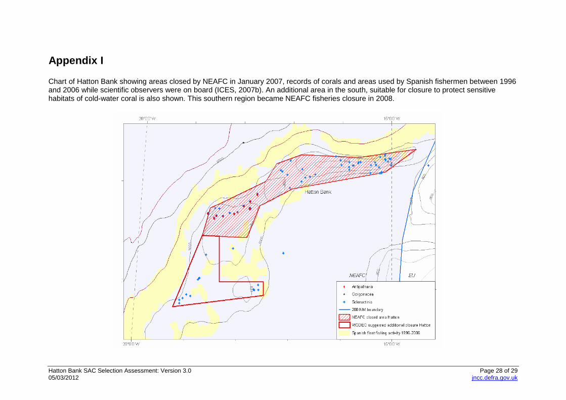
Appendix I Chart of Hatton Bank showing areas closed by NEAFC in January 2007, records of corals and areas used by Spanish fishermen between 1996 and 2006 while scientific observers were on board (ICES, 2007b). An additional area in the south, suitable for closure to protect sensitive habitats of cold-water coral is also shown. This southern region became NEAFC fisheries closure in 2008.
Hatton Bank SAC Selection Assessment: Version 3.0 Page 29 of 29 05/03/2012 jncc.defra.gov.uk
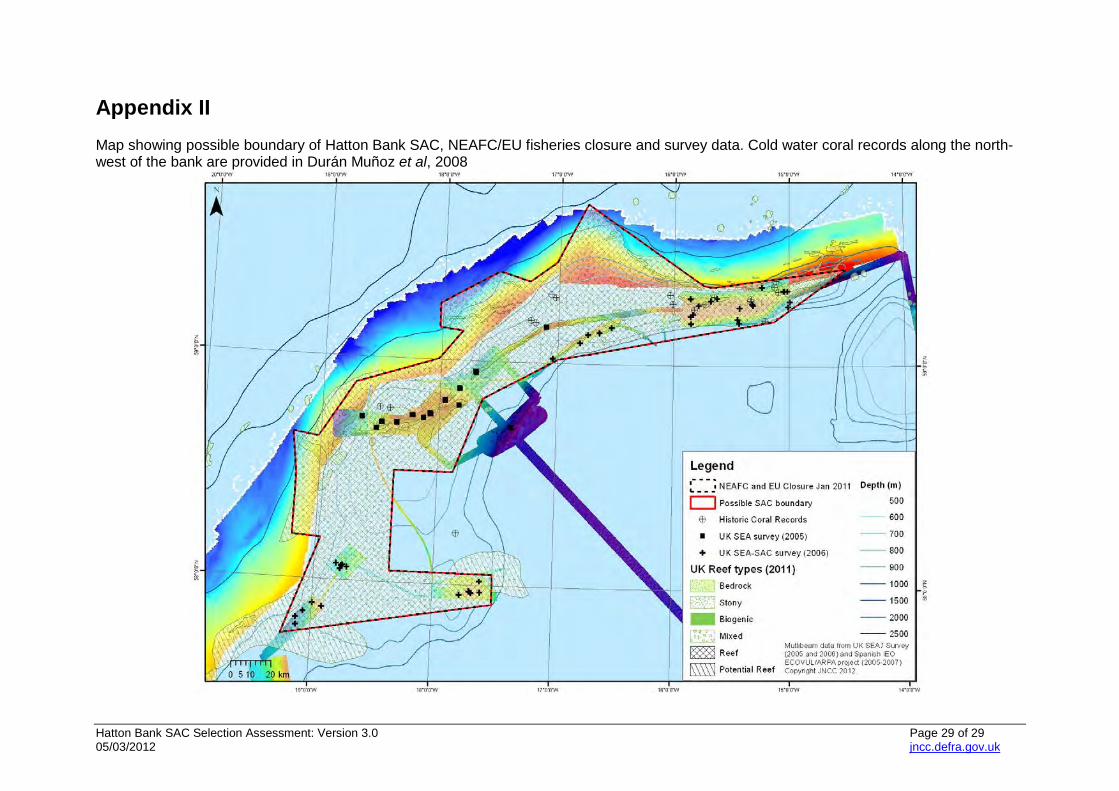
Appendix II Map showing possible boundary of Hatton Bank SAC, NEAFC/EU fisheries closure and survey data. Cold water coral records along the north-west of the bank are provided in Durán Muñoz et al, 2008