Embed Size (px)
DESCRIPTION
Hawaii Range Complex Final Environmental Impact Statement/Overseas Environmental Impact Statement (EIS/OEIS)
Citation preview
FOR OFFICIAL USE ONLY
May 2008
CoordinatorHawaii Range ComplexPacific Missile Range FacilityP.O. Box 128Kekaha, Kauai, Hawaii 96752-0128
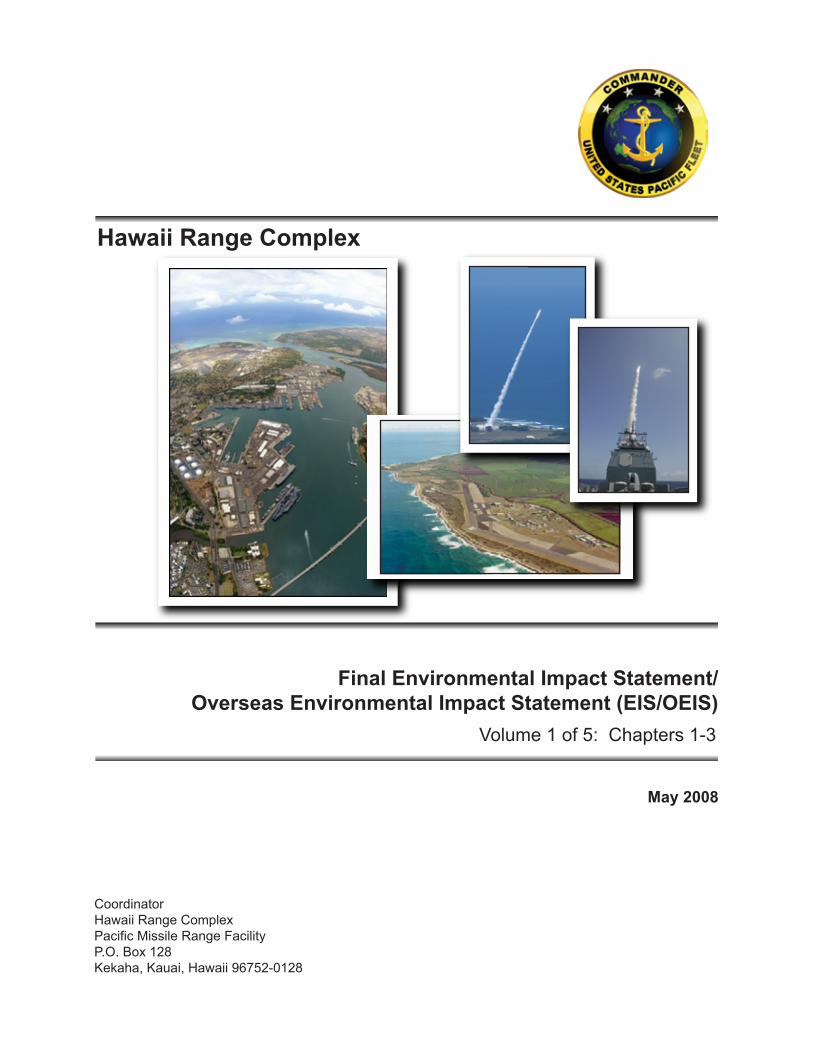
Hawaii Range Complex
Final Environmental Impact Statement/Overseas Environmental Impact Statement (EIS/OEIS)
Volume 1 of 5: Chapters 1-3
Lo no C en tr al
Lo no E as t
Lo no W es t
Ma ko
Me la C en tr al
Me la N or th
Ne ne
Pa li
Pe le
Qu in t Ta ro
W- 18 8 W -1 88 (R ai nb ow )
W- 18 9
W- 19 0
A- 31 1
R- 31 10B
W- 19 6 W- 19 1
R- 31 03 W- 19 4 W- 19 3 W- 19 2
Me la So ut h
R- 31 07
W- 18 7
Ha wa ii
Ma ui
O ahu
Ka ua i
Ka ul a
PM RF
Nii hau
Mo lo ka i La na i
Ka ho ol aw e
R- 31 01
W- 18 6

HAWAII RANGE COMPLEX FINAL ENVIRONMENTAL IMPACT STATEMENT/
OVERSEAS ENVIRONMENTAL IMPACT STATEMENT
Volume 1 of 5
MAY 2008
Coordinator Hawaii Range Complex Pacific Missile Range Facility P.O. Box 128 Kekaha, Kauai, Hawaii 96752-0128

May 2008
COVER SHEET FINAL ENVIRONMENTAL IMPACT STATEMENT/
OVERSEAS ENVIRONMENTAL IMPACT STATEMENT HAWAII RANGE COMPLEX (HRC)
Lead Agency for the EIS: U.S. Department of the Navy
Title of the Proposed Action: Hawaii Range Complex
Affected Jurisdiction: Kauai, Honolulu, Maui, and Hawaii Counties
Designation: Final Environmental Impact Statement/Overseas Environmental Impact Statement (EIS/OEIS)
Abstract
This Final EIS/OEIS has been prepared by the U.S. Department of the Navy (Navy) in compliance with the National Environmental Policy Act (NEPA) of 1969 (42 United States Code § 4321 et seq.); the Council on Environmental Quality (CEQ) Regulations for Implementing the Procedural Provisions of NEPA (Title 40 Code of Federal Regulations [CFR] §§ 1500-1508); Navy Procedures for Implementing NEPA (32 CFR § 775); and Executive Order 12114 (EO 12114), Environmental Effects Abroad of Major Federal Actions. The Navy has identified the need to support and conduct current, emerging, and future training and research, development, test, and evaluation (RDT&E) activities in the Hawaii Range Complex (HRC). The alternatives—the No-action Alternative, Alternative 1, Alternative 2, and Alternative 3—are analyzed in this Final EIS/OEIS. All alternatives include an analysis of potential environmental impacts associated with the use of mid-frequency active (MFA) and high-frequency active (HFA) sonar. The No-action Alternative stands as no change from current levels of HRC usage and includes HRC training, support, and RDT&E activities, Major Exercises, and maintenance of the technical and logistical facilities that support these activities and exercises. Alternative 1 includes all ongoing training associated with the No-action Alternative, an increased tempo and frequency of such training (including increases in MFA and HFA sonar use), a new training event (Field Carrier Landing Practice), enhanced and future RDT&E activities, enhancements to optimize HRC capabilities, and an increased number of Major Exercises. Alternative 2 includes all of the training associated with Alternative 1 plus additional increases in the tempo and frequency of training (including additional increases in MFA and HFA sonar use), enhanced RDT&E activities, future RDT&E activities, and additional Major Exercises, such as supporting three Strike Groups training at the same time. Alternative 3 would include all of the training and RDT&E activities associated with Alternative 2. The difference between Alternative 2 and Alternative 3 is the amount of MFA/HFA sonar usage. As described under Alternative 2, Alternative 3 would provide increased flexibility in training activities by increasing the tempo and frequency of training events, future and enhanced RDT&E activities, and the addition of Major Exercises. Alternative 3 would consist of the MFA/HFA sonar usage as analyzed under the No-action Alternative. Alternative 3 is the Navy’s preferred alternative.
This Final EIS/OEIS addresses potential environmental impacts that result from activities that occur under the No-action Alternative and proposed activities that would occur under Alternatives 1, 2, and 3. This EIS/OEIS also addresses changes and associated environmental analyses that were presented in the Supplement to the Draft EIS/OEIS. Environmental resource topics evaluated include air quality, airspace, biological resources (open ocean, offshore, and onshore), cultural resources, geology and soils, hazardous materials and waste, health and safety, land use, noise, socioeconomics, transportation, utilities, and water resources.
Prepared by: U.S. Department of Defense, Department of the Navy Point of Contact: Pacific Missile Range Facility Public Affairs Officer P.O. Box 128, Kekaha, Hawaii, 96752, (866) 767-3347

THIS PAGE INTENTIONALLY LEFT BLANK
Executive Summary

Executive Summary
May 2008 Hawaii Range Complex Final EIS/OEIS ES-1
EXECUTIVE SUMMARY
ES1.1 INTRODUCTION
This Environmental Impact Statement/Overseas Environmental Impact Statement (EIS/OEIS) analyzes the potential environmental consequences that may result from the United States (U.S.) Department of the Navy’s Proposed Action and alternatives. The Proposed Action presented in this EIS/OEIS addresses ongoing and proposed activities within the Navy’s existing Hawaii Range Complex (HRC) and represents current and anticipated future use of the “existing footprint.” This EIS/OEIS contains analysis of research, development, test, and evaluation (RDT&E) of new technologies used by the Navy and other Federal agencies, including the Missile Defense Agency.
This EIS/OEIS has been prepared by the Department of the Navy in compliance with the National Environmental Policy Act (NEPA) of 1969 (42 United States Code [U.S.C.] § 4321 et seq.) and Executive Order (EO) 12114, Environmental Effects Abroad of Major Federal Actions.
The Navy is the lead for the EIS/OEIS; the National Marine Fisheries Service (NMFS), Missile Defense Agency, U.S. Department of the Army, and the U.S. Department of Energy are cooperating agencies. Additionally, the Navy has worked with experts from the State of Hawaii and other Federal agencies to ensure that the effects on the environment of the Navy’s Proposed Action are fully assessed in this document.
The HRC geographically encompasses the open ocean (outside 12 nautical miles [nm] from land), offshore waters (within 12 nm from land), and onshore areas located on or around the islands of the Hawaiian Islands chain (Figure ES-1).
There are three component areas of the HRC: (1) the Hawaii Operating Area (OPAREA) (includes surface and subsurface ocean areas and special use airspace); (2) the Temporary Operating Area (TOA) (composed of sea and airspace north and west of Kauai for RDT&E activities); and (3) various Navy land ranges and other Services’ land for military training and RDT&E activities.
ES1.2 PURPOSE AND NEED
The purpose of the Proposed Action is to achieve and maintain fleet readiness using the HRC to support and conduct current, emerging, and future training and RDT&E activities, and enhance training resources through investment on the ranges. The mission of the HRC is to support naval operational readiness by providing a realistic, live training environment for forces assigned to the Pacific Fleet, the Fleet Marine Force, and other users.
The need for the Proposed Action is to enable the Navy to meet its statutory responsibility under Title 10 Sections 5013 and 5062 to organize, train, equip, and maintain combat-ready naval forces and to successfully fulfill its current and future global mission of winning wars, deterring aggression, and maintaining freedom of the seas. Activities involving RDT&E for Department of Defense (DoD) or Navy systems are an integral part of this readiness mandate.
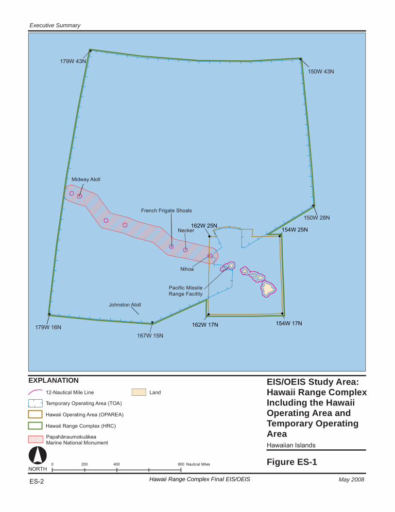
EIS/OE IS St udy A re a: Ha wa ii R ange C ompl ex In cl udi ng the Ha wa ii Op er at in g Ar ea a nd Te mporar y Oper at in g Ar ea Hawaii an Isl and s
Fi gur e ES-1 0 4 00 80 0 20 0 N au ti ca l M ile s
EX PL ANA TI ON
NORT H
La nd
1 79W 43N
1 79W 16N
1 50W 43N
1 50W 28N
Mi dw ay A to ll
Jo hn st on A to ll
Fren ch F ri ga te S ho al s
167W 15N
Ne ck er
Ni ho a
Pa pa hā nau mo ku āk ea Ma ri ne N at io nal M on um en t
Ha wa ii Ran ge C om pl ex (HRC)
12 -N au ti ca l Mi le L in e
Te m por ar y O pe ra ti ng A re a (T OA )
Ha wa ii O pe ra ti ng A re a (O PA RE A)
ES-2 Hawaii Range Complex Final EIS/OEIS
Executive Summary
May 2008
Pacific MissileRange Facility
154W 25N162W 25N
154W 17N162W 17N
Executive Summary
May 2008 Hawaii Range Complex Final EIS/OEIS ES-3
The HRC plays a vital part in the execution of this naval readiness mandate. The Hawaii area is home to a large concentration of U.S. naval forces. Naval forces based in Hawaii and those transiting across the Pacific Ocean use and rely on the HRC because of its capabilities and strategic location in the mid-Pacific region. The Navy’s Proposed Action is essential to ensure the continued vitality of this training resource.
ES1.2.1 WHY THE NAVY TRAINS
The U.S. military is maintained to ensure the freedom and safety of all Americans both at home and abroad. In order to do so, Title 10 of the U.S.C requires the Navy to “maintain, train and equip combat-ready naval forces capable of winning wars, deterring aggression and maintaining freedom of the seas.” Modern war and security operations are complex. Modern weaponry has brought both unprecedented opportunity and innumerable challenges to the Navy. Smart weapons, used properly, are accurate and allow the Navy to accomplish its mission with greater precision and less destruction than in past conflicts. U.S. military personnel must train regularly with these modern, complex weapons in order to understand their capabilities, limitations, and operation. Modern military actions require teamwork between hundreds or thousands of people, and their various equipment, vehicles, ships, and aircraft, all working individually and as a coordinated unit to achieve success. Navy training addresses all aspects of the team, from the individual to joint and coalition teamwork. To do this, the Navy employs a building-block approach to training. Training doctrine and procedures are based on operational requirements for deployment of naval forces. Training proceeds on a continuum, from teaching basic and specialized individual military skills, to intermediate skills or small unit training, to advanced, integrated training events, culminating in multi-service (Joint) exercises, coalition or combined exercises (with allied nations participating), or pre-deployment certification events.
In order to provide the experience so important to success and survival, training must be as realistic as possible. The Navy often employs simulators and synthetic training to provide early skill repetition and to enhance teamwork, but live training in a realistic environment is vital to success. Live training requires sufficient sea and airspace to maneuver tactically, realistic targets and objectives, simulated opposition that creates a realistic enemy, and instrumentation that monitors the events and provides essential feedback.
Range complexes, like the HRC, provide a controlled and safe environment with threat-representative targets that allow Navy forces to conduct realistic training as Navy men and women undergo all phases of the graduated buildup needed for combat-ready deployment. The range complexes are designed to provide the most realistic training in the most relevant environments, replicating to the greatest extent possible the operational stresses of warfare. The integration of undersea ranges and OPAREAs with land training ranges, safety landing fields, and amphibious landing sites are critical to this realism, allowing execution of multi-dimensional exercises in complex scenarios. The live-fire phase of training is fundamental to the adequate assessment of weapon precision under stressful conditions. Live training, most of it accomplished in the waters off the United States’ coasts, will remain the cornerstone of readiness as the Navy prepares its military forces for a security environment characterized by uncertainty and surprise.
Executive Summary
ES-4 Hawaii Range Complex Final EIS/OEIS May 2008
ES1.2.2 STRATEGIC IMPORTANCE OF THE EXISTING HAWAII RANGE COMPLEX
The HRC is used for training and assessment of operational forces, missile training, RDT&E of military systems and equipment, and other military activities. The HRC is characterized by a unique combination of attributes that make it a strategically important range complex for the Navy. These attributes include:
• Proximity to the homeport of Pearl Harbor
• Proximity to the Western Pacific
• Proximity to military families based in Hawaii
• New training terrain for west coast based naval forces
Refer to Section 1.3.5 of Chapter 1.0 for a detailed description of these attributes.
The large training area available to deployed forces within the HRC allows training to take place using a geographic scope that replicates possible real world events, with the channels between islands providing geography necessary for opposed transit scenarios. The presence of the instrumented tracking ranges at the Pacific Missile Range Facility (PMRF) as well as DoD-controlled warning areas and special use airspace also allow safe and structured training with sufficient flexibility to interject tactical challenges to enhance realism for exercise participants. Exercise participants at sea can conduct air strike sorties to Pohakuloa Training Area (PTA) and an Expeditionary Strike Group (ESG) can conduct amphibious landing on DoD beaches, while each simultaneously conducts Anti-Submarine Warfare (ASW) training. Finally, the presence of submarines homeported at Pearl Harbor allows for a readily available opposition force during the training event without having to transit to participate in the exercise events.
ES1.3 SCOPE AND CONTENT OF THE EIS/OEIS
The Navy’s analysis of environmental effects under NEPA includes areas of the HRC that lie within the territorial seas, which extend 12 nm from land. The environmental effects in the ocean areas that are outside of U.S. territorial seas are analyzed under EO 12114 and associated implementing regulations.
ES1.3.1 NATIONAL ENVIRONMENTAL POLICY ACT (NEPA)
In 1969, Congress enacted NEPA, which provides for the consideration of environmental issues in Federal agency planning and decision-making. Regulations for Federal agency implementation of the act were established by the President’s Council on Environmental Quality (CEQ). NEPA requires that Federal agencies prepare an EIS if the agency’s proposed action might significantly affect the quality of the human environment. The EIS must disclose significant environmental impacts and inform decision makers and the public of the reasonable alternatives to the proposed action. Presidential Proclamation 5928, issued December 27, 1988, extended the exercise of United States sovereignty and jurisdiction under international law to 12 nm; however, the Proclamation expressly provides that it does not extend or otherwise alter existing Federal law or any associated jurisdiction, rights, legal interests, or obligations.
Executive Summary
May 2008 Hawaii Range Complex Final EIS/OEIS ES-5
However, as a matter of policy, the Navy analyzes environmental effects and actions within 12 nm under NEPA and those effects occurring beyond 12 nm under the provisions of EO 12114.
This EIS/OEIS provides an assessment of the potential environmental impacts associated with sustainable range usage and enhancements within the Navy’s HRC. The Navy completed the Supplement to the 2002 Rim of the Pacific (RIMPAC) Programmatic Environmental Assessment in May 2006 and the Undersea Warfare Exercise (USWEX) Programmatic Environmental Assessment in October 2007. This EIS/OEIS analyzes the continuation of these exercises in the baseline analysis. It also analyzes Navy training that currently occurs or is proposed to occur in open ocean, offshore, and onshore areas of the HRC.
The first step in the NEPA process is the publication of a Notice of Intent (NOI) to prepare an EIS. The NOI provides an overview of the proposed action and the scope of the EIS. The NOI for this project was published in the Federal Register on August 29, 2006, and in five local newspapers (i.e., Honolulu Advertiser, the Honolulu Star Bulletin, the Maui News, the Hawaii Tribune Herald, and the Garden Island) on September 2, 4, and 5, 2006.
Scoping is an early and open process for developing the “scope” of issues to be addressed in the EIS and for identifying significant issues related to a proposed action. During scoping, the public helps define and prioritize issues and convey these issues to the agency through both oral and written comments. The scoping period for the HRC EIS/OEIS began with the publication of an NOI. The scoping period lasted 46 days, concluding on October 13, 2006. Four scoping meetings were held on September 13, 14, 16, and 18, 2006 on the islands of Maui, Oahu, Hawaii, and Kauai, respectively. The scoping meetings were held in an open house format, presenting informational posters and written information, and making Navy staff and project experts available to answer participants’ questions. Additionally, a court reporter was available to record participants’ oral comments. This format allowed the public to interact informally, one-on-one, with project representatives or comment formally, on the record, to representatives of the Navy.
In addition to the scoping meetings, the public could make comments through a toll-free telephone number, by sending an email, or by mailing a written comment. Issues identified by the public were provided to resource specialists working on the EIS/OEIS to ensure that all comments were considered during the preparation of the document.
After scoping, the Draft EIS/OEIS was prepared to provide an assessment of the potential impacts of the Proposed Action and alternatives on the environment. Public hearings were conducted during the review process in Kauai (Lihue), Oahu (Honolulu), Maui (Wailuku), and Hawaii (Hilo). The Draft EIS/OEIS was circulated for public review and the comment period concluded on September 17, 2007. Approximately 2,500 public comments were received and appropriately incorporated into this EIS/OEIS. Responses to public comments on the Draft EIS/OEIS may be found in Chapter 13.0.
During the scoping and public review process, members of the public and non-governmental environmental organizations expressed concerns on a variety of topics. One of the issues receiving the most comments related to the potential effects associated with mid-frequency active (MFA) sonar use and testing in the HRC. These concerns are addressed in this EIS/OEIS.
Executive Summary
ES-6 Hawaii Range Complex Final EIS/OEIS May 2008
The Navy recognizes that the potential impact on marine mammals caused by the use of sonar is controversial. Based on continued coordination with NMFS, the Navy has used best available science as the basis to assess impacts on marine mammals caused by MFA and high-frequency active (HFA) sonar used by a particular torpedo. The best available science has been used as a basis for development of the “Risk Function” model for predicting potential exposures of marine mammals to Navy MFA and HFA sonar use that will result in behavioral effects. What this model cannot do yet is to include in its calculations reductions in the behavioral effects estimates resulting from all of the procedures that the Navy has in place to protect marine mammals. These include personnel training, pre- and post-exercise surveys, power-down and power-off requirements for the sonar when mammals are within certain distances of the sound source, and passive detection of marine mammals.
During the public hearings, it was clear that many of those voicing concern were unaware that the training and testing activities proposed for the HRC are not new activities and have been occurring for approximately 40 years. No known marine mammal strandings directly related to Navy activities have occurred during this time. Nonetheless, by design, the Navy has taken an approach to modeling that calculates the maximum potential exposures to marine mammals to account for uncertainties in existing scientific data.
Since the publication of the Draft EIS/OEIS, the Navy, in coordination with the NMFS, re-analyzed the effects that MFA sonar has on marine mammals. This re-evaluation and consequent proposed changes to the Draft EIS/OEIS led the Navy to prepare a Supplement to the Draft EIS/OEIS. Accordingly, this EIS/OEIS incorporates the following changes and associated environmental analysis as presented in the Supplement to the Draft EIS/OEIS:
• Modifications to the analytical methodology used to evaluate the effects of MFA sonar on marine mammals;
• Changes to the amount and types of sonar allocated to each of the alternatives; and,
• The development of a new alternative.
The NOI for the Supplement to the Draft EIS/OEIS was published in the Federal Register on January 17, 2008. The Supplement to the Draft EIS/OEIS was circulated for public review, and the comment period ended on April 7, 2008. Responses to all comments on the Supplement to the Draft EIS/OEIS are presented in Chapter 14.0 of this document.
There is a 30-day wait period following the publication of the Notice of Availability of the Final EIS/OEIS in the Federal Register. At the conclusion of this wait period, the Navy will decide the action it will implement through its Record of Decision (ROD) which will be published in the Federal Register. The ROD will summarize the final decision and identify the selected alternative, describe the public involvement and agency decision-making processes, and present commitments to specific mitigation measures. The selected decision can then be implemented.
Executive Summary
May 2008 Hawaii Range Complex Final EIS/OEIS ES-7
ES1.3.2 EXECUTIVE ORDER (EO 12114)
Environmental effects in the areas that are beyond the U.S. territorial sea are analyzed under EO 12114 and associated implementing regulations.
ES1.3.3 MARINE MAMMAL PROTECTION ACT, ENDANGERED SPECIES ACT COMPLIANCE
The Marine Mammal Protection Act (MMPA) of 1972 established, with limited exceptions, a moratorium on the “taking” of marine mammals in waters or on lands under U.S. jurisdiction. Section 101(a)(5) of the MMPA directs the Secretary of Commerce to allow, upon request, the incidental, but not intentional, taking of marine mammals by U.S. citizens who engage in a specified activity (exclusive of commercial fishing). In support of the Proposed Action, the Navy applied for a Letter of Authorization from NMFS pursuant to Section 101(a) (5) (A) of the MMPA. NMFS intends to publish a proposed rule for public comment coincident with the publication of this EIS/OEIS, and anticipates issuing the final authorization toward the end of Calendar Year 2008.
On January 23, 2007, the Deputy Secretary of Defense exempted all military readiness activities employing MFA sonar or Improved Extended Echo Ranging (IEER) sonobuoys from compliance with the requirements of the MMPA for a period of 2 years. This exemption is limited to Major Exercises or training and RDT&E activities within established operating areas or established DoD maritime ranges. This National Defense Exemption (NDE) remains in effect until January 23, 2009 or authorization under the MMPA, whichever is earliest.
The NDE will cover MFA sonar and IEER sonobuoy activities on the HRC until an MMPA authorization is issued for these activities or the NDE expires whichever is earliest. While the NDE remains applicable (until an MMPA authorization is issued), the Navy will continue to employ the marine mammal mitigation measures outlined in Chapter 6.0 of this EIS/OEIS to protect marine mammals while training with the use of MFA sonar. These measures include safety zones around ships and trained lookouts based on coordination of science-based measures with NMFS. Additional measures that may be required as a result of the MMPA authorization would be implemented once authorization is received.
The Endangered Species Act (ESA) requires that Federal agencies, in consultation with the responsible wildlife agency, ensure that proposed actions are not likely to jeopardize the continued existence of any endangered species or threatened species, or result in the destruction or adverse modification of a critical habitat. Regulations implementing the ESA consultation requirement also include those actions that “may affect” a listed species or adversely modify critical habitat.
As part of the environmental documentation for this EIS/OEIS, and as an MMPA permit applicant, the Navy entered into early consultation procedures with NMFS, endangered species division. The Navy has been actively engaged in consultation with NMFS regarding the potential effects on ESA-listed species from the conduct of the activities outlined in this EIS/OEIS. In accordance with 50 Code of Federal Regulations (CFR) §402.11, prior to the issuance of the ROD, NMFS will issue a Preliminary Biological Opinion documenting its determination as to whether the activities conducted in the HRC are likely to jeopardize the
Executive Summary
ES-8 Hawaii Range Complex Final EIS/OEIS May 2008
continued existence of ESA-listed species, or result in the destruction or adverse modification of critical habitat. Additionally, a preliminary Incidental Take Statement will accompany the preliminary Biological Opinion. Because the Section 7 consultation is simultaneously conducted internally to address NMFS’ issuance of an MMPA authorization, an Incidental Take Statement for marine mammals cannot be issued until an MMPA authorization is issued.
The Preliminary Biological Opinion and Preliminary Incidental Take Statement do not exempt the Navy from the prohibitions of Section 9 of the ESA. Further, the Navy has determined that activities occurring in the HRC prior to the issuance of an MMPA authorization (e.g., RIMPAC, USWEX, etc.) may affect endangered species in the HRC, and may incidentally take ESA-listed species, thus requiring consultation under the ESA and an associated Incidental Take Statement. As such, the Navy and NMFS are engaged in a separate Section 7 consultation on these specified activities. A separate Biological Opinion and Incidental Take Statement will be issued, as appropriate, for this subset of specified activities, which will occur prior to the issuance of the MMPA authorization and be covered by the NDE.
ES1.3.4 OTHER ENVIRONMENTAL REQUIREMENTS CONSIDERED
The Navy must comply with a variety of other Federal environmental laws, regulations, and EOs. These include (among other applicable laws and regulations):
• Migratory Bird Treaty Act;
• Coastal Zone Management Act;
• Rivers and Harbors Act;
• Magnuson-Stevens Fishery Conservation and Management Act;
• Clean Air Act;
• Federal Water Pollution Control Act (Clean Water Act);
• National Historic Preservation Act;
• EO 12898, Federal Actions to Address Environmental Justice in Minority Populations and Low-Income Populations
• EO 13045, Environmental Health and Safety Risks to Children;
• EO 13423, Strengthening Federal Environmental, Energy and Transportation Management;
• EO 13089, Coral Reef Protection; and
• National Marine Sanctuaries Act.
In addition, laws and regulations of the State of Hawaii appropriate to Navy actions are identified and addressed in this EIS/OEIS. To the extent practicable, this document will be used as the basis for any required consultation and coordination.
Executive Summary
May 2008 Hawaii Range Complex Final EIS/OEIS ES-9
ES1.4 PROPOSED ACTION AND ALTERNATIVES
The Proposed Action presented in this EIS/OEIS addresses ongoing and proposed activities within the Navy’s existing HRC and contains analyses of RDT&E of new technologies used by the Navy and other Federal agencies.
ES1.4.1 ALTERNATIVES DEVELOPMENT
NEPA requires that an EIS evaluate the environmental consequences of a range of reasonable alternatives. Guidance for the development of alternatives is provided in CEQ regulations (40 CFR § 1502.14) and Navy procedures described in 32 CFR § 775. Reasonable alternatives must meet the stated purpose and need of the Proposed Action.
ES1.4.2 ALTERNATIVES ELIMINATED FROM FURTHER CONSIDERATION
The Navy eliminated alternatives from further consideration. Specifically, the following alternatives (described in Chapter 2.0) were not carried forward for analysis:
• Reduction or Elimination of Training in the Hawaii Range Complex
• Alternative Locations for Training Conducted in the Hawaii Range Complex
• Computer Simulation Training
After careful consideration, none of these alternatives meet the Navy’s purpose and need for the Proposed Action.
ES1.4.3 ALTERNATIVES CONSIDERED
Alternatives were selected based on their ability to meet the following criteria, which were developed from the purpose and need for the Proposed Action: (1) use existing Navy ranges and facilities in and around Hawaii; (2) be consistent with the stated current and emerging requirements for the range complex; (3) achieve training tempo requirements based on Fleet deployment schedules; (4) meet the requirements of DoD Directive 3200.15, Sustainment of Ranges and Operating Areas; (5) implement new training requirements and RDT&E activities; and (6) support realistic training that replicates expected operating environments for naval forces. Four alternatives are analyzed in the EIS/OEIS, including three action alternatives (Alternatives 1, 2, and 3) and the No-action Alternative.
ES1.4.3.1 No-Action Alternative
The No-action Alternative is required by CEQ regulations as a baseline against which the impacts of the Proposed Action are compared. In the EIS/OEIS, the No-action Alternative is represented by baseline training and RDT&E operations at current levels, including more than 9,300 training and RDT&E activities in the HRC annually. Training events, including those that make up Major Exercises (RIMPAC Exercise and five USWEXs) and RDT&E activities, would continue at the baseline levels. Ongoing training events include Anti-Air Warfare, Amphibious Warfare, Anti-Surface Warfare, ASW, Electronic Combat, Mine Warfare, Naval Special Warfare, and Strike Warfare Exercises. The No-action Alternative includes support activities such as
Executive Summary
ES-10 Hawaii Range Complex Final EIS/OEIS May 2008
Command and Control, in-port ship and aircraft support, and personnel support. RDT&E activities occur primarily at one of two locations in Hawaii: PMRF and Naval Undersea Warfare Center Detachment Pacific ranges.
ES1.4.3.2 Alternative 1
Alternative 1 includes all ongoing Navy training associated with the No-action Alternative, and proposes an increased number of such training events. The Navy proposes to increase both the tempo and the frequency of training exercises in the HRC. Alternative 1 includes the addition of Field Carrier Landing Practice (FCLP), a series of touch-and-go landings to train and qualify pilots for aircraft carrier landings at PMRF airfield on Kauai and Marine Corps Base Hawaii (MCBH) on Oahu. The Navy proposes to enhance and add RDT&E activities above current levels.
ES1.4.3.3 Alternative 2
Alternative 2 would include all of the activities described in Alternative 1, plus a further increased tempo and frequency of training events, future RDT&E programs at PMRF, and the addition of Major Exercises, such as supporting three Carrier Strike Groups training at the same time.
ES1.4.3.4 Alternative 3 (Preferred Alternative)
The only difference between Alternative 2 and Alternative 3 is the amount of MFA/HFA sonar usage. Alternative 3 would include all of the training associated with Alternative 2. As described under Alternative 2, Alternative 3 would provide increased flexibility in training activities by increasing the tempo and frequency of training events, future and enhanced RDT& E activities, and the addition of Major Exercises. Alternative 3 would consist of sonar usage as analyzed under the No-action Alternative. Sonar hours for Alternative 3 and effects associated with ASW training would be identical to that presented under the No-action Alternative.
Alternative 3 is the preferred alternative because it allows the Navy to meet its future non-ASW training and RDT&E mission objectives while maintaining historic levels of ASW training to avoid increases in potential effects to marine mammals in the HRC. At this time, the Navy believes that its ASW requirements will be met based on the No-action Alternative sonar hours.
ES1.5 SPORTS DATA
The data from the Sonar Positional Reporting System (SPORTS) provided a foundation for the sonar hours analyzed under each of the Alternatives. SPORTS is a database tool established by Commander, U.S. Fleet Forces Command in mid-2006. All commands employing MFA sonar and sonobuoys are required to populate the SPORTS database by reporting MFA sonar use. A review by senior officers determined that SPORTS data would be used in this EIS/OEIS in conjunction with previous planning data to assist in determining the amount of MFA sonar use for purposes of modeling potential effects on marine mammals.
The types of sonar sources used as part of ASW activities within the HRC are listed below:
Executive Summary
May 2008 Hawaii Range Complex Final EIS/OEIS ES-11
• Surface ship sonar (AN/SQS-53 and AN/SQS-56)
• Helicopter dipping sonar (AN/AQS-22)
• Aircraft deployed sonobuoys (AN/SSQ-62)
• Submarine sonar (BQQ-10, BQQ-5, BSY-1)
• MK-48 torpedo Table ES-1 presents a comparison of the sonar used for each of the alternatives analyzed. The majority of training and RDT&E activities in the HRC involve five types of narrowband sonars. Exposure estimates are calculated for each sonar according to the manner in which it operates. For example, the AN/SQS 53 and AN/SQS 56 are hull-mounted, MFA surface ship sonars that operate for many hours at a time (although sound is output—the “active” portion—only a small fraction of that time), so it is most useful to calculate and report surface ship sonar exposures per hour of operation. The BQQ-10 submarine sonar is also reported per hour of operation. However, the submarine sonar is modeled as pinging only twice per hour. The AN/AQS-22 is a helicopter-deployed sonar, which is lowered into the water, pings several times, and then moves to a new location; this sonar is used for localization and tracking a suspected contact as opposed to searching for contacts. For the AN/AQS-22, it is most helpful to calculate and report exposures per dip. The AN/SSQ-62 is a sonobuoy that is dropped into the water from an aircraft or helicopter and pings about 10 to 30 times in an hour. For the AN/SSQ-62, it is most helpful to calculate and report exposures per sonobuoy. For the MK-48 torpedo the sonar is modeled for a typical training event and the MK-48 reporting metric is the number of torpedo runs. See Table J-2 of Appendix J for a presentation of the deployment platform, frequency class, the metric for reporting exposures, and the units for each sonar.
Note that sonar usage for Alternative 3 and effects associated with ASW training would be identical to that presented under the No-action Alternative.
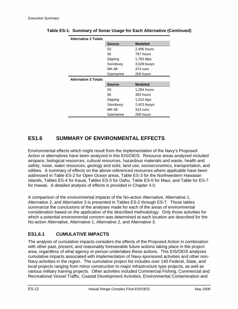
Table ES-1. Summary of Sonar Usage for Each Alternative
No-action Totals Source Modeled 53 1,284 hours 56 383 hours Dipping 1,010 dips Sonobuoy 2,423 buoys MK-48 313 runs Submarine 200 hours Alternative 1 Totals Source Modeled 53 1,788 hours 56 551 hours Dipping 1,517 dips Sonobuoy 3,127 buoys MK-48 317 runs Submarine 200 hours
Executive Summary
ES-12 Hawaii Range Complex Final EIS/OEIS May 2008
Table ES-1. Summary of Sonar Usage for Each Alternative (Continued)
Alternative 2 Totals Source Modeled 53 2,496 hours 56 787 hours Dipping 1,763 dips Sonobuoy 3,528 buoys MK-48 374 runs Submarine 200 hours Alternative 3 Totals Source Modeled 53 1,284 hours 56 383 hours Dipping 1,010 dips Sonobuoy 2,423 buoys MK-48 313 runs Submarine 200 hours
ES1.6 SUMMARY OF ENVIRONMENTAL EFFECTS
Environmental effects which might result from the implementation of the Navy’s Proposed Action or alternatives have been analyzed in this EIS/OEIS. Resource areas analyzed included airspace, biological resources, cultural resources, hazardous materials and waste, health and safety, noise, water resources, geology and soils, land use, socioeconomics, transportation, and utilities. A summary of effects on the above-referenced resources where applicable have been addressed in Table ES-2 for Open Ocean areas, Table ES-3 for the Northwestern Hawaiian Islands, Tables ES-4 for Kauai, Tables ES-5 for Oahu, Table ES-6 for Maui, and Table for ES-7 for Hawaii. A detailed analysis of effects is provided in Chapter 4.0.
A comparison of the environmental impacts of the No-action Alternative, Alternative 1, Alternative 2, and Alternative 3 is presented in Tables ES-2 through ES-7. These tables summarize the conclusions of the analyses made for each of the areas of environmental consideration based on the application of the described methodology. Only those activities for which a potential environmental concern was determined at each location are described for the No-action Alternative, Alternative 1, Alternative 2, and Alternative 3.
ES1.6.1 CUMULATIVE IMPACTS The analysis of cumulative impacts considers the effects of the Proposed Action in combination with other past, present, and reasonably foreseeable future actions taking place in the project area, regardless of what agency or person undertakes these actions. This EIS/OEIS analyzes cumulative impacts associated with implementation of Navy-sponsored activities and other non-Navy activities in the region. The cumulative project list includes over 140 Federal, State, and local projects ranging from minor construction to major infrastructure type projects, as well as various military training projects. Other activities included Commercial Fishing, Commercial and Recreational Vessel Traffic, Coastal Development Activities, Environmental Contamination and
Executive Summary
May 2008 Hawaii Range Complex Final EIS/OEIS ES-13
Biotoxins, and Scientific Research Permits. Potential cumulative impacts resulting from other relevant projects (such as those listed above) combined with the Proposed Action addressed in this EIS/OEIS were determined to be less than significant.
ES1.6.2 MITIGATION MEASURES The Navy is a global environmental leader. As part of the Navy’s commitment to sustainable use of resources and environmental stewardship, the Navy incorporates mitigation measures that are protective of the environment into all of its activities. The Navy’s current mitigation measures reflect a balance between training requirements and the Navy’s important role in ensuring environmental protection. These measures have been the subject of extensive discussions between NMFS and the Navy, and evaluated for mission impacts, probable effectiveness, and the ability to implement. Mitigation measures are described in detail in Chapter 6.0.
Mitigation measures identified to reduce effects or ensure no future impacts occur are provided in Table ES-8.
ES1.6.3 OTHER NEPA CONSIDERATIONS ES1.6.3.1 Conflicts with Federal, State, and Local Land Use Plans, Policies, and
Controls for the Area Concerned Based on an evaluation of consistency with statutory obligations, the Navy’s proposed training and RDT&E activities for the HRC do not conflict with the objectives or requirements of Federal, State, regional, or local plans, policies, or legal requirements. The proposed training and RDT&E activities would not alter the use of the sites that currently support missile testing. Enhancement of the HRC would be in accordance with applicable Federal, State, and local planning plans and policies. The DoD maintains Federal jurisdiction for on-installation land use.
ES1.6.3.2 Energy Requirements and Conservation Potential The proposed training and RDT&E activities include increased training events in the HRC. In order to implement the proposed training and RDT&E activities, increased amounts of fossil fuels would be required to power the increased use by ships and aircraft. These fuels are currently in adequate supply from either Navy owned sources or from commercial distributors. The required electricity demands would be met by the existing electrical generation infrastructure on the Hawaiian Islands. Anticipated energy requirements of the continued use and enhancement of the HRC would be well within the energy supply capacity of all facilities. Energy requirements would be subject to any established energy conservation practices at each facility. No additional power generation capacity other than the potential use of generators would be required for any of the training and RDT&E activities. The use of energy sources has been minimized wherever possible without compromising safety, training, or testing events. No additional conservation measures related to direct energy consumption by the proposed training and RDT&E activities are identified.
Executive Summary
ES-14 Hawaii Range Complex Final EIS/OEIS May 2008
ES1.6.3.3 Irreversible or Irretrievable Commitment of Resources The proposed training and RDT&E activities would have an irreversible or irretrievable effect due to the use of nonrenewable energy sources: hydrocarbon fuels for aircraft, vessels, and vehicles. However, among the alternative training scenarios there are no significant differences in the cost of fuel and the climatic consequences of large-scale combustion of hydrocarbon fuel. Implementation of the proposed training and RDT&E activities would not result in the destruction of environmental resources so as to cause the potential uses of the environment of the HRC to be limited. The proposed training and RDT&E activities would not adversely affect the biodiversity or cultural integrity within the HRC including the open ocean, offshore, onshore, or human environment.
ES1.6.3.4 Relationship Between Short-Term Environmental Impact and Long-Term Productivity
The Navy is committed to sustainable range management. Effective, sustainable range management addresses both short- and long-term effects on the human environment and strives to ensure the long-term productivity and availability of vital range training resources. The Navy is committed to the co-use of the HRC and surrounding areas with the general public and, for the open ocean areas, international community. This commitment to co-use is incorporated in the Navy’s long-term range management and will enhance the long-term productivity of the range and surrounding areas for the public and commercial interests.
Executive Summary
May 2008 Hawaii Range Complex Final EIS/OEIS ES-15
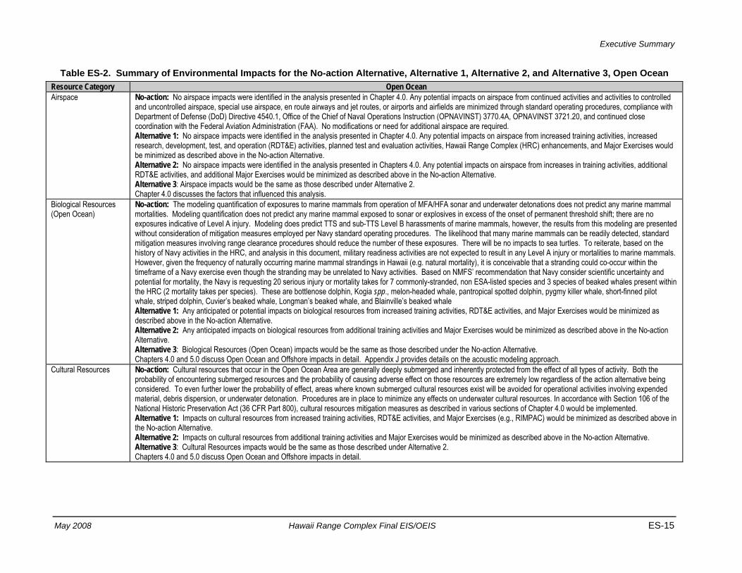
Table ES-2. Summary of Environmental Impacts for the No-action Alternative, Alternative 1, Alternative 2, and Alternative 3, Open Ocean Resource Category Open Ocean Airspace No-action: No airspace impacts were identified in the analysis presented in Chapter 4.0. Any potential impacts on airspace from continued activities and activities to controlled
and uncontrolled airspace, special use airspace, en route airways and jet routes, or airports and airfields are minimized through standard operating procedures, compliance with Department of Defense (DoD) Directive 4540.1, Office of the Chief of Naval Operations Instruction (OPNAVINST) 3770.4A, OPNAVINST 3721.20, and continued close coordination with the Federal Aviation Administration (FAA). No modifications or need for additional airspace are required. Alternative 1: No airspace impacts were identified in the analysis presented in Chapter 4.0. Any potential impacts on airspace from increased training activities, increased research, development, test, and operation (RDT&E) activities, planned test and evaluation activities, Hawaii Range Complex (HRC) enhancements, and Major Exercises would be minimized as described above in the No-action Alternative. Alternative 2: No airspace impacts were identified in the analysis presented in Chapters 4.0. Any potential impacts on airspace from increases in training activities, additional RDT&E activities, and additional Major Exercises would be minimized as described above in the No-action Alternative. Alternative 3: Airspace impacts would be the same as those described under Alternative 2. Chapter 4.0 discusses the factors that influenced this analysis.
Biological Resources (Open Ocean)
No-action: The modeling quantification of exposures to marine mammals from operation of MFA/HFA sonar and underwater detonations does not predict any marine mammal mortalities. Modeling quantification does not predict any marine mammal exposed to sonar or explosives in excess of the onset of permanent threshold shift; there are no exposures indicative of Level A injury. Modeling does predict TTS and sub-TTS Level B harassments of marine mammals, however, the results from this modeling are presented without consideration of mitigation measures employed per Navy standard operating procedures. The likelihood that many marine mammals can be readily detected, standard mitigation measures involving range clearance procedures should reduce the number of these exposures. There will be no impacts to sea turtles. To reiterate, based on the history of Navy activities in the HRC, and analysis in this document, military readiness activities are not expected to result in any Level A injury or mortalities to marine mammals. However, given the frequency of naturally occurring marine mammal strandings in Hawaii (e.g. natural mortality), it is conceivable that a stranding could co-occur within the timeframe of a Navy exercise even though the stranding may be unrelated to Navy activities. Based on NMFS’ recommendation that Navy consider scientific uncertainty and potential for mortality, the Navy is requesting 20 serious injury or mortality takes for 7 commonly-stranded, non ESA-listed species and 3 species of beaked whales present within the HRC (2 mortality takes per species). These are bottlenose dolphin, Kogia spp., melon-headed whale, pantropical spotted dolphin, pygmy killer whale, short-finned pilot whale, striped dolphin, Cuvier’s beaked whale, Longman’s beaked whale, and Blainville’s beaked whale Alternative 1: Any anticipated or potential impacts on biological resources from increased training activities, RDT&E activities, and Major Exercises would be minimized as described above in the No-action Alternative. Alternative 2: Any anticipated impacts on biological resources from additional training activities and Major Exercises would be minimized as described above in the No-action Alternative. Alternative 3: Biological Resources (Open Ocean) impacts would be the same as those described under the No-action Alternative. Chapters 4.0 and 5.0 discuss Open Ocean and Offshore impacts in detail. Appendix J provides details on the acoustic modeling approach.
Cultural Resources No-action: Cultural resources that occur in the Open Ocean Area are generally deeply submerged and inherently protected from the effect of all types of activity. Both the probability of encountering submerged resources and the probability of causing adverse effect on those resources are extremely low regardless of the action alternative being considered. To even further lower the probability of effect, areas where known submerged cultural resources exist will be avoided for operational activities involving expended material, debris dispersion, or underwater detonation. Procedures are in place to minimize any effects on underwater cultural resources. In accordance with Section 106 of the National Historic Preservation Act (36 CFR Part 800), cultural resources mitigation measures as described in various sections of Chapter 4.0 would be implemented. Alternative 1: Impacts on cultural resources from increased training activities, RDT&E activities, and Major Exercises (e.g., RIMPAC) would be minimized as described above in the No-action Alternative. Alternative 2: Impacts on cultural resources from additional training activities and Major Exercises would be minimized as described above in the No-action Alternative. Alternative 3: Cultural Resources impacts would be the same as those described under Alternative 2. Chapters 4.0 and 5.0 discuss Open Ocean and Offshore impacts in detail.
Executive Summary
ES-16 Hawaii Range Complex Final EIS/OEIS May 2008
Table ES-2. Summary of Environmental Impacts for the No-action Alternative, Alternative 1, Alternative 2, and Alternative 3, Open Ocean (Continued)
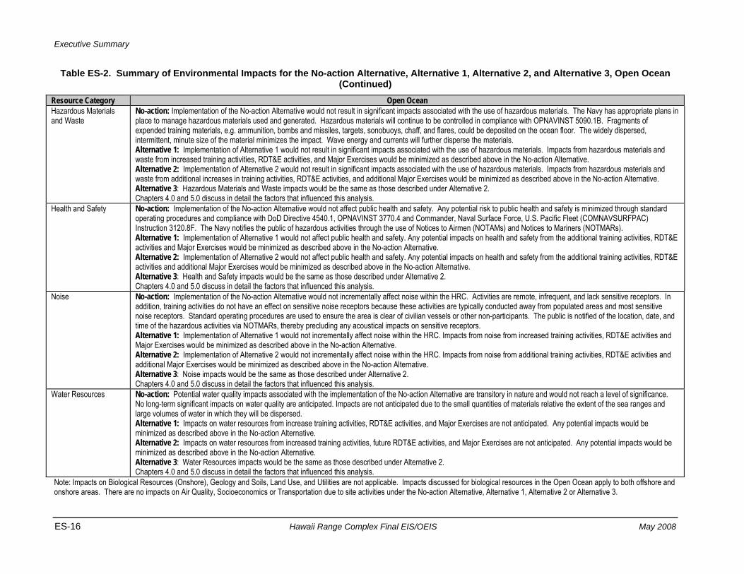
Resource Category Open Ocean Hazardous Materials and Waste
No-action: Implementation of the No-action Alternative would not result in significant impacts associated with the use of hazardous materials. The Navy has appropriate plans in place to manage hazardous materials used and generated. Hazardous materials will continue to be controlled in compliance with OPNAVINST 5090.1B. Fragments of expended training materials, e.g. ammunition, bombs and missiles, targets, sonobuoys, chaff, and flares, could be deposited on the ocean floor. The widely dispersed, intermittent, minute size of the material minimizes the impact. Wave energy and currents will further disperse the materials. Alternative 1: Implementation of Alternative 1 would not result in significant impacts associated with the use of hazardous materials. Impacts from hazardous materials and waste from increased training activities, RDT&E activities, and Major Exercises would be minimized as described above in the No-action Alternative. Alternative 2: Implementation of Alternative 2 would not result in significant impacts associated with the use of hazardous materials. Impacts from hazardous materials and waste from additional increases in training activities, RDT&E activities, and additional Major Exercises would be minimized as described above in the No-action Alternative. Alternative 3: Hazardous Materials and Waste impacts would be the same as those described under Alternative 2. Chapters 4.0 and 5.0 discuss in detail the factors that influenced this analysis.
Health and Safety No-action: Implementation of the No-action Alternative would not affect public health and safety. Any potential risk to public health and safety is minimized through standard operating procedures and compliance with DoD Directive 4540.1, OPNAVINST 3770.4 and Commander, Naval Surface Force, U.S. Pacific Fleet (COMNAVSURFPAC) Instruction 3120.8F. The Navy notifies the public of hazardous activities through the use of Notices to Airmen (NOTAMs) and Notices to Mariners (NOTMARs). Alternative 1: Implementation of Alternative 1 would not affect public health and safety. Any potential impacts on health and safety from the additional training activities, RDT&E activities and Major Exercises would be minimized as described above in the No-action Alternative. Alternative 2: Implementation of Alternative 2 would not affect public health and safety. Any potential impacts on health and safety from the additional training activities, RDT&E activities and additional Major Exercises would be minimized as described above in the No-action Alternative. Alternative 3: Health and Safety impacts would be the same as those described under Alternative 2. Chapters 4.0 and 5.0 discuss in detail the factors that influenced this analysis.
Noise No-action: Implementation of the No-action Alternative would not incrementally affect noise within the HRC. Activities are remote, infrequent, and lack sensitive receptors. In addition, training activities do not have an effect on sensitive noise receptors because these activities are typically conducted away from populated areas and most sensitive noise receptors. Standard operating procedures are used to ensure the area is clear of civilian vessels or other non-participants. The public is notified of the location, date, and time of the hazardous activities via NOTMARs, thereby precluding any acoustical impacts on sensitive receptors. Alternative 1: Implementation of Alternative 1 would not incrementally affect noise within the HRC. Impacts from noise from increased training activities, RDT&E activities and Major Exercises would be minimized as described above in the No-action Alternative. Alternative 2: Implementation of Alternative 2 would not incrementally affect noise within the HRC. Impacts from noise from additional training activities, RDT&E activities and additional Major Exercises would be minimized as described above in the No-action Alternative. Alternative 3: Noise impacts would be the same as those described under Alternative 2. Chapters 4.0 and 5.0 discuss in detail the factors that influenced this analysis.
Water Resources No-action: Potential water quality impacts associated with the implementation of the No-action Alternative are transitory in nature and would not reach a level of significance. No long-term significant impacts on water quality are anticipated. Impacts are not anticipated due to the small quantities of materials relative the extent of the sea ranges and large volumes of water in which they will be dispersed. Alternative 1: Impacts on water resources from increase training activities, RDT&E activities, and Major Exercises are not anticipated. Any potential impacts would be minimized as described above in the No-action Alternative. Alternative 2: Impacts on water resources from increased training activities, future RDT&E activities, and Major Exercises are not anticipated. Any potential impacts would be minimized as described above in the No-action Alternative. Alternative 3: Water Resources impacts would be the same as those described under Alternative 2. Chapters 4.0 and 5.0 discuss in detail the factors that influenced this analysis.
Note: Impacts on Biological Resources (Onshore), Geology and Soils, Land Use, and Utilities are not applicable. Impacts discussed for biological resources in the Open Ocean apply to both offshore and onshore areas. There are no impacts on Air Quality, Socioeconomics or Transportation due to site activities under the No-action Alternative, Alternative 1, Alternative 2 or Alternative 3.
Executive Summary
May 2008 Hawaii Range Complex Final EIS/OEIS ES-17
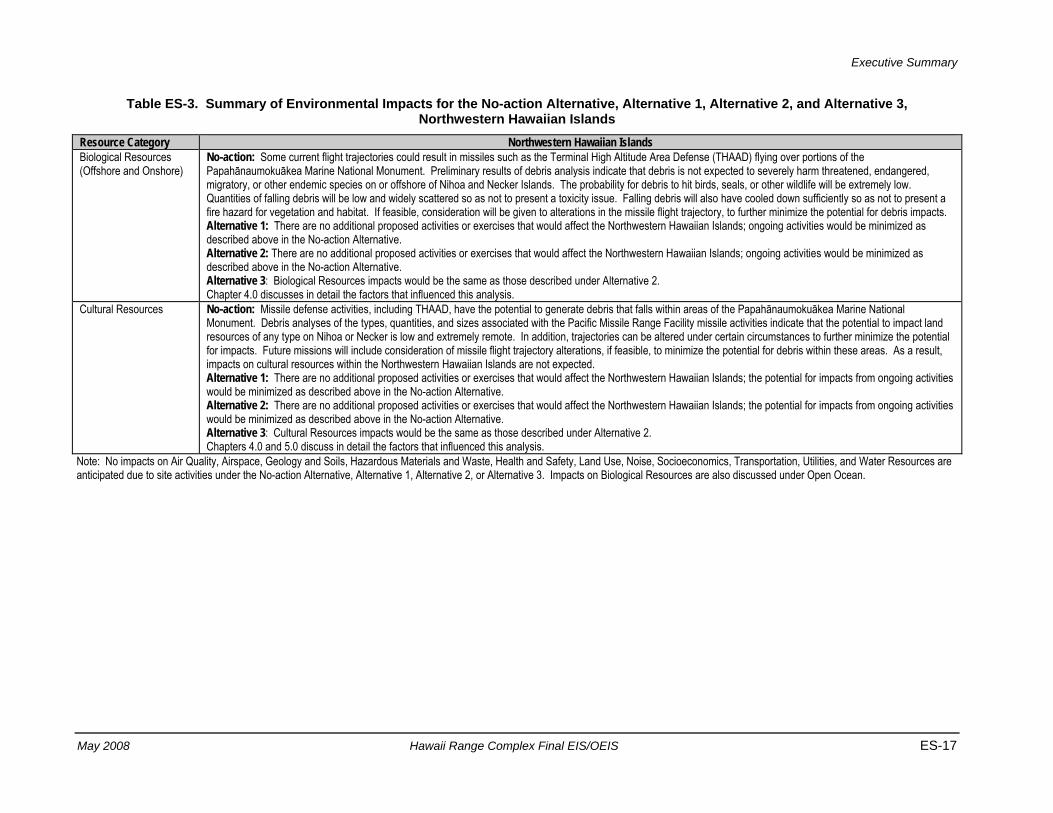
Table ES-3. Summary of Environmental Impacts for the No-action Alternative, Alternative 1, Alternative 2, and Alternative 3, Northwestern Hawaiian Islands
Resource Category Northwestern Hawaiian Islands Biological Resources (Offshore and Onshore)
No-action: Some current flight trajectories could result in missiles such as the Terminal High Altitude Area Defense (THAAD) flying over portions of the Papahānaumokuākea Marine National Monument. Preliminary results of debris analysis indicate that debris is not expected to severely harm threatened, endangered, migratory, or other endemic species on or offshore of Nihoa and Necker Islands. The probability for debris to hit birds, seals, or other wildlife will be extremely low. Quantities of falling debris will be low and widely scattered so as not to present a toxicity issue. Falling debris will also have cooled down sufficiently so as not to present a fire hazard for vegetation and habitat. If feasible, consideration will be given to alterations in the missile flight trajectory, to further minimize the potential for debris impacts. Alternative 1: There are no additional proposed activities or exercises that would affect the Northwestern Hawaiian Islands; ongoing activities would be minimized as described above in the No-action Alternative. Alternative 2: There are no additional proposed activities or exercises that would affect the Northwestern Hawaiian Islands; ongoing activities would be minimized as described above in the No-action Alternative. Alternative 3: Biological Resources impacts would be the same as those described under Alternative 2. Chapter 4.0 discusses in detail the factors that influenced this analysis.
Cultural Resources No-action: Missile defense activities, including THAAD, have the potential to generate debris that falls within areas of the Papahānaumokuākea Marine National Monument. Debris analyses of the types, quantities, and sizes associated with the Pacific Missile Range Facility missile activities indicate that the potential to impact land resources of any type on Nihoa or Necker is low and extremely remote. In addition, trajectories can be altered under certain circumstances to further minimize the potential for impacts. Future missions will include consideration of missile flight trajectory alterations, if feasible, to minimize the potential for debris within these areas. As a result, impacts on cultural resources within the Northwestern Hawaiian Islands are not expected. Alternative 1: There are no additional proposed activities or exercises that would affect the Northwestern Hawaiian Islands; the potential for impacts from ongoing activities would be minimized as described above in the No-action Alternative. Alternative 2: There are no additional proposed activities or exercises that would affect the Northwestern Hawaiian Islands; the potential for impacts from ongoing activities would be minimized as described above in the No-action Alternative. Alternative 3: Cultural Resources impacts would be the same as those described under Alternative 2. Chapters 4.0 and 5.0 discuss in detail the factors that influenced this analysis.
Note: No impacts on Air Quality, Airspace, Geology and Soils, Hazardous Materials and Waste, Health and Safety, Land Use, Noise, Socioeconomics, Transportation, Utilities, and Water Resources are anticipated due to site activities under the No-action Alternative, Alternative 1, Alternative 2, or Alternative 3. Impacts on Biological Resources are also discussed under Open Ocean.
Executive Summary
ES-18 Hawaii Range Complex Final EIS/OEIS May 2008
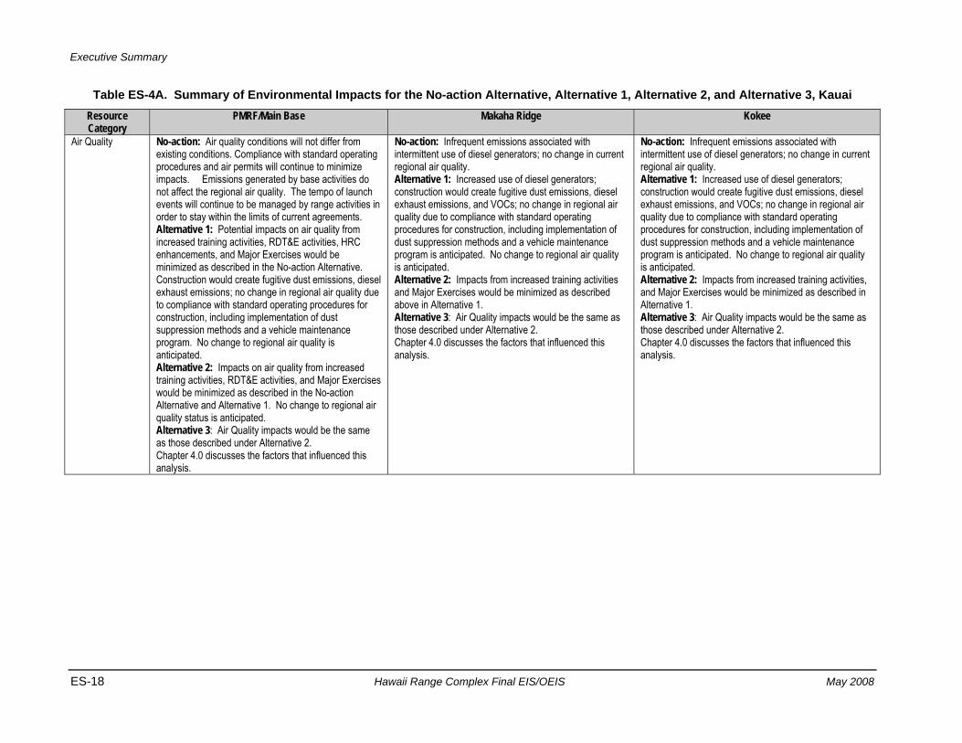
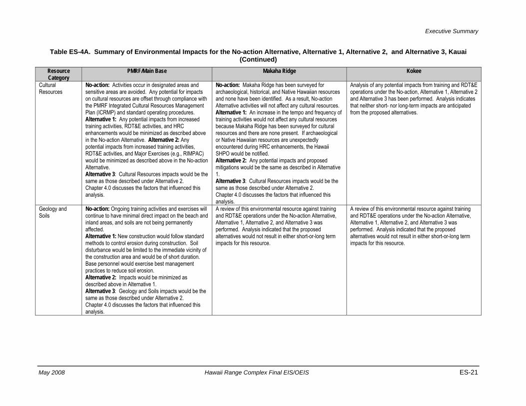
Table ES-4A. Summary of Environmental Impacts for the No-action Alternative, Alternative 1, Alternative 2, and Alternative 3, Kauai Resource Category
PMRF/Main Base Makaha Ridge Kokee
Air Quality No-action: Air quality conditions will not differ from existing conditions. Compliance with standard operating procedures and air permits will continue to minimize impacts. Emissions generated by base activities do not affect the regional air quality. The tempo of launch events will continue to be managed by range activities in order to stay within the limits of current agreements. Alternative 1: Potential impacts on air quality from increased training activities, RDT&E activities, HRC enhancements, and Major Exercises would be minimized as described in the No-action Alternative. Construction would create fugitive dust emissions, diesel exhaust emissions; no change in regional air quality due to compliance with standard operating procedures for construction, including implementation of dust suppression methods and a vehicle maintenance program. No change to regional air quality is anticipated. Alternative 2: Impacts on air quality from increased training activities, RDT&E activities, and Major Exercises would be minimized as described in the No-action Alternative and Alternative 1. No change to regional air quality status is anticipated. Alternative 3: Air Quality impacts would be the same as those described under Alternative 2. Chapter 4.0 discusses the factors that influenced this analysis.
No-action: Infrequent emissions associated with intermittent use of diesel generators; no change in current regional air quality. Alternative 1: Increased use of diesel generators; construction would create fugitive dust emissions, diesel exhaust emissions, and VOCs; no change in regional air quality due to compliance with standard operating procedures for construction, including implementation of dust suppression methods and a vehicle maintenance program is anticipated. No change to regional air quality is anticipated. Alternative 2: Impacts from increased training activities and Major Exercises would be minimized as described above in Alternative 1. Alternative 3: Air Quality impacts would be the same as those described under Alternative 2. Chapter 4.0 discusses the factors that influenced this analysis.
No-action: Infrequent emissions associated with intermittent use of diesel generators; no change in current regional air quality. Alternative 1: Increased use of diesel generators; construction would create fugitive dust emissions, diesel exhaust emissions, and VOCs; no change in regional air quality due to compliance with standard operating procedures for construction, including implementation of dust suppression methods and a vehicle maintenance program is anticipated. No change to regional air quality is anticipated. Alternative 2: Impacts from increased training activities, and Major Exercises would be minimized as described in Alternative 1. Alternative 3: Air Quality impacts would be the same as those described under Alternative 2. Chapter 4.0 discusses the factors that influenced this analysis.
Executive Summary
May 2008 Hawaii Range Complex Final EIS/OEIS ES-19
Table ES-4A. Summary of Environmental Impacts for the No-action Alternative, Alternative 1, Alternative 2, and Alternative 3, Kauai (Continued)
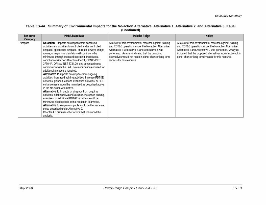
Resource Category
PMRF/Main Base Makaha Ridge Kokee
Airspace No-action: Impacts on airspace from continued activities and activities to controlled and uncontrolled airspace, special use airspace, en route airways and jet routes, or airports and airfields will continue to be minimized through standard operating procedures, compliance with DoD Directive 4540.1, OPNAVINST 3770.4A, OPNAVINST 3721.20, and continued close coordination with the FAA. No modifications or need for additional airspace is required. Alternative 1: Impacts on airspace from ongoing activities, increased training activities, increase RDT&E activities, planned test and evaluation activities, or HRC enhancements would be minimized as described above in the No-action Alternative. Alternative 2: Impacts on airspace from ongoing activities, additional Major Exercises, increased training exercises, or additional RDT&E activities would be minimized as described in the No-action alternative. Alternative 3: Airspace impacts would be the same as those described under Alternative 2. Chapter 4.0 discusses the factors that influenced this analysis.
A review of this environmental resource against training and RDT&E operations under the No-action Alternative, Alternative 1, Alternative 2, and Alternative 3 was performed. Analysis indicated that the proposed alternatives would not result in either short-or-long term impacts for this resource.
A review of this environmental resource against training and RDT&E operations under the No-action Alternative, Alternative 1 and Alternative 2 was performed. Analysis indicated that the proposed alternatives would not result in either short-or-long term impacts for this resource.
Executive Summary
ES-20 Hawaii Range Complex Final EIS/OEIS May 2008
Table ES-4A. Summary of Environmental Impacts for the No-action Alternative, Alternative 1, Alternative 2, and Alternative 3, Kauai (Continued)
Resource Category
PMRF/Main Base Makaha Ridge Kokee
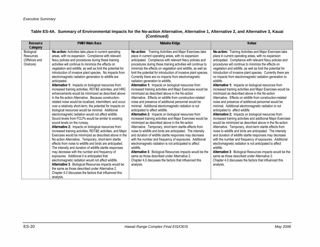
Biological Resources (Offshore and Onshore)
No-action: Activities take place in current operating areas, with no expansion. Compliance with relevant Navy policies and procedures during these training activities will continue to minimize the effects on vegetation and wildlife, as well as limit the potential for introduction of invasive plant species. No impacts from electromagnetic radiation generation to wildlife are anticipated. Alternative 1: Impacts on biological resources from increased training activities, RDT&E activities, and HRC enhancements would be minimized as described above in the No-action Alternative. Because construction-related noise would be localized, intermittent, and occur over a relatively short-term, the potential for impacts on biological resources would be minimal. Additional electromagnetic radiation would not affect wildlife. Sound levels from FCLPs would be similar to existing sound levels on the runway. Alternative 2: Impacts on biological resources from increased training activities, RDT&E activities, and Major Exercises would be minimized as described above in the No-action Alternative. Temporary, short-term startle effects from noise to wildlife and birds are anticipated. The intensity and duration of wildlife startle responses may decrease with the number and frequency of exposures. Additional it is anticipated that electromagnetic radiation would not affect wildlife. Alternative 3: Biological Resources impacts would be the same as those described under Alternative 2. Chapter 4.0 discusses the factors that influenced this analysis.
No-action: Training Activities and Major Exercises take place in current operating areas, with no expansion anticipated. Compliance with relevant Navy policies and procedures during these training activities will continue to minimize the effects on vegetation and wildlife, as well as limit the potential for introduction of invasive plant species. Currently there are no impacts from electromagnetic radiation generation to wildlife. Alternative 1: Impacts on biological resources from increased training activities and Major Exercises would be minimized as described above in the No-action Alternative. Effects on wildlife from construction-related noise and presence of additional personnel would be minimal. Additional electromagnetic radiation is not anticipated to affect wildlife. Alternative 2: Impacts on biological resources from increased training activities and Major Exercises would be minimized as described above in the No-action Alternative. Temporary, short-term startle effects from noise to wildlife and birds are anticipated. The intensity and duration of wildlife startle responses may decrease with the number and frequency of exposures. Additional electromagnetic radiation is not anticipated to affect wildlife. Alternative 3: Biological Resources impacts would be the same as those described under Alternative 2. Chapter 4.0 discusses the factors that influenced this analysis.
No-action: Training Activities and Major Exercises take place in current operating areas, with no expansion anticipated. Compliance with relevant Navy policies and procedures will continue to minimize the effects on vegetation and wildlife, as well as limit the potential for introduction of invasive plant species. Currently there are no impacts from electromagnetic radiation generation to wildlife. Alternative 1: Impacts on biological resources from increased training activities and Major Exercises would be minimized as described above in the No-action Alternative. Effects on wildlife from construction-related noise and presence of additional personnel would be minimal. Additional electromagnetic radiation is not anticipated to affect wildlife Alternative 2: Impacts on biological resources from increased training activities and additional Major Exercises would be minimized as described above in the No-action Alternative. Temporary, short-term startle effects from noise to wildlife and birds are anticipated. The intensity and duration of wildlife startle responses may decrease with the number and frequency of exposures. Additional electromagnetic radiation is not anticipated to affect wildlife. Alternative 3: Biological Resources impacts would be the same as those described under Alternative 2. Chapter 4.0 discusses the factors that influenced this analysis.
Executive Summary
May 2008 Hawaii Range Complex Final EIS/OEIS ES-21
Table ES-4A. Summary of Environmental Impacts for the No-action Alternative, Alternative 1, Alternative 2, and Alternative 3, Kauai (Continued)
Resource Category
PMRF/Main Base Makaha Ridge Kokee
Cultural Resources
No-action: Activities occur in designated areas and sensitive areas are avoided. Any potential for impacts on cultural resources are offset through compliance with the PMRF Integrated Cultural Resources Management Plan (ICRMP) and standard operating procedures. Alternative 1: Any potential impacts from increased training activities, RDT&E activities, and HRC enhancements would be minimized as described above in the No-action Alternative. Alternative 2: Any potential impacts from increased training activities, RDT&E activities, and Major Exercises (e.g., RIMPAC) would be minimized as described above in the No-action Alternative. Alternative 3: Cultural Resources impacts would be the same as those described under Alternative 2. Chapter 4.0 discusses the factors that influenced this analysis.
No-action: Makaha Ridge has been surveyed for archaeological, historical, and Native Hawaiian resources and none have been identified. As a result, No-action Alternative activities will not affect any cultural resources. Alternative 1: An increase in the tempo and frequency of training activities would not affect any cultural resources because Makaha Ridge has been surveyed for cultural resources and there are none present. If archaeological or Native Hawaiian resources are unexpectedly encountered during HRC enhancements, the Hawaii SHPO would be notified. Alternative 2: Any potential impacts and proposed mitigations would be the same as described in Alternative 1. Alternative 3: Cultural Resources impacts would be the same as those described under Alternative 2. Chapter 4.0 discusses the factors that influenced this analysis.
Analysis of any potential impacts from training and RDT&E operations under the No-action, Alternative 1, Alternative 2 and Alternative 3 has been performed. Analysis indicates that neither short- nor long-term impacts are anticipated from the proposed alternatives.
Geology and Soils
No-action: Ongoing training activities and exercises will continue to have minimal direct impact on the beach and inland areas, and soils are not being permanently affected. Alternative 1: New construction would follow standard methods to control erosion during construction. Soil disturbance would be limited to the immediate vicinity of the construction area and would be of short duration. Base personnel would exercise best management practices to reduce soil erosion. Alternative 2: Impacts would be minimized as described above in Alternative 1. Alternative 3: Geology and Soils impacts would be the same as those described under Alternative 2. Chapter 4.0 discusses the factors that influenced this analysis.
A review of this environmental resource against training and RDT&E operations under the No-action Alternative, Alternative 1, Alternative 2, and Alternative 3 was performed. Analysis indicated that the proposed alternatives would not result in either short-or-long term impacts for this resource.
A review of this environmental resource against training and RDT&E operations under the No-action Alternative, Alternative 1, Alternative 2, and Alternative 3 was performed. Analysis indicated that the proposed alternatives would not result in either short-or-long term impacts for this resource.
Executive Summary
ES-22 Hawaii Range Complex Final EIS/OEIS May 2008
Table ES-4A. Summary of Environmental Impacts for the No-action Alternative, Alternative 1, Alternative 2, and Alternative 3, Kauai (Continued)
Resource Category
PMRF/Main Base Makaha Ridge Kokee
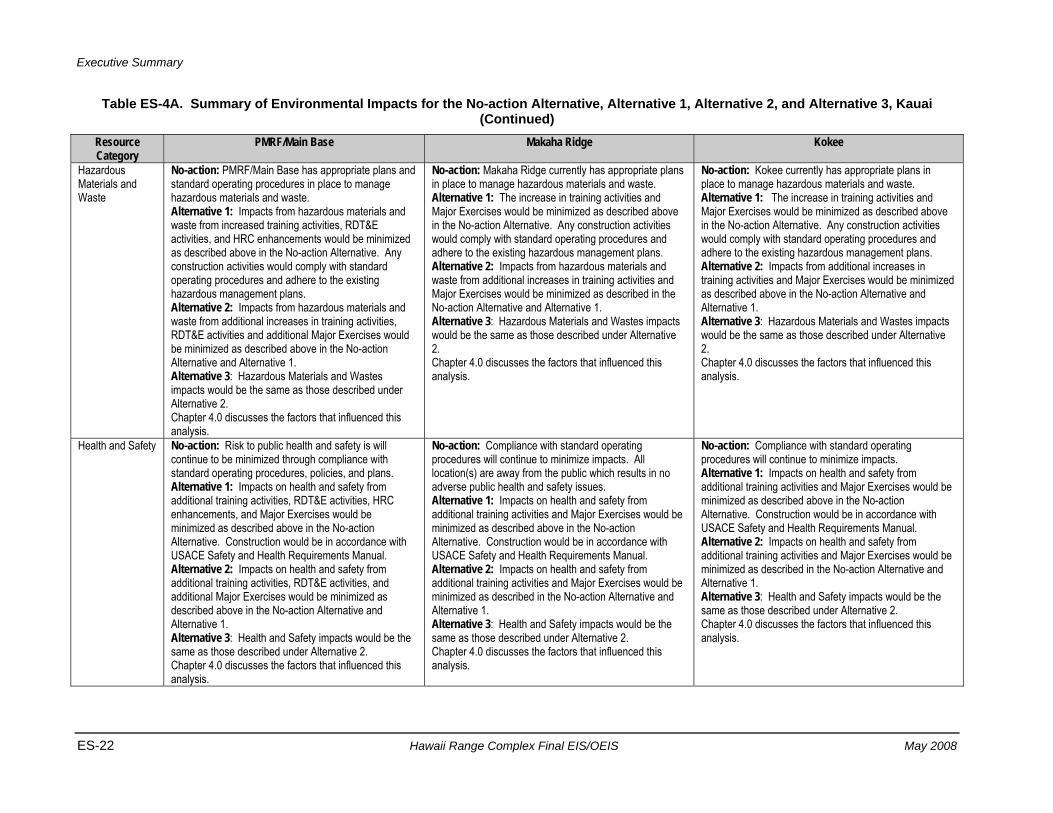
Hazardous Materials and Waste
No-action: PMRF/Main Base has appropriate plans and standard operating procedures in place to manage hazardous materials and waste. Alternative 1: Impacts from hazardous materials and waste from increased training activities, RDT&E activities, and HRC enhancements would be minimized as described above in the No-action Alternative. Any construction activities would comply with standard operating procedures and adhere to the existing hazardous management plans. Alternative 2: Impacts from hazardous materials and waste from additional increases in training activities, RDT&E activities and additional Major Exercises would be minimized as described above in the No-action Alternative and Alternative 1. Alternative 3: Hazardous Materials and Wastes impacts would be the same as those described under Alternative 2. Chapter 4.0 discusses the factors that influenced this analysis.
No-action: Makaha Ridge currently has appropriate plans in place to manage hazardous materials and waste. Alternative 1: The increase in training activities and Major Exercises would be minimized as described above in the No-action Alternative. Any construction activities would comply with standard operating procedures and adhere to the existing hazardous management plans. Alternative 2: Impacts from hazardous materials and waste from additional increases in training activities and Major Exercises would be minimized as described in the No-action Alternative and Alternative 1. Alternative 3: Hazardous Materials and Wastes impacts would be the same as those described under Alternative 2. Chapter 4.0 discusses the factors that influenced this analysis.
No-action: Kokee currently has appropriate plans in place to manage hazardous materials and waste. Alternative 1: The increase in training activities and Major Exercises would be minimized as described above in the No-action Alternative. Any construction activities would comply with standard operating procedures and adhere to the existing hazardous management plans. Alternative 2: Impacts from additional increases in training activities and Major Exercises would be minimized as described above in the No-action Alternative and Alternative 1. Alternative 3: Hazardous Materials and Wastes impacts would be the same as those described under Alternative 2. Chapter 4.0 discusses the factors that influenced this analysis.
Health and Safety No-action: Risk to public health and safety is will continue to be minimized through compliance with standard operating procedures, policies, and plans. Alternative 1: Impacts on health and safety from additional training activities, RDT&E activities, HRC enhancements, and Major Exercises would be minimized as described above in the No-action Alternative. Construction would be in accordance with USACE Safety and Health Requirements Manual. Alternative 2: Impacts on health and safety from additional training activities, RDT&E activities, and additional Major Exercises would be minimized as described above in the No-action Alternative and Alternative 1. Alternative 3: Health and Safety impacts would be the same as those described under Alternative 2. Chapter 4.0 discusses the factors that influenced this analysis.
No-action: Compliance with standard operating procedures will continue to minimize impacts. All location(s) are away from the public which results in no adverse public health and safety issues. Alternative 1: Impacts on health and safety from additional training activities and Major Exercises would be minimized as described above in the No-action Alternative. Construction would be in accordance with USACE Safety and Health Requirements Manual. Alternative 2: Impacts on health and safety from additional training activities and Major Exercises would be minimized as described in the No-action Alternative and Alternative 1. Alternative 3: Health and Safety impacts would be the same as those described under Alternative 2. Chapter 4.0 discusses the factors that influenced this analysis.
No-action: Compliance with standard operating procedures will continue to minimize impacts. Alternative 1: Impacts on health and safety from additional training activities and Major Exercises would be minimized as described above in the No-action Alternative. Construction would be in accordance with USACE Safety and Health Requirements Manual. Alternative 2: Impacts on health and safety from additional training activities and Major Exercises would be minimized as described in the No-action Alternative and Alternative 1. Alternative 3: Health and Safety impacts would be the same as those described under Alternative 2. Chapter 4.0 discusses the factors that influenced this analysis.
Executive Summary
May 2008 Hawaii Range Complex Final EIS/OEIS ES-23
Table ES-4A. Summary of Environmental Impacts for the No-action Alternative, Alternative 1, Alternative 2, and Alternative 3, Kauai (Continued)
Resource Category
PMRF/Main Base Makaha Ridge Kokee
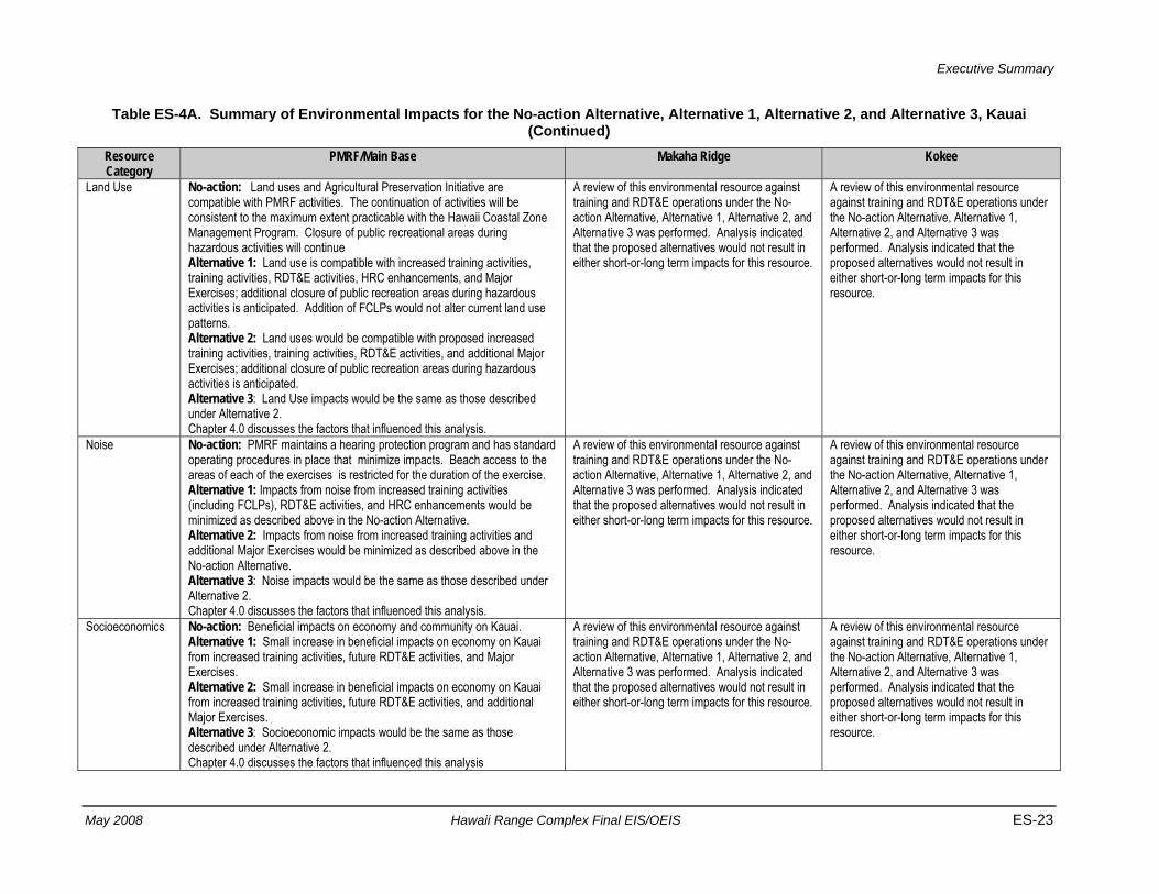
Land Use No-action: Land uses and Agricultural Preservation Initiative are compatible with PMRF activities. The continuation of activities will be consistent to the maximum extent practicable with the Hawaii Coastal Zone Management Program. Closure of public recreational areas during hazardous activities will continue Alternative 1: Land use is compatible with increased training activities, training activities, RDT&E activities, HRC enhancements, and Major Exercises; additional closure of public recreation areas during hazardous activities is anticipated. Addition of FCLPs would not alter current land use patterns. Alternative 2: Land uses would be compatible with proposed increased training activities, training activities, RDT&E activities, and additional Major Exercises; additional closure of public recreation areas during hazardous activities is anticipated. Alternative 3: Land Use impacts would be the same as those described under Alternative 2. Chapter 4.0 discusses the factors that influenced this analysis.
A review of this environmental resource against training and RDT&E operations under the No-action Alternative, Alternative 1, Alternative 2, and Alternative 3 was performed. Analysis indicated that the proposed alternatives would not result in either short-or-long term impacts for this resource.
A review of this environmental resource against training and RDT&E operations under the No-action Alternative, Alternative 1, Alternative 2, and Alternative 3 was performed. Analysis indicated that the proposed alternatives would not result in either short-or-long term impacts for this resource.
Noise No-action: PMRF maintains a hearing protection program and has standard operating procedures in place that minimize impacts. Beach access to the areas of each of the exercises is restricted for the duration of the exercise. Alternative 1: Impacts from noise from increased training activities (including FCLPs), RDT&E activities, and HRC enhancements would be minimized as described above in the No-action Alternative. Alternative 2: Impacts from noise from increased training activities and additional Major Exercises would be minimized as described above in the No-action Alternative. Alternative 3: Noise impacts would be the same as those described under Alternative 2. Chapter 4.0 discusses the factors that influenced this analysis.
A review of this environmental resource against training and RDT&E operations under the No-action Alternative, Alternative 1, Alternative 2, and Alternative 3 was performed. Analysis indicated that the proposed alternatives would not result in either short-or-long term impacts for this resource.
A review of this environmental resource against training and RDT&E operations under the No-action Alternative, Alternative 1, Alternative 2, and Alternative 3 was performed. Analysis indicated that the proposed alternatives would not result in either short-or-long term impacts for this resource.
Socioeconomics No-action: Beneficial impacts on economy and community on Kauai. Alternative 1: Small increase in beneficial impacts on economy on Kauai from increased training activities, future RDT&E activities, and Major Exercises. Alternative 2: Small increase in beneficial impacts on economy on Kauai from increased training activities, future RDT&E activities, and additional Major Exercises. Alternative 3: Socioeconomic impacts would be the same as those described under Alternative 2. Chapter 4.0 discusses the factors that influenced this analysis
A review of this environmental resource against training and RDT&E operations under the No-action Alternative, Alternative 1, Alternative 2, and Alternative 3 was performed. Analysis indicated that the proposed alternatives would not result in either short-or-long term impacts for this resource.
A review of this environmental resource against training and RDT&E operations under the No-action Alternative, Alternative 1, Alternative 2, and Alternative 3 was performed. Analysis indicated that the proposed alternatives would not result in either short-or-long term impacts for this resource.
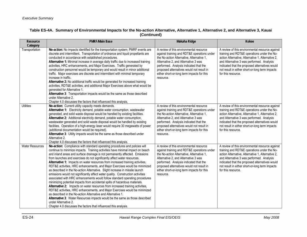
Executive Summary
ES-24 Hawaii Range Complex Final EIS/OEIS May 2008
Table ES-4A. Summary of Environmental Impacts for the No-action Alternative, Alternative 1, Alternative 2, and Alternative 3, Kauai (Continued)
Resource Category
PMRF/Main Base Makaha Ridge Kokee
Transportation No-action: No impacts identified for the transportation system; PMRF events are discrete and intermittent. Transportation of ordnance and liquid propellants are conducted in accordance with established procedures. Alternative 1: Minimal increase in average daily traffic due to increased training activities, HRC enhancements, and Major Exercises. Traffic generated by construction personnel would be temporary and would result in minor additional traffic. Major exercises are discrete and intermittent with minimal temporary increase in traffic. Alternative 2: No additional traffic would be generated for increased training activities, RDT&E activities, and additional Major Exercises above what would be generated for Alternative 1. Alternative 3: Transportation impacts would be the same as those described under Alternative 2. Chapter 4.0 discusses the factors that influenced this analysis,
A review of this environmental resource against training and RDT&E operations under the No-action Alternative, Alternative 1, Alternative 2, and Alternative 3 was performed. Analysis indicated that the proposed alternatives would not result in either short-or-long term impacts for this resource.
A review of this environmental resource against training and RDT&E operations under the No-action Alternative, Alternative 1, Alternative 2, and Alternative 3 was performed. Analysis indicated that the proposed alternatives would not result in either short-or-long term impacts for this resource.
Utilities No-action: Current utility capacity meets demands. Alternative 1: Electricity demand, potable water consumption, wastewater generated, and solid waste disposal would be handled by existing facilities. Alternative 2: Additional electricity demand, potable water consumption, wastewater generated and solid waste disposal would be handled by existing facilities. Operation of a high-energy laser would require 30 megawatts of power (additional documentation would be required). Alternative 3: Utility impacts would be the same as those described under Alternative 2. Chapter 4.0 discusses the factors that influenced this analysis.
A review of this environmental resource against training and RDT&E operations under the No-action Alternative, Alternative 1, Alternative 2, and Alternative 3 was performed. Analysis indicated that the proposed alternatives would not result in either short-or-long term impacts for this resource.
A review of this environmental resource against training and RDT&E operations under the No-action Alternative, Alternative 1, Alternative 2, and Alternative 3 was performed. Analysis indicated that the proposed alternatives would not result in either short-or-long term impacts for this resource.
Water Resources No-action: Compliance with standard operating procedures and policies will continue to minimize impacts. Training activities have minimal impact on beach and inland areas and surface drainage is not permanently affected. Emissions from launches and exercises do not significantly affect water resources. Alternative 1: Impacts on water resources from increased training activities, RDT&E activities, HRC enhancements, and Major Exercises would be minimized as described in the No-action Alternative. Slight increase in missile launch emissions would not significantly affect water quality. Construction activities associated with HRC enhancements would follow standard operating procedures minimizing potential impacts from accidental spills of hazardous materials. Alternative 2: Impacts on water resources from increased training activities, RDT&E activities, HRC enhancements, and Major Exercises would be minimized as described in the No-action Alternative and Alternative 1. Alternative 3: Water Resources impacts would be the same as those described under Alternative 2. Chapter 4.0 discusses the factors that influenced this analysis.
A review of this environmental resource against training and RDT&E operations under the No-action Alternative, Alternative 1, Alternative 2, and Alternative 3 was performed. Analysis indicated that the proposed alternatives would not result in either short-or-long term impacts for this resource.
A review of this environmental resource against training and RDT&E operations under the No-action Alternative, Alternative 1, Alternative 2, and Alternative 3 was performed. Analysis indicated that the proposed alternatives would not result in either short-or-long term impacts for this resource.
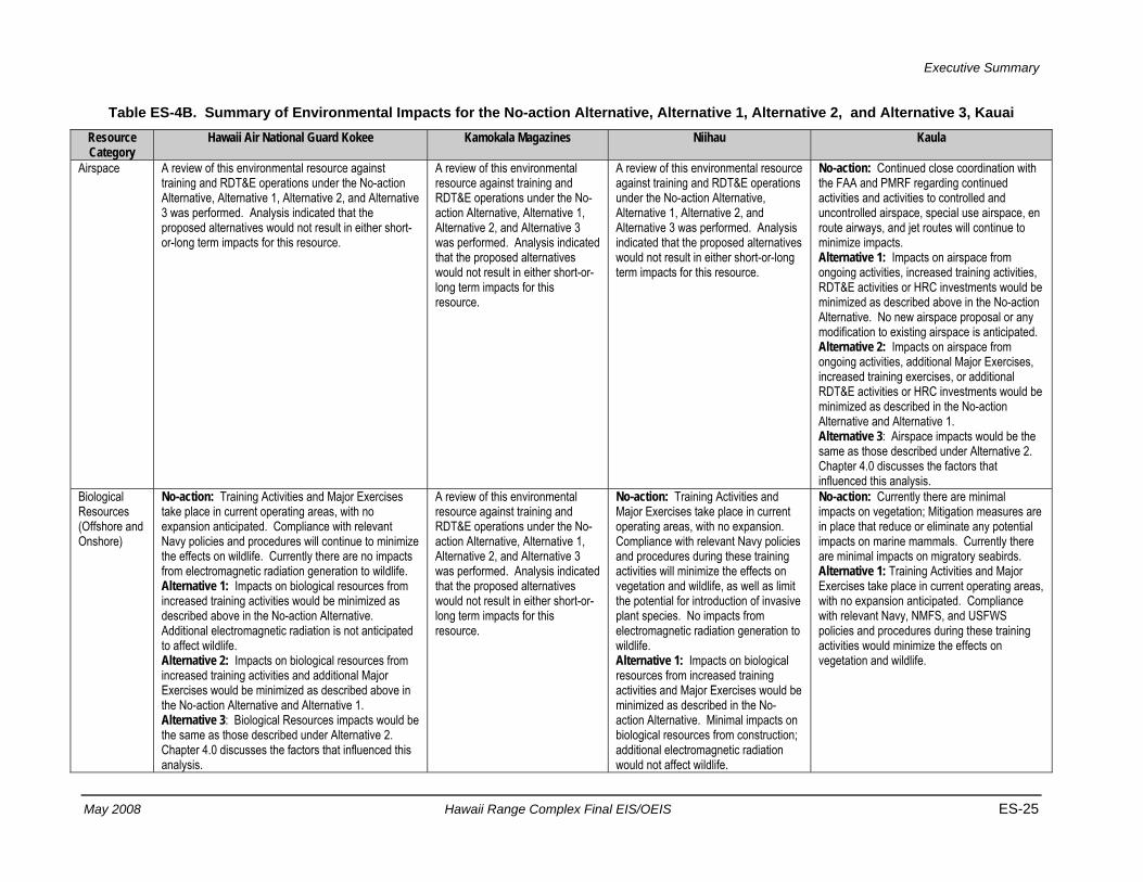
Executive Summary
May 2008 Hawaii Range Complex Final EIS/OEIS ES-25
Table ES-4B. Summary of Environmental Impacts for the No-action Alternative, Alternative 1, Alternative 2, and Alternative 3, Kauai Resource Category
Hawaii Air National Guard Kokee Kamokala Magazines Niihau Kaula
Airspace A review of this environmental resource against training and RDT&E operations under the No-action Alternative, Alternative 1, Alternative 2, and Alternative 3 was performed. Analysis indicated that the proposed alternatives would not result in either short-or-long term impacts for this resource.
A review of this environmental resource against training and RDT&E operations under the No-action Alternative, Alternative 1, Alternative 2, and Alternative 3 was performed. Analysis indicated that the proposed alternatives would not result in either short-or-long term impacts for this resource.
A review of this environmental resource against training and RDT&E operations under the No-action Alternative, Alternative 1, Alternative 2, and Alternative 3 was performed. Analysis indicated that the proposed alternatives would not result in either short-or-long term impacts for this resource.
No-action: Continued close coordination with the FAA and PMRF regarding continued activities and activities to controlled and uncontrolled airspace, special use airspace, en route airways, and jet routes will continue to minimize impacts. Alternative 1: Impacts on airspace from ongoing activities, increased training activities, RDT&E activities or HRC investments would be minimized as described above in the No-action Alternative. No new airspace proposal or any modification to existing airspace is anticipated. Alternative 2: Impacts on airspace from ongoing activities, additional Major Exercises, increased training exercises, or additional RDT&E activities or HRC investments would be minimized as described in the No-action Alternative and Alternative 1. Alternative 3: Airspace impacts would be the same as those described under Alternative 2. Chapter 4.0 discusses the factors that influenced this analysis.
Biological Resources (Offshore and Onshore)
No-action: Training Activities and Major Exercises take place in current operating areas, with no expansion anticipated. Compliance with relevant Navy policies and procedures will continue to minimize the effects on wildlife. Currently there are no impacts from electromagnetic radiation generation to wildlife. Alternative 1: Impacts on biological resources from increased training activities would be minimized as described above in the No-action Alternative. Additional electromagnetic radiation is not anticipated to affect wildlife. Alternative 2: Impacts on biological resources from increased training activities and additional Major Exercises would be minimized as described above in the No-action Alternative and Alternative 1. Alternative 3: Biological Resources impacts would be the same as those described under Alternative 2. Chapter 4.0 discusses the factors that influenced this analysis.
A review of this environmental resource against training and RDT&E operations under the No-action Alternative, Alternative 1, Alternative 2, and Alternative 3 was performed. Analysis indicated that the proposed alternatives would not result in either short-or-long term impacts for this resource.
No-action: Training Activities and Major Exercises take place in current operating areas, with no expansion. Compliance with relevant Navy policies and procedures during these training activities will minimize the effects on vegetation and wildlife, as well as limit the potential for introduction of invasive plant species. No impacts from electromagnetic radiation generation to wildlife. Alternative 1: Impacts on biological resources from increased training activities and Major Exercises would be minimized as described in the No-action Alternative. Minimal impacts on biological resources from construction; additional electromagnetic radiation would not affect wildlife.
No-action: Currently there are minimal impacts on vegetation; Mitigation measures are in place that reduce or eliminate any potential impacts on marine mammals. Currently there are minimal impacts on migratory seabirds. Alternative 1: Training Activities and Major Exercises take place in current operating areas, with no expansion anticipated. Compliance with relevant Navy, NMFS, and USFWS policies and procedures during these training activities would minimize the effects on vegetation and wildlife.

Executive Summary
ES-26 Hawaii Range Complex Final EIS/OEIS May 2008
Table ES-4B. Summary of Environmental Impacts for the No-action Alternative, Alternative 1, Alternative 2, and Alternative 3, Kauai (Continued)
Resource Category
Hawaii Air National Guard Kokee Kamokala Magazines Niihau Kaula
Biological Resources (Offshore and Onshore) (Continued)
Alternative 2: Impacts on biological resources from increased training activities and Major Exercises would be as described above in the No-action Alternative and Alternative 1. Temporary, short-term startle effects from noise to wildlife and birds are anticipated. The intensity and duration of wildlife startle responses decrease with the number and frequency of exposures. Alternative 3: Biological Resources impacts would be the same as those described under Alternative 2. Chapter 4.0 discusses the factors that influenced this analysis.
Alternative 2: Impacts on biological resources from increased training activities and Major Exercises would be minimized as described above in the No-action Alternative and Alternative 1. Temporary, short-term startle effects from noise to wildlife and birds anticipated. The intensity and duration of wildlife startle responses may decrease with the number and frequency of exposures. No potential impacts on migratory seabird populations. Alternative 3: Biological Resources impacts would be the same as those described under Alternative 2. Chapter 4.0 discusses the factors that influenced this analysis.
Cultural Resources
Analysis of any potential impacts from training and RDT&E operations under the No-action, Alternative 1, Alternative 2, and Alternative 3 has been performed. Analysis indicates that neither short- nor long-term impacts are anticipated from the proposed alternatives.
Analysis of any potential impacts from training and RDT&E operations under the No-action, Alternative 1, Alternative 2, and Alternative 3 has been performed. Analysis indicates that neither short- nor long-term impacts are anticipated from the proposed alternatives.
Analysis of any potential impacts from training and RDT&E operations under the No-action, Alternative 1, Alternative 2, and Alternative 3 has been performed. Analysis indicates that neither short- nor long-term impacts are anticipated from the proposed alternatives.
No-action: There are no known cultural resources sites within the ROI for Kaula; therefore, there will be no impacts on cultural resources from training activities or Major Exercises. Alternative 1: There are no known cultural resources sites within the ROI for Kaula; therefore, there will be no impacts on cultural resources from increased training activities. Alternative 2: There will be no impacts on cultural resources from any additional increases in training activities because there are no known cultural resources within the Kaula ROI. Alternative 3: Cultural Resources impacts would be the same as those described under Alternative 2.
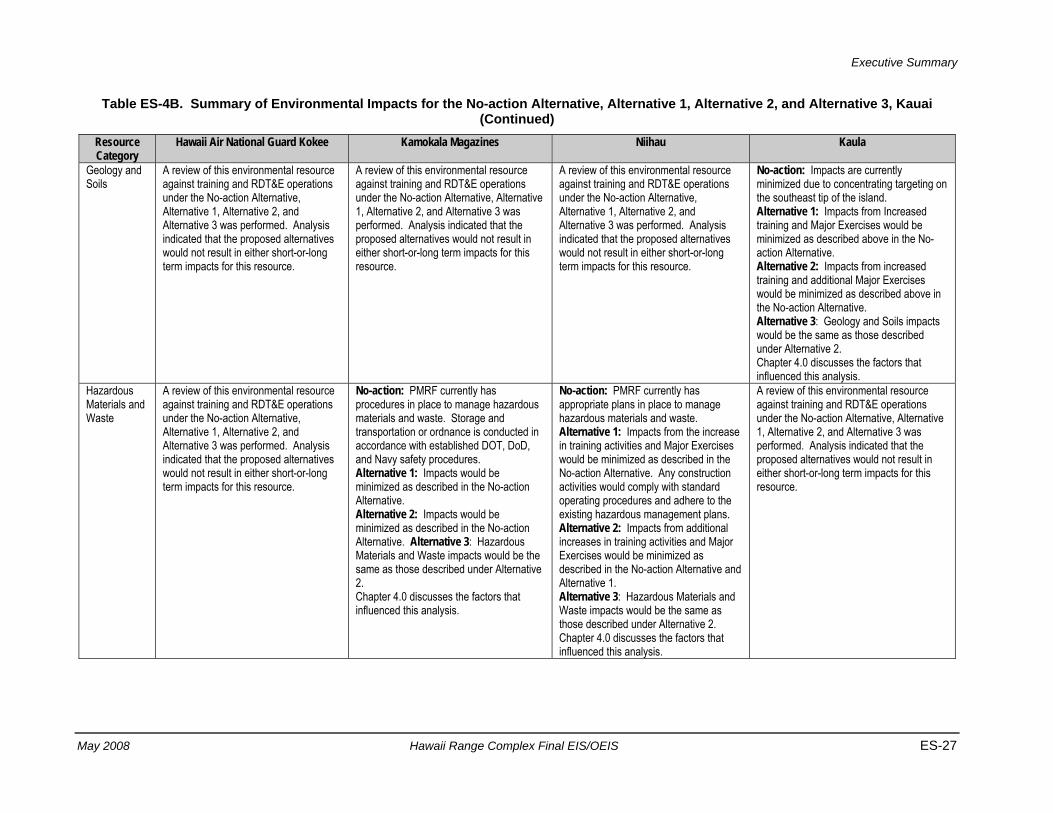
Executive Summary
May 2008 Hawaii Range Complex Final EIS/OEIS ES-27
Table ES-4B. Summary of Environmental Impacts for the No-action Alternative, Alternative 1, Alternative 2, and Alternative 3, Kauai (Continued)
Resource Category
Hawaii Air National Guard Kokee Kamokala Magazines Niihau Kaula
Geology and Soils
A review of this environmental resource against training and RDT&E operations under the No-action Alternative, Alternative 1, Alternative 2, and Alternative 3 was performed. Analysis indicated that the proposed alternatives would not result in either short-or-long term impacts for this resource.
A review of this environmental resource against training and RDT&E operations under the No-action Alternative, Alternative 1, Alternative 2, and Alternative 3 was performed. Analysis indicated that the proposed alternatives would not result in either short-or-long term impacts for this resource.
A review of this environmental resource against training and RDT&E operations under the No-action Alternative, Alternative 1, Alternative 2, and Alternative 3 was performed. Analysis indicated that the proposed alternatives would not result in either short-or-long term impacts for this resource.
No-action: Impacts are currently minimized due to concentrating targeting on the southeast tip of the island. Alternative 1: Impacts from Increased training and Major Exercises would be minimized as described above in the No-action Alternative. Alternative 2: Impacts from increased training and additional Major Exercises would be minimized as described above in the No-action Alternative. Alternative 3: Geology and Soils impacts would be the same as those described under Alternative 2. Chapter 4.0 discusses the factors that influenced this analysis.
Hazardous Materials and Waste
A review of this environmental resource against training and RDT&E operations under the No-action Alternative, Alternative 1, Alternative 2, and Alternative 3 was performed. Analysis indicated that the proposed alternatives would not result in either short-or-long term impacts for this resource.
No-action: PMRF currently has procedures in place to manage hazardous materials and waste. Storage and transportation or ordnance is conducted in accordance with established DOT, DoD, and Navy safety procedures. Alternative 1: Impacts would be minimized as described in the No-action Alternative. Alternative 2: Impacts would be minimized as described in the No-action Alternative. Alternative 3: Hazardous Materials and Waste impacts would be the same as those described under Alternative 2. Chapter 4.0 discusses the factors that influenced this analysis.
No-action: PMRF currently has appropriate plans in place to manage hazardous materials and waste. Alternative 1: Impacts from the increase in training activities and Major Exercises would be minimized as described in the No-action Alternative. Any construction activities would comply with standard operating procedures and adhere to the existing hazardous management plans. Alternative 2: Impacts from additional increases in training activities and Major Exercises would be minimized as described in the No-action Alternative and Alternative 1. Alternative 3: Hazardous Materials and Waste impacts would be the same as those described under Alternative 2. Chapter 4.0 discusses the factors that influenced this analysis.
A review of this environmental resource against training and RDT&E operations under the No-action Alternative, Alternative 1, Alternative 2, and Alternative 3 was performed. Analysis indicated that the proposed alternatives would not result in either short-or-long term impacts for this resource.
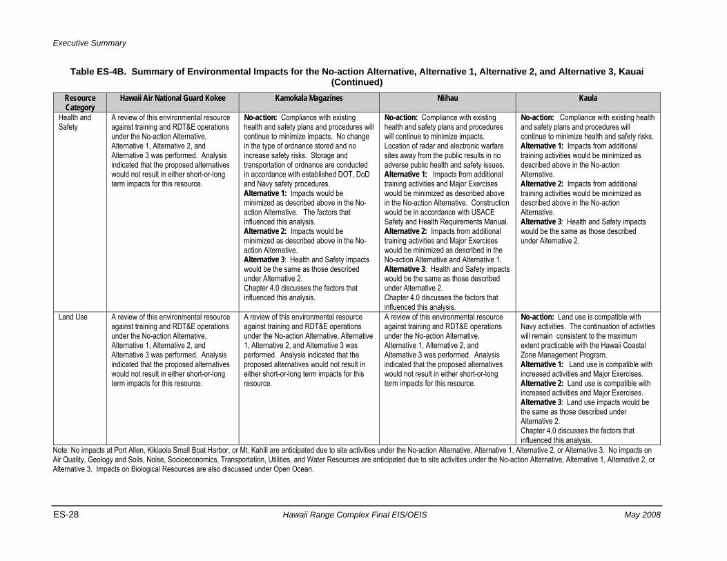
Executive Summary
ES-28 Hawaii Range Complex Final EIS/OEIS May 2008
Table ES-4B. Summary of Environmental Impacts for the No-action Alternative, Alternative 1, Alternative 2, and Alternative 3, Kauai (Continued)
Resource Category
Hawaii Air National Guard Kokee Kamokala Magazines Niihau Kaula
Health and Safety
A review of this environmental resource against training and RDT&E operations under the No-action Alternative, Alternative 1, Alternative 2, and Alternative 3 was performed. Analysis indicated that the proposed alternatives would not result in either short-or-long term impacts for this resource.
No-action: Compliance with existing health and safety plans and procedures will continue to minimize impacts. No change in the type of ordnance stored and no increase safety risks. Storage and transportation of ordnance are conducted in accordance with established DOT, DoD and Navy safety procedures. Alternative 1: Impacts would be minimized as described above in the No-action Alternative. The factors that influenced this analysis. Alternative 2: Impacts would be minimized as described above in the No-action Alternative. Alternative 3: Health and Safety impacts would be the same as those described under Alternative 2. Chapter 4.0 discusses the factors that influenced this analysis.
No-action: Compliance with existing health and safety plans and procedures will continue to minimize impacts. Location of radar and electronic warfare sites away from the public results in no adverse public health and safety issues. Alternative 1: Impacts from additional training activities and Major Exercises would be minimized as described above in the No-action Alternative. Construction would be in accordance with USACE Safety and Health Requirements Manual. Alternative 2: Impacts from additional training activities and Major Exercises would be minimized as described in the No-action Alternative and Alternative 1. Alternative 3: Health and Safety impacts would be the same as those described under Alternative 2. Chapter 4.0 discusses the factors that influenced this analysis.
No-action: Compliance with existing health and safety plans and procedures will continue to minimize health and safety risks. Alternative 1: Impacts from additional training activities would be minimized as described above in the No-action Alternative. Alternative 2: Impacts from additional training activities would be minimized as described above in the No-action Alternative. Alternative 3: Health and Safety impacts would be the same as those described under Alternative 2.
Land Use A review of this environmental resource against training and RDT&E operations under the No-action Alternative, Alternative 1, Alternative 2, and Alternative 3 was performed. Analysis indicated that the proposed alternatives would not result in either short-or-long term impacts for this resource.
A review of this environmental resource against training and RDT&E operations under the No-action Alternative, Alternative 1, Alternative 2, and Alternative 3 was performed. Analysis indicated that the proposed alternatives would not result in either short-or-long term impacts for this resource.
A review of this environmental resource against training and RDT&E operations under the No-action Alternative, Alternative 1, Alternative 2, and Alternative 3 was performed. Analysis indicated that the proposed alternatives would not result in either short-or-long term impacts for this resource.
No-action: Land use is compatible with Navy activities. The continuation of activities will remain consistent to the maximum extent practicable with the Hawaii Coastal Zone Management Program. Alternative 1: Land use is compatible with increased activities and Major Exercises. Alternative 2: Land use is compatible with increased activities and Major Exercises. Alternative 3: Land use impacts would be the same as those described under Alternative 2. Chapter 4.0 discusses the factors that influenced this analysis.
Note: No impacts at Port Allen, Kikiaola Small Boat Harbor, or Mt. Kahili are anticipated due to site activities under the No-action Alternative, Alternative 1, Alternative 2, or Alternative 3. No impacts on Air Quality, Geology and Soils, Noise, Socioeconomics, Transportation, Utilities, and Water Resources are anticipated due to site activities under the No-action Alternative, Alternative 1, Alternative 2, or Alternative 3. Impacts on Biological Resources are also discussed under Open Ocean.
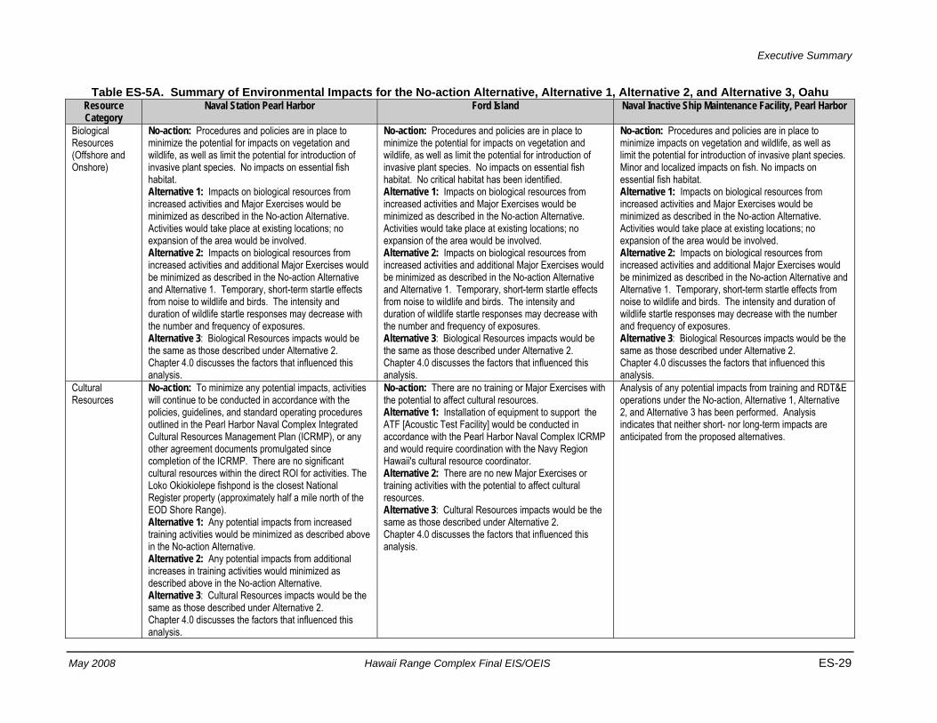
Executive Summary
May 2008 Hawaii Range Complex Final EIS/OEIS ES-29
Table ES-5A. Summary of Environmental Impacts for the No-action Alternative, Alternative 1, Alternative 2, and Alternative 3, Oahu Resource Category
Naval Station Pearl Harbor Ford Island Naval Inactive Ship Maintenance Facility, Pearl Harbor
Biological Resources (Offshore and Onshore)
No-action: Procedures and policies are in place to minimize the potential for impacts on vegetation and wildlife, as well as limit the potential for introduction of invasive plant species. No impacts on essential fish habitat. Alternative 1: Impacts on biological resources from increased activities and Major Exercises would be minimized as described in the No-action Alternative. Activities would take place at existing locations; no expansion of the area would be involved. Alternative 2: Impacts on biological resources from increased activities and additional Major Exercises would be minimized as described in the No-action Alternative and Alternative 1. Temporary, short-term startle effects from noise to wildlife and birds. The intensity and duration of wildlife startle responses may decrease with the number and frequency of exposures. Alternative 3: Biological Resources impacts would be the same as those described under Alternative 2. Chapter 4.0 discusses the factors that influenced this analysis.
No-action: Procedures and policies are in place to minimize the potential for impacts on vegetation and wildlife, as well as limit the potential for introduction of invasive plant species. No impacts on essential fish habitat. No critical habitat has been identified. Alternative 1: Impacts on biological resources from increased activities and Major Exercises would be minimized as described in the No-action Alternative. Activities would take place at existing locations; no expansion of the area would be involved. Alternative 2: Impacts on biological resources from increased activities and additional Major Exercises would be minimized as described in the No-action Alternative and Alternative 1. Temporary, short-term startle effects from noise to wildlife and birds. The intensity and duration of wildlife startle responses may decrease with the number and frequency of exposures. Alternative 3: Biological Resources impacts would be the same as those described under Alternative 2. Chapter 4.0 discusses the factors that influenced this analysis.
No-action: Procedures and policies are in place to minimize impacts on vegetation and wildlife, as well as limit the potential for introduction of invasive plant species. Minor and localized impacts on fish. No impacts on essential fish habitat. Alternative 1: Impacts on biological resources from increased activities and Major Exercises would be minimized as described in the No-action Alternative. Activities would take place at existing locations; no expansion of the area would be involved. Alternative 2: Impacts on biological resources from increased activities and additional Major Exercises would be minimized as described in the No-action Alternative and Alternative 1. Temporary, short-term startle effects from noise to wildlife and birds. The intensity and duration of wildlife startle responses may decrease with the number and frequency of exposures. Alternative 3: Biological Resources impacts would be the same as those described under Alternative 2. Chapter 4.0 discusses the factors that influenced this analysis.
Cultural Resources
No-action: To minimize any potential impacts, activities will continue to be conducted in accordance with the policies, guidelines, and standard operating procedures outlined in the Pearl Harbor Naval Complex Integrated Cultural Resources Management Plan (ICRMP), or any other agreement documents promulgated since completion of the ICRMP. There are no significant cultural resources within the direct ROI for activities. The Loko Okiokiolepe fishpond is the closest National Register property (approximately half a mile north of the EOD Shore Range). Alternative 1: Any potential impacts from increased training activities would be minimized as described above in the No-action Alternative. Alternative 2: Any potential impacts from additional increases in training activities would minimized as described above in the No-action Alternative. Alternative 3: Cultural Resources impacts would be the same as those described under Alternative 2. Chapter 4.0 discusses the factors that influenced this analysis.
No-action: There are no training or Major Exercises with the potential to affect cultural resources. Alternative 1: Installation of equipment to support the ATF [Acoustic Test Facility] would be conducted in accordance with the Pearl Harbor Naval Complex ICRMP and would require coordination with the Navy Region Hawaii's cultural resource coordinator. Alternative 2: There are no new Major Exercises or training activities with the potential to affect cultural resources. Alternative 3: Cultural Resources impacts would be the same as those described under Alternative 2. Chapter 4.0 discusses the factors that influenced this analysis.
Analysis of any potential impacts from training and RDT&E operations under the No-action, Alternative 1, Alternative 2, and Alternative 3 has been performed. Analysis indicates that neither short- nor long-term impacts are anticipated from the proposed alternatives.
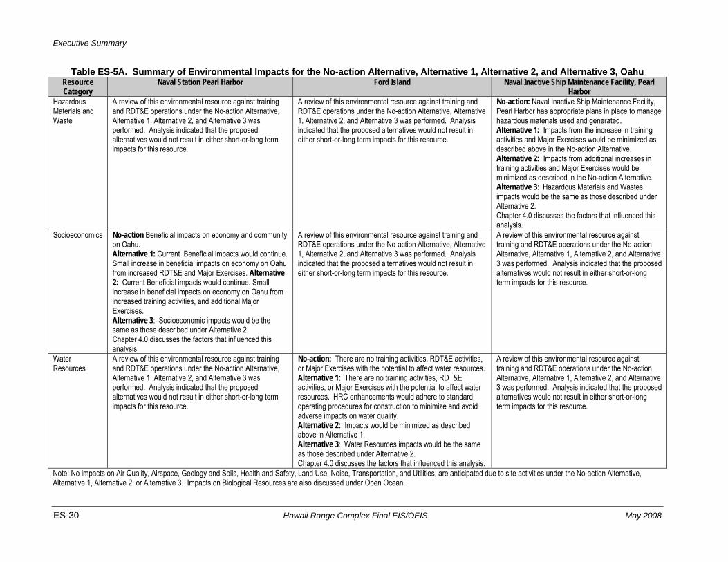
Executive Summary
ES-30 Hawaii Range Complex Final EIS/OEIS May 2008
Table ES-5A. Summary of Environmental Impacts for the No-action Alternative, Alternative 1, Alternative 2, and Alternative 3, Oahu Resource Category
Naval Station Pearl Harbor Ford Island Naval Inactive Ship Maintenance Facility, Pearl Harbor
Hazardous Materials and Waste
A review of this environmental resource against training and RDT&E operations under the No-action Alternative, Alternative 1, Alternative 2, and Alternative 3 was performed. Analysis indicated that the proposed alternatives would not result in either short-or-long term impacts for this resource.
A review of this environmental resource against training and RDT&E operations under the No-action Alternative, Alternative 1, Alternative 2, and Alternative 3 was performed. Analysis indicated that the proposed alternatives would not result in either short-or-long term impacts for this resource.
No-action: Naval Inactive Ship Maintenance Facility, Pearl Harbor has appropriate plans in place to manage hazardous materials used and generated. Alternative 1: Impacts from the increase in training activities and Major Exercises would be minimized as described above in the No-action Alternative. Alternative 2: Impacts from additional increases in training activities and Major Exercises would be minimized as described in the No-action Alternative. Alternative 3: Hazardous Materials and Wastes impacts would be the same as those described under Alternative 2. Chapter 4.0 discusses the factors that influenced this analysis.
Socioeconomics No-action Beneficial impacts on economy and community on Oahu. Alternative 1: Current Beneficial impacts would continue. Small increase in beneficial impacts on economy on Oahu from increased RDT&E and Major Exercises. Alternative 2: Current Beneficial impacts would continue. Small increase in beneficial impacts on economy on Oahu from increased training activities, and additional Major Exercises. Alternative 3: Socioeconomic impacts would be the same as those described under Alternative 2. Chapter 4.0 discusses the factors that influenced this analysis.
A review of this environmental resource against training and RDT&E operations under the No-action Alternative, Alternative 1, Alternative 2, and Alternative 3 was performed. Analysis indicated that the proposed alternatives would not result in either short-or-long term impacts for this resource.
A review of this environmental resource against training and RDT&E operations under the No-action Alternative, Alternative 1, Alternative 2, and Alternative 3 was performed. Analysis indicated that the proposed alternatives would not result in either short-or-long term impacts for this resource.
Water Resources
A review of this environmental resource against training and RDT&E operations under the No-action Alternative, Alternative 1, Alternative 2, and Alternative 3 was performed. Analysis indicated that the proposed alternatives would not result in either short-or-long term impacts for this resource.
No-action: There are no training activities, RDT&E activities, or Major Exercises with the potential to affect water resources. Alternative 1: There are no training activities, RDT&E activities, or Major Exercises with the potential to affect water resources. HRC enhancements would adhere to standard operating procedures for construction to minimize and avoid adverse impacts on water quality. Alternative 2: Impacts would be minimized as described above in Alternative 1. Alternative 3: Water Resources impacts would be the same as those described under Alternative 2. Chapter 4.0 discusses the factors that influenced this analysis.
A review of this environmental resource against training and RDT&E operations under the No-action Alternative, Alternative 1, Alternative 2, and Alternative 3 was performed. Analysis indicated that the proposed alternatives would not result in either short-or-long term impacts for this resource.
Note: No impacts on Air Quality, Airspace, Geology and Soils, Health and Safety, Land Use, Noise, Transportation, and Utilities, are anticipated due to site activities under the No-action Alternative, Alternative 1, Alternative 2, or Alternative 3. Impacts on Biological Resources are also discussed under Open Ocean.
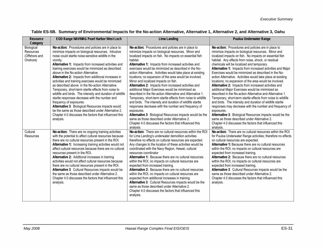
Executive Summary
May 2008 Hawaii Range Complex Final EIS/OEIS ES-31
Table ES-5B. Summary of Environmental Impacts for the No-action Alternative, Alternative 1, Alternative 2, and Alternative 3, Oahu Resource Category
EOD Range NAVMAG Pearl Harbor West Loch Lima Landing Puuloa Underwater Range
Biological Resources (Offshore and Onshore)
No-action: Procedures and policies are in place to minimize impacts on biological resources. Intrusive noise could startle noise-sensitive wildlife in the vicinity. Alternative 1: Impacts from increased activities and training exercises would be minimized as described above in the No-action Alternative. Alternative 2: Impacts from additional increases in activities and training exercises would be minimized as described above in the No-action Alternative. Temporary, short-term startle effects from noise to wildlife and birds. The intensity and duration of wildlife startle responses decrease with the number and frequency of exposures. Alternative 3: Biological Resources impacts would be the same as those described under Alternative 2. Chapter 4.0 discusses the factors that influenced this analysis.
No-action: Procedures and policies are in place to minimize impacts on biological resources. Minor and localized impacts on fish. No impacts on essential fish habitat. Alternative 1: Impacts from increased activities and exercises would be minimized as described in the No-action Alternative. Activities would take place at existing locations; no expansion of the area would be involved. Minor and localized impacts on fish. Alternative 2: Impacts from increased activities and additional Major Exercises would be minimized as described in the No-action Alternative and Alternative 1. Temporary, short-term startle effects from noise to wildlife and birds. The intensity and duration of wildlife startle responses decrease with the number and frequency of exposures. Alternative 3: Biological Resources impacts would be the same as those described under Alternative 2. Chapter 4.0 discusses the factors that influenced this analysis.
No-action: Procedures and policies are in place to minimize impacts on biological resources. Minor and localized impacts on fish. No impacts on essential fish habitat. Any effects from noise, shock, or residual chemicals will be localized and temporary. Alternative 1: Impacts from increased activities and Major Exercises would be minimized as described in the No-action Alternative. Activities would take place at existing locations; no expansion of the area would be involved. Alternative 2: Impacts from increased activities and additional Major Exercises would be minimized as described in the No-action Alternative and Alternative 1. Temporary, short-term startle effects from noise to wildlife and birds. The intensity and duration of wildlife startle responses may decrease with the number and frequency of exposures. Alternative 3: Biological Resources impacts would be the same as those described under Alternative 2. Chapter 4.0 discusses the factors that influenced this analysis.
Cultural Resources
No-action: There are no ongoing training activities with the potential to affect cultural resources because there are no cultural resources present in the ROI. Alternative 1: Increasing training activities would not affect cultural resources because there are no cultural resources present in the ROI. Alternative 2: Additional increases in training activities would not affect cultural resources because there are no cultural resources present in the ROI. Alternative 3: Cultural Resources impacts would be the same as those described under Alternative 2. Chapter 4.0 discusses the factors that influenced this analysis.
No-action: There are no cultural resources within the ROI for Lima Landing's underwater demolition activities therefore no effects on cultural resources are expected. Any changes to the location of these activities would be coordinated with the Navy Region, Hawaii, cultural resources coordinator Alternative 1: Because there are no cultural resources within the ROI, no impacts on cultural resources are expected from increased training. Alternative 2: Because there are no cultural resources within the ROI, no impacts on cultural resources are expected from additional increases in training. Alternative 3: Cultural Resources impacts would be the same as those described under Alternative 2. Chapter 4.0 discusses the factors that influenced this analysis.
No-action: There are no cultural resources within the ROI for Puuloa Underwater Range activities; therefore no effects on cultural resources are expected. Alternative 1: Because there are no cultural resources within the ROI, no impacts on cultural resources are expected from increased training. Alternative 2: Because there are no cultural resources within the ROI, no impacts on cultural resources are expected from increased training. Alternative 3: Cultural Resources impacts would be the same as those described under Alternative 2. Chapter 4.0 discusses the factors that influenced this analysis.
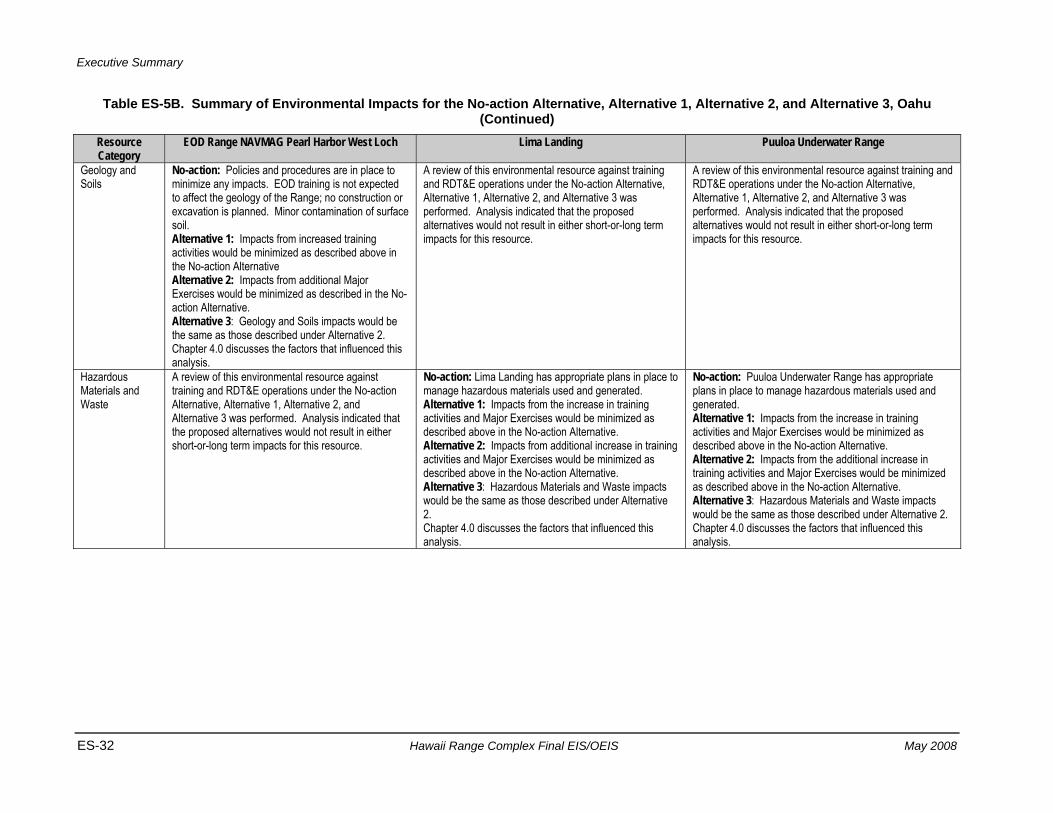
Executive Summary
ES-32 Hawaii Range Complex Final EIS/OEIS May 2008
Table ES-5B. Summary of Environmental Impacts for the No-action Alternative, Alternative 1, Alternative 2, and Alternative 3, Oahu (Continued)
Resource Category
EOD Range NAVMAG Pearl Harbor West Loch Lima Landing Puuloa Underwater Range
Geology and Soils
No-action: Policies and procedures are in place to minimize any impacts. EOD training is not expected to affect the geology of the Range; no construction or excavation is planned. Minor contamination of surface soil. Alternative 1: Impacts from increased training activities would be minimized as described above in the No-action Alternative Alternative 2: Impacts from additional Major Exercises would be minimized as described in the No-action Alternative. Alternative 3: Geology and Soils impacts would be the same as those described under Alternative 2. Chapter 4.0 discusses the factors that influenced this analysis.
A review of this environmental resource against training and RDT&E operations under the No-action Alternative, Alternative 1, Alternative 2, and Alternative 3 was performed. Analysis indicated that the proposed alternatives would not result in either short-or-long term impacts for this resource.
A review of this environmental resource against training and RDT&E operations under the No-action Alternative, Alternative 1, Alternative 2, and Alternative 3 was performed. Analysis indicated that the proposed alternatives would not result in either short-or-long term impacts for this resource.
Hazardous Materials and Waste
A review of this environmental resource against training and RDT&E operations under the No-action Alternative, Alternative 1, Alternative 2, and Alternative 3 was performed. Analysis indicated that the proposed alternatives would not result in either short-or-long term impacts for this resource.
No-action: Lima Landing has appropriate plans in place to manage hazardous materials used and generated. Alternative 1: Impacts from the increase in training activities and Major Exercises would be minimized as described above in the No-action Alternative. Alternative 2: Impacts from additional increase in training activities and Major Exercises would be minimized as described above in the No-action Alternative. Alternative 3: Hazardous Materials and Waste impacts would be the same as those described under Alternative 2. Chapter 4.0 discusses the factors that influenced this analysis.
No-action: Puuloa Underwater Range has appropriate plans in place to manage hazardous materials used and generated. Alternative 1: Impacts from the increase in training activities and Major Exercises would be minimized as described above in the No-action Alternative. Alternative 2: Impacts from the additional increase in training activities and Major Exercises would be minimized as described above in the No-action Alternative. Alternative 3: Hazardous Materials and Waste impacts would be the same as those described under Alternative 2. Chapter 4.0 discusses the factors that influenced this analysis.
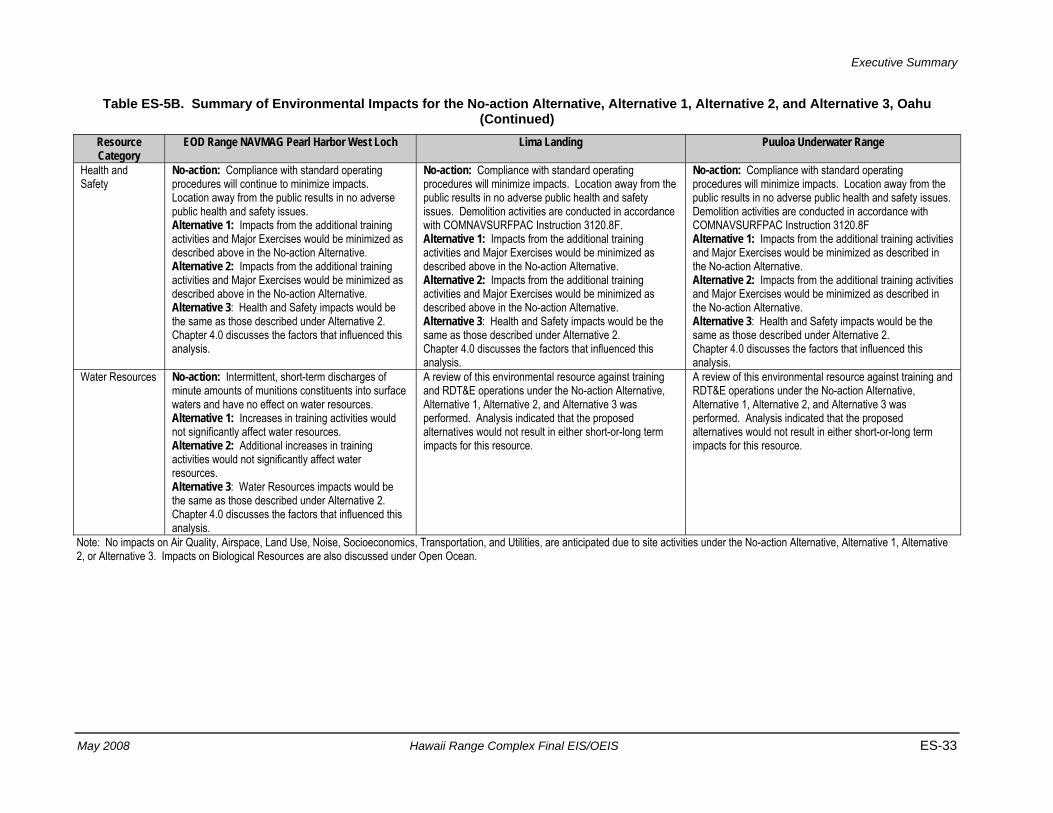
Executive Summary
May 2008 Hawaii Range Complex Final EIS/OEIS ES-33
Table ES-5B. Summary of Environmental Impacts for the No-action Alternative, Alternative 1, Alternative 2, and Alternative 3, Oahu (Continued)
Resource Category
EOD Range NAVMAG Pearl Harbor West Loch Lima Landing Puuloa Underwater Range
Health and Safety
No-action: Compliance with standard operating procedures will continue to minimize impacts. Location away from the public results in no adverse public health and safety issues. Alternative 1: Impacts from the additional training activities and Major Exercises would be minimized as described above in the No-action Alternative. Alternative 2: Impacts from the additional training activities and Major Exercises would be minimized as described above in the No-action Alternative. Alternative 3: Health and Safety impacts would be the same as those described under Alternative 2. Chapter 4.0 discusses the factors that influenced this analysis.
No-action: Compliance with standard operating procedures will minimize impacts. Location away from the public results in no adverse public health and safety issues. Demolition activities are conducted in accordance with COMNAVSURFPAC Instruction 3120.8F. Alternative 1: Impacts from the additional training activities and Major Exercises would be minimized as described above in the No-action Alternative. Alternative 2: Impacts from the additional training activities and Major Exercises would be minimized as described above in the No-action Alternative. Alternative 3: Health and Safety impacts would be the same as those described under Alternative 2. Chapter 4.0 discusses the factors that influenced this analysis.
No-action: Compliance with standard operating procedures will minimize impacts. Location away from the public results in no adverse public health and safety issues. Demolition activities are conducted in accordance with COMNAVSURFPAC Instruction 3120.8F Alternative 1: Impacts from the additional training activities and Major Exercises would be minimized as described in the No-action Alternative. Alternative 2: Impacts from the additional training activities and Major Exercises would be minimized as described in the No-action Alternative. Alternative 3: Health and Safety impacts would be the same as those described under Alternative 2. Chapter 4.0 discusses the factors that influenced this analysis.
Water Resources No-action: Intermittent, short-term discharges of minute amounts of munitions constituents into surface waters and have no effect on water resources. Alternative 1: Increases in training activities would not significantly affect water resources. Alternative 2: Additional increases in training activities would not significantly affect water resources. Alternative 3: Water Resources impacts would be the same as those described under Alternative 2. Chapter 4.0 discusses the factors that influenced this analysis.
A review of this environmental resource against training and RDT&E operations under the No-action Alternative, Alternative 1, Alternative 2, and Alternative 3 was performed. Analysis indicated that the proposed alternatives would not result in either short-or-long term impacts for this resource.
A review of this environmental resource against training and RDT&E operations under the No-action Alternative, Alternative 1, Alternative 2, and Alternative 3 was performed. Analysis indicated that the proposed alternatives would not result in either short-or-long term impacts for this resource.
Note: No impacts on Air Quality, Airspace, Land Use, Noise, Socioeconomics, Transportation, and Utilities, are anticipated due to site activities under the No-action Alternative, Alternative 1, Alternative 2, or Alternative 3. Impacts on Biological Resources are also discussed under Open Ocean.

Executive Summary
ES-34 Hawaii Range Complex Final EIS/OEIS May 2008
Table ES-5C. Summary of Environmental Impacts for the No-action Alternative, Alternative 1, Alternative 2, and Alternative 3, Oahu Resource Category
Naval Defensive Sea Area CG Station Barbers Point/Kalaeola Airport Marine Corps Base Hawaii
Airspace A review of this environmental resource against training and RDT&E operations under the No-action Alternative, Alternative 1, Alternative 2, and Alternative 3 was performed. Analysis indicated that the proposed alternatives would not result in either short-or-long term impacts for this resource.
No-action: Impacts on airspace from continued activities and activities to controlled and uncontrolled airspace, en route airways and jet routes, or airports and airfields are minimized through standard operating procedures, and coordination with the State of Hawaii, U.S. Coast Guard, Kalaeloa Airport, and the FAA. No modifications or need for additional airspace is required. Alternative 1: Impacts on airspace from increased training activities and Major Exercises would be minimized as described above in the No-action Alternative. Alternative 2: Impacts on airspace from increased training activities and additional Major Exercises would be minimized as described above in the No-action Alternative. Alternative 3: Airspace impacts would be the same as those described under Alternative 2. Chapter 4.0 discusses the factors that influenced this analysis.
No-action: Impacts on airspace from continued activities and activities to controlled and uncontrolled airspace, special use airspace, en route airways and jet routes, or airports and airfields are minimized through standard operating procedures and continued close coordination with the FAA. No modifications or need for additional airspace is required. Alternative 1: Impacts on airspace from increased training activities, and Major Exercises would be minimized as described above in the No-action Alternative. Alternative 2: Impacts on airspace from ongoing activities, increased training activities, and additional Major Exercises would be minimized as described above in the No-action Alternative. Alternative 3: Airspace impacts would be the same as those described under Alternative 2. Chapter 4.0 discusses the factors that influenced this analysis.
Biological Resources (Offshore and Onshore)
No-action: Procedures and policies are in place to minimize impacts on biological resources. No essential fish habitat affected. Alternative 1: Impacts would be minimized as described above in the No-action Alternative. Increased activities and Major Exercises would take place at existing locations; no expansion of the area would be involved. Alternative 2: Impacts would be minimized as described above in the No-action Alternative. Increased activities and additional Major Exercises would take place at existing locations; no expansion of the area would be involved. Alternative 3: Biological Resources impacts would be the same as those described under Alternative 2. Chapter 4.0 discusses the factors that influenced this analysis.
No-action: Training Activities and Major Exercises take place in current operating areas, with no expansion. Compliance with relevant Navy and Coast Guard policies and procedures during these training activities will continue to minimize the effects on vegetation and wildlife, as well as limit the potential for introduction of invasive plant species. Alternative 1: Impacts from increased training activities and Major Exercises would be minimized as described above in the No-action Alternative. Alternative 2: Impacts from increased training activities and Major Exercises would be minimized as described in the No-action Alternative. Temporary, short-term startle effects from noise to wildlife and birds are anticipated. The intensity and duration of wildlife startle responses decrease with the number and frequency of exposures. Alternative 3: Biological Resources impacts would be the same as those described under Alternative 2. Chapter 4.0 discusses the factors that influenced this analysis.
No-action: Marine Corps and Navy procedures and policies are in place to minimize impacts on biological resources and prevent introduction of invasive species. Alternative 1: Impacts from increased training activities and Major Exercises would be minimized as described in the No-action Alternative. Alternative 2: Impacts from increased activities and additional Major Exercises would be minimized as described in the No-action Alternative. Temporary, short-term startle effects from noise to wildlife and birds. The intensity and duration of wildlife startle responses may decrease with the number and frequency of exposures. Alternative 3: Biological Resources impacts would be the same as those described under Alternative 2. Chapter 4.0 discusses the factors that influenced this analysis.
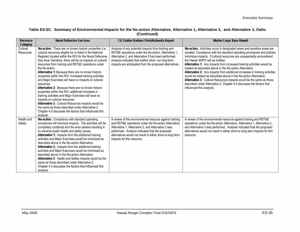
Executive Summary
May 2008 Hawaii Range Complex Final EIS/OEIS ES-35
Table ES-5C. Summary of Environmental Impacts for the No-action Alternative, Alternative 1, Alternative 2, and Alternative 3, Oahu (Continued)
Resource Category
Naval Defensive Sea Area CG Station Barbers Point/Kalaeola Airport Marine Corps Base Hawaii
Cultural Resources
No-action: There are no known historic properties (i.e., cultural resources eligible for or listed in the National Register) located within the ROI for the Naval Defensive Sea Area; therefore, there will be no impacts on cultural resources from training and RDT&E operations under the No-action. Alternative 1: Because there are no known historic properties within the ROI, increased training activities and Major Exercises will have no impacts on cultural resources. Alternative 2: Because there are no known historic properties within the ROI, additional increases in training activities and Major Exercises will have no impacts on cultural resources. Alternative 3: Cultural Resources impacts would be the same as those described under Alternative 2. Chapter 4.0 discusses the factors that influenced this analysis.
Analysis of any potential impacts from training and RDT&E operations under the No-action, Alternative 1, Alternative 2, and Alternative 3 has been performed. Analysis indicates that neither short- nor long-term impacts are anticipated from the proposed alternatives.
No-action: Activities occur in designated areas and sensitive areas are avoided. Compliance with the standard operating procedures and policies minimizes impacts. If cultural resources are unexpectedly encountered the Hawaii SHPO will be notified. Alternative 1: Any impacts from increased training activities would be treated as described above in the No-action Alternative. Alternative 2: Any impacts from additional increases in training activities would be treated as described above in the No-action Alternative. Alternative 3: Cultural Resources impacts would be the same as those described under Alternative 2. Chapter 4.0 discusses the factors that influenced this analysis.
Health and Safety
No-action: Compliance with standard operating procedures will minimize impacts. The activities will be completely contained and the area cleared resulting in no adverse public health and safety issues. Alternative 1: Impacts from the additional training activities and Major Exercises would be minimized as described above in the No-action Alternative. Alternative 2: Impacts from the additional training activities and Major Exercises would be minimized as described above in the No-action Alternative. Alternative 3: Health and Safety impacts would be the same as those described under Alternative 2. Chapter 4.0 discusses the factors that influenced this analysis.
A review of this environmental resource against training and RDT&E operations under the No-action Alternative, Alternative 1, Alternative 2, and Alternative 3 was performed. Analysis indicated that the proposed alternatives would not result in either short-or-long term impacts for this resource.
A review of this environmental resource against training and RDT&E operations under the No-action Alternative, Alternative 1, Alternative 2, and Alternative 3 was performed. Analysis indicated that the proposed alternatives would not result in either short-or-long term impacts for this resource.

Executive Summary
ES-36 Hawaii Range Complex Final EIS/OEIS May 2008
Table ES-5C. Summary of Environmental Impacts for the No-action Alternative, Alternative 1, Alternative 2, and Alternative 3, Oahu (Continued)
Resource Category
Naval Defensive Sea Area CG Station Barbers Point/Kalaeola Airport Marine Corps Base Hawaii
Noise A review of this environmental resource against training and RDT&E operations under the No-action Alternative, Alternative 1, Alternative 2, and Alternative 3 was performed. Analysis indicated that the proposed alternatives would not result in either short-or-long term impacts for this resource.
No-action: Coast Guard Air Station Barbers Point has appropriate plans in place to manage noise levels. Noise produced is expected to stay within the existing noise contours. Alternative 1: Minor impacts are anticipated for areas near the airport from increased activities, training exercises, and Major Exercises. Alternative 2: Minor impacts are anticipated for areas near the airport from increased activities, training exercises, and Major Exercises. Alternative 3: Noise impacts would be the same as those described under Alternative 2. Chapter 4.0 discusses the factors that influenced this analysis.
No-action: MCBH maintains a hearing protection program that will continue to minimize impacts. Noise levels that reach off-post are mitigated by public notification and restricting training to daylight hours. Alternative 1: Increased training activities would take place at existing locations; no expansion of the area would be involved. Impacts would be minimized as described above in the No-action Alternative. Alternative 2: Increased training activities and additional Major Exercises would take place at existing locations; no expansion of the area would be involved. Impacts would be minimized as described in the No-action Alternative. Alternative 3: Noise impacts would be the same as those described under Alternative 2. Chapter 4.0 discusses the factors that influenced this analysis.
Note: No impacts on Air Quality, Geology and Soils, Hazardous Materials and Waste, Land Use, Socioeconomics, Transportation, Utilities, and Water Resources, are anticipated due to site activities under the No-action Alternative, Alternative 1, Alternative 2, or Alternative 3. Impacts on Biological Resources are also discussed under Open Ocean.
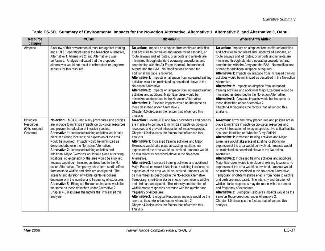
Executive Summary
May 2008 Hawaii Range Complex Final EIS/OEIS ES-37
Table ES-5D. Summary of Environmental Impacts for the No-action Alternative, Alternative 1, Alternative 2, and Alternative 3, Oahu Resource Category
MCTAB Hickam AFB Wheeler Army Airfield
Airspace A review of this environmental resource against training and RDT&E operations under the No-action Alternative, Alternative 1, Alternative 2, and Alternative 3 was performed. Analysis indicated that the proposed alternatives would not result in either short-or-long term impacts for this resource.
No-action: Impacts on airspace from continued activities and activities to controlled and uncontrolled airspace, en route airways and jet routes, or airports and airfields are minimized through standard operating procedures, and coordination with the Air Force, Honolulu International Airport, and the FAA. No modifications or need for additional airspace is required. Alternative 1: Impacts on airspace from increased training activities would be minimized as described above in the No-action Alternative. Alternative 2: Impacts on airspace from increased training activities and additional Major Exercises would be minimized as described in the No-action Alternative. Alternative 3: Airspace impacts would be the same as those described under Alternative 2. Chapter 4.0 discusses the factors that influenced this analysis.
No-action: Impacts on airspace from continued activities and activities to controlled and uncontrolled airspace, en route airways and jet routes, or airports and airfields are minimized through standard operating procedures, and coordination with the Army and the FAA. No modifications or need for additional airspace is required. Alternative 1: Impacts on airspace from increased training activities would be minimized as described in the No-action Alternative. Alternative 2: Impacts on airspace from increased training activities and additional Major Exercises would be minimized as described in the No-action Alternative. Alternative 3: Airspace impacts would be the same as those described under Alternative 2. Chapter 4.0 discusses the factors that influenced this analysis.
Biological Resources (Offshore and Onshore)
No-action: MCTAB and Navy procedures and policies are in place to minimize impacts on biological resources and prevent introduction of invasive species. Alternative 1: Increased training activities would take place at existing locations; no expansion of the area would be involved. Impacts would be minimized as described above in the No-action Alternative. Alternative 2: Increased training activities and additional Major Exercises would take place at existing locations; no expansion of the area would be involved. Impacts would be minimized as described in the No-action Alternative. Temporary, short-term startle effects from noise to wildlife and birds are anticipated. The intensity and duration of wildlife startle responses decrease with the number and frequency of exposures. Alternative 3: Biological Resources impacts would be the same as those described under Alternative 2. Chapter 4.0 discusses the factors that influenced this analysis.
No-action: Hickam AFB and Navy procedures and policies are in place to continue to minimize impacts on biological resources and prevent introduction of invasive species. Chapter 4.0 discusses the factors that influenced this analysis. Alternative 1: Increased training activities and Major Exercises would take place at existing locations; no expansion of the area would be involved. Impacts would be minimized as described above in the No-action Alternative. Alternative 2: Increased training activities and additional Major Exercises would take place at existing locations; no expansion of the area would be involved. Impacts would be minimized as described in the No-action Alternative. Temporary, short-term startle effects from noise to wildlife and birds are anticipated. The intensity and duration of wildlife startle responses decrease with the number and frequency of exposures. Alternative 3: Biological Resources impacts would be the same as those described under Alternative 2. Chapter 4.0 discusses the factors that influenced this analysis.
No-action: Army and Navy procedures and policies are in place to minimize impacts on biological resources and prevent introduction of invasive species. No critical habitat has been identified on Wheeler Army Airfield. Alternative 1: Increased training activities and Major Exercises would take place at existing locations; no expansion of the area would be involved. Impacts would be minimized as described above in the No-action Alternative. Alternative 2: Increased training activities and additional Major Exercises would take place at existing locations; no expansion of the area would be involved. Impacts would be minimized as described in the No-action Alternative. Temporary, short-term startle effects from noise to wildlife and birds are anticipated. The intensity and duration of wildlife startle responses may decrease with the number and frequency of exposures. Alternative 3: Biological Resources impacts would be the same as those described under Alternative 2. Chapter 4.0 discusses the factors that influenced this analysis.
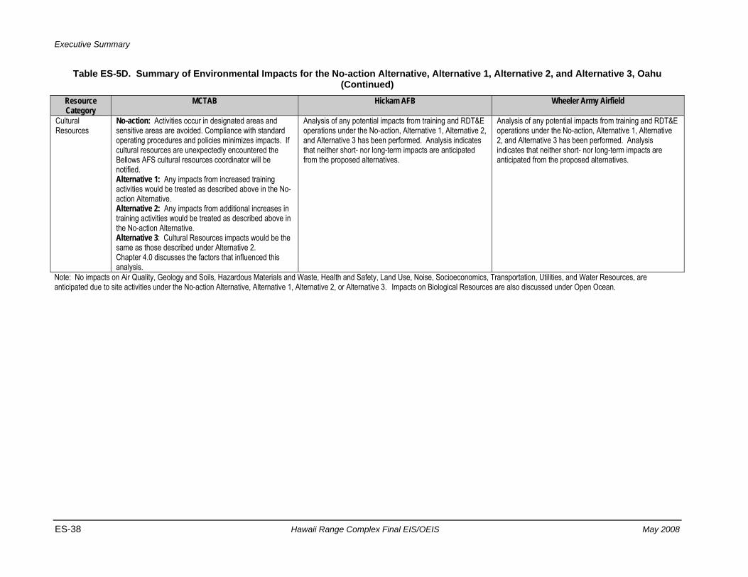
Executive Summary
ES-38 Hawaii Range Complex Final EIS/OEIS May 2008
Table ES-5D. Summary of Environmental Impacts for the No-action Alternative, Alternative 1, Alternative 2, and Alternative 3, Oahu (Continued)
Resource Category
MCTAB Hickam AFB Wheeler Army Airfield
Cultural Resources
No-action: Activities occur in designated areas and sensitive areas are avoided. Compliance with standard operating procedures and policies minimizes impacts. If cultural resources are unexpectedly encountered the Bellows AFS cultural resources coordinator will be notified. Alternative 1: Any impacts from increased training activities would be treated as described above in the No-action Alternative. Alternative 2: Any impacts from additional increases in training activities would be treated as described above in the No-action Alternative. Alternative 3: Cultural Resources impacts would be the same as those described under Alternative 2. Chapter 4.0 discusses the factors that influenced this analysis.
Analysis of any potential impacts from training and RDT&E operations under the No-action, Alternative 1, Alternative 2, and Alternative 3 has been performed. Analysis indicates that neither short- nor long-term impacts are anticipated from the proposed alternatives.
Analysis of any potential impacts from training and RDT&E operations under the No-action, Alternative 1, Alternative 2, and Alternative 3 has been performed. Analysis indicates that neither short- nor long-term impacts are anticipated from the proposed alternatives.
Note: No impacts on Air Quality, Geology and Soils, Hazardous Materials and Waste, Health and Safety, Land Use, Noise, Socioeconomics, Transportation, Utilities, and Water Resources, are anticipated due to site activities under the No-action Alternative, Alternative 1, Alternative 2, or Alternative 3. Impacts on Biological Resources are also discussed under Open Ocean.
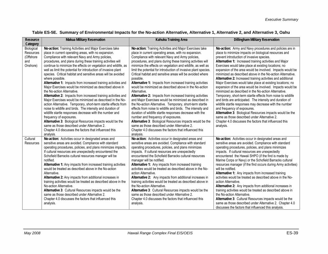
Executive Summary
May 2008 Hawaii Range Complex Final EIS/OEIS ES-39
Table ES-5E. Summary of Environmental Impacts for the No-action Alternative, Alternative 1, Alternative 2, and Alternative 3, Oahu Resource Category
Makua Military Reservation Kahuku Training Area Dillingham Military Reservation
Biological Resources (Offshore and Onshore)
No-action: Training Activities and Major Exercises take place in current operating areas, with no expansion. Compliance with relevant Navy and Army policies, procedures, and plans during these training activities will continue to minimize the effects on vegetation and wildlife, as well as limit the potential for introduction of invasive plant species. Critical habitat and sensitive areas will be avoided where possible. Alternative 1: Impacts from increased training activities and Major Exercises would be minimized as described above in the No-action Alternative. Alternative 2: Impacts from increased training activities and Major Exercises would be minimized as described in the No-action Alternative. Temporary, short-term startle effects from noise to wildlife and birds. The intensity and duration of wildlife startle responses decrease with the number and frequency of exposures. Alternative 3: Biological Resources impacts would be the same as those described under Alternative 2. Chapter 4.0 discusses the factors that influenced this analysis.
No-action: Training Activities and Major Exercises take place in current operating areas, with no expansion. Compliance with relevant Navy and Army policies, procedures, and plans during these training activities will minimize the effects on vegetation and wildlife, as well as limit the potential for introduction of invasive plant species. Critical habitat and sensitive areas will be avoided where possible. Alternative 1: Impacts from increased training activities would be minimized as described above in the No-action Alternative. Alternative 2: Impacts from increased training activities and Major Exercises would be minimized as described in the No-action Alternative. Temporary, short-term startle effects from noise to wildlife and birds. The intensity and duration of wildlife startle responses decrease with the number and frequency of exposures. Alternative 3: Biological Resources impacts would be the same as those described under Alternative 2. Chapter 4.0 discusses the factors that influenced this analysis.
No-action: Army and Navy procedures and policies are in place to minimize impacts on biological resources and prevent introduction of invasive species. Alternative 1: Increased training activities and Major Exercises would take place at existing locations; no expansion of the area would be involved. Impacts would be minimized as described above in the No-action Alternative. Alternative 2: Increased training activities and additional Major Exercises would take place at existing locations; no expansion of the area would be involved. Impacts would be minimized as described in the No-action Alternative. Temporary, short-term startle effects from noise to wildlife and birds are anticipated. The intensity and duration of wildlife startle responses may decrease with the number and frequency of exposures. Alternative 3: Biological Resources impacts would be the same as those described under Alternative 2. Chapter 4.0 discusses the factors that influenced this analysis.
Cultural Resources
No-action: Activities occur in designated areas and sensitive areas are avoided. Compliance with standard operating procedures, policies, and plans minimizes impacts. If cultural resources are unexpectedly encountered the Schofield Barracks cultural resources manager will be notified. Alternative 1: Any impacts from increased training activities would be treated as described above in the No-action Alternative. Alternative 2: Any impacts from additional increases in training activities would be treated as described above in the No-action Alternative. Alternative 3: Cultural Resources impacts would be the same as those described under Alternative 2. Chapter 4.0 discusses the factors that influenced this analysis.
No-action: Activities occur in designated areas and sensitive areas are avoided. Compliance with standard operating procedures, policies, and plans minimizes impacts. If cultural resources are unexpectedly encountered the Schofield Barracks cultural resources manager will be notified. Alternative 1: Any impacts from increased training activities would be treated as described above in the No-action Alternative. Alternative 2: Any impacts from additional increases in training activities would be treated as described above in the No-action Alternative. Alternative 3: Cultural Resources impacts would be the same as those described under Alternative 2. Chapter 4.0 discusses the factors that influenced this analysis.
No-action: Activities occur in designated areas and sensitive areas are avoided. Compliance with standard operating procedures, policies, and plans minimizes impacts. If cultural resources are unexpectedly encountered the Hawaii SHPO (if the find is made by Marine Corps or Navy) or the Schofield Barracks cultural resources manager (if the find occurs during Army activities) will be notified. Alternative 1: Any impacts from increased training activities would be treated as described above in the No-action Alternative. Alternative 2: Any impacts from additional increases in training activities would be treated as described above in the No-action Alternative. Alternative 3: Cultural Resources impacts would be the same as those described under Alternative 2. Chapter 4.0 discusses the factors that influenced this analysis.
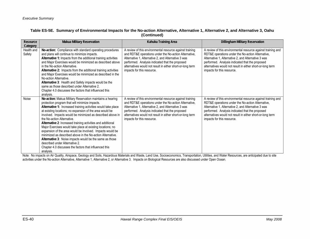
Executive Summary
ES-40 Hawaii Range Complex Final EIS/OEIS May 2008
Table ES-5E. Summary of Environmental Impacts for the No-action Alternative, Alternative 1, Alternative 2, and Alternative 3, Oahu (Continued)
Resource Category
Makua Military Reservation Kahuku Training Area Dillingham Military Reservation
Health and Safety
No-action: Compliance with standard operating procedures and plans will continue to minimize impacts. Alternative 1: Impacts from the additional training activities and Major Exercises would be minimized as described above in the No-action Alternative. Alternative 2: Impacts from the additional training activities and Major Exercises would be minimized as described in the No-action Alternative. Alternative 3: Health and Safety impacts would be the same as those described under Alternative 2. Chapter 4.0 discusses the factors that influenced this analysis.
A review of this environmental resource against training and RDT&E operations under the No-action Alternative, Alternative 1, Alternative 2, and Alternative 3 was performed. Analysis indicated that the proposed alternatives would not result in either short-or-long term impacts for this resource.
A review of this environmental resource against training and RDT&E operations under the No-action Alternative, Alternative 1, Alternative 2, and Alternative 3 was performed. Analysis indicated that the proposed alternatives would not result in either short-or-long term impacts for this resource.
Noise No-action: Makua Military Reservation maintains a hearing protection program that will minimize impacts. Alternative 1: Increased training activities would take place at existing locations; no expansion of the area would be involved. Impacts would be minimized as described above in the No-action Alternative. Alternative 2: Increased training activities and additional Major Exercises would take place at existing locations; no expansion of the area would be involved. Impacts would be minimized as described above in the No-action Alternative. Alternative 3: Noise impacts would be the same as those described under Alternative 2. Chapter 4.0 discusses the factors that influenced this analysis.
A review of this environmental resource against training and RDT&E operations under the No-action Alternative, Alternative 1, Alternative 2, and Alternative 3 was performed. Analysis indicated that the proposed alternatives would not result in either short-or-long term impacts for this resource.
A review of this environmental resource against training and RDT&E operations under the No-action Alternative, Alternative 1, Alternative 2, and Alternative 3 was performed. Analysis indicated that the proposed alternatives would not result in either short-or-long term impacts for this resource.
Note: No impacts on Air Quality, Airspace, Geology and Soils, Hazardous Materials and Waste, Land Use, Socioeconomics, Transportation, Utilities, and Water Resources, are anticipated due to site activities under the No-action Alternative, Alternative 1, Alternative 2, or Alternative 3. Impacts on Biological Resources are also discussed under Open Ocean.
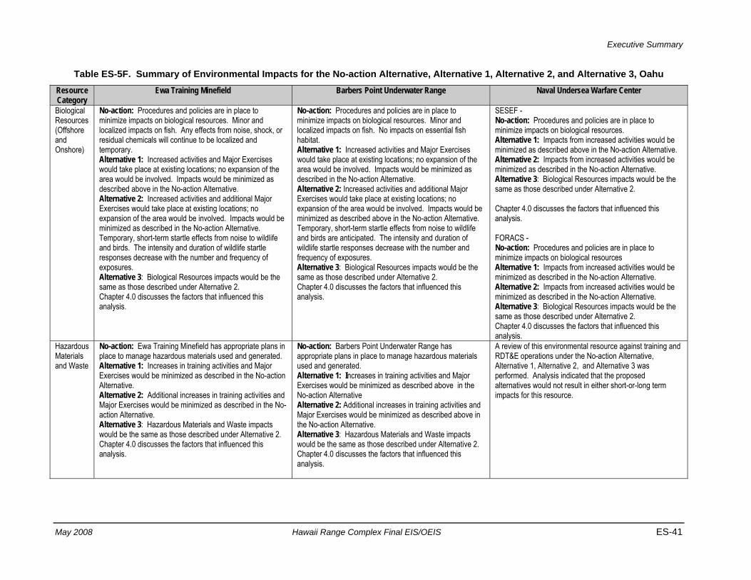
Executive Summary
May 2008 Hawaii Range Complex Final EIS/OEIS ES-41
Table ES-5F. Summary of Environmental Impacts for the No-action Alternative, Alternative 1, Alternative 2, and Alternative 3, Oahu Resource Category
Ewa Training Minefield Barbers Point Underwater Range Naval Undersea Warfare Center
Biological Resources (Offshore and Onshore)
No-action: Procedures and policies are in place to minimize impacts on biological resources. Minor and localized impacts on fish. Any effects from noise, shock, or residual chemicals will continue to be localized and temporary. Alternative 1: Increased activities and Major Exercises would take place at existing locations; no expansion of the area would be involved. Impacts would be minimized as described above in the No-action Alternative. Alternative 2: Increased activities and additional Major Exercises would take place at existing locations; no expansion of the area would be involved. Impacts would be minimized as described in the No-action Alternative. Temporary, short-term startle effects from noise to wildlife and birds. The intensity and duration of wildlife startle responses decrease with the number and frequency of exposures. Alternative 3: Biological Resources impacts would be the same as those described under Alternative 2. Chapter 4.0 discusses the factors that influenced this analysis.
No-action: Procedures and policies are in place to minimize impacts on biological resources. Minor and localized impacts on fish. No impacts on essential fish habitat. Alternative 1: Increased activities and Major Exercises would take place at existing locations; no expansion of the area would be involved. Impacts would be minimized as described in the No-action Alternative. Alternative 2: Increased activities and additional Major Exercises would take place at existing locations; no expansion of the area would be involved. Impacts would be minimized as described above in the No-action Alternative. Temporary, short-term startle effects from noise to wildlife and birds are anticipated. The intensity and duration of wildlife startle responses decrease with the number and frequency of exposures. Alternative 3: Biological Resources impacts would be the same as those described under Alternative 2. Chapter 4.0 discusses the factors that influenced this analysis.
SESEF - No-action: Procedures and policies are in place to minimize impacts on biological resources. Alternative 1: Impacts from increased activities would be minimized as described above in the No-action Alternative. Alternative 2: Impacts from increased activities would be minimized as described in the No-action Alternative. Alternative 3: Biological Resources impacts would be the same as those described under Alternative 2. Chapter 4.0 discusses the factors that influenced this analysis. FORACS - No-action: Procedures and policies are in place to minimize impacts on biological resources Alternative 1: Impacts from increased activities would be minimized as described in the No-action Alternative. Alternative 2: Impacts from increased activities would be minimized as described in the No-action Alternative. Alternative 3: Biological Resources impacts would be the same as those described under Alternative 2. Chapter 4.0 discusses the factors that influenced this analysis.
Hazardous Materials and Waste
No-action: Ewa Training Minefield has appropriate plans in place to manage hazardous materials used and generated. Alternative 1: Increases in training activities and Major Exercises would be minimized as described in the No-action Alternative. Alternative 2: Additional increases in training activities and Major Exercises would be minimized as described in the No-action Alternative. Alternative 3: Hazardous Materials and Waste impacts would be the same as those described under Alternative 2. Chapter 4.0 discusses the factors that influenced this analysis.
No-action: Barbers Point Underwater Range has appropriate plans in place to manage hazardous materials used and generated. Alternative 1: Increases in training activities and Major Exercises would be minimized as described above in the No-action Alternative Alternative 2: Additional increases in training activities and Major Exercises would be minimized as described above in the No-action Alternative. Alternative 3: Hazardous Materials and Waste impacts would be the same as those described under Alternative 2. Chapter 4.0 discusses the factors that influenced this analysis.
A review of this environmental resource against training and RDT&E operations under the No-action Alternative, Alternative 1, Alternative 2, and Alternative 3 was performed. Analysis indicated that the proposed alternatives would not result in either short-or-long term impacts for this resource.
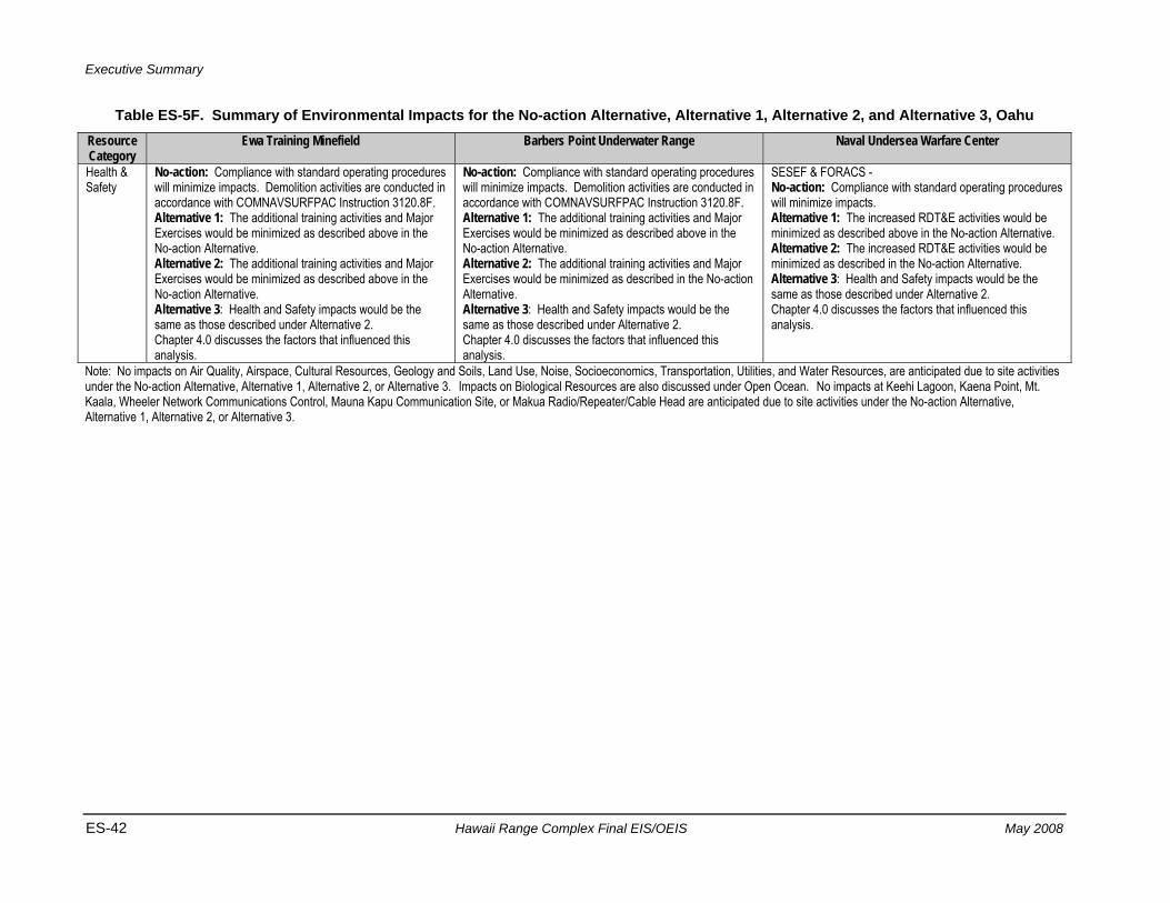
Executive Summary
ES-42 Hawaii Range Complex Final EIS/OEIS May 2008
Table ES-5F. Summary of Environmental Impacts for the No-action Alternative, Alternative 1, Alternative 2, and Alternative 3, Oahu Resource Category
Ewa Training Minefield Barbers Point Underwater Range Naval Undersea Warfare Center
Health & Safety
No-action: Compliance with standard operating procedures will minimize impacts. Demolition activities are conducted in accordance with COMNAVSURFPAC Instruction 3120.8F. Alternative 1: The additional training activities and Major Exercises would be minimized as described above in the No-action Alternative. Alternative 2: The additional training activities and Major Exercises would be minimized as described above in the No-action Alternative. Alternative 3: Health and Safety impacts would be the same as those described under Alternative 2. Chapter 4.0 discusses the factors that influenced this analysis.
No-action: Compliance with standard operating procedures will minimize impacts. Demolition activities are conducted in accordance with COMNAVSURFPAC Instruction 3120.8F. Alternative 1: The additional training activities and Major Exercises would be minimized as described above in the No-action Alternative. Alternative 2: The additional training activities and Major Exercises would be minimized as described in the No-action Alternative. Alternative 3: Health and Safety impacts would be the same as those described under Alternative 2. Chapter 4.0 discusses the factors that influenced this analysis.
SESEF & FORACS - No-action: Compliance with standard operating procedures will minimize impacts. Alternative 1: The increased RDT&E activities would be minimized as described above in the No-action Alternative. Alternative 2: The increased RDT&E activities would be minimized as described in the No-action Alternative. Alternative 3: Health and Safety impacts would be the same as those described under Alternative 2. Chapter 4.0 discusses the factors that influenced this analysis.
Note: No impacts on Air Quality, Airspace, Cultural Resources, Geology and Soils, Land Use, Noise, Socioeconomics, Transportation, Utilities, and Water Resources, are anticipated due to site activities under the No-action Alternative, Alternative 1, Alternative 2, or Alternative 3. Impacts on Biological Resources are also discussed under Open Ocean. No impacts at Keehi Lagoon, Kaena Point, Mt. Kaala, Wheeler Network Communications Control, Mauna Kapu Communication Site, or Makua Radio/Repeater/Cable Head are anticipated due to site activities under the No-action Alternative, Alternative 1, Alternative 2, or Alternative 3.
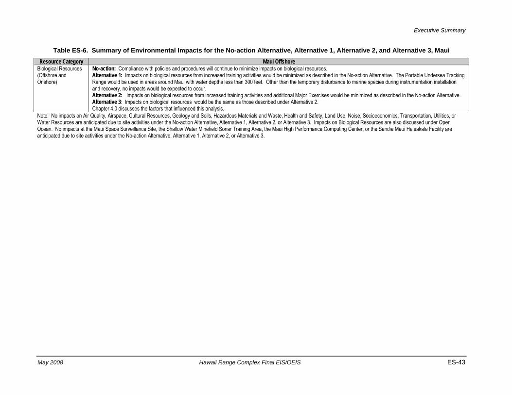
Executive Summary
May 2008 Hawaii Range Complex Final EIS/OEIS ES-43
Table ES-6. Summary of Environmental Impacts for the No-action Alternative, Alternative 1, Alternative 2, and Alternative 3, Maui Resource Category Maui Offshore
Biological Resources (Offshore and Onshore)
No-action: Compliance with policies and procedures will continue to minimize impacts on biological resources. Alternative 1: Impacts on biological resources from increased training activities would be minimized as described in the No-action Alternative. The Portable Undersea Tracking Range would be used in areas around Maui with water depths less than 300 feet. Other than the temporary disturbance to marine species during instrumentation installation and recovery, no impacts would be expected to occur. Alternative 2: Impacts on biological resources from increased training activities and additional Major Exercises would be minimized as described in the No-action Alternative. Alternative 3: Impacts on biological resources would be the same as those described under Alternative 2. Chapter 4.0 discusses the factors that influenced this analysis.
Note: No impacts on Air Quality, Airspace, Cultural Resources, Geology and Soils, Hazardous Materials and Waste, Health and Safety, Land Use, Noise, Socioeconomics, Transportation, Utilities, or Water Resources are anticipated due to site activities under the No-action Alternative, Alternative 1, Alternative 2, or Alternative 3. Impacts on Biological Resources are also discussed under Open Ocean. No impacts at the Maui Space Surveillance Site, the Shallow Water Minefield Sonar Training Area, the Maui High Performance Computing Center, or the Sandia Maui Haleakala Facility are anticipated due to site activities under the No-action Alternative, Alternative 1, Alternative 2, or Alternative 3.
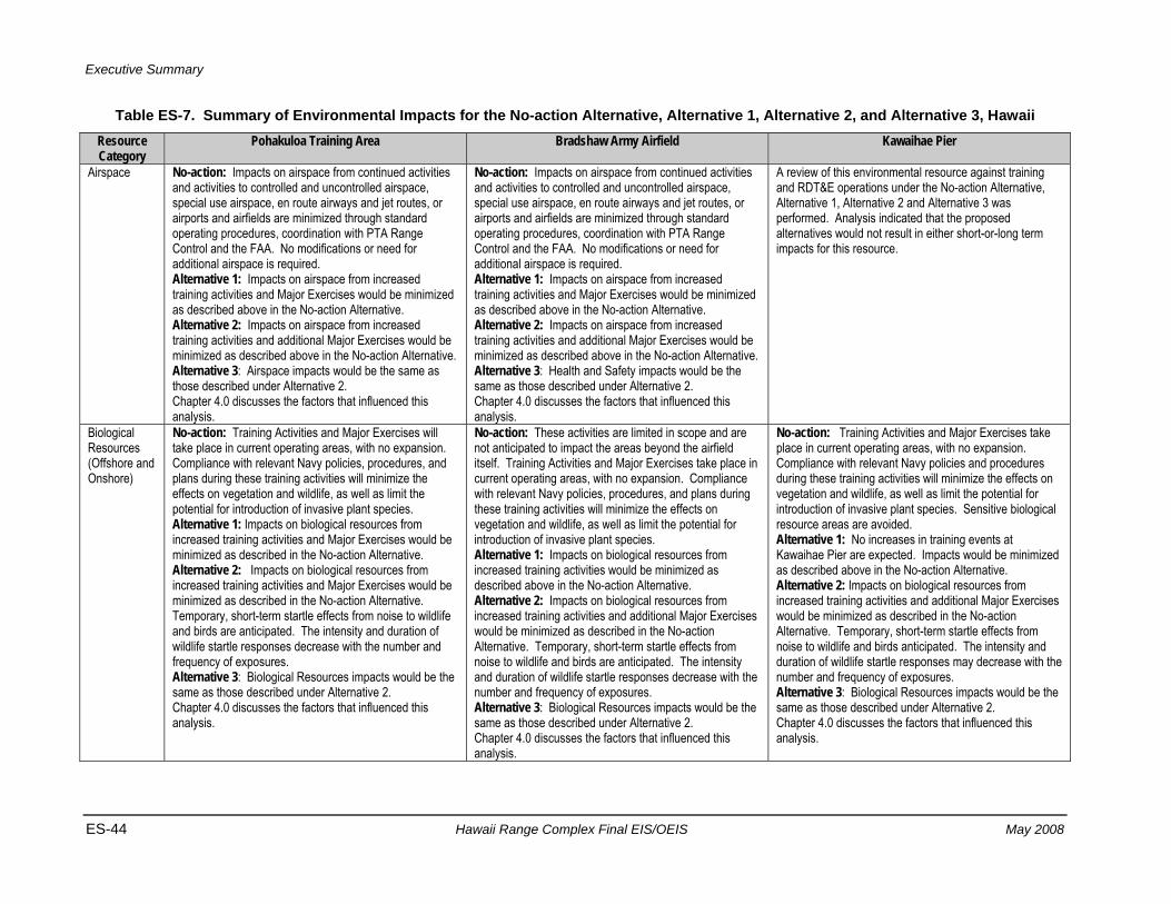
Executive Summary
ES-44 Hawaii Range Complex Final EIS/OEIS May 2008
Table ES-7. Summary of Environmental Impacts for the No-action Alternative, Alternative 1, Alternative 2, and Alternative 3, Hawaii Resource Category
Pohakuloa Training Area Bradshaw Army Airfield Kawaihae Pier
Airspace No-action: Impacts on airspace from continued activities and activities to controlled and uncontrolled airspace, special use airspace, en route airways and jet routes, or airports and airfields are minimized through standard operating procedures, coordination with PTA Range Control and the FAA. No modifications or need for additional airspace is required. Alternative 1: Impacts on airspace from increased training activities and Major Exercises would be minimized as described above in the No-action Alternative. Alternative 2: Impacts on airspace from increased training activities and additional Major Exercises would be minimized as described above in the No-action Alternative. Alternative 3: Airspace impacts would be the same as those described under Alternative 2. Chapter 4.0 discusses the factors that influenced this analysis.
No-action: Impacts on airspace from continued activities and activities to controlled and uncontrolled airspace, special use airspace, en route airways and jet routes, or airports and airfields are minimized through standard operating procedures, coordination with PTA Range Control and the FAA. No modifications or need for additional airspace is required. Alternative 1: Impacts on airspace from increased training activities and Major Exercises would be minimized as described above in the No-action Alternative. Alternative 2: Impacts on airspace from increased training activities and additional Major Exercises would be minimized as described above in the No-action Alternative. Alternative 3: Health and Safety impacts would be the same as those described under Alternative 2. Chapter 4.0 discusses the factors that influenced this analysis.
A review of this environmental resource against training and RDT&E operations under the No-action Alternative, Alternative 1, Alternative 2 and Alternative 3 was performed. Analysis indicated that the proposed alternatives would not result in either short-or-long term impacts for this resource.
Biological Resources (Offshore and Onshore)
No-action: Training Activities and Major Exercises will take place in current operating areas, with no expansion. Compliance with relevant Navy policies, procedures, and plans during these training activities will minimize the effects on vegetation and wildlife, as well as limit the potential for introduction of invasive plant species. Alternative 1: Impacts on biological resources from increased training activities and Major Exercises would be minimized as described in the No-action Alternative. Alternative 2: Impacts on biological resources from increased training activities and Major Exercises would be minimized as described in the No-action Alternative. Temporary, short-term startle effects from noise to wildlife and birds are anticipated. The intensity and duration of wildlife startle responses decrease with the number and frequency of exposures. Alternative 3: Biological Resources impacts would be the same as those described under Alternative 2. Chapter 4.0 discusses the factors that influenced this analysis.
No-action: These activities are limited in scope and are not anticipated to impact the areas beyond the airfield itself. Training Activities and Major Exercises take place in current operating areas, with no expansion. Compliance with relevant Navy policies, procedures, and plans during these training activities will minimize the effects on vegetation and wildlife, as well as limit the potential for introduction of invasive plant species. Alternative 1: Impacts on biological resources from increased training activities would be minimized as described above in the No-action Alternative. Alternative 2: Impacts on biological resources from increased training activities and additional Major Exercises would be minimized as described in the No-action Alternative. Temporary, short-term startle effects from noise to wildlife and birds are anticipated. The intensity and duration of wildlife startle responses decrease with the number and frequency of exposures. Alternative 3: Biological Resources impacts would be the same as those described under Alternative 2. Chapter 4.0 discusses the factors that influenced this analysis.
No-action: Training Activities and Major Exercises take place in current operating areas, with no expansion. Compliance with relevant Navy policies and procedures during these training activities will minimize the effects on vegetation and wildlife, as well as limit the potential for introduction of invasive plant species. Sensitive biological resource areas are avoided. Alternative 1: No increases in training events at Kawaihae Pier are expected. Impacts would be minimized as described above in the No-action Alternative. Alternative 2: Impacts on biological resources from increased training activities and additional Major Exercises would be minimized as described in the No-action Alternative. Temporary, short-term startle effects from noise to wildlife and birds anticipated. The intensity and duration of wildlife startle responses may decrease with the number and frequency of exposures. Alternative 3: Biological Resources impacts would be the same as those described under Alternative 2. Chapter 4.0 discusses the factors that influenced this analysis.
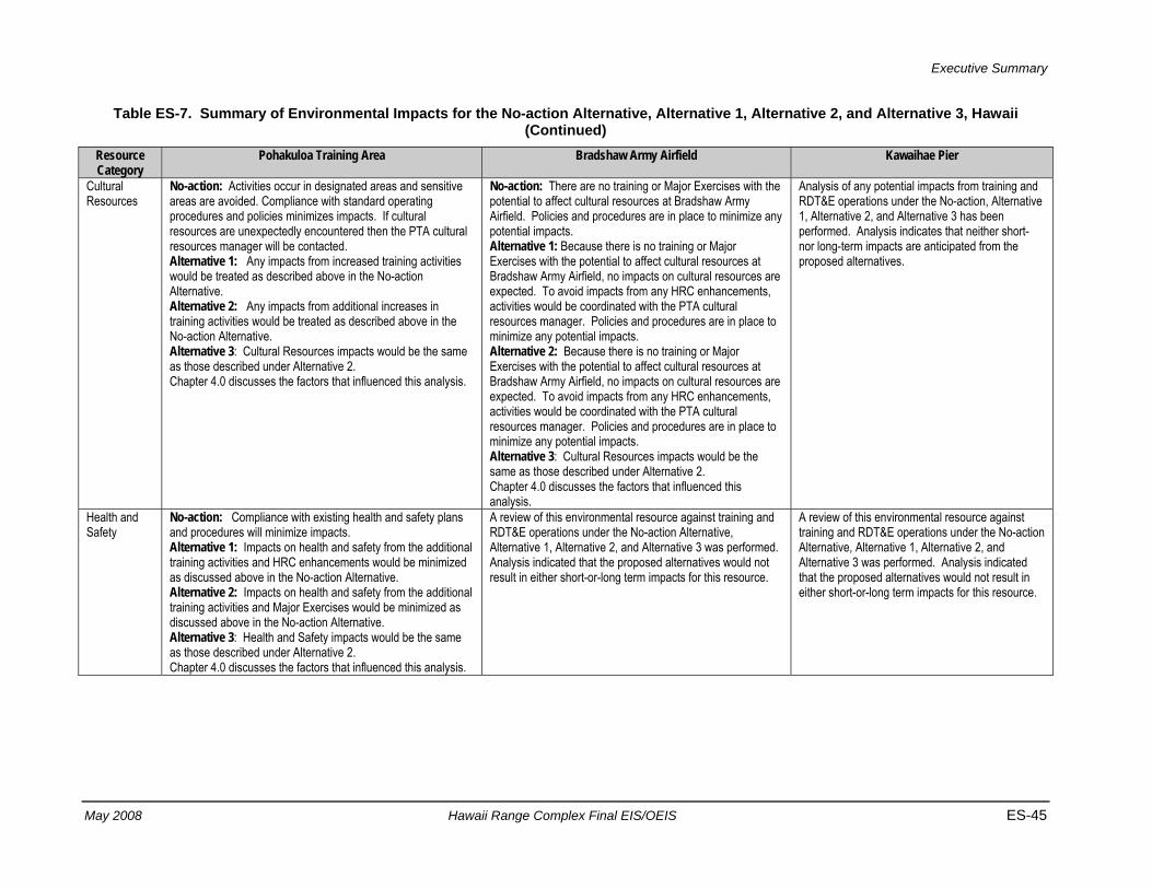
Executive Summary
May 2008 Hawaii Range Complex Final EIS/OEIS ES-45
Table ES-7. Summary of Environmental Impacts for the No-action Alternative, Alternative 1, Alternative 2, and Alternative 3, Hawaii (Continued)
Resource Category
Pohakuloa Training Area Bradshaw Army Airfield Kawaihae Pier
Cultural Resources
No-action: Activities occur in designated areas and sensitive areas are avoided. Compliance with standard operating procedures and policies minimizes impacts. If cultural resources are unexpectedly encountered then the PTA cultural resources manager will be contacted. Alternative 1: Any impacts from increased training activities would be treated as described above in the No-action Alternative. Alternative 2: Any impacts from additional increases in training activities would be treated as described above in the No-action Alternative. Alternative 3: Cultural Resources impacts would be the same as those described under Alternative 2. Chapter 4.0 discusses the factors that influenced this analysis.
No-action: There are no training or Major Exercises with the potential to affect cultural resources at Bradshaw Army Airfield. Policies and procedures are in place to minimize any potential impacts. Alternative 1: Because there is no training or Major Exercises with the potential to affect cultural resources at Bradshaw Army Airfield, no impacts on cultural resources are expected. To avoid impacts from any HRC enhancements, activities would be coordinated with the PTA cultural resources manager. Policies and procedures are in place to minimize any potential impacts. Alternative 2: Because there is no training or Major Exercises with the potential to affect cultural resources at Bradshaw Army Airfield, no impacts on cultural resources are expected. To avoid impacts from any HRC enhancements, activities would be coordinated with the PTA cultural resources manager. Policies and procedures are in place to minimize any potential impacts. Alternative 3: Cultural Resources impacts would be the same as those described under Alternative 2. Chapter 4.0 discusses the factors that influenced this analysis.
Analysis of any potential impacts from training and RDT&E operations under the No-action, Alternative 1, Alternative 2, and Alternative 3 has been performed. Analysis indicates that neither short- nor long-term impacts are anticipated from the proposed alternatives.
Health and Safety
No-action: Compliance with existing health and safety plans and procedures will minimize impacts. Alternative 1: Impacts on health and safety from the additional training activities and HRC enhancements would be minimized as discussed above in the No-action Alternative. Alternative 2: Impacts on health and safety from the additional training activities and Major Exercises would be minimized as discussed above in the No-action Alternative. Alternative 3: Health and Safety impacts would be the same as those described under Alternative 2. Chapter 4.0 discusses the factors that influenced this analysis.
A review of this environmental resource against training and RDT&E operations under the No-action Alternative, Alternative 1, Alternative 2, and Alternative 3 was performed. Analysis indicated that the proposed alternatives would not result in either short-or-long term impacts for this resource.
A review of this environmental resource against training and RDT&E operations under the No-action Alternative, Alternative 1, Alternative 2, and Alternative 3 was performed. Analysis indicated that the proposed alternatives would not result in either short-or-long term impacts for this resource.
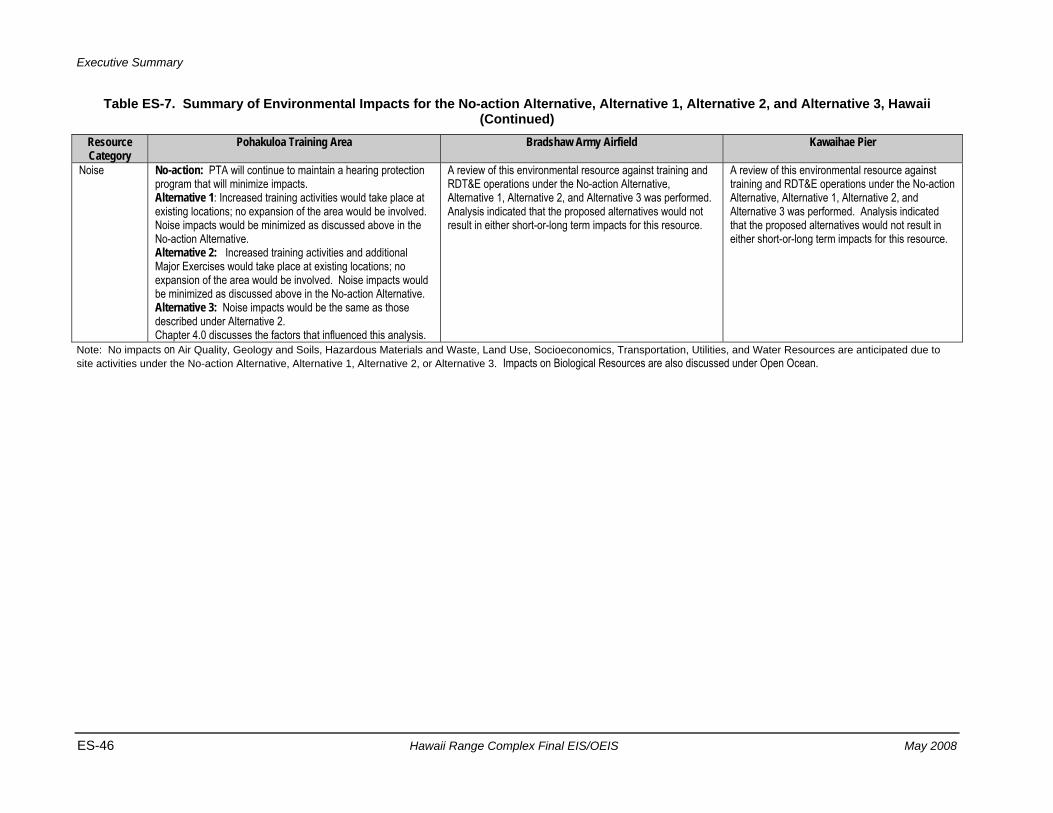
Executive Summary
ES-46 Hawaii Range Complex Final EIS/OEIS May 2008
Table ES-7. Summary of Environmental Impacts for the No-action Alternative, Alternative 1, Alternative 2, and Alternative 3, Hawaii (Continued)
Resource Category
Pohakuloa Training Area Bradshaw Army Airfield Kawaihae Pier
Noise No-action: PTA will continue to maintain a hearing protection program that will minimize impacts. Alternative 1: Increased training activities would take place at existing locations; no expansion of the area would be involved. Noise impacts would be minimized as discussed above in the No-action Alternative. Alternative 2: Increased training activities and additional Major Exercises would take place at existing locations; no expansion of the area would be involved. Noise impacts would be minimized as discussed above in the No-action Alternative. Alternative 3: Noise impacts would be the same as those described under Alternative 2. Chapter 4.0 discusses the factors that influenced this analysis.
A review of this environmental resource against training and RDT&E operations under the No-action Alternative, Alternative 1, Alternative 2, and Alternative 3 was performed. Analysis indicated that the proposed alternatives would not result in either short-or-long term impacts for this resource.
A review of this environmental resource against training and RDT&E operations under the No-action Alternative, Alternative 1, Alternative 2, and Alternative 3 was performed. Analysis indicated that the proposed alternatives would not result in either short-or-long term impacts for this resource.
Note: No impacts on Air Quality, Geology and Soils, Hazardous Materials and Waste, Land Use, Socioeconomics, Transportation, Utilities, and Water Resources are anticipated due to site activities under the No-action Alternative, Alternative 1, Alternative 2, or Alternative 3. Impacts on Biological Resources are also discussed under Open Ocean.
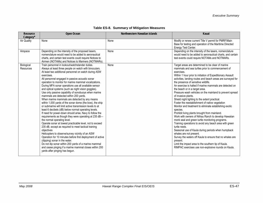
Executive Summary
May 2008 Hawaii Range Complex Final EIS/OEIS ES-47
Table ES-8. Summary of Mitigation Measures Resource Category*
Open Ocean Northwestern Hawaiian islands Kauai
Air Quality None None Modify or renew current Title V permit for PMRF/Main Base for testing and operation of the Maritime Directed Energy Test Center.
Airspace Depending on the intensity of the proposed lasers, nomenclature would need to be added to aeronautical charts, and certain test events could require Notices to Airmen (NOTAMs) and Notices to Mariners (NOTMARs).
None Depending on the intensity of the lasers, nomenclature would need to be added to aeronautical charts, and certain test events could require NOTAMs and NOTMARs.
Biological Resources
Train personnel in lookout/watchstander duties. Always at least three people on watch with binoculars. At least two additional personnel on watch during ASW exercises. All personnel engaged in passive acoustic sonar operation to monitor for marine mammal vocalizations. During MFA sonar operations use all available sensor and optical systems (such as night vision goggles). Use only passive capability of sonobuoys when marine mammals are detected within 200 yards. When marine mammals are detected by any means within 1,000 yards of the sonar dome (the bow), the ship or submarine will limit active transmission levels to at least 6 decibels (dB) below normal operating levels. If need for power-down should arise, Navy to follow the requirements as though they were operating at 235 dB—the normal operating level. Operate sonar at lowest practicable level, not to exceed 235 dB, except as required to meet tactical training objectives Helicopters to observe/survey vicinity of an ASW Operation for 10 minutes before first deployment of active (dipping) sonar in the water. Do not dip sonar within 200 yards of a marine mammal and cease pinging if a marine mammal closes within 200 yards after pinging has begun.
None Target areas are determined to be clear of marine mammals and sea turtles prior to commencement of exercises. Within 1 hour prior to initiation of Expeditionary Assault activities, landing routes and beach areas are surveyed for the presence of sensitive wildlife. An exercise is halted if marine mammals are detected on the beach or in a target area. Pressure wash vehicles on the mainland to prevent spread of invasive plants. Shield night lighting to the extent practical. Foster the reestablishment of native vegetation Monitor and treatment to eliminate establishing exotic species. Prohibit living plants brought from mainland. Work with owners of Niihau Ranch to develop Hawaiian monk seal and green turtle monitoring programs. Training operations to avoid any beach area with green turtle nests. Seasonal use of Kaula during periods when humpback whales are not present. Survey the waters off Kaula to ensure that no whales are present. Limit the impact area to the southern tip of Kaula. RIMPAC exercises use non-explosive rounds on Kaula.
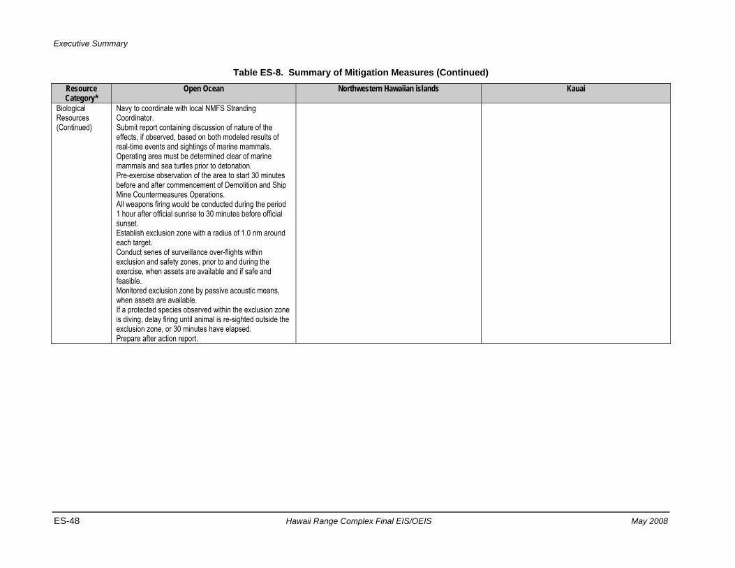
Executive Summary
ES-48 Hawaii Range Complex Final EIS/OEIS May 2008
Table ES-8. Summary of Mitigation Measures (Continued) Resource Category*
Open Ocean Northwestern Hawaiian islands Kauai
Biological Resources (Continued)
Navy to coordinate with local NMFS Stranding Coordinator. Submit report containing discussion of nature of the effects, if observed, based on both modeled results of real-time events and sightings of marine mammals. Operating area must be determined clear of marine mammals and sea turtles prior to detonation. Pre-exercise observation of the area to start 30 minutes before and after commencement of Demolition and Ship Mine Countermeasures Operations. All weapons firing would be conducted during the period 1 hour after official sunrise to 30 minutes before official sunset. Establish exclusion zone with a radius of 1.0 nm around each target. Conduct series of surveillance over-flights within exclusion and safety zones, prior to and during the exercise, when assets are available and if safe and feasible. Monitored exclusion zone by passive acoustic means, when assets are available. If a protected species observed within the exclusion zone is diving, delay firing until animal is re-sighted outside the exclusion zone, or 30 minutes have elapsed. Prepare after action report.
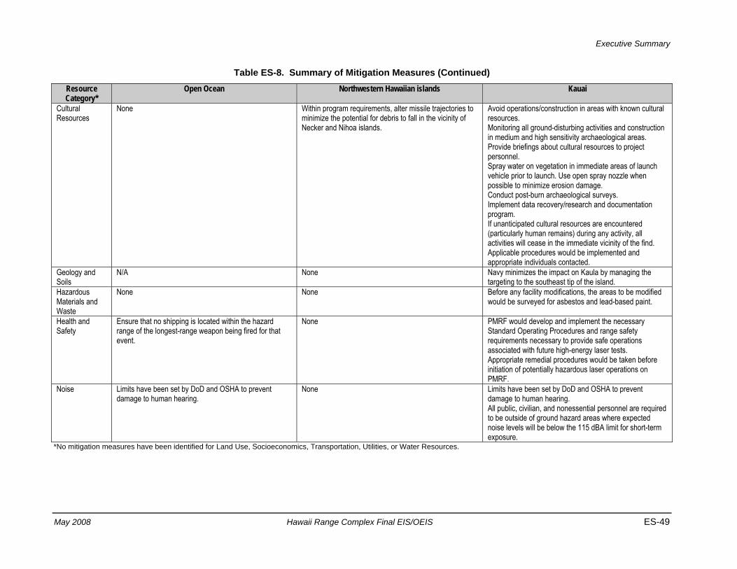
Executive Summary
May 2008 Hawaii Range Complex Final EIS/OEIS ES-49
Table ES-8. Summary of Mitigation Measures (Continued) Resource Category*
Open Ocean Northwestern Hawaiian islands Kauai
Cultural Resources
None Within program requirements, alter missile trajectories to minimize the potential for debris to fall in the vicinity of Necker and Nihoa islands.
Avoid operations/construction in areas with known cultural resources. Monitoring all ground-disturbing activities and construction in medium and high sensitivity archaeological areas. Provide briefings about cultural resources to project personnel. Spray water on vegetation in immediate areas of launch vehicle prior to launch. Use open spray nozzle when possible to minimize erosion damage. Conduct post-burn archaeological surveys. Implement data recovery/research and documentation program. If unanticipated cultural resources are encountered (particularly human remains) during any activity, all activities will cease in the immediate vicinity of the find. Applicable procedures would be implemented and appropriate individuals contacted.
Geology and Soils
N/A None Navy minimizes the impact on Kaula by managing the targeting to the southeast tip of the island.
Hazardous Materials and Waste
None None Before any facility modifications, the areas to be modified would be surveyed for asbestos and lead-based paint.
Health and Safety
Ensure that no shipping is located within the hazard range of the longest-range weapon being fired for that event.
None PMRF would develop and implement the necessary Standard Operating Procedures and range safety requirements necessary to provide safe operations associated with future high-energy laser tests. Appropriate remedial procedures would be taken before initiation of potentially hazardous laser operations on PMRF.
Noise Limits have been set by DoD and OSHA to prevent damage to human hearing.
None Limits have been set by DoD and OSHA to prevent damage to human hearing. All public, civilian, and nonessential personnel are required to be outside of ground hazard areas where expected noise levels will be below the 115 dBA limit for short-term exposure.
*No mitigation measures have been identified for Land Use, Socioeconomics, Transportation, Utilities, or Water Resources.
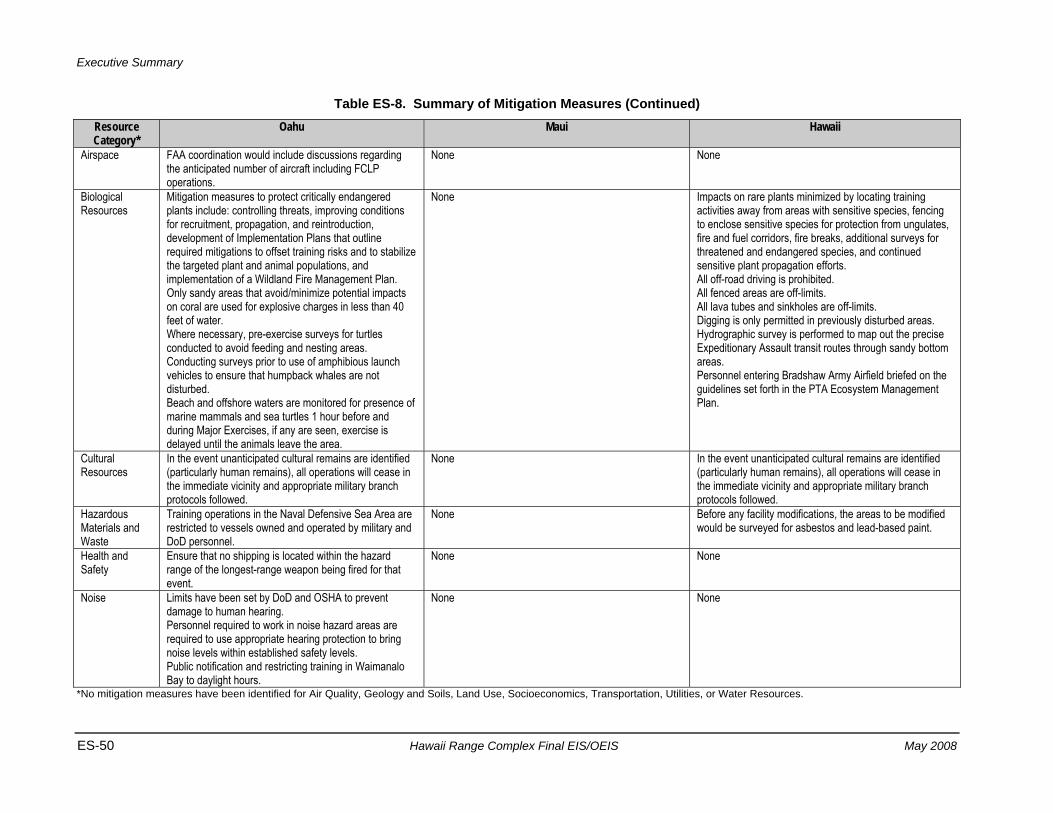
Executive Summary
ES-50 Hawaii Range Complex Final EIS/OEIS May 2008
Table ES-8. Summary of Mitigation Measures (Continued) Resource Category*
Oahu Maui Hawaii
Airspace FAA coordination would include discussions regarding the anticipated number of aircraft including FCLP operations.
None None
Biological Resources
Mitigation measures to protect critically endangered plants include: controlling threats, improving conditions for recruitment, propagation, and reintroduction, development of Implementation Plans that outline required mitigations to offset training risks and to stabilize the targeted plant and animal populations, and implementation of a Wildland Fire Management Plan. Only sandy areas that avoid/minimize potential impacts on coral are used for explosive charges in less than 40 feet of water. Where necessary, pre-exercise surveys for turtles conducted to avoid feeding and nesting areas. Conducting surveys prior to use of amphibious launch vehicles to ensure that humpback whales are not disturbed. Beach and offshore waters are monitored for presence of marine mammals and sea turtles 1 hour before and during Major Exercises, if any are seen, exercise is delayed until the animals leave the area.
None Impacts on rare plants minimized by locating training activities away from areas with sensitive species, fencing to enclose sensitive species for protection from ungulates, fire and fuel corridors, fire breaks, additional surveys for threatened and endangered species, and continued sensitive plant propagation efforts. All off-road driving is prohibited. All fenced areas are off-limits. All lava tubes and sinkholes are off-limits. Digging is only permitted in previously disturbed areas. Hydrographic survey is performed to map out the precise Expeditionary Assault transit routes through sandy bottom areas. Personnel entering Bradshaw Army Airfield briefed on the guidelines set forth in the PTA Ecosystem Management Plan.
Cultural Resources
In the event unanticipated cultural remains are identified (particularly human remains), all operations will cease in the immediate vicinity and appropriate military branch protocols followed.
None In the event unanticipated cultural remains are identified (particularly human remains), all operations will cease in the immediate vicinity and appropriate military branch protocols followed.
Hazardous Materials and Waste
Training operations in the Naval Defensive Sea Area are restricted to vessels owned and operated by military and DoD personnel.
None Before any facility modifications, the areas to be modified would be surveyed for asbestos and lead-based paint.
Health and Safety
Ensure that no shipping is located within the hazard range of the longest-range weapon being fired for that event.
None None
Noise Limits have been set by DoD and OSHA to prevent damage to human hearing. Personnel required to work in noise hazard areas are required to use appropriate hearing protection to bring noise levels within established safety levels. Public notification and restricting training in Waimanalo Bay to daylight hours.
None None
*No mitigation measures have been identified for Air Quality, Geology and Soils, Land Use, Socioeconomics, Transportation, Utilities, or Water Resources.
Executive Summary
May 2008 Hawaii Range Complex Final EIS/OEIS ES-51
Acronyms and Abbreviations AFB Air Force Base ASW Anti-Submarine Warfare CFR Code of Federal Regulations COMNAVSURFPAC Commander, Naval Surface Force, U.S. Pacific Fleet CEQ Council on Environmental Quality dB Decibel dBA A-Weighted Decibels DoD Department of Defense DOT Department of Transportation EIS Environmental Impact Statement EO Executive Order EOD Explosive Ordnance Disposal ESA Endangered Species Act ESG Expeditionary Strike Group FCLP Field Carrier Landing Practice FORACS Fleet Operational Readiness HFA High-Frequency Active HRC Hawaii Range Complex ICRMP Integrated Cultural Resource Management Plan IEER Improved Extended Echo Ranging MCBH Marine Corps Base Hawaii MCTAB Marine Corps Training Area Bellows MFA Mid-Frequency Active MMPA Marine Mammal Protection Act NDE National Defense Exemption NEPA National Environmental Policy Act nm Nautical Mile(s) nm2 Square Nautical Mile(s) NMFS National Marine Fisheries Service NOI Notice of Intent NOTAM Notice to Airmen NOTMAR Notice to Mariners OEIS Overseas Environmental Impact Statement OPAREA Operating Area OSHA Occupational Safety and Health Administration PMRF Pacific Missile Range Facility PTA Pohakuloa Training Area RDT&E Research, Development, Test, and Evaluation RIMPAC Rim of the Pacific ROD Record of Decision SESEF Shipboard Electronic Systems Evaluation Facility SPORTS Sonar Positional Reporting System THAAD Terminal High Altitude Area Defense TOA Temporary Operating Area U.S. United States U.S.C. United States Code USACE United States Army Corps of Engineers USFWS U.S. Fish and Wildlife Service USWEX Undersea Warfare Exercise
Executive Summary
ES-52 Hawaii Range Complex Final EIS/OEIS May 2008
THIS PAGE INTENTIONALLY LEFT BLANK

Table of Contents


Table of Contents
May 2008 Hawaii Range Complex Final EIS/OEIS i
TABLE OF CONTENTS
Volume 1
Page EXECUTIVE SUMMARY ........................................................................................................ ES-1
1.0 PURPOSE AND NEED FOR THE PROPOSED ACTION ................................................ 1-1 1.1 Introduction ............................................................................................................... 1-1 1.2 Overview of the Hawaii Range Complex .................................................................. 1-2 1.3 Background .............................................................................................................. 1-6
1.3.1 Navy’s At Sea Policy .................................................................................... 1-8 1.3.2 Why the Navy Trains .................................................................................... 1-9 1.3.3 Tactical Training Theater Assessment and Planning Program .................. 1-11 1.3.4 Mission of the Hawaii Range Complex ....................................................... 1-12 1.3.5 Strategic Importance of the Existing Hawaii Range Complex .................... 1-13
1.4 Purpose and Need for the Proposed Action ........................................................... 1-14 1.5 The Environmental Review Process ...................................................................... 1-15
1.5.1 Scope and Content of the EIS/OEIS .......................................................... 1-15 1.5.2 Cooperating Agencies ................................................................................ 1-16 1.5.3 National Environmental Policy Act .............................................................. 1-16
1.5.3.1 Public Scoping Process ............................................................... 1-17 1.5.3.2 Public Review Process ................................................................ 1-17
1.5.4 Executive Order 12114 ............................................................................... 1-21 1.5.5 Marine Mammal Protection Act Compliance .............................................. 1-21 1.5.6 Endangered Species Act Compliance ........................................................ 1-23 1.5.7 Other Environmental Requirements Considered ........................................ 1-24
1.6 Related Environmental Documents ........................................................................ 1-24
2.0 DESCRIPTION OF THE PROPOSED ACTION AND ALTERNATIVES ........................... 2-1 2.1 Description of the Hawaii Range Complex ............................................................... 2-2 2.2 Proposed Action and Alternatives ............................................................................ 2-8
2.2.1 Alternatives Eliminated From Further Consideration .................................... 2-9 2.2.1.1 Reduction or Elimination of Training in the Hawaii Range
Complex ......................................................................................... 2-9 2.2.1.2 Alternative Locations for Training Conducted in the Hawaii
Range Complex ........................................................................... 2-10 2.2.1.3 Computer Simulation Training ..................................................... 2-11
2.2.2 No-action Alternative .................................................................................. 2-12 2.2.2.1 Hawaii Range Complex Training for the No-action Alternative .... 2-13 2.2.2.2 Hawaii Range Complex Support Events for the No-action
Alternative .................................................................................... 2-16 2.2.2.3 Current Training Events Within the Hawaii Range Complex for
the No-action Alternative.............................................................. 2-17 2.2.2.4 Mid-Frequency Active/High-Frequency Active Sonar Usage for
the No-action Alternative.............................................................. 2-21 2.2.2.5 Hawaii Range Complex RDT&E Activities for the No-action
Alternative .................................................................................... 2-23 2.2.2.5.1 Pacific Missile Range Facility .............................................. 2-25
Table of Contents
ii Hawaii Range Complex Final EIS/OEIS May 2008
2.2.2.5.2 Naval Undersea Warfare Center Ranges ........................... 2-32 2.2.2.6 Major Exercises for the No-action Alternative .............................. 2-36
2.2.2.6.1 Rim of the Pacific ................................................................ 2-36 2.2.2.6.2 Undersea Warfare Exercise ................................................ 2-39
2.2.2.7 Mitigation Measures for the No-action Alternative ....................... 2-40 2.2.3 Alternative 1 ................................................................................................ 2-40
2.2.3.1 Training Events for Alternative 1 .................................................. 2-40 2.2.3.2 MFA/HFA Sonar Usage for Alternative 1 ..................................... 2-40 2.2.3.3 Increased Tempo and Frequency of Training and New
Training for Alternative 1 .............................................................. 2-41 2.2.3.4 Enhanced RDT&E Activities for Alternative 1 .............................. 2-42 2.2.3.5 Future RDT&E Activities for Alternative 1 .................................... 2-42 2.2.3.6 Hawaii Range Complex Enhancements for Alternative 1 ............ 2-46
2.2.3.6.1 EOD Range Enhancements ................................................ 2-47 2.2.3.6.2 Pearl Harbor Enhancements ............................................... 2-47 2.2.3.6.3 Offshore Enhancements ..................................................... 2-51 2.2.3.6.4 PMRF Enhancements ......................................................... 2-51
2.2.3.7 Major Exercises for Alternative 1 ................................................. 2-60 2.2.3.8 Mitigation Measures for Alternative 1 ........................................... 2-60
2.2.4 Alternative 2 ................................................................................................ 2-60 2.2.4.1 Training Events for Alternative 2 .................................................. 2-60 2.2.4.2 MFA/HFA Sonar Usage for Alternative 2 ..................................... 2-61 2.2.4.3 Increased Tempo and Frequency of Training for Alternative 2 .... 2-62 2.2.4.4 Enhanced RDT&E Activities for Alternative 2 .............................. 2-62 2.2.4.5 Future RDT&E Activities for Alternative 2 .................................... 2-62 2.2.4.6 Hawaii Range Complex Enhancements for Alternative 2 ............ 2-64 2.2.4.7 Additional Major Exercises—Multiple Strike Group Training for
Alternative 2 ................................................................................. 2-64 2.2.4.8 Mitigation Measures For Alternative 2 ......................................... 2-65
2.2.5 Alternative 3 (Preferred) ............................................................................. 2-65 2.2.5.1 Mitigation Measures For Alternative 3 ......................................... 2-66
3.0 AFFECTED ENVIRONMENT ............................................................................................ 3-1 3.1 Open Ocean Area .................................................................................................... 3-1
3.1.1 Airspace—Open Ocean Area ....................................................................... 3-3 3.1.2 Biological Resources—Open Ocean Area ................................................... 3-8
3.1.2.1 Coral .............................................................................................. 3-8 3.1.2.2 Fish .............................................................................................. 3-11
3.1.2.2.1 Essential Fish Habitat ......................................................... 3-12 3.1.2.2.2 Offshore Ocean or Pelagic Species .................................... 3-13 3.1.2.2.3 Fish Acoustics ..................................................................... 3-14
3.1.2.2.3.1 Sound in Water ......................................................... 3-16 3.1.2.2.3.1.1 What Do Fish Hear? ..................................... 3-17 3.1.2.2.3.1.2 Sound Detection Mechanisms ...................... 3-18 3.1.2.2.3.1.3 Hearing Generalists and Specialists ............. 3-19 3.1.2.2.3.1.4 Ancillary Structures for Hearing
Specializations .............................................. 3-19 3.1.2.2.3.1.5 Lateral Line ................................................... 3-20
3.1.2.2.3.2 Overview of Fish Hearing Capabilities ...................... 3-21 3.1.2.2.3.2.1 Variability in Hearing Among Groups of Fish 3-21 3.1.2.2.3.2.2 Marine Hearing Specialists ........................... 3-25
Table of Contents
May 2008 Hawaii Range Complex Final EIS/OEIS iii
3.1.2.2.3.2.3 Marine Hearing Generalists .......................... 3-26 3.1.2.2.3.2.4 Hearing Capabilities of Elasmobranchs and
Other “Fish” ................................................... 3-28 3.1.2.2.3.2.5 Data on Fish Hearing .................................... 3-28
3.1.2.3 Sea Turtles .................................................................................. 3-29 3.1.2.3.1 Green Turtle (Chelonia mydas) ........................................... 3-33 3.1.2.3.2 Hawksbill Turtle (Eretmochelys imbricata) .......................... 3-35 3.1.2.3.3 Leatherback Turtle (Dermochelys coriacea) ....................... 3-35 3.1.2.3.4 Loggerhead Turtle (Caretta caretta) ................................... 3-36 3.1.2.3.5 Olive Ridley Turtle (Lepidochelys olivacea) ........................ 3-38
3.1.2.4 Marine Mammals ......................................................................... 3-39 3.1.2.4.1 Marine Mammal Occurrence ............................................... 3-41
3.1.2.4.1.1 Mysticetes ................................................................. 3-41 3.1.2.4.1.2 Odontocetes ............................................................. 3-52 3.1.2.4.1.3 Pinnipeds .................................................................. 3-69
3.1.3 Cultural Resources—Open Ocean Area .................................................... 3-73 3.1.4 Hazardous Materials and Waste—Open Ocean Area ................................ 3-77 3.1.5 Health and Safety—Open Ocean Area ...................................................... 3-86 3.1.6 Noise—Open Ocean Area .......................................................................... 3-86 3.1.7 Water Resources—Open Ocean Area ....................................................... 3-89
3.2 Northwestern Hawaiian Islands .............................................................................. 3-93 3.2.1 Northwestern Hawaiian Islands Offshore ................................................... 3-99
3.2.1.1 Biological Resources—Northwestern Hawaiian Islands Offshore ....................................................................................... 3-99
3.2.1.1.1 Nihoa—Biological Resources—Northwestern Hawaiian Islands Offshore .................................................................. 3-99
3.2.1.1.2 Necker—Biological Resources—Northwestern Hawaiian Islands Offshore ................................................ 3-100
3.2.2 Northwestern Hawaiian Islands Onshore ................................................. 3-102 3.2.2.1 Biological Resources—Northwestern Hawaiian Islands
Onshore ..................................................................................... 3-102 3.2.2.1.1 Nihoa—Biological Resources—Northwestern Hawaiian
Islands Onshore ................................................................ 3-102 3.2.2.1.2 Necker—Biological Resources—Northwestern
Hawaiian Islands Onshore ................................................ 3-103 3.2.2.2 Cultural Resources—Northwestern Hawaiian Islands Onshore 3-104
3.3 Kauai .................................................................................................................... 3-107 3.3.1 Kauai Offshore .......................................................................................... 3-107
3.3.1.1 PMRF Offshore (BARSTUR, BSURE, SWTR, Kingfisher) ........ 3-107 3.3.1.1.1 Biological Resources—PMRF—Offshore (BARSTUR,
BSURE, SWTR, Kingfisher) .............................................. 3-108 3.3.1.1.2 Cultural Resources—PMRF—Offshore (BARSTUR,
BSURE, SWTR, Kingfisher) .............................................. 3-115 3.3.1.1.3 Socioeconomics—PMRF—Offshore (BARSTUR,
BSURE, SWTR, Kingfisher) .............................................. 3-117 3.3.1.1.4 Transportation—PMRF—Offshore (BARSTUR,
BSURE, SWTR, Kingfisher) .............................................. 3-121 3.3.1.2 Niihau Offshore .......................................................................... 3-122
3.3.1.2.1 Biological Resources—Niihau—Offshore ......................... 3-122 3.3.1.3 Kaula Offshore ........................................................................... 3-124
3.3.1.3.1 Biological Resources—Kaula—Offshore .......................... 3-124
Table of Contents
iv Hawaii Range Complex Final EIS/OEIS May 2008
3.3.1.3.2 Cultural Resources—Kaula—Offshore ............................. 3-125 3.3.2 Kauai Onshore .......................................................................................... 3-126
3.3.2.1 PMRF/Main Base ....................................................................... 3-126 3.3.2.1.1 Air Quality—PMRF/Main Base .......................................... 3-126 3.3.2.1.2 Airspace—PMRF/Main Base ............................................ 3-128 3.3.2.1.3 Biological Resources—PMRF/Main Base ......................... 3-132 3.3.2.1.4 Cultural Resources—PMRF/Main Base ............................ 3-139 3.3.2.1.5 Geology and Soils—PMRF/Main Base ............................. 3-141 3.3.2.1.6 Hazardous Materials and Waste—PMRF/Main Base ....... 3-143 3.3.2.1.7 Health and Safety—PMRF/Main Base .............................. 3-146 3.3.2.1.8 Land Use—PMRF/Main Base ........................................... 3-152 3.3.2.1.9 Noise—PMRF/Main Base ................................................. 3-158 3.3.2.1.10 Socioeconomics—PMRF/Main Base ................................ 3-161 3.3.2.1.11 Transportation—PMRF/Main Base ................................... 3-165 3.3.2.1.12 Utilities—PMRF/Main Base ............................................... 3-166 3.3.2.1.13 Water Resources—PMRF/Main Base .............................. 3-168
3.3.2.2 Makaha Ridge ............................................................................ 3-171 3.3.2.2.1 Air Quality—Makaha Ridge ............................................... 3-171 3.3.2.2.2 Biological Resources—Makaha Ridge .............................. 3-172 3.3.2.2.3 Cultural Resources—Makaha Ridge ................................. 3-174 3.3.2.2.4 Hazardous Materials and Waste—Makaha Ridge ............ 3-176 3.3.2.2.5 Health and Safety—Makaha Ridge ................................... 3-176
3.3.2.3 Kokee ......................................................................................... 3-178 3.3.2.3.1 Air Quality—Kokee ............................................................ 3-178 3.3.2.3.2 Biological Resources—Kokee ........................................... 3-178 3.3.2.3.3 Hazardous Materials and Waste—Kokee ......................... 3-180 3.3.2.3.4 Health and Safety—Kokee ................................................ 3-181
3.3.2.4 Hawaii Air National Guard Kokee .............................................. 3-183 3.3.2.4.1 Biological Resources—Hawaii Air National Guard
Kokee ................................................................................ 3-183 3.3.2.5 Kamokala Magazines ................................................................ 3-185
3.3.2.5.1 Hazardous Materials and Waste—Kamokala Magazines ......................................................................... 3-185
3.3.2.5.2 Health and Safety—Kamokala Magazines ....................... 3-185 3.3.2.6 Port Allen ................................................................................... 3-187 3.3.2.7 Kikiaola Small Boat Harbor ........................................................ 3-188 3.3.2.8 Mt. Kahili .................................................................................... 3-189 3.3.2.9 Niihau ......................................................................................... 3-190
3.3.2.9.1 Biological Resources—Niihau ........................................... 3-190 3.3.2.9.2 Hazardous Materials and Waste—Niihau ......................... 3-192 3.3.2.9.3 Health and Safety—Niihau ................................................ 3-192
3.3.2.10 Kaula .......................................................................................... 3-195 3.3.2.10.1 Airspace—Kaula ............................................................... 3-195 3.3.2.10.2 Biological Resources—Kaula ............................................ 3-195 3.3.2.10.3 Cultural Resources—Kaula ............................................... 3-197 3.3.2.10.4 Geology and Soils—Kaula ................................................ 3-197 3.3.2.10.5 Health and Safety—Kaula ................................................. 3-198 3.3.2.10.6 Land Use—Kaula .............................................................. 3-199
3.4 Oahu ..................................................................................................................... 3-201 3.4.1 Oahu Offshore .......................................................................................... 3-201
3.4.1.1 Puuloa Underwater Range—Offshore ....................................... 3-201
Table of Contents
May 2008 Hawaii Range Complex Final EIS/OEIS v
3.4.1.1.1 Biological Resources—Puuloa Underwater Range—Offshore ............................................................................ 3-202
3.4.1.1.2 Cultural Resources—Puuloa Underwater Range—Offshore ............................................................................ 3-205
3.4.1.1.3 Hazardous Materials and Waste—Puuloa Underwater Range—Offshore .............................................................. 3-205
3.4.1.1.4 Health and Safety—Puuloa Underwater Range—Offshore ............................................................................ 3-206
3.4.1.2 Naval Defensive Sea Area—Offshore ....................................... 3-207 3.4.1.2.1 Biological Resources—Naval Defensive Sea Area—
Offshore ............................................................................ 3-207 3.4.1.2.2 Cultural Resources—Naval Defensive Sea Area—
Offshore ............................................................................ 3-208 3.4.1.2.3 Health and Safety—Naval Defensive Sea Area—
Offshore ............................................................................ 3-209 3.4.1.3 Marine Corps Base Hawaii (MCBH)—Offshore ......................... 3-210
3.4.1.3.1 Biological Resources—MCBH—Offshore ......................... 3-210 3.4.1.3.2 Cultural Resources—MCBH—Offshore ............................ 3-213
3.4.1.4 Marine Corps Training Area/Bellows (MCTAB)—Offshore ........ 3-215 3.4.1.4.1 Biological Resources—MCTAB—Offshore ....................... 3-215 3.4.1.4.2 Cultural Resources—MCTAB—Offshore .......................... 3-216
3.4.1.5 Makua Military Reservation—Offshore ...................................... 3-217 3.4.1.5.1 Biological Resources—Makua Military Reservation—
Offshore ............................................................................ 3-217 3.4.1.5.2 Cultural Resources—Makua Military Reservation—
Offshore ............................................................................ 3-218 3.4.1.6 Dillingham Military Reservation—Offshore ................................ 3-219
3.4.1.6.1 Biological Resources—Dillingham Military Reservation—Offshore ..................................................... 3-219
3.4.1.6.2 Cultural Resources—Dillingham Military Reservation—Offshore ............................................................................ 3-221
3.4.1.7 Ewa Training Minefield—Offshore ............................................. 3-222 3.4.1.7.1 Biological Resources—Ewa Training Minefield—
Offshore ............................................................................ 3-222 3.4.1.7.2 Hazardous Materials and Waste—Ewa Training
Minefield—Offshore .......................................................... 3-223 3.4.1.7.3 Health and Safety—Ewa Training Minefield—Offshore .... 3-223
3.4.1.8 Barbers Point Underwater Range—Offshore ............................. 3-224 3.4.1.8.1 Biological Resources—Barbers Point Underwater
Range—Offshore .............................................................. 3-224 3.4.1.8.2 Hazardous Materials and Waste—Barbers Point
Underwater Range—Offshore .......................................... 3-225 3.4.1.8.3 Health and Safety—Barbers Point Underwater
Range—Offshore .............................................................. 3-226 3.4.1.9 Naval Undersea Warfare Center (NUWC) Shipboard
Electronic Systems Evaluation Facility (SESEF)—Offshore ...... 3-227 3.4.1.9.1 Biological Resources—SESEF—Offshore ........................ 3-227 3.4.1.9.2 Health and Safety—SESEF—Offshore ............................. 3-228
3.4.1.10 Naval Undersea Warfare Center (NUWC) Fleet Operational Readiness Accuracy Check Site (FORACS)—Offshore ............ 3-229
3.4.1.10.1 Biological Resources—FORACS—Offshore ..................... 3-229
Table of Contents
vi Hawaii Range Complex Final EIS/OEIS May 2008
3.4.1.10.2 Health and Safety—FORACS—Offshore ......................... 3-231 3.4.2 Oahu Onshore .......................................................................................... 3-232
3.4.2.1 Naval Station Pearl Harbor ........................................................ 3-232 3.4.2.1.1 Biological Resources—Naval Station Pearl Harbor .......... 3-232 3.4.2.1.2 Cultural Resources—Naval Station Pearl Harbor ............. 3-235 3.4.2.1.3 Socioeconomics—Naval Station Pearl Harbor.................. 3-237
3.4.2.2 Ford Island ................................................................................. 3-242 3.4.2.2.1 Biological Resources—Ford Island ................................... 3-242 3.4.2.2.2 Cultural Resources—Ford Island ...................................... 3-243 3.4.2.2.3 Water Resources—Ford Island ......................................... 3-244
3.4.2.3 Naval Inactive Ship Maintenance Facility, Pearl Harbor ............ 3-246 3.4.2.3.1 Biological Resources—Naval Inactive Ship
Maintenance Facility, Pearl Harbor ................................... 3-246 3.4.2.3.2 Hazardous Materials and Waste—Naval Inactive Ship
Maintenance Facility, Pearl Harbor ................................... 3-246 3.4.2.3.3 Water Resources—Naval Inactive Ship Maintenance
Facility, Pearl Harbor ........................................................ 3-247 3.4.2.4 Explosive Ordnance Disposal (EOD) Land Range— Naval
Magazine (NAVMAG) Pearl Harbor West Loch ......................... 3-249 3.4.2.4.1 Biological Resources—EOD Land Range—NAVMAG
Pearl Harbor West Loch .................................................... 3-249 3.4.2.4.2 Cultural Resources—EOD Land Range—NAVMAG
Pearl Harbor West Loch .................................................... 3-250 3.4.2.4.3 Geology and Soils—EOD Land Range—NAVMAG
Pearl Harbor West Loch .................................................... 3-251 3.4.2.4.4 Health and Safety—EOD Land Range—NAVMAG
Pearl Harbor West Loch .................................................... 3-251 3.4.2.4.5 Water Resources—EOD Land Range—NAVMAG
Pearl Harbor West Loch .................................................... 3-252 3.4.2.5 Lima Landing ............................................................................. 3-253
3.4.2.5.1 Biological Resources—Lima Landing ............................... 3-253 3.4.2.5.2 Cultural Resources—Lima Landing .................................. 3-254 3.4.2.5.3 Hazardous Materials and Waste—Lima Landing .............. 3-254 3.4.2.5.4 Health and Safety—Lima Landing .................................... 3-255
3.4.2.6 U.S. Coast Guard Air Station Barbers Point/Kalaeloa Airport .... 3-256 3.4.2.6.1 Airspace—U.S. Coast Guard Air Station Barbers
Point/Kalaeloa Airport ....................................................... 3-256 3.4.2.6.2 Biological Resources—U.S. Coast Guard Air Station
Barbers Point/Kalaeloa Airport .......................................... 3-258 3.4.2.7 Marine Corps Base Hawaii (MCBH) .......................................... 3-260
3.4.2.7.1 Airspace—MCBH .............................................................. 3-260 3.4.2.7.2 Biological Resources—MCBH .......................................... 3-261 3.4.2.7.3 Cultural Resources—MCBH ............................................. 3-264 3.4.2.7.4 Noise—MCBH ................................................................... 3-265 3.4.2.7.5 Socioeconomics—MCBH .................................................. 3-267
3.4.2.8 Marine Corps Training Area/Bellows (MCTAB) ......................... 3-268 3.4.2.8.1 Biological Resources—MCTAB ........................................ 3-268 3.4.2.8.2 Cultural Resources—MCTAB ........................................... 3-269
3.4.2.9 Hickam Air Force Base (AFB) .................................................... 3-272 3.4.2.9.1 Airspace—Hickam AFB .................................................... 3-272 3.4.2.9.2 Biological Resources—Hickam AFB ................................. 3-273

Table of Contents
May 2008 Hawaii Range Complex Final EIS/OEIS vii
3.4.2.10 Wheeler Army Airfield ................................................................ 3-275 3.4.2.10.1 Airspace—Wheeler Army Airfield ...................................... 3-275 3.4.2.10.2 Biological Resources—Wheeler Army Airfield .................. 3-276
3.4.2.11 Makua Military Reservation........................................................ 3-279 3.4.2.11.1 Biological Resources—Makua Military Reservation .......... 3-279 3.4.2.11.2 Cultural Resources—Makua Military Reservation ............. 3-282 3.4.2.11.3 Health and Safety—Makua Military Reservation............... 3-285 3.4.2.11.4 Noise—Makua Military Reservation .................................. 3-286
3.4.2.12 Kahuku Training Area ................................................................ 3-287 3.4.2.12.1 Biological Resources—Kahuku Training Area .................. 3-287 3.4.2.12.2 Cultural Resources—Kahuku Training Area ..................... 3-289
3.4.2.13 Dillingham Military Reservation .................................................. 3-292 3.4.2.13.1 Biological Resources—Dillingham Military Reservation .... 3-292 3.4.2.13.2 Cultural Resources—Dillingham Military Reservation ....... 3-294
3.4.2.14 Keehi Lagoon ............................................................................. 3-295 3.4.2.15 Kaena Point ............................................................................... 3-296 3.4.2.16 Mt. Kaala .................................................................................... 3-297 3.4.2.17 Wheeler Network Segment Control/PMRF Communication
Sites ........................................................................................... 3-298 3.4.2.18 Mauna Kapu Communication Site ............................................. 3-299 3.4.2.19 Makua Radio/Repeater/Cable Head .......................................... 3-300
3.5 Maui ...................................................................................................................... 3-301 3.5.1 Maui Offshore ........................................................................................... 3-301
3.5.1.1 Maui Offshore ............................................................................ 3-301 3.5.1.1.1 Biological Resources—Maui Offshore .............................. 3-301
3.5.1.2 Shallow-water Minefield Sonar Training Area-Offshore ............. 3-304 3.5.2 Maui Onshore ........................................................................................... 3-305
3.5.2.1 Maui Space Surveillance System .............................................. 3-305 3.5.2.2 Maui High Performance Computing Center ............................... 3-306 3.5.2.3 Sandia Maui Haleakala Facility .................................................. 3-307 3.5.2.4 Molokai Mobile Transmitter Site ................................................. 3-308
3.6 Hawaii ................................................................................................................... 3-309 3.6.1 Hawaii Offshore ........................................................................................ 3-309
3.6.1.1 Kawaihae Pier—Offshore .......................................................... 3-309 3.6.1.1.1 Biological Resources—Kawaihae Pier—Offshore ............ 3-309
3.6.2 Hawaii Onshore ........................................................................................ 3-312 3.6.2.1 Pohakuloa Training Area (PTA) ................................................. 3-312
3.6.2.1.1 Airspace—PTA ................................................................. 3-312 3.6.2.1.2 Biological Resources—PTA .............................................. 3-315 3.6.2.1.3 Cultural Resources—PTA ................................................. 3-319 3.6.2.1.4 Health and Safety—PTA ................................................... 3-320 3.6.2.1.5 Noise—PTA ...................................................................... 3-322
3.6.2.2 Bradshaw Army Airfield.............................................................. 3-324 3.6.2.2.1 Airspace—Bradshaw Army Airfield ................................... 3-324 3.6.2.2.2 Biological Resources—Bradshaw Army Airfield ................ 3-324 3.6.2.2.3 Cultural Resources—Bradshaw Army Airfield................... 3-325
3.6.2.3 Kawaihae Pier ............................................................................ 3-326 3.6.2.3.1 Biological Resources—Kawaihae Pier .............................. 3-326
Table of Contents
viii Hawaii Range Complex Final EIS/OEIS May 2008
3.7 Hawaiian Islands Humpback Whale National Marine Sanctuary (HIHWNMS) .... 3-327 3.7.1 Biological Resources—HIHWNMS ........................................................... 3-329
3.7.1.1 Kauai—Biological Resources—HIHWNMS ............................... 3-329 3.7.1.2 Oahu—Biological Resources—HIHWNMS ................................ 3-329 3.7.1.3 Maui—Biological Resources—HIHWNMS ................................. 3-329 3.7.1.4 Hawaii—Biological Resources—HIHWNMS .............................. 3-330
Table of Contents
May 2008 Hawaii Range Complex Final EIS/OEIS ix
Volume 2
Page
4.0 ENVIRONMENTAL CONSEQUENCES ............................................................................ 4-1 4.1 Open Ocean Area .................................................................................................... 4-3
4.1.1 Airspace—Open Ocean ................................................................................ 4-3 4.1.1.1 No-action Alternative (Airspace—Open Ocean) ............................ 4-3
4.1.1.1.1 HRC Training—No-action Alternative ................................... 4-3 4.1.1.1.2 HRC RDT&E Activities—No-action Alternative ..................... 4-5 4.1.1.1.3 Major Exercises—No-action Alternative ............................... 4-8
4.1.1.2 Alternative 1 (Airspace—Open Ocean).......................................... 4-8 4.1.1.2.1 Increased Tempo and Frequency of Training—
Alternative 1 .......................................................................... 4-8 4.1.1.2.2 Enhanced and Future RDT&E Activities—Alternative 1........ 4-9 4.1.1.2.3 HRC Enhancements—Alternative 1 ...................................... 4-9 4.1.1.2.4 Major Exercises—Alternative 1 ............................................. 4-9
4.1.1.3 Alternative 2 (Airspace—Open Ocean)........................................ 4-10 4.1.1.3.1 Increased Tempo and Frequency of Training—
Alternative 2 ........................................................................ 4-10 4.1.1.3.2 Enhanced and Future RDT&E Activities—Alternative 2...... 4-11 4.1.1.3.3 Additional Major Exercises—Multiple Strike Group
Training—Alternative 2 ....................................................... 4-11 4.1.1.4 Alternative 3 (Airspace—Open Ocean)........................................ 4-12
4.1.2 Biological Resources—Open Ocean .......................................................... 4-12 4.1.2.1 Coral (Biological Resources—Open Ocean) ............................... 4-13
4.1.2.1.1 No-action Alternative, Alternative 1, Alternative 2, and Alternative 3 (Coral—Biological Resources—Open Ocean) ................................................................................ 4-13
4.1.2.2 Fish (Biological Resources—Open Ocean) ................................. 4-14 4.1.2.2.1 No-action Alternative (Fish—Biological Resources—
Open Ocean) ...................................................................... 4-32 4.1.2.2.2 Alternative 1 (Fish—Biological Resources—Open
Ocean) ................................................................................ 4-33 4.1.2.2.3 Alternative 2 (Fish—Biological Resources—Open
Ocean) ................................................................................ 4-34 4.1.2.2.4 Alternative 3 (Fish—Biological Resources—Open
Ocean) ................................................................................ 4-36 4.1.2.3 Sea Turtles (Biological Resources—Open Ocean) ...................... 4-36
4.1.2.3.1 No-action Alternative (Sea Turtles—Biological Resources—Open Ocean) .................................................. 4-41
4.1.2.3.2 Alternative 1 (Sea Turtles—Biological Resources—Open Ocean) ...................................................................... 4-42
4.1.2.3.3 Alternative 2 (Sea Turtles—Biological Resources—Open Ocean) ...................................................................... 4-43
4.1.2.3.4 Alternative 3 (Sea Turtles—Biological Resources—Open Ocean) ...................................................................... 4-44
4.1.2.4 Marine Mammals (Biological Resources—Open Ocean) ............ 4-44 4.1.2.4.1 Potential Non-Acoustic Impacts .......................................... 4-45 4.1.2.4.2 Potential Sonar and Explosive Impacts .............................. 4-49
Table of Contents
x Hawaii Range Complex Final EIS/OEIS May 2008
4.1.2.4.3 Analytical Framework for Assessing Marine Mammal Response to Active Sonar .................................................. 4-50
4.1.2.4.4 Regulatory Framework ........................................................ 4-54 4.1.2.4.5 Integration of Regulatory and Biological Frameworks ......... 4-55 4.1.2.4.6 Criteria and Thresholds for Physiological Effects................ 4-61 4.1.2.4.7 Other Physiological Effects Considered .............................. 4-70 4.1.2.4.8 Previous Criteria and Thresholds for Behavioral Effects ..... 4-73 4.1.2.4.9 Summary of Existing Credible Scientific Evidence
Relevant to Assessing Behavioral Effects........................... 4-76 4.1.2.4.9.1 Background ............................................................... 4-76 4.1.2.4.9.2 Development of the Risk Function ............................ 4-77 4.1.2.4.9.3 Methodology for Applying Risk Function .................. 4-78 4.1.2.4.9.4 Data Sources Used for Risk Function ....................... 4-82 4.1.2.4.9.5 Limitations of the Risk Function Data Sources ......... 4-84 4.1.2.4.9.6 Input Parameters for the Feller-Adapted Risk
Function .................................................................... 4-85 4.1.2.4.9.7 Basic Application of the Risk Function and
Relation to the Current Regulatory Scheme ............. 4-88 4.1.2.4.9.8 Navy Post Acoustic Modeling Analysis ..................... 4-91
4.1.2.4.10 Cetacean Stranding Events ................................................ 4-92 4.1.2.4.10.1 Causes of Strandings ............................................... 4-96 4.1.2.4.10.2 Stranding Events Associated with Navy Sonar ....... 4-116 4.1.2.4.10.3 Other Global Stranding Discussions ....................... 4-123
4.1.2.4.11 Marine Mammal Mitigation Measures Related to Acoustic and Explosive Exposures ................................... 4-134
4.1.2.4.11.1 Acoustic Exposure Mitigation Measures ................. 4-134 4.1.2.4.11.2 Explosive Source Mitigation Measures ................... 4-135
4.1.2.4.12 Sonar Marine Mammal Modeling ...................................... 4-137 4.1.2.4.12.1 Active Acoustic Devices .......................................... 4-137 4.1.2.4.12.2 Sonar Modeling Methodology ................................. 4-139
4.1.2.4.13 Explosive Source Marine Mammal Modeling .................... 4-141 4.1.2.4.13.1 Explosive Source Exercises ................................... 4-141 4.1.2.4.13.2 Explosive Source Modeling Criteria ........................ 4-144
4.1.2.5 Marine Mammals No-action Alternative (Biological Resources—Open Ocean)......................................................... 4-151
4.1.2.5.1 No-action Alternative Summary of Exposures .................. 4-151 4.1.2.5.2 Estimated Effects on ESA Listed Species—No-action
Alternative ......................................................................... 4-154 4.1.2.5.3 Estimated Exposures for Non-ESA Species—No-action
Alternative ......................................................................... 4-161 4.1.2.5.4 Summary of Compliance with MMPA and ESA—No-
action Alternative .............................................................. 4-175 4.1.2.5.5 HRC Training—No-action Alternative ............................... 4-176 4.1.2.5.6 HRC RDT&E Activities—No-action Alternative ................. 4-178 4.1.2.5.7 Major Exercises—No-action Alternative ........................... 4-178
4.1.2.6 Marine Mammals Alternative 1 (Biological Resources—Open Ocean) ....................................................................................... 4-181
4.1.2.6.1 Alternative 1 Summary of Exposures ................................ 4-181 4.1.2.6.2 Estimated Effects on ESA Listed Species—
Alternative 1 ...................................................................... 4-184
Table of Contents
May 2008 Hawaii Range Complex Final EIS/OEIS xi
4.1.2.6.3 Estimated Exposures for Non-ESA Species—Alternative 1 ...................................................................... 4-189
4.1.2.6.4 Summary of Compliance with MMPA and ESA—Alternative 1 ...................................................................... 4-203
4.1.2.6.5 Increased Tempo and Frequency of Training—Alternative 1 ...................................................................... 4-205
4.1.2.6.6 Enhanced and Future RDT&E Activities—Alternative 1.... 4-205 4.1.2.6.7 HRC Enhancements—Alternative 1 .................................. 4-205 4.1.2.6.8 Major Exercises—Alternative 1 ......................................... 4-207
4.1.2.7 Marine Mammals Alternative 2 (Biological Resources—Open Ocean) ....................................................................................... 4-210
4.1.2.7.1 Alternative 2 Summary of Exposures ................................ 4-210 4.1.2.7.2 Estimated Effects on ESA Listed Species—Alternative
2 ........................................................................................ 4-213 4.1.2.7.3 Estimated Exposures for Non-ESA Species—
Alternative 2 ...................................................................... 4-219 4.1.2.7.4 Summary of Compliance with MMPA and ESA—
Alternative 2 ...................................................................... 4-233 4.1.2.7.5 Increased Tempo and Frequency of Training—
Alternative 2 ...................................................................... 4-236 4.1.2.7.6 Enhanced and Future RDT&E Activities—Alternative 2.... 4-236 4.1.2.7.7 HRC Enhancements—Alternative 2 .................................. 4-236 4.1.2.7.8 Major Exercises—RIMPAC, USWEX, and Multiple
Strike Group Training—Alternative 2 ................................ 4-236 4.1.2.8 Marine Mammals Alternative 3 (Biological Resources—Open
Ocean) ....................................................................................... 4-237 4.1.2.8.1 Summary of Compliance with ESA and MMPA—
Alternative 3 ...................................................................... 4-237 4.1.2.9 Marine Mammal Mortality Request ............................................ 4-239
4.1.3 Cultural Resources—Open Ocean ........................................................... 4-241 4.1.3.1 No-action Alternative, Alternative 1, Alternative 2, and
Alternative 3 (Cultural Resources Open Ocean) ........................ 4-241 4.1.4 Hazardous Materials & Wastes—Open Ocean ........................................ 4-242
4.1.4.1 No-action Alternative (Hazardous materials and Wastes—Open Ocean) ............................................................................. 4-242
4.1.4.1.1 HRC Training—No-action Alternative ............................... 4-242 4.1.4.1.2 HRC RDT&E Activities—No-action Alternative ................. 4-246 4.1.4.1.3 Major Exercises—No-action Alternative ........................... 4-246
4.1.4.2 Alternative 1 (Hazardous Materials and Wastes—Open Ocean) ....................................................................................... 4-246
4.1.4.2.1 Increased Tempo and Frequency of Training—Alternative 1 ...................................................................... 4-246
4.1.4.2.2 Enhanced RDT&E Activities—Alternative 1 ...................... 4-247 4.1.4.2.3 HRC Enhancements—Alternative 1 .................................. 4-247 4.1.4.2.4 Major Exercises—Alternative 1 ......................................... 4-247
4.1.4.3 Alternative 2 (Hazardous Materials and Wastes—Open Ocean) ....................................................................................... 4-249
4.1.4.3.1 Increased Tempo and Frequency of Training—Alternative 2 ...................................................................... 4-249
4.1.4.3.2 Enhanced RDT&E Activities—Alternative 2 ...................... 4-249
Table of Contents
xii Hawaii Range Complex Final EIS/OEIS May 2008
4.1.4.3.3 Additional Major Exercises—Multiple Strike Group Training—Alternative 2 ..................................................... 4-251
4.1.4.4 Alternative 3 (Hazardous Materials and Wastes—Open Ocean) ....................................................................................... 4-251
4.1.5 Health and Safety—Open Ocean ............................................................. 4-252 4.1.5.1 No-action Alternative (Health and Safety—Open Ocean) .......... 4-252
4.1.5.1.1 HRC Training—No-action Alternative ............................... 4-252 4.1.5.1.2 HRC RDT&E Activities—No-action Alternative ................. 4-254 4.1.5.1.3 Major Exercises—No-action Alternative ........................... 4-255
4.1.5.2 Alternative 1 (Health and Safety—Open Ocean) ....................... 4-255 4.1.5.2.1 Increased Tempo and Frequency of Training—
Alternative 1 ...................................................................... 4-255 4.1.5.2.2 Enhanced RDT&E Activities—Alternative 1 ...................... 4-256 4.1.5.2.3 HRC Enhancements and Major Exercises—
Alternative 1 ...................................................................... 4-256 4.1.5.3 Alternative 2 (Health and Safety—Open Ocean) ....................... 4-256
4.1.5.3.1 Increased Tempo and Frequency of Training—Alternative 2 ...................................................................... 4-256
4.1.5.3.2 Enhanced RDT&E Activities—Alternative 2 ...................... 4-257 4.1.5.3.3 Future RDT&E Activities—Alternative 2 ............................ 4-257 4.1.5.3.4 Additional Major Exercises—Multiple Strike Group
Training—Alternative 2 ..................................................... 4-258 4.1.5.4 Alternative 3 (Health and Safety—Open Ocean) ....................... 4-258
4.1.6 Noise—Open Ocean ................................................................................ 4-259 4.1.6.1 No-action Alternative, Alternative 1, Alternative 2, and
Alternative 3 (Noise—Open Ocean) .......................................... 4-259 4.1.7 Water Resources—Open Ocean .............................................................. 4-259
4.1.7.1 No-action Alternative (Water Resources—Open Ocean) .......... 4-259 4.1.7.1.1 HRC Training—No-action Alternative ............................... 4-259 4.1.7.1.2 HRC RDT&E Activities—No-action Alternative ................. 4-275 4.1.7.1.3 Major Exercises—No-action Alternative ........................... 4-277
4.1.7.2 Alternative 1 (Water Resources—Open Ocean) ........................ 4-277 4.1.7.2.1 Increased Tempo and Frequency of Training—
Alternative 1 ...................................................................... 4-277 4.1.7.2.2 Enhanced and Future RDT&E Activities—Alternative 1.... 4-277 4.1.7.2.3 HRC Enhancement—Alternative 1.................................... 4-277 4.1.7.2.4 Major Exercises—Alternative 1 ......................................... 4-277
4.1.7.3 Alternative 2 (Water Resources—Open Ocean) ........................ 4-277 4.1.7.3.1 Increased Tempo and Frequency of Training—
Alternative 2 ...................................................................... 4-277 4.1.7.3.2 Enhanced and Future RDT&E Activities—Alternative 2.... 4-278 4.1.7.3.3 Additional Major Exercises—Multiple Strike Group
Training—Alternative 2 ..................................................... 4-278 4.1.7.4 Alternative 3 (Water Resources—Open Ocean) ........................ 4-278
4.2 Northwestern Hawaiian Islands ............................................................................ 4-279 4.2.1 Northwestern Hawaiian Islands Offshore ................................................. 4-279
4.2.1.1 Biological Resources—Northwestern Hawaiian Islands—Offshore ..................................................................................... 4-280
4.2.1.1.1 Nihoa—Biological Resources—Offshore .......................... 4-280 4.2.1.1.1.1 No-action Alternative (Biological Resources—
Nihoa—Offshore) .................................................... 4-280
Table of Contents
May 2008 Hawaii Range Complex Final EIS/OEIS xiii
4.2.1.1.1.2 Alternative 1 (Biological Resources—Nihoa—Offshore) ................................................................. 4-282
4.2.1.1.1.3 Alternative 2 (Biological Resources—Nihoa—Offshore) ................................................................. 4-283
4.2.1.1.1.4 Alternative 3 (Biological Resources—Nihoa—Offshore) ................................................................. 4-283
4.2.1.1.2 Necker—Biological Resources—Offshore ........................ 4-283 4.2.1.1.2.1 No-action Alternative (Biological Resources—
Necker—Offshore) .................................................. 4-283 4.2.1.1.2.2 Alternative 1 (Biological Resources—Necker—
Offshore) ................................................................. 4-284 4.2.1.1.2.3 Alternative 2 (Biological Resources—Necker—
Offshore) ................................................................. 4-284 4.2.1.1.2.4 Alternative 3 (Biological Resources—Necker—
Offshore) ................................................................. 4-284 4.2.2 Northwestern Hawaiian Islands Onshore ................................................. 4-286
4.2.2.1 Biological Resources—Northwestern Hawaiian Islands ............ 4-286 4.2.2.1.1 Nihoa—Biological Resources ........................................... 4-286
4.2.2.1.1.1 No-action Alternative (Biological Resources—Nihoa) ..................................................................... 4-286
4.2.2.1.1.2 Alternative 1 (Biological Resources—Nihoa) .......... 4-287 4.2.2.1.1.3 Alternative 2 (Biological Resources—Nihoa) .......... 4-288 4.2.2.1.1.4 Alternative 3 (Biological Resources—Nihoa) .......... 4-288
4.2.2.1.2 Necker—Biological Resources ......................................... 4-289 4.2.2.1.2.1 No-action Alternative (Biological Resources—
Necker) ................................................................... 4-289 4.2.2.1.2.2 Alternative 1 (Biological Resources—Necker) ........ 4-289 4.2.2.1.2.3 Alternative 2 (Biological Resources—Necker) ........ 4-289 4.2.2.1.2.4 Alternative 3 (Biological Resources—Necker) ........ 4-290
4.2.2.2 Cultural Resources—Northwestern Hawaiian Islands ............... 4-290 4.2.2.2.1 No-action Alternative, Alternative 1, Alternative 2, and
Alternative 3 (Cultural Resources—Northwestern Hawaiian Islands) .............................................................. 4-290
4.3 Kauai .................................................................................................................... 4-291 4.3.1 Kauai Offshore .......................................................................................... 4-291
4.3.1.1 PMRF Offshore (BARSTUR, BSURE, SWTR, Kingfisher) ........ 4-291 4.3.1.1.1 Biological Resources—PMRF Offshore (BARSTUR,
BSURE, SWTR, Kingfisher) .............................................. 4-292 4.3.1.1.1.1 No-action Alternative (Biological Resources—
PMRF Offshore ([BARSTUR, BSURE, SWTR, Kingfisher]) .............................................................. 4-292
4.3.1.1.1.2 Alternative 1 (Biological Resources—PMRF Offshore [BARSTUR, BSURE, SWTR, Kingfisher]) .............................................................. 4-299
4.3.1.1.1.3 Alternative 2 (Biological Resources—PMRF Offshore [BARSTUR, BSURE, SWTR, Kingfisher]) .............................................................. 4-300
4.3.1.1.1.4 Alternative 3 (Biological Resources—PMRF Offshore [BARSTUR, BSURE, SWTR, Kingfisher]) .............................................................. 4-301
Table of Contents
xiv Hawaii Range Complex Final EIS/OEIS May 2008
4.3.1.1.2 Cultural Resources—PMRF Offshore (BARSTUR, BSURE, SWTR, Kingfisher) .............................................. 4-302
4.3.1.1.2.1 No-action Alternative, Alternative 1, Alternative 2, and Alternative 3 (Cultural Resources—PMRF Offshore [BARSTUR, BSURE, SWTR, Kingfisher]) 4-302
4.3.1.1.3 Socioeconomics—PMRF Offshore (BARSTUR, BSURE, SWTR, Kingfisher) .............................................. 4-302
4.3.1.1.3.1 No-action Alternative (Socioeconomics—PMRF Offshore [BARSTUR, BSURE, SWTR, Kingfisher]) 4-302
4.3.1.1.3.2 Alternative 1 (Socioeconomics—PMRF Offshore [BARSTUR, BSURE, SWTR, Kingfisher]) .............. 4-303
4.3.1.1.3.3 Alternative 2 (Socioeconomics—PMRF Offshore [BARSTUR, BSURE, SWTR, Kingfisher]) .............. 4-303
4.3.1.1.3.4 Alternative 3 (Socioeconomics—PMRF Offshore [BARSTUR, BSURE, SWTR, Kingfisher]) .............. 4-304
4.3.1.1.4 Transportation—PMRF Offshore (BARSTUR, BSURE, SWTR, Kingfisher) ............................................................ 4-305
4.3.1.1.4.1 No-action Alternative (Transportation—PMRF Offshore [BARSTUR, BSURE, SWTR, Kingfisher]) 4-305
4.3.1.1.4.2 Alternative 1 (Transportation—PMRF Offshore [BARSTUR, BSURE, SWTR, Kingfisher]) .............. 4-305
4.3.1.1.4.3 Alternative 2 (Transportation —PMRF Offshore [BARSTUR, BSURE, SWTR, Kingfisher]) .............. 4-306
4.3.1.1.4.4 Alternative 3 (Transportation —PMRF Offshore [BARSTUR, BSURE, SWTR, Kingfisher]) .............. 4-306
4.3.1.2 Niihau Offshore .......................................................................... 4-307 4.3.1.2.1 Biological Resources—Niihau Offshore ............................ 4-307
4.3.1.2.1.1 No-action Alternative (Biological Resources—Niihau Offshore) ...................................................... 4-307
4.3.1.2.1.2 Alternative 1 (Biological Resources—Niihau Offshore) ................................................................. 4-308
4.3.1.2.1.3 Alternative 2 (Biological Resources—Niihau Offshore) ................................................................. 4-309
4.3.1.2.1.4 Alternative 3 (Biological Resources—Niihau Offshore) ................................................................. 4-310
4.3.1.3 Kaula Offshore ........................................................................... 4-311 4.3.1.3.1 Biological Resources—Kaula Offshore ............................. 4-311
4.3.1.3.1.1 No-action Alternative (Biological Resources—Kaula Offshore) ....................................................... 4-311
4.3.1.3.1.2 Alternative 1 (Biological Resources—Kaula Offshore) ................................................................. 4-312
4.3.1.3.1.3 Alternative 2 (Biological Resources—Kaula Offshore) ................................................................. 4-313
4.3.1.3.1.4 Alternative 3 (Biological Resources—Kaula Offshore) ................................................................. 4-313
4.3.1.3.2 Cultural Resources—Kaula Offshore ................................ 4-313 4.3.1.3.2.1 No-action Alternative, Alternative 1, Alternative 2,
and Alternative 3 (Cultural Resources—Kaula Offshore) ................................................................. 4-313
4.3.2 Kauai Onshore .......................................................................................... 4-314 4.3.2.1 Pacific Missile Range Facility/Main Base ................................... 4-314
Table of Contents
May 2008 Hawaii Range Complex Final EIS/OEIS xv
4.3.2.1.1 Air Quality—PMRF/Main Base .......................................... 4-315 4.3.2.1.1.1 No-action Alternative (Air Quality—PMRF/Main
Base) ...................................................................... 4-315 4.3.2.1.1.2 Alternative 1 (Air Quality—PMRF/Main Base) ........ 4-319 4.3.2.1.1.3 Alternative 2 (Air Quality—PMRF/Main Base) ........ 4-321 4.3.2.1.1.4 Alternative 3 (Air Quality—PMRF/Main Base) ........ 4-323
4.3.2.1.2 Airspace—PMRF/Main Base ............................................ 4-323 4.3.2.1.2.1 No-action Alternative (Airspace—PMRF/Main
Base) ...................................................................... 4-323 4.3.2.1.2.2 Alternative 1 (Airspace—PMRF/Main Base) ........... 4-326 4.3.2.1.2.3 Alternative 2 (Airspace—PMRF/Main Base) ........... 4-328 4.3.2.1.2.4 Alternative 3 (Airspace—PMRF/Main Base) ........... 4-329
4.3.2.1.3 Biological Resources—PMRF/Main Base ......................... 4-330 4.3.2.1.3.1 No-action Alternative (Biological Resources—
PMRF/Main Base) .................................................. 4-330 4.3.2.1.3.2 Alternative 1 (Biological Resources—PMRF/Main
Base) ...................................................................... 4-334 4.3.2.1.3.3 Alternative 2 (Biological Resources—PMRF/Main
Base) ...................................................................... 4-338 4.3.2.1.3.4 Alternative 3 (Biological Resources—PMRF/Main
Base) ...................................................................... 4-339 4.3.2.1.4 Cultural Resources—PMRF/Main Base ............................ 4-339
4.3.2.1.4.1 No-action Alternative (Cultural Resources—PMRF/Main Base) .................................................. 4-339
4.3.2.1.4.2 Alternative 1 (Cultural Resources—PMRF/Main Base) ...................................................................... 4-341
4.3.2.1.4.3 Alternative 2 (Cultural Resources—PMRF/Main Base) ...................................................................... 4-342
4.3.2.1.4.4 Alternative 3 (Cultural Resources—PMRF/Main Base) ...................................................................... 4-343
4.3.2.1.5 Geology and Soils—PMRF/Main Base ............................. 4-343 4.3.2.1.5.1 No-action Alternative (Geology and Soils—
PMRF/Main Base) .................................................. 4-343 4.3.2.1.5.2 Alternatives 1, 2, and 3 (Geology and Soils—
PMRF/Main Base) .................................................. 4-343 4.3.2.1.6 Hazardous Materials and Waste—PMRF/Main Base ....... 4-343
4.3.2.1.6.1 No-action Alternative (Hazardous Materials and Waste—PMRF/Main Base) ..................................... 4-343
4.3.2.1.6.2 Alternative 1 (Hazardous Materials and Waste—PMRF/Main Base) .................................................. 4-346
4.3.2.1.6.3 Alternative 2 (Hazardous Materials and Waste—PMRF/Main Base) .................................................. 4-348
4.3.2.1.6.4 Alternative 3 (Hazardous Materials and Waste—PMRF/Main Base) .................................................. 4-349
4.3.2.1.7 Health and Safety—PMRF/Main Base .............................. 4-349 4.3.2.1.7.1 No-action Alternative (Health and Safety—
PMRF/Main Base) .................................................. 4-349 4.3.2.1.7.2 Alternative 1 (Health and Safety—PMRF/Main
Base) ...................................................................... 4-354 4.3.2.1.7.3 Alternative 2 (Health and Safety—PMRF/Main
Base) ...................................................................... 4-355
Table of Contents
xvi Hawaii Range Complex Final EIS/OEIS May 2008
4.3.2.1.7.4 Alternative 3 (Health and Safety—PMRF/Main Base) ...................................................................... 4-357
4.3.2.1.8 Land Use—PMRF/Main Base ........................................... 4-357 4.3.2.1.8.1 No-action Alternative (Land Use—PMRF/Main
Base) ...................................................................... 4-357 4.3.2.1.8.2 Alternative 1 (Land Use—PMRF/Main Base) ......... 4-359 4.3.2.1.8.3 Alternative 2 (Land Use—PMRF/Main Base) ......... 4-361 4.3.2.1.8.4 Alternative 3 (Land Use—PMRF/Main Base) ......... 4-362
4.3.2.1.9 Noise—PMRF/Main Base ................................................. 4-363 4.3.2.1.9.1 No-action Alternative (Noise—PMRF/Main Base) .. 4-363 4.3.2.1.9.2 Alternative 1 (Noise—PMRF/Main Base) ............... 4-369 4.3.2.1.9.3 Alternative 2 (Noise—PMRF/Main Base) ............... 4-372 4.3.2.1.9.4 Alternative 3 (Noise—PMRF/Main Base) ............... 4-373
4.3.2.1.10 Socioeconomics—PMRF/Main Base ................................ 4-373 4.3.2.1.10.1 No-action Alternative (Socioeconomics—
PMRF/Main Base) .................................................. 4-373 4.3.2.1.10.2 Alternative 1 (Socioeconomics—PMRF/Main
Base) ...................................................................... 4-373 4.3.2.1.10.3 Alternative 2 (Socioeconomics—PMRF/Main
Base) ...................................................................... 4-375 4.3.2.1.10.4 Alternative 3 (Socioeconomics—PMRF/Main
Base) ...................................................................... 4-376 4.3.2.1.11 Transportation—PMRF/Main Base ................................... 4-376
4.3.2.1.11.1 No-action Alternative (Transportation—PMRF/Main Base) .................................................. 4-377
4.3.2.1.11.2 Alternative 1 (Transportation—PMRF/Main Base) . 4-377 4.3.2.1.11.3 Alternative 2 (Transportation—PMRF/Main Base) . 4-378 4.3.2.1.11.4 Alternative 3 (Transportation—PMRF/Main Base) . 4-380
4.3.2.1.12 Utilities—PMRF/Main Base ............................................... 4-380 4.3.2.1.12.1 No-action Alternative (Utilities—PMRF/Main Base) 4-380 4.3.2.1.12.2 Alternative 1 (Utilities—PMRF/Main Base) ............. 4-380 4.3.2.1.12.3 Alternative 2 (Utilities—PMRF/Main Base) ............. 4-383 4.3.2.1.12.4 Alternative 3 (Utilities—PMRF/Main Base) ............. 4-384
4.3.2.1.13 Water Resources—PMRF/Main Base .............................. 4-384 4.3.2.1.13.1 No-action Alternative (Water Resources—
PMRF/Main Base) .................................................. 4-384 4.3.2.1.13.2 Alternative 1 (Water Resources—PMRF/Main
Base) ...................................................................... 4-386 4.3.2.1.13.3 Alternative 2 (Water Resources—PMRF/Main
Base) ...................................................................... 4-386 4.3.2.1.13.4 Alternative 3 (Water Resources—PMRF/Main
Base) ...................................................................... 4-387 4.3.2.2 Makaha Ridge ............................................................................ 4-388
4.3.2.2.1 Air Quality—Makaha Ridge ............................................... 4-388 4.3.2.2.1.1 No-action Alternative (Air Quality—Makaha Ridge) 4-388 4.3.2.2.1.2 Alternative 1 (Air Quality—Makaha Ridge) ............. 4-389 4.3.2.2.1.3 Alternative 2 (Air Quality—Makaha Ridge) ............. 4-389 4.3.2.2.1.4 Alternative 3 (Air Quality—Makaha Ridge) ............. 4-389
4.3.2.2.2 Biological Resources—Makaha Ridge .............................. 4-389 4.3.2.2.2.1 No-action Alternative (Biological Resources—
Makaha Ridge) ....................................................... 4-389
Table of Contents
May 2008 Hawaii Range Complex Final EIS/OEIS xvii
4.3.2.2.2.2 Alternative 1 (Biological Resources—Makaha Ridge) ..................................................................... 4-390
4.3.2.2.2.3 Alternative 2 (Biological Resources—Makaha Ridge) ..................................................................... 4-391
4.3.2.2.2.4 Alternative 3 (Biological Resources—Makaha Ridge) ..................................................................... 4-391
4.3.2.2.3 Cultural Resources—Makaha Ridge ................................. 4-392 4.3.2.2.3.1 No-action Alternative (Cultural Resources—
Makaha Ridge) ....................................................... 4-392 4.3.2.2.3.2 Alternative 1 (Cultural Resources—Makaha Ridge)4-392 4.3.2.2.3.3 Alternative 2 (Cultural Resources—Makaha Ridge)4-392 4.3.2.2.3.4 Alternative 3 (Cultural Resources—Makaha Ridge)4-393
4.3.2.2.4 Hazardous Materials and Waste—Makaha Ridge ............ 4-393 4.3.2.2.4.1 No-action Alternative (Hazardous Materials and
Waste—Makaha Ridge) .......................................... 4-393 4.3.2.2.4.2 Alternative 1 (Hazardous Materials and Waste—
Makaha Ridge) ....................................................... 4-393 4.3.2.2.4.3 Alternative 2 (Hazardous Materials and Waste—
Makaha Ridge) ....................................................... 4-394 4.3.2.2.4.4 Alternative 3 (Hazardous Materials and Waste—
Makaha Ridge) ....................................................... 4-394 4.3.2.2.5 Health and Safety—Makaha Ridge ................................... 4-394
4.3.2.2.5.1 No-action Alternative (Health and Safety—Makaha Ridge) ..................................................................... 4-394
4.3.2.2.5.2 Alternative 1 (Health and Safety—Makaha Ridge) . 4-394 4.3.2.2.5.3 Alternative 2 (Health and Safety—Makaha Ridge) . 4-395 4.3.2.2.5.4 Alternative 3 (Health and Safety—Makaha Ridge) . 4-395
4.3.2.3 Kokee ......................................................................................... 4-396 4.3.2.3.1 Air Quality—Kokee ............................................................ 4-396
4.3.2.3.1.1 No-action Alternative (Air Quality—Kokee) ............. 4-396 4.3.2.3.1.2 Alternative 1 (Air Quality—Kokee) .......................... 4-397 4.3.2.3.1.3 Alternative 2 (Air Quality—Kokee) .......................... 4-397 4.3.2.3.1.4 Alternative 3 (Air Quality—Kokee) .......................... 4-397
4.3.2.3.2 Biological Resources—Kokee ........................................... 4-398 4.3.2.3.2.1 No-action Alternative (Biological Resources—
Kokee) .................................................................... 4-398 4.3.2.3.2.2 Alternative 1 (Biological Resources—Kokee) ......... 4-398 4.3.2.3.2.3 Alternative 2 (Biological Resources—Kokee) ......... 4-399 4.3.2.3.2.4 Alternative 3 (Biological Resources—Kokee) ......... 4-399
4.3.2.3.3 Hazardous Materials and Waste—Kokee ......................... 4-400 4.3.2.3.3.1 No-action Alternative (Hazardous Materials and
Waste—Kokee) ....................................................... 4-400 4.3.2.3.3.2 Alternative 1 (Hazardous Materials and Waste—
Kokee) .................................................................... 4-400 4.3.2.3.3.3 Alternative 2 (Hazardous Materials and Waste—
Kokee) .................................................................... 4-400 4.3.2.3.3.4 Alternative 3 (Hazardous Materials and Waste—
Kokee) .................................................................... 4-401 4.3.2.3.4 Health and Safety—Kokee ................................................ 4-401
4.3.2.3.4.1 No-action Alternative (Health and Safety—Kokee) . 4-401 4.3.2.3.4.2 Alternative 1 (Health and Safety—Kokee) .............. 4-401
Table of Contents
xviii Hawaii Range Complex Final EIS/OEIS May 2008
4.3.2.3.4.3 Alternative 2 (Health and Safety—Kokee) .............. 4-402 4.3.2.3.4.4 Alternative 3 (Health and Safety—Kokee) .............. 4-402
4.3.2.4 Hawaii Air National Guard Kokee .............................................. 4-403 4.3.2.4.1 Biological Resources—Hawaii Air National Guard
Kokee ................................................................................ 4-403 4.3.2.4.1.1 No-action Alternative (Biological Resources—
Hawaii Air National Guard Kokee) .......................... 4-403 4.3.2.4.1.2 Alternative 1 (Biological Resources—Hawaii Air
National Guard Kokee) ........................................... 4-404 4.3.2.4.1.3 Alternative 2 (Biological Resources—Hawaii Air
National Guard Kokee) ........................................... 4-404 4.3.2.4.1.4 Alternative 3 (Biological Resources—Hawaii Air
National Guard Kokee) ........................................... 4-404 4.3.2.5 Kamokala Magazines ................................................................ 4-405
4.3.2.5.1 Hazardous Materials and Waste—Kamokala Magazines ......................................................................... 4-405
4.3.2.5.1.1 No-action Alternative, Alternative 1, Alternative 2, and Alternative 3 (Hazardous Materials and Waste—Kamokala Magazines) .............................. 4-405
4.3.2.5.2 Health and Safety—Kamokala Magazines ....................... 4-405 4.3.2.5.2.1 No-action Alternative, Alternative 1, Alternative 2,
and Alternative 3 (Health and Safety—Kamokala Magazines) ............................................................. 4-405
4.3.2.6 Port Allen ................................................................................... 4-406 4.3.2.7 Kikiaola Small Boat Harbor ........................................................ 4-408 4.3.2.8 Mt. Kahili .................................................................................... 4-409 4.3.2.9 Niihau ......................................................................................... 4-410
4.3.2.9.1 Biological Resources—Niihau ........................................... 4-410 4.3.2.9.1.1 No-action Alternative (Biological Resources—
Niihau) .................................................................... 4-410 4.3.2.9.1.2 Alternative 1 (Biological Resources—Niihau) ......... 4-411 4.3.2.9.1.3 Alternative 2 (Biological Resources—Niihau) ......... 4-412 4.3.2.9.1.4 Alternative 3 (Biological Resources—Niihau) ......... 4-412
4.3.2.9.2 Hazardous Materials and Waste—Niihau ......................... 4-412 4.3.2.9.2.1 No-action Alternative (Hazardous Materials and
Waste—Niihau) ....................................................... 4-412 4.3.2.9.2.2 Alternative 1, Alternative 2, and Alternative 3
(Hazardous Materials and Waste—Niihau) ............ 4-413 4.3.2.9.3 Health and Safety—Niihau ................................................ 4-414
4.3.2.9.3.1 No-action Alternative (Health and Safety—Niihau) . 4-414 4.3.2.9.3.2 Alternative 1, Alternative 2, and Alternative 3
(Health and Safety—Niihau) ................................... 4-414 4.3.2.10 Kaula .......................................................................................... 4-416
4.3.2.10.1 Airspace—Kaula ............................................................... 4-416 4.3.2.10.1.1 No-action Alternative, Alternative 1, Alternative 2,
and Alternative 3 (Airspace—Kaula) ....................... 4-416 4.3.2.10.2 Biological Resources—Kaula ............................................ 4-417
4.3.2.10.2.1 No-action Alternative (Biological Resources—Kaula) ..................................................................... 4-417
4.3.2.10.2.2 Alternative 1 (Biological Resources—Kaula) .......... 4-418 4.3.2.10.2.3 Alternative 2 (Biological Resources—Kaula) .......... 4-418
Table of Contents
May 2008 Hawaii Range Complex Final EIS/OEIS xix
4.3.2.10.2.4 Alternative 3 (Biological Resources—Kaula) .......... 4-418 4.3.2.10.3 Cultural Resources—Kaula ............................................... 4-419
4.3.2.10.3.1 No-action Alternative (Cultural Resources—Kaula) 4-419 4.3.2.10.3.2 Alternative 1 (Cultural Resources—Kaula) ............. 4-419 4.3.2.10.3.3 Alternative 2 (Cultural Resources—Kaula) ............. 4-419 4.3.2.10.3.4 Alternative 3 (Cultural Resources—Kaula) ............. 4-419
4.3.2.10.4 Geology and Soils—Kaula ................................................ 4-420 4.3.2.10.4.1 No-action Alternative (Geology and Soils—Kaula) . 4-420 4.3.2.10.4.2 Alternative 1 (Geology and Soils—Kaula) .............. 4-420 4.3.2.10.4.3 Alternative 2 (Geology and Soils—Kaula) .............. 4-420 4.3.2.10.4.4 Alternative 3 (Geology and Soils—Kaula) .............. 4-420
4.3.2.10.5 Health and Safety—Kaula ................................................. 4-421 4.3.2.10.5.1 No-action Alternative, Alternative 1, Alternative 2,
and Alternative 3 (Health and Safety—Kaula) ........ 4-421 4.3.2.10.6 Land Use—Kaula .............................................................. 4-421
4.3.2.10.6.1 No-action Alternative (Land Use—Kaula) ............... 4-421 4.3.2.10.6.2 Alternative 1 (Land Use—Kaula) ............................ 4-421 4.3.2.10.6.3 Alternative 2 (Land Use—Kaula) ............................ 4-422 4.3.2.10.6.4 Alternative 3 (Land Use—Kaula) ............................ 4-422
4.4 Oahu ..................................................................................................................... 4-423 4.4.1 Oahu Offshore .......................................................................................... 4-423
4.4.1.1 Puuloa Underwater Range—Offshore ....................................... 4-423 4.4.1.1.1 Biological Resources—Puuloa Underwater Range—
Offshore ............................................................................ 4-423 4.4.1.1.1.1 No-action Alternative (Biological Resources—
Puuloa Underwater Range—Offshore) ................... 4-423 4.4.1.1.1.2 Alternative 1 (Biological Resources—Puuloa
Underwater Range—Offshore) ............................... 4-425 4.4.1.1.1.3 Alternative 2 (Biological Resources—Puuloa
Underwater Range—Offshore) ............................... 4-426 4.4.1.1.1.4 Alternative 3 (Biological Resources—Puuloa
Underwater Range—Offshore) ............................... 4-426 4.4.1.1.2 Cultural Resources—Puuloa Underwater Training
Range—Offshore .............................................................. 4-426 4.4.1.1.2.1 No-action Alternative, Alternative 1, Alternative 2,
and Alternative 3 (Cultural Resources—Puuloa Underwater Training Range—Offshore) ................. 4-426
4.4.1.1.3 Hazardous Materials and Waste—Puuloa Underwater Range—Offshore .............................................................. 4-427
4.4.1.1.3.1 No-action Alternative, Alternative 1, Alternative 2, and Alternative 3 (Hazardous Materials and Waste—Puuloa Underwater Range—Offshore) ..... 4-427
4.4.1.1.4 Health and Safety—Puuloa Underwater Range—Offshore ............................................................................ 4-428
4.4.1.1.4.1 No-action Alternative, Alternative 1, Alternative 2, and Alternative 3 (Health and Safety—Puuloa Underwater Range—Offshore) ............................... 4-428
4.4.1.2 Naval Defensive Sea Area—Offshore ....................................... 4-429 4.4.1.2.1 Biological Resources—Naval Defensive Sea Area—
Offshore ............................................................................ 4-429
Table of Contents
xx Hawaii Range Complex Final EIS/OEIS May 2008
4.4.1.2.1.1 No-action Alternative, Alternative 1, Alternative 2, and Alternative 3 (Biological Resources—Naval Defensive Sea Area—Offshore) ............................. 4-429
4.4.1.2.2 Cultural Resources—Naval Defensive Sea Area—Offshore ............................................................................ 4-430
4.4.1.2.2.1 No-action Alternative, Alternative 1, Alternative 2, and Alternative 3 (Cultural Resources—Naval Defensive Sea Area—Offshore) ............................. 4-430
4.4.1.2.3 Health and Safety—Naval Defensive Sea Area—Offshore ............................................................................ 4-430
4.4.1.2.3.1 No-action Alternative, Alternative 1, Alternative 2, and Alternative 3 (Health and Safety—Naval Defensive Sea Area—Offshore) ............................. 4-430
4.4.1.3 Marine Corps Base Hawaii (MCBH)—Offshore ......................... 4-432 4.4.1.3.1 Biological Resources—MCBH—Offshore ......................... 4-432
4.4.1.3.1.1 No-action Alternative (Biological Resources—MCBH—Offshore) ................................................... 4-432
4.4.1.3.1.2 Alternative 1 (Biological Resources—MCBH—Offshore) ................................................................. 4-434
4.4.1.3.1.3 Alternative 2 (Biological Resources—MCBH—Offshore) ................................................................. 4-434
4.4.1.3.1.4 Alternative 3 (Biological Resources—MCBH—Offshore) ................................................................. 4-435
4.4.1.3.2 Cultural Resources—MCBH—Offshore ............................ 4-435 4.4.1.3.2.1 No-action Alternative, Alternative 1, Alternative 2,
and Alternative 3 (Cultural Resources—MCBH—Offshore) ................................................................. 4-435
4.4.1.4 Marine Corps Training Area/Bellows (MCTAB)—Offshore ........ 4-436 4.4.1.4.1 Biological Resources—MCTAB—Offshore ....................... 4-436
4.4.1.4.1.1 No-action Alternative (Biological Resources—MCTAB—Offshore) ................................................. 4-436
4.4.1.4.1.2 Alternative 1 (Biological Resources—MCTAB—Offshore) ................................................................. 4-438
4.4.1.4.1.3 Alternative 2 (Biological Resources—MCTAB—Offshore) ................................................................. 4-439
4.4.1.4.1.4 Alternative 3 (Biological Resources—MCTAB—Offshore) ................................................................. 4-439
4.4.1.4.2 Cultural Resources—MCTAB—Offshore .......................... 4-439 4.4.1.4.2.1 No-action Alternative, Alternative 1, Alternative 2,
and Alternative 3 (Cultural Resources—MCTAB—Offshore) ................................................................. 4-439
4.4.1.5 Makua Military Reservation—Offshore ...................................... 4-440 4.4.1.5.1 Biological Resources—Makua Military Reserve—
Offshore ............................................................................ 4-440 4.4.1.5.1.1 No-action Alternative (Biological Resources—
Makua Military Reservation—Offshore) .................. 4-440 4.4.1.5.1.2 Alternative 1 (Biological Resources—Makua
Military Reservation—Offshore) .............................. 4-441 4.4.1.5.1.3 Alternative 2 (Biological Resources—Makua
Military Reservation—Offshore) .............................. 4-441
Table of Contents
May 2008 Hawaii Range Complex Final EIS/OEIS xxi
4.4.1.5.1.4 Alternative 3 (Biological Resources—Makua Military Reservation—Offshore) .............................. 4-442
4.4.1.5.2 Cultural Resources—Makua Military Reservation—Offshore ............................................................................ 4-442
4.4.1.5.2.1 No-action Alternative, Alternative 1, Alternative 2, and Alternative 3 (Cultural Resources—Makua Military Reservation—Offshore) .............................. 4-442
4.4.1.6 Dillingham Military Reservation—Offshore ................................ 4-443 4.4.1.6.1 Biological Resources—Dillingham Military
Reservation—Offshore ..................................................... 4-443 4.4.1.6.1.1 No-action Alternative (Biological Resources—
Dillingham Military Reservation—Offshore) ............ 4-443 4.4.1.6.1.2 Alternative 1 (Biological Resources—Dillingham
Military Reservation—Offshore) .............................. 4-444 4.4.1.6.1.3 Alternative 2 (Biological Resources—Dillingham
Military Reservation—Offshore) .............................. 4-444 4.4.1.6.1.4 Alternative 3 (Biological Resources—Dillingham
Military Reservation—Offshore) .............................. 4-445 4.4.1.6.2 Cultural Resources—Dillingham Military Reservation—
Offshore ............................................................................ 4-445 4.4.1.6.2.1 No-action Alternative, Alternative 1, Alternative 2,
and Alternative 3 (Cultural Resources—Dillingham Military Reservation—Offshore) .............................. 4-445
4.4.1.7 Ewa Training Minefield—Offshore ............................................. 4-446 4.4.1.7.1 Biological Resources—Ewa Training Minefield—
Offshore ............................................................................ 4-446 4.4.1.7.1.1 No-action Alternative (Biological Resources—Ewa
Training Minefield—Offshore) ................................. 4-446 4.4.1.7.1.2 Alternative 1 (Biological Resources—Ewa Training
Minefield—Offshore) ............................................... 4-447 4.4.1.7.1.3 Alternative 2 (Biological Resources—Ewa Training
Minefield—Offshore) ............................................... 4-447 4.4.1.7.1.4 Alternative 3 (Biological Resources—Ewa Training
Minefield—Offshore) ............................................... 4-447 4.4.1.7.2 Hazardous Materials and Waste—Ewa Training
Minefield—Offshore .......................................................... 4-447 4.4.1.7.2.1 No-action Alternative, Alternative 1, Alternative 2,
and Alternative 3 (Hazardous Materials and Waste—Ewa Training Minefield—Offshore) ........... 4-447
4.4.1.7.3 Health and Safety—Ewa Training Minefield—Offshore .... 4-448 4.4.1.7.3.1 No-action Alternative, Alternative 1, Alternative 2,
and Alternative 3 (Health and Safety—Ewa Training Minefield—Offshore) ................................. 4-448
4.4.1.8 Barbers Point Underwater Range—Offshore ............................. 4-449 4.4.1.8.1 Biological Resources—Barbers Point Underwater
Range—Offshore .............................................................. 4-449 4.4.1.8.1.1 No-action Alternative (Biological Resources—
Barbers Point Underwater Range—Offshore) ........ 4-449 4.4.1.8.1.2 Alternative 1 (Biological Resources—Barbers
Point Underwater Range—Offshore) ...................... 4-450
Table of Contents
xxii Hawaii Range Complex Final EIS/OEIS May 2008
4.4.1.8.1.3 Alternative 2 (Biological Resources—Barbers Point Underwater Range—Offshore) ...................... 4-450
4.4.1.8.1.4 Alternative 3 (Biological Resources—Barbers Point Underwater Range—Offshore) ...................... 4-450
4.4.1.8.2 Hazardous Materials and Waste—Barbers Point Underwater Range—Offshore .......................................... 4-451
4.4.1.8.2.1 No-action Alternative, Alternative 1, Alternative 2, and Alternative 3 (Hazardous Materials and Waste—Barbers Point Underwater Range—Offshore) ................................................................. 4-451
4.4.1.8.3 Health and Safety—Barbers Point Underwater Range—Offshore .............................................................. 4-451
4.4.1.8.3.1 No-action Alternative, Alternative 1, Alternative 2, and Alternative 3 (Health and Safety—Barbers Point Underwater Range—Offshore) ...................... 4-451
4.4.1.9 Naval Undersea Warfare Center (NUWC) Shipboard Electronic Systems Evaluation Facility (SESEF)—Offshore ...... 4-453
4.4.1.9.1 Biological Resources—SESEF—Offshore ........................ 4-453 4.4.1.9.1.1 No-action Alternative (Biological Resources—
SESEF—Offshore) ................................................. 4-453 4.4.1.9.1.2 Alternative 1 (Biological Resources—SESEF—
Offshore) ................................................................. 4-454 4.4.1.9.1.3 Alternative 2 (Biological Resources—SESEF—
Offshore) ................................................................. 4-454 4.4.1.9.1.4 Alternative 3 (Biological Resources—SESEF—
Offshore) ................................................................. 4-454 4.4.1.9.2 Health and Safety—SESEF—Offshore ............................. 4-455
4.4.1.9.2.1 No-action Alternative (Health and Safety—SESEF—Offshore) ................................................. 4-455
4.4.1.9.2.2 Alternative 1, Alternative 2, and Alternative 3 (Health and Safety—SESEF—Offshore) ................ 4-455
4.4.1.10 Naval Undersea Warfare Center (NUWC) Fleet Operational Readiness Accuracy Check Site (FORACS)—Offshore ............ 4-456
4.4.1.10.1 Biological Resources—FORACS—Offshore ..................... 4-456 4.4.1.10.1.1 No-action Alternative (Biological Resources—
FORACS—Offshore) .............................................. 4-456 4.4.1.10.1.2 Alternative 1 (Biological Resources—FORACS—
Offshore) ................................................................. 4-457 4.4.1.10.1.3 Alternative 2 (Biological Resources—FORACS—
Offshore) ................................................................. 4-457 4.4.1.10.1.4 Alternative 3 (Biological Resources—FORACS—
Offshore) ................................................................. 4-457 4.4.1.10.2 Health and Safety—FORACS—Offshore ......................... 4-457
4.4.1.10.2.1 No-action Alternative (Health and Safety—FORACS—Offshore) .............................................. 4-457
4.4.1.10.2.2 Alternative 1 (Health and Safety—FORACS—Offshore) ................................................................. 4-458
4.4.1.10.2.3 Alternative 2 (Health and Safety—FORACS—Offshore) ................................................................. 4-458
4.4.1.10.2.4 Alternative 3 (Health and Safety—FORACS—Offshore) ................................................................. 4-458
Table of Contents
May 2008 Hawaii Range Complex Final EIS/OEIS xxiii
4.4.2 Oahu Onshore .......................................................................................... 4-459 4.4.2.1 Naval Station Pearl Harbor ........................................................ 4-459
4.4.2.1.1 Biological Resources—Naval Station Pearl Harbor .......... 4-459 4.4.2.1.1.1 No-action Alternative (Biological Resources—
Naval Station Pearl Harbor) .................................... 4-460 4.4.2.1.1.2 Alternative 1 (Biological Resources—Naval Station
Pearl Harbor) .......................................................... 4-462 4.4.2.1.1.3 Alternative 2 (Biological Resources—Naval Station
Pearl Harbor) .......................................................... 4-463 4.4.2.1.1.4 Alternative 3 (Biological Resources—Naval Station
Pearl Harbor) .......................................................... 4-463 4.4.2.1.2 Cultural Resources—Naval Station Pearl Harbor ............. 4-463
4.4.2.1.2.1 No-action Alternative, Alternative 1, Alternative 2, and Alternative 3 (Cultural Resources—Naval Station Pearl Harbor) .............................................. 4-463
4.4.2.1.3 Socioeconomics—Naval Station Pearl Harbor.................. 4-464 4.4.2.1.3.1 No-action Alternative (Socioeconomics—Naval
Station Pearl Harbor) .............................................. 4-464 4.4.2.1.3.2 Alternative 1 (Socioeconomics—Naval Station
Pearl Harbor) .......................................................... 4-465 4.4.2.1.3.3 Alternative 2 (Socioeconomics—Naval Station
Pearl Harbor) .......................................................... 4-465 4.4.2.1.3.4 Alternative 3 (Socioeconomics—Naval Station
Pearl Harbor) .......................................................... 4-465 4.4.2.2 Ford Island ................................................................................. 4-467
4.4.2.2.1 Biological Resources—Ford Island ................................... 4-467 4.4.2.2.1.1 No-action Alternative (Biological Resources—Ford
Island) ..................................................................... 4-467 4.4.2.2.1.2 Alternative 1 (Biological Resources—Ford Island) . 4-467 4.4.2.2.1.3 Alternative 2 (Biological Resources—Ford Island) . 4-468 4.4.2.2.1.4 Alternative 3 (Biological Resources—Ford Island) . 4-468
4.4.2.2.2 Cultural Resources—Ford Island ...................................... 4-468 4.4.2.2.2.1 No-action Alternative (Cultural Resources—Ford
Island) ..................................................................... 4-468 4.4.2.2.2.2 Alternative 1 (Cultural Resources—Ford Island) .... 4-468 4.4.2.2.2.3 Alternative 2 (Cultural Resources—Ford Island) .... 4-469 4.4.2.2.2.4 Alternative 3 (Cultural Resources—Ford Island) .... 4-469
4.4.2.2.3 Water Resources—Ford Island ......................................... 4-469 4.4.2.2.3.1 No-action Alternative (Water Resources—Ford
Island) ..................................................................... 4-469 4.4.2.2.3.2 Alternative 1 (Water Resources—Ford Island) ....... 4-469 4.4.2.2.3.3 Alternative 2 (Water Resources—Ford Island) ....... 4-469 4.4.2.2.3.4 Alternative 3 (Water Resources—Ford Island) ....... 4-470
4.4.2.3 Naval Inactive Ship Maintenance Facility, Pearl Harbor ............ 4-471 4.4.2.3.1 Biological Resources—Naval Inactive Ship
Maintenance Facility, Pearl Harbor ................................... 4-471 4.4.2.3.1.1 No-action Alternative (Biological Resources—
Naval Inactive Ship Maintenance Facility, Pearl Harbor) .................................................................... 4-471
4.4.2.3.1.2 Alternative 1 (Biological Resources—Naval Inactive Ship Maintenance Facility, Pearl Harbor) .. 4-472
Table of Contents
xxiv Hawaii Range Complex Final EIS/OEIS May 2008
4.4.2.3.1.3 Alternative 2 (Biological Resources—Naval Inactive Ship Maintenance Facility, Pearl Harbor) .. 4-473
4.4.2.3.1.4 Alternative 3 (Biological Resources—Naval Inactive Ship Maintenance Facility, Pearl Harbor) .. 4-473
4.4.2.3.2 Hazardous Materials and Waste—Naval Inactive Ship Maintenance Facility, Pearl Harbor ................................... 4-473
4.4.2.3.2.1 No-action Alternative, Alternative 1, Alternative 2, and Alternative 3 (Hazardous Materials and Waste—Naval Inactive Ship Maintenance Facility, Pearl Harbor) .......................................................... 4-473
4.4.2.3.3 Water Resources—Naval Inactive Ship Maintenance Facility, Pearl Harbor ........................................................ 4-474
4.4.2.3.3.1 No-action Alternative, Alternative 1, Alternative 2, and Alternative 3 (Water Resources—Naval Inactive Ship Maintenance Facility, Pearl Harbor) .. 4-474
4.4.2.4 Explosive Ordnance Disposal (EOD) Land Range–Naval Magazine (NAVMAG) Pearl Harbor West Loch ......................... 4-475
4.4.2.4.1 Biological Resources—EOD Land Range–NAVMAG Pearl Harbor West Loch .................................................... 4-475
4.4.2.4.1.1 No-action Alternative (Biological Resources—EOD Land Range–NAVMAG Pearl Harbor West Loch) .. 4-475
4.4.2.4.1.2 Alternative 1 (Biological Resources—EOD Land Range–NAVMAG Pearl Harbor West Loch) ........... 4-476
4.4.2.4.1.3 Alternative 2 (Biological Resources—EOD Land Range–NAVMAG Pearl Harbor West Loch) ........... 4-476
4.4.2.4.1.4 Alternative 3 (Biological Resources—EOD Land Range–NAVMAG Pearl Harbor West Loch) ........... 4-476
4.4.2.4.2 Cultural Resources—EOD Land Range–NAVMAG Pearl Harbor West Loch) .................................................. 4-476
4.4.2.4.2.1 No-action Alternative, Alternative 1, Alternative 2, and Alternative 3 (Cultural Resources—EOD Land Range–NAVMAG Pearl Harbor West Loch) ........... 4-476
4.4.2.4.3 Geology and Soils—EOD Land Range–NAVMAG Pearl Harbor West Loch) ............................................................ 4-477
4.4.2.4.3.1 No-action Alternative, Alternative 1, Alternative 2, and Alternative 3 (Geology and Soils—EOD Land Range–NAVMAG Pearl Harbor West Loch) ........... 4-477
4.4.2.4.4 Health and Safety—EOD Land Range–NAVMAG Pearl Harbor West Loch ............................................................. 4-478
4.4.2.4.4.1 No-action Alternative, Alternative 1, Alternative 2, and Alternative 3 (Health and Safety—EOD Land Range–NAVMAG Pearl Harbor West Loch) ........... 4-478
4.4.2.4.5 Water Resources—EOD Land Range–NAVMAG Pearl Harbor West Loch ............................................................. 4-479
4.4.2.4.5.1 No-action Alternative, Alternative 1, Alternative 2, and Alternative 3 (Water Resources—EOD Land Range–NAVMAG Pearl Harbor West Loch) ........... 4-479
4.4.2.5 Lima Landing ............................................................................. 4-481 4.4.2.5.1 Biological Resources—Lima Landing ............................... 4-481
4.4.2.5.1.1 No-action Alternative (Biological Resources—Lima Landing) .................................................................. 4-481
Table of Contents
May 2008 Hawaii Range Complex Final EIS/OEIS xxv
4.4.2.5.1.2 Alternative 1 (Biological Resources—Lima Landing) .................................................................. 4-482
4.4.2.5.1.3 Alternative 2 (Biological Resources—Lima Landing) .................................................................. 4-483
4.4.2.5.1.4 Alternative 3 (Biological Resources—Lima Landing) .................................................................. 4-483
4.4.2.5.2 Cultural Resources—Lima Landing .................................. 4-483 4.4.2.5.2.1 No-action Alternative, Alternative 1, Alternative 2,
and Alternative 3 (Cultural Resources—Lima Landing) .................................................................. 4-483
4.4.2.5.3 Hazardous Materials and Waste—Lima Landing .............. 4-484 4.4.2.5.3.1 No-action Alternative, Alternative 1, Alternative 2,
and Alternative 3 (Hazardous Materials and Waste—Lima Landing) ........................................... 4-484
4.4.2.5.4 Health and Safety—Lima Landing .................................... 4-484 4.4.2.5.4.1 No-action Alternative, Alternative 1, Alternative 2,
and Alternative 3 (Health and Safety—Lima Landing) .................................................................. 4-484
4.4.2.6 U.S. Coast Guard Air Station Barbers Point/Kalaeloa Airport .... 4-486 4.4.2.6.1 Airspace—U.S. Coast Guard Air Station Barbers
Point/Kalaeloa Airport ....................................................... 4-486 4.4.2.6.1.1 No-action Alternative (Airspace—U.S. Coast
Guard Air Station Barbers Point/Kalaeloa Airport) .. 4-486 4.4.2.6.1.2 Alternative 1 (Airspace—U.S. Coast Guard Air
Station Barbers Point/Kalaeloa Airport) .................. 4-487 4.4.2.6.1.3 Alternative 2 (Airspace—U.S. Coast Guard Air
Station Barbers Point/Kalaeloa Airport) .................. 4-487 4.4.2.6.1.4 Alternative 3 (Airspace—U.S. Coast Guard Air
Station Barbers Point/Kalaeloa Airport) .................. 4-488 4.4.2.6.2 Biological Resources—U.S. Coast Guard Air Station
Barbers Point/Kalaeloa Airport .......................................... 4-488 4.4.2.6.2.1 No-action Alternative (Biological Resources—U.S.
Coast Guard Air Station Barbers Point/Kalaeloa Airport) .................................................................... 4-488
4.4.2.6.2.2 Alternative 1 (Biological Resources—U.S. Coast Guard Air Station Barbers Point/Kalaeloa Airport) .. 4-489
4.4.2.6.2.3 Alternative 2 (Biological Resources—U.S. Coast Guard Air Station Barbers Point/Kalaeloa Airport) .. 4-490
4.4.2.6.2.4 Alternative 3 (Biological Resources—U.S. Coast Guard Air Station Barbers Point/Kalaeloa Airport) .. 4-490
4.4.2.6.3 Noise—U.S. Coast Guard Air Station Barbers Point/Kalaeloa Airport ....................................................... 4-490
4.4.2.6.3.1 No-action Alternative, Alternative 1, Alternative 2, and Alternative 3 (Noise—U.S. Coast Guard Air Station Barbers Point/Kalaeloa Airport) .................. 4-490
4.4.2.7 Marine Corps Base Hawaii (MCBH) .......................................... 4-491 4.4.2.7.1 Airspace—MCBH .............................................................. 4-491
4.4.2.7.1.1 No-action Alternative (Airspace—MCBH) ............... 4-491 4.4.2.7.1.2 Alternative 1 (Airspace—MCBH) ............................ 4-492 4.4.2.7.1.3 Alternative 2 (Airspace—MCBH) ............................ 4-492 4.4.2.7.1.4 Alternative 3 (Airspace—MCBH) ............................ 4-493
Table of Contents
xxvi Hawaii Range Complex Final EIS/OEIS May 2008
4.4.2.7.2 Biological Resources—MCBH .......................................... 4-493 4.4.2.7.2.1 No-action Alternative (Biological Resources—
MCBH) .................................................................... 4-493 4.4.2.7.2.2 Alternative 1 (Biological Resources—MCBH) ......... 4-494 4.4.2.7.2.3 Alternative 2 (Biological Resources—MCBH) ......... 4-495 4.4.2.7.2.4 Alternative 3 (Biological Resources—MCBH) ......... 4-495
4.4.2.7.3 Cultural Resources—MCBH ............................................. 4-496 4.4.2.7.3.1 No-action Alternative (Cultural Resources—
MCBH) .................................................................... 4-496 4.4.2.7.3.2 Alternative 1 (Cultural Resources—MCBH) ............ 4-496 4.4.2.7.3.3 Alternative 2 (Cultural Resources—MCBH) ............ 4-496 4.4.2.7.3.4 Alternative 3 (Cultural Resources—MCBH) ............ 4-497
4.4.2.7.4 Noise—MCBH ................................................................... 4-497 4.4.2.7.4.1 No-action Alternative (Noise—MCBH) .................... 4-497 4.4.2.7.4.2 Alternative 1 (Noise—MCBH) ................................. 4-498 4.4.2.7.4.3 Alternative 2 (Noise—MCBH) ................................. 4-499 4.4.2.7.4.4 Alternative 3 (Noise—MCBH) ................................. 4-499
4.4.2.7.5 Socioeconomics—MCBH .................................................. 4-499 4.4.2.7.5.1 No-action Alternative (Socioeconomics—MCBH) ... 4-499 4.4.2.7.5.2 Alternative 1 (Socioeconomics—MCBH) ................ 4-500 4.4.2.7.5.3 Alternative 2 (Socioeconomics—MCBH) ................ 4-501 4.4.2.7.5.4 Alternative 3 (Socioeconomics—MCBH) ................ 4-501
4.4.2.8 Marine Corps Training Area/Bellows (MCTAB) ......................... 4-503 4.4.2.8.1 Biological Resources—MCTAB ........................................ 4-503
4.4.2.8.1.1 No-action Alternative (Biological Resources—MCTAB) .................................................................. 4-503
4.4.2.8.1.2 Alternative 1 (Biological Resources—MCTAB) ....... 4-505 4.4.2.8.1.3 Alternative 2 (Biological Resources—MCTAB) ....... 4-505 4.4.2.8.1.4 Alternative 3 (Biological Resources—MCTAB) ....... 4-506
4.4.2.8.2 Cultural Resources—MCTAB ........................................... 4-506 4.4.2.8.2.1 No-action Alternative (Cultural Resources—
MCTAB) .................................................................. 4-506 4.4.2.8.2.2 Alternative 1 (Cultural Resources—MCTAB) .......... 4-507 4.4.2.8.2.3 Alternative 2 (Cultural Resources—MCTAB) .......... 4-507 4.4.2.8.2.4 Alternative 3 (Cultural Resources—MCTAB) .......... 4-507
4.4.2.9 Hickam Air Force Base (AFB) .................................................... 4-508 4.4.2.9.1 Airspace—Hickam AFB .................................................... 4-508
4.4.2.9.1.1 No-action Alternative (Airspace—Hickam AFB) ..... 4-508 4.4.2.9.1.2 Alternative 1 (Airspace—Hickam AFB) ................... 4-509 4.4.2.9.1.3 Alternative 2 (Airspace—Hickam AFB) ................... 4-509 4.4.2.9.1.4 Alternative 3 (Airspace—Hickam AFB) ................... 4-510
4.4.2.9.2 Biological Resources —Hickam AFB ................................ 4-510 4.4.2.9.2.1 No-action Alternative (Biological Resources—
Hickam AFB) ........................................................... 4-510 4.4.2.9.2.2 Alternative 1 (Biological Resources—Hickam AFB)4-511 4.4.2.9.2.3 Alternative 2 (Biological Resources—Hickam AFB)4-511 4.4.2.9.2.4 Alternative 3 (Biological Resources—Hickam AFB)4-512
4.4.2.10 Wheeler Army Airfield ................................................................ 4-513 4.4.2.10.1 Airspace—Wheeler Army Airfield ...................................... 4-513
4.4.2.10.1.1 No-action Alternative (Airspace—Wheeler Army Airfield) .................................................................... 4-513
Table of Contents
May 2008 Hawaii Range Complex Final EIS/OEIS xxvii
4.4.2.10.1.2 Alternative 1 (Airspace—Wheeler Army Airfield) .... 4-514 4.4.2.10.1.3 Alternative 2 (Airspace—Wheeler Army Airfield) .... 4-514 4.4.2.10.1.4 Alternative 3 (Airspace—Wheeler Army Airfield) .... 4-514
4.4.2.10.2 Biological Resources—Wheeler Army Airfield .................. 4-515 4.4.2.10.2.1 No-action Alternative (Biological Resources—
Wheeler Army Airfield) ............................................ 4-515 4.4.2.10.2.2 Alternative 1 (Biological Resources—Wheeler
Army Airfield) .......................................................... 4-515 4.4.2.10.2.3 Alternative 2 (Biological Resources—Wheeler
Army Airfield) .......................................................... 4-516 4.4.2.10.2.4 Alternative 3 (Biological Resources—Wheeler
Army Airfield) .......................................................... 4-516 4.4.2.11 Makua Military Reservation........................................................ 4-517
4.4.2.11.1 Biological Resources—Makua Military Reservation .......... 4-517 4.4.2.11.1.1 No-action Alternative (Biological Resources—
Makua Military Reservation) ................................... 4-517 4.4.2.11.1.2 Alternative 1 (Biological Resources—Makua
Military Reservation) ............................................... 4-519 4.4.2.11.1.3 Alternative 2 (Biological Resources—Makua
Military Reservation) ............................................... 4-519 4.4.2.11.1.4 Alternative 3 (Biological Resources—Makua
Military Reservation) ............................................... 4-520 4.4.2.11.2 Cultural Resources—Makua Military Reservation ............. 4-520
4.4.2.11.2.1 No-action Alternative (Cultural Resources—Makua Military Reservation) ............................................... 4-520
4.4.2.11.2.2 Alternative 1 (Cultural Resources—Makua Military Reservation) ........................................................... 4-521
4.4.2.11.2.3 Alternative 2 (Cultural Resources—Makua Military Reservation) ........................................................... 4-521
4.4.2.11.2.4 Alternative 3 (Cultural Resources—Makua Military Reservation) ........................................................... 4-521
4.4.2.11.3 Health and Safety—Makua Military Reservation............... 4-521 4.4.2.11.3.1 No-action Alternative (Health and Safety—Makua
Military Reservation ................................................ 4-521 4.4.2.11.3.2 Alternative 1 (Health and Safety—Makua Military
Reservation ............................................................. 4-522 4.4.2.11.3.3 Alternative 2 (Health and Safety—Makua Military
Reservation) ........................................................... 4-522 4.4.2.11.3.4 Alternative 3 (Health and Safety—Makua Military
Reservation) ........................................................... 4-522 4.4.2.11.4 Noise—Makua Military Reservation .................................. 4-523
4.4.2.11.4.1 No-action Alternative (Noise—Makua Military Reservation) ........................................................... 4-523
4.4.2.11.4.2 Alternative 1 (Noise—Makua Military Reservation) 4-523 4.4.2.11.4.3 Alternative 2 (Noise—Makua Military Reservation) 4-523 4.4.2.11.4.4 Alternative 3 (Noise—Makua Military Reservation) 4-524
4.4.2.12 Kahuku Training Area ................................................................ 4-525 4.4.2.12.1 Biological Resources—Kahuku Training Area .................. 4-525
4.4.2.12.1.1 No-action Alternative (Biological Resources—Kahuku Training Area) ............................................ 4-525
Table of Contents
xxviii Hawaii Range Complex Final EIS/OEIS May 2008
4.4.2.12.1.2 Alternative 1 (Biological Resources—Kahuku Training Area) ......................................................... 4-526
4.4.2.12.1.3 Alternative 2 (Biological Resources—Kahuku Training Area) ......................................................... 4-527
4.4.2.12.1.4 Alternative 3 (Biological Resources—Kahuku Training Area) ......................................................... 4-527
4.4.2.12.2 Cultural Resources—Kahuku Training Area ..................... 4-527 4.4.2.12.2.1 No-action Alternative (Cultural Resources—
Kahuku Training Area) ............................................ 4-527 4.4.2.12.2.2 Alternative 1 (Cultural Resources—Kahuku
Training Area) ......................................................... 4-528 4.4.2.12.2.3 Alternative 2 (Cultural Resources—Kahuku
Training Area) ......................................................... 4-528 4.4.2.12.2.4 Alternative 3 (Cultural Resources—Kahuku
Training Area) ......................................................... 4-529 4.4.2.13 Dillingham Military Reservation .................................................. 4-530
4.4.2.13.1 Biological Resources—Dillingham Military Reservation .... 4-530 4.4.2.13.1.1 No-action Alternative (Biological Resources—
Dillingham Military Reservation) ............................. 4-530 4.4.2.13.1.2 Alternative 1 (Biological Resources—Dillingham
Military Reservation) ............................................... 4-531 4.4.2.13.1.3 Alternative 2 (Biological Resources—Dillingham
Military Reservation) ............................................... 4-532 4.4.2.13.1.4 Alternative 3 (Biological Resources—Dillingham
Military Reservation) ............................................... 4-532 4.4.2.13.2 Cultural Resources—Dillingham Military Reservation ....... 4-532
4.4.2.13.2.1 No-action Alternative (Cultural Resources—Dillingham Military Reservation) ............................. 4-532
4.4.2.13.2.2 Alternative 1 (Cultural Resources—Dillingham Military Reservation) ............................................... 4-533
4.4.2.13.2.3 Alternative 2 (Cultural Resources—Dillingham Military Reservation) ............................................... 4-533
4.4.2.13.2.4 Alternative 3 (Cultural Resources—Dillingham Military Reservation) ............................................... 4-533
4.4.2.14 Keehi Lagoon ............................................................................. 4-534 4.4.2.15 Kaena Point ............................................................................... 4-535 4.4.2.16 Mt. Kaala .................................................................................... 4-536 4.4.2.17 Wheeler Network Segment Control/PMRF Communication
Sites ........................................................................................... 4-537 4.4.2.18 Mauna Kapu Communication Site ............................................. 4-538 4.4.2.19 Makua Radio/Repeater/Cable Head .......................................... 4-539
4.5 Maui ...................................................................................................................... 4-541 4.5.1 Maui Offshore ........................................................................................... 4-541
4.5.1.1 Maui Offshore ............................................................................ 4-542 4.5.1.1.1 Biological Resources—Maui Offshore .............................. 4-542
4.5.1.1.1.1 No-action Alternative (Biological Resources—Maui Offshore) ................................................................. 4-542
4.5.1.1.1.2 Alternative 1 (Biological Resources—Maui Offshore) ................................................................. 4-543
4.5.1.1.1.3 Alternative 2 (Biological Resources—Maui Offshore) ................................................................. 4-544

Table of Contents
May 2008 Hawaii Range Complex Final EIS/OEIS xxix
4.5.1.1.1.4 Alternative 3 (Biological Resources—Maui Offshore) ................................................................. 4-544
4.5.1.2 Shallow-water Minefield Sonar Training Area Offshore ............. 4-545 4.5.2 Maui Onshore ........................................................................................... 4-546
4.5.2.1 Maui Space Surveillance System .............................................. 4-546 4.5.2.2 Maui High Performance Computing Center ............................... 4-547 4.5.2.3 Sandia Maui Haleakala Facility .................................................. 4-548 4.5.2.4 Molokai Mobile Transmitter Site ................................................. 4-549
4.6 Hawaii ................................................................................................................... 4-551 4.6.1 Hawaii Offshore ........................................................................................ 4-551
4.6.1.1 Kawaihae Pier Offshore ............................................................. 4-551 4.6.1.1.1 Biological Resources—Kawaihae Pier—Offshore ............ 4-551
4.6.1.1.1.1 No-action Alternative (Biological Resources—Kawaihae Pier—Offshore) ...................................... 4-551
4.6.1.1.1.2 Alternative 1 (Biological Resources—Kawaihae Pier—Offshore) ....................................................... 4-553
4.6.1.1.1.3 Alternative 2 (Biological Resources—Kawaihae Pier—Offshore) ....................................................... 4-553
4.6.1.1.1.4 Alternative 3 (Biological Resources—Kawaihae Pier—Offshore) ....................................................... 4-553
4.6.2 Hawaii Onshore ........................................................................................ 4-554 4.6.2.1 Pohakuloa Training Area ........................................................... 4-554
4.6.2.1.1 Airspace—PTA ................................................................. 4-555 4.6.2.1.1.1 No-action Alternative (Airspace—PTA) .................. 4-555 4.6.2.1.1.2 Alternative 1 (Airspace—PTA) ................................ 4-555 4.6.2.1.1.3 Alternative 2 (Airspace—PTA) ................................ 4-556 4.6.2.1.1.4 Alternative 3 (Airspace—PTA) ................................ 4-557
4.6.2.1.2 Biological Resources—PTA .............................................. 4-557 4.6.2.1.2.1 No-action Alternative (Biological Resources—
PTA) ........................................................................ 4-557 4.6.2.1.2.2 Alternative 1 (Biological Resources—PTA) ............ 4-559 4.6.2.1.2.3 Alternative 2 (Biological Resources—PTA) ............ 4-560 4.6.2.1.2.4 Alternative 3 (Biological Resources—PTA) ............ 4-560
4.6.2.1.3 Cultural Resources—PTA ................................................. 4-561 4.6.2.1.3.1 No-action Alternative (Cultural Resources—PTA) .. 4-561 4.6.2.1.3.2 Alternative 1 (Cultural Resources—PTA) ............... 4-561 4.6.2.1.3.3 Alternative 2 (Cultural Resources—PTA) ............... 4-562 4.6.2.1.3.4 Alternative 3 (Cultural Resources—PTA) ............... 4-562
4.6.2.1.4 Health and Safety—PTA ................................................... 4-562 4.6.2.1.4.1 No-action Alternative (Health and Safety—PTA) .... 4-562 4.6.2.1.4.2 Alternative 1 (Health and Safety—PTA) ................. 4-563 4.6.2.1.4.3 Alternative 2 (Health and Safety—PTA) ................. 4-564 4.6.2.1.4.4 Alternative 3 (Health and Safety—PTA) ................. 4-564
4.6.2.1.5 Noise—PTA ...................................................................... 4-564 4.6.2.1.5.1 No-action Alternative (Noise—PTA) ....................... 4-564 4.6.2.1.5.2 Alternative 1 (Noise—PTA) ..................................... 4-565 4.6.2.1.5.3 Alternative 2 (Noise—PTA) ..................................... 4-565 4.6.2.1.5.4 Alternative 3 (Noise—PTA) ..................................... 4-565
4.6.2.2 Bradshaw Army Airfield.............................................................. 4-567 4.6.2.2.1 Airspace—Bradshaw Army Airfield ................................... 4-567
Table of Contents
xxx Hawaii Range Complex Final EIS/OEIS May 2008
4.6.2.2.1.1 No-action Alternative (Airspace—Bradshaw Army Airfield) .................................................................... 4-567
4.6.2.2.1.2 Alternative 1 (Airspace—Bradshaw Army Airfield) . 4-568 4.6.2.2.1.3 Alternative 2 (Airspace—Bradshaw Army Airfield) . 4-568 4.6.2.2.1.4 Alternative 3 (Airspace—Bradshaw Army Airfield) . 4-569
4.6.2.2.2 Biological Resources—Bradshaw Army Airfield ................ 4-569 4.6.2.2.2.1 No-action Alternative (Biological Resources—
Bradshaw Army Airfield) ......................................... 4-569 4.6.2.2.2.2 Alternative 1 (Biological Resources—Bradshaw
Army Airfield) .......................................................... 4-570 4.6.2.2.2.3 Alternative 2 (Biological Resources—Bradshaw
Army Airfield ........................................................... 4-570 4.6.2.2.2.4 Alternative 3 (Biological Resources—Bradshaw
Army Airfield ........................................................... 4-571 4.6.2.2.3 Cultural Resources—Bradshaw Army Airfield................... 4-571
4.6.2.2.3.1 No-action Alternative (Cultural Resources—Bradshaw Army Airfield) ......................................... 4-571
4.6.2.2.3.2 Alternative 1 (Cultural Resources—Bradshaw Army Airfield) .......................................................... 4-571
4.6.2.2.3.3 Alternative 2 (Cultural Resources—Bradshaw Army Airfield) .......................................................... 4-571
4.6.2.2.3.4 Alternative 3 (Cultural Resources—Bradshaw Army Airfield) .......................................................... 4-572
4.6.2.3 Kawaihae Pier ............................................................................ 4-573 4.6.2.3.1 Biological Resources—Kawaihae Pier .............................. 4-573
4.6.2.3.1.1 No-action Alternative (Biological Resources—Kawaihae Pier) ....................................................... 4-573
4.6.2.3.1.2 Alternative 1 (Biological Resources—Kawaihae Pier) ........................................................................ 4-574
4.6.2.3.1.3 Alternative 2 (Biological Resources—Kawaihae Pier) ........................................................................ 4-574
4.6.2.3.1.4 Alternative 3 (Biological Resources—Kawaihae Pier) ........................................................................ 4-575
4.7 Hawaiian Islands Humpback Whale National Marine Sanctuary (HIHWNMS) .... 4-576 4.7.1 Biological Resources—HIHWNMS ........................................................... 4-577
4.7.1.1 Kauai—Biological Resources—HIHWNMS ............................... 4-577 4.7.1.2 Oahu—Biological Resources—HIHWNMS ................................ 4-578 4.7.1.3 Maui—Biological Resources—HIHWNMS ................................. 4-578 4.7.1.4 Hawaii—Biological Resources—HIHWNMS .............................. 4-578
4.8 Conflicts With Federal, State, and Local Land Use Plans, Policies, and Controls for the Area Concerned .......................................................................... 4-579
4.9 Energy Requirements and Conservation Potential .............................................. 4-581 4.10 Irreversible or Irretrievable Commitment of Resources ........................................ 4-581 4.11 Relationship Between Short-Term Use of The Human Environment and the
Maintenance and Enhancement of Long-Term Productivity ................................ 4-582 4.12 Federal Actions To Address Environmental Justice in Minority Populations
and Low-Income Populations (Executive Order 12898) ....................................... 4-582 4.12.1 Air Quality .............................................................................................. 4-584 4.12.2 Airspace ................................................................................................. 4-584 4.12.3 Biological Resources ............................................................................. 4-584 4.12.4 Cultural Resources ................................................................................ 4-585

Table of Contents
May 2008 Hawaii Range Complex Final EIS/OEIS xxxi
4.12.5 Geology and Soils ................................................................................. 4-585 4.12.6 Hazardous Materials and Waste ........................................................... 4-585 4.12.7 Health and Safety .................................................................................. 4-585 4.12.8 Land Use ............................................................................................... 4-586 4.12.9 Noise ..................................................................................................... 4-587 4.12.10 Socioeconomics .................................................................................... 4-587 4.12.11 Transportation ....................................................................................... 4-587 4.12.12 Utilities ................................................................................................... 4-587 4.12.13 Water Resources ................................................................................... 4-588
4.13 Federal Actions To Address Protection of Children from Environmental Health Risks and Safety Risks (Executive Order 13045, as Amended by Executive Order 13229) ........................................................................................................ 4-588
4.14 Hawaii’s Coastal Zone Management Program ..................................................... 4-589
5.0 CUMULATIVE IMPACTS .................................................................................................. 5-1 5.1 Requirement for Cumulative Impact Analysis .......................................................... 5-1 5.2 Approach .................................................................................................................. 5-2 5.3 Geographic Boundaries for Cumulative Analysis ..................................................... 5-2 5.4 Other Projects and Activities Analyzed for Cumulative Impacts ............................... 5-3
5.4.1 Other Projects ............................................................................................... 5-3 5.4.2 Other Activities ........................................................................................... 5-18
5.4.2.1 Commercial Fishing ..................................................................... 5-18 5.4.2.2 Ship Strikes .................................................................................. 5-20 5.4.2.3 Anthropogenic Contributors to Ocean Noise Levels .................... 5-21
5.4.2.3.1 Commercial Shipping .......................................................... 5-22 5.4.2.3.2 Vessel Mechanical Noise Sources ...................................... 5-22 5.4.2.3.3 Whale Watching .................................................................. 5-23 5.4.2.3.4 Commercial and Military Sonar ........................................... 5-23
5.4.2.4 Environmental Contamination and Biotoxins ............................... 5-28 5.4.2.5 Coastal Development Activities ................................................... 5-28 5.4.2.6 Scientific Research Permits ......................................................... 5-29 5.4.2.7 Other considerations .................................................................... 5-29
5.5 Cumulative Impact Analysis ................................................................................... 5-30 5.5.1 Air Quality ................................................................................................... 5-30 5.5.2 Airspace ...................................................................................................... 5-31 5.5.3 Biological Resources .................................................................................. 5-31
5.5.3.1 Open Ocean and Offshore Biological Resources ........................ 5-31 5.5.3.2 Onshore Biological Resources..................................................... 5-45
5.5.4 Cultural Resources ..................................................................................... 5-46 5.5.5 Geology and Soils ...................................................................................... 5-46 5.5.6 Hazardous Materials and Waste ................................................................ 5-47 5.5.7 Health and Safety ....................................................................................... 5-47 5.5.8 Land Use .................................................................................................... 5-48 5.5.9 Noise .......................................................................................................... 5-48 5.5.10 Socioeconomics ......................................................................................... 5-49 5.5.11 Transportation ............................................................................................ 5-49 5.5.12 Utilities ........................................................................................................ 5-49 5.5.13 Water Resources ........................................................................................ 5-50
6.0 MITIGATION MEASURES ................................................................................................ 6-1 6.1 Current Mitigation Measures .................................................................................... 6-1
Table of Contents
xxxii Hawaii Range Complex Final EIS/OEIS May 2008
6.1.1 Personnel Training ....................................................................................... 6-3 6.1.2 Lookout and Watchstander Responsibilities ................................................. 6-3 6.1.3 Operating Procedures .................................................................................. 6-4 6.1.4 Current Mitigation Measures Associated with Events Using EER/IEER
Sonobuoys .................................................................................................... 6-7 6.1.5 MFA/HFA Sonar Use Associated with Training Events in the
Humpback Whale Cautionary Area .............................................................. 6-8 6.1.5.1 Humpback Whale Cautionary Area................................................ 6-9 6.1.5.2 Cautionary Area Use, Authorization, and Reporting ...................... 6-9
6.1.6 Evaluation of Current Mitigation Measures ................................................. 6-10 6.2 Alternative and/or Additional Mitigation Measures ................................................. 6-11
6.2.1 Evaluation of Alternative and/or Additional Mitigation Measures ................ 6-12 6.2.1.1 After Action Reports and Assessment ......................................... 6-19 6.2.1.2 Coordination and Reporting ......................................................... 6-19
6.3 Conservation Measures ......................................................................................... 6-20 6.4 Underwater Detonations ......................................................................................... 6-20
6.4.1 Demolition and Ship Mine Countermeasures Operations (up to 20 Pounds) ...................................................................................................... 6-20 6.4.1.1 Exclusion Zones .......................................................................... 6-20 6.4.1.2 Pre-Exercise Surveillance ............................................................ 6-20 6.4.1.3 Post-Exercise Surveillance .......................................................... 6-21 6.4.1.4 Reporting ..................................................................................... 6-21
6.4.2 Sinking Exercise, Gunnery Exercise, Missile Exercise and Bombing Exercise ...................................................................................................... 6-21
6.4.3 Underwater Detonations Mitigation Procedures ......................................... 6-21 6.5 Aircraft Operations Involving Non-Explosive Devices ............................................ 6-23 6.6 Conditions Associated with the Biological Opinion ................................................. 6-23 6.7 Review of Endangered Species Recovery Plans ................................................... 6-24
6.7.1 Recovery Plan for the Blue Whale (Balaenoptera musculus)—(1998) ....... 6-25 6.7.2 Draft Recovery Plan for the Fin Whale (Balaenoptera physalus)—
(2006) ......................................................................................................... 6-25 6.7.3 Final Recovery Plan for the Humpback Whale (Megaptera
novaeangliae)—(1991) ............................................................................... 6-26 6.7.4 Draft Recovery Plan for the Sperm Whale (Physeter
macrocephalus)—(2006) ............................................................................ 6-27 6.7.4.1 G.8 Military Operations (p.I-32).................................................... 6-27
6.7.5 Recovery Plan for the Hawaiian Monk Seal (Monachus schauinslandi)—(Draft revision 2005) ........................................................ 6-28
6.7.6 Recovery Plan for the U.S. Pacific Populations of the Green Turtle (Chelonia mydas)—(1998) ......................................................................... 6-29
6.7.7 Recovery Plan for U.S. Pacific Populations of the Hawksbill Turtle (Eretmochelys imbricata)—(1998) .............................................................. 6-30
6.7.8 Recovery Plan for U.S. Pacific Populations of the Loggerhead Turtle (Caretta caretta)—(1998) ........................................................................... 6-30
6.7.9 Recovery Plan for U.S. Pacific Populations of the Olive Ridley Turtle (Lepidochelys olivacea)—(1998) ................................................................ 6-31
6.7.10 Recovery Plan for U.S. Populations of the Leatherback Turtle (Dermochelys coriacea)—(1998) ................................................................ 6-32
6.7.11 Additional Marine Mammal Research Sources .......................................... 6-32 6.8 Hawaii Range Complex Monitoring Plan ................................................................ 6-33
6.8.1 Integrated Comprehensive Monitoring Program ......................................... 6-33
Table of Contents
May 2008 Hawaii Range Complex Final EIS/OEIS xxxiii
6.9 Navy-Funded Research ......................................................................................... 6-34 6.10 Kauai ...................................................................................................................... 6-35
6.10.1 Airspace ...................................................................................................... 6-35 6.10.2 Biological Resources .................................................................................. 6-36 6.10.3 Cultural Resources ..................................................................................... 6-38 6.10.4 Geology and Soils ...................................................................................... 6-39 6.10.5 Hazardous Materials and Waste ................................................................ 6-39 6.10.6 Health and Safety ....................................................................................... 6-39 6.10.7 Noise .......................................................................................................... 6-40 6.10.8 Kaula .......................................................................................................... 6-41 6.10.9 Niihau ......................................................................................................... 6-41
6.10.9.1 Biological Resources ................................................................... 6-41 6.10.9.2 Hazardous Materials and Waste .................................................. 6-41 6.10.9.3 Health and Safety ........................................................................ 6-41
6.11 Oahu ....................................................................................................................... 6-42 6.11.1 Puuloa Underwater Range ......................................................................... 6-42
6.11.1.1 Airspace ....................................................................................... 6-42 6.11.1.2 Biological Resources ................................................................... 6-42 6.11.1.3 Health and Safety ........................................................................ 6-42
6.11.2 Naval Defensive Sea Area ......................................................................... 6-44 6.11.2.1 Biological Resources ................................................................... 6-44 6.11.2.2 Health and Safety ........................................................................ 6-44
6.11.3 Pearl Harbor ............................................................................................... 6-44 6.11.4 Ford Island .................................................................................................. 6-44 6.11.5 Explosive Ordnance Disposal Land Range ................................................ 6-44 6.11.6 Lima Landing .............................................................................................. 6-44
6.11.6.1 Biological Resources ................................................................... 6-44 6.11.6.2 Health and Safety ........................................................................ 6-45
6.11.7 Marine Corps Base Hawaii ......................................................................... 6-45 6.11.7.1 Airspace ....................................................................................... 6-45 6.11.7.2 Biological Resources ................................................................... 6-45 6.11.7.3 Cultural Resources ...................................................................... 6-45
6.11.8 Marine Corps Training Area/Bellows .......................................................... 6-46 6.11.8.1 Biological Resources ................................................................... 6-46 6.11.8.2 Cultural Resources ...................................................................... 6-46
6.11.9 Hickam Air Force Base ............................................................................... 6-46 6.11.9.1 Airspace ....................................................................................... 6-46 6.11.9.2 Biological Resources ................................................................... 6-46
6.11.10 Wheeler Army Airfield ............................................................................... 6-47 6.11.10.1 Airspace ..................................................................................... 6-47 6.11.10.2 Biological: Resources ................................................................. 6-47
6.11.11 Makua Military Reservation ....................................................................... 6-47 6.11.11.1 Biological Resources .................................................................. 6-47 6.11.11.2 Cultural Resources ..................................................................... 6-47 6.11.11.3 Health and Safety ....................................................................... 6-47
6.11.12 Kahuku Training Area ............................................................................... 6-48 6.11.12.1 Biological Resources .................................................................. 6-48 6.11.12.2 Cultural Resources ..................................................................... 6-48
6.11.13 Dillingham Military Reservation ................................................................. 6-49 6.11.13.1 Biological Resources .................................................................. 6-49 6.11.13.2 Cultural Resources ..................................................................... 6-49
Table of Contents
xxxiv Hawaii Range Complex Final EIS/OEIS May 2008
6.12 Maui ........................................................................................................................ 6-49 6.13 Hawaii ..................................................................................................................... 6-50
6.13.1 Kawaihae Pier ............................................................................................ 6-50 6.13.2 Pohakuloa Training Area ............................................................................ 6-50
6.13.2.1 Airspace ....................................................................................... 6-50 6.13.2.2 Biological Resources ................................................................... 6-51 6.13.2.3 Cultural Resources ...................................................................... 6-52 6.13.2.4 Health and Safety ........................................................................ 6-52
6.13.3 Bradshaw Army Airfield .............................................................................. 6-52 6.13.3.1 Airspace ....................................................................................... 6-52 6.13.3.2 Biological Resources ................................................................... 6-52
6.14 General Offshore Areas ......................................................................................... 6-52
7.0 LIST OF PREPARERS ..................................................................................................... 7-1
8.0 GLOSSARY OF TERMS ................................................................................................... 8-1
9.0 REFERENCES .................................................................................................................. 9-1
10.0 DISTRIBUTION LIST ...................................................................................................... 10-1
11.0 AGENCIES AND INDIVIDUALS CONTACTED .............................................................. 11-1
Table of Contents
May 2008 Hawaii Range Complex Final EIS/OEIS xxxv
Volume 3
Page
12.0 CONSULTATION COMMENTS AND RESPONSES ...................................................... 12-1
13.0 COMMENTS AND RESPONSES—DRAFT EIS/OEIS ................................................... 13-1 13.1 Public Involvement Process ................................................................................... 13-1
13.1.1 Public Scoping Process .............................................................................. 13-1 13.1.2 Public Review Process ............................................................................... 13-1
13.2 Summary of Comments .......................................................................................... 13-5 13.3 Summary of Responses ....................................................................................... 13-10 13.4 Summary Tables .................................................................................................. 13-18
13.4.1 Written Public Comments ......................................................................... 13-21 13.4.2 Email Public Comments ......................................................................... 13-199 13.4.3 Public Hearing Comments ...................................................................... 13-565 13.4.4 Webmail Public Comments .................................................................... 13-705
Table of Contents
xxxvi Hawaii Range Complex Final EIS/OEIS May 2008
Volume 4
Page
14.0 COMMENTS AND RESPONSES—SUPPLEMENT TO THE DRAFT EIS/OEIS ............ 14-1 14.1 Public Involvement Process ................................................................................... 14-1 14.2 Summary of Comments .......................................................................................... 14-3 14.3 Summary of Responses ......................................................................................... 14-7 14.4 Summary Tables .................................................................................................. 14-16
14.4.1 Written Public Comments ......................................................................... 14-19 14.4.2 Email Public Comments ........................................................................... 14-65 14.4.3 Public Hearing Comments ...................................................................... 14-183 14.4.4 Webmail Public Comments .................................................................... 14-239
Table of Contents
May 2008 Hawaii Range Complex Final EIS/OEIS xxxvii
Volume 5
APPENDICES
Page
A COOPERATING AGENCIES REQUEST AND ACCEPTANCE LETTERS .................. A-1
B FEDERAL REGISTER NOTICES ................................................................................. B-1
C RESOURCE DESCRIPTIONS INCLUDING LAWS AND REGULATIONS CONSIDERED .............................................................................................................. C-1
D HAWAII RANGE COMPLEX TRAINING ....................................................................... D-1
E WEAPON SYSTEMS .................................................................................................... E-1
F MAJOR EXERCISE MONITORING REPORTS ............................................................. F-1
G OVERVIEW OF AIRBORNE AND UNDERWATER ACOUSTICS ................................ G-1
H CULTURAL RESOURCES ........................................................................................... H-1
I LAND USE ...................................................................................................................... I-1
J ACOUSTIC IMPACT MODELING .................................................................................. J-1
K MISSILE LAUNCH SAFETY AND EMERGENCY RESPONSE .................................... K-1
ACRONYMS AND ABBREVIATIONS ..................................................................................... AC-1
Table of Contents
xxxviii Hawaii Range Complex Final EIS/OEIS May 2008
FIGURES Page
1.2-1 Hawaii Range Complex Overview, Pacific Ocean ........................................... 1-3 1.2-2 EIS/OEIS Study Area: Hawaii Range Complex Open Ocean, Offshore,
and Land Areas, Hawaiian Islands .................................................................. 1-4 1.2-3 EIS/OEIS Study Area: Hawaii Range Complex Including the Hawaii
Operating Area and Temporary Operating Area, Hawaiian Islands ................ 1-5 1.2-4 Distance Relationship Between Major Hawaiian Islands ................................. 1-7 2.1-1 EIS/OEIS Study Area: Hawaii Range Complex Including the Temporary
Operating Area, Hawaiian Islands ................................................................... 2-3 2.1-2 Hawaii Range Complex Study Area and Support Locations, Kauai,
Niihau, and Kaula, Hawaii ............................................................................... 2-4 2.1-3 Hawaii Range Complex Study Area and Support Locations, Oahu,
Hawaii .............................................................................................................. 2-5 2.1-4 Hawaii Range Complex Study Area and Support Locations, Maui,
Molokai, and Lanai, Hawaii .............................................................................. 2-6 2.1-5 Hawaii Range Complex Study Area and Support Locations, Island of
Hawaii .............................................................................................................. 2-7 2.2.2.5.1-1 Relative Missile Heights ................................................................................ 2-26 2.2.2.5.1-2 Existing Pacific Missile Range Facility and Kauai Test Facility Launch
Facilities, Kauai, Hawaii ................................................................................. 2-29 2.2.2.5.1-3 Existing Missile Flight Corridors at Pacific Missile Range Facility, Open
Ocean ............................................................................................................ 2-30 2.2.2.5.1-4 Pacific Missile Range Facility Open Ocean Conceptual Intercept
Scenarios—Sea, Hawaiian Islands ............................................................... 2-31 2.2.2.5.1-5 Pacific Missile Range Facility Open Ocean Conceptual Intercept
Scenarios—Land, Hawaiian Islands .............................................................. 2-33 2.2.2.5.2-1 Naval Undersea Warfare Center Ranges, Oahu, Hawaii .............................. 2-34 2.2.2.6-1 Existing Exercise Area for Rim of the Pacific and Undersea Warfare
Exercise, Hawaiian Islands ............................................................................ 2-38 2.2.3.5-1 Proposed Target Flight Corridors into the Temporary Operating Area,
Open Ocean .................................................................................................. 2-43 2.2.3.6.1-1 Explosive Ordnance Disposal Land Range at Pearl Harbor, Oahu,
Hawaii ............................................................................................................ 2-48 2.2.3.6.2-1 Ford Island, Oahu, Hawaii ............................................................................. 2-49 2.2.3.6.2-2 Mobile Diving and Salvage Unit Training Areas Proposed Sites, Oahu,
Hawaii ............................................................................................................ 2-50 2.2.3.6.3-1 Portable Undersea Tracking Range Potential Area, Hawaiian Islands ......... 2-52 2.2.3.6.4-1 Large Area Tracking Range Upgrade, Hawaiian Islands .............................. 2-53 2.2.3.6.4-2 Kingfisher Range, Hawaiian Islands .............................................................. 2-55 2.2.3.6.4-3 Proposed RDT&E Enhancements at Makaha Ridge, Kauai, Hawaii ............. 2-56 2.2.3.6.4-4 Proposed RDT&E Enhancements at Kokee Park Radar Facility, Kauai,
Hawaii ............................................................................................................ 2-57 2.2.3.6.4-5 Proposed Consolidated Range Operations Complex, Kauai, Hawaii ............ 2-59 2.2.4.5-1 Proposed Directed Energy Facilities at Pacific Missile Range Facility,
Kauai, Hawaii ................................................................................................. 2-63 3.1.1-1 Airways and Special Use Airspace, Hawaiian Islands ..................................... 3-4
Table of Contents
May 2008 Hawaii Range Complex Final EIS/OEIS xxxix
3.1.1-2 Airspace Managed by Oakland and Honolulu Air Route Traffic Control Centers, Pacific Ocean .................................................................................... 3-7
3.1.2.1-1 Distribution of Deep-Sea Corals and Hydrothermal Vents, Hawaiian Islands ........................................................................................................... 3-10
3.1.2.2.3.1-1 Hearing Curves (Audiograms) for Select Teleost Fishes .............................. 3-18 3.1.3-1 Shipwreck Locations Near Kauai and Niihau, Kauai and Niihau, Hawaii ..... 3-74 3.1.3-2 Shipwreck Locations Near Oahu, Oahu, Hawaii ........................................... 3-75 3.1.3-3 Shipwreck Locations Near Maui, Molokai, Lanai, and Kahoolawe, Maui,
Molokai, Lanai, and Kahoolawe, Hawaii ........................................................ 3-76 3.2-1 Papahānaumokuākea (Northwestern Hawaiian Islands) Marine National
Monument, Hawaiian Islands ........................................................................ 3-94 3.3.1.1.1-1 Offshore Hardbottom Habitats of Pacific Missile Range Facility, Kauai,
Hawaii .......................................................................................................... 3-109 3.3.1.1.1-2 Hawaiian Islands Humpback Whale National Marine Sanctuary,
Hawaiian Islands ......................................................................................... 3-114 3.3.1.1.2-1 Hawaiian Fishpond Locations in the Vicinity of Kauai and Niihau, Kauai
and Niihau, Hawaii ....................................................................................... 3-116 3.3.2.1.2–1 Airspace Use Surrounding Pacific Missile Range Facility, Kauai, Niihau,
and Kaula, Hawaii ........................................................................................ 3-129 3.3.2.1.3-1 Critical Habitat—Western Kauai, Hawaii, Kauai, Hawaii ............................. 3-138 3.3.2.1.7-1 Pacific Missile Range Facility Health and Safety Areas, Kauai, Hawaii ...... 3-149 3.3.2.1.8-1 State Land Use—Western Kauai, Hawaii, Kauai, Hawaii ............................ 3-154 3.3.2.1.8-2 Agricultural Lands of Importance to the Hawaii/Department of Hawaiian
Homelands, Kauai, Hawaii .......................................................................... 3-157 3.3.2.2.2-1 Critical Habitat—Northwestern Kauai, Hawaii, Kauai, Hawaii ..................... 3-175 3.3.2.9.1-1 Critical Habitat—Niihau, Hawaii, Niihau, Hawaii .......................................... 3-193 3.4.1.1.1-1 Offshore Hardbottom Habitats of the Pearl Harbor Area, Oahu, Hawaii ..... 3-203 3.4.1.3.1-1 Offshore Hardbottom Habitats of Marine Corps Base, Hawaii and
Marine Corps Training Area-Bellows, Oahu, Hawaii ................................... 3-211 3.4.1.3.2-1 Hawaiian Fishpond Locations in the Vicinity of Oahu, Oahu, Hawaii .......... 3-214 3.4.1.6.1-1 Offshore Hardbottom Habitats of Dillingham Military Reservation,
Makua Military Reservation, and Kaena Point, Oahu, Hawaii ..................... 3-220 3.4.1.10.1-1 Offshore Hardbottom Habitats Near Fleet Operational Readiness
Accuracy Check Site, Oahu, Hawaii ............................................................ 3-230 3.4.2.1.1-1 Critical Habitat, Southern Oahu, Hawaii, Oahu, Hawaii .............................. 3-236 3.4.2.6.1-1 Airspace Use Surrounding Oahu, Hawaii, Oahu, Hawaii ............................ 3-257 3.4.2.7.2-1 Critical Habitat—Eastern Oahu, Hawaii, Oahu, Hawaii ............................... 3-263 3.4.2.7.4-1 Marine Corps Base Hawaii Noise Contours for 1999 Aircraft Operations,
Oahu, Hawaii ............................................................................................... 3-266 3.4.2.10.2-1 Critical Habitat—Central Oahu, Hawaii, Oahu, Hawaii ................................ 3-278 3.4.2.11.1-1 Critical Habitat—Northwest Oahu, Hawaii, Oahu, Hawaii ........................... 3-283 3.4.2.12.1-1 Critical Habitat—Northern Oahu, Hawaii, Oahu, Hawaii ............................. 3-290 3.6.1.1.1-1 Offshore Hardbottom Habitats Near Kawaihae Pier, Island of Hawaii ........ 3-311 3.6.2.1.1-1 Airspace Use Surrounding Pohakuloa Training Area, Island of Hawaii ....... 3-313 3.6.2.1.2-1 Critical Habitat—Pohakuloa Training Area, Island of Hawaii ....................... 3-318 3.6.2.1.5-1 Existing Noise Levels at Pohakuloa Training Area ...................................... 3-323 4.1.2.4.3-1 Conceptual Marine Mammal Protection Act Analytical Framework ............... 4-51 4.1.2.4.5-1 Harassment Zones Extending from a Hypothetical, Directional Sound
Source ........................................................................................................... 4-58 4.1.2.4.5-2 Hypothetical Temporary and Permanent Threshold Shifts ............................ 4-60 4.1.2.4.6-1 Existing TTS Data for Cetaceans .................................................................. 4-63
Table of Contents
xl Hawaii Range Complex Final EIS/OEIS May 2008
4.1.2.4.6-2 Growth of TTS Versus the Exposure EL (from Ward et al., 1958, 1959) ...... 4-65 4.1.2.4.9.3-1 Step Function Versus Risk Continuum Function ........................................... 4-79 4.1.2.4.9.6.3-1 Risk Function Curve for Odontocetes (Toothed Whales) and Pinnipeds ...... 4-86 4.1.2.4.9.6.3-2 Risk Function Curve for Mysticetes (Baleen Whales) ................................... 4-87 4.1.2.4.9.7-1 The Percentage of Behavioral Harassments Resulting from the Risk
Function for Every 5 dB of Received Level ................................................... 4-90 4.1.2.4.13.2-1 Proposed Marine Mammal Response Severity Scale Spectrum to
Anthropogenic Sounds in Free Ranging Marine Mammals ......................... 4-148 4.3.2.1.7.1-1 Pacific Missile Range Facility Flight Corridor Azimuth Limits, Kauai,
Hawaii .......................................................................................................... 4-352 4.3.2.1.9.1-1 Typical Launch Noise Levels (dBA) for Kauai Test Facility Launch Area,
Kauai, Hawaii ............................................................................................... 4-365 4.3.2.1.9.1-2 Typical Launch Noise Levels (dBA) for Pacific Missile Range Facility
Launch Area, Kauai, Hawaii ........................................................................ 4-366 4.3.2.1.9.1-3 Typical Launch Noise Levels (dBA) for Kokole Point Launch Area,
Kauai, Hawaii ............................................................................................... 4-367 4.3.2.1.9.2-1 Pacific Missile Range Facility Noise Contours for 2009 Prospective
Flight Operations, Kauai, Hawaii ................................................................. 4-370 5.4.2.1-1 Impacts from Fishing and Whaling Compared to Potential Impacts from
Sonar Use ...................................................................................................... 5-20 5.5.3.1-1 Human Threats to World-wide Small Cetacean Populations ......................... 5-36
TABLES Page
1.5.3.1-1 Meeting Locations, Dates, and Attendees–Scoping ...................................... 1-17 1.5.3.1-2 Number of Comments by Resource Area–Scoping ....................................... 1-18 1.5.3.2-1 Public Hearing Locations, Dates, and Attendees– HRC Draft EIS/OEIS ...... 1-18 1.5.3.2-2 Number of Comments by Resource Area– HRC Draft EIS/OEIS .................. 1-19 1.5.3.2-3 Public Informational Sessions Locations, Dates, and Attendees– HRC
Supplement to the Draft EIS/OEIS ................................................................ 1-20 1.5.3.2-4 Number of Comments by Resource Area HRC—Supplement to the
Draft EIS/OEIS .............................................................................................. 1-20 2.1-1 Onshore Locations Where Navy Training is Conducted .................................. 2-8 2.2.2.1-1 Current Navy Training Events in the HRC ..................................................... 2-13 2.2.2.3-1 No-action Alternative, Alternative 1, Alternative 2, and Alternative 3
Proposed Navy Training ................................................................................ 2-18 2.2.2.4-1 Sonar Usage for the No-action Alternative .................................................... 2-22 2.2.2.5-1 No-action Alternative, Alternative 1, Alternative 2, and Alternative 3
Proposed RDT&E Activities ........................................................................... 2-23 2.2.2.6-1 Current Training Events Included in Major Exercises .................................... 2-37 2.2.3.2-1 Sonar Usage for Alternative 1 ....................................................................... 2-40 2.2.4.2-1 Sonar Usage for Alternative 2 ....................................................................... 2-61 2.3-1 Sonar Usage for Alternative 3 ....................................................................... 2-65 3-1 Chapter 3.0 Locations and Resources ............................................................ 3-2 3.1.1-1 Special Use Airspace in the Open Ocean Area Airspace Use Region of
Influence .......................................................................................................... 3-5
Table of Contents
May 2008 Hawaii Range Complex Final EIS/OEIS xli
3.1.2.2.2-1 Summary of Pelagic or Open Water Species and Depth Distribution ........... 3-15 3.1.2.2.3.2-1 Marine Fish Hearing Sensitivities .................................................................. 3-22 3.1.2.4-1 Summary of Hawaiian Islands Stock or Population of Marine Mammals ...... 3-40 3.1.4-1 Hazardous Constituents of Training Materials ............................................... 3-78 3.1.4-2 Water Solubility and Degradation Products of Common Explosives ............ 3-80 3.1.4-3 Explosive Components of Munitions ............................................................. 3-80 3.1.4-4 Chemical Byproducts of Underwater Detonations ......................................... 3-81 3.1.4-7 Sonobuoy Hazardous Constituents ............................................................... 3-84 3.1.6-1 Sound Levels of Typical Airborne Noise Sources and Environments ........... 3-88 3.1.7-1 Threshold Marine Pollutant Concentrations .................................................. 3-91 3.2.1.1.1-1 Listed Species Known or Expected to Occur Offshore of Nihoa and
Necker ......................................................................................................... 3-100 3.2.2.1.1-1 Listed Species Known or Expected to Occur on Nihoa and Necker ........... 3-102 3.3.1.1.1-1 Listed Species Known or Expected to Occur Offshore of PMRF/Main
Base ............................................................................................................ 3-112 3.3.2.1.2-1 Special Use Airspace in the PMRF/Main Base Airspace Use Region of
Influence ...................................................................................................... 3-131 3.3.2.1.3-1 Listed Species Known or Expected to Occur in the Vicinity of
PMRF/Main Base ........................................................................................ 3-134 3.3.2.1.9-1 Typical Range Operations Noise Levels ..................................................... 3-160 3.3.2.1.9-2 Noise Levels Monitored for ZEST and Strategic Target System
Launches ..................................................................................................... 3-160 3.3.2.1.10–1 Demographics of the Population of Kauai in 2000 ...................................... 3-162 3.3.2.1.10-2 Age Profile of Kauai County Residents in 2000 ........................................... 3-162 3.3.2.1.10-3 2006 Economic Impact of the Military in Hawaii .......................................... 3-163 3.3.2.1.10-4 Employment in Kauai and Hawaii ................................................................ 3-164 3.3.2.1.10-5 Visitors to Kauai (2000–2006) ..................................................................... 3-165 3.3.2.1.13-1 Water Tank Perchlorate Sampling ............................................................... 3-170 3.3.2.2.2-1 Listed Species Known or Expected to Occur in the Vicinity of Makaha
Ridge ........................................................................................................... 3-173 3.3.2.3.2-1 Listed Species Known or Expected to Occur in the Vicinity of Kokee ........ 3-180 3.3.2.4.1-1 Listed Species Known or Expected to Occur in the Vicinity of Kokee Air
Force Station ............................................................................................... 3-184 3.3.2.9.1-1 Listed Species Known or Expected to Occur on Niihau .............................. 3-191 3.3.2.10.2-1 Listed Species Known or Expected to Occur on Kaula ............................... 3-196 3.4.1.1.1-1 Listed Species Known or Expected to Occur in the Vicinity of Puuloa
Underwater Range ...................................................................................... 3-205 3.4.1.3.1-1 Listed Species Known or Expected to Occur Offshore of Marine Corps
Base Hawaii ................................................................................................. 3-212 3.4.2.1.1-1 Listed Species Known or Expected to Occur at Naval Station Pearl
Harbor .......................................................................................................... 3-234 3.4.2.1.3-1 Demographics of the Population of Oahu in 2006 ....................................... 3-238 3.4.2.1.3-2 Age Profile of Honolulu County Residents in 2006 ...................................... 3-238 3.4.2.1.3-3 Renter Occupied Housing Units .................................................................. 3-239 3.4.2.1.3-4 Employment on Oahu and in Hawaii ........................................................... 3-240 3.4.2.1.3-5 Visitors to Oahu (2000–2006) ...................................................................... 3-241 3.4.2.6.2-1 Listed Species Known or Expected to Occur in the Vicinity of .................... 3-259 3.4.2.7.2-1 Listed Species Known or Expected to Occur in the MCBH Region ............. 3-262
Table of Contents
xlii Hawaii Range Complex Final EIS/OEIS May 2008
3.4.2.8.1-1 Listed Species Known or Expected to Occur at Marine Corps Training Area/Bellows ................................................................................................ 3-269
3.4.2.9.2-1 Listed Species Known or Expected to Occur in the Hickam AFB Region ... 3-274 3.4.2.11.1-1 Listed Species Known or Expected to Occur at Makua Military
Reservation ................................................................................................. 3-280 3.4.2.12.1-1 Listed Species Known or Expected to Occur at Kahuku Training Area ....... 3-288 3.4.2.13.1-1 Listed Species Known or Expected to Occur at Dillingham Military
Reservation ................................................................................................. 3-293 3.6.2.1.1-1 Special Use Airspace in the Island of Hawaii Region of Influence .............. 3-314 3.6.2.1.2-1 Listed Species Known or Expected to Occur in the Vicinity of the
Proposed Action .......................................................................................... 3-318 4-1 Chapter 4.0 Locations and Resources ............................................................ 4-2 4.1-1 Training and RDT&E Activities in the Open Ocean Area ................................ 4-3 4.1.2.2-1 Maximum Fish-Effects Ranges ...................................................................... 4-31 4.1.2.3-1 Summary of Criteria and Acoustic Thresholds for Underwater
Detonation Impacts on Sea Turtles and Marine Mammals ............................ 4-39 4.1.2.4.9.7-1 Harassments at Each Received Level Band ................................................. 4-90 4.1.2.4.9.8-1 Navy Protocols Providing for Accurate Modeling Quantification of
Marine Mammal Exposures ........................................................................... 4-91 4.1.2.4.10-1 Summary of the Number of Cetacean and Pinniped Strandings by
Region from 2001-2005 ................................................................................. 4-96 4.1.2.4.10.1-1 Marine Mammal Unusual Mortality Events Attributed to or Suspected
from Natural Causes 1978-2005 ................................................................... 4-98 4.1.2.4.10.1-2 Summary of Marine Mammal Strandings by Cause for Each Region
from 1999-2000 ........................................................................................... 4-104 4.1.2.5.1-1 No-action Alternative Sonar Modeling Summary—Yearly Marine
Mammal Exposures From all ASW (RIMPAC, USWEX, and Other ASW Training) ...................................................................................................... 4-152
4.1.2.5.1-2 No-action Alternative Explosives Modeling Summary—Yearly Marine Mammal Exposures From all Explosive Sources ........................................ 4-153
4.1.2.5.5-1 No-action Alternative Sonar Modeling Summary—Yearly Marine Mammal Exposures from Other HRC ASW Training ................................... 4-177
4.1.2.5.7-1 No-action Alternative Sonar Modeling Summary—Yearly Marine Mammal Exposures for RIMPAC (Conducted Every Other Year) ............... 4-179
4.1.2.5.7-2 No-action Alternative Sonar Modeling Summary - Yearly Marine Mammal Exposures from USWEX (5 per year) ........................................... 4-180
4.1.2.6.1-1 Alternative 1 Sonar Modeling Summary—Yearly Marine Mammal Exposures from All ASW (RIMPAC, USWEX, and Other ASW Training) ... 4-182
4.1.2.6.1-2 Alternative 1 Explosives Modeling Summary—Yearly Marine Mammal Exposures from All Explosive Sources ........................................................ 4-183
4.1.2.6.5-1 Alternative 1 Sonar Modeling Summary—Yearly Marine Mammal Exposures from Other HRC ASW Training ................................................. 4-206
4.1.2.6.8-1 Alternative 1 Sonar Modeling Summary—Yearly Marine Mammal Exposures for RIMPAC with 2 Strike Groups (Conducted Every Other Year) ............................................................................................................ 4-208
4.1.2.6.8-2 Alternative 1 Sonar Modeling Summary—Yearly Marine Mammal Exposures from USWEX (6 per year) .......................................................... 4-209
4.1.2.7.1-1 Alternative 2 Sonar Modeling Summary—Yearly Marine Mammal Exposures from all ASW (RIMPAC, USWEX, Multiple Strike Group, and Other ASW Training) ................................................................................... 4-211
Table of Contents
May 2008 Hawaii Range Complex Final EIS/OEIS xliii
4.1.2.7.1-2 Alternative 2 Explosives Modeling Summary - Yearly Marine Mammal Exposures from all Explosive Sources ........................................................ 4-212
4.1.2.7.5-1 Alternative 2 Sonar Modeling Summary—Yearly Marine Mammal Exposures from Other HRC ASW Training ................................................. 4-235
4.1.4.1.1-1 HRC Training with Hazardous Materials No-action Alternative—Open Ocean Areas ................................................................................................ 4-243
4.1.4.1.1-2 Sonobuoy Hazardous Materials, No-action Alternative (Based on Average Amounts of Constituents) .............................................................. 4-245
4.1.4.2.1-1 HRC Training with Hazardous Training Materials Alternative 1—Open Ocean Areas ................................................................................................ 4-248
4.1.4.3.1-1 HRC Training with Hazardous Training Materials Alternative 2—Open Ocean Areas ................................................................................................ 4-250
4.1.4.3.1-2 Sonobuoy Hazardous Materials, Alternative 2 (Based on Average Amounts of Constituents) ............................................................................ 4-251
4.1.7.1.1-1 Ordnance Constituents of Concern ............................................................. 4-261 4.1.7.1.1-2 Missiles Typically Fired in Training Exercises ............................................. 4-264 4.1.7.1.1-3 Hazardous Materials in Aerial Targets Typically Used in Navy Training ..... 4-265 4.1.7.1.1-4 Concentration of Sonobuoy Battery Constituents and Criteria .................... 4-268 4.1.7.1.1-5 Torpedoes Typically Used in Navy Training Activities ................................. 4-270 4.1.7.1.1-6 MK-46 Torpedo Constituents ....................................................................... 4-270 4.2-1 RDT&E Activities Near the Northwestern Hawaiian Islands ........................ 4-279 4.3.1.1-1 Training and RDT&E Activities at PMRF Offshore (BARSTUR, BSURE,
SWTR, Kingfisher) ....................................................................................... 4-291 4.3.1.2-1 Training and RDT&E Activities at Niihau Offshore ...................................... 4-307 4.3.1.3-1 Training at Kaula Offshore ........................................................................... 4-311 4.3.2.1-1 Training and RDT&E Activities at PMRF/Main Base ................................... 4-314 4.3.2.1.1.1-1 Air Emissions from Emergency Generators, PMRF/Main Base .................. 4-315 4.3.2.1.1.2-1 Proposed Construction Air Emissions Summary (Tons per Year) ............... 4-321 4.3.2.2-1 Training and RDT&E Activities at Makaha Ridge ........................................ 4-388 4.3.2.3-1 RDT&E Activities at Kokee .......................................................................... 4-396 4.3.2.9-1 Training and RDT&E Activities at Niihau ..................................................... 4-410 4.3.2.10-1 Training at Kaula ......................................................................................... 4-416 4.4.1.1-1 Training and RDT&E Activities at Puuloa Underwater Range—Offshore ... 4-423 4.4.1.2-1 Training and RDT&E Activities at Naval Defensive Sea Area—Offshore .... 4-429 4.4.1.3-1 Training at MCBH—Offshore ....................................................................... 4-432 4.4.1.4-1 Training Offshore of MCTAB—Offshore ...................................................... 4-436 4.4.1.5-1 Training at Makua Military Reservation—Offshore ...................................... 4-440 4.4.1.6-1 Training at Dillingham Military Reservation—Offshore ................................ 4-443 4.4.1.7-1 Training at Ewa Training Minefield—Offshore ............................................. 4-446 4.4.1.8-1 Training at Barbers Point Underwater Range—Offshore ............................ 4-449 4.4.1.9-1 RDT&E Activities at SESEF—Offshore ....................................................... 4-453 4.4.1.10-1 RDT&E Activities at FORACS—Offshore .................................................... 4-456 4.4.2.1-1 Training at Naval Station Pearl Harbor ........................................................ 4-459 4.4.2.1.1.1-1 Training Guidelines for Resource Protection— All Oahu Training Areas .... 4-460 4.4.2.2-1 RDT&E Activities at Ford Island .................................................................. 4-467 4.4.2.3-1 Training at Naval Inactive Ship Maintenance Facility, Pearl Harbor ........... 4-471 4.4.2.4-1 Training at EOD Land Range- NAVMAG Pearl Harbor West Loch ............. 4-475 4.4.2.5-1 Training at Lima Landing ............................................................................. 4-481 4.4.2.6-1 Training at Coast Guard Air Station Barbers Point/Kalaeloa Airport ........... 4-486 4.4.2.7-1 Training at Marine Corps Base Hawaii ........................................................ 4-491 4.4.2.8-1 Training at MCTAB ...................................................................................... 4-503

Table of Contents
xliv Hawaii Range Complex Final EIS/OEIS May 2008
4.4.2.9-1 Training and RDT&E Activities at Hickam AFB ........................................... 4-508 4.4.2.10-1 Training at Wheeler Army Airfield ................................................................ 4-513 4.4.2.11-1 Training at Makua Military Reservation ....................................................... 4-517 4.4.2.12-1 Training at Kahuku Training Area ................................................................ 4-525 4.4.2.13-1 Training at Dillingham Military Reservation ................................................. 4-530 4.5.1-1 Training and RDT&E Activities in the Maui Offshore ................................... 4-541 4.6.1.1-1 Training at Kawaihae Pier Offshore ............................................................. 4-551 4.6.2.1-1 Training and RDT&E Activities at PTA ........................................................ 4-554 4.6.2.2-1 Training at Bradshaw Army Airfield ............................................................ 4-567 4.6.2.3-1 Training at Kawaihae Pier ........................................................................... 4-573 4.8-1 Summary of Environmental Compliance Requirements .............................. 4-579 4.12-1 Population and Ethnicity for the State of Hawaii .......................................... 4-583 5.3-1 Geographic Areas for Cumulative Impacts Analysis ....................................... 5-3 5.4.1-1 Cumulative Projects List .................................................................................. 5-4 5.5.3.1-1 Sea Turtles Captured Incidentally in the Hawaii-Based Long Line
Fishery 2003 - 2007 ....................................................................................... 5-32 6.11-1 Training Guidelines for Resource Protection—All Oahu Training Areas ....... 6-43 13.1.2-1 Information Repositories with Copies of the Draft EIS/OEIS ......................... 13-2 13.1.2-2 Advertisements Published for the HRC EIS/OEIS Public Hearings and
Comment Period ............................................................................................ 13-3 13.1.2-3 Public Hearing Locations, HRC EIS/OEIS ..................................................... 13-3 13.2-1 Number of Public Commenters—HRC Draft EIS/OEIS ................................. 13-5 13.2-2 Number of Comments Organized by Resource Area HRC Draft
EIS/OEIS ....................................................................................................... 13-6 13.4.1-1 Commenters on the HRC Draft EIS/OEIS (Written) .................................... 13-21 13.4.1-2 Responses to Written Comments – Draft EIS/OEIS .................................. 13-157 13.4.2-1 Commenters on the HRC Draft EIS/OEIS (Email) ..................................... 13-199 13.4.2-2 Responses to Email Comments – Draft EIS/OEIS .................................... 13-411 13.4.3-1 Commenters on the HRC Draft EIS/OEIS (Public Hearings) .................... 13-565 13.4.3-2 Responses to Public Hearing Comments – Draft EIS/OEIS ...................... 13-679 13.4.4-1 Commenters on the HRC Draft EIS/OEIS (Webmail) ................................ 13-705 13.4.4-2 Responses to Webmail Comments – Draft EIS/OEIS ............................... 13-767 14.1-1 Advertisements Published for the Supplement to the Draft EIS/OEIS
Public Hearings and Comment Period .......................................................... 14-2 14.1-2 Public Hearing Locations, Supplement to the Draft EIS/OEIS ...................... 14-2 14.2-1 Number of Public Commenters—Supplement to the Draft EIS/OEIS ........... 14-3 14.2-2 Number of Comments by Resource Area Supplement to the Draft
EIS/OEIS ....................................................................................................... 14-4 14.4.1-1 Commenters on the Supplement to the Draft EIS/OEIS (Written) ............... 14-19 14.4.1-2 Responses to Written Comments – Supplement to the Draft EIS/OEIS ..... 14-49 14.4.2-1 Commenters on the Supplement to the Draft EIS/OEIS (E-Mail) ................ 14-65 14.4.2-2 Responses to Email Comments – Supplement to the Draft EIS/OEIS ...... 14-113 14.4.3-1 Commenters on the Supplement to the Draft EIS/OEIS (Public
Hearings) ................................................................................................... 14-183 14.4.3-2 Responses to Public Hearing Comments – Supplement to the
Draft EIS/OEIS .......................................................................................... 14-229 14.4.4-1 Commenters on the HRC Supplement to the Draft EIS/OEIS (Webmail) . 14-239 14.4.4-2 Responses to Webmail Comments – Supplement to the Draft EIS/OEIS . 14-255
Table of Contents
May 2008 Hawaii Range Complex Final EIS/OEIS xlv
EXHIBITS Page
12-1 Consultation Comments and Responses ...................................................... 12-2 13.4.1-1 Copy of Written Documents – Draft EIS/OEIS ............................................ 13-25 13.4.2-1 Copy of Email Documents – Draft EIS/OEIS ............................................. 13-207 13.4.3-1 Copy of Public Hearing Documents – Draft EIS/OEIS .............................. 13-567 13.4.4-1 Copy of Webmail Documents – Draft EIS/OEIS ........................................ 13-707 14.4.1-1 Copy of Written Documents – Supplement to the Draft EIS/OEIS .............. 14-21 14.4.2-1 Copy of Email Documents – Supplement to the Draft EIS/OEIS ................. 14-69 14.4.3-1 Copy of Public Hearing Documents – Supplement to the
Draft EIS/OEIS .......................................................................................... 14-185 14.4.4-1 Copy of Webmail Documents – Supplement to the Draft EIS/OEIS .......... 14-241
Table of Contents
xlvi Hawaii Range Complex Final EIS/OEIS May 2008
THIS PAGE INTENTIONALLY LEFT BLANK
1.0 Purpose and Need for the Proposed Action


1.0 Purpose and Need for the Proposed Action
May 2008 Hawaii Range Complex Final EIS/OEIS 1-1
1.0 PURPOSE AND NEED FOR THE PROPOSED ACTION
1.1 INTRODUCTION This Environmental Impact Statement/Overseas Environmental Impact Statement (hereafter referred to as the EIS/OEIS) has been prepared by the Navy in compliance with the National Environmental Policy Act (NEPA) of 1969 (42 United States [U.S.] Code [U.S.C.] § 4321 et seq.); the Council on Environmental Quality (CEQ) Regulations for Implementing the Procedural Provisions of NEPA (Title 40 Code of Federal Regulations [CFR] §§ 1500-1508 [2005]); Navy Procedures for Implementing NEPA (32 CFR Part 775 [2005]); and Executive Order (EO) 12114, Environmental Effects Abroad of Major Federal Actions. The NEPA process ensures that environmental effects of proposed major Federal actions are considered in the decision-making process. EO 12114 requires environmental consideration for actions that may significantly harm the environment of the global commons. This EIS/OEIS satisfies the requirements of both NEPA and EO 12114.
The U.S. Department of the Navy (Navy) has prepared this Final EIS/OEIS to assess the potential environmental impacts associated with ongoing and proposed Naval activities (described in detail in Chapter 2.0) within the Navy’s existing Hawaii Range Complex (HRC). Following publication of the Draft EIS/OEIS in July 2007, the Navy, in coordination with the National Marine Fisheries Service (NMFS), conducted a re-evaluation of the analysis in that document. This re-evaluation subsequent to identification of new information led the Navy to prepare a Supplement to the Draft EIS/OEIS, which was released to the public in February 2008.
This EIS/OEIS incorporates the following changes and associated environmental analysis as presented in the Supplement to the Draft EIS/OEIS:
• Modifications to the analytical methodology used to evaluate the effects of mid-frequency active (MFA) and high-frequency active (HFA) sonar on marine mammals;
• Changes to the amount and types of sonar allocated to each of the alternatives; and,
• Development of a new alternative.
This document also responds to public comments received on both the Draft EIS/OEIS and the Supplement to the Draft EIS/OEIS.
The Proposed Action would support and maintain U.S. Pacific Fleet training and assessments of current capabilities, and research, development, test, and evaluation (RDT&E) activities, and associated range capabilities (including hardware and infrastructure improvements in the HRC). Training and RDT&E do not include combat operations, operations in direct support of combat, or other activities conducted primarily for purposes other than training. The Assistant Secretary of the Navy (Installations & Environment) will determine which alternative (or combination of proposed activities) analyzed in the EIS/OEIS satisfies both the level and mix of training to be
1.0 Purpose and Need for the Proposed Action
1-2 Hawaii Range Complex Final EIS/OEIS May 2008
conducted and the range capabilities enhancements to be made within the HRC that will best meet the needs of the Navy given that all reasonably foreseeable environmental impacts have been considered.
1.2 OVERVIEW OF THE HAWAII RANGE COMPLEX
A range complex is an organized and designated set of specifically bounded geographic areas which can encompass a landmass, body of water (above or below the surface), and airspace used to conduct training of naval and other military forces and personnel, and RDT&E of military systems and equipment. A range complex can consist of several ranges, operating areas (OPAREAs), and special use airspace. These areas can be under strict control of the Department of Defense (DoD) or its agencies, or can be shared among several agencies. The Hawaiian Islands are located close to the middle of the Pacific Ocean. San Francisco lies 2,400 miles to the east, while Asia is 4,000 miles west of the islands. The entire Hawaiian Islands chain extends 2,050 miles from the main island of Hawaii to the Kure Atoll. The entire chain, except for Federal property of Midway Atoll, is part of the State of Hawaii (Figure 1.2-1).
The HRC geographically encompasses open ocean (outside 12 nautical miles [nm] from land), offshore (within 12 nm from land), and onshore areas located on or around the major islands of the Hawaiian Islands chain. The offshore areas extend from 16 degrees north latitude to 43 degrees north latitude and from 150 degrees west longitude to 179 degrees west longitude, forming an area approximately 1,700 nm by 1,600 nm. The component areas of the HRC include:
• The Hawaii OPAREA consisting of 235,000 square nautical miles [nm2]) of surface and subsurface ocean areas and special use airspace for military training and RDT&E activities. In addition, various Navy land ranges and other Services’ land for military training and RDT&E activities are also considered part of the Hawaii OPAREA (Figure 1.2-2) and
• The Temporary Operating Area (TOA) consisting of 2.1 million nm2 of sea and airspace for RDT&E activities (Figure 1.2-3).
The Hawaii OPAREA includes the Pacific Missile Range Facility (PMRF) on Kauai, which is both a Fleet training range and a Fleet and DoD RDT&E range. PMRF includes 1,020 nm2 of instrumented ocean area at depths between 1,800 feet and 15,000 feet. Also included in the Hawaii OPAREA are designated warning and training areas, airspace, water ranges, land ranges, airfields, the Pearl Harbor Naval Defensive Sea Area, and open ocean areas. The Hawaii OPAREA also includes the southern tip of the Papahānaumokuākea Marine National Monument (Monument) where part of the 50-nm buffer around the islands within the Monument extends into the traditionally used exercise area and adjacent ranges at PMRF. The Monument’s buffer area within the Hawaii OPAREA encompasses about 4,300 nm2 of the entire Monument’s approximately 140,000 nm2. As provided in Presidential Proclamation 8031, “Activities and exercises of the Armed Forces of the United States” are allowed within the Monument by the terms of the Presidential Proclamation which created the Monument.
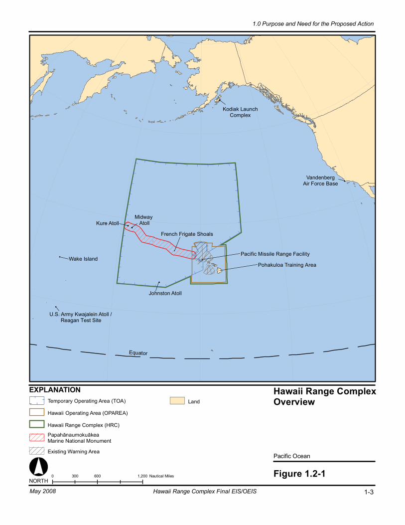
Equator
Hawaii Range ComplexOverview
Pacific Ocean
Figure 1.2-10 600 1,200300 Nautical MilesNORTH
EXPLANATION
Kodiak LaunchComplex
Midway Atoll
Johnston Atoll
French Frigate Shoals
Wake Island
U.S. Army Kwajalein Atoll /Reagan Test Site
Temporary Operating Area (TOA)
Hawaii Operating Area (OPAREA)
Hawaii Range Complex (HRC)
PapahānaumokuākeaMarine National Monument
Existing Warning Area
Land
VandenbergAir Force Base
Pacific Missile Range Facility
1-3Hawaii Range Complex Final EIS/OEIS
1.0 Purpose and Need for the Proposed Action
May 2008
Kure Atoll
Pohakuloa Training Area
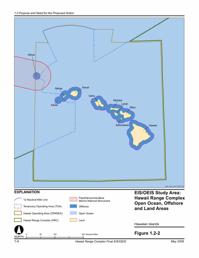
EIS/OEIS Study Area:Hawaii Range ComplexOpen Ocean, Offshoreand Land Areas
Hawaiian Islands
Figure 1.2-2
EXPLANATION
Hawaii
Maui
Oahu
KauaiNiihau
MolokaiLanai
Kahoolawe
Nihoa
Kaula
0 100 20050 Nautical MilesNORTH
12-Nautical Mile LinePapahānaumokuākeaMarine National Monument
Offshore
Open Ocean
LandHawaii Range Complex (HRC)
Temporary Operating Area (TOA)
Hawaii Operating Area (OPAREA)
study_ocean_land_071007.mxd
1-4 Hawaii Range Complex Final EIS/OEIS
1.0 Purpose and Need for the Proposed Action
May 2008
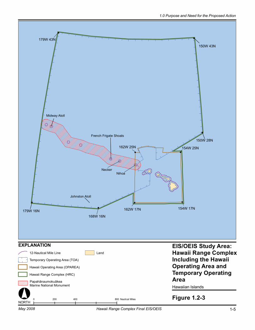
EIS/OEIS Study Area:Hawaii Range ComplexIncluding the HawaiiOperating Area andTemporary OperatingAreaHawaiian Islands
Figure 1.2-30 400 800200 Nautical Miles
EXPLANATION
NORTH
Land
179W 43N
179W 16N
150W 43N
150W 28N
154W 25N162W 25N
154W 17N162W 17N
Midway Atoll
Johnston Atoll
French Frigate Shoals
168W 16N
NeckerNihoa
PapahānaumokuākeaMarine National Monument
Hawaii Range Complex (HRC)
12-Nautical Mile Line
Temporary Operating Area (TOA)
Hawaii Operating Area (OPAREA)
1-5Hawaii Range Complex Final EIS/OEIS
1.0 Purpose and Need for the Proposed Action
May 2008

1.0 Purpose and Need for the Proposed Action
1-6 Hawaii Range Complex Final EIS/OEIS May 2008
For range management and scheduling purposes, the Hawaii OPAREA is divided into numerous sub-component ranges or training areas used to conduct training events and RDT&E of military hardware, personnel, tactics, munitions, explosives, and electronic combat systems, as described in detail in Chapter 2.0.
Because of the vast size of the HRC and Hawaii OPAREA, multiple training and RDT&E activities can occur at the same time, without interfering with each other. For reference purposes Figure 1.2-4 illustrates the size and extent of the Hawaii OPAREA by superimposing the State of California across the major Hawaiian Islands. Individual Fleet training and RDT&E activities can occur up to 200 to 300 nm apart and 100 to 200 nm offshore of any island.
The Hawaii OPAREA provides the geography, infrastructure, space, and location necessary to accomplish complex military training and RDT&E activities. The large size of the Hawaii OPAREA allows training that involves complicated scenarios and large numbers of training participants within a complex geographic setting (i.e., channels between islands, varying bathymetry, etc.). The presence of the underwater instrumented tracking ranges offshore of PMRF as well as DoD-controlled warning areas and special use airspace also enable training to proceed in a safe and structured manner while retaining the flexibility for training controllers to interject tactical challenges that enhance realism for training participants. In the Hawaii OPAREA, forces can engage in training involving events at PMRF on Kauai simultaneously with Anti-Submarine Warfare (ASW) events offshore and in the open ocean. Submarines homeported at Pearl Harbor are available as opposition forces during training events without having to undertake long transits to participate in those events. Maritime patrol aircraft based at Marine Corps Base Hawaii (MCBH) also contribute additional training and assessment capabilities.
1.3 BACKGROUND As its highest priority, the HRC will support the Fleet Response Training Plan (FRTP) readiness processes as revised in 2006 in the Fleet Response Plan (Commander, U.S. Fleet Forces Command, 2006). One of the obligations of the Navy, pursuant to Title 10 of the U.S.C., is to ensure that the men and women, Sailors and officers, sent to sea on behalf of the United States are fully trained and ready for deployment on short notice, as a combat-ready naval force and for other non-combat missions assigned to them. In addition, combat forces must have available to them the changes and improvements that new technologies can provide. These emerging technologies must be researched, developed, tested, and evaluated before being made widely available for use. The Navy meets these training and testing responsibilities across the open oceans and on its range complexes.
For more than a century, Hawaii has been a place where the Navy has trained its Sailors and repaired and replenished the ships of the United States at Pearl Harbor. In the 1920s, a submarine base was established at Pearl Harbor, creating a need for the training of Sailors and officers serving in the undersea environment. As world tensions increased in the 1930s and early 1940s, the Navy rapidly increased its presence and number of facilities in Hawaii. The Pacific Fleet established its headquarters at Pearl Harbor on February 1, 1941. Ten months later, on December 7, 1941, the Fleet was attacked at Pearl Harbor, propelling America into World War II. The Pacific was the site of World War II’s most decisive naval battles. Naval
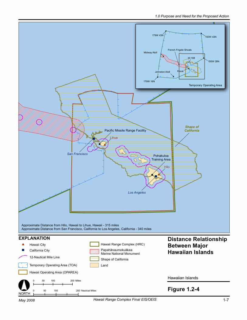
Distance RelationshipBetween MajorHawaiian Islands
Hawaiian Islands
Figure 1.2-4
San Francisco
Shape ofCalifornia
Los Angeles
Pacific Missile Range Facility
PohakuloaTraining Area
Lihue
Hilo
0 100 20050 Nautical Miles
EXPLANATION
NORTH
Land
Approximate Distance from Hilo, Hawaii to Lihue, Hawaii - 315 milesApproximate Distance from San Francisco, California to Los Angeles, California - 340 miles
PapahānaumokuākeaMarine National Monument
179W 43N
179W 16N
150W 43N
150W 28N
Temporary Operating Area
W-188
Midway Atoll
Johnston Atoll
French Frigate Shoals
Kauai
0 100 20050 Miles
12-Nautical Mile Line
Hawaii Range Complex (HRC)
Temporary Operating Area (TOA)
Hawaii Operating Area (OPAREA)
Hawaii City
California City
Shape of California
1-7Hawaii Range Complex Final EIS/OEIS
1.0 Purpose and Need for the Proposed Action
May 2008
1.0 Purpose and Need for the Proposed Action
1-8 Hawaii Range Complex Final EIS/OEIS May 2008
forces in Hawaii remained vital to U.S. interests throughout the mid-century, as control of the seas provided advantages to allied forces during the Korean and Vietnam Wars. Since 1968, a multinational sea-power exercise given the name “Rim of the Pacific” (RIMPAC) has been conducted within the Hawaii OPAREA, testing the abilities of a number of the navies of the Pacific Rim to function together. Participating Pacific Rim nations have included Australia, Japan, Republic of Korea, Indonesia, Malaysia, Singapore, Chile, Peru, and Canada. Today, the Navy’s presence in Hawaii remains of essential strategic and operational importance to U.S. national interests.
Over 20 years ago, acoustic monitoring devices were placed at PMRF on the ocean floor off the west coast of Kauai to detect and track underwater activity. These acoustic systems, known as Barking Sands Tactical Underwater Range (BARSTUR) and Barking Sands Underwater Range Expansion (BSURE), provide a unique evaluative tool that offers specific information in tracking participants’ movements and responses during naval training. PMRF is now the world’s largest military test and training range capable of supporting subsurface, surface, air, and space training events, as well as RDT&E and marine mammal research. It consists of instrumented underwater ranges, controlled airspace, and a TOA covering 2.1 million nm2 of ocean. Since its establishment, PMRF has provided major range services for training, tactics development, and RDT&E of air, surface, and subsurface weapons systems for the Navy, other DoD agencies, allies, and private industry.
Today, more than 20 surface ships and submarines are homeported in Hawaii. Specialty forces, including Navy divers and explosive ordnance disposal technicians, also conduct vital training within the Hawaii OPAREA. The Sailors and officers assigned to these homeported ships and submarines, those awaiting sea duty, and Strike Groups (a naval force comprising one or more capital ships, several combatant ships and one or more attack submarines) transiting through the Pacific, as well as naval forces of foreign allies, must maintain their proficiencies to allow them to be ready and qualified to be deployed when ordered to do so at short notice. The HRC, including the Hawaii OPAREA, provides extensive, remote, and strategic training areas and facilities that enable Navy personnel to maintain and strengthen these required proficiencies.
1.3.1 NAVY’S AT SEA POLICY In December of 2000, the Under Secretary of the Navy issued a memorandum for the Chief of Naval Operations and the Commandant of the Marine Corps entitled “Compliance with Environmental Requirements in the Conduct of Naval Exercises or Training at Sea” that has come to be known as the “At Sea Policy.” The Navy’s At Sea Policy sets forth how the Navy would update and upgrade its compliance with the body of environmental law which applies to these exercises and training—at sea and at the Navy’s range complexes. The policy applies to training at sea, including the conduct of joint (multi-service) and combined (multi-nation) exercises, which are also known as military readiness activities, as that term is defined in Section 315(f) of Public Law 107-314. Training, including joint and combined exercises, does not include combat operations, operations in direct support of combat, or other activities conducted primarily for purposes other than training.
The memorandum directed the Navy’s Fleet commanders to develop an approach to environmental compliance for the Fleet training ranges and training areas within their respective areas of responsibility, including ranges used for RDT&E activities. Major Exercises and
1.0 Purpose and Need for the Proposed Action
May 2008 Hawaii Range Complex Final EIS/OEIS 1-9
training occurring within a range or OPAREA could be included with the compliance effort for the applicable range or OPAREA. The approach would involve a “comprehensive analysis of the environmental impacts of a class of undertakings repetitive in nature or of similar effect and recurring within the same geographical area, so as to avoid or mitigate adverse effects on the extent practicable consistent with the accomplishment of the military training and exercise activities under review.” Fleet commanders were similarly directed to review RDT&E ranges to the extent they are used for Fleet training.
For the HRC, the Commander, U.S. Pacific Fleet is conducting a programmatic geography-based approach to environmental analysis, complying with NEPA and EO 12114, reviewing the present and reasonably foreseeable activities at each range complex. In accordance with the At Sea Policy, this analysis provides a description of existing training and RDT&E activities and reasonably foreseeable alternative levels of activity within the HRC, and an analysis of the environmental consequences of training and RDT&E activities and alternative levels of activity. Included are Major Exercises, routine training, and RDT&E activities conducted within or projected to be conducted within the HRC, as well as planned upgrades to the HRC to ensure its sustainability. This document builds upon the Pacific Missile Range Facility Enhanced Capability Final Environmental Impact Statement prepared and completed in 1998 for the facilities at PMRF and training and RDT&E activities under PMRF’s control.
1.3.2 WHY THE NAVY TRAINS The U.S. military is maintained to ensure the freedom and safety of all Americans both at home and abroad. In order to do so, Title 10 of the U.S.C. requires the Navy to “maintain, train and equip combat-ready naval forces capable of winning wars, deterring aggression and maintaining freedom of the seas.” Modern war and security operations are complex. Modern weaponry has brought both unprecedented opportunity and innumerable challenges to the Navy. Smart weapons, used properly, are very accurate and actually allow the military services to accomplish their missions with greater precision and far less destruction than in past conflicts. But these modern smart weapons are very complex to use. U.S. military personnel must train regularly with them to understand their capabilities, limitations, and operation. Modern military actions require teamwork between hundreds or thousands of people, and their various equipment, vehicles, ships, and aircraft, all working individually and as a coordinated unit to achieve success. These teams must be prepared to conduct activities in multiple warfare areas simultaneously in an integrated and effective manner. Navy training addresses all aspects of the team, from the individual to joint and coalition teamwork. To do this, the Navy employs a building-block approach to training. Training doctrine and procedures are based on operational requirements for deployment of naval forces. Training proceeds on a continuum, from teaching basic and specialized individual military skills, to intermediate skills or small unit training, to advanced, integrated training events, culminating in multi-service (Joint) exercises or pre-deployment certification events.
To provide the experience so important to success and survival, training must be as realistic as possible. The Navy often employs simulators and synthetic training to provide early skill repetition and to enhance teamwork, but live training in a realistic environment is vital to success. Live training is the only vehicle available to ensure naval forces develop and maintain the ability to conduct integrated warfare across a wide spectrum of situations. This requires sufficient sea and airspace to maneuver tactically, realistic targets and objectives, opposition
1.0 Purpose and Need for the Proposed Action
1-10 Hawaii Range Complex Final EIS/OEIS May 2008
that creates a realistic enemy, and instrumentation to objectively monitor the events and learn to correct errors.
Range complexes provide a controlled and safe environment with threat representative targets that enable Navy forces to conduct realistic combat-like training as they undergo all phases of the graduated buildup needed for combat-ready deployment. Navy’s ranges and OPAREAs provide the space necessary to conduct controlled and safe training scenarios representative of those that Navy men and women would have to face in actual combat. The range complexes are designed to provide the most realistic training in the most relevant environments, replicating to the best extent possible the operational stresses of warfare. The integration of undersea ranges and OPAREAs with land training ranges, safety landing fields, and amphibious landing sites are critical to this realism, allowing execution of multi-dimensional exercises in complex scenarios. They also provide instrumentation that captures the performance of Navy tactics and equipment in order to provide the feedback and assessment that is essential for constructive criticism of personnel and equipment. The live-fire training facilitates assessment of the Navy’s ability to place weapons on target with the required level of precision while under a stressful environment. Live training, most of it accomplished in the waters off the United States’ coasts, will remain the cornerstone of readiness as the Navy transforms its military forces for a security environment characterized by uncertainty and surprise.
Navy training activities focus on achieving proficiency in eight functional areas encompassed by Navy operations. These functional areas, known as Primary Mission Areas (PMARs), are: Anti-Air Warfare (AAW), Amphibious Warfare (AMW), Anti-Surface Warfare (ASUW), ASW, Mine Warfare (MIW), Strike Warfare (STW), Electronic Combat (EC), and Naval Special Warfare (NSW). Each training event addressed in the EIS/OEIS is categorized under one of the PMARs.
The HRC is used for training of operational forces, RDT&E of military equipment, and other military activities. As with each Navy range complex, the primary mission of the HRC is to provide a realistic training environment for naval forces to ensure that they have the capabilities and high state of readiness required to accomplish assigned missions.
Training is focused on preparing for worldwide deployment. Naval forces generally deploy in specially organized units called Strike Groups. A Strike Group may be organized around one or more aircraft carriers, together with several surface combatant ships and submarines, collectively known as a Carrier Strike Group (CSG). A naval force known as a Surface Strike Group (SSG) consists of three or more surface combatant ships. A Strike Group may also be organized around a Marine Expeditionary Unit (MEU)1 embarked on amphibious ships accompanied by surface combatant ships and submarines, known as an Expeditionary Strike Group (ESG). The Navy and Marine Corps deploy CSGs, SSGs, and ESGs on a continuous basis. The number and composition of Strike Groups deployed, and the schedule for deployment, are determined based on the worldwide requirements and commitments.
Pre-deployment training is governed by the Navy’s FRTP. The FRTP sets a deployment cycle for the Strike Groups that includes three phases: (1) basic, intermediate, and advanced pre-
1 The MEU is a battalion-sized (1,500 Marines) Marine Air Ground Task Force or MAGTF. MAGTFs consist of ground combat, aviation combat, combat logistics, and command and control elements, and vary in size depending on the nature of the intended mission.

1.0 Purpose and Need for the Proposed Action
May 2008 Hawaii Range Complex Final EIS/OEIS 1-11
deployment training and certification, (2) deployment, and (3) post-deployment sustainment, training, and maintenance. While several Strike Groups are always deployed to provide a global naval presence, Strike Groups must also be ready to “surge” on short notice in response to directives from the National Command Authority. One objective of the FRTP is to provide this surge capability. The FRTP calls for the ability to train and deploy six CSGs in a very short period, and two more in stages soon thereafter. Established in 2003, the FRTP calls for changes in the Fleet training cycle, including acceleration of the cycle and near-simultaneous execution of similar training events. Deployment schedules are not fixed, but must remain flexible and responsive to the Nation’s security needs. The capability and capacity of ranges such as the HRC to support the entire training continuum must be available as needed.
The deployment of naval forces, including those that train in the HRC, is determined by the combatant commanders (a senior military commander with a large, geographically demarked area of responsibility) based on worldwide requirements and commitments. In order to meet these requirements, naval forces are geographically apportioned. The dynamic requirements of national security affect the deployment of naval forces. As a result, deployment schedules are not fixed, but remain flexible, often changing to meet the Nation’s security needs. Real world contingencies drive the training schedule in relation to when and where the naval forces are required. The support necessary to conduct required pre-deployment training, particularly training range support, must therefore be available as needed.
Specific to ASW, continued training and use of active sonar systems is vital. Modern diesel-electric submarines are designed to suppress emitted noise levels specifically to counter and defeat passive sonar technology. Passive sonar involves listening for any sounds inadvertently emitted by a potentially hostile submarine, which are then used to detect, localize and track it. As a result, modern diesel-electric submarines have been designed to be quieter through the use of improved technology and to “hide” in the naturally occurring noise levels of the shallow waters of coastal environments. The result is that a modern diesel-electric submarine operating on battery power is nearly undetectable to naval forces using only passive sonar. Accordingly, sonar, initially developed during World War I, has been improved and deployed on U.S. naval vessels since the mid-1920s. Although the Navy continues evaluating technologies to locate and track submarines, active sonar remains the most viable means of locating and tracking submarines.
1.3.3 TACTICAL TRAINING THEATER ASSESSMENT AND PLANNING PROGRAM
The Tactical Training Theater Assessment and Planning (TAP) Program serves as the Navy’s range sustainment program. The purpose of TAP is to support Navy objectives that: (1) promote use and management of ranges (such as the HRC) in a manner that supports national security objectives and a high state of combat readiness, and (2) ensures the long-term viability of range assets while protecting human health and the environment. The TAP Program focuses specifically on the sustainability of ranges, OPAREAs, and airspace areas that support the FRTP.
The Navy’s Required Capabilities Document (RCD) is a product of the TAP Program. The purpose of the RCD is to quantitatively define the required range capabilities that would allow Navy ranges to support mission-essential training. The RCD provides guidelines for range
1.0 Purpose and Need for the Proposed Action
1-12 Hawaii Range Complex Final EIS/OEIS May 2008
requirements, but is not range-specific. The Navy, therefore, has developed an analysis of its requirements for each range complex (U.S. Department of Defense, 2006). These analyses:
• Provide comprehensive descriptions of ranges, OPAREAs and training areas within a given range complex;
• Assess training activities currently conducted within the range complex;
• Identify investment needs and strategy for maintenance, range improvement and modernization;
• Develop a strategic vision for range operations with a long-term planning horizon;
• Provide range complex sustainable management principles and practices, to include environmental stewardship and community outreach; and
• Identify encroachments on ranges, and evaluate the potential impacts of encroachments on training and RDT&E.
Also of note is that the Base Realignment and Closure Commission 2005 process, leading to the decisions of the Congress and the President, examined availability of ranges to support closure recommendations. HRC is specifically retained as a needed range.
1.3.4 MISSION OF THE HAWAII RANGE COMPLEX The strategic mission of the HRC is to support naval operational readiness by providing a realistic, live training environment for forces assigned to the Pacific Fleet, the Fleet Marine Force, and other users. As its highest priority, the HRC will support the FRTP readiness processes as revised in 2006 in the Fleet Response Plan (Commander, U.S. Fleet Forces Command, 2006) and Commander, Fleet Forces Command (CFFC) Instruction 3501.3, Fleet Training Strategy. The strategic mission implements the strategic vision and includes management objectives and the HRC concept of training events.
The Commander, U.S. Pacific Fleet and CFFC strategic vision for this complex is for it to remain the principal Navy training venue in the middle Pacific with the capability and capacity to support current, emerging, and future training requirements. The capabilities of the HRC must be sustained, upgraded, modernized, and transformed as new weapons systems achieve initial operational capability, new threat capabilities emerge, and new technologies offer improved training opportunities. More specifically, the range complex must be capable of providing:
• Advanced-level training of Strike Groups pursuant to the FRTP, including realistic opposing force and electronic threat replication to support training of integrated and joint forces
• Joint training events as a compatible and interoperable component of the emerging Joint National Training Capability (JNTC)
• Intermediate-level and basic-level training of Navy forces across all primary mission areas pursuant to the requirements of the FRTP
1.0 Purpose and Need for the Proposed Action
May 2008 Hawaii Range Complex Final EIS/OEIS 1-13
• Sustainment training as a “backyard” range2 for surface ships, submarines, aviation squadrons, special warfare, and explosive ordnance disposal units based in Hawaii, and specialized support for units based elsewhere on the West Coast and in the western Pacific
• Sophisticated instrumented range facilities for ASW and MIW training for ships, aircraft, and submarines
• Alignment of the HRC infrastructure with Naval Force structure, including accommodating new weapons, systems, and platforms (vessels and aircraft) as they are introduced into the Fleet
• Sustainable range management and planning that provides for consolidated range communications and scheduling; institutionalizes standardized data management practices; and protects and conserves range resources for current and future training requirements
• Support for allies’ military training and RDT&E activities.
1.3.5 STRATEGIC IMPORTANCE OF THE EXISTING HAWAII RANGE COMPLEX
The existing HRC is the only range complex in the mid-Pacific Region and is used for training and assessment of operational forces, missile training, RDT&E of military systems and equipment, and other military activities. The HRC is characterized by a unique combination of attributes that make it a strategically important range complex for the Navy. These attributes include:
Proximity to the Homeport of Pearl Harbor. The Hawaii OPAREA surrounds the major homeport of Pearl Harbor where a large number of ships and submarines are based. Hawaii is also the home for Navy aircraft from five operational squadrons and encompasses seven major Navy commands. Training and assessment events, such as the Undersea Warfare Exercise (USWEX), occur in the Hawaii OPAREA, before the deployed forces report to Commander, U.S. SEVENTH Fleet in the Western Pacific and/or Commander, U.S. FIFTH Fleet in the Middle East. The USWEX simulates a real-world submarine threat and gives an ESG or CSG the opportunity to conduct realistic ASW training. It also provides the U.S. Pacific Fleet an opportunity to assess the Navy’s ASW capabilities using a fully certified Strike Group.
Proximity to the Western Pacific. Hawaii serves as an ideal en route training location for units deploying to the western Pacific Ocean or Middle East from the U.S. west coast. Maritime Patrol aircraft are located at Marine Corps Base, Hawaii (MCBH), and submarines are based at Pearl Harbor. Both play an important role in ASW training. The co-location of these assets assists in conducting ASW training in Hawaii in support of naval forces that are being deployed to the Western Pacific and Middle East. Much of this training is managed by Commander, U.S. Pacific Fleet’s ASW experts who are located in Pearl Harbor.
Proximity to Military Families. Hawaii is home to thousands of military families. The Navy and Marine Corps strive, and in many cases are required by law, to track and where possible limit
2A “backyard range” is a range facility located in close proximity to homeports and stations, and it is a critical component of naval readiness.
1.0 Purpose and Need for the Proposed Action
1-14 Hawaii Range Complex Final EIS/OEIS May 2008
“personnel tempo,” meaning the amount of time Sailors and Marines spend deployed away from home. Personnel tempo is an important factor in family readiness, morale, and retention. The availability of the HRC as a “backyard” training range is critical to Navy efforts in these areas.
Training Terrain. Since most west coast based naval forces have been training in the continental United States for a period as long as 18 months prior to deployment, the Hawaii area provides an opportunity to work in an unfamiliar environment, and to make real-time adjustments just as Sailors and Marines will have to do when they reach the SEVENTH or FIFTH Fleet areas of responsibility.
The large training area available to deploy forces within the HRC allows training to take place on a geographic scale that replicates possible real world events, with the channels between islands serving as strategic choke-points to ocean commerce. The presence of the instrumented tracking ranges at PMRF as well as DoD-controlled warning areas and special use airspace also enable training to proceed in a safe and structured manner while retaining the flexibility for controllers to interject tactical challenges to enhance realism for training participants. Exercise participants at sea can conduct air strike sorties to Pohakuloa Training Area, and an ESG can conduct amphibious landings on DoD beaches, both while simultaneously conducting ASW. Finally, the presence of submarines homeported at Pearl Harbor provides access to these submarines, which can then serve as an opposition force during USWEX without having to transit to participate in the exercise training events. Sites outside of Hawaii do not provide a reasonable alternative for satisfying the Navy’s required training purposes or its obligations under the Quadrennial Defense Review (QDR) to increase its presence in the Pacific.
The QDR sets forth a specific series of recommendations for implementing the goals and objectives of national defense and security strategies. The 2001 QDR noted that the Pacific and Asian regions have become increasingly important to regional and U.S. security in recent years. In response, the DoD’s new planning construct calls for maintaining regionally tailored forces, forward stationed and deployed in the Pacific and Asian theaters. It requires enhancing the future capability of forward deployed and stationed forces, coupled with global intelligence, strike, and information assets, in order to deter aggression or coercion with only modest reinforcement from outside the theater. The 2006 QDR continued to emphasize the need for the Navy to provide more flexible and sustainable locations from which to operate globally. Pursuant to the QDR, the naval fleet must have greater presence in the Pacific Ocean, consistent with the global shift of trade and transport. Accordingly, the Navy plans to adjust its force posture and basing to provide at least six operationally available and sustainable carriers and 60 percent of its submarines in the Pacific to support engagement, presence and deterrence. The HRC provides the geography, infrastructure, space, and location necessary to accomplish these 2001 and 2006 QDR requirements.
1.4 PURPOSE AND NEED FOR THE PROPOSED ACTION
Given the strategic importance of the HRC to the readiness of naval forces and the unique training environment provided by the HRC, the Navy proposes to take actions for the purposes of:
1.0 Purpose and Need for the Proposed Action
May 2008 Hawaii Range Complex Final EIS/OEIS 1-15
• Achieving and maintaining Fleet readiness using the HRC to support and conduct current, emerging, future training, assessment events3, and RDT&E activities;
• Conducting missions supported by the HRC, consistent with the requirements of the FRTP, and;
• Upgrading/modernizing existing range capabilities to enhance and ensure the sustainability of Navy and other DoD training and testing.
The Proposed Action is needed to provide a training environment consisting of ranges, training areas, and range instrumentation with the capacity and capabilities to fully support required training tasks for operational units and military schools. To accomplish this purpose and need and execute its Title 10 responsibilities, the Navy must:
• Maintain current levels of military readiness by training in the HRC;
• Accommodate future increases in training tempo in the HRC and support the rapid deployment of naval units and/or Strike Groups;
• Achieve and sustain readiness of ships and squadrons consistent with the FRTP so that the Navy can rapidly increase significant combat power in the event of a crisis or contingency operation;
• Support the acquisition and implementation into the Fleet of advanced military technology. The HRC must adequately support the testing and training needed for new platforms and weapons systems (e.g., the Littoral Combat Ship and the MH-60R Seahawk helicopter); and,
• Maintain the long-term viability of the HRC while protecting human health and the environment (including the implementation of marine mammal mitigation measures), and enhancing the quality and communication capability and safety of the range complex.
Conduct of current and emerging training and RDT&E training events, and implementation of range capabilities enhancements, includes a collection of actions which will be evaluated in this EIS/OEIS.
1.5 THE ENVIRONMENTAL REVIEW PROCESS
1.5.1 SCOPE AND CONTENT OF THE EIS/OEIS The scope (Study Area) for this EIS/OEIS is the HRC (Figure 1.2-3), which includes the open ocean, offshore, and onshore areas. This EIS/OEIS will address current and proposed activities associated with the following three categories: (1) Navy units (ships, submarines, aircraft, personnel) conducting unit-level activities on any military’s range within the HRC; (2) any U.S. or foreign military unit conducting activities on Navy-operated ranges; and, (3) any U.S. or foreign
3 An assessment event is an assessment of a program to determine if systems and tactics are capable of addressing an estimated threat.
1.0 Purpose and Need for the Proposed Action
1-16 Hawaii Range Complex Final EIS/OEIS May 2008
military unit conducting activities on any military’s range in Hawaii as part of a Navy-sponsored exercise.
To assist the reader, Sections 3.1 and 4.1 of Chapters 3.0 and 4.0 present the affected open ocean environment and associated impact analysis relative to EO 12114. The remaining sections of Chapters 3.0 and 4.0 present the affected environment and impact analysis relative to NEPA for offshore and onshore areas. Chapters 3.0 and 4.0 are further arranged according to islands from west to east: Northwestern Hawaiian Islands, Kauai, Oahu, Maui, and Hawaii. For organizational purposes in this document, discussions about Niihau and Kaula are included under the Kauai heading, because although they are separate islands, they are part of Kauai County. In addition, discussions about Molokai are included under the Maui heading, because although it is a separate island, it is part of Maui County.
1.5.2 COOPERATING AGENCIES The following Federal agencies are cooperating agencies in the preparation of this EIS/OEIS:
• U.S. Department of Energy
• Missile Defense Agency
• U.S. Army
• National Marine Fisheries Service
1.5.3 NATIONAL ENVIRONMENTAL POLICY ACT In 1969, Congress enacted NEPA, which provides for the consideration of environmental issues in Federal agency planning and decision-making. Regulations for Federal agency implementation of the act were established by the President’s CEQ. NEPA requires that Federal agencies prepare an EIS if an Environmental Assessment (EA) determines a proposed action might significantly affect the quality of the human environment. The EIS must disclose significant environmental impacts and inform decision makers and the public of the reasonable alternatives to the Proposed Action. Presidential Proclamation 5928, issued December 27, 1988, extended the exercise of United States sovereignty and jurisdiction under international law to 12 nm; however, the Proclamation expressly provides that it does not extend or otherwise alter existing Federal law or any associated jurisdiction, rights, legal interests, or obligations. As a result, the Navy analyzes environmental effects and actions within 12 nm under NEPA and those effects occurring beyond 12 nm under the provisions of EO 12114.
This EIS/OEIS provides an assessment of the potential environmental impacts associated with sustainable range usage and enhancements within the Navy’s HRC. The Navy completed the Supplement to the 2002 Rim of the Pacific (RIMPAC) Programmatic Environmental Assessment in May 2006 and the Undersea Warfare Exercise (USWEX) Programmatic Environmental Assessment in January 2007. This EIS/OEIS analyzes the continuation of these exercises in the baseline analysis. It also analyzes Navy training that currently occurs or is proposed to occur in open ocean, offshore, and onshore areas of the HRC.
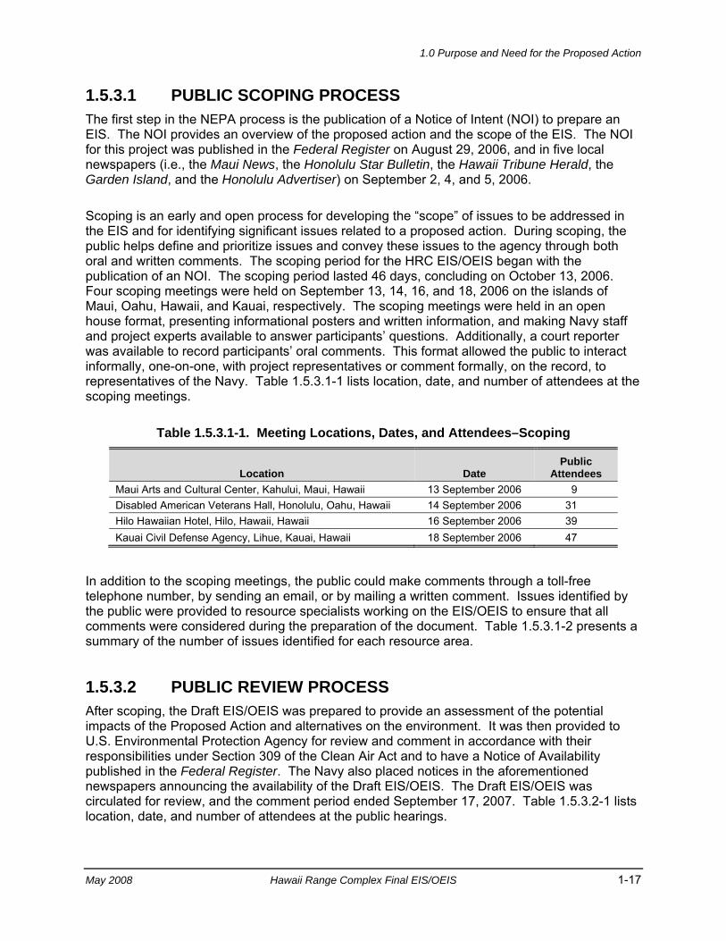
1.0 Purpose and Need for the Proposed Action
May 2008 Hawaii Range Complex Final EIS/OEIS 1-17
1.5.3.1 PUBLIC SCOPING PROCESS The first step in the NEPA process is the publication of a Notice of Intent (NOI) to prepare an EIS. The NOI provides an overview of the proposed action and the scope of the EIS. The NOI for this project was published in the Federal Register on August 29, 2006, and in five local newspapers (i.e., the Maui News, the Honolulu Star Bulletin, the Hawaii Tribune Herald, the Garden Island, and the Honolulu Advertiser) on September 2, 4, and 5, 2006.
Scoping is an early and open process for developing the “scope” of issues to be addressed in the EIS and for identifying significant issues related to a proposed action. During scoping, the public helps define and prioritize issues and convey these issues to the agency through both oral and written comments. The scoping period for the HRC EIS/OEIS began with the publication of an NOI. The scoping period lasted 46 days, concluding on October 13, 2006. Four scoping meetings were held on September 13, 14, 16, and 18, 2006 on the islands of Maui, Oahu, Hawaii, and Kauai, respectively. The scoping meetings were held in an open house format, presenting informational posters and written information, and making Navy staff and project experts available to answer participants’ questions. Additionally, a court reporter was available to record participants’ oral comments. This format allowed the public to interact informally, one-on-one, with project representatives or comment formally, on the record, to representatives of the Navy. Table 1.5.3.1-1 lists location, date, and number of attendees at the scoping meetings.
Table 1.5.3.1-1. Meeting Locations, Dates, and Attendees–Scoping
Location Date Public
Attendees Maui Arts and Cultural Center, Kahului, Maui, Hawaii 13 September 2006 9 Disabled American Veterans Hall, Honolulu, Oahu, Hawaii 14 September 2006 31 Hilo Hawaiian Hotel, Hilo, Hawaii, Hawaii 16 September 2006 39 Kauai Civil Defense Agency, Lihue, Kauai, Hawaii 18 September 2006 47
In addition to the scoping meetings, the public could make comments through a toll-free telephone number, by sending an email, or by mailing a written comment. Issues identified by the public were provided to resource specialists working on the EIS/OEIS to ensure that all comments were considered during the preparation of the document. Table 1.5.3.1-2 presents a summary of the number of issues identified for each resource area.
1.5.3.2 PUBLIC REVIEW PROCESS After scoping, the Draft EIS/OEIS was prepared to provide an assessment of the potential impacts of the Proposed Action and alternatives on the environment. It was then provided to U.S. Environmental Protection Agency for review and comment in accordance with their responsibilities under Section 309 of the Clean Air Act and to have a Notice of Availability published in the Federal Register. The Navy also placed notices in the aforementioned newspapers announcing the availability of the Draft EIS/OEIS. The Draft EIS/OEIS was circulated for review, and the comment period ended September 17, 2007. Table 1.5.3.2-1 lists location, date, and number of attendees at the public hearings.
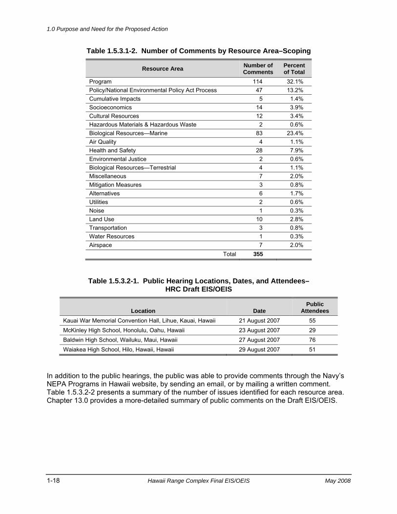
1.0 Purpose and Need for the Proposed Action
1-18 Hawaii Range Complex Final EIS/OEIS May 2008
Table 1.5.3.1-2. Number of Comments by Resource Area–Scoping
Resource Area Number of Comments
Percent of Total
Program 114 32.1% Policy/National Environmental Policy Act Process 47 13.2% Cumulative Impacts 5 1.4% Socioeconomics 14 3.9% Cultural Resources 12 3.4% Hazardous Materials & Hazardous Waste 2 0.6% Biological Resources—Marine 83 23.4% Air Quality 4 1.1% Health and Safety 28 7.9% Environmental Justice 2 0.6% Biological Resources—Terrestrial 4 1.1% Miscellaneous 7 2.0% Mitigation Measures 3 0.8% Alternatives 6 1.7% Utilities 2 0.6% Noise 1 0.3% Land Use 10 2.8% Transportation 3 0.8% Water Resources 1 0.3% Airspace 7 2.0%
Total 355
Table 1.5.3.2-1. Public Hearing Locations, Dates, and Attendees– HRC Draft EIS/OEIS
Location Date Public
Attendees Kauai War Memorial Convention Hall, Lihue, Kauai, Hawaii 21 August 2007 55 McKinley High School, Honolulu, Oahu, Hawaii 23 August 2007 29 Baldwin High School, Wailuku, Maui, Hawaii 27 August 2007 76 Waiakea High School, Hilo, Hawaii, Hawaii 29 August 2007 51
In addition to the public hearings, the public was able to provide comments through the Navy’s NEPA Programs in Hawaii website, by sending an email, or by mailing a written comment. Table 1.5.3.2-2 presents a summary of the number of issues identified for each resource area. Chapter 13.0 provides a more-detailed summary of public comments on the Draft EIS/OEIS.
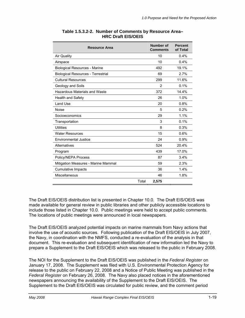
1.0 Purpose and Need for the Proposed Action
May 2008 Hawaii Range Complex Final EIS/OEIS 1-19
Table 1.5.3.2-2. Number of Comments by Resource Area– HRC Draft EIS/OEIS
Resource Area Number of Comments
Percent of Total
Air Quality 10 0.4% Airspace 10 0.4% Biological Resources - Marine 492 19.1% Biological Resources - Terrestrial 69 2.7% Cultural Resources 299 11.6% Geology and Soils 2 0.1% Hazardous Materials and Waste 372 14.4% Health and Safety 26 1.0% Land Use 20 0.8% Noise 5 0.2% Socioeconomics 29 1.1% Transportation 3 0.1% Utilities 8 0.3% Water Resources 15 0.6% Environmental Justice 24 0.9% Alternatives 524 20.4% Program 439 17.0% Policy/NEPA Process 87 3.4% Mitigation Measures - Marine Mammal 59 2.3% Cumulative Impacts 36 1.4% Miscellaneous 46 1.8%
Total 2,575
The Draft EIS/OEIS distribution list is presented in Chapter 10.0. The Draft EIS/OEIS was made available for general review in public libraries and other publicly accessible locations to include those listed in Chapter 10.0. Public meetings were held to accept public comments. The locations of public meetings were announced in local newspapers.
The Draft EIS/OEIS analyzed potential impacts on marine mammals from Navy actions that involve the use of acoustic sources. Following publication of the Draft EIS/OEIS in July 2007, the Navy, in coordination with the NMFS, conducted a re-evaluation of the analysis in that document. This re-evaluation and subsequent identification of new information led the Navy to prepare a Supplement to the Draft EIS/OEIS which was released to the public in February 2008.
The NOI for the Supplement to the Draft EIS/OEIS was published in the Federal Register on January 17, 2008. The Supplement was filed with U.S. Environmental Protection Agency for release to the public on February 22, 2008 and a Notice of Public Meeting was published in the Federal Register on February 26, 2008. The Navy also placed notices in the aforementioned newspapers announcing the availability of the Supplement to the Draft EIS/OEIS. The Supplement to the Draft EIS/OEIS was circulated for public review, and the comment period
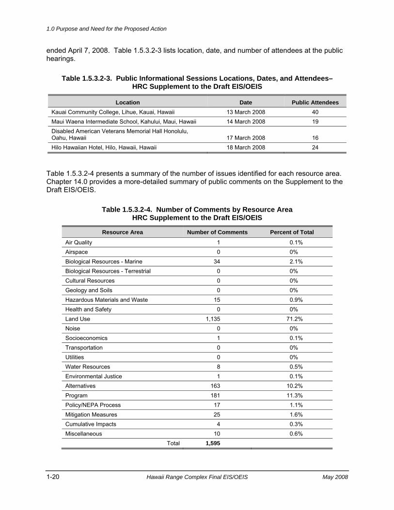
1.0 Purpose and Need for the Proposed Action
1-20 Hawaii Range Complex Final EIS/OEIS May 2008
ended April 7, 2008. Table 1.5.3.2-3 lists location, date, and number of attendees at the public hearings.
Table 1.5.3.2-3. Public Informational Sessions Locations, Dates, and Attendees– HRC Supplement to the Draft EIS/OEIS
Location Date Public Attendees Kauai Community College, Lihue, Kauai, Hawaii 13 March 2008 40 Maui Waena Intermediate School, Kahului, Maui, Hawaii 14 March 2008 19 Disabled American Veterans Memorial Hall Honolulu, Oahu, Hawaii 17 March 2008 16 Hilo Hawaiian Hotel, Hilo, Hawaii, Hawaii 18 March 2008 24
Table 1.5.3.2-4 presents a summary of the number of issues identified for each resource area. Chapter 14.0 provides a more-detailed summary of public comments on the Supplement to the Draft EIS/OEIS.
Table 1.5.3.2-4. Number of Comments by Resource Area HRC Supplement to the Draft EIS/OEIS
Resource Area Number of Comments Percent of Total
Air Quality 1 0.1% Airspace 0 0% Biological Resources - Marine 34 2.1% Biological Resources - Terrestrial 0 0% Cultural Resources 0 0% Geology and Soils 0 0% Hazardous Materials and Waste 15 0.9% Health and Safety 0 0% Land Use 1,135 71.2% Noise 0 0% Socioeconomics 1 0.1% Transportation 0 0% Utilities 0 0% Water Resources 8 0.5% Environmental Justice 1 0.1% Alternatives 163 10.2% Program 181 11.3% Policy/NEPA Process 17 1.1% Mitigation Measures 25 1.6% Cumulative Impacts 4 0.3% Miscellaneous 10 0.6%
Total 1,595
1.0 Purpose and Need for the Proposed Action
May 2008 Hawaii Range Complex Final EIS/OEIS 1-21
There is a 30-day wait period following the publication of the NOA of the Final EIS/OEIS in the Federal Register. At the conclusion of this wait period, the Navy will make its Record of Decision (ROD), which will be published in the Federal Register. The ROD will summarize the final decision and identify the selected alternative, describe the public involvement and agency decision-making processes, and present commitments to specific mitigation measures. The selected alternative can then be implemented. The ROD will be published in the Federal Register.
1.5.4 EXECUTIVE ORDER 12114 EO 12114, Environmental Effects Abroad of Major Federal Actions, directs Federal agencies to provide for informed decision-making for major Federal actions outside the United States, including the global commons, the environment of a non-participating foreign nation, or impacts on protected global resources. An OEIS is required when an action has the potential to significantly harm the environment of the global commons. Global commons are defined as “geographical areas that are outside of the jurisdiction of any nation, and include the oceans outside territorial limits (outside 12 nm from the coast) and Antarctica. Global commons do not include contiguous zones and fisheries zones of foreign nations.” (32 CFR Part 187.3)
Effects on areas within the HRC that lie outside 12 nm (shown as Open Ocean on Figure 1.2-2) are analyzed using the procedures set out in EO 12114 and associated implementing regulations.
1.5.5 MARINE MAMMAL PROTECTION ACT COMPLIANCE The Marine Mammal Protection Act (MMPA) established, with limited exceptions, a moratorium on the “taking” of marine mammals in waters or on lands under U.S. jurisdiction (MMPA, 1972). The Act further regulates “takes” of marine mammals on the high seas by vessels or persons under U.S. jurisdiction. The term “take,” as defined in Section 3 of the MMPA (16 U.S.C. 1362), means “to harass, hunt, capture, or kill, or attempt to harass, hunt, capture, or kill any marine mammal.” “Harassment” was further defined in the 1994 and 2004 amendments to the MMPA. The 1994 amendments provided two levels of harassment, Level A (potential injury) and Level B (potential disturbance).
As applied to military readiness activities, the National Defense Authorization Act for Fiscal Year 2004 (FY04 NDAA) (Public Law [PL] 108-136) amended the MMPA to (1) clarify the applicable definition of harassment; (2) exempt such activities from the “specified geographical region” and “small numbers” requirements of Section 101(1)(5)(A) of the Act; (3) require consideration of personnel safety, practicality of implementation, and impact on effectiveness of military readiness activities by NMFS in making its determination regarding least practicable adverse impact; and (4) establish a national defense exemption. PL 107-314, Section 315(f), defines “military readiness activities” to include “all training and operations of the Armed Forces that relate to combat; and the adequate and realistic testing of military equipment, vehicles, weapons and sensors for proper operation and suitability for combat use.” The testing and training with active sonar constitutes a military readiness activity under this definition.
1.0 Purpose and Need for the Proposed Action
1-22 Hawaii Range Complex Final EIS/OEIS May 2008
The definition of “harassment” as applied to military readiness activities is any act that:
• Injures or has the significant potential to injure a marine mammal or marine mammal stock in the wild (“Level A harassment”), or
• Disturbs or is likely to disturb a marine mammal or marine mammal stock in the wild by causing disruption of natural behavioral patterns including, but not limited to, migration, surfacing, nursing, breeding, feeding, or sheltering to a point where such behavioral patterns are abandoned or significantly altered (“Level B harassment”) (16 U.S.C. 1362 [18][B][i],[ii]).
Section 101(a)(5) of the MMPA directs the Secretary of Commerce to allow, upon request, the incidental, but not intentional, taking of marine mammals by U.S. citizens who engage in a specified activity (exclusive of commercial fishing). These incidental takes are allowed only if NMFS issues regulations governing the permissible methods of taking. In order to issue regulations, NMFS must make a determination that (1) the taking will have a negligible impact on the species or stock, and (2) the taking will not have an unmitigable adverse impact on the availability of such species or stock for taking for subsistence uses.
In addition, the MMPA requires NMFS to develop regulations governing the issuance of a LOA and to publish these regulations in the Federal Register. Specifically, the regulations for each allowed activity establish:
• Permissible methods of taking, and other means of affecting the least practicable adverse impact on such species or stock and its habitat, and on the availability of such species or stock for subsistence (as clarified above).
• Requirements for monitoring and reporting of such taking. For military readiness activities (as described in the NDAA), a determination of “least practicable adverse impacts” on a species or stock includes consideration, in consultation with the DoD, of personnel safety, practicality of implementation, and impact on the effectiveness of the military readiness activity.
In support of the Proposed Action, the Navy applied for an authorization pursuant to Section 101(a) (5) (A) of the MMPA. After the application was reviewed by NMFS, a Notice of Receipt of Application was published in the Federal Register. Publication of the Notice of Receipt of Application initiated the 30-day public comment period, during which time anyone could obtain a copy of the application by contacting NMFS. NMFS intends to publish a proposed rule for public comment coincident with the publication of this EIS/OEIS. The public will be afforded 30 days to comment on this proposed rulemaking. NMFS will consider and address all comment received during the public comment period, and anticipates issuing the final rule, if appropriate, toward the end of Calendar Year (CY) 2008.
On January 23, 2007, the Deputy Secretary of Defense exempted all military readiness activities employing MFA sonar or Improved Extended Echo Ranging (IEER) sonobuoys from compliance with the requirements of the MMPA for a period of 2 years. This exemption is limited to Major Exercises or training and RDT&E activities within established operating areas or established DoD maritime ranges. This National Defense Exemption (NDE) remains in effect until January 23, 2009 or authorization under the MMPA, whichever is earliest.
1.0 Purpose and Need for the Proposed Action
May 2008 Hawaii Range Complex Final EIS/OEIS 1-23
The NDE will cover MFA sonar and IEER sonobuoy activities on the HRC until an MMPA authorization is issued for these activities or the NDE expires whichever is earliest. While the NDE remains applicable (until an MMPA authorization is issued), the Navy will continue to employ the marine mammal mitigation measures outlined in Chapter 6.0 of this EIS/OEIS to protect marine mammals while training with the use of MFA sonar. These measures include safety zones around ships and trained lookouts based on coordination of science-based measures with NMFS. Additional measures that may be required as a result of the MMPA authorization would be implemented once authorization is received.
1.5.6 ENDANGERED SPECIES ACT COMPLIANCE The Endangered Species Act (ESA) (16 U.S.C. 1531 to 1543) applies to federal actions in two separate respects. First, the ESA requires that federal agencies, in consultation with the responsible wildlife agency (e.g., NMFS), ensure that proposed actions are not likely to jeopardize the continued existence of any endangered species or threatened species, or result in the destruction or adverse modification of a critical habitat (16 U.S.C. 1536 [a][2]). Regulations implementing the ESA consultation requirement also include those actions that “may affect” a listed species or adversely modify critical habitat.
If an agency’s Proposed Action would take a listed species, the agency must obtain an incidental take statement from the responsible wildlife agency. The ESA defines the term “take” to mean “harass, harm, pursue, hunt, shoot, wound, kill, trap, capture, or collect, or attempt any such conduct” (16 U.S.C. 1532[19]).
As part of the environmental documentation for this EIS/OEIS, and as an MMPA permit applicant, the Navy entered into early consultation procedures with NMFS, endangered species division. The Navy has been actively engaged in consultation with NMFS regarding the potential effects on ESA-listed species from the conduct of the activities outlined in this EIS/OEIS. In accordance with 50 CFR §402.11, prior to the issuance of the ROD, NMFS will issue a Preliminary Biological Opinion documenting its determination as to whether the activities conducted in the HRC are likely to jeopardize the continued existence of ESA-listed species, or result in the destruction or adverse modification of critical habitat. Additionally, a preliminary Incidental Take Statement will accompany the preliminary Biological Opinion. Because the Section 7 consultation is simultaneously conducted internally to address NMFS” issuance of an MMPA authorization, an Incidental Take Statement for marine mammals cannot be issued until an MMPA authorization is issued.
The Preliminary Biological Opinion and Preliminary Incidental Take Statement do not exempt the Navy from the prohibitions of Section 9 of the Endangered Species Act. Further, the Navy has determined that activities occurring in the HRC prior to the issuance of an MMPA authorization (e.g., RIMPAC, USWEX, etc.) may affect endangered species in the HRC, and may incidentally take ESA-listed species, thus requiring consultation under the ESA and an associated Incidental Take Statement. As such, the Navy and NMFS are engaged in a separate Section 7 consultation on these specified activities. A separate Biological Opinion and Incidental Take Statement will be issued, as appropriate, for this subset of specified activities, which will occur prior to the issuance of the MMPA authorization and be covered by the NDE.

1.0 Purpose and Need for the Proposed Action
1-24 Hawaii Range Complex Final EIS/OEIS May 2008
1.5.7 OTHER ENVIRONMENTAL REQUIREMENTS CONSIDERED
The Navy must comply with a variety of other Federal environmental laws, regulations, and EOs. These include (among other applicable laws and regulations):
• Migratory Bird Treaty Act;
• Coastal Zone Management Act;
• Rivers and Harbors Act;
• Magnuson-Stevens Fishery Conservation and Management Act;
• Clean Air Act;
• Federal Water Pollution Control Act (Clean Water Act);
• National Historic Preservation Act;
• EO 12898, Federal Actions to Address Environmental Justice in Minority Populations and Low-Income Populations;
• EO 13045, Environmental Health and Safety Risks to Children;
• EO 13423, Strengthening Federal Environmental, Energy and Transportation Management;
• EO 13089, Coral Reef Protection; and
• National Marine Sanctuaries Act.
In addition, laws and regulations of the State of Hawaii appropriate to Navy actions are identified and addressed in this EIS/OEIS. To the extent practicable, this document will be used as the basis for any required consultation and coordination. Appendix C includes a brief description of the laws, regulations, and EOs that apply to events and activities in the HRC.
1.6 RELATED ENVIRONMENTAL DOCUMENTS Environmental documents for some of the programs, projects, and installations within the geographical scope of this EIS/OEIS that have undergone environmental review to ensure NEPA and EO 12114 compliance include:
• Barking Sands Underwater Range Expansion (BSURE) Refurbishment Overseas Environmental Assessment, March 2008
• Flexible Target Family Environmental Assessment, December 2007
• Undersea Warfare Exercise (USWEX) Programmatic Environmental Assessment, October 2007
• Overseas Environmental Assessment for Valiant Shield, July 2007
1.0 Purpose and Need for the Proposed Action
May 2008 Hawaii Range Complex Final EIS/OEIS 1-25
• Construction of a Mock Airfield on Pohakuloa Training Area, Hawaii Environmental Assessment, July 2007
• Permanent Stationing of the 2/25th Stryker Brigade Combat Team Draft Environmental Impact Statement, June 2007
• Environmental Assessment (EA) for MK-48 Mod 6 Torpedo Exercises in Hawaiian Waters, June 2007
• Programmatic Overseas Environmental Assessment for MK-48 Advanced Capability Torpedo Service Weapons Test and Sinking Exercises in Four Pacific Ocean Locations, May 2007
• Supplemental Overseas Environmental Impact Statement and Environmental Impact Statement for Surveillance Towed Array Sensor System Low Frequency Active (SURTASS LFA) Sonar, April 2007
• Composite Training Unit Exercises and Joint Task Force Training Exercises Environmental Assessment/Overseas Environmental Assessment, February 2007
• Ballistic Missile Defense System Programmatic Final Environmental Impact Statement, February, 2007
• 2006 Exercise Valiant Shield Overseas Environmental Assessment, June 2006
• 2006 Supplement to the 2002 Rim of the Pacific (RIMPAC) Programmatic Environmental Assessment, May 2006
• Draft Environmental Impact Statement Military Training Activities at Makua Military Reservation, Hawaii, May 2005
• Final Environmental Assessment for Construction and Operation of a C-17 Short Austere Airfield (SAAF) Within the State of Hawaii, November 2004
• Mobile Sensors Environmental Assessment, October 2004
• Ballistic Missile Defense System Programmatic Draft Environmental Impact Statement, September 2004
• 2004 Supplement to the 2002 Rim of the Pacific Programmatic Environmental Assessment, June 2004
• Mobile Launch Platform Environmental Assessment, June 2004
• Final Environmental Impact Statement Transformation of the 2nd Brigade, 25th Infantry Division (L) to a Stryker Brigade Combat Team in Hawaii, May 2004
• Hickam Air Force Base C-17 Globemaster III Beddown Environmental Assessment, September 2003
• Ground-Based Midcourse Defense (GMD) Extended Test Range (ETR) Environmental Impact Statement, July 2003
• Theater High Altitude Area Defense (THAAD) Pacific Test Flights Environmental Assessment, December 2002
• Development and Demonstration of the Long Range Air Launch Target System Environmental Assessment, October 2002
1.0 Purpose and Need for the Proposed Action
1-26 Hawaii Range Complex Final EIS/OEIS May 2008
• Rim of the Pacific (RIMPAC) 2002 Programmatic Environmental Assessment, June 2002
• North Pacific Targets Program Environmental Assessment, April 2001
• Mountaintop Surveillance Sensor Test Integration Center (MSSTIC) Facility Kauai, Hawaii Environmental Assessment, May 2000
• Rim of the Pacific (RIMPAC) 2000 Environmental Assessment, May 2000
• Pacific Missile Range Facility Enhanced Capability Final Environmental Impact Statement, December 1998
• Hawaiian Islands Humpback Whale National Marine Sanctuary Final Environmental Impact Statement/Management Plan, February 1997
• Final Environmental Assessment for Temporary Hawaiian Area Tracking System, June 1994
• Advanced Radar Detection Laboratory Environmental Assessment (in process)
2.0 Description of theProposed Action and Alternatives

2.0 Description of the Proposed Action and Alternatives
May 2008 Hawaii Range Complex Final EIS/OEIS 2-1
2.0 DESCRIPTION OF THE PROPOSED ACTION AND ALTERNATIVES
This chapter provides detailed information on the Proposed Action and alternatives analyzed in this Environmental Impact Statement/Overseas Environmental Impact Statement (EIS/OEIS) and incorporates changes from the Draft and Supplement to the Draft EIS/OEIS. The United States (U.S.) Department of the Navy (Navy) proposes to implement actions within the Hawaii Range Complex (HRC) to:
• Maintain current levels of military readiness by training in the HRC;
• Accommodate future increases in training tempo in the HRC and support the rapid deployment of naval units and/or Strike Groups;
• Achieve and sustain readiness of ships and squadrons consistent with the Fleet Response Training Plan (FRTP) so that the Navy can rapidly increase significant combat power in the event of a crisis or contingency operation;
• Support the acquisition and implementation into the Fleet of advanced military technology. The HRC must adequately support the testing and training needed for new platforms and weapons systems that will be introduced and used by the Fleet before the summer of 2013 (e.g., the Littoral Combat Ship and the MH-60R Seahawk helicopter); and,
• Maintain the long-term viability of the HRC while protecting human health and the environment, and enhancing the quality and communication capability and safety of the range complex.
Conducting current and emerging training and research, development, test, and evaluation (RDT&E) activities and implementation of HRC enhancements includes a collection of actions which will be evaluated in this EIS/OEIS. Alternative implementation scenarios (described in detail in this chapter) involve combinations of the following elements:
• Increase training to support the FRTP and necessary force structure changes;
• Support three transient Strike Group training and assessment exercises at the same time;
• Support an additional carrier during Rim of the Pacific (RIMPAC) Exercises;
• Operate a Portable Undersea Tracking Range;
• Construct and operate an Acoustic Test Facility;
• Enhance RDT&E activities and training at the Pacific Missile Range Facility (PMRF),
• Relocate and operate the simulated underwater minefield training area; and
• Use the 2.1-million square nautical miles (nm2) Temporary Operating Area (TOA) to support RDT&E and training.
2.0 Description of the Proposed Action and Alternatives
2-2 Hawaii Range Complex Final EIS/OEIS May 2008
2.1 DESCRIPTION OF THE HAWAII RANGE COMPLEX
As described in Chapter 1.0, the HRC consists of open ocean areas (outside 12 nautical miles [nm] from land), offshore areas (within 12 nm from land), and onshore areas geographically situated on and around the Hawaiian Islands. The offshore areas extend from 16 degrees north latitude to 43 degrees north latitude and from 150 degrees west longitude to 179 degrees west longitude, forming an area approximately 1,700 nautical miles (nm) by 1,600 nm (Figure 1.2-3). The component areas of the HRC include:
• The Hawaii operating area (OPAREA) consisting of 235,000 square nautical miles [nm2]) of surface and subsurface ocean areas and special use airspace for military training and RDT&E activities. In addition, various Navy land ranges and other Services’ land for military training and RDT&E activities are also considered part of the Hawaii OPAREA (Figure 1.2-2) and
• The TOA consisting of 2.1 million nm2 of sea and airspace for RDT&E activities (Figure 1.2-3).
Within the Hawaii OPAREA, there are a number of open ocean, offshore, and underwater ranges and training areas, Air Traffic Control Assigned Airspace (ATCAA), and Special Use Airspace (Figure 2.1-1).
The TOA was established to support missile defense testing and extends primarily north and west of Kauai (Figure 1.2-3). For safety purposes, PMRF requests use of the airspace within the TOA from the Federal Aviation Administration (FAA) during times of missile defense testing. During testing, PMRF will control the airspace and the FAA will temporarily restrict an area of airspace within the TOA (typically not the entire area) until testing is complete. Due to the range and speed of weapons and missiles, this large area is required to ensure a safety area in which debris and/or expended materials could fall with minimal risk of damage or injury to humans.
Onshore areas include air and land space associated with various Navy controlled land areas on Kauai, Niihau, Kaula, and Oahu where the Navy and other Department of Defense (DoD) services conduct military training and RDT&E activities. In addition, onshore areas include other military service’s land and airspace on Oahu and Hawaii where Navy training is conducted (Figures 2.1-2 through 2.1-5 and Table 2.1-1).
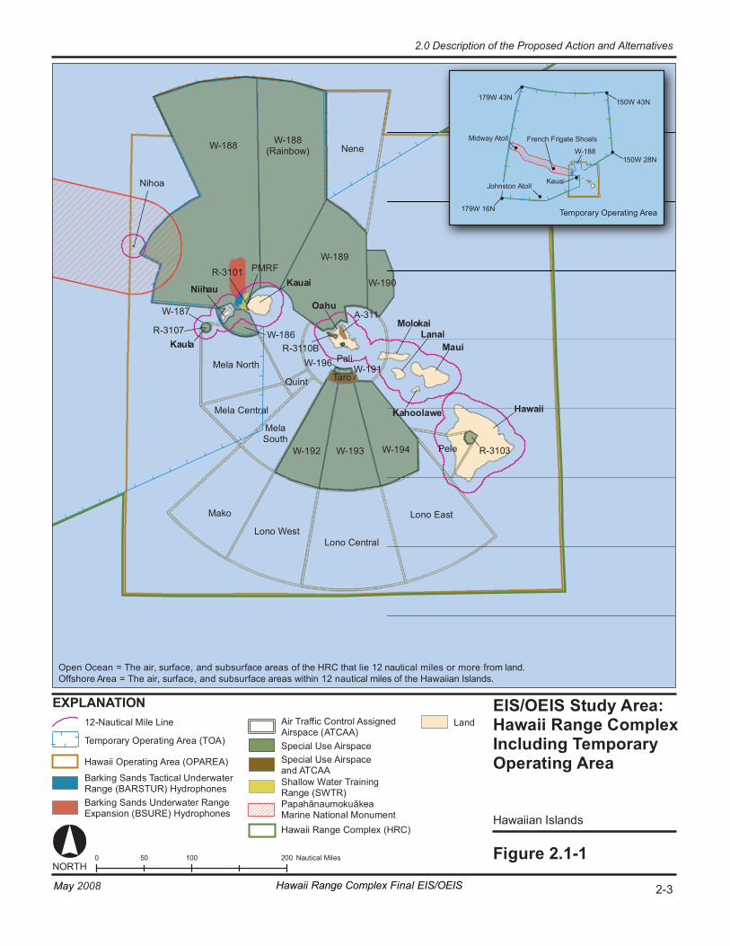
EIS/OE IS St udy A re a: Ha wa ii R ange C ompl ex In cl udi ng Te mporar y Op er at in g Ar ea
Hawaii an Isl and s
Fi gur e 2. 1- 1
Lo no C en tr al
Lo no E as t
Lo no Wes t
Ma ko
Me la C en tr al
Me la N or th
Ne ne
Pa li
Pe le
Qu in t Ta ro
0 1 00 20 0 50 Na ut ic al M il es
17 9W 43N
17 9W 16N
1 50W 43N
1 50W 28N
Te m por ar y Op er at i ng Ar ea
W- 188
EX PL ANA TI ON
W- 188 W- 188 (R ai nb ow )
W- 189
W- 190
A- 31 1
R- 31 10 B W- 196
W- 191
R- 31 03 W- 194 W- 193 W- 192
Me la So ut h
R- 31 07
W- 187
Hawaii
Maui
Oahu
Kauai
Kaula
PM RF
NORT H
Niihau
MolokaiLanai
Kahoolawe
Mi dway A to ll
J ohns ton At ol l
Fr enc h Fr i gate Sh oa ls
K auai
R- 31 01
W- 186
Ba rk i ng Sa nd s Un de rw at er R an ge Ex pa ns io n ( BSURE) Hy dr op ho ne s
Sh al lo w Wa te r Tr ai ni ng Ra ng e (S WT R)
Sp ec ia l Us e Ai rs pa ce an d AT CA A
12 -N au ti ca l Mi le L in e La nd
Pa pa hā nau mo ku āk ea Ma ri ne N at io nal M on um en t Ha wa ii Ran ge C om pl ex (HRC)
Ni ho a
Ba rk i ng Sa nd s Ta ct ic al U nde rw at er Ra ng e (B AR STUR) H yd ro ph on es
Ha wa ii O pe ra ti ng A re a (O PA RE A)
Te m por ar y Op er at in g Ar ea ( TO A)
Air Tr af fi c Co nt ro l As si gn ed Airs pa ce ( AT CAA) Sp ec ia l Us e Ai rs pa ce
2-3Hawaii Range Complex Final EIS/OEISMay 2008
2.0 Description of the Proposed Action and Alternatives
Open Ocean = The air, surface, and subsurface areas of the HRC that lie 12 nautical miles or more from land. Offshore Area = The air, surface, and subsurface areas within 12 nautical miles of the Hawaiian Islands.
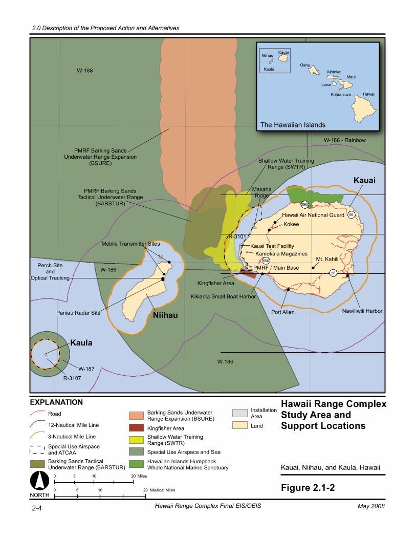
Hawaii Range ComplexStudy Area andSupport Locations
Kauai, Niihau, and Kaula, Hawaii
Figure 2.1-20 10 205 Nautical MilesNORTH
The Hawaiian Islands
Kauai
Niihau
Mt. Kahili
50
550
560
56
PMRF / Main Base
Kauai Test FacilityKamokala Magazines
Kikiaola Small Boat Harbor
Port Allen
MakahaRidge
Hawaii Air National Guard
Kokee
Oahu
Molokai
Lanai
Kahoolawe
Maui
Hawaii
KauaiNiihau
Kaula
Mobile Transmitter Sites
PMRF Barking SandsUnderwater Range Expansion
(BSURE)
PMRF Barking SandsTactical Underwater Range
(BARSTUR)
Nawiliwili Harbor
Kaula
Shallow Water TrainingRange (SWTR)
Kingfisher Area
Perch Siteand
Optical Tracking
Paniau Radar Site
EXPLANATION
Kingfisher Area Land
Road
12-Nautical Mile Line
3-Nautical Mile Line
0 10 205 Miles
Shallow Water TrainingRange (SWTR)
W-188 - Rainbow
W-186
W-188
W-186
Hawaiian Islands HumpbackWhale National Marine Sanctuary
Special Use Airspace and ATCAABarking Sands TacticalUnderwater Range (BARSTUR)
Barking Sands UnderwaterRange Expansion (BSURE)
Special Use Airspace and Sea
InstallationArea
R-3107
W-187
R-3101
Hawaii Range Complex Final EIS/OEIS May 20082-4
2.0 Description of the Proposed Action and Alternatives
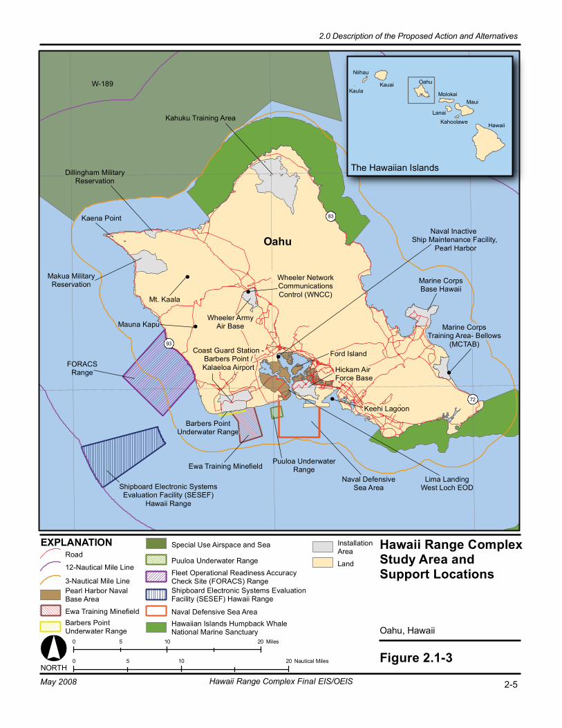
Hawaii Range ComplexStudy Area andSupport Locations
Oahu, Hawaii
Figure 2.1-30 10 205 Nautical MilesNORTH
The Hawaiian Islands
EXPLANATION
Oahu
Ford Island
83
72
93
Kaena Point
Mt. Kaala
Mauna Kapu
Wheeler NetworkCommunicationsControl (WNCC)
Marine CorpsTraining Area- Bellows
(MCTAB)Coast Guard Station -
Barbers Point /Kalaeloa Airport Hickam Air
Force Base
Wheeler ArmyAir Base
Makua MilitaryReservation
Kahuku Training Area
Dillingham MilitaryReservation
Marine CorpsBase Hawaii
Puuloa UnderwaterRange
Lima LandingWest Loch EOD
Ewa Training Minefield
Barbers PointUnderwater Range
Shipboard Electronic SystemsEvaluation Facility (SESEF)
Hawaii Range
FORACSRange
Hawaii
Maui
KahoolaweLanai
Molokai
OahuKauai
Niihau
Kaula
Naval DefensiveSea Area
Naval Inactive Ship Maintenance Facility,
Pearl Harbor
Keehi Lagoon
0 10 205 Miles
W-189
Puuloa Underwater Range
Special Use Airspace and Sea
Shipboard Electronic Systems EvaluationFacility (SESEF) Hawaii Range
Fleet Operational Readiness AccuracyCheck Site (FORACS) Range
Naval Defensive Sea AreaHawaiian Islands Humpback Whale National Marine Sanctuary
Land
InstallationArea
3-Nautical Mile LinePearl Harbor NavalBase Area
Ewa Training MinefieldBarbers PointUnderwater Range
Road
12-Nautical Mile Line
2-5Hawaii Range Complex Final EIS/OEISMay 2008
2.0 Description of the Proposed Action and Alternatives
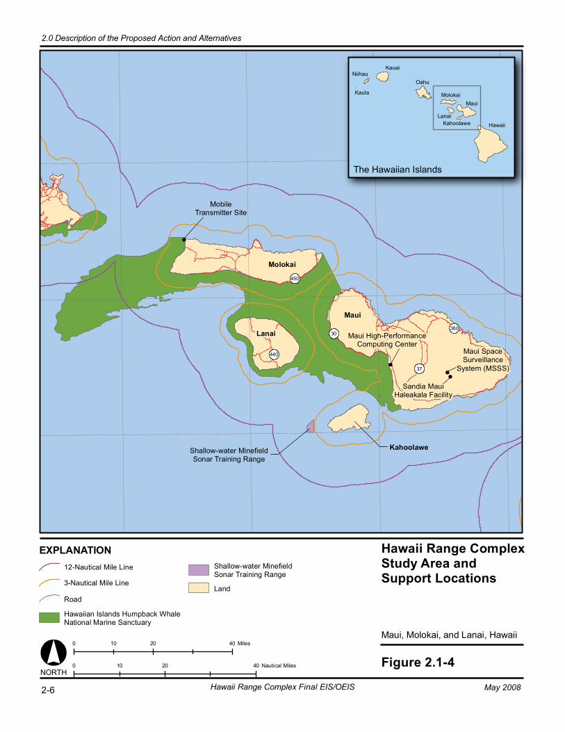
Hawaii Range ComplexStudy Area andSupport Locations
Maui, Molokai, and Lanai, Hawaii
Figure 2.1-40 20 4010 Nautical MilesNORTH
The Hawaiian Islands
360
450
440
30
37
Maui
Kahoolawe
Lanai
Molokai
Hawaii
Maui
KahoolaweLanai
Molokai
Oahu
KauaiNiihau
Kaula
0 20 4010 Miles
EXPLANATION
Shallow-water MinefieldSonar Training Range
Maui SpaceSurveillance
System (MSSS)
Sandia MauiHaleakala Facility
Maui High-PerformanceComputing Center
MobileTransmitter Site
12-Nautical Mile Line
3-Nautical Mile Line
Road
Hawaiian Islands Humpback Whale National Marine Sanctuary
Shallow-water Minefield Sonar Training Range
Land
2.0 Description of the Proposed Action and Alternatives
Hawaii Range Complex Final EIS/OEIS May 20082-6
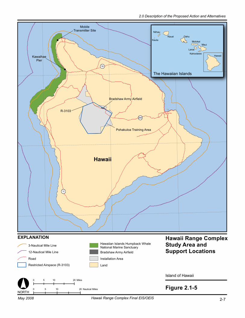
Hawaii Range ComplexStudy Area andSupport Locations
Island of Hawaii
Figure 2.1-50 10 205 Nautical Miles
11
200
19
Pohakuloa Training Area
NORTH
The Hawaiian Islands
Bradshaw Army Airfield
KawaihaePier
MobileTransmitter Site
Hawaii
Maui
Kahoolawe
Lanai
Molokai
OahuKauai
Niihau
Kaula
0 10 205 Miles
EXPLANATION
3-Nautical Mile Line
12-Nautical Mile Line
Road
Hawaiian Islands Humpback WhaleNational Marine SanctuaryBradshaw Army Airfield
Installation Area
Land
R-3103
Restricted Airspace (R-3103)
Hawaii Range Complex Final EIS/OEISMay 2008 2-7
2.0 Description of the Proposed Action and Alternatives
Hawaii
2.0 Description of the Proposed Action and Alternatives
2-8 Hawaii Range Complex Final EIS/OEIS May 2008
Table 2.1-1. Onshore Locations Where Navy Training is Conducted Service Location Island
Navy Pacific Missile Range Facility (Main Base) Kauai Niihau Niihau Kaula Kaula Pearl Harbor Oahu Coast Guard Air Station Barbers Point/Kalaeloa Airport Oahu Marines Marine Corps Base Hawaii Oahu Marine Corps Training Area Bellows Oahu Air Force Hickam Air Force Base Oahu Army Kahuku Training Area Oahu Makua Military Reservation Oahu Dillingham Military Reservation Oahu Wheeler Army Airfield Oahu K-Pier, Kawaihae Hawaii Bradshaw Army Airfield Hawaii Pohakuloa Training Area Hawaii
Note: A description of the training events and RDT&E activities that occur at these locations is listed in Tables 2.2.2.3-1 and 2.2.2.5-1.
2.2 PROPOSED ACTION AND ALTERNATIVES National Environmental Policy Act (NEPA) implementing regulations (40 Code of Federal Regulations [CFR] § 1502.14) and Navy procedures (32 CFR Part 775) provide direction on the consideration of alternatives in an EIS and promote rigorous exploration and objective evaluation of all reasonable alternatives. Alternatives were developed giving due consideration to the purpose and need of the Proposed Action, and factors such as the capability to support current and emerging Fleet tactical training and RDT&E requirements; the capability to support realistic, essential training at the level and frequency sufficient to support the FRTP and Tactical Training Theater Assessment and Planning (TAP) program recommendations; and the capability to support training requirements without impacting Navy guidelines governing the amount of time a unit may be deployed away from its homeport.
Guidance for the development of alternatives is provided in Council on Environmental Quality (CEQ) regulations (40 CFR § 1502.14) and Navy procedures described in 32 CFR § 775. The analysis of alternatives is the heart of an EIS and is intended to provide the decision-maker and the public with a clear understanding of relevant issues and the basis for choice among identified options. NEPA requires that an EIS be prepared to evaluate the environmental consequences of a range of reasonable alternatives. Reasonable alternatives must meet the stated purpose and need of the Proposed Action.
2.0 Description of the Proposed Action and Alternatives
May 2008 Hawaii Range Complex Final EIS/OEIS 2-9
Alternatives that are outside the scope of what Congress has approved or funded must still be evaluated in the EIS/OEIS if they are reasonable, because the EIS/OEIS may serve as the basis for modifying congressional approval or funding in light of NEPA’s goals and policies.
As described in the first paragraph, alternatives were selected based on their ability to meet the following criteria:
• Use existing Navy ranges and facilities in and around Hawaii;
• Be consistent with the stated current and emerging requirements for the range complex;
• Achieve training tempo requirements based on Fleet deployment schedules;
• Meet the requirements of DoD Directive 3200.15, Sustainment of Ranges and Operating Areas;
• Implement new training requirements and RDT&E activities; and
• Support realistic training that replicates expected operating environments for naval forces.
2.2.1 ALTERNATIVES ELIMINATED FROM FURTHER CONSIDERATION
2.2.1.1 REDUCTION OR ELIMINATION OF TRAINING IN THE HAWAII RANGE COMPLEX
During scoping the alternative to reduce the level of training or eliminate training in the HRC was suggested. A reduction in levels of or complete elimination of training within the HRC would not support the Navy’s ability to meet United States Code (U.S.C.) Title 10 obligations, which at Section 5062 requires the Navy to be “organized, trained, and equipped primarily for prompt and sustained combat incident to operations at sea.” Reduced or eliminated training would jeopardize the ability of specialty forces, transient units, and Strike Groups using the HRC for training purposes to be ready and qualified for deployment. Lastly, a reduction or termination of training in the HRC would require local units/users to routinely travel to other range complexes to fulfill training requirements and result in an unacceptable increase in time away from the homeport (that is, time away from home and families). For these reasons, an alternative that would decrease military training from current levels or eliminate training altogether would not meet the purpose and need of the Proposed Action. The CEQ requires an EIS to include an alternative of No-action. The CEQ defines “No-action” as no change from current activities. This alternative has been eliminated from further consideration in the EIS/OEIS.
2.0 Description of the Proposed Action and Alternatives
2-10 Hawaii Range Complex Final EIS/OEIS May 2008
2.2.1.2 ALTERNATIVE LOCATIONS FOR TRAINING CONDUCTED IN THE HAWAII RANGE COMPLEX
The HRC has the infrastructure to support a large number of forces, has extensive existing range assets, and accommodates Navy training and testing responsibilities both geographically and strategically, in a location under U.S. control. The strategic importance of the HRC is discussed in Section 1.3.5. The Navy’s physical presence and training capabilities are critical in providing stability to the Pacific region. Centrally located in the North Pacific, the HRC is co-located with the naval command units of Commander U.S. Pacific Fleet; Commander Submarine Force, U.S. Pacific Fleet; and the U.S. Marine Corps Forces, Pacific. The HRC is also home to the joint armed services command units of U.S. Pacific Command, U.S. Army Pacific, and Commander, Pacific Air Forces. With a unified presence of Army, Marine Corps, Navy, Air Force, National Guard, and Coast Guard elements, the HRC provides the training area for large multi-force (air, land, and sea components) and multinational training exercises. One example of this is the biennial RIMPAC Exercise. The HRC is the only central location in the Pacific for numerous allied nations from North America, South America, and Asia to converge for valuable training that help strengthen ties with our many allies, partners, and friends. Other critical HRC capabilities include:
• The relative isolation of the HRC’s broad open ocean area offers an invaluable facility on which to conduct missile testing and training.
• The HRC provides a superior joint training environment for all the services as well as advanced missile testing capability because of its ability to utilize the Army’s Pohakuloa Training Area, Air Force, and Marine Corps bases where aircraft basing and amphibious training may occur.
• The open ocean of the HRC presents a realistic environment for strike warfare training, including amphibious, offshore, and Anti-submarine Warfare (ASW). There is room and space to operate within proximity of land but at safe distances from other simultaneous training. This allows both training of local units and the necessary build-up of capability through training that culminates in multi-force training in Hawaii as naval forces transit the Pacific. Training may be conducted that takes advantage of the proximity of the islands and military facilities/ranges to create realistic battle problems. The relatively large area of the HRC coupled with different islands and military facilities/ranges provides a safe, flexible, and diverse training environment for Multiple Strike Groups or units to operate simultaneously.
• The HRC is the most capable and time-efficient en route training location in the eastern pacific for U.S. west coast naval forces and units deploying to or returning from regions in the western Pacific and Indian Ocean from homeports on the U.S. west coast. Recent changes in the Navy’s FRTP require ships and squadrons returning from overseas deployment to remain fully trained and ready to redeploy on short notice. The HRC is the training location for those units returning to homeports on the west coast of the United States after operational deployments.
• One of the HRC’s premier capabilities is PMRF. PMRF is the world’s largest military test and training range capable of supporting subsurface, surface, air, and space training. It consists of underwater ranges, controlled airspace, and a TOA covering 2.1 million nm2 of ocean. PMRF provides major range services for training, tactics
2.0 Description of the Proposed Action and Alternatives
May 2008 Hawaii Range Complex Final EIS/OEIS 2-11
development, and RDT&E of air, surface, and subsurface weapons systems for the Navy, other DoD agencies, allies, and private industry.
The specific value of the HRC and its superiority to alternative ranges is defined by its location in the Pacific Ocean, its proximity to Hawaii-based forces, its presence on the route of transiting forces, and its central location for nations around the rim of the Pacific. The HRC contains distinctive individual capabilities that require the continuation of specific in-place training and RDT&E activities. Further, the HRC is just one of many naval ranges in current operation that will require separate environmental analyses for mandated achievement of sustainable on-site training and testing. For the above reasons and those discussed in Section 1.3.5, it is neither reasonable, practicable, nor appropriate to seek alternative locations for training conducted in the HRC. Therefore, this alternative has been eliminated from further consideration in the EIS/OEIS.
2.2.1.3 COMPUTER SIMULATION TRAINING Navy and Marine Corps training includes extensive use of computer-simulated virtual training environments, and conducts command and control exercises without operational forces (constructive training) where possible. These training methods have substantial value in achieving limited training objectives. Computer technologies provide excellent tools for implementing a successful, integrated training program while reducing the risk and expense typically associated with live military training. However, virtual and constructive training are an adjunct to, not a substitute for, live training, including live-fire training. Unlike live training, these methods do not provide the requisite level of realism necessary to attain combat readiness, and cannot replicate the high-stress environment encountered during an actual contingency situation.
The Navy and Marine Corps continue to research new ways to provide realistic training through simulation, but there are limits to realism that simulation can provide, most notably in dynamic environments involving numerous forces, and where the training media is too complex to accurately model, such as sound behavior in the ocean.
Current simulation technology does not permit ASW training with the degree of fidelity required to maintain proficiency. Basic training of sonar technicians does take place using simulators, but beyond basic levels, simulation is of limited utility. A simulator cannot match the dynamic nature of the environment, either in bathymetry, sound propagation properties, or oceanography. Specifically, coordinated unit-level and Strike Group Training activities require multiple crews to interact in a variety of acoustic environments that cannot be simulated. Moreover, it is a training imperative that crews actually utilize the equipment they will be called upon to operate. In addition, the majority of RDT&E activities also must be conducted in a variety of acoustic environments to ensure the safe and effective use of the active sonar system.
Sonar operators and crews must train regularly and frequently to develop the skills necessary to master the process of identifying underwater threats in the complex subsurface environment. They cannot reliably simulate this training through current computer technology because the actual marine environment is too complex. Sole reliance on simulation would deny Navy Strike
2.0 Description of the Proposed Action and Alternatives
2-12 Hawaii Range Complex Final EIS/OEIS May 2008
Groups the training benefit and opportunity to derive critical lessons learned in the employment of active sonar in the following specific areas:
• Bottom bounce and other environmental conditions; • Mutual sonar interference; • Interplay between ship and submarine target; and • Interplay between ASW teams in the Strike Group.
Currently, these factors cannot be adequately simulated to provide the fidelity and level of training necessary in the employment of active sonar. Further, like any combat skill, employment of active sonar is a perishable skill that must be exercised—in a realistic and integrated manner—in order to maintain proficiency. Eliminating the use of active sonar during the training cycle would cause ASW skills to atrophy and thus put Navy forces at risk during real world operations.
Consequently, conducting all naval training by simulation is deemed inadequate and fails to meet the purpose and need of the Proposed Action. Therefore, this alternative has been eliminated from further consideration in the EIS/OEIS.
2.2.2 NO-ACTION ALTERNATIVE The purpose of including a No-action Alternative in environmental impact analyses is to ensure that agencies compare the potential impacts of the proposed Federal action to the known impacts of maintaining the status quo. The No-action Alternative presented here comprises a baseline of current, ongoing training and RDT&E activities and support of existing range capabilities. This alternative represents what is in essence a continuation of the Navy’s present course of action, that is, the regular and historic level of activity present within the HRC. The analysis of this alternative is a snapshot of the status quo, a description of the continuing and current use of the HRC. The Navy considered a reduced level of training and the elimination of training in the HRC as alternatives. However, as discussed in Section 2.2.1.1, these alternatives were eliminated and not carried forward for evaluation. As a part of the Navy’s long-standing and ongoing commitment to the environment, and as a part of the No-action Alternative, the Navy will ensure compliance with applicable environmental laws and regulations. An integral part of this EIS/OEIS process is to take a hard look at all applicable environmental laws and regulations and to ensure that actions associated with each proposed alternative are in compliance with applicable laws and regulations.
The No-action Alternative stands as no change from current levels of training usage. The existing level of activity is used as a benchmark with which to compare the outputs and effects of differing alternatives. If the No-action Alternative is selected, the Navy would continue its current activities at the HRC. Alternatives 1, 2, and 3 analyze greater use of range assets to support training by combining activities together to maximize training opportunities. By using the status quo as the No-action Alternative, the Navy compares the impacts of current training and RDT&E activities to the impacts of enhanced training and RDT&E activities presented in Alternatives 1, 2, and 3.
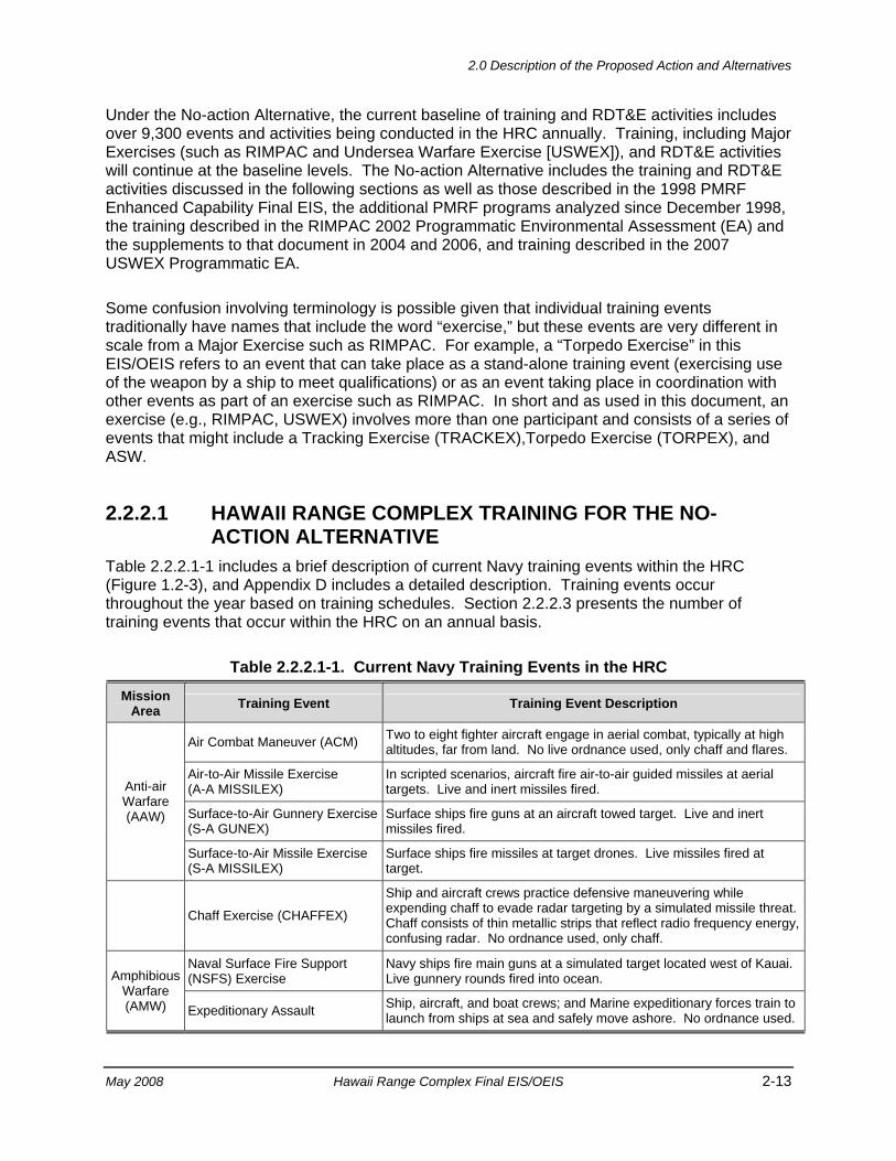
2.0 Description of the Proposed Action and Alternatives
May 2008 Hawaii Range Complex Final EIS/OEIS 2-13
Under the No-action Alternative, the current baseline of training and RDT&E activities includes over 9,300 events and activities being conducted in the HRC annually. Training, including Major Exercises (such as RIMPAC and Undersea Warfare Exercise [USWEX]), and RDT&E activities will continue at the baseline levels. The No-action Alternative includes the training and RDT&E activities discussed in the following sections as well as those described in the 1998 PMRF Enhanced Capability Final EIS, the additional PMRF programs analyzed since December 1998, the training described in the RIMPAC 2002 Programmatic Environmental Assessment (EA) and the supplements to that document in 2004 and 2006, and training described in the 2007 USWEX Programmatic EA.
Some confusion involving terminology is possible given that individual training events traditionally have names that include the word “exercise,” but these events are very different in scale from a Major Exercise such as RIMPAC. For example, a “Torpedo Exercise” in this EIS/OEIS refers to an event that can take place as a stand-alone training event (exercising use of the weapon by a ship to meet qualifications) or as an event taking place in coordination with other events as part of an exercise such as RIMPAC. In short and as used in this document, an exercise (e.g., RIMPAC, USWEX) involves more than one participant and consists of a series of events that might include a Tracking Exercise (TRACKEX),Torpedo Exercise (TORPEX), and ASW.
2.2.2.1 HAWAII RANGE COMPLEX TRAINING FOR THE NO-ACTION ALTERNATIVE
Table 2.2.2.1-1 includes a brief description of current Navy training events within the HRC (Figure 1.2-3), and Appendix D includes a detailed description. Training events occur throughout the year based on training schedules. Section 2.2.2.3 presents the number of training events that occur within the HRC on an annual basis.
Table 2.2.2.1-1. Current Navy Training Events in the HRC
Mission Area Training Event Training Event Description
Anti-air Warfare (AAW)
Air Combat Maneuver (ACM) Two to eight fighter aircraft engage in aerial combat, typically at high altitudes, far from land. No live ordnance used, only chaff and flares.
Air-to-Air Missile Exercise (A-A MISSILEX)
In scripted scenarios, aircraft fire air-to-air guided missiles at aerial targets. Live and inert missiles fired.
Surface-to-Air Gunnery Exercise (S-A GUNEX)
Surface ships fire guns at an aircraft towed target. Live and inert missiles fired.
Surface-to-Air Missile Exercise (S-A MISSILEX)
Surface ships fire missiles at target drones. Live missiles fired at target.
Chaff Exercise (CHAFFEX)
Ship and aircraft crews practice defensive maneuvering while expending chaff to evade radar targeting by a simulated missile threat. Chaff consists of thin metallic strips that reflect radio frequency energy, confusing radar. No ordnance used, only chaff.
Amphibious Warfare (AMW)
Naval Surface Fire Support (NSFS) Exercise
Navy ships fire main guns at a simulated target located west of Kauai. Live gunnery rounds fired into ocean.
Expeditionary Assault Ship, aircraft, and boat crews; and Marine expeditionary forces train to launch from ships at sea and safely move ashore. No ordnance used.
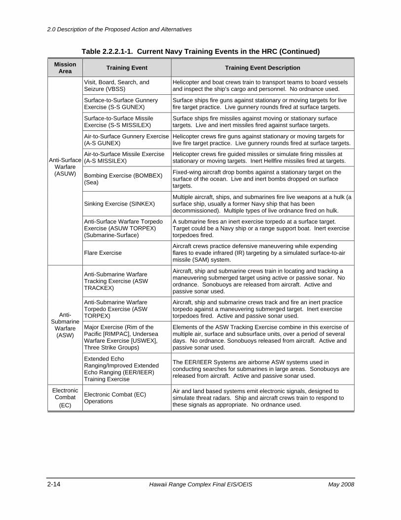
2.0 Description of the Proposed Action and Alternatives
2-14 Hawaii Range Complex Final EIS/OEIS May 2008
Table 2.2.2.1-1. Current Navy Training Events in the HRC (Continued)
Mission Area Training Event Training Event Description
Anti-Surface Warfare (ASUW)
Visit, Board, Search, and Seizure (VBSS)
Helicopter and boat crews train to transport teams to board vessels and inspect the ship’s cargo and personnel. No ordnance used.
Surface-to-Surface Gunnery Exercise (S-S GUNEX)
Surface ships fire guns against stationary or moving targets for live fire target practice. Live gunnery rounds fired at surface targets.
Surface-to-Surface Missile Exercise (S-S MISSILEX)
Surface ships fire missiles against moving or stationary surface targets. Live and inert missiles fired against surface targets.
Air-to-Surface Gunnery Exercise (A-S GUNEX)
Helicopter crews fire guns against stationary or moving targets for live fire target practice. Live gunnery rounds fired at surface targets.
Air-to-Surface Missile Exercise (A-S MISSILEX)
Helicopter crews fire guided missiles or simulate firing missiles at stationary or moving targets. Inert Hellfire missiles fired at targets.
Bombing Exercise (BOMBEX) (Sea)
Fixed-wing aircraft drop bombs against a stationary target on the surface of the ocean. Live and inert bombs dropped on surface targets.
Sinking Exercise (SINKEX) Multiple aircraft, ships, and submarines fire live weapons at a hulk (a surface ship, usually a former Navy ship that has been decommissioned). Multiple types of live ordnance fired on hulk.
Anti-Surface Warfare Torpedo Exercise (ASUW TORPEX) (Submarine-Surface)
A submarine fires an inert exercise torpedo at a surface target. Target could be a Navy ship or a range support boat. Inert exercise torpedoes fired.
Flare Exercise Aircraft crews practice defensive maneuvering while expending flares to evade infrared (IR) targeting by a simulated surface-to-air missile (SAM) system.
Anti-Submarine
Warfare (ASW)
Anti-Submarine Warfare Tracking Exercise (ASW TRACKEX)
Aircraft, ship and submarine crews train in locating and tracking a maneuvering submerged target using active or passive sonar. No ordnance. Sonobuoys are released from aircraft. Active and passive sonar used.
Anti-Submarine Warfare Torpedo Exercise (ASW TORPEX)
Aircraft, ship and submarine crews track and fire an inert practice torpedo against a maneuvering submerged target. Inert exercise torpedoes fired. Active and passive sonar used.
Major Exercise (Rim of the Pacific [RIMPAC], Undersea Warfare Exercise [USWEX], Three Strike Groups)
Elements of the ASW Tracking Exercise combine in this exercise of multiple air, surface and subsurface units, over a period of several days. No ordnance. Sonobuoys released from aircraft. Active and passive sonar used.
Extended Echo Ranging/Improved Extended Echo Ranging (EER/IEER) Training Exercise
The EER/IEER Systems are airborne ASW systems used in conducting searches for submarines in large areas. Sonobuoys are released from aircraft. Active and passive sonar used.
Electronic Combat
(EC)
Electronic Combat (EC) Operations
Air and land based systems emit electronic signals, designed to simulate threat radars. Ship and aircraft crews train to respond to these signals as appropriate. No ordnance used.
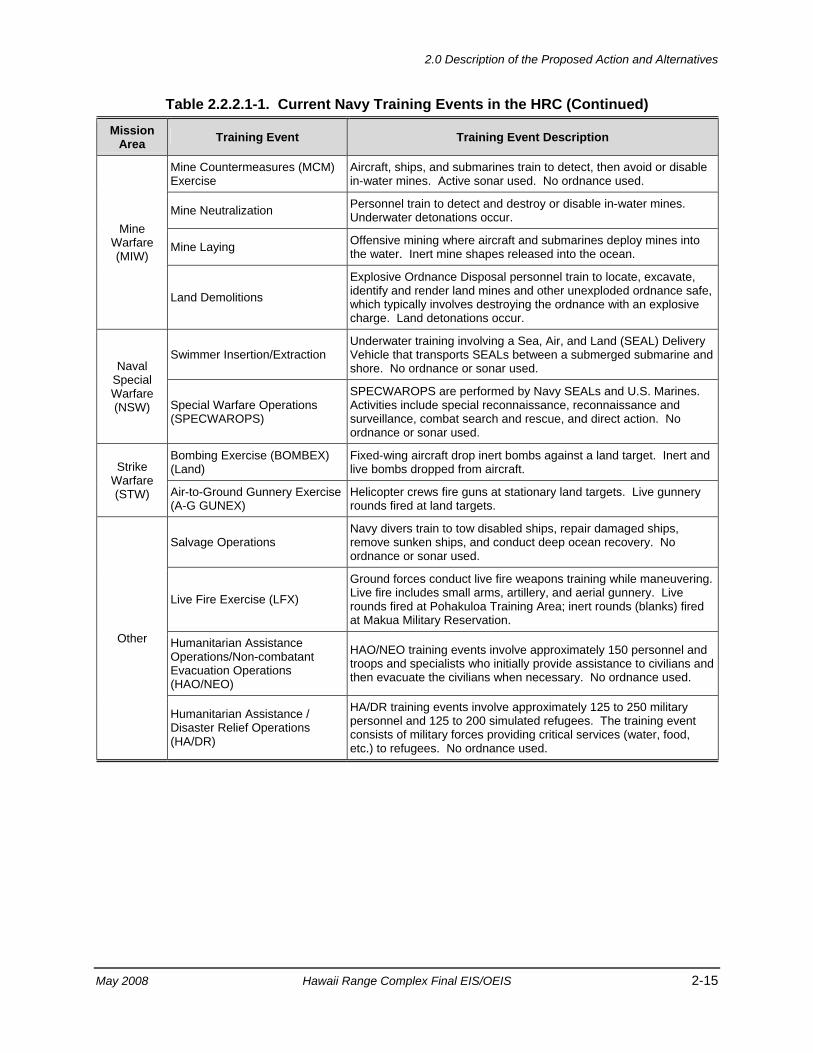
2.0 Description of the Proposed Action and Alternatives
May 2008 Hawaii Range Complex Final EIS/OEIS 2-15
Table 2.2.2.1-1. Current Navy Training Events in the HRC (Continued)
Mission Area Training Event Training Event Description
Mine Warfare (MIW)
Mine Countermeasures (MCM) Exercise
Aircraft, ships, and submarines train to detect, then avoid or disable in-water mines. Active sonar used. No ordnance used.
Mine Neutralization Personnel train to detect and destroy or disable in-water mines. Underwater detonations occur.
Mine Laying Offensive mining where aircraft and submarines deploy mines into the water. Inert mine shapes released into the ocean.
Land Demolitions
Explosive Ordnance Disposal personnel train to locate, excavate, identify and render land mines and other unexploded ordnance safe, which typically involves destroying the ordnance with an explosive charge. Land detonations occur.
Naval Special Warfare (NSW)
Swimmer Insertion/Extraction Underwater training involving a Sea, Air, and Land (SEAL) Delivery Vehicle that transports SEALs between a submerged submarine and shore. No ordnance or sonar used.
Special Warfare Operations (SPECWAROPS)
SPECWAROPS are performed by Navy SEALs and U.S. Marines. Activities include special reconnaissance, reconnaissance and surveillance, combat search and rescue, and direct action. No ordnance or sonar used.
Strike Warfare (STW)
Bombing Exercise (BOMBEX) (Land)
Fixed-wing aircraft drop inert bombs against a land target. Inert and live bombs dropped from aircraft.
Air-to-Ground Gunnery Exercise (A-G GUNEX)
Helicopter crews fire guns at stationary land targets. Live gunnery rounds fired at land targets.
Other
Salvage Operations Navy divers train to tow disabled ships, repair damaged ships, remove sunken ships, and conduct deep ocean recovery. No ordnance or sonar used.
Live Fire Exercise (LFX)
Ground forces conduct live fire weapons training while maneuvering. Live fire includes small arms, artillery, and aerial gunnery. Live rounds fired at Pohakuloa Training Area; inert rounds (blanks) fired at Makua Military Reservation.
Humanitarian Assistance Operations/Non-combatant Evacuation Operations (HAO/NEO)
HAO/NEO training events involve approximately 150 personnel and troops and specialists who initially provide assistance to civilians and then evacuate the civilians when necessary. No ordnance used.
Humanitarian Assistance / Disaster Relief Operations (HA/DR)
HA/DR training events involve approximately 125 to 250 military personnel and 125 to 200 simulated refugees. The training event consists of military forces providing critical services (water, food, etc.) to refugees. No ordnance used.
2.0 Description of the Proposed Action and Alternatives
2-16 Hawaii Range Complex Final EIS/OEIS May 2008
2.2.2.2 HAWAII RANGE COMPLEX SUPPORT EVENTS FOR THE NO-ACTION ALTERNATIVE
Numerous support events take place as an integral part of training occurring in the HRC. These support events can generally be described as either supporting the command and control (C2) events, or supporting ships, submarines, aircraft, or personnel.
Command and Control The purpose of the C2 events is to provide continuous C2 support for Major Exercises. Each activity is monitored and coordinated for safety and on-time performance, to ensure training objectives are accomplished, and to identify lessons learned for future training and exercises. Overall command functions can be performed from a command ship or from land facilities at Pearl Harbor or PMRF. C2 is achieved through a network of communication devices, or nodes, strategically located at selected DoD installations around the islands (e.g., at range control offices and air traffic centers) to ensure positive communication with the training and exercise participants. Existing C2 nodes are located on the following islands:
• Kauai (Makaha Ridge, Kokee, and Mt. Kahili)
• Oahu (Kaena Point, Mt. Kaala, Wheeler Network Segment Control, Mauna Kapu Communication Site, and Makua Radio/Repeater/Cable Head)
• Molokai (Molokai Mobile Transmitter Site)
• Maui (Maui Space Surveillance System, Maui High Performance Computing Center, and Sandia Maui Haleakala Facility)
• Hawaii (Big Island Mobile Transmitter Site) In-port Ship Support Operations The purpose of the In-port Ship Operations is to provide major support for Navy ships and submarines. In-port support includes the typical activities that are carried out when foreign and U.S. warships and submarines are berthed at Pearl Harbor. This includes in-port briefings and debriefings and in-port training activities, including oil spill response training. Once berthed, ships would re-supply, plan for refueling, load ammunition, and conduct other maintenance activities, including the off loading of solid wastes and wastewater (black and gray water). In addition, the Fleet and Industrial Supply Center at Pearl Harbor processes non-typical orders to acquire country unique items that are not normally handled by the U.S. Fleet.
Shore facilities management activities include berthing space and utility hookups, harbor coordination and control, and space management for equipment and personnel. Pearl Harbor has contained more than 60 warships during Major Exercises and on other occasions.
Pearl Harbor is a restricted area. No vessels are allowed into Pearl Harbor without permission of Commander Navy Region Hawaii. The restricted area extends outward from the mouth of the harbor and is defined by a rectangular boundary known as the Pearl Harbor Naval Defensive Sea Area.
2.0 Description of the Proposed Action and Alternatives
May 2008 Hawaii Range Complex Final EIS/OEIS 2-17
Aircraft Support Operations Aircraft Support Operations are necessary to ensure safe air activities. Aircraft support includes space for the various types of aircraft, equipment for refueling and maintenance.
U.S. and foreign aircraft (fixed wing, rotary, and airship) are supported from Hickam Air Force Base (AFB), Marine Corps Base Hawaii (MCBH), U.S. Coast Guard Air Station Barbers Point/Kalaeloa Airport, and Wheeler Army Airfield on Oahu; Bradshaw Army Airfield on Hawaii; and PMRF (Main Base) airfield on Kauai.
Personnel Support Operations The purpose of the Personnel Support Operations is to meet the housing and facilities needs of the personnel that support range activities. This includes in-port briefings and debriefings and in-port training activities. In addition, some exercises conclude with receptions, athletic events, and other social activities.
Housing is provided both on and off installation as necessary to house transient aircraft crews and temporary support personnel. Off-installation housing requirements can range from 700 to 1,500 units.
Air Operations Air Operations are a part of daily activities and Major Exercises. Air Operations are supported at the following facilities: Hickam AFB, MCBH, U.S. Coast Guard Air Station Barbers Point/Kalaeloa Airport, and Wheeler Army Airfield on Oahu; Bradshaw Army Airfield on Hawaii; and PMRF (Main Base) airfield on Kauai.
2.2.2.3 CURRENT TRAINING EVENTS WITHIN THE HAWAII RANGE COMPLEX FOR THE NO-ACTION ALTERNATIVE
Table 2.2.2.3-1 presents current Navy training events (No-action Alternative) that are conducted per year within the HRC. For purpose of comparison, Table 2.2.2.3-1 also presents proposed Navy training events under Alternative 1, Alternative 2, and Alternative 3. Detailed descriptions of these alternatives are described in Sections 2.2.3, 2.2.4, and 2.2.5, respectively. Appendix D provides additional description of these events.
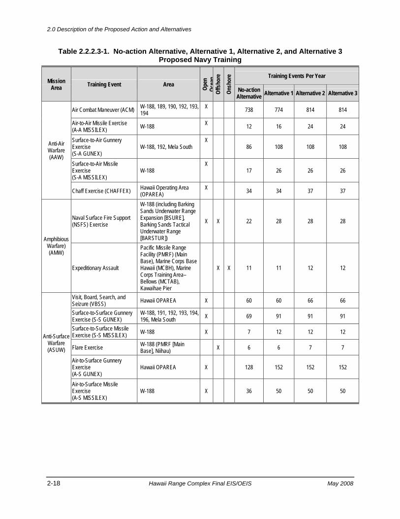
2.0 Description of the Proposed Action and Alternatives
2-18 Hawaii Range Complex Final EIS/OEIS May 2008
Table 2.2.2.3-1. No-action Alternative, Alternative 1, Alternative 2, and Alternative 3 Proposed Navy Training
Mission Area Training Event Area Op
en
Ocea
n Of
fsho
re
Onsh
ore Training Events Per Year
No-action Alternative Alternative 1 Alternative 2 Alternative 3
Anti-Air Warfare (AAW)
Air Combat Maneuver (ACM) W-188, 189, 190, 192, 193, 194
X 738 774 814 814
Air-to-Air Missile Exercise (A-A MISSILEX) W-188 X 12 16 24 24
Surface-to-Air Gunnery Exercise (S-A GUNEX)
W-188, 192, Mela South X
86 108 108 108
Surface-to-Air Missile Exercise (S-A MISSILEX)
W-188 X
17 26 26 26
Chaff Exercise (CHAFFEX) Hawaii Operating Area (OPAREA)
X 34 34 37 37
Amphibious Warfare) (AMW)
Naval Surface Fire Support (NSFS) Exercise
W-188 (including Barking Sands Underwater Range Expansion [BSURE], Barking Sands Tactical Underwater Range [BARSTUR])
X X 22 28 28 28
Expeditionary Assault
Pacific Missile Range Facility (PMRF) (Main Base), Marine Corps Base Hawaii (MCBH), Marine Corps Training Area–Bellows (MCTAB), Kawaihae Pier
X X 11 11 12 12
Anti-Surface Warfare (ASUW)
Visit, Board, Search, and Seizure (VBSS) Hawaii OPAREA X 60 60 66 66
Surface-to-Surface Gunnery Exercise (S-S GUNEX)
W-188, 191, 192, 193, 194, 196, Mela South X 69 91 91 91
Surface-to-Surface Missile Exercise (S-S MISSILEX) W-188 X 7 12 12 12
Flare Exercise W-188 (PMRF [Main Base], Niihau) X 6 6 7 7
Air-to-Surface Gunnery Exercise (A-S GUNEX)
Hawaii OPAREA X 128 152 152 152
Air-to-Surface Missile Exercise (A-S MISSILEX)
W-188 X 36 50 50 50
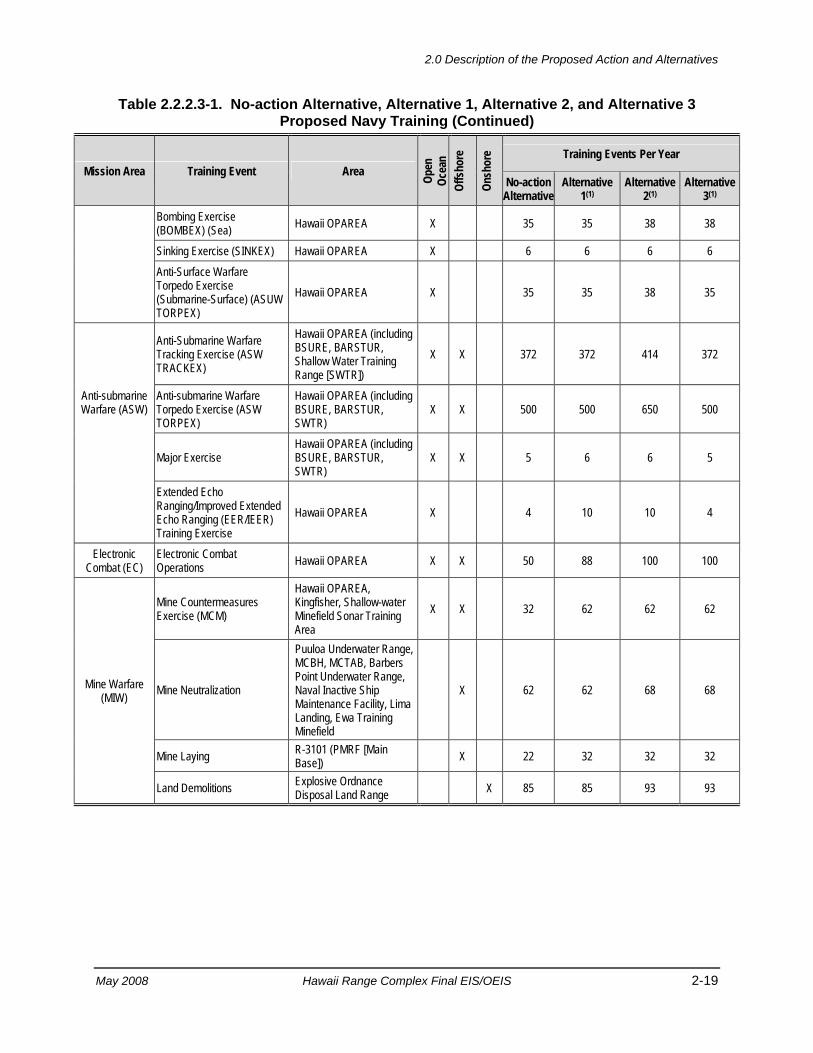
2.0 Description of the Proposed Action and Alternatives
May 2008 Hawaii Range Complex Final EIS/OEIS 2-19
Table 2.2.2.3-1. No-action Alternative, Alternative 1, Alternative 2, and Alternative 3 Proposed Navy Training (Continued)
Mission Area Training Event Area Open
Oc
ean
Offs
hore
Onsh
ore Training Events Per Year
No-action Alternative
Alternative 1(1)
Alternative 2(1)
Alternative 3(1)
Bombing Exercise (BOMBEX) (Sea) Hawaii OPAREA X 35 35 38 38
Sinking Exercise (SINKEX) Hawaii OPAREA X 6 6 6 6 Anti-Surface Warfare Torpedo Exercise (Submarine-Surface) (ASUW TORPEX)
Hawaii OPAREA X 35 35 38 35
Anti-submarine Warfare (ASW)
Anti-Submarine Warfare Tracking Exercise (ASW TRACKEX)
Hawaii OPAREA (including BSURE, BARSTUR, Shallow Water Training Range [SWTR])
X X 372 372 414 372
Anti-submarine Warfare Torpedo Exercise (ASW TORPEX)
Hawaii OPAREA (including BSURE, BARSTUR, SWTR)
X X 500 500 650 500
Major Exercise Hawaii OPAREA (including BSURE, BARSTUR, SWTR)
X X 5 6 6 5
Extended Echo Ranging/Improved Extended Echo Ranging (EER/IEER) Training Exercise
Hawaii OPAREA X 4 10 10 4
Electronic Combat (EC)
Electronic Combat Operations Hawaii OPAREA X X 50 88 100 100
Mine Warfare (MIW)
Mine Countermeasures Exercise (MCM)
Hawaii OPAREA, Kingfisher, Shallow-water Minefield Sonar Training Area
X X 32 62 62 62
Mine Neutralization
Puuloa Underwater Range, MCBH, MCTAB, Barbers Point Underwater Range, Naval Inactive Ship Maintenance Facility, Lima Landing, Ewa Training Minefield
X 62 62 68 68
Mine Laying R-3101 (PMRF [Main Base]) X 22 32 32 32
Land Demolitions Explosive Ordnance Disposal Land Range X 85 85 93 93
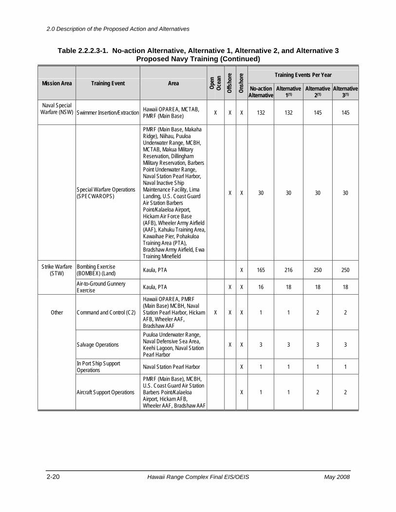
2.0 Description of the Proposed Action and Alternatives
2-20 Hawaii Range Complex Final EIS/OEIS May 2008
Table 2.2.2.3-1. No-action Alternative, Alternative 1, Alternative 2, and Alternative 3 Proposed Navy Training (Continued)
Mission Area Training Event Area Open
Oc
ean
Offs
hore
Onsh
ore Training Events Per Year
No-action Alternative
Alternative 1(1)
Alternative 2(1)
Alternative 3(1)
Naval Special Warfare (NSW)
Swimmer Insertion/Extraction Hawaii OPAREA, MCTAB,
PMRF (Main Base) X X X 132 132 145 145
Special Warfare Operations (SPECWAROPS)
PMRF (Main Base, Makaha Ridge), Niihau, Puuloa Underwater Range, MCBH, MCTAB, Makua Military Reservation, Dillingham Military Reservation, Barbers Point Underwater Range, Naval Station Pearl Harbor, Naval Inactive Ship Maintenance Facility, Lima Landing, U.S. Coast Guard Air Station Barbers Point/Kalaeloa Airport, Hickam Air Force Base (AFB), Wheeler Army Airfield (AAF), Kahuku Training Area, Kawaihae Pier, Pohakuloa Training Area (PTA), Bradshaw Army Airfield, Ewa Training Minefield
X X 30 30 30 30
Strike Warfare (STW)
Bombing Exercise (BOMBEX) (Land) Kaula, PTA X 165 216 250 250
Air-to-Ground Gunnery Exercise Kaula, PTA X X 16 18 18 18
Other Command and Control (C2)
Hawaii OPAREA, PMRF (Main Base) MCBH, Naval Station Pearl Harbor, Hickam AFB, Wheeler AAF, Bradshaw AAF
X X X 1 1 2 2
Salvage Operations
Puuloa Underwater Range, Naval Defensive Sea Area, Keehi Lagoon, Naval Station Pearl Harbor
X X 3 3 3 3
In Port Ship Support Operations Naval Station Pearl Harbor X 1 1 1 1
Aircraft Support Operations
PMRF (Main Base), MCBH, U.S. Coast Guard Air Station Barbers Point/Kalaeloa Airport, Hickam AFB, Wheeler AAF, Bradshaw AAF
X 1 1 2 2
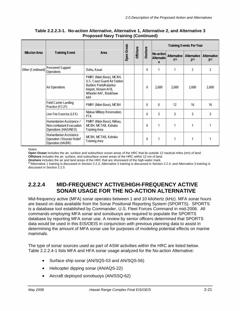
2.0 Description of the Proposed Action and Alternatives
May 2008 Hawaii Range Complex Final EIS/OEIS 2-21
Table 2.2.2.3-1. No-action Alternative, Alternative 1, Alternative 2, and Alternative 3 Proposed Navy Training (Continued)
Mission Area Training Event Area
Open
Oce
an
Offs
hore
Onsh
ore Training Events Per Year
No-action Alternativ
e Alternative
1(1) Alternative
2(1) Alternative
3(1)
Other (Continued) Personnel Support Operations Oahu, Kauai X 1 1 2 2
Air Operations
PMRF (Main Base), MCBH, U.S. Coast Guard Air Station Barbers Point/Kalaeloa Airport, Hickam AFB, Wheeler AAF, Bradshaw AAF
X 2,600 2,600 2,600 2,600
Field Carrier Landing Practice (FCLP) PMRF (Main Base), MCBH X 0 12 16 16
Live Fire Exercise (LFX) Makua Military Reservation, PTA X 3 3 3 3
Humanitarian Assistance / Non-combatant Evacuation Operations (HAO/NEO)
PMRF (Main Base), Niihau, MCBH, MCTAB, Kahuku Training Area
X 1 1 1 1
Humanitarian Assistance Operation / Disaster Relief Operation (HA/DR)
MCBH, MCTAB, Kahuku Training Area X 1 1 1 1
Notes: Open Ocean includes the air, surface and subsurface ocean areas of the HRC that lie outside 12 nautical miles (nm) of land. Offshore includes the air, surface, and subsurface ocean areas of the HRC within 12 nm of land. Onshore includes the air and land areas of the HRC that are shoreward of the high-water mark. (1)Alternative 1 training is discussed in Section 2.2.3, Alternative 2 training is discussed in Section 2.2.4, and Alternative 3 training is discussed in Section 2.2.5
2.2.2.4 MID-FREQUENCY ACTIVE/HIGH-FREQUENCY ACTIVE SONAR USAGE FOR THE NO-ACTION ALTERNATIVE
Mid-frequency active (MFA) sonar operates between 1 and 10 kilohertz (kHz). MFA sonar hours are based on data available from the Sonar Positional Reporting System (SPORTS). SPORTS is a database tool established by Commander, U.S. Fleet Forces Command in mid-2006. All commands employing MFA sonar and sonobuoys are required to populate the SPORTS database by reporting MFA sonar use. A review by senior officers determined that SPORTS data would be used in this EIS/OEIS in conjunction with previous planning data to assist in determining the amount of MFA sonar use for purposes of modeling potential effects on marine mammals.
The type of sonar sources used as part of ASW activities within the HRC are listed below. Table 2.2.2.4-1 lists MFA and HFA sonar usage analyzed for the No-action Alternative:
• Surface ship sonar (AN/SQS-53 and AN/SQS-56)
• Helicopter dipping sonar (AN/AQS-22)
• Aircraft deployed sonobuoys (AN/SSQ-62)
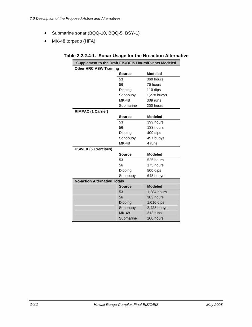
2.0 Description of the Proposed Action and Alternatives
2-22 Hawaii Range Complex Final EIS/OEIS May 2008
• Submarine sonar (BQQ-10, BQQ-5, BSY-1)
• MK-48 torpedo (HFA)
Table 2.2.2.4-1. Sonar Usage for the No-action Alternative Supplement to the Draft EIS/OEIS Hours/Events Modeled
Other HRC ASW Training Source Modeled 53 360 hours 56 75 hours Dipping 110 dips Sonobuoy 1,278 buoys MK-48 309 runs Submarine 200 hours RIMPAC (1 Carrier) Source Modeled 53 399 hours 56 133 hours Dipping 400 dips Sonobuoy 497 buoys MK-48 4 runs USWEX (5 Exercises) Source Modeled 53 525 hours 56 175 hours Dipping 500 dips Sonobuoy 648 buoys No-action Alternative Totals Source Modeled 53 1,284 hours 56 383 hours Dipping 1,010 dips Sonobuoy 2,423 buoys MK-48 313 runs Submarine 200 hours
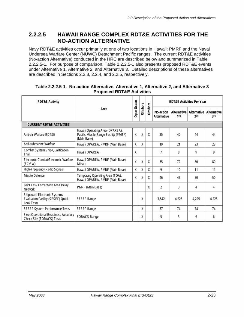
2.0 Description of the Proposed Action and Alternatives
May 2008 Hawaii Range Complex Final EIS/OEIS 2-23
2.2.2.5 HAWAII RANGE COMPLEX RDT&E ACTIVITIES FOR THE NO-ACTION ALTERNATIVE
Navy RDT&E activities occur primarily at one of two locations in Hawaii: PMRF and the Naval Undersea Warfare Center (NUWC) Detachment Pacific ranges. The current RDT&E activities (No-action Alternative) conducted in the HRC are described below and summarized in Table 2.2.2.5-1. For purpose of comparison, Table 2.2.2.5-1 also presents proposed RDT&E events under Alternative 1, Alternative 2, and Alternative 3. Detailed descriptions of these alternatives are described in Sections 2.2.3, 2.2.4, and 2.2.5, respectively.
Table 2.2.2.5-1. No-action Alternative, Alternative 1, Alternative 2, and Alternative 3 Proposed RDT&E Activities
RDT&E Activity
Area
Open
Oce
an
Offs
hore
Onsh
ore RDT&E Activities Per Year
No-action Alternative
Alternative 1(1)
Alternative 2(1)
Alternative 3(1)
CURRENT RDT&E ACTIVITIES
Anti-air Warfare RDT&E Hawaii Operating Area (OPAREA), Pacific Missile Range Facility (PMRF) (Main Base)
X X X 35 40 44 44
Anti-submarine Warfare Hawaii OPAREA, PMRF (Main Base) X X 19 21 23 23 Combat System Ship Qualification Trial Hawaii OPAREA X 7 8 9 9
Electronic Combat/Electronic Warfare (EC/EW)
Hawaii OPAREA, PMRF (Main Base), Niihau X X X 65 72 80 80
High-Frequency Radio Signals Hawaii OPAREA, PMRF (Main Base) X X X 9 10 11 11 Missile Defense Temporary Operating Area (TOA),
Hawaii OPAREA, PMRF (Main Base) X X X 46 46 50 50
Joint Task Force Wide Area Relay Network PMRF (Main Base) X 2 3 4 4
Shipboard Electronic Systems Evaluation Facility (SESEF) Quick Look Tests
SESEF Range X 3,842 4,225 4,225 4,225
SESEF System Performance Tests SESEF Range X 67 74 74 74 Fleet Operational Readiness Accuracy Check Site (FORACS) Tests FORACS Range X 5 5 6 6
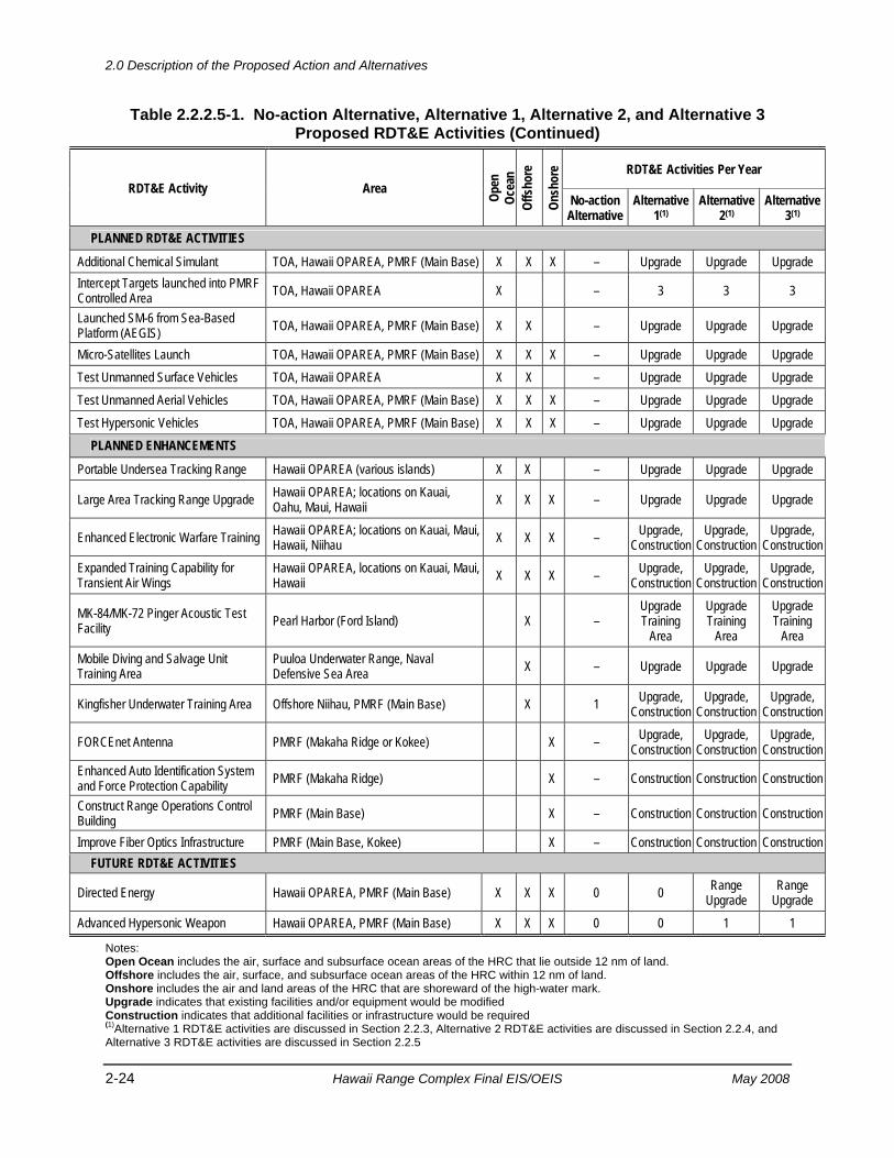
2.0 Description of the Proposed Action and Alternatives
2-24 Hawaii Range Complex Final EIS/OEIS May 2008
Table 2.2.2.5-1. No-action Alternative, Alternative 1, Alternative 2, and Alternative 3 Proposed RDT&E Activities (Continued)
RDT&E Activity Area Open
Oc
ean
Offs
hore
Onsh
ore RDT&E Activities Per Year
No-action Alternative
Alternative 1(1)
Alternative 2(1)
Alternative 3(1)
PLANNED RDT&E ACTIVITIES
Additional Chemical Simulant TOA, Hawaii OPAREA, PMRF (Main Base) X X X – Upgrade Upgrade Upgrade Intercept Targets launched into PMRF Controlled Area TOA, Hawaii OPAREA X – 3 3 3
Launched SM-6 from Sea-Based Platform (AEGIS) TOA, Hawaii OPAREA, PMRF (Main Base) X X – Upgrade Upgrade Upgrade
Micro-Satellites Launch TOA, Hawaii OPAREA, PMRF (Main Base) X X X – Upgrade Upgrade Upgrade Test Unmanned Surface Vehicles TOA, Hawaii OPAREA X X – Upgrade Upgrade Upgrade Test Unmanned Aerial Vehicles TOA, Hawaii OPAREA, PMRF (Main Base) X X X – Upgrade Upgrade Upgrade Test Hypersonic Vehicles TOA, Hawaii OPAREA, PMRF (Main Base) X X X – Upgrade Upgrade Upgrade
PLANNED ENHANCEMENTS
Portable Undersea Tracking Range Hawaii OPAREA (various islands) X X – Upgrade Upgrade Upgrade
Large Area Tracking Range Upgrade Hawaii OPAREA; locations on Kauai, Oahu, Maui, Hawaii X X X – Upgrade Upgrade Upgrade
Enhanced Electronic Warfare Training Hawaii OPAREA; locations on Kauai, Maui, Hawaii, Niihau X X X – Upgrade,
Construction Upgrade,
Construction Upgrade,
Construction Expanded Training Capability for Transient Air Wings
Hawaii OPAREA, locations on Kauai, Maui, Hawaii X X X – Upgrade,
Construction Upgrade,
Construction Upgrade,
Construction
MK-84/MK-72 Pinger Acoustic Test Facility Pearl Harbor (Ford Island) X –
Upgrade Training
Area
Upgrade Training
Area
Upgrade Training
Area Mobile Diving and Salvage Unit Training Area
Puuloa Underwater Range, Naval Defensive Sea Area X – Upgrade Upgrade Upgrade
Kingfisher Underwater Training Area Offshore Niihau, PMRF (Main Base) X 1 Upgrade, Construction
Upgrade, Construction
Upgrade, Construction
FORCEnet Antenna PMRF (Makaha Ridge or Kokee) X – Upgrade, Construction
Upgrade, Construction
Upgrade, Construction
Enhanced Auto Identification System and Force Protection Capability PMRF (Makaha Ridge) X – Construction Construction Construction
Construct Range Operations Control Building PMRF (Main Base) X – Construction Construction Construction
Improve Fiber Optics Infrastructure PMRF (Main Base, Kokee) X – Construction Construction Construction FUTURE RDT&E ACTIVITIES
Directed Energy Hawaii OPAREA, PMRF (Main Base) X X X 0 0 Range Upgrade
Range Upgrade
Advanced Hypersonic Weapon Hawaii OPAREA, PMRF (Main Base) X X X 0 0 1 1
Notes: Open Ocean includes the air, surface and subsurface ocean areas of the HRC that lie outside 12 nm of land. Offshore includes the air, surface, and subsurface ocean areas of the HRC within 12 nm of land. Onshore includes the air and land areas of the HRC that are shoreward of the high-water mark. Upgrade indicates that existing facilities and/or equipment would be modified Construction indicates that additional facilities or infrastructure would be required (1)Alternative 1 RDT&E activities are discussed in Section 2.2.3, Alternative 2 RDT&E activities are discussed in Section 2.2.4, and Alternative 3 RDT&E activities are discussed in Section 2.2.5
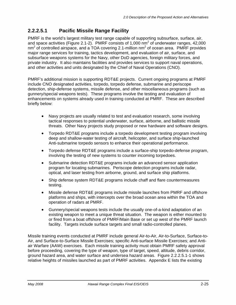
2.0 Description of the Proposed Action and Alternatives
May 2008 Hawaii Range Complex Final EIS/OEIS 2-25
2.2.2.5.1 Pacific Missile Range Facility PMRF is the world’s largest military test range capable of supporting subsurface, surface, air, and space activities (Figure 2.1-2). PMRF consists of 1,000 nm2 of underwater ranges, 42,000 nm2 of controlled airspace, and a TOA covering 2.1-million nm2 of ocean area. PMRF provides major range services for training, tactics development, and evaluation of air, surface, and subsurface weapons systems for the Navy, other DoD agencies, foreign military forces, and private industry. It also maintains facilities and provides services to support naval operations, and other activities and units designated by the Chief of Naval Operations (CNO).
PMRF’s additional mission is supporting RDT&E projects. Current ongoing programs at PMRF include CNO designated activities, torpedo, torpedo defense, submarine and periscope detection, ship-defense systems, missile defense, and other miscellaneous programs (such as gunnery/special weapons tests). These programs involve the testing and evaluation of enhancements on systems already used in training conducted at PMRF. These are described briefly below:
• Navy projects are usually related to test and evaluation research, some involving tactical responses to potential underwater, surface, airborne, and ballistic missile threats. Other Navy projects study proposed or new hardware and software designs.
• Torpedo RDT&E programs include a torpedo development testing program involving deep and shallow-water testing of aircraft, helicopter, and surface ship-launched Anti-submarine torpedo sensors to enhance their operational performance.
• Torpedo defense RDT&E programs include a surface-ship torpedo-defense program, involving the testing of new systems to counter incoming torpedoes.
• Submarine detection RDT&E programs include an advanced sensor application program for locating submarines. Periscope detection programs include radar, optical, and laser testing from airborne, ground, and surface ship platforms.
• Ship defense system RDT&E programs include chaff and flare countermeasures testing.
• Missile defense RDT&E programs include missile launches from PMRF and offshore platforms and ships, with intercepts over the broad ocean area within the TOA and operation of radars at PMRF.
• Gunnery/special weapons tests include the usually one-of-a-kind adaptation of an existing weapon to meet a unique threat situation. The weapon is either mounted to or fired from a boat offshore of PMRF/Main Base or set up west of the PMRF launch facility. Targets include surface targets and small radio-controlled planes.
Missile training events conducted at PMRF include general Air-to-Air, Air-to-Surface, Surface-to-Air, and Surface-to-Surface Missile Exercises; specific Anti-surface Missile Exercises; and Anti-air Warfare (AAW) exercises. Each missile training activity must obtain PMRF safety approval before proceeding, covering the type of weapon, type of target, speed, altitude, debris corridor, ground hazard area, and water surface and undersea hazard areas. Figure 2.2.2.5.1-1 shows relative heights of missiles launched as part of PMRF activities. Appendix E lists the existing
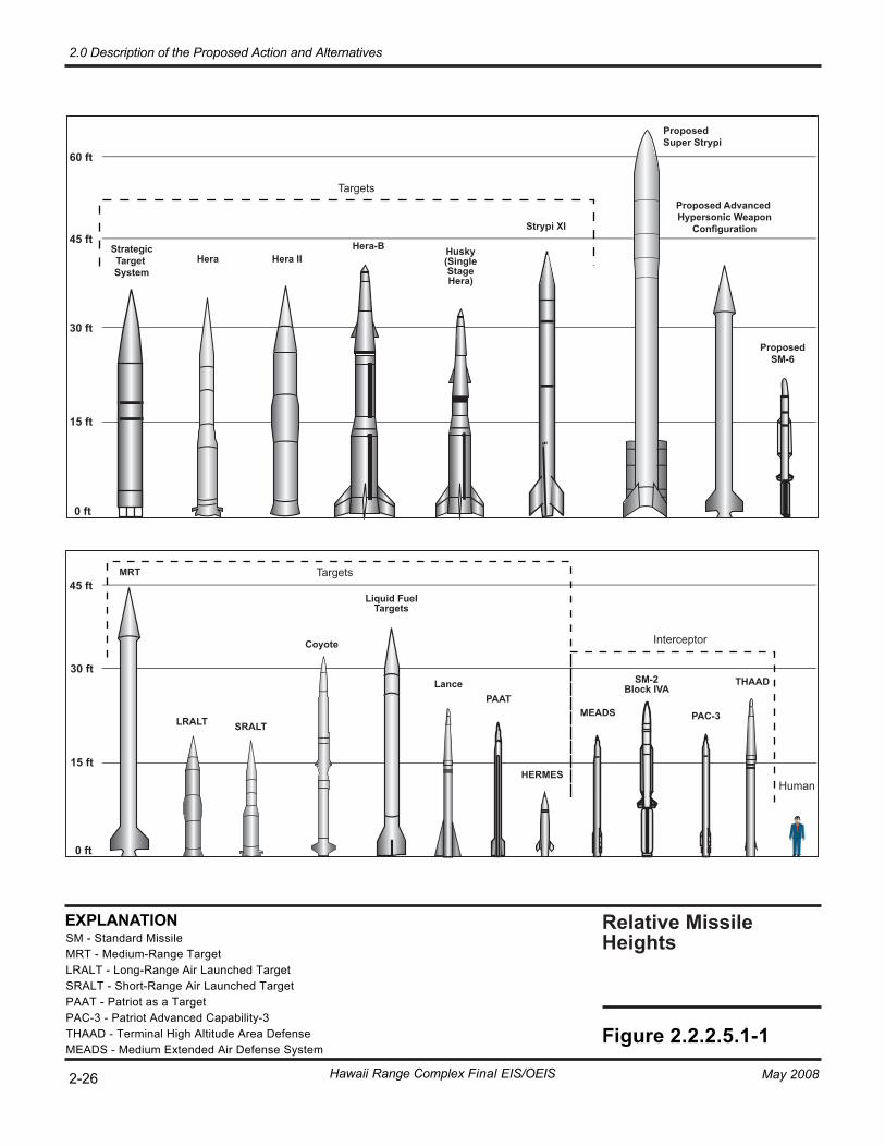
Relative Missile Heights
Hera-B
Strypi XI
LancePAAT
PAC-3MEADS
HERMESHuman
Interceptor
THAAD
Husky(SingleStageHera)
StrategicTarget System
ProposedSM-6
SM-2Block IVA
2-26
Figure 2.2.2.5.1-1
Liquid FuelTargets
SRALT
Hera
MRT
Proposed Advanced Hypersonic Weapon
Configuration
Hera II
LRALT
0 ft
15 ft
30 ft
45 ft
45 ft
60 ft
0 ft
15 ft
30 ft
Hawaii Range Complex Final EIS/OEIS
2.0 Description of the Proposed Action and Alternatives
May 2008
EXPLANATIONSM - Standard MissileMRT - Medium-Range TargetLRALT - Long-Range Air Launched TargetSRALT - Short-Range Air Launched TargetPAAT - Patriot as a TargetPAC-3 - Patriot Advanced Capability-3THAAD - Terminal High Altitude Area DefenseMEADS - Medium Extended Air Defense System
Coyote
ProposedSuper Strypi
Targets
Targets
2.0 Description of the Proposed Action and Alternatives
May 2008 Hawaii Range Complex Final EIS/OEIS 2-27
missile defense systems at PMRF. These systems use both solid and liquid propellants. Defensive missile payloads may be equipped with divert and attitude control propulsion systems that control the payload after separation from the launch vehicle. Divert and attitude control systems may use small liquid hypergolic propellant systems or consist of miniature solid-propellant rocket motors.
Anti-Air Warfare RDT&E AAW RDT&E activities involve testing and training on Aegis-capable ships after refurbishment or overhaul. Aegis Ballistic Missile Defense (BMD) activities involve testing and evaluating the ship’s missile system and associated hardware in support of the ship’s missile defense mission. An additional RDT&E activity for Aegis ships is the waterfront integration test (WIT), which simulates events that take place during the on range Aegis BMD activities. WIT ensures that all shipboard systems are operable. AAW RDT&E activities may include missile and gunnery ordnance and active sonar.
Anti-Submarine Warfare Test and Evaluation ASW test and evaluation activities at PMRF include sensor, fire control, and weapon testing. PMRF Submarine Tracking Systems involve using this system to evaluate MK-30 system upgrades. The MK-30 target is a self-propelled underwater vehicle capable of simulating the dynamic, acoustic, and magnetic characteristics of a submarine. The Navy uses in-water submarine simulators such as the MK-30 ASW target. The MK-30 target fulfills the need for a convenient, cost-effective means for operational training of Fleet units. Submarine system evaluation activities conducted in submarine training areas near Maui are also part of ASW test and evaluation activities. The submarine’s main active sonar system is not used; however, tracking pingers are a source of underwater sound during ASW test and evaluation activities.
Combat System Ship Qualification Trial Combat System Ship Qualification Trial (CSSQT) activities are performed at PMRF and are categorized as test and evaluation activities. CSSQT is an at-sea test conducted for new ships and for ships that have undergone modification and/or overhaul of their combat systems. Although CSSQT can vary from ship to ship as requirements dictate, the primary goals are to ensure that the ship’s equipment and combat systems are in top operational condition, and that the ship’s crew is proficient at operating these systems. Therefore, CSSQT can include operating any or all of a ship’s combat systems and may include firing missiles and conducting gunnery exercises.
Electronic Combat/Electronic Warfare Electronic Combat/Electronic Warfare (EC/EW) activities include tests designed to assess how well EC/EW training events are performed. The EC/EW activities, which occur typically in W-188, are monitored at PMRF shore sites. No ordnance is used during these RDT&E activities.
High-Frequency Radio Signals High-frequency test and evaluation activities include the use of high-frequency radio signals and the evaluation of their effectiveness. High frequency in the radio spectrum refers to frequencies between 3 megahertz (MHz) and 30 MHz. This frequency range is commonly used for maritime
2.0 Description of the Proposed Action and Alternatives
2-28 Hawaii Range Complex Final EIS/OEIS May 2008
and amateur short-wave radio transmissions. These activities can take place both at PMRF shore sites and within W-188. No ordnance is used during these test and evaluation activities.
Joint Task Force Wide Area Relay Network Joint Task Force Wide Area Relay Network (JTF WARNET) is a demonstration of advanced Command, Control and Communications (C3) technologies in a highly mobile, wireless, wide-area relay network in support of tactical forces. The objective of a network of this type is to link tactical forces, providing a common operating picture. Although similar in function to a common internet setting, JTF WARNET demonstrates this capability in a very austere battlefield environment, without the luxury of existing communication systems. In addition, the network must be capable of transmitting classified information. JTF WARNET testing evaluates joint and allied C3 decision-making, planning and execution, and tactical capability. These tests are monitored at PMRF shore facilities. No ordnance is used.
Missile Defense Figure 2.2.2.5.1-2 shows the existing launch facilities at PMRF and the Kauai Test Facility (KTF). Figure 2.2.2.5.1-3 shows the existing missile flight corridors. Aerial targets are launched from PMRF, mobile sea-based platforms, or military cargo aircraft. During missile defense RDT&E activities, a ballistic missile target vehicle is launched from PMRF and intercepted by a ship-launched missile (Figure 2.2.2.5.1-4). No ordnance is used during these events. The test activities can involve:
• Aegis equipped classes of ships (destroyers and cruisers)
• Use of the mobile and airborne range safety systems
• On-load and off-load of aircraft
• Long-Range and Short-Range Air Launched Targets
• Smart Test Vehicle
• Light Detection and Ranging
• Mobile At-Sea Sensor System
• Use of the Battle Management Interoperability Center
• Transportation of liquid propellants to PMRF
• Flight Termination System preparations for an operation
• Dry runs and dress rehearsals for specific missile defense activities
The Army’s Terminal High Altitude Area Defense (THAAD) is part of the DoD Ballistic Missile Defense System. THAAD is the antimissile system designed to intercept and destroy missiles in the final phase of their trajectories. THAAD PMRF test activities include midcourse tracking of ballistic missiles using the THAAD radar (two THAAD radars may be operated concurrently at PMRF during interceptor testing), Coherent Signal Processing radar, telemetry, C-Band precision radars, and Mobile At-Sea Sensor System. THAAD differs from other missile defense testing in that THAAD scenarios involve the target vehicle being launched outside of PMRF from a mobile launch platform, with the THAAD interceptor launched from an existing launch pad at PMRF (Figure 2.2.2.5.1-2). The intercept occurs in the TOA.
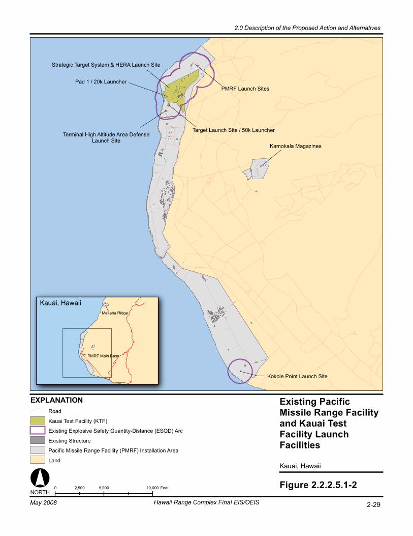
Existing PacificMissile Range Facilityand Kauai TestFacility LaunchFacilities
Kauai, Hawaii
0 5,000 10,0002,500 Feet
Terminal High Altitude Area DefenseLaunch Site
Strategic Target System & HERA Launch Site
EXPLANATION
Figure 2.2.2.5.1-2
Target Launch Site / 50k Launcher
Kauai, HawaiiMakaha Ridge
Pad 1 / 20k Launcher
NORTH
Kokole Point Launch Site
PMRF Launch Sites
PMRF Main Base
Kamokala Magazines
Land
Pacific Missile Range Facility (PMRF) Installation Area
Road
Existing Explosive Safety Quantity-Distance (ESQD) Arc
Existing Structure
Kauai Test Facility (KTF)
2-29Hawaii Range Complex Final EIS/OEIS
2.0 Description of the Proposed Action and Alternatives
May 2008
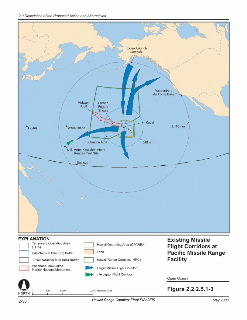
Wa ke I sl an d G uam
Eq ua to r
Existing Mi ssi le Fl ight C or ridor s at Pacific Missile Ran ge F aci li ty
Op en O ce an
Fi gur e 2. 2. 2. 5.1- 3 0 1 ,000 2, 000 50 0 N au ti ca l Mi le s
64 8 n m
2,1 60 n m
NORT H
EX PL ANA TI ON
Va nd en be rg Air Fo rc e Ba se
Ko di ak L au nc h Co mp le x
Mi dw ay At ol l
Jo hn st on A to ll
Ka ua i
G uam
U.S. A rm y Kw aj al ei n At ol l / Reagan Test Site
Pa pa hā nau mo ku āk ea Ma ri ne N at io nal M on um en t
Ha wa ii Ran ge C om pl ex (HRC)
La nd
Fren ch Frig at e Sh oa ls
Te m por ar y Op er at in g Ar ea (T OA )
Ha wa ii Operating Area (OPAREA)
Target Missile Flight Corridor
Interceptor Flight Corridor
2-30 May 2008Hawaii Range Complex Final EIS/OEIS
2.0 Description of the Proposed Action and Alternatives
648-Nautical Mile (nm) Buffer
2,160-Nautical Mile (nm) Buffer

Fi gur e 2. 2. 2. 5.1- 4
Hawaiia n Isl and s
Pacific Missile Ran ge F aci li ty O pe n O cea n Conc eptu al I nt erce pt Scenarios - Se a
0 2 00 40 0 10 0 N au ti ca l Mi le s
EX PL ANA TI ON
NORT H
Jo hn st on A to ll
La nd T ar ge t (P MR F)
Air or S ea Ta rg et
P ap ah ā nau mo ku āk ea Ma ri ne N at io nal M on um en t
Air or S ea T ar ge t Warning Area
La nd
P MR F - P ac if ic M is si le R an ge F ac i lit y
Se a Inte rc ep to r
Da ta E xch an ge
P ap ah ā nau mo ku āk ea Ma ri ne N at io nal M on um en t
Ha wa ii O pe ra ti ng A re a (OP AR EA )
Se a In te rc ept or / D at a Ex c han ge
12 -N au ti ca l Mi le L in e
1 79W 43N
1 79W 16N
1 50W 43N
1 50W 28N
Te m por ar y Op er at i ng Ar ea
W- 188 Mi dway A to ll
J ohns ton At ol l K auai
Te m por ar y Op er at in g Ar ea ( TO A)
Ha wa ii Ran ge C om pl ex (HRC)
2-31May 2008 Hawaii Range Complex Final EIS/OEIS
2.0 Description of the Proposed Action and Alternatives
French Frigate Shoals
2.0 Description of the Proposed Action and Alternatives
2-32 Hawaii Range Complex Final EIS/OEIS May 2008
Other RDT&E associated missile defense activities include preparing security, range instrumentation and communications checks, radar calibrations, and range surveillance/ clearance.
As part of the required clearance before an activity, the target area must be inspected visually and determined to be clear. Range Control is charged with hazard area surveillance and clearance and the control of all range operational areas. Figures 2.2.2.5.1-4 and 2.2.2.5.1-5 depict the range areas associated with two conceptual missile defense scenarios. The PMRF Range Control Officer is solely responsible for determining range status and setting RED (no firing) and GREEN (range is clear and support units are ready to begin the event) range firing conditions. The Range Control Officer coordinates the control of PMRF airspace, with the FAA and other military users, often on a real-time basis.
The Range Control Officer communicates with the training events conductors and all participants entering and leaving the range areas. The Range Control Officer also communicates with other agencies such as the FAA Air Route Traffic Control Center in Honolulu, the PMRF/Main Base airfield control tower, the 154th Air Control Squadron at Kokee, and the Fleet Area Control and Surveillance Facility at Ford Island, Pearl Harbor.
2.2.2.5.2 Naval Undersea Warfare Center Ranges RDT&E activities take place at the NUWC ranges in Hawaii (Figure 2.2.2.5.2-1). The Shipboard Electronic Systems Evaluation Facilities (SESEF) range, located off Barbers Point on Oahu, provides state-of-the-art test and evaluation of combat systems that radiate or receive electromagnetic energy. The SESEF range includes land based test facilities established to provide electromagnetic system test and evaluation services to afloat and shore commands. SESEF services can be used for the development of new and upgraded systems, and provide a real-time evaluation of a system in an operational environment.
The Fleet Operational Readiness Accuracy Check Site (FORACS) range control is located near Nanakuli, Oahu. The electronic equipment at this site checks range and bearing accuracy for Navy and Coast Guard ships to ensure equipment function and calibration.
SESEF Tests SESEF tests are conducted to evaluate ship, shore, and aircraft systems that emit or detect electronic emissions. These systems include those used for radio communications, data transfer, navigation, radar, and systems that identify friend and foe. Depending on the system being evaluated, either the tested site, the SESEF, or both will transmit electronic signals in or near the radio frequency band of the electromagnetic spectrum. Specific frequencies and power settings are dependent on the type of test being conducted. The test equipment operated by SESEF allows for a performance evaluation of the ship, shore, or aircraft system. Tests conducted by SESEF fall into one of two broad categories: Quick Look and System Performance tests. Neither SESEF test uses ordnance or sonar.
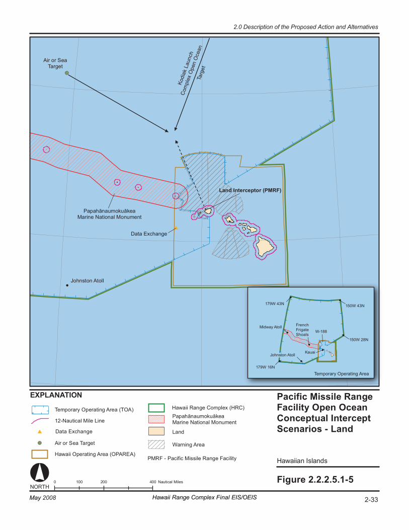
Fi gur e 2. 2. 2. 5.1- 5
Hawaiia n Isl and s
Pacific Missile Ran ge F aci li ty O pe n O cea n Conc eptu al I nt erce pt Scenarios - Land
0 2 00 40 0 10 0 N au ti ca l Mi le s
EX PL ANA TI ON
NORT H
1 79W 43N
1 79W 16N
1 50W 43N
1 50W 28N
Te mp or ar y Op er at i ng Ar ea
W- 188 Mi dway A to ll
J ohns ton At ol l K auai
Jo hn st on A to ll
La nd I nt er ce pt or ( PM RF )
Air or S ea Ta rg et
Pa p ah ā nau mo ku āk ea Ma ri ne N at io nal M on um en t
Air or S ea T ar ge t
Ko di
ak L
au nc
h
Co m
p le x
Op e
n O
ce an
Ta
rg et
PM RF - P ac if ic M is si le R an ge F ac i lit y Ha wa ii O p er at in g Ar ea ( OP AR EA )
Pa p ah ā nau mo ku āk ea Ma ri ne N at io nal M on um en t 12 -N au ti ca l Mi le L in e
Te mp or ar y Op er at in g Ar ea ( TO A) Ha wa ii Ran ge C omp le x (HRC)
La nd
Warning Area
2-33May 2008 Hawaii Range Complex Final EIS/OEIS
2.0 Description of the Proposed Action and Alternatives
Data Exchange
French Frigate Shoals
Data Exchange

Naval UnderseaWarfare CenterRanges
Oahu, Hawaii
Figure 2.2.2.5.2-10 2 41 Nautical MilesNORTH
EXPLANATION
Coast Guard StationBarbers Point / Kalaeloa Airport
SESEF Hawaii Range
FORACS Range
Oahu, Hawaii
Makua Military Reservation
FORACS Range Control93
Land
Installation Area
Road
Puuloa UnderwaterRange
Ewa Training Minefield
Barbers PointUnderwater Range
Naval DefensiveSea Area
Puuloa Underwater Range
Ewa Training Minefield
Fleet Operational Readiness AccuracyCheck Site (FORACS) RangeShipboard Electronic Systems EvaluationFacility (SESEF) Hawaii Range
Naval Defensive Sea Area
3-Nautical Mile Line
12-Nautical Mile Line
Barbers Point Underwater Range
2-34 Hawaii Range Complex Final EIS/OEIS
2.0 Description of the Proposed Action and Alternatives
May 2008
2.0 Description of the Proposed Action and Alternatives
May 2008 Hawaii Range Complex Final EIS/OEIS 2-35
Quick Look tests are generally conducted during transit to and from port, or while pier side at Pearl Harbor. These tests provide the ship a quick operational evaluation of the system(s) being tested with a simple “SAT or UNSAT” grade along with any detected system anomalies or problems. An example is a radio check that confirms that a ship’s radio can both transmit and receive voice communications. Quick Look tests have the following characteristics:
• Generally short in duration
• Require little or no advance scheduling
• Require little or no shipboard maneuvering
• May be accomplished pier side (Communications, LINK-4A and LINK-11 only)
• Require minimal internal shipboard coordination System performance testing provides the ship with a more-detailed analysis and evaluation of the system(s) under test. The testing requirements and the desired measurement precision dictate a higher degree of control on the ship and coordination of its personnel. System performance tests are characterized as tests which:
• Generally require longer periods of dedicated testing
• Require advance scheduling and coordination with SESEF
• Require the ship to maneuver in pre-defined geometries within a certain geographic area; and
• Require internal shipboard coordination
FORACS Tests The purpose of the FORACS tests is to provide accuracy checks of ship and submarine sonar, both in active and passive modes, and to evaluate the accuracy of a ship’s radar. The ship will conduct a series of “runs” on the range, each taking approximately 1.5 hours. Both active and passive sonar can be checked on a single run. During a run, the ship will approach the target, a stationary underwater acoustic transducer located offshore, making a slow turn to eventually track outbound from the target, establishing a bearing to the target in use. This information is compared with the known bearing by FORACS range technicians stationed onboard the ship. During active sonar testing, range-to-target information is also evaluated. No ordnance is used. Active sonar is used. Examples of specific FORACS tests are:
• Surface Weapons System Accuracy Trial (SURFSAT)—both an acoustic and a Radio Frequency accuracy evaluation for a surface ship’s radar.
• At-Sea Bearing Accuracy Test—a test of a ship’s radar alone.
• Submarine Warfare System Assessment (SWSA)—an assessment of a submarine’s radar and sonar. The SWSA is similar to the SURFSAT, but is only for submarines.
• Undersea Warfare Readiness Evaluation Facility (USWREF)—a test of a ship’s radar and sonar. The USWREF is similar to, but less involved than, the SURFSAT or SWSA.
2.0 Description of the Proposed Action and Alternatives
2-36 Hawaii Range Complex Final EIS/OEIS May 2008
2.2.2.6 MAJOR EXERCISES FOR THE NO-ACTION ALTERNATIVE Types of Major Exercises that occur within the HRC include RIMPAC and USWEX. Table 2.2.2.6-1 shows the matrix of individual training events and RDT&E activities that could be included in a Major Exercise. Figure 2.2.2.6-1 shows the HRC OPAREA where these training events occur. The training and RDT&E activities that make up a Major Exercise are typically unit-level training, conducted under the umbrella of a large, coordinated event. These are the same training and RDT&E activities conducted throughout the year in Hawaii. During a Major Exercise, an additional C2 element is introduced which requires that units conduct and demonstrate multiple warfare capabilities (e.g., ASW).
Each of these exercises has at least one Strike Group at its center. A Strike Group is a naval force comprising one or more capital ships, such as an aircraft carrier. Several surface combatant ships such as cruisers, frigates, and destroyers; and one or more attack submarines, usually accompany the capital ship to complete the Strike Group.
Although multiple ships and aircraft may be participating in a simultaneous event, they commonly operate at significant distances from one another, usually not in sight of other participants. The vastness of the HRC allows multiple ships to operate, without creating a high density footprint in any discrete area.
ASW training conducted during RIMPAC and USWEX utilizes ships, submarines, aircraft, non-explosive exercise weapons, and other training systems and devices. The ASW training described here and in Table 2.2.2.1-1 includes both passive and active sonar use. This EIS/OEIS includes an acoustic exposure effects-analysis on marine mammals that may be affected by the RIMPAC and USWEX ASW training events and use of MFA tactical sonar.
Nearly all ASW training would occur in the eight sonar modeling areas delineated in Figure 2.2.2.6-1. ASW events could occur throughout the approximate 235,000 nm2 of the Hawaii OPAREA; however, the approximately 55,000 nm2 of these eight areas, were used for analysis as being representative of the marine mammal habitats and the bathymetric, seabed, wind speed, and sound velocity profile conditions within the entire Hawaiian Islands OPAREA. Sonar modeling included the AN/SQS-53 and AN/SQS-56 surface ship sonar, the AN/AQS-22 helicopter dipping sonar, the AN/SSQ-62 sonobuoy sonar, and the MK-48 torpedo sonar. Submarine sonar was not modeled for RIMPAC and USWEX because it is not used during these events.
2.2.2.6.1 Rim of the Pacific The RIMPAC Exercise, dating back to 1968, is conducted biennially in the Hawaiian OPAREA. Consisting of the Navy, Army, Marine Corps and Air Force with Pacific Rim armed forces, RIMPAC enhances the ability of Pacific Rim armed forces to communicate effectively, understand the capabilities and limitations of each others’ forces, and be able to execute the employment of forces quickly and precisely. This promotes stability in the region to the benefit of all participating nations.
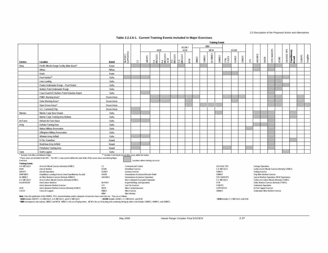
2.0 Description of the Proposed Action and Alternatives
May 2008 Hawaii Range Complex Final EIS/OEIS 2-37
Table 2.2.2.6-1. Current Training Events Included in Major Exercises Training Events
Service Location Island IN-P
ORT/
SU
PPOR
TEX
C2
AAW ASUW /
ASW MIW
ASUW
LFX
HAO
/NEO
HA/
DR
SPE
CWAR
OPS
DEM
O
SAL
VAGE
OPS
Exp
editi
onar
y As
saul
t
SUB
OPS
Sea
glide
r
MCM
AIR
OPS
S-A
MISS
ILEX
A-A
MISS
ILEX/
A
CM
A-S
MI
SSILE
X
S-S
MI
SSILE
X
ASW
MIN
EX
SMW
EX
Air M
IWEX
UMW
EX
STW
, C
ASEX
GUN
EX
SIN
KEX
Navy Pacific Missile Range Facility (Main Base)* Kauai Niihau Niihau Kaula Kaula Pearl Harbor** Oahu Lima Landing Oahu Puuloa Underwater Range – Pearl Harbor Oahu Barbers Point Underwater Range Oahu Coast Guard AS Barbers Point/ Kalaeloa Airport Oahu PMRF Warning Areas# Ocean Areas Oahu Warning Areas# Ocean Areas Open Ocean Areas# Ocean Areas U.S. Command Ship Ocean Areas Marines Marine Corps Base Hawaii Oahu Marine Corps Training Area Bellows Oahu Air Force Hickam Air Force Base Oahu Army Kahuku Training Area Oahu Makua Military Reservation Oahu Dillingham Military Reservation Oahu Wheeler Army Airfield Oahu K-Pier, Kawaihae Hawaii Bradshaw Army Airfield Hawaii Pohakuloa Training Area Hawaii State Keehi Lagoon Oahu * Includes Port Allen and Makaha Ridge ** Includes Ford Island and all other areas within the harbor. # These areas are included in the HRC. The HRC is now used to define the outer limits of the ocean areas used during Major Exercises. Locations where training can occur Training Events: A-A MISSILEX Air-to-Air Missile Exercise (formerly AAMEX) C2 Command and Control SALVAGE OPS Salvage Operations AAW1 Anti-air Warfare DEMO Demolition Exercise S-A MISSILEX Surface-to-Air Missile Exercise (formerly SAMEX) AIROPS Aircraft Operations GUNEX Gunnery Exercise SINKEX Sinking Exercise AMPHIBEX Amphibious Landing Exercise (now Expeditionary Assault) HA/DR Humanitarian Assistance/Disaster Relief SMWEX Ship Mine Warfare Exercise Air MIWEX Air Mine Warfare Exercise (formerly AMWEX) HAO/NEO Humanitarian Assistance Operation/ SPECWAROPS Special Warfare Operations (NSW Operations) A-S MISSILEX Air-to-Surface Missile Exercise (formerly ASMEX) Non-Combatant Evacuation Operation S-S MISSILEX Surface-to-Surface Missile (formerly SSMEX) ASUW2/ASW3 Anti-Surface Warfare/ IN-PORT In-port Briefings and Operations STW Strike Warfare Exercise (formerly STWEX) Anti-Submarine Warfare Exercise LFX Live Fire Exercise SUBOPS Submarine Operations ASW Anti-Submarine Warfare Exercise (formerly ASWEX) MCM Mine Countermeasures SUPPORTEX In-Port Support Exercise CASEX Close Air Support MINEX Mine Exercise UMWEX Underwater Mine Warfare Exercise MIW4 Mine Warfare Note: Since the publication of the RIMPAC PEA, new terminology and/or categories of exercises have come into use. They are as follows: 1 AAW includes AIROPS, S-A MISSILEX, A-A MISSILEX, and A-S MISSILEX 2 ASUW includes GUNEX, S-S MISSILEX, and ASW 3 ASW includes S-S MISSILEX and ASW 4 MIW encompasses two subsets, MINEX and MCM. MINEX is the act of laying mines. MCM is the act of locating and countering mining by others and includes SMWEX, AMWEX, and UMWEX.
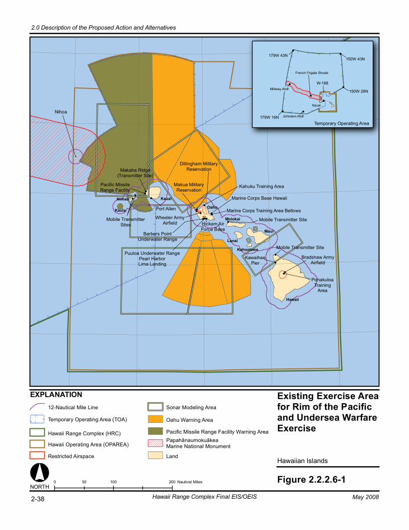
Existing Exercise Areafor Rim of the Pacificand Undersea WarfareExercise
Hawaiian Islands
Figure 2.2.2.6-10 100 20050 Nautical Miles
179W 43N
179W 16N
150W 43N
150W 28N
Temporary Operating Area
W-188
Hawaii
Maui
Oahu
Kauai
Kaula
NORTH
Niihau
Molokai
Lanai
Kahoolawe
Makaha Ridge(Transmitter Site)
Pacific MissileRange Facility
Mobile TransmitterSites
Port Allen
Wheeler ArmyAirfield
Barbers PointUnderwater Range
Puuloa Underwater RangePearl HarborLima Landing
Hickam AirForce Base
Makua MilitaryReservation
Dillingham MilitaryReservation
Kahuku Training Area
Marine Corps Base Hawaii
Marine Corps Training Area Bellows
Mobile Transmitter Site
Mobile Transmitter Site
KawaihaePier
Bradshaw ArmyAirfield
PohakuloaTraining
Area
Midway Atoll
Johnston Atoll
Kauai
EXPLANATION
Nihoa
12-Nautical Mile Line
Hawaii Operating Area (OPAREA)
Restricted Airspace
Sonar Modeling Area
PapahānaumokuākeaMarine National Monument
Land
Pacific Missile Range Facility Warning Area
Oahu Warning Area
Hawaii Range Complex (HRC)
Temporary Operating Area (TOA)
2-38 Hawaii Range Complex Final EIS/OEIS
2.0 Description of the Proposed Action and Alternatives
May 2008
French Frigate Shoals

2.0 Description of the Proposed Action and Alternatives
May 2008 Hawaii Range Complex Final EIS/OEIS 2-39
Conducted on existing Army, Marine Corps, Army PMRF ranges, open ocean, and offshore, the month-long RIMPAC Exercise is different from exercises conducted offshore of southern California in several important ways. RIMPAC’s focus on multi-national training is very different from other exercises conducted to certify U.S. Strike Groups for deployment. RIMPAC offers the only opportunity for military forces from both the Western and Eastern Pacific to train together in scripted, but realistic, scenarios, and in that regard is a vital training exercise.
A Programmatic EA for RIMPAC was completed in 2002, and supplemental EAs were prepared in 2004 and 2006. The 2004 Supplement to the RIMPAC Programmatic EA was prepared to evaluate the additional RIMPAC training proposed for 2004 not covered by the RIMPAC Programmatic EA. The 2004 Supplement examined new installations or facilities proposed for use, whether significantly different training levels or types of equipment were proposed, and whether environmental conditions had changed. The following events were evaluated in the 2004 Supplement:
• Gunnery Exercises (GUNEX) at PMRF Barking Sands Tactical Underwater Range (BARSTUR)
• Mine Countermeasures (MCM) at Marine Corps Training Area/Bellows (MCTAB), Oahu; Open Ocean Areas, Hawaiian Islands between Molokai, Lanai, and Maui, (including Penguin Bank and the Navy’s shallow water training area south of Maui)
• Demolition at Land/Underwater Demolition Range, Naval Magazine Pearl Harbor, West Loch Branch, Oahu; Naval Inactive Ship Maintenance Facility, Middle Loch, Pearl Harbor, Oahu
The 2006 Supplement to the RIMPAC Programmatic EA also included an assessment of a Non-combatant Evacuation Operation (NEO) training event at PMRF and on Niihau and additional analysis related to MFA sonar. The training analyzed was the same as previously analyzed and had taken place with no significant changes over the previous 19 RIMPAC Exercises. Appendix D shows the matrix of training events used during previous RIMPAC Exercises by location.
For RIMPAC under the No-action Alternative, the marine mammal exposure modeling included 532 hours of AN/SQS-53 and AN/SQS-56 surface ship sonar and associated dipping sonar, sonobuoys, and MK-48 torpedoes.
2.2.2.6.2 Undersea Warfare Exercise The USWEX is an assessment-based ASW exercise conducted by the Strike Groups while in transit from the west coast of the United States to the Western Pacific Ocean. USWEX is considered a “graduate” level assessment focused on ASW warfare and composed of more complex ASW scenarios that can be magnified in scale by adding increased numbers of adversary submarine threats to the training scenario. USWEX is invaluable to Strike Groups as they prepare to execute existing war plans, if necessary. In preparing for these missions, USWEX provides an extremely valuable opportunity to conduct ASW in a very realistic environment, against the level of threat expected in order to effect changes in both training and capabilities, such as tactics, equipment, size and manning of the Strike Group. Since the ability to operate MFA sonar as part of ASW is a highly perishable skill, losing the opportunities a USWEX provides will cause ASW personnel to suffer in the proficiency level and skills they

2.0 Description of the Proposed Action and Alternatives
2-40 Hawaii Range Complex Final EIS/OEIS May 2008
have acquired right before they face real world events on deployment. USWEXs are designed to enable a Strike Group to maintain proficiency of its ASW skills during deployment. USWEX also allows the Navy to separately “assess” the ASW capabilities of a fully ready Strike Group to improve all future ASW training exercises.
A Programmatic Environmental Assessment/Overseas Environmental Assessment (EA/OEA) for USWEX in Hawaii was completed in January 2007.
For USWEX under the No-action Alternative, the marine mammal exposure modeling included 700 hours of AN/SQS-53 and AN/SQS-56 surface ship sonar plus associated dipping sonar, and sonobuoys.
2.2.2.7 MITIGATION MEASURES FOR THE NO-ACTION ALTERNATIVE
Under the No-action Alternative, the Navy’s marine mammal mitigation measures will continue to be implemented. Chapter 6.0 presents these mitigation measures, outlining steps that are currently implemented to protect marine mammals and federally-listed species.
2.2.3 ALTERNATIVE 1 2.2.3.1 TRAINING EVENTS FOR ALTERNATIVE 1 Alternative 1 includes all ongoing Navy training associated with the No-action Alternative (as described in Section 2.2.2), and proposes an increased number of such training events. Table 2.2.2.3-1 includes the number of Navy training events associated with the No-action Alternative and the proposed number of events under Alternative 1.
2.2.3.2 MFA/HFA SONAR USAGE FOR ALTERNATIVE 1 Table 2.2.3.2-1 lists MFA/HFA sonar usage analyzed for Alternative 1. Sonar usage is based on SPORTS data and operator input.
Table 2.2.3.2-1. Sonar Usage for Alternative 1 Supplement to the Draft EIS/OEIS Hours/
Events Modeled Other HRC ASW Training Source Modeled
53 360 hours 56 75 hours Dipping 117 dips Sonobuoy 1,355 buoys MK-48 309 runs Submarine 200 hours
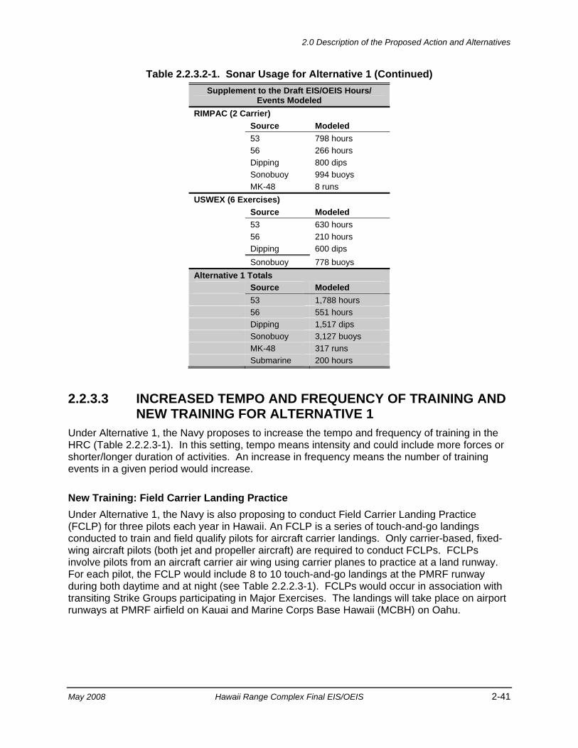
2.0 Description of the Proposed Action and Alternatives
May 2008 Hawaii Range Complex Final EIS/OEIS 2-41
Table 2.2.3.2-1. Sonar Usage for Alternative 1 (Continued) Supplement to the Draft EIS/OEIS Hours/
Events Modeled RIMPAC (2 Carrier) Source Modeled 53 798 hours 56 266 hours Dipping 800 dips Sonobuoy 994 buoys MK-48 8 runs USWEX (6 Exercises) Source Modeled 53 630 hours 56 210 hours Dipping 600 dips Sonobuoy 778 buoys Alternative 1 Totals Source Modeled 53 1,788 hours 56 551 hours Dipping 1,517 dips Sonobuoy 3,127 buoys MK-48 317 runs Submarine 200 hours
2.2.3.3 INCREASED TEMPO AND FREQUENCY OF TRAINING AND NEW TRAINING FOR ALTERNATIVE 1
Under Alternative 1, the Navy proposes to increase the tempo and frequency of training in the HRC (Table 2.2.2.3-1). In this setting, tempo means intensity and could include more forces or shorter/longer duration of activities. An increase in frequency means the number of training events in a given period would increase.
New Training: Field Carrier Landing Practice Under Alternative 1, the Navy is also proposing to conduct Field Carrier Landing Practice (FCLP) for three pilots each year in Hawaii. An FCLP is a series of touch-and-go landings conducted to train and field qualify pilots for aircraft carrier landings. Only carrier-based, fixed-wing aircraft pilots (both jet and propeller aircraft) are required to conduct FCLPs. FCLPs involve pilots from an aircraft carrier air wing using carrier planes to practice at a land runway. For each pilot, the FCLP would include 8 to 10 touch-and-go landings at the PMRF runway during both daytime and at night (see Table 2.2.2.3-1). FCLPs would occur in association with transiting Strike Groups participating in Major Exercises. The landings will take place on airport runways at PMRF airfield on Kauai and Marine Corps Base Hawaii (MCBH) on Oahu.
2.0 Description of the Proposed Action and Alternatives
2-42 Hawaii Range Complex Final EIS/OEIS May 2008
2.2.3.4 ENHANCED RDT&E ACTIVITIES FOR ALTERNATIVE 1 The Navy proposes to enhance its RDT&E activities from current levels as necessary as shown in Table 2.2.2.5-1. Enhanced RDT&E could include activities such as additional AAW RDT&E activities involving Aegis-capable ships, EC/EW activities, and SESEF tests to evaluate ship, shore, and aircraft systems.
2.2.3.5 FUTURE RDT&E ACTIVITIES FOR ALTERNATIVE 1 Additional Chemical Simulant The purpose of using chemical simulants in ballistic missile target vehicles is to assess the effectiveness of defensive missiles against threat missiles carrying chemical agents as payloads. To adequately emulate this threat in testing, it is necessary to use materials that are similar to the physical characteristics of actual chemical agents, but without the toxic effects. Use of actual chemical agents in testing would present the potential for unacceptable hazards, thus the need for simulants.
Target launches from PMRF would incorporate additional chemical simulants to include larger quantities of tributyl phosphate (TBP) and various glycols. The list of potential glycols would include glyceryl tributyrate, propylene glycol, diethyl phthalate, polyethylene glycol, triethylene glycol, diethyl decanedioate, dibenzyl ether, dibutyl phthalate, di(2-ethylhexyl) phthalate, diethylene glycol, and polypropylene glycol 425. The top three preferred simulants would be TBP, glyceryl tributyrate, and propylene glycol. TBP is typically used as a solvent for lacquers and natural gums, as a primary plasticizer in the manufacture of plastics and vinyl resins and as an antifoam agent. Primary uses for glyceryl tributyrate are a synthetic flavoring substance and a plasticizer. Propylene glycol is a substance used in foods, cosmetic products, and pharmaceutical creams to help retain moisture.
Approximately 120 gallons (gal) of simulant would be used in target vehicles launched from PMRF. The simulant would be transported from the continental United States to PMRF with the target vehicle and would be loaded into the target vehicle payload as part of the payload processing activities.
Intercept Targets Launched Into the TOA Individual launches from Wake Island, the Reagan Test Site at U.S. Army Kwajalein Atoll, or Vandenberg AFB would be intercepted in the TOA (Figure 2.2.3.5-1). PMRF Range Control would manage these interceptor activities. Launches from those sites would be from existing launch facilities, and no new boosters from these sites are proposed. Targets would also continue to be launched from sea-based and air-based platforms as analyzed in previous environmental documents.
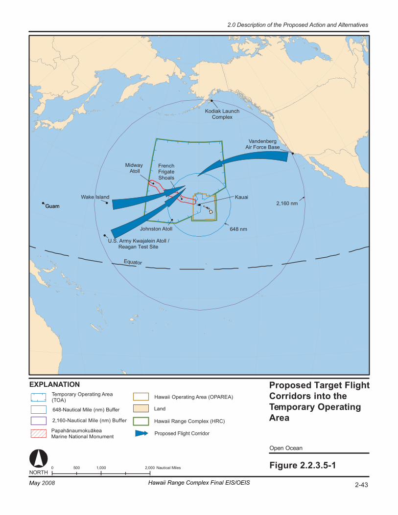
Wa ke I sl an d
G uam
Eq ua to r
Op en O ce an
Fi gur e 2. 2. 3. 5-1 0 1 ,000 2, 000 50 0 N au ti ca l Mi le s
64 8 n m
2,1 60 n m
NORT H
EX PL ANA TI ON
Va nd en be rg Air Fo rc e Ba se
Ko di ak L au nc h Co mp le x
Mi dw ay At ol l
Jo hn st on A to ll
Ka ua i
G uam
U.S. A rm y Kw aj al ei n At ol l / Reagan Test Site
Pa pa hā nau mo ku āk ea Ma ri ne N at io nal M on um en t
Ha wa ii Ran ge C om pl ex (HRC)
La nd
Fren ch Frig at e Sh oa ls
Te m por ar y Op er at in g Ar ea (T OA ) Ha wa ii Operating Area (OPAREA)
Proposed Flight Corridor
2-43May 2008 Hawaii Range Complex Final EIS/OEIS
2.0 Description of the Proposed Action and Alternatives
648-Nautical Mile (nm) Buffer
2,160-Nautical Mile (nm) Buffer
Proposed Target Flight Corridors into the Temporary Operating Area
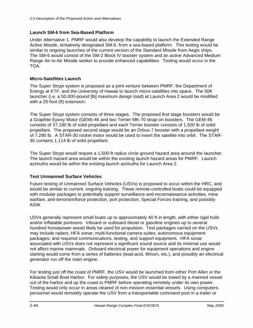
2.0 Description of the Proposed Action and Alternatives
2-44 Hawaii Range Complex Final EIS/OEIS May 2008
Launch SM-6 from Sea-Based Platform Under Alternative 1, PMRF would also develop the capability to launch the Extended Range Active Missile, tentatively designated SM-6, from a sea-based platform. This testing would be similar to ongoing launches of the current version of the Standard Missile from Aegis ships. The SM-6 would consist of the SM-2 Block IV booster system and an active Advanced Medium Range Air-to-Air Missile seeker to provide enhanced capabilities. Testing would occur in the TOA.
Micro-Satellites Launch The Super Strypi system is proposed as a joint venture between PMRF, the Department of Energy at KTF, and the University of Hawaii to launch micro-satellites into space. The 50K launcher (i.e. a 50,000-pound [lb] maximum design load) at Launch Area 2 would be modified with a 25-foot (ft) extension.
The Super Strypi system consists of three stages. The proposed first stage boosters would be a Graphite Epoxy Motor (GEM)-46 and two Terrier MK-70 strap-on boosters. The GEM-46 consists of 37,180 lb of solid propellant and each Terrier booster consists of 1,500 lb of solid propellant. The proposed second stage would be an Orbus-7 booster with a propellant weight of 7,290 lb. A STAR-30 rocket motor would be used to insert the satellite into orbit. The STAR-30 contains 1,114 lb of solid propellant.
The Super Strypi would require a 1,500-ft radius circle ground hazard area around the launcher. The launch hazard area would be within the existing launch hazard areas for PMRF. Launch azimuths would be within the existing launch azimuths for Launch Area 2.
Test Unmanned Surface Vehicles Future testing of Unmanned Surface Vehicles (USVs) is proposed to occur within the HRC, and would be similar to current, ongoing training. These remote-controlled boats could be equipped with modular packages to potentially support surveillance and reconnaissance activities, mine warfare, anti-terrorism/force protection, port protection, Special Forces training, and possibly ASW.
USVs generally represent small boats up to approximately 40 ft in length, with either rigid hulls and/or inflatable pontoons. Inboard or outboard diesel or gasoline engines up to several hundred horsepower would likely be used for propulsion. Test packages carried on the USVs may include radars; HFA sonar; multi-functional camera suites; autonomous equipment packages; and required communications, testing, and support equipment. HFA sonar associated with USVs does not represent a significant sound source and its minimal use would not affect marine mammals. Onboard electrical power for equipment operations and engine starting would come from a series of batteries (lead-acid, lithium, etc.), and possibly an electrical generator run off the main engine.
For testing just off the coast of PMRF, the USV would be launched from either Port Allen or the Kikiaola Small Boat Harbor. For safety purposes, the USV would be towed by a manned vessel out of the harbor and up the coast to PMRF before operating remotely under its own power. Testing would only occur in areas cleared of non-mission essential vessels. Using computers, personnel would remotely operate the USV from a transportable command post in a trailer or
2.0 Description of the Proposed Action and Alternatives
May 2008 Hawaii Range Complex Final EIS/OEIS 2-45
located within an existing building at PMRF. The types of tests may include low-speed surveillance activities using cameras, radar, and/or sonar; maneuvering through obstacles; and high-speed runs in excess of 40 knots. Individual test activities could occur day or night and last for up to 24 hours, depending on test requirements. Following each test, the USV would be towed back to harbor. Depending on test schedules, the USV might be temporarily docked, or taken out of the water on a trailer for storage at the harbor or at PMRF. No new storage or docking facilities would be required.
The testing of USVs could also occur in open waters within the TOA. In this case, the USV would be towed out to sea or launched directly from a surface ship. Remote control of the USV would occur from a command center on a vessel. Again, testing would only occur in areas cleared of non-mission essential vessels.
Test Unmanned Aerial Vehicles A variety of Unmanned Aerial Vehicles (UAVs) may also be tested in the future at PMRF and would be similar to current, ongoing training. UAVs are remotely piloted or self-piloted aircraft that include fixed-wing, rotary-wing, and other vertical takeoff vehicles. They can carry cameras, sensors, communications equipment, weapons, or other payloads. At PMRF, UAV testing could support one or more of the following mission areas: intelligence, surveillance, and reconnaissance; suppression of enemy air defenses; electronic attack; anti-surface ship and ASW; mine warfare; communications relay; and derivations of these themes.
UAVs can vary in size up to approximately 45 ft in length, with gross vehicle weights ranging from several hundred pounds to approximately 45,000 lb. Forms of propulsion for UAVs can range from traditional turbofans, turboprops, and piston engine-driven propellers; to electric motor-driven propellers powered by rechargeable batteries (lead-acid, nickel-cadmium, lithium ion), photovoltaic cells, and/or hydrogen fuel cells.
Prior to testing at PMRF, each UAV would be ground-checked at existing facilities to ensure proper system operations. Depending on engine propulsion, the vehicle would be fueled most likely with gasoline or diesel fuel (approximately 50 to 700 lb); or jet fuel (approximately 50 to 17,000 lb of JP-5 or JP-8). Takeoff procedures would vary by UAV system, using a traditional runway takeoff, small solid rocket-assisted takeoff, or a portable catapult launcher. Personnel would use computers to remotely operate the UAV from a transportable command post in a trailer or located within an existing building at PMRF.
Depending on the UAV system being tested, individual flights could extend just a few nautical miles off the PMRF coast, or well over 100 nm into the TOA. Maximum altitudes for flights could range from a few thousand feet for the smallest UAVs to over 30,000 ft for the largest jet-powered vehicles. Maximum velocities attained would range from approximately 100 to 500 knots. Testing would only occur in areas cleared of non-mission essential aircraft and away from populated areas. The types of tests conducted could include demonstration of aircraft flight worthiness and endurance, surveillance activities using onboard cameras and other sensors, and over-the-horizon targeting. Individual test flights could last from a few hours to more than a day. At the completion of each flight test, vehicle landing would occur via traditional runway landing or using retrieval nets for smaller UAVs. The storage and ground-support for UAVs would occur within existing facilities at PMRF. No new facilities are planned.

2.0 Description of the Proposed Action and Alternatives
2-46 Hawaii Range Complex Final EIS/OEIS May 2008
In some cases, UAV flight tests, including takeoff and landing procedures, may be conducted from surface ships in the TOA. Remote control of the UAV would occur from a command center on a vessel. Again, testing would only occur in areas cleared of non-mission essential aircraft.
Test Hypersonic Vehicles The Navy and the DoD are working toward development of air-breathing hypersonic vehicles that are capable of maximum sustainable cruising speeds in excess of Mach 4. As potential ordnance delivery systems, such vehicles could significantly decrease the launch to target engagement timeline.
Hypersonic vehicles, such as those being developed under the Hypersonic Flight Demonstration program, could be flight-tested at PMRF from within and beyond the TOA. The missile-like test vehicle would be fueled at PMRF using JP-10 (exo-tetrahydrocyclo-pentadiene) or a similar turbine liquid fuel. On-board fuel weights are currently undetermined, but are expected to not exceed 500 lb. Because the hypersonic vehicles use a scramjet technology, engine operation requires a high-speed boost on a rocket or from a jet aircraft.
Rocket launching a hypersonic test vehicle could occur from the Vandal launch site at PMRF and follow a similar flight trajectory as other missiles launched from PMRF. For example, a two-stage Terrier-Orion sounding rocket could be used to boost the hypersonic vehicle. Following launch and booster motor separation, the spent motor casings would impact in the open ocean. Upon reaching hypersonic velocities at altitudes in excess of 50,000 ft, the test vehicle would continue on a pre-designated flight trajectory under its own scramjet power, before making a controlled splashdown into the open ocean.
For flight insertion using a jet aircraft, such as an F-15, the test vehicle would be attached under the aircraft at PMRF. Following takeoff, and upon reaching an appropriate altitude and velocity over the TOA, the test vehicle would be released from the aircraft. With engine ignition, the hypersonic test vehicle would climb to an appropriate cruising altitude before making a controlled splashdown into the open ocean.
The hypersonic vehicle flight tests would demonstrate flight performance and flight worthiness. Testing would only occur in areas cleared of non-mission essential aircraft and vessels, and away from populated areas. In support of test activities at PMRF, no new facilities would be needed.
2.2.3.6 HAWAII RANGE COMPLEX ENHANCEMENTS FOR ALTERNATIVE 1
As part of the Tactical Training Theater Assessment and Planning (TAP) Program, specific enhancements and recommendations to optimize range capabilities to adequately support training for all missions and roles were identified for the HRC (U.S. Department of Defense, 2006).
2.0 Description of the Proposed Action and Alternatives
May 2008 Hawaii Range Complex Final EIS/OEIS 2-47
2.2.3.6.1 EOD Range Enhancements Naval Special Warfare and Explosive Ordnance Disposal (EOD) Targets Hawaii-based Sea, Air, and Land (SEAL) and EOD forces have target requirements not currently met in Hawaii. The Navy proposes to develop targets and support target maintenance for exposed beach obstacles and fortified beach or offshore defenses, at least some of which must be cleared for live Naval Special Warfare (NSW) weapons and explosives. NSW targets are steel frames and shapes that can be lowered into the water to simulate hulls of ships, or amphibious obstacles. EOD targets would be inert mine and bomb shapes. Some targets would be removed following the training. Others, including NSW obstacles and EOD targets, would be destroyed in place and are not recoverable. All the targets would be used at the EOD Land Range (Figure 2.2.3.6.1-1) or the Puuloa Underwater Range (Figure 2.1-3).
2.2.3.6.2 Pearl Harbor Enhancements MK-84/MK-72 Pinger Acoustic Test Facility MK-84 and MK-72 acoustic pingers are critical to the underwater tracking of targets on ASW ranges throughout the HRC. Each of these two models of pingers is a small acoustic transmitter that emits HFA sonar at regular intervals at low power. The pinger is attached internally or externally to submarines, simulated submarine targets, and exercise torpedoes. Undersea tracking ranges, such as the BARSTUR and Barking Sands Underwater Range Expansion (BSURE) at PMRF rely on this signal to track these underwater objects during training on the range. MK-84 and MK-72 pingers are serviced and tested in an in-ground tank at NUWC Detachment Pacific’s Acoustic Test Facility at the Lualualei location. However, due to Base Realignment and Closure, NUWC is vacating the Lualualei location, and there are no plans to move or rebuild the testing tank at the Acoustic Test Facility.
The Navy proposes to install new equipment to support a new open-water Acoustic Test Facility capability near NUWC’s Ford Island facility in Pearl Harbor, shown in Figure 2.2.3.6.2-1. Testing would take place in the water to the west of Ford Island, between Middle Loch and East Loch. The pinger (noise source) could be located in one of several sites. Possible locations include pier S291 on Ford Island, Beckoning Point piers, or a mobile test site that could operate within the test area. Pinger training events typically run for an 8-hour period once a week. Development of the Acoustic Test Facility would require minor modification to the pier to provide electrical cabling and pinger attach points.
Mobile Diving and Salvage Unit Training Area The Navy would establish an underwater training area in which Mobile Diving and Salvage Unit ONE can conduct military diving and salvage training, including submerging a 100-ft by 50-ft vessel. Figure 2.2.3.6.2-2 shows three proposed locations (Sites A, B, and C) with Site B being the preferred location. The vessel would be placed within a 328- by 328-ft area. The type of training to be conducted would consist of various underwater projects designed to develop mission critical skills, such as hot tapping, welding, cutting, patching, plugging, drilling, tapping, and grinding.
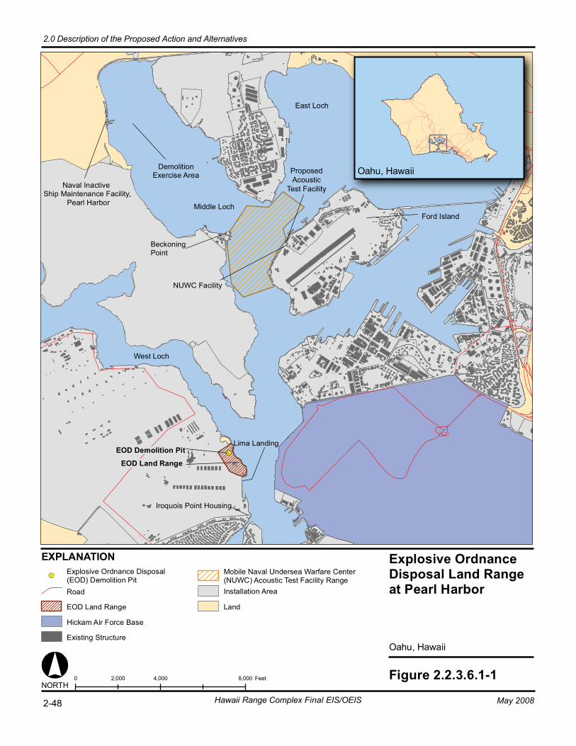
Explosive OrdnanceDisposal Land Rangeat Pearl Harbor
Oahu, Hawaii
Figure 2.2.3.6.1-10 4,000 8,0002,000 FeetNORTH
Lima Landing
EOD Land Range
Iroquois Point Housing
EOD Demolition Pit
DemolitionExercise Area
West Loch
Middle Loch
East Loch
Ford Island
Naval Inactive Ship Maintenance Facility,
Pearl Harbor
NUWC Facility
EXPLANATION
BeckoningPoint
Oahu, HawaiiOahu, Hawaii
Explosive Ordnance Disposal(EOD) Demolition PitRoad
EOD Land Range
Hickam Air Force Base
Existing Structure
Mobile Naval Undersea Warfare Center(NUWC) Acoustic Test Facility RangeInstallation Area
Land
2-48 Hawaii Range Complex Final EIS/OEIS
2.0 Description of the Proposed Action and Alternatives
May 2008
ProposedAcoustic
Test Facility
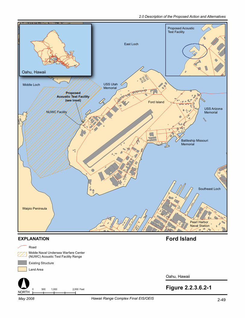
Oahu, Hawaii
Figure 2.2.3.6.2-1
Oahu, Hawaii
Ford Island
0 1,000 2,000500 Feet
USS UtahMemorial
Ford Island
Battleship MissouriMemorial
USS ArizonaMemorial
Southeast Loch
Pearl HarborNaval Station
Waipio Peninsula
NORTH
ProposedAcoustic Test Facility
(see inset)
NUWC Facility
Proposed AcousticTest Facility
EXPLANATION
Road
Existing Structure
Land Area
East Loch
Middle Loch
2-49Hawaii Range Complex Final EIS/OEIS
2.0 Description of the Proposed Action and Alternatives
May 2008
Mobile Naval Undersea Warfare Center (NUWC) Acoustic Test Facility Range

Coast Guard Station -Barbers Point /Kalaeloa Airport
Puuloa UnderwaterRange
Ewa Training Minefield
Barbers PointUnderwater Range
Hickam AirForce Base
Preferred Site(Site B)
Puuloa Rifle Range
Site C Site A
Mobile Divingand Salvage UnitTraining AreaProposed Site
Oahu, Hawaii
Figure 2.2.3.6.2-20 1 20.5 Nautical MilesNORTH
Oahu, Hawaii
EXPLANATION
Barbers Point Underwater Range
Ewa Training Minefield
Puuloa Rifle Range
Puuloa Underwater Range
Land
Puuloa Rifle RangeSmall Arms Firing Area
RoadPuuloa Rifle RangeSurface Danger Zone
Naval Defensive Sea Area
Installation Area
Proposed Mobile Diving and SalvageUnit Training Area
mdsu_prop_sites_071707.mxd
2-50 Hawaii Range Complex Final EIS/OEIS
2.0 Description of the Proposed Action and Alternatives
May 2008
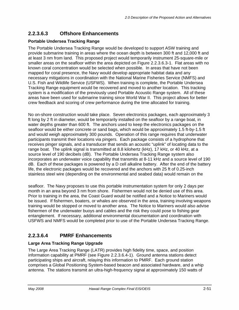
2.0 Description of the Proposed Action and Alternatives
May 2008 Hawaii Range Complex Final EIS/OEIS 2-51
2.2.3.6.3 Offshore Enhancements Portable Undersea Tracking Range The Portable Undersea Tracking Range would be developed to support ASW training and provide submarine training in areas where the ocean depth is between 300 ft and 12,000 ft and at least 3 nm from land. This proposed project would temporarily instrument 25-square-mile or smaller areas on the seafloor within the area depicted on Figure 2.2.3.6.3-1. Flat areas with no known coral concentration would be selected when possible. In areas that have not been mapped for coral presence, the Navy would develop appropriate habitat data and any necessary mitigations in coordination with the National Marine Fisheries Service (NMFS) and U.S. Fish and Wildlife Service (USFWS). When training is complete, the Portable Undersea Tracking Range equipment would be recovered and moved to another location. This tracking system is a modification of the previously used Portable Acoustic Range system. All of these areas have been used for submarine training since World War II. This project allows for better crew feedback and scoring of crew performance during the time allocated for training.
No on-shore construction would take place. Seven electronics packages, each approximately 3 ft long by 2 ft in diameter, would be temporarily installed on the seafloor by a range boat, in water depths greater than 600 ft. The anchors used to keep the electronics packages on the seafloor would be either concrete or sand bags, which would be approximately 1.5 ft-by-1.5 ft and would weigh approximately 300 pounds. Operation of this range requires that underwater participants transmit their locations via pingers. Each package consists of a hydrophone that receives pinger signals, and a transducer that sends an acoustic “uplink” of locating data to the range boat. The uplink signal is transmitted at 8.8 kilohertz (kHz), 17 kHz, or 40 kHz, at a source level of 190 decibels (dB). The Portable Undersea Tracking Range system also incorporates an underwater voice capability that transmits at 8-11 kHz and a source level of 190 dB. Each of these packages is powered by a D cell alkaline battery. After the end of the battery life, the electronic packages would be recovered and the anchors with 25 ft of 0.25-inch stainless steel wire (depending on the environmental and seabed data) would remain on the
seafloor. The Navy proposes to use this portable instrumentation system for only 2 days per month in an area beyond 3 nm from shore. Fishermen would not be denied use of this area. Prior to training in the area, the Coast Guard would be notified and a Notice to Mariners would be issued. If fishermen, boaters, or whales are observed in the area, training involving weapons training would be stopped or moved to another area. The Notice to Mariners would also advise fishermen of the underwater buoys and cables and the risk they could pose to fishing gear entanglement. If necessary, additional environmental documentation and coordination with USFWS and NMFS would be completed prior to use of the Portable Undersea Tracking Range.
2.2.3.6.4 PMRF Enhancements Large Area Tracking Range Upgrade The Large Area Tracking Range (LATR) provides high fidelity time, space, and position information capability at PMRF (see Figure 2.2.3.6.4-1). Ground antenna stations detect participating ships and aircraft, relaying this information to PMRF. Each ground station comprises a Global Positioning System-based beacon and associated hardware, and a whip antenna. The stations transmit an ultra-high-frequency signal at approximately 150 watts of
Portable UnderseaTracking RangePotential Area
Hawaiian Islands
Figure 2.2.3.6.3-1NORTH
0 20 4010 Nautical Miles
Hawaii
Maui
Oahu
KauaiNiihau
Kaula
Molokai
Lanai
Kahoolawe
The Hawaiian Islands
Hawaii
Maui
KahoolaweLanai
Molokai
Oahu
EXPLANATION
295-Foot (90-Meter) Bathymetric Line
12,007-Foot (3,660-Meter) Bathymetric Line
12-Nautical Mile Line
3-Nautical Mile Line
Kaula
Niihau
Kauai
Land
Hawaiian Islands HumpbackWhale National Marine Sanctuary
Potential Portable UnderseaTracking Range (PUTR) Area
2-52 Hawaii Range Complex Final EIS/OEIS
2.0 Description of the Proposed Action and Alternatives
May 2008
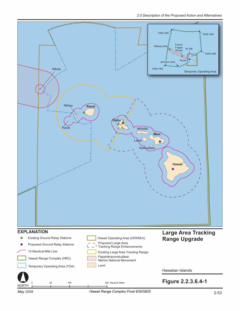
La rge Ar ea Tr a cki ng Ra ng e U pgr ad e
Hawaii an Isl and s
Fi gur e 2. 2. 3. 6.4- 1 0 1 00 20 0 50 Na ut ic al M il es
1 79W 43N
1 79W 16N
1 50W 43N
1 50W 28N
Te m por ar y Op er at i ng Ar ea
W- 188
EX PL ANA TI ON
NORT H
Mi dway A to ll
J ohns ton At ol l K auai
Ka ul a
Niih au
Ni ho a
La nd
Ex is ti ng G r ou nd R el ay S ta ti on s
Pr op os ed G r oun d Re la y St at io ns Pr op os ed Lar ge A r ea Tr a cki ng R an ge En ha nc em en ts
Ex is ti ng Lar ge A r ea Tr ac ki ng R an ge Pa pa hā nau mo ku āk ea Ma rin e Na ti o nal M on um en t Ha wa ii Ran ge C om pl ex (HRC )
12 -N au ti ca l Mi le L in e
Ha wa ii O pe r at in g Ar ea ( OP AR EA )
Te m por ar y Op er at in g Ar ea ( TO A)
2-53Hawaii Range Complex Final EIS/OEIS
2.0 Description of the Proposed Action and Alternatives
May 2008
French Frigate Shoals
Kauai
Oahu
Maui
Hawaii
Molokai
Lanai
Kahoolawe
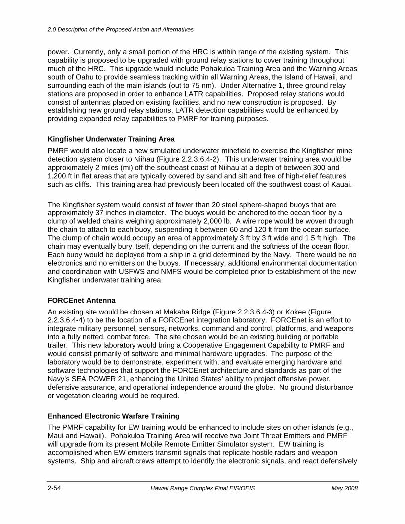
2.0 Description of the Proposed Action and Alternatives
2-54 Hawaii Range Complex Final EIS/OEIS May 2008
power. Currently, only a small portion of the HRC is within range of the existing system. This capability is proposed to be upgraded with ground relay stations to cover training throughout much of the HRC. This upgrade would include Pohakuloa Training Area and the Warning Areas south of Oahu to provide seamless tracking within all Warning Areas, the Island of Hawaii, and surrounding each of the main islands (out to 75 nm). Under Alternative 1, three ground relay stations are proposed in order to enhance LATR capabilities. Proposed relay stations would consist of antennas placed on existing facilities, and no new construction is proposed. By establishing new ground relay stations, LATR detection capabilities would be enhanced by providing expanded relay capabilities to PMRF for training purposes.
Kingfisher Underwater Training Area PMRF would also locate a new simulated underwater minefield to exercise the Kingfisher mine detection system closer to Niihau (Figure 2.2.3.6.4-2). This underwater training area would be approximately 2 miles (mi) off the southeast coast of Niihau at a depth of between 300 and 1,200 ft in flat areas that are typically covered by sand and silt and free of high-relief features such as cliffs. This training area had previously been located off the southwest coast of Kauai.
The Kingfisher system would consist of fewer than 20 steel sphere-shaped buoys that are approximately 37 inches in diameter. The buoys would be anchored to the ocean floor by a clump of welded chains weighing approximately 2,000 lb. A wire rope would be woven through the chain to attach to each buoy, suspending it between 60 and 120 ft from the ocean surface. The clump of chain would occupy an area of approximately 3 ft by 3 ft wide and 1.5 ft high. The chain may eventually bury itself, depending on the current and the softness of the ocean floor. Each buoy would be deployed from a ship in a grid determined by the Navy. There would be no electronics and no emitters on the buoys. If necessary, additional environmental documentation and coordination with USFWS and NMFS would be completed prior to establishment of the new Kingfisher underwater training area.
FORCEnet Antenna An existing site would be chosen at Makaha Ridge (Figure 2.2.3.6.4-3) or Kokee (Figure 2.2.3.6.4-4) to be the location of a FORCEnet integration laboratory. FORCEnet is an effort to integrate military personnel, sensors, networks, command and control, platforms, and weapons into a fully netted, combat force. The site chosen would be an existing building or portable trailer. This new laboratory would bring a Cooperative Engagement Capability to PMRF and would consist primarily of software and minimal hardware upgrades. The purpose of the laboratory would be to demonstrate, experiment with, and evaluate emerging hardware and software technologies that support the FORCEnet architecture and standards as part of the Navy’s SEA POWER 21, enhancing the United States’ ability to project offensive power, defensive assurance, and operational independence around the globe. No ground disturbance or vegetation clearing would be required.
Enhanced Electronic Warfare Training The PMRF capability for EW training would be enhanced to include sites on other islands (e.g., Maui and Hawaii). Pohakuloa Training Area will receive two Joint Threat Emitters and PMRF will upgrade from its present Mobile Remote Emitter Simulator system. EW training is accomplished when EW emitters transmit signals that replicate hostile radars and weapon systems. Ship and aircraft crews attempt to identify the electronic signals, and react defensively
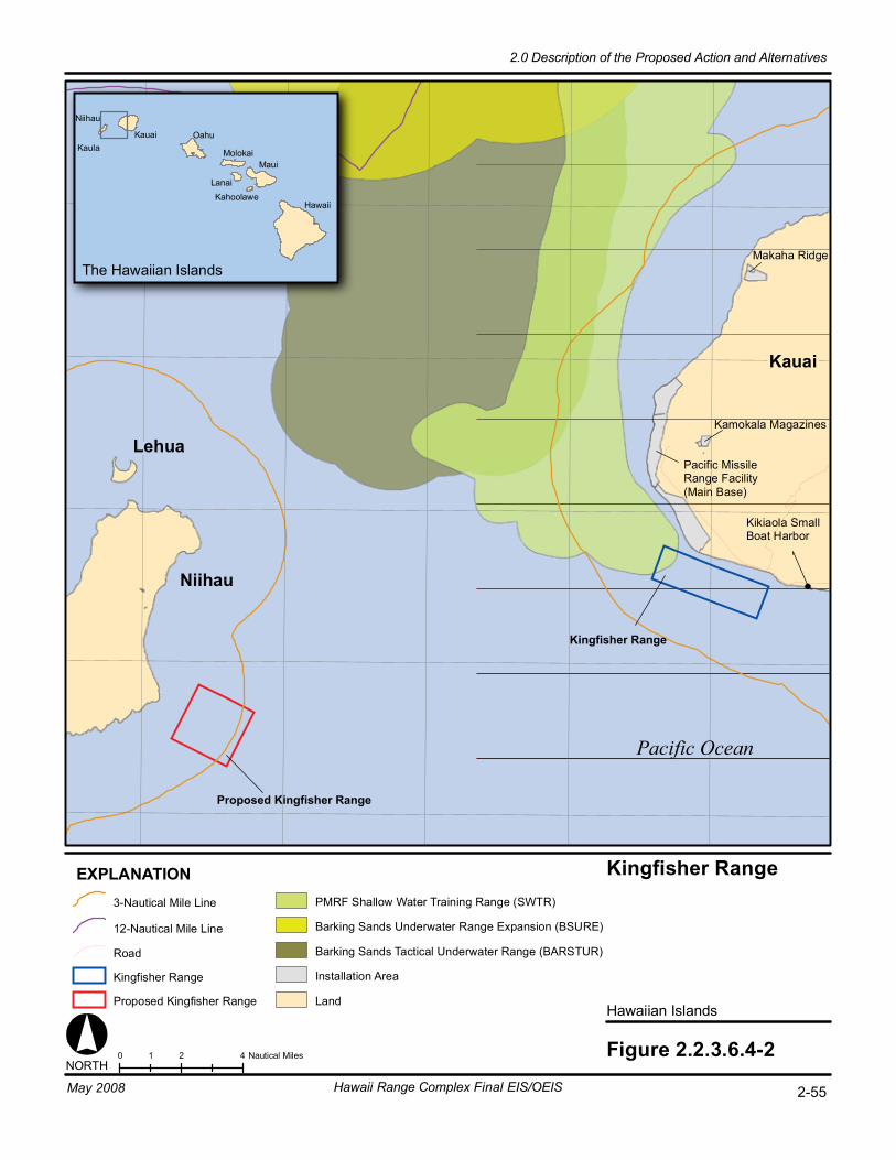
0 2 41 Nautical Miles Figure 2.2.3.6.4-2
Hawaiian Islands
Kingfisher Range
Pacific Ocean
Pacific MissileRange Facility(Main Base)
Kikiaola Small Boat Harbor
Kamokala Magazines
Makaha Ridge
NORTH
Kauai
Niihau
Lehua
The Hawaiian Islands
Hawaii
Maui
KahoolaweLanai
Molokai
OahuKauai
Niihau
Kaula
EXPLANATION3-Nautical Mile Line
12-Nautical Mile Line
Road
Proposed Kingfisher Range
Barking Sands Underwater Range Expansion (BSURE)
Barking Sands Tactical Underwater Range (BARSTUR)
Installation Area
Land
PMRF Shallow Water Training Range (SWTR)
Kingfisher Range
2-55Hawaii Range Complex Final EIS/OEIS
2.0 Description of the Proposed Action and Alternatives
May 2008
Proposed Kingfisher Range
Kingfisher Range
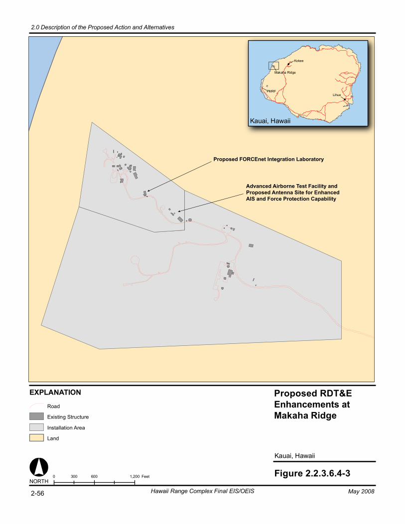
Kauai, Hawaii
Figure 2.2.3.6.4-30 600 1,200300 Feet
Kauai, Hawaii
PMRF
Makaha Ridge
Kokee
Lihue
NORTH
EXPLANATION
Road
Existing Structure
Installation Area
Land
2-56 Hawaii Range Complex Final EIS/OEIS
2.0 Description of the Proposed Action and Alternatives
May 2008
Proposed FORCEnet Integration Laboratory
Advanced Airborne Test Facility andProposed Antenna Site for EnhancedAIS and Force Protection Capability
Proposed RDT&EEnhancements at Makaha Ridge
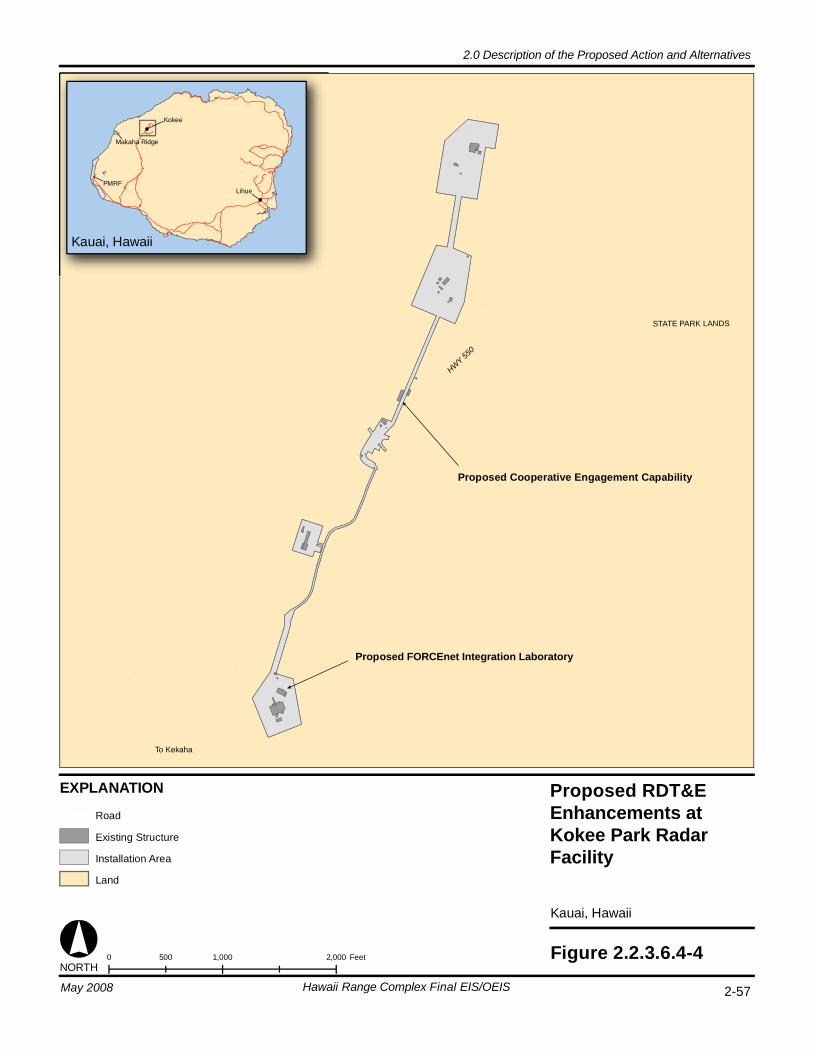
STATE PARK LANDS
HWY 550
To Kekaha
0 1,000 2,000500 Feet Figure 2.2.3.6.4-4
Kauai, Hawaii
Proposed Cooperative Engagement Capability
Proposed FORCEnet Integration Laboratory
Kauai, Hawaii
PMRF
Makaha Ridge
Kokee
Lihue
NORTH
EXPLANATION
Road
Existing Structure
Installation Area
Land
2-57Hawaii Range Complex Final EIS/OEIS
2.0 Description of the Proposed Action and Alternatives
May 2008
Proposed RDT&E Enhancements at Kokee Park RadarFacility
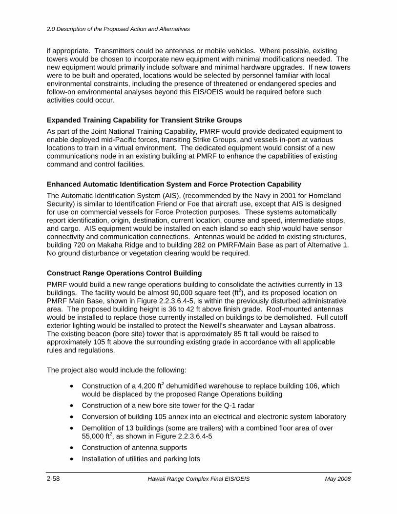
2.0 Description of the Proposed Action and Alternatives
2-58 Hawaii Range Complex Final EIS/OEIS May 2008
if appropriate. Transmitters could be antennas or mobile vehicles. Where possible, existing towers would be chosen to incorporate new equipment with minimal modifications needed. The new equipment would primarily include software and minimal hardware upgrades. If new towers were to be built and operated, locations would be selected by personnel familiar with local environmental constraints, including the presence of threatened or endangered species and follow-on environmental analyses beyond this EIS/OEIS would be required before such activities could occur.
Expanded Training Capability for Transient Strike Groups As part of the Joint National Training Capability, PMRF would provide dedicated equipment to enable deployed mid-Pacific forces, transiting Strike Groups, and vessels in-port at various locations to train in a virtual environment. The dedicated equipment would consist of a new communications node in an existing building at PMRF to enhance the capabilities of existing command and control facilities.
Enhanced Automatic Identification System and Force Protection Capability The Automatic Identification System (AIS), (recommended by the Navy in 2001 for Homeland Security) is similar to Identification Friend or Foe that aircraft use, except that AIS is designed for use on commercial vessels for Force Protection purposes. These systems automatically report identification, origin, destination, current location, course and speed, intermediate stops, and cargo. AIS equipment would be installed on each island so each ship would have sensor connectivity and communication connections. Antennas would be added to existing structures, building 720 on Makaha Ridge and to building 282 on PMRF/Main Base as part of Alternative 1. No ground disturbance or vegetation clearing would be required.
Construct Range Operations Control Building PMRF would build a new range operations building to consolidate the activities currently in 13 buildings. The facility would be almost 90,000 square feet (ft2), and its proposed location on PMRF Main Base, shown in Figure 2.2.3.6.4-5, is within the previously disturbed administrative area. The proposed building height is 36 to 42 ft above finish grade. Roof-mounted antennas would be installed to replace those currently installed on buildings to be demolished. Full cutoff exterior lighting would be installed to protect the Newell’s shearwater and Laysan albatross. The existing beacon (bore site) tower that is approximately 85 ft tall would be raised to approximately 105 ft above the surrounding existing grade in accordance with all applicable rules and regulations.
The project also would include the following:
• Construction of a 4,200 ft2 dehumidified warehouse to replace building 106, which would be displaced by the proposed Range Operations building
• Construction of a new bore site tower for the Q-1 radar • Conversion of building 105 annex into an electrical and electronic system laboratory • Demolition of 13 buildings (some are trailers) with a combined floor area of over
55,000 ft2, as shown in Figure 2.2.3.6.4-5 • Construction of antenna supports • Installation of utilities and parking lots
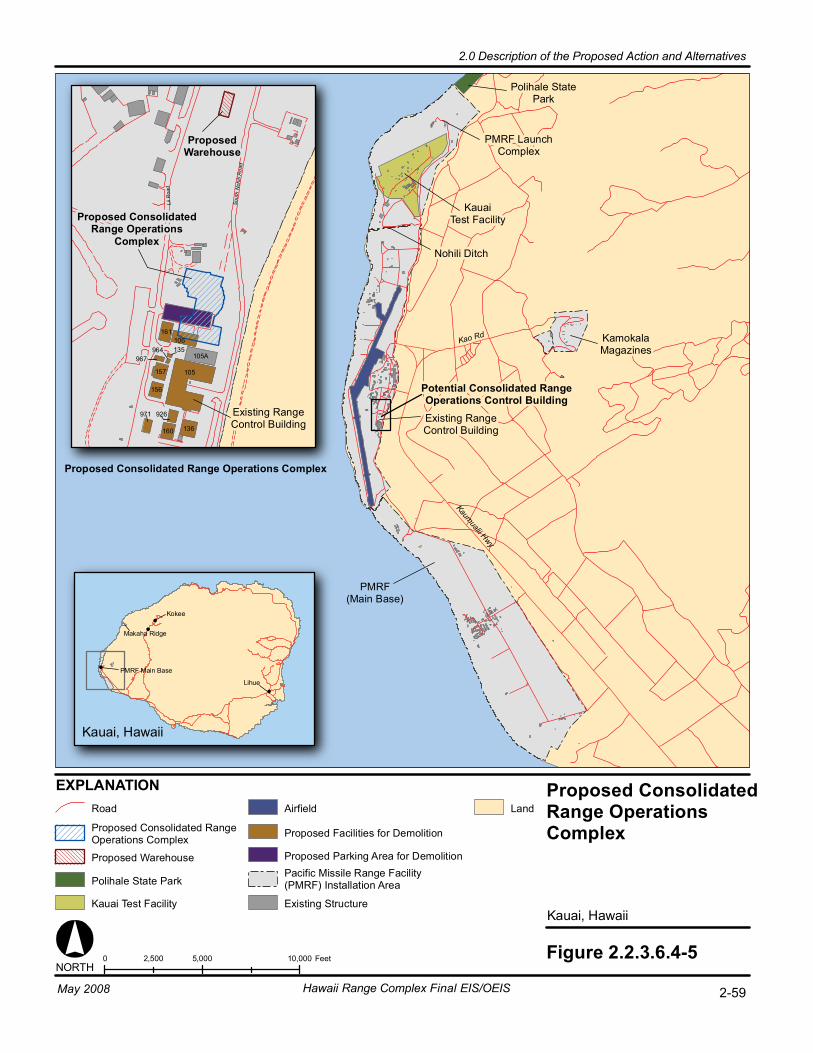
Kao Rd
Kaumualii Hwy
Proposed ConsolidatedRange OperationsComplex
Kauai, Hawaii
0 5,000 10,0002,500 Feet Figure 2.2.3.6.4-5
KamokalaMagazines
Polihale StatePark
KauaiTest Facility
PMRF LaunchComplex
EXPLANATION
Kauai, Hawaii
Makaha Ridge
Kokee
Lihue
Nohili Ditch
Potential Consolidated RangeOperations Control BuildingExisting RangeControl Building
NORTH
Land
PMRF Main Base
964
105
106
105A
136
161
160
157
156
971 926
967135
Proposed Consolidated Range Operations Complex
Lii R
oad
Sou
th N
ohili
Roa
d
ProposedWarehouse
Proposed ConsolidatedRange Operations
Complex
Existing RangeControl Building
PMRF(Main Base)
Road
Proposed Consolidated RangeOperations Complex
Proposed Warehouse
Polihale State Park
Kauai Test Facility
Airfield
Proposed Facilities for Demolition
Proposed Parking Area for DemolitionPacific Missile Range Facility(PMRF) Installation Area
Existing Structure
2-59Hawaii Range Complex Final EIS/OEIS
2.0 Description of the Proposed Action and Alternatives
May 2008
2.0 Description of the Proposed Action and Alternatives
2-60 Hawaii Range Complex Final EIS/OEIS May 2008
Improve Fiber Optics Infrastructure To improve communications and data transmission, PMRF would install fiber optic cable between the Main Base and the sites at Kokee, shown in Figure 2.1-2. This project would involve the installation of approximately 23 mi of fiber optic cable, which would be hung on existing Kauai Island Utility Cooperative poles between PMRF/Main Base and Kokee. The existing poles run from Kekaha Mill, up a ridge, and intersect Kokee Road at an existing substation. If exceptionally long spans are encountered, additional poles might need to be installed in some areas. It is expected that all equipment and installation activities would occur along existing public and Kauai Island Utility Cooperative access roads. Prior to implementation, PMRF would coordinate with Kauai Island Utility Cooperative and the local Department of Transportation for approvals.
2.2.3.7 MAJOR EXERCISES FOR ALTERNATIVE 1 The Navy proposes to continue Major Exercises such as RIMPAC and USWEX described in the No-action Alternative. Under Alternative 1, RIMPAC would include two Strike Groups (which could include up to two carriers), and FCLPs would occur in association with transiting Strike Groups participating in Major Exercises. The training events associated with Major Exercises would be chosen from the appropriate matrix of training events in Appendix D.
For RIMPAC under Alternative 1, the marine mammal exposure modeling included 1,064 hours of AN/SQS-53 and AN/SQS-56 surface ship sonar and associated dipping sonar, sonobuoys, and MK-48 torpedoes. For USWEX under Alternative 1, the marine mammal exposure modeling included six USWEXs for a total of 840 hours of AN/SQS-53 and AN/SQS-56 surface ship sonar and associated dipping sonar, sonobuoys, and MK-48 torpedoes (Table 2.2.3.2-1).
2.2.3.8 MITIGATION MEASURES FOR ALTERNATIVE 1 Under Alternative 1, the Navy’s marine mammal mitigation measures would continue to be implemented. Chapter 6.0 presents these mitigation measures, outlining steps that are currently implemented to protect marine mammals and federally-listed species.
2.2.4 ALTERNATIVE 2 2.2.4.1 TRAINING EVENTS FOR ALTERNATIVE 2 Alternative 2 would include all of the training described in Alternative 1 plus a further increased tempo and frequency of training events, future RDT&E programs at PMRF and the addition of Major Exercises, such as supporting three carrier Strike Groups training at the same time. Table 2.2.2.3-1 shows the number of Navy training events proposed for Alternative 2, compared to No-action Alternative and the number of events proposed under Alternative 1.
For RIMPAC under Alternative 2, the marine mammal exposure modeling included 1,064 hours of AN/SQS-53 and AN/SQS-56 surface ship sonar and associated dipping sonar, sonobuoys, and MK-48 torpedoes. For USWEX under Alternative 2, the marine mammal exposure modeling included six USWEXs for a total of 840 hours of AN/SQS-53 and AN/SQS-56 surface ship sonar and associated dipping sonar, and sonobuoys (refer to Section 2.2.4.2).
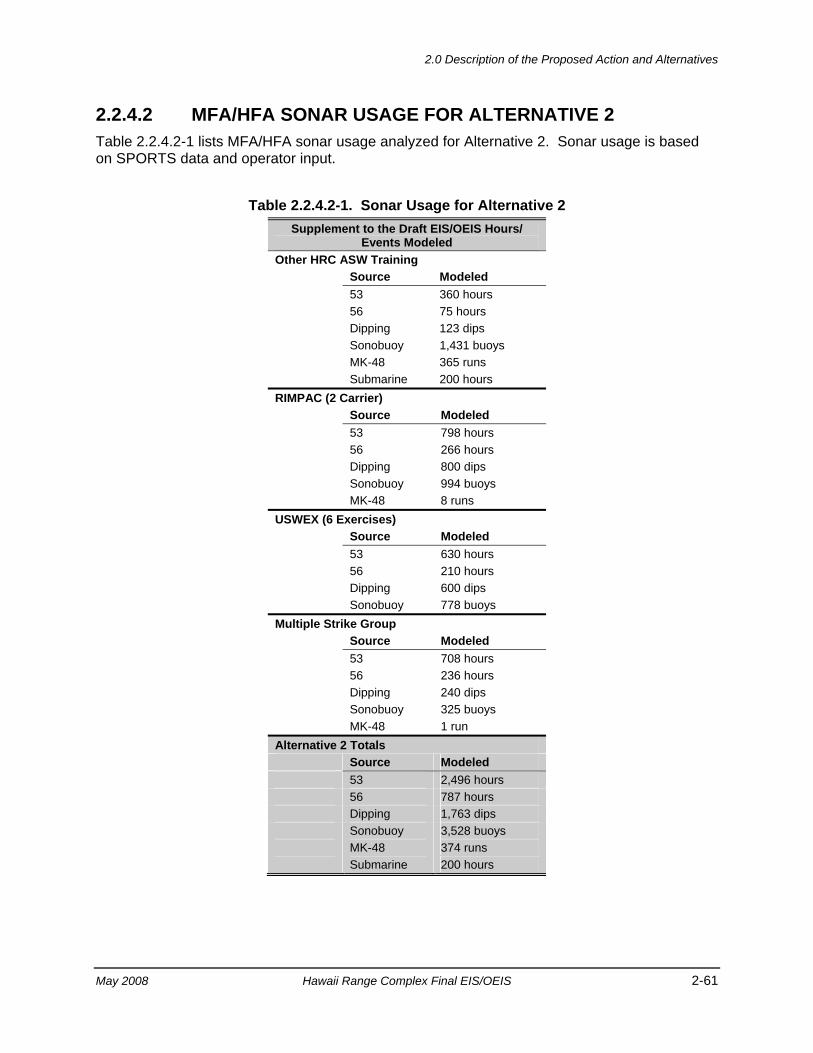
2.0 Description of the Proposed Action and Alternatives
May 2008 Hawaii Range Complex Final EIS/OEIS 2-61
2.2.4.2 MFA/HFA SONAR USAGE FOR ALTERNATIVE 2 Table 2.2.4.2-1 lists MFA/HFA sonar usage analyzed for Alternative 2. Sonar usage is based on SPORTS data and operator input.
Table 2.2.4.2-1. Sonar Usage for Alternative 2 Supplement to the Draft EIS/OEIS Hours/
Events Modeled Other HRC ASW Training Source Modeled 53 360 hours 56 75 hours Dipping 123 dips Sonobuoy 1,431 buoys MK-48 365 runs Submarine 200 hours RIMPAC (2 Carrier) Source Modeled 53 798 hours 56 266 hours Dipping 800 dips Sonobuoy 994 buoys MK-48 8 runs USWEX (6 Exercises) Source Modeled 53 630 hours 56 210 hours Dipping 600 dips Sonobuoy 778 buoys Multiple Strike Group Source Modeled 53 708 hours 56 236 hours Dipping 240 dips Sonobuoy 325 buoys MK-48 1 run Alternative 2 Totals Source Modeled 53 2,496 hours 56 787 hours Dipping 1,763 dips Sonobuoy 3,528 buoys MK-48 374 runs Submarine 200 hours

2.0 Description of the Proposed Action and Alternatives
2-62 Hawaii Range Complex Final EIS/OEIS May 2008
2.2.4.3 INCREASED TEMPO AND FREQUENCY OF TRAINING FOR ALTERNATIVE 2
Under Alternative 2, the Navy proposes to increase the tempo and frequency of training events (above Alternative 1 levels) and compress the tempo of training events in the HRC. In this setting, tempo means intensity and could include more forces or shorter/longer duration of activities. For example, instead of a training event lasting 5 days, the same training events would be completed in 3 days. The frequency of training would also be increased. An increase in frequency means the number of training events in a given time period would increase.
2.2.4.4 ENHANCED RDT&E ACTIVITIES FOR ALTERNATIVE 2 The Navy proposes to enhance RDT&E activities from Alternative 1 levels as shown in Table 2.2.2.5-1. Enhanced RDT&E could include activities such as additional missile defense RDT&E (including an increase in THAAD interceptor activities), CSSQT at-sea tests, and FORACS accuracy checks.
2.2.4.5 FUTURE RDT&E ACTIVITIES FOR ALTERNATIVE 2 PMRF would develop the capability to support the Directed Energy and Advanced Hypersonic Weapon programs.
Directed Energy The Navy proposes to establish a long-term support facility, the Maritime Directed Energy Test Center, at PMRF for directed energy programs, such as the High-Energy Laser.
The high-energy laser would require a permanent operations building with approximately 25,000 ft2. Figure 2.2.4.5-1 shows the proposed location. The actual footprint of the proposed center would be smaller than the circles shown on Figure 2.2.4.5-1 and would avoid designated critical habitat. During testing, the range would need to be cleared. Up to four air targets and up to four surface targets would be used for testing. The laser would require 30 megawatts of power. Up to 100 personnel would support this program. Construction of the Maritime Directed Energy Test Center would require separate/additional environmental documentation.
PMRF would develop the necessary standard operating procedures and range safety requirements necessary to provide safe operations associated with future high-energy laser tests.
PMRF would add the capability to test non-eye-safe lasers. The range could also be used to support Airborne Laser program testing. The Airborne Laser aircraft would stage out of Hickam AFB on Oahu. The chemicals for operating the laser onboard the aircraft would be transported to Oahu by ship and would be stored at Hickam AFB. Should the Airborne Laser program decide to perform testing at PMRF, separate environmental documentation would be required to analyze potential impacts.
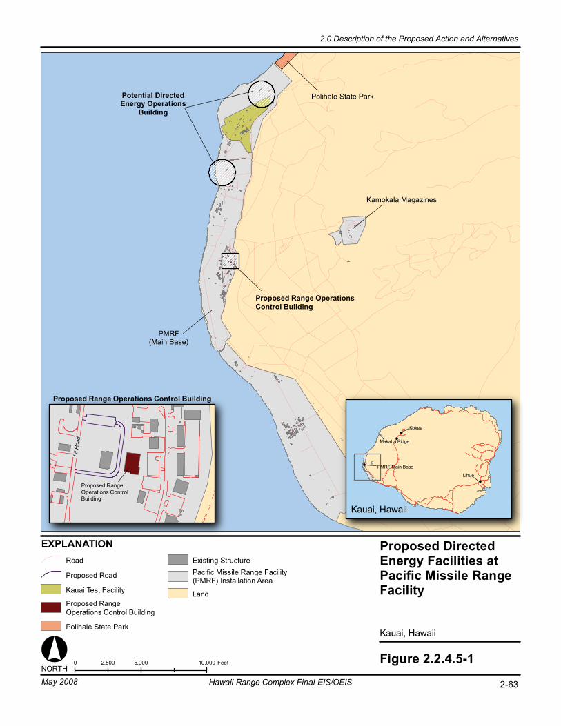
Proposed Directed Energy Facilities at Pacific Missile Rang e F aci li ty
Ka uai , Ha waii
0 5 ,000 10 ,000 2, 500 F eet
EX PL AN AT IO N
Fi gure 2. 2.4. 5-1 NORT H
Ka mo ka la M ag az in es
Ka ua i Te s t F ac il it y
Pote nt ia l Dire ct ed En er gy O pe ra ti on s
Buil di ng
Ro ad E xi st in g Stru ct ur e Pa ci fi c Mi ssi le R an ge F ac il it y (P MR F) I ns ta ll at io n Ar ea
La nd
L ii R
o ad
Proposed Range Operations Control Building
Proposed Range Operations Control Building
Po li ha le S ta te P ar k
Po li ha le S ta te P ar k
Pro pos ed R oa d
Ka uai , Ha waii
Ma ka ha R id ge
Ko ke e
Li hu e
PM RF M ai n Ba se
PM RF (M ai n Ba se )
2-63May 2008 Hawaii Range Complex Final EIS/OEIS
2.0 Description of the Proposed Action and Alternatives
Proposed Range Operations Control Building
Proposed Range Operations Control Building
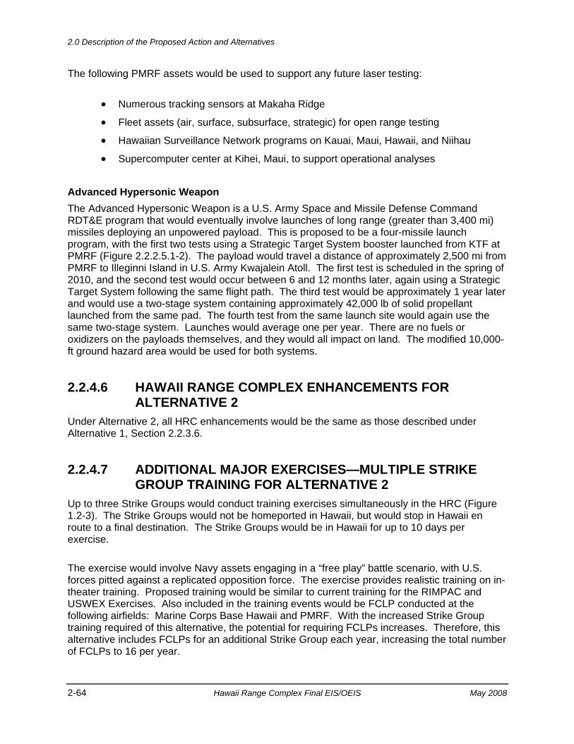
2.0 Description of the Proposed Action and Alternatives
2-64 Hawaii Range Complex Final EIS/OEIS May 2008
The following PMRF assets would be used to support any future laser testing:
• Numerous tracking sensors at Makaha Ridge
• Fleet assets (air, surface, subsurface, strategic) for open range testing
• Hawaiian Surveillance Network programs on Kauai, Maui, Hawaii, and Niihau
• Supercomputer center at Kihei, Maui, to support operational analyses
Advanced Hypersonic Weapon The Advanced Hypersonic Weapon is a U.S. Army Space and Missile Defense Command RDT&E program that would eventually involve launches of long range (greater than 3,400 mi) missiles deploying an unpowered payload. This is proposed to be a four-missile launch program, with the first two tests using a Strategic Target System booster launched from KTF at PMRF (Figure 2.2.2.5.1-2). The payload would travel a distance of approximately 2,500 mi from PMRF to Illeginni Island in U.S. Army Kwajalein Atoll. The first test is scheduled in the spring of 2010, and the second test would occur between 6 and 12 months later, again using a Strategic Target System following the same flight path. The third test would be approximately 1 year later and would use a two-stage system containing approximately 42,000 lb of solid propellant launched from the same pad. The fourth test from the same launch site would again use the same two-stage system. Launches would average one per year. There are no fuels or oxidizers on the payloads themselves, and they would all impact on land. The modified 10,000-ft ground hazard area would be used for both systems.
2.2.4.6 HAWAII RANGE COMPLEX ENHANCEMENTS FOR ALTERNATIVE 2
Under Alternative 2, all HRC enhancements would be the same as those described under Alternative 1, Section 2.2.3.6.
2.2.4.7 ADDITIONAL MAJOR EXERCISES—MULTIPLE STRIKE GROUP TRAINING FOR ALTERNATIVE 2
Up to three Strike Groups would conduct training exercises simultaneously in the HRC (Figure 1.2-3). The Strike Groups would not be homeported in Hawaii, but would stop in Hawaii en route to a final destination. The Strike Groups would be in Hawaii for up to 10 days per exercise.
The exercise would involve Navy assets engaging in a “free play” battle scenario, with U.S. forces pitted against a replicated opposition force. The exercise provides realistic training on in-theater training. Proposed training would be similar to current training for the RIMPAC and USWEX Exercises. Also included in the training events would be FCLP conducted at the following airfields: Marine Corps Base Hawaii and PMRF. With the increased Strike Group training required of this alternative, the potential for requiring FCLPs increases. Therefore, this alternative includes FCLPs for an additional Strike Group each year, increasing the total number of FCLPs to 16 per year.
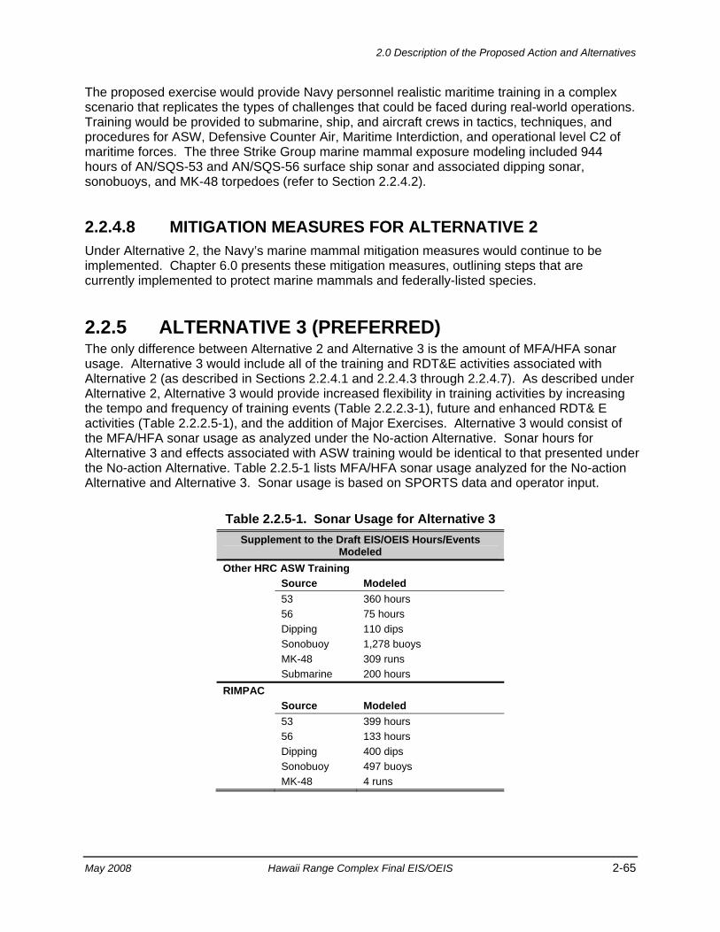
2.0 Description of the Proposed Action and Alternatives
May 2008 Hawaii Range Complex Final EIS/OEIS 2-65
The proposed exercise would provide Navy personnel realistic maritime training in a complex scenario that replicates the types of challenges that could be faced during real-world operations. Training would be provided to submarine, ship, and aircraft crews in tactics, techniques, and procedures for ASW, Defensive Counter Air, Maritime Interdiction, and operational level C2 of maritime forces. The three Strike Group marine mammal exposure modeling included 944 hours of AN/SQS-53 and AN/SQS-56 surface ship sonar and associated dipping sonar, sonobuoys, and MK-48 torpedoes (refer to Section 2.2.4.2).
2.2.4.8 MITIGATION MEASURES FOR ALTERNATIVE 2 Under Alternative 2, the Navy’s marine mammal mitigation measures would continue to be implemented. Chapter 6.0 presents these mitigation measures, outlining steps that are currently implemented to protect marine mammals and federally-listed species.
2.2.5 ALTERNATIVE 3 (PREFERRED) The only difference between Alternative 2 and Alternative 3 is the amount of MFA/HFA sonar usage. Alternative 3 would include all of the training and RDT&E activities associated with Alternative 2 (as described in Sections 2.2.4.1 and 2.2.4.3 through 2.2.4.7). As described under Alternative 2, Alternative 3 would provide increased flexibility in training activities by increasing the tempo and frequency of training events (Table 2.2.2.3-1), future and enhanced RDT& E activities (Table 2.2.2.5-1), and the addition of Major Exercises. Alternative 3 would consist of the MFA/HFA sonar usage as analyzed under the No-action Alternative. Sonar hours for Alternative 3 and effects associated with ASW training would be identical to that presented under the No-action Alternative. Table 2.2.5-1 lists MFA/HFA sonar usage analyzed for the No-action Alternative and Alternative 3. Sonar usage is based on SPORTS data and operator input.
Table 2.2.5-1. Sonar Usage for Alternative 3 Supplement to the Draft EIS/OEIS Hours/Events
Modeled Other HRC ASW Training Source Modeled 53 360 hours 56 75 hours Dipping 110 dips Sonobuoy 1,278 buoys MK-48 309 runs Submarine 200 hours RIMPAC Source Modeled 53 399 hours 56 133 hours Dipping 400 dips Sonobuoy 497 buoys MK-48 4 runs

2.0 Description of the Proposed Action and Alternatives
2-66 Hawaii Range Complex Final EIS/OEIS May 2008
Table 2.2.5-1. Sonar Usage for Alternative 3 (Continued) Supplement to the Draft EIS/OEIS Hours/Events
Modeled USWEX (5 Exercises) Source Modeled 53 525 hours 56 175 hours Dipping 500 dips Sonobuoy 648 buoys Alternative 3 Totals Source Modeled 53 1,284 hours 56 383 hours Dipping 1,010 dips Sonobuoy 2,423 buoys MK-48 313 runs Submarine 200 hours
Alternative 3 is the preferred alternative because it allows the Navy to meet its future non-ASW training and RDT&E mission objectives while maintaining historic levels of ASW training to avoid increases in potential effects on marine species in the HRC. At this time, the Navy believes that its ASW requirements will be met on the No-action Alternative sonar hours.
2.2.5.1 MITIGATION MEASURES FOR ALTERNATIVE 3 Under Alternative 3, the Navy’s marine mammal mitigation measures would continue to be implemented. Chapter 6.0 presents these mitigation measures, outlining steps that are currently implemented to protect marine mammals and federally-listed species.
3.0 Affected Environment

3.0 Affected Environment, Open Ocean Area
May 2008 Hawaii Range Complex Final EIS/OEIS 3-1
3.0 AFFECTED ENVIRONMENT This chapter describes the environmental characteristics that may be affected by the No-action Alternative, Alternative 1, Alternative 2, and Alternative 3. Points of reference for understanding any potential impacts are based on the activities that have been historically conducted in the Hawaii Range Complex (HRC). Available reference materials including prior Environmental Assessments (EAs) and Environmental Impact Statements (EISs) were reviewed. Questions were directed to installation and facility personnel, and private individuals. Site visits were also conducted where necessary to gather the baseline data presented herein.
Environmental characteristics are discussed according to location; the Open Ocean Area (outside 12 nautical miles [nm] from land) is discussed first, followed by offshore (within 12 nm from land) and onshore discussion organized by island location from west to east: Northwestern Hawaiian Islands, Kauai, Oahu, Maui, and Hawaii. For organizational purposes, discussions about Niihau and Kaula are included under the Kauai heading, because although they are separate islands, they are part of Kauai County. In addition, discussions about Molokai, Lanai, and Kahoolawe are included under the Maui heading, because although they are separate islands, they are part of Maui County. The last section discusses the Hawaiian Islands Humpback Whale National Marine Sanctuary. The page headers in this chapter identify which location is discussed.
Thirteen environmental resource areas were evaluated to provide a context for understanding the potential effects of ongoing and proposed activities. These areas include air quality, airspace, biological resources, cultural resources, geology and soils, hazardous materials and waste, health and safety, land use, noise, socioeconomics, transportation, utilities, and water resources. Each resource area is discussed for each proposed location unless the proposed activities at that location would not foreseeably result in an impact, as explained for each location in Chapter 4.0. Table 3-1 lists each location and the section number within this chapter where each of the resources is addressed.
3.1 OPEN OCEAN AREA The Open Ocean Area is the area within the HRC that is greater than 12 nm offshore of the Hawaiian Islands. The Open Ocean Area also includes the Pacific Missile Range Facility (PMRF) Warning Areas, Oahu Warning Areas (Figure 2.1-1), and the Temporary Operating Area (Figure 1.2-3). The Open Ocean Area, as part of the high seas (outside 12 nm from land), is subject to Executive Order (EO) 12114. Both sea and air operations are covered in this section. Of the 13 environmental resources considered for analysis, air quality, geology and soils, land use, socioeconomics, transportation, and utilities are not addressed.
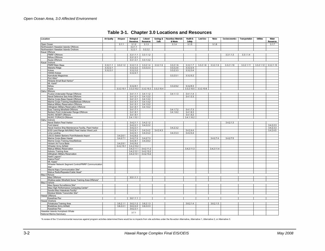
Open Ocean Area, 3.0 Affected Environment
3-2 Hawaii Range Complex Final EIS/OEIS May 2008
Table 3-1. Chapter 3.0 Locations and Resources Air Quality Airspace Biological
Resources Cultural
ResourcesGeology &
SoilsHazardous Materials
& WasteHealth & Safety
Land Use Noise Socioeconomics Transportation Utilities Water Resources
3.1.1 3.1.2 3.1.3 3.1.4 3.1.5 3.1.6 3.1.73.2.1.13.2.2.1 3.2.2.2
PMRF-Offshore 3.3.1.1.1 3.3.1.1.2 3.3.1.1.3 3.3.1.1.4Niihau-Offshore 3.3.1.2.1Kaula-Offshore 3.3.1.3.1 3.3.1.3.2
3.3.2.1.1 3.3.2.1.2 3.3.2.1.3 3.3.2.1.4 3.3.2.1.5 3.3.2.1.6 3.3.2.1.7 3.3.2.1.8 3.3.2.1.9 3.3.2.1.10 3.3.2.1.11 3.3.2.1.12 3.3.2.1.133.3.2.2.1 3.3.2.2.2 3.3.2.2.3 3.3.2.2.4 3.3.2.2.53.3.2.3.1 3.3.2.3.2 3.3.2.3.3 3.3.2.3.4
3.3.2.4.13.3.2.5.1 3.3.2.5.2
3.3.2.9.1 3.3.2.9.2 3.3.2.9.33.3.2.10.1 3.3.2.10.2 3.3.2.10.3 3.3.2.10.4 3.3.2.10.5 3.3.2.10.6
3.4.1.1.1 3.4.1.1.2 3.4.1.1.3 3.4.1.1.43.4.1.2.1 3.4.1.2.2 3.4.1.2.33.4.1.3.1 3.4.1.3.23.4.1.4.1 3.4.1.4.23.4.1.5.1 3.4.1.5.23.4.1.6.1 3.4.1.6.23.4.1.7.1 3.4.1.7.2 3.4.1.7.33.4.1.8.1 3.4.1.8.2 3.4.1.8.33.4.1.9.1 3.4.1.9.2
3.4.1.10.1 3.4.1.10.2
3.4.2.1.1 3.4.2.1.2 3.4.2.1.33.4.2.2.1 3.4.2.2.2 3.4.2.2.33.4.2.3.1 3.4.2.3.2 3.4.2.3.33.4.2.4.1 3.4.2.4.2 3.4.2.4.3 3.4.2.4.4 3.4.2.4.53.4.2.5.1 3.4.2.5.2 3.4.2.5.3 3.4.2.5.4
3.4.2.6.1 3.4.2.6.23.4.2.7.1 3.4.2.7.2 3.4.2.7.3 3.4.2.7.4 3.4.2.7.5
3.4.2.8.1 3.4.2.8.23.4.2.9.1 3.4.2.9.2
3.4.2.10.1 3.4.2.10.23.4.2.11.1 3.4.2.11.2 3.4.2.11.3 3.4.2.11.43.4.2.12.1 3.4.2.12.23.4.2.13.1 3.4.2.13.2
3.5.1.1.1
3.6.1.1.1
3.6.2.1.1 3.6.2.1.2 3.6.2.1.3 3.6.2.1.4 3.6.2.1.53.6.2.2.1 3.6.2.2.2 3.6.2.2.3
3.6.2.3.1
*A review of the 13 environmental resources against program activities determined there would be no impacts from site activities under the No-action Alternative, Alternative 1, Alternative 2, or Alternative 3.
Location
Bradshaw Army AirfieldKawaihae Pier
Molokai Mobile Transmitter Site*
Kawaihae Pier
Pohakuloa Training Area
Maui Offshore
Kaena Point*Mt. Kaala*Wheeler Network Segment Control/PMRF Communication Site*Mauna Kapu Communication Site*
Keehi Lagoon*
Maui Offshore
Wheeler Army AirfieldMakua Military ReservationKahuku Training AreaDillingham Military Reservation
Ford IslandNaval Inactive Ship Maintenance Facility, Pearl HarborEOD Land Range NAVMAG Pearl Harbor West LochLima Landing
Marine Corps Training Area/BellowsHickam Air Force Base
Marine Corps Base Hawaii
HIANG KokeeKamokala MagazinesPort Allen*Kikiaola Small Boat Harbor*
Dillingham Military Reservation-OffshoreEwa Training Minefield-Offshore
Mt. Kahili*
Kaula
Puuloa Underwater Range-OffshoreNaval Defensive Sea Area-Offshore
Open Ocean
Kauai Offshore
Kauai OnshorePMRF/Main BaseMakaha RidgeKokee
Northwestern Hawaiian Islands OffshoreNorthwestern Hawaiian Islands Onshore
Marine Corps Base Hawaii-Offshore
Niihau
Marine Corps Training Area/Bellows-OffshoreMakua Military Reservation-Offshore
Oahu Onshore
Barbers Point Underwater Range-OffshoreNUWC SESEF-OffshoreNUWC FORACS-Offshore
Oahu Offshore
Naval Station Pearl Harbor
Hawaii Onshore
Shallow-water Minefield Sonar Training Area-Offshore*Maui Onshore
Maui Space Surveillance Site*Maui High Performance Computing Center*Sandia Maui Haleakala Facility*
Hawaii Offshore
Makua Radio/Repeater/Cable Head*
USCG Station Barbers Point/Kalaeola Airport
Hawaiian Islands Humpback Whale National Marine Sanctuary 3.7.1
3.0 Affected Environment, Open Ocean Area
May 2008 Hawaii Range Complex Final EIS/OEIS 3-3
3.1.1 AIRSPACE—OPEN OCEAN AREA Airspace, or that space which lies above a nation and comes under its jurisdiction, is generally viewed as being unlimited. However, it is a finite resource that can be defined vertically and horizontally, as well as temporally, when describing its use for aviation purposes. The time dimension is a very important factor in airspace management and air traffic control.
Under Public Law (PL) 85-725, Federal Aviation Act of 1958, the Federal Aviation Administration (FAA) is charged with the safe and efficient use of our nation's airspace, and has established certain criteria for and limits to its use. The method used to provide this service is the National Airspace System. This system is “…a common network of U.S. airspace; air navigation facilities, equipment and services, airports or landing areas; aeronautical charts, information and services; rules, regulations and procedures, technical information and manpower and material.” Appendix C includes a detailed definition of airspace.
Region of Influence For this EIS/Overseas EIS (OEIS), the region of influence for the Open Ocean Area airspace is defined as those areas beyond the territorial limit which is otherwise known as international airspace.
Affected Environment The affected airspace environment in the Open Ocean Area region of influence is described below in terms of its principal attributes: controlled and uncontrolled airspace, special use airspace, en route airways and jet routes, airports and airfields, and air traffic control. There are no military training routes in the region of influence.
Controlled and Uncontrolled Airspace Most of the airspace within the region of influence is in international airspace, and air traffic is managed by the Hawaii Combined Facility. The Honolulu Combined Facility includes the Air Route Traffic Control Center (ARTCC), the Honolulu Control Tower, and the Combined Radar Approach Control collocated in a single facility. Airspace outside that managed by the Hawaii Combined Facility is managed by the Oakland ARTCC.
Special Use Airspace The special use airspace in the region of influence (Figure 3.1.1-1) consists of Warning Area W-188 north of Kauai, and Warning Area W-186 southwest of Kauai, controlled by PMRF. Warning Areas W-188 Rainbow, W-189 and W-190 north of Oahu, W-187 surrounding Kaula, and W-191, W-192, W-193, W-194, and W-196 south of Oahu are scheduled through the Navy Fleet Area Control and Surveillance Facility (FACSFAC) Pearl Harbor which then coordinates with the Honolulu Combined Facility. There are also 12 Air Traffic Control Assigned Airspace (ATCAA) areas within the region of influence. These ATCAA areas provide additional controlled airspace adjacent to and between the Warning Areas.
Table 3.1.1-1 lists the affected Warning Areas and ATCAA areas and their effective altitudes, times used, and their manager or scheduler. There are no prohibited or alert special use airspace areas in the Open Ocean Area airspace use region of influence.
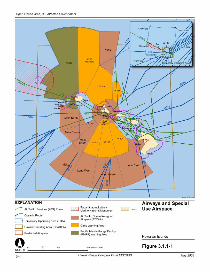
Airways and SpecialUse Airspace
Hawaiian Islands
Figure 3.1.1-1
Lono Central
Lono East
Lono West
Mako
Mela Central
Mela North
Nene
Pali
Pele
Quint Taro
R464
R584
A331
B595
G45
7
B326
B474
B580
R463
G347
A579
A450
B59
6
R465
R578
R576
R577
V4V12
V7
V15
V25
V8
V16
V22
V17
V2
V11
V23 V21
V13
V6V5
V20
V24
V1
3MIL20
V3
V7
V17
0 100 20050 Nautical Miles
179W 43N
179W 16N
150W 43N
150W 28N
Temporary Operating Area
W-188
EXPLANATION
Hawaii
Maui
Oahu
Kauai
Kaula
NORTH
Niihau
Molokai
Lanai
Kahoolawe
Midway Atoll
Johnston Atoll
Tern
KauaiA450
A331
A332
3MIL20
R584B326
MelaSouth
W188(Rainbow)
R-3107
W-188
W-189
W-190
W-192
W-186
R-3101
W-187
W-193W-194 R-3103
R-3110BR-3109B
W-191
W-196
A-311
Air Traffic Services (ATS) Route
Oceanic Route
Temporary Operating Area (TOA)
Hawaii Operating Area (OPAREA)
Restricted Airspace
PapahānaumokuākeaMarine National Monument
Air Traffic Control AssignedAirspace (ATCAA)
Oahu Warning Area
Pacific Missile Range Facility(PMRF) Warning Area
Land
airways_071807.mxd
3-4 May 2008Hawaii Range Complex Final EIS/OEIS
Open Ocean Area, 3.0 Affected Environment
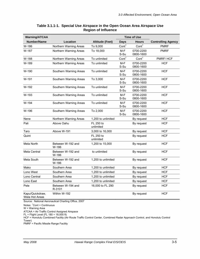
3.0 Affected Environment, Open Ocean Area
May 2008 Hawaii Range Complex Final EIS/OEIS 3-5
Table 3.1.1-1. Special Use Airspace in the Open Ocean Area Airspace Use Region of Influence
Warning/ATCAA Time of Use Number/Name Location Altitude (Feet) Days Hours Controlling Agency
W-186 Northern Warning Areas To 9,000 Cont1 Cont1 PMRF W-187 Northern Warning Areas To 18,000 M-F
S-Su 0700-2200 0800-1600
PMRF
W-188 Northern Warning Areas To unlimited Cont1 Cont1 PMRF/ HCF W-189 Northern Warning Areas To unlimited M-F
S-Su 0700-2200 0800-1600
HCF
W-190 Southern Warning Areas To unlimited M-F S-Su
0700-2200 0800-1600
HCF
W-191 Southern Warning Areas To 3,000 M-F S-Su
0700-2200 0800-1600
HCF
W-192 Southern Warning Areas To unlimited M-F S-Su
0700-2200 0800-1600
HCF
W-193 Southern Warning Areas To unlimited M-F S-Su
0700-2200 0800-1600
HCF
W-194 Southern Warning Areas To unlimited M-F S-Su
0700-2200 0800-1600
HCF
W-196 Southern Warning Areas To 2,000 M-F S-Su
0700-2200 0800-1600
HCF
Nene Northern Warning Areas 1,200 to unlimited By request HCF Pali Above Oahu FL 250 to
unlimited By request HCF
Taro Above W-191 3,000 to 16,000 By request HCF Quint FL 250 to
unlimited By request HCF
Mela North Between W-192 and W-186
1,200 to 15,000 By request HCF
Mela Central Between W-192 and W-186
to unlimited By request HCF
Mela South Between W-192 and W-186
1,200 to unlimited By request HCF
Mako Southern Area 1,200 to unlimited By request HCF Lono West Southern Area 1,200 to unlimited By request HCF Lono Central Southern Area 1,200 to unlimited By request HCF Lono East Southern Area 1,200 to unlimited By request HCF Pele Between W-194 and
R-3101 16,000 to FL 290 By request HCF
Kapu/Quickdraw, Wela Hot Areas
Within W-192 By request HCF
Source: National Aeronautical Charting Office, 2007 Notes: 1Cont = Continuous W = Warning Area ATCAA = Air Traffic Control Assigned Airspace FL = Flight Level (FL 180 = 18,000 ft) HCF = Honolulu Combined Facility (Air Route Traffic Control Center, Combined Radar Approach Control, and Honolulu Control Tower) PMRF = Pacific Missile Range Facility
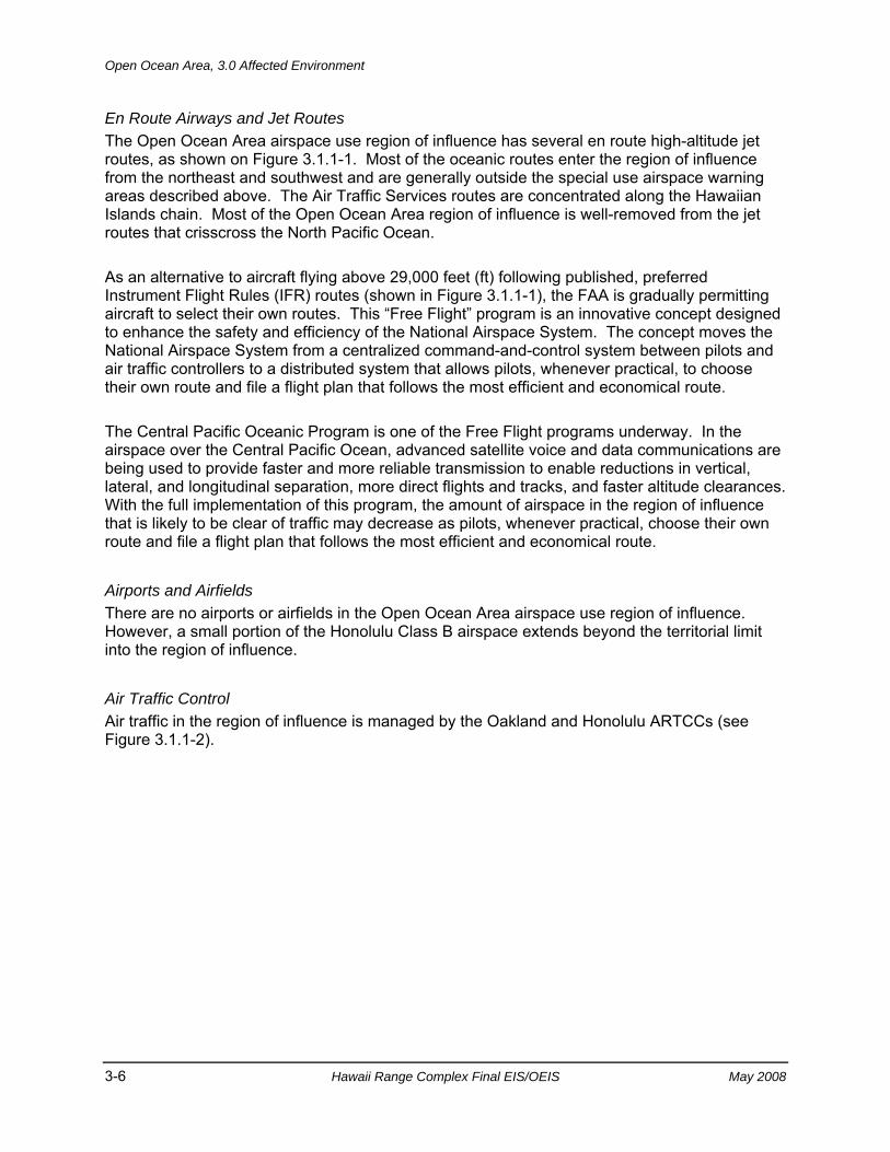
Open Ocean Area, 3.0 Affected Environment
3-6 Hawaii Range Complex Final EIS/OEIS May 2008
En Route Airways and Jet Routes The Open Ocean Area airspace use region of influence has several en route high-altitude jet routes, as shown on Figure 3.1.1-1. Most of the oceanic routes enter the region of influence from the northeast and southwest and are generally outside the special use airspace warning areas described above. The Air Traffic Services routes are concentrated along the Hawaiian Islands chain. Most of the Open Ocean Area region of influence is well-removed from the jet routes that crisscross the North Pacific Ocean.
As an alternative to aircraft flying above 29,000 feet (ft) following published, preferred Instrument Flight Rules (IFR) routes (shown in Figure 3.1.1-1), the FAA is gradually permitting aircraft to select their own routes. This “Free Flight” program is an innovative concept designed to enhance the safety and efficiency of the National Airspace System. The concept moves the National Airspace System from a centralized command-and-control system between pilots and air traffic controllers to a distributed system that allows pilots, whenever practical, to choose their own route and file a flight plan that follows the most efficient and economical route.
The Central Pacific Oceanic Program is one of the Free Flight programs underway. In the airspace over the Central Pacific Ocean, advanced satellite voice and data communications are being used to provide faster and more reliable transmission to enable reductions in vertical, lateral, and longitudinal separation, more direct flights and tracks, and faster altitude clearances. With the full implementation of this program, the amount of airspace in the region of influence that is likely to be clear of traffic may decrease as pilots, whenever practical, choose their own route and file a flight plan that follows the most efficient and economical route.
Airports and Airfields There are no airports or airfields in the Open Ocean Area airspace use region of influence. However, a small portion of the Honolulu Class B airspace extends beyond the territorial limit into the region of influence.
Air Traffic Control Air traffic in the region of influence is managed by the Oakland and Honolulu ARTCCs (see Figure 3.1.1-2).
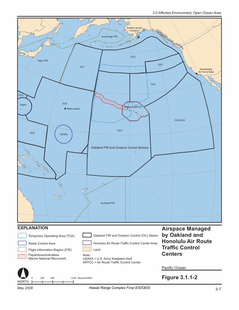
OC 1
To ky o FI R OC 2
OC 4
OC 4/ OC 3
OC 5
OC 5
OC 7
OC 9
0 6 00 1, 200 30 0 N au ti ca l Mi le s Fi gure 3. 1. 1- 2
P ac if ic Oc ea n
Airs p ace Man ag ed by O akl a nd an d Honolul u Ai r R out e Tr af fi c Con trol C en te rs
EX PL AN AT IO N
OC 6
US AKA
G uam Ho no lu lu A RT CC
Wa ke Is la nd
V andenber g Ai r Fo rc e Ba se
NORT H
No te : USAKA = U.S . Ar my K wa ja le in A to ll AR T CC = Ai r R out e Tr a ffi c Co nt ro l Ce nt er
Oa kl an d FI R an d Oce ani c Co nt ol S ec to rs
An c hor age FI R
K odi ak Launc h Co mp le x
Au ck l and FI R
Te mp or ar y O per at in g Ar ea ( TO A)
Ra da r Co nt ro l Ar ea
Fl ig h t I nf or ma ti on R eg i on (F IR ) P ap a hān au mok uāk ea Ma ri ne Na ti on al M onu me nt
La nd
Ho no lu lu A ir R ou te T ra ffi c Co nt ro l Ce nt er A re a
Oa kl an d FI R an d Oce ani c Co nt ro l (OC) S ec to r
3-7 May 2008 Hawaii Range Complex Final EIS/OEIS
3.0 Affected Environment, Open Ocean Area
Open Ocean Area, 3.0 Affected Environment
3-8 Hawaii Range Complex Final EIS/OEIS May 2008
3.1.2 BIOLOGICAL RESOURCES—OPEN OCEAN AREA Native or naturalized vegetation, wildlife, and the habitats in which they occur are collectively referred to as biological resources. Existing information on plant and animal species and habitat types in the vicinity of the proposed sites was reviewed, with special emphasis on the presence of any species listed as threatened or endangered by Federal or State agencies, to assess their sensitivity to the effects of the No-action Alternative, Alternative 1, Alternative 2, or Alternative 3. Appendix C includes a definition of biological resources and the main regulations and laws that govern their protection.
Region of Influence The region of influence for open ocean species includes the areas of the Pacific Ocean within the HRC beyond 12 nm from the shore.
Affected Environment The affected biological resources environment in the Open Ocean Area region of influence is described below.
3.1.2.1 CORAL The Hawaiian Islands have 6,764.5 square miles (mi2) of coral reef area, representing 84 percent of the coral reef area in the United States (Maragos, 1977). Due to the motion of the Pacific Plate, the Hawaiian Islands have been transported in a north to northwest direction away from their original location of formation over the hot spot at a rate of about 4 inches per year (Grigg, 1988; 1997b). The youngest island in the archipelago is Hawaii, where the youngest fringing reefs and barrier reefs are found. Fringing reefs on the western coast of Hawaii are from 100 to 1,000 years old.
Precious coral are corals of the genus Corallium and the pink, gold, bamboo and black corals. Precious coral resources in Hawaii and the Western Pacific are managed by the State of Hawaii and the U.S. Federal government per regulation. The State has jurisdiction over coral resources out to 3 nm but also claims authority over inter-island waters the Makapuu Coral Bed, 6 mi off Makapuu in the channel between Oahu and Molokai. Federal jurisdiction extends from 3 nm beyond the coast of Hawaii to 200 nm and from the shoreline of all U.S. possessions in the Western Pacific to 200 nm. This area is defined as the U.S. Exclusive Economic Zone (EEZ). (Grigg, 1993; United Nations Convention On The Law Of The Sea, 1982)
To the degree authorized by law, black corals in Hawaiian waters are managed by the State of Hawaii. Fishermen are required to have commercial fishing licenses and report their catch monthly to the Hawaii Division of Aquatic Resources. A state regulation sets a minimum size of 48 inches in colony height or a minimum stem diameter of 1 inch for the harvest of live black coral (U.S. Fish and Wildlife Service, 2007b). Currently, black coral divers in Hawaii comply voluntarily with this draft regulation (Grigg, 1993).
3.0 Affected Environment, Open Ocean Area
May 2008 Hawaii Range Complex Final EIS/OEIS 3-9
Precious coral resources within the U.S. EEZ are managed by the Western Pacific Regional Fishery Management Council, under a Fishery Management Plan (FMP) for precious coral. The FMP allows for domestic and foreign fishing by regular or experimental permits and requires logbooks. Specific weight quotas and size limits have been determined based on estimates of maximum sustainable yields and optimum yields (Grigg, 1993).
The FMP and regulations outline and classify the known beds of precious corals within the Western Pacific Region, and designate harvesting method and the amount of corals that can be harvested. There are four bed classifications:
• Established Beds—history of harvest and optimum yields have been established on the basis of biological stock assessment techniques and selective harvesting gear is required. Makapuu is the only designated Established Bed.
• Conditional Beds—yields have been estimated on the basis of bed size relative to established beds assuming that ecological conditions at established beds are representative of conditions at all other beds. Keahole Point, Kaena Point, Brooks Banks, and 180 Fathom Bank are Conditional Beds. Nonselective harvesting is permitted only in the two conditional beds in the Northwestern Hawaiian Islands (Brooks and the 180 Fathom Banks).
• Refugia Beds—one set aside to serve as a baseline study area and possibly reproductive reserve. No harvesting of any kind is permitted in Refugia. The Western Pacific bed, between Nihoa and Necker Islands, is the only designated Refugia Bed.
• Exploratory Permit Areas—unexplored portions of the EEZ in which coral beds are almost certain to exist, but no beds have yet been located. There are four exploratory permit areas, including one surrounding the Hawaiian Islands. Either selective or nonselective harvest gear is permitted in exploratory permit areas except in the Hawaii exploratory area around the Main Hawaiian Islands (Grigg, 1993).
Deep-sea coral communities are prevalent throughout the Hawaiian archipelago (Figure 3.1.2.1-1). They often form offshore reefs that surround all of the Main Hawaiian Islands at depths between 27 and 109 fathoms (Maragos, 1998). Although light penetrates to these depths, it is normally insufficient for photosynthesis. The term “deep-sea corals” may be misleading because substrate (surface for growth), currents, temperature, salinity, and nutrient supply are more important factors in determining the distribution of growth rather than depth (Chave and Malahoff, 1998).
Deep-sea coral communities provide habitat, feeding grounds, recruitment, and nursery grounds for a range of deep-water organisms including epibenthic invertebrates (e.g., echinoderms, sponges, polychaetes, crustaceans, and mollusks), fishes, solitary precious corals (e.g., black corals), and marine mammals (e.g., monk seals) (Maragos, 1998; Midson, 1999; Coral Reef Information System, 2003; Roberts and Hirshfield, 2003; Freiwald et al., 2004). Deep-sea corals live in complete darkness, in temperatures as low as 39 degrees Fahrenheit (°F), and in waters as deep as 19,685 ft (Coral Reef Information System, 2003).
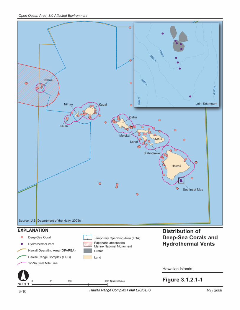
Di stri buti on of De ep -Sea Co rals and Hy drot herma l Ve nt s
Hawa ii an Is l ands
Fi gure 3. 1. 2. 1- 1 0 1 00 20 0 50 Na ut ic al M il es
EX PL AN AT IO N
NORT H
Ha wa ii
Ma ui
O ahu
Ka ua i
Ka ul a
Nii hau
Mo lo ka i
La na i
Ka ho ol aw e
Ni ho a
- 350
0 m
- 3000 m
- 250
0 m
- 2000 m
- 1500 m
Lo ih i Se am ou nt
Se e In se t Ma p
De ep -S ea C or al
Hy dr ot he rm al V en t
Cr at er
La nd
So ur ce : U.S . D ep ar tm en t of th e Na vy , 2 005 c
Te m po ra ry O per at in g Ar ea ( TO A)
Ha wa ii O pe ra ti ng A r ea (O PA RE A)
Ha wa ii R an ge C om pl ex ( HRC)
12 -N au ti ca l M ile L in e
Pa pa hān au mok uāk ea Ma ri ne Na ti on al M onu men t
Hawaii Range Complex Final EIS/OEIS3-10 May 2008
Open Ocean Area, 3.0 Affected Environment
3.0 Affected Environment, Open Ocean Area
May 2008 Hawaii Range Complex Final EIS/OEIS 3-11
Deep-sea corals can form large communities ranging in size from patches of small solitary colonies to massive reef structures (mounds, banks, and forests) spanning an estimated total spatial coverage of about of 772 square miles (mi2) (Cairns, 1994; Freiwald et al., 2004). Much like shallow-water corals, deep-sea corals are fragile, slow growing, and can survive for hundreds of years (Roberts and Hirshfield, 2003). Deep-sea corals can be of two basic types: (1) the hard or stony corals which are related to those found on tropical coral reefs; and (2) the soft corals which include the familiar gorgonians of tropical shallow seas, as well as a broad diversity of other fleshy or tree-like forms. Some of the stony corals are small, but they can grow to be very massive. The soft corals may be small and delicate or very large and tree-like (Watling, 2003). In the Hawaiian Islands, gorgonians are the most common group of deep-sea corals. Of the gorgonians, primnoids are the most abundant group in the Hawaiian archipelago and are dominant off Molokai (Chave and Malahoff, 1998). Potential threats to deep-sea corals include fishing (e.g., bottom trawling), oil- and gas-related activities, cable laying, seabed aggregate extraction, shipping activities, the disposal of waste in deep waters, coral exploitation, other mineral exploration, and increased atmospheric carbon dioxide (Gass, 2003; Freiwald et al., 2004).
3.1.2.2 FISH Distribution and abundance of fisheries, as well as the individual species, depend greatly on the physical and biological factors associated with an ecosystem. Physical parameters include habitat quality variables such as salinity, temperature, dissolved oxygen, and large-scale environmental disturbances (e.g., El Niño Southern Oscillation [ENSO]). Biological factors affecting distribution are complex and include variables such as population dynamics, predator/prey oscillations, seasonal movements, reproductive/life cycles, and recruitment success (Helfman et al., 1997). A single factor is rarely responsible for the distribution of fishery species; more often, a combination of factors is accountable. For example, pelagic or open ocean species optimize their growth, reproduction, and survival by tracking gradients of temperature, oxygen, or salinity (Helfman et al., 1997). Additionally, the spatial distribution of food resources is variable and changes with prevailing physical habitat parameters. Another major component in understanding species distribution is the location of highly productive regions such as frontal zones.
The prevailing oceanographic current in the Hawaiian archipelago is the westward flowing North Equatorial Current. Due to the origin of the North Equatorial Current (cool waters and distance from Hawaii), it is not likely to have had a major impact on fish species occurring in the Hawaiian Islands archipelago. Based on the present current system, most fish larvae would probably arrive at the Northwestern Hawaiian Islands via an eddy of the warm Kuroshio Current that bathes southern Japan and heads northeast where it becomes the North Pacific Current (Randall, 1998).
Environmental variations, such as ENSO events, change the normal characteristics of water temperature, thereby changing the patterns of water flow. In the northern hemisphere, El Niño events typically result in tropical, warm-water species moving north (extending species range), and cold-water species moving north or into deeper water (restricting their range). Surface-oriented, schooling fish often disperse and move into deeper waters. ENSO events alter normal current patterns, alter productivity, and have dramatic effects on distribution, habitat range, and movement of pelagic species (National Marine Fisheries Service, 2002b). Fishes that remain in an affected region experience reduced growth, reproduction, and survival (National Marine
Open Ocean Area, 3.0 Affected Environment
3-12 Hawaii Range Complex Final EIS/OEIS May 2008
Fisheries Service, 2002b). El Niño events have caused fisheries such as that of the skipjack tuna (Katsuwonus pelamis) to shift over 621 miles (mi) (National Marine Fisheries Service-Pacific Islands Region, 2001).
The Hawaiian archipelago distinguishes itself as a subprovince of the spacious tropical and subtropical Indo-Pacific region, which extends from the Red Sea and coast of East Africa to the easternmost islands of Oceania (Hawaii and Easter Island). The composition of the Hawaiian marine life varies enough from the rest of the Indo-Pacific to be treated as a distinct faunal subregion. Hawaii’s unique fish fauna can be explained by its geographical and hydrographical isolation (Randall, 1998). Pelagic fishes such as the larger tunas, the billfishes, and some sharks are able to traverse the great distance that separates the Hawaiian Islands from other islands or continents in the Pacific Ocean; however, shore fishes are dependent on passive transport as larvae in ocean currents for distribution. As would be expected, the fish families that have a high percentage of species in the Hawaiian Islands compared to elsewhere tend to be those with a long larval life stage, such as the moray eels and surgeonfishes (Acanthurus spp.). Families that contain mainly species with short larval life stages, such as the gobies, blennies, and cardinal fishes, are not as well represented in Hawaii as in the rest of the Indo-Pacific region (Randall, 1995).
3.1.2.2.1 Essential Fish Habitat Pursuant to the Magnuson-Stevens Fishery Conservation and Management Act (MSFCMA), the National Marine Fisheries Service (NMFS), eight regional fishery management councils (Councils), and other Federal agencies are mandated to identify and protect important marine and anadromous fish habitat. The Councils (with assistance from NMFS) are required to delineate Essential Fish Habitat (EFH) for all managed species. Federal agencies which fund, permit, or carry out activities that may adversely impact EFH are required to consult with NMFS regarding potential impacts on EFH.
The MSFCMA defines EFH means those waters and substrate necessary to fish for spawning, breeding, feeding or growth to maturity (16 U.S.C.§ 1802). These waters include aquatic areas and their associated physical, chemical, and biological properties used by fish, and may include areas historically used by fish. Substrate types include sediment, hard bottom, structures underlying the waters, and associated biological communities.
EFH can consist of both the water column and the underlying surface (e.g., seafloor) of a particular area. Areas designated as EFH contain habitat essential to the long-term survival and health of our nation’s fisheries. Certain properties of the water column such as temperature, nutrients, or salinity are essential to various species. Some species may require certain bottom types such as sandy or rocky bottoms, vegetation such as sea grasses or kelp, or structurally complex coral or oyster reefs. EFH also includes those habitats that support the different life stages of each managed species, as a single species may use many different habitats throughout its life to support breeding, spawning, nursery, feeding, and protection functions.
3.0 Affected Environment, Open Ocean Area
May 2008 Hawaii Range Complex Final EIS/OEIS 3-13
The Western Pacific Regional Fishery Management Council (WPRFMC) manages major fisheries within the EEZ around Hawaii and the territories and possessions of the United States in the Pacific Ocean (Western Pacific Regional Fishery Management Council, 1998, 2001). The WPRFMC, in conjunction with the State of Hawaii, Division of Aquatic Resources (HDAR), manages the fishery resources in the study area. The WPRFMC focuses on the major fisheries in the study area that require regional management. EFH species, as designated by the WPRFMC (2004), have been divided into management units according to their ecological relationships and preferred habitats. Management units include bottom fish management unit species (BMUS), pelagic management unit species (PMUS), crustacean management unit species (CMUS), precious corals management unit species (PCMUS), and coral reef ecosystem management unit species. Currently, 22 species are managed as BMUS, 32 species and one genus are managed as PMUS, five species and one genus are managed as CMUS, and 13 species are managed under the PCMUS.
Specific information on EFH within the HRC can be found in a separate document, Essential Fish Habitat and Coral Reef Assessment for the Hawaii Range Complex EIS/OEIS (U.S. Department of the Navy, 2007a).
Additionally, a potential squid group consisting of three flying squids (neon flying squid [Ommastrephes bartramii], diamondback squid [Thysanoteuthis rhombus], and purpleback flying squid [Sthenoteuthis oualaniensis]) has been proposed by the WPRFMC for incorporation into the existing PMUS (National Marine Fisheries Service, 2004c). Currently, no data are available to determine if the pelagic species are approaching an overfished situation (National Marine Fisheries Service, 2004b), except for the bigeye tuna (Thunnus obesus). The National Marine Fisheries Service (2004d) determined that overfishing was occurring Pacific-wide for this species. In addition, shark species are afforded protection under the Shark Finning Prohibition Act (National Marine Fisheries Service, 2002c).
The broadbill swordfish (Xiphias gladius), albacore tuna (Thunnus alalunga), common thresher shark (Alopias vulpinus), and salmon shark (Lamna ditropis) have been listed as data deficient on the International Union for Conservation of Nature and Natural Resources (IUCN) Red List due to inadequate information to make a direct, or indirect assessment of its risk of extinction based on its distribution and/or population status (Safina, 1996; Uozumi, 1996a; Goldman and Human, 2000; Goldman et al., 2001). The shortfin mako shark (Isurus oxyrinchus), oceanic whitetip shark (Carcharhinus longimanus), crocodile shark (Pseudocarcharius kamoharai), blacktip shark (C. limbatus), and blue shark (Prionace glauca) have been listed as near threatened (Compagno and Musick, 2000; Shark Specialist Group, 2000; Smale, 2000; Stevens, 2000a; 2000b). The bigeye tuna and the great white shark (Carcharadon carcharias) are listed as vulnerable on the IUCN Red List (Uozumi, 1996b; Fergusson et al., 2000).
3.1.2.2.2 Offshore Ocean or Pelagic Species Pelagic species occur in tropical and temperate waters of the western Pacific Ocean (National Marine Fisheries Service-Pacific Islands Region, 2001). Geographical distribution among these species is governed by seasonal changes in ocean temperature. These species range from as far north as Japan, to as far south as New Zealand. Albacore tuna, striped marlin (Tetrapurus audax), and broadbill swordfish have broader ranges and occur from 50°N to 50°S (Western Pacific Regional Fishery Management Council, 1998). Some species of tuna may aggregate near sea mounts (Yasui, 1986; Itano and Holland, 2000). Temperate species includes those
Open Ocean Area, 3.0 Affected Environment
3-14 Hawaii Range Complex Final EIS/OEIS May 2008
that are found in greater abundance outside tropical waters at higher latitudes (e.g., broadbill swordfish, bigeye tuna, northern bluefin tuna [Thunnus thynnus], and albacore tuna). Pelagic species are typically found in epipelagic to pelagic waters; however, shark species can be found in inshore benthic, neritic to epipelagic, and mesopelagic (ocean zone from 109.3 to 546.7 fathoms) waters. Factors such as gradients in temperature, oxygen, or salinity can affect the suitability of a habitat for pelagic fishes. Skipjack tuna, yellowfin tuna (T. albacares), and Indo-Pacific blue marlin (Makaira nigricans) prefer warm surface layers where the water is well-mixed and relatively uniform in temperature (Western Pacific Regional Fishery Management Council, 1998). Species such as albacore tuna, bigeye tuna, striped marlin, and broadbill swordfish prefer temperate waters associated with higher latitudes and greater depths (Western Pacific Regional Fishery Management Council, 1998). Certain species, such as broadbill swordfish and bigeye tuna, are known to aggregate near the surface at night. During the day broadbill swordfish can be found at depths of about 437 fathoms and bigeye tuna around 150 to 301 fathoms (Table 3.1.2.2.2-1; Western Pacific Regional Fishery Management Council, 1998). Juvenile albacore tuna generally concentrate above 49 fathoms, with adults found in deeper waters (about 49 to 150 fathoms) (Western Pacific Regional Fishery Management Council, 1998).
3.1.2.2.3 Fish Acoustics Fishes, like other vertebrates, have a variety of different sensory systems that enable them to glean information from the world around them (see volumes by Atema et al., 1988 and by Collin and Marshall, 2003 for thorough reviews of fish sensory systems). While each of the sensory systems may have some overlap in providing a fish with information about a particular stimulus (e.g., an animal might see and hear a predator), different sensory systems may be most appropriate to serve an animal in a particular situation. Thus, vision is often most useful when a fish is close to the source of the signal, in daylight, and when the water is clear. However, vision does not work well at night, or in deep waters. Chemical signals can be highly specific (e.g., a particular pheromone used to indicate danger). However, chemical signals travel slowly in still water, and diffusion of the chemicals depends upon currents and so chemical signals are not directional and, in many cases, they may diffuse quickly to a non-detectable level. As a consequence, chemical signals may not be effective over long distances.
In contrast, acoustic signals in water travel very rapidly, travel great distances without substantially attenuating (declining in level) in open water, and they are highly directional. Thus, acoustic signals provide the potential for two animals that are some distance apart to communicate quickly (reviewed in Zelick et al., 1999; Popper et al., 2003).
Since sound is potentially such a good source of information, fishes have evolved two sensory systems to detect acoustic signals, and many species use sound for communication (e.g., mating, territorial behavior—see Zelick et al., 1999 for review). The two systems are the ear, for detection of sound above perhaps 20 hertz (Hz) to 1 kilohertz (kHz) or more, and the lateral line for detection of hydrodynamic signals (water motion) from less than 1 Hz to perhaps 100 or 200 Hz. The inner ear in fish functions very much like the ear found in all other vertebrates, including mammals. The lateral line, in contrast, is only found in fish and a few amphibian (frogs) species. It consists of a series of receptors along the body of the fish. Together, the ear and lateral line are often referred to as the octavolateralis system.
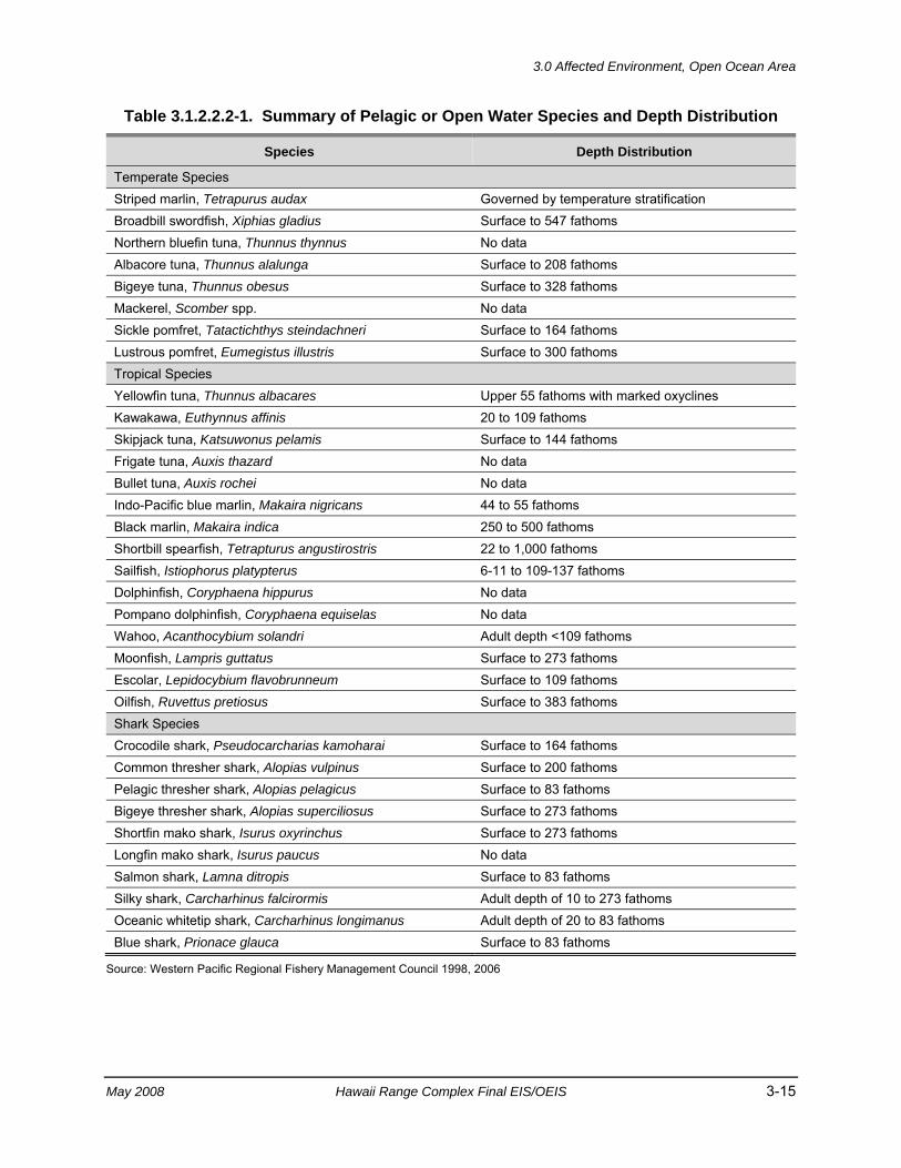
3.0 Affected Environment, Open Ocean Area
May 2008 Hawaii Range Complex Final EIS/OEIS 3-15
Table 3.1.2.2.2-1. Summary of Pelagic or Open Water Species and Depth Distribution
Species Depth Distribution
Temperate Species Striped marlin, Tetrapurus audax Governed by temperature stratification Broadbill swordfish, Xiphias gladius Surface to 547 fathoms Northern bluefin tuna, Thunnus thynnus No data Albacore tuna, Thunnus alalunga Surface to 208 fathoms Bigeye tuna, Thunnus obesus Surface to 328 fathoms Mackerel, Scomber spp. No data Sickle pomfret, Tatactichthys steindachneri Surface to 164 fathoms Lustrous pomfret, Eumegistus illustris Surface to 300 fathoms Tropical Species Yellowfin tuna, Thunnus albacares Upper 55 fathoms with marked oxyclines Kawakawa, Euthynnus affinis 20 to 109 fathoms Skipjack tuna, Katsuwonus pelamis Surface to 144 fathoms Frigate tuna, Auxis thazard No data Bullet tuna, Auxis rochei No data Indo-Pacific blue marlin, Makaira nigricans 44 to 55 fathoms Black marlin, Makaira indica 250 to 500 fathoms Shortbill spearfish, Tetrapturus angustirostris 22 to 1,000 fathoms Sailfish, Istiophorus platypterus 6-11 to 109-137 fathoms Dolphinfish, Coryphaena hippurus No data Pompano dolphinfish, Coryphaena equiselas No data Wahoo, Acanthocybium solandri Adult depth <109 fathoms Moonfish, Lampris guttatus Surface to 273 fathoms Escolar, Lepidocybium flavobrunneum Surface to 109 fathoms Oilfish, Ruvettus pretiosus Surface to 383 fathoms Shark Species Crocodile shark, Pseudocarcharias kamoharai Surface to 164 fathoms Common thresher shark, Alopias vulpinus Surface to 200 fathoms Pelagic thresher shark, Alopias pelagicus Surface to 83 fathoms Bigeye thresher shark, Alopias superciliosus Surface to 273 fathoms Shortfin mako shark, Isurus oxyrinchus Surface to 273 fathoms Longfin mako shark, Isurus paucus No data Salmon shark, Lamna ditropis Surface to 83 fathoms Silky shark, Carcharhinus falcirormis Adult depth of 10 to 273 fathoms Oceanic whitetip shark, Carcharhinus longimanus Adult depth of 20 to 83 fathoms Blue shark, Prionace glauca Surface to 83 fathoms
Source: Western Pacific Regional Fishery Management Council 1998, 2006
Open Ocean Area, 3.0 Affected Environment
3-16 Hawaii Range Complex Final EIS/OEIS May 2008
3.1.2.2.3.1 Sound in Water The basic physical principles of sound in water are the same as sound in air (see Rogers and Cox, 1988; Kalmijn, 1988; 1989). Any sound source produces both pressure waves and actual motion of the medium particles. However, whereas in air the actual particle motion attenuates very rapidly and is often inconsequential even a few centimeters from a sound source, particle motion travels (propagates) much further in water due to the much greater density of water than air. One therefore often sees reference to the “acoustic near field” and the “acoustic far field” in the literature on fish hearing. Acoustic near field refers to the particle motion component of the sound and acoustic far field refers to the pressure. Acoustic near field is often misconstrued as only present close to the source. Indeed, all propagating sound in water has both pressure and particle motion components, but after some distance, often defined as the point at a distance of wavelength of the sound divided by 2 pi (λ/2π), the pressure component of the signal dominates, though particle motion is still present and potentially important for fish (e.g., Rogers and Cox, 1988; Kalmijn, 1988; Kalmijn, 1989). For a 500 Hz signal, this point is about 0.5 m from the source.
Fish detect both pressure and particle motion, whereas terrestrial vertebrates generally only detect pressure. Fish directly detect particle motion using the inner ear (see below). Pressure signals, however, are initially detected by the gas-filled swim bladder or other bubble of air in the body. The air bubble then vibrates and serves as a small sound source which “reradiates” (or resends) the signal to the inner ear as a near field particle motion. The ear can only detect particle motion directly, and it needs the air bubble to produce particle motion from the pressure component of the signal.
If a fish is able to only detect particle motion, it is most sensitive to sounds when the source is nearby due to the substantial attenuation of the particle motion signal as it propagates away from the sound source. As the signal level gets lower (further from the source), the signal ultimately gets below the minimum level detectable by the ear (the threshold). Fish that detect both particle motion and pressure generally are more sensitive to sound than are fish that only detect particle motion. This is the case because the pressure component of the signal attenuates much less over distance than does the particle motion, although both particle motion and pressure are always present in the signal as it propagates from the source.
One very critical difference between particle motion and pressure is that fish pressure signals are not directional. Thus, for fish, as to any observer with a single pressure detector, pressure does not appear to come from any direction (e.g., Popper et al., 2003; Fay, 2005). In contrast, particle motion is highly directional, and this is detectable by the ear itself. Accordingly, fish appear to use the particle motion component of a sound field to glean information about sound source direction. This makes particle motion an extremely important signal to fish.
Since both pressure and particle motion are important to fish, it becomes critical that in design of experiments to test the effects of sound on fish (and fish hearing in general), the signal must be understood not only in terms of its pressure levels, but also in terms of the particle motion component. This has not been done in most experiments on effects of human-generated sound to date, with the exception of one study on effects of seismic airguns on fish (Popper et al., 2005).

3.0 Affected Environment, Open Ocean Area
May 2008 Hawaii Range Complex Final EIS/OEIS 3-17
3.1.2.2.3.1.1 What Do Fish Hear? Basic data on hearing provides information about the range of frequencies that a fish can detect, and the lowest sound level that an animal is able to detect at a particular frequency. This level is often called the “threshold.” Sounds that are above threshold are detectable by fish. It therefore follows that if a fish can hear a biologically irrelevant human-generated sound (e.g., sonar, ship noise), such sound might interfere with the ability of fish to detect other biologically relevant signals. In effect, anthropogenic sounds and explosions may affect behavior, and result in short and long-term tissue damage, but only at significantly high levels. Importantly, to date there has been not any experimental determination of an association of such effects from military mid-frequency active and high-frequency active (MFA/HFA) sonars.
Hearing thresholds have been determined for perhaps 100 of the more than 29,000 living fish species (Figure 3.1.2.2.3.1-1) (see Fay, 1988; Popper et al., 2003; Ladich and Popper, 2004; and Nedwell et al.; 2004 for data on hearing thresholds). These studies show that, with few exceptions, fish cannot hear sounds above about 3 to 4 kHz, and that the majority of species are only able to detect sounds to 1 kHz or even below. In contrast, a healthy young human can detect sounds to about 20 kHz, and dolphins and bats can detect sounds to well over 100 kHz. There have also been studies on a few species of cartilaginous fish, with results suggesting that they detect sounds to no more than 600 or 800 Hz (e.g., Fay, 1988; Casper et al., 2003).
Besides being able to detect sounds, a critical role for hearing is to be able to discriminate between different sounds (e.g., frequency and intensity), detect biologically relevant sounds in the presence of background noises, and determine the direction and location of a sound source in the space around the animal. While data are available on these tasks for only a few fish species, all species studied appear to be able to discriminate sounds of different intensities and frequencies (reviewed in Fay and Megela-Simmons, 1999; Popper et al., 2003) and perform sound source localization (reviewed in Popper et al., 2003; Fay, 2005).
Fish are also able to detect signals in the presence of background noise (reviewed in Fay and Megela-Simmons, 1999; Popper et al., 2003). The results of these studies show that fish hearing is affected by the presence of background noise that is in the same general frequency band as the biologically relevant signal. In other words, if a fish has a particular threshold for a biologically relevant sound in a quiet environment, and a background noise that contains energy in the same frequency range is introduced, this will decrease the ability of the fish to detect the biologically relevant signal. In effect, the threshold for the biologically relevant signal will become poorer.
The significance of this finding is that if background noise is increased, such as a result of human-generated sources, it may be harder for a fish to detect the biologically relevant sounds that it needs to survive.
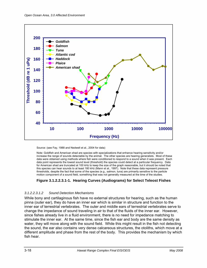
Open Ocean Area, 3.0 Affected Environment
3-18 Hawaii Range Complex Final EIS/OEIS May 2008
Frequency (Hz)
10 100 1000 10000 100000
Thre
shol
d (d
B re
1 u
Pa)
40
60
80
100
120
140
160
180
200GoldfishSalmonTunaAtlantic codHaddock Plaice American shad
Source: (see Fay, 1988 and Nedwell et al., 2004 for data)
Note: Goldfish and American shad are species with specializations that enhance hearing sensitivity and/or increase the range of sounds detectable by the animal. The other species are hearing generalists. Most of these data were obtained using methods where fish were conditioned to respond to a sound when it was present. Each data point represents the lowest sound level (threshold) the species could detect at a particular frequency. Data for American shad are truncated at 100 kHz to keep the size of the graph reasonable, but it should be noted that this species can hear sounds to at least 180 kHz (Mann et al., 1997). Note that these data represent pressure thresholds, despite the fact that some of the species (e.g., salmon, tuna) are primarily sensitive to the particle motion component of a sound field, something that was not generally measured at the time of the studies.
Figure 3.1.2.2.3.1-1. Hearing Curves (Audiograms) for Select Teleost Fishes
3.1.2.2.3.1.2 Sound Detection Mechanisms While bony and cartilaginous fish have no external structures for hearing, such as the human pinna (outer ear), they do have an inner ear which is similar in structure and function to the inner ear of terrestrial vertebrates. The outer and middle ears of terrestrial vertebrates serve to change the impedance of sound traveling in air to that of the fluids of the inner ear. However, since fishes already live in a fluid environment, there is no need for impedance matching to stimulate the inner ear. At the same time, since the fish ear and body are the same density as water, they will move along with the sound field. While this might result in the fish not detecting the sound, the ear also contains very dense calcareous structures, the otoliths, which move at a different amplitude and phase from the rest of the body. This provides the mechanism by which fish hear.
3.0 Affected Environment, Open Ocean Area
May 2008 Hawaii Range Complex Final EIS/OEIS 3-19
The ear of a fish has three semicircular canals that are involved in determining the angular movements of the fish. The ear also has three otolith organs, the saccule, lagena, and utricle, that are involved in both determining the position of the fish relative to gravity and detection of sound and information about such sounds. Each of the otolith organs contains an otolith that lies in close proximity to a sensory epithelium.
The sensory epithelium (or macula) in each otolith organ of fish contains mechanoreceptive sensory hair cells that are virtually the same as found in the mechanoreceptive cells of the lateral line and in the inner ear of terrestrial vertebrates. All parts of the ear have the same kind of cell to detect movement, whether it be movement caused by sound or movements of the head relative to gravity.
3.1.2.2.3.1.3 Hearing Generalists and Specialists Very often, fish are referred to as “hearing generalists” (or non-specialists) or “hearing specialists” (e.g., Fay, 1988; Popper et al., 2003; Ladich and Popper, 2004). Hearing generalists generally detect sound to no more than 1 to 1.5 kHz, whereas specialists are generally able to detect sounds to above 1.5 kHz (see Figure 3.1.2.2.3.1-1). And, in the frequency range of hearing that the specialists and generalists overlap, the specialists generally have lower thresholds than generalists, meaning that they can detect quieter (lower intensity) sounds. Furthermore, it has often been suggested that generalists only detect the particle motion component of the sound field, whereas the specialists detect both particle motion and pressure (see Popper et al., 2003).
However, while the terms hearing generalist and specialist have been useful, it is now becoming clear that the dichotomy between generalists and specialists is not very distinct. Instead, investigators are now coming to the realization that many species that do not hear particularly well still detect pressure as well as particle motion and pressure. However, these species often have poorer pressure detection than those fishes that have a wider hearing bandwidth and greater sensitivity (see Popper and Schilt, 2008).
It is important to note that hearing specialization is not limited to just a few fish taxa. Instead, there are hearing specialists that have evolved in many very diverse fish groups. Moreover, there are instances where one species hears very well while a very closely related species does not hear well. The only “generalizations” that one can make is that all cartilaginous fish are likely to be hearing generalists, while all otophysan fishes (goldfish, catfish, and relatives) are hearing specialists. It is also likely that bony fish without an air bubble such as a swim bladder (see below) are, like cartilaginous fishes, hearing generalists. These fish include all flatfish, some tuna, and a variety of other taxonomically diverse species.
3.1.2.2.3.1.4 Ancillary Structures for Hearing Specializations All species of fish respond to sound by detecting relative motion between the otoliths and the sensory hair cells. However, many species, and most effectively the hearing specialists, also detect sounds using the air-filled swim bladder in the abdominal cavity. The swim bladder is used for a variety of different functions in fish. It probably evolved as a mechanism to maintain buoyancy in the water column, but later evolved to have multiple functions.
The other two roles of the swim bladder are in sound production and hearing (e.g., Zelick et al., 1999; Popper et al., 2003). In sound production, the air in the swim bladder is vibrated by the
Open Ocean Area, 3.0 Affected Environment
3-20 Hawaii Range Complex Final EIS/OEIS May 2008
sound producing structures (often muscles that are integral to the swim bladder wall) and serves as a radiator of the sound into the water (see Zelick et al., 1999).
For hearing, the swim bladder serves to re-radiate sound energy to the ear. This happens since the air in the swim bladder is of a very different density than the rest of the fish body. Thus, in the presence of sound the air starts to vibrate. The vibrating gas re-radiates energy which then stimulates the inner ear by moving the otolith relative to the sensory epithelium. However, in species that have the swim bladder some distance from the ear, any re-radiated sound attenuates a great deal before it reaches the ear. Thus, these species probably do not detect the pressure component of the sound field as well as fish where the swim bladder comes closer to the ear.
In contrast, hearing specialists always have some kind of acoustic coupling between the swim bladder and the inner ear to reduce attenuation and ensure that the signal from the swim bladder gets to the ear. In the goldfish and its relatives, the otophysan fishes, there is a series of bones, the Weberian ossicles, which connect the swim bladder to the ear. When the walls of the swim bladder vibrate in a sound field, the ossicles move and carry the sound directly to the inner ear. Removal of the swim bladder in these fish results in a drastic loss of hearing range and sensitivity (reviewed in Popper et al., 2003).
Besides species with Weberian ossicles, other fishes have evolved a number of different strategies to enhance hearing. For example, the swim bladder may have one or two anterior projections that actually contact one of the otolith organs. In this way, the motion of the swim bladder walls directly couples to the inner ear of these species (see discussion in Popper et al., 2003).
3.1.2.2.3.1.5 Lateral Line The lateral line system is a specialized sensory receptor found on the body that enables detection of the hydrodynamic component of a sound field or other water motions relative to the fish (reviewed in Coombs and Montgomery, 1999, Webb et al., 2008). The lateral line is most sensitive to stimuli that occur within a few body lengths of the animal and to signals that are from below 1 Hz to a few hundred hertz (Coombs and Montgomery, 1999; Webb et al., 2008). The lateral line is involved with schooling behavior, where fish swim in a cohesive formation with many other fish, and it is also involved with detecting the presence of near-by moving objects, such as food. Finally, the lateral line is an important determinant of current speed and direction, providing useful information to fishes that live in streams or where tidal flows dominate.
The only study on the effect of exposure to sound on the lateral line system suggests no effect on these sensory cells by very intense pure tone signals (Hastings et al., 1996). However, since this study was limited to one (freshwater) species and only to pure tones, extrapolation to other sounds is not warranted, and further work needs to be done on any potential lateral line effects on other species and with other types of sounds.
3.0 Affected Environment, Open Ocean Area
May 2008 Hawaii Range Complex Final EIS/OEIS 3-21
3.1.2.2.3.2 Overview of Fish Hearing Capabilities Determination of hearing capability has only been done for fewer than 100 of the more than 29,000 fish species (Fay, 1988; Popper et al., 2003; Ladich and Popper, 2004; Nedwell et al., 2004). Much of this data is summarized in Table 3.1.2.2.3.2-1 for species of marine fish that have been studied and that could potentially be in areas where sonar or other Navy sound sources might be used. This data set, while very limited, suggests that the majority of marine species are hearing generalists, although it must be kept in mind that there are virtually no data for species that live at great ocean depths and it is possible that such species, living in a lightless environment, may have evolved excellent hearing to help them get an auditory “image” of their environment (e.g., Popper, 1980).
While it is hard to generalize as to which fish taxa are hearing generalists or specialists since specialists have evolved in a wide range of fish taxa (see, for example, Holocentridae and Sciaenidae in Table 3.1.2.2.3.2-1), there may be some broad generalizations as to hearing capabilities of different groups. For example, it is likely that all, or the vast majority of species in the following groups would have hearing capabilities that would include them as hearing generalists. These include cartilaginous fishes (Casper et al., 2003; Casper and Mann, 2006; Myrberg, 2001), scorpaeniforms (i.e., scorpionfishes, searobins, sculpins) (Tavolga and Wodinsky, 1963), scombrids (i.e., albacores, bonitos, mackerels, tunas) (Iversen, 1967, 1969; Song et al., 2006), and more specifically, midshipman fish (Porichthys notatus) (Sisneros and Bass, 2003), Atlantic salmon (Salmo salar) (Hawkins and Johnstone, 1978) and other salmonids (e.g., Popper et al., 2007), and all toadfish in the family Batrachoididae (see Table 3.1.2.2.3.2-1 for species).
Marine hearing specialists include some Holocentridae (“soldierfish” and “squirrelfish”) (Coombs and Popper, 1979) and some Sciaenidae (drums and croakers) (reviewed in Ramcharitar et al., 2006b) (see Table 3.1.2.2.3.2-1). In addition, all of the clupeids (herrings, shads, alewives, anchovies) are able to detect sounds to over 3 kHz. And, more specifically, members of the clupeid family Alosinae, which includes menhaden and shad, are able to detect sounds to well over 100 kHz (e.g., Enger, 1967; Mann et al., 2001; Mann et al., 2005).
3.1.2.2.3.2.1 Variability in Hearing Among Groups of Fish Hearing capabilities vary considerably between different fish species (Figure 3.1.2.2.3.1-1), and there is no clear correlation between hearing capability and environment, even though some investigators (e.g., Amoser and Ladich, 2005) have argued that the level of ambient noise in a particular environment might have some impact on hearing capabilities of a species. However, the evidence for this suggestion is very limited, and there are species that live in close proximity to one another, and which are closely related taxonomically, that have different hearing capabilities. This is widely seen within the family Sciaenidae, where there is broad diversity in hearing capabilities and hearing structures (data reviewed in Ramcharitar et al., 2006b). This is also seen in the family Holocentridae. In this group, the shoulderbar soldierfish (Myripristis kuntee) and the Hawaiian squirrelfish (Sargocentron xantherythrum) live near one another on the same reefs, yet Sargocentron detects sounds from below 100 Hz to about 800 Hz, whereas Myripristis is able to detect sounds from 100 Hz to over 3 kHz, and it can hear much lower intensity sounds than can Sargocentron (Coombs and Popper, 1979; see also Tavolga and Wodinsky, 1963).
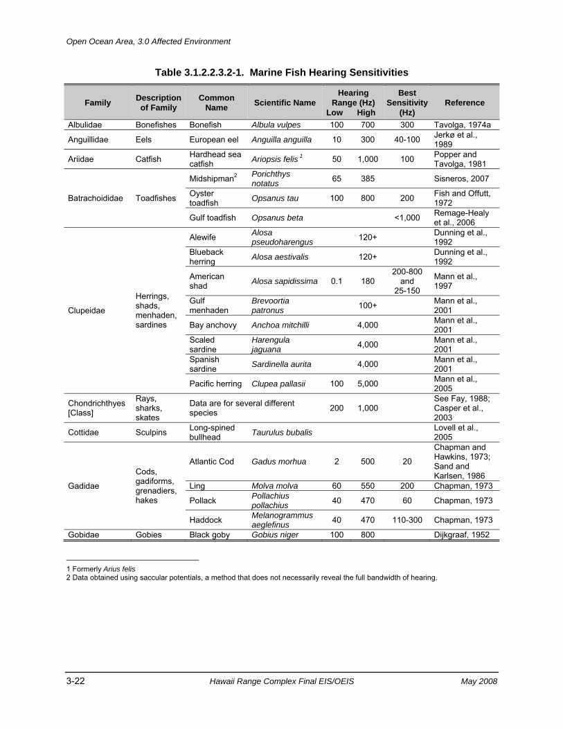
Open Ocean Area, 3.0 Affected Environment
3-22 Hawaii Range Complex Final EIS/OEIS May 2008
Table 3.1.2.2.3.2-1. Marine Fish Hearing Sensitivities
Family Description of Family
Common Name Scientific Name
Hearing Range (Hz)
Low High
Best Sensitivity
(Hz) Reference
Albulidae Bonefishes Bonefish Albula vulpes 100 700 300 Tavolga, 1974a
Anguillidae Eels European eel Anguilla anguilla 10 300 40-100 Jerkø et al., 1989
Ariidae Catfish Hardhead sea catfish Ariopsis felis 1 50 1,000 100 Popper and
Tavolga, 1981
Batrachoididae Toadfishes
Midshipman2 Porichthys notatus 65 385 Sisneros, 2007
Oyster toadfish Opsanus tau 100 800 200 Fish and Offutt,
1972
Gulf toadfish Opsanus beta <1,000 Remage-Healy et al., 2006
Clupeidae
Herrings, shads, menhaden, sardines
Alewife Alosa pseudoharengus 120+ Dunning et al.,
1992 Blueback herring Alosa aestivalis 120+ Dunning et al.,
1992
American shad Alosa sapidissima 0.1 180
200-800 and
25-150
Mann et al., 1997
Gulf menhaden
Brevoortia patronus 100+ Mann et al.,
2001
Bay anchovy Anchoa mitchilli 4,000 Mann et al., 2001
Scaled sardine
Harengula jaguana 4,000 Mann et al.,
2001 Spanish sardine Sardinella aurita 4,000 Mann et al.,
2001
Pacific herring Clupea pallasii 100 5,000 Mann et al., 2005
Chondrichthyes [Class]
Rays, sharks, skates
Data are for several different species 200 1,000
See Fay, 1988; Casper et al., 2003
Cottidae Sculpins Long-spined bullhead Taurulus bubalis Lovell et al.,
2005
Gadidae
Cods, gadiforms, grenadiers, hakes
Atlantic Cod Gadus morhua 2 500 20
Chapman and Hawkins, 1973; Sand and Karlsen, 1986
Ling Molva molva 60 550 200 Chapman, 1973
Pollack Pollachius pollachius 40 470 60 Chapman, 1973
Haddock Melanogrammus aeglefinus 40 470 110-300 Chapman, 1973
Gobidae Gobies Black goby Gobius niger 100 800 Dijkgraaf, 1952 1 Formerly Arius felis 2 Data obtained using saccular potentials, a method that does not necessarily reveal the full bandwidth of hearing.
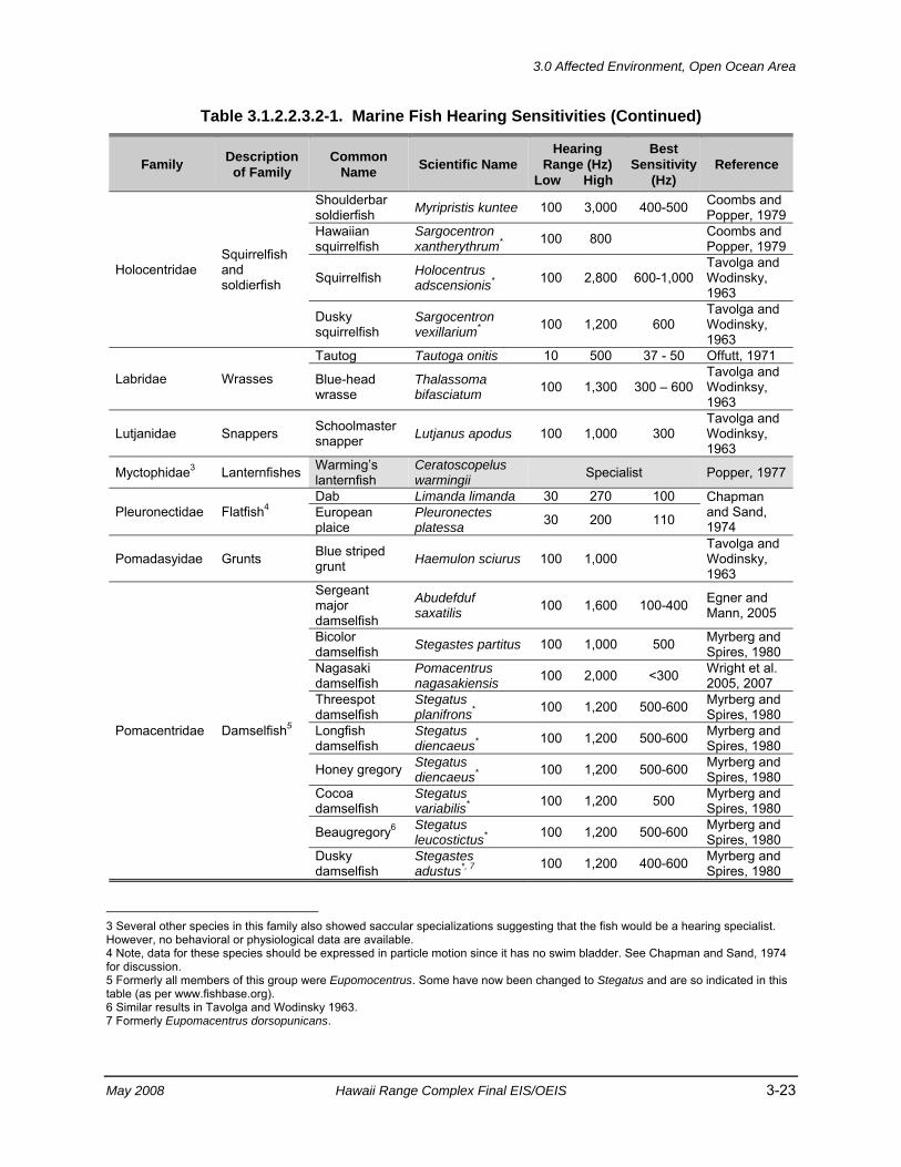
3.0 Affected Environment, Open Ocean Area
May 2008 Hawaii Range Complex Final EIS/OEIS 3-23
Table 3.1.2.2.3.2-1. Marine Fish Hearing Sensitivities (Continued)
Family Description of Family
Common Name Scientific Name
Hearing Range (Hz)
Low High
Best Sensitivity
(Hz) Reference
Holocentridae Squirrelfish and soldierfish
Shoulderbar soldierfish Myripristis kuntee 100 3,000 400-500 Coombs and
Popper, 1979Hawaiian squirrelfish
Sargocentron xantherythrum* 100 800 Coombs and
Popper, 1979
Squirrelfish Holocentrus adscensionis* 100 2,800 600-1,000
Tavolga and Wodinsky, 1963
Dusky squirrelfish
Sargocentron vexillarium* 100 1,200 600
Tavolga and Wodinsky, 1963
Labridae Wrasses
Tautog Tautoga onitis 10 500 37 - 50 Offutt, 1971
Blue-head wrasse
Thalassoma bifasciatum 100 1,300 300 – 600
Tavolga and Wodinksy, 1963
Lutjanidae Snappers Schoolmaster snapper Lutjanus apodus 100 1,000 300
Tavolga and Wodinksy, 1963
Myctophidae3 Lanternfishes Warming’s lanternfish
Ceratoscopelus warmingii Specialist Popper, 1977
Pleuronectidae Flatfish4 Dab Limanda limanda 30 270 100 Chapman
and Sand, 1974
European plaice
Pleuronectes platessa 30 200 110
Pomadasyidae Grunts Blue striped grunt Haemulon sciurus 100 1,000
Tavolga and Wodinsky, 1963
Pomacentridae Damselfish5
Sergeant major damselfish
Abudefduf saxatilis 100 1,600 100-400 Egner and
Mann, 2005
Bicolor damselfish Stegastes partitus 100 1,000 500 Myrberg and
Spires, 1980 Nagasaki damselfish
Pomacentrus nagasakiensis 100 2,000 <300 Wright et al.
2005, 2007 Threespot damselfish
Stegatus planifrons* 100 1,200 500-600 Myrberg and
Spires, 1980 Longfish damselfish
Stegatus diencaeus* 100 1,200 500-600 Myrberg and
Spires, 1980
Honey gregory Stegatus diencaeus* 100 1,200 500-600 Myrberg and
Spires, 1980 Cocoa damselfish
Stegatus variabilis* 100 1,200 500 Myrberg and
Spires, 1980
Beaugregory6 Stegatus leucostictus* 100 1,200 500-600 Myrberg and
Spires, 1980 Dusky damselfish
Stegastes adustus*, 7 100 1,200 400-600 Myrberg and
Spires, 1980 3 Several other species in this family also showed saccular specializations suggesting that the fish would be a hearing specialist. However, no behavioral or physiological data are available. 4 Note, data for these species should be expressed in particle motion since it has no swim bladder. See Chapman and Sand, 1974 for discussion. 5 Formerly all members of this group were Eupomocentrus. Some have now been changed to Stegatus and are so indicated in this table (as per www.fishbase.org). 6 Similar results in Tavolga and Wodinsky 1963. 7 Formerly Eupomacentrus dorsopunicans.
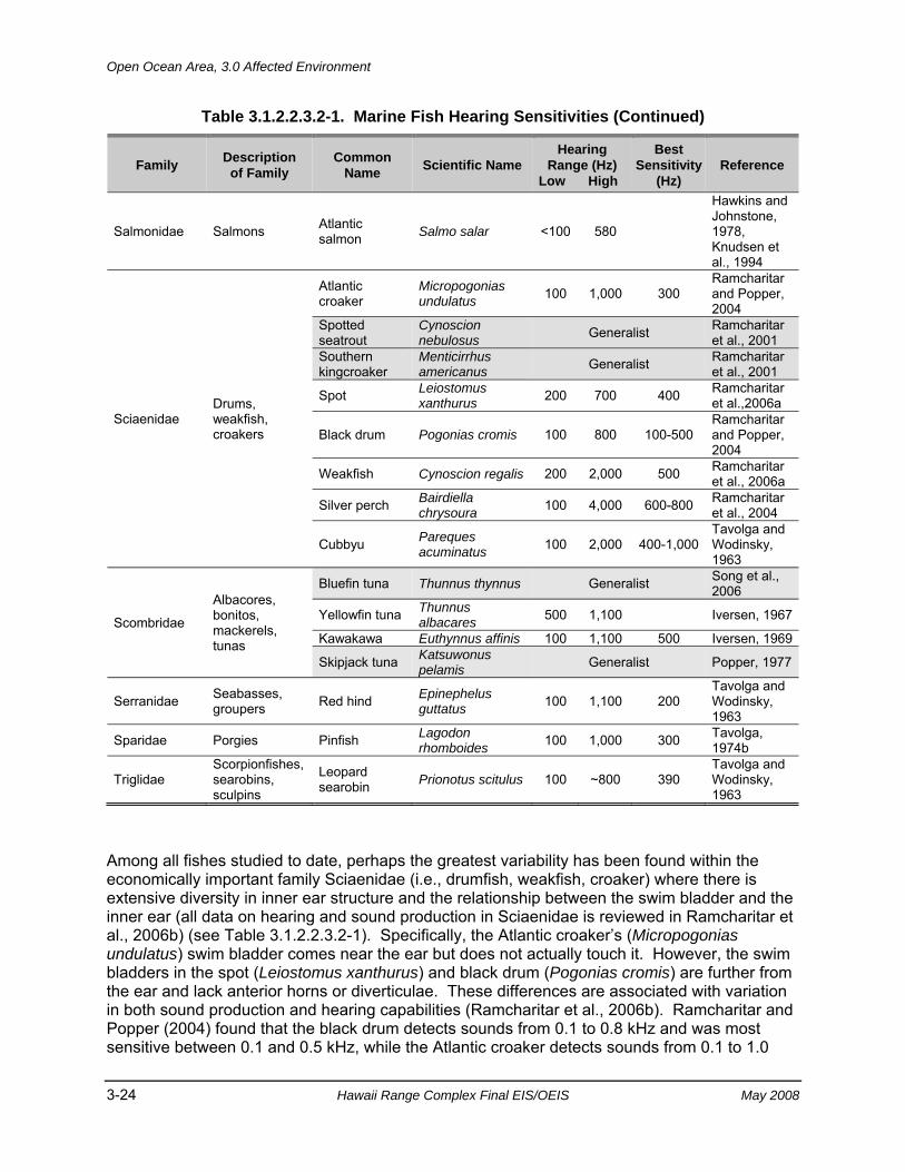
Open Ocean Area, 3.0 Affected Environment
3-24 Hawaii Range Complex Final EIS/OEIS May 2008
Table 3.1.2.2.3.2-1. Marine Fish Hearing Sensitivities (Continued)
Family Description of Family
Common Name Scientific Name
Hearing Range (Hz)
Low High
Best Sensitivity
(Hz) Reference
Salmonidae Salmons Atlantic salmon Salmo salar <100 580
Hawkins and Johnstone, 1978, Knudsen et al., 1994
Sciaenidae Drums, weakfish, croakers
Atlantic croaker
Micropogonias undulatus 100 1,000 300
Ramcharitar and Popper, 2004
Spotted seatrout
Cynoscion nebulosus Generalist Ramcharitar
et al., 2001 Southern kingcroaker
Menticirrhus americanus Generalist Ramcharitar
et al., 2001
Spot Leiostomus xanthurus 200 700 400 Ramcharitar
et al.,2006a
Black drum Pogonias cromis 100 800 100-500 Ramcharitar and Popper, 2004
Weakfish Cynoscion regalis 200 2,000 500 Ramcharitar et al., 2006a
Silver perch Bairdiella chrysoura 100 4,000 600-800 Ramcharitar
et al., 2004
Cubbyu Pareques acuminatus 100 2,000 400-1,000
Tavolga and Wodinsky, 1963
Scombridae
Albacores, bonitos, mackerels, tunas
Bluefin tuna Thunnus thynnus Generalist Song et al., 2006
Yellowfin tuna Thunnus albacares 500 1,100 Iversen, 1967
Kawakawa Euthynnus affinis 100 1,100 500 Iversen, 1969
Skipjack tuna Katsuwonus pelamis Generalist Popper, 1977
Serranidae Seabasses, groupers Red hind Epinephelus
guttatus 100 1,100 200 Tavolga and Wodinsky, 1963
Sparidae Porgies Pinfish Lagodon rhomboides 100 1,000 300 Tavolga,
1974b
Triglidae Scorpionfishes, searobins, sculpins
Leopard searobin Prionotus scitulus 100 ~800 390
Tavolga and Wodinsky, 1963
Among all fishes studied to date, perhaps the greatest variability has been found within the economically important family Sciaenidae (i.e., drumfish, weakfish, croaker) where there is extensive diversity in inner ear structure and the relationship between the swim bladder and the inner ear (all data on hearing and sound production in Sciaenidae is reviewed in Ramcharitar et al., 2006b) (see Table 3.1.2.2.3.2-1). Specifically, the Atlantic croaker’s (Micropogonias undulatus) swim bladder comes near the ear but does not actually touch it. However, the swim bladders in the spot (Leiostomus xanthurus) and black drum (Pogonias cromis) are further from the ear and lack anterior horns or diverticulae. These differences are associated with variation in both sound production and hearing capabilities (Ramcharitar et al., 2006b). Ramcharitar and Popper (2004) found that the black drum detects sounds from 0.1 to 0.8 kHz and was most sensitive between 0.1 and 0.5 kHz, while the Atlantic croaker detects sounds from 0.1 to 1.0
3.0 Affected Environment, Open Ocean Area
May 2008 Hawaii Range Complex Final EIS/OEIS 3-25
kHz and was most sensitive at 0.3 kHz. Additionally, Ramcharitar et al. (2006a) found that weakfish (Cynoscion regalis) is able to detect frequencies up to 2.0 kHz, while spot can hear only up to 0.7 kHz.
The sciaenid with the greatest hearing sensitivity discovered thus far is the silver perch (Bairdiella chrysoura), a species which has auditory thresholds similar to goldfish and which is able to respond to sounds up to 4.0 kHz (Ramcharitar et al., 2004). Silver perch swim bladders have anterior horns that terminate close to the ear.
3.1.2.2.3.2.2 Marine Hearing Specialists The majority of marine fish studied to date are hearing generalists. However, a few species have been shown to have a broad hearing range suggesting that they are specialists. These include some holocentrids and sciaenids, as discussed above. There is also evidence, based on structure of the ear and the relationship between the ear and the swim bladder that at least some deep-sea species, including myctophids, may be hearing specialists (Popper, 1977; Popper, 1980), although it has not been possible to do actual measures of hearing on these fish from great depths.
The most significant studies have shown that all herring like fishes (order Clupeiformes) are hearing specialists and able to detect sounds to at least 3 to 4 kHz, and that some members of this order, in the sub-family Alosinae, are able to detect sounds to over 180 kHz (Figure 3.1.2.2.3.1-1) (Mann et al., 1997, 1998, 2001, 2005; Gregory and Clabburn, 2003). Significantly, there is evidence that detection of ultrasound (defined by the investigators as sounds over 20 kHz) in these species is mediated through one of the otolithic organs of the inner ear, the utricle (Higgs et al., 2004, Plachta et al., 2004). While there is no evidence from field studies, laboratory data leads to the suggestion that detection of ultrasound probably arose to enable these fish to hear the echolocation sounds of odontocete predators and avoid capture (Mann et al., 1998; Plachta and Popper, 2003). This is supported by field studies showing that several Alosinae clupeids avoid ultrasonic sources. These include the alewife (Alosa pseudoharengus) (Dunning et al. 1992, Ross et al. 1996), blueback herring (A. aestivalis) (Nestler et al., 2002), Gulf menhaden (Brevoortia patronus) (Mann et al., 2001), and American shad (A. sapidissima) (Mann et al., 1997, 1998, 2001). Thus, masking of ultrasound by mid- or high-frequency sonar could potentially affect the ability of these species to avoid predation.
Although few non-clupeid species have been tested for ultrasound (Mann et al., 2001), the only non-clupeid species shown to possibly be able to detect ultrasound is the cod (Gadus morhua) (Astrup and Møhl, 1993). However, in Astrup and Møhl’s (1993) study it is feasible that the cod was detecting the stimulus using touch receptors that were over driven by very intense fish-finding sonar emissions (Astrup, 1999; Ladich and Popper, 2004). Nevertheless, Astrup and Møhl (1993) indicated that cod have ultrasound thresholds of up to 38 kHz at 185 to 200 dB re 1 micropascal-meter (µPa-m), which likely only allows for detection of odontocete’s clicks at distances no greater than 10 to 30 meters (m) (33 to 98 ft) (Astrup 1999).
Finally, while most otophysan species are freshwater, a few species inhabit marine waters. In the one study of such species, Popper and Tavolga (1981) determined that the hardhead sea catfish (Ariopsis felis) was able to detect sounds from 0.05 to 1.0 kHz, which is a narrower frequency range than that common to freshwater otophysans (i.e., above 3.0 kHz) (Popper et al., 2003). However, hearing sensitivity below about 500 Hz was much better in the hardhead
Open Ocean Area, 3.0 Affected Environment
3-26 Hawaii Range Complex Final EIS/OEIS May 2008
sea catfish than in virtually all other hearing specialists studied to date (Table 3.1.2.2.3.2-1, Fay, 1988; Popper et al., 2003).
3.1.2.2.3.2.3 Marine Hearing Generalists As mentioned above, investigations into the hearing ability of marine bony fishes have most often yielded results exhibiting a narrower hearing range and less sensitive hearing than specialists. This was first demonstrated in a variety of marine fishes by Tavolga and Wodinsky (1963), and later demonstrated in taxonomically and ecologically diverse marine species (reviews in Fay, 1988; Popper et al., 2003; Ladich and Popper, 2004).
By examining the morphology of the inner ear of bluefin tuna (Thunnus thynnus), Song et al. (2006) hypothesized that this species probably does not detect sounds to much over 1 kHz (if that high). This research concurred with the few other studies conducted on tuna species. Iversen (1967) found that yellowfin tuna (T. albacares) can detect sounds from 0.05 to 1.1 kHz, with best sensitivity of 89 dB (re 1 µPa) at 0.5 kHz. Kawakawa (Euthynnus affinis) appear to be able to detect sounds from 0.1 to 1.1 kHz but with best sensitivity of 107 dB (re 1 µPa) at 0.5 kHz (Iversen, 1969). Additionally, Popper (1981) looked at the inner ear structure of a skipjack tuna (Katsuwonus pelamis) and found it to be typical of a hearing generalist. While only a few species of tuna have been studied, and in a number of fish groups both generalists and specialists exist, it is reasonable to suggest that unless bluefin tuna are exposed to very high intensity sounds from which they cannot swim away, short- and long-term effects may be minimal or non-existent (Song et al., 2006).
Some damselfish have been shown to be able to hear frequencies of up to 2 kHz, with best sensitivity well below 1 kHz. Egner and Mann (2005) found that juvenile sergeant major damselfish (Abudefduf saxatilis) were most sensitive to lower frequencies (0.1 to 0.4 kHz); however, larger fish (greater than 50 millimeters) responded to sounds up to 1.6 kHz. Still, the sergeant major damselfish is considered to have poor sensitivity in comparison even to other hearing generalists (Egner and Mann, 2005). Kenyon (1996) studied another marine generalist, the bicolor damselfish (Stegastes partitus), and found responses to sounds up to 1.6 kHz with the most sensitive frequency at 0.5 kHz. Further, larval and juvenile Nagasaki damselfish (Pomacentrus nagasakiensis) have been found to hear at frequencies between 0.1 and 2 kHz; however, they are most sensitive to frequencies below 0.3 kHz (Wright et al., 2005, 2007). Thus, damselfish appear to be primarily generalists.
Female oyster toadfish (Opsanus tau) apparently use the auditory sense to detect and locate vocalizing males during the breeding season (e.g., Winn; 1967). Interestingly, female midshipman fish (Porichthys notatus) (in the same family as the oyster toadfish) go through a shift in hearing sensitivity depending on their reproductive status. Reproductive females showed temporal encoding up to 0.34 kHz, while non-reproductive females showed comparable encoding only up to 0.1 kHz (Sisneros and Bass, 2003).
The hearing capability of Atlantic salmon (Salmo salar) indicates relatively poor sensitivity to sound (Hawkins and Johnstone, 1978). Laboratory experiments yielded responses only to 580 Hz and only at high sound levels. The Atlantic salmon is considered to be a hearing generalist, and this is probably the case for all other salmonids studied to date based on studies of hearing (e.g., Popper et al., 2007, Wysocki et al., 2007) and inner ear morphology (e.g., Popper, 1976, 1977).
3.0 Affected Environment, Open Ocean Area
May 2008 Hawaii Range Complex Final EIS/OEIS 3-27
Furthermore, investigations into the inner ear structure of the long-spined bullhead (Taurulus bubalis, order Scorpaeniformes) have suggested that these fishes have generalist hearing abilities, and this is supported by their lack of a swim bladder (Lovell et al., 2005). While it is impossible to extrapolate from this species to all members of this large group of taxonomically diverse fishes, studies of hearing in another species in this group, the leopard robin (Prionotus scitulus), suggest that it is probably not able to detect sound to much above 800 Hz, indicating that it would be a hearing generalist (Tavolga and Wodinsky, 1963). However, since the leopard sea robin has a swim bladder, and the long-spined bullhead does not, this illustrates the diversity of species in this order and makes extrapolation on hearing from these two fishes to all members of the group very difficult to do.
A number of hearing generalists can detect very low frequencies of sound. Detection of very low frequencies, or infrasound, was not investigated until fairly recently since most laboratory sound sources were unable to produce undistorted tones below 20 to 30 Hz. In addition, most earlier measures of fish hearing indicated a steadily declining sensitivity towards lower frequencies (Fay, 1988), suggesting that fish would not detect low frequencies. However, as has been pointed out in the literature, often the problem with measuring lower frequency hearing (e.g., below 50 or 100 Hz) was simply that the sound sources available (underwater loud speakers) were not capable of producing lower frequency sounds, or the acoustics of the tanks in which the studies were conducted prevented lower frequency sounds from being effectively used.
Infrasound sensitivity in fish was first demonstrated in the Atlantic cod (Gadus morhua) (Sand and Karlsen, 1986). This species can detect sounds down to about 10 Hz and is sensitive to particle motion of the sound field and not to pressure. Other species shown to detect infrasound include the plaice flatfish (Pleuronectes platessa) (Karlsen, 1992), and the European eel (Anguilla anguilla) (Sand et al., 2000).
The sensitivity of at least some species of fish to infrasound may theoretically provide the animals with a wide range of information about the environment than detection of somewhat higher frequencies. An obvious potential use for this sensitivity is detection of moving objects in the surroundings, where infrasound could be important in, for instance, courtship and prey-predator interactions. Juvenile salmonids display strong avoidance reactions to near-by infrasound (Knudsen et al., 1992, 1994), and it is reasonable to suggest that such behavior has evolved as a protection against predators.
More recently, Sand and Karlsen (2000) proposed the hypothesis that fish may also use the ambient infrasounds in the ocean, which are produced by things like waves, tides, and other large scale motions, for orientation during migration. This would be in the form of an inertial guidance system where the fish detect surface waves and other large scale infrasound motions as part of their system to detect linear acceleration, and in this way migrate long distances.
An important issue with respect to infrasound relates to the distance at which such signals are detected. It is clear that fish can detect such sounds. However, behavioral responses only seem to occur when fish are well within the acoustic near field of the sound source. Thus, it is likely that the responses are to the particle motion component of the infrasound.
Open Ocean Area, 3.0 Affected Environment
3-28 Hawaii Range Complex Final EIS/OEIS May 2008
3.1.2.2.3.2.4 Hearing Capabilities of Elasmobranchs and Other “Fish” Bony fishes are not the only species that may be impacted by environmental sounds. The two other groups to consider are the jawless fish (Agnatha – lamprey) and the cartilaginous fishes (i.e., elasmobranchs; the sharks and rays). While there are some lamprey in the marine environment, virtually nothing is known as to whether they hear or not. They do have ears, but these are relatively primitive compared to the ears of other vertebrates. No one has investigated whether the ear can detect sound (reviewed in Popper and Hoxter, 1987).
The cartilaginous fishes are important parts of the marine ecosystem, and many species are top predators. While there have been some studies on their hearing, these have not been extensive. However, available data suggests detection of sounds from 0.02 to 1 kHz, with best sensitivity at lower ranges (Myrberg, 2001; Casper et al., 2003, Casper and Mann, 2006). Though fewer than 10 elasmobranch species have been tested for hearing thresholds (reviewed in Fay, 1988), it is likely that all elasmobranchs only detect low frequency sounds because they lack a swim bladder or other pressure detector. At the same time, the ear in a number of elasmobranch species whose hearing has not been tested is very large with numerous sensory hair cells (e.g., Corwin, 1981, 1989). Thus, it is possible that future studies will demonstrate somewhat better hearing in those species than is now known.
There is also evidence that elasmobranchs can detect and respond to human-generated sounds. Myrberg and colleagues did experiments in which they played back sounds and attracted a number of different shark species to the sound source (e.g., Myrberg et al., 1969, 1972, 1976; Nelson and Johnson, 1972). The results of these studies showed that sharks were attracted to pulsed low-frequency sounds (below several hundred Hz), in the same frequency range of sounds that might be produced by struggling prey (or divers in the water). However, sharks are not known to be attracted by continuous signals or higher frequencies (which they cannot hear).
3.1.2.2.3.2.5 Data on Fish Hearing Table 3.1.2.2.3.2-1 provides data on the hearing capabilities of all of the marine fish species that have been studied to date. However, before examining the data in the table, a number of important points must be made.
• In order to conform to the most recent taxonomic studies of the species, the table uses current scientific names for a number of species rather than the scientific names used at the time that the research paper was written (Fishbase, 2008).
• The data in the table were primarily compiled by two sources, Fay (1988) and Nedwell et al. (2004). Since the Nedwell et al. (2004) study was not published, the data were checked, where possible, against Fay (1988) or original sources.
• The data in the table for “best sensitivity” is only provided to give a sense of where the best hearing was for that species. However, since thresholds are often variable, this information should be used with utmost caution.
• It may generally be said that fish with a hearing range that only extends to 1.5 kHz are more likely to be hearing generalists, whereas fish with higher frequency hearing would be considered specialists.
3.0 Affected Environment, Open Ocean Area
May 2008 Hawaii Range Complex Final EIS/OEIS 3-29
• It is critical to note that comparison of the data in the table between species must be done with considerable caution. Most importantly, data were obtained in very different ways for the various species, and it is highly likely that different experimental methods yield different results in terms of range of hearing and in hearing sensitivity. Thus, data obtained using behavioral measures, such as those done by Tavolga and Wodinksy (1963) for a variety of marine fishes provide data in terms of what animals actually detected since the animals were required to do a behavioral task whenever they detected a sound.
• In contrast, studies performed using auditory evoked potentials (AEP), often called auditory brainstem response (ABR), a very effective general measure of hearing that is being widely used today, tends, in fishes, to generally provide results that indicate a somewhat narrower hearing range and possibly different sensitivity (thresholds) than obtained using behavioral methods. The difference is that ABR is a measure that does not involve any response on the part of the fish. Instead, ABR is a measure of the brainstem response and does not measure the integrated output of the auditory system (e.g. cortical process, decision-making, etc.). Examples of data from ABR studies include the work of Casper et al. (2003) and Ramcharitar et al. (2004, 2006a).
• Many of the species, as shown, are hearing generalists, and these species respond best primarily to particle motion rather than pressure, as discussed earlier. However, the vast majority of the species were tested with pressure signals, and the particle motion signal was not calibrated. Thus, hearing sensitivity data, and hearing range, may be somewhat different if particle motion had been calibrated. Accordingly, while the table gives a general sense of hearing of different species, caution must be taken in extrapolation to other species, and in interpretation of the data.
Data were compiled from reviews in Fay (1988) and Nedwell et al. (2004). See the very important caveats about the data in the text. For a number of additional species, we can only surmise about hearing capabilities from morphological data. These data are shown in gray, with a suggestion as to hearing capabilities based only on morphology. Scientific names marked with an asterisk have a different name in the literature. (Fishbase, 2008).
As a consequence of these differences in techniques, as well as differences in sound fields used and differences in experimental paradigms, one must be extremely cautious in comparing data between different species when they were tested in different ways and/or in different laboratories. While general comparisons are possible (e.g., which species are generalists and which are specialists), more-detailed comparisons, such as of thresholds, should be done with utmost caution since one investigator may have been measuring pressure and another particle motion. At the same time, it should be noted that when different species were tested in the same lab, using the same experimental approach, it is possible to make comparative statements about hearing among the species used since all would have been subject to the same sound field.
3.1.2.3 SEA TURTLES Sea turtles are long lived reptiles that can be found throughout the world’s tropical, subtropical, and temperate seas (Caribbean Conservation Corporation and Sea Turtle Survival League, 2003). There are seven living species of sea turtles from two distinct families, the Cheloniidae (hard-shelled sea turtles; six species) and the Dermochelyidae (leatherback turtle [Dermochelys
Open Ocean Area, 3.0 Affected Environment
3-30 Hawaii Range Complex Final EIS/OEIS May 2008
coriacea]; one species). These two families can be distinguished from one another on the basis of their carapace (upper shell) and other morphological features. Sea turtles are an important marine resource in that they provide economic, arid existence (non-use) value to humans (Witherington and Frazer, 2003). Over the last few centuries, sea turtle populations have declined dramatically due to anthropogenic (human-related) activities such as coastal development, oil exploration, commercial fishing, marine-based recreation, pollution, and over-harvesting (Natural Research Council, 1990; Eckert, 1995). As a result, all six species of sea turtles found in U.S. waters are currently listed as either threatened or endangered under the Endangered Species Act (ESA). Five of the seven living species of sea turtles are known to occur in the HRC: the green (Chelonia mydas), hawksbill (Eretmochelys imbricata), loggerhead (Caretta caretta), olive ridley (Lepidochelys olivacea), and leatherback turtles.
Sea turtles are highly adapted for life in the marine environment. Unlike terrestrial and freshwater turtles, sea turtles possess powerful, modified forelimbs (or flippers) that enable them to swim continuously for extended periods of time (Wyneken, 1997). They also have compact and streamlined bodies that help to reduce drag. Additionally, sea turtles are among the longest and deepest diving of the air-breathing vertebrates, spending as little as 3 to 6 percent of their time at the water’s surface (Lutcavage and Lutz, 1997). Sea turtles often travel thousands of miles between their nesting beaches and feeding grounds, which makes the aforementioned suite of adaptations very important (Ernst et al., 1994; Meylan, 1995). Sea turtle traits and behaviors also help protect them from predation. Sea turtles have a tough outer shell and grow to a large size as adults; mature leatherback turtles can weigh up to 2,091 pounds (lb) (Eckert and Luginbuhl, 1988). Sea turtles cannot withdraw their head or limbs into their shell, so growing to a large size as adults is important.
Although they are specialized for life at sea, sea turtles begin their lives on land. Aside from this brief terrestrial period, which lasts approximately 2 months as eggs and an additional few minutes to a few hours as hatchlings scrambling to the surf, most sea turtles are rarely encountered out of the water. Sexually mature females return to land in order to nest, while certain species in the Hawaiian Islands, Australia, and the Galapagos Islands haul out on land in order to bask (Carr, 1995; Spotila et al., 1997). Sea turtles bask to thermoregulate, elude predators, avoid harmful mating encounters, and possibly to accelerate the development of their eggs, accelerate their metabolism, and destroy aquatic algae growth on their carapaces (Whittow and Balazs, 1982; Spotila et al., 1997). On occasion, sea turtles can unintentionally end up on land if they are dead, sick, injured, or cold-stunned. These events, also known as strandings, can be caused by either biotic (e.g., predation and disease) or abiotic (e.g., water temperature) factors.
Female sea turtles nest in tropical, subtropical, and warm-temperate latitudes, often in the same region or on the same beach where they hatched (Miller, 1997). Upon selecting a suitable nesting beach, most sea turtles tend to re-nest in close proximity during subsequent nesting attempts. The leatherback turtle is a notable divergence from this pattern. This species nests primarily on beaches with little reef or rock offshore. On these types of beaches erosion reduces the probability of nest survival. To compensate, leatherbacks scatter their nests over larger geographic areas and lay on average two times as many clutches as other species (Eckert, 1987).
At times, sea turtles may fail to nest after emerging from the ocean. These non-nesting emergences, known as false crawls, can occur if sea turtles are obstructed from laying their
3.0 Affected Environment, Open Ocean Area
May 2008 Hawaii Range Complex Final EIS/OEIS 3-31
eggs (by debris, rocks, roots, or other obstacles), are distracted by surrounding conditions (by noise, lighting, or human presence), or are uncomfortable with the consistency or moisture of the sand on the nesting beach. Turtles that are successful at nesting usually lay several clutches of eggs during a nesting season with each clutch containing between 50 and 200 eggs, depending on the species (Witzell, 1983; Dodd, 1988; Hirth, 1997). Most sea turtles, with the possible exception of Kemp’s ridley turtles (Lepidochelys kempii), do not nest in consecutive years; instead, they will often skip 2 or 3 years before returning to the nesting grounds (Márquez-M., 1990; Ehrhart, 1995). Nesting success is vital to the long-term existence of sea turtles since it is estimated that only 1 out of every 1,000 hatchlings survives long enough to reproduce (Frazer, 1986).
During the nesting season, daytime temperatures can be lethal on tropical, subtropical, and warm-temperate beaches. As a result, adult sea turtles most often nest and hatchlings most often emerge from their nest at night (Miller, 1997). After emerging from the nest, sea turtle hatchlings use visual cues (e.g., light intensity or wavelengths) to orient themselves toward the sea (Lohmann et al., 1997).
Hatchlings that make it into the water will spend the first few years of their lives in offshore waters, drifting in convergence zones or amidst floating vegetation, where they find food (mostly pelagic invertebrates) and refuge in flotsam that accumulates in surface circulation features (Carr, 1987). Originally labeled the lost year, this stage in a sea turtle’s life history is now known to be much longer in duration, possibly lasting a decade or more (Chaloupka and Musick, 1997; Bjorndal et al., 2000). Sea turtles will spend several years growing in the early juvenile “nursery habitat,” which is usually pelagic and oceanic, before migrating to distant feeding grounds that comprise the later juvenile “developmental habitat,” which is usually demersal and neritic (in shallow water) (Musick and Limpus, 1997; Frazier, 2001). Hard-shelled sea turtles most often utilize shallow offshore and inshore waters as later juvenile developmental habitats; whereas leatherback turtles, depending on the season, can utilize either coastal feeding areas in temperate waters or offshore feeding areas in tropical waters (Frazier, 2001).
Once in the later juvenile developmental habitat, most sea turtles change from surface to benthic feeding and begin to feed on larger items such as crustaceans, mollusks, sponges, coelenterates, fishes, macroalgae, and seagrasses (Bjorndal, 1997). A sea turtle’s diet varies according to its feeding habitat and its preferred prey. Upon moving from the later juvenile developmental habitat to the adult foraging habitat, sea turtles may demonstrate further changes in prey preference, dietary composition, and feeding behavior (Bjorndal, 1997; Musick and Limpus, 1997).
Throughout their life cycles, sea turtles undergo complex seasonal movements. Sea turtle movement patterns are influenced by changes in ocean currents, turbidity, salinity, and food availability. In addition to these factors, the distribution of many sea turtle species is dependent upon and often restricted by water temperature (Epperly et al., 1995; Davenport, 1997; Coles and Musick, 2000). Most sea turtles become lethargic at temperatures below 50°F and above 104°F (Spotila et al., 1997).
Sea turtles do not have an auditory meatus or pinna that channels sound to the middle ear, nor do they have a specialized tympanum (eardrum). Instead, they have a cutaneous layer and underlying subcutaneous fatty layer that function as a tympanic membrane. The subcutaneous
Open Ocean Area, 3.0 Affected Environment
3-32 Hawaii Range Complex Final EIS/OEIS May 2008
fatty layer receives and transmits sound to the extracolumella, a cartilaginous disk, located at the entrance to the columella, a long, thin bone that extends from the middle ear cavity to the entrance of the inner ear or otic cavity (Ridgway et al., 1969a). Sound arriving at the inner ear via the columella is transduced by the bones of the middle ear. Sound also arrives by bone conduction through the skull.
Sea turtle auditory sensitivity is not well studied, though a few preliminary investigations suggest that it is limited to low-frequency bandwidths, such as the sounds of waves breaking on a beach. The role of underwater low-frequency hearing in sea turtles is unclear. It has been suggested that sea turtles may use acoustic signals from their environment as guideposts during migration and as a cue to identify their natal beaches (Lenhardt et al., 1983). The range of maximum sensitivity for sea turtles is 100 to 800 Hz, with an upper limit of about 2,000 Hz (Lenhardt, 1994). Hearing below 80 Hz is less sensitive but still potentially usable to the animal (Lenhardt, 1994). Ridgway et al. (1969a) used aerial and mechanical stimulation to measure the cochlea in three specimens of green turtle, and concluded that they have a useful hearing span of perhaps 60 to 1,000 Hz, but hear best from about 200 Hz up to 700 Hz, with their sensitivity falling off considerably below 200 Hz. The maximum sensitivity for one animal was at 300 Hz, and for another was at 400 Hz. At the 400 Hz frequency, the turtle's hearing threshold was about 64 dB in air. At 70 Hz, it was about 70 dB in air. Bartol et al. (1999) reported that juvenile loggerhead sea turtles hear sounds between 250 and 1,000 Hz. Lenhardt et al. (1983) applied audio-frequency vibrations at 250 Hz and 500 Hz to the heads of loggerheads and Kemp’s ridleys submerged in salt water to observe their behavior, measure the attenuation of the vibrations, and assess any neural-evoked response. These stimuli (250 Hz, 500 Hz) were chosen as representative of the lowest sensitivity area of marine turtle hearing (Wever, 1978). At the maximum upper limit of the vibratory delivery system, the turtles exhibited abrupt movements, slight retraction of the head, and extension of the limbs in the process of swimming. Lenhardt et al. (1983) concluded that bone-conducted hearing appears to be a reception mechanism for at least some of the sea turtle species, with the skull and shell acting as receiving surfaces. Finally, sensitivity even within the optimal hearing range is apparently low as threshold detection levels in water are relatively high at 160 to 200 dB re 1 µPa-m (Lenhardt, 1994).
Five of the seven living species of sea turtles are known to occur in the HRC: the green, hawksbill, loggerhead, olive ridley, and leatherback turtles. Each of these species is protected under the ESA. However, critical habitat has not yet been designated for any of these species in the U.S. Pacific. A draft proposed rule was prepared in 1980 to designate critical habitat for the green turtle in the Hawaiian Islands, American Samoa, and the Trust Territories of the United States, but it was never approved by the U.S. Fish and Wildlife Service (USFWS) (Eckert, 1993).
Green, hawksbill, loggerhead, olive ridley, and leatherback turtles are all regular inhabitants of the HRC (i.e., they occur as a regular or normal part of the fauna in the HRC, regardless of how abundant or common they are). Green and hawksbill turtles are most common in offshore waters around the Main Hawaiian Islands and Nihoa, as they prefer to reside in reef-type environments that are less than about 55 fathoms in depth (U.S. Department of the Navy, 2005b). The green turtle is by far the most common species occurring in the offshore waters around the Hawaiian Islands; this is highly evidenced by the available stranding data for the Main Hawaiian Islands. More than 90 percent of all green turtle breeding and nesting activity in Hawaiian waters occurs at French Frigate Shoals in the Northwestern Hawaiian Islands, yet a
3.0 Affected Environment, Open Ocean Area
May 2008 Hawaii Range Complex Final EIS/OEIS 3-33
substantial foraging population resides in and returns to the shallow, coastal waters surrounding the Main Hawaiian Islands (especially around Maui and Kauai). Hawksbill turtles are the second most common species in the offshore waters of the Hawaiian Islands, as also reflected by the stranding records, yet they are far less abundant than green turtles. Hawksbills occur around and nest on several of the Main Hawaiian Islands. Hawksbill nesting occurs primarily on the southeastern end of Hawaii and on the eastern end of Molokai (Aki et al., 1994).
Further offshore (in waters beyond the 55-fathom isobath), juvenile loggerheads forage in or migrate through the HRC as they move between North American developmental habitats and Japan. The highest densities of loggerheads can be found just north of the HRC within the North Pacific transition zone (Polovina et al., 2000). The highest densities of olive ridleys, on the other hand, are likely found just south of the HRC. The distribution of the olive ridley in the central Pacific Ocean is primarily tropical; as a result, they are often found in warmer waters than loggerheads (Polovina et al., 2004). The primary migration corridor for leatherbacks moving west from U.S. west coast foraging areas to western Pacific nesting and foraging areas lies along the southern edge of the HRC, while an eastward return corridor appears to pass through the northern portion of the HRC (U.S. Department of the Navy, 2005b).
Due to the offshore habitat preferences of the green and hawksbill turtles and the oceanic habitat preferences of the loggerhead, olive ridley, and leatherback turtles, the entire HRC is recognized as an area of primary occurrence for sea turtles. Since the Hawaiian Islands are situated in tropical waters that are warm year-round, the area of primary occurrence is the same in fall and winter as it is in spring and summer. Sea turtles are also known to come ashore at several locations throughout the Main Hawaiian Islands, for terrestrial basking (green turtles only) or nesting (primarily green and hawksbill turtles). Nesting/basking sites for sea turtles occur on all eight of the Main Hawaiian Islands. Of note are green turtle nesting/basking beaches located at PMRF Barking Sands on Kauai and a green turtle basking beach located along Kiholo Bay off the northwestern shore of Hawaii (National Ocean Service, 2001; U.S. Department of the Navy, 2004a). These beaches are located in areas where the HRC runs right up to the shoreline.
3.1.2.3.1 Green Turtle (Chelonia mydas) Status. Green turtles are listed as threatened under the ESA, except for breeding populations found in Florida and the Pacific coast of Mexico, which are both listed as endangered. Commercial exploitation and uncontrolled subsistence harvest of nesters and eggs has resulted in a dramatic decline of nesting females at the two main nesting beaches in Michoacan, Mexico. A conservative estimate of the total number of adult females at these locations is 4,238. This population is considered to be stable for now, and estimated extinction probabilities indicate very low risks of quasi-extinction over the next 100 years (Snover, 2005). Green turtle populations are in serious decline throughout most of the rest of the Pacific Ocean, except for the Hawaiian population. The Hawaiian population of green turtles is its own distinct genetic haplotype.
The Hawaiian population of green turtles appears to have increased gradually over the past 30 years and currently has population sizes sufficient to warrant a status review (Balazs, 1995; Balazs and Chaloupka, 2004). This is presumably due to effective protection at primary nesting

Open Ocean Area, 3.0 Affected Environment
3-34 Hawaii Range Complex Final EIS/OEIS May 2008
areas in the Northwestern Hawaiian Islands and better enforcement of regulations prohibiting take of the species.
A herpes virus is involved in a complex etiology of sea turtle fibropapilloma that affects the skin with large tumors (Herbst, 1994; Herbst et al., 1995; Quackenbush et al., 1998). Fibropapilloma may be caused by exposure to marine areas impacted by pollution such as runoff from agricultural, industrial, or urban sources (Aguirre and Lutz, 2004). Growth rates of green turtles were significantly lower in those with fibropapilloma tumors (Chaloupka and Balazs, 2005). Despite the occurrence of fibropapillomatosis, and spirochidiasis, both of which are major causes of stranding of this species, nester abundance has continued to increase (Balazs and Chaloupka 2004). The size of the green turtle population in the Pacific Ocean was estimated at about 21,000 adults in 2001 (National Marine Fisheries Service, 2005b; Seminoff, 2004).
Abundance and Distribution. Green turtles occur in the coastal waters surrounding the Main Hawaiian Islands throughout the year and also migrate seasonally to the Northwestern Hawaiian Islands to reproduce. Genetic analyses conducted by NMFS suggest that about 57 percent of the green turtles that have been captured in the Hawaii-based longline fisheries have been members of the endangered Mexican (Pacific coast) nesting aggregation, while 43 percent have represented the threatened Hawaiian (French Frigate Shoals) nesting aggregations. This EIS/OEIS assumes that these results are generally representative of the relative abundance of green turtles found in open ocean areas off the Main Hawaiian Islands.
Adult green turtles that breed in the Northwestern Hawaiian Islands make regular reproductive migrations from their foraging grounds either around the Main Hawaiian Islands or around the westernmost atolls in the Northwestern Hawaiian Islands. This has been evidenced by mark-recapture and satellite-tracking studies on both adult male and female green turtles (Balazs, 1976; 1983; Balazs and Ellis, 1998; Balazs et al., 1994). Juvenile green turtles can also make long-range movements throughout the Hawaiian archipelago. From June 2002 to March 2003, a captive-reared green turtle released off northwestern Hawaii traveled over 2,983 mi around the Hawaiian Islands, swimming as far west as the waters between Nihoa and Necker Islands before turning around and heading back to the Main Hawaiian Islands (Thompson, 2003).
The largest nesting colony in the central Pacific Ocean occurs at French Frigate Shoals in the Northwestern Hawaiian Islands, where about 200 to 700 females nest each year. On occasion, green turtles also nest in the Main Hawaiian Islands. The most famous nesting green turtle in the Main Hawaiian Islands is turtle 5690, known by sea turtle biologists as “Maui Girl.” This turtle, which was raised to a year old at Oahu’s Sea Life Park and then tagged and released, has nested on beaches near Lahaina, Maui in 2000, 2002, and 2004 (Leone, 2004). Other sporadic nesting events in the Main Hawaiian Islands have occurred along the north shore of Molokai, the northwest shore of Lanai, and the south, northeast, and southwest shores of Kauai (U.S. Department of the Navy, 2001a, 2002a; National Ocean Service, 2001).
The area of year-round primary occurrence for green turtles is located in waters inshore of the 55-fathom isobath (bathymetric contour of equal depth) around all of the Main Hawaiian Islands and Nihoa. It is in these areas where reefs, their preferred habitats for foraging and resting, are most abundant. The area of secondary occurrence encompasses an oceanic zone surrounding the Hawaiian Islands. This area is frequently inhabited by adults that are migrating to the Northwestern Hawaiian Islands to reproduce and by pelagic stage individuals that have yet to settle into coastal feeding grounds of the Main Hawaiian Islands. Further offshore of this
3.0 Affected Environment, Open Ocean Area
May 2008 Hawaii Range Complex Final EIS/OEIS 3-35
seasonal use zone, green turtles occur in much lower numbers and densities. The occurrence of East Pacific green turtles in this oceanic habitat is documented through by-catch in the Hawaii-based longline fishery. These turtles may represent late stage pelagic juveniles from this population, but the reasons for their presence are otherwise not well understood.
3.1.2.3.2 Hawksbill Turtle (Eretmochelys imbricata) Status. The hawksbill turtle is listed as endangered under the ESA. A lack of regular quantitative surveys for hawksbill turtles in the Pacific Ocean and the discrete nature of this species’ nesting have made it extremely difficult for scientists to assess the distribution and population status of hawksbills in the region (National Marine Fisheries Service and U.S. Fish and Wildlife Service, 1998a; Seminoff et al., 2003).
Abundance and Distribution. Around the Hawaiian Islands, hawksbills are only known to occur in the coastal waters of the eight main and inhabited islands of the archipelago. Hawksbills forage throughout the Main Hawaiian Islands, although in much fewer numbers than green turtles. Hawksbills have been captured at several locations including Kiholo Bay and Kau (Hawaii), Palaau (Molokai), and Makaha (Oahu) (Hawaii Department of Land and Natural Resources, 2002). Strandings have been reported in Kaneohe and Kahana Bays (Oahu) as well as in other locations throughout the Main Hawaiian Islands (Eckert, 1993; National Marine Fisheries Service and U.S. Fish and Wildlife Service, 1998a). No reliable reports are known from Niihau (U.S. Department of the Navy, 2001a). Hawksbills are much more abundant in the shallow, offshore waters of the Hawaiian Islands than they are in deeper, offshore waters of the central Pacific Ocean.
Throughout the year, the area of primary occurrence for hawksbill turtles can be found in HRC waters shoreward of the 55-fathom isobath. Beyond the 55-fathom isobath, hawksbill occurrence is apparently rare year-round. Pelagic stage individuals may occur in oceanic waters off the Main Hawaiian Islands and Nihoa, but these life stages are nearly impossible to sight during surveys and rarely, if ever, interact with the pelagic longline fishery. Of the five sea turtle species known to occur in the HRC, the hawksbill is the only one that is not taken by Hawaiian longliners (Kobayashi and Polovina, 2005).
Since 1991, 81 nesting female hawksbills have been tagged on the Island of Hawaii at various locations, 22 tagged in the last 3 years. These do not include nesting females from Maui or Molokai which would add a small number to the total. While this appears to be an encouraging trend, Seitz and Kagimoto (2007) report that there are insufficient data to confirm an increasing population as yet.
3.1.2.3.3 Leatherback Turtle (Dermochelys coriacea) Status. Leatherback turtles are listed as endangered under the ESA and are critically endangered with extinction in the Pacific Ocean. There are few quantitative data available concerning the seasonality, abundance, or distribution of leatherbacks in the central North Pacific Ocean. The leatherback is not typically associated with insular habitats, such as those characterized by coral reefs, yet individuals are occasionally encountered in deep ocean waters near prominent archipelagos such as the Hawaiian Islands (Eckert, 1993).
Open Ocean Area, 3.0 Affected Environment
3-36 Hawaii Range Complex Final EIS/OEIS May 2008
Abundance and Distribution. Based on the genetic sampling of 18 leatherback turtles in Hawaiian waters, about 94 percent of the leatherback turtles sampled originated from western Pacific nesting beaches (National Marine Fisheries Service, 2004b, 2005b). These turtles could represent individuals from Indonesia (Jamursba-Medi or War-Mon), Papua New Guinea (Kamiali or other areas of the Huon Gulf), Malaysia (Terrenganu), the Solomon Islands, or Fiji, although satellite tracks from leatherback turtles tagged in Papua New Guinea suggest that leatherback turtles from these islands tend to migrate south instead of north, which would take them away from the action area. The remaining 6 percent of the leatherback turtles found off the Main Hawaiian Islands represent nesting aggregations from the eastern tropical Pacific Ocean (Mexico and Costa Rica).
Leatherback turtles are regularly sighted by fishermen in offshore waters surrounding the Hawaiian Islands, generally beyond the 647-fathom contour, and especially at the southeastern end of the island chain and off the north coast of Oahu (Nitta and Henderson, 1993; Balazs, 1995; 1998). Leatherbacks encountered in these waters, including those caught incidental to fishing operations, may represent individuals in transit from one part of the Pacific Ocean to another (National Marine Fisheries Service and U.S. Fish and Wildlife Service, 1998b). Leatherbacks apparently have a wide geographic distribution throughout the region where the Hawaiian longline fishery operates, with sightings and reported interactions commonly occurring around seamount habitats located above the Northwestern Hawaiian Islands (from 35° to 45°N and 175° to 180°W) (Skillman and Balazs, 1992; Skillman and Kleiber, 1998).
McCracken (2000) has also documented incidental captures of leatherbacks at several offshore locations around the Main Hawaiian Islands. Although leatherback bycatch events are common occurrences off the archipelago, leatherback stranding events on its beaches are not. Since 1982, only five leatherbacks have stranded in the Hawaiian Islands (National Marine Fisheries Service, 2004c).
Satellite-tracking studies, a lack of Hawaiian stranding records, and occasional incidental captures of the species in the Hawaii-based longline fishery indicate that deep, oceanic waters are the most preferred habitats of leatherback turtles in the central Pacific Ocean. As a result, the area of year-round primary occurrence for the leatherback turtle encompasses all HRC waters beyond the 55-fathom isobath. Inshore of the 55-fathom isobath is the area of rare leatherback occurrence, which is the same year-round. Leatherbacks were not sighted during any of the aerial surveys for which data were collected, all of which took place over waters lying close to the Hawaiian shoreline. Leatherbacks were not sighted during any of the NMFS shipboard surveys either, although their deep diving capabilities and long submergence times lessen the probability that observers would be able to spot them during marine surveys.
3.1.2.3.4 Loggerhead Turtle (Caretta caretta) Status. The loggerhead turtle is listed as threatened under the ESA. On July 16, 2007, NMFS received a petition from the Center for Biological Diversity and the Turtle Island Restoration Network requesting that loggerhead turtles in the North Pacific Ocean be reclassified as a Distinct Population Segment with endangered status and that critical habitat be designated. In a Federal Register Notice dated November 16, 2007 (National Marine Fisheries Service, 2007q) NMFS initiated a review of the status of the species to determine whether the petitioned action is warranted and to determine whether any additional changes to the current listing of the
3.0 Affected Environment, Open Ocean Area
May 2008 Hawaii Range Complex Final EIS/OEIS 3-37
loggerhead turtle are warranted. NMFS requested information and comments which were due by January 15, 2008.
Abundance and Distribution. Loggerhead turtles found off the Main Hawaiian Islands represent turtles that nest on beaches in southern Japan, which includes about 1,500 adult females. According to the 2005 status review conducted by NMFS and USFWS (National Marine Fisheries Service and Fish and Wildlife Service 2007) it is probable that fewer than 1,000 females breed annually in Japan (Kamezaki et al., 2003). While annual nest numbers increased gradually from 1998 through 2004, these data are insufficient to conclude a trend. Based on a review of census data collected from most of the Japanese beaches from the 1950s through the 1990s, Kamezaki et al. (2003) concluded that a substantial decline (50-90 percent) occurred in the annual loggerhead nesting population in Japan in recent decades.
National Marine Fisheries Service and U.S. Fish and Wildlife Service (1998b) listed four records of this species for the Hawaiian Islands: two from the southeastern end of the archipelago, one from Kure Atoll (recovered from the stomach of a tiger shark [Galeocerdo cuvier]), and a fourth from the coast of Oahu (seen just offshore of the Sheraton Waikiki hotel). All four individuals were identified as juvenile loggerheads and most likely drifted or traveled to the region from either Mexico or Japan. A single male loggerhead turtle has also been reported to visit Lehua Channel and Keamano Bay (located off the north coast of Niihau) every June through July (U.S. Department of the Navy, 2001a; National Ocean Service, 2001). Only one loggerhead stranding has been recorded in the Hawaiian Islands since researchers began documenting them in 1982. This event, which was recorded along the shores of Kaneohe Bay, Oahu, was determined to be the result of a shark attack (National Marine Fisheries Service, , 2004c).
Genetic analyses indicate that nearly all of the loggerheads found in the North Pacific Ocean are born on nesting beaches in Japan (Bowen et al., 1995; Resendiz et al., 1998). Pacific loggerheads appear to utilize the entire North Pacific Ocean during the course of development, much like Atlantic loggerheads use the North Atlantic Ocean. There is substantial evidence that both stocks make two separate transoceanic crossings. The first crossing (west to east) is made immediately after hatching from the nesting beach, while the second (east to west) is made upon reaching either the late juvenile or adult life stage.
The area of primary occurrence for the loggerhead turtle spans all ocean waters off the Main Hawaiian Islands and Nihoa beyond the 55-fathom isobath. Incidental catches of loggerheads in the Hawaii-based longline fishery provided evidence of their presence and use of these waters for migrations and development (Polovina, et al., 2000). This area, like the area of rare occurrence, which can be found between the Hawaiian Islands shoreline and the 55-fathom isobath, is the same throughout the year. Occurrence in offshore waters is believed to be rare due to a lack of sighting and stranding records in those waters. Except for the four sighting and one stranding records listed previously, loggerheads have not been recorded at all on the Hawaiian shelf.
Open Ocean Area, 3.0 Affected Environment
3-38 Hawaii Range Complex Final EIS/OEIS May 2008
3.1.2.3.5 Olive Ridley Turtle (Lepidochelys olivacea) Status. Olive ridley turtles are listed as threatened under the ESA, except for the Mexican nesting population, which is listed as endangered. Until the advent of commercial exploitation, the olive ridley was highly abundant in the eastern tropical Pacific Ocean, probably outnumbering all other sea turtle species combined in the area (National Marine Fisheries Service and U.S. Fish and Wildlife Service, 1998d). Clifton et al. (1995) estimated that a minimum of 10 million olive ridleys were present in ocean waters off the Pacific coast of Mexico prior to 1950. Even though there are no current estimates of worldwide abundance, the olive ridley is still considered the most abundant of the world’s sea turtles. However, the number of olive ridley turtles occurring in U.S. territorial waters is believed to be small (National Marine Fisheries Service and U.S. Fish and Wildlife Service, 1998c).
The largest nesting aggregation in the world now occurs in the Indian Ocean along the northeast coast of India (Orissa), where in 1991 over 600,000 turtles nested in a single week (Mrosovsky, 1993). The second most important nesting area occurs in the eastern Pacific, along the west coast of Mexico and Central America (National Marine Fisheries Service and U.S. Fish and Wildlife Service, 1998d). Although increasing numbers of nests and nesting females have been observed in Mexico in recent years, the decline of the species continues in the eastern Pacific countries of Costa Rica, Guatemala, and Nicaragua. Egg loss has occurred from both legal and illegal collection, as well as natural loss due to nesting turtles inadvertently digging up previously laid nests. Population growth rate parameters calculated for the primary nesting site of Escobilla Beach, Oaxaca, Mexico indicate a negligible risk of extinction over the next several decades, given that current conservation practices are continued (Snover, 2005).
Abundance and Distribution. Genetic analyses of 44 olive ridleys captured in the Hawaii-based longline fishery concluded that 75 percent of these turtles (n=33) originated from the eastern Pacific (Mexico and Costa Rica) and 25 percent of the turtles (n=11) were from the Indian and western Pacific rookeries (National Marine Fisheries Service, 2005h).
About 61 percent of the sea turtles that interact (that are captured, killed, or both) with Hawaii-based longline fisheries are olive ridley turtles; more olive ridley turtles have been captured in these fisheries than all other sea turtles combined (National Marine Fisheries Service, 2005h). In addition, about 26 olive ridley turtles have stranded in the Hawaiian Islands since 1982, making it the third most common species to strand after greens and hawksbills (Hawaii Department of Land and Natural Resources, 2002). Available information suggests that olive ridleys traverse through the oceanic waters surrounding the Hawaiian Islands during foraging and developmental migrations (Nitta and Henderson, 1993).
In the Hawaiian Islands, a single olive ridley nest was recorded along Paia Bay, Maui in September 1985; however, there was no successful hatching associated with this event (Balazs and Hau, 1986; National Ocean Service, 2001). Since there are no other known nesting records for the central Pacific Ocean, the above nesting attempt should be considered an anomaly (National Marine Fisheries Service and U.S. Fish and Wildlife Service, 1998c).
3.0 Affected Environment, Open Ocean Area
May 2008 Hawaii Range Complex Final EIS/OEIS 3-39
3.1.2.4 MARINE MAMMALS Marine mammals addressed within this EIS/OEIS include members of two orders: Cetacea, which includes whales, dolphins, and porpoises; and Carnivora, which includes true seals (family Phocidae) and sea lions (family Otariidae). Cetaceans spend their lives entirely at sea. Pinnipeds (seals and sea lions) hunt and feed exclusively in the ocean, and one of the species occurring in the areas addressed in this EIS/OEIS comes ashore to rest, mate, and bear young. There are 27 species of marine mammals that occur in the Hawaiian Islands area (Table 3.1.2.4-1). Most of the marine mammal species found in the Hawaiian Islands area are cetaceans, including 7 mysticetes (baleen whales) and 18 odonocetes (tooth whales and dolphins) with 2 pinniped species, both phocids (true seals). No otariids (sea lions and fur seals) or sirenians (dugongs and manatees) are found in the Hawaiian Islands area. Of the 27 marine mammal species, 7 species are considered endangered under the ESA and are considered a depleted and strategic stock under the 1972 Marine Mammal Protection Act (MMPA).
Information on the density of marine mammals used for the acoustic exposures modeling for MFA/HFA sonar and underwater detonations was primarily collected from Barlow (2006) and Mobley (2004). Information from the Hawaii Marine Resource Assessment (U.S. Department of the Navy, 2005a; Barlow, 2003; and Carretta, et al., 2006) was also used in the analysis. Barlow (2006) did not give a density estimate for fin (Balaenoptera physalus) and sei (Balaenoptera borealis) whales in Hawaii because the survey (originally analyzed in Barlow 2003) was not conducted during the peak period of abundance. Therefore, for the analysis undertaken in support of this EIS/OEIS, it was assumed that the number and density of fin and sei whales did not exceed that of the small population of false killer whales (Pseudorca crassidens) (236 false killer whales in Hawaii). Marine mammals inhabit most marine environments from deep ocean canyons to shallow estuarine waters. They are not randomly distributed. Marine mammal distribution is affected by demographic, evolutionary, ecological, habitat-related, and anthropogenic factors (Bowen et al., 2002; Bjørge, 2002; Forcada, 2002; Stevick et al., 2002). Marine mammal movements are often related to feeding or breeding activity (Stevick et al., 2002). A migration is the periodic movement of all, or significant components of, an animal population from one habitat to one or more other habitats and back again. Some baleen whale species, such as humpback whales (Megaptera novaeangliae), make extensive annual migrations to low-latitude mating and calving grounds in the winter and to high-latitude feeding grounds in the summer (Corkeron and Connor, 1999).
The oceanic waters surrounding the Hawaiian Islands do not contain a true continental shelf, and therefore no true shelf break—the region in which there is a sharp break in the slope of the island shelf (Kennett, 1982; Thurman, 1997). Rather, the HRC and vicinity is composed of a series of volcanic seamounts, several of which have broken the surface to form the Hawaiian Islands. Seamount topography has been previously correlated with enhanced production due to the formation of vortices capable of mixing nutrients to the surface and entraining phytoplankton in the overlying waters (Rogers, 1994).
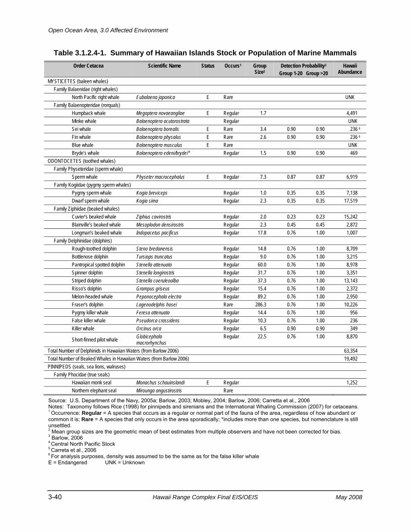
Open Ocean Area, 3.0 Affected Environment
3-40 Hawaii Range Complex Final EIS/OEIS May 2008
Table 3.1.2.4-1. Summary of Hawaiian Islands Stock or Population of Marine Mammals Order Cetacea Scientific Name Status Occurs1 Group
Size2 Detection Probability3
Group 1-20 Group >20 Hawaii
Abundance MYSTICETES (baleen whales) Family Balaenidae (right whales) North Pacific right whale Eubalaena japonica E Rare UNK Family Balaenopteridae (rorquals) Humpback whale Megaptera novaeangliae E Regular 1.7 4,491 Minke whale Balaenoptera acutorostrata Regular UNK Sei whale Balaenoptera borealis E Rare 3.4 0.90 0.90 236 6 Fin whale Balaenoptera physalus E Rare 2.6 0.90 0.90 236 6 Blue whale Balaenoptera musculus E Rare UNK Bryde’s whale Balaenoptera edeni/brydei* Regular 1.5 0.90 0.90 469 ODONTOCETES (toothed whales) Family Physeteridae (sperm whale) Sperm whale Physeter macrocephalus E Regular 7.3 0.87 0.87 6,919 Family Kogiidae (pygmy sperm whales) Pygmy sperm whale Kogia breviceps Regular 1.0 0.35 0.35 7,138 Dwarf sperm whale Kogia sima Regular 2.3 0.35 0.35 17,519 Family Ziphiidae (beaked whales) Cuvier’s beaked whale Ziphius cavirostris Regular 2.0 0.23 0.23 15,242 Blainville’s beaked whale Mesoplodon densirostris Regular 2.3 0.45 0.45 2,872 Longman’s beaked whale Indopacetus pacificus Regular 17.8 0.76 1.00 1,007 Family Delphinidae (dolphins) Rough-toothed dolphin Steno bredanensis Regular 14.8 0.76 1.00 8,709 Bottlenose dolphin Tursiops truncatus Regular 9.0 0.76 1.00 3,215 Pantropical spotted dolphin Stenella attenuata Regular 60.0 0.76 1.00 8,978 Spinner dolphin Stenella longirostris Regular 31.7 0.76 1.00 3,351 Striped dolphin Stenella coeruleoalba Regular 37.3 0.76 1.00 13,143 Risso’s dolphin Grampus griseus Regular 15.4 0.76 1.00 2,372 Melon-headed whale Peponocephala electra Regular 89.2 0.76 1.00 2,950 Fraser’s dolphin Lagenodelphis hosei Rare 286.3 0.76 1.00 10,226 Pygmy killer whale Feresa attenuata Regular 14.4 0.76 1.00 956 False killer whale Pseudorca crassidens Regular 10.3 0.76 1.00 236 Killer whale Orcinus orca Regular 6.5 0.90 0.90 349
Short-finned pilot whale Globicephala macrorhynchus
Regular 22.5 0.76 1.00 8,870
Total Number of Delphinids in Hawaiian Waters (from Barlow 2006) 63,354 Total Number of Beaked Whales in Hawaiian Waters (from Barlow 2006) 19,492 PINNIPEDS (seals, sea lions, walruses) Family Phocidae (true seals) Hawaiian monk seal Monachus schauinslandi E Regular 1,252 Northern elephant seal Mirounga angustirostris Rare
Source: U.S. Department of the Navy, 2005a; Barlow, 2003; Mobley, 2004; Barlow, 2006; Carretta et al., 2006 Notes: Taxonomy follows Rice (1998) for pinnipeds and sirenians and the International Whaling Commission (2007) for cetaceans. 1 Occurrence: Regular = A species that occurs as a regular or normal part of the fauna of the area, regardless of how abundant or common it is; Rare = A species that only occurs in the area sporadically; *includes more than one species, but nomenclature is still unsettled. 2 Mean group sizes are the geometric mean of best estimates from multiple observers and have not been corrected for bias. 3 Barlow, 2006
4 Central North Pacific Stock 5 Carreta et al., 2006 6 For analysis purposes, density was assumed to be the same as for the false killer whale E = Endangered UNK = Unknown
3.0 Affected Environment, Open Ocean Area
May 2008 Hawaii Range Complex Final EIS/OEIS 3-41
In addition, the passage of the North Equatorial Current through the Hawaiian archipelago is capable of creating regions of enhanced turbulence. Passage of the current of the North Equatorial Current can initiate the formation of eddies on the lee side of the islands (Wolanski et al., 2003); these are capable of entraining phytoplankton and creating localized regions of enhanced primary production. In addition, passage of currents through a narrow channel (as found in the Alenuehaha Channel between Hawaii and Maui) can create localized zones of turbulent flow capable of mixing nutrients into the surface layer to fuel primary production (Gilmartin and Revelante, 1974; Simpson et al., 1982).
3.1.2.4.1 Marine Mammal Occurrence Information on the abundance, behavior, distribution, and diving behavior of marine mammal species in the Hawaiian waters is based on peer reviewed literature including the most recent publications, the Navy Marine Resource Assessment, NMFS Stock Assessment Reports, marine mammals surveys using acoustics or visual observations from aircraft or ships, and previous environmental documents such as the Rim of the Pacific (RIMPAC) EA and supplements and the Undersea Warfare Exercise EA/Overseas EA and Incidental Harassment Authorization applications. Some specific definitions for terms used within this section of the document are required as they are not the same as used in other sections of the document. Information on each species is given relative to a specific definition of onshore (within 25 nm of shore) and offshore (beyond 25 nm from shore) habitats. A regular occurrence species is defined as a species that occurs as a regular or normal part of the fauna of the area, regardless of how abundant or common it is; a rare occurrence is a species that only occurs in the area sporadically; and an extralimital occurrence is a species that does not normally occur in the area, but for which there are one or more records that are considered beyond the normal range of the species. In this section, mysticetes are listed first, followed by odontocetes, then pinniped species (Table 3.1.2.4-1).
The acoustic abilities of marine mammals are important to their ability to communicate with conspecifics (offspring, mates, or competitors), navigation, foraging, and avoidance of predators. Little is known of the hearing abilities of mysticete whales, but generally they vocalize in low frequencies under 3 kHz, which may aid in long-range communication but do not echolocate (Review by Richardson et al., 1995a). The exception is the humpback whale, which may have a range up to 24 kHz (Au et al., 2006), and the north Atlantic right whale which may hear up to 22 kHz (Parks et al., 2004, 2007). It had been assumed that their hearing range was also under 3 kHz (Ketten, 1997) but from studies of vocalizations and anatomy, it may extend up to 24 kHz (Parks et al., 2004; Au et al., 2006; review by Southall et al., 2007). Odontocetes vocalize and echolocate over a much higher range of frequencies, ranging from below 1 kHz to 200 kHz (Review by Richardson et al., 1995a). Phocid seals, such as the Hawaiian monk seal (Monachus schauinslandi), hear underwater in the range of 2 to 40 kHz, with best hearing from 16 to 24 kHz (Thomas et al., 1990).
3.1.2.4.1.1 Mysticetes North Pacific Right Whale (Eubalaena japonica) Status. The North Pacific right whale is listed as endangered under the ESA and as a depleted and strategic stock under the MMPA (Carretta et al., 2005). Until recently, right whales in the North Atlantic and North Pacific were classified together as a single species, referred to as the “northern right whale.” Genetic data indicate that these two populations represent separate
Open Ocean Area, 3.0 Affected Environment
3-42 Hawaii Range Complex Final EIS/OEIS May 2008
species: the North Atlantic right whale (Eubalaena glacialis) and the North Pacific right whale (Eubalaena japonica) (Rosenbaum et al., 2000; Proposed in National Oceanic and Atmospheric Administration, 2006a).
The North Pacific right whale is perhaps the world’s most endangered large whale species (Perry et al., 1999; International Whaling Commission, 2001). North Pacific right whales are classified as endangered both under the ESA and on the IUCN Red List (Reeves et al., 2003). There are insufficient genetic or resighting data to address whether there is support for the traditional separation into eastern and western stocks (Brownell et al., 2001); however, Clapham et al. (2004) noted that north–south migratory movements support the hypothesis of two largely discrete populations of right whales in the eastern and western North Pacific. No reliable population estimate presently exists for this species; the population in the eastern North Pacific is considered to be very small, perhaps only in the tens of animals (National Marine Fisheries Service, 2002a; Clapham et al., 2004), while in the western North Pacific, the population may number at least in the low hundreds (Brownell et al., 2001; Clapham et al., 2004). There is no proposed or designated critical habitat for the North Pacific right whale in the HRC.
Abundance and Distribution. Right whales occur in sub-polar to temperate waters. The North Pacific right whale historically occurred across the Pacific Ocean north of 35°N, with concentrations in the Gulf of Alaska, eastern Aleutian Islands, south-central Bering Sea, Sea of Okhotsk, and the Sea of Japan (Omura et al., 1969; Scarff, 1986; Clapham et al., 2004). Presently, sightings are extremely rare, occurring primarily in the Okhotsk Sea and the eastern Bering Sea (Brownell et al., 2001; Shelden et al., 2005). Prior to 1996, right whale sightings were very rare in the eastern North Pacific (Scarff, 1986; Brownell et al., 2001). Recent summer sightings of right whales in the eastern Bering Sea represent the first reliable consistent observations in this area since the 1960s (Tynan et al., 2001; LeDuc, 2001).
Neither the west coast of North America nor the Hawaiian Islands constituted a major calving ground for right whales within the last 200 years (Scarff, 1986). No coastal calving grounds for right whales have been found in the western North Pacific either (Scarff, 1986). Mid-ocean whaling records of right whales in the winter suggest that right whales may have wintered and calved far offshore in the Pacific (Scarff, 1986; 1991; Clapham et al., 2004). Such pelagic calving would appear to be inconsistent with the records of offshore calving grounds in other locales for the other right whale species.
There are very few recorded sightings from the Hawaiian Islands; they are from both shallow and deep waters (Herman et al., 1980; Rowntree et al., 1980; Salden and Mickelsen, 1999). Secondary occurrence is expected from the coastline to seaward of the HRC boundaries. Right whales are not expected to make their way into lagoons or busy harbors; therefore, occurrence in Pearl Harbor is expected to be rare to nonexistent (U.S. Department of the Navy, 2005b). Right whale occurrence patterns are assumed to be similar throughout the year. Based on migration patterns and whaling data, the Hawaiian Islands may have been a breeding ground for North Pacific right whales in the past (Clapham et al., 2004).
Reproduction/Breeding. Calving primarily occurs from December through March (Best, 1994).
Diving Behavior. Dives of 5 to 15 min or even longer have been reported (Winn et al., 1995; Mate et al., 1997; Baumgartner and Mate, 2003). Baumgartner and Mate (2003) found that the
3.0 Affected Environment, Open Ocean Area
May 2008 Hawaii Range Complex Final EIS/OEIS 3-43
average depth of a North Atlantic right whale dive was strongly correlated with both the average depth of peak copepod abundance and the average depth of the bottom mixed layer’s upper surface. North Atlantic right whale feeding dives are characterized by a rapid descent from the surface to a particular depth between 262 and 574 ft, remarkable fidelity to that depth for 5 to 14 min, and then rapid ascent back to the surface (Baumgartner and Mate, 2003). Longer surface intervals have been observed for reproductively active females and their calves (Baumgartner and Mate, 2003).
Acoustics. North Pacific right whale calls are classified into five categories: (1) up; (2) down-up; (3) down; (4) constant; and (5) unclassified (McDonald and Moore, 2002). The “up” call is the predominant type (McDonald and Moore, 2002; Mellinger et al., 2004). Typically, the “up” call is a signal sweeping from about 90 to 150 Hz in 0.7 sec and could be detected out to 13.5 nm (McDonald and Moore, 2002). Wiggins et al. (2004) recorded upsweeping low frequency (90 to 160 kHz) calls of North Pacific right whales in the Bering Sea. Right whales commonly produce calls in a series of 10 to 15 calls lasting 5 to 10 min, followed by silence lasting an hour or more; some individuals do not call for periods of at least 4 hours (McDonald and Moore, 2002). This calling pattern is similar to the “moan cluster” reported for North Atlantic right whales by Matthews et al. (2001). Vocalization rates of North Atlantic right whales are also highly variable, and individuals have been known to remain silent for hours (Gillespie and Leaper, 2001).
Frequencies of these vocalizations are between 50 and 500 Hz (Matthews et al., 2001; Laurinolli et al., 2003); typical sounds are in the 300 to 600 Hz range with up- and down-sweeping modulations (Vanderlaan et al., 2003). Vanderlaan et al. (2003) found that lower (<200 Hz) and higher (>900 Hz) frequency sounds are relatively rare. Source levels have been estimated only for pulsive calls of North Atlantic right whales, which are 172 to 187 dB re 1 µPa-m (Richardson et al., 1995a).
Morphometric analyses of the inner ear of right whales resulted in an estimated hearing frequency range of approximately 10 Hz to 22 kHz, based on established marine mammal models (Parks et al., 2004; 2007). Research by Nowacek et al. (2004) on North Atlantic right whales suggests that received sound levels of only 133 to 148 dB re 1 µPa at 500 Hz to 4.5 kHz for the duration of the sound exposure (three signals of 2 min each played over 18 min) are likely to disrupt feeding behavior. The authors did note, however, that a return to normal behavior within minutes of when the source is turned off would be expected. While some of the upper frequencies approach those of MFA sonar, the signals were not similar because they were either too low in frequency range or longer and contain a down sweep signal 4,500 to 500 Hz.
Humpback Whale (Megaptera novaeangliae) Status. The humpback whale is listed as endangered under the ESA and as a depleted and strategic stock under the MMPA (Carretta et al., 2005). There is no designated critical habitat for this species in the North Pacific. Humpback whales and other marine mammals are of interest from a cultural perspective to some Native Hawaiians and other people (National Oceanic and Atmospheric Administration, 2003).
Abundance and Distribution. The best available estimate of abundance for the Central West Pacific stock of the humpback whales is 4,491 individuals (Mobley, 2004). Humpback whales use Hawaiian waters as a major breeding ground during winter and spring (November through April). Evidence suggests that some humpback whales may move between the waters of Japan
Open Ocean Area, 3.0 Affected Environment
3-44 Hawaii Range Complex Final EIS/OEIS May 2008
in the Western North Pacific (Darling and Cerchio, 1993; Salden, et al., 1999; Calambokidis et al., 2001; Witteveen et al., 2004). Calambokidis et al. (1997) estimated that up to half of the North Pacific populations of humpback whales migrate to the Hawaiian Islands during the winter. Peak abundance around the Hawaiian Islands is from late February through early April (Mobley et al., 2001a; Carretta et al., 2005). During the fall–winter period, primary occurrence is expected from the coast to 50 nm offshore, which takes into consideration both the available sighting data and the preferred breeding habitat (shallow waters) (Herman and Antinoja, 1977; Mobley et al., 1999, 2000, 2001a). The greatest densities of humpback whales (including calves) are in the four-island region consisting of Maui, Molokai, Kahoolawe, and Lanai, as well as Penguin Bank (Baker and Herman, 1981; Mobley et al., 1999; Maldini, 2003) and around Kauai (Mobley, 2005). Secondary occurrence is expected from seaward of this area, past the HRC boundaries. Humpback whales are not expected to be in Pearl Harbor, though an anomalous sighting of an adult and calf was reported during 1998 and 2003 (U.S. Department of the Navy, 2005b). The occurrence of humpback whales in deeper waters is based on work in the Caribbean (the breeding ground for humpback whales in the North Atlantic), where humpback whale calls were acoustically detected over deep water, far from any banks or islands (Swartz et al., 2002; Frankel et al., 1995).
During the spring–summer period, secondary occurrence is expected offshore out to 50 nm, mainly to account for the possible occurrence of humpback whales during the end of the breeding season (April). Humpback whales return to the feeding grounds of near northern California to the Aleutian Islands as determined by comparing songs (McSweeney et al., 1989) and recording the migration path of animals with satellite tags (Mate et al., 1998). Occurrence further offshore, as well as in Pearl Harbor, is expected to be rare.
The Hawaiian Islands Humpback Whale National Marine Sanctuary was signed into law in November 1992. The Final EIS/Management Plan was released in March 1997, and the final rule was published in November 1999. Activities allowed within the Sanctuary are all classes of military activities, internal or external to the Sanctuary, that were being or had been conducted before the effective date of the regulations, as identified in the Final EIS/Management Plan. The sanctuary includes specific areas from the coast of the Hawaiian Islands seaward to the 100-fathom isobath.
Reproduction/Breeding. Most of the central north Pacific stock of humpback whales migrate south to Hawaii in winter for breeding and calving from December through April (Clapham and Mead, 1999; Mobley et al., 2001a).
Diving Behavior. Humpback whale diving behavior depends on the time of year (Clapham and Mead, 1999). In summer, most dives last less than 5 min; those exceeding 10 min are atypical. In winter (December through March), dives average 10 to 15 min; but dives of greater than 30 min have also been recorded (Clapham and Mead, 1999). Although humpback whales have been recorded to dive as deep as about 273 fathoms (Dietz et al., 2002), on the feeding grounds they spend the majority of their time in the upper 66 fathoms of the water column (Dolphin, 1987; Dietz et al., 2002). Humpback whales on the wintering grounds do dive deeply; Baird et al. (2000) recorded dives are to a maximum of 577 ft.
Acoustics. Humpback whales are known to produce three classes of vocalizations: (1) “songs” in the late fall, winter, and spring by solitary males; (2) sounds made within groups on the wintering (calving) grounds; and (3) social sounds made on the feeding grounds (Richardson et
3.0 Affected Environment, Open Ocean Area
May 2008 Hawaii Range Complex Final EIS/OEIS 3-45
al., 1995a). The best-known types of sounds produced by humpback whales are songs, which are thought to be breeding displays used only by adult males (Helweg et al., 1992). Singing is most common on breeding grounds during the winter and spring months, but is occasionally heard outside breeding areas and out of season (Matilla et al., 1987; Clark and Clapham, 2004). There is geographical variation in humpback whale song, with different populations singing different songs, and all members of a population using the same basic song. However, the song evolves over the course of a breeding season, but remains nearly unchanged from the end of one season to the start of the next (Payne et al., 1983). Social calls are from 50 Hz to over 10 kHz, with the highest energy below 3 kHz (Silber, 1986). Female vocalizations appear to be simple; Simão and Moreira (2005) noted little complexity. The male song, however, is complex and changes between seasons. Components of the song range from under 20 Hz to 4 kHz and occasionally 8 kHz, with source levels of 144 to 174 dB re 1 µPa-m, with a mean of 155 dB re 1 µPa-m. Au et al. (2001) recorded high-frequency harmonics (out to 13.5 kHz) and source level (between 171 and 189 dB re 1 µPa-m) of humpback whale songs. (Au et al., 2001) Songs have also been recorded on feeding grounds (Mattila et al., 1987; Clark and Clapham, 2004). Zoidis et al. (2008) recorded humpback whale calves in Hawaii and reported that they produced simple structured vocalizations that were mostly low frequency (140 to 4,000 Hz with a mean of 220 Hz).
The main energy of the song lies between 0.2 and 3.0 kHz, with frequency peaks at 4.7 kHz. Feeding calls, unlike song and social sounds, are highly stereotyped series of narrow-band trumpeting calls. They are 20 Hz to 2 kHz, less than 1 sec in duration, and have source levels of 175 to 192 dB re 1 µPa-m. The fundamental frequency of feeding calls is approximately 500 Hz (D’Vincent et al., 1985).
No tests on humpback whale hearing have been made. Houser et al. (2001) constructed a humpback audiogram using a mathematical model based on the internal structure of the ear. The predicted audiogram indicates sensitivity to frequencies from 700 Hz to 10 kHz, with maximum relative sensitivity between 2 and 6 kHz. Maybaum (1989) reported that humpback whales showed a mild response to a hand held sonar marine mammal detection and location device (frequency of 3.3 kHz at 219 dB re 1 µPa at 1 meter or frequency sweep of 3.1 to 3.6 kHz), although this system is very different from the Navy’s hull mounted sonars. In addition, the system had some low frequency components (below 1 kHz), which may be an artifact of the acoustic equipment. This may have affected the response of the whales to both the control and sonar playbacks. Humpback whales also stop singing in response to playbacks of the singing or social sounds of conspecifics (Tyack, 1983). Miller et al. (2000) reported that humpback whales sang longer during playbacks of low-frequency active sonar, which is much lower in frequency than the MFA sonar described in this EIS/OEIS. Recent information on the songs of humpback whales suggests that their hearing may extend to frequencies of at least 24 kHz (Au et al., 2006).
Minke Whale (Balaenoptera acutorostrata) Status. The minke whale is not listed as endangered under the ESA and is not a depleted or strategic stock under the MMPA (Carretta et al., 2005). The International Whaling Commission (IWC) recognizes three stocks of minke whales in the North Pacific: one in the Sea of Japan/East China Sea, one in the rest of the western Pacific west of 180°N, and one in the remainder of the Pacific (Donovan, 1991). For the National Oceanic and Atmospheric Administration (NOAA) stock assessment report, there are three stocks of minke whales within the U.S. Pacific EEZ: (1) a Hawaiian stock; (2) a California/Oregon/ Washington stock; and
Open Ocean Area, 3.0 Affected Environment
3-46 Hawaii Range Complex Final EIS/OEIS May 2008
(3) an Alaskan stock (Carretta et al., 2005). There currently is no abundance estimate for the Hawaiian stock of minke whales, which appears to occur seasonally (approximately November through March) around the Hawaiian Islands (Carretta et al., 2005).
Abundance and Distribution. There currently is no abundance estimate for the Hawaiian stock of minke whales, which appears to occur seasonally (approximately November through March) around the Hawaiian Islands (Carretta et al., 2005). Mating is thought to occur in winter or early spring (Stewart and Leatherwood, 1985).
Minke whales are distributed in polar, temperate, and tropical waters (Jefferson et al., 1993); they are less common in the tropics than in cooler waters. Minke whales are present in the North Pacific from near the equator to the Arctic (Horwood, 1990). The summer range extends to the Chukchi Sea (Perrin and Brownell, 2002). In the winter, minke whales are found south to within 2° of the equator (Perrin and Brownell, 2002). The distribution of minke whale vocalizations (specifically, “boings”) suggests that the winter breeding grounds are the offshore tropical waters of the North Pacific Ocean (Rankin and Barlow, 2003). There is no obvious migration from low-latitude, winter breeding grounds to high-latitude, summer feeding locations in the western North Pacific, as there is in the North Atlantic (Horwood, 1990); however, there are some monthly changes in densities in both high and low latitudes (Okamura et al., 2001). In the northern part of their range, minke whales are believed to be migratory, whereas they appear to establish home ranges in the inland waters of Washington and along central California (Dorsey, 1983) and exhibit site fidelity to these areas between years (Borggaard et al., 1999).
The minke whale is expected to occur seasonally in the HRC (Barlow, 2003). Abundance is expected to be higher between November and March (Carretta et al., 2005). Therefore, an area of secondary occurrence is seaward of the shoreline during the fall–winter period. Both visual and acoustic detections of minke whales have been reported for this area (Balcomb, 1987; Thompson and Friedl, 1982; Barlow et al., 2004; Carretta et al., 2005; Norris et al., 2005). The occurrence pattern takes into account both sightings in shallow waters in some locales globally as well as the anticipated oceanic occurrence of this species (U.S. Department of the Navy 2005b). “Boings” were recorded in waters with a bottom depth of approximately 700 to 2,100 fathoms (Norris et al., 2005). Norris et al. (2005) reported sighting a minke whale 58 mi southwest of Kauai, in waters with a bottom depth of approximately 1,400 fathoms (U.S. Department of the Navy, 2005b). During the spring–summer period, there is a rare occurrence for the minke whale throughout the entire HRC although recent evidence from passive acoustic monitoring suggests that there may be more minke whales in the HRC than previously thought (Rankin and Barlow, 2005; Barlow 2006).
Reproduction/Breeding. Stewart and Leatherwood (1985) suggested that mating occurs in winter or early spring although it had never been observed. No breeding or calving areas for Hawaii have been described.
Diving Behavior. Stern (1992) described a general surfacing pattern of minke whales consisting of about four surfacings, interspersed by short-duration dives averaging 38 sec. After the fourth surfacing, there was a longer duration dive ranging from approximately 2 to 6 min. Minke whales are “gulpers,” like the other rorquals (baleen whales) (Pivorunas, 1979). Hoelzel et al. (1989) reported on different feeding strategies used by minke whales. In the North Pacific,
3.0 Affected Environment, Open Ocean Area
May 2008 Hawaii Range Complex Final EIS/OEIS 3-47
major food items include krill, Japanese anchovy (Engraulis japonicus), Pacific saury (Cololabis saira), and walleye pollock (Theragra chalcogramma) (Perrin and Brownell, 2002).
Acoustics. Recordings in the presence of minke whales have included both high-and low-frequency sounds (Beamish and Mitchell, 1973; Winn and Perkins, 1976; Mellinger et al., 2000). Mellinger et al. (2000) described two basic forms of pulse trains that were attributed to minke whales: a “speed up” pulse train with energy in the 200 to 400 Hz band, with individual pulses lasting 40 to 60 milliseconds, and a less-common “slow-down” pulse train characterized by a decelerating series of pulses with energy in the 250 to 350 Hz band. Recorded vocalizations from minke whales have dominant frequencies of 60 Hz to greater than 12,000 Hz, depending on vocalization type (Richardson et al., 1995a). Recorded source levels, depending on vocalization type, range from 151 to 175 dB re 1 µPa-m (Ketten, 1998). Gedamke et al. (2001) recorded a complex and stereotyped sound sequence (“star-wars vocalization”) in the Southern Hemisphere that spanned a frequency range of 50 Hz to 9.4 kHz. Broadband source levels between 150 and 165 dB re 1 µPa-m were calculated. “Boings,” recently confirmed to be produced by minke whales and suggested to be a breeding call, consist of a brief pulse at 1.3 kHz, followed by an amplitude-modulated call with greatest energy at 1.4 kHz, with slight frequency modulation over a duration of 2.5 sec (Anonymous, 2002; Rankin and Barlow, 2003). While no data on hearing ability for this species are available, Ketten (1997) hypothesized that mysticetes have acute infrasonic hearing.
Sei Whale (Balaenoptera borealis) Status. The sei whale is listed as endangered under the ESA and as a depleted and strategic stock under the MMPA (Carretta et al., 2005). The IWC designates the entire North Pacific Ocean as one sei whale stock unit (Donovan, 1991), although some evidence exists for multiple stocks (National Marine Fisheries Service, 1998; Carretta et al., 2005). For the NOAA stock assessment reports, sei whales within the Pacific EEZ are divided into three discrete, non-contiguous areas: (1) the Hawaiian stock; (2) California/Oregon/Washington stock; and (3) the Eastern North Pacific (Alaska) stock (Carretta et al., 2005).
The taxonomy of the baleen whale group formerly known as sei and Bryde’s whales is currently confused and highly controversial (see Reeves et al., 2004 for a recent review, also see the Bryde’s whale species account below for further explanation).
Abundance and Distribution. Barlow (2006) did not give a density estimate for sei whales in Hawaii because the survey (originally analyzed in Barlow, 2003) was not conducted during the peak period of abundance. Therefore, for the analysis undertaken in support of this EIS/OEIS, it was assumed that the number and density of sei whales did not exceed that of the small population of false killer whales (236 false killer whales in Hawaii). There is no information on the population trend of sei whales. Sei whales have a worldwide distribution, but are found primarily in cold temperate to subpolar latitudes, rather than in the tropics or near the poles (Horwood, 1987). Sei whales are also known for occasional irruptive occurrences in areas followed by disappearances for sometimes decades (Horwood, 1987; Schilling et al., 1992; Clapham et al., 1997).
Sei whales spend the summer months feeding in the subpolar higher latitudes and return to the lower latitudes to calve in winter. There is some evidence from whaling catch data of differential migration patterns by reproductive class, with females arriving at and departing from feeding
Open Ocean Area, 3.0 Affected Environment
3-48 Hawaii Range Complex Final EIS/OEIS May 2008
areas earlier than males (Horwood, 1987; Perry et al., 1999). For the most part, the location of winter breeding areas remains a mystery (Rice, 1998; Perry et al., 1999). In the North Pacific, sei whales are thought to occur mainly south of the Aleutian Islands. They are present all across the temperate North Pacific north of 40°N (National Marine Fisheries Service, 1998) and are seen at least as far south as 20°N (Horwood, 1987). In the east, they range as far south as Baja California, Mexico, and in the west, to Japan and Korea (Reeves et al., 1999). As noted by Reeves et al. (1999), reports in the literature from any time before the mid-1970s are suspect, because of the frequent failure to distinguish sei from Bryde’s whales, particularly in tropical to warm temperate waters where Bryde’s whales are generally more common than sei whales.
The sei whale is considered to be rare in Hawaiian waters based on reported sighting data and the species’ preference for cool, temperate waters. Secondary occurrence is expected seaward of the 1,640-fathom isobath on the north side of the islands only. This pattern was based on sightings made during the NMFS–Southwest Fisheries Science Center shipboard survey assessment of Hawaiian cetaceans (Barlow et al., 2004). Sei whales are expected to be rare throughout the remainder of the HRC. Occurrence patterns are expected to be the same throughout the year.
Reproduction/Breeding. No breeding areas have been determined but calving is thought to occur from September to March (Rice 1977). No breeding or calving areas for Hawaii have been described.
Diving Behavior. There are no reported diving depths or durations for sei whales.
Acoustics. Sei whale vocalizations have been recorded only on a few occasions. They consist of paired sequences (0.5 to 0.8 sec, separated by 0.4 to 1.0 sec) of 7 to 20 short (4 milliseconds) frequency modulated sweeps between 1.5 and 3.5 kHz; source level is not known (Richardson et al., 1995a). Sei whales in the Antarctic produced broadband “growls” and “whooshes” at a frequency of 433 ±192 kHz and source level of 156 ±3.6 dB re 1 µPa at 1 meter (Mc Donald et al., 2005).
Although no data on hearing ability for this species are available, Ketten (1997) hypothesized that mysticetes have acute infrasonic hearing.
Fin Whale (Balaenoptera physalus) Status. The fin whale is listed as endangered under the ESA and as a depleted and strategic stock under the MMPA. There is no designated critical habitat for this species in the North Pacific. The IWC recognizes two management stocks in the North Pacific: a single widespread stock in the North Pacific and a smaller stock in the East China Sea (Donovan, 1991). The NOAA stock assessment report recognizes three stocks of fin whales in the North Pacific: (1) the Hawaii stock; (2) the California/Oregon/Washington stock; and (3) the Alaska stock (Carretta et al., 2005). There is no information on the population trend of fin whales.
Abundance and Distribution. Barlow (2006) did not give a density estimate for fin whales in Hawaii because the survey (originally analyzed in Barlow 2003) was not conducted during the peak period of abundance. Therefore, for the analysis undertaken in support of this EIS/OEIS, it was assumed that the number and density of fin whales did not exceed that of the small population of false killer whales (236 false killer whales in Hawaii). There is no information on
3.0 Affected Environment, Open Ocean Area
May 2008 Hawaii Range Complex Final EIS/OEIS 3-49
the population trend of fin whales. Fin whales are broadly distributed throughout the world’s oceans, usually in temperate to polar latitudes, and less commonly in the tropics (Reeves et al., 2002). Fin whales are distributed across the North Pacific during the summer (May through October) from the southern Chukchi Sea (69°N) south to the Subarctic Boundary (approximately 42°N) and to 30°N in the California Current (Mizroch et al., 1999). They have been observed during the summer in the central Bering Sea (Moore et al., 2000).
Fin whales are not common in the Hawaiian Islands. Sightings were reported north of Oahu in May 1976, the Kauai Channel in February 1979, and north of Kauai in February 1994 (Shallenberger, 1981; Mobley et al., 1996). Thompson and Friedl (1982) suggested that fin whales migrate into Hawaiian waters mainly during fall and winter, based on acoustic recordings off the island of Oahu and the Midway Atoll (Northrop et al., 1971; McDonald and Fox, 1999). Primary occurrence is expected seaward of the 330-ft isobath during the fall-winter period to account for possible stragglers migrating through the area. There is a rare occurrence for the fin whale from the shore to the 55-fathom isobath. There is a rare occurrence of fin whales throughout the Hawaiian Islands during the spring–summer period.
Reproduction/Breeding. Reproductive activities for fin whales occur primarily in low latitude areas in the winter (Reeves 1998; Carretta et al. 2007). No breeding or calving areas for Hawaii have been described.
Diving Behavior. Fin whales typically dive for 5 to 15 min, separated by sequences of 4 to 5 blows at 10 to 20 sec intervals (Cetacean and Turtle Assessment Program, 1982; Stone et al., 1992; Lafortuna et al., 2003). Kopelman and Sadove (1995) found significant differences in blow intervals, dive times, and blows per hour between surface feeding and non-surface feeding fin whales. Croll et al. (2001) determined that fin whales dived to 321 ft ± 106.8 ft) with a duration of 6.3 min (standard deviation = ±1.53 min) when foraging and to 194 ft (standard deviation = ±97 ft) with a duration of 4.2 min (standard deviation = ±1.67 min) when not foraging. Goldbogen et al. (2006) reported that fin whales in California made foraging dives to a maximum of 748 to 889 ft and dive durations of 6.2 to 7.0 min. Fin whale dives exceeding 492 ft and coinciding with the diel migration of krill were reported by Panigada et al. (1999).
Acoustics. Fin whales produce calls with the lowest frequency and highest source levels of all cetaceans. Infrasonic, pattern sounds have been documented for fin whales (Watkins et al., 1987; Clark and Fristrup, 1997; McDonald and Fox, 1999). Fin whales produce a variety of sounds with a frequency range up to 750 Hz. The long, patterned 15 to 30-Hz vocal sequence is most typically recorded; only males are known to produce these (Croll et al., 2002). The most typical fin whale sound is a 20-Hz infrasonic pulse call (actually an FM sweep from about 23 to 18 Hz) with durations of about 1 sec and can reach source levels of 184 to 186 dB re 1 µPa-m (maximum up to 200) (Richardson et al., 1995a; Charif et al., 2002). Croll et al. (2002) recently suggested that these long, patterned vocalizations might function as male breeding displays, much like those that male humpback whales sing. The source depth, or depth of calling fin whales, has been reported to be about 27 fathoms (Watkins et al., 1987). While no data on hearing ability for this species are available, Ketten (1997) hypothesized that mysticetes have acute infrasonic hearing.
Open Ocean Area, 3.0 Affected Environment
3-50 Hawaii Range Complex Final EIS/OEIS May 2008
Blue Whale (Balaenoptera musculus) Status. The blue whale is listed as endangered under the ESA and as a depleted and strategic stock under the MMPA. The NMFS considers blue whales found in Hawaii as part of the Western North Pacific stock (Carretta et al., 2005) due to differences in call types with the Eastern North Pacific stock (Stafford et al., 2001; Stafford, 2003). The blue whale was severely depleted by commercial whaling in the twentieth century (National Marine Fisheries Service, 1998). There is no designated critical habitat for this species in the North Pacific. There is no information on the population trend of blue whales.
Abundance and Distribution. Blue whales are distributed from the ice edges to the tropics in both hemispheres (Jefferson et al., 1993). Blue whales summer in high latitudes and move into the subtropics and tropics during the winter calving period (Yochem and Leatherwood, 1985). Data from both the Pacific and Indian Oceans, however, indicate that some individuals may remain in low latitudes year-round, such as over the Costa Rican Dome (Wade and Friedrichsen, 1979; Reilly and Thayer, 1990). The productivity of the Costa Rican Dome may allow blue whales to feed during their winter calving/breeding season and not fast, like humpback whales (Mate et al., 1999).
The only reliable sighting report of this species in the central North Pacific was a sighting made from a scientific research vessel about 216 nm northeast of Hawaii in January 1964 (National Marine Fisheries Service, 1998). There is a rare occurrence for the blue whale throughout the entire HRC. Blue whale calls have been recorded off the Midway Atoll and Oahu (Northrop et al., 1971; Thompson and Friedl, 1982; McDonald and Fox, 1999); these provide evidence of blue whales occurring within several hundred miles of these islands (National Marine Fisheries Service, 1998). The recordings made off Oahu showed bimodal peaks throughout the year, suggesting that the animals were migrating into the area during summer and winter (Thompson and Friedl, 1982; McDonald and Fox, 1999). The greatest likelihood of encountering blue whales would be in waters deeper than 55 fathoms, based on observations in locales where blue whales are seen regularly (Schoenherr, 1991).
Reproduction/Breeding. Calving occurs primarily during the winter (Yochem and Leatherwood, 1985). No breeding or calving areas for Hawaii have been described.
Diving Behavior. Blue whales spend more than 94 percent of their time below the water’s surface (Lagerquist et al., 2000). Croll et al. (2001) determined that blue whales dive to an average of 462 ft for 7.8 min when foraging and to 222 ft for 4.9 min when not foraging. Calambokidis et al. (2003) deployed tags on blue whales and collected data on dives as deep as about 164 fathoms.
Acoustics. Blue whales produce calls with the lowest frequency and highest source levels of all cetaceans. Blue whale vocalizations are long, patterned low-frequency sounds with durations up to 36 sec (Richardson et al., 1995a) repeated every 1 to 2 min (Mellinger and Clark, 2003). Their frequency range is 12 to 400 Hz, with dominant energy in the infrasonic range at 12 to 25 Hz (Ketten, 1998; Mellinger and Clark, 2003). Source levels are up to 188 dB re 1 µPa-m over a frequency of 10 to 110 Hz (Ketten, 1998; McDonald et al., 2001). During the Magellan II Sea Test (at sea exercises designed to test systems for anti-submarine warfare) off the coast of California in 1994, blue whale vocalization source levels at 17 Hz were estimated in the range of 195 dB re 1 µPa-m (Aburto et al., 1997).
3.0 Affected Environment, Open Ocean Area
May 2008 Hawaii Range Complex Final EIS/OEIS 3-51
Vocalizations of blue whales appear to vary among geographic areas (Rivers, 1997), with clear differences in call structure suggestive of separate populations for the western and eastern regions of the North Pacific (Stafford et al., 2001). Stafford et al. (2005) recorded the highest calling rates when blue whale prey was closest to the surface during its vertical migration. Wiggins et al. (2005) reported the same trend of reduced vocalization during daytime foraging and then an increase in vocalizations at dusk as prey move up into the water column and disperse. Blue whales make seasonal migrations to areas of high productivity to feed and vocalize less in the feeding grounds than during the migration (Burtenshaw et al., 2004). Oleson et al. (2007) reported higher calling rates in shallow diving (<16 fathoms) whales while deeper diving (>27 fathoms) whales were likely feeding and calling less. Although no data on hearing ability for this species are available, Ketten (1997) hypothesized that mysticetes have acute infrasonic hearing.
Bryde’s Whale (Balaenoptera edeni) Status. The Bryde’s whale is not listed as endangered under the ESA and is not a depleted or strategic stock under the MMPA (Carretta et al., 2005). Bryde’s whales can be easily confused with sei whales. It is not clear how many species of Bryde’s whales there are, but genetic analyses suggest the existence of at least two species (Rice, 1998; Kato, 2002). The taxonomy of the baleen whale group formerly known as sei and Bryde’s whales is currently confused and highly controversial (see Reeves et al., 2004 for a recent review).
The IWC recognizes three management stocks of Bryde’s whales in the North Pacific: western North Pacific, eastern North Pacific, and East China Sea (Donovan, 1991). There is currently no biological basis for defining separate stocks of Bryde’s whales in the central North Pacific (Carretta et al., 2005). For the NOAA stock assessment reports, Bryde’s whales within the U.S. Pacific EEZ are divided into two areas: (1) Hawaiian waters, and (2) the eastern tropical Pacific (east of 150°W and including the Gulf of California and waters off California) (Carretta et al., 2005).
Abundance and Distribution. The best available estimate of abundance for the Hawaiian stock of the Bryde’s whale is 469 (Coefficient of Variation [CV] = 0.45) individuals (Barlow, 2006). The Bryde’s whale is found in tropical and subtropical waters, generally not moving poleward of 40° in either hemisphere (Jefferson et al., 1993). Long migrations are not typical of Bryde’s whales, though limited shifts in distribution toward and away from the equator, in winter and summer, respectively, have been observed (Cummings, 1985). In summer, the distribution of Bryde’s whales in the western North Pacific extends as far north as 40°N, but many individuals remain in lower latitudes, as far south as about 5°N. Data also suggest that winter and summer grounds partially overlap in the central North Pacific (Kishiro, 1996; Ohizumi et al., 2002). Bryde’s whales are also distributed in the central North Pacific in summer; the southernmost summer distribution of Bryde’s whales inhabiting the central North Pacific is about 20°N (Kishiro, 1996). Some whales remain in higher latitudes (around 25°N) in both winter and summer (Kishiro, 1996).
Bryde’s whales are seen year-round throughout tropical and subtropical waters (Kato, 2002) and are also expected in the HRC year-round (U.S. Department of the Navy 2005b). It should be noted that more sightings are reported for the Northwest Hawaiian Islands than in the Main Hawaiian Islands (Barlow et al., 2004; Carretta et al., 2005). Bryde’s whales have been reported to occur in both deep and shallow waters globally. There is a secondary occurrence of Bryde’s whales seaward of the 27-fathom isobath in the HRC. Bryde’s whales are sometimes
Open Ocean Area, 3.0 Affected Environment
3-52 Hawaii Range Complex Final EIS/OEIS May 2008
seen very close to shore and even inside enclosed bays (Best et al., 1984). Occurrence is expected to be rare inshore of this area.
Reproduction/Breeding. Breeding and calving occur in warm temperate and tropical areas.
Diving Behavior. Bryde’s whales are lunge-feeders, feeding on fish and krill (Nemoto and Kawamura, 1977). Cummings (1985) reported that Bryde’s whales might dive as long as 20 min.
Acoustics. Bryde’s whales produce low frequency tonal and swept calls similar to those of other rorquals (Oleson et al., 2003). Calls vary regionally, yet all but one of the call types has a fundamental frequency below 60 Hz; they last from 0.25 sec to several seconds; and they are produced in extended sequences (Oleson et al., 2003). Heimlich et al. (2005) recently described five tone types. While no data on hearing ability for this species are available, Ketten (1997) hypothesized that mysticetes have acute infrasonic hearing.
3.1.2.4.1.2 Odontocetes Sperm Whale (Physeter macrocephalus) Status. The sperm whale is listed as endangered under the ESA and as a depleted and strategic stock under the MMPA (Carretta et al., 2005). There is no designated critical habitat for this species in the North Pacific. Although many sperm whale populations have been depleted to varying degrees by past whaling activities, sperm whales remain one of the more globally common great whale species. In fact, in some areas, they are actually quite abundant. For example, there are estimated to be about 21,200 to 22,700 sperm whales in the eastern tropical Pacific Ocean (Wade and Gerrodette, 1993).
For management purposes, the IWC has divided the North Pacific into two management regions defined by a zig-zag line which starts at 150°W at the equator, is at 160°W between 40° to 50°N, and ends up at 180°W north of 50°N (Donovan, 1991). Preliminary genetic analyses reveal significant differences between sperm whales off the coast of California, Oregon, and Washington and those sampled offshore to the Hawaiian Islands (Mesnick et al., 1999; Carretta et al., 2005). The NOAA stock assessment report divides sperm whales within the U.S. Pacific EEZ into three discrete, noncontiguous areas: (1) waters around the Hawaiian Islands; (2) California, Oregon, and Washington waters; and (3) Alaskan waters (Carretta et al., 2005).
Abundance and Distribution. The best available estimate of abundance for the Hawaiian stock of the sperm whale is 6,919 (CV = 0.81) individuals (Barlow, 2006). Sperm whales are found from tropical to polar waters in all oceans of the world between approximately 70°N and 70°S (Rice, 1998). Females use a subset of the waters where males are regularly found. Females are normally restricted to areas with sea surface temperatures greater than approximately 15°C; whereas males, especially the largest males, can be found in waters as far poleward as the pack ice within approximately to the 40° parallels (50° in the North Pacific) (Whitehead, 2003). Sperm whale abundance in the eastern temperate North Pacific is estimated to be 32,100 individuals and 26,300 individuals by acoustic and visual detection methods, respectively (Barlow and Taylor, 2005).
Sperm whales are widely distributed throughout the Hawaiian Islands year-round (Rice, 1960; Shallenberger, 1981; Lee, 1993; and Mobley et al., 2000). Sperm whale clicks recorded from
3.0 Affected Environment, Open Ocean Area
May 2008 Hawaii Range Complex Final EIS/OEIS 3-53
hydrophones off Oahu confirm the presence of sperm whales near the Hawaiian Islands throughout the year (Thompson and Friedl, 1982). Globally, sperm whales are typically distributed in waters over the shelf break and continental slope. The primary area of occurrence for the sperm whale is seaward of the shelf break in the HRC. There is a rare occurrence of sperm whales from the shore to the shelf break. This occurrence prediction is based on the possibility of this typically deepwater species being found in insular shelf waters that are in such close proximity to deep water. Mating behavior occurs from winter through summer and calving from spring through fall (U.S. Department of the Navy, 2005a). Occurrence patterns are assumed to be similar throughout the year.
Reproduction/Breeding. Breeding occurs from winter through summer and calving generally occurs in the summer through fall at lower latitudes and the tropics (U.S. Department of the Navy, 2005a). No breeding or calving areas for Hawaii have been described.
Diving Behavior. Sperm whales forage during deep dives that routinely exceed a depth of 219 fathoms and 30 min duration (Watkins et al., 2002). Sperm whales are capable of diving to depths of over 1,094 fathoms with durations of over 60 min (Watkins et al., 1993). Sperm whales spend up to 83 percent of daylight hours underwater (Jaquet et al., 2000; Amano and Yoshioka, 2003). Males do not spend extensive periods of time at the surface (Jaquet et al., 2000). In contrast, females spend prolonged periods of time at the surface (1 to 5 hours daily) without foraging (Whitehead and Weilgart, 1991; Amano and Yoshioka, 2003). The average swimming speed is estimated to be 2.3 ft per second (ft/sec) (Watkins et al., 2002). Dive descents averaged 11 min at a rate of 5 ft/sec, and ascents averaged 11.8 min at a rate of 4.6 ft/sec (Watkins et al., 2002).
Acoustics. Sperm whales produce short-duration (generally less than 3 sec), broadband clicks, (100 Hz to 30 kHz), with dominant energy in two bands (2 to 4 kHz and 10 to 16 kHz). Generally, most of the acoustic energy is present at frequencies below 4 kHz, although diffuse energy up to past 20 kHz has been reported (Thode et al., 2002). The source levels can be up to 236 dB re 1 µPa-m (Møhl et al., 2003). Thode et al. (2002) suggested that the acoustic directivity (angular beam pattern) from sperm whales must range between 10 and 30 dB in the 5 to 20 kHz region. The clicks of neonate sperm whales are very different from usual clicks of adults in that they are of low directionality, long duration, and low-frequency (centroid frequency between 300 and 1,700 Hz) with estimated source levels between 140 and 162 dB re 1 µPa-m (Madsen et al., 2003). Clicks are heard most frequently when sperm whales are engaged in diving/foraging behavior (Whitehead and Weilgart, 1991; Miller et al., 2004; Zimmer et al., 2005). These may be echolocation clicks used in feeding, contact calls (for communication), and orientation during dives. When sperm whales are socializing, they tend to repeat series of clicks (codas), which follow a precise rhythm and may last for hours (Watkins and Schevill, 1977). Codas are shared between individuals of a social unit and are considered to be primarily for intragroup communication (Weilgart and Whitehead, 1997; Rendell and Whitehead, 2004).
The anatomy of the sperm whale’s ear indicates that it hears high-frequency sounds (Ketten 1992). Anatomical studies also suggest that the sperm whale has some ultrasonic hearing, but at a lower maximum frequency than many other odontocetes (Ketten, 1992). The sperm whale may also possess better low-frequency hearing than some other odontocetes, although not as extraordinarily low as many baleen whales (Ketten, 1992). Auditory brainstem response in a neonatal sperm whale indicated highest sensitivity to frequencies between 5 and 20 kHz (Ridgway and Carder, 2001).
Open Ocean Area, 3.0 Affected Environment
3-54 Hawaii Range Complex Final EIS/OEIS May 2008
Pygmy Sperm Whale (Kogia breviceps) and Dwarf Sperm Whale (Kogia sima) Status. Neither species of Kogia is listed as endangered under the ESA and is not a depleted or strategic stock under the MMPA (Carretta et al., 2005). There is no information on the population trend of pygmy sperm whales.
The difficulty in identifying pygmy and dwarf sperm whales is exacerbated by their avoidance reaction towards ships and change in behavior towards approaching survey aircraft (Würsig et al., 1998). Based on the cryptic behavior of these species and their small group sizes (much like that of beaked whales), as well as similarity in appearance, it is difficult to identify these species in sightings at sea.
Abundance and Distribution. The best available estimate of abundance for the Hawaiian stock of the pygmy sperm whale is 7,138 (CV = 1.12) individuals (Barlow 2006). Both Kogia species have a worldwide distribution in tropical and temperate waters (Jefferson et al., 1993).
Pygmy and dwarf sperm whales within the U.S. Pacific EEZ are each divided into two discrete, non-contiguous areas: (1) Hawaiian waters, and (2) waters off California, Oregon, and Washington (Carretta et al., 2005). The best available estimate of abundance for the Hawaiian stock of the dwarf sperm whale is 19,172 individuals (Barlow, 2003; Carretta et al., 2005).
Both species of Kogia generally occur in waters along the continental shelf break and over the continental slope (Baumgartner et al., 2001; McAlpine, 2002; Baird, 2005b). The primary occurrence for Kogia is seaward of the shelf break in the HRC and in deep water with a mean depth of 779 fathoms (Baird, 2005b). This takes into account their preference for deep waters. There is a rare occurrence for Kogia inshore of the area of primary occurrence. Occurrence is expected to be the same throughout the year. Dwarf sperm whales showed a high degree of site fidelity, determined from photo identification over several years, in areas west of the island of Hawaii (Baird et al., 2006a).
Reproduction/Breeding. There is no information on the breeding behavior in this area. No breeding or calving areas for Hawaii have been described.
Diving Behavior. Kogia feed on cephalopods and, less often, on deep-sea fishes and shrimps (Caldwell and Caldwell, 1989; Baird et al., 1996; Willis and Baird, 1998; Wang et al., 2002). Willis and Baird (1998) reported that Kogia make dives of up to 25 min. Median dive times of around 11 min have been documented for Kogia (Barlow, 1999). A satellite-tagged pygmy sperm whale released off Florida was found to make long nighttime dives, presumably indicating foraging on squid in the deep scattering layer (Scott et al., 2001). Most sightings of Kogia are brief; these whales are often difficult to approach, and they actively avoid aircraft and vessels (Würsig et al., 1998).
Acoustics. Pygmy sperm whale clicks range from 60 to 200 kHz, with a dominant frequency of 120 kHz (Richardson et al., 1995a). There is no information available on dwarf sperm whale vocalizations or hearing capabilities. An auditory brainstem response study indicates that pygmy sperm whales have their best hearing between 90 and 150 kHz (Ridgway and Carder, 2001).
3.0 Affected Environment, Open Ocean Area
May 2008 Hawaii Range Complex Final EIS/OEIS 3-55
Cuvier’s Beaked Whale (Ziphius cavirostris) Status. The Cuvier’s beaked whale is not listed as endangered under the ESA and is not a depleted or strategic stock under the MMPA (Carretta et al., 2005). There is no information on the population trend of Cuvier’s beaked whales.
Abundance and Distribution. The best available estimate of abundance for the Hawaiian stock of the Cuvier’s beaked whale is 15,242 (CV = 1.43) individuals (Barlow, 2006). Recent information collected from photo identification studies of Cuvier’s beaked whale shows a degree of site fidelity near the island of Hawaii (Baird et al., 2006a). The same individuals had been observed multiple times off of the west coast of the island of Hawaii during a 15-year period, suggesting an island associated population (McSweeney et al., 1989). Mobley (2006a) report the presence of a Cuvier’s beaked whale in the Alenuihaha Channel area between the islands of Maui and Hawaii during the RIMPAC 06 Exercise. There is no information on the population trend of Cuvier’s beaked whales. Previously proposed definition of beaked whale habitat may be too narrow, and beaked whales may be found from the continental slope to the abyssal plain, in waters ranging from well-mixed to highly stratified. There was no geographic pattern in the data (Ferguson et al., 2006).
Reproduction/Breeding. Little is known of beaked whale reproductive behavior. No breeding or calving areas for Hawaii have been described.
Diving Behavior. Cuvier’s beaked whales are generally sighted in waters with a bottom depth greater than about 109 fathoms and are frequently recorded at depths of 547 fathoms or more (Gannier, 2000; MacLeod, et al., 2004). They are commonly sighted around seamounts, escarpments, and canyons. In the eastern tropical Pacific Ocean, the mean bottom depth for Cuvier’s beaked whales is approximately 1,859 fathoms, with a maximum depth of over 16,732 ft (Ferguson, 2005). Recent studies by Baird et al. (2006b) show that Cuvier’s beaked whales dive deeply (maximum of 793 fathoms) and for long periods (maximum dive duration of 68.7 min) but also spent time at shallow depths. Gouge marks were observed on mud volcanoes on the sea floor at 930 to 1,094 fathoms, and Woodside et al. (2006) speculated that they were caused by Cuvier’s beaked whales foraging on benthic prey.
Acoustics. There is no acoustic information on Longman’s beaked whales but it is likely that they are similar to other beaked whales. MacLeod (1999) suggested that beaked whales use frequencies of between 300 Hz and 129 kHz for pulse sounds, and between 2 and 10 kHz, and possibly up to 16 kHz, for social communication. Cuvier’s beaked whales echolocation clicks were recorded at frequencies from 20 to 70 kHz (Zimmer et al., 2005). Cook et al. (2006) reported that the Gervais beaked whale (Mesoplodon europeus) could hear in the range of 5 to 80 kHz although no measurements were attempted above 80 kHz). The Gervais beaked whale was most sensitive from 40 to 80 kHz (Cook et al., 2006).
Blainville’s Beaked Whale (Mesoplodon densirostris) Status. The Blainville’s beaked whale is not listed as endangered under the ESA and is not a depleted or strategic stock under the MMPA (Carretta et al., 2005).
Open Ocean Area, 3.0 Affected Environment
3-56 Hawaii Range Complex Final EIS/OEIS May 2008
Abundance and Distribution. The best available estimate of abundance for the Hawaiian stock of the Blainville’s beaked whale is 2,872 individuals (CV = 1.25) (Barlow, 2006). There is no information on the population trend of Blainville’s beaked whales.
The Blainville’s beaked whale occurs in temperate and tropical waters of all oceans (Jefferson et al., 1993). The distribution of Mesoplodon species in the western North Atlantic may relate to water temperature (Mead, 1989; MacLeod, 2000), with Blainville’s beaked whale generally occurring in warmer southern waters (MacLeod 2000). In the eastern Pacific, where there are about a half-dozen Mesoplodon species known, the Blainville’s beaked whale is second only to the pygmy beaked whale (Mesoplodon peruvianus) in abundance in tropical waters (Wade and Gerrodette, 1993). Mobley (2006a) reported the presence of a Blainville’s beaked whale at the northern edge of the Kaulakahi Channel between the islands of Kauai and Niihau. Mobley (2006a) also reported the presence of a Blainville’s beaked whale in the Alenuihaha Channel area between the islands or Maui and Hawaii during the RIMPAC 06 Exercise. The same individuals had been observed multiple times off the west coast of the island of Hawaii during a 15-year period, suggesting an island associated population (McSweeney et al., 2007). Previously proposed definition of beaked whale habitat may be too narrow and beaked whales may be found from the continental slope to the abyssal plain, in waters ranging from well-mixed to highly stratified. There was no geographic pattern in the data (Ferguson et al., 2006).
Reproduction/Breeding. Little is known of beaked whale reproductive behavior. No breeding or calving areas for Hawaii have been described.
Diving Behavior. Analysis of stomach contents from captured and stranded individuals suggests that beaked whales are deep-diving animals, feeding by suction (Heyning and Mead, 1996). Another species of beaked whales, the Baird’s beaked whale (Berardius bairdii), feeds mainly on benthic fishes and cephalopods, but occasionally on pelagic fish such as mackerel, sardine, and saury (Kasuya, 2002; Walker et al., 2002; Ohizumi et al., 2003). Baird et al. (2006a) reported on the diving behavior of four Blainville’s beaked whales off the west coast of Hawaii. The four beaked whales foraged in deep ocean areas (378 to 1,643 fathoms) with a maximum dive to 770 fathoms. Dives ranged from at least 13 min (lost dive recorder during the dive) to a maximum of 68 min (Baird et al., 2006a).
Acoustics. MacLeod (1999) suggested that beaked whales use frequencies of between 300 Hz and 129 kHz for echolocation, and between 2 and 10 kHz, and possibly up to 16 kHz, for social communication. Blainville’s beaked whales echolocation clicks were recorded at frequencies from 20 to 40 kHz (Johnson et al., 2004).
Recent information on the hearing abilities of beaked whales (Gervais’ beaked whales) shows that they are most sensitive from 40 to 80 kHz with an overall range of 5 to 80 kHz, although no measurements were attempted above 80 kHz (Cook et al., 2006).
Longman’s Beaked Whale (Indopacetus pacificus) Status. The Longman’s beaked whale is not listed as endangered under the ESA and is not a depleted or strategic stock under the MMPA (Carretta et al., 2005). There is no information on the population trend of Longman’s beaked whale.
3.0 Affected Environment, Open Ocean Area
May 2008 Hawaii Range Complex Final EIS/OEIS 3-57
Abundance and Distribution. Beaked whales may be expected to occur in the area including around seaward of the shelf break. There is a low or unknown occurrence of beaked whales on the shelf between the 27-fathom isobath and the shelf break, which takes into account that deep waters come very close to the shore in this area. In some locales, beaked whales can be found in waters over the shelf, so it is possible that beaked whales have similar habitat preferences here. Occurrence patterns are expected to be the same throughout the year (U.S. Department of the Navy, 2005b). The best available estimate for the Hawaiian stock of the Longman’s beaked whale is 1,007 (CV 1.26) individuals (Barlow, 2006).
Longman’s beaked whale is not as rare as previously thought. However, the frequency with which it has been sighted in the eastern and western tropical Pacific oceans (MacLeod et al., 2004) suggests that it is probably not as common as the Cuvier’s and Mesoplodon beaked whales (Ferguson and Barlow, 2001). Previously proposed definition of beaked whale habitat may be too narrow and beaked whales may be found from the continental slope to the abyssal plain, in waters ranging from well-mixed to highly stratified. There was no geographic pattern in the data (Ferguson et al., 2006).
Reproduction/Breeding. Little is known of beaked whale reproductive behavior. No breeding or calving areas for Hawaii have been described.
Diving Behavior. Analysis of stomach contents from captured and stranded individuals suggests that beaked whales are deep-diving animals, feeding by suction (Heyning and Mead 1996). Prolonged dives by the Baird’s beaked whales for periods of up to 67 min have been reported (Kasuya, 2002), though dives of about 14 to 19 fathoms are typical, and dives of 45 min are not unusual (Balcomb, 1989; Von Saunder and Barlow, 1999).
Acoustics. There is no acoustic information on Longman’s beaked whales, but it is likely that they are similar to other beaked whales. MacLeod (1999) suggested that beaked whales use frequencies of between 300 Hz and 129 kHz for echolocation, and between 2 and 10 kHz, and possibly up to 16 kHz, for social communication. Blainville’s beaked whales echolocation clicks were recorded at frequencies from 20 to 40 kHz (Johnson et al., 2004) and Cuvier’s beaked whales at frequencies from 20 to 70 kHz (Zimmer et al., 2005).
Recent information on the hearing abilities of beaked whales (Gervais’ beaked whales) shows that they are most sensitive from 40 to 80 kHz with an overall range of 5 to 80 kHz, although no measurements were attempted above 80 kHz (Cook et al., 2006).
Rough-Toothed Dolphin (Steno bredanensis) Status. The rough-toothed dolphin is not listed as endangered under the ESA and is not a depleted or strategic stock under the MMPA (Carretta et al., 2005). There is no information on the population trend of rough-toothed dolphins. Nothing is known about stock structure for the rough-toothed dolphin in the North Pacific (Carretta et al., 2005).
Abundance and Distribution. The best available estimate of abundance for the Hawaiian stock of the rough-toothed dolphin is 8,709 (CV = 0.45) individuals (Barlow, 2006).

Open Ocean Area, 3.0 Affected Environment
3-58 Hawaii Range Complex Final EIS/OEIS May 2008
Rough-toothed dolphins are found in tropical to warm-temperate waters globally, rarely ranging north of 40°N or south of 35° (Miyazaki and Perrin, 1994). In the Main Hawaiian Islands, this species appears to demonstrate site fidelity to specific islands (Baird, R.W., 2005a).
Primary occurrence for the rough-toothed dolphin is from the shelf break to seaward of the HRC boundaries. There is also an area of rare occurrence of rough-toothed dolphins from the shore to the shelf break. Baird et al. (2003) noted that rough-toothed dolphins are rarely seen in offshore waters of the Main Hawaiian Islands. Occurrence patterns are expected to be the same throughout the year.
Reproduction/Breeding. Little is known of rough-toothed dolphin reproductive behavior. No breeding or calving areas for Hawaii have been described.
Diving Behavior. They are deep divers, and can dive for up to 15 min (Reeves et al., 2002). They usually inhabit deep waters (Davis et al., 1998), where they prey on fish and cephalopods (Reeves et al., 2002). Rough-toothed dolphins may stay submerged for up to 15 min and are known to dive as deep as 38 fathoms, but can probably dive much deeper (Miyazaki and Perrin, 1994).
Acoustics. The vocal repertoire of the rough-toothed dolphin includes broad-band clicks, barks, and whistles (Yu et al., 2003). Echolocation clicks of rough-toothed dolphins are in the frequency range of 0.1 to 200 kHz, with a peak of about 25 kHz (Miyazaki and Perrin, 1994; Yu et al., 2003). Whistles show a wide frequency range: 0.3 to >24 kHz (Yu et al., 2003). There is no published information on hearing ability of this species.
Bottlenose Dolphin (Tursiops truncatus) Status. The bottlenose dolphin is not listed as endangered under the ESA and is not a depleted or strategic stock under the MMPA (Carretta et al., 2005). There is no information on the population trend of bottlenose dolphins.
Genetic analyses of biopsied bottlenose dolphins in the Main Hawaiian Islands suggested the possibility of two species of bottlenose dolphins in Hawaiian waters (U.S. Department of the Navy, Command Third Fleet, 2006). In the meantime, however, information is presented on the one confirmed Tursiops species for this HRC.
Abundance and Distribution. The best available estimate of abundance for the Hawaiian stock of the bottlenose dolphin is 3,215 (CV = 0.59) individuals (Barlow, 2006).
The overall range of Tursiops is worldwide in tropical to temperate waters. Tursiops generally do not range poleward of 45°, except around the United Kingdom and northern Europe (Jefferson et al., 1993).
Bottlenose dolphins found in offshore waters around the Main Hawaiian Islands are island-associated, with all sightings occurring in relatively offshore and shallow waters (<109 fathoms), and no apparent movement between the islands (Baird et al., 2002, 2003). Baird et al. (2003) noted the possibility of a second population of bottlenose dolphins in the Hawaiian Islands,

3.0 Affected Environment, Open Ocean Area
May 2008 Hawaii Range Complex Final EIS/OEIS 3-59
based on sighting data, with a preference for deeper (bottom depth of 219 to 492 fathoms) waters.
Bottlenose dolphins are regularly found around the Main Hawaiian Islands in both onshore and offshore waters (Rice, 1960; Shallenberger, 1981; Mobley et al., 2000; Baird et al., 2003). Based on photo-identification studies and sighting data, there is a possibility of separate island populations with different preferences for shallow (<109 fathoms) and deep (about 219 to 492 fathoms) waters (Baird et al., 2003; 2006b). Therefore, an area of primary occurrence is expected from the shore to the 547-fathom isobath in the HRC, excluding Nihoa due to no survey effort. This area is continuous between Niihau and Kauai and between Oahu, Molokai, Lanai, Maui, and Kahoolawe to account for possible movements between islands. There is a secondary occurrence seaward of the 547-fathom isobath and seaward from the shoreline of Nihoa. Mead and Potter (1990) suggested that the Atlantic species has a calving period of spring through fall with a peak in the spring. Occurrence patterns are expected to be the same throughout the year.
Reproduction/Breeding. Hohn (1980) reported a calving season of spring season with possible summer and fall seasons on the east coast of the United States, but Mead and Potter (1990) suggested a prolonged calving season with a peak in spring. No specific breeding or calving areas for Hawaii have been described.
Diving Behavior. Pacific coast bottlenose dolphins feed primarily on surf perches (Family Embiotocidae) and croakers (Family Sciaendae) (Norris and Prescott, 1961; Walker, 1981; Schwartz et al., 1992; Hanson and Defran, 1993), and also consume squid (Loligo opalescens) (Schwartz et al., 1992). Navy bottlenose dolphins have been trained to reach maximum diving depths of about 164 fathoms (Ridgway et al., 1969b). Reeves et al. (2002) noted that the presence of deep-sea fish in the stomachs of some offshore individual bottlenose dolphins suggests that they dive to depths of more than 273 fathoms. Dive durations up to 15 min have been recorded for trained individuals (Ridgway et al., 1969b). Typical dives, however, are more shallow and of a much shorter duration.
Acoustics. Sounds emitted by bottlenose dolphins have been classified into two broad categories: pulsed sounds (including clicks and burst-pulses) and narrow-band continuous sounds (whistles), which usually are FM. Clicks and whistles have a dominant frequency range of 110 to 130 kHz and a peak to peak source level of 218 to 228 dB re 1 μPa-m (Au, 1993) and 3.5 to 14.5 kHz and 125 to 173 dB re 1 μPa-m, respectively (Ketten, 1998). Generally, whistles range in frequency from 0.8 to 24 kHz (Richardson et al., 1995a).
The bottlenose dolphin has a functional high-frequency hearing limit of 160 kHz (Au, 1993) and can hear sounds at frequencies as low as 40 to 125 Hz (Turl, 1993). Inner ear anatomy of this species has been described (Ketten, 1992). Electrophysiological experiments suggest that the bottlenose dolphin brain has a dual analysis system: one specialized for ultrasonic clicks and the other for lower-frequency sounds, such as whistles (Ridgway, 2000). The audiogram of the bottlenose dolphin shows that the lowest thresholds occurred near 50 kHz at a level around 45 dB re 1 μPa (Nachtigall et al., 2000). Below the maximum sensitivity, thresholds increased continuously up to a level of 137 dB at 75 Hz. Above 50 kHz, thresholds increased slowly up to a level of 55 dB at 100 kHz, then increased rapidly above this to about 135 dB at 150 kHz. Scientists have reported a range of best sensitivity between 25 and 70 kHz, with peaks in
Open Ocean Area, 3.0 Affected Environment
3-60 Hawaii Range Complex Final EIS/OEIS May 2008
sensitivity occurring at 25 and 50 kHz at levels of 47 and 46 dB re 1 μPa-m (Nachtigall et al., 2000).
Temporary threshold shifts (TTS) in hearing have been experimentally induced in captive bottlenose dolphins (Ridgway et al., 1997; Finneran et al., 2000; 2005, 2007; Schlundt et al., 2000; Nachtigall et al., 2003). Ridgway et al. (1997) observed changes in behavior at the following minimum levels for 1 sec tones: 186 dB at 3 kHz, 181 dB at 20 kHz, and 178 dB at 75 kHz (all re 1 μPa). TTS levels were 194 to 201 dB at 3 kHz, 193 to 196 dB at 20 kHz, and 192 to 194 dB at 75 kHz (all re 1 μPa). Schlundt et al. (2000) exposed bottlenose dolphins to intense tones (0.4, 3, 10, 20, and 75 kHz); the animals demonstrated altered behavior at source levels of 178 to 193 dB re 1 μPa, with TTS after exposures generally between 192 and 201 dB re 1 μPa (though one dolphin exhibited TTS after exposure at 182 dB re 1 μPa). Nachtigall et al. (2003) determined threshold for a 7.5 kHz pure tone stimulus. No shifts were observed at 165 or 171 dB re 1 μPa, but when the noise level reached 179 dB re 1 μPa, the animal showed the first sign of TTS. Recovery apparently occurred rapidly, with full recovery apparently within 45 min following noise exposure. TTS measured between 8 and 16 kHz (negligible or absent at higher frequencies) after 30 min of noise exposure (4 to 11 kHz) at 160 dB re 1 μPa (Nachtigall et al., 2004). Finneran et al. (2005) reported the onset of TTS in bottlenose dolphins at 197 dB re 1 µPa2-s for 1-sec pulse sounds at 3.0 and 4.5 kHz. For further discussion of TTS in marine mammals, see Section 4.1.2.
Pantropical Spotted Dolphin (Stenella attenuata) Status. The pantropical spotted dolphin is not listed as endangered under the ESA and is not a depleted or strategic stock under the MMPA (Carretta et al., 2005). There is no information on the population trend of pantropical spotted dolphins.
Abundance and Distribution. The best available estimate of abundance for the pantropical spotted dolphin within the Hawaiian Islands EEZ is 8,978 (CV = 0.48) individuals (Barlow, 2003; Carretta et al., 2005).
The pantropical spotted dolphin is distributed in tropical and subtropical waters worldwide (Perrin and Hohn, 1994). Range in the central Pacific is from the Hawaiian Islands in the north to at least the Marquesas in the south (Perrin and Hohn, 1994).
Based on known habitat preferences and sighting data, the primary occurrence for the pantropical spotted dolphin is between the 330-ft and 13,122-ft isobaths throughout the HRC. This area of primary occurrence also includes a continuous band connecting all the Main Hawaiian Islands, Nihoa, and Kaula, taking into account possible inter-island movements. Secondary occurrence is expected from the shore to 330 ft, as well as seaward of 13,122 ft. Pantropical spotted dolphins are expected to be rare in Pearl Harbor. In the Eastern Tropical Pacific there are two calving periods, one in the spring and one in the fall (Perrin and Hohn, 1994). Occurrence patterns are the same throughout the year.
Reproduction/Breeding. In the Eastern Tropical Pacific there are two calving peaks in the spring and fall (Perrin and Hohn, 1994). No breeding or calving areas for Hawaii have been described.
3.0 Affected Environment, Open Ocean Area
May 2008 Hawaii Range Complex Final EIS/OEIS 3-61
Diving Behavior. Results from various tracking and food habit studies suggest that pantropical spotted dolphins in the Eastern Tropical Pacific and off Hawaii feed primarily at night on epipelagic species and on mesopelagic species which rise towards the water’s surface after dark (Robertson and Chivers, 1997; Scott and Cattanach, 1998; Baird et al., 2001). Dives during the day generally are shorter and shallower than dives at night; rates of descent and ascent are higher at night than during the day (Baird et al., 2001). Similar mean dive durations and depths have been obtained for tagged pantropical spotted dolphins in the Eastern Tropical Pacific and off Hawaii (Baird et al., 2001).
Acoustics. Pantropical spotted dolphin whistles have a dominant frequency range of 6.7 to 17.8 kHz (Ketten, 1998). Click source levels between 197 and 220 dB re 1 μPa-m (peak to peak), in the range of 40 to 140 kHz, have been recorded for pantropical spotted dolphins (Schotten et al., 2004). Data from Atlantic spotted dolphins are provided to fill in the gaps of acoustic information for pantropical spotted dolphins. Echolocation clicks measured in wild Atlantic spotted dolphins showed bimodal ranges of 40 and 50 kHz and a high-frequency peak between 110 and 130 kHz, with a source level of 210 dB re 1 μPa (Au and Herzing, 2003).
There is no information on the hearing abilities of pantropical spotted dolphins.
Spinner Dolphin (Stenella longirostris) Status. The spinner dolphin is not listed as endangered under the ESA and is not a depleted or strategic stock under the MMPA (Carretta et al., 2005). There is no information on the population trend of spinner dolphins.
Abundance and Distribution. The best available estimate of abundance for the Hawaiian stock of the spinner dolphin is 3,351 (CV = 0.74) individuals (Barlow, 2006).
The spinner dolphin is found in tropical and subtropical waters worldwide. Limits are near 40°N and 40°S (Jefferson et al., 1993). These dolphins occur near islands such as the Hawaiian Islands, the Mariana Islands, the South Pacific, the Caribbean, and Fernando de Noronha Island off Brazil. Spinner dolphins have been documented to travel distances of about 25 mi between the Main Hawaiian Islands (Maldini, 2003). In the Hawaiian Islands, spinner dolphins occur along the leeward coasts of all the major islands and around several of the atolls northwest of the main island chain. Long-term site fidelity has been noted for spinner dolphins along the Kona coast of Hawaii, along Oahu, and off the island of Moorea in the Society Islands (Norris et al., 1994; Östman 1994; Poole, 1995; Marten and Psarakos, 1999), with some individuals being sighted for up to 12 years at Moorea (Poole, 1995). Recent data suggests that spinner dolphins do not readily move between islands as determined by genetic analysis (Andrews et al., 2006). Monitoring for RIMPAC 2006 showed that spinner dolphins are seen daily in the offshore area of Kekaha Beach, Kauai (near PMRF) and this despite being regularly accompanied by tour boats (U.S. Department of the Navy, 2006a).
Spinner dolphins occur year-round throughout the HRC, with primary occurrence from the shore to the 13,122-ft isobath. This takes into account offshore resting habitat and offshore feeding areas. Spinner dolphins are expected to occur in shallow water (about 162 ft or less) resting areas throughout the middle of the day, moving into deep waters offshore during the night to feed. Primary resting areas are along the west side of Hawaii, including Makako Bay, Honokohau Bay, Kailua Bay, Kealakekua Bay, Honaunau Bay, Kauhako Bay, and off Kahena on the southeast side of the island (Östman-Lind et al., 2004). Along the Waianae coast of
Open Ocean Area, 3.0 Affected Environment
3-62 Hawaii Range Complex Final EIS/OEIS May 2008
Oahu, spinner dolphins rest along Makua Beach, Kahe Point, and Pokai Bay during the day (Lammers, 2004). Kilauea Bay in Kauai is also a popular resting bay for Hawaiian spinner dolphins (U.S. Department of the Navy, Commander Third Fleet, 2006). There is an area of secondary occurrence seaward of 2,187 fathoms. Although sightings have been recorded around the mouth of Pearl Harbor (Lammers, 2004), spinner dolphin occurrence is expected to be rare. Occurrence patterns are assumed to be the same throughout the year. It is currently not known whether individuals move between islands or island groups (Carretta et al., 2005) but recent data on the genetic comparison of animals from each suggest there is little movement between the islands (Andrews et al., 2006). Spinner dolphins in Tahiti showed a pattern of being present a higher percentage of time on the weekend compared to weekdays despite the higher tourist traffic and encounter rate (Gannier and Petiau, 2007).
Reproduction/Breeding. Spinner dolphins have island specific populations and breeding may occur throughout the year (Östman-Lind et al., 2004).
Diving Behavior. Spinner dolphins feed primarily on small mesopelagic fishes, squids, and sergestid shrimp and they dive to at least 109 to 164 fathoms (Perrin and Gilpatrick, 1994). Foraging can begin in the late afternoon (Lammers, 2004), but takes place primarily at night when the mesopelagic prey migrates vertically towards the surface and also horizontally towards the shore (Benoit-Bird et al., 2001; Benoit-Bird and Au, 2004; Dollar and Grigg, 2003)
Acoustics. There is little information on the acoustic abilities of the spinner dolphin. They produce whistles in the range of 1 to 22.5 kHz with the dominant frequency being 6.8 to 17.9 kHz, above that of the active sonar frequencies. Whistles may have harmonics that may extend past 50 kHz and sometimes as high as 100 kHz (Lammers et al., 2003). The full range of hearing may extend down to 1 kHz or below as reported for other small odontocetes (Richardson et al., 1995a; Nedwell et al., 2004; Bazúa-Durán, C. and W.W.L. Au, 2002). They also display pulse burst sounds in the range of 5 to 60 kHz. Their echolocation clicks range up to at least 65 kHz (Richardson et al., 1995a). Whistles of spinner dolphins have harmonics that may extend past 50 kHz and sometimes as high as 100 kHz (Lammers et al., 2003). Spinner dolphins are island specific residents, but all island pods share about 48 percent of the parameters of their whistles (Bazua-Durana and Au, 2004).
Striped Dolphin (Stenella coeruleoalba) Status. The striped dolphin is not listed as endangered under the ESA and is not a depleted or strategic stock under the MMPA (Carretta et al., 2005). There is no information on the population trend of striped dolphins.
Abundance and Distribution. The best available estimate of abundance for the Hawaiian stock of the striped dolphin is 13,143 (CV = 0.46) individuals (Barlow, 2003; Carretta et al., 2005). The striped dolphin has a worldwide distribution in cool-temperate to tropical waters. This species is well documented in both the western and eastern Pacific off the coasts of Japan and North America (Perrin et al., 1994a); the northern limits are the Sea of Japan, Hokkaido, Washington State, and along roughly 40°N across the western and central Pacific (Reeves et al., 2002). Scattered records exist from the South Pacific as well (Perrin et al., 1994a).
The striped dolphin regularly occurs throughout the HRC. There is a primary occurrence for the striped dolphin seaward of 547 fathoms based on sighting records and the species’ known
3.0 Affected Environment, Open Ocean Area
May 2008 Hawaii Range Complex Final EIS/OEIS 3-63
preference for deep waters. Striped dolphins are occasionally sighted closer to shore (Mobley et al., 2000); therefore, an area of secondary occurrence is expected from 55 fathoms to 547 fathoms. Occurrence patterns are assumed to be the same throughout the year.
Reproduction/Breeding. Off of Japan there are two calving peaks, one in summer and one in winter (Perrin et al., 1994a). No specific breeding or calving areas for Hawaii have been described.
Diving Behavior. Striped dolphins often feed in pelagic or benthopelagic zones along the continental slope or just beyond oceanic waters. A majority of the prey possess luminescent organs, suggesting that striped dolphins may be feeding at great depths, possibly diving to about 109 to 383 fathoms to reach potential prey (Archer and Perrin, 1999). Striped dolphins may feed at night, in order to take advantage of the deep scattering layer’s diurnal vertical movements. Small, mid-water fishes (in particular, myctophids or lanternfish) and squids are the dominant prey (Perrin et al., 1994a).
Acoustics. Striped dolphin whistles range from 6 to 24+ kHz, with dominant frequencies ranging from 8 to 12.5 kHz (Richardson et al., 1995a). The striped dolphin’s range of most sensitive hearing (defined as the frequency range with sensitivities within 10 dB of maximum sensitivity) was determined to be 29 to 123 kHz using standard psycho-acoustic techniques; maximum sensitivity occurred at 64 kHz (Kastelein et al., 2003).
Risso’s Dolphin (Grampus griseus) Status. The Risso’s dolphin is not listed as endangered under the ESA and is not a depleted or strategic stock under the MMPA (Carretta et al., 2005). There is no information on the population trend of Risso’s dolphins.
Abundance and Distribution. The best available estimate of abundance for the Hawaiian stock of the Risso’s dolphin is 2,372 (CV = 0.65) individuals (Barlow, 2006). The Risso’s dolphin is distributed worldwide in tropical to warm-temperate waters, roughly between 60°N and 60°S, where surface water temperature is usually greater than 50°F (Kruse et al., 1999). Water temperature appears to be a factor that affects the distribution of Risso’s dolphins in the Pacific (Kruse et al., 1999). Changes in local distribution and abundance along the California coast are probably in response to protracted or unseasonal warm-water events, such as El Niño events (Shane, 1994).
There is an area of secondary occurrence between the 330-ft and 16,400-ft isobaths based on the known habitat preferences of this species, as well as the paucity of sightings, even though there is extensive aerial and boat-based survey coverage near the islands. There is a narrow band of rare occurrence from the shore to the 55-fathom isobath, including Pearl Harbor, which takes into consideration the possibility that this species, with a preference for waters with steep bottom topography, might swim into areas where deep water is close to shore. Risso’s dolphins are expected to be rare seaward of the 16,400-ft isobath. Occurrence patterns are assumed to be the same throughout the year.
Open Ocean Area, 3.0 Affected Environment
3-64 Hawaii Range Complex Final EIS/OEIS May 2008
Reproduction/Breeding. There is no information on the breeding behavior in this area. No breeding or calving areas for Hawaii have been described.
Diving Behavior. They may remain submerged on dives for up to 30 min (Kruse et al., 1999). Cephalopods are the primary prey (Clarke, 1996).
Acoustics. Risso’s dolphin vocalizations include broadband clicks, barks, buzzes, grunts, chirps, whistles, and simultaneous whistle and burst-pulse sounds (Corkeron and Van Parijs, 2001). The combined whistle and burst pulse sound appears to be unique to Risso’s dolphin (Corkeron and Van Parijs, 2001). Corkeron and Van Parijs (2001) recorded five different whistle types, ranging in frequency from 4 to 22 kHz. Broadband clicks had a frequency range of 6 to greater than 22 kHz. Low-frequency narrowband grunt vocalizations had a frequency range of 0.4 to 0.8 kHz. A recent study established empirically that Risso’s dolphins echolocate; estimated source levels were up to 216 dB re 1 μPa-m (peak to peak levels) with two prominent peaks in the range of 30 to 50 kHz and 80 to 100 kHz (Philips et al., 2003).
The range of hearing in Risso’s dolphins is 1.6 to 122.9 kHz with maximum sensitivity occurring between 8 and 64 kHz (Nachtigall et al., 1995). The range of hearing in an infant Risso’s dolphin was 4 to 150 kHz and showed more sensitive hearing at higher frequencies than adults (Nachtigall et al., 2005).
Melon-headed Whale (Peponocephala electra) Status. The melon headed whale is not listed as endangered under the ESA and is not a depleted or strategic stock under the MMPA (Carretta et al., 2005). There is no information on the population trend of melon headed whales.
Abundance and Distribution. The best available estimate of abundance for the Hawaiian stock of the melon-headed whale is 2,950 (CV = 1.17) individuals (Barlow, 2006). Melon-headed whales are found worldwide in tropical and subtropical waters. They have occasionally been reported from higher latitudes, but these sightings are often associated with incursions of warm water currents (Perryman et al., 1994). Preliminary results from photo-identification work in the Main Hawaiian Islands suggest inter-island movements by some individuals (e.g., between the islands of Kauai and Hawaii) as well as some residency by other individuals (e.g., at the island of Hawaii) (U.S. Department of the Navy 2005b).
The melon-headed whale is an oceanic species. Melon-headed whales are primarily expected to occur from the shelf break to seaward of the HRC and vicinity. There is a rare sighting occurrence from the shore to the shelf break. Occurrence patterns are assumed to be the same throughout the year.
Reproduction/Breeding. There is no information on the breeding behavior in this area. No breeding or calving areas for Hawaii have been described.
Diving Behavior. There is no information on the diving behavior of melon headed whales.
3.0 Affected Environment, Open Ocean Area
May 2008 Hawaii Range Complex Final EIS/OEIS 3-65
Acoustics. Watkins et al. (1997) reported melon-headed whale whistles in the range of 8 to 12 kHz (source level of 155 dB re 1µPa-m) and clicks in the range of 20 to 40 kHz (165 dB re 1µPa-m). There are no data on the hearing abilities of melon-headed whales.
Fraser’s Dolphin (Lagenodelphis hosei) Status. The Fraser’s dolphin is not listed as endangered under the ESA and is not a depleted or strategic stock under the MMPA (Carretta et al., 2005). There is no information on the population trend of Fraser’s dolphins.
Abundance and Distribution. The best available estimate of abundance for the Hawaiian stock of the Fraser’s dolphin is 10,226 (CV = 1.16) individuals (Barlow, 2006).
Fraser’s dolphins have only recently been documented in Hawaiian waters (Carretta et al., 2005). Sightings have been recorded in the Northwestern Hawaiian Islands but not within the Main Hawaiian Islands (Barlow, 2003). There is a rare occurrence of the Fraser’s dolphin from the shore to seaward of the HRC that takes into account that this is an oceanic species that can be found closer to the coast, particularly in locations where the shelf is narrow and deep waters are nearby. There is no evidence of a seasonal calving season (U.S. Department of the Navy, 2005a). Occurrence patterns are assumed to be the same throughout the year.
Reproduction/Breeding. There is little information on the breeding behavior in this area and there appears to be no seasonality to calving (Jefferson et al, 1994). No breeding or calving areas for Hawaii have been described.
Diving Behavior. There is no information available on their diving behavior.
Acoustics. Little is known of the acoustic abilities of Fraser’s dolphins. Whistles have been reported in the range of 7.6 to 13.4 kHz (Leatherwood et al., 1993). Nothing is known of their hearing abilities.
Pygmy Killer Whale (Feresa attenuata) Status. The pygmy killer whale is not listed as endangered under the ESA and is not a depleted or strategic stock under the MMPA (Carretta et al., 2005). There is no information on the population trend of pygmy killer whales.
Abundance and Distribution. The best available estimate of abundance for the Hawaiian stock of the pygmy killer whale is 956 (CV = 0.83) individuals (Barlow, 2006). This species has a worldwide distribution in deep tropical and subtropical oceans. Pygmy killer whales generally do not range north of 40°N or south of 35°S (Jefferson et al., 1993). Reported sightings suggest that this species primarily occurs in equatorial waters, at least in the eastern tropical Pacific (Perryman et al., 1994). Most of the records outside the tropics are associated with strong, warm western boundary currents that effectively extend tropical conditions into higher latitudes (Ross and Leatherwood, 1994).
Pygmy killer whales regularly occur in the HRC. Pygmy killer whales are easily confused with false killer whales and melon-headed whales, which are two species that also have expected
Open Ocean Area, 3.0 Affected Environment
3-66 Hawaii Range Complex Final EIS/OEIS May 2008
occurrence in the HRC. The pygmy killer whale is primarily expected to occur from the shelf break to seaward of the HRC boundaries. There is a rare sighting occurrence from the shore to the shelf break. Occurrence patterns are assumed to be the same throughout the year. Pygmy killer whales off the island of Hawaii demonstrate tremendous site fidelity to the island (U.S. Department of the Navy, 2005b).
Reproduction/Breeding. There is no information on the breeding behavior in this area.
Diving Behavior. There is no information on the diving behavior of pygmy killer whales.
Acoustics. The pygmy killer whale produces clicks in the range of 45 to 117 kHz, with the main energy in the range of 70 to 85 kHz (Madsen et al., 2004). Peak to peak source levels were 197 to 223 dB re 1 µPa. There is no information on the hearing of pygmy killer whales.
False Killer Whale (Pseudorca crassidens) Status. This stock is listed as a strategic stock by NMFS because the estimated level of serious injury and mortality from the Hawaii-based tuna and swordfish longline fishery is greater than the potential biological removal (Carretta et al., 2005). Genetic evidence suggests that the Hawaiian stock might be a reproductively isolated population from false killer whales in the eastern tropical Pacific (Chivers et al., 2003). Baird et al. (2005) noted that more work was needed to determine whether false killer whales using coastal waters might even be a discrete population from those in offshore waters and waters off the Northwestern Hawaiian Islands.
Abundance and Distribution. The best available estimate of abundance for the Hawaiian stock of the false killer whale is 236 (CV = 1.13) individuals (Barlow, 2006). False killer whales are found in tropical and temperate waters, generally between 50°S and 50°N latitude with a few records north of 50°N in the Pacific and the Atlantic (Odell and McClune, 1999). Seasonal movements in the western North Pacific may be related to prey distribution (Odell and McClune, 1999). Baird et al. (2005) noted considerable inter-island movements of individuals in the Hawaiian Islands.
False killer whales are commonly sighted in offshore waters from small boats and aircraft, as well as offshore from longline fishing vessels (Mobley et al., 2000; Baird et al., 2003; Walsh and Kobayashi, 2004). Baird et al. (2005) reported that false killer whales in the Hawaiian Islands occur in waters from about 22 to 2,187 fathoms. There is an area of primary occurrence for the false killer whale from the shore to 1,094 fathoms, with the exception of Pearl Harbor, where there is a rare occurrence for this species. There is an additional area of primary occurrence seaward of 2,187 fathoms on the south side of the islands, which takes into account false killer whale sighting and incidental catch data in the southwestern portion of the HRC (Forney, 2004; Walsh and Kobayashi, 2004; Carretta et al., 2005). The area of secondary occurrence includes a narrow band between 1,094 fathoms and 2,187 fathoms south of the islands and the entire area north of the islands seaward of 1,094 fathoms. It has been suggested that false killer whales using coastal waters might be a discrete population from those in offshore waters and waters off the Northwestern Hawaiian Islands (Baird et al., 2005; Carretta et al., 2005). The area of secondary occurrence takes into account the possibility of two different stocks, with a possible hiatus in their distribution (U.S. Department of the Navy, Commander Third Fleet, 2006). There is no evidence of a seasonal calving period (Jefferson et al., 1993). Occurrence patterns are assumed to be the same throughout the year.
3.0 Affected Environment, Open Ocean Area
May 2008 Hawaii Range Complex Final EIS/OEIS 3-67
Reproduction/Breeding. There is no information on the breeding behavior in this area.
Diving Behavior. False killer whales primarily eat deep-sea cephalopods and fish (Odell and McClune, 1999), but they have been known to attack other cetaceans, including dolphins (Perryman and Foster, 1980; Stacey and Baird, 1991), sperm whales (Palacios and Mate, 1996), and baleen whales.
Acoustics. The dominant frequencies of false killer whale whistles are 4 to 9.5 kHz; those of their clicks are 25 to 30 kHz and 95 to 130 kHz (Thomas et al., 1990; Richardson et al., 1995a). The source level for clicks is 220 to 228 dB re 1 µPa-m (Ketten, 1998). Best hearing sensitivity measured for a false killer whale was around 16 to 64 kHz (Thomas et al., 1988, 1990). Yuen et al. (2005) tested a stranded false killer whale using auditory evoke potentials to produce an audiogram in the range of 4 to 44 kHz and with best sensitivity at 16 to 24 kHz, but it may have had age related hearing loss.
Killer Whale (Orcinus orca) Status. The killer whale is not listed as endangered under the ESA and is not a depleted or strategic stock under the MMPA (Carretta et al., 2005). There is no information on the population trend of killer whales.
Abundance and Distribution. The best available estimate of abundance for the Hawaiian stock of the killer whale is 349 (CV = 0.98) individuals (Barlow, 2006). Genetic analysis of a biopsy sample taken from a killer whale in Hawaii (during the NMFS Hawaiian Islands Cetacean and Ecosystem Assessment Survey) was most closely related to mammal-eating killer whales in Alaska (Baird et al., 2003).
The killer whale is a cosmopolitan species found throughout all oceans and contiguous seas, from equatorial regions to the polar pack-ice zones. This species has sporadic occurrence in most regions (Ford, 2002). Though found in tropical waters and the open ocean, killer whales as a species are most numerous in coastal waters and at higher latitudes (Mitchell, 1975; Miyazaki and Wada, 1978; Dahlheim et al., 1982). Sightings in most tropical waters, although not common, are widespread (Visser and Bonoccorso, 2003).
Killer whales in general are uncommon in most tropical areas (U.S. Department of Defense, 2005). The distinctiveness of this species would lead it to be reported more than any other member of the dolphin family, if it occurs in a certain locale. Killer whales are infrequently sighted and found stranded around the Hawaiian Islands (Shallenberger, 1981; Tomich, 1986; Mobley et al., 2001b; Baird et al., 2003), though with increasing numbers of boaters, sightings each year could be expected (Baird et al., 2006c). Because the killer whale has a sporadic occurrence in tropical waters and can be found in both coastal areas and the open ocean, there is a rare occurrence of this species in the HRC from the shoreline to seaward of the HRC boundaries. Occurrence patterns are assumed to be the same throughout the year.
Reproduction/Breeding. There is no information on the breeding behavior in this area.
Diving Behavior. The maximum depth recorded for free-ranging killer whales diving off British Columbia is about 144 fathoms (Baird et al., 2005). On average, however, for seven tagged
Open Ocean Area, 3.0 Affected Environment
3-68 Hawaii Range Complex Final EIS/OEIS May 2008
individuals, less than 1 percent of all dives examined were to depths greater than about 16 fathoms (Baird et al., 2003). The longest duration of a recorded dive from a radio-tagged killer whale was 17 min (Dahlheim and Heyning, 1999).
Acoustics. The killer whale produces a wide variety of clicks and whistles from 1.5 to 25 kHz, but most of its sounds are pulsed with dominant frequencies of 1 to 6 kHz (Richardson et al., 1995a). The peak-to-peak source levels of echolocation signals range between 195 and 224 dB re 1 μPa-m (Au et al., 2004). The source level of social vocalizations ranges between 137 to 157 dB re 1 μPa-m (Veirs, 2004). Acoustic studies of resident killer whales in British Columbia have found that there are dialects, in their highly stereotyped, repetitive discrete calls, which are group-specific and shared by all group members (Ford, 2002). These dialects likely are used to maintain group identity and cohesion, and may serve as indicators of relatedness that help in the avoidance of inbreeding between closely related whales (Ford, 2002). Dialects also have been documented in killer whales occurring in northern Norway, and likely occur in other locales as well (Ford, 2002). The killer whale has the lowest frequency of maximum sensitivity and one of the lowest high-frequency hearing limits known among toothed whales (Szymanski et al., 1999). The upper limit of hearing is 100 kHz for this species. The most sensitive frequency, in both behavioral and in auditory brainstem response audiograms, has been determined to be 20 kHz (Szymanski et al., 1999).
Short-finned Pilot Whale (Globicephala macrorhynchus) Status. Stock structure of short-finned pilot whales has not been well-studied in the North Pacific Ocean, except in Japanese waters (Carretta et al., 2005). Two stocks have been identified in Japan based on pigmentation patterns and differences in the head shape of adult males (Kasuya et al., 1988). Pilot whales in Hawaiian waters are similar morphologically to the Japanese southern form (Carretta et al., 2005). Genetic analyses of tissue samples collected near the Main Hawaiian Islands indicate that the Hawaiian population is reproductively isolated from short-finned pilot whales found in the eastern North Pacific Ocean (Carretta et al., 2005).
Abundance and Distribution. The best available estimate of abundance for the Hawaiian stock of the short-finned pilot whale is 8,870 (CV = 0.38) individuals (Barlow, 2006). The short-finned pilot whale is found worldwide in tropical to warm-temperate seas, generally in deep offshore areas. The short-finned pilot whale usually does not range north of 50°N or south of 40°S (Jefferson et al., 1993). The long-finned pilot whale is not known to presently occur in the North Pacific (Kasuya, 1975); the range of the short-finned pilot whale appears to be expanding to fill the former range of the long-finned pilot whale (Bernard and Reilly, 1999). Pilot whales are sighted throughout the Hawaiian Islands (Shallenberger, 1981).
Short-finned pilot whales are expected to occur year-round throughout the HRC. They are commonly found in deep waters with steep bottom topography, including deepwater channels between the Main Hawaiian Islands, such as the Alenuihaha Channel between Maui and Hawaii (Balcomb, 1987). The area of primary occurrence for this species is between 109 fathoms and 2,187 fathoms. Considering the narrow insular shelf and deep waters in proximity to the shore, secondary occurrence is between 27 fathoms and 109 fathoms. Another area of secondary occurrence extends from 2,187 fathoms to seaward of the HRC boundaries. Short-finned pilot whales are expected to be rare between the shore and 27 fathoms. Occurrence patterns are assumed to be the same throughout the year. Photo-identification work suggests a high degree of site fidelity around the island of Hawaii (Shane and McSweeney, 1990).
3.0 Affected Environment, Open Ocean Area
May 2008 Hawaii Range Complex Final EIS/OEIS 3-69
Reproduction/Breeding. There is no information on the breeding behavior in this area.
Diving Behavior. Pilot whales are deep divers; the maximum dive depth measured is about 531 fathoms (Baird et al., 2002). Pilot whales feed primarily on squid, but also take fish (Bernard and Reilly, 1999). Pilot whales are not generally known to prey on other marine mammals; however, records from the Eastern Tropical Pacific suggest that the short-finned pilot whale does occasionally chase, attack, and may eat dolphins during fishery operations (Perryman and Foster, 1980), and they have been observed harassing sperm whales in the Gulf of Mexico (Weller et al., 1996).
Acoustics. Short-finned pilot whale whistles have a dominant frequency range of 2 to 14 kHz and clicks have frequency range of 30 to 60 kHz, both with source levels of 180 dB re 1 μPa-m (Fish and Turl, 1976; Ketten, 1998). There are no published hearing data available for this species.
3.1.2.4.1.3 Pinnipeds Hawaiian Monk Seal (Monachus schauinslandi) Status. The Hawaiian monk seal is listed as endangered under the ESA and as a depleted and strategic stock under the MMPA (Ragen and Lavigne, 1999; Carretta et al., 2005). Hawaiian monk seals are managed as a single stock, although there are six main reproductive subpopulations at French Frigate Shoals, Laysan Island, Lisianski Island, Pearl and Hermes Reef, Midway Atoll, and Kure Atoll (Ragen and Lavigne, 1999; Carretta et al., 2005). Genetic comparisons between the Northwestern and Main Hawaiian Islands seals have not yet been conducted, but observed interchange of individuals among the regions is extremely rare, suggesting that these may be more appropriately designated as separate stocks; further research is needed (Carretta et al., 2005).
Critical habitat for the Hawaiian monk seal is designated from the shore out to 20 fathoms in 10 areas of the Northwestern Hawaiian Islands (National Marine Fisheries Service, 1988). The eastern-most island is located on the northwestern edge of the HRC. A revised recovery plan, which included species status, threats to the population and recommendations to prevent extinction, was issued in 2007 (National Marine Fisheries Service, 2007e). Hawaiian monk seals were given the Hawaiian name `ilio holo i ka uaua, which translates literally as “dog walking on water.”
Abundance and Distribution. The best estimate of the total population size is 1,252 individuals in the Hawaiian Islands Archipelago (Carretta et al., 2006). There are an estimated 77 seals in the Main Hawaiian Islands (National Marine Fisheries Services, 2007e). The vast majority of the population is present in the Northwestern Hawaiian Islands. The trend in abundance for the population over the past 20 years has mostly been negative (Baker and Johanos, 2004; Carretta et al., 2005). A self-sustaining subpopulation in the Main Hawaiian Islands may improve the monk seal’s long-term prospects for recovery (Marine Mammal Commission, 2003; Baker and Johanos, 2004; Carretta et al., 2005).
The Hawaiian monk seal occurs only in the central North Pacific. Until recently, this species occurred almost exclusively at remote atolls in the Northwestern Hawaiian Islands where six major breeding colonies are located: French Frigate Shoals, Laysan and Lisianski Islands, Pearl
Open Ocean Area, 3.0 Affected Environment
3-70 Hawaii Range Complex Final EIS/OEIS May 2008
and Hermes Reef, Midway Atoll, and Kure Atoll. In the last decade, however, sightings of Hawaiian monk seals in the Main Hawaiian Islands have increased considerably (Baker and Johanos, 2004; Carretta et al., 2005). Most monk seal haulout events in the Main Hawaiian Islands have been on the western islands of Niihau and Kauai (Baker and Johanos, 2004; Carretta et al., 2005), although sightings or births have now been reported for all of the Main Hawaiian Islands, including Lehua and Kaula (Marine Mammal Commission, 2003; Baker and Johanos, 2004). Births of Hawaiian monk seal pups have been recorded in the Main Hawaiian Islands including Kauai, Niihau (Baker and Johanos, 2004), Oahu, and Molokai (National Marine Fisheries Service, 2007e) Hawaiian monk seals wander to Maro Reef and Gardner Pinnacles and have occasionally been sighted on nearby island groups such as Johnston Atoll, Wake Island, and Palmyra Atoll (Rice, 1998).
Hawaiian monk seals may give birth throughout the year, but most births occur between February to August with a peak from March to June (Gilmartin and Forcada, 2002). Hawaiian monk seals show very high site fidelity to natal (birthing) islands, with only about 10 percent of individuals moving to another island in their lifetime (Gilmartin and Forcada, 2002). While monk seals do move between islands, long-distance movements are not common. Seals move distances of up to 135 nm on a regular basis, but longer distances have been recorded (e.g from Laysan to Molokai) (Johanos and Baker, 2005). Primary occurrence of monk seals within the HRC is expected in a continuous band between Nihoa, Kaula, Niihau, and Kauai. This band extends from the shore to around 273 fathoms and is based on the large number of sightings and births recorded in this area (Westlake and Gilmartin, 1990; Ragen and Finn, 1996; Marine Mammal Commission, 2003; Baker and Johanos, 2004). An area of secondary occurrence is expected from 273 fathoms to 547 fathoms around Nihoa, Kaula, Niihau, and Kauai. A continuous area of secondary occurrence is also expected from the shore to 547 fathoms around the other Main Hawaiian Islands, taking into account sighting records, the location of deep sea corals, and the ability of monk seals to forage in water deeper than about 273 fathoms (Parrish et al., 2002; Severns and Fiene Severns, 2002; Kona Blue Water Farms, 2003; Kubota, 2004; Anonymous 2005 [from Honolulu Star Bulletin]; Fujimori, 2005). The Pearl Harbor entrance is included in the area of secondary occurrence based on sightings of this species near the entrance of the harbor (U.S. Department of the Navy, Commander Navy Region Hawaii, 2001a). There is a rare occurrence of the monk seal seaward of the 3,281-ft isobath. Occurrence patterns are expected to be the same throughout the year.
Reproduction/Breeding. Pupping can occur year round but generally occurs from February to August with a peak in March (Johanos et al., 1994; Gilmartin and Forcada, 2002). Most pupping occurs on the Northwestern Hawaii Islands.
Diving Behavior. Monk seals feed on a variety of benthic and mid-water fish and invertebrates (Goodman-Lowe, 1998; Parrish et al., 2000). Adult seals at French Frigate Shoals forage at depths of 164 to 273 fathoms in coral beds, and juveniles forage at depths of about 5.5 to 16 fathoms and to 27 to 55 fathoms at underwater sand fields (Parrish et al., 2002; 2005).
In a study conducted by NMFS and Hubbs-Sea World Research Institute, movements of 11 tagged seals were monitored in the MHI for 32 to 167 days. Most locations for all seals were in nearshore, neritic, marine habitats and within the 200-m depth contours surrounding the MHI or nearby banks. Several seals moved between islands in the Main Hawaiian Islands. One juvenile male seal instrumented on Kauai traveled to the northwest and southwest coasts of Oahu. The
3.0 Affected Environment, Open Ocean Area
May 2008 Hawaii Range Complex Final EIS/OEIS 3-71
adult males that were tagged on the south coast of Kauai ranged extensively along the south and west coasts of Kauai and also traveled to Niihau (Littnan et al., 2006).
Acoustics. The range of underwater hearing in monk seals is 2 to 48 kHz, with best hearing from 16 to 30 kHz (Thomas et al., 1990). This audiogram was from only one animal and may not be indicative of the species.
There is no information on underwater sounds. In-air sounds are low frequency sounds (below 1,000 Hz) such as “soft liquid bubble,” short duration guttural expiration, a roar and belching/coughing sound (Miller and Job, 1992). A pup produces a higher frequency call (1.4 kHz) that presumably is used to call its mother.
Northern Elephant Seal (Mirounga angustirostris) Status. The northern elephant seal is not listed as endangered under the ESA and is not a depleted or strategic stock under the MMPA (Carretta et al., 2005).
Abundance and Distribution. The northern elephant seal population has recovered dramatically after being reduced to several dozen to perhaps no more than a few animals in the 1890s (Bartholomew and Hubbs, 1960; Stewart et al., 1994). Although movement and genetic exchange continues between rookeries, most elephant seals return to their natal rookeries when they start breeding (Huber et al., 1991). The population size has to be estimated since all age classes are not ashore at any one time of the year (Carretta et al., 2005). There is a conservative minimum population estimate of 60,547 elephant seals in the California stock (Carretta et al., 2005). Based on trends in pup counts, abundance in California is increasing by around 6 percent annually, but the Mexican stock is evidently decreasing slowly (Stewart et al., 1994; Carretta et al., 2005).
Breeding and molting habitat for northern elephant seals is characterized by sandy beaches, mostly on offshore islands, but also in some mainland locations along the coast (Stewart et al., 1994). When on shore, seals will also use small coves and sand dunes behind and adjacent to breeding beaches. They rarely enter the water during the breeding season, but some seals will spend short periods in tide pools and alongshore; these are most commonly weaned pups that are learning to swim (Le Boeuf et al., 1972).
The northern elephant seal is endemic to the North Pacific Ocean, occurring almost exclusively in the eastern and central North Pacific. However, vagrant individuals do sometimes range to the western North Pacific. Northern elephant seals occur in Hawaiian waters only rarely as extralimital vagrants. The most far-ranging individual appeared on Nijima Island off the Pacific coast of Japan in 1989 (Kiyota et al., 1992). This demonstrates the great distances that these animals are capable of covering.
There is a rare occurrence of northern elephant seals throughout the HRC year-round. There are several unconfirmed reports of elephant seals at Midway Atoll, Pearl and Hermes Reef, and Kure Atoll (U.S. Department of the Navy, 2005b). The first confirmed sighting of a northern elephant seal in the Hawaiian Islands was a female found on Midway Atoll in 1978 that had been tagged earlier at San Miguel Island (off the coast of southern California) (Northwest and Alaska Fisheries Center, 1978). The first sighting of an elephant seal in the Main Hawaiian
Open Ocean Area, 3.0 Affected Environment
3-72 Hawaii Range Complex Final EIS/OEIS May 2008
Islands occurred on the Kona coast of Hawaii in January 2002; a juvenile male was sighted hauled out at Kawaihae Beach and later at the Kona Village Resort (Fujimori, 2002;). Based on these sightings and documented long-distance movements as far west as Japan (Northwest and Alaska Fisheries Center, 1978; Antonelis and Fiscus, 1980; Tomich, 1986; Kiyota et al., 1992; Fujimori, 2002), rare encounters with northern elephant seals in the HRC are possible.
Reproduction/Breeding. Northern elephant seals haul out on land exclusively in Baja California, Mexico and California, to give birth and breed from December through March, and pups remain on shore or in the shallow waters adjacent to the rookery through May.
Diving Behavior. Feeding habitat is mostly in deep, offshore waters of warm temperate to subpolar zones (Stewart and DeLong, 1995; Stewart, 1997; Le Boeuf et al., 2000). Some seals will move into subtropical or tropical waters while foraging (Stewart and DeLong, 1995).
Both sexes routinely dive deep (82 to 437.5 fathoms) (Le Boeuf et al., 2000); dives average 15–25 min, depending on time of year, and surface intervals between dives are 2 to 3 min. The deepest dives recorded for both sexes are over 833 fathoms (e.g., Le Boeuf et al., 2000; Schreer et al., 2001). Females remain submerged about 86 to 92 percent of the time and males about 88 to 90 percent (Le Boeuf et al., 1989; Stewart and Delong, 1995). Feeding juvenile northern elephant seals dive for slightly shorter periods (13 to 18 min), but they dive to similar depths (163 to 250 fathoms) and spend a similar proportion (86 to 92 percent) of their time submerged (Le Boeuf et al., 1996).
Acoustics. The northern elephant seal produces loud, low-frequency in-air vocalizations (Bartholomew and Collias, 1962). The mean fundamental frequencies are in the range of 147 to 334 Hz for adult males (Le Bouef and Petrinovich, 1974). The mean source level of the male-produced vocalizations during the breeding season is 110 dB re 20 μPa 1 m (Sanvito and Galimberti, 2003). In-air calls made by aggressive males include: (1) snoring, which is a low intensity threat; (2) a snort (0.2 to 0.6 kHz) made by a dominant male when approached by a subdominant male; and (3) a clap threat (<2.5 kHz) which may contain signature information at the individual level (Richardson et al., 1995a). These sounds appear to be important social cues (Shipley et al., 1992). The mean fundamental frequency of airborne calls for adult females is 500 to 1,000 Hz (Bartholomew and Collias, 1962). In-air sounds produced by females include a <0.7 kHz belch roar used in aggressive situations and a 0.5 to 1 kHz bark used to attract the pup (Bartholomew and Collias, 1962). As noted by Kastak and Schusterman (1999), evidence for underwater sound production by this species is scant. Except for one unsubstantiated report, none have been definitively identified (Fletcher et al., 1996; Burgess et al., 1998). Burgess et al. (1998) detected possible vocalizations in the form of click trains that resembled those used by males for communication in air.
The audiogram of the northern elephant seal indicates that this species is well-adapted for underwater hearing; sensitivity is best between 3.2 and 45 kHz, with greatest sensitivity at 6.4 kHz and an upper frequency cutoff of approximately 55 kHz (Kastak and Schusterman, 1999).
3.0 Affected Environment, Open Ocean Area
May 2008 Hawaii Range Complex Final EIS/OEIS 3-73
3.1.3 CULTURAL RESOURCES—OPEN OCEAN AREA Cultural resources include prehistoric and historic sites, structures, objects, districts, artifacts or any other physical evidence of human activity considered important to a culture, subculture, or community for scientific, traditional, religious, or any other reasons. For ease of discussion, cultural resources have been divided into archaeological resources (prehistoric and historic), historic buildings and structures, and traditional resources. Traditional resources include, but are not limited to, topographical areas, natural features, plants/trees, minerals, water sources, or archaeological sites that contemporary cultures value presently (or did so in the past) and consider essential for the persistence of their traditional culture. Appendix C includes a description of cultural resources and the laws and regulations pertaining to them.
Region of Influence For all locations analyzed in this EIS/OEIS, the region of influence for cultural resources (both terrestrial and underwater) is synonymous with the Area of Potential Effect as defined under the National Historic Preservation Act. In general, the region of influence includes any area where ground disturbance from the proposed activities described in Chapter 2.0 could occur. The region of influence also encompasses any identified historic buildings or structures that could be affected by demolition, renovation, or other major alteration.
The region of influence for cultural resources within the Open Ocean Area and offshore areas includes any locations where underwater demolition; trenching; or placement of new systems, infrastructure, or equipment might affect submerged sites, features, wrecks, or ruins. Humpback whales and other marine mammals of cultural value to some Native Hawaiians and other people (National Oceanic and Atmospheric Administration, 2003) are also known to transit these areas.
Affected Environment
Open Ocean Area Archaeological Resources In the waters surrounding the Hawaiian Islands, there are thousands of submerged cultural resources. Among the typical deep water resources are wrecks of World War II submarines and ships, commercial fishing vessels and tankers, and aircraft. There is no definitive count of the number of shipwrecks surrounding the Hawaiian Islands, as Pacific Ocean currents are quick to destroy wrecks. In addition, identifying older wrecks can be problematic, as islands are periodically subjected to large storms, powerful seas, and occasional tsunamis. The types of shipwrecks most likely to occur around the Hawaiian Islands are 19th century cargo ships, submarines, old whaling and merchant ships, fishing boats, or 20th century U.S. Warships, recreational craft, and land vehicles.
The State of Hawaii’s Geographic Information System and the Marine Resources Assessment for the Hawaiian Islands Operating Area, Final Report (U.S. Department of the Navy, 2005b) were reviewed to determine the potential for shipwrecks to exist within the waters surrounding the Hawaiian Islands, as well as the specific proposed regions of influence. Figures 3.1.3-1 through 3.1.3-3 show the distribution of shipwrecks identified.
A discussion of offshore submerged resources (e.g., fishponds) is provided in Section 3.3.1.1.2.
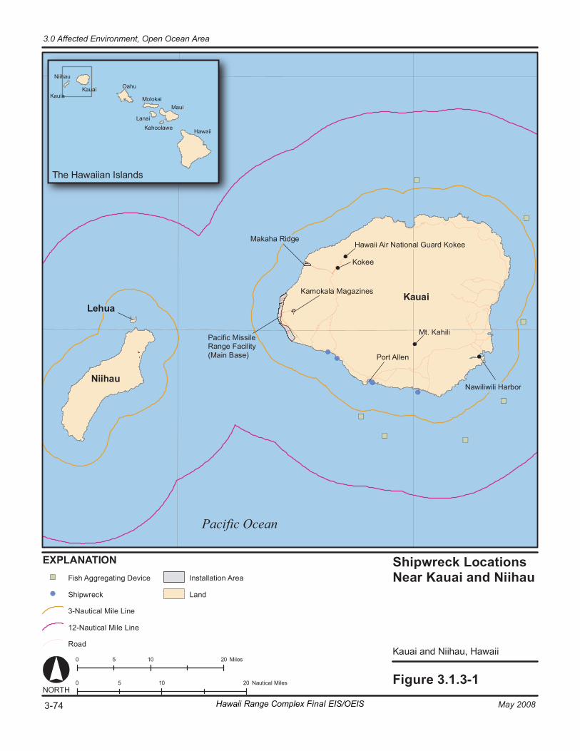
Shipwreck Lo cati ons Ne ar K auai and Ni ih au
Ka uai and N ii hau , H awai i
Fi gure 3. 1. 3- 1 0 1 0 2 0 5 N au ti ca l Mi le s NORT H
T he Ha wa iia n Is la nd s
Hawa ii
M aui
K ahool aw e L anai
Mo lo ka i
O ahu K auai
Ni i hau
K aul a
0 1 0 2 0 5 M ile s
Pa ci fic Ocea n
Pa ci fi c Mi ssi le Ra ng e Fa ci li ty (M ai n Ba se )
Ka mo ka la M ag az in es
Ma ka ha R id g e
Kaua i
Ni ih au
Le hu a
Po rt A ll en
Mt . K ah ili
Ha wa ii A ir N at io na l Gu ar d Ko ke e
Ko ke e
Na wi li wi li H ar bo r
EX PL AN AT I ON Fi sh A gg re g at in g D ev ic e
Sh ip wr ec k
3- Na ut ic al M il e Li ne
Ro ad
In st al la ti on A re a
La nd
12 -N au ti ca l Mi le L in e
3-74 May 2008Hawaii Range Complex Final EIS/OEIS
3.0 Affected Environment, Open Ocean Area
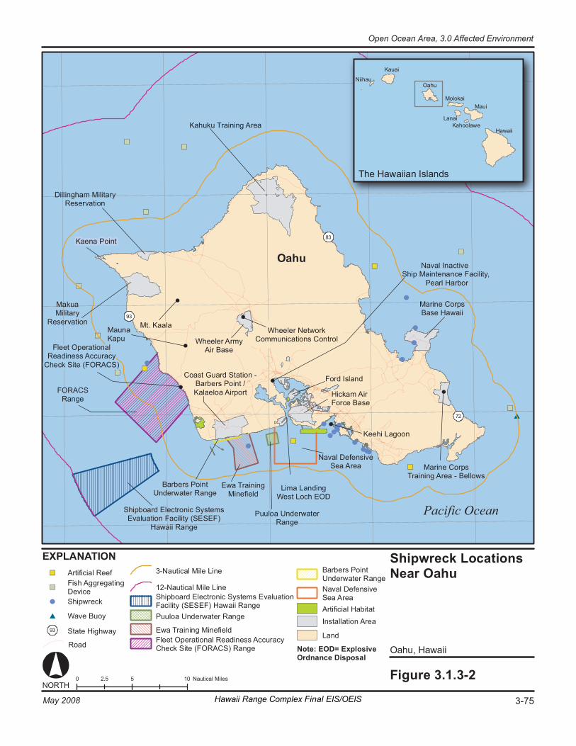
0 5 10 2. 5 N au ti ca l Mi le s Fi gure 3. 1. 3- 2
O ahu , Hawa ii
Shipwreck Lo cati ons Ne ar Oa hu
NORT H
EX PL AN AT I ON Arti fi ci al R ee f
Sh ip wr ec k
Wa ve B uo y
Ro ad
93 St at e Hi gh wa y
Fi sh A gg re ga ti ng De vi ce
Pa ci fic Ocea n
Hawa ii
M aui
O ahu
K auai
Mo lo ka i
L anai
Ni i hau
K ahool aw e
T he Ha wa iia n Is la nd s
Sh ip bo ar d El ec tr oni c S yst em s Ev al uat io n Fa ci li ty (SE SEF )
Ha wa ii R an ge
Na va l De fe ns iv e Se a Ar ea
Oa hu
83 Ka en a Po in t
Mt . K aal a
Ma ku a Mi li ta ry
Re se rv at io n
Ka hu ku T ra in in g Ar ea
Dill in g ham M ili ta ry Re se rv at io n
Ma ri ne Co rp s B as e Ha wa ii
Na va l I nac ti ve Sh ip M ai nt en anc e Fa ci li ty ,
P ea rl H ar bo r
Fo rd I sl an d
72
93
Ma un a Ka pu
Wh ee le r Ne tw or k Co mmu ni ca ti on s Co nt ro l
Ma ri ne Co rp s Tr ai ni ng A re a - B el lo ws
Co as t Gu ar d St at io n - B ar ber s Po in t / Ka la el oa A ir po rt Hi ck am A ir
Fo rc e B as e
Wh ee le r Ar my Air B as e
Li ma L an di ng We s t L oc h EO D
Fl ee t Op er at io na l Re ad in es s Ac cu ra cy
Ch ec k Si te ( FO RACS )
Ke eh i La go on
Pu ul oa U n der wa te r Ra ng e
Ew a Tr ai ni ng Mi ne fi el d
B ar ber s Po in t Un de rw at er R an ge
FO RACS Ra ng e
Note : EOD= E xp lo si ve Or dn an ce D is po sal
3- Na ut ic al M il e Li ne
12 -N au ti ca l M ile L in e Sh ip bo ar d El ec tr oni c S yst em s Ev al ua ti on Fa ci lit y (SES EF) Ha wa ii R an ge Pu ul oa U n der wa te r Ra ng e
Ew a Tr ai ni ng Mi ne fi el d Fl ee t Op er at io na l Re ad in e ss A ccu ra cy Ch ec k Si te ( FO RACS ) Ra ng e
B ar ber s Po in t Un de rw at er R an ge Na va l De fe ns iv e Se a Ar ea Arti fi ci al H ab it at In st al la ti on A re a
La nd
Hawaii Range Complex Final EIS/OEIS 3-75May 2008
Open Ocean Area, 3.0 Affected Environment
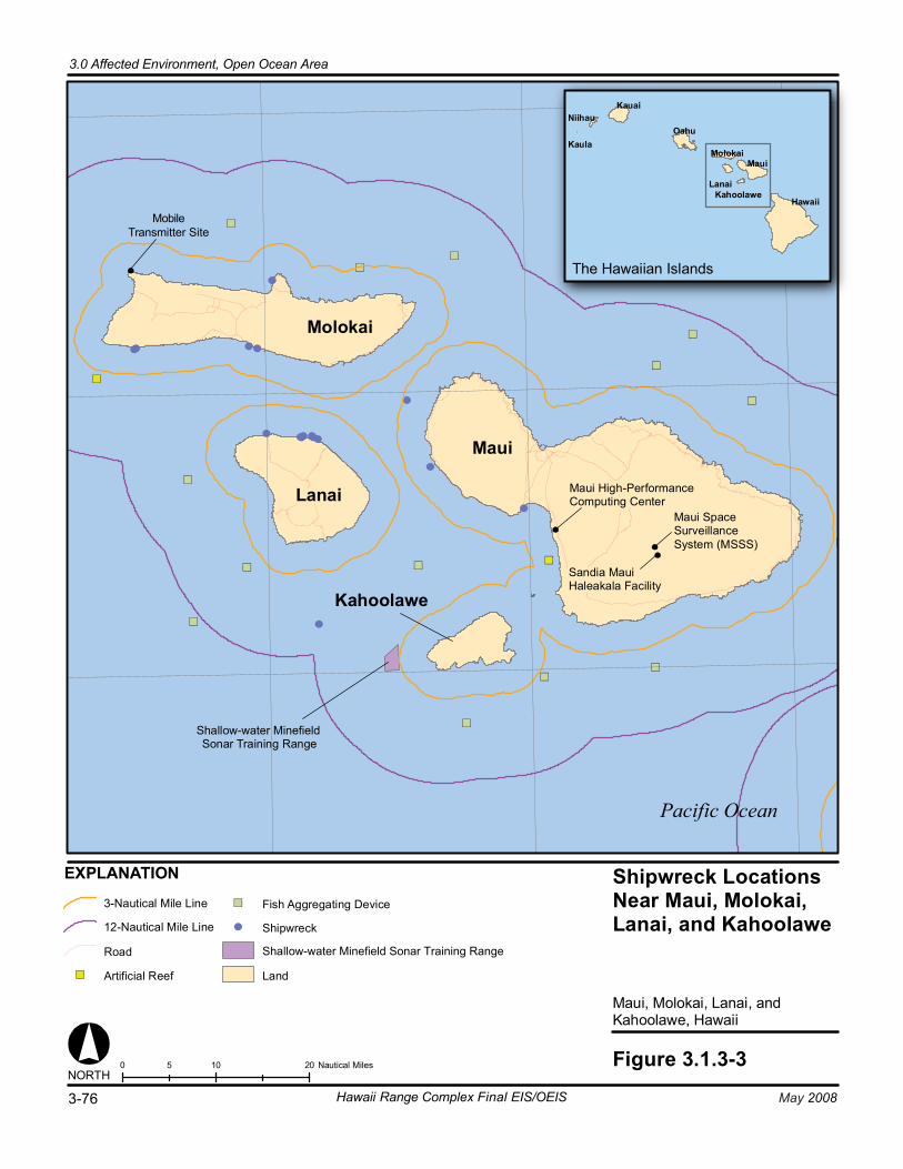
0 10 205 Nautical Miles Figure 3.1.3-3
Maui, Molokai, Lanai, andKahoolawe, Hawaii
Shipwreck LocationsNear Maui, Molokai,Lanai, and Kahoolawe
Pacific Ocean
Lanai
Molokai
Oahu
Maui
KahoolaweHawaii
Kaula
KauaiNiihau
The Hawaiian Islands
NORTH
Maui
Kahoolawe
Maui High-PerformanceComputing Center
Sandia MauiHaleakala Facility
Maui SpaceSurveillanceSystem (MSSS)
Lanai
Molokai
EXPLANATION
3-Nautical Mile Line
12-Nautical Mile Line
Road
Artificial Reef
Fish Aggregating Device
Shipwreck
Shallow-water Minefield Sonar Training Range
Land
Shallow-water MinefieldSonar Training Range
3-76 May 2008Hawaii Range Complex Final EIS/OEIS
3.0 Affected Environment, Open Ocean Area
MobileTransmitter Site
3.0 Affected Environment, Open Ocean Area
May 2008 Hawaii Range Complex Final EIS/OEIS 3-77
3.1.4 HAZARDOUS MATERIALS AND WASTE—OPEN OCEAN AREA
Appendix C includes a discussion of hazardous materials and waste resource regulations.
Region of Influence The hazardous materials and wastes region of influence for the Open Ocean Area includes the Navy’s sea ranges and immediately adjacent waters.
Affected Environment
Hazardous Materials and Hazardous Constituents Hazardous materials can be broadly defined as those materials with clearly hazardous properties that are in general use in commercial and industrial applications. Hazardous materials include, but are not limited to, petroleum products, coolants, paints, adhesives, solvents, corrosion inhibitors, cleaning compounds, photographic materials and chemicals, and batteries. Hazardous materials are required for maintenance and operation of vessels, machinery, and equipment used by the Navy in training activities.
Hazardous constituents can generally be defined as hazardous materials present at low concentrations in a generally non-hazardous matrix, such that their hazardous properties do not produce acute effects. Navy vessels conducting training do not intentionally release hazardous constituents into the water. U.S. Environmental Protection Agency (USEPA) and the Department of Defense (DoD), however, have identified numerous waste streams from Navy vessels that do or may contain hazardous constituents. Waste streams from Navy vessels that may contain hazardous constituents include hull coating leachate and:
• Bilgewater/oil water separator discharges,
• Gray water,
• Cooling water,
• Weather deck runoff
• Chain locker effluent,
• Elevator pit effluent, and
• Photographic laboratory drains.
In addition, small boat engines discharge petroleum products in their wet exhaust (U.S. Environmental Protection Agency, 2004).
Table 3.1.4-1 lists the hazardous constituents of common Navy training munitions. Hazardous materials associated with training are described below.
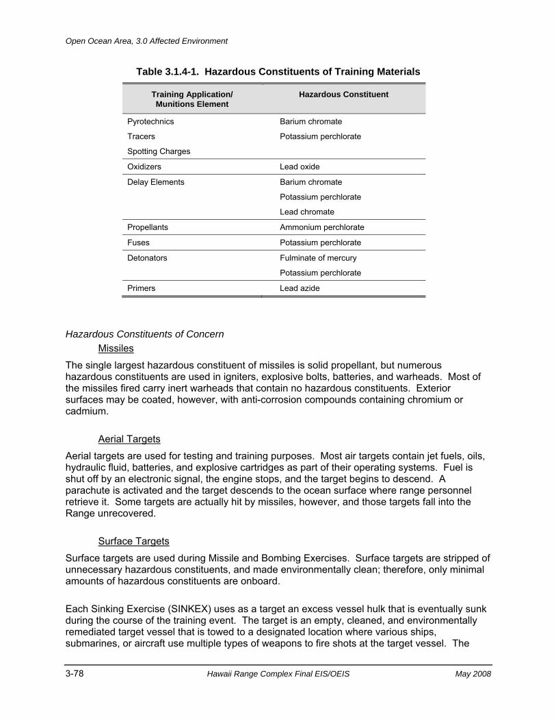
Open Ocean Area, 3.0 Affected Environment
3-78 Hawaii Range Complex Final EIS/OEIS May 2008
Table 3.1.4-1. Hazardous Constituents of Training Materials
Training Application/ Munitions Element
Hazardous Constituent
Pyrotechnics
Tracers
Spotting Charges
Barium chromate
Potassium perchlorate
Oxidizers Lead oxide
Delay Elements Barium chromate
Potassium perchlorate
Lead chromate
Propellants Ammonium perchlorate
Fuses Potassium perchlorate
Detonators Fulminate of mercury
Potassium perchlorate
Primers Lead azide
Hazardous Constituents of Concern Missiles
The single largest hazardous constituent of missiles is solid propellant, but numerous hazardous constituents are used in igniters, explosive bolts, batteries, and warheads. Most of the missiles fired carry inert warheads that contain no hazardous constituents. Exterior surfaces may be coated, however, with anti-corrosion compounds containing chromium or cadmium.
Aerial Targets
Aerial targets are used for testing and training purposes. Most air targets contain jet fuels, oils, hydraulic fluid, batteries, and explosive cartridges as part of their operating systems. Fuel is shut off by an electronic signal, the engine stops, and the target begins to descend. A parachute is activated and the target descends to the ocean surface where range personnel retrieve it. Some targets are actually hit by missiles, however, and those targets fall into the Range unrecovered.
Surface Targets
Surface targets are used during Missile and Bombing Exercises. Surface targets are stripped of unnecessary hazardous constituents, and made environmentally clean; therefore, only minimal amounts of hazardous constituents are onboard.
Each Sinking Exercise (SINKEX) uses as a target an excess vessel hulk that is eventually sunk during the course of the training event. The target is an empty, cleaned, and environmentally remediated target vessel that is towed to a designated location where various ships, submarines, or aircraft use multiple types of weapons to fire shots at the target vessel. The
3.0 Affected Environment, Open Ocean Area
May 2008 Hawaii Range Complex Final EIS/OEIS 3-79
vessels used as targets are selected from a list of USEPA-approved destroyers, tenders, cutters, frigates, cruisers, tugs, and transports (See Appendix D). Weapons can include missiles, precision and non-precision bombs, gunfire, and torpedoes. If none of the shots sinks the target vessel, either a submarine shot or placed explosive charges are used to sink the ship. If sunk by explosives, charges ranging from 100 to 200 lb, depending on the size of the ship, are placed on or in the target vessel.
USEPA granted the U.S. Department of the Navy a general permit through the Marine Protection, Research, and Sanctuaries Act to transport vessels “for the purpose of sinking such vessels in ocean waters…” (40 Code of Federal Regulations [CFR] Part 229.2). Subparagraph (a)(3) of this regulation states “All such vessel sinkings shall be conducted in water at least 1,000 fathoms (6,000 ft) deep and at least 50 nm from land.” In Hawaii, SINKEX events take place in Warning Area W-188 (see Figure 3.1.1-1) at least 50 nm from shore and in water deeper than 1,000 fathoms.
Other Ordnance
Other ordnance includes bombs and gunnery rounds. Most of this ordnance is inert (non-explosive) and consists of non-hazardous constituents. Inert ordnance includes steel shapes or replicas containing concrete, vermiculite (clay), or other non-hazardous constituents similar in appearance, size, and weight to explosive ordnance.
Explosives
Trinitrotoluene (TNT), used since 1912 by the Navy, is a nitroaromatic compound that continues to be a component of modern military munitions. Modern explosives in military ordnance, however, are generally solid-cast explosive fills formed by melting the constituents and pouring them into casings (usually steel). Most new Navy formulations contain plastic-bonded explosives (PBX), with plastic or other polymer binders added to increase their stability (Jane’s Information Group, 2005; 2006). Royal Demolition Explosive (RDX)/High Melting Explosive (HMX) blends have generally replaced TNT in plastic-bonded formulations.
Explosives become an environmental concern when expended ordnance fails to function as designed (dud), and explosive compounds in the unexploded ordnance (UXO) are released into the environment. Munitions constituents of concern include nitroaromatics—principally TNT, its degradation products, and related compounds—and cyclonitramines, including RDX, HMX, and their degradation products. TNT degrades to dinitrotoluene (DNT) and subsequent degradation products from exposure to sunlight (photolysis) or bacteria (biodegradation). RDX also is subject to photolysis and biodegradation once exposed to the environment. As a group, military-grade explosives have low water solubility (see Table 3.1.4-2), and are relatively immobile in water. The physical structure and composition of blended explosives containing multiple chemical compounds, often with additional binding agents, may further slow the degradation and dissolution of these materials (see Table 3.1.4-3).
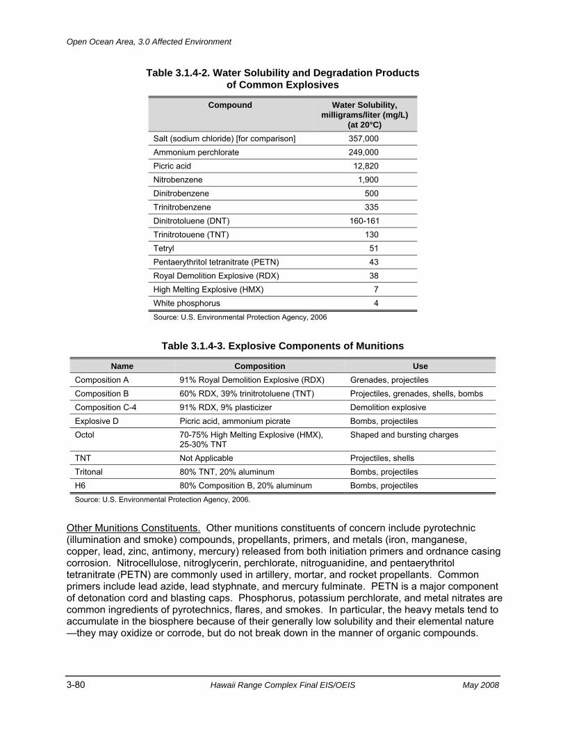
Open Ocean Area, 3.0 Affected Environment
3-80 Hawaii Range Complex Final EIS/OEIS May 2008
Table 3.1.4-2. Water Solubility and Degradation Products of Common Explosives
Compound Water Solubility, milligrams/liter (mg/L)
(at 20°C) Salt (sodium chloride) [for comparison] 357,000 Ammonium perchlorate 249,000 Picric acid 12,820 Nitrobenzene 1,900 Dinitrobenzene 500 Trinitrobenzene 335 Dinitrotoluene (DNT) 160-161 Trinitrotouene (TNT) 130 Tetryl 51 Pentaerythritol tetranitrate (PETN) 43 Royal Demolition Explosive (RDX) 38 High Melting Explosive (HMX) 7 White phosphorus 4 Source: U.S. Environmental Protection Agency, 2006
Table 3.1.4-3. Explosive Components of Munitions
Name Composition Use Composition A 91% Royal Demolition Explosive (RDX) Grenades, projectiles Composition B 60% RDX, 39% trinitrotoluene (TNT) Projectiles, grenades, shells, bombs Composition C-4 91% RDX, 9% plasticizer Demolition explosive Explosive D Picric acid, ammonium picrate Bombs, projectiles Octol 70-75% High Melting Explosive (HMX),
25-30% TNT Shaped and bursting charges
TNT Not Applicable Projectiles, shells Tritonal 80% TNT, 20% aluminum Bombs, projectiles H6 80% Composition B, 20% aluminum Bombs, projectiles Source: U.S. Environmental Protection Agency, 2006.
Other Munitions Constituents. Other munitions constituents of concern include pyrotechnic (illumination and smoke) compounds, propellants, primers, and metals (iron, manganese, copper, lead, zinc, antimony, mercury) released from both initiation primers and ordnance casing corrosion. Nitrocellulose, nitroglycerin, perchlorate, nitroguanidine, and pentaerythritol tetranitrate (PETN) are commonly used in artillery, mortar, and rocket propellants. Common primers include lead azide, lead styphnate, and mercury fulminate. PETN is a major component of detonation cord and blasting caps. Phosphorus, potassium perchlorate, and metal nitrates are common ingredients of pyrotechnics, flares, and smokes. In particular, the heavy metals tend to accumulate in the biosphere because of their generally low solubility and their elemental nature —they may oxidize or corrode, but do not break down in the manner of organic compounds.
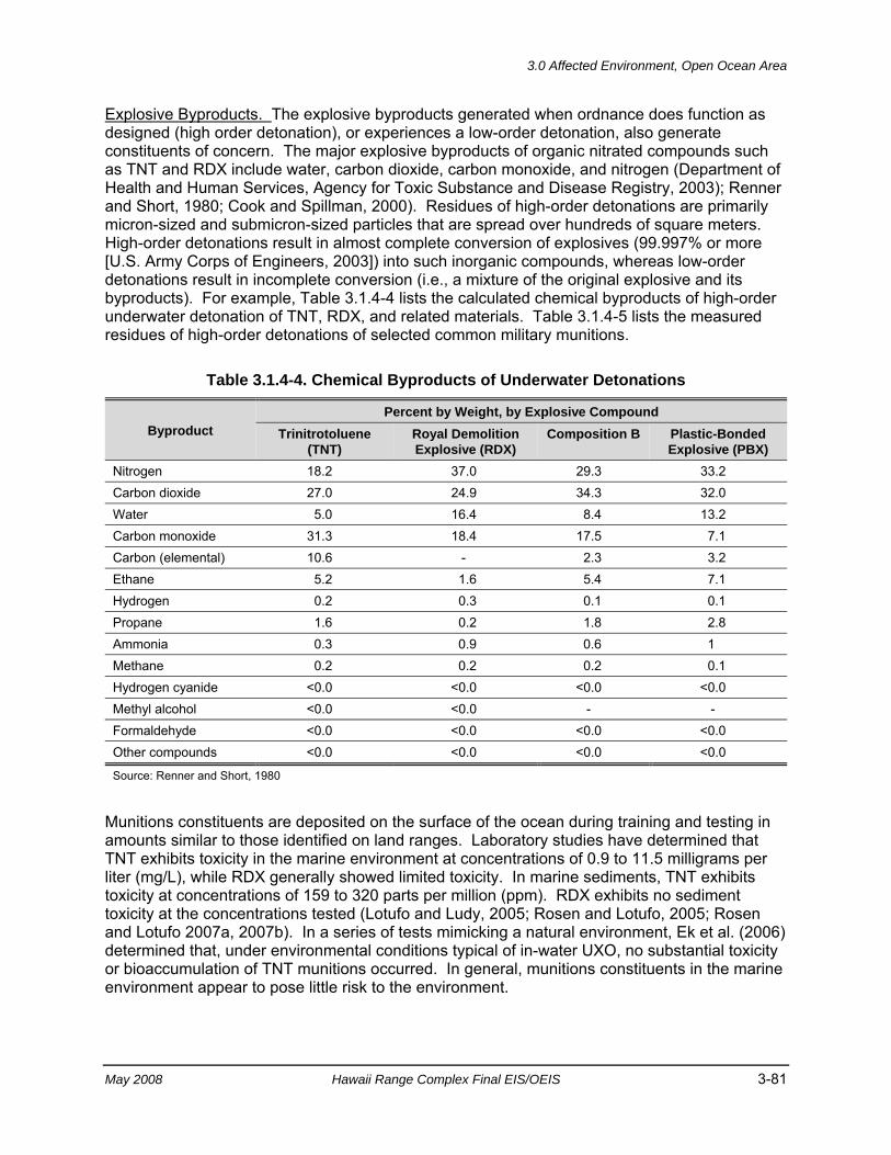
3.0 Affected Environment, Open Ocean Area
May 2008 Hawaii Range Complex Final EIS/OEIS 3-81
Explosive Byproducts. The explosive byproducts generated when ordnance does function as designed (high order detonation), or experiences a low-order detonation, also generate constituents of concern. The major explosive byproducts of organic nitrated compounds such as TNT and RDX include water, carbon dioxide, carbon monoxide, and nitrogen (Department of Health and Human Services, Agency for Toxic Substance and Disease Registry, 2003); Renner and Short, 1980; Cook and Spillman, 2000). Residues of high-order detonations are primarily micron-sized and submicron-sized particles that are spread over hundreds of square meters. High-order detonations result in almost complete conversion of explosives (99.997% or more [U.S. Army Corps of Engineers, 2003]) into such inorganic compounds, whereas low-order detonations result in incomplete conversion (i.e., a mixture of the original explosive and its byproducts). For example, Table 3.1.4-4 lists the calculated chemical byproducts of high-order underwater detonation of TNT, RDX, and related materials. Table 3.1.4-5 lists the measured residues of high-order detonations of selected common military munitions.
Table 3.1.4-4. Chemical Byproducts of Underwater Detonations
Byproduct Percent by Weight, by Explosive Compound
Trinitrotoluene (TNT)
Royal Demolition Explosive (RDX)
Composition B Plastic-Bonded Explosive (PBX)
Nitrogen 18.2 37.0 29.3 33.2 Carbon dioxide 27.0 24.9 34.3 32.0 Water 5.0 16.4 8.4 13.2 Carbon monoxide 31.3 18.4 17.5 7.1 Carbon (elemental) 10.6 - 2.3 3.2 Ethane 5.2 1.6 5.4 7.1 Hydrogen 0.2 0.3 0.1 0.1 Propane 1.6 0.2 1.8 2.8 Ammonia 0.3 0.9 0.6 1 Methane 0.2 0.2 0.2 0.1 Hydrogen cyanide <0.0 <0.0 <0.0 <0.0 Methyl alcohol <0.0 <0.0 - - Formaldehyde <0.0 <0.0 <0.0 <0.0 Other compounds <0.0 <0.0 <0.0 <0.0
Source: Renner and Short, 1980
Munitions constituents are deposited on the surface of the ocean during training and testing in amounts similar to those identified on land ranges. Laboratory studies have determined that TNT exhibits toxicity in the marine environment at concentrations of 0.9 to 11.5 milligrams per liter (mg/L), while RDX generally showed limited toxicity. In marine sediments, TNT exhibits toxicity at concentrations of 159 to 320 parts per million (ppm). RDX exhibits no sediment toxicity at the concentrations tested (Lotufo and Ludy, 2005; Rosen and Lotufo, 2005; Rosen and Lotufo 2007a, 2007b). In a series of tests mimicking a natural environment, Ek et al. (2006) determined that, under environmental conditions typical of in-water UXO, no substantial toxicity or bioaccumulation of TNT munitions occurred. In general, munitions constituents in the marine environment appear to pose little risk to the environment.
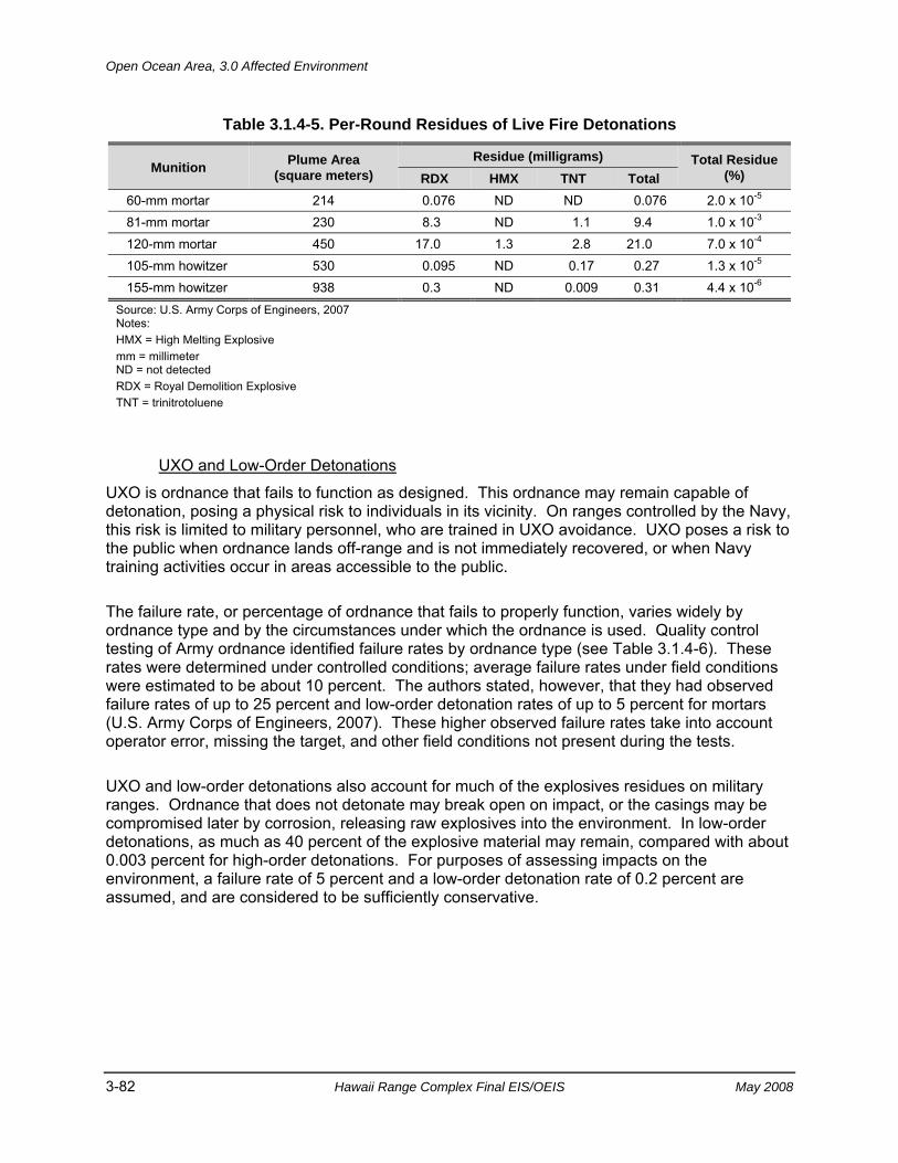
Open Ocean Area, 3.0 Affected Environment
3-82 Hawaii Range Complex Final EIS/OEIS May 2008
Table 3.1.4-5. Per-Round Residues of Live Fire Detonations
Munition Plume Area (square meters)
Residue (milligrams) Total Residue (%) RDX HMX TNT Total
60-mm mortar 214 0.076 ND ND 0.076 2.0 x 10⁻⁵ 81-mm mortar 230 8.3 ND 1.1 9.4 1.0 x 10⁻³ 120-mm mortar 450 17.0 1.3 2.8 21.0 7.0 x 10⁻⁴ 105-mm howitzer 530 0.095 ND 0.17 0.27 1.3 x 10⁻⁵ 155-mm howitzer 938 0.3 ND 0.009 0.31 4.4 x 10⁻⁶
Source: U.S. Army Corps of Engineers, 2007 Notes: HMX = High Melting Explosive mm = millimeter ND = not detected RDX = Royal Demolition Explosive TNT = trinitrotoluene
UXO and Low-Order Detonations
UXO is ordnance that fails to function as designed. This ordnance may remain capable of detonation, posing a physical risk to individuals in its vicinity. On ranges controlled by the Navy, this risk is limited to military personnel, who are trained in UXO avoidance. UXO poses a risk to the public when ordnance lands off-range and is not immediately recovered, or when Navy training activities occur in areas accessible to the public.
The failure rate, or percentage of ordnance that fails to properly function, varies widely by ordnance type and by the circumstances under which the ordnance is used. Quality control testing of Army ordnance identified failure rates by ordnance type (see Table 3.1.4-6). These rates were determined under controlled conditions; average failure rates under field conditions were estimated to be about 10 percent. The authors stated, however, that they had observed failure rates of up to 25 percent and low-order detonation rates of up to 5 percent for mortars (U.S. Army Corps of Engineers, 2007). These higher observed failure rates take into account operator error, missing the target, and other field conditions not present during the tests.
UXO and low-order detonations also account for much of the explosives residues on military ranges. Ordnance that does not detonate may break open on impact, or the casings may be compromised later by corrosion, releasing raw explosives into the environment. In low-order detonations, as much as 40 percent of the explosive material may remain, compared with about 0.003 percent for high-order detonations. For purposes of assessing impacts on the environment, a failure rate of 5 percent and a low-order detonation rate of 0.2 percent are assumed, and are considered to be sufficiently conservative.
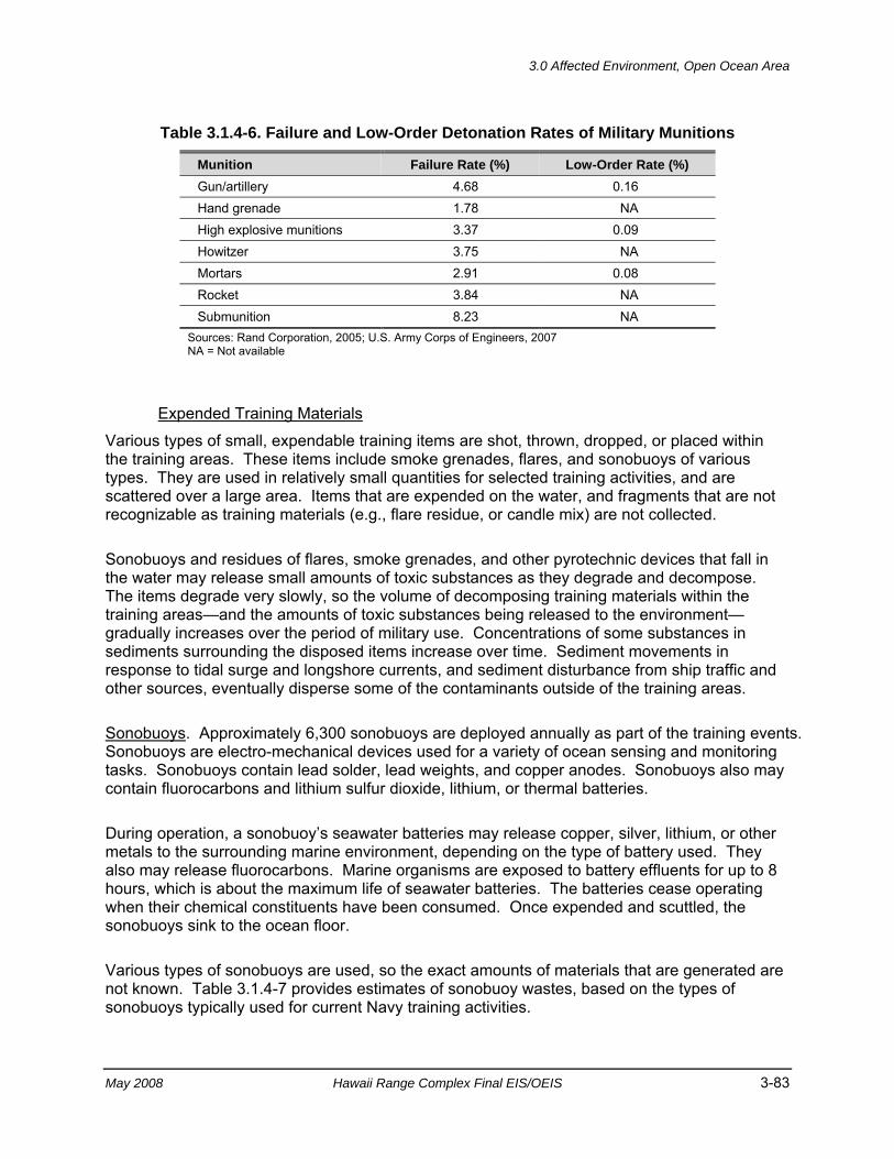
3.0 Affected Environment, Open Ocean Area
May 2008 Hawaii Range Complex Final EIS/OEIS 3-83
Table 3.1.4-6. Failure and Low-Order Detonation Rates of Military Munitions
Munition Failure Rate (%) Low-Order Rate (%) Gun/artillery 4.68 0.16 Hand grenade 1.78 NA High explosive munitions 3.37 0.09 Howitzer 3.75 NA Mortars 2.91 0.08 Rocket 3.84 NA Submunition 8.23 NA
Sources: Rand Corporation, 2005; U.S. Army Corps of Engineers, 2007 NA = Not available
Expended Training Materials
Various types of small, expendable training items are shot, thrown, dropped, or placed within the training areas. These items include smoke grenades, flares, and sonobuoys of various types. They are used in relatively small quantities for selected training activities, and are scattered over a large area. Items that are expended on the water, and fragments that are not recognizable as training materials (e.g., flare residue, or candle mix) are not collected.
Sonobuoys and residues of flares, smoke grenades, and other pyrotechnic devices that fall in the water may release small amounts of toxic substances as they degrade and decompose. The items degrade very slowly, so the volume of decomposing training materials within the training areas—and the amounts of toxic substances being released to the environment—gradually increases over the period of military use. Concentrations of some substances in sediments surrounding the disposed items increase over time. Sediment movements in response to tidal surge and longshore currents, and sediment disturbance from ship traffic and other sources, eventually disperse some of the contaminants outside of the training areas.
Sonobuoys. Approximately 6,300 sonobuoys are deployed annually as part of the training events. Sonobuoys are electro-mechanical devices used for a variety of ocean sensing and monitoring tasks. Sonobuoys contain lead solder, lead weights, and copper anodes. Sonobuoys also may contain fluorocarbons and lithium sulfur dioxide, lithium, or thermal batteries.
During operation, a sonobuoy’s seawater batteries may release copper, silver, lithium, or other metals to the surrounding marine environment, depending on the type of battery used. They also may release fluorocarbons. Marine organisms are exposed to battery effluents for up to 8 hours, which is about the maximum life of seawater batteries. The batteries cease operating when their chemical constituents have been consumed. Once expended and scuttled, the sonobuoys sink to the ocean floor.
Various types of sonobuoys are used, so the exact amounts of materials that are generated are not known. Table 3.1.4-7 provides estimates of sonobuoy wastes, based on the types of sonobuoys typically used for current Navy training activities.
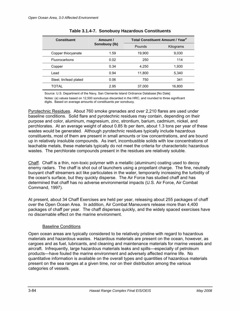
Open Ocean Area, 3.0 Affected Environment
3-84 Hawaii Range Complex Final EIS/OEIS May 2008
Table 3.1.4-7. Sonobuoy Hazardous Constituents
Constituent Amount / Sonobuoy (lb)
Total Constituent Amount / Yeara
Pounds Kilograms
Copper thiocyanate 1.59 19,900 9,030
Fluorocarbons 0.02 250 114
Copper 0.34 4,250 1,930
Lead 0.94 11,800 5,340
Steel, tin/lead plated 0.06 750 341
TOTAL 2.95 37,000 16,800
Source: U.S. Department of the Navy, San Clemente Island Ordnance Database [No Date] Notes: (a) values based on 12,500 sonobuoys discarded in the HRC, and rounded to three significant digits. Based on average amounts of constituents per sonobuoy.
Pyrotechnic Residues. About 760 smoke grenades and over 2,210 flares are used under baseline conditions. Solid flare and pyrotechnic residues may contain, depending on their purpose and color, aluminum, magnesium, zinc, strontium, barium, cadmium, nickel, and perchlorates. At an average weight of about 0.85 lb per item, about 1.3 tons per year of these wastes would be generated. Although pyrotechnic residues typically include hazardous constituents, most of them are present in small amounts or low concentrations, and are bound up in relatively insoluble compounds. As inert, incombustible solids with low concentrations of leachable metals, these materials typically do not meet the criteria for characteristic hazardous wastes. The perchlorate compounds present in the residues are relatively soluble.
Chaff. Chaff is a thin, non-toxic polymer with a metallic (aluminum) coating used to decoy enemy radars. The chaff is shot out of launchers using a propellant charge. The fine, neutrally buoyant chaff streamers act like particulates in the water, temporarily increasing the turbidity of the ocean's surface, but they quickly disperse. The Air Force has studied chaff and has determined that chaff has no adverse environmental impacts (U.S. Air Force, Air Combat Command, 1997).
At present, about 34 Chaff Exercises are held per year, releasing about 255 packages of chaff over the Open Ocean Area. In addition, Air Combat Maneuvers release more than 4,400 packages of chaff per year. The chaff disperses quickly, and the widely spaced exercises have no discernable effect on the marine environment.
Baseline Conditions
Open ocean areas are typically considered to be relatively pristine with regard to hazardous materials and hazardous wastes. Hazardous materials are present on the ocean, however, as cargoes and as fuel, lubricants, and cleaning and maintenance materials for marine vessels and aircraft. Infrequently, large hazardous materials leaks and spills—especially of petroleum products—have fouled the marine environment and adversely affected marine life. No quantitative information is available on the overall types and quantities of hazardous materials present on the sea ranges at a given time, nor on their distribution among the various categories of vessels.
3.0 Affected Environment, Open Ocean Area
May 2008 Hawaii Range Complex Final EIS/OEIS 3-85
Navy vessels present on the Hawaii sea ranges represent a small fraction of the overall commercial and recreational boat traffic and, correspondingly, account for only a small fraction of the potentially hazardous materials present in the Open Ocean Area around Hawaii. As described earlier, Navy training activities in open ocean areas involve the use of fuel, lubricants, explosives, propellants, batteries, oxidizers, and other hazardous substances. The Navy makes every effort to minimize its use of hazardous materials during training, and recovers and reuses unexpended training materials to the extent practicable.
Hazardous Wastes Management
Environmental compliance policies and procedures applicable to training and RDT&E activities on shore are defined in Naval Operations Instruction (OPNAVINST) 5090.1C (2007), while environmental compliance policies and procedures applicable to shipboard operations afloat are defined in OPNAVINST 5090.1C (2007). The Consolidated Hazardous Materials Reutilization and Inventory Management Program (CHRIMP) also provides information on management of hazardous materials for both afloat and ashore. These documents provide a comprehensive compilation of procedures and requirements that are mandated by law, directive, or regulation. These documents have a compliance orientation to ensure safe and efficient control, use, transport, and disposal of hazardous waste. Hazardous wastes generated afloat are stored in approved containers. The waste is offloaded for proper disposal within 5 working days of arrival at a Navy port.
Generation
Environmental compliance policies and procedures applicable to shipboard operations afloat are defined in OPNAVINST 5090.1C (2007). Munitions containing or comprising hazardous materials expended during training exercises that are irretrievable from the ocean are not considered a hazardous waste in accordance with the Military Munitions Rule.
Storage
Navy ships may not discharge overboard untreated used or excess hazardous materials generated onboard the ship within 200 nm of shore. Ships retain used and excess hazardous material on board for shore disposal. Ships offload used hazardous materials within 5 working days of arrival at a Navy port.
Disposal
Hawaii lacks permitted hazardous waste disposal facilities; therefore, hazardous waste generated by the Navy is shipped to the mainland for disposal. Limited facilities for treatment and processing of recycled materials exist on Oahu.
Baseline Conditions
Commercial, scientific, and military vessels generate small quantities of hazardous wastes during their operations. These materials typically are accumulated while at sea, and then offloaded and transported to land disposal facilities when in port. No quantitative information is
Open Ocean Area, 3.0 Affected Environment
3-86 Hawaii Range Complex Final EIS/OEIS May 2008
available on the overall types and quantities of hazardous wastes present on the sea ranges at a given time, nor on their distribution among the various categories of vessels.
3.1.5 HEALTH AND SAFETY—OPEN OCEAN AREA Public health and safety issues include potential hazards inherent in flight operations, weapons firings, vessel operations, and target activities. This section also addresses public proximity and access, effects of electromagnetic radiation (EMR), potential ordnance hazards, and potential fuel hazards. The safety policy of the Navy is to observe every reasonable precaution in planning and executing its range operations to prevent injuries to or adverse health effects on its personnel or the public. Appendix C includes a discussion of health and safety resource regulations.
Region of Influence The region of influence for public health and safety includes the sea ranges themselves, and ocean areas adjacent to the sea ranges.
Affected Environment The ocean in the vicinity of the main Hawaiian Islands is used for a variety of recreational, commercial, scientific, transportation, cultural, and institutional purposes. The intensity of use generally declines with increasing distance from the shoreline, although specific resources in the Open Ocean Area may result in a concentration of use (e.g., sea mounts are preferred fishing locations). Areas that are shielded by land masses from the full force of wind and waves, such as the channels between Maui and adjacent islands, are preferred recreational areas. The HDAR is conducting a Hawaii Marine Recreational Fishing Survey Project to determine the quantity of recreational fishing in Hawaii.
Activities in the Open Ocean Area have no influence on public health. These areas are widely used for recreation, commerce, and scientific, educational, and cultural activities, however, surface vessel transits, aircraft operations, and weapons firing have the potential to affect public safety. The Navy has developed extensive protocols and procedures for the safe operation of its vessels and the safe execution of its training events.
3.1.6 NOISE—OPEN OCEAN AREA Appendix C includes a definition of noise and the main regulations and laws that govern them. Wildlife receptors and their acoustic characteristic and sensitivities are described in Section 3.1.2, Biological Resources.
Region of Influence Noise sources in the HRC are transitory and widely dispersed. The region of influence for noise includes all areas of the HRC where air operations or live weapons firings take place.
3.0 Affected Environment, Open Ocean Area
May 2008 Hawaii Range Complex Final EIS/OEIS 3-87
Affected Environment Table 3.1.6-1 lists typical noise sources and their effects on the corresponding noise environments. Note that each of the sound levels indicated is for a single event. Such events are discrete, and the resulting noise is not additive.
Airborne Noise Sources Airborne noise sources include civilian and military aircraft (both types of which fly at altitudes ranging from hundreds of feet to tens of thousands of feet above the surface), bombs, naval gunfire, missiles, rockets, and small arms. Noise levels may be significant in the vicinity of these activities, but the noise intensity decreases rapidly with increasing distance from the source, especially for impulsive noise from the discrete noise events characteristic of military training. Additionally, these activities take place miles at sea, where few or no human receptors are exposed to the noise. Open Ocean Area noise events are widely dispersed, temporally and geographically, with little or no overlap or additive effects.
Airborne Noise Levels As shown on Table 3.1.6-1, at the lower end of the threshold, human hearing begins at 0 dB. At the upper end of the hearing range, sounds become uncomfortable, and even painful at approximately 140 dB. At or above approximately 140 dB, permanent damage and hearing loss can occur, even with brief exposure to the noise. The noise levels shown are measured at the receiver, not the source. For example, the vacuum cleaner level of 70 dB is measured 10 ft from the vacuum cleaner itself. In general, sound levels decrease by 6 dB as you double the distance to the source. At 20 ft from the same vacuum cleaner, a person would receive approximately 64 dB of noise. Therefore, both the source level and the distance from the source are important to gauge the impact of a noise on a human receptor.
Underwater Noise Underwater sources on the HRC may be categorized in terms of their time-related characteristics. The categories are continuous or slowly varying, pulse (tonal), impulse (broadband), and explosive sources. The continuous or slowly varying source category includes submarine simulators, and torpedoes. Noise radiated into water from slower, low-flying fixed-wing aircraft and helicopters is also included in this category. The pulse category includes active sonar, beacons, transponders, fathometers, underwater telephones, and various pingers. The broadband impulse category includes noise made by fast, low-flying aircraft, naval surface gunfire, and objects impacting the water (e.g., sonobuoys, intact missiles, bombs, aerial targets, mine shapes, and various projectiles). Underwater noise sources include bombs and other projectiles that explode underwater and demolition activities. These sources are distinguished from the broadband impulse category by shock wave propagation near the source with high peak pressures and short durations. See Appendix G for additional details.
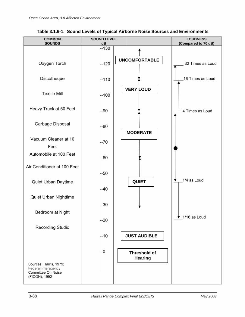
Open Ocean Area, 3.0 Affected Environment
3-88 Hawaii Range Complex Final EIS/OEIS May 2008
Table 3.1.6-1. Sound Levels of Typical Airborne Noise Sources and Environments COMMON SOUNDS
SOUND LEVEL dB LOUDNESS
(Compared to 70 dB)
Oxygen Torch
Discotheque
Textile Mill
Heavy Truck at 50 Feet
Garbage Disposal
Vacuum Cleaner at 10
Feet
Automobile at 100 Feet
Air Conditioner at 100 Feet
Quiet Urban Daytime
Quiet Urban Nighttime
Bedroom at Night
Recording Studio
--130
--120
--110
--100
--90
--80
--70
--60
--50
--40
--30
--20
--10
--0
____ 32 Times as Loud ____16 Times as Loud ____4 Times as Loud ____1/4 as Loud ____1/16 as Loud
MODERATE
VERY LOUD
UNCOMFORTABLE
QUIET
JUST AUDIBLE
Threshold of Hearing
Sources: Harris, 1979; Federal Interagency Committee On Noise (FICON), 1992
3.0 Affected Environment, Open Ocean Area
May 2008 Hawaii Range Complex Final EIS/OEIS 3-89
3.1.7 WATER RESOURCES—OPEN OCEAN AREA Appendix C describes the primary laws and regulations regarding water resources.
Region of Influence The region of influence for water resources includes open ocean waters within the HRC.
Affected Environment The Open Ocean Area off the Hawaiian Islands is a dynamic, tropical marine environment. Average water temperatures vary from 71° F in March to 81°F in September. Wave height varies from occasional flat seas to over 40 ft during high winter winds. Average swells commonly range from 3.3 to 9.8 ft in height. Water quality in the Open Ocean Area is excellent, with high clarity, low concentrations of suspended particles, high levels of dissolved oxygen, and low levels of contamination from trace metals or hydrocarbons (components of petroleum-based fuels) (U.S. Department of the Navy, 2000).
Physical and Chemical Properties The general composition of the ocean includes water, salts, dissolved gases, minerals, and nutrients. The characteristics of seawater determine, in part, the interactions between the ocean and its inhabitants. The most important physical and chemical properties of seawater are temperature, salinity, density, alkalinity (pH), and dissolved gases.
Salinity Salinity refers to the salt (sodium chloride) content of seawater. For oceanic waters, the salinity is approximately 35 parts of salt per 1,000 parts of seawater. Variations in the salinity of ocean water are linked primarily to climatic conditions. Salinity variations are at their highest at the surface of the water. The salinity of surface water is increased by the removal of water through evaporation. Alternately, it decreases through dilution from the addition of fresh water (e.g., rain, runoff from fresh water sources such as streams).
Seawater salinity has a profound effect on the concentration of salts in the tissues and body fluids of organisms. Slight shifts of salt concentrations in the bodies of animals can have stressful or even fatal consequences. Therefore, animals have either evolved mechanisms to control body salt levels, or they let them rise and fall with the levels of the seawater around them. (Waller, 1996)
In addition to the direct effects on marine biota, salinity also has an effect on the ocean’s physical properties. For example, salinity helps maintain a constant temperature throughout the ocean depths. A high salt content in water slightly increases its density, which makes it resistant to drastic temperature fluctuations.
Density Density (mass per unit volume) of seawater depends on its composition, and is affected by temperature. The dissolved salt and other dissolved substances contribute to the higher density of seawater versus fresh water. As temperatures increase, density decreases. Accordingly, water that is denser will sink, while water which is less dense will rise. Therefore, oceans can
Open Ocean Area, 3.0 Affected Environment
3-90 Hawaii Range Complex Final EIS/OEIS May 2008
be thought of as having a three-layered system of water masses. The three layers of the ocean include: the surface layer, from 0 to 92 fathoms; an intermediate layer, from 92 to 250 fathoms; and a deepwater layer, from 250 fathoms to the sea floor. (Waller, 1996)
Temperature Water temperature is one of the most important physical factors of the marine environment. Temperature controls the rate at which chemical reactions and biological processes occur (Waller, 1996). In addition, most organisms have a distinct range of temperatures in which they may thrive. A greater number of species live within the moderate temperature zones with fewer species tolerant of extremes in temperature. Typically, the vast majority of organisms cannot survive dramatic temperature fluctuations.
Temperature gradients are created when warmer, lighter water floats above the cold, denser water. The warm and cold layers of water are separated by a thin, narrow band of stable water called a thermocline. In tropical latitudes, the thermocline is present as a permanent feature and is located approximately 33 to 167 fathoms below the surface. The temperature below the thermocline remains relatively constant, with most areas of the Pacific Ocean maintaining a temperature of 39.2ºF. The thermocline acts as a depth barrier to many plants and animals and often represents the boundary between hospitable and inhospitable water masses for many species of organisms. (Waller, 1996)
pH The measure of the acidity or alkalinity of a substance, known as the pH, is based on a scale ranging from 1 (highly acidic) to 14 (highly basic). A pH of 7 is considered neutral. Surface seawater often has a pH between 8.1 and 8.3 (slightly basic), but generally the acidity of ocean water is very stable with a neutral pH. In shallow seas and coastal areas, the pH can be altered by plant and animal activities, by pollution, and interaction with fresh water. (Waller, 1996)
Dissolved Gases Oxygen is not readily soluble in seawater. The amount of oxygen present in seawater will vary with the rate of production by plants, consumption by animals and plants, bacterial decomposition, and by surface interactions with the atmosphere. Most organisms require oxygen for their life processes. When surface water sinks to deeper levels, it retains its store of oxygen. (Waller, 1996) Carbon dioxide is a gas required by plants for photosynthetic production of new organic matter. Carbon dioxide is 60 times more concentrated in seawater than it is in the atmosphere. Seawater in tropical regions has lower levels of dissolved gas in a given volume of water compared to seawater in high latitudes (Waller, 1996).
Marine Pollutants Ocean waters and sediments are chemically complex solutions that contain numerous natural and manmade substances, including all of the heavy metals and manmade organic compounds such as polychlorinated biphenyls (PCBs). Depending upon their concentrations and other factors, such as the concentrations of other substances or the alkalinity, salinity, or temperature of the water, some of these substances could be toxic to marine plants or animals. NOAA has established pollutant thresholds (i.e., screening concentrations of potential contaminants) for marine waters and sediments (see Table 3.1.7-1). These thresholds (for acute exposures) are not intended to indicate observable effects on marine biota in general, but rather to trigger a
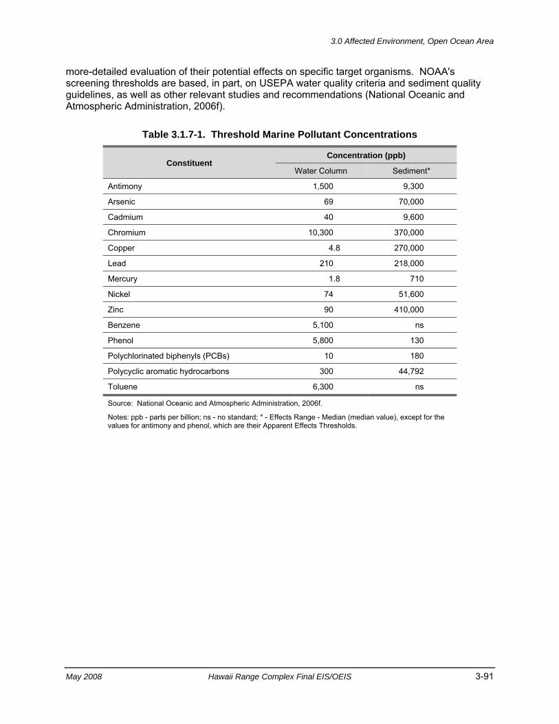
3.0 Affected Environment, Open Ocean Area
May 2008 Hawaii Range Complex Final EIS/OEIS 3-91
more-detailed evaluation of their potential effects on specific target organisms. NOAA's screening thresholds are based, in part, on USEPA water quality criteria and sediment quality guidelines, as well as other relevant studies and recommendations (National Oceanic and Atmospheric Administration, 2006f).
Table 3.1.7-1. Threshold Marine Pollutant Concentrations
Constituent Concentration (ppb)
Water Column Sediment*
Antimony 1,500 9,300
Arsenic 69 70,000
Cadmium 40 9,600
Chromium 10,300 370,000
Copper 4.8 270,000
Lead 210 218,000
Mercury 1.8 710
Nickel 74 51,600
Zinc 90 410,000
Benzene 5,100 ns
Phenol 5,800 130
Polychlorinated biphenyls (PCBs) 10 180
Polycyclic aromatic hydrocarbons 300 44,792
Toluene 6,300 ns
Source: National Oceanic and Atmospheric Administration, 2006f.
Notes: ppb - parts per billion; ns - no standard; * - Effects Range - Median (median value), except for the values for antimony and phenol, which are their Apparent Effects Thresholds.
Open Ocean Area, 3.0 Affected Environment
3-92 Hawaii Range Complex Final EIS/OEIS May 2008
THIS PAGE INTENTIONALLY LEFT BLANK
3.0 Affected Environment, Northwestern Hawaiian Islands
May 2008 Hawaii Range Complex Final EIS/OEIS 3-93
3.2 NORTHWESTERN HAWAIIAN ISLANDS The Northwestern Hawaiian Islands are a chain of small islands, atolls, submerged banks, and reefs stretching for more than 1,000 miles (mi) northwest of the Main Hawaiian Islands. According to Friedlander et al. (2004), the coral reef fauna from the Northwestern Hawaiian Islands is rich, with over 1,000 identified species. Fifty-seven stony coral species have been identified in the shallow, subtropical waters of the Northwestern Hawaiian Islands (Friedlander et al., 2004). Only 12 species of alien marine algae, invertebrates, and fish have been recorded in the Northwestern Hawaiian Islands. Hypnea musciformis, an invasive algal species, is not yet established in the Northwestern Hawaiian Islands. It is located in drift only at Maro Reef. (National Oceanic and Atmospheric Administration, 2006c)
Depending on the trajectory, missiles launched from the Pacific Missile Range Facility (PMRF) have the potential to overfly portions of the Papahānaumokuākea Marine National Monument. Of particular concern is the potential for missile debris on or offshore of Nihoa and Necker, which are the islands closest to the Main Hawaiian Islands. Thus, these two islands are described in greater detail. Nihoa is located at the southeastern end of the Northwestern Hawaiian Islands and is 240 nautical miles (nm) northwest of Oahu.
This section describes the environmental resources that would be affected by the No-action Alternative, Alternative 1, Alternative 2, or Alternative 3 for the Northwestern Hawaiian Islands. Of the 13 environmental resources considered for analysis, air quality, airspace, geology and soils, hazardous materials and waste, health and safety, land use, noise, socioeconomics, transportation, utilities, and water resources are not addressed.
Papahānaumokuākea (Northwestern Hawaiian Islands) Marine National Monument The Northwestern Hawaiian Islands Marine National Monument was established in June 2006 by Presidential Proclamation 8031 (Presidential Document, 2006), under the authority of the Antiquities Act (16 United States Code section 431). The Monument is nearly 140,000-square-mile (mi2) area, 100 mi wide, established to protect marine resources in the area including coral reefs, the endangered Hawaiian monk seal (Monachus schauinslandi), the threatened Hawaiian green turtle (Chelonia mydas), and the endangered leatherback and hawksbill turtles (Dermochelys coriacea and Eretmochelys imbricata). The Monument includes the Northwestern Hawaiian Islands Coral Reef Ecosystem Reserve, the Hawaiian Islands National Wildlife Refuge, the Midway Atoll National Wildlife Refuge, and the Battle of Midway National Memorial, which are briefly described below (National Oceanic and Atmospheric Administration, 2006b). The Monument was given the name Papahānaumokuākea Marine National Monument in 2007. Only a fraction of the Monument is within the Hawaiian Islands Operating Area on its western boundary near the northern border (Figure 3.2-1). The Temporary Operating Area encompasses the entire Monument.
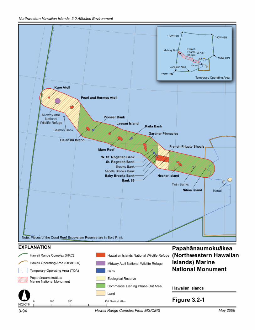
Hawaiian Islands
Figure 3.2-10 200 400100 Nautical Miles
179W 43N
179W 16N
150W 43N
150W 28N
Temporary Operating Area
W-188
EXPLANATION
NORTH
Midway Atoll
Johnston AtollKauai
Kure Atoll
Midway AtollNational
Wildlife Refuge
Pearl and Hermes Atoll
Lisianski Island
Laysan Island
Maro Reef
Gardner Pinnacles
French Frigate Shoals
Necker Island
Nihoa Island Kauai
Salmon Bank
Pioneer Bank
Raita Bank
W. St. Rogatien BankSt. Rogatien Bank
Brooks BankMiddle Brooks BankBaby Brooks Bank
Bank 66Twin Banks
Land
Commercial Fishing Phase-Out Area
Ecological Reserve
Midway Atoll National Wildlife Refuge
Hawaiian Islands National Wildlife Refuge
Note: Pieces of the Coral Reef Ecosystem Reserve are in Bold Print.
BankTemporary Operating Area (TOA)
PapahānaumokuākeaMarine National Monument
Hawaii Range Complex (HRC)
Hawaii Operating Area (OPAREA)
3-94 May 2008Hawaii Range Complex Final EIS/OEIS
Northwestern Hawaiian Islands, 3.0 Affected Environment
FrenchFrigateShoals
Papahānaumokuākea(Northwestern HawaiianIslands) Marine National Monument
3.0 Affected Environment, Northwestern Hawaiian Islands
May 2008 Hawaii Range Complex Final EIS/OEIS 3-95
The Monument is situated in the Pacific Ocean northwest of the Main Hawaiian Islands and is an approximately 1,200-nm stretch of coral islands, seamounts, banks, and shoals (Figure 3.2-1). The Monument has been established for the protection of natural resources, including one of the last intact marine ecosystems in the world, home to sharks, whales, extensive coral reefs, and the endangered Hawaiian monk seal. The Presidential Proclamation establishing the Monument includes the following language regarding military activities in the area:
“1. The prohibitions required by this proclamation shall not apply to activities and exercises of the Armed Forces (including those carried out by the United States Coast Guard) that are consistent with applicable laws.
2. Nothing in this proclamation shall limit agency actions to respond to emergencies posing an unacceptable threat to human health or safety or to the marine environment and admitting of no other feasible solution.
3. All activities and exercises of the Armed Forces shall be carried out in a manner that avoids, to the extent practicable and consistent with operational requirements, adverse impacts on monument resources and qualities.
4. In the event of threatened or actual destruction of, loss of, or injury to a monument resource or quality resulting from an incident, including but not limited to spills and groundings, caused by a component of the Department of Defense or the USCG [U.S. Coast Guard], the cognizant component shall promptly coordinate with the Secretaries for the purpose of taking appropriate actions to respond to and mitigate the harm and, if possible, restore or replace the monument resource or quality.” (U.S. Government, The White House, 2006)
In April 2007, the Departments of Commerce and Interior issued a notice in the Federal Register (U.S. Fish and Wildlife Service, 2007c) advising the public that the National Oceanic and Atmospheric Administration, the U.S. Fish and Wildlife Service (USFWS) and the Department of Land and Natural Resources (DLNR), State of Hawaii intend to prepare a Monument Management Plan as well as an associated Environmental Assessment for the Papahānaumokuākea Marine National Monument in the Northwestern Hawaiian Islands and the surrounding marine areas. The Monument Plan will modify the existing Northwestern Hawaiian Islands Proposed National Marine Sanctuary Draft Management Plan and incorporate USFWS refuge comprehensive conservation planning requirements, DLNR planning needs, and other elements to reflect the area’s new status as a national monument.
The Departments of Commerce and Interior solicited comments from the public and other agencies. In September 2007, the agencies issued a Scoping Report that summarized the public comments and responses to those comments. Currently, the public review draft of the Monument Management Plan is planned for release in spring of 2008 with a final Plan to be issued in July 2008.
The Draft Management Plan’s Scoping Report indicates that the Management Plan and Environmental Assessment will address current military activities, with the understanding that “activities of the Armed Forces that could occur within the Monument are beyond the scope of [Monument Management Board] management activities,” wording in keeping with the Presidential Proclamation’s statement that required prohibitions are not applicable to activities and exercises of the Armed Forces.
Northwestern Hawaiian Islands, 3.0 Affected Environment
3-96 Hawaii Range Complex Final EIS/OEIS May 2008
The Monument’s large geographic area is vitally important to strategic interests and international commerce. The Navy expects that the final Monument Plan will continue to recognize the need to preserve the operational flexibility of the military services and combatant commanders in this strategically important region.
Nihoa lies 130 mi northwest of Niihau and is the closest of the Northwestern Hawaiian Islands to the Main Hawaiian Islands. It is the largest volcanic island in the northwestern chain, with approximately 170 acres of land. The submerged coral reef habitat associated with Nihoa is approximately 142,000 acres.
The next closest island is Necker. This is a dry, volcanic island shaped like a fish hook that includes about 45 acres of land. More than 380,000 acres of coral reef habitat are associated with Necker (Hawaii Department of Land and Natural Resources, no date[b]). Because Nihoa and Necker are more likely to be impacted by program activities, they are discussed in more detail at the end of this section.
French Frigate Shoals is an 18-mi wide, crescent-shaped atoll. Its lagoon contains two exposed volcanic rocks and 11 low, sandy islets. Ninety to 95 percent of green turtle nesting and breeding occurs at French Frigate Shoals. Tern Island is a part of French Frigate Shoals. Approximately 67 acres of land and 230,000 acres of coral reef habitat are associated with French Frigate Shoals. Gardner Pinnacles consists of two peaks of volcanic rock that total 5 acres. Gardner Pinnacles is an important roosting site and breeding habitat for 12 species of tropical seabirds and is surrounded by approximately 600,000 acres of coral reef habitat (Hawaii Department of Land and Natural Resources, no date[b]).
Maro Reef is a largely submerged atoll, with only approximately 1 acre of emergent land but about 475,000 acres of submerged coral reef habitat. Laysan is the largest island in the chain, with about 1,000 acres of land. It is well vegetated and contains a hypersaline lake that is one of only five natural lakes in the State of Hawaii. Approximately 145,000 acres of coral reef habitat are associated with this island (Hawaii Department of Land and Natural Resources, no date[b]). Approximately 2 million birds nest on the island (National Oceanic and Atmospheric Administration, 2006c).
Lisianski Island is a low sand and coral island, with approximately 400 acres of land. It lies at the northern end of a large reef bank that spans about 65 mi2, and totals about 310,000 acres. Pearl and Hermes Reef is a large atoll with several small islets forming about 80 acres of land with approximately 200,000 acres of coral reef habitat. The islets are periodically washed over during winter storms (Hawaii Department of Land and Natural Resources, no date[b]).
Midway Atoll measures 5 mi across and includes three small islands located at the southeastern end of the lagoon totaling 1,550 acres. The protective reef around the lagoon is submerged in some places and 4 to 5 feet (ft) above sea level in others. Approximately 55,000 acres of reef habitat are associated with Midway Atoll (Hawaii Department of Land and Natural Resources, no date[b]).
Northwestern Hawaiian Islands Coral Reef Ecosystem Reserve Executive Order (EO) 13178, Northwestern Hawaiian Islands Coral Reef Ecosystem Reserve, created the Reserve. EO 13196, Final Northwestern Hawaiian Islands Coral Reef Ecosystem
3.0 Affected Environment, Northwestern Hawaiian Islands
May 2008 Hawaii Range Complex Final EIS/OEIS 3-97
Reserve, amended EO 13178 by finalizing several of its provisions. The principal purpose of the Reserve is the long-term conservation and protection of the coral reef ecosystem and related marine resources and species of the Northwestern Hawaiian Islands in their natural character.
The Northwestern Hawaiian Islands Coral Reef Ecosystem Reserve lies to the northwest of the main islands of the Hawaiian chain. The Reserve includes submerged lands and waters of the Northwestern Hawaiian Islands, extending approximately 1,200 nm long and 100 nm wide. The Reserve is adjacent to and seaward of the seaward boundaries of the State of Hawaii and the Midway Atoll National Wildlife Refuge, and overlies the Hawaiian Islands National Wildlife Refuge to the extent that it extends beyond the seaward boundaries of the State of Hawaii (Presidential Document, 2000).
Midway Atoll National Wildlife Refuge The Midway Atoll National Wildlife Refuge was created by EO 13022 in 1996. It is administered by the Secretary of the Interior through the USFWS in part to maintain and restore natural biological diversity and to provide for the conservation and management of fish and wildlife and their habitat. Fifteen species of seabirds nest on islands within the refuge, including the world’s largest colony of Laysan albatross (Phoebastria immutabilis) and the largest colonies of red-tailed tropicbirds (Phaethon rubricauda rothschildi), black noddies (Anous minutus), and white terns (Gygis alba) in the Hawaiian archipelago. (U.S. Fish and Wildlife Service, 2006b)
Over 250 species of fish and a large diversity of marine invertebrates inhabit the lagoon and surrounding waters. Approximately 50 to 65 Hawaiian monk seals are located within the area offshore of the refuge. Midway's beaches provide critically important habitat where monk seals raise their pups. Threatened green turtles are most common offshore of Sand Island's beaches, but they are seen throughout the lagoon and surrounding offshore waters. A population of about 300 spinner dolphins (Stenella longirostris) also inhabit Midway's lagoon during daylight hours. (U.S. Fish and Wildlife Service, 2006b)
As part of the base closure process for Naval Air Facility Midway Island, the Navy was obligated to consider the effects of the closure process on historic sites and structures. The Navy determined that 78 structures, buildings, or objects were eligible for inclusion in the National Register of Historic Places, including the structures associated with the Battle of Midway National Historic Landmark, designated in 1986. (U.S. Fish and Wildlife Service, 2006b)
To guide the historic preservation process during the transition, the Navy entered into a Programmatic Agreement with the USFWS, the Hawaii State Historic Preservation Office and the Advisory Council on Historic Preservation. The Programmatic Agreement recommended specific types of treatment for the 78 historic sites or structures. (U.S. Fish and Wildlife Service, 2006a)
Hawaiian Islands National Wildlife Refuge The Hawaiian Islands National Wildlife Refuge was designated by President Theodore Roosevelt in 1909. It consists of a chain of islands, atolls, and reefs extending approximately 800 mi northwest from the Main Hawaiian Islands. The refuge consists of Nihoa, Necker, French Frigate Shoals, Gardner Pinnacles, Maro Reef, Laysan, Lisianski, and Pearl and
Northwestern Hawaiian Islands, 3.0 Affected Environment
3-98 Hawaii Range Complex Final EIS/OEIS May 2008
Hermes Reef. Millions of seabirds, such as the sooty tern (Sterna fuscata) and albatross, live within the refuge, which also provides a rich habitat for marine life (U.S. Fish and Wildlife Service, Pacific Islands, 2002).
Kure Atoll State Wildlife Sanctuary Kure is the northernmost coral atoll in the world. The island has a 6-mi diameter that encloses approximately 200 acres of emergent land. The outer reef almost completely encircles the lagoon except for passages to the southwest. The only permanent land in the atoll is Green Island, located near the fringing reef in the southeastern part of the lagoon. Almost 80,000 acres of coral reef habitat are associated with Kure Atoll. (Hawaii Department of Land and Natural Resources, no date[b]) Kure Atoll is a State wildlife refuge/sanctuary under the jurisdiction of the Hawaii Division of Forestry and Wildlife, DLNR. Jurisdiction of the USFWS and National Marine Fisheries Service (NMFS) applies to the enforcement of the Marine Mammal Protection Act and Endangered Species Act, although Kure Atoll is not part of the Hawaiian Islands National Wildlife Refuge.
3.0 Affected Environment
Northwestern Hawaiian Islands Offshore
May 2008 Hawaii Range Complex Final EIS/OEIS 3-99
3.2.1 NORTHWESTERN HAWAIIAN ISLANDS OFFSHORE
3.2.1.1 BIOLOGICAL RESOURCES—NORTHWESTERN HAWAIIAN ISLANDS OFFSHORE
Appendix C includes a definition of biological resources and the main regulations and laws that govern their protection. The 12- to 50-nm portion of the Papahānaumokuākea Marine National Monument is discussed in Section 3.2. As earlier noted, Nihoa and Necker islands are more likely to be affected by program activities. Their biological resources are addressed in greater detail below.
3.2.1.1.1 Nihoa—Biological Resources—Northwestern Hawaiian Islands Offshore
Region of Influence The region of influence for biological resources offshore of Nihoa is the ocean surrounding the island from the shoreline out to 12 nm.
Affected Environment A description of the coral reef area associated with the Hawaiian Islands and its management by both the State of Hawaii and the Federal government is provided in Section 3.1.2.1. Pink coralline, red, brown, and green algae are present offshore of Nihoa. The amount of shallow reef habitat immediately surrounding Nihoa is small due to the lack of suitable habitats, and fewer fish and other species have colonized there and been able to survive (Coral Reef Information System, 2007). Only submerged reefs are located around Nihoa. Most of the coral present only survives at depths greater than 40 ft, and coral cover is not greater than 25 percent. Seventeen species of stony coral have been identified offshore of Nihoa. Small lobe coral (Porites lobata) and rose coral colonies (Pocillopora meandrina) are the most common. The soft corals Palythoa sp. and Sinularia abrupta and the wire coral Cirrhipathes sp. are also present (National Oceanic and Atmospheric Administration, 2001). The most common invertebrates are small encrusting species such as sponges, bryozoans, and tunicates. (Coral Reef Information System, 2007; U.S. Fish and Wildlife Service and Hawaii Department of Land and Natural Resources, Division of Aquatic Resources, 2002; National Oceanic and Atmospheric Administration, 2006c)
No age data are available for coral communities off Nihoa; however, marine surveys indicate that the rocky bottoms around Nihoa are scoured by powerful surf and have limited coral growth, suggesting that coral communities are composed of relatively young colonies. High-wave energy coral communities appear to be most common and are dominated by cauliflower coral (Pocillopora spp.) and lobe coral (Porites spp.).
Reef sharks (Carcharhinus spp.) and jacks are common to the waters offshore of the island. The spotted knifejaw (Oplegnathus punctatus), which is uncommon in the Main Hawaiian Islands, is often seen. (Coral Reef Information System, 2007)
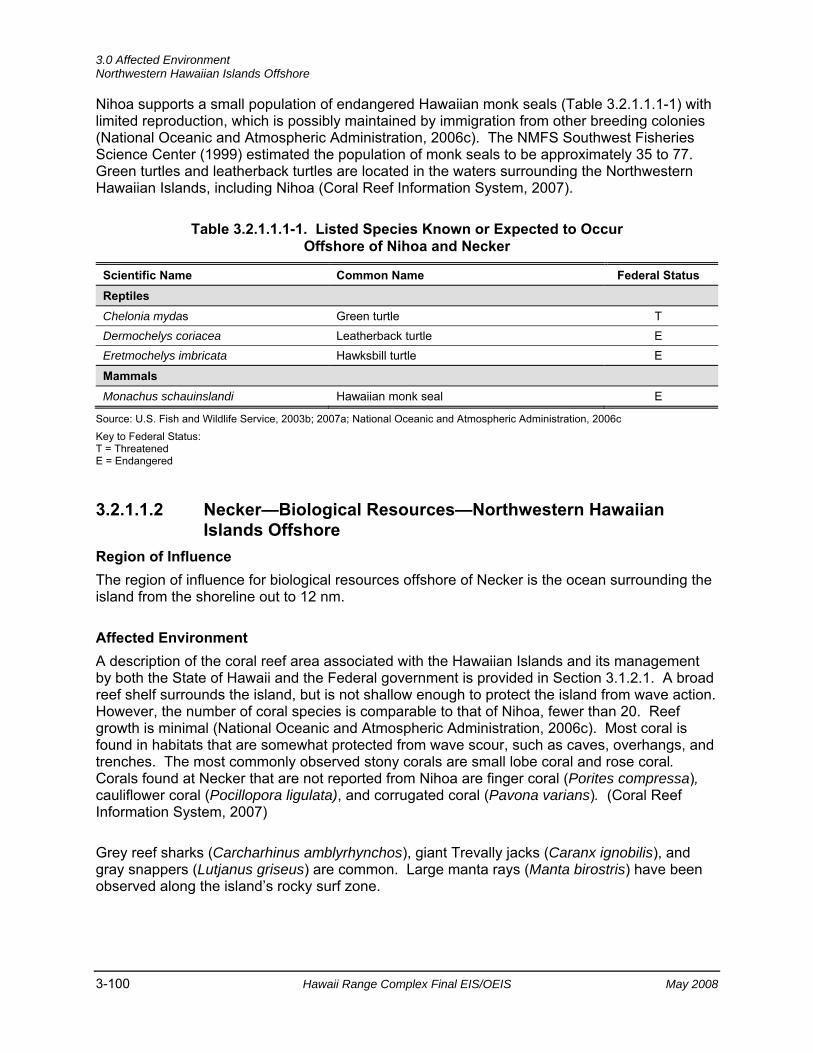
3.0 Affected Environment Northwestern Hawaiian Islands Offshore
3-100 Hawaii Range Complex Final EIS/OEIS May 2008
Nihoa supports a small population of endangered Hawaiian monk seals (Table 3.2.1.1.1-1) with limited reproduction, which is possibly maintained by immigration from other breeding colonies (National Oceanic and Atmospheric Administration, 2006c). The NMFS Southwest Fisheries Science Center (1999) estimated the population of monk seals to be approximately 35 to 77. Green turtles and leatherback turtles are located in the waters surrounding the Northwestern Hawaiian Islands, including Nihoa (Coral Reef Information System, 2007).
Table 3.2.1.1.1-1. Listed Species Known or Expected to Occur Offshore of Nihoa and Necker
Scientific Name Common Name Federal Status Reptiles
Chelonia mydas Green turtle T Dermochelys coriacea Leatherback turtle E Eretmochelys imbricata Hawksbill turtle E
Mammals
Monachus schauinslandi Hawaiian monk seal E
Source: U.S. Fish and Wildlife Service, 2003b; 2007a; National Oceanic and Atmospheric Administration, 2006c Key to Federal Status: T = Threatened E = Endangered
3.2.1.1.2 Necker—Biological Resources—Northwestern Hawaiian Islands Offshore
Region of Influence The region of influence for biological resources offshore of Necker is the ocean surrounding the island from the shoreline out to 12 nm.
Affected Environment A description of the coral reef area associated with the Hawaiian Islands and its management by both the State of Hawaii and the Federal government is provided in Section 3.1.2.1. A broad reef shelf surrounds the island, but is not shallow enough to protect the island from wave action. However, the number of coral species is comparable to that of Nihoa, fewer than 20. Reef growth is minimal (National Oceanic and Atmospheric Administration, 2006c). Most coral is found in habitats that are somewhat protected from wave scour, such as caves, overhangs, and trenches. The most commonly observed stony corals are small lobe coral and rose coral. Corals found at Necker that are not reported from Nihoa are finger coral (Porites compressa), cauliflower coral (Pocillopora ligulata), and corrugated coral (Pavona varians). (Coral Reef Information System, 2007)
Grey reef sharks (Carcharhinus amblyrhynchos), giant Trevally jacks (Caranx ignobilis), and gray snappers (Lutjanus griseus) are common. Large manta rays (Manta birostris) have been observed along the island’s rocky surf zone.
3.0 Affected Environment
Northwestern Hawaiian Islands Offshore
May 2008 Hawaii Range Complex Final EIS/OEIS 3-101
Necker supports a small population of Hawaiian monk seals (Table 3.2.1.1.1-1) with limited reproduction that is possibly maintained by immigration from other breeding colonies. Green turtles occasionally are observed off the coast (National Oceanic and Atmospheric Administration, 2006c). Leatherback turtles are located in the waters surrounding the Northwestern Hawaiian Islands, including Necker (Coral Reef Information System, 2007).
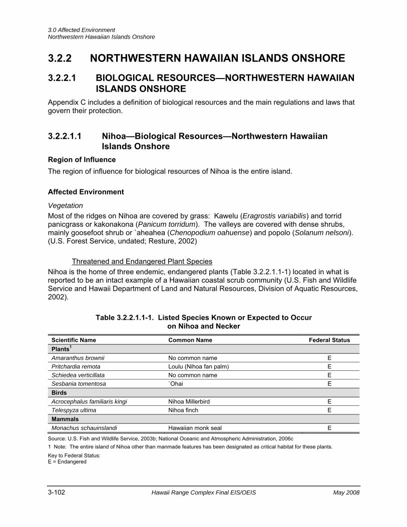
3.0 Affected Environment Northwestern Hawaiian Islands Onshore
3-102 Hawaii Range Complex Final EIS/OEIS May 2008
3.2.2 NORTHWESTERN HAWAIIAN ISLANDS ONSHORE
3.2.2.1 BIOLOGICAL RESOURCES—NORTHWESTERN HAWAIIAN ISLANDS ONSHORE
Appendix C includes a definition of biological resources and the main regulations and laws that govern their protection.
3.2.2.1.1 Nihoa—Biological Resources—Northwestern Hawaiian Islands Onshore
Region of Influence The region of influence for biological resources of Nihoa is the entire island.
Affected Environment
Vegetation Most of the ridges on Nihoa are covered by grass: Kawelu (Eragrostis variabilis) and torrid panicgrass or kakonakona (Panicum torridum). The valleys are covered with dense shrubs, mainly goosefoot shrub or `aheahea (Chenopodium oahuense) and popolo (Solanum nelsoni). (U.S. Forest Service, undated; Resture, 2002)
Threatened and Endangered Plant Species Nihoa is the home of three endemic, endangered plants (Table 3.2.2.1.1-1) located in what is reported to be an intact example of a Hawaiian coastal scrub community (U.S. Fish and Wildlife Service and Hawaii Department of Land and Natural Resources, Division of Aquatic Resources, 2002).
Table 3.2.2.1.1-1. Listed Species Known or Expected to Occur on Nihoa and Necker
Scientific Name Common Name Federal Status Plants1
Amaranthus brownii No common name E Pritchardia remota Loulu (Nihoa fan palm) E Schiedea verticillata No common name E Sesbania tomentosa `Ohai E Birds Acrocephalus familiaris kingi Nihoa Millerbird E Telespyza ultima Nihoa finch E Mammals Monachus schauinslandi Hawaiian monk seal E
Source: U.S. Fish and Wildlife Service, 2003b; National Oceanic and Atmospheric Administration, 2006c 1 Note: The entire island of Nihoa other than manmade features has been designated as critical habitat for these plants. Key to Federal Status: E = Endangered
3.0 Affected Environment
Northwestern Hawaiian Islands Onshore
May 2008 Hawaii Range Complex Final EIS/OEIS 3-103
The three endemic endangered plants on Nihoa are the loulu (Nihoa fan palm) (Pritchardia remota), Amaranthus brownii (no common name, last observed in 1983), and Schiedea verticillata (no common name). The endangered `ohai (Sesbania tomentosa) is also found on Nihoa. The loulu relies on the isolation and protection from invasive species and disturbance that the Hawaiian Islands provide (U.S. Fish and Wildlife Service and Hawaii Department of Land and Natural Resources, Division of Aquatic Resources, 2002). The entire island other than manmade features has been designated as critical habitat for these plants (U.S. Fish and Wildlife Service, 2003b).
Wildlife For many years the only regular inhabitants of Nihoa have been vast numbers of birds, including black-footed albatross (Phoebastria nigripes), Tristram’s storm-petrel (Oceanodroma tristrami), Bulwer's petrel (Bulweria bulwerii), wedge-tailed shearwaters (Puffinus pacificus chlororhynchus), blue-gray noddies (Procelsterna cerulea), red-tailed tropic birds, great frigate birds or `iwa (Fregata minor palmerstoni), three kinds of boobies (Sula spp.), and terns such as the gray-backed tern or pakalakala (Sterna lunata), white (fairy) tern or manu-o-ku, and sooty tern or `ewa`ewa. Birds nest in a variety of places, from the ground to the crowns of the loulu palms. (State of Hawaii, 2005a)
Several species of migratory birds covered by the Migratory Bird Treaty Act (MBTA) are present during some portion of the year including, but not limited to boobies, wedge-tailed shearwaters, and albatross.
Threatened and Endangered Wildlife Species In addition to the seabirds mentioned above, there are two species of native land birds: the Nihoa finch (Telespyza ultima) and the Nihoa Millerbird (Acrocephalus familiaris kingi), both endangered, endemic species found only on Nihoa (Table 3.2.2.1.1-1), but related to species on Laysan (Resture, 2002). Nihoa supports a small population of Hawaiian monk seals with limited reproduction, which is possibly maintained by immigration from other breeding colonies (National Oceanic and Atmospheric Administration, 2006c).
The current estimate of 300 to 700 Nihoa Millerbirds and 2,000 to 4,000 Nihoa finches rely on the isolation and protection from invasive species and disturbance that the Hawaiian Islands provide (State of Hawaii, 2005b; U.S. Fish and Wildlife Service and Hawaii Department of Land and Natural Resources, Division of Aquatic Resources, 2002). While critical habitat has not been designated for either species on Nihoa, the area nevertheless contains important habitat for both birds, and protection afforded by the Endangered Species Act still applies.
3.2.2.1.2 Necker—Biological Resources—Northwestern Hawaiian Islands Onshore
Region of Influence The region of influence for biological resources of Necker is the entire island.
3.0 Affected Environment Northwestern Hawaiian Islands Onshore
3-104 Hawaii Range Complex Final EIS/OEIS May 2008
Affected Environment
Vegetation Although Necker appears from a distance to be devoid of vegetation, its rounded crest and narrow terraces are actually sparsely covered with five species of plants: `aheahea, also common throughout the main Hawaiian Islands; kakonakona; purslane or ihi (Portulaca lutea); pickle weed or akulikuli kai (Batis maritima); and a few `ohai shrub. None of the plants reach more than 2 ft high. (Resture, 2004; Coral Reef Information System, 2007)
Threatened and Endangered Plant Species The endangered `ohai shrub is present on the island (Table 3.2.2.1.1-1) (Coral Reef Information System, 2007).
Wildlife The only wildlife other than land snails, spiders, and several endemic insects, are seabirds. Brown noddies (Anous stolidus) are year-round residents; egg laying has been documented throughout the year (Megyesi and Griffin, 1996). Great frigate birds or `iwa, blue-gray noddies, and masked boobies (Sula dactylatra) are also present. These birds are covered under the MBTA.
Threatened and Endangered Wildlife Species Green turtles (Table 3.2.2.1.1-1) occasionally bask along the coast (National Oceanic and Atmospheric Administration, 2006c). Necker also supports a small population of endangered Hawaiian monk seals (Table 3.2.2.1.1-1) with limited reproduction that is possibly maintained by immigration from other breeding colonies (Coral Reef Information System, 2007).
3.2.2.2 CULTURAL RESOURCES—NORTHWESTERN HAWAIIAN ISLANDS ONSHORE
Appendix C includes a definition of cultural resources and the main regulations and laws that govern their protection.
Region of Influence The region of influence for cultural resources encompasses portions of the Papahānaumokuākea Marine National Monument, particularly in the vicinity of Nihoa or Necker (Mokumanamana).
Affected Environment
Archaeological Resources (Prehistoric and Historic) The Northwestern Hawaiian Islands were explored, colonized, and in some cases, semi-permanently settled by Native Hawaiians in pre-contact times. Nihoa and Necker (Mokumanamana), the islands that are closest to the Main Hawaiian Islands (approximately 150 mi apart), are listed in the National and Hawaii State Registers of Historic Places and are protected by the USFWS.

3.0 Affected Environment
Northwestern Hawaiian Islands Onshore
May 2008 Hawaii Range Complex Final EIS/OEIS 3-105
Several archaeological surveys of Nihoa and Necker have been conducted beginning with a survey by the Bishop Museum (the Tanager Expedition in 1923) (Emory, 1928). Between the two islands more than 140 archaeological sites have been documented. Though barren and seemingly inhospitable to humans, the number of cultural sites they support is testimony to their occupation and use prior to European discovery, and demonstrates how human colonization and settlement can occur even in seemingly marginal environments (U.S. Department of Commerce, The Under Secretary of Commerce for Oceans and Atmosphere, 2007).
All of the documented prehistoric archaeological sites within Papahānaumokuākea are on either Nihoa or Necker (Mokumanamana). The other islands within Papahānaumokuākea have been less investigated for these types of sites, but may contain cultural sites that have either not yet been discovered or properly interpreted. Archaeologists suspect that Hawaiians did not leave artifacts that they wished to preserve on such low-lying islets because they knew that the elements would soon reclaim them. Several underwater ko`a have been found in the main Hawaiian Islands, however, and burials are not unknown; therefore, it is possible that additional cultural sites may be discovered in Papahānaumokuākea (U.S. Department of Commerce, The Under Secretary of Commerce for Oceans and Atmosphere, 2007).
In addition to the prehistoric features within Papahānaumokuākea, there are World War II-era sites of national significance. These include the Battle of Midway National Memorial and nine defensive positions on Midway Atoll; each designated a National Historic Landmark under the theme of World War II Pacific battlefields (U.S. Department of Commerce, The Under Secretary of Commerce for Oceans and Atmosphere, 2007).
Nihoa
On Nihoa, 89 cultural sites have been recorded. The sites date from before the 13th century and include 25 to 35 house terraces, 15 ceremonial structures, burial caves, bluff shelters, and agricultural terraces. Numerous artifacts found on Nihoa establish a close relationship with Native Hawaiian culture in the Main Hawaiian Islands, and to the first settlers of Hawaii who sailed through the Pacific on large voyaging canoes. Because the island had sufficient soil and water for limited agriculture, Nihoa was a good place for voyagers to stop and resupply their canoes. This is evidenced by the remains of stone terraces that suggest an investment in agricultural food production (U.S. Department of Commerce, The Under Secretary of Commerce for Oceans and Atmosphere, 2007).
In 1789, Captain Douglas of the Iphegenia was the first Westerner to visit Nihoa. Queen Kaahumanu visited and annexed the island for the Kingdom of Hawaii in 1822 and, in 1885, Queen Liliuokalani and her 200-person entourage landed on Nihoa. As many as 175 people are estimated to have lived on the island at one time, but a shortage of fresh water likely was a limiting factor (Emory, 1928).
Necker (Mokumanamana)
At least 52 cultural sites exist on Necker (Mokumanamana), including 33 ceremonial features, which is the highest concentration of religious sites found anywhere in the Hawaiian Archipelago. Like Nihoa, Necker (Mokumanamana) shows clear evidence of prehistoric Hawaiian occupation, although given the numerous religious sites, the island appears to have been used primarily for worship by visitors from other Hawaiian Islands, rather than having supported permanent inhabitants for any length of time. Many of the temple sites closely
3.0 Affected Environment Northwestern Hawaiian Islands Onshore
3-106 Hawaii Range Complex Final EIS/OEIS May 2008
resemble those of Tahiti, possibly establishing a link between this site and early Polynesian culture. Carved basalt human figurines found there are of a style not seen elsewhere in Hawaii, showing instead similarities to those found in the Marquesas. Emory (1928) considered the sites of Necker (Mokumanamana) to be a “…pure sample of the culture prevailing in Hawaii before the thirteenth century” (U.S. Department of Commerce, The Under Secretary of Commerce for Oceans and Atmosphere, 2007).
The first European to document Necker (Mokumanamana) was Compte de La Perouse in 1786. Captain John Paty claimed the island for the Kingdom of Hawaii in 1857, though his claim was later contested until the island was formally annexed by Hawaii’s Provisional Government in 1894 (U.S. Department of Commerce, The Under Secretary of Commerce for Oceans and Atmosphere, 2007).
There are no longer permanent inhabitants of Nihoa or Necker (Mokumanamana); however, research scientists and other educational expeditions occasionally visit the various islands of the island chain and camp for 1 to 12 weeks (Northwestern Hawaiian Islands Multi-Agency Education Project, 2006).
Historic Buildings and Structures There are no modern historic buildings or structures on Nihoa or Necker (Mokumanamana); however, there are a number of pre-contact stone structures representing habitation, agricultural, and ceremonial features (Emory, 1928).
Traditional Resources (Including Burials) Among the recorded sites on Nihoa and Necker (Mokumanamana) are religious and ceremonial features (cairns, terraces, stone platforms, upright stones, and burial sites) (Emory, 1928; TenBruggencate, 2005; U.S. Department of Commerce, The Under Secretary of Commerce for Oceans and Atmosphere, 2007).
3.0 Affected Environment, Kauai
PMRF Offshore
May 2008 Hawaii Range Complex Final EIS/OEIS 3-107
3.3 KAUAI Kauai is the oldest and fourth largest of the Main Hawaiian Islands. It covers approximately 550 square miles (mi2) and was formed by the volcano Waialeale located at its center. The town of Lihue is Kauai’s county seat and is home to the State and County buildings. The islands of Kauai, Niihau, and Kaula combine to form Kauai County. Current and proposed Hawaii Range Complex (HRC) training and research, development, test, and evaluation (RDT&E) activities on Kauai addressed in this Environmental Impact Statement (EIS)/Overseas EIS (OEIS) are located at Pacific Missile Range Facility (PMRF) (PMRF/Main Base) or facilities that support PMRF range operations (Kauai Test Facility [KTF], Makaha Ridge, Kokee, Hawaii Air National Guard Kokee, Kamokala Magazines, Port Allen, Kikiaola Small Boat Harbor, and Mt. Kahili). PMRF also conducts range operations on the nearby islands of Niihau and Kaula. PMRF plans to continue using all sites. For organizational purposes in this document, discussions about Niihau and Kaula are included under the Kauai heading, because they are part of Kauai County.
3.3.1 KAUAI OFFSHORE Kauai Offshore addresses ocean areas within 12 nautical miles (nm) of Kauai, Niihau, and Kaula, including ranges and training areas where activities are performed by the Navy. Discussions include PMRF Offshore (the Barking Sands Tactical Underwater Range [BARSTUR], the Barking Sands Underwater Range Expansion [BSURE], Shallow Water Training Range [SWTR], and the Kingfisher Underwater Training Area [Kingfisher]), Niihau Offshore, and Kaula Offshore. These offshore areas are not within the Hawaiian Islands Humpback Whale National Marine Sanctuary.
3.3.1.1 PMRF OFFSHORE (BARSTUR, BSURE, SWTR, KINGFISHER)
PMRF Offshore includes HRC ranges and training areas 0 to 12 nm from PMRF/Main Base (Figure 2.1-2). Included in PMRF Offshore are BARSTUR and BSURE, which are within the 12-nm area from PMRF/Main Base; SWTR, which is within 3 nm and extends into the 12-nm area offshore of PMRF/Main Base; and Kingfisher, which is within 3 nm of PMRF/Main Base. BARSTUR is a 104-square nautical mile range used for anti-submarine training. BSURE provides the capability to support Anti-Submarine Warfare (ASW) training and over 80 percent of PMRF’s underwater tracking capability. SWTR provides submarine forces with a shallow-water sonar training area to conduct shallow-water sonar proficiency training and readiness under realistic conditions. Kingfisher is a simulated underwater minefield used with the Kingfisher mine detection system.
This section describes the environmental resources that would be affected by the No-action Alternative, Alternative 1, Alternative 2, or Alternative 3 for PMRF Offshore. Of the 13 environmental resources considered for analysis, air quality, airspace, geology and soils, hazardous materials and waste, health and safety, land use, noise, and utilities resources are not addressed.
Kauai, 3.0 Affected Environment PMRF Offshore
3-108 Hawaii Range Complex Final EIS/OEIS May 2008
3.3.1.1.1 Biological Resources—PMRF—Offshore (BARSTUR, BSURE, SWTR, Kingfisher)
Region of Influence The region of influence for offshore biological resources is the ocean area from the shoreline out to 12 nm.
Affected Environment
Vegetation The substrates of Hawaiian rocky intertidal habitats are mostly consolidated basalts with some consolidated limestones (cemented beach rock or raised coral reefs). Common plants found in rocky intertidal habitats include sea lettuce (Ulva), Sargasso or kala (Sargassum), coralline red algae (Hydrolithon), red fleshy algae (Melanamansia, Pterocladiella, Jania), brown algae (Padina, Turbinaria, Dictyota), and fleshy green algae (Neomeris, Halimeda, and Caulerpa). (U.S. Department of the Navy, 2005c)
Algal species on the limestone bench fronting Nohili Point preferred by the green turtle (Chelonia mydas) include but are not limited to lipuupuu (Dictyospheria versluysii), kala-lau-nunui (Sargassum echinocarpum), pahalahala (Ulva fasciatus), and mane`one`o (Laurencia nidifica). The algal and macroinvertebrate survey in Majors Bay noted that four macroalgal and eight macroinvertebrate species were present. (Pacific Missile Range Facility, 2001; Commander, Navy Region Hawaii, 2007)
Threatened and Endangered Vegetation
No threatened or endangered vegetation is located in the offshore area.
Wildlife A description of the coral reef area associated with the Hawaiian Islands and its management by both the State of Hawaii and the Federal government is provided in Section 3.1.2.1. North of Mana Point on Kauai, a narrow fringing reef follows the coastline up to Nohili Point and Barking Sands (Figure 3.3.1.1.1-1). Coral density is low and is dominated by lobe coral (Porites lobata) and small stands of arborescent (branched or tree shaped) corals. Broad uncolonized pavement (1,772 feet [ft] wide) and colonized pavement (2,297 ft wide) stretch along the coastline seaward of the fringing reef. North of Nohili Point, the uncolonized pavement ends and the colonized pavement continues along a northward heading; it turns gradually to the east to join the coastline north of Keawanui. (U.S. Department of the Navy, 2007a) Uncolonized pavement is flat, low relief, solid carbonate rock often covered by a thin sand veneer. The surface of the pavement often has sparse coverage of macroalgae, hard coral, and other sessile invertebrates that does not obscure the underlying surface. Colonized pavement is flat, low-relief, solid carbonate rock with coverage of macroalgae, hard coral, and other sessile invertebrates that are dense enough to begin to obscure the underlying surface. (Center for Coastal Monitoring and Assessment, 2006)
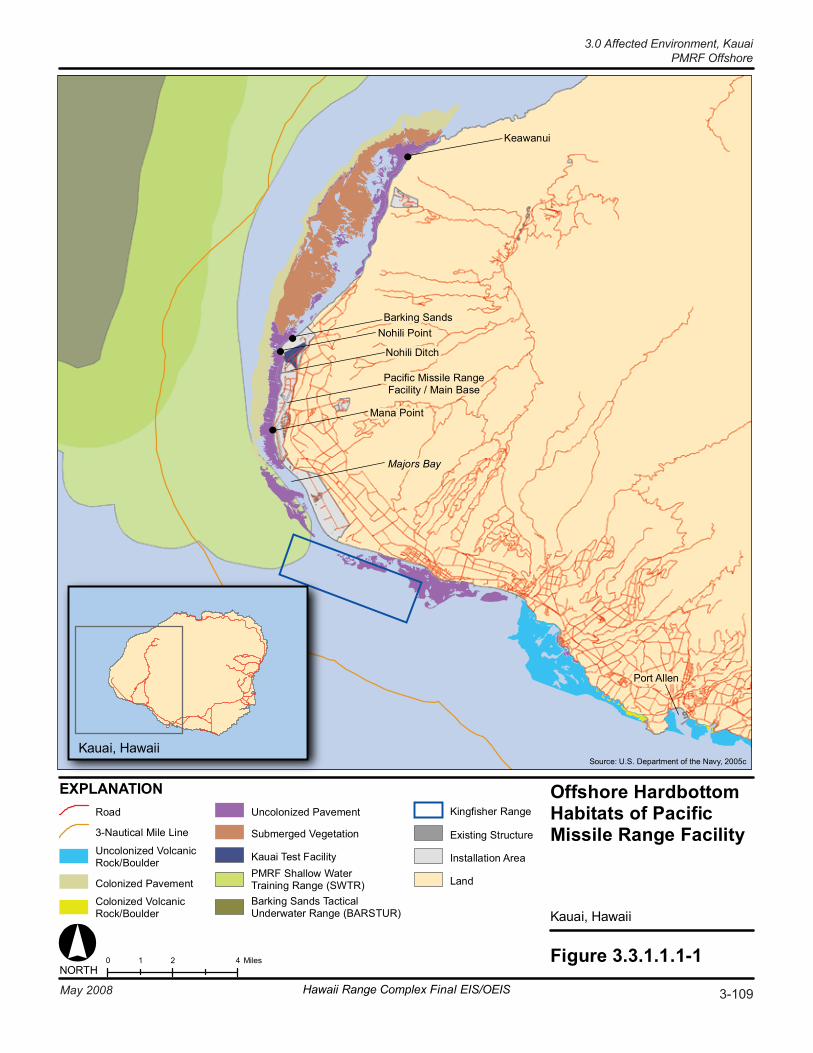
Figure 3.3.1.1.1-10 2 41 MilesNORTH
EXPLANATION Offshore HardbottomHabitats of PacificMissile Range Facility
Kauai, Hawaii
Pacific Missile RangeFacility / Main Base
Port Allen
Source: U.S. Department of the Navy, 2005c
Road
3-Nautical Mile Line
Uncolonized VolcanicRock/Boulder
Colonized Pavement
Colonized VolcanicRock/Boulder
Uncolonized Pavement
Submerged Vegetation
Kauai Test FacilityPMRF Shallow WaterTraining Range (SWTR)Barking Sands TacticalUnderwater Range (BARSTUR)
Kingfisher Range
Existing Structure
Installation Area
Land
Kauai, Hawaii
Nohili Ditch
Nohili PointBarking Sands
Mana Point
Keawanui
Majors Bay
3-109May 2008 Hawaii Range Complex Final EIS/OEIS
3.0 Affected Environment, KauaiPMRF Offshore
Kauai, 3.0 Affected Environment PMRF Offshore
3-110 Hawaii Range Complex Final EIS/OEIS May 2008
Wave action is the main natural control on coral reef structure along the coastline of the Hawaiian Islands (Grigg, 1997a; Jokiel et al., 2001; 2004). Corals in wave-exposed areas die as fast as they can be replaced (Grigg, 1997a). The breaking, scouring, and abrading action caused by waves on corals yields high mortality. Hence, no coral accretion takes place in wave-exposed areas. Despite the fact that wave action limits the accretion of reef building corals, reefs are also found along the north coastline of Kauai. (Maragos, 2000)
The general marine topography of the nearshore region off of PMRF consists of four sectors separated by distinct physiographic and biotic structure. The first three of these sectors are (1) the Nohili Sector, which extends from the northern end of the property to approximately the location of Nohili Ditch; (2) the Mana Point Sector, which extends southward to the southern part of Mana Point; and (3) the Majors Bay Sector, which extends to the southern boundary of PMRF at Kokole Point extending from the shoreline to a depth of approximately 49 ft. The fourth sector is considered the Offshore Sector, and extends along most of the entire length of PMRF within the depth range of 49 to 66 ft. (Commander, Navy Region Hawaii, 2007)
Total coral cover in the Nohili Sector ranges from 32 to 39 percent of bottom cover. The most abundant coral species are lobe coral, rose or cauliflower coral (Pocillopora meandrina), and ringed rice coral (Montipora patula). Macroinvertebrates in this area include the rock oyster (Spondylus tenebrosus), cone shells (Conus spp.), sea urchins (Echinometra mathaei), and sea cucumbers (Holothuria atra). Along the central portion of PMRF in the Mana Sector, living coral is sparsely distributed, approximately one half of that found in the Nohili area. The dominant species is lobe coral. Coral cover in the Major’s Bay Sector is less than 2 percent. The algal and macroinvertebrate survey in Majors Bay noted that eight macroinvertebrate species were present. (Pacific Missile Range Facility, 2001; Commander, Navy Region Hawaii, 2007)
The predominant coral found in the Offshore Sector is antler coral (Pocillopora eydouxi), which occurs as single large branching colonies. Other corals found on the platform are primarily smaller species which have a collective coverage of about 5 percent of bottom cover: rose or cauliflower coral, lobe coral, corrugated coral (Pavona varians), flat lobe coral (P. duerdeni), blue rice coral (Montipora flabellata), ringed rice coral, Verrill’s ringed rice coral (M. verrilli), rice coral (M. capitata), crust coral (Leptastrea purpurea), and mushroom coral (Fungia scutaria). (Commander, Navy Region Hawaii, 2007)
Black coral (Family Antipathidae) is found south of Kauai outside the region of influence, closer to shore and in shallower water than black coral of other Hawaiian Islands (Western Pacific Regional Fishery Management Council, 2006).
Essential Fish Habitat (EFH) occurs and is incorporated within Kauai’s Exclusive Economic Zone (EEZ), the 200-mile (mi) limit around the island. EFH and Habitat Areas of Particular Concern (HAPC) are described in Section 3.1.2.2.1 (Open Ocean), and a detailed description, including status, distribution, and habitat preference of managed fisheries is provided in the Navy’s Final Essential Fish Habitat and Coral Reef Assessment for the Hawaii Range Complex EIS/OEIS (U.S. Department of the Navy, 2007a). EFH for adult and juvenile bottomfish includes the water column and all bottom habitats extending from the shoreline to a depth of 219 fathoms, which encompasses important steep drop-offs and high relief habitats. Shallow-water (0 to 328 ft) bottomfish species include uku or grey snappers (Aprion virescens), thicklip trevallies (Pseudocaranx dentex), groupers (Epinephelus quernus), emperors (Lethrinus spp.), amberjacks (Seriola dumerili), and taape or bluestriped snappers (Lutjanus kasmira). Deep-
3.0 Affected Environment, Kauai
PMRF Offshore
May 2008 Hawaii Range Complex Final EIS/OEIS 3-111
water (328 to 1,312 ft) species, which are discussed in Section 3.1.2, include ehu or squirrelfish snapper (Etelis carbunculus), onaga or red snapper (Pristipomoides zonatus), opapaka or pink snapper (Pristipomoides filamentosus), gindai or snapper (Etelis coruscans), hapu`upu`u or Hawaiian grouper (Epinephelus quernus), and lehi or ironjaw snapper (Aphareus rutilans). (Western Pacific Regional Fishery Management Council, 2005)
Pelagic HAPC that include the offshore area are designated as the water column down to 3,280 ft from the shoreline to the EEZ that lies above all seamounts and banks shallower than 1,100 fathoms. Marketable pelagic species include striped marlin (Tetrapturus audax), bluefin tuna (Thunnus thynnus), swordfish (Xiphias gladius), albacore (Thunnus alalunga), skipjack (Katsuwonus pelamis), sailfish (Istiophorus platypterus), kawakawa or tuna (Euthynnus affinis), and various sharks. Banks with summits less than 16.3 fathoms have been designated as HAPC for crustaceans. Crustacean species include spiny lobsters (Panulirus marginatus), slipper lobsters (Scyllarides squammosus), and Kona crabs (Ranina ranina). (Western Pacific Regional Fishery Management Council, 2005)
Common animals found in rocky intertidal habitats include limpets or `opihi (Cellana exerata), periwinkles (Littorina sp.), littorine snails (Littorina, Nerita), rock crabs or `a`ama (Metapograpsus sp.), gastropods (Drupa, Morula, Cypraea, Strombus), and rock urchins (Colobocentrotus atratus). Adjacent to rocky shoreline, offshore waters are possible feeding areas for the threatened green turtle. (U.S. Department of the Navy, 2005c)
Spinner dolphins (Stenella longirostris) are the most commonly recorded cetaceans observed within 12 nm of the PMRF coastline. The spinner dolphin inhabits bays and protected waters, often in waters less than 40 ft deep (Pacific Missile Range Facility, 2001). Monitoring for Rim of the Pacific (RIMPAC) Exercises in 2006 showed that spinner dolphins are seen daily in the offshore area of Kekaha Beach, Kauai (near PMRF/Main Base) despite being accompanied regularly by tour boats (U.S. Department of the Navy, 2006a). Spinner dolphins are expected to occur in shallow water resting areas (about 162 ft deep or less) throughout the middle of the day, moving into deep waters offshore during the night to feed. Additional information on spinner dolphins, including description, habitat, abundance, and distribution is provided in Section 3.1.2.
A small-boat based survey for odontocetes was undertaken off the islands of Kauai and Niihau in October and November 2005 to photo-identify individuals and collect genetic samples for examining stock structure. Survey coverage was from shallow coastal waters out to over 9,842 ft depth, though almost half was in waters less than 1,640 ft in depth. There were 56 sightings of five species of odontocetes: 30 spinner dolphins; 14 bottlenose dolphins (Tursiops truncatus); 6 short-finned pilot whales (Globicephala macrorhynchus); 5 rough-toothed dolphins (Steno bredanensis); and 1 pantropical spotted dolphin (Stenella attenuata). (Baird et al., 2006a)
Threatened and Endangered Wildlife Species
Table 3.3.1.1.1-1 lists threatened and endangered species that are known or expected to occur in the offshore areas off PMRF/Main Base.
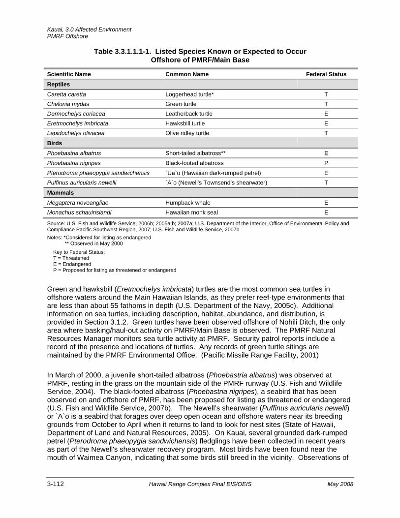
Kauai, 3.0 Affected Environment PMRF Offshore
3-112 Hawaii Range Complex Final EIS/OEIS May 2008
Table 3.3.1.1.1-1. Listed Species Known or Expected to Occur Offshore of PMRF/Main Base
Scientific Name Common Name Federal Status Reptiles
Caretta caretta Loggerhead turtle* T Chelonia mydas Green turtle T Dermochelys coriacea Leatherback turtle E Eretmochelys imbricata Hawksbill turtle E Lepidochelys olivacea Olive ridley turtle T
Birds
Phoebastria albatrus Short-tailed albatross** E
Phoebastria nigripes Black-footed albatross P
Pterodroma phaeopygia sandwichensis `Ua`u (Hawaiian dark-rumped petrel) E Puffinus auricularis newelli `A`o (Newell's Townsend’s shearwater) T
Mammals
Megaptera noveangliae Humpback whale E Monachus schauinslandi Hawaiian monk seal E
Source: U.S. Fish and Wildlife Service, 2006b; 2005a;b; 2007a; U.S. Department of the Interior, Office of Environmental Policy and Compliance Pacific Southwest Region, 2007; U.S. Fish and Wildlife Service, 2007b Notes: *Considered for listing as endangered
** Observed in May 2000 Key to Federal Status: T = Threatened E = Endangered P = Proposed for listing as threatened or endangered
Green and hawksbill (Eretmochelys imbricata) turtles are the most common sea turtles in offshore waters around the Main Hawaiian Islands, as they prefer reef-type environments that are less than about 55 fathoms in depth (U.S. Department of the Navy, 2005c). Additional information on sea turtles, including description, habitat, abundance, and distribution, is provided in Section 3.1.2. Green turtles have been observed offshore of Nohili Ditch, the only area where basking/haul-out activity on PMRF/Main Base is observed. The PMRF Natural Resources Manager monitors sea turtle activity at PMRF. Security patrol reports include a record of the presence and locations of turtles. Any records of green turtle sitings are maintained by the PMRF Environmental Office. (Pacific Missile Range Facility, 2001)
In March of 2000, a juvenile short-tailed albatross (Phoebastria albatrus) was observed at PMRF, resting in the grass on the mountain side of the PMRF runway (U.S. Fish and Wildlife Service, 2004). The black-footed albatross (Phoebastria nigripes), a seabird that has been observed on and offshore of PMRF, has been proposed for listing as threatened or endangered (U.S. Fish and Wildlife Service, 2007b). The Newell’s shearwater (Puffinus auricularis newelli) or `A`o is a seabird that forages over deep open ocean and offshore waters near its breeding grounds from October to April when it returns to land to look for nest sites (State of Hawaii, Department of Land and Natural Resources, 2005). On Kauai, several grounded dark-rumped petrel (Pterodroma phaeopygia sandwichensis) fledglings have been collected in recent years as part of the Newell's shearwater recovery program. Most birds have been found near the mouth of Waimea Canyon, indicating that some birds still breed in the vicinity. Observations of
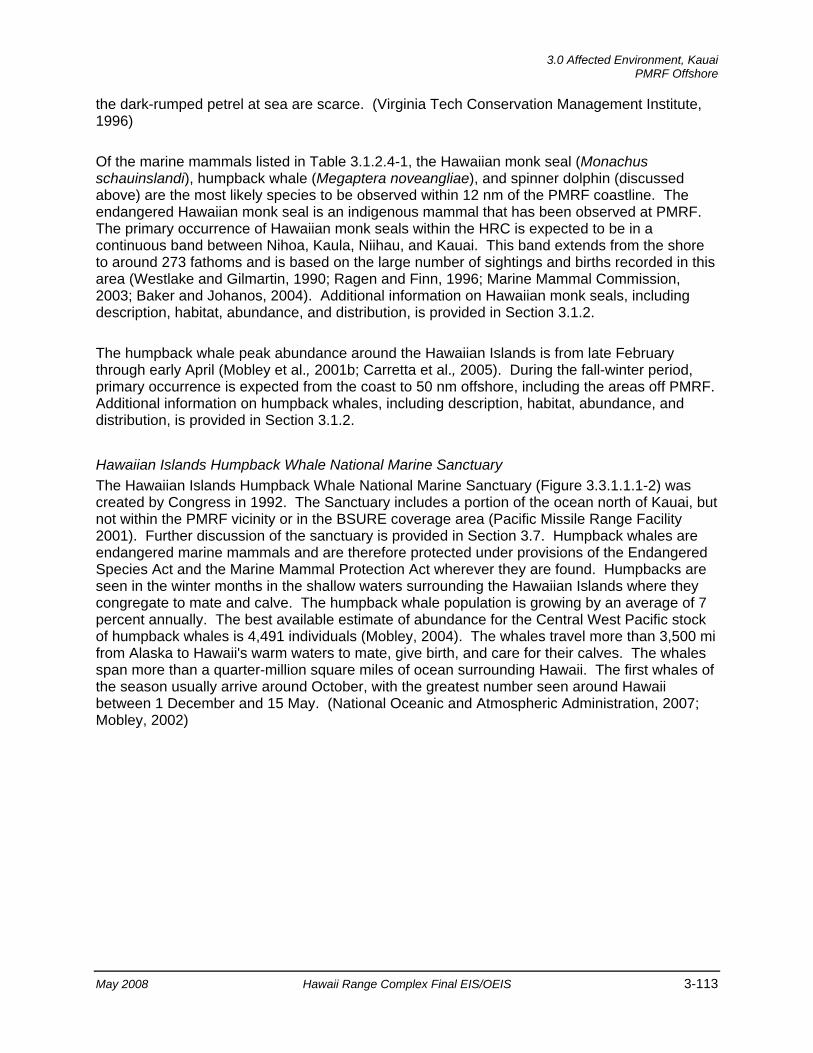
3.0 Affected Environment, Kauai
PMRF Offshore
May 2008 Hawaii Range Complex Final EIS/OEIS 3-113
the dark-rumped petrel at sea are scarce. (Virginia Tech Conservation Management Institute, 1996)
Of the marine mammals listed in Table 3.1.2.4-1, the Hawaiian monk seal (Monachus schauinslandi), humpback whale (Megaptera noveangliae), and spinner dolphin (discussed above) are the most likely species to be observed within 12 nm of the PMRF coastline. The endangered Hawaiian monk seal is an indigenous mammal that has been observed at PMRF. The primary occurrence of Hawaiian monk seals within the HRC is expected to be in a continuous band between Nihoa, Kaula, Niihau, and Kauai. This band extends from the shore to around 273 fathoms and is based on the large number of sightings and births recorded in this area (Westlake and Gilmartin, 1990; Ragen and Finn, 1996; Marine Mammal Commission, 2003; Baker and Johanos, 2004). Additional information on Hawaiian monk seals, including description, habitat, abundance, and distribution, is provided in Section 3.1.2.
The humpback whale peak abundance around the Hawaiian Islands is from late February through early April (Mobley et al., 2001b; Carretta et al., 2005). During the fall-winter period, primary occurrence is expected from the coast to 50 nm offshore, including the areas off PMRF. Additional information on humpback whales, including description, habitat, abundance, and distribution, is provided in Section 3.1.2.
Hawaiian Islands Humpback Whale National Marine Sanctuary The Hawaiian Islands Humpback Whale National Marine Sanctuary (Figure 3.3.1.1.1-2) was created by Congress in 1992. The Sanctuary includes a portion of the ocean north of Kauai, but not within the PMRF vicinity or in the BSURE coverage area (Pacific Missile Range Facility 2001). Further discussion of the sanctuary is provided in Section 3.7. Humpback whales are endangered marine mammals and are therefore protected under provisions of the Endangered Species Act and the Marine Mammal Protection Act wherever they are found. Humpbacks are seen in the winter months in the shallow waters surrounding the Hawaiian Islands where they congregate to mate and calve. The humpback whale population is growing by an average of 7 percent annually. The best available estimate of abundance for the Central West Pacific stock of humpback whales is 4,491 individuals (Mobley, 2004). The whales travel more than 3,500 mi from Alaska to Hawaii's warm waters to mate, give birth, and care for their calves. The whales span more than a quarter-million square miles of ocean surrounding Hawaii. The first whales of the season usually arrive around October, with the greatest number seen around Hawaii between 1 December and 15 May. (National Oceanic and Atmospheric Administration, 2007; Mobley, 2002)
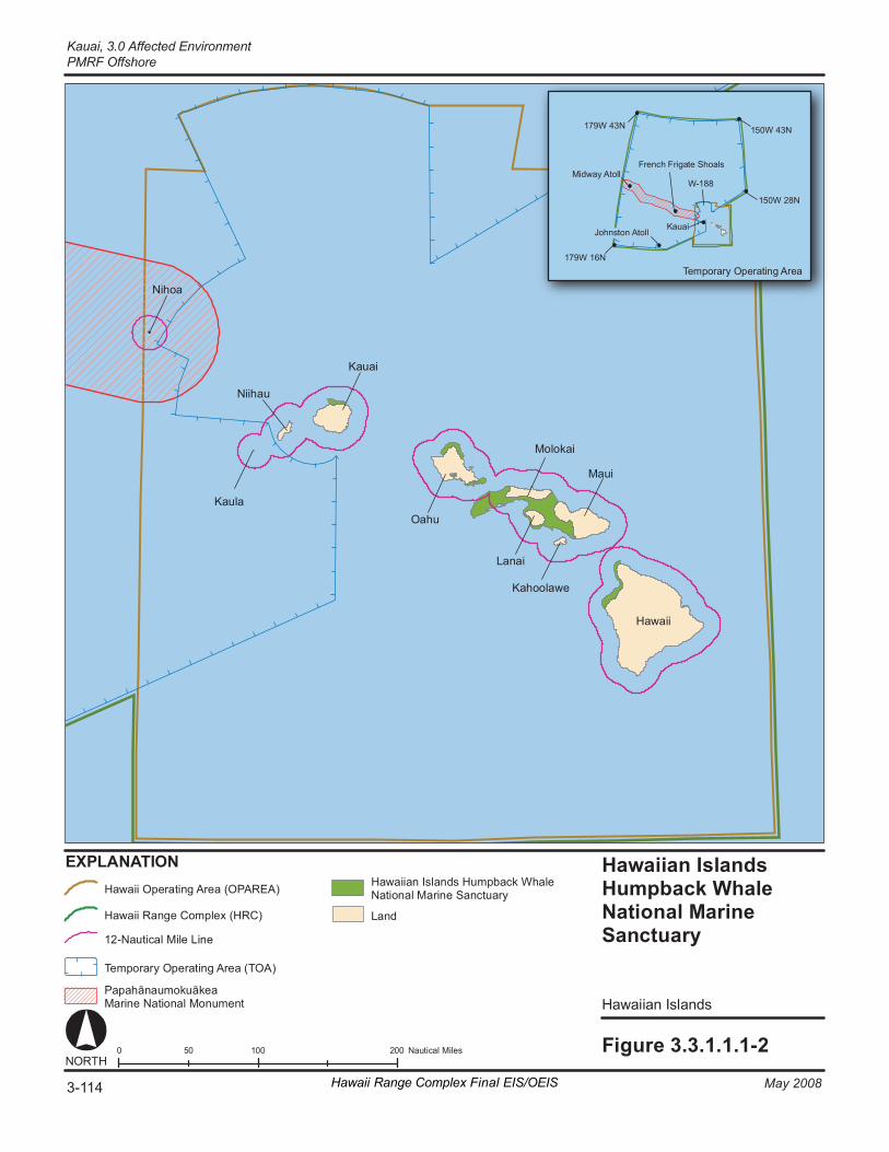
Ha wa ii an I sl a nds Humpb ack W ha le Na ti ona l Ma rine Sa nc tuar y
Hawa ii an Is l ands
Fi gure 3. 3. 1. 1. 1- 2 0 1 00 20 0 50 Na ut ic al M il es
1 79W 43N
1 79W 16N
1 50W 43N
1 50W 28N
Te m por ar y Op er at in g Ar ea
W- 188
EX PL AN AT IO N
NORT H
Mi dway A to ll
J ohns ton At ol l
Fr enc h Fr ig at e Shoal s
K auai
Ha wa ii
Ma ui
O ahu
Ka ua i
Ka ul a
Nii hau
Ni ho a
Mo lo ka i
La na i
Ka ho ol aw e
Ha wa ii O pe r at in g Ar ea (O PA RE A)
Ha wa ii R an ge C om pl ex ( HRC)
12 -N au ti ca l M ile L in e
Te mp or ar y O per at in g Ar ea ( TO A)
Pa pa hān au mok uāk ea Ma ri ne Na ti on al M onu me nt
La nd
Ha wa ii an Is la nd s Hu mp ba ck Wh al e Na ti o nal M ar in e Sa nc tu ar y
3-114 May 2008Hawaii Range Complex Final EIS/OEIS
Kauai, 3.0 Affected EnvironmentPMRF Offshore
3.0 Affected Environment, Kauai
PMRF Offshore
May 2008 Hawaii Range Complex Final EIS/OEIS 3-115
3.3.1.1.2 Cultural Resources—PMRF—Offshore (BARSTUR, BSURE, SWTR, Kingfisher)
Region of Influence The underwater cultural resources region of influence for PMRF would include offshore areas in Majors Bay and areas offshore from PMRF/Main Base (including PMRF Warning Area 188). The training and RDT&E activities proposed for these areas include Expeditionary Assault and other amphibious landings; torpedo; torpedo defense; submarine detection; deep and shallow water testing of anti-submarine torpedo sensors and weapons systems; mine-laying and neutralization; over-water missile launches and intercepts; Gunnery Exercise (GUNEX); Bombing Exercise (BOMBEX); and movement of the simulated underwater minefield (Kingfisher).
Affected Environment
Underwater Cultural Resources For a discussion of Open Ocean Area underwater cultural resources, see Section 3.1.3.
Offshore Area Archaeological Resources Within the offshore waters surrounding each island, there are a variety of submerged resources. The most common of these are shipwrecks (Figure 3.1.3-1) and fishponds; however, junked motor vehicles, harbor features, and old shoreline structures are also present.
Historically, Native Hawaiians constructed four different types of fishponds—freshwater taro ponds, other freshwater ponds, brackish water ponds, and seawater ponds (Aquaculture in Hawaii, 2006). Aquaculture was employed to supplement their other fishing activities, and permanent fishponds guaranteed a stable food supply for populations in lean times. Tended ponds provided fish without requiring fishing expertise, and harvesting the pond, unlike fishing at sea, was not weather dependent. Village-owned fishponds also increased the wealth of the managing Hawaiian Chief. At the time of European contact, there were hundreds of fishponds along the coast of the Hawaiian Islands. Many of the fishponds remain, but few are actively used (Aquaculture in Hawaii, 2006). Saltwater fishponds constructed on shallow water coral reef platforms are unique to the Hawaiian Islands and are very important national and international historical assets. Evidence suggests that Hawaiian fishponds were constructed as early as A.D. 1000, if not earlier, and continued to be built until the 1820s. The operation of fishponds declined throughout the islands by the early 1900s; there are approximately 488 fishponds in varying states of repair scattered throughout the six main islands. A database of identified Hawaiian saltwater fishponds is managed by the University of Hawaii at Manoa to publicize research and restoration projects, and to raise awareness of their cultural value.
Figure 3.3.1.1.2-1 shows the distribution of fishponds in the waters surrounding the Hawaiian Islands (State of Hawaii Office of Planning, 2005).
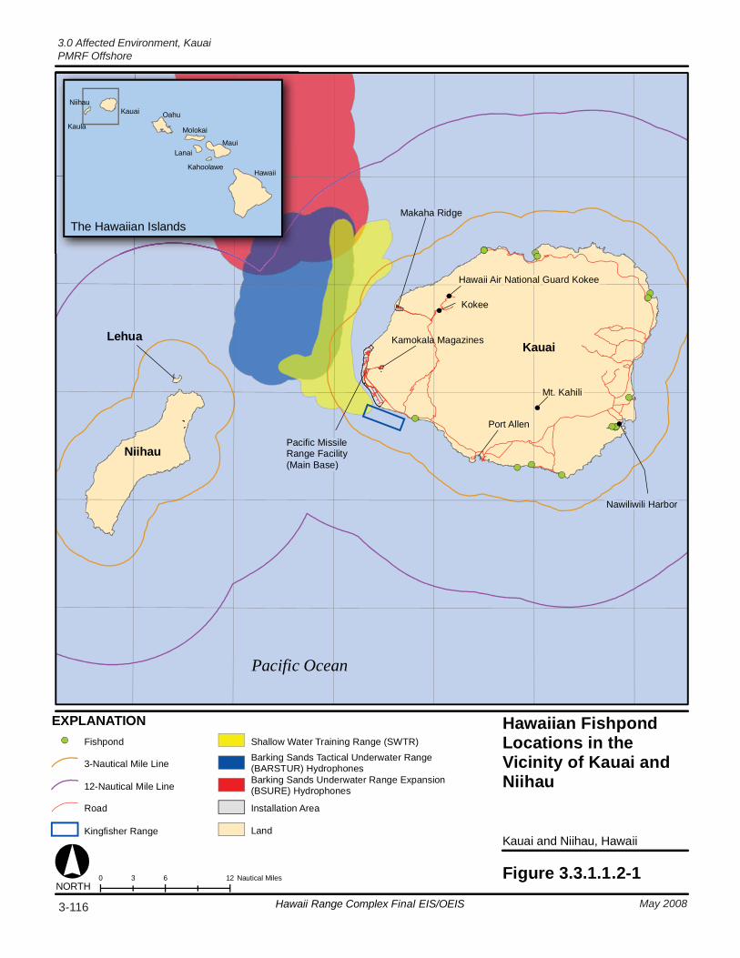
0 6 123 Nautical Miles Figure 3.3.1.1.2-1
Kauai and Niihau, Hawaii
Hawaiian FishpondLocations in theVicinity of Kauai andNiihau
Pacific Ocean
Pacific MissileRange Facility(Main Base)
Kamokala Magazines
Makaha RidgeThe Hawaiian Islands
NORTH
Kauai
Niihau
Lehua
Port Allen
Mt. Kahili
Hawaii Air National Guard Kokee
Kokee
Nawiliwili Harbor
EXPLANATIONFishpond
3-Nautical Mile Line
12-Nautical Mile Line
Road
Kingfisher Range
Shallow Water Training Range (SWTR)Barking Sands Tactical Underwater Range (BARSTUR) HydrophonesBarking Sands Underwater Range Expansion(BSURE) Hydrophones
Installation Area
Land
Hawaii
Maui
Kahoolawe
Lanai
Molokai
OahuKauaiNiihau
Kaula
3-116 May 2008Hawaii Range Complex Final EIS/OEIS
3.0 Affected Environment, KauaiPMRF Offshore
3.0 Affected Environment, Kauai
PMRF Offshore
May 2008 Hawaii Range Complex Final EIS/OEIS 3-117
The underwater environment surrounding Kauai encompasses a large number of shipwrecks and Hawaiian fishponds (see Figures 3.1.3-1 and 3.3.1.1.2-1). Among the wrecks is Pele, a freighter that sank on March 22, 1892. Pele rammed into an underwater pinnacle (tearing the hull) and sank a half-mile later in 14 fathoms of water. Very little of the wreck remains—the boiler, some hull plates, and a couple of anchors.
In 1824 the King of Hawaii used a vessel named Ha`aheo o Hawaii (Pride of Hawaii) as a private yacht, a cargo and passenger transport, and a diplomatic vehicle. The ship was also once used as a pirate ship. While the king was en route to England on a diplomatic mission, a Native Hawaiian crew sailed her to the northern shore of the island of Kauai and wrecked her in the southwestern corner of Hanalei Bay. The ship struck a 5-ft-deep reef just a hundred yards offshore and sank after an unsuccessful salvage attempt by the local population. (Johnston, 2005)
Within the specific offshore and open ocean underwater cultural resources region of influence for PMRF and KTF are a sparse distribution of shipwrecks and fishponds (see Figures 3.1.3-1 and 3.3.1.1.2-1).
3.3.1.1.3 Socioeconomics—PMRF—Offshore (BARSTUR, BSURE, SWTR, Kingfisher)
Region of Influence The region of influence for offshore Socioeconomics is the ocean area from the shoreline out to 12 nm from PMRF/Main Base. This includes the Kingfisher, which is within 3 nm of PMRF/Main Base; SWTR, which is within 3 nm and extends into the 12 nm area offshore of PMRF/Main Base; and BARSTUR and BSURE, which are within 12 nm of PMRF/Main Base.
Affected Environment There are activities that occur in the offshore area of PMRF/Main Base that contribute to the economy of Kauai. They can be categorized as shipping, recreation, subsistence fishing, and tourism related.
Shipping There is no commercial shipping to PMRF/Main Base, although boat tours are conducted within the region of influence. A primary commercial shipping route exists approximately 50 mi north of Kauai (EDAW, Inc., 2005).
Hawaii’s remote location in the mid-Pacific makes it economically dependent upon the local waterways and its inter-modal maritime transportation system. Hawaii’s harbors and local waterways use vessel traffic separation schemes that are closely monitored and supervised by the U.S. Coast Guard to promote safe navigation and provide a secure system for shipping. Barges and ships navigate these waterways daily to transport goods and personnel, not just within the Hawaiian Islands and to and from the mainland of North America, but across the Pacific Ocean to all the major ports of Asia, Oceania, Central and South America, and the South Pacific.
Kauai, 3.0 Affected Environment PMRF Offshore
3-118 Hawaii Range Complex Final EIS/OEIS May 2008
The National Oceanic and Atmospheric Administration (NOAA) provides frequently updated electronic and paper navigation charts for all mariners depicting the current vessel traffic separation schemes for all of Hawaii’s major harbors and inland waterways. While traffic separation schemes are demarcated on NOAA charts to maintain safe traffic flow, inter-modal shipping lanes are not. Outside of the traffic schemes and regulated waterways of the Hawaiian Islands, mariners are free to plot their own course; however, it is common practice for many shipping companies to use great circle routes with track adjustments made for navigational risks such as restricted waters, obstructions, depth of water, currents, weather, traffic, and environmental factors. Great circle routes are commonly used because they are the shortest distance between two points on the globe; therefore, it is more economical for companies to follow these routes.
Recreation Recreational activities include surfing, fishing, and boating. The physical areas accessible for fishing/surfing/recreation and socializing run from Shenanigans (all-hands club) up to KiniKini Ditch (south end of runway). Under PMRF Instruction 5530.7, normal access is allowed 7 days a week from 6:00 a.m. to 30 minutes after sunset, except during heightened force protection conditions or PMRF range operational periods.
Offshore of PMRF/Main Base, fishing is also allowed up to 1,000 ft in the Special Use Fishing Area (Kawaiele Ditch northward to the windsock adjacent to the runway) on weekends and Federal holidays, except during heightened force protection conditions and PMRF range operational periods. Use of this area is limited to 25 fishermen at one time. Fish species of commercial and recreational interest seen in the Majors Bay area in surveys performed in 2000 and 2006 included weke (Mulloidichthys samoensi), moano (Parupeneus multifasciatus), malu (Parupeneus pleurostigma), palani (Acanthurus dussumieri), mai`i`i (Acanthurus nigrofuscus), and naenae (Acanthurus olivaceus). The 2006 survey also found a small school of bonefish (Albula vulpes), uku, and juvenile ula (Panulirus marginatus). Discussions with fisherman familiar with the resources fronting PMRF indicate that those waters are well known for the commercial catches of akule or bigeye scad (Selar crumenophthalmus) which is done using nets, papios (members of the Jack family), threadfin or moi (Polydactylus sexfilis), opelu (Decapterus macarellus), uku, goatfishes and surgeonfishes, all of which are caught by a variety of methods by both commercial and recreational fishers. Surfing is also permitted in front of the PMRF housing area. (Commander, Navy Region Hawaii, 2007)
Subsistence Fishing Hawaii Revised Statutes (HRS) Section 188-22.6 defines subsistence fishing as the customary and traditional Native-Hawaiian uses of renewable ocean resources for direct personal or family consumption or sharing. HRS defines Native-Hawaiian as any descendant of the races inhabiting the Hawaiian Islands prior to 1778.
Fishing is still an extremely popular pastime for people in Hawaii (Western Pacific Regional Fishery Management Council, 1999). Recent data indicate that a quarter of Hawaii’s population participates in some form of fishing at least once a year. Hawaii’s annual fish consumption is about 90 pounds (lb) per capita, over twice the national average (Western Pacific Regional Fishery Management Council, National Oceanic and Atmospheric Administration, 2003).
3.0 Affected Environment, Kauai
PMRF Offshore
May 2008 Hawaii Range Complex Final EIS/OEIS 3-119
The overall level of subsistence fishing activity is difficult to assess, due to a lack of detailed catch data. Under-reporting by commercial fishermen and the existence of a large number of recreational and subsistence fishermen without licensing or reporting requirements have resulted in uncertainty in actual fisheries catch statistics for the state. Consequently, in the past no formal attempt to assess the subsistence fishing contribution to island economies has been made, but the value of fishing for subsistence by contemporary Native Hawaiians is known to be an important component of some communities, particularly rural communities (Pooley, 1993). However, it is believed that offshore recreational and subsistence catch is likely equal to or greater than the offshore commercial fisheries catch, with more species taken using a wider range of fishing gear (Friedlander, et al., 2004).
The Pacific Islands Region has a special mandate under the Magnuson and Stevens Fishery Conservation and Management Act to promote the sustained participation of indigenous communities. In March of 2004, the “Strategic Plan for the Conservation and Management of Marine Resources in the Pacific Islands Region” was developed by three Federal agencies: the National Marine Fisheries Service (NMFS) Pacific Islands Fisheries Science Center, the Pacific Islands Regional Office, and the Western Pacific Regional Fishery Management Council. The plan discusses critical issues facing the region and provides plans for addressing the issues. The plan identifies five research projects which the offices have started: (1) developing a sociological baseline of the Hawaii longline fishery; (2) developing profiles of fishing communities and fishing ports; (3) compiling and analyzing historical fishing club and tournament records, studies concerning fishing capacity in Hawaii’s commercial fisheries; (4) developing an economic evaluation of fishing tournaments; and (5) developing cost-earning studies for Hawaii fisheries.
Hawaii’s coastal fisheries, as in other parts of the world, are facing unprecedented overexploitation and severe depletion. In heavily populated areas of the Main Hawaiian Islands, fishing demands for offshore resources appear to exceed the capacity for resource renewal (Friedlander, et al., 2004).
The Western Pacific Regional Fishery Management Council and NOAA worked together to prepare a Supplemental EIS to the Final Environmental Impact Statement on the Fishery Management Plan for Bottomfish and Seamount Groundfish Fisheries of the Western Pacific Region in May of 2005. The purpose of the Supplemental EIS was to implement measures which would end overfishing in the bottomfish complex in the Hawaiian Archipelago. The draft of this document was published in March 2006. The draft Supplemental EIS analyzed five alternatives: (1) no action; (2) area closures; (3) seasonal closures; (4) catch quotas; and (5) combination of alternatives two and three. The draft Supplemental EIS concluded that the most effective means of ending overfishing would be implementation of alternative three (seasonal closures). For seasonal closures to be effective, State and Federal regulations would need to be promulgated (Western Pacific Regional Fishery Management Council, National Oceanic and Atmospheric Administration, 2003).
State and Federal agencies have given protective status to a variety of marine areas in Hawaii in efforts to improve fisheries. These areas include Marine Life Conservation Districts, Fisheries Management Areas, Fisheries Replenishment Areas, Bottomfish Restricted Fishing Areas, Hawaii Marine Laboratory Refuge-Coconut Island, Kahoolawe Island Reserve, Paiko Lagoon Wildlife Sanctuary, Ahihi-Kinau Natural Area Reserve, South Kona opelu fishing area, the Hawaiian Islands Humpback Whale National Marine Sanctuary (Figure 3.3.1.1.1-2), and the
Kauai, 3.0 Affected Environment PMRF Offshore
3-120 Hawaii Range Complex Final EIS/OEIS May 2008
Northwestern Hawaiian Islands Coral Reef Ecosystem Reserve (Figure 3.2-1) (Friedlander, et al., 2004).
In Hawaii, habitats with low spatial relief and limited shelter were found to be associated with low biomass and diversity of reef fishes, whereas highly complex habitats harbored high fish biomass and diversity. Ideally, EFH in the Main Hawaiian Islands should consist of an area with high rugosity (roughness) or relief and moderate wave exposure that has a high percentage of branching and/or lobate coral coupled with legal protection from fish pressure. Habitats with these optimal characteristics should possess fish assemblages with high species richness, abundance, biomass, and diversity. If protective areas are to be effective, they must include the diversity of habitats necessary to accommodate the wide range of fish species (Friedlander, et al., 2004).
Due to the shape of Kauai and the lack of any protective barrier reef structure, the shoreline region is nearly continually scoured by the force of breaking waves. The essentially “round” shape of Kauai results in exposure from swells emanating from both the north and the south Pacific, hence the nearly continual wave action. The entire region offshore of PMRF is directly exposed to long-period swells generated by storms in both the North (winter) and South (summer) Pacific. As a result of these physical processes, the offshore areas are subjected to extreme stress from wave impact and scouring of sediment from wave action. Consequently, there is minimal coral reef development in the offshore areas off the coast of PMRF (Commander, Navy Region Hawaii, 2007). Since the implementation of the Force Protection Restriction after September 11, 2001, there has been a decline in fishing activities in the waters fronting PMRF, and this has corresponded to increases in the abundance, mean size, and biodiversity of fish in the area (Commander, Navy Region Hawaii, 2007).
Tourism The tourism industry has been the economic mainstay of the Hawaiian Islands since statehood in 1959. The industry accounts for 22.3 percent of all jobs in Hawaii (Kauai, County of, 2005). Kauai’s share of the Hawaii visitor market was 14.5 percent in 2005. Despite terrorism concerns and periodic economic slumps, the tourism industry on Kauai has remained robust, with the number of annual visitors consistently over 1 million a year in the past 5 years (Kauai, County of, 2005). Estimated visitor expenditure in 2005 was $11.9 billion, a 9.6 percent increase from 2004 (State of Hawaii, Department of Business, Economic Development & Tourism, 2006). Many island visitors enjoy participating in activities in the ocean areas within the HRC such as scuba diving, kayaking, sailing, and dinner cruises. There are many businesses that rent equipment, offer guided tours, operate charter boats, and supply other services to the tourists within the region of influence. The Super Ferry was just starting its operations at the same time this document was drafted.
3.0 Affected Environment, Kauai
PMRF Offshore
May 2008 Hawaii Range Complex Final EIS/OEIS 3-121
3.3.1.1.4 Transportation—PMRF—Offshore (BARSTUR, BSURE, SWTR, Kingfisher)
Region of Influence The region of influence for offshore transportation is the ocean area from the shoreline out to 12 nm. This area includes the Kingfisher Area, which is within 3 nm of PMRF/Main Base; SWTR, which is within 3 nm and extends into the 12 nm range of PMRF/Main Base; and BARSTUR and BSURE, which are within 12 nm of PMRF/Main Base.
Affected Environment The affected environment is the area from the shoreline of PMRF/Main Base out to 12 nm.
Waterways There is no commercial shipping to PMRF, although boat tours are conducted within the region of influence. A primary commercial shipping route exists approximately 50 mi north of Kauai (EDAW, Inc., 2005).
Kauai, 3.0 Affected Environment Niihau Offshore
3-122 Hawaii Range Complex Final EIS/OEIS May 2008
3.3.1.2 NIIHAU OFFSHORE Niihau is a privately owned island located approximately 17 nm southwest of Kauai. It is about 8 mi wide by 18 mi long and comprises approximately 72 mi2. PMRF leases 1,170 acres of land in the northeastern corner of the island and operates radar units, optics, and electronic warfare sites on Niihau. Niihau Offshore includes proposed HRC ranges and training areas 0 to 12 nm from Niihau (Figure 2.1-2).
This section describes the environmental resources that would be affected by the No-action Alternative, Alternative 1, Alternative 2, or Alternative 3 for Niihau Offshore. Of the 13 resources considered for analysis, airspace, air quality, cultural resources, geology and soils, hazardous materials and waste, health and safety, land use, noise, socioeconomics, transportation, utilities, and water resources are not addressed.
3.3.1.2.1 Biological Resources—Niihau—Offshore Region of Influence The region of influence for offshore biological resources is the ocean area from the shoreline of Niihau out to 12 nm.
Affected Environment
Vegetation Common plants found in Niihau’s rocky intertidal habitats include sea lettuce (Ulva lactuca), Sargasso or kala, coralline red algae, red fleshy algae, brown algae, and fleshy green algae (U.S. Department of the Navy, 2005c). Common plants that inhabit the sandy beach intertidal habitat on Niihau include the beach morning glory (Ipomoea imperati), beach heliotrope (Heliotropium anomalum), milo (Thespesia populnea), and hau (Hibiscus tiliaceus) (Maragos, 1998).
Threatened and Endangered Vegetation No threatened or endangered vegetation is located in the offshore area.
Wildlife Common animals using and inhabiting the sandy beach intertidal habitat on Niihau include ghost crabs (Ocypode ceratophthalma), mitre and auger shells (Terebra), clams, and seabirds. (Maragos, 1998)
Reefs offshore of Niihau are poorly developed due to extreme wave energy from all directions. There are no substantial bays that could shelter coral development. Colonized and uncolonized hardbottom areas are located off the western coastline. High-wave energy coral communities appear to be most common and are dominated by cauliflower coral and lobe coral. Black coral (Antipathes sp.) occurs as shallow as 90 ft off the northern end of the island. (Hawaii Institute of Marine Biology, 2006)
3.0 Affected Environment, Kauai
Niihau Offshore
May 2008 Hawaii Range Complex Final EIS/OEIS 3-123
Pelagic fish such as tuna swim close to steep vertical walls around the northwest portion of Niihau. Large kumu (white saddle goatfish) (Parupeneus porphyreus), u`u (squirrelfish) (Myripristis spp.), and uhu (parrotfish) (Chlorurus sordidus) are abundant. Sharks are also present off of Niihau, including the grey reef shark (Carcharhinus amblyrhynchos), sandbar shark (C. plumbeus), Galapagos (C. galapagensis), and tiger shark (Galeorcerdo cuvier). (Papastamatiou, et al., 2006; Hawaii Institute of Marine Biology, 2006)
EFH and HAPC are described in Section 3.1.2 (Open Ocean), and a detailed description, including status, distribution, and habitat preference of managed fisheries is provided in the Navy’s Final Essential Fish Habitat and Coral Reef Assessment for the Hawaii Range Complex EIS/OEIS (U.S. Department of the Navy, 2007a).
Threatened and Endangered Wildlife The endangered Hawaiian monk seal and the threatened green turtle have been observed offshore of Niihau.
Kauai, 3.0 Affected Environment Kaula Offshore
3-124 Hawaii Range Complex Final EIS/OEIS May 2008
3.3.1.3 KAULA OFFSHORE Kaula is approximately 108 acres of land used by the Navy for aircraft gunnery and inert ordnance target practice. No HRC training events are performed offshore (0 to 12 nm) of Kaula; however, onshore training events may affect offshore resources.
This section describes the environmental resources that would be affected by the No-action Alternative, Alternative 1, Alternative 2, or Alternative 3 for Kaula Offshore. Of the 13 resources considered for analysis, air quality, airspace, geology and soils, hazardous materials and waste, health and safety, land use, noise, socioeconomics, transportation, utilities, and water resources are not addressed.
3.3.1.3.1 Biological Resources—Kaula—Offshore Vegetation Common plants found in rocky intertidal habitats include sea lettuce, coralline red algae, red fleshy algae, brown algae, and fleshy green algae (U.S. Department of the Navy, 2005c).
No threatened or endangered vegetation is located in the offshore area.
Wildlife Kaula is surrounded by Kaula Bank, which supports some coral reefs. The entire bank has been identified as a HAPC in the Coral Reef Ecosystem Fisheries Management Plan. Several commercially important fish, such as tunas and jacks observed spawning in the area, have been reported. Another species seen in the area is the whale shark (Rhincodon typus), which is rarely sighted in the Main Hawaiian Islands. Gray reef and sandbar sharks have also been observed. Spinner dolphins are common in the water around Kaula. (Pacific Missile Range Facility, 2001)
Threatened and Endangered Wildlife Species Coastal waters off Kaula are considered viable foraging habitat for green turtles, but no sightings of sea turtles have been documented (Pacific Missile Range Facility, 2001).
Four consecutive NMFS humpback whale surveys conducted between 1976 and 1979 established that humpback whales occur in the offshore waters of Kaula during the peak of the winter season on an annual basis (Pacific Missile Range Facility, 2001). Three Hawaiian monk seals were observed on a shelf off Kaula in a 2000 aerial survey (Baker and Johanos, 2004). Fifteen Hawaiian monk seals were counted during a 4-hour period hauled out on Kaula during a 2006 cruise (National Marine Fisheries Service, 2007b).
3.0 Affected Environment, Kauai
Kaula Offshore
May 2008 Hawaii Range Complex Final EIS/OEIS 3-125
3.3.1.3.2 Cultural Resources—Kaula—Offshore Region of Influence The underwater cultural resources region of influence for Kaula would include areas offshore of the southwestern tip of the island where there is an existing, heavily disturbed ordnance impact area. Proposed or ongoing training with the potential to affect cultural resources on Kaula and within Warning Area W-187 include BOMBEX and GUNEX.
Affected Environment
Underwater Cultural Resources There are no recorded underwater archaeological resources surrounding Kaula (e.g., shipwrecks) (see Figures 3.1.3-1 and 3.3.1.1.2-1).
Kauai, 3.0 Affected Environment PMRF/Main Base
3-126 Hawaii Range Complex Final EIS/OEIS May 2008
3.3.2 KAUAI ONSHORE
3.3.2.1 PMRF/MAIN BASE The Main Base portion of PMRF is located on the west side of Kauai, approximately 120 nm from Pearl Harbor. The majority of PMRF’s facilities and equipment are at the Main Base, which occupies a land area of 1,925 acres and lies just south of Polihale State Park. PMRF/Main Base is generally flat and approximately 0.5 mi wide and 6.5 mi long with a nominal elevation of 15 ft above mean sea level except for the target launch pad areas. PMRF is a multi-environment range capable of supporting surface, subsurface, air, and space events and activities simultaneously. Training and RDT&E activities areas on PMRF/Main Base contain tracking and surveillance radars, data processing, and the communications network. Airfield facilities are located on PMRF/Main Base. Ordnance and launch areas are also located on PMRF/Main Base, the KTF launch area, northern launch area, and southern launch facility. Sandia National Laboratories operates the KTF for the Department of Energy and provides PMRF with rocket launch services for target systems and upper atmosphere measurements.
This section describes the environmental resources that would be affected by the No-action Alternative, Alternative 1, Alternative 2, or Alternative 3 for PMRF/Main Base. All 13 environmental resources are addressed.
3.3.2.1.1 Air Quality—PMRF/Main Base Air quality in Hawaii is defined with respect to compliance with primary and secondary National Ambient Air Quality Standards (NAAQS) (40 Code of Federal Regulations [CFR] §50) established by U.S. Environmental Protection Agency (USEPA) and adopted by the State of Hawaii. The Clean Air Act (42 United States Code [U.S.C.] 7401-7671q), as amended, gives USEPA the responsibility to set safe concentration levels for six criteria pollutants: particulate matter measuring less than 10 and 2.5 microns in diameter (PM-10 and PM-2.5), sulfur dioxide, carbon monoxide, nitrogen oxides, 8-hour ozone, and lead. Ozone is measured by emissions of volatile organic compounds (VOCs) and nitrogen oxides. The NAAQS and State Ambient Air Quality Standards (AAQS) are presented in Appendix C.
Region of Influence For inert pollutants (all pollutants other than ozone and its precursors), the region of influence is generally limited to an area extending several miles downwind from the source. The region of influence for ozone may extend much farther downwind than the region of influence for inert pollutants. As the project area has no heavy industry and very few automobiles, ozone and its precursors are not of concern. Consequently, for the air quality analysis, the region of influence for project activities is the existing airshed (the geographic area responsible for emitting 75 percent of the air pollution reaching a body of water) surrounding the various sites, which encompasses the Mana Plain, including PMRF/Main Base.
Affected Environment
Climate Weather is an important factor in the disbursement of air pollutants. PMRF/Main Base is located just south of the Tropic of Cancer and has a mild and semi-tropical climate. Typical

3.0 Affected Environment, Kauai
PMRF/Main Base
May 2008 Hawaii Range Complex Final EIS/OEIS 3-127
temperatures for the area are 80 to 84 degrees Fahrenheit (°F) during the day and 65 to 68°F during the night. The trade winds are from the northeast and are typically light—mean trade winds between 16 to 18 knots. Precipitation in the area averages 41 inches annually. Most of the rain falls during the October through April wet season. Relative humidity is approximately 60 percent during the day throughout the year.
Regional Air Quality Air quality data in Hawaii are collected by the Hawaii State Department of Health, Clean Air Branch. The most recent available data (for the years 2001–2005) from monitoring stations State-wide are used to describe the existing ambient air quality in Hawaii.
The only State air quality monitoring station on Kauai is located in Lihue and collects data on PM-10 levels. The monitored ambient air concentrations in Lihue are well below the corresponding State and Federal annual average AAQS (Hawaii State Department of Health, Clean Air Branch, 2005). Between 2001 and 2005, none of the monitored ambient air concentrations in the entire state exceeded the annual average AAQS. Areas that meet the NAAQS for a criteria pollutant are designated as being “in attainment”; areas exceeding NAAQS are “nonattainment.” The entire State of Hawaii is in attainment of the NAAQS and State AAQS established for all criteria pollutants. Consequently, Clean Air Act applicability analysis and conformity determination do not apply to Navy actions in Hawaii.
Existing Emission Sources The only major stationary sources for pollution at PMRF/Main Base are the five diesel generators that serve as a backup to the utility power system. During power outages and some of the mission events and activities, these generators are run to provide back-up power to critical facilities at the Main Base area. All five units are normally cycled, so that two or three units are in service at any time. However, when electrical demand is high, three or more of these generators may be operated simultaneously. During the worst case emergency conditions, all five generators can be operated simultaneously.
These generators are covered under the PMRF Title V Covered Source Permit. By restricting the hours of use for each generator and limiting the sulfur content of the diesel fuel supplied for the generators to 0.5 percent by weight, the Title V permit controls the nitrogen dioxide emissions. Operational limitations for the three 320-kilowatt (kW) generators are 208,000 gallons (gal) of fuel annually at maximum fuel consumption rate of 23.2 gal/hour, and the limitations for the two 600-kW generators are 217,800 gal of fuel annually at 43.5 gal/hour (Hawaii Department of Health, 2003).
Stationary emissions sources at KTF include two electrical generators that are permitted for operation by the State of Hawaii under a Non-covered Source Permit through April 2009 (Sandia National Laboratories, 2006).
Mobile sources from PMRF-associated training include aircraft, rocket launches, diesel-fueled vehicles, and dust from vehicular traffic. Aircraft are operated and supported at PMRF Airfield. Records show that existing PMRF air operations in fiscal year (FY) 2004 consisted of 13,395 air operations (defined as a takeoff or landing of one aircraft) of which 8,129 were Navy. The C-26 “Metroliner” aircraft and UH-3H “Sea King” helicopter accounted for 67 percent of all Navy air
Kauai, 3.0 Affected Environment PMRF/Main Base
3-128 Hawaii Range Complex Final EIS/OEIS May 2008
operations at PMRF. Transient Navy H-60, C-20, and NP-3D aircraft combined for the remaining 33 percent of Navy air operations at PMRF. (U.S. Department of the Navy, Engineering Field Activity Chesapeake, 2006)
Rocket launches are another source of mobile emissions at PMRF. Currently, there are as many as 46 missile launches per year from PMRF. These systems use both solid and liquid propellants. Appendix E includes a detailed list of the typical weapon systems tested at PMRF. The most common exhaust components for typical missiles include aluminum oxide, carbon dioxide, carbon monoxide, hydrogen, hydrogen chloride, nitrogen, water, ferric chloride, ferric oxide, nitric oxide, chlorine, and sulfur dioxide.
3.3.2.1.2 Airspace—PMRF/Main Base Airspace, or that space which lies above a nation and comes under its jurisdiction, is generally viewed as being unlimited. However, it is a finite resource that can be defined vertically and horizontally, as well as temporally, when describing its use for aviation purposes. The time dimension is a very important factor in airspace management and air traffic control.
Under Public Law (PL) 85-725, Federal Aviation Act of 1958, the Federal Aviation Administration (FAA) is charged with the safe and efficient use of our nation's airspace and has established certain criteria and limits to its use. The method used to provide this service is the National Airspace System. This system is “…a common network of U.S. airspace; air navigation facilities, equipment and services, airports or landing areas; aeronautical charts, information and services; rules, regulations and procedures, technical information and manpower and material.” Appendix C includes a detailed description of airspace.
Region of Influence The region of influence for airspace includes the airspace over and surrounding PMRF/Main Base. Figure 3.3.2.1.2-1 shows a view of the airspace within the PMRF/Main Base region of influence, it includes the PMRF Aircraft Operational Areas, the R-3101 Restricted Area, and surrounding airspace off the western and northwestern coast of Kauai. For airspace, the region of influence also includes KTF, Makaha Ridge, Kokee, Kaula, and Niihau.
Affected Environment The affected airspace use environment in the PMRF region of influence is described below in terms of its principal attributes: controlled and uncontrolled airspace, special use airspace, en route airways and jet routes, airports and airfields, and air traffic control. There are no military training routes in the region of influence.
Controlled and Uncontrolled Airspace The airspace outside the special use airspace identified below is essentially international airspace controlled by Honolulu Air Route Traffic Control Center (ARTCC). Class D airspace (described in Appendix C) surrounds the PMRF/Main Base airfield with a ceiling of 2,500 ft. It is
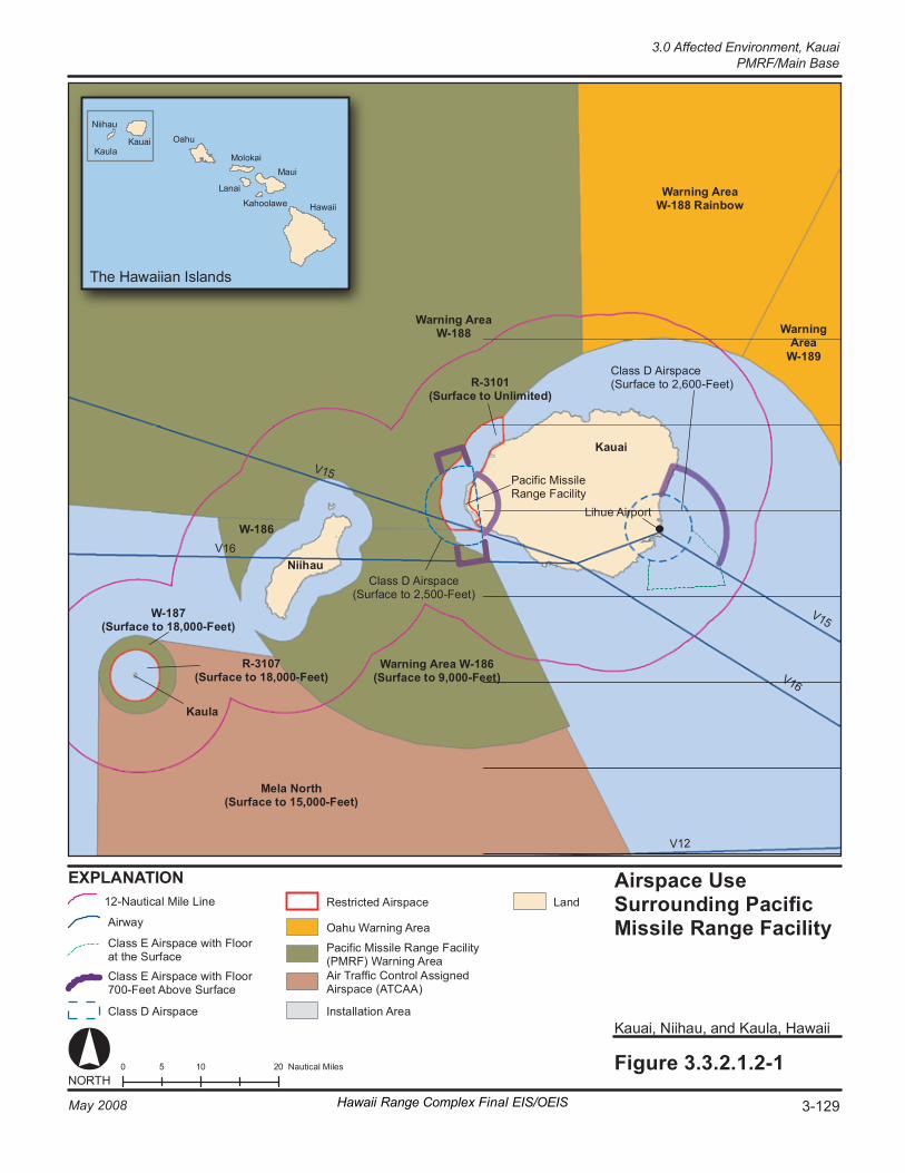
V1 5
V1 2
V1 6
T he Ha wa iia n Is la nd s
0 1 0 2 0 5 N aut ic al M il es Fi gure 3. 3. 2. 1. 2- 1
Ka uai , N iih au , and K au la , Ha waii
Ka ua i
Ka ul a
Niih au
Wa rn in g Ar ea W-1 86 (Surf ace t o 9, 00 0- Fe et )
Wa rn in g Ar ea W- 188
Wa rn in g Ar ea W- 188 R ai nb ow
Wa rn in g Ar ea
W- 189
Pa ci fi c Mi ssi le Ra ng e Fa ci li ty
R- 31 01 (Surf ace t o Un lim it ed )
W- 187 (Surf ace t o 18 ,0 00 -F ee t)
R- 31 07 (Surf ace t o 18 ,0 00 -F ee t)
Cl as s D Ai rs pac e (S ur fa ce to 2 ,6 00 -F ee t)
Cl as s D Ai rs pac e (S ur fa ce to 2 ,5 00 -F ee t)
K auai
Ni i hau
K aul a
V1 6
V1 5
Airs p ace U se Surround i ng Pa ci fi c Mi ss il e Ra nge F ac il it y
W- 186
NORT H
Li hue A ir por t
O ahu
Mo lo ka i
L anai
K ahool aw e
M aui
Hawa ii
Me la N or th (Surf ace t o 15 ,0 00 -F ee t)
EX PL AN AT IO N La nd
Airw ay
Cl as s E Ai rs pa ce w it h Fl oo r at t he S ur fa ce
Cl as s E Ai rs pa ce w it h Fl oo r 70 0- Fe et A bo ve S ur fa ce
Cl as s D Ai rs pac e
Re st ri ct ed A ir sp ac e
Air Tr a ffi c Co nt ro l As si gne d Airs pa ce ( AT CA A)
In st al la ti on A re a
Pa ci fi c Mi ssi le R an ge F ac il it y (P MR F) W ar ni ng A re a
O ahu War ni ng Ar ea
12 -N au ti ca l M ile L in e
3-129May 2008 Hawaii Range Complex Final EIS/OEIS
3.0 Affected Environment, KauaiPMRF/Main Base
Kauai, 3.0 Affected Environment PMRF/Main Base
3-130 Hawaii Range Complex Final EIS/OEIS May 2008
surrounded to the north, south, and east by Class D airspace with a floor 700 ft above the surface (see Figure 3.3.2.1.2-1). Lihue Airport, located approximately 20 nm east of PMRF, includes Class D, surface Class E, and additional Class E airspace with a floor 700 ft above the surface.
No Class B (U.S. terminal control areas) airspace, which usually surrounds the nation’s busiest airports, or Class C airspace, is found in the region of influence.
Special Use Airspace A restricted area is airspace designated under Part 73 within which the flight of aircraft, while not wholly prohibited, is subject to restriction. A warning area is airspace of defined dimensions, extending from 3 nm outward from the coast of the United States that contains activity that may be hazardous to nonparticipating aircraft. The purpose of such warning areas is to warn nonparticipating pilots of the potential danger. A warning area may be located over domestic or international waters or both. (14 CFR Title 14 Part 1.1, 2006)
The special use airspace in the region of influence (see Figure 3.3.2.1.2-1) consists of Restricted Area R-3101, which lies immediately above PMRF/Main Base and to the west of Kauai, portions of Warning Area W-188 north of Kauai, and Warning Area W-186 southwest of Kauai, all controlled by PMRF. Restricted Area R-3107 over Kaula, a small uninhabited rocky islet 19 nm southwest of Niihau that is used for fixed- and rotary-wing aircraft gunnery practice, and which lies within the W-187 Warning Area, is also special use airspace within the region of influence. Restricted Area R-3107 and Warning Area W-187 are scheduled through the Navy Fleet and Area Control and Surveillance Facility Pearl Harbor (FACSFACPH). PMRF and FACSFACPH each coordinate with the FAA Hawaii Combined Facility regarding special use airspace. The Hawaii Combined Facility is the location in which the ARTCC, the Honolulu control tower, and the Combined Radar Approach Control are collocated.
Table 3.3.2.1.2-1 lists the affected Restricted Areas and Warning Areas and their effective altitudes, times used, and their manager or scheduler. There are no Prohibited or Alert special use airspace areas in the PMRF airspace use region of influence.
En Route Airways and Jet Routes Although relatively remote from the majority of jet routes that crisscross the Pacific, the airspace use region of influence has two instrument flight rules (IFR) en route low altitude airways used by commercial air traffic that pass through the region of influence: V15, which passes east to west through the southernmost part of Warning Area W-188, and V16, which passes east to west through the northern part of Warning Area W-186 and over Niihau (see Figure 3.3.2.1.2-1). An accounting of the number of flights using each airway is not maintained.
The airspace use region of influence, located to the west, northwest, and north of Kauai, is far removed from the low altitude airways carrying commercial traffic between Kauai and Oahu and the other Hawaiian islands, all of which lie to the southeast of Kauai. There is a high volume of island helicopter sightseeing flights along the Na Pali coastline and over the Waimea Canyon, inland and to the east of PMRF, particularly out of Port Allen near Hanapepe on Kauai’s southern coastline and other tourist and resort towns on the island. However, these do not fly over PMRF or into Restricted Area R-3101 (National Aeronautical Charting Office, 2007).
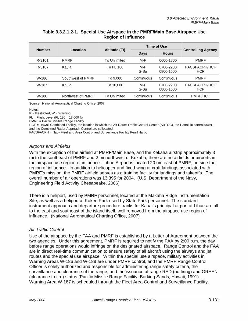
3.0 Affected Environment, Kauai
PMRF/Main Base
May 2008 Hawaii Range Complex Final EIS/OEIS 3-131
Table 3.3.2.1.2-1. Special Use Airspace in the PMRF/Main Base Airspace Use Region of Influence
Number Location Altitude (Ft) Time of Use
Controlling Agency Days Hours
R-3101 PMRF To Unlimited M-F 0600-1800 PMRF
R-3107 Kaula To FL 180 M-F S-Su
0700-2200 0800-1600
FACSFACPH/HCF HCF
W-186 Southwest of PMRF To 9,000 Continuous Continuous PMRF
W-187 Kaula To 18,000 M-F S-Su
0700-2200 0800-1600
FACSFACPH/HCF HCF
W-188 Northwest of PMRF To Unlimited Continuous Continuous PMRF/HCF
Source: National Aeronautical Charting Office, 2007 Notes: R = Restricted, W = Warning FL = Flight Level (FL 180 = 18,000 ft) PMRF = Pacific Missile Range Facility HCF = Hawaii Combined Facility, the location in which the Air Route Traffic Control Center (ARTCC), the Honolulu control tower, and the Combined Radar Approach Control are collocated. FACSFACPH = Navy Fleet and Area Control and Surveillance Facility Pearl Harbor
Airports and Airfields With the exception of the airfield at PMRF/Main Base, and the Kekaha airstrip approximately 3 mi to the southeast of PMRF and 2 mi northwest of Kekaha, there are no airfields or airports in the airspace use region of influence. Lihue Airport is located 20 nm east of PMRF, outside the region of influence. In addition to helicopter and fixed-wing aircraft landings associated with PMRF’s mission, the PMRF airfield serves as a training facility for landings and takeoffs. The overall number of air operations was 13,395 for 2004. (U.S. Department of the Navy, Engineering Field Activity Chesapeake, 2006)
There is a heliport, used by PMRF personnel, located at the Makaha Ridge Instrumentation Site, as well as a heliport at Kokee Park used by State Park personnel. The standard instrument approach and departure procedure tracks for Kauai’s principal airport at Lihue are all to the east and southeast of the island itself, well removed from the airspace use region of influence. (National Aeronautical Charting Office, 2007)
Air Traffic Control Use of the airspace by the FAA and PMRF is established by a Letter of Agreement between the two agencies. Under this agreement, PMRF is required to notify the FAA by 2:00 p.m. the day before range operations would infringe on the designated airspace. Range Control and the FAA are in direct real-time communication to ensure safety of all aircraft using the airways and jet routes and the special use airspace. Within the special use airspace, military activities in Warning Areas W-186 and W-188 are under PMRF control, and the PMRF Range Control Officer is solely authorized and responsible for administering range safety criteria, the surveillance and clearance of the range, and the issuance of range RED (no firing) and GREEN (clearance to fire) status (Pacific Missile Range Facility, Barking Sands, Hawaii, 1991). Warning Area W-187 is scheduled through the Fleet Area Control and Surveillance Facility.
Kauai, 3.0 Affected Environment PMRF/Main Base
3-132 Hawaii Range Complex Final EIS/OEIS May 2008
As Warning Areas are located in international airspace, the procedures of the International Civil Aviation Organization (ICAO), outlined in ICAO Document 444, Rules of the Air and Air Traffic Services, are followed. ICAO Document 444 is the equivalent air traffic control manual to FAA Handbook 7110.65, Air Traffic Control. The FAA acts as the U.S. agent for aeronautical information to the ICAO, and air traffic in the region of influence is managed by the Honolulu ARTCCs.
3.3.2.1.3 Biological Resources—PMRF/Main Base Native or naturalized vegetation, wildlife, and the habitats in which they occur are collectively referred to as biological resources. Existing information on plant and animal species and habitat types in the vicinity of the proposed sites was reviewed, with special emphasis on the presence of any species listed as threatened or endangered by Federal or State agencies, to assess their sensitivity to the effects of the No-action Alternative, Alternative 1, Alternative 2, or Alternative 3. For the purpose of discussion, biological resources have been divided into the areas of vegetation, wildlife, threatened and endangered species, and environmentally sensitive habitat.
The main Federal Acts that provide guidance on avoiding or minimizing impacts on biological resources are detailed in Appendix C.
Region of Influence The region of influence for biological resources includes the area within the PMRF/Main Base property boundary and offshore areas used for testing and training. Within the region of influence, human activities have altered most of the natural terrestrial environment. The land in PMRF/Main Base is used for military activities such as air operations, rocket launches, various training, and base maintenance operations. Most of the same terrestrial species discussed below for PMRF/Main Base could also occur within the adjacent Mana Plain area.
Affected Environment
Vegetation There are six recognized vegetation types on the undeveloped portions of PMRF/Main Base: kiawe (Prosopis pallida)-koa haole (Leucaena leucocephala) scrub, a`ali`i (Dodonaea viscosa)-nama (Nama sandwicensis) scrub, pohinahina (Vitex rotundifolia), naupaka (Scaevola sericea) dune, strand, drainage-way wetlands, and ruderal vegetation. Kiawe/koa haole and a`ali`i-nama scrub are the dominant vegetation in the undeveloped portions of the PMRF/Main Base region of influence. A well-developed native strand community exists along the shoreline. (Pacific Missile Range Facility, 2001) Common plants that inhabit the sandy beach habitat on Kauai include the beach morning glory, beach heliotrope, milo, and hau (Maragos, 1998).
Drainage-way wetlands vegetation occupies only a small area on PMRF/Main Base. Ruderal (disturbed, weedy) vegetation is present along roadsides and other areas where man has disturbed the natural vegetation, and much of this vegetation is mowed on a regular basis. The broad, white, sandy beach that fronts Majors Bay supports only sparse littoral kiawe-koa haole thickets on the northern half and native a`ali`i-nama scrub on the southern half. (Pacific Missile Range Facility, 2001)
3.0 Affected Environment, Kauai
PMRF/Main Base
May 2008 Hawaii Range Complex Final EIS/OEIS 3-133
Golden crown beard (Verbesina enceliodes) is a new invasive species on the Nohili dunes since the 2000 survey. It has recently begun to take over areas that were previously dominated by native vegetation such as nama. Other alien species include ironwood (Casuarina spp.), sourbush (Pluchea carolinensis), and swollen fingergrass (Chloris barbata). (Pacific Missile Range Facility, 2006a)
The vegetation in the Mana Plain restrictive easement area was dominated by sugar cane (Saccharum officinarum), ruderal vegetation, and wetlands associated with agricultural ponds and drains. Sugar cane is being phased out, and more diversified agricultural crops are being grown (Hawaii Coral Reef Assessment and Monitoring Program, 2006). The non-native, non-agricultural vegetation is dominated by kiawe/koa haole. This vegetation type is the dominant type present on the relatively undisturbed areas of the sand dunes, associated with PMRF and Polihale State Park, as well as along the cliff face in the restrictive easement area. Because of the restrictions on off-highway vehicle activities, the sand dune related vegetation within the PMRF boundary is less disturbed than the vegetation in Polihale State Park. (Pacific Missile Range Facility, 2001)
At KTF, naupaka, beach morning glory, and `a`ali`i are common. Coastal dune vegetation covers much of the dunes north of KTF, which is located in the northern portion of the base. Vegetation at the Kokole Point Launch Complex in the southern portion of the base is composed of a mixture of Bermuda grass (Cynodon dactylon), portulaca (Portulaca lutea), and buffelgrass (Cenchrus ciliaris). (Department of Energy, 1991; Pacific Missile Range Facility, 2001)
Threatened and Endangered Plant Species
Table 3.3.2.1.3-1 lists threatened and endangered species known or expected to occur within the PMRF/Main Base region of influence. There is no known plant species listed as threatened or endangered on PMRF/Main Base. (Pacific Missile Range Facility, 2001)
Two Federally listed plant species have been observed north of, but not on, PMRF/Main Base. Ohai (Sesbania tomentosa), a spreading shrub, is a Federally endangered species that has been observed in the sand dunes to the north of PMRF/Main Base in Polihale State Park and could potentially occur on the installation, including KTF. Lau`ehu (Panicum niihauense), an endangered species of rare grass, has been observed near Queens Pond also north of PMRF/Main Base. (Pacific Missile Range Facility, 2001; U.S. Department of the Navy, 1998a)
Wildlife Birds identified at PMRF/Main Base include non-native, migratory and species endemic to Hawaii. The pueo (Asio flammeus sandwichensis), or Hawaiian short-eared owl, is the only endemic non-migratory bird species that occurs in the region. Non-native bird species on Kauai are usually common field and urban birds such as the non-migratory zebra dove (Geopelia striata) and Japanese white-eye (Zosterops japonicus) and the migratory ring-necked pheasant (Phasianus colchicus), northern cardinal (Cardinalis cardinalis), northern mockingbird (Mimus polyglottos), and house finch (Carpodacus mexicanus). (Pacific Missile Range Facility, 2001; 2006b)
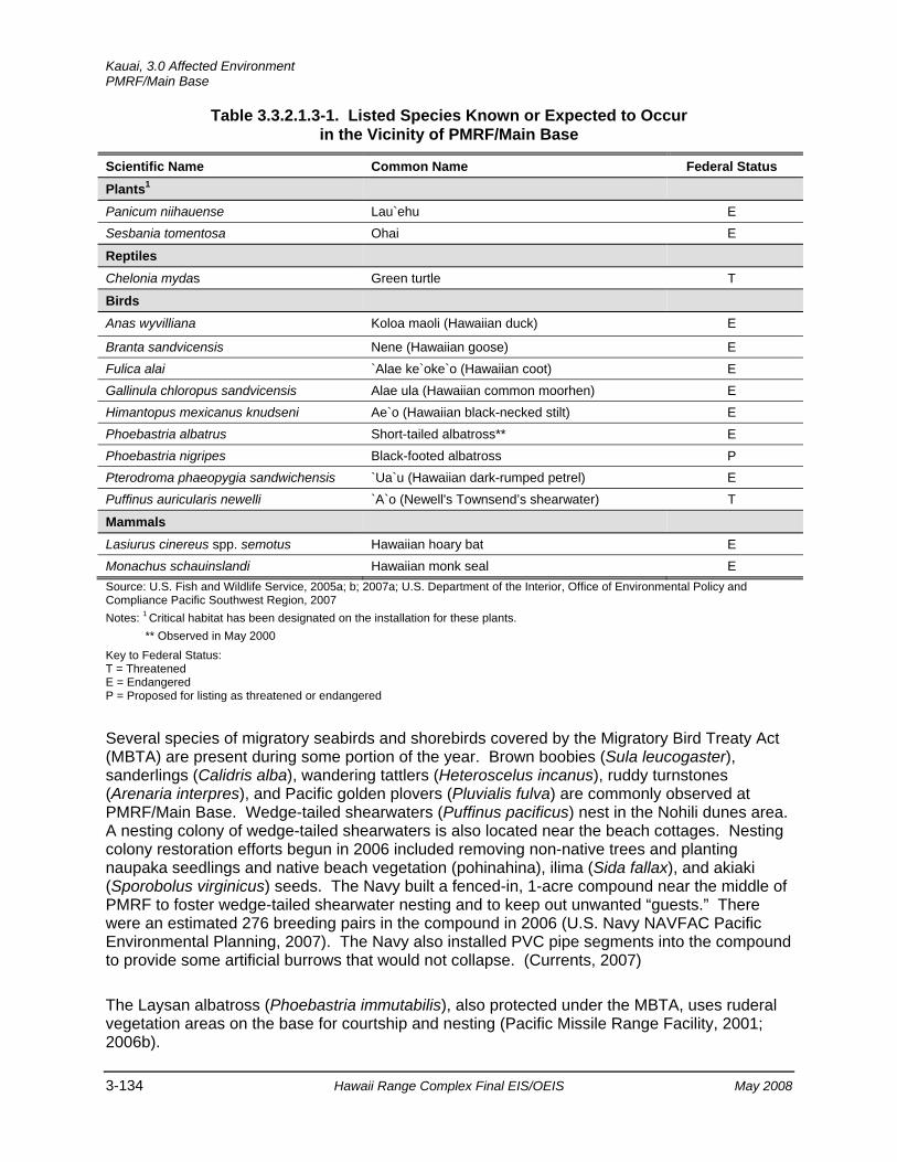
Kauai, 3.0 Affected Environment PMRF/Main Base
3-134 Hawaii Range Complex Final EIS/OEIS May 2008
Table 3.3.2.1.3-1. Listed Species Known or Expected to Occur in the Vicinity of PMRF/Main Base
Scientific Name Common Name Federal Status Plants1
Panicum niihauense Lau`ehu E Sesbania tomentosa Ohai E
Reptiles
Chelonia mydas Green turtle T
Birds
Anas wyvilliana Koloa maoli (Hawaiian duck) E
Branta sandvicensis Nene (Hawaiian goose) E Fulica alai `Alae ke`oke`o (Hawaiian coot) E Gallinula chloropus sandvicensis Alae ula (Hawaiian common moorhen) E Himantopus mexicanus knudseni Ae`o (Hawaiian black-necked stilt) E Phoebastria albatrus Short-tailed albatross** E Phoebastria nigripes Black-footed albatross P Pterodroma phaeopygia sandwichensis `Ua`u (Hawaiian dark-rumped petrel) E Puffinus auricularis newelli `A`o (Newell's Townsend’s shearwater) T
Mammals
Lasiurus cinereus spp. semotus Hawaiian hoary bat E Monachus schauinslandi Hawaiian monk seal E Source: U.S. Fish and Wildlife Service, 2005a; b; 2007a; U.S. Department of the Interior, Office of Environmental Policy and Compliance Pacific Southwest Region, 2007 Notes: 1 Critical habitat has been designated on the installation for these plants.
** Observed in May 2000 Key to Federal Status: T = Threatened E = Endangered P = Proposed for listing as threatened or endangered
Several species of migratory seabirds and shorebirds covered by the Migratory Bird Treaty Act (MBTA) are present during some portion of the year. Brown boobies (Sula leucogaster), sanderlings (Calidris alba), wandering tattlers (Heteroscelus incanus), ruddy turnstones (Arenaria interpres), and Pacific golden plovers (Pluvialis fulva) are commonly observed at PMRF/Main Base. Wedge-tailed shearwaters (Puffinus pacificus) nest in the Nohili dunes area. A nesting colony of wedge-tailed shearwaters is also located near the beach cottages. Nesting colony restoration efforts begun in 2006 included removing non-native trees and planting naupaka seedlings and native beach vegetation (pohinahina), ilima (Sida fallax), and akiaki (Sporobolus virginicus) seeds. The Navy built a fenced-in, 1-acre compound near the middle of PMRF to foster wedge-tailed shearwater nesting and to keep out unwanted “guests.” There were an estimated 276 breeding pairs in the compound in 2006 (U.S. Navy NAVFAC Pacific Environmental Planning, 2007). The Navy also installed PVC pipe segments into the compound to provide some artificial burrows that would not collapse. (Currents, 2007)
The Laysan albatross (Phoebastria immutabilis), also protected under the MBTA, uses ruderal vegetation areas on the base for courtship and nesting (Pacific Missile Range Facility, 2001; 2006b).
3.0 Affected Environment, Kauai
PMRF/Main Base
May 2008 Hawaii Range Complex Final EIS/OEIS 3-135
The Laysan albatross is being discouraged from nesting at PMRF to prevent interaction between the species and aircraft using the runway. Albatross on the airfield are tagged and released on the north portion of the base or returnees are relocated to Kilauea National Wildlife Refuge in order to prevent bird/aircraft strikes. This action is accomplished under a U.S. Fish and Wildlife (USFWS) permit. During the nesting season, PMRF staff in cooperation with the U.S. Department of Agriculture’s Animal and Plant Health Inspection Service and the Kauai National Wildlife Refuge Complex relocates viable PMRF albatross eggs to Kilauea Point and other north shore nest sites to replace eggs that would never hatch. All of the resulting chicks were accepted by new surrogate parents and should now return to the north shore when old enough to mate. With no chicks to feed, the adult albatross returned to the open sea. This surrogate parenting program continues through the 2007/2008 nesting season and is anticipated to continue as long as viable eggs are available at PMRF/Main Base. Thirty-seven eggs were placed with surrogate parents during the 2007 season (Burger, 2007e). (Burger, 2007a; U.S. Fish and Wildlife Service, 2005b; U.S. Department of the Navy, 1998a; U.S. Army Space and Missile Defense Command, 2001)
Feral dogs (Canis familiaris) and cats (Felis catus) occur in the region and prey on native and introduced species of birds. Rodents including the Polynesian black rat (Rattus exulans), Norway or brown rat (Rattus norvegicus), and the house mouse (Mus musculus) are also known to occur in the region. (U.S. Department of the Navy, 1998a; U.S. Army Space and Missile Defense Command, 2001) PMRF has an ongoing feral animal-trapping program to protect the albatross as well as the wedge-tail shearwater and other birds on base (Burger, 2007a). Reptiles observed on PMRF/Main Base during recent surveys were the house gecko (Hemidactylus frenatus), mourning gecko (Lepidodactylus lugubris), and snake-eyed skink (Cryptoblepharus poecilopleurus). The only amphibian observed was the marine toad (Bufo marinus). (Pacific Missile Range Facility, 2006c; U.S. Department of the Navy, 1998c; U.S. Army Space and Missile Defense Command, 2001)
Wildlife on KTF is similar to that described above for PMRF/Main Base. Birds on KTF include resident species such as the red junglefowl (Gallus gallus), ring-necked pheasant, and northern mockingbird. Non-resident species identified include the short-eared owl, brown noddy (Anous stolidus), and great frigate bird (Fregata minor). The Laysan albatross has also been observed in the KTF area. Feral dogs and cats occur in the region. Rodents including the roof rat (Rattus rattus), Norway or brown rat, and the house mouse are also expected to be present on KTF. (Pacific Missile Range Facility, 2001)
Threatened and Endangered Wildlife Species
Seven birds Federally listed as threatened or endangered are potentially present or confirmed in the PMRF area (Table 3.3.2.1.3-1). The black-footed albatross, a seabird that has recently been proposed for listing as threatened or endangered (U.S. Fish and Wildlife Service, 2007b), has also been observed on PMRF. According to the Navy and USFWS, the nene (Branta sandvicensis) is present on PMRF/Main Base (U.S. Department of the Interior, Office of Environmental Policy and Compliance Pacific Southwest Region, 2007). Kauai provides the majority of Hawaii’s habitat for the threatened Newell's shearwater. The Newell's shearwater nests from April to November in the interior mountains of Kauai. Fledglings leave the nesting grounds at night in October and November and head for the open ocean. They may become temporarily blinded by lights when flying near brightly lit urban areas or street lights, and some may collide with trees, utility lines and light poles, buildings, and automobiles. PMRF personnel have retrofitted their outdoor lighting with hoods that direct the lights downward to prevent
Kauai, 3.0 Affected Environment PMRF/Main Base
3-136 Hawaii Range Complex Final EIS/OEIS May 2008
confusing the seabirds, which can be disoriented by upward- and outward-shining lights (Honolulu Advertiser, 2006). (Audubon, 2006; Hawaii Department of Land and Natural Resources, no date[a])
The Hawaiian dark-rumped petrel, which is federally listed as endangered and protected by the MBTA, arrives in February and may traverse the area from its nesting grounds to the sea. On Kauai, several grounded dark-rumped petrel fledglings have been collected in recent years as part of the Newell's shearwater recovery program. Most birds have been found near the mouth of Waimea Canyon, indicating that some birds still breed in the vicinity. Dark-rumped petrels are nocturnal over land and are active from about 1 hour after sunset until about 1 hour before sunrise. Nesting occurs from April through May. Chicks begin hatching in late June and fledge in late October to November, slightly earlier than that of the Newell's Townsend’s shearwater. (Audubon, 2006; Virginia Tech Conservation Management Institute, 1996)
The Hawaiian coot (Fulica alai), Hawaiian black-necked stilt (Himantopus mexicanus knudseni), Hawaiian common moorhen (Gallinula chloropus sandvicensis), and Hawaiian duck (Anas wyvilliana) are endangered waterbirds that have been observed in the drainage ditches and ponds on PMRF/Main Base. The Hawaiian coot, black-necked stilt, and common moorhen are listed as migratory species (U.S. Fish and Wildlife Service, 2006c), but nest year-round, May through September, and April through October respectively. (U.S. Department of the Navy, 1998a)
The Hawaiian hoary bat (Lasiurus cinereus spp. semotus) is listed as a Federal and State endangered species. It has been recorded at PMRF; a group of four was observed foraging around the sewage treatment ponds, and another group of five bats was seen just offshore of northern PMRF/Main Base. It has also been observed at the Polihale State Park north of the base. (Pacific Missile Range Facility, 2001)
The threatened Newell’s shearwater and endangered Hawaiian coot, Hawaiian black-necked stilt, Hawaiian common moorhen, and Hawaiian duck are potentially present or confirmed within or near the KTF area. The endangered Hawaiian hoary bat has been observed at the Polihale State Park north of KTF. (Pacific Missile Range Facility, 2001)
Two marine wildlife species Federally and State listed as threatened or endangered commonly occur on PMRF/Main Base. The endangered Hawaiian monk seal has been observed at PMRF. The first Hawaiian monk seal birth recorded on a Kauai beach since 1993 occurred on PMRF in 1999 (Marine Mammal Commission, 2003; Pacific Missile Range Facility, 1999). Two and three pups were born on Kauai beaches in 2003 and 2004 respectively (Kauai Monk Seal Watch Program, 2003; National Oceanic and Atmospheric Administration, 2006d; National Marine Fisheries Service, 2007e). Three pups were born on Kauai in 2005 and four pups were born in 2006 (National Oceanic and Atmospheric Administration, 2006d; National Marine Fisheries Service, 2007e). Pups are born between February and August. Sitings of Hawaiian monk seal haul outs are documented by the PMRF Environmental Office.
Green turtles have been observed basking on shore in the vicinity of Nohili Ditch; the only area where basking/haul-out activity on PMRF/Main Base is observed. The PMRF Natural Resources Manager monitors sea turtle activity at PMRF. Green turtles have not nested anywhere along the beachfront. In the past 3 years only one apparent “false nesting” has been
3.0 Affected Environment, Kauai
PMRF/Main Base
May 2008 Hawaii Range Complex Final EIS/OEIS 3-137
observed. (Burger, 2007b) Security patrols reports include a record of the presence and locations of turtles. Any records of green turtle sitings are maintained by the PMRF Environmental Office. (Pacific Missile Range Facility, 2001)
Environmentally Sensitive Habitat Wetlands
Wetlands are associated with (1) the Mana base pond located outside the industrial area of the facility boundaries; (2) Kawaiele wildlife sanctuaries that include a State Waterbird Refuge for Hawaii's four endangered waterbird species, created at Mana during a sand removal program; and (3) agricultural drains from the Nohili and Kawaiele ditches within PMRF/Main Base. (National Wetlands Inventory, 2007) The freshwater discharge at Nohili Ditch appears to be at least partially responsible for the preferred turtle foraging habitat since it stimulates filamentous algae growth on the nearshore reef bench (Commander, Navy Region Hawaii, 2007).
Two marine system, subtidal subsystem, reef class, coral subclass, subtidal wetlands exist along part of the coastline west of KTF. (Pacific Missile Range Facility, 2001)
Critical Habitat
A proposed rule to designate critical habitat for 76 listed plant species on the islands of Kauai and Niihau published in November 2000 (U.S. Fish and Wildlife Service, 2000) included land in the northwestern end of PMRF near Polihale Park as critical habitat for the endangered ohai and lau`ehu. In January 2002, the USFWS proposed critical habitat for additional plant species on Kauai and Niihau, revising the total number of plants to 83, which included additional land in the southern portion of PMRF for protection of lau`ehu. (U.S. Fish and Wildlife Service, Pacific Region, 2002; U.S. Fish and Wildlife Service, 2002) The USFWS reevaluated the dune habitat on PMRF and the habitat on Navy land at Makaha Ridge and determined that these lands were not essential for the conservation of ohai or dwarf iliau (Wilkesia hobdyi, found on Makaha Ridge). Although lau`ehu does not grow on PMRF/Main Base, the USFWS has determined that land on PMRF adjacent to Polihale State Park and dune areas along the southern portion of the range contain primary constituents necessary for the recovery of lau`ehu because not enough areas exist outside of PMRF (Figure 3.3.2.1.3-1). The USFWS designated these areas as unoccupied critical habitat because there are not enough other areas outside the base that contain the elements to achieve the USFWS’s goal of 8 to 10 populations. (U.S. Fish and Wildlife Service, 2003a)
The areas of unoccupied critical habitat for the lau`ehu established along the coast of PMRF include the KTF coastal area and the area adjacent to Kokole Point. Lau`ehu has not been observed on KTF. (Pacific Missile Range Facility, 2001; U.S. Fish and Wildlife Service, 2003a)
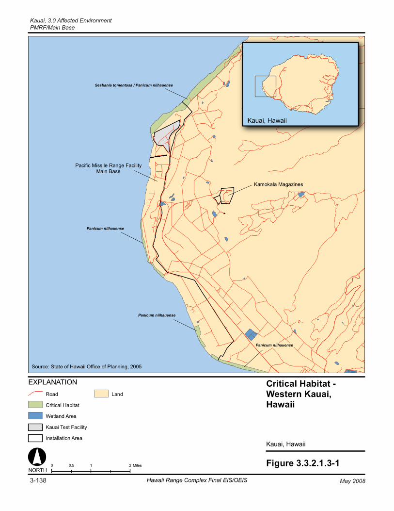
Figure 3.3.2.1.3-10 1 20.5 MilesNORTH
Critical Habitat - Western Kauai,Hawaii
Kauai, Hawaii
Pacific Missile Range FacilityMain Base
Kamokala Magazines
Panicum niihauense
Sesbania tomentosa / Panicum niihauense
Panicum niihauense
Panicum niihauense
EXPLANATION
Critical Habitat
Land
Wetland Area
Installation Area
Kauai Test Facility
Source: State of Hawaii Office of Planning, 2005
Kauai, Hawaii
Road
3-138 May 2008Hawaii Range Complex Final EIS/OEIS
Kauai, 3.0 Affected EnvironmentPMRF/Main Base
3.0 Affected Environment, Kauai
PMRF/Main Base
May 2008 Hawaii Range Complex Final EIS/OEIS 3-139
3.3.2.1.4 Cultural Resources—PMRF/Main Base Appendix C includes a description of cultural resources and the laws and regulations pertaining to them.
Region of Influence The region of influence for terrestrial cultural resources at PMRF/Main Base/KTF consists of areas throughout the installation. These areas include existing launch pads and locations for the construction of new facilities and infrastructure features (e.g., Directed Energy facilities) (see Figures 2.2.2.5.1-2, 2.2.3.6.4-5, and 2.2.4.5-1). Survey data indicate that most of the proposed construction locations are surficially devoid of archaeological sites; however, subsurface archaeological and traditional cultural materials (particularly burials) could be present anywhere within the boundary of the installation. Locations for the proposed warehouse and consolidated Range Operations complex (see Figure 2.2.3.6.4-5) are located with an area of medium sensitivity for burials. Building 282, where a new Automatic Identification System antenna is planned, has not been recommended as a historic building (see Appendix H).
Affected Environment
Archaeological Resources (Prehistoric and Historic) Brief Prehistory/Early History
PMRF/Main Base and KTF are situated in a region known as Mana. Throughout prehistory, large areas of the Mana Plain were covered by the great Mana swamp, allowing Native Hawaiians to canoe as far south as Waimea (Von Holt, 1985; State of Hawaii, 1993). It is believed that these wet conditions encouraged the independent invention of aquaculture on Kauai and the construction of stone and earthen ponds for growing staples such as taro, yam, and sweet potatoes (Kikuchi, 1987). After the arrival of Europeans to the island, aquaculture transitioned to agriculture through the eventual draining of the swamp and the cultivation of sugar cane and rice. The first successful sugar plantation to export from the islands was established at Koloa in 1835 (Hawaii Visitors Bureau, 1993), and by the 1930s, nearly all of the Mana swamp had been filled to produce this crop.
Brief Military History
In 1940, 549 acres in Mana were deeded to the U.S. War Department for an Army Air Corps flight training field. The Navy was given permission to use the facilities in 1944; however, after the Air Force was established (1947), it assumed control of the facility (redesignated Barking Sands Air Force Base), and continued operations through the Korean War years. In 1953, the base was re-named Bonham Air Force Base and in 1961, the U.S. Departments of the Air Force and Navy were operating the facility under a joint use agreement. In 1964, 1,884 acres of the Mana Plain were officially transferred to the Navy, and by 1966 the facility was renamed PMRF (International Archaeological Resources Institute, Inc., 2005).
Throughout the Cold War years (1946-1991), PMRF supported both offensive and defensive Cold War missions, including offensive weapons managed by the Navy, air defense weapons managed by the Hawaii Air National Guard, and research into ballistic missile defensive systems. PMRF also supported atmospheric nuclear testing by the Atomic Energy Commission, which led to the establishment of the KTF in the early 1960s. In 2007, PMRF is the largest instrumented multi-environment test range in the world. The range is unique in providing
Kauai, 3.0 Affected Environment PMRF/Main Base
3-140 Hawaii Range Complex Final EIS/OEIS May 2008
realistic testing environments for anti-submarine, air, surface, and subsurface weapons systems. The installation also provides services for training, tactics development, and evaluation of air, surface, and subsurface weapons systems for the Navy, other Department of Defense (DoD) agencies, foreign military forces, and private industry (International Archaeological Resources Institute, Inc., 2005).
Native Hawaiian (Traditional) Information
Mana is an area specifically referred to in Hawaiian literature and oral tradition as a leina-a-ka-uhane, a place (generally cliffs or seacoast promontories) where the spirits of men, after death, plunge into eternity and are divided into one of three spiritual realms: the realm of the wandering spirits; the realm of the ancestral spirits; or the realm of the endless night (Han, et al., 1986; Fornander, 1917). Typical of Native Hawaiian mortuary practices, burial sites believed to be associated with the Mana leina-a-ka-uhane have been identified throughout the area.
Large portions of PMRF have been systematically surface surveyed for archaeological resources; however, subsurface features may still be present (West and Desilets, 2005). Previous investigations have identified a variety of prehistoric and historic resources, including burial sites, heiaus (temples), campsites, house sites, lithic (stone) scatters, aquaculture ponds, and modern military-associated sites, any or all of which could be potentially eligible for inclusion in the National Register of Historic Places (NRHP). Appendix H includes a list of significant archaeological and traditional resources (International Archaeological Resources Institute, Inc., 2005).
Historic Buildings and Structures Since 1991, several architectural evaluations have been conducted for PMRF, including PMRF/Main Base, Kamokala Ridge, and Port Allen (Drolet et al., 1996; Rechtman, et al., 1998). The evaluations covered pre-military facilities and features, as well as World War II and Cold War era resources. Appendix H includes a list of the buildings and structures recommended eligible for inclusion in the NRHP (International Archaeological Resources Institute, Inc., 2005).
Traditional Resources Traditional resources can include archaeological sites, burial sites, ceremonial areas, natural features (e.g., caves, mountains, water sources, trails, plant habitat, or gathering areas), or any other natural area important to a culture for religious or heritage reasons. As such, many of the cultural materials identified within the region of influence could also be considered traditional resources. In addition to Native Hawaiians, several other cultures have also inhabited the island of Kauai. These include the Japanese, Korean, Portuguese, Chinese, and Filipino. A Japanese cemetery is located within the boundary of PMRF, and cemeteries associated with each of the other cultures are located near Kekaha, Hanapepe, and Waimea.
A comprehensive cultural study of the Mana Plain was carried out by Flores and Kaohi in 1992 as part of investigations related to the proposed Strategic Defense Command Energy Dispersive X-Ray Analysis project (U.S. Army Strategic Defense Command, 1990). This study included historical research, review of documented Hawaiian traditions, and oral history interviews with knowledgeable local residents.
3.0 Affected Environment, Kauai
PMRF/Main Base
May 2008 Hawaii Range Complex Final EIS/OEIS 3-141
Intensive historical research and a review of traditions were also undertaken by Maly and Wulzen (1997) as part of an extensive reconnaissance survey of PMRF Barking Sands and Makaha Ridge. Oral histories were collected by McGerty and Spear (1997) for a project that technically covered an area inland of PMRF Barking Sands. Oral history information, however, is pertinent to the Mana Plain in general and thus provides a cultural context for PMRF.
In 1999, traditional cultural properties on Navy lands in Hawaii were assessed. The PMRF research was conducted by Alitha Kachi and Kalani Flores, with some additional research by Tuggle and Tomonari-Tuggle. The assessment lists Kawaiele Ditch, Nohili Dune, and Elekuna Heiau as potential traditional cultural properties. Identified traditional Hawaiian sites under the jurisdiction of PMRF are listed in Appendix H. Traditional sites recommended as eligible for listing in the NRHP are listed in Appendix H.
Burials
Burials are the most significant cultural resources concern within the sandy soils of PMRF. There have been numerous inadvertent discoveries of human remains in both the coastal and back bay areas of the installation. The sites represent both traditional Hawaiian and Plantation-era periods (see Appendix H).
3.3.2.1.5 Geology and Soils—PMRF/Main Base Geology and soils are considered earth resources that may be adversely affected by proposed training and RDT&E activities. This resource is described in terms of existing information on the land forms, geology, and associated soil development as it may be subject to erosion, flooding, mass wasting, mineral resource consumption, contamination, and alternative land uses resulting from proposed construction and launch activities. Appendix C includes a description of geology and soils.
Region of Influence Geology and soils are considered resources that may be adversely affected by proposed training and RDT&E activities. These resources are described in terms of existing information on land forms, geology, and associated soil development.
Affected Environment
Physiography PMRF/Main Base is situated on a strip of low-lying coastal terrace called the Mana Plain. The plain bounds the western flank of the island, forming gentle westerly slopes ranging from about 2 percent near the volcanic uplands to relatively flat over the coastal margin occupied by PMRF/Main Base. The plain does not form cliffs at the PMRF/Main Base shoreline. Local relief is formed by low beach barrier dunes, mildly undulating blanket sands, and the more prominent Nohili Dune located in the northern portion of PMRF/Main Base, adjacent to the northwestern side of KTF at Nohili Point. Ground elevations over the facility average between 10 ft to 20 ft, rising to 100 ft at Nohili Dune. PMRF/Main Base is not traversed by perennial or ephemeral streams. Surface runoff is controlled by manmade channels located at Nohili Ditch on northern PMRF/Main Base, Kawaiele Drainage in central PMRF/Main Base, and a drainage channel just south of Kawaiele Drainage.
Kauai, 3.0 Affected Environment PMRF/Main Base
3-142 Hawaii Range Complex Final EIS/OEIS May 2008
Geology Kauai is the result of a massive shield volcano, part of the chain of similar volcanoes that migrated northwest to southeast to form the Hawaiian archipelago. Kauai is the oldest of the eight main islands. Volcanic rocks exposed in the western half of the island are composed of Pliocene basaltic flows of the Waimea Volcanic Series (U.S. Army Strategic Defense Command, 1992). The volcanic terrain forms an abrupt, crescent-shaped scarp at the eastern boundary of the Mana Plain, the result of wave action from a higher sea stand. The surface of the volcanic basement complex plunges beneath the Mana Plain at approximately 5 degrees (U.S. Army Strategic Defense Command, 1992).
The Mana Plain is composed of alluvium, lagoon, beach, and dune deposits that overlie the volcanic basement. This sedimentary sequence forms a wedge that thickens east to west, attaining an approximate thickness of 200 ft at the eastern base boundary, increasing to about 400 ft at the coast (U.S. Army Strategic Defense Command, 1992). Older and younger terrestrial alluvium interfingers with gypsum-bearing clayey lagoonal deposits and marine offshore deposits at depth. Sediments are characteristically red and brown near volcanic outcrops, changing to tan and gray calcareous sand near the coast.
The surface of the Mana Plain typically consists of loose sand associated with younger (Modern) alluvium and flattened dunes with little relief (U.S. Army Strategic Defense Command, 1992). The dune sands can be of substantial thickness along the coastal margin where they have been reported to be in excess of 42 ft thick at the Kokole Point housing area (U.S. Army Strategic Defense Command, 1992). The dunes are composed of loose fine sand and silty sand that is weakly to strongly indurated (hardened) a few meters below ground surface. This indurated surface can form resistant remnants, or fossil dunes, fronting the beach along some reaches of the PMRF shoreline. The beach berm is about 10 ft high and is breached only where drainage canals have been excavated at Nohili and Kawaiele (U.S. Army Strategic Defense Command, 1992).
Coral reefs developed on the eroded platform around the island when the sea was about 5 ft above its current level (U.S. Army Strategic Defense Command, 1992). Wave action has eroded the coral surface, creating a primary source for beach sand which is actively being deposited and reworked along the shoreline. Coral reefs are also discussed in Section 3.3.1.1.1. Beach sand is generally medium to coarse grained.
Soil The U.S. Department of Agriculture Soil Conservation Service published a soil survey that includes the surficial deposits of the Mana Plain (PMRF and Easement areas). The dominant soil within the PMRF area has been mapped as Jaucas loamy fine sand, 0 to 8 percent slopes (U.S. Army Strategic Defense Command, 1992). The U.S. Department of Agriculture describes this soil as occurring on old (inactive) beaches and on windblown sand deposits. It is pale brown to very pale brown sand, and in some cases it is more than 5 ft deep. In many places, the surface layer is dark brown as a result of accumulated organic matter and alluvium. The silt is neutral to moderately alkaline through its profile. It has an available water capacity of 0.05 to 0.07 inch per foot of soil (U.S. Army Strategic Defense Command, 1992). The soils are permeable, and infiltration is rapid. Wind erosion is severe where vegetation has been removed.
3.0 Affected Environment, Kauai
PMRF/Main Base
May 2008 Hawaii Range Complex Final EIS/OEIS 3-143
Along the ocean margin of PMRF/Main Base are areas of active dunes and beaches. Dune lands consist of hills and ridges of sand drifted and piled by the wind. The hills and ridges are actively shifting, or so recently stabilized that no soil horizons have developed. The sand is chiefly calcareous, derived from coral and seashells (U.S. Army Strategic Defense Command, 1992).
Soil samples at the Vandal launch site were obtained to determine if lead concentrations exceeded the 400 milligrams per kilogram (mg/kg) cleanup goal established by the Hawaii Department of Health for residential use. No site soil samples had lead concentrations exceeding 400 mg/kg prior to the 1994 Vandal launches. After five 1994 launches, two sites contained lead concentrations exceeding 400 mg/kg. Both of these sites were located within 50 ft of the launch site. Concentrations of lead 100 ft away in the same direction were only 30 and 75 mg/kg. None of the lead concentrations outside this 100-ft range were above the reporting limit. (U.S. Department of the Navy, Naval Facilities Engineering Command, Pearl Harbor, 1996)
Although the Vandal target missile is no longer used, past launches from PMRF appear to have caused elevated lead concentrations in soil only within 100 ft of the launch mechanism. The locations of these soil samples suggest that lead concentrations do not pose an immediate risk to human health because the launch pad is restricted from public access and that none of the apparently contaminated sand has been or will be transported to the beach.
A study was conducted by the Department of Energy to determine if elevated aluminum concentrations occur at PMRF/Main Base and/or KTF as a result of rocket emissions. Analysis of background aluminum levels from Mana Plain soils ranged from 0.2 to 1.1 ounces per pound (oz/lb). Kauai soil aluminum values range from 0.09 to 0.7 oz/lb. Deposits of gibbsite, the trihydrate of aluminum oxide, occur naturally in the high rainfall areas of windward Kauai (Land Study Bureau, 1967). The study suggested that if there has been an increase in the amount of aluminum in the soil at PMRF/Main Base as a result of rocket emissions, the total amount is still less than nearby soils.
KTF also tested for lead and found levels up to 270 mg/kg and indicated that these were not “actionable levels” (U.S. Army Strategic Defense Command, 1992). The KTF report described studies of lead poisoning in children, which found that levels of lead of 300 to 400 mg/kg (300 to 400 parts per million) are acceptable. An additional study of the soils of the Mana Plain and KTF area revealed that chloride and pH do not indicate residual effects from past missile launches at KTF.
3.3.2.1.6 Hazardous Materials and Waste—PMRF/Main Base Appendix C includes a discussion of hazardous materials and waste resource laws and regulations.
Region of Influence The region of influence for hazardous materials and hazardous waste would be limited to areas of PMRF/Main Base, including KTF, to be used for launch preparation, launch, and post-launch activities and in areas where hazardous materials are stored and handled.

Kauai, 3.0 Affected Environment PMRF/Main Base
3-144 Hawaii Range Complex Final EIS/OEIS May 2008
Affected Environment
Hazardous Materials PMRF manages hazardous materials through the Navy’s Consolidated Hazardous Materials Reutilization and Inventory Management Program (CHRIMP). CHRIMP mandates procedures to control, track, and reduce the variety and quantities of hazardous materials in use at facilities. The CHRIMP concept established Hazardous Materials Minimization Centers as the inventory controllers for Navy facilities. All departments, tenant commands, and work centers must order hazardous materials from the Hazardous Materials Minimization Centers, where all such transactions are recorded and tracked. The exception to this is KTF, which obtains its hazardous materials through Department of Energy channels. Hazardous materials on PMRF are managed by the operations and maintenance contractor through CHRIMP. Hazardous materials managed through the CHRIMP program other than fuels are stored in Building 338. Typical materials used on PMRF/Main Base and stored at Building 338 include cleaning agents, solvents, and lubricating oils.
PMRF has management plans for oil and hazardous materials outlined in the PMRF Spill Prevention Control and Countermeasures Plan and the Installation Spill Contingency Plan. These plans regulate both PMRF/Main Base as well associated sites and tenant organizations, including KTF, Makaha Ridge, Kokee, Kamokala Magazines, and Port Allen.
PMRF has developed programs to comply with the requirements of the Superfund Amendments and Reauthorization Act Title III and Emergency Planning and Community Right-to-Know Act. This effort has included submission to the State and local emergency planning committees of annual Tier II forms, which are an updated inventory of chemicals or extremely hazardous substances in excess of threshold limits. These chemicals at PMRF include jet fuel, diesel fuel, propane, gasoline, aqueous fire fighting foam, chlorine, used oil, paint/oils, and paint.
Hazardous Waste Management PMRF/Main Base is a large-quantity hazardous waste generator with a USEPA identification number. Hazardous waste on PMRF is not stored beyond the 90-day collection period. In 2004, PMRF/Main Base generated 35,613 lb of hazardous waste.
PMRF/Main Base has two accumulation points on base for hazardous wastes: Building 392 and Building 419. Building 392 accumulates all base waste except for OTTO (torpedo) fuel, a liquid monopropellant. Building 419 is the torpedo repair shop. At present, both buildings are not used at their maximum hazardous waste storage capacity. KTF has one hazardous waste accumulation point. Makaha Ridge and Kokee generate only used oil, which is recycled. Port Allen activities generate used oil and oily bilge water, which are taken to PMRF/Main Base to be recycled and processed. The oily bilge water is processed through an oil/water separator and then is fed into the PMRF/Main Base sewage treatment plant.
PMRF outlines management and disposal procedures for used oils and fuels in the Hazardous Waste Management Plan. PMRF maintains a Used Oil transporter/Processor Permit through the Hawaii Department of Health. Additionally, degraded jet fuel is used in crash-fire training events. The majority of wastes are collected and containerized at PMRF/Main Base for direct offsite disposal through the Defense Reutilization and Marketing Office (DRMO) at Pearl Harbor
3.0 Affected Environment, Kauai
PMRF/Main Base
May 2008 Hawaii Range Complex Final EIS/OEIS 3-145
within 90 days. The DRMO provides for the transportation and disposal of the wastes to the final disposal facility.
KTF is a small-quantity hazardous waste generator and has a USEPA identification number. There is one hazardous waste accumulation point on KTF; however, KTF has not generated enough hazardous waste for disposal since becoming a small quantity generator in 1994. (Sandia National Laboratories, 2006)
Pollution Prevention/Recycling/Waste Minimization
PMRF has a pollution prevention plan in place for the Main Base and all sites on Kauai, which follows CHRIMP procedures for controlling, tracking, and reducing hazardous materials use and waste generation. PMRF/Main Base currently has three hazardous waste elimination programs in place. These involve recycling toner cartridges, mercury from mercury lamps, and acid/lead batteries.
Installation Restoration Program
PMRF/Main Base has 19 Installation Restoration Program (IRP) sites. Two fire fighting training pits, the battery acid disposal, three former oil change pits, a battery acid neutralization unit and the torpedo post run facility require no further action based on the results of past investigations and approval by the Hawaii Department of Health. Three landfills (5, 6, and 7), tanker truck pod facility, former missile (Regulus) defueling pit, and the former oil/fuel pipeline are scheduled to be investigated in FY 2011. A site investigation of transformer sites (four) and the reclamite asphalt rejuvenation burial areas is complete. A recommendation for a No Further Action was sent to the Hawaii Department of Health for these sites.
KTF has no Environmental Restoration sites. Three Environmental Restoration sites were identified in 1995 and were given a No Further Action determination by USEPA in 1996 (Sandia National Laboratory, 2006).
Underground and Aboveground Storage Tanks
PMRF/Main Base has nine 50,000-gal field constructed underground storage tanks (USTs) located at the Fuel Farm, one 30,000-gal UST located at the Power Plant, two 5,000-gal USTs at the Navy Exchange, three 5,000-gal USTs at the gasoline station, and one 1,000-gal UST at the Calibration Lab. With the exception of the field constructed tanks, all tanks are double-walled, fiberglass-reinforced plastic. All USTs are equipped with a leak detection system. (Burger, 2006)
There are two 25,000-gal aboveground storage tanks (ASTs) at the Kokee Power Plant, two 6,000-gal diesel ASTs and one 1,000-gal AST at Makaha Ridge, three 200-gal ASTs near building 510 and one 1,000-gal AST near building 450. All tanks have proper capacity spill containment systems. (Burger, 2006)
There is one UST and one 10,000-gal aboveground fuel tank at KTF. KTF complies with PMRF’s management plans for oil and hazardous materials outlined in the PMRF Spill Prevention Control and Countermeasures Plan and the Installation Spill Contingency Plan. (Sandia National Laboratories, 2006)
Kauai, 3.0 Affected Environment PMRF/Main Base
3-146 Hawaii Range Complex Final EIS/OEIS May 2008
Asbestos, Lead-Based Paint, and Polychlorinated Biphenyls
PMRF manages asbestos in accordance with the base asbestos management plan. Prior to any construction projects, areas to be disturbed are surveyed for asbestos, and any asbestos is removed, before disturbance, by a certified asbestos contractor. The handling of hazardous materials and the potential generation and disposal of hazardous wastes follow ongoing, standard, and applicable regulations and procedures at PMRF.
All facilities associated with PMRF follow its lead-based paint management plan. The exception is KTF, which follows Department of Energy plans for the removal of lead-based paint wastes.
No known components at PMRF/Main Base contain polychlorinated biphenyl (PCBs). In the event that components containing PCBs are found at PMRF/Main Base and become waste, they would be labeled according to the Toxic Substances Control Act, 40 CFR 761, requirements for shipping, and disposed of through the DRMO or a contractor within 1 year of the waste’s initial storage.
KTF follows the Department of Energy plans for the removal of any lead-based paint wastes. The transformers on the KTF site have been tested and are free of PCBs, and there are no asbestos issues at the site. (Sandia National Laboratory, 2006)
Liquid Fuels and Other Toxic Fuels
PMRF uses gasoline and diesel fuels to power range trucks and equipment. Aircraft at PMRF utilize jet fuel and Jet-A. Jet-A is available at the fuel farm near the airfield. Both aircraft fuels are delivered to the flight line in refuelers.
3.3.2.1.7 Health and Safety—PMRF/Main Base Health and safety includes consideration of any activities, occurrences, or training and RDT&E activities that have the potential to affect one or more of the following:
The well-being, safety, or health of workers—Workers are considered to be persons directly involved with the training and RDT&E activities producing the effect or who are physically present at the site.
The well-being, safety, or health of members of the public—Members of the public are considered to be persons not physically present at the location of the training and RDT&E activities, including workers at nearby locations who are not involved in the training and RDT&E activities and the off-base population. Also included within this category are hazards to equipment, structures, plants, and wildlife.
Appendix C includes a detailed discussion of health and safety resources laws and regulations.
Region of Influence The region of influence for potential impact related to the health and safety of workers includes work areas associated with range operations, training, and RDT&E activities. The population of
3.0 Affected Environment, Kauai
PMRF/Main Base
May 2008 Hawaii Range Complex Final EIS/OEIS 3-147
concern includes the workers employed at PMRF/Main Base, including KTF, but also encompasses the contractor, military, and government civilian personnel directly involved with range operation, training, and RDT&E activities.
The region of influence for potential impact related to public health and safety includes the areas of Kauai County and the island of Kauai and Niihau affected by range operations, training, and RDT&E activities. These areas include the PMRF overwater training areas. The population of concern consists of visitors to Kauai and permanent residents living in Kauai County.
Affected Environment PMRF takes every reasonable precaution during the planning and execution of the range operations, training, and RDT&E activities to prevent injury to human life or property. In addition to explosive, physical impact, and electromagnetic hazards, potential hazards from chemical contamination, ionizing and non-ionizing radiation, radioactive materials, and lasers are studied by PMRF Range Safety Office to determine safety restrictions. In addition, Appendix K includes a discussion in general terms of the potential health and safety hazards associated with missile launch activities and the corresponding procedures that are in place to protect people and assets.
Range Safety Range Safety at PMRF is controlled by Range Control, which is responsible for hazard area surveillance and clearance and control of all PMRF operational areas. Range Control maintains real time surveillance, clearance, and safety at all PMRF areas including PMRF/Main Base. PMRF sets requirements for minimally acceptable risk criteria to occupational and non-occupational personnel, test facilities, and non-military assets during range operations. For all range operations at PMRF, the Range Control Officer requires a safety plan. A Range Safety Operation Plan (RSOP) is generated by PMRF Range Safety personnel prior to range operations.
The PMRF Range Safety Office is responsible for establishing Ground Hazard Areas and Launch Hazard Areas over water beyond which no debris from early flight termination is expected to fall. The Ground and Launch Hazard Areas for missile launches are determined by size and flight characteristics of the missile, as well as individual flight profiles of each flight test. Data processed by ground-based or onboard missile computer systems may be used to recognize malfunctions and terminate missile flight. Before a launch is allowed to proceed, the range is determined cleared using input from ship sensors, visual surveillance from aircraft and range safety boats, radar data, and acoustic information.
Other safety areas under PMRF’s control include radars, explosives, and airspace. All range users must: (1) provide a list of project materials, items, or test conditions that could present hazards to personnel or material through toxicity, combustion, blast, acoustics, fragmentation, electromagnetic radiation (EMR), radioactivity, ionization, or other means; (2) describe radiation, toxic, explosive, or ionization problems that could accumulate as a result of their tests; (3) provide aerodynamic and flight control information, and destruct system information and parameters; (4) submit plans, specifications, and procedural or functional steps for events and activities involving explosives to conform to criteria in the PMRF instruction; and (5) provide complete operational specifications of any laser to be used and a detailed description of its planned use. (U.S. Department of the Navy, 1998a)
Kauai, 3.0 Affected Environment PMRF/Main Base
3-148 Hawaii Range Complex Final EIS/OEIS May 2008
Missile Flight Analysis PMRF conducts missile flight safety, which takes into account potential hazards from chemical contamination, ionizing and non-ionizing radiation, radioactive materials, and lasers in accordance with Naval Air Warfare Center Weapons Division Instruction. Missile flight safety includes analysis of missile performance capabilities and limitations, of hazards inherent in missile operations and destruct systems, and of the electronic characteristics of missiles and instrumentation. It also includes computation and review of missile trajectories, launch azimuths, kinetic energy intercept debris impact areas, and hazard area dimensions, review and approval of destruct systems proposals, and preparation of the RSOP required of all programs at PMRF. These plans are prepared by the PMRF Safety Office for each mission and must be approved by the Commanding Office prior to any launch. Launch is only allowed when the risk levels are less than the acceptable risk criteria in PMRF Instruction 8020.16, which are equivalent to the criteria developed by the Range Commanders Council (e.g., RCC 321).
Ground Safety The Range Control Officer using PMRF assets is solely responsible for determining range status and setting RED (no firing – unsafe condition due to a fouled firing area) and GREEN (range is clear and support units are ready to begin the event) range firing conditions. The Range Safety Approval and the RSOP documents are required for all weapons systems using PMRF (U.S. Department of the Navy, 1998a). PMRF uses RCC 321, Common Risk Criteria for National Test Ranges. RCC 321 sets requirements for minimally-acceptable risk criteria to occupational and non-occupational personnel, test facilities, and non-military assets during range operations. Under RCC 321, the general public shall not be exposed to a probability of casualty greater than 1 in 10 million for each individual during any single mission and a total expectation of casualty must be less than 30 in 1 million. (Range Commanders Council, Range Safety Group, 2002) Figure 3.3.2.1.7-1 shows the PMRF health and safety areas including the Ground Hazard Areas associated with missile launch activities at PMRF/Main Base.
To ensure the protection of all persons and property, standard operating procedures (SOPs) have been established and implemented for the Ground Hazard Areas. These SOPs include establishing road control points and clearing the area using vehicles and helicopters (if necessary). Road control points are established 3 hours prior to launches. This allows security forces to monitor traffic that passes through the Ground Hazard Areas. At 20 minutes before a launch, the Ground Hazard Area is cleared of the public to ensure that, in the unlikely event of early flight termination, no injuries or damage to persons or property would occur. After the Range Safety Officer declares the area safe, the security force gives the all-clear signal, and the public is allowed to reenter the area. (U.S. Department of the Navy, 1998a) No inhabited structures are located within the off-base sections of the Ground Hazard Area. The potential for launch-associated hazards are further minimized through the use of the PMRF Missile Accident Emergency Team. This team is assembled for all launches from PMRF facilities and on-call for all PMRF launches in accordance with PMRF Instruction (PMRFINST) 5100.1F.
Ordnance Management and Safety Ordnance safety includes procedures to prevent premature, unintentional, or unauthorized detonation of ordnance. Any program using a new type of ordnance device for which proven safety procedures have not been established requires an Explosive Safety Approval before the
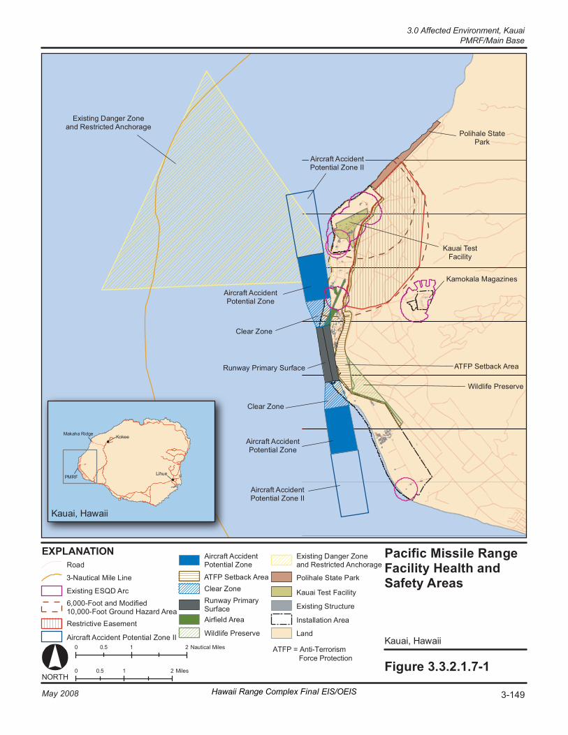
Pacific Missile Ran ge F aci li ty H eal th a nd Safety A re as
Ka ua i, Haw ai i
0 1 2 0. 5 M il es Fi gur e 3. 3. 2. 1. 7- 1
Ka ua i, Haw ai i
PM RF
Ma ka ha Ri dg e Ko ke e
Li hu e
NORT H
Ex is t in g Da ng er Z one an d Re st ri ct ed A nc ho r age
Airc ra ft A cc i den t Po t en tia l Zo ne
Cl ea r Zo ne
Ru nw ay P ri ma ry S ur fa ce
Cl ea r Zo ne
Airc ra ft A cc i den t Po t en tia l Zo ne
Po li ha le S tat e Pa rk
Ka ua i Te st Fa ci li t y
Ka mo ka la M ag az in es
Wi ld li fe P re se rv e
AT FP S et ba ck A re a
Airc ra ft A cc i den t Po t en tia l Zo ne I I
Airc ra ft A cc i den t Po t en tia l Zo ne I I
EX PL ANA TI ON
Re st ri ct iv e Ea se me nt
6, 00 0- Fo ot a nd M od if ie d 10 ,0 00 -F oo t G ro un d Ha za rd A re a
Airc ra ft A cc i den t Po t en tia l Zo ne
Cl ea r Zo ne Ru nw ay P ri ma ry Su rf ac e Airf ie ld A re a
Wi ld li fe P re se rv e
AT FP S et ba ck A re a Po li ha le S tat e Pa rk
Ka ua i Te st F ac il it y
Ro ad
Ex is t in g ES QD A rc
Ex is t in g St ru ct ur e
In st al la t io n Ar ea
La nd Airc ra ft A cc i den t P ot en tia l Zo ne II
3- Na ut ic al M ile L in e
0 1 2 0. 5 N au t ic al M il es
Ex is t in g Da ng er Z one an d Re st ri ct ed A nc ho r age
3-149May 2008 Hawaii Range Complex Final EIS/OEIS
3.0 Affected Environment, KauaiPMRF/Main Base
ATFP = Anti-Terrorism Force Protection
Kauai, 3.0 Affected Environment PMRF/Main Base
3-150 Hawaii Range Complex Final EIS/OEIS May 2008
ordnance is allowed on PMRF or used on a test range. This approval involves a detailed analysis of the explosives and of the proposed training and RDT&E activities, procedures, and facilities for surveillance and control, an adequacy analysis of movement and control procedures, and a design review of the facilities where the ordnance items will be handled.
Ordnance management procedures are found in PMRFINST 8020.5, Explosive Safety Criteria for Range Users Ordnance Operations. The Range Control Branch of the Range Programs Division is responsible for: (1) providing detailed analysis of all proposals concerning missiles or explosives and their proposed operation on the range; (2) establishing procedures for surveillance and control of traffic within and entering hazard areas; (3) reviewing the design of facilities in which ordnance items are to be handled to ensure that safety protection meets the requirements of Naval Sea System Command Publication (NAVSEAOP) -5, Ammunition and Explosives Ashore; Safety Regulations for Handling, Storing, Production, Renovation, and Shipping, Chapter 4; (4) training, certifying, and providing Launch Control Officers, Safety Monitors, and Ordnance personnel for training and RDT&E activities involving explosive ordnance; (5) assuming responsibility for the control of all emergency facilities, equipment, and personnel required in the event of a hazardous situation from a missile inadvertently impacting on a land area; (6) providing positive control of the ordering, receipt, issue, transport, and storage of all ordnance items; and (7) ensuring that only properly certified handling personnel are employed in any handling of ordnance.
Ordnance is either delivered to PMRF/Main Base by aircraft to the on-base airfield or by ship to Nawiliwili Harbor, then over land by truck transport along Highway 50 to the base (see Figure 2.1-2). The barges carrying explosives are met at Nawiliwili Harbor by trained ordnance personnel and special vehicles for transit to and delivery at PMRF/Main Base. All ordnance is transported in accordance with U.S. Department of Transportation regulations. Ordnance is stored in caves at the Kamokala Magazine area, except for the Strategic Target System, which is stored in a specially constructed facility on KTF. No mishaps involving the use or handling of ordnance have occurred at PMRF.
PMRF/Main Base has defined explosive safety-quantity distance (ESQD) arcs. The arcs are generated by launch pads, the Kamokala Magazine ordnance storage area, the Interim Ordnance Handling Pad, and the Missile Assembly/Test Buildings 573 and 685. Only the ESQD arcs generated by the Interim Ordnance Handling Pad and Building 573 are covered by a waiver or exemption. The Sandia Launcher site can accommodate a 1,250-ft ESQD arc.
A 1,250-ft ESQD Red Label Area, to handle incoming and outgoing ordnance items, is centered on the airfield taxiway, 1,250 ft from Building 412 (see Figure 3.3.2.1.7-1). A soft pad in the Red Label recovery area is used by helicopters for setting down targets and weapons recovered from the range. The 800-ft ESQD surrounding the soft pad falls totally within the Red Label ESQD area.
Ocean Area Clearance Range Safety officials manage operational safety for projectiles, targets, missiles, and other hazardous activities into PMRF operational areas. The operational areas consist of two Warning Areas (W-186 and W-188) and one Restricted Area (R-3101) under the local control of PMRF. The Warning Areas are in international waters and are not restricted; however, the surface area of the Warning Areas is listed as “HOT” (actively in use) 24 hours a day. For
3.0 Affected Environment, Kauai
PMRF/Main Base
May 2008 Hawaii Range Complex Final EIS/OEIS 3-151
special operations, multi-participant or hazardous weekend firings, PMRF publishes dedicated warning Notices to Mariners (NOTMARs) and Notices to Airmen (NOTAMs) 1 week before hazardous operations. In addition, a 24-hour recorded message is updated on the hotline daily by Range Operations to inform the public when and where hazardous operations will take place.
Prior to a hazardous operation proceeding, the range is determined to be cleared using inputs from ship sensors, visual surveillance of the range from aircraft and range safety boats, radar data, and acoustic information from a comprehensive system of sensors and surveillance from shore.
Transportation Safety PMRF transports ordnance by truck from Nawiliwili Harbor to PMRF along Highway 50 (see Figure 2.1-2). The barges carrying explosives are met at Nawiliwili Harbor by trained ordnance personnel and special vehicles for transit to and delivery at PMRF. All ordnance is transported in accordance with U.S. Department of Transportation regulations. PMRF has established PMRFINST 8023.G, which covers the handling and transportation of ammunition, explosives, and hazardous materials on the facility.
In addition, liquid fuels (e.g., nitrogen tetroxide and unsymmetrical dimethylhydrazine) are transported to KTF. These fuels can be shipped to the site by truck, aircraft or barge, which do not affect transportation routes on the island of Kauai. Transportation of these materials is conducted in accordance with U.S. Department of Transportation regulations and specific safety procedures developed for the location.
Range Control and the FAA are in direct communication in real time to ensure the safety of all aircraft using the airways and the Warning Areas. Within the Special Use Airspace, military activities in Warning Areas W-186 and W-188 are under PMRF control. Warning Areas W-189, W-187, and W-190 are scheduled through the Fleet Area Control and Surveillance Facility. Section 3.3.2.1.2 provides further airspace details.
The Warning Areas are located in international airspace. Because they are in international airspace, the procedures of the ICAO are followed. The FAA acts as the U.S. agent for aeronautical information to the ICAO, and air traffic in the region of influence is managed by the Honolulu ARTCC.
Fire and Crash Safety The Navy has developed standards that dictate the amount of fire/crash equipment and staffing that must be present based on the number and types of aircraft stationed on base, and the types and total square footage of base structures and housing. PMRF Crash/Fire is located in the base of the Air Traffic Control Tower, Building 300. Personnel are trained to respond to activities such as aircraft fire fighting and rescue in support of airfield operations, hazardous material incidents, confined space rescue, and hypergolic fuel releases, plus structure and brush fire fighting, fire prevention instruction and fire inspections.
Ambulance and Class II Emergency Medical Technician services are provided by Emergency Medical Technicians assigned to Crash/Fire. These contractor-operated services are available to military, civil service, and non-government personnel at PMRF, 24 hours a day, 7 days a
Kauai, 3.0 Affected Environment PMRF/Main Base
3-152 Hawaii Range Complex Final EIS/OEIS May 2008
week. More extensive emergency medical services are available from the West Kauai Medical Center in Waimea, 10 mi from the Main Gate at Barking Sands.
KTF KTF is a launch facility operated by Sandia National Laboratories for the Department of Energy on PMRF/Main Base through Inter-Service Support Agreements (U.S. Department of the Navy, 1998a). KTF notifies PMRF Operations, Security, Fire Department, and Ordnance/Explosive Disposal as required prior to launch and other hazardous operations. (Sandia National Laboratories, 2006)
All hazardous operations at KTF are performed under strict adherence to SOPs. A site SOP provides general requirements and guidance for all range operations at KTF, including ordnance safety, pre-launch and hazardous operations control, ordnance handling and storage facilities, liquid fuels storage and handling, and launch pad operations.
KTF rocket motors and other ordnance components are stored in explosive storage magazines by PMRF, except when needed by KTF for processing, assembly, and launch. The movement of explosives and other hazardous materials between PMRF and KTF is conducted in accordance with PMRF procedures and DoD Explosives Safety Standards.
PMRF provides fire protection and fire fighting services to KTF, and enforces base safety regulations and programs on KTF.
3.3.2.1.8 Land Use—PMRF/Main Base This section describes current land-based uses including recreational activities. The No-action Alternative will be a continuation of training and RDT&E activities which currently occur on PMRF/Main Base, and the Alternative Actions are incremental increases of training and RDT&E activities which already occur or have occurred. The Navy has no intention of expanding land ownership in the PMRF/Main Base area. Appendix C includes a definition of land use and laws and regulations that pertain to it. Additionally, Appendix I describes the circumstance by which the lands now known as PMRF came into Federal ownership.
Region of Influence The region of influence for land use includes the Main Base Complex and adjacent areas on the Mana Plain. Because KTF resides entirely within PMRF/Main Base, all discussion regarding land use and recreation stated for PMRF/Main Base would apply to KTF.
Affected Environment
On-base Land Use PMRF’s land use is managed via the 2006 Comprehensive Infrastructure Plan. The plan promotes efficient, effective use of resources through a consolidation of like land uses and the minimization, recognition, and deconfliction of existing constraints. The plan supports the protection of essential range operations from encroachment and the protection of human and natural environments (U.S. Department of the Navy, 2006b, U.S. Department of the Navy, 1998a).
3.0 Affected Environment, Kauai
PMRF/Main Base
May 2008 Hawaii Range Complex Final EIS/OEIS 3-153
According to the State Land Use Classification, PMRF is located within a conservation district (Figure 3.3.2.1.8-1). The 2000 Kauai General Plan and the Waimea-Kekaha Region Development Plan classify PMRF as a Military Land Use area. Kauai County has designated the dune area from Nohili Point to the north boundary of PMRF as a scenic ecological area.
The Nohili and Kinikini Ditches act as natural dividers, separating PMRF into three zones: North, Central, and South (Figure 3.3.2.1.8-1). The North Zone is used for rocket launches and its associated support activities, administration, and services. This includes ESQD Arcs and Ground Hazard Areas. The Central Zone contains air operations, administration, supply, base services, range operations, ordnance maintenance, and fuel/supply. In addition, the runway has Clear Zones and Accident Potential Zones (I & II) as safety measures which are discussed further in Section 3.3.2.1.7. The South Zone contains housing, personnel support, recreational, communications and rocket launcher facilities (KTF). ESQDs and Ground Hazard Areas exist for the rocket launcher pad as well. Additionally, KTF, as shown in Figure 3.3.2.1.8-1 is located in the northern portion of PMRF/Main Base. Sandia National Laboratories operates KTF for the Department of Energy and provides testing, evaluation, research and development of rocket systems (Sandia National Laboratories, 2006; U.S. Department of Defense, 2006).
On-base Recreation Recreational services available to military and civilian personnel include an auto hobby shop, a craft center, a 200-seat outdoor movie theater, a recreation center, a wood hobby shop, and a racquetball/handball court. Outdoor facilities include three tennis courts, a lighted golf driving range, a lighted softball field, a lighted multi-purpose playing court, a year-round swimming pool, and an 18-hole miniature golf course (U.S. Department of the Navy, 1998a).
Public access to the installation’s approximately 200 ft wide by 2 mi long coastline is outlined in PMRF Instruction 5530.7 (March 2004). Individuals who can demonstrate Kauai residency can obtain a PMRF-approved beach access pass, which allows them access to the beach recreation area of Majors Bay at PMRF/Main Base. PMRF Range Operations maintains a 24-hour hotline, which is updated daily in order to provide information on recreational area access. Recreational activities include surfing, fishing, and boating. The physical areas accessible for fishing/surfing/recreation/and socializing run from Shenanigans (All-hands club) up to KiniKini Ditch (south end of runway). Under PMRF Instruction 5530.7, normal access is allowed 7 days a week from 6:00 am to 30 minutes after sunset, except during heightened force protection conditions or range operational periods.
Off-base Land Use Current land uses adjacent to PMRF are agricultural, recreational, and a landfill. No inhabited buildings are within these areas. The non-developed, open-type uses of these adjacent lands are compatible with range operations and safety requirements of PMRF. The State Land Use District Boundary Map classifies adjacent lands to the north of PMRF/Main Base (Polihale State Park) and adjacent lands to the South of PMRF/Main Base (Kekaha Landfill), as conservation (Figure 3.3.2.1.8-1). Adjacent lands to the east of PMRF/Main Base are classified as agricultural (formerly sugar cane fields). To the west of PMRF/Main Base is the Pacific Ocean (for Naval training and recreational activities). The County of Kauai classifies adjacent lands as open and agricultural. The State and County’s designations are compatible with base activities
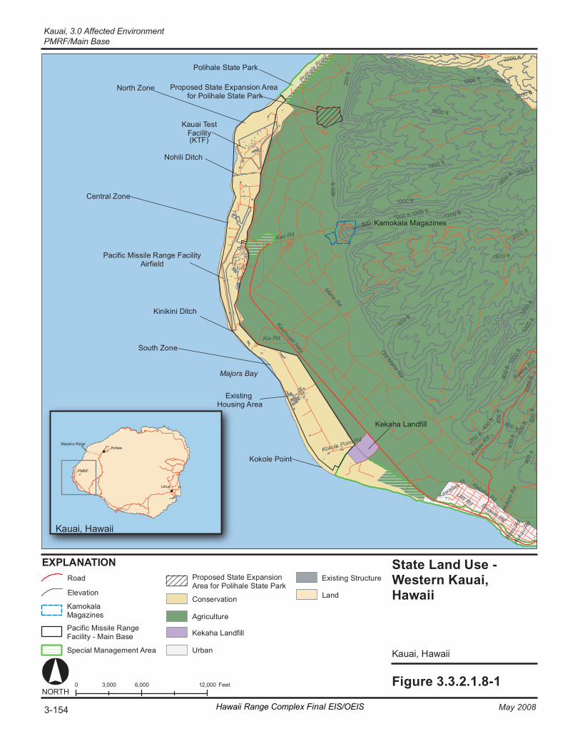
K aumual ii H wy
Ko k ee
Rd
Ol d Mana Rd
M ana Rd
El epai o Rd
Ke k aha R d
Po li ha
l e Roa
d
K ao Rd
Ki a Rd
Ul il i Rd Hu
ki po
R d
Au k u
u Rd
Ka wa il oa St
P ueo
Rd
Ko ko le P oi nt R d
Ko k ee Rd
1 000 ft
1 000
ft
1 000 ft 1 000 ft
1 000
ft
1 000
ft
1 200 ft
1 200
ft
1 400 ft
1 600 ft
1 800 ft
1 800 ft
1 800 ft
2 00
ft
2 00 ft
2 000 ft
2 000 ft
2 000 ft
2 200 ft
2 400 ft
4 00
ft
4 00 f
t
4 00
ft
4 00
ft
4 00
ft
6 00 ft
6 00
ft 6 00 ft
8 00
ft
8 00
ft
8 00 ft
Fi gure 3. 3. 2. 1. 8- 1 0 6 ,000 12 ,000 3, 000 F eet NORT H
Ka uai , Ha waii
EX PL AN AT IO N State Land Us e - We st ern Ka uai, Ha wa ii
Ka uai , Ha waii
Pa ci fi c Mi ssi le R an ge F ac il it y Air fi el d
No hi li D it ch
Ki ni ki ni D it ch
Ma jo rs B ay
Ko ko le P oi nt
Ka ua i Te st Fa (KTF)
ci lit y
Ke ka ha L an df ill
Po li ha le S ta te P ar k
No rt h Zo ne
Ce nt ra l Zo ne
So ut h Z one
Pro pos ed S ta te E xp an si on A re a for Po li hal e St at e Pa rk
Ex is ti ng Ho us in g A re a
PMRF
Ma ka ha R id ge
Li hu e
Koke e
Ka mo ka la M ag az in es
El ev at io n
A gr ic ul tu re
Co ns er va ti on Ka mo ka la Ma ga zi ne s
Ke ka ha L an df ill
Ur ba n
Ro ad
Sp ec ia l Ma na ge me nt A re a
Ex is ti ng S tr uc tu re
Pa ci fi c Mi ssi le R an ge Fa ci lit y - Ma in B as e
Pro pos ed S ta te E xp an si on Are a fo r Po li ha le S ta te P ar k
La nd
3-154 May 2008Hawaii Range Complex Final EIS/OEIS
Kauai, 3.0 Affected EnvironmentPMRF/Main Base

3.0 Affected Environment, Kauai
PMRF/Main Base
May 2008 Hawaii Range Complex Final EIS/OEIS 3-155
and limits development that would conflict with current use. PMRF activities which affect off-base land uses include those within the ESQD arcs, EMR areas, aircraft noise contours, and missile Ground Hazard Areas. ESQD arcs that extend beyond the PMRF boundary include four areas in the northern area and one in the central portion of the base. The off-base land use within these State-owned lands has been designated by both the County and State as agricultural areas. Missile Ground Hazard Areas which are only used during launch events, and extend off-base, occur in northern PMRF and encompass agricultural and recreational uses. Specifically, adjacent areas to PMRF include Polihale State Park, the Agricultural Preservation Initiative (API) and the Kekaha Landfill.
Coastal Zone Management All Federal development projects in a coastal zone and all Federal activities which directly affect a coastal zone must be consistent to the maximum extent practicable with the Coastal Zone Management Program as authorized by the Coastal Zone Management Act of 1972. The entire State of Hawaii is included in Hawaii’s Coastal Program and Coastal Zone. Federally owned, leased, or controlled facilities and areas are excluded from the State’s Coastal Zone Management Plan, and are thus outside of the Coastal Zone. The proposed action required a determination evaluating the consistence of the PMRF activities with the policies of the Hawaii Coastal Act. The proposed actions are incremental increases in activities that already occur at PMRF and which were previously found to be consistent to the maximum extent possible with the Hawaii Coastal Act in the 1998 PMRF Enhanced Capability Final EIS.
In December 2007 the Kauai County Council passed a science-based shoreline setback ordinance. The law mandates a 40-ft minimum setback plus 70 times the annual coastal erosion rate as recommended in the Hawaii Coastal Hazard Mitigation Guidebook. The law preserves beaches and protects property owner’s coastal assets. (The Garden Island, 2007, Hawaii Revised Statutes (HRS), 2007) Federally owned, leased, or controlled facilities are not subject to such requirements, but the Navy will remain consistent to the maximum extent possible or practicable.
Polihale State Park
Polihale State Park, a small area just east of PMRF North Gate, and a parcel of land south of PMRF and south makai, from the Kekaha Landfill have been designated as special management areas (U.S. Department of the Navy, 1998a). Kauai County established guidelines for reviewing proposed developments in special management areas (Figure 3.3.2.1.8-1) as part of the Coastal Zone Management Act Program. Any development in these areas requires a special management use permit.
The Agricultural Preservation Initiative (API)
In May of 2004, by amendments, the State Board of Land and Natural Resources approved the API (U.S. Department of the Navy, 2006a). The purpose of the API is to ensure lands adjacent to PMRF (5,371 acres + 215 acres-leased = 5,586 acres), which are currently designated as agricultural by the State Land Use Commission, remain agricultural lands for the term of the agreement (the agreement expires December 31, 2030 [U.S. Department of the Navy, 1998a]). The use of this land requires activation of a restrictive easement. The initiative is consistent with the Kauai General Plan policy for agricultural lands, which states: “The primary intent of the Agriculture designation is to conserve land and water resources” (Kauai, County of, 2005.)
Kauai, 3.0 Affected Environment PMRF/Main Base
3-156 Hawaii Range Complex Final EIS/OEIS May 2008
The agricultural land is owned by the State of Hawaii and is leased to the Agribusiness Development Corporation.
The API benefits to the Navy include: (1) land use remains compatible with PMRF activities, thus preventing encroachment issues; (2) able to maintain compliance with Anti-Terrorism Force Protection criteria (Unified Facilities Criteria 4-010-01); and (3) improved Homeland defense/physical security. The API includes 215 leased acres, which contain the pumping system for the Mana Plain. By placing the drainage pumps under a Navy lease, the Navy will be able to use Federal funds to maintain the pumps that help prevent flooding in the Mana Plain (U.S. Department of the Navy, 2006b). The lease agreement (S-3852) for the 215 acres was signed February 2007 with the State of Hawaii. The over 5,000 acres maintained in the API support the initiatives of the State Department of Agriculture in its charge to preserve important resources to ensure the viability of Hawaii's diversified agricultural industry. The API restrictive use easement was signed by the State of Hawaii, June 2007. Figure 3.3.2.1.8-2 shows the land use alignment of PMRF and the Agricultural Preservation Initiative/Mana Plan and Figure 3.3.2.1.7-1 shows the Restrictive Easement.
Kekaha Landfill
Kekaha Landfill sits on 64 acres of land, of which 32 acres make up the footprint of the lined Subtitle-D landfill itself. Kekaha averages 230 tons of trash per day and 88,000 tons of trash per year. The Landfill was opened in 1953 and was expected to close in 2004, but was recently given permission to operate until approximately 2012 (Kauai Island Utility Cooperative, 2006a).
Off-base Recreation Off-base recreation within the region of influence is limited to range operations within the 140 acres of Polihale State Park (Figure 3.3.2.1.8-2). The park provides overnight camping and day use recreational activities (swimming, shore fishing, subsistence fishing, picnicking). It is operated by the Department of Land and Natural Resources, Division of State Parks, which estimates half a million people visit during the day, each year. Approximately 70 acres of the southern extent of the park is within the restrictive easement boundary (Figure 3.3.2.1.7-1). Use of the restrictive easement may be exercised up to 30 times per year during launches conducted by the U.S. Government. In order to launch missiles from PMRF and KTF, the U.S. Government must, in accordance with DoD policy, be able to exclude nonparticipants from a Ground Hazard Area (U.S. Army Space and Strategic Defense Command, 1993a). None of the developed campsites or picnic areas are within the restricted easement or the Ground Hazard Area (southern extent). The northern area, where picnicking and camping facilities are located, is accessible via a 5-mi dirt road from Highway 50 and is within a Ground Hazard Area.
The Division of State Parks plans to expand Polihale State Park, subject to the availability of funds. The expansion would include a portion of a sugar cane field and cliffs adjacent to the park’s boundary (Figure 3.3.2.1.8-2). The purpose is to encompass sensitive cultural resources and biological resources within the park boundary. No park development, other than interpretive trail signs, is expected within the expansion area (U.S. Department of the Navy, 1998a).
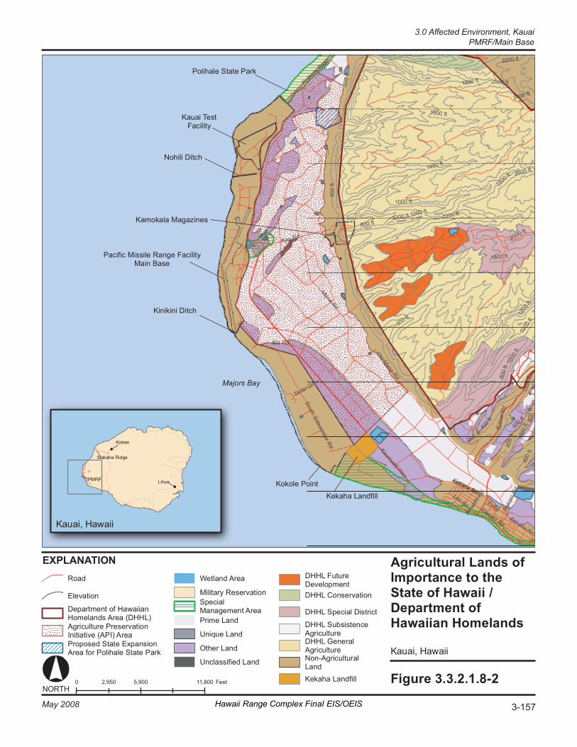
K aumual ii Hwy
Ko ke
e R
d
Ol d Mana Rd
M ana Rd
El epa io R d Ke ka ha Rd
Po li ha
l e Roa
d
K ao Rd
S outh Si dewi nder R d
Ki a Rd
Ul il i Rd Hu
ki po
R d
Ta rt er D r
Am ak
ih i R
d
Io R d
1 000 ft
1 000
ft
1 000 ft 1 000 ft
1 000
ft
1 000
ft
1 200 ft
1 200
ft
1 400 ft
1 600 ft
1 800 ft
1 800 ft
1 800 ft
2 00
ft
2 00 ft
2 000 ft
2 000 ft
2 000 ft
2 200 ft
2 400 ft
4 00
ft
4 00
ft
4 00 f
t
4 00
ft
6 00 ft
6 00 f
t 6 0
0 ft
8 00
ft
8 00
ft
8 00 ft
Fi gur e 3. 3. 2. 1. 8- 2 0 5 ,900 11 ,800 2, 950 F eet NORT H
Ka ua i, Haw ai i
EX PL ANA TI ON Agri cu lt ur al L a nds o f Im porta nc e to t he State of Hawaii / De pa rtmen t of Ha wa ii an H omel a nds
Ka ua i, Haw ai i
Pa ci fi c Mi ss il e Ra ng e Fa ci lit y Ma in B as e
Ka mo ka la M ag az i nes
No h ili D it ch
Ki ni ki ni D it ch
Ma jo rs B ay
Ko ko le P oi nt
Ka ua i Te st Fa ci li ty
Ke ka ha La nd fi ll
Po li ha le S ta te P ar k
PM RF
Ma ka ha Ri dg e
Ko ke e
Li hu e Ke ka ha Rd
Pr op os ed S ta te E x pan si on Ar ea fo r Po li ha le S ta te P ar k
De pa rt me nt o f Ha wa ii an Ho me la nd s Ar ea (DH HL )
El ev at io n DHHL C on se rv at io n
DHHL S pe ci al Dis tr ic t
DHHL S ub si st en ce Ag ri cu lt ur e DHHL G en er al Ag ri cu lt ur e No n- Ag ri cu lt ur al La nd Ke ka ha La nd fi ll
Mi lit ar y R es er va ti on
DHHL F ut ur e De ve lo pm en t
Ro ad We tl an d Ar ea
Sp ec ia l Ma na ge me nt A re a
Un iq ue L an d
Ot he r La nd
Un cl as si fi ed Lan d
Ag ri cu lt ur e Pr es er va ti on In it ia ti ve (AP I) A re a
Prim e La nd
3-157May 2008 Hawaii Range Complex Final EIS/OEIS
3.0 Affected Environment, Kauai PMRF/Main Base
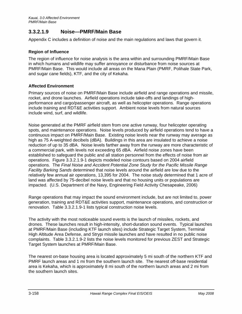
Kauai, 3.0 Affected Environment PMRF/Main Base
3-158 Hawaii Range Complex Final EIS/OEIS May 2008
3.3.2.1.9 Noise—PMRF/Main Base Appendix C includes a definition of noise and the main regulations and laws that govern it.
Region of Influence The region of influence for noise analysis is the area within and surrounding PMRF/Main Base in which humans and wildlife may suffer annoyance or disturbance from noise sources at PMRF/Main Base. This would include all areas on the Mana Plain (PMRF, Polihale State Park, and sugar cane fields), KTF, and the city of Kekaha.
Affected Environment Primary sources of noise on PMRF/Main Base include airfield and range operations and missile, rocket, and drone launches. Airfield operations include take-offs and landings of high-performance and cargo/passenger aircraft, as well as helicopter operations. Range operations include training and RDT&E activities support. Ambient noise levels from natural sources include wind, surf, and wildlife.
Noise generated at the PMRF airfield stem from one active runway, four helicopter operating spots, and maintenance operations. Noise levels produced by airfield operations tend to have a continuous impact on PMRF/Main Base. Existing noise levels near the runway may average as high as 75 A-weighted decibels (dBA). Buildings in this area are insulated to achieve a noise reduction of up to 35 dBA. Noise levels farther away from the runway are more characteristic of a commercial park, with levels not exceeding 65 dBA. Airfield noise zones have been established to safeguard the public and all station personnel from the effects of noise from air operations. Figure 3.3.2.1.9-1 depicts modeled noise contours based on 2004 airfield operations. The Final Noise and Accident Potential Zone Study for the Pacific Missile Range Facility Barking Sands determined that noise levels around the airfield are low due to the relatively few annual air operations, 13,395 for 2004. The noise study determined that 1 acre of land was affected by 75-decibel noise levels and that no housing units or populations are impacted. (U.S. Department of the Navy, Engineering Field Activity Chesapeake, 2006)
Range operations that may impact the sound environment include, but are not limited to, power generation, training and RDT&E activities support, maintenance operations, and construction or renovation. Table 3.3.2.1.9-1 lists typical construction noise levels.
The activity with the most noticeable sound events is the launch of missiles, rockets, and drones. These launches result in high-intensity, short-duration sound events. Typical launches at PMRF/Main Base (including KTF launch sites) include Strategic Target System, Terminal High Altitude Area Defense, and Strypi missile launches and have resulted in no public noise complaints. Table 3.3.2.1.9-2 lists the noise levels monitored for previous ZEST and Strategic Target System launches at PMRF/Main Base.
The nearest on-base housing area is located approximately 5 mi south of the northern KTF and PMRF launch areas and 1 mi from the southern launch site. The nearest off-base residential area is Kekaha, which is approximately 8 mi south of the northern launch areas and 2 mi from the southern launch sites.
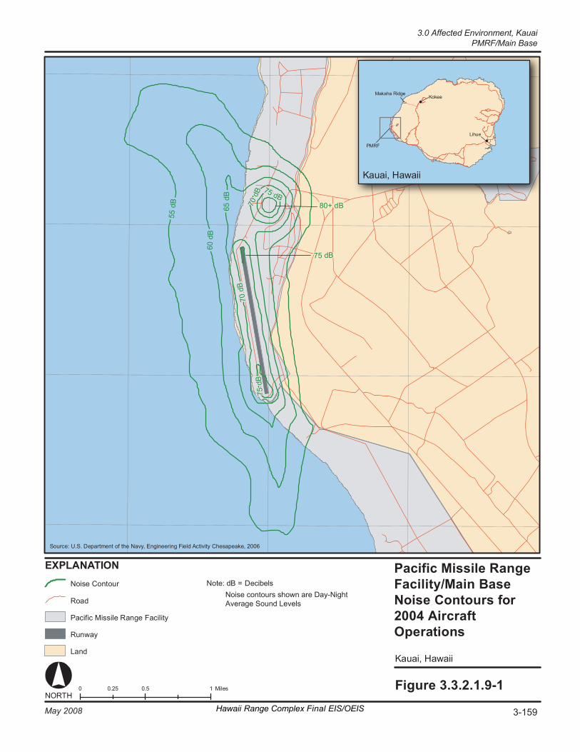
Fi gur e 3. 3. 2. 1. 9- 1
Ka uai , Ha waii
0 0 .5 1 0. 25 M ile s NORT H
S our ce : U.S . De par tm ent of the Na vy , E ngi neer in g Fi el d Ac ti vi ty Ches apeak e , 2006
EX PL A NA TI ON
70 d
B
70 d
B
75 d B
60 d
B
80 + dB
75 d B
55 d
B
65 d
B
75 d
B
No is e Co n to ur
Ro ad
Ru n wa y
La n d
Pa ci fi c Mi ssi le R an ge F ac il it y
Ka uai , Ha waii
PM RF
Ma ka ha R id ge Ko ke e
Li hu e
3-159May 2008 Hawaii Range Complex Final EIS/OEIS
3.0 Affected Environment, KauaiPMRF/Main Base
Pacific Missile Range Facility/Main Base Noise Contours for 2004 Aircraft Operations
Note: dB = Decibels Noise contours shown are Day-Night Average Sound Levels

Kauai, 3.0 Affected Environment PMRF/Main Base
3-160 Hawaii Range Complex Final EIS/OEIS May 2008
Table 3.3.2.1.9-1. Typical Range Operations Noise Levels
Source Noise level (peak)
Distance from Source
50 feet 100 feet 200 feet 400 feet Heavy Trucks 95 84-89 73-83 72-77 66-71 Dump Trucks 108 88 82 76 70 Concrete Mixer 105 85 79 73 67 Jackhammer 108 88 82 76 70 Scraper 93 80-89 74-82 68-77 60-71 Dozer 107 87-102 81-96 75-90 69-84 Generator 96 76 70 64 58 Crane 104 75-88 69-82 63-76 55-70 Loader 104 73-86 67-80 61-74 55-68 Grader 108 88-91 82-85 76-79 70-73 Dragline 105 85 79 73 67 Pile Driver 105 95 89 83 77 Fork Lift 100 95 89 83 77
Source: Golden et al., 1980
Table 3.3.2.1.9-2. Noise Levels Monitored for ZEST and Strategic Target System Launches
Launch Vehicle Distance (ft) Measured Average Peak (dB)
ZEST 725 124.8 1,000 122.5 1,263 119.6 1,400 119.5 2,975 110.5
Strategic Target System 575 125.3 800 123.0 881 121.8 1,222 118.2 1,584 115.3 10,000 97.1 35,000 54.0
Source: U.S. Army Strategic Defense Command, 1992 KTF supports a variety of sounding rocket missions; therefore, occasional rocket, missile, or drone launches produce high-intensity, short-duration sound events. Table 3.3.2.1.9-2 lists noise levels associated with these types of launches. Data collected in the nearest town of Kekaha indicated that levels were no louder than noise generated from passing vehicles on a nearby highway. No noise-sensitive land uses are affected by existing noise levels. (Sandia National Laboratories, 2006)
3.0 Affected Environment, Kauai
PMRF/Main Base
May 2008 Hawaii Range Complex Final EIS/OEIS 3-161
In addition to the noise of the rocket engine, sonic booms are possible. A sonic boom is a sound that resembles rolling thunder, and is produced by a shock wave that forms at the nose of a vehicle that is traveling faster than the speed of sound. Sonic booms from PMRF/Main Base launches do not occur over land. Offshore vessels impacted by sonic booms will be expected to experience sound resembling mild thunder. Sonic booms generated during launch activities will occur over the Pacific Ocean, and will not affect the public on Kauai or Niihau because the proposed missile trajectory will not include overflight of populated areas.
Wildlife receptors at the PMRF/Main Base area are discussed in Section 3.3.2.1.3, Biological Resources.
3.3.2.1.10 Socioeconomics—PMRF/Main Base Socioeconomics describes the social and economic character of a community through the review of several metrics including population size, employment characteristics, income generated, and the type and cost of housing. This section presents a socioeconomic overview of the Kauai region. Appendix C includes a general definition of socioeconomics.
Region of Influence The region of influence for socioeconomics is defined as the island of Kauai, which covers 552 mi2. The entire island is designated as Kauai County.
Affected Environment
Population and Income In 2000, the population of Kauai County was 58,463. The 2005 Bureau of Census Counties Profile estimates that the population for the County rose to 62,640 in 2005 (equal to 4.9 percent of the population of Hawaii), a change of approximately 7.1 percent over the 5-year period. The estimated population for 2006 is 63,004 (U.S. Census Bureau, 2007a). The projected population for 5 and 10 years out is 65,900 people in 2010 and 70,200 people in 2015 (Hawaii, State of, 2004). PMRF employs nearly 1,000 personnel, of which 54 are military personnel (Mossman, 2007). The 54 personnel account for 0.086 percent of the estimated 2006 population of Kauai. Table 3.3.2.1.10-1 summarizes the demographics of the population of Kauai in 2000. Table 3.3.2.1.10-2 illustrates the age profile of those living in Kauai County in 2000.
Personal income in Kauai was estimated by the Department of Business, Economic Development and Tourism to be $1.595 billion in 2005 (FY 2000 dollars). This represented 4 percent of the total personal income of Hawaii. In FY 2000 the annual average salary for Kauai County was $26,550, while the annual average income in 2005 for Kauai County was $29,650, which is an 11.6 percent increase.
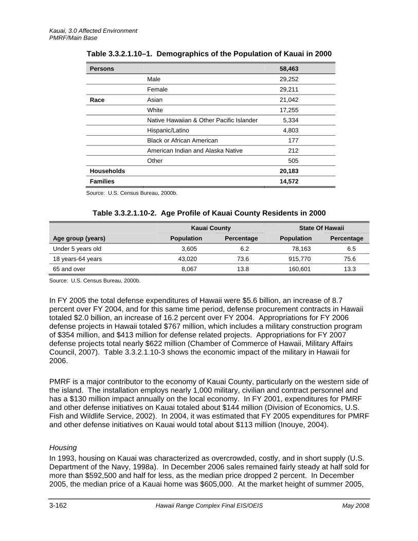
Kauai, 3.0 Affected Environment PMRF/Main Base
3-162 Hawaii Range Complex Final EIS/OEIS May 2008
Table 3.3.2.1.10–1. Demographics of the Population of Kauai in 2000
Persons 58,463
Male 29,252
Female 29,211
Race Asian 21,042
White 17,255 Native Hawaiian & Other Pacific Islander 5,334 Hispanic/Latino 4,803 Black or African American 177 American Indian and Alaska Native 212 Other 505
Households 20,183 Families 14,572
Source: U.S. Census Bureau, 2000b.
Table 3.3.2.1.10-2. Age Profile of Kauai County Residents in 2000
Kauai County State Of Hawaii Age group (years) Population Percentage Population Percentage Under 5 years old 3,605 6.2 78,163 6.5 18 years-64 years 43,020 73.6 915,770 75.6 65 and over 8,067 13.8 160,601 13.3
Source: U.S. Census Bureau, 2000b.
In FY 2005 the total defense expenditures of Hawaii were $5.6 billion, an increase of 8.7 percent over FY 2004, and for this same time period, defense procurement contracts in Hawaii totaled $2.0 billion, an increase of 16.2 percent over FY 2004. Appropriations for FY 2006 defense projects in Hawaii totaled $767 million, which includes a military construction program of $354 million, and $413 million for defense related projects. Appropriations for FY 2007 defense projects total nearly $622 million (Chamber of Commerce of Hawaii, Military Affairs Council, 2007). Table 3.3.2.1.10-3 shows the economic impact of the military in Hawaii for 2006.
PMRF is a major contributor to the economy of Kauai County, particularly on the western side of the island. The installation employs nearly 1,000 military, civilian and contract personnel and has a $130 million impact annually on the local economy. In FY 2001, expenditures for PMRF and other defense initiatives on Kauai totaled about $144 million (Division of Economics, U.S. Fish and Wildlife Service, 2002). In 2004, it was estimated that FY 2005 expenditures for PMRF and other defense initiatives on Kauai would total about $113 million (Inouye, 2004).
Housing In 1993, housing on Kauai was characterized as overcrowded, costly, and in short supply (U.S. Department of the Navy, 1998a). In December 2006 sales remained fairly steady at half sold for more than $592,500 and half for less, as the median price dropped 2 percent. In December 2005, the median price of a Kauai home was $605,000. At the market height of summer 2005,

3.0 Affected Environment, Kauai
PMRF/Main Base
May 2008 Hawaii Range Complex Final EIS/OEIS 3-163
the median sales price on Kauai reached close to $700,000. Median home prices declined by 15.4 percent between the summer of 2005 and December 2006 and declined by 2.1 percent between December 2005 and December 2006 (Star Bulletin, 2007). Condominium prices on Kauai, on the other hand, increased to by 17.7 percent; up to $570,000 in December 2005 from $484,500 in December 2005 (Star Bulletin, 2007).
Table 3.3.2.1.10-3. 2006 Economic Impact of the Military in Hawaii Industry Output
(millions of dollars) Employment
(number of jobs) Household Income (millions of dollars)
Fed Def-Military & civilian 766 Real estate & Rentals 149 Health services 88 Mining & Construction 77 Retail Trade 77 Professional services 68 Finance & insurance 51 Other manufacturing 47 Business services 39 Other services 35 Wholesale trade 30 Information 29 Eating & drinking 26 Transportation 23 Utilities 22 All other industries 61
Total 1,588
Fed Def-Military & civilian 10,371 Retail trade 1,198 Health services 1,086 Business services 771 Professional services 721 Other services 667 Mining & construction 530 Eating & drinking 503 Real Estate & rentals 400 Finance & insurance 326 Wholesale trade 256 Educational services 231 Other government 213 Arts & entertainment 172 Information 172 All other industries 721
Total 18,338
Def-Military & civilian 690 Health services 45 Professional services 35 Mining & construction 31 Retail trade 29 Business services 22 Finance & insurance 16 Other services 15 Wholesale trade 11 Other government 11 Information 10 Other manufacturing 9 Eating & drinking 9 Real estate & rentals 8 Transportation 7 All other industries 23
Total 971
Source: Chamber of Commerce of Hawaii, Military Affairs Council, 2007
Employment Government, tourism, and tourism-related services have been the main employment generators on Kauai since the 1992 hurricane (U.S. Department of the Navy, 1998a). In 2006, government and tourism were the main employment generators. In FY 2006 PMRF employed a total of 821 employees, which comprised 128 DoD civilian personnel, 54 military personnel, 512 ITT personnel (Prime Support Contractor), 97 other contractors personnel, and 30 Hawaii Island Air National Guard. Table 3.3.2.1.10-4 shows the number of individuals employed in the main sectors of the economy of Kauai and in Hawaii as a whole.
Unemployment in Kauai has steadily declined from 4.5 percent in 2000 to 2.7 percent in 2005. This is the lowest the rate has been in over 15 years, which is also significantly lower than the 1998 unemployment rate of 11.6 percent. During the same period, the total labor force has increased from 30,350 in 2000 to 32,350 in 2005, a 6.7 percent increase (Hawaii, State of, 2005a).
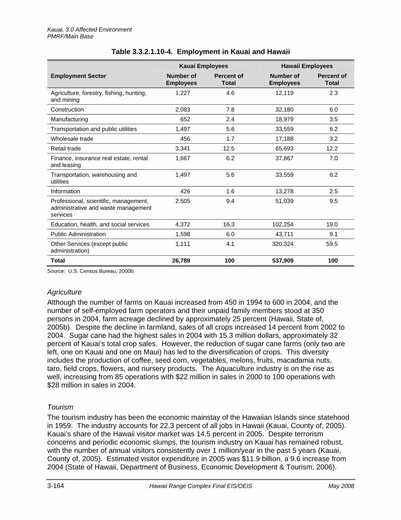
Kauai, 3.0 Affected Environment PMRF/Main Base
3-164 Hawaii Range Complex Final EIS/OEIS May 2008
Table 3.3.2.1.10-4. Employment in Kauai and Hawaii
Kauai Employees Hawaii Employees Employment Sector Number of
Employees Percent of
Total Number of
Employees Percent of
Total Agriculture, forestry, fishing, hunting, and mining
1,227 4.6 12,119 2.3
Construction 2,083 7.8 32,180 6.0 Manufacturing 652 2.4 18,979 3.5 Transportation and public utilities 1,497 5.6 33,559 6.2 Wholesale trade 456 1.7 17,188 3.2 Retail trade 3,341 12.5 65,693 12.2 Finance, insurance real estate, rental and leasing
1,667 6.2 37,867 7.0
Transportation, warehousing and utilities
1,497 5.6 33,559 6.2
Information 426 1.6 13,278 2.5 Professional, scientific, management, administrative and waste management services
2.505 9.4 51,039 9.5
Education, health, and social services 4,372 16.3 102,254 19.0 Public Administration 1,598 6.0 43,711 9.1 Other Services (except public administration)
1,111 4.1 320,324 59.5
Total 26,789 100 537,909 100
Source: U.S. Census Bureau, 2000b.
Agriculture Although the number of farms on Kauai increased from 450 in 1994 to 600 in 2004, and the number of self-employed farm operators and their unpaid family members stood at 350 persons in 2004, farm acreage declined by approximately 25 percent (Hawaii, State of, 2005b). Despite the decline in farmland, sales of all crops increased 14 percent from 2002 to 2004. Sugar cane had the highest sales in 2004 with 15.3 million dollars, approximately 32 percent of Kauai’s total crop sales. However, the reduction of sugar cane farms (only two are left, one on Kauai and one on Maui) has led to the diversification of crops. This diversity includes the production of coffee, seed corn, vegetables, melons, fruits, macadamia nuts, taro, field crops, flowers, and nursery products. The Aquaculture industry is on the rise as well, increasing from 85 operations with $22 million in sales in 2000 to 100 operations with $28 million in sales in 2004.
Tourism The tourism industry has been the economic mainstay of the Hawaiian Islands since statehood in 1959. The industry accounts for 22.3 percent of all jobs in Hawaii (Kauai, County of, 2005). Kauai’s share of the Hawaii visitor market was 14.5 percent in 2005. Despite terrorism concerns and periodic economic slumps, the tourism industry on Kauai has remained robust, with the number of annual visitors consistently over 1 million/year in the past 5 years (Kauai, County of, 2005). Estimated visitor expenditure in 2005 was $11.9 billion, a 9.6 increase from 2004 (State of Hawaii, Department of Business, Economic Development & Tourism, 2006).
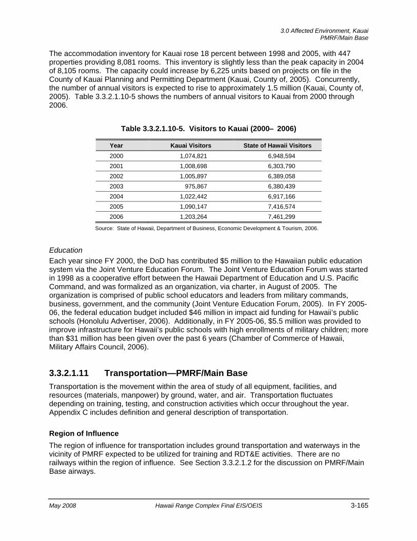
3.0 Affected Environment, Kauai
PMRF/Main Base
May 2008 Hawaii Range Complex Final EIS/OEIS 3-165
The accommodation inventory for Kauai rose 18 percent between 1998 and 2005, with 447 properties providing 8,081 rooms. This inventory is slightly less than the peak capacity in 2004 of 8,105 rooms. The capacity could increase by 6,225 units based on projects on file in the County of Kauai Planning and Permitting Department (Kauai, County of, 2005). Concurrently, the number of annual visitors is expected to rise to approximately 1.5 million (Kauai, County of, 2005). Table 3.3.2.1.10-5 shows the numbers of annual visitors to Kauai from 2000 through 2006.
Table 3.3.2.1.10-5. Visitors to Kauai (2000– 2006)
Year Kauai Visitors State of Hawaii Visitors 2000 1,074,821 6,948,594 2001 1,008,698 6,303,790 2002 1,005,897 6,389,058 2003 975,867 6,380,439 2004 1,022,442 6,917,166 2005 1,090,147 7,416,574 2006 1,203,264 7,461,299
Source: State of Hawaii, Department of Business, Economic Development & Tourism, 2006.
Education Each year since FY 2000, the DoD has contributed $5 million to the Hawaiian public education system via the Joint Venture Education Forum. The Joint Venture Education Forum was started in 1998 as a cooperative effort between the Hawaii Department of Education and U.S. Pacific Command, and was formalized as an organization, via charter, in August of 2005. The organization is comprised of public school educators and leaders from military commands, business, government, and the community (Joint Venture Education Forum, 2005). In FY 2005-06, the federal education budget included $46 million in impact aid funding for Hawaii’s public schools (Honolulu Advertiser, 2006). Additionally, in FY 2005-06, $5.5 million was provided to improve infrastructure for Hawaii’s public schools with high enrollments of military children; more than $31 million has been given over the past 6 years (Chamber of Commerce of Hawaii, Military Affairs Council, 2006).
3.3.2.1.11 Transportation—PMRF/Main Base Transportation is the movement within the area of study of all equipment, facilities, and resources (materials, manpower) by ground, water, and air. Transportation fluctuates depending on training, testing, and construction activities which occur throughout the year. Appendix C includes definition and general description of transportation.
Region of Influence The region of influence for transportation includes ground transportation and waterways in the vicinity of PMRF expected to be utilized for training and RDT&E activities. There are no railways within the region of influence. See Section 3.3.2.1.2 for the discussion on PMRF/Main Base airways.

Kauai, 3.0 Affected Environment PMRF/Main Base
3-166 Hawaii Range Complex Final EIS/OEIS May 2008
Affected Environment
Ground Transportation Imiloa Road is a two-lane roadway that provides direct access to PMRF from the southwest through its intersection with State Highway 50 (Kaumualii Highway), a primary circulation route connecting the base with Kekaha and Lihue. Kaumualii Highway, in the vicinity of Imiloa Road, is a two-lane road with a posted speed limit of 50 mi per hour. On September 20 and 21, 2005, a Hawaii Department of Transportation traffic counter, located on Kaumualii Highway between Imiloa Road and Kao Road, measured 24-hour total volumes of 469 and 516 vehicles respectively. The average daily volume of 493 translates to Level of Service (LOS) B, which is a 50 to 75 percent volume-to-capacity of the roadway capacity. Another traffic counter between Imiloa Road and Kia Road on the same days counted 749 and 747 vehicles respectively in a 24-hr period, which again translates into LOS B (Hawaii Department of Transportation, 2005; Transportation Research Board, 2000; 2006). North Nohili Road, which branches off Imiloa Road, provides access to KTF.
3.3.2.1.12 Utilities—PMRF/Main Base This section discusses utilities serving the existing and proposed project areas, which include water supply, wastewater treatment, electricity, and natural gas. Additionally, this section identifies utility providers and the major attributes of utility systems in these areas such as existing capacity and existing demand. The PMRF Public Works Office maintains base facilities and oversees the facility’s environmental program (U.S. Army Space and Missile Defense Command, 2002). Appendix C includes a definition and general discussion of utilities.
Region of Influence The utility systems that could potentially be affected include potable water distribution, wastewater collection, solid waste collection and disposal, and electrical lines within or servicing the project sites.
Affected Environment
Water Potable water at PMRF is a blend of on-base and municipal sources, including both the State Department of Land and Natural Resources and the Waimea-Kekaha Service Area of the Kauai Department of Water. The water department of Kauai County supplies water to PMRF that originates from the Kekaha’s Waipao Valley Well, Paua Valley Well, and Shaft 12, as well as Waimea wells A and B (County of Kauai, Department of Water, 2006 and Naval Facilities Engineering Command, Hawaii, 2007). PMRF’s portion is stored in two 126,000-gal tanks at Kokole Point. These sources serve the southern portions of the base. The Department of Land and Natural Resources supply water originates from the Mana well (located approximately 1,000 ft south of the Kamokala Ridge magazine), which is pumped to PMRF and stored near the Main Hanger in one 100,000-gal tank and one 420,000-gal tank. This source serves the central and northern portions of the base (U.S. Army Space and Missile Defense Command, 2002). In 2006, PMRF’s water consumption from the Mana well system was 78,533,000 gal and 10,817,909 gal from the Kauai County Department of Water. The monthly consumption from the Mana well ranged from as low as 3,753,000 gal in November 2006 to as high as 8,827,000 gal in July 2006. The monthly consumption from the Kauai County Department of Water ranged from as low as 215,147 gal in November 2006 to as high as 1,719,843 gal in May
3.0 Affected Environment, Kauai
PMRF/Main Base
May 2008 Hawaii Range Complex Final EIS/OEIS 3-167
2006 (Maintenance Logs and Records-PMRF, 2006). The Navy chlorinates and fluoridates all purchased water before distribution, except that provided by the State of Hawaii (Commerce Business Daily, 2000). The maximum delivery capacity of water from the State is 320,000 gal per day (GPD).
Wastewater The PMRF wastewater system comprises two domestic sewage treatment facilities and a collection system. These facilities include a treatment plant located approximately one half-mile south of the Main Gate and an oxidation pond south of the family housing area (U.S. Army Space and Missile Defense Command, 2002). A package treatment plant located at PMRF/Main Base treats approximately 8,000 GPD, or 27.7 percent of its 30,000-GPD design capacity. On the southern end of the base, an oxidation pond receives 20,000 to 25,000 GPD of its 54,000-GPD capacity. Both sites discharge their effluent into leach fields. For the period of 6 June 1995 to 31 May 1996, the average flow into the leach field (situated between the runway and the coast) was 9,500 GPD, or 37 percent of its 26,000-GPD design capacity. PMRF also has approximately 22 septic tank/leachfield systems and cesspools serving individual buildings in the northern part of PMRF/Main Base (U.S. Army Space and Missile Defense Command, 2002; Commerce Business Daily, 2000).
Solid Waste Kauai County’s Kekaha Landfill sits on 64 acres of land, of which 32 acres make up the footprint of the lined Subtitle-D landfill itself. Kekaha averages 230 tons per day and 88,000 tons per year. The Landfill was opened in 1953 and was expected to close in 2004, but was recently given permission to operate until approximately 2012. The FY 2006 total for refuse deposited into the landfill from PMRF was 530.6 tons, and 252.32 tons were recycled by PMRF (Burger and Nizo, 2007). To minimize waste flow, PMRF maintains a recycling program for aluminum cans, glass, paper and cardboard, all of which are collected biweekly. Green waste is collected and chipped for composting and use on the base (U.S. Army Space and Missile Defense Command, 2002).
Electricity Until recently, PMRF’s municipal power was provided by Kauai Electric; however, in 2002 Kauai Electric was purchased by Kauai Island Utility Cooperative (Pacific Business News, 2002). The total firm electrical generating capacity on the island is 110 megawatts (MW), with an additional 4.1 MW provided by non-firm sources (Kauai County, 2005).
PMRF is located in Kauai County’s West Side region. The West Side’s main transmission line runs along Kaumualii Highway from Port Allen to Mana, and includes double circuits between Port Allen and Kekaha. There are switchyards in Kekaha and Port Allen, as well as substations in Mana and Kaumakani (Kauai County, 2005). Power to PMRF/Main Base and northern complex area is supplied via a 57-kilovolt (kV)/69-kV transmission line between the Kauai Island Utility Cooperative’s Mana Substation and Kekaha Switchyard. This West Side transmission line’s capacity is 7.6 MW at 95 percent power factor; the current peak load is 2.5 MW (U.S. Department of the Navy, Naval Sea Systems Command, 2005). A 12.47-kV feeder circuit system owned by Kauai Island Utility Cooperative supplies primary power to the base’s southern area; this circuit has a capacity of 4.3 MW at 95 percent power factor (U.S. Department of the Navy, Naval Sea Systems Command, 2005). In the event of a power outage PMRF provides additional power, utilizing commercial power as a backup. The PMRF power
Kauai, 3.0 Affected Environment PMRF/Main Base
3-168 Hawaii Range Complex Final EIS/OEIS May 2008
plant contains two 600-kW and three 300-kW generator units (U.S. Army Space and Missile Defense Command, 2002).
By 2003, PMRF’s energy consumption had been considerably reduced from its 1985 baseline; moreover, the base’s energy consumption during peak hours had decreased by $100,000 annually, allowing the Kauai Island Utility Commission to redirect energy to other areas on the island (U.S. House of Representatives, 2003). PMRF has been recognized for these energy-saving efforts, as well as initiating innovative high-tech energy conservation projects, including using methane gas, by the County of Kauai's Kekaha landfill and using fuel cells to support range operations (U.S. House of Representatives, 2003). Since 2005, photovoltaic panels have been used to augment base requirements without increasing consumption from the island’s commercial electric utility grid (Naval Facilities Engineering Command, Hawaii Public Affairs, 2005).
3.3.2.1.13 Water Resources—PMRF/Main Base Water resources include those aspects of the natural environment related to the availability and characteristics of water. For the purposes of this document, water resources can be divided into three main sections: surface water, groundwater, and flood hazard areas.
Surface water includes discussions of runoff, changes to surface drainage, and general surface water quality. Groundwater discussions focus on aquifer characteristics, general groundwater quality, and water supply. Flood hazard area discussions center on floodplains.
Where practicable, water resources are described quantitatively (volume, mineral concentrations, salinity, etc.); otherwise they are described qualitatively (good, poor, etc.) when necessary. Appendix C includes a description of the primary laws and regulations regarding water resources.
Detailed descriptions of fresh water quality and well water supplies can be found in the Utilities section of this EIS/OEIS.
Region of Influence The region of influence for PMRF/Main Base includes the area within and surrounding the PMRF property boundaries. The region of influence also includes KTF and the restrictive easement, including the Mana Plain and the Ground Hazard Area.
Affected Environment
Surface Water The surface water within the PMRF boundary is in the canals that drain the agricultural areas east of PMRF. Apart from these drainages, no surface drainage has been established because the rain sinks into the permeable sand. There are numerous drains and several irrigation ponds in the agricultural land.
The waters in the irrigation ponds generally do not meet drinking water standards for chloride salts, but have near neutral to slightly alkaline pH. A surface water quality study for chloride
3.0 Affected Environment, Kauai
PMRF/Main Base
May 2008 Hawaii Range Complex Final EIS/OEIS 3-169
was conducted in the Mana Plain/KTF area. The chloride levels do not indicate residual hydrochloric acid effects of the past launches at KTF (U.S. Army Program Executive Office, 1995). The surface waters on the southern half of PMRF/Main Base are expected to have similar chemical characteristics. Because the drainage ditches are designed to move water away from the agricultural fields during irrigation and rainfall, and to leach salts from the soil, no residual effects of past launches are expected. (U.S. Army Program Executive Office, 1995)
Surface water in the area of the restrictive easement on the Mana Plain is restricted to drains and agricultural irrigation ponds. Within the restrictive easement boundary, the surface water and storm water runoff drain onto Amfac Sugar-Kauai lands and agricultural ponds below the Mana cliffs. The Mana Plain is drained by canals that flow seaward. Typically, the water from the canals that drain from the sugar cane fields is brackish. (U.S. Army Space and Strategic Defense Command, 1993a)
The waters in the agricultural ponds along the Mana cliffs generally do not meet drinking water standards for chloride salts but are near neutral to slightly alkaline. The highest chloride salt levels, near those of seawater, were observed in water from the Mana Pond Wildlife Sanctuary near the north gate of PMRF. This may be due to the infiltration of brackish to saline groundwater into the pond basin or excessive evaporation to a low surface level. (U.S. Army Space and Strategic Defense Command, 1993a)
Water quality along the PMRF shoreline was within Department of Health standards, with the exception of two locations where sugar cane irrigation water, pumped from the sugar cane fields, is discharged to the ocean (Belt Collins Hawaii, 1994). In these areas, Department of Health water quality criteria are exceeded within 164 ft of the shoreline. Mixing processes are sufficient to dilute the drainage water to near background levels within 164 to 328 ft of the shoreline (Belt Collins Hawaii, 1994).
Groundwater Bedrock, alluvium, and sand dunes make up hydraulically connected aquifers within the region of influence. The bedrock (basement volcanics, primarily basalt) is highly permeable, containing brackish water that floats on seawater. (U.S. Army Space and Strategic Defense Command, 1993a)
The overlying sediments act as a caprock because of their overall low permeability, although individual layers, such as buried fossil coral reefs, may be as permeable as the basalt. Although the sediments are saturated, they are not exploitable as an aquifer because of unfavorable hydraulic characteristics. The groundwater in the sediments originates as seepage from irrigation percolation and rainfall in the basalt aquifer, especially where the sediments are thin near the inland margin of the Mana Plain.
The dune sand aquifer on which PMRF/Main Base lies has a moderate hydraulic conductivity and moderate porosity of about 20 percent. It consists of a lens of brackish groundwater that floats on seawater and is recharged by rainfall and by seepage from the underlying sediments. The only record of an attempt to exploit this groundwater is of a well drilled for the Navy in 1974, 4 to 5 mi south of KTF. The well was drilled to a depth of 42 ft, and tested at 300 gal per minute. In 1992, the water was too brackish for plants and animals to consume; consequently, the well is not used. (U.S. Army Program Executive Office, 1995)
Kauai, 3.0 Affected Environment PMRF/Main Base
3-170 Hawaii Range Complex Final EIS/OEIS May 2008
The nearest fresh groundwater sources are in the Napali formation at the inland edge of the coastal plain along the base of the Mana cliffs. Groundwater in the region is generally considered to be potable at the base of the cliffs, increasing in salinity closer to the coast. (U.S. Army Space and Strategic Defense Command, 1993a)
The groundwater beneath the restrictive easement increases in salinity from the base of the Mana cliffs to the Pacific Ocean. To keep the groundwater table below the root zone of the sugar cane, thousands of feet of canal have been excavated to drain excess water from the soil. The water is then pumped into canals such as the Nohili Ditch for release into the ocean. (U.S. Army Space and Strategic Defense Command, 1993a )
Sampling for perchlorate was initiated at PMRF in 2006. USEPA adopted an oral reference dose for perchlorate in 2005, following a National Academy of Sciences recommendation that it not exceed 24.5 parts per billion in drinking water. Until USEPA promulgates standards for perchlorate, the DoD has established 24 parts per billion as the current level of concern for managing perchlorate. This level has also been adopted in the Navy Perchlorate Sampling and Management Policy, 15 April 2006.
As part of the implementation of the Navy policy, perchlorate sampling has been conducted at two drinking water supply locations. One location is the “Mana well,” which is the former Kekaha Sugar/AMFAC well from which PMRF obtains drinking water, referenced as “BS 335,” and supplies the “north end” of PMRF. It is a hand-dug well, now concrete-lined, approximately 90 ft deep, and is located at the base of the ridge near the Kamokala Caves. The pumps and electric motors are down in the well. The other location is the water tank at the southern end of the base identified as reference code “BS 820.” Water in the tank comes from the County of Kauai. The results are shown in Table 3.3.2.1.13-1.
Table 3.3.2.1.13-1. Water Tank Perchlorate Sampling
Sample Location Sample date 1 Sample Date 2
BS 335 0.860 ppb <4 ppb (specifics pending)
BS 820 3.500 ppb <4 ppb (specifics pending) Note: ppb = parts per billion
Perchlorate concentrations at both sites were less than the initial screening level of 4.0 parts per billion. Based on guidance PMRF received from Navy Region Hawaii, since the two consecutive samples were less than 4 parts per billion, no further analysis was required.
Flood Hazard Areas The primary flood hazard is from overflow of the ditches that drain the Mana Plain. Extended periods of heavy rainfall have resulted in minor flooding of low-lying areas of PMRF/Main Base. In addition, most of PMRF/Main Base is within the tsunami evacuation area.
3.0 Affected Environment, Kauai
Makaha Ridge
May 2008 Hawaii Range Complex Final EIS/OEIS 3-171
3.3.2.2 MAKAHA RIDGE Makaha Ridge, a secondary range operation area for PMRF, is about 7 miles north of PMRF/Main Base. This 244.7-acre complex is located approximately at the 1,600-ft elevation of Makaha Ridge and is leased from the State of Hawaii. Its primary mission in support of PMRF is to provide facilities for range operations at PMRF. Makaha Ridge features tracking and surveillance radars, primary telemetry receivers and recorders, a Frequency Monitoring Station, and Electronic Warfare and networked communications systems.
This section describes the environmental resources that would be affected by the No-action Alternative, Alternative 1, Alternative 2, or Alternative 3 for Makaha Ridge. Of the 13 resources considered for analysis, airspace, geology and soils, land use, noise, socioeconomics, transportation, utilities, and water resources are not addressed. Any issues with these resources that are associated with Makaha Ridge are included within the PMRF/Main Base discussion.
3.3.2.2.1 Air Quality—Makaha Ridge Appendix C includes a definition of air quality and the main regulations and laws governing its protection.
Region of Influence For inert pollutants (all pollutants other than ozone and its precursors), the region of influence is generally limited to an area extending a few miles downwind from the source. The region of influence for ozone may extend much farther downwind than the region of influence for inert pollutants. However, as the project area has no heavy industry and very few automobiles, ozone and its precursors are not of concern. Consequently, for the air quality analysis, the region of influence for project activities is the existing airshed surrounding Makaha Ridge.
Affected Environment
Climate and Regional Air Quality Section 3.3.2.1.1 describes climate and regional air quality on Kauai, which includes Makaha Ridge.
Existing Emission Sources The primary air pollutant emissions at Makaha Ridge are from diesel generators. The two 600-kW and two 300-kW generators are permitted by the State of Hawaii under a non-covered source permit.
Kauai, 3.0 Affected Environment Makaha Ridge
3-172 Hawaii Range Complex Final EIS/OEIS May 2008
3.3.2.2.2 Biological Resources—Makaha Ridge Appendix C includes a definition of biological resources and the main regulations and laws that govern their protection.
Region of Influence The region of influence for biological resources encompasses Makaha Ridge and limited adjacent areas.
Affected Environment
Vegetation
Vegetation at the sites is dominated by introduced non-native, naturalized species. The most common native species that occur on the cliffs in the area are false sandalwood, or naio, (Myoporum sandwicense) and kawela, a bunch grass. Thirteen endemic species are represented within the boundaries of the Makaha Ridge facility: `ahinahina (Artemisia australis), ko`oko`olau (Bidens sandwicensis), Carex wahuensis, Gahnia beecheyi, Pteridium aquilinum var. decompositum, koa (Acacia koa), naupaka kuahiwi (Scaevola gaudichaudi), kawelu (Eragrostis variabilis), hakonakona (Panicum torridum), kumuniu (Doryopteris decipiens), lepelepe a moa (Selaginella arbuscula), the native herb (Spermolepis hawaiiensis), and dwarf iliau (Wilkesia hobdyi). The last two species are discussed below as endangered plant species. There are also 14 indigenous species on the property including naio (Myoporum sandwicense), and `ilima (Sida fallax). (Pacific Missile Range Facility, 2006d) A few shrubs of naio and introduced lantana (Lanatana camara) occur along the makai (coastal) edge of the Makaha Ridge complex. Pine plantings and mixed scrub covers most of the area at the Makaha Ridge facility. Rows or scattered clumps of pine trees have been planted for erosion control. There are high levels of erosion at the ridge with many areas having less than 10 percent cover due most likely to ungulates (hoofed mammals). Silk oak trees (Grevillea robusta) are also abundant. Mixed scrub consisting mainly of lantana shrubs and molasses grass (Melinis minutiflora) with scattered guava shrubs (Psidium spp.) is located between the trees. Some native koa trees are located in the southern portion of the property. Well-maintained grassy lawns and landscape plantings are located around the existing buildings. (Pacific Missile Range Facility, 2001; U.S. Department of the Navy, 1998a)
Threatened and Endangered Plant Species
Table 3.3.2.2.2-1 lists threatened and endangered species known or expected to occur in the vicinity of the Makaha Ridge site. The endemic dwarf iliau, a shrub species Federally and State listed as endangered, occurs on cliffs overlooking the Makaha Valley along the northern boundary of the Makaha Ridge site. The Makaha Ridge population was estimated to be about 50 plants in 2000. A survey conducted in April 2006 documented an additional 11 colonies of dwarf iliau on cliffs within and adjacent to the Makaha Ridge boundary totaling 214 individuals (Pacific Missile Range Facility, 2006d). The plants are out of the reach of goats (Capra hircus) that frequent the area. (Center for Plant Conservation, 2006; U.S. Fish and Wildlife Service, 2002; Pacific Missile Range Facility, 2001)
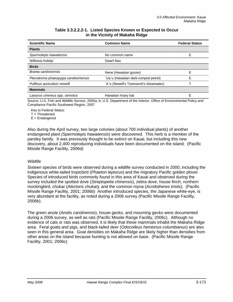
3.0 Affected Environment, Kauai
Makaha Ridge
May 2008 Hawaii Range Complex Final EIS/OEIS 3-173
Table 3.3.2.2.2-1. Listed Species Known or Expected to Occur in the Vicinity of Makaha Ridge
Scientific Name Common Name Federal Status Plants
Spermolepis hawaiiensis No common name E
Wilkesia hobdyi Dwarf iliau
Birds Branta sandvicensis Nene (Hawaiian goose) E Pterodroma phaeopygia sandwichensis `Ua`u (Hawaiian dark-rumped petrel) E Puffinus auricularis newelli `A`o (Newell's Townsend’s shearwater) T
Mammals
Lasiurus cinereus spp. semotus Hawaiian hoary bat E Source: U.S. Fish and Wildlife Service, 2005a; b; U.S. Department of the Interior, Office of Environmental Policy and Compliance Pacific Southwest Region, 2007
Key to Federal Status: T = Threatened E = Endangered
Also during the April survey, two large colonies (about 700 individual plants) of another endangered plant (Spermolepis hawaiiensis) were discovered. This herb is a member of the parsley family. It was previously thought to be extinct on Kauai, but including this new discovery, about 2,400 reproducing individuals have been documented on the island. (Pacific Missile Range Facility, 2006d)
Wildlife Sixteen species of birds were observed during a wildlife survey conducted in 2000, including the indigenous white-tailed tropicbird (Phaeton lepturus) and the migratory Pacific golden plover. Species of introduced birds commonly found in this area of Kauai and observed during the survey included the spotted dove (Streptopelia chinensis), zebra dove, house finch, northern mockingbird, chukar (Alectoris chukar), and the common myna (Acridotheres tristis). (Pacific Missile Range Facility, 2001; 2006b) Another introduced species, the Japanese white-eye, is very abundant at the facility, as noted during a 2006 survey (Pacific Missile Range Facility, 2006b).
The green anole (Anolis carolinensis), house gecko, and mourning gecko were documented during a 2006 survey, as well as rats (Pacific Missile Range Facility, 2006c). Although no evidence of cats or rats was observed, it is likely that these mammals inhabit the Makaha Ridge area. Feral goats and pigs, and black-tailed deer (Odocoileus hemionus columbianus) are also seen in this general area. Goat densities on Makaha Ridge are likely higher than densities from other areas on the island because hunting is not allowed on base. (Pacific Missile Range Facility, 2001; 2006c)
Kauai, 3.0 Affected Environment Makaha Ridge
3-174 Hawaii Range Complex Final EIS/OEIS May 2008
Threatened and Endangered Wildlife Species
Table 3.3.2.2.2-1 lists threatened and endangered species known or expected to occur in the vicinity of the Makaha Ridge site. The threatened Newell’s shearwater may fly over the site while on the way to its feeding grounds at sea. In addition, the endangered Hawaiian goose, or nene (Branta sandvicensis), occurs as a breeding population within the Makaha Ridge facility. The nene appears to still use the area, but may not nest due to the high density of goats. The endangered Hawaiian hoary bat is known to frequent the area and may forage or roost on the property or in surrounding forested areas. (Pacific Missile Range Facility, 2001)
Environmentally Sensitive Habitat No critical habitat is located at the Makaha Ridge Facility (Figure 3.3.2.2.2-1).
3.3.2.2.3 Cultural Resources—Makaha Ridge Appendix C includes a description of cultural resources and the laws and regulations pertaining to them.
Region of Influence The region of influence for cultural resources at Makaha Ridge encompasses the location for a new laboratory, power plant, and fiber optic cable. There are no archaeological resources within the region of influence. Building 720, where a new Automatic Identification System antenna is planned (see Figure 2.2.3.6.4-3), has not been identified as a historic property.
Affected Environment
Archaeological Resources (Prehistoric and Historic) Operated as a sub-installation of PMRF, Makaha Ridge encompasses 244 acres of a prominent ridgeline overlooking the Mana Plain. The area consists of range operations communications facilities (International Archaeological Resources Institute, Inc., 2005). Makaha Ridge has been surveyed for archaeological resources and found to contain no significant archaeological sites (International Archaeological Resources Institute, Inc., 2005).
Historic Buildings and Structures There are no identified historic buildings or structures at Makaha Ridge (International Archaeological Resources Institute, Inc., 2005).
Traditional Resources Makaha Ridge has been surveyed and found to contain no significant traditional Hawaiian sites (International Archaeological Resources Institute, Inc., 2005).
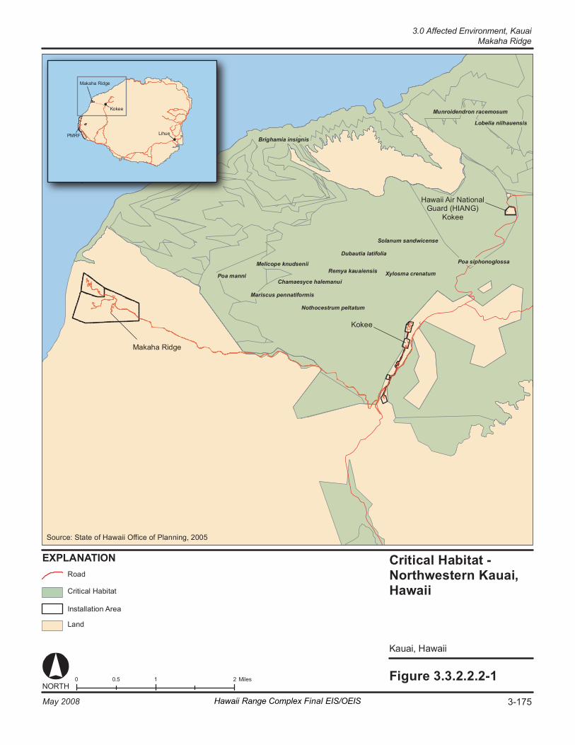
Xy lo sm a cren at um Remya ka ua ie ns is Me lic op e k nud sen ii
Ma riscu s pe nn at if or mi s
Chamaesyce halemanu i
No th o cest ru m pe lt at um
D uba ut ia la ti fo lia Po a sip hono gl o ssa
Br ig ha mi a in si gn is
Po a ma nni
Mu nr oi de nd r on r acem os um
Lobe lia n iih au en si s
So la nu m san dw icen se
Fi gure 3. 3. 2. 2. 2- 1 0 1 2 0. 5 M il es NORT H
EX PL AN AT IO N Crit ic al H ab it at - Northw es te rn Kauai , Ha wa ii
Ka uai , Ha waii
Ha wa ii A ir N at io na l G uar d (HIA NG )
Ko kee
Ko kee
Ma k ah a Ri dg e
Ka uai , Ha waii
Cr it ic al H ab it at
La nd
Ro ad
In st al la ti on A re a
L eahua
K auai i
Mak ah a Ri dg e
Ko k ee
Li hu e
PM RF M ai n Ba se
So ur ce : St at e o f H aw a ii Of fi ce o f Pl ann in g , 2 00 5
PM RF
Mak ah a Ri dg e
Ko k ee
Li hu e
3-175May 2008 Hawaii Range Complex Final EIS/OEIS
3.0 Affected Environment, KauaiMakaha Ridge
Kauai, 3.0 Affected Environment Makaha Ridge
3-176 Hawaii Range Complex Final EIS/OEIS May 2008
3.3.2.2.4 Hazardous Materials and Waste—Makaha Ridge Appendix C includes a discussion of hazardous materials and waste resource laws and regulations.
Region of Influence The region of influence for hazardous materials and potential hazardous waste is limited to areas of Makaha Ridge where hazardous materials are stored, handled, and consumed.
Affected Environment Hazardous materials and potential hazardous waste activities at Makaha Ridge are included in PMRF management plans for these types of materials. Daily activities are in accordance with those plans and similar range operations described in Section 3.3.2.1.6 for PMRF/Main Base.
Makaha Ridge follows PMRF’s hazardous materials management plans as described under PMRFINST 5100.2C, Hazardous Material Control and Management Program. The hazardous materials used at Makaha Ridge consist of lubricating oils, low sulfur diesel fuel, and some minor amounts of solvents. Each hazardous material storage area has appropriate Material Safety Data Sheets.
Hazardous waste generated at Makaha Ridge has been eliminated through Best Management Practices for routine range operations. Small aerosol solvent requirements for electrical parts/radar maintenance do not generate hazardous waste, and empty containers are returned to the PMRF Hazardous Material Minimization Center for disposal. Corrosion control/painting activities do not generate hazardous waste. Generator overhauls, following 1,000 hours of operations, produce “on-specification used oil fuel” confirmed by routine laboratory testing.
There are two 600-kW and two 300-kW generators supplied by two 6,000-gal diesel tanks and four 300-gal day tanks. There is one 1,000-gal gasoline tank and one 55-gal drum of motor oil. All tanks are above ground with appropriate containment devices.
Pesticide use at Makaha Ridge is applied by the certified applicator from PMRF. There are no radon issues at the site, and ordnance is not stored at Makaha Ridge. No medical or radioactive wastes are generated, and there are no IRP sites at Makaha Ridge. Lead-based paint management and asbestos management at Makaha Ridge follow the same procedures as described for PMRF/Main Base.
3.3.2.2.5 Health and Safety—Makaha Ridge Appendix C includes a detailed discussion of health and safety resources laws and regulations.
Region of Influence The region of influence for health and safety of workers includes immediate work areas and EMR hazard areas. The region of influence for public safety includes areas bordering Makaha Ridge.
3.0 Affected Environment, Kauai
Makaha Ridge
May 2008 Hawaii Range Complex Final EIS/OEIS 3-177
Affected Environment Hazards to health and safety potentially occur as a result of EMR at the site. There are four tracking radars, two surveillance radars, and the primary PMRF telemetry station at Makaha Ridge. Frequency Interference Control, Electronic Warfare (EW) and Communication Facilities are also located at Makaha Ridge.
Hazards of EMR to personnel and fuel (called HERP and HERF, respectively) are the main concerns at Makaha Ridge. No ordnance is stored at the site, so there are no Hazards of Electromagnetic Radiation to Ordnance (HERO) issues. The helicopters that use the heliport at Makaha Ridge may have Electro-explosive Devices; however, the area is below HERO unsafe levels due to sector blanking (i.e., filtering) of the area. To ensure conditions are safe, the site is regularly surveyed for radiation hazards, and all systems have warning lights to inform personnel when radar units are operating. Because of Makaha Ridge’s location at the end of a ridge, there are no health and safety issues associated with the public. As discussed under airspace, aircraft are warned through aeronautical charts of the potential EMR hazards associated with Makaha Ridge.
Kauai, 3.0 Affected Environment Kokee
3-178 Hawaii Range Complex Final EIS/OEIS May 2008
3.3.2.3 KOKEE Kokee is located at an altitude of 3,710 ft above mean sea level within Kokee State Park, which is owned by the State of Hawaii and managed by the Department of Land and Natural Resources, Division of State Parks. Kokee is operated jointly by PMRF and NASA. Kokee supports tracking radars, telemetry, Ultra-High Frequency/Very High Frequency (UHF/VHF) communications, and Command and Control (C2) systems.
This section describes the environmental resources that would be affected by the No-action Alternative, Alternative 1, Alternative 2, or Alternative 3 for Kokee. Of the 13 resources considered for analysis, air space, cultural resources, geology and soils, land use, noise, socioeconomics, transportation, utilities, and water resources are not addressed. Any issues with these resources that are associated with Kokee are included within the PMRF/Main Base discussion.
3.3.2.3.1 Air Quality—Kokee Appendix C includes a definition of air quality and the main regulations and laws governing its protection.
Region of Influence For inert pollutants (all pollutants other than ozone and its precursors), the region of influence is generally limited to an area extending a few miles downwind from the source. The region of influence for ozone may extend much farther downwind than the region of influence for inert pollutants; however, as the project area has no heavy industry and very few automobiles, ozone and its precursors are not of concern. Consequently, for the air quality analysis, the region of influence for project activities is the existing airshed surrounding Kokee.
Affected Environment
Climate and Regional Air Quality Section 3.3.2.1.1 describes climate and regional air quality on Kauai, which includes Kokee.
Existing Emission Sources The primary air pollutant emissions at Kokee are from backup diesel generators. The two 500-kW, two 350-kW, and one 250-kW generator sets are permitted by the State of Hawaii under a current non-covered source permit.
3.3.2.3.2 Biological Resources—Kokee Appendix C includes a definition of biological resources and the main regulations and laws that govern their protection.
3.0 Affected Environment, Kauai
Kokee
May 2008 Hawaii Range Complex Final EIS/OEIS 3-179
Region of Influence The region of influence for biological resources is the area within the fence surrounding the site.
Affected Environment
Vegetation A botanical assessment survey was conducted at Kokee in 2000. The vegetation on the site is dominated by non-native species. The site is surrounded by forested areas that are a mixture of exotic species and some native trees and shrubs. Kokee is composed of mainly intact koa-ohia mesic native forest that is contiguous with the surrounding State forest (Pacific Missile Range Facility, 2006e). Most of the areas around existing buildings and within the fenceline are paved or are grassy lawns (kikuyu grass [Pennisetum clandestinum]). Native plants observed include koa, `ohi`a, and `a`ali`i. The areas outside the fence lines of the southern portion of Kokee are periodically maintained and consist of grassy lawn. Dense thickets of blackberry (Rubus argutus), mats of kikuyu grass, and scattered firetree and firethorn are located outside the common fence line surrounding the northern portion of Kokee. The northern portion of Kokee also contains large iliahi/sandalwood trees. A small patch of Asian melastome (Melastoma septemnervium), an invasive species targeted for removal in the Kokee area, was found near the roadside at northern Kokee. (Pacific Missile Range Facility, 2001; 2006e)
Threatened and Endangered Plant Species
No threatened or endangered plant species were identified on Navy property at Kokee during the surveys conducted as part of the Integrated Natural Resources Management Plan process.
Wildlife A bird and feral mammal survey was conducted at Kokee in 2001. Native and migratory bird species observed at Kokee included the Pacific golden plover, the common amakihi (Hemignathus kauaiensis), short-eared owl, Kauai `elepaio (Chasiempis sandwichensis), `i`iwi (Vestiaria coccinea), and `apapane (Himatione sanguinea). The `apapane was the most abundant native bird observed in 2006, followed by the Kauai amakihi and `elepaio. `I`iwi were not observed in 2006. Other birds observed at Kokee included the common myna, Japanese white-eye, red junglefowl, spotted dove, white-rumped shama (Copsychus malabaricus), northern cardinal, house finch, hwa-mei (Garrulax canorus), zebra dove, and nutmeg manikin (Lonchura punctulata). (Pacific Missile Range Facility, 2001; 2006b)
No evidence of cats or rats was noted at the facility, but these mammals likely do occur on or near the site. Roof and Norway rats were captured at Kokee during a 2006 survey. The metallic skink (Lampropholis delicata) was observed during the same survey. There was also evidence of dogs, black-tailed deer (Odocoileus hemionus), and feral pigs on the site. (Pacific Missile Range Facility, 2001; 2006c)
Threatened and Endangered Wildlife Species
Table 3.3.2.3.2-1 provides a list of threatened and endangered species at or adjacent to the Kokee facility. The threatened Newell’s shearwater may fly over the Kokee site. Three endangered Hawaiian hoary bats were observed at Site 3, foraging above the forest. (Pacific Missile Range Facility, 2001)
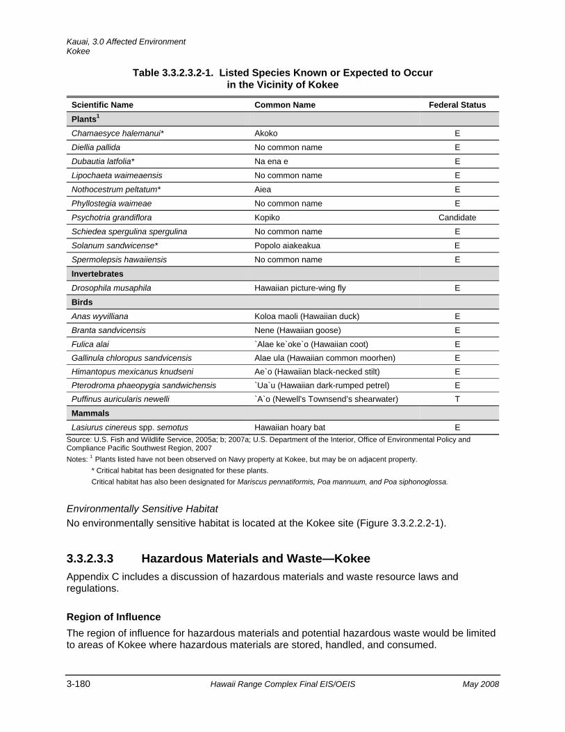
Kauai, 3.0 Affected Environment Kokee
3-180 Hawaii Range Complex Final EIS/OEIS May 2008
Table 3.3.2.3.2-1. Listed Species Known or Expected to Occur in the Vicinity of Kokee
Scientific Name Common Name Federal Status Plants1
Chamaesyce halemanui* Akoko E
Diellia pallida No common name E
Dubautia latfolia* Na ena e E
Lipochaeta waimeaensis No common name E
Nothocestrum peltatum* Aiea E
Phyllostegia waimeae No common name E
Psychotria grandiflora Kopiko Candidate
Schiedea spergulina spergulina No common name E
Solanum sandwicense* Popolo aiakeakua E
Spermolepsis hawaiiensis No common name E
Invertebrates
Drosophila musaphila Hawaiian picture-wing fly E
Birds
Anas wyvilliana Koloa maoli (Hawaiian duck) E
Branta sandvicensis Nene (Hawaiian goose) E
Fulica alai `Alae ke`oke`o (Hawaiian coot) E Gallinula chloropus sandvicensis Alae ula (Hawaiian common moorhen) E Himantopus mexicanus knudseni Ae`o (Hawaiian black-necked stilt) E Pterodroma phaeopygia sandwichensis `Ua`u (Hawaiian dark-rumped petrel) E Puffinus auricularis newelli `A`o (Newell's Townsend’s shearwater) T
Mammals
Lasiurus cinereus spp. semotus Hawaiian hoary bat E Source: U.S. Fish and Wildlife Service, 2005a; b; 2007a; U.S. Department of the Interior, Office of Environmental Policy and Compliance Pacific Southwest Region, 2007 Notes: 1 Plants listed have not been observed on Navy property at Kokee, but may be on adjacent property.
* Critical habitat has been designated for these plants. Critical habitat has also been designated for Mariscus pennatiformis, Poa mannuum, and Poa siphonoglossa.
Environmentally Sensitive Habitat No environmentally sensitive habitat is located at the Kokee site (Figure 3.3.2.2.2-1).
3.3.2.3.3 Hazardous Materials and Waste—Kokee Appendix C includes a discussion of hazardous materials and waste resource laws and regulations.
Region of Influence The region of influence for hazardous materials and potential hazardous waste would be limited to areas of Kokee where hazardous materials are stored, handled, and consumed.
3.0 Affected Environment, Kauai
Kokee
May 2008 Hawaii Range Complex Final EIS/OEIS 3-181
Affected Environment Hazardous materials and activities that may result in hazardous waste at Kokee are included in PMRF management plans for these types of materials. Daily activities are in accordance with those plans and similar range operations described in Section 3.3.2.1.6 for PMRF/Main Base.
Kokee follows PMRF’s hazardous materials management plans as described under PMRFINST 5100 and the Navy’s CHRIMP. The hazardous materials used at Kokee consist of lubricating oils, low sulfur diesel fuel, and some minor amounts of solvents. Each hazardous material storage area has appropriate Material Safety Data Sheets.
Best Management Practices for routine range operations have eliminated hazardous waste at Kokee. Small aerosol solvent requirements for electrical parts/radar maintenance do not generate hazardous waste, and empty containers are returned to PMRF Hazardous Material Minimization Center for disposal. Corrosion control/painting activities do not generate hazardous waste. Generator overhauls, following 1,000 hours of operations, produce “on-specification used oil fuel” confirmed by routine laboratory testing.
Hydrostatic oil associated with the radar units is replaced every 4 years and generates approximately 55 gal of used oil. There are five generators at Kokee, two 500-kW, two 350-kW, and one 250-kW, with associated fuel tanks. There are two 25,000-gal aboveground diesel tanks, and one 500-gal day tank. All tanks have appropriate containment devices.
Pesticide at Kokee is applied by the certified applicator from PMRF. There are no radon issues at the site, and ordnance is not stored at Kokee. No medical or radioactive wastes are generated, and there are no IRP sites at Kokee. Lead-based paint management and asbestos management at Kokee follow the same procedures as described for PMRF/Main Base.
There are no PCB-containing transformers at Kokee. Kokee radar facilities do have capacitors and other components that contain PCBs. When such an oil-containing part is no longer functional and requires disposal, the component is disposed according to PMRF’s Hazardous Waste Management Plan. When a component suspected of containing PCBs needs to be disposed of, the manufacturer is called to determine if PCBs are actually present in the part. Disposal occurs according to the required procedures.
3.3.2.3.4 Health and Safety—Kokee Appendix C includes a detailed discussion of health and safety resources laws and regulations.
Region of Influence The region of influence for health and safety of workers includes immediate work areas and EMR hazard areas. The region of influence for public safety includes areas bordering Kokee.
Affected Environment Kokee supports tracking radars, telemetry, UHF/VHF Communications, and C2 systems. Hazards to health and safety potentially occur as a result of EMR at the site. Hazards of electromagnetic radiation to personnel and fuel (called HERP and HERF, respectively) are the

Kauai, 3.0 Affected Environment Kokee
3-182 Hawaii Range Complex Final EIS/OEIS May 2008
main concerns at Kokee. No ordnance is stored at the site, so there are no HERO issues. The only fuel stored at the site (low sulfur diesel fuel for the electrical generators) is located outside of any EMR generating areas, so there are no HERF issues at the site. Appropriate sector blanking and the elevation of the radar units above the ground have eliminated any potential HERP issues at Kokee. To ensure that conditions are safe, the site is regularly surveyed for radiation hazards, and all systems have warning lights to inform personnel when the radar units are operating. The public is not exposed to any unsafe EMR levels. As discussed under airspace, aircraft are warned through aeronautical charts of the potential EMR hazards associated with Kokee range operations.
3.0 Affected Environment, Kauai Hawaii Air National Guard Kokee
May 2008 Hawaii Range Complex Final EIS/OEIS 3-183
3.3.2.4 HAWAII AIR NATIONAL GUARD KOKEE The Hawaii Air National Guard provides operation and maintenance of the Hawaii Digital Microwave System. Hawaii Air National Guard Kokee is a radar site, and PMRF maintains an APS-134, X-band, surface search radar.
This section describes the environmental resources that would be affected by the No-action Alternative, Alternative 1, Alternative 2, or Alternative 3 for Hawaii Air National Guard Kokee. Of the 13 resources considered for analysis, air quality, airspace, cultural resources, geology and soils, hazardous materials and waste, health and safety, land use, noise, socioeconomics, transportation, utilities, and water resources are not addressed.
3.3.2.4.1 Biological Resources—Hawaii Air National Guard Kokee Appendix C includes a definition of biological resources and the main regulations and laws that govern their protection.
Region of Influence The region of influence includes the areas on and surrounding Kokee.
Affected Environment Kokee Air Force Station is located on 11 acres of leased land operated by Hawaii Air National Guard 150th Aircraft Control and Warning Squadron.
Vegetation Kokee Air Force Station lies within the Na Pali-Kona Forest Reserve. `Ohi`a and koa trees are present in the area as well as native dry-land shrubs pukiawe and `a`ali`i.
Threatened and Endangered Plant Species
No rare, threatened, or endangered plants have been recorded at Kokee Air Force Station (Air Force Center for Environmental Excellence Environmental Services Office, 2003).
Wildlife Wildlife present in the Kokee Air Force Station area is similar to that described above in Section 3.3.2.3.2, such as the birds Kauai elepaio, `i`iwi, and `apapane. Feral pigs and goats are also located in the area.
Threatened and Endangered Wildlife
Table 3.3.2.4.1-1 provides a list of threatened and endangered species at the Kokee Air Force Station. Three endangered species have been recorded at Kokee Air Force Station: the Newell’s shearwater, dark-rumped petrel, and the Hawaiian hoary bat. The Hawaiian hoary bat roosts and forages on the station property or in adjacent forested areas. The seabirds are known to nest near the installation. (Air Force Center for Environmental Excellence Environmental Services Office, 2003)
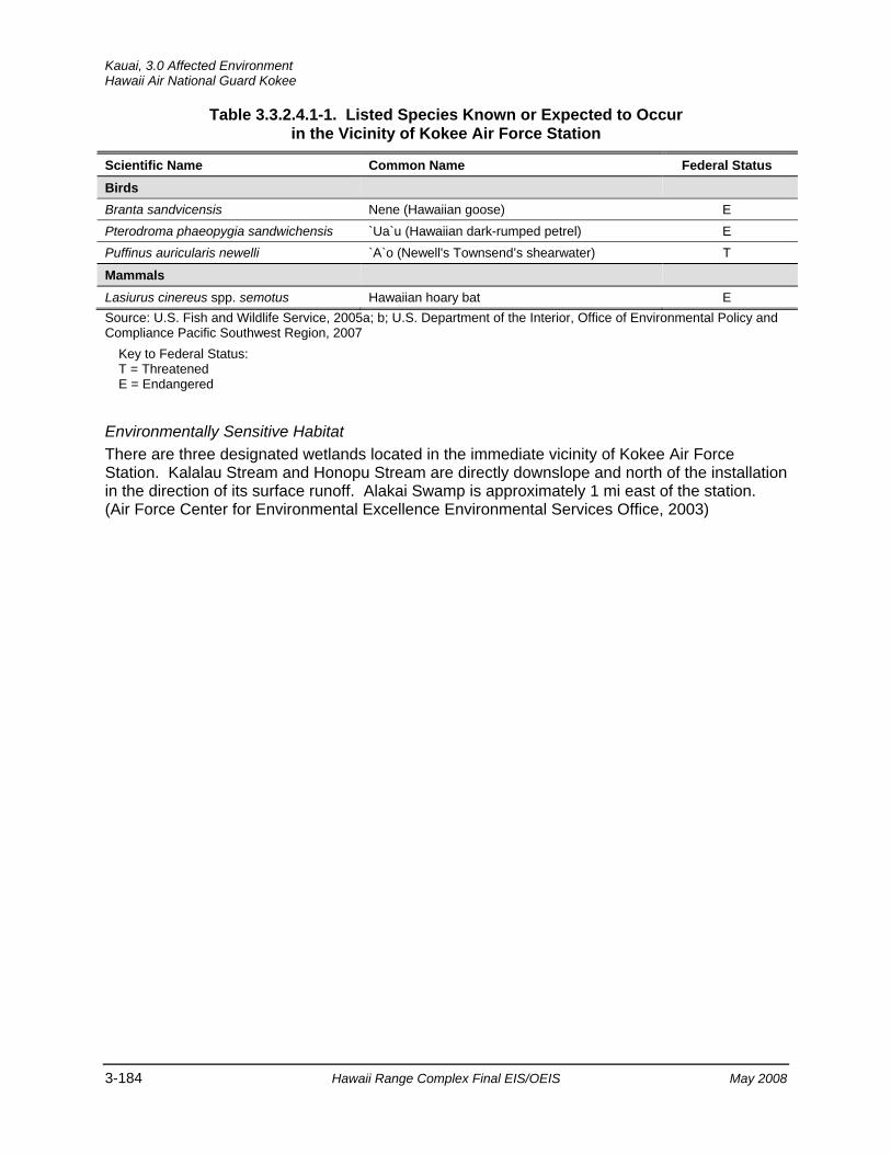
Kauai, 3.0 Affected Environment Hawaii Air National Guard Kokee
3-184 Hawaii Range Complex Final EIS/OEIS May 2008
Table 3.3.2.4.1-1. Listed Species Known or Expected to Occur in the Vicinity of Kokee Air Force Station
Scientific Name Common Name Federal Status Birds
Branta sandvicensis Nene (Hawaiian goose) E Pterodroma phaeopygia sandwichensis `Ua`u (Hawaiian dark-rumped petrel) E Puffinus auricularis newelli `A`o (Newell's Townsend’s shearwater) T
Mammals
Lasiurus cinereus spp. semotus Hawaiian hoary bat E Source: U.S. Fish and Wildlife Service, 2005a; b; U.S. Department of the Interior, Office of Environmental Policy and Compliance Pacific Southwest Region, 2007
Key to Federal Status: T = Threatened E = Endangered
Environmentally Sensitive Habitat There are three designated wetlands located in the immediate vicinity of Kokee Air Force Station. Kalalau Stream and Honopu Stream are directly downslope and north of the installation in the direction of its surface runoff. Alakai Swamp is approximately 1 mi east of the station. (Air Force Center for Environmental Excellence Environmental Services Office, 2003)
3.0 Affected Environment, Kauai
Kamokala Magazines
May 2008 Hawaii Range Complex Final EIS/OEIS 3-185
3.3.2.5 KAMOKALA MAGAZINES Kamokala Magazines are located approximately 2 mi east of PMRF/Main Base. Kamokala Magazines are a secure explosive storage area consisting of 10 magazines.
This section describes the environmental resources that would be affected by the No-action Alternative, Alternative 1, Alternative 2, or Alternative 3 for Kamokala Magazines. Of the 13 resources considered for analysis, air quality, airspace, biological, cultural resources, geology and soils, land use, noise, socioeconomics, transportation, utilities, and water resources are not addressed.
3.3.2.5.1 Hazardous Materials and Waste—Kamokala Magazines Appendix C includes a discussion of hazardous materials and waste resource laws and regulations.
Region of Influence The region of influence for hazardous materials and potential hazardous waste would be limited to areas of Kamokala Magazines where hazardous materials are stored, handled, and consumed. The only hazardous materials stored at the Kamokala Magazines are associated with the devices authorized for storage; specifically, hypergolic fuels, solid propellants, and other ordnance. These materials are contained in the devices that are required to be stored in the Kamokala Magazines with proper ventilation, marking, and placarding.
Affected Environment No hazardous materials are used or hazardous waste generated from range operations at Kamokala Magazines. There are no storage tanks or known IRP sites at this location. The gunnite material lining the caves has not been tested for asbestos, and therefore, must be presumed to be an asbestos-containing material. The site does not have any PCB-containing material or radon issues.
The magazines are a secured area controlled by the PMRF Ordnance Office, Code 7331, and they are the storage sites for the ordnance and solid rocket motors used in training events at PMRF. When needed, they are transported to the launch or loading site. All explosive ordnance, including solid rocket motors, is handled in accordance with NAVSEA OP5, Volume 1.
3.3.2.5.2 Health and Safety—Kamokala Magazines Appendix C includes a detailed discussion of health and safety resources laws and regulations.
Region of Influence The region of influence for health and safety consists of the immediate work areas and ordnance hazard areas. The region of influence for public safety includes Kamokala Magazines, Mana Plain, and the ESQD not within the surrounding cliffs.
Kauai, 3.0 Affected Environment Kamokala Magazines
3-186 Hawaii Range Complex Final EIS/OEIS May 2008
Affected Environment Kamokala Magazines are an explosive storage area consisting of 10 magazines. The health and safety issues for Kamokala Magazines are associated with the transfer and storage of ordnance. No more than 30,000-lb net explosive weight can be stored at each magazine cave; this generates a safety area with a 2,350-ft radius in a 60-degree arc to the front of each 30,000-lb net explosive weight tunnel, diminishing in radius by 30-degree increments away from the front (see Figure 3.3.2.1.7-1). Ordnance is stored in accordance with DoD and Navy standards. In addition, PMRF has established instruction 8023.G, which details how the storage and handling of ordnance is conducted.
3.0 Affected Environment, Kauai
Port Allen
May 2008 Hawaii Range Complex Final EIS/OEIS 3-187
3.3.2.6 PORT ALLEN Port Allen is a State of Hawaii harbor facility, located approximately 17 miles from PMRF/Main Base, on the southern coast of Kauai. The Navy leases office, storage, and berthing space at the Port Allen pier for range vessels and surface target support. Port Allen hosts PMRF's Range Support Boats and Seaborne Powered Target Boat site operations and maintenance facilities, and provides pier space, protected anchorage, and small-boat launch facilities. A review of the 13 resources that would be affected by the No-action Alternative, Alternative 1, Alternative 2, or Alternative 3 determined there would be no impacts from site operations at Port Allen.
Kauai, 3.0 Affected Environment Kikiaola Small Boat Harbor
3-188 Hawaii Range Complex Final EIS/OEIS May 2008
3.3.2.7 KIKIAOLA SMALL BOAT HARBOR Kikiaola Harbor is located on the southwest coast of the island of Kauai. The Harbor hosts Range Support Boats and small-boat launch facilities. PMRF’s Seaborne Powered Targets are launched from Kikiaola. A review of the 13 resources that would be affected by the No-action Alternative, Alternative 1, Alternative 2, or Alternative 3 determined there would be no impacts from site operations at the Kikiaola Small Boat Harbor.
3.0 Affected Environment, Kauai
Mt. Kahili
May 2008 Hawaii Range Complex Final EIS/OEIS 3-189
3.3.2.8 MT. KAHILI Mt. Kahili is an existing Department of Energy/PMRF communication site required for line-of-sight transmissions that contains a repeater station. The Mt. Kahili electronic site is one of the most remote tower locations in the Hawaiian Islands. Frequency band information is listed in Appendix E, Table E-5 (Remote Sites). There is no lighting at the facility. Road access is limited, in good weather, to very high-clearance 4-wheel drive vehicles only, and one can only drive within about a mile below the tower. From the end of the road, there is a 1-hour hike up a steep ridge covered with wet Hawaiian ferns, and finally a 30 ft. rope leads to the summit and the electronic site. (Broadcast Engineering Services of Bonny Doon, 2007)
The endangered Newell’s shearwater and Hawaiian petrel traverse the area, which may support breeding locations for these species. Hawaiian hoary bats are also likely to be using Mt. Kahili. (U.S. Department of the Interior, Office of Environmental Policy and Compliance Pacific Southwest Region, 2007) A review of the 13 environmental resources that would be affected by the No-action Alternative, Alternative 1, Alternative 2, or Alternative 3 determined there would be no impacts from site operations at Mt. Kahili.

Kauai, 3.0 Affected Environment Niihau
3-190 Hawaii Range Complex Final EIS/OEIS May 2008
3.3.2.9 NIIHAU Niihau is a privately owned island located about 17 nm southwest of Kauai. It is about 8 mi wide by 18 mi long and comprises approximately 72 mi2. PMRF leases 1,170 acres of land in the northeastern corner of the island and operates radar units, optics, and electronic warfare sites.
This section describes the environmental resources that would be affected by the No-action Alternative, Alternative 1, Alternative 2, or Alternative 3 for Niihau. Of the 13 resources considered for analysis, air quality, airspace, cultural resources, geology and soils, land use, noise, socioeconomics, transportation, utilities, and water resources for Niihau are not addressed.
3.3.2.9.1 Biological Resources—Niihau Appendix C includes a definition of biological resources and the main regulations and laws that govern their protection.
Region of Influence The region of influence for biological resources is the island of Niihau and its offshore environment.
Affected Environment
Vegetation The vegetation of the island is dominated by non-native plant species and plant communities. The dominant types of vegetation on Niihau are kiawe forest, grassland, and koa haole. On the northern lowland areas, the kiawe forest is more open and has a kiawe overstory with an extensive shrub understory of `ilima. A coastal dry herbland/grassland community is present along the northeastern coast of Niihau. A dry coastal community, koa haole shrubland, often dominated by pure stands of koa haole, occurs at scattered locations at higher elevations on the island. This vegetation community is often associated with abandoned pastures. In some locations the koa haole canopy is so thick and grazing pressure of feral sheep and pigs so intense that there is little, if any, herbaceous understory. Small mixed stands of eucalyptus (Eucalyptus robusta) and common ironwood occur in a few sheltered areas at higher elevations. Ironwood also occurs in coastal areas near the ocean. Scattered individuals of the endemic naio occur at higher elevations in a mixed kiawe/koa haole shrub association. (Pacific Missile Range Facility, 2001; U.S. Department of the Navy, 1998a)
Threatened and Endangered Plant Species
Table 3.3.2.9.1-1 lists threatened and endangered species known or expected to occur on Niihau. Alula (Brighamia insignis), Federally listed as endangered, was historically known on Niihau. A population occurred on the Kaali Cliff, but has not been observed since 1947. Other endangered plants that have been found in the area include pu`uka`a (Cyperus trachysanthos) and Lobelia niihauensis (no common name) (Hawaii Department of Land and Natural Resources, no date [c]). Threats to the species include loss of native pollinators, browsing by goats, and invertebrate pests. (Hawaii Department of Land and Natural Resources, 2006)
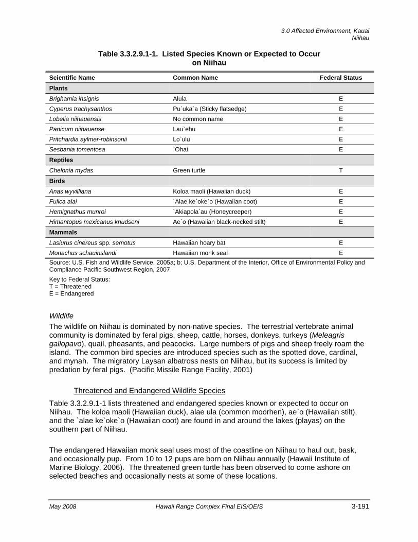
3.0 Affected Environment, Kauai
Niihau
May 2008 Hawaii Range Complex Final EIS/OEIS 3-191
Table 3.3.2.9.1-1. Listed Species Known or Expected to Occur on Niihau
Scientific Name Common Name Federal Status Plants
Brighamia insignis Alula E Cyperus trachysanthos Pu`uka`a (Sticky flatsedge) E Lobelia niihauensis No common name E Panicum niihauense Lau`ehu E Pritchardia aylmer-robinsonii Lo`ulu E Sesbania tomentosa `Ohai E
Reptiles
Chelonia mydas Green turtle T
Birds
Anas wyvilliana Koloa maoli (Hawaiian duck) E Fulica alai `Alae ke`oke`o (Hawaiian coot) E Hemignathus munroi `Akiapola`au (Honeycreeper) E Himantopus mexicanus knudseni Ae`o (Hawaiian black-necked stilt) E
Mammals
Lasiurus cinereus spp. semotus Hawaiian hoary bat E Monachus schauinslandi Hawaiian monk seal E Source: U.S. Fish and Wildlife Service, 2005a; b; U.S. Department of the Interior, Office of Environmental Policy and Compliance Pacific Southwest Region, 2007 Key to Federal Status: T = Threatened E = Endangered
Wildlife The wildlife on Niihau is dominated by non-native species. The terrestrial vertebrate animal community is dominated by feral pigs, sheep, cattle, horses, donkeys, turkeys (Meleagris gallopavo), quail, pheasants, and peacocks. Large numbers of pigs and sheep freely roam the island. The common bird species are introduced species such as the spotted dove, cardinal, and mynah. The migratory Laysan albatross nests on Niihau, but its success is limited by predation by feral pigs. (Pacific Missile Range Facility, 2001)
Threatened and Endangered Wildlife Species
Table 3.3.2.9.1-1 lists threatened and endangered species known or expected to occur on Niihau. The koloa maoli (Hawaiian duck), alae ula (common moorhen), ae`o (Hawaiian stilt), and the `alae ke`oke`o (Hawaiian coot) are found in and around the lakes (playas) on the southern part of Niihau.
The endangered Hawaiian monk seal uses most of the coastline on Niihau to haul out, bask, and occasionally pup. From 10 to 12 pups are born on Niihau annually (Hawaii Institute of Marine Biology, 2006). The threatened green turtle has been observed to come ashore on selected beaches and occasionally nests at some of these locations.
Kauai, 3.0 Affected Environment Niihau
3-192 Hawaii Range Complex Final EIS/OEIS May 2008
Environmentally Sensitive Habitat An area of 357 acres in the northern portion of Niihau has been designated as critical habitat for the alula (Figure 3.3.2.9.1-1). This area is considered essential to the conservation of the taxon by the USFWS. (U.S. Fish and Wildlife Service, 2003a)
3.3.2.9.2 Hazardous Materials and Waste—Niihau Appendix C includes a discussion of hazardous materials and waste resource laws and regulations.
Region of Influence The region of influence for hazardous materials and potential hazardous waste would be limited to areas of Niihau where hazardous materials are stored, handled, and consumed.
Affected Environment Hazardous materials are used on Niihau during the minor maintenance activities associated with PMRF facilities, including some aerosol solvents, diesel fuel for generators, paint, and oil. These materials are used for the radar unit and EW site facilities. These materials are brought to Niihau when required for maintenance. General site maintenance is provided by Niihau Ranch. All hazardous materials used and waste generated are managed in accordance with PMRF procedures described in Section 3.3.2.1.6.
PMRF does maintain two aboveground diesel fuel storage tanks on Niihau to operate the electrical generators for the radar site and EW site. These fuel storage tanks consist of a 1,000-gal tank for the radar site and a 100-gal tank for the EW site. There are no radon issues associated with operation of range facilities on Niihau, and there are no IRP sites. There are no PCB-containing devices in any of the radar or power-related components at Niihau.
3.3.2.9.3 Health and Safety—Niihau Appendix C includes a detailed discussion of health and safety resources laws and regulations.
Region of Influence The region of influence for health and safety is Niihau.
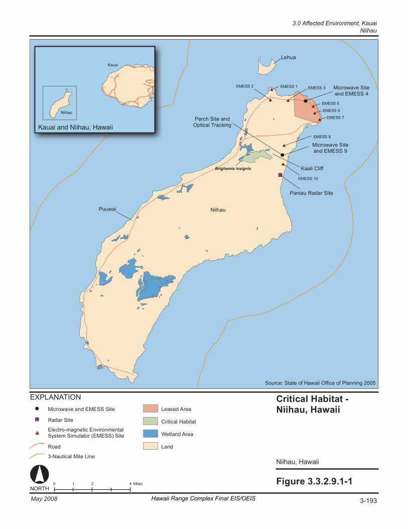
Fi gure 3. 3. 2. 9. 1- 1 0 2 4 1 M il es NORT H
Ka uai and N ii hau , H awai i
K auai
Ni i hau
Crit ic al H ab it at - Ni ihau , Ha wa ii
Niih au , Ha wa ii
Br ig ha mi a in si gn is
Nii hau
Le hu a
Mi cr ow av e Si te an d EM ESS 4
P er ch S it e an d Op ti ca l Tr ac ki ng
P an ia u Ra dar S it e
EX P LA NA TION
Cr it ic al H ab it at
La nd
We tl an d Ar ea
Ra da r Si te
Le as ed A re a
El ec tr o- m agn et ic E nv ir onm ent al Sy st em S im ul at or ( EM ESS ) Si te
Ka al i Cl if f
P uu wa i
Mi cr ow av e Si te an d EM ESS 9
EM ES S 1 EM ES S 2 EM ES S 3
EM ES S 5
EM ES S 6
EM ES S 7
EM ES S 8
EM ES S 10
Mi cr ow av e and E ME SS Si te
Ro ad
3- Na ut ic al M il e Li ne
3-193May 2008 Hawaii Range Complex Final EIS/OEIS
3.0 Affected Environment, Kauai Niihau
Source: State of Hawaii Office of Planning 2005
Kauai, 3.0 Affected Environment Niihau
3-194 Hawaii Range Complex Final EIS/OEIS May 2008
Affected Environment Niihau is a privately owned island, that through agreements with the owners, PMRF uses to support range operations. The primary health and safety concern for the residents of Niihau is the potential for a fire on the island. Due in part to the dry climate and kiawe vegetation that dominates the island, there is the potential for very large fires to occur. Currently, the island does not have any firefighting equipment. Emergency medical evacuation service can be provided by the helicopter owned by the Robinson family.
PMRF operates a radar at Paniau that is remotely operated from PMRF/Main Base. The radar unit, which is located on top of a facility, presents no HERP hazards at ground level where any island resident could be affected. PMRF/Main Base also operates the Niihau Perch site EW system, which has a HERP EMR hazard of 12 ft in front of where the system is pointing. A warning light and warning signs are placed in the area when the system is operating. In addition, PMRF flies AEGIS drone targets along the east coast of the island away from inhabited areas. Presently, helicopters are airborne with buckets during nearland/overland range operations occurring on or near Niihau to deal with potential fire hazards.
3.0 Affected Environment, Kauai
Kaula
May 2008 Hawaii Range Complex Final EIS/OEIS 3-195
3.3.2.10 KAULA Kaula is approximately 108 acres of federally owned and controlled land. The Navy uses a small portion of Kaula for aircraft gunnery and inert ordnance target practice. The ordnance impact area is limited to about 10 acres on the south end of the island. The island is not inhabited, and there are no structures. Access to the island is restricted.
This section describes the environmental resources that would be affected by the No-action Alternative, Alternative 1, Alternative 2, or Alternative 3 for Kaula. Of the 13 resources considered for analysis, air quality, noise, hazardous materials and waste, socioeconomics, transportation, utilities, and water resources are not addressed.
3.3.2.10.1 Airspace—Kaula Appendix C includes a detailed description of airspace. Kaula is included in the region of influence for PMRF/Main Base. See Section 3.3.2.1.2 for the airspace affected environment that includes Kaula.
3.3.2.10.2 Biological Resources—Kaula Kaula is located approximately 60 miles southwest of PMRF. It is approximately 1 mi long and 0.25 mi wide (an area of 0.25 mi2 or 160 acres). The island is crescent shaped and generally comprised of steep cliffs on all sides ranging from 100 to 150 ft above mean sea level with no beaches. Kaula is covered by a sparse grass landscape and earthen/rock outcrops, and is reportedly underlain by a relatively thin soil layer with highly weathered limestone bedrock. The southern end of the island is used as a range for inert ordnance. The majority of the island is left undisturbed with a portion designated as a bird sanctuary. Kaula is used by the Navy for aircraft gunnery and inert ordnance target practice. Appendix C includes a definition of biological resources and the main regulations and laws that govern their protection.
Region of Influence The region of influence for biological resources associated with Kaula includes the island and offshore area.
Affected Environment
Vegetation Due to strong, dry, and continuous winds, the vegetation on Kaula is very sparse. The dominant vegetation is low-growing shrubs or herbs that belong to a semi-arid and strand flora. A small number of koa haole have been noted on the island. Common plants that inhabit the sandy beach intertidal habitat include beach morning glory, beach heliotrope, milo, and hau (Maragos, 1998). The vegetation composition includes 5 endemic Hawaiian species, 10 indigenous species, and 14 introduced (exotic) species. Native ilima and ihi are the most abundant species. (Pacific Missile Range Facility, 2001; Offshore Island Restoration Committee, undated)

Kauai, 3.0 Affected Environment Kaula
3-196 Hawaii Range Complex Final EIS/OEIS May 2008
Threatened and Endangered Plant Species
Endangered plants located on Kaula are listed in Table 3.3.2.10.2-1.
Table 3.3.2.10.2-1. Listed Species Known or Expected to Occur on Kaula
Scientific Name Common Name Federal Status Plants
Amaranthus brownii No common name E
Pritchardia aylmer-robinsonii Lo`ulu E
Schiedea verticellata No common name E
Sesbania tomentosa `Ohai E
Reptiles
Chelonia mydas Green turtle T
Eretmochelys imbricata Hawksbill turtle E
Mammals
Monachus schauinslandi Hawaiian monk seal E Source: U.S. Fish and Wildlife Service, 2007a
Key to Federal Status: T = Threatened E = Endangered
Wildlife Twenty-six different species of seabirds have been observed on Kaula. An estimated 18 species of seabirds currently nest on the island (Offshore Island Restoration Committee, undated). These species appear to be healthy and are reproducing normally. The species include three species of migratory shorebirds that occasionally stop on Kaula seasonally and small numbers of six species of exotic (introduced) land birds. The sooty tern (Sterna fuscata), brown noddy, red-footed booby, and masked booby are some of the more common species observed. No other terrestrial wildlife is known to occur on Kaula, and none is expected. (Pacific Missile Range Facility, 2001; Offshore Island Restoration Committee, undated)
Threatened and Endangered Wildlife Species
None of the species of birds Federally listed as threatened or endangered occur on Kaula. Coastal waters off Kaula are considered viable foraging habitat for green turtles, but no sightings of sea turtles have been documented. (Pacific Missile Range Facility, 2001)
Three Hawaiian monk seals were observed on a shelf off Kaula in a 2000 aerial survey (Baker and Johanos, 2004). Fifteen Hawaiian monk seals were counted during a 4-hour period hauled out on Kaula during a 2006 cruise (National Marine Fisheries Service, 2007b).
Environmentally Sensitive Habitat According to the Hawaii Department of Land and Natural Resources, the Hawaii State Seabird Sanctuary consists of and includes 40 State-owned or controlled islands, islets, and rocks (Hawaii Department of Land and Natural Resources, 1981). Kaula was listed erroneously by the State as one of these islands; it remains Federally owned and controlled.
3.0 Affected Environment, Kauai
Kaula
May 2008 Hawaii Range Complex Final EIS/OEIS 3-197
3.3.2.10.3 Cultural Resources—Kaula Appendix C includes a description of cultural resources and the laws and regulations pertaining to them.
Region of Influence The region of influence for cultural resources at Kaula encompasses the southwestern tip of the island where there is an existing, heavily disturbed ordnance impact area (see Figure 2.1-2). There are no known historic properties within the impact area; however, due to the presence of unexploded ordnance, only a portion has been surveyed (U.S. Department of Defense, 2006).
Proposed or ongoing training events with the potential to affect cultural resources on Kaula and within Warning Area W-187 include BOMBEX and GUNEX. Both BOMBEX and GUNEX (Air-to-Ground) involve the islet only and not the surrounding waters.
Affected Environment
Archaeological Resources (Prehistoric and Historic) Kaula has no evidence of extensive human habitation, although six archaeological sites located in the northern portion of the islet indicate some level of visitation (U.S. Department of the Navy, Commander, Third Fleet, 2006).
Historic Buildings and Structures Two stone features (possibly heiaus); a sea cave with a low man-made wall; and the remains of a small unmanned light station, derrick, and shelter constructed by the U.S. Lighthouse Service in 1932 are the only structures mentioned in the literature for Kaula (Resture, 2006; Columbia Gazetteer of North America, 2000).
Traditional Resources References to Kaula have been noted in Hawaiian oral traditions; however, there are no recorded traditional Hawaiian sites on the islet.
3.3.2.10.4 Geology and Soils—Kaula Region of Influence The region of influence for geology and soils is the southern end of Kaula, specifically, the southernmost 10 acres, currently used by the Navy for airborne ordnance training.
Affected Environment
Physiography Kaula is a small, crescent-shaped volcanic island located southwest of Niihau. The island is the remnant of a breached volcanic cone that has been heavily eroded. The island is fairly symmetrical, with the highest elevation achieved near the center of the island at slightly greater than 500 ft. Steep sea cliffs occur around the island perimeter; however, the remnants of a narrow wave-cut terrace, cut 8 to 10 ft above current sea level, are evident on the eastern
Kauai, 3.0 Affected Environment Kaula
3-198 Hawaii Range Complex Final EIS/OEIS May 2008
shore. Near the northwest end of the convex (leeward) side of the island, slopes are the steepest, reaching approximately 140 percent and greater. In general, the sea cliffs are relatively smooth; however, in some areas, joints and fissures in the rock have promoted large blocks of ash to erode, making elongated sea caves (U.S. Department of the Navy, 1980). On the concave windward side, upland slopes generally range from 75 to 125 percent. Gullies on the leeward slopes are relatively few and small, whereas those on the windward slopes tend to be more numerous and larger (U.S. Department of the Navy, 1980).
Geology The distance and water depth between Kaula and Niihau suggest that Kaula was an independent volcanic center (U.S. Department of the Navy, 1980). Earlier geologic surveys reported by Palmer (1927) indicate a geologic history typical of other islands in the Hawaiian chain. Kaula was raised to sea level, or near sea level, during a major period of Tertiary volcanism when large volumes of lava were deposited. An erosional unconformity ensued, during which coral reefs developed on the summit of the submerged volcano or the beveled base of the subaerial mountain. A second eruptive epoch followed, during which a tuff crater was formed. The crater was probably unsymmetrical, with the leeward side being the highest and the windward side considerably lower, possibly not above sea level. The tuff crater was subsequently eroded by wind, waves, and runoff, and a submarine terrace was cut around most of the island. The sea has since receded to about 15 ft below the wave cut terrace.
Volcanic rock on Kaula is reported as a light brownish-gray tuff (U.S. Department of the Navy, 1980). Embedded in the tuff are olivine nodules, which may be the same age as the tuff. Other inclusions encompass fragments of older lava and reef limestone, which suggest that the last phase of volcanic activity dislodged and incorporated these materials during violent eruptions (U.S. Department of the Navy, 1980).
Soils Soil on Kaula is primarily composed of water-lain detritus, which mantles the wave cut terrace on the leeward side of the island. The detritus is fine- to coarse-grained tuffaceous material and has not been reworked; therefore, the grains are generally angular. The coarsest grains are composed of fresh to decomposed volcanic glass, fine grained basalt, and fragments of bird bones along with a few olivine fragments (U.S. Department of the Navy, 1980). The relicts in the finer-grained material suggest that the parent material was of basaltic composition. Augite and feldspar, common elements of Hawaiian basalts, however, have been weathered out (U.S. Department of the Navy, 1980).
3.3.2.10.5 Health and Safety—Kaula Appendix C includes a detailed discussion of health and safety resources laws and regulations.
Region of Influence The region of influence for health and safety is Kaula and the immediate surface danger zone around the island.
3.0 Affected Environment, Kauai
Kaula
May 2008 Hawaii Range Complex Final EIS/OEIS 3-199
Affected Environment The primary health and safety issue concern associated with Kaula is the aerial inert bombing/aircraft gunnery impact area; no other hazardous operations occur on the island. To minimize health and safety risks, a Surface Danger Zone surrounding Kaula was established for the primary purpose of ensuring an adequate margin of safety to both personnel and equipment during the conduct of gunnery training events by the military. In addition, because of the potential for unexploded ordnance to be present on and just below the surface of the island and adjacent waters, the island and tidal shoreline are closed to unauthorized personnel at all times. Prior to any bombing training events, an aircraft flies over the island and determines if it is safe to conduct the mission.
To allow some fishing use of the waters surrounding the island (excluding the tidal zone), the Navy does open the surface danger zone on weekends and holidays for fishing by notifying the appropriate State agency. The Commander Fleet Air Hawaii, as the controlling and scheduling agency for the military use of Kaula, is responsible for notifying the Hawaii Department of Land and Natural Resources, Division of Fish and Game, and Commander Fourteenth Coast Guard District, in writing, of the period of time the Surface Danger Zone will be opened for fishing.
3.3.2.10.6 Land Use—Kaula Appendix C includes a definition of land use and laws and regulations that pertain to it.
Region of Influence The region of influence is the southern end of Kaula, specifically, the southernmost 10 acres, currently used by the Navy for airborne ordnance training. The Navy has no intention of expanding land holdings at this location. Kaula is federally owned and controlled.
Affected Environment Kaula is a 108-acre island southwest of Niihau and is part of Kauai County (Figure 2.1-2). There are no recreational activities associated with or occurring on Kaula. Ordnance delivery is limited to the southeastern tip of the island (U.S. Department of Defense, 2006). The State Land Use classification for Kaula is Conservation Land, and there is no County land use designation for Kaula.
Kauai, 3.0 Affected Environment Kaula
3-200 Hawaii Range Complex Final EIS/OEIS May 2008
THIS PAGE INTENTIONALLY LEFT BLANK
3.0 Affected Environment, Oahu
Puuloa Underwater Range—Offshore
May 2008 Hawaii Range Complex Final EIS/OEIS 3-201
3.4 OAHU Oahu serves as the main commerce port for all of Hawaii. It is the third largest of the Hawaiian Islands in size and the largest in population, with roughly 75 percent of the State’s residents. Honolulu County encompasses the entire island of Oahu; its county seat is the city of Honolulu. Current and proposed Hawaii Range Complex (HRC) training and research, development, test, and evaluation (RDT&E) activities offshore or onshore of Oahu addressed in this Environmental Impact Statement (EIS)/Overseas EIS (OEIS) are located at Puuloa Underwater Range, Naval Defensive Sea Area, U.S. Coast Guard Air Station Barbers Point/Kalaeloa Airport, Marine Corps Base Hawaii (MCBH), Marine Corps Training Area–Bellows (MCTAB), Makua Military Reservation, Dillingham Military Reservation, Ewa Training Minefield, Barbers Point Underwater Range, Naval Undersea Warfare Center (NUWC) Range Shipboard Electronic Systems Evaluation Facility (SESEF), NUWC Fleet Operational Readiness Accuracy Check Site (FORACS), Naval Station Pearl Harbor, Ford Island, Naval Inactive Ship Maintenance Facility Pearl Harbor, Explosive Ordnance Disposal (EOD) Land Range–Naval Magazine (NAVMAG) Pearl Harbor West Loch, Lima Landing, Hickam Air Force Base (AFB), Wheeler Army Airfield, Kahuku Training Area, Keehi Lagoon, Kaena Point, Mt. Kaala, Wheeler Network Segment Control/Pacific Missile Range Facility (PMRF) Communication Sites, Mauna Kapu Communication Site, and Makua Radio/Repeater/Cable Head.
3.4.1 OAHU OFFSHORE Oahu Offshore addresses ocean areas within 12 nautical miles (nm) of Oahu, including ranges and training areas where activities are performed by the Navy. Discussions include Puuloa Underwater Range, Naval Defensive Sea Area, MCBH, MCTAB, Makua Military Reservation, Dillingham Military Reservation, Ewa Training Minefield, Barbers Point Underwater Range, NUWC SESEF, and NUWC FORACS. These offshore areas are not within the Hawaiian Islands Humpback Whale National Marine Sanctuary.
3.4.1.1 PUULOA UNDERWATER RANGE—OFFSHORE The Puuloa Underwater Range is 2 square nautical miles (nm2) and oriented parallel to the shore at Ewa Beach, west of the mouth of Pearl Harbor. Water depths range from about 9 feet (ft) near shore to a maximum depth approaching 228 ft in the southwest corner. The majority of the range is less than 39 ft in depth. The Puuloa Underwater Range supports underwater demolition activities.
This section describes the environmental resources that would be affected by the No-action Alternative, Alternative 1, Alternative 2, or Alternative 3 for Puuloa Underwater Range Offshore. Of the 13 environmental resources considered for analysis, air quality, airspace, geology and soils, land use, noise, socioeconomics, transportation, utilities, and water resources are not addressed.
Oahu, 3.0 Affected Environment Puuloa Underwater Range—Offshore
3-202 Hawaii Range Complex Final EIS/OEIS May 2008
3.4.1.1.1 Biological Resources—Puuloa Underwater Range—Offshore Section 3.1.2 provides a detailed description of marine biological resources.
Region of Influence The region of influence includes the underwater range and adjacent waters.
Affected Environment
Vegetation Several hundred species of marine algae (seaweed) have been collected in Hawaiian waters (MacCaughey, 1916). Seaweed, mainly alien forms such as Acanthophora spicifera and Hypnea musciformis, is still very abundant in the offshore areas of Oahu (U.S. Department of the Navy, 2002a). A. spicifera is the most widespread and successful alien alga in Hawaii. Its adaptability has enabled it to spread throughout the state where it is found in brackish water ponds, salty tidepools, on basalt ledges and in sandy bottomed habitats attached to coral rubble. It is now found on all of the Main Hawaiian Islands and is a common component of the intertidal environment throughout the state. Soon after the introduction of H. musciformis, it was identified as a food source for the green sea turtle. H. musciformis can make up a significant part of their diet, sometimes representing 99 to 100 percent of the seaweed found in their stomachs. Avarainvillea amadelpha can be found in abundance on the shallow reef flats on Oahu's south shore where it competes directly with the Islands' only native seagrass on sandy bottoms off south Oahu. Specimens have been collected from deeper water up to 90 meter (m) depth. It is not known if this alga has been introduced or is a native. (University of Hawaii, undated)
Threatened and Endangered Plant Species No threatened or endangered plant species have been observed in the region of influence.
Wildlife A description of coral reef area associated with the Hawaiian Islands and its management by both the State of Hawaii and the Federal government is provided in Section 3.1.2.1. A benthic survey conducted in 2001 close to and with a similar depth range to the Puuloa Underwater Range indicated that corals ranged from locally abundant on the northern inshore reef slope at Ewa Beach (Figure 3.4.1.1.1-1) to uncommon on the broad sandy slopes on the south (seaward) side of the surveyed area. Coral coverage ranged from 80 to 90 percent at depths between 9.7 and 13 fathoms to less than 1 percent in water depths from 13 to 20 fathoms. The coral community was dominated by rose or cauliflower coral (Pocillopora meandrina), lobe coral (Porites lobata), and finger coral (Porites compressa). (U.S. Department of the Navy, 2002a)
Coastal waters of the Ewa Plain receive nutrient rich water from springs below sea level. The nutrients in this water come from upland agricultural fertilization, leaching from cesspools and septic tanks, domestic waste injection wells, and urban application of fertilizers. These extra nutrients promote the growth of benthic algae (limu). A few species of reef fish are present in low numbers in the littoral waters. (U.S. Department of the Navy, 2002a)
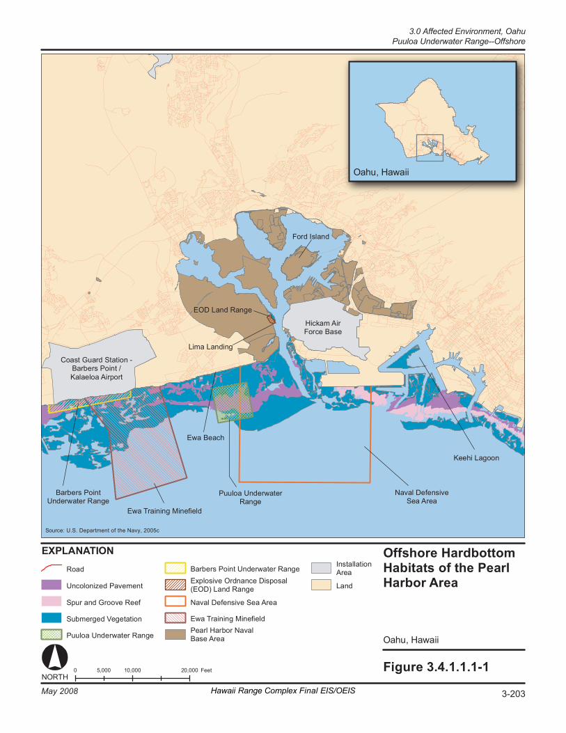
Fi gure 3. 4. 1. 1. 1- 1 0 1 0,000 20 ,000 5, 000 F eet NORT H
O ahu , Hawa ii
EX PL AN AT IO N O ffs hore Hardbot to m Ha bi ta ts o f th e Pe ar l Ha rbor A re a
O ahu , Hawa ii
S our ce: U.S. Department of the Navy, 2005c
Ro ad
Un co lo ni ze d Pa veme nt
Sp ur a nd G r oov e Re ef
Su bm er ged V e get at io n
Pu ul oa U n der wa te r Ra ng e
Ba r ber s Po in t U nd er wa te r Ra ng e
Ew a Tr ai ni ng Mi ne fi el d
Na va l De fe ns iv e Se a Are a
Ex pl os iv e Ord nan ce D is po sa l (EOD) Lan d Ra ng e
Pe ar l Ha rb or N av al Ba se A re a
La nd
In st al la ti on Are a
Pu ul oa U n der wa te r Ra ng e
Ew a Tr ai ni ng Mi ne fi el d
Ba r ber s Po in t Un de rw at er R an ge
Na va l De fe ns iv e Se a A re a
Fo rd I sl an d
Co as t Gu ar d St at io n - Ba r ber s Po in t / Ka la el oa A ir po rt
Hi ck am A ir Fo rc e Ba se
Li ma L an di ng
Ke eh i La go on
EOD La nd R a nge
Ew a Be ac h
Hawaii Range Complex Final EIS/OEIS 3-203May 2008
3.0 Affected Environment, OahuPuuloa Underwater Range--Offshore
Oahu, 3.0 Affected Environment Puuloa Underwater Range—Offshore
3-204 Hawaii Range Complex Final EIS/OEIS May 2008
Fish species are diverse and abundant and generally associated with the deeper (greater than 20 fathoms) areas containing coral coverage and vertical relief. This type of area has been designated by the National Oceanic and Atmospheric Administration (NOAA) as Habitat Areas of Particular Concern (HAPC). The most common families represented are surgeonfishes (acanthurids), butterflyfishes (chaetodontids), damselfishes (pomacentrids), wrasses (labrids), triggerfishes (balistids), and moorish idols (zanclids). (U.S. Department of the Navy, 2002a) Section 3.1.2.2.1 includes a description of Essential Fish Habitat (EFH); however, a detailed description, including status, distribution, and habitat preference of managed fisheries, is provided in the Navy’s Final Essential Fish Habitat and Coral Reef Assessment for the Hawaii Range Complex EIS/OEIS (U.S. Department of the Navy, 2007a).
A variety of whales and dolphins not listed as threatened or endangered are found around the Hawaiian Islands, including the minke whale (Balaenoptera acutorostrata) and Bryde’s whale (Balaenoptera edeni). These whales have been identified both by visual sighting and by acoustic surveys. More than 20 species of toothed whales and dolphins are known to exist around the islands, including those most frequently seen: spinner dolphin (Stenella longirostris), spotted dolphin (Stenella attenuata), bottlenose dolphin (Tursiops truncatus), short finned pilot whale (Globicephala macrorynchus), and false killer whale (Pseudorca crassidens). The spinner dolphin is commonly seen on the leeward side of all of the Main Hawaiian Islands. Spotted dolphins are usually located near the spinners in deeper waters, while the bottlenose dolphins frequent both shallow and deep areas. (U.S. Department of the Navy, 2002a)
Threatened and Endangered Species Table 3.4.1.1.1-1 provides a list of threatened and endangered species that are known or expected to occur in the vicinity of Puuloa Underwater Range. Transitory humpback whales (Megaptera novaeangliae) are occasionally reported in the area outside of the Pearl Harbor Entrance Channel but are not resident in the area (Smith et al., 2006). Hawaiian monk seals (Monachus schauinslandi) are resident on Oahu and have been sighted near the Pearl Harbor Entrance Channel. The green turtle (Chelonia mydas) is commonly sighted in this area (Smith et al., 2006).
Nine marine wildlife species listed as Federal and State threatened or endangered species are known or suspected to exist in Hawaiian waters. These species include the Hawaiian monk seal, blue whale (Balaenoptera musculus), fin whale (Balaenoptera physalus), humpback whale, sei whale (Balaenoptera borealis), sperm whale (Physeter macrocephalus), hawksbill turtle (Eretmochelys imbricata), green turtle, and loggerhead turtle (Caretta caretta). Section 3.1.2 includes a description of these listed species. (U.S. Department of the Navy, 2002a)
Environmentally Sensitive Habitat No environmentally sensitive habitat has been identified.
Hawaiian Islands Humpback Whale National Marine Sanctuary Hawaiian Islands Humpback Whale National Marine Sanctuary areas are located off the northern and southeastern coastlines of Oahu. No current HRC activities are being performed within portions of the Hawaiian Islands Humpback Whale National Marine Sanctuary offshore of Oahu, and none are being proposed.
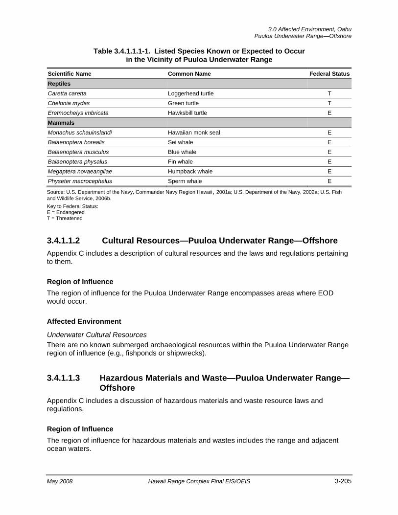
3.0 Affected Environment, Oahu
Puuloa Underwater Range—Offshore
May 2008 Hawaii Range Complex Final EIS/OEIS 3-205
Table 3.4.1.1.1-1. Listed Species Known or Expected to Occur in the Vicinity of Puuloa Underwater Range
Scientific Name Common Name Federal StatusReptiles Caretta caretta Loggerhead turtle T Chelonia mydas Green turtle T Eretmochelys imbricata Hawksbill turtle E
Mammals Monachus schauinslandi Hawaiian monk seal E Balaenoptera borealis Sei whale E Balaenoptera musculus Blue whale E Balaenoptera physalus Fin whale E Megaptera novaeangliae Humpback whale E Physeter macrocephalus Sperm whale E
Source: U.S. Department of the Navy, Commander Navy Region Hawaii, 2001a; U.S. Department of the Navy, 2002a; U.S. Fish and Wildlife Service, 2006b. Key to Federal Status: E = Endangered T = Threatened
3.4.1.1.2 Cultural Resources—Puuloa Underwater Range—Offshore Appendix C includes a description of cultural resources and the laws and regulations pertaining to them.
Region of Influence The region of influence for the Puuloa Underwater Range encompasses areas where EOD would occur.
Affected Environment
Underwater Cultural Resources There are no known submerged archaeological resources within the Puuloa Underwater Range region of influence (e.g., fishponds or shipwrecks).
3.4.1.1.3 Hazardous Materials and Waste—Puuloa Underwater Range—Offshore
Appendix C includes a discussion of hazardous materials and waste resource laws and regulations.
Region of Influence The region of influence for hazardous materials and wastes includes the range and adjacent ocean waters.
Oahu, 3.0 Affected Environment Puuloa Underwater Range—Offshore
3-206 Hawaii Range Complex Final EIS/OEIS May 2008
Affected Environment
Hazardous Materials Puuloa Underwater Range is used for underwater demolition training using small underwater detonations. Training on Puuloa Underwater Range involves transporting (by vehicle and boat), handling, and using small quantities of hazardous materials (e.g., explosives). Explosives charges up to 20 pounds (lb) (net explosive weight) may be detonated on this range.
Hazardous Waste The detonations of explosives generate small quantities of explosives residues, metals, and inorganic salts. These hazardous constituents generally disperse into the water column, but some may remain in bottom sediments. The annual quantities of hazardous materials consumed on this range are very small, however, and have no known offsite effects.
3.4.1.1.4 Health and Safety—Puuloa Underwater Range—Offshore Appendix C includes a detailed discussion of health and safety resources laws and regulations.
Region of Influence The region of influence for public health and safety includes the footprint of the range and adjacent ocean areas.
Affected Environment Puuloa Underwater Range is a 2 nm2 area in the open ocean outside and to the west of the entrance to Naval Station Pearl Harbor. The range lies well offshore under the Surface Danger Zone of the Marine Corps’ Puuloa Firing Range. The range is used for training in underwater demolition and Special Warfare Operations (SPECWAROPS).
Public health and safety risks associated with this training activity include the possible dispersal of hazardous explosives residues in ocean waters, re-suspension of bottom sediment contaminants, and possible public proximity to an underwater detonation.
Public uses are not permitted within the range. Procedures for approving an underwater detonation include filing a “Request for Detonation of Underwater Ordnance” with Commander, Naval Station Pearl Harbor to determine whether the proposed detonation would constitute any danger. Upon concurrence by appropriate commands, Commander, Naval Surface Force, Pacific grants permission to conduct the underwater detonations and concurrently requests issuance of a local Notice to Mariners by the appropriate U.S. Coast Guard District. Thus, current underwater EOD training at Puuloa Underwater Range poses no risk to public safety.
3.0 Affected Environment, Oahu
Naval Defensive Sea Area—Offshore
May 2008 Hawaii Range Complex Final EIS/OEIS 3-207
3.4.1.2 NAVAL DEFENSIVE SEA AREA—OFFSHORE The Naval Defensive Sea Area is a restricted area at Naval Station Pearl Harbor established by Executive Order 8143 of May 26, 1939 and controlled by the Navy. The Naval Defensive Sea Area encompasses areas where underwater training for HRC training and RDT&E activities would occur. Access to the area is restricted.
This section describes the environmental resources that would be affected by the No-action Alternative, Alternative 1, Alternative 2, or Alternative 3 for the Naval Defensive Sea Area. Of the 13 environmental resources considered for analysis, air quality, airspace, geology and soils, land use, noise, socioeconomics, transportation, utilities, and water resources are not addressed.
3.4.1.2.1 Biological Resources—Naval Defensive Sea Area—Offshore Section 3.1.2 provides a detailed description of marine biological resources.
Region of Influence The region of influence includes the Naval Defensive Sea Area offshore waters.
Affected Environment
Vegetation Seaweed is very abundant in the offshore areas as described in Section 3.4.1.1.1 (U.S. Department of the Navy, 2002a).
Threatened and Endangered Plant Species No threatened or endangered plant species have been observed in the region of influence.
Wildlife A fairly large spur-and-groove reef is found adjacent to the runway of the Honolulu International Airport and on the insular shelf beyond the fore reef. The reef is oriented east-west and is approximately 9,190 ft long and 1,770 ft wide. This reef extends further eastward from the airport area toward Waikiki Beach covering an approximate distance of 5.4 miles. Contrary to earlier data, moderately developed spur and groove reefs do occur on either side of the Naval Station Pearl Harbor entrance channel, including Tripod Reef and Ahua Reef. (U.S. Department of the Navy, 2005b)
A visual inspection of two proposed positions outside the Pearl Harbor channel entrance was performed as part of a Pearl Harbor West Loch reconnaissance survey in 2007. The preferred location for the Mobile Diving and Salvage Unit Training Area (Site B) was observed to be 85 percent hard bottom, 10 percent coral, and 5 percent shallow sand patches. The topography is flat at a depth of 65 ft. Site C was observed to be 24 percent hard bottom, 75 percent sand, and 1 percent coral. The topography of the site is flat at a depth of 45 ft. (National Oceanic and Atmospheric Administration Pacific Islands Region, 2007)
Oahu, 3.0 Affected Environment Naval Defensive Sea Area—Offshore
3-208 Hawaii Range Complex Final EIS/OEIS May 2008
Coastal waters of the Ewa Plain receive nutrient rich water from springs below sea level. The nutrients in this water come from upland agricultural fertilization, leaching from cesspools and septic tanks, domestic waste injection wells, and urban application of fertilizers. These extra nutrients promote the growth of benthic algae (limu). A few species of reef fish are present in low numbers in the littoral waters. (U.S. Department of the Navy, 2002a)
Fish species are diverse and abundant and generally associated with the deeper (greater than 20 fathoms) areas containing coral coverage and vertical relief. This type of area has been designated by NOAA as HAPC. The most common families represented are surgeonfishes, butterflyfishes, damselfishes, wrasses, triggerfishes, and moorish idols. (U.S. Department of the Navy, 2002a) Section 3.1.2.2.1 includes a description of EFH; however, a detailed description, including status, distribution, and habitat preference of managed fisheries is available in the Navy’s Final Essential Fish Habitat and Coral Reef Assessment for the Hawaii Range Complex EIS/OEIS (U.S. Department of the Navy, 2007a).
Threatened and Endangered Species Nine marine wildlife species listed as Federal and State threatened or endangered species (Table 3.4.1.1.1-1) are known or suspected to exist in Hawaiian waters and could transit through the Naval Defensive Sea Area. These species include the Hawaiian monk seal, blue whale, fin whale, humpback whale, sei whale, sperm whale, hawksbill turtle, green turtle, and loggerhead turtle. Section 3.1.2 includes a description of these listed species. (U.S. Department of the Navy, 2002a)
Transitory humpback whales are occasionally reported in the area outside of the Pearl Harbor Entrance Channel but are not resident in the area (Smith et al., 2006). Hawaiian monk seals are resident on Oahu and have been sighted near the Pearl Harbor Entrance Channel.
Environmentally Sensitive Habitat No environmentally sensitive habitat has been identified within the region of influence.
3.4.1.2.2 Cultural Resources—Naval Defensive Sea Area—Offshore Appendix C includes a description of cultural resources and the laws and regulations pertaining to them.
Region of Influence The cultural resources region of influence for the Naval Defensive Sea Area encompasses an underwater training area where Mobile Diving and Salvage Unit ONE can conduct military diving and salvage training.
Affected Environment
Underwater Cultural Resources There are no known submerged archaeological resources within the Naval Defensive Sea Area region of influence (e.g., fishponds or shipwrecks).
3.0 Affected Environment, Oahu
Naval Defensive Sea Area—Offshore
May 2008 Hawaii Range Complex Final EIS/OEIS 3-209
3.4.1.2.3 Health and Safety—Naval Defensive Sea Area—Offshore Appendix C includes a detailed discussion of health and safety resources laws and regulations.
Region of Influence The region of influence for public health and safety includes the footprint of the Naval Defensive Sea Area and adjacent ocean areas.
Affected Environment Naval Station Pearl Harbor is a restricted area. No vessels are allowed into Naval Station Pearl Harbor without permission of Commander Naval Region Hawaii. The restricted area extends outward from the mouth of the harbor and is defined by a rectangular-shaped boundary known as the Naval Defensive Sea Area. The Navy regulates recreational fishing and boating in Pearl Harbor, and allows active duty and retired military personnel in specified areas of the harbor for such purposes. Fishing from boats is limited to permitted vessels and to non-prohibited areas within Naval Station Pearl Harbor. Permission to enter Naval Station Pearl Harbor must be obtained in advance from Commander, Naval Station Pearl Harbor, Hawaii.
Oahu, 3.0 Affected Environment Marine Corps Base Hawaii—Offshore
3-210 Hawaii Range Complex Final EIS/OEIS May 2008
3.4.1.3 MARINE CORPS BASE HAWAII (MCBH)—OFFSHORE MCBH is a 2,951-acre reservation on Mokapu Peninsula on the northeast side of the island of Oahu. The base is bounded by water on three sides: Kaneohe Bay, the Pacific Ocean, and Kailua Bay. MCBH Offshore includes areas used for HRC training 0 to 12 nm from MCBH (Figure 2.1-3).
This section describes the environmental resources that would be affected by the No-action Alternative, Alternative 1, Alternative 2, or Alternative 3 for MCBH Offshore. Of the 13 environmental resources considered for analysis, airspace, air quality, geology and soils, hazardous materials and hazardous waste, health and safety, land use, noise, socioeconomics, transportation, utilities, and water resources are not addressed.
3.4.1.3.1 Biological Resources—MCBH—Offshore Section 3.1.2 provides a detailed description of marine biological resources.
Region of Influence The region of influence consists of the MCBH offshore areas.
Affected Environment
Vegetation Seagrass (Halophila ovalis) is located in the Hale Koa Beach/West field area. At Fort Hase Beach, the seafloor is composed of a flat limestone platform dominated by brown algae (Distyopteris australis). (U.S. Department of the Navy, 2002a)
Threatened and Endangered Plant Species No threatened or endangered plants have been observed offshore of MCBH.
Wildlife The offshore area at Pyramid Rock Beach is composed primarily of sand and exposed, barren basalt with limited coral coverage by small colonies of cauliflower coral (Pocillopora meandrina). The Expeditionary Assault landing site is within an area with a wide sand channel that extends several hundred yards offshore. Sparse colonies of live coral (less than 10 percent coverage) occur in deeper waters offshore. (U.S. Department of the Navy, 2002a)
The following information on corals is summarized from the more extensive data provided in the Marine Resources Assessment for the Hawaiian Islands Operating Area (U.S. Department of the Navy, 2005b). In Kaneohe Bay a narrow reef crest is located approximately 0.5 nm offshore that consists of uncolonized pavement (Figure 3.4.1.3.1-1). Seaward of the reef crest a fore reef and slope are covered by colonized pavement. The colonized pavement is approximately 3.8 nm long and 1 nm wide running more or less parallel to the shoreline in a northwest to southeast direction. Aggregated coral heads are located on the back reef, and isolated patch reefs occur on the reef flat shoreward of the back reef. The patch reefs range in size from 230
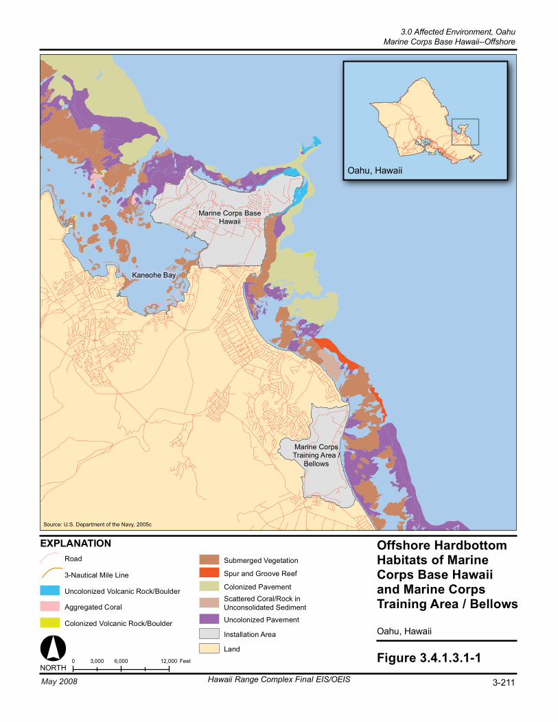
Figure 3.4.1.3.1-10 6,000 12,0003,000 FeetNORTH
Oahu, Hawaii
EXPLANATION Offshore HardbottomHabitats of MarineCorps Base Hawaiiand Marine CorpsTraining Area / Bellows
Oahu, Hawaii
Marine Corps BaseHawaii
Marine CorpsTraining Area /
Bellows
Source: U.S. Department of the Navy, 2005c
Kaneohe Bay
Colonized Volcanic Rock/Boulder
Uncolonized Volcanic Rock/Boulder Colonized Pavement
Uncolonized Pavement
Land
Spur and Groove Reef
Scattered Coral/Rock inUnconsolidated Sediment
Installation Area
3-Nautical Mile Line
Submerged Vegetation
Aggregated Coral
Road
Hawaii Range Complex Final EIS/OEIS 3-211May 2008
3.0 Affected Environment, OahuMarine Corps Base Hawaii--Offshore
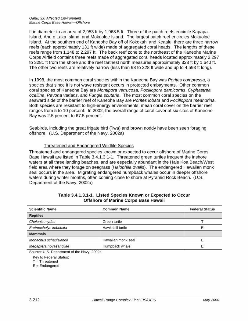
Oahu, 3.0 Affected Environment Marine Corps Base Hawaii—Offshore
3-212 Hawaii Range Complex Final EIS/OEIS May 2008
ft in diameter to an area of 2,953 ft by 1,968.5 ft. Three of the patch reefs encircle Kapapa Island, Ahu o Laka Island, and Mokuoloe Island. The largest patch reef encircles Mokuoloe Island. At the southern end of Kaneohe Bay off of Kokokahi and Keaalu, there are three narrow reefs (each approximately 131 ft wide) made of aggregated coral heads. The lengths of these reefs range from 1,148 to 2,297 ft. The back reef zone to the northeast of the Kaneohe Marine Corps Airfield contains three reefs made of aggregated coral heads located approximately 2,297 to 3281 ft from the shore and the reef farthest north measures approximately 328 ft by 1,640 ft. The other two reefs are relatively narrow (less than 98 to 328 ft wide and up to 4,593 ft long).
In 1998, the most common coral species within the Kaneohe Bay was Porites compressa, a species that since it is not wave resistant occurs in protected embayments. Other common coral species of Kaneohe Bay are Montipora verrucosa, Pocillopora damicornis, Cyphastrea ocellina, Pavona varians, and Fungia scutaria. The most common coral species on the seaward side of the barrier reef of Kaneohe Bay are Porites lobata and Pocillopora meandrina. Both species are resistant to high-energy environments; mean coral cover on the barrier reef ranges from 5 to 10 percent. In 2002, the overall range of coral cover at six sites of Kaneohe Bay was 2.5 percent to 67.5 percent.
Seabirds, including the great frigate bird (`iwa) and brown noddy have been seen foraging offshore. (U.S. Department of the Navy, 2002a)
Threatened and Endangered Wildlife Species Threatened and endangered species known or expected to occur offshore of Marine Corps Base Hawaii are listed in Table 3.4.1.3.1-1. Threatened green turtles frequent the inshore waters at all three landing beaches, and are especially abundant in the Hale Koa Beach/West field area where they forage on seagrass (Halophila ovalis). The endangered Hawaiian monk seal occurs in the area. Migrating endangered humpback whales occur in deeper offshore waters during winter months, often coming close to shore at Pyramid Rock Beach. (U.S. Department of the Navy, 2002a)
Table 3.4.1.3.1-1. Listed Species Known or Expected to Occur Offshore of Marine Corps Base Hawaii
Scientific Name Common Name Federal Status Reptiles
Chelonia mydas Green turtle T Eretmochelys imbricata Hawksbill turtle E
Mammals
Monachus schauislandii Hawaiian monk seal E
Megaptera novaeangliae Humpback whale E Source: U.S. Department of the Navy, 2002a
Key to Federal Status: T = Threatened E = Endangered
3.0 Affected Environment, Oahu
Marine Corps Base Hawaii—Offshore
May 2008 Hawaii Range Complex Final EIS/OEIS 3-213
3.4.1.3.2 Cultural Resources—MCBH—Offshore Appendix C includes a description of cultural resources and the laws and regulations pertaining to them.
Region of Influence The region of influence for cultural resources at MCBH encompasses locations where Humanitarian Assistance/Disaster Relief Operations will occur.
Affected Environment
Underwater Cultural Resources Underwater archaeological resources within the offshore waters of MCBH include shipwrecks and several Hawaiian fishponds (see Figures 3.1.3-2 and 3.4.1.3.2-1).
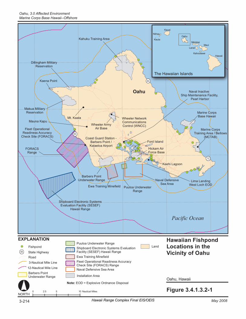
0 5 10 2. 5 N au ti ca l Mi le s Fi gur e 3. 4. 1. 3. 2- 1
O ahu , H awai i
Ha wa ii an F is hpon d Lo cat i ons i n th e Vi ci ni ty o f Oahu
Pa ci fi c Ocea n
EX PL ANA TI ON
NORT H
Sh ip bo ar d El ec tron ic S y st em s Ev al ua ti on F ac il ity (S ESEF )
Ha wa ii Ran ge
Na va l De fe ns iv e Se a Ar ea
Oa hu
83 Ka en a Po in t
Mt . K aa la
Ma k ua M ili ta ry Re se rv at io n
Ka hu ku T ra in in g Ar ea
Dill in gh am M i lit ar y Re se rv at io n
Ma ri ne C or ps Ba se H aw ai i
Na va l In ac ti ve Sh ip M ai nt en an ce F ac i lit y ,
P ea rl Har bo r
Ford I sl an d
72
93
Ma un a Ka pu Wh eel er Net wo rk Co mmu ni ca ti on s Co nt ro l (W NCC)
Ma ri ne C or ps Tr ai ni ng A re a / Be ll ow s
(M CT AB ) Co as t Gu ar d St at i on - Ba rb er s Po in t / Ka la el oa A ir po rt
Hi ck am A ir Forc e Ba se
Wh eel er A rm y Air Ba se
Li ma L an di ng We s t L oc h EO D
Fl ee t Op er at io na l Re ad in es s Ac cu ra cy
Ch ec k Si te (FO RA CS )
Ke eh i La go on
Pu ul oa U nd er wa te r Ra ng e
Ew a Tr ai ni ng M in ef ie ld
Ba rb er s Po in t Un de rw at er R an ge
FO RACS Ra ng e
93 St at e Hi gh wa y
La nd
Fl ee t Op er at io na l Re ad in es s Ac cu ra cy Ch ec k Si te (FO RA CS) Ra ng e
Pu ul oa U nd er wa te r Ra ng e
Ew a Tr ai ni ng M in ef ie ld
Na va l De fe ns iv e Se a Ar ea
Fi sh pon d Sh ip bo ar d El ec tron ic S y st em s Ev al ua ti on Fa ci li ty ( SESE F) H aw ai i Ra ng e
Ha wa ii
M aui
O ahu
K auai
Mo lo ka i
L anai
Ni ih au
K ahool aw e
K aul a
T he Hawa ii an Is l ands
Ro ad
In st al la ti on A re a
12 -N au ti ca l Mi le L in e Ba rb er s Po in t Un de rw at er R an ge
3- Na ut ic al M ile L in e
3-214 May 2008Hawaii Range Complex Final EIS/OEIS
Oahu, 3.0 Affected EnvironmentMarine Corps Base Hawaii--Offshore
Note: EOD = Explosive Ordnance Disposal
3.0 Affected Environment, Oahu
Marine Corps Training Area/Bellows—Offshore
May 2008 Hawaii Range Complex Final EIS/OEIS 3-215
3.4.1.4 MARINE CORPS TRAINING AREA/BELLOWS (MCTAB)—OFFSHORE
MCTAB covers 1,078 acres on the southeastern portion of Oahu. The inactive airfield in the center of the site is limited to rotary wing activity, and is occasionally used for U.S. Marine Corps helicopter training. MCTAB Offshore includes areas used for HRC training 0 to 12 nm from MCTAB (Figure 2.1-3).
This section describes the environmental resources that would be affected by the No-action Alternative, Alternative 1, Alternative 2, or Alternative 3 for MCTAB. Of the 13 environmental resources considered for analysis, air quality, airspace, geology and soils, hazardous materials and hazardous waste, health and safety, land use, noise, socioeconomics, transportation, utilities, and water resources are not addressed.
3.4.1.4.1 Biological Resources—MCTAB—Offshore Section 3.1.2 provides a detailed description of marine biological resources.
Region of Influence The region of influence consists of the MCTAB offshore areas.
Affected Environment
Vegetation Threatened and Endangered Plant Species
No threatened or endangered plants have been observed offshore of MCTAB.
Wildlife There are no live coral colonies in the offshore areas as a result of redistribution of sand and scouring caused by wave action. The seafloor out to a distance of 492 ft from the beach consists of a sand flat, beyond which a low-relief fossil reef platform becomes interspersed with the sand. The outer barrier reef crest (see Figure 3.4.1.3.1-1) is an actively accreting coral reef habitat comprising predominantly the genera Pocillopora, Porites, and Montipora. There are two well-defined sand channels that extend from the shoreline through the barrier reef to the open ocean beyond. (U.S. Department of the Navy, 2002a) Section 3.1.2.2.1 includes a description of EFH; however, a detailed description, including status, distribution, and habitat preference of managed fisheries, is provided in the Navy’s Final Essential Fish Habitat and Coral Reef Assessment for the Hawaii Range Complex EIS/OEIS (U.S. Department of the Navy, 2007a).
Threatened and Endangered Wildlife Species Threatened and endangered species known or expected to be in offshore MCTAB are the same as those listed in Table 3.4.1.3.1-1. Green turtles occur frequently in the offshore water. Also occasionally feeding in these waters are hawksbill turtles (U.S. Department of the Navy, 2005b). Hawaiian monk seals have been sighted in the area (U.S. Department of the Navy, 2005b). Waimanalo Bay is expected to be too shallow for whales, such as the humpback whale, which
Oahu, 3.0 Affected Environment Marine Corps Training Area/Bellows—Offshore
3-216 Hawaii Range Complex Final EIS/OEIS May 2008
winters in the Hawaiian Islands. However, it is possible that an occasional humpback whale could use Waimanalo Bay. (U.S. Pacific Command, 1995)
3.4.1.4.2 Cultural Resources—MCTAB—Offshore Appendix C includes a description of cultural resources and the laws and regulations pertaining to them.
Region of Influence The region of influence for underwater cultural resources at MCTAB includes locations where Expeditionary Assault (amphibious training), Mine Neutralization, Swimmer Insertion/Extraction, and SPECWAROPS would occur (see Figure 2.1-3).
Affected Environment
Underwater Cultural Resources Offshore features within the region of influence for MCTAB include a shoreline burial complex (Site 4854) and several Hawaiian fishponds (Figure 3.4.1.3.2-1) (U.S. Army Corps of Engineers, Honolulu Engineer District, 2005). As shown on NOAA maps, there are also several shipwrecks in the MCTAB vicinity (Figure 3.1.3-2).

3.0 Affected Environment, Oahu
Makua Military Reservation—Offshore
May 2008 Hawaii Range Complex Final EIS/OEIS 3-217
3.4.1.5 MAKUA MILITARY RESERVATION—OFFSHORE Makua Military Reservation is a Department of the Army reservation containing a total of 4,190 acres in the Makua Valley on the northwestern side of Oahu. Makua Military Reservation extends from the Farrington Highway along the west coast eastward to the ridgeline of the Waianae Mountains. Makua Military Reservation Offshore includes areas used for HRC training 0 to 12 nm from Makua Military Reservation (Figure 2.1-3).
This section describes the environmental resources that would be affected by the No-action Alternative, Alternative 1, Alternative 2, or Alternative 3 for Makua Military Reservation. Of the 13 environmental resources considered for analysis, air quality, airspace, geology and soils, hazardous materials and hazardous waste, health and safety, land use, noise, socioeconomics, transportation, utilities, and water resources are not addressed.
3.4.1.5.1 Biological Resources—Makua Military Reservation—Offshore Section 3.1.2 provides a detailed description of marine biological resources.
Region of Influence The region of influence consists of the Makua Military Reservation offshore areas.
Affected Environment
Vegetation Threatened and Endangered Plant Species
No threatened or endangered plants have been observed offshore of Makua Military Reservation.
Wildlife The National Centers for Coastal Ocean Science/NOAA benthic habitat maps show no coral reefs along the western side of Oahu from the Naval Reservation to the Makua Military Reservation. (U.S. Department of the Navy, 2005b)
Non-listed marine mammals present in the region of influence include the bottlenose dolphin, spotted dolphin, and spinner dolphin, which are common along the coastline (U.S. Department of the Navy, 2005b; U.S. Department of the Army, 2005). Spinner dolphins are regularly seen in Makua Bay where they use the sandy-bottom habitat for resting and socializing (National Marine Fisheries Service, 2007a).
Threatened and Endangered Wildlife Species Threatened and endangered species known or expected to occur offshore of Makua Military Reservation are the same as those provided in Table 3.4.1.3.1-1, with the exception of the leatherback turtle. The only threatened and endangered marine mammals potentially present in the region of influence are the Hawaiian monk seal and the humpback whale (U.S. Department of the Navy, 2005b). Of the five species of sea turtles that occur in Hawaiian waters, only the
Oahu, 3.0 Affected Environment Makua Military Reservation—Offshore
3-218 Hawaii Range Complex Final EIS/OEIS May 2008
green turtle, hawksbill turtle, and rarely the leatherback turtle (which prefers deep ocean water) are likely to be in the region of influence (U.S. Department of the Army, 2005).
3.4.1.5.2 Cultural Resources—Makua Military Reservation—Offshore Appendix C includes a description of cultural resources and the laws and regulations pertaining to them.
Region of Influence The cultural resources region of influence for Makua Military Reservation encompasses all areas where Live Fire Exercise (LFX) events (including major ground troop and artillery movement and munitions detonation [e.g., mortars, heavy artillery]) could be conducted (see Figure 2.1-3).
Affected Environment
Underwater Cultural Resources Underwater archaeological resources within the offshore Makua Military Reservation region of influence include several shipwrecks (see Figure 3.1.3-2).
3.0 Affected Environment, Oahu
Dillingham Military Reservation—Offshore
May 2008 Hawaii Range Complex Final EIS/OEIS 3-219
3.4.1.6 DILLINGHAM MILITARY RESERVATION—OFFSHORE Dillingham Military Reservation is a 664-acre training area with a beach and an airfield on the northwestern shore of Oahu. It is on a narrow, sloping plain between the Waianae Range and the sea. Dillingham Military Reservation Offshore includes areas used for HRC training 0 to 12 nm from Dillingham Military Reservation (Figure 2.1-3).
This section describes the environmental resources that would be affected by the No-action Alternative, Alternative 1, Alternative 2, or Alternative 3 for Dillingham Military Reservation. Of the 13 environmental resources considered for analysis, air quality, airspace, geology and soils, hazardous materials and hazardous waste, health and safety, land use, noise, socioeconomics, transportation, utilities, and water resources are not addressed.
3.4.1.6.1 Biological Resources—Dillingham Military Reservation—Offshore Section 3.1.2 provides a detailed description of marine biological resources.
Region of Influence The region of influence consists of the Dillingham Military Reservation offshore areas.
Affected Environment
Vegetation Threatened and Endangered Plant Species
No threatened or endangered plants have been observed offshore of Dillingham Military Reservation.
Wildlife There are coral reefs within 0.5 mile (mi) of the shoreline. Spur-and-groove reefs are found along the northern shoreline of Oahu (from Dillingham Airfield to Kaena Point) (Figure 3.4.1.6.1-1). There are no specific coral reefs of management concern. (U.S. Department of the Army, 2004)
Non-listed marine mammals potentially present in the region of influence include the bottlenose dolphin, spotted dolphin, and spinner dolphin, which are common along the coastline (U.S. Department of the Army, 2004).
Threatened and Endangered Wildlife Species Threatened and endangered species known or expected to occur offshore of Dillingham Military Reservation are the same as those listed in Table 3.4.1.3.1-1. Since Dillingham Military Reservation is adjacent to a small segment of beachfront, a portion of the region of influence extends to the offshore waters. This area is outside the Hawaiian Islands Humpback Whale National Marine Sanctuary. The humpback whale and several dolphin species are marine mammals most likely to be present in the region of influence (U.S. Department of the Navy, 2005b). The Hawaiian monk seal is likely to occur since the area of Kaena Point is used by monk seals to haul-out, pup, and rear young (National Marine Fisheries Service, 2007a). No
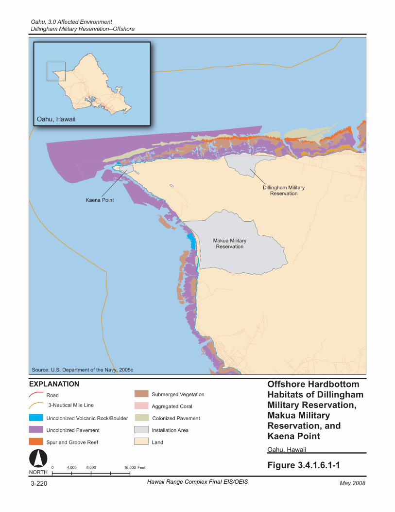
Fi gur e 3.4.1.6.1-1 0 8 ,000 16 ,000 4, 000 F eet NORT H
O ahu , H awai i
EX PL ANA TI ON Of fs hore Ha rdbot to m Ha bi ta ts o f Di l li ngha m Mi li ta ry R e ser va ti on, M aku a Mi li ta ry Re se rv at ion, a nd Ka en a Poin t O ahu , H awai i
Ma k ua M ili ta ry Re se rv at io n
Dill in gh am M i lit ar y Re se rv at io n
Ka en a Po in t
Un co lo ni ze d Pa ve m en t
Sp ur a nd G ro ov e Re ef
Co lo ni ze d Pa ve m en t
La nd
Ro ad
In st al la ti on A re a
3- Na ut ic al M ile L in e
Un co lo ni ze d Vo lc an ic R o ck/ Bo ul de r
Ag gr e gat ed C or al
Su bm er ge d V ege ta ti on
Hawaii Range Complex Final EIS/OEIS3-220 May 2008
Oahu, 3.0 Affected EnvironmentDillingham Military Reservation--Offshore
Source: U.S. Department of the Navy, 2005c
3.0 Affected Environment, Oahu
Dillingham Military Reservation—Offshore
May 2008 Hawaii Range Complex Final EIS/OEIS 3-221
sea turtle nesting has been observed in the region of influence, although the green turtle is expected to occur in the region of influence. (U.S. Department of the Army, 2004)
3.4.1.6.2 Cultural Resources—Dillingham Military Reservation—Offshore
Appendix C includes a description of cultural resources and the laws and regulations pertaining to them.
Region of Influence The cultural resources region of influence for Dillingham Military Reservation encompasses areas where Navy and Marine Corps SPECWAROPS under the Rim of the Pacific (RIMPAC) Exercise and small unit maneuvers by the Army occur (e.g., reconnaissance insertions and search and rescue). (See Figure 2.1-3.)
Affected Environment
Underwater Cultural Resources Underwater archaeological resources within the offshore Dillingham region of influence include scattered shipwrecks.
Oahu, 3.0 Affected Environment Ewa Training Minefield—Offshore
3-222 Hawaii Range Complex Final EIS/OEIS May 2008
3.4.1.7 EWA TRAINING MINEFIELD—OFFSHORE Ewa Training Minefield is an offshore area extending from Ewa Beach approximately 2 nm toward Barbers Point, and out to sea approximately 4 nm (Figure 2.1-3). This area is defined and restricted by 33 Code of Federal Regulations (CFR) 334.1400 and has been used for surface ship mine avoidance training.
This section describes the environmental resources that would be affected by the No-action Alternative, Alternative 1, Alternative 2, or Alternative 3 for Ewa Training Minefield. Of the 13 environmental resources considered for analysis, air quality, airspace, cultural resources, geology and soils, land use, noise, socioeconomics, transportation, utilities, and water resources are not addressed.
3.4.1.7.1 Biological Resources—Ewa Training Minefield—Offshore Section 3.1.2 provides a detailed description of marine biological resources.
Region of Influence The region of influence is the area that can be affected by mine avoidance training.
Affected Environment
Vegetation The Ewa Beach area is a popular seaweed harvesting area on Oahu (U.S. Department of the Navy, 2002a).
Threatened and Endangered Plant Species No threatened or endangered plant species have been identified in the region of influence.
Wildlife Organisms offshore of Ewa Beach include corals, several species of sea cucumber, sea urchins, and colonial soft corals. A few species of reef fish are also present in low numbers in the littoral waters. A benthic survey conducted in 2001 indicated that corals were locally abundant on the northern inshore reef slope at Ewa Beach (Figure 3.4.1.1.1-1). (U.S. Department of the Navy, 2002a) Section 3.1.2.2.1 includes a description of EFH; however, a detailed description, including status, distribution, and habitat preference of managed fisheries is provided in the Navy’s Final Essential Fish Habitat and Coral Reef Assessment for the Hawaii Range Complex EIS/OEIS (U.S. Department of the Navy, 2007a).
Threatened and Endangered Wildlife Species Green turtles are common in the region of influence. Threatened and endangered species potentially occurring in the region of influence would be the same as those listed in Table 3.4.1.1.1-1.
Environmentally Sensitive Habitat No environmentally sensitive habitat has been identified.
3.0 Affected Environment, Oahu
Ewa Training Minefield—Offshore
May 2008 Hawaii Range Complex Final EIS/OEIS 3-223
3.4.1.7.2 Hazardous Materials and Waste—Ewa Training Minefield—Offshore
Appendix C includes a discussion of hazardous materials and waste resource laws and regulations.
Region of Influence The region of influence for hazardous materials and wastes includes the range and adjacent ocean waters.
Affected Environment Ewa Training Minefield is an ocean area extending from Ewa Beach approximately 2 nm toward Barbers Point, and out to sea approximately 4 nm. This restricted area has been used in the past for surface ship mine avoidance training. Although the area is not used for this training mission, the Navy may use it in the future, and retains control over it. No hazardous materials are used on this range, and no hazardous wastes are normally generated. Bottom sediments within the range may harbor some residual contamination from past uses of the area.
3.4.1.7.3 Health and Safety—Ewa Training Minefield—Offshore Appendix C includes a detailed discussion of health and safety resources laws and regulations.
Region of Influence The region of influence for public health and safety includes the footprint of the range and adjacent ocean areas.
Affected Environment Because there are no current public health and safety concerns, there are no restrictions on commercial or recreation activities at Ewa Beach. Ocean activities occurring at Ewa Beach include netting, fishing, tropical fish collecting, surfing, scuba diving, paddling, kayaking, and shelling. A commercial net pen cage aquaculture site is located near the western range boundary (U.S. Department of the Navy, 2000).
Oahu, 3.0 Affected Environment Barbers Point Underwater Range—Offshore
3-224 Hawaii Range Complex Final EIS/OEIS May 2008
3.4.1.8 BARBERS POINT UNDERWATER RANGE—OFFSHORE The Barbers Point Underwater Range is a restricted area established by 33 CFR 334. The range encompasses a narrow offshore strip water directly in front of the U.S. Coast Guard Air Station/Kalaeloa Airport. The Barbers Point Underwater Range includes areas used for HRC training (Figure 2.1-3).
This section describes the environmental resources that would be affected by the No-action Alternative, Alternative 1, Alternative 2, or Alternative 3 for Barbers Point Underwater Range. Of the 13 environmental resources considered for analysis, air quality, airspace, cultural resources, geology and soils, land use, noise, socioeconomics, transportation, utilities, and water resources are not addressed.
3.4.1.8.1 Biological Resources—Barbers Point Underwater Range—Offshore
Section 3.1.2 provides a detailed description of marine biological resources.
Region of Influence The region of influence includes the underwater range and adjacent waters.
Affected Environment
Vegetation Seaweed is abundant in the offshore areas (U.S. Department of the Navy, 2002a).
Threatened and Endangered Plant Species No threatened or endangered plant species have been observed in the region of influence.
Wildlife Biological resources are similar to those described previously for the Puuloa Underwater Range (Section 3.4.1.1.1). A variety of whales and dolphins not listed as threatened or endangered are found around the Hawaiian Islands, including the minke whale and Bryde’s whale. Spinner dolphin, spotted dolphin, bottlenose dolphin, short finned pilot whale, false killer whale, and sperm whale are seen in the area most frequently. (U.S. Department of the Navy, 2002a)
Coral coverage ranges from 80 to 90 percent at depths between 9.7 and 13 fathoms to less than 1 percent in water depths from 13 to 20 fathoms. The coral community (Figure 3.4.1.1.1-1) is dominated by Pocillopora meandrina, Porites lobata, and Porites compressa. (U.S. Department of the Navy, 2002a)
The most common fish families represented are surgeonfishes (acanthurids), butterflyfishes (chaetodontids), damselfishes (pomacentrids), wrasses (labrids), triggerfishes (balistids) and moorish idols (zanclids) (U.S. Department of the Navy, 2002a). Section 3.1.2.2.1 includes a description of EFH; however, a detailed description, including status, distribution, and habitat preference of managed fisheries, is provided in the Navy’s Final Essential Fish Habitat and
3.0 Affected Environment, Oahu
Barbers Point Underwater Range—Offshore
May 2008 Hawaii Range Complex Final EIS/OEIS 3-225
Coral Reef Assessment for the Hawaii Range Complex EIS/OEIS (U.S. Department of the Navy, 2007a).
Threatened and Endangered Species Threatened and endangered species known or expected to occur in the vicinity of Barbers Point Underwater Range are the same as those listed in Table 3.4.1.1.1-1. Nine marine wildlife species listed as Federal and State threatened or endangered species are known or suspected to exist in Hawaiian waters, although the offshore environment may be too shallow for frequent use. These species include the Hawaiian monk seal, blue whale, fin whale, humpback whale, sei whale, sperm whale, hawksbill turtle, green turtle, and loggerhead turtle. A description of these listed species is provided in Section 3.1.2. (U.S. Department of the Navy, 2002a)
Environmentally Sensitive Habitat No environmentally sensitive habitat has been identified.
3.4.1.8.2 Hazardous Materials and Waste—Barbers Point Underwater Range—Offshore
Appendix C includes a discussion of hazardous materials and waste resource laws and regulations.
Region of Influence The region of influence for hazardous materials and wastes includes the range and adjacent ocean waters and shoreline.
Affected Environment Barbers Point Underwater Range comprises a narrow strip of offshore ocean that directly fronts the entire southern boundary of the former Naval Air Station Barbers Point. Naval Air Station Barbers Point was closed as part of the Base Realignment and Closure in July 1998 and renamed the Kalaeloa Airport. The northern range boundary is the high-water mark of the beach at Kalaeloa Airport. It aligns with what was once the station boundary of the closed Naval Air Station Barbers Point. The U.S. Coast Guard Air Station Barbers Point is across the street from the beach and covers a third of the shore of the original installation. No hazardous materials are used on this range, and no hazardous wastes are normally generated. Bottom sediments within the range may harbor some residual contamination from past uses of the area.
Oahu, 3.0 Affected Environment Barbers Point Underwater Range—Offshore
3-226 Hawaii Range Complex Final EIS/OEIS May 2008
3.4.1.8.3 Health and Safety—Barbers Point Underwater Range—Offshore
Appendix C includes a detailed discussion of health and safety resources laws and regulations.
Region of Influence The region of influence for public health and safety includes the range and adjacent shore and ocean areas.
Affected Environment Currently there are no public health and safety concerns at Barbers Point Underwater Range. Therefore beach activities, including netting, fishing, topical fish collecting, surfing, scuba diving, paddling, kayaking, and shelling, are not constrained.
3.0 Affected Environment, Oahu
Shipboard Electronic Systems Evaluation Facility—Offshore
May 2008 Hawaii Range Complex Final EIS/OEIS 3-227
3.4.1.9 NAVAL UNDERSEA WARFARE CENTER (NUWC) SHIPBOARD ELECTRONIC SYSTEMS EVALUATION FACILITY (SESEF)—OFFSHORE
The NUWC SESEF range, located off Barbers Point on Oahu (Figure 2.1-3), provides state-of-the-art testing and evaluation of combat systems which emit or receive electromagnetic radiation (EMR). Ships operate and maneuver in this area as necessary to remain within electronic signal reception range of the Fleet Technical Evaluation Center onshore. Offshore RDT&E activities associated with SESEF include the SESEF Quick Look Tests and the SESEF System Performance Tests.
This section describes the environmental resources that would be affected by the No-action Alternative, Alternative 1, Alternative 2, or Alternative 3 for SESEF. Of the 13 environmental resources considered for analysis, airspace, air quality, cultural resources, geology and soils, hazardous materials and hazardous waste, land use, noise, socioeconomics, transportation, utilities, and water resources are not addressed.
3.4.1.9.1 Biological Resources—SESEF—Offshore Section 3.1.2 provides a detailed description of marine biological resources.
Region of Influence The region of influence is the ocean area that could be affected by RDT&E activities.
Affected Environment
Wildlife Wildlife in the SESEF range would be to the same as those discussed in Section 3.1.2, Biological Resources (Marine)—Open Ocean Area.
Threatened and Endangered Wildlife Species Threatened and endangered species would be the same as those discussed in Section 3.1.2, Biological Resources (Marine)—Open Ocean Area.
Environmentally Sensitive Habitat Environmentally sensitive habitat would be to the same as that discussed in Section 3.1.2, Biological Resources (Marine)—Open Ocean Area.
Oahu, 3.0 Affected Environment Shipboard Electronic Systems Evaluation Facility—Offshore
3-228 Hawaii Range Complex Final EIS/OEIS May 2008
3.4.1.9.2 Health and Safety—SESEF—Offshore Appendix C includes a detailed discussion of health and safety resources laws and regulations.
Region of Influence The region of influence for public health and safety includes the footprints of the range and adjacent ocean areas.
Affected Environment Land areas associated with NUWC ranges are minimal and are for range operations facilities only. NUWC’s SESEF area provides state-of-the-art testing and evaluation of combat systems which emit or receive EMR. At present, an average of about 3,910 events—or about 15 per day—take place on the SESEF range.
The potential public health risks of these training events include public exposure to excessive densities of EMR. The potential public safety risks include conflicts between Navy vessels and other vessels on the range.
The sea space where SESEF tests are conducted is unrestricted and is not controlled by NUWC or the Navy. Ships underway for SESEF tests maintain safe separation from other vessels without direct control by SESEF operators.
Communications and electronic devices such as radar, electronic jammers, and other radio transmitters produce EMR. Equipment that produces an electromagnetic field has the potential to generate hazardous levels of EMR. An EMR hazard exists when transmitting equipment generates electromagnetic fields that induce currents or voltages great enough to trigger electro-explosive devices in ordnance, cause harmful effects on people or wildlife, or create sparks that can ignite flammable substances in the area.
EMR fields generally decrease rapidly in intensity with increasing distance from the source, so hazards are reduced or eliminated by establishing minimum distances from EMR emitters for people, ordnance, and fuels. Furthermore, ground-level EMR levels that are generally safe for military personnel aboard ship for long-term exposure are generally safe for transient exposure of individuals at greater distances from the source. Thus, EMR emissions from Navy vessels conducting RDT&E activities on the NUWC ranges are not a public health concern.
NUWC’s SESEF area provides state-of-the-art testing and evaluation of combat systems which radiate or receive electromagnetic energy. The sea space where SESEF tests are conducted is unrestricted and is not controlled by NUWC or the Navy. Ships underway for SESEF tests maintain safe separation from other units without direct control by SESEF operators. If the range is fouled by non-participants, the NUWC Range Control Officer determines if and when range operations can continue.
3.0 Affected Environment, Oahu
Fleet Operational Readiness Accuracy Check Site—Offshore
May 2008 Hawaii Range Complex Final EIS/OEIS 3-229
3.4.1.10 NAVAL UNDERSEA WARFARE CENTER (NUWC) FLEET OPERATIONAL READINESS ACCURACY CHECK SITE (FORACS)—OFFSHORE
The offshore area where NUWC FORACS tests are conducted is unrestricted and is not controlled by NUWC or the Navy (Figure 2.1-3). The NUWC Range Control Officer conducts visual lookout and radar searches of the FORACS range to identify any transient, non-participating vessels.
This section describes the environmental resources that would be affected by the No-action Alternative, Alternative 1, Alternative 2, or Alternative 3 for FORACS. Of the 13 environmental resources considered for analysis, air quality, airspace, cultural resources, geology and soils, hazardous materials and hazardous waste, land use, noise, socioeconomics, transportation, utilities, and water resources are not addressed.
3.4.1.10.1 Biological Resources—FORACS—Offshore Section 3.1.2 provides a detailed description of marine biological resources.
Region of Influence The region of influence is that area of the range that could be affected by current or proposed RDT&E activities.
Affected Environment
Vegetation A filamentous green algae (Neomeris annulata) that grows upright is common over wide areas of sandy substrate at depths between about 12.5 and 15 fathoms (Commander in Chief Pacific Fleet, 2001).
Threatened and Endangered Plant Species No threatened or endangered plants have been identified in the region of influence.
Wildlife Inshore areas at depths of about 7 to 12 fathoms have a modestly diverse coral community. Pocillopora meandrina, Porites lobata, and Porites compressa are dominant species of coral. Coral coverage (Figure 3.4.1.10.1-1) declines markedly at depths below 12.5 fathoms with gently sloping sand flats. (Commander in Chief Pacific Fleet, 2001)
Fish are generally rare, except where a coral colony or ocean floor debris provides habitat. The Hawaiian dascyllus is often abundant in these areas. Small schools of pennantfish, Hawaiian cleaner wrasses, Moorish idols, damselfish, and surgeonfish are also present. Common invertebrates include black sea urchins and sea cucumbers. (Commander-in-Chief Pacific Fleet, 2001)
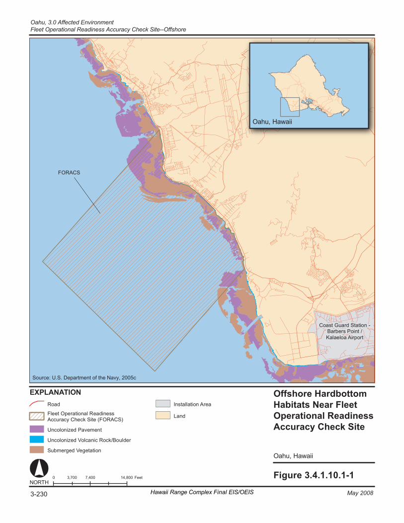
Fi gur e 3. 4. 1. 10. 1- 1 0 7 ,400 14 ,800 3, 700 F eet NORT H
O ahu , H awai i
EX PL ANA TI ON Offshore Hardbottom Habitats Near Fleet Operational Readiness Accuracy Check Site
O ahu , H awai i
Co as t Gu ar d St at i on - Ba rb er s Po in t / Ka la el oa A ir po rt
FO RACS
Un co lo ni ze d Pa ve me nt
La nd Fl ee t Op er at io na l Re ad in es s Ac cu ra cy Ch ec k Site ( FO RACS )
Ro ad In st al la ti on A re a
Un co lo ni ze d Vo lc an ic R o ck/ Bo ul de r
Su bme rg ed V ege ta ti on
Hawaii Range Complex Final EIS/OEIS3-230 May 2008
Oahu, 3.0 Affected EnvironmentFleet Operational Readiness Accuracy Check Site--Offshore
Source: U.S. Department of the Navy, 2005c
3.0 Affected Environment, Oahu
Fleet Operational Readiness Accuracy Check Site—Offshore
May 2008 Hawaii Range Complex Final EIS/OEIS 3-231
A detailed description, including status, distribution, and habitat preference of managed fisheries, is provided in the Navy’s Final Essential Fish Habitat and Coral Reef Assessment for the Hawaii Range Complex EIS/OEIS (U.S. Department of the Navy, 2007a).
A variety of whales and dolphins not listed as threatened or endangered are found around the Hawaiian Islands, including the minke whale and Bryde’s whale. Spinner dolphin, spotted dolphin, bottlenose dolphin, short finned pilot whale, false killer whale, and sperm whale are seen in the area most frequently. (U.S. Department of the Navy, 2002a)
Threatened and Endangered Wildlife Species Green turtles are abundant in the area and frequently use caves and ledges along the fringing reef as resting areas (Commander-in-Chief Pacific Fleet, 2001). Nine marine wildlife species listed as Federal and State threatened or endangered species are known or suspected to exist in Hawaiian waters. These species include the Hawaiian monk seal, blue whale, fin whale, humpback whale, sei whale, sperm whale, hawksbill turtle, green turtle, and loggerhead turtle. A description of these listed species is provided in Section 3.1.2. (U.S. Department of the Navy, 2002a)
Environmentally Sensitive Habitat No environmentally sensitive habitat has been identified.
3.4.1.10.2 Health and Safety—FORACS—Offshore Appendix C includes a detailed discussion of health and safety resources laws and regulations.
Region of Influence The region of influence for public health and safety includes the footprints of the range and adjacent ocean areas.
Affected Environment Land areas associated with Naval NUWC ranges are minimal and are for range operations facilities only. At present, an average of about five events per year take place on the FORACS range.
The sea space where FORACS tests are conducted is unrestricted and is not controlled by NUWC or the Navy. The NUWC Range Control Officer conducts visual lookout and radar searches of the FORACS range to identify any transient, non-participating vessels. If the range contains non-participants, the NUWC Range Control Officer determines if and when range operations can continue. These measures have proved adequate for safe operation of the ranges, and the potential for public safety effects from current training on the NUWC ranges is considered to be negligible.
The potential health risks of these training events include exposure to excessive densities of EMR. As discussed in Section 3.4.1.9.2, EMR emissions from Navy vessels conducting RDT&E activities on the NUWC ranges are not a public health concern.
Oahu, 3.0 Affected Environment Naval Station Pearl Harbor
3-232 Hawaii Range Complex Final EIS/OEIS May 2008
3.4.2 OAHU ONSHORE
3.4.2.1 NAVAL STATION PEARL HARBOR Naval Station Pearl Harbor, on the southern shore of the island of Oahu, is a natural water body divided into three lochs by the Waipio and Pearl City peninsulas: West Loch, Middle Loch, and East Loch. Naval Station Pearl Harbor (Figure 2.1-3) encompasses land along the eastern and southern shorelines of East Loch and Ford Island under the Navy’s exclusive control. A major portion of the operational area at Naval Station Pearl Harbor is used for maintenance and supply/storage largely located adjacent to ship berthing and repair areas.
This section describes the environmental resources that would be affected by the No-action Alternative, Alternative 1, Alternative 2, or Alternative 3 for Naval Station Pearl Harbor. Of the 13 environmental resources considered for analysis, air quality, airspace, geology and soils, hazardous materials and hazardous waste, health and safety, land use, noise, transportation, utilities, and water resources are not addressed.
3.4.2.1.1 Biological Resources—Naval Station Pearl Harbor Appendix C includes a detailed description of biological resources.
Region of Influence The region of influence includes the land area and waters adjacent to Naval Station Pearl Harbor that could be affected by current and proposed training.
Affected Environment
Vegetation Exotic imported grasses and trees maintained by intensive landscaping efforts make up the majority of the vegetative community at Naval Station Pearl Harbor. Native vegetation, including grasses, trees, and shrubs, is present only in small areas. These areas of native vegetation provide erosion control except during the heaviest rainfall.
Vegetation along the shoreline and the intertidal zone is dominated by pickleweed (Batis maritima) and the alien red mangrove (Rhizophora mangle) at the heads of the three lochs. Red mangrove has been successful because there are no mangrove predators, herbivores and insects, or diseases. (U.S. Department of the Navy, Commander Navy Region Hawaii, 2001a)
Threatened and Endangered Plant Species No threatened and endangered plant species have been identified at Naval Station Pearl Harbor. Recently, three endangered plants, ko`oloa`ula (Abutilon menziesii), ohai (Sesbania tomentosa), and loulu (Pritchardia kaalae) were established as mitigation for past projects at the Honouliuli Unit of the Pearl Harbor National Wildlife Refuge. These three plants are at least 3 mi from the EOD Land Range and Lima Landing, the closest facilities along West Loch.
3.0 Affected Environment, Oahu
Naval Station Pearl Harbor
May 2008 Hawaii Range Complex Final EIS/OEIS 3-233
Wildlife Fish and wildlife on and in the waters off of Naval Station Pearl Harbor are managed through its Integrated Natural Resources Management Plan in cooperation with the U.S. Fish and Wildlife Service (USFWS) and the State of Hawaii. Feral dogs (Canis familiaris) and cats (Felis catus), mongooses (Herpestes javanicus), and rodents are present throughout the region of influence. The majority of forest birds at Naval Station Pearl Harbor are exotic or introduced species. The common myna (Acridotheres tristis), red-vented bulbul (Pycnonotus cafer), Japanese white-eye (Zosterops japonicus), house finch (Carpodacus mexicanus), and zebra dove (Geopelia striata) are among the most common. The State-threatened white tern (Gygis alba rothschildi) and the State-endangered pueo (Asio flammeus sandwichensis) are occasionally found in the Naval Station Pearl Harbor vicinity. (U.S. Department of the Navy, Commander Navy Region Hawaii, 2001a)
One resident indigenous bird, the black-crowned night heron (`auku`u) (Nycticorax nycticorax), and 46 migratory species occur in the Naval Station Pearl Harbor area. The migratory birds are dominated by wading birds including the wandering tattler (Heteroscelus incanus), ruddy turnstone (Arenaria interpes), and Pacific golden plover (Pluvialis fulva). (U.S. Department of the Navy, Commander Navy Region Hawaii, 2001a)
Introduced species of crustaceans, insects, fish, amphibians, and birds dominate the wildlife of Naval Station Pearl Harbor’s wetlands, estuaries, springs, and the lowest reaches of streams. The numbers of native Megalagrion damselflies and the native o`opu nakea (goby) (Awaous guamensis) have been declining. Approximately 90 percent of the sea floor of the harbor is considered soft bottom with a layer of terrigenous (derived primarily from erosive action on land) mud and/or calcareous (composed of, containing, or resembling calcium carbonate, calcite, or chalk) sand. The remaining 10 percent is considered hard bottom, the limestone platform (Figure 3.4.1.1.1-1). (U.S. Department of the Navy, Commander Navy Region Hawaii, 2001a)
The following information on corals is summarized from the more extensive data provided in the Marine Resources Assessment for the Hawaiian Islands Operating Area (U.S. Department of the Navy, 2005b). Considerable reef development occurs in embayments and sheltered areas on Oahu including Kaneohe Bay and Hanauma Bay (Figure 3.4.1.1.1-1). Sediment-laden runoff and polluted runoff have impacted reefs of Oahu, specifically Pearl Harbor and Kaneohe Bay.
No reefs are shown along the southeastern end of the island (Kaloko to Wailea Point) (Figure 3.4.1.1.1-1). Fringing reefs are well developed on the southern side of Oahu from the Wailupe Peninsula to Kawaihoa Point and Hanauma Bay, while west of Kawaihoa Point, fringing reefs as well as spur-and-groove reefs are well developed. Other spur-and-groove reefs are found along the southern coastline (Wailupe Peninsula to Honolulu International Airport). (U.S. Department of the Navy, 2005b)
According to the National Centers for Coastal Ocean Science/NOAA, no coral reefs occur to the west of the airport runway, along the shoreline of the Fort Kamehameha Military Reservation, Hickam AFB, the Naval Reservation, or within Naval Station Pearl Harbor (Figure 3.4.1.1.1-1). Contrary to the National Centers for Coastal Ocean Science data, moderately developed spur and groove reefs do occur on either side of the Pearl Harbor entrance channel, including Tripod Reef and Ahua Reef. Tripod Reef is a spur-and-groove system where average coral cover is approximately 40 percent, and live coral cover on Ahua Reef is 40 percent, but in some parts of the reef, coral cover reaches 80 percent. Five species of stony corals occur within Pearl
Oahu, 3.0 Affected Environment Naval Station Pearl Harbor
3-234 Hawaii Range Complex Final EIS/OEIS May 2008
Harbor: Pocillopora damicornis, P. meandrina, Porites compressa, Leptastrea purpurea, and Montipora patula. In 1996, the most common coral in Pearl Harbor was L. purpurea, and corals were most abundant at the entrance of the West Loch Channel. (U.S. Department of the Navy, 2005b)
A detailed study in 1974 found 90 species of fish in Pearl Harbor (Evans, et al., 1974). Some of the commercially important species are ama`ama (grey mullet) (Mugil cephalus), awa (milkfish) (Chanos chanos), o`io (bonefish) (Albula vulpes), kaku (barracuda) (Sphyraena barracuda), nenue (chub) (Kyphosus sp.), menpachi (soldierfish) (Myripristis spp.), and papio (jacks) (Carangoides spp.). Pearl Harbor appears to be very important in the life cycle of the scalloped hammerhead shark (Sphyrna lewini). All waters around Naval Station Pearl Harbor have been designated as EFH for eggs and larvae of a number of species. The harbor has not been designated as a HAPC. (U.S. Department of the Navy, Commander Navy Region Hawaii, 2001a)
Threatened and Endangered Wildlife Species Four Federally endangered waterbirds (Table 3.4.2.1.1-1) are recognized as occurring on Naval Station Pearl Harbor: koloa maoli (Hawaiian duck) (Anas wyvilliana), `alae ke`ok`o (Hawaiian coot) (Fulica alai), alae ula (Hawaiian common moorhen) (Gallinula chloropus sandvicensis), and ae`o (Hawaiian black-necked stilt) (Himantopus mexicanus knudseni).
Table 3.4.2.1.1-1. Listed Species Known or Expected to Occur at Naval Station Pearl Harbor
Scientific Name Common Name (Hawaiian Name) Federal StatusReptiles/Mammals Chelonia mydas Green turtle T Lasiurus cinereus semotus Hawaiian hoary bat E Monachus schauinslandi Hawaiian monk seal E
Birds Anas wyvilliana Koloa maoli (Hawaiian duck) E Fulica alai `Alae ke`oke`o (Hawaiian coot) E Gallinula chloropus sandvicensis Alae ula (Hawaiian common moorhen) E Himantopus mexicanus knudseni Ae`o (Hawaiian black-necked stilt) E Pterodroma phaeopygia sandwichensis `Ua`u (Hawaiian dark-rumped petrel) E Puffinus auricularis newelli `A`o (Newell's Townsend’s shearwater) T Source: U.S. Department of the Navy, Commander Navy Region Hawaii, 2001a; U.S. Department of the Navy, 2002a; U.S. Fish and Wildlife Service, 2006b; U.S. Department of the Interior, Office of Environmental Policy and Compliance Pacific Southwest Region, 2007. Key to Federal Status: E = Endangered T = Threatened
According to the USFWS, the Hawaiian hoary bat is located within the region of influence for Naval Station Pearl Harbor (U.S. Department of the Interior, Office of Environmental Policy and Compliance Pacific Southwest Region, 2007). The green turtle has rarely been seen in Pearl Harbor, and no sandy beaches suitable for nesting exist inside the harbor. They have been seen routinely in the outer reaches of the Naval Station Pearl Harbor entrance channel (Smith et al., 2006). Although the Hawaiian monk seal has never been reported in the harbor, it has been
3.0 Affected Environment, Oahu
Naval Station Pearl Harbor
May 2008 Hawaii Range Complex Final EIS/OEIS 3-235
recorded at Iroquois Point at the Naval Station Pearl Harbor entrance channel (Smith et al., 2006). An adult humpback and calf were once reported to have entered East Loch, but this was an unusual event. The pair left the harbor within 24 hours on their own volition. (U.S. Department of the Navy, Commander Navy Region Hawaii, 2001a)
Environmentally Sensitive Habitat The Pearl Harbor National Wildlife Refuge (Figure 3.4.2.1.1-1) is comprised of the Honouliuli Unit (located on the northwestern tip of West Loch) and the Waiawa Unit (located on Pearl City Peninsula). The refuge provides primary wetland habitat for threatened and endangered waterbirds and other bird species in Naval Station Pearl Harbor. Mangrove wetlands are the most common type of wetland. (U.S. Department of the Navy, Commander Navy Region Hawaii, 2001a)
No critical habitat has been designated within Naval Station Pearl Harbor (Figure 3.4.2.1.1-1). Approximately 127 acres of jurisdictional wetlands are located on Navy properties in Naval Station Pearl Harbor. Wetland areas adjacent to Naval Station Pearl Harbor include mudflats, shallow ponds, small streams, pickleweed beds, kiawe forests, cattails (Typha latifolia), and watercress (Rorippa microphylla) and provide habitat for waterbirds. (U.S. Department of the Navy, Commander Navy Region Hawaii, 2001a)
3.4.2.1.2 Cultural Resources—Naval Station Pearl Harbor Appendix C includes a description of cultural resources and the laws and regulations pertaining to them.
Region of Influence The region of influence for proposed or ongoing training within Naval Station Pearl Harbor would include any location where Salvage Operations would occur.
Affected Environment
Underwater Cultural Resources Submerged archaeological resources surrounding Oahu include numerous shipwrecks (see Figure 3.1.3-2), many of which, including USS Arizona and USS Utah, are within Naval Station Pearl Harbor and are National Historic Landmarks. USS Arizona lies in 40 ft of water and is the final resting place for many of the ship's 1,177 crewmen who lost their lives during the Japanese attack on December 7, 1941. The USS Arizona Memorial became a National Park Service unit in 1980, and the National Park Service conducts approximately 50 research and cultural preservation dives per year (National Park Service, 2006). USS Utah lies where she sank on the northern side of Ford Island. Naval Station Pearl Harbor contains the wrecks of other U.S. Warship remnant fields, Japanese midget submarines, and Japanese aircraft as well (Rosendahl, 2000).
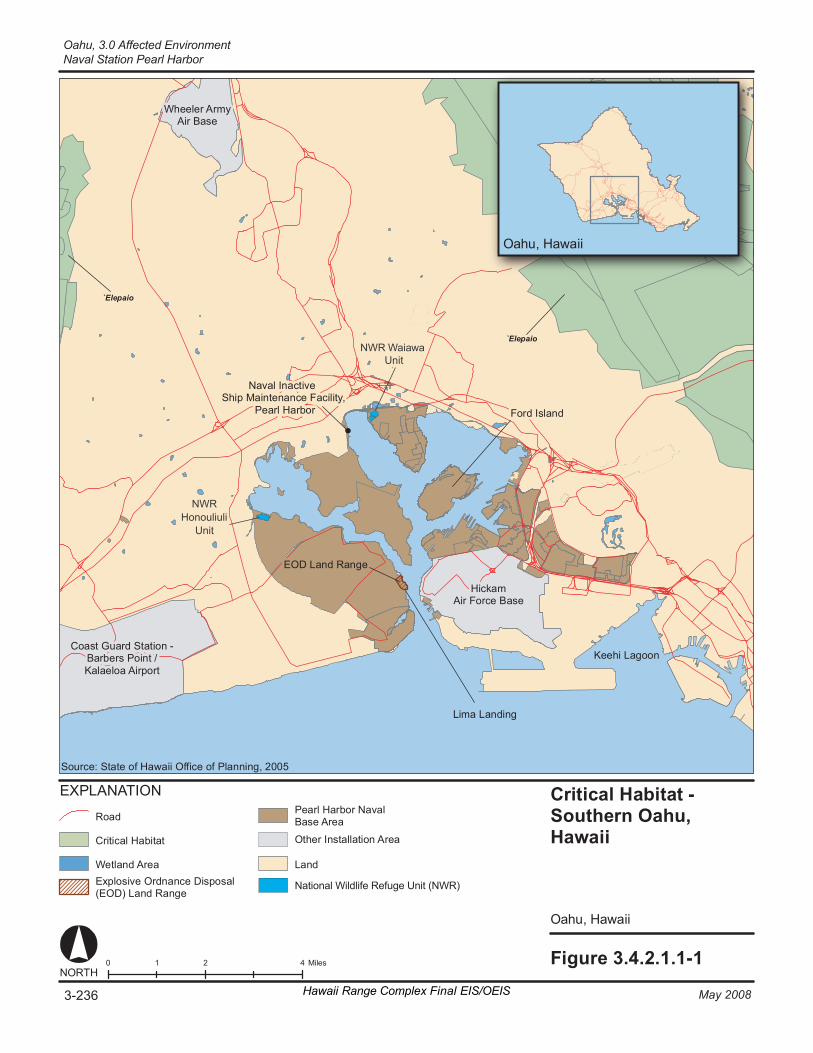
Fi gure 3. 4. 2. 1. 1- 1 0 2 4 1 M il es NORT H
O ahu , Hawa ii
Crit ic al H ab it at - Southe rn Oahu, Ha wa ii
O ahu , Hawa ii
Fo rd I sl an d
Hi ck am Air Fo rc e Ba se
`E le pa io
`E le pa io
E XP LA NA TION
Cr it ic al H ab it at
La
National Wildlife Refuge Unit (NWR)
nd
Co as t Gu ar d St at io n - Ba r ber s Po in t / Ka la el oa A ir po rt
Ke eh i La go on
Wh ee le r Ar my Air Ba se
Na va l I nac ti ve Sh ip M ai nt en anc e Fa ci li ty ,
P ea rl H ar bo r
Li ma L an di ng
Ro ad
We tl an d Ar ea
EOD L an d Ra nge
So ur ce : St at e o f H aw a ii Of fi ce o f Pl ann in g , 2 00 5
Pe ar l Ha rb or N av al Ba se A re a
E xp lo si ve O rd nan ce D is po sa l (EOD) Lan d Ra ng e
Ot he r In st al la ti on A re a
3-236 May 2008Hawaii Range Complex Final EIS/OEIS
Oahu, 3.0 Affected EnvironmentNaval Station Pearl Harbor
NWR Honouliuli
Unit
NWR Waiawa Unit
3.0 Affected Environment, Oahu
Naval Station Pearl Harbor
May 2008 Hawaii Range Complex Final EIS/OEIS 3-237
Other known wrecks surrounding Oahu include the largely intact wreck of the Sea Tiger, which was sunk in 1996 by a submarine company; a World War II-era Japanese midget submarine located in 2002; Mahi, a scuttled Navy minesweeper/cable layer located off the Waianae Coast, which now serves as an artificial reef; and the YO-257, which was a Navy yard oiler built in the 1940s and sunk off Waikiki in 1989 to create an artificial reef. There is also an aircraft crash site, which resulted from a Corsair ditching when it ran out of fuel along the south shore.
Only a few of the roughly 100 fishponds that once existed in the waters surrounding Oahu still remain (see Figure 3.4.1.3.2-1); however, four of them are located within Pearl Harbor. These include Loko Paaiau near McGrew Point in the East Loch; Loko Okiokiolepe, located northwest of the EOD Land Range; Loko Pamoku near the NAVMAG in West Loch, and Loko Laulaunui on Laulaunui Island in West Loch (see also Section 3.4.2.4.2) ( U.S. Department of the Navy, Commander Navy Region Hawaii, 2002).
Loko Okiokiolepe Fishpond The areas around the lochs of Naval Station Pearl Harbor were once used extensively for aquaculture. Historical maps and other sources indicate that there were as many as 25 fishponds, fish traps, and other kinds of aquacultural features along the shoreline of Pearl Harbor. Based on an overlay of historical maps with current facilities, 20 of these features were located wholly or partially within the boundaries of Naval Station Pearl Harbor. Although most of the original fishponds have been buried beneath fill and subsequently developed, archaeological and paleoenvironmental studies have shown that in some areas intact fishpond sediments are still present. Among the four extant fishponds listed above, Loko Okiokiolepe was officially listed in the National Register of Historic Places (NRHP) on March 14, 1973 (Hawaii State Historic Preservation Office, 2006; U.S. Department of the Navy, Commander Navy Region Hawaii, 2002). Most of the interior of the fishpond has been filled, but the seaward coral wall still remains intact (Naval Facilities Engineering Command, 2006).
3.4.2.1.3 Socioeconomics—Naval Station Pearl Harbor Appendix C includes a general definition of socioeconomics.
Region of Influence The region of influence for socioeconomic analysis is the island of Oahu. The County of Honolulu comprises the entire island of Oahu.
Affected Environment
Population and Income In 2000, the population of Oahu was 876,156. The 2005 Bureau of Census Counties Profile estimates that the population of the county rose to 912,900 in 2005 (equal to 71 percent of the population of Hawaii), a change of almost 4.0 percent over the 5-year period. The estimated 2006 population for Oahu was 909,863 (U.S. Census Bureau, 2007b). The State of Hawaii Data Book 2006 indicates that the number of military personnel and dependence (Air Force, Army, Coast Guard, Marine Corps and Navy) is approximately 96,496. In 2006, military personnel and dependence accounted for 10.6 percent of the population of Oahu. The projected population for 5 and 10 years out is 952,650 people in 2010 and 995,550 people in 2015, which would be an increase of 4.5 percent (Hawaii, State of, 2004). Table 3.4.2.1.3-1
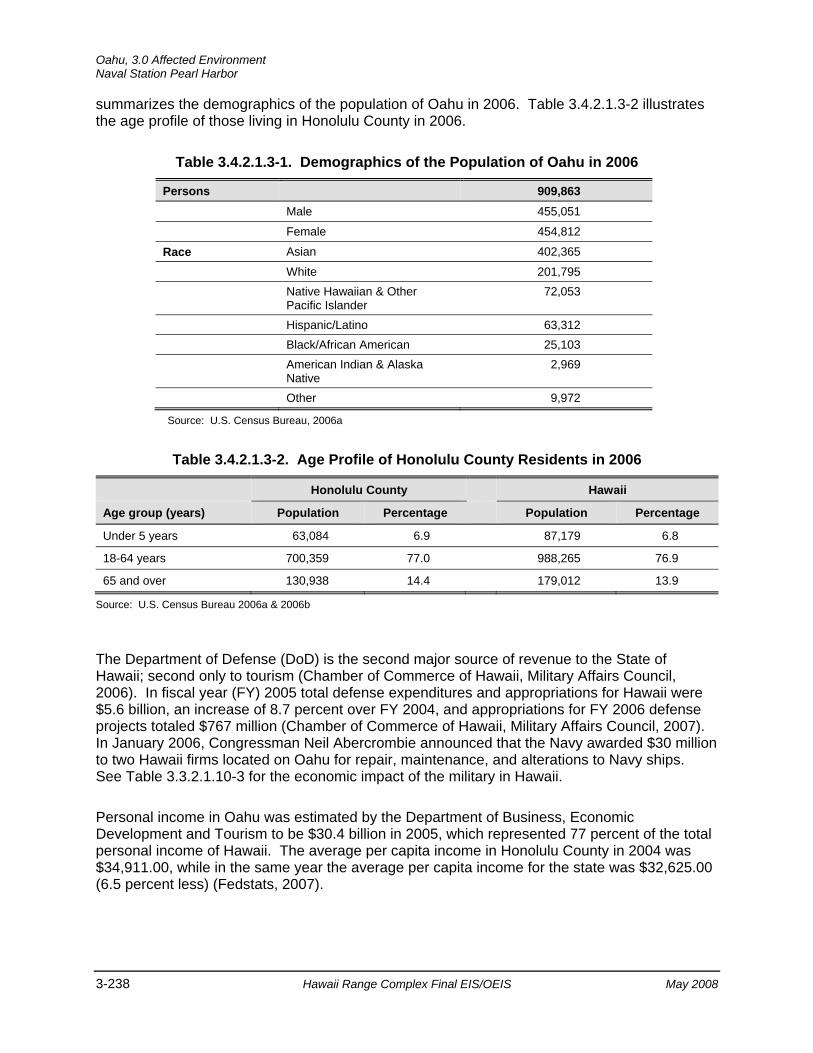
Oahu, 3.0 Affected Environment Naval Station Pearl Harbor
3-238 Hawaii Range Complex Final EIS/OEIS May 2008
summarizes the demographics of the population of Oahu in 2006. Table 3.4.2.1.3-2 illustrates the age profile of those living in Honolulu County in 2006.
Table 3.4.2.1.3-1. Demographics of the Population of Oahu in 2006
Persons 909,863
Male 455,051
Female 454,812
Race Asian 402,365
White 201,795 Native Hawaiian & Other
Pacific Islander 72,053
Hispanic/Latino 63,312 Black/African American 25,103 American Indian & Alaska
Native 2,969
Other 9,972
Source: U.S. Census Bureau, 2006a
Table 3.4.2.1.3-2. Age Profile of Honolulu County Residents in 2006
Honolulu County Hawaii
Age group (years) Population Percentage Population Percentage
Under 5 years 63,084 6.9 87,179 6.8
18-64 years 700,359 77.0 988,265 76.9
65 and over 130,938 14.4 179,012 13.9
Source: U.S. Census Bureau 2006a & 2006b
The Department of Defense (DoD) is the second major source of revenue to the State of Hawaii; second only to tourism (Chamber of Commerce of Hawaii, Military Affairs Council, 2006). In fiscal year (FY) 2005 total defense expenditures and appropriations for Hawaii were $5.6 billion, an increase of 8.7 percent over FY 2004, and appropriations for FY 2006 defense projects totaled $767 million (Chamber of Commerce of Hawaii, Military Affairs Council, 2007). In January 2006, Congressman Neil Abercrombie announced that the Navy awarded $30 million to two Hawaii firms located on Oahu for repair, maintenance, and alterations to Navy ships. See Table 3.3.2.1.10-3 for the economic impact of the military in Hawaii.
Personal income in Oahu was estimated by the Department of Business, Economic Development and Tourism to be $30.4 billion in 2005, which represented 77 percent of the total personal income of Hawaii. The average per capita income in Honolulu County in 2004 was $34,911.00, while in the same year the average per capita income for the state was $32,625.00 (6.5 percent less) (Fedstats, 2007).

3.0 Affected Environment, Oahu
Naval Station Pearl Harbor
May 2008 Hawaii Range Complex Final EIS/OEIS 3-239
Housing In the fall of 2006, housing supply was 2,005 single-family homes and 2,750 condominiums available. At the same time prices have remained fairly level with interest rates at a 6-month low (Honolulu Board of REALTORS®, 2006a). The number of owner-occupied homes has grown from 156,290 in 2000, to 173,182 in 2005 (Hawaii, State of, 2004, U.S. Census Bureau, 2000a). This change represents a 9.8 percent increase in the stock of owner-occupied homes, compared to a 6.7 percent growth in the State as a whole. Additionally, as shown in Table 3.4.2.1.3-3, renter-occupied homes increased 34.7 percent over a 6-year period.
Table 3.4.2.1.3-3. Renter Occupied Housing Units
Gross Monthly Rent Number of Housing Units, 2000 Number of Housing Units, 2006
Less than $200 4,501 4,272
$200 to $299 3,324 4,423
$300 to $499 9,265 8,125
$500 to $749 30,991 17,505
$750 to $999 28,973 32,420
$1000 or more 33,801 91,348
No cash rent 19,052 16,940
Total 129,907 175,033
Median rent $802 $1,116
Source: U.S. Census Bureau, 2000a and 2006c.
Employment In 2001, the U.S. military employed 64,074 people in the State of Hawaii. The number employed by the Navy and Marine Corps was 24,654 (38 percent of military). Major locations for the active duty military and civilian personnel on Oahu in 2001 were: Schofield Barracks (12,699 jobs), Naval Station Pearl Harbor (12,407 jobs), Kaneohe (6,847 jobs), Hickam AFB (5,374 jobs), Tripler Army Medical Center (2,826 jobs), Fort Shafter (2,337 jobs), Honolulu (1,879 jobs), Wheeler AFB (1,816), Kunia (1,495 jobs) and Camp H.M. Smith (1,045). Naval Station Pearl Harbor is the largest industrial employer in Hawaii (Enterprise Honolulu, 2007). Table 3.4.2.1.3-4 shows the number of individuals employed in the main sectors of the economy of Oahu, and within Hawaii as a whole.
Tourism, tourism-related services, and government continue to be the main employment generators (U.S. Department of the Navy, 1998a). Natural resources and mining, mainly consisting of the agriculture, forestry, and fishing industry will add the fewest number of jobs and will continue to employ only 1 percent of the workforce (Department of Labor and Industrial Relations, 2006).
Unemployment on Oahu has fluctuated from a low of 2.0 percent in 1991 to a high of 4.9 percent in 1996 and 1998. In 2001, the rate was 4.1 and has steadily declined to 2.7 percent in 2005. This is the lowest the rate has been in over 12 years. During the same period, the total labor force has increased from 435,300 in 2001 to 445,150 in 2005—a 2.2 percent increase. In
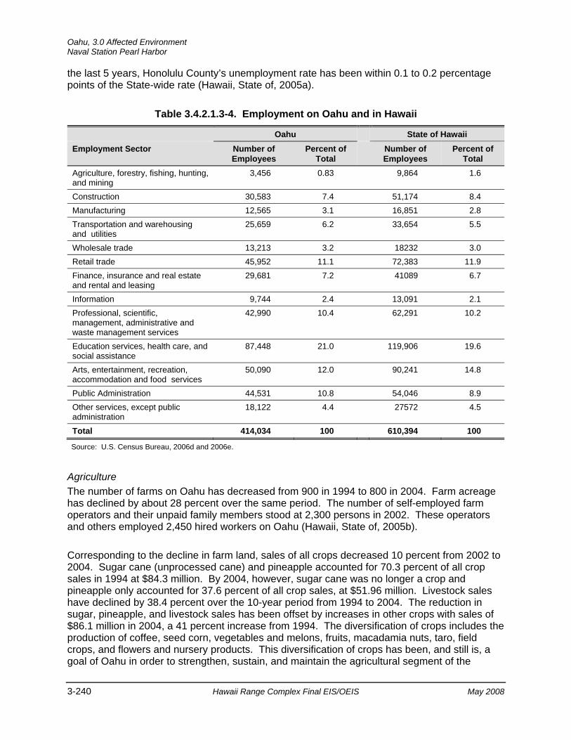
Oahu, 3.0 Affected Environment Naval Station Pearl Harbor
3-240 Hawaii Range Complex Final EIS/OEIS May 2008
the last 5 years, Honolulu County’s unemployment rate has been within 0.1 to 0.2 percentage points of the State-wide rate (Hawaii, State of, 2005a).
Table 3.4.2.1.3-4. Employment on Oahu and in Hawaii
Oahu State of Hawaii Employment Sector Number of
Employees Percent of
Total Number of
Employees Percent of
Total Agriculture, forestry, fishing, hunting, and mining
3,456 0.83 9,864 1.6
Construction 30,583 7.4 51,174 8.4 Manufacturing 12,565 3.1 16,851 2.8 Transportation and warehousing and utilities
25,659 6.2 33,654 5.5
Wholesale trade 13,213 3.2 18232 3.0 Retail trade 45,952 11.1 72,383 11.9 Finance, insurance and real estate and rental and leasing
29,681 7.2 41089 6.7
Information 9,744 2.4 13,091 2.1 Professional, scientific, management, administrative and waste management services
42,990 10.4 62,291 10.2
Education services, health care, and social assistance
87,448 21.0 119,906 19.6
Arts, entertainment, recreation, accommodation and food services
50,090 12.0 90,241 14.8
Public Administration 44,531 10.8 54,046 8.9 Other services, except public administration
18,122 4.4 27572 4.5
Total 414,034 100 610,394 100
Source: U.S. Census Bureau, 2006d and 2006e.
Agriculture The number of farms on Oahu has decreased from 900 in 1994 to 800 in 2004. Farm acreage has declined by about 28 percent over the same period. The number of self-employed farm operators and their unpaid family members stood at 2,300 persons in 2002. These operators and others employed 2,450 hired workers on Oahu (Hawaii, State of, 2005b).
Corresponding to the decline in farm land, sales of all crops decreased 10 percent from 2002 to 2004. Sugar cane (unprocessed cane) and pineapple accounted for 70.3 percent of all crop sales in 1994 at $84.3 million. By 2004, however, sugar cane was no longer a crop and pineapple only accounted for 37.6 percent of all crop sales, at $51.96 million. Livestock sales have declined by 38.4 percent over the 10-year period from 1994 to 2004. The reduction in sugar, pineapple, and livestock sales has been offset by increases in other crops with sales of $86.1 million in 2004, a 41 percent increase from 1994. The diversification of crops includes the production of coffee, seed corn, vegetables and melons, fruits, macadamia nuts, taro, field crops, and flowers and nursery products. This diversification of crops has been, and still is, a goal of Oahu in order to strengthen, sustain, and maintain the agricultural segment of the
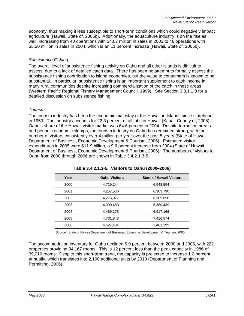
3.0 Affected Environment, Oahu
Naval Station Pearl Harbor
May 2008 Hawaii Range Complex Final EIS/OEIS 3-241
economy, thus making it less susceptible to short-term conditions which could negatively impact agriculture (Hawaii, State of, 2005b). Additionally, the aquaculture industry is on the rise as well, increasing from 40 operations with $4.67 million in sales in 2003 to 46 operations with $5.20 million in sales in 2004, which is an 11 percent increase (Hawaii, State of, 2005b).
Subsistence Fishing The overall level of subsistence fishing activity on Oahu and all other islands is difficult to assess, due to a lack of detailed catch data. There has been no attempt to formally assess the subsistence fishing contribution to island economies, but the value to consumers is known to be substantial. In particular, subsistence fishing is an important supplement to cash income in many rural communities despite increasing commercialization of the catch in these areas (Western Pacific Regional Fishery Management Council, 1999). See Section 3.3.1.1.3 for a detailed discussion on subsistence fishing.
Tourism The tourism industry has been the economic mainstay of the Hawaiian Islands since statehood in 1959. The industry accounts for 22.3 percent of all jobs in Hawaii (Kauai, County of, 2005). Oahu’s share of the Hawaii visitor market was 64.6 percent in 2004. Despite terrorism threats and periodic economic slumps, the tourism industry on Oahu has remained strong, with the number of visitors consistently over 4 million per year over the past 5 years (State of Hawaii Department of Business, Economic Development & Tourism, 2006). Estimated visitor expenditures in 2005 were $11.9 billion, a 9.6 percent increase from 2004 (State of Hawaii Department of Business, Economic Development & Tourism, 2006). The numbers of visitors to Oahu from 2000 through 2006 are shown in Table 3.4.2.1.3-5.
Table 3.4.2.1.3-5. Visitors to Oahu (2000–2006)
Year Oahu Visitors State of Hawaii Visitors
2000 4,719,244 6,948,594
2001 4,257,536 6,303,790
2002 4,276,077 6,389,058
2003 4,090,483 6,380,439
2004 4,469,278 6,917,166
2005 4,731,843 7,416,574
2006 4,627,484 7,461,299
Source: State of Hawaii Department of Business, Economic Development & Tourism, 2006.
The accommodation inventory for Oahu declined 5.9 percent between 2000 and 2005, with 222 properties providing 34,167 rooms. This is 12 percent less than the peak capacity in 1986 of 39,010 rooms. Despite this short-term trend, the capacity is projected to increase 1.2 percent annually, which translates into 2,100 additional units by 2010 (Department of Planning and Permitting, 2006).
Oahu, 3.0 Affected Environment Ford Island
3-242 Hawaii Range Complex Final EIS/OEIS May 2008
3.4.2.2 FORD ISLAND Ford Island is a 450-acre site in the heart of Naval Station Pearl Harbor, about 1 mi long by 0.25-mi wide. It is connected to the main island by the Ford Island Bridge. The island houses several naval facilities.
This section describes the environmental resources that would be affected by the No-action Alternative, Alternative 1, Alternative 2, or Alternative 3 for Ford Island. Of the 13 environmental resources considered for analysis, air quality, airspace, geology and soils, hazardous materials and hazardous waste, health and safety, land use, noise, socioeconomics, transportation, and utilities are not addressed.
3.4.2.2.1 Biological Resources—Ford Island Appendix C includes a detailed description of biological resources.
Region of Influence The region of influence is Ford Island and its adjacent waters.
Affected Environment
Vegetation Vegetation on Ford Island consists mainly of non-native grasses, shrubs, and trees such as kiawe, mangrove, koa haole, Cuban jute (Sida rhombifolia), and pitted beardgrass (Bothriochloa pertusa). Non-native ornamental plants are used in housing area landscaping. There are a small number of native plants on the island such as `ilima, milo (Thespesia populnea), and `uhaloa (Waltheria indica). (National Oceanic and Atmospheric Administration, 2006d)
Threatened and Endangered Plant Species No threatened and endangered plant species have been reported on Ford Island. (National Oceanic and Atmospheric Administration, 2006d)
Wildlife Wildlife similar to that described at Naval Station Pearl Harbor is likely to be found on Ford Island. Two indigenous bird species are found on Ford Island: the black-crowned night heron (`auku`u) and the Pacific golden plover. (National Oceanic and Atmospheric Administration 2006d) Non-native birds such as the myna, house finch, and zebra dove are also found on the island. Mongoose and rodents are present in the region of influence.
Ghost shrimp (Myrichthys maculosus), mantis shrimp (Odontodactylus scyllarus), Samoan crabs (Scylla serrata), and clams are members of the soft bottom community. These species are eaten by fish such as the weke pueo (bandtail goatfish) (Upeneus arge), hailepo (spotted eagle ray) (Aetobatus narinari), and pakii (panther flounder) (Bothus pantherinus). Piers and pilings around Ford Island are habitat for species such as pualo and manini (surgeonfish) Acanthurus spp.), butterflyfish (Chaetodon spp.), and goby. The largest concentrations of fish are found around the seaplane ramps along the southeastern corner of the island and around
3.0 Affected Environment, Oahu
Ford Island
May 2008 Hawaii Range Complex Final EIS/OEIS 3-243
USS Utah. The region of influence contains EFH for juvenile, adult, egg, and larvae life stages for all pelagic and bottom fish and crustaceans. However, no HAPC has been designated. (National Oceanic and Atmospheric Administration, 2006d) Section 3.1.2.2.1 includes a description of EFH; however, a detailed description, including status, distribution, and habitat preference of managed fisheries, is provided in the Navy’s Final Essential Fish Habitat and Coral Reef Assessment for the Hawaii Range Complex EIS/OEIS (U.S. Department of the Navy, 2007a).
During surveys conducted in 1999 and 2000, colonies of Montipora spp., Pocillopora damicornis, and Leptastrea purpurea were found at a few scattered locations in the region of influence. While these corals do not constitute a coral reef, they are indicative of improved water quality within the harbor. (National Oceanic and Atmospheric Administration, 2006d)
Threatened and Endangered Wildlife Species There are no threatened or endangered terrestrial wildlife on the island. In the past 10 years, there have been four documented green turtle sightings within Pearl Harbor and one hawksbill turtle carcass was collected from the island. There are no reported sightings of live hawksbill turtles and no suitable sea turtle nesting habitat within the region of influence (Smith et al., 2006). There has only been one case of humpback whales in the region of influence, which is mentioned in Section 3.4.2.1.1, Naval Station Pearl Harbor. (National Oceanic and Atmospheric Administration, 2006d)
Environmentally Sensitive Habitat No critical habitat has been designated in the region of influence.
3.4.2.2.2 Cultural Resources—Ford Island Appendix C includes a description of cultural resources and the laws and regulations pertaining to them.
Region of Influence The cultural resources region of influence for Ford Island encompasses the area where a new open-water Acoustic Test Facility would be constructed.
Affected Environment
Underwater Cultural Resources Ford Island is one of Naval Station Pearl Harbor’s Historic Management Zones. Historically, the development and use of Ford Island served one military purpose: aviation. The island is the only area at Naval Station Pearl Harbor specifically associated with that “theme” or activity. As a result, the Ford Island Management Zone encompasses all of Ford Island, including the shallow reef areas and coral islets at the northern end of the island, and the associated wharves and docks that are attached to the island. It also includes the mooring quays just offshore and the submerged resources near the island such as USS Utah and USS Arizona. (U.S. Department of the Navy, Commander Navy Region Hawaii, 2002)
Oahu, 3.0 Affected Environment Ford Island
3-244 Hawaii Range Complex Final EIS/OEIS May 2008
Archaeological Resources There is very little specific archival or archaeological information concerning traditional land use or pre-contact events on Ford Island, although some inferences can be made. Given the island’s lack of water, there was probably little pre-contact habitation, except short-term occupation for fishing, collecting pili grass, and possible seasonal cultivation of dryland crops, such as gourd and sweet potato. Fisheries adjacent to the island were probably associated with land units on the island, which at the time of the Great Mahele, were divided between the ahupua`a of Waimalu and Kalauao (U.S. Department of the Navy, Commander Navy Region Hawaii, 2002).
Based on previous land use and/or historical information, three areas within Naval Station Pearl Harbor may contain intact subsurface deposits beneath historically deposited fill. Although the presence of intact deposits at these locations has not been confirmed through archaeological testing, the three areas include the original lands of Ford Island (including the area where the new Acoustic Test Facility would be constructed), the northwestern portion of Pearl City Peninsula, and the Navy’s Bishop Point parcel (U.S. Department of the Navy, Commander Navy Region Hawaii, 2002).
Historic Buildings and Structures. Within the Ford Island Management Zone there are numerous historic buildings and structures. The facilities are associated with aviation, housing, and recreation. Subtypes include airfield facilities (e.g., control tower, hangars), Officer’s Quarters, barracks, a theater, and a Plantation-era seawall in the vicinity of the planned Acoustic Test Facility.
Traditional Resources. Ethnographic information identifies the Pearl Harbor lagoon as a place that was rich in resources and a place associated with sharks; as deities, as a food source, and as a family `aumakua (family or personal god). Several contemporary Hawaiian sources characterize the lagoon as a “breadbasket” in ancient times, and one source describes Mokuumeume (Ford Island) as the piko or umbilical cord located in the middle of Ka-awa-lau-o-pu`uloa, transferring mana (supernatural or divine power) from one generation to the next. There is one historical reference to the use of the island as a burial place (U.S. Department of the Navy, Commander Navy Region Hawaii, 2002)
3.4.2.2.3 Water Resources—Ford Island Appendix C includes a description of the primary laws and regulations regarding water resources.
Region of Influence The region of influence for water resources includes Ford Island and the adjacent waters.
Affected Environment Ford Island is located within Naval Station Pearl Harbor, which differs from most industrialized harbors in that the surface waters are entirely under the jurisdiction of the Navy, and are dominated by a significant homeport presence of surface ships, submarines, and inactive and reserve vessels. A large shore-based infrastructure has developed around the harbor in response to a historical build-up of the area as a major support base for fleet activities (U.S. Department of the Navy, 1998a).
3.0 Affected Environment, Oahu
Ford Island
May 2008 Hawaii Range Complex Final EIS/OEIS 3-245
Water temperatures in Pearl Harbor range from an average low of 76°F in the winter to 81°F in September and October (National Oceanic and Atmospheric Administration, 2006a). The mean tidal range in the harbor is 1.28 ft. The relatively high water temperatures and low volume of tidal exchange combine to result in low dissolved oxygen concentrations within the harbor.
The Department of Health has classified Pearl Harbor as a “Water Quality Limited Segment” due to its high levels of nutrients, suspended solids, and turbidity (Department of Health, 2001) and its chronic inability to meet the State’s Water Quality Standards.
Oahu, 3.0 Affected Environment Naval Inactive Ship Maintenance Facility, Pearl Harbor
3-246 Hawaii Range Complex Final EIS/OEIS May 2008
3.4.2.3 NAVAL INACTIVE SHIP MAINTENANCE FACILITY, PEARL HARBOR
The Naval Inactive Ship Maintenance Facility, Pearl Harbor inactivates, performs custodial and maintenance duties, and disposes of Naval vessels in the Pacific. Its ship moorings are located in Middle Loch, Pearl Harbor. Figure 2.2.3.6.1-1 shows the location of Naval Inactive Ship Maintenance Facility, Pearl Harbor. The proposed demolition location in Middle Loch is approximately 1,100 ft from the nearest shoreline (Waipio Peninsula).
This section describes the environmental resources that would be affected by the No-action Alternative, Alternative 1, Alternative 2, or Alternative 3 for the Naval Inactive Ship Maintenance Facility, Pearl Harbor. Of the 13 environmental resources considered for analysis, air quality, airspace, cultural resources, geology and soils, health and safety, land use, noise, socioeconomics, transportation, utilities, and water resources are not addressed.
3.4.2.3.1 Biological Resources—Naval Inactive Ship Maintenance Facility, Pearl Harbor
Appendix C includes a detailed description of biological resources.
Region of Influence The region of influence includes Naval Inactive Ship Maintenance Facility, Pearl Harbor and its adjacent waters.
Affected Environment The Waiawa Unit of the Pearl Harbor National Wildlife Refuge is located on the western boundary of Pearl City Peninsula, adjacent to Middle Loch. The Waiawa Unit is located approximately 2,360 ft northeast of the demolition location. The Honouliuli Unit of the Pearl Harbor National Wildlife Refuge is located along the western shoreline of West Loch, over 2 mi from the location of the proposed demolition at Naval Inactive Ship Maintenance Facility, Pearl Harbor. Waipio Peninsula is located between the proposed demolition location and the Honouliuli Unit. Both the Waiawa and Honouliuli Units are managed under a cooperative use agreement between the USFWS and the Navy for enhancement of endangered waterbirds. The affected environment of the Naval Inactive Ship Maintenance Facility is similar to that described for Naval Station Pearl Harbor.
3.4.2.3.2 Hazardous Materials and Waste—Naval Inactive Ship Maintenance Facility, Pearl Harbor
Appendix C includes a discussion of hazardous materials and waste resource laws and regulations.
Region of Influence The region of influence for hazardous materials and wastes includes the Naval Inactive Ship Maintenance Facility, and the waters adjacent to the facility.
3.0 Affected Environment, Oahu
Naval Inactive Ship Maintenance Facility, Pearl Harbor
May 2008 Hawaii Range Complex Final EIS/OEIS 3-247
Affected Environment Naval Inactive Ship Maintenance Facility, Pearl Harbor inactivates, performs custodial and maintenance duties, and disposes of U.S. Naval vessels in the Pacific. Its ship moorings are located in Middle Loch, Pearl Harbor. Navy ships brought to the Naval Inactive Ship Maintenance Facility, Pearl Harbor are defueled upon decommissioning and towed in. Residual fuels remain in the tanks of the ships, with the exception of those that are to be used in Sinking Exercises or artificial reefs. The residual fuel in the tanks and pipes of these ships are removed and disposed of in accordance with Naval Station Pearl Harbor Standard Operating Procedures. In addition, some decommissioned ships contain hazardous materials that are part of the structure of the ship. These materials are also removed and disposed of in accordance with Naval Station Pearl Harbor Standard Operating Procedures. The demolition location in Middle Loch is approximately 1,100 ft from the nearest shoreline (Waipio Peninsula).
3.4.2.3.3 Water Resources—Naval Inactive Ship Maintenance Facility, Pearl Harbor
Appendix C includes a description of the primary laws and regulations regarding water resources.
Region of Influence The region of influence for water resources includes the Naval Inactive Ship Maintenance Facility, and the waters adjacent to the facility.
Affected Environment Pearl Harbor is a natural marine water body located on the southern shore of the island of Oahu. It is divided into three lobes or bays, East Loch, Middle Loch, and West Loch. The Naval Inactive Ship Maintenance Facility is located in the Middle Loch, and the demolition location is approximately 1,100 ft from the nearest shoreline.
Pearl Harbor receives inflow from eight streams that enter the harbor from the highly urbanized areas of Honolulu and its suburban areas. The upstream reaches of these streams include multiple uses: agriculture, residential development, commercial and industrial, and storm water discharge. Each of these streams carries a load of sediment, nutrients, and pollutants, depending on the land use and storm water management activities that occur in the watershed. In addition, Pearl Harbor is affected by releases of partially treated sewage effluent.
The Department of Health has classified Pearl Harbor as a “Water Quality Limited Segment” due to its high levels of nutrients, suspended solids, and turbidity (Department of Health, 2001) and its chronic inability to meet the State’s Water Quality Standards. The Department of Health lists several locations within Pearl Harbor as impaired waters due to high concentrations of nutrients (nitrogen and phosphorus), turbidity (suspended sediment), and polychlorinated biphenyls. The Navy reported in 1998 and 2001 that copper and nutrient loading were of concern in the harbor, in addition to leachate from anti-fouling paint widely used on ship hulls. The presence of these pollutants can be directly linked to the Navy’s long-term use of the harbor and nearby shore facilities (U.S. Department of the Navy, 1998a, 2001a).
Oahu, 3.0 Affected Environment Naval Inactive Ship Maintenance Facility, Pearl Harbor
3-248 Hawaii Range Complex Final EIS/OEIS May 2008
Groundwater Groundwater aquifers on the island typically consist of deep lenses of fresh water within the basalt bedrock that float on top of a saltwater lens. The two layers remain separate due to the difference in density between fresh water and seawater. Aquifer recharge occurs through infiltration of precipitation, return of irrigation water, and exchange between the underground aquifers.
Groundwater accounts for about 90 percent of the water consumed on Oahu for municipal, industrial, agricultural, and military uses. The numerous hydrogeologic units and aquifer basins yield over 635 million gallons per day. Oahu is more dependent on groundwater than the other Hawaiian Islands (U.S. Department of the Army, 2004). There are no groundwater resources in Naval Station Pearl Harbor.
3.0 Affected Environment, Oahu
EOD Land Range—NAVMAG Pearl Harbor West Loch
May 2008 Hawaii Range Complex Final EIS/OEIS 3-249
3.4.2.4 EXPLOSIVE ORDNANCE DISPOSAL (EOD) LAND RANGE— NAVAL MAGAZINE (NAVMAG) PEARL HARBOR WEST LOCH
The EOD Land Range is a 2.75-acre facility located within NAVMAG, West Loch, Pearl Harbor where land demolition of ordnance occurs.
This section describes the environmental resources that would be affected by the No-action Alternative, Alternative 1, Alternative 2, or Alternative 3 for the EOD Land Range. Of the 13 environmental resources considered for analysis, air quality, airspace, hazardous materials and hazardous waste, land use, noise, socioeconomics, transportation, and utilities resources are not addressed.
3.4.2.4.1 Biological Resources—EOD Land Range—NAVMAG Pearl Harbor West Loch
Appendix C includes a detailed description of biological resources.
Region of Influence The region of influence is within and adjacent to the EOD Land Range.
Affected Environment This flat, 2.75-acre tract of land is located at an elevation of about 0 to 10 ft above mean sea level, adjacent to Naval Station Pearl Harbor. Portions of the site are paved or disturbed.
Vegetation The vegetation consists of an overstory primarily of non-native kiawe trees (Prosopis pallida) with an understory of non-native grasses, primarily buffelgrass (Cenchrus ciliaris). Other introduced species in this plant community include koa haole (Leucaena leucocephala), panic grasses (Panicum sp.), and other non-native grasses such as hurricane grass (Dicanthium pertusum) and natal redtop (Melinus repens). (U.S. Department of the Navy, Commander Navy Region Hawaii, 2001b)
Threatened and Endangered Plant Species The property has been well-surveyed, and no plants listed as threatened or endangered under the Federal Endangered Species Act have ever been reported for the site (U.S. Department of the Navy, Commander Navy Region Hawaii, 2001b).
Wildlife The wildlife community at West Loch is typical of disturbed vacant lands in Hawaii. A comprehensive bird survey in 1985 identified 21 species on the site, of which only two Pacific golden plover (Pluvialis fulva) and Hawaiian short-eared owl (Asio flammeus sandwichensis), or pueo, are native species. Mammals found on the property include the mongoose, rat, house mouse, feral dog, and feral cat, all of which are non-native pests. (U.S. Department of the Navy, Commander Navy Region Hawaii, 2001b)
Oahu, 3.0 Affected Environment EOD Land Range—NAVMAG Pearl Harbor West Loch
3-250 Hawaii Range Complex Final EIS/OEIS May 2008
Threatened and Endangered Wildlife Species No animal species listed as threatened or endangered under the Federal Endangered Species Act are known to inhabit the site. The Oahu population of pueo is listed by the State of Hawaii as endangered.
Environmentally Sensitive Habitat No critical habitat has been designated in the region of influence (Figure 3.4.2.1.1-1).
3.4.2.4.2 Cultural Resources—EOD Land Range—NAVMAG Pearl Harbor West Loch
Appendix C includes a description of cultural resources and the laws and regulations pertaining to them.
Region of Influence The region of influence for the EOD Land Range encompasses a 2.75-acre area where land demolition of ordnance occurs (see Figure 2.2.3.6.1-1). The range falls within the boundary of the Pearl Harbor National Historic Landmark Boundary (International Archaeological Resources Institute, Inc., 2005).
Affected Environment
Archaeological Resources (Prehistoric and Historic) The EOD Land Range is situated within the greater NAVMAG, West Loch, Pearl Harbor area. The NAVMAG area was surveyed for archaeological resources in 1997 (Jensen, et al., 1997). Undeveloped lands at West Loch contain a wide range of archaeological sites including stone walls, enclosures, mounds, platforms, and modified outcrops and sinkholes; however, the area of the EOD Land Range was determined to be devoid of archaeological sites. (International Archaeological Resources Institute, Inc., 2005; Jensen, et al., 1997)
Historic Buildings and Structures The EOD Land Range consists of two concrete blast chambers and one concrete safety bunker. Although historic buildings and structures have been identified within the greater NAVMAG area, which is managed as a Pearl Harbor World War II-era Historic Management Zone, the three EOD Land Range facilities are south of the Management Zone and are not among the identified historic properties (International Archaeological Resources Institute, Inc., 2005).
Traditional Resources Archaeological, historical, and paleoenvironmental studies conducted within Naval Station Pearl Harbor have documented sites associated with traditional Hawaiian aquaculture, agriculture, and habitation-related activities; early historic land use activities; and historic military activities (International Archaeological Resources Institute, Inc., 2005). In addition to the types of archaeological sites described above (which could also be considered traditional Hawaiian resources), identified site types include fishponds and former taro/rice fields. The closest identified traditional Hawaiian site is the NRHP-listed Okiokiolepe fishpond located along the
3.0 Affected Environment, Oahu
EOD Land Range—NAVMAG Pearl Harbor West Loch
May 2008 Hawaii Range Complex Final EIS/OEIS 3-251
shoreline approximately 0.5 mi northwest of the EOD Land Range. (International Archaeological Resources Institute, Inc., 2005)
3.4.2.4.3 Geology and Soils—EOD Land Range—NAVMAG Pearl Harbor West Loch
Appendix C includes a description of geology and soils.
Region of Influence The region of influence for the EOD Land Range includes the surface soils and subsurface geology of the site.
Affected Environment The ground surface at West Loch is the top of a fossil reef, which has consolidated into limestone. The fossil reef is highly permeable and serves as an aquifer. Below the reef, caprock consisting of terrestrial and marine sediments extends to the top of the basement rock, Koolau basalt. The overall permeability of the caprock is very low, preventing upward seepage of groundwater. The Koolau basalt is composed of layered lava flows. The Hawaiian Agronomics' 1986 report identifies the predominant soils of the West Loch area as Mamala series, or Coral outcrop.
Surface soils on the EOD Land Range have not been tested. Soils within the EOD pit itself are assumed to be contaminated with detectable concentrations of typical explosives such as Royal Demolition Explosive (RDX) (cyclotrimethylenetrinitramine) and TNT (trinitrotoluene) (and their degradation products), and perhaps with other ordnance constituents or byproducts such as heavy metals or perchlorate. The surface topography is such that surface flows are unlikely to convey constituents of concern to nearby surface waters. The caprock under the site limits downward migration of contaminants, effectively containing any such materials in the surface soils.
3.4.2.4.4 Health and Safety—EOD Land Range—NAVMAG Pearl Harbor West Loch
Appendix C includes a detailed discussion of health and safety resources laws and regulations.
Region of Influence The region of influence for public health and safety of the EOD Land Range includes the range and adjacent land and water (Pearl Harbor) areas.
Affected Environment Navy training at the EOD Land Range could affect public health through releases to the environment (e.g., air, soil, or water) of hazardous constituents. EOD training could affect public safety through inappropriate public proximity to EOD events. The EOD Land Range is located within NAVMAG Pearl Harbor, West Loch; however, the public already is excluded due
Oahu, 3.0 Affected Environment EOD Land Range—NAVMAG Pearl Harbor West Loch
3-252 Hawaii Range Complex Final EIS/OEIS May 2008
to larger safety concerns associated with the bulk storage of munitions. At present, about 85 training events are held per year on this range, or about one to two events per week.
Explosive Safety Quantity Distance Arcs and Explosives The types and amounts of explosives materials that may be stored in an area are determined by the quantity-distance requirements established by the DoD Explosives Safety Board. Explosive safety quantity-distance (ESQD) arcs, defined by the Naval Sea Systems Command, are used to establish the minimum safe distance between munitions storage areas and habitable structures. To ensure safety, personnel movements are restricted in areas surrounding a magazine or group of magazines. ESQD arcs have been developed for the Navy's munitions storage facilities at NAVMAG Pearl Harbor.
Baseline Conditions NAVMAG West Loch Branch constrains large land and water areas because its ordnance storage and transfer activities require large ESQD arcs. Land use and personnel occupancy of the lands encumbered by the arcs are strictly limited, particularly around West Loch (U.S. Department of the Navy, Commander Navy Region Hawaii, 2001a). During land training, gates are locked to secure the area, and warning flags are raised.
The EOD Land Range is within NAVMAG, West Loch. Land demolition training takes place on this range. Training materials, including small quantities of explosives, are brought to the facility as needed for each training session. The demolition pit consists of two concrete blast chambers and one concrete safety bunker. The safety arc for the demolition pit is contained entirely within the Land Range and adjacent, Navy-controlled waters of Pearl Harbor. Current EOD training thus has no effect on public safety in the nearest public use areas.
3.4.2.4.5 Water Resources—EOD Land Range—NAVMAG Pearl Harbor West Loch
Appendix C includes a description of the primary laws and regulations regarding water resources.
Region of Influence The region of influence for water resources of the EOD Land Range includes the range and adjacent land and water (Pearl Harbor) areas.
Affected Environment Water resources at the EOD Land Range consist primarily of storm water infiltration and runoff from the site. No streams or other surface water features are present at the site, no well-defined surface hydrology features (e.g., drainage swales) exist, and no potable groundwater aquifer is known to exist there. Rainfall in the Honolulu–Pearl Harbor area averages about 32 inches per year. In an average year, about 7.3 acre-ft of rain water (2.5 ft of rainfall x 2.75 acres) falls on the site. Surface water which does not evaporate or get taken up by vegetation either percolates into the soil or flows off the site into Pearl Harbor. Surface water flows from the site drain into Pearl Harbor. An impermeable capstone limits the downward movement of groundwater, so storm water entering the shallow aquifer under the site tends to move horizontally into Pearl Harbor.
3.0 Affected Environment, Oahu
Lima Landing
May 2008 Hawaii Range Complex Final EIS/OEIS 3-253
3.4.2.5 LIMA LANDING Lima Landing range is at the southernmost tip of the EOD Land Range and within the Naval Station Pearl Harbor. Lima Landing is a small underwater area used for underwater demolition training using small underwater detonations.
This section describes the environmental resources that would be affected by the No-action Alternative, Alternative 1, Alternative 2, or Alternative 3 for Lima Landing. Of the 13 environmental resources considered for analysis, airspace, air quality, geology and soils, land use, noise, socioeconomics, transportation, utilities, and water resources are not addressed.
3.4.2.5.1 Biological Resources—Lima Landing Appendix C includes a detailed description of biological resources.
Region of Influence The region of influence for Lima Landing encompasses areas where EOD would occur.
Affected Environment
Vegetation Exotic imported grasses and trees maintained by intensive landscaping efforts make up the majority of the vegetative community in the vicinity of Naval Station Pearl Harbor. Native vegetation, including grasses, trees, and shrubs are present only in small areas. These areas of native vegetation provide control for erosion except under the heaviest rainfall conditions. (U.S. Department of the Navy, 2002a)
Threatened and Endangered Plant Species No threatened or endangered plant species have been identified in the region of influence.
Wildlife A cooperative agreement for the conservation and management of terrestrial and aquatic resources within Naval Station Pearl Harbor has been developed with the Navy, USFWS, National Marine Fisheries Service, and the Hawaii Department of Land and Natural Resources. There are no HAPC in Naval Station Pearl Harbor. (U.S. Department of the Navy, 2002a) Section 3.1.2.2.1 includes a description of EFH; however, a detailed description, including status, distribution, and habitat preference of managed fisheries, is provided in the Navy’s Final Essential Fish Habitat and Coral Reef Assessment for the Hawaii Range Complex EIS/OEIS (U.S. Department of the Navy, 2007a).
Threatened and Endangered Wildlife Species Green turtles have been seen in the entrance to Pearl Harbor (Smith et al., 2006). Monk seals have been reported hauled-out on the beach at Iroquois Point housing area. There was a report of a humpback whale and calf entering Pearl Harbor in 1998, which is mentioned in Section 3.4.2.1.1. (U.S. Department of the Navy, 2002a)
Oahu, 3.0 Affected Environment Lima Landing
3-254 Hawaii Range Complex Final EIS/OEIS May 2008
Threatened and endangered terrestrial species that may occur in the region are similar to those provided in Table 3.4.2.1.1-1.
Environmentally Sensitive Habitat No environmentally sensitive habitat has been identified in the region of influence.
3.4.2.5.2 Cultural Resources—Lima Landing Appendix C includes a description of cultural resources and the laws and regulations pertaining to them.
Region of Influence The region of influence for Lima Landing encompasses areas where EOD would occur. The range is at the southernmost tip of the EOD Land Range (see Figure 2.2.3.6.1-1) and is within the Pearl Harbor National Historic Landmark Boundary.
Affected Environment
Underwater Cultural Resources There are no known submerged cultural resources within the Lima Landing region of influence.
3.4.2.5.3 Hazardous Materials and Waste—Lima Landing Appendix C includes a discussion of hazardous materials and waste resource laws and regulations.
Region of Influence The region of influence for hazardous materials and wastes includes Lima Landing, and the waters adjacent to the range.
Affected Environment
Hazardous Materials Lima Landing is a small underwater area used for underwater demolition training using small underwater detonations. Training at Lima Landing involve transporting (by vehicle and boat), handling, and using small quantities of hazardous materials (e.g., explosives). Explosives charges of up to 0.25 lb (net explosive weight) may be detonated on this range. Baseline training consists of about five training events per year, resulting in the detonation of about 1.25 lb per year.
Hazardous Waste The detonations of explosives generate small quantities of explosives residues, metals, and inorganic salts. These hazardous constituents generally disperse into the water column, but some may remain in bottom sediments. The annual quantities of hazardous materials consumed on this range are minute, however, and have no known offsite effects.
3.0 Affected Environment, Oahu
Lima Landing
May 2008 Hawaii Range Complex Final EIS/OEIS 3-255
3.4.2.5.4 Health and Safety—Lima Landing Appendix C includes a detailed discussion of health and safety resources laws and regulations.
Region of Influence The region of influence for Lima Landing for public health and safety includes the range and adjacent portions of Naval Station Pearl Harbor.
Affected Environment Lima Landing is a small underwater area just off an abandoned concrete pier at the approach to Pearl Harbor near the entrance of West Loch. Access to the range is via small boats. Underwater demolition training on this range uses small underwater detonations. At present, about five training events per year occur on this range, or about one every other month.
Procedures for approving an underwater detonation include filing a “Request for Detonation of Underwater Ordnance” with Commander, Naval Station Pearl Harbor to determine whether the proposed detonation would constitute any danger. Upon concurrence by appropriate commands, Commander, Naval Surface Force, Pacific grants permission to conduct the underwater detonations and concurrently requests issuance of a local Notice to Mariners by the appropriate U.S. Coast Guard District.
Public health and safety risks associated with this training activity include the possible dispersal of hazardous explosives residues in the bay waters, re-suspension of bay sediment contaminants, and possible public proximity to an underwater detonation. The Navy regulates recreational fishing and boating in Pearl Harbor, and allows active duty and retired military personnel in specified areas of the harbor for such purposes. In addition, eligible DoD personnel may launch their own boats from Rainbow Bay, Iroquois Point, or Hickam Marinas, with a permit from the Navy's Pass and Identification office. The Navy permits shore fishing from Navy property by authorized personnel (military and civilian employees of the DoD and their dependents, relatives, and guests) from sunrise to sunset. Fishing from boats is limited to permitted vessels and to non-prohibited areas within Pearl Harbor. Prohibited areas identified in the instruction include West Loch (U.S. Department of the Navy, Commander Navy Region Hawaii, 2001a).
Current underwater EOD training events at Lima Landing thus pose no risk to public safety. Public uses are not permitted within or adjacent to the range, the proximity of authorized personnel is managed and restricted, and range activities are planned and executed so as to contain all effects within the boundaries of the range.
Oahu, 3.0 Affected Environment U.S. Coast Guard Air Station Barbers Point/Kalaeloa Airport
3-256 Hawaii Range Complex Final EIS/OEIS May 2008
3.4.2.6 U.S. COAST GUARD AIR STATION BARBERS POINT/KALAELOA AIRPORT
U.S. Coast Guard Air Station Barbers Point is located on Kalaeloa Airport, which was formerly the active airfield portion of Naval Air Station Barbers Point. Kalaeloa Airport is a general aviation facility that uses 750 acres of the former Naval facility. The state operates the three runways at the airport, the control tower and support facilities. Aircraft Support Operations are associated with U.S. Coast Guard Air Station Barbers Point.
This section describes the environmental resources that would be affected by the No-action Alternative, Alternative 1, Alternative 2, or Alternative 3 for the U.S. Coast Guard Air Station Barbers Point. Of the 13 environmental resources considered for analysis, air quality, cultural resources, geology and soils, hazardous materials and hazardous waste, health and safety, land use, noise, socioeconomics, transportation, utilities, and water resources are not addressed.
3.4.2.6.1 Airspace—U.S. Coast Guard Air Station Barbers Point/Kalaeloa Airport
Appendix C includes a detailed description of airspace.
Region of Influence Based on the RIMPAC Exercise, air operations include space for the various types of aircraft and equipment for refueling and maintenance. The use of U.S. Coast Guard Air Station Barbers Point by aircraft during RIMPAC would be secondary and would fall within the day-to-day coordination for the movement of equipment and supplies.
The use of U.S. Coast Guard Air Station Barbers Point by aircraft during RIMPAC would be coordinated as part of the biennial planning process during three planning conferences leading up to the RIMPAC Exercise. Due to the level and extent of planning involved, and the minimal potential for significant impacts, airspace has not been evaluated under the RIMPAC Environmental Assessments (EAs) (U.S. Department of the Navy, 2006a; 2002a; 2000 and U.S. Department of the Navy, Commander Third Fleet, 2004).
The region of influence is the airspace above U.S. Coast Guard Air Station Barbers Point and Kalaeloa Airport. This area is within the area described for Hickam AFB. Figure 3.4.2.6.1-1 shows a view of the airspace above Oahu including U.S. Coast Guard Air Station Barbers Point/Kalaeloa Airport.
Affected Environment Search and rescue is the primary mission of U.S. Coast Guard Air Station Barbers Point within the Pacific Maritime Region. As the sole U.S. Coast Guard Air unit in this area of the Pacific, U.S. Coast Guard Air Station Barbers Point is responsible for a vast area, including such island chains as the Hawaiian, Marianas, Caroline, and Marshalls. To accomplish its assigned missions, the U.S. Coast Guard uses four Aerospatiale HH-65A “Dolphin” short-range recovery helicopters and four Lockheed HC-130H “Hercules” long-range search aircraft.
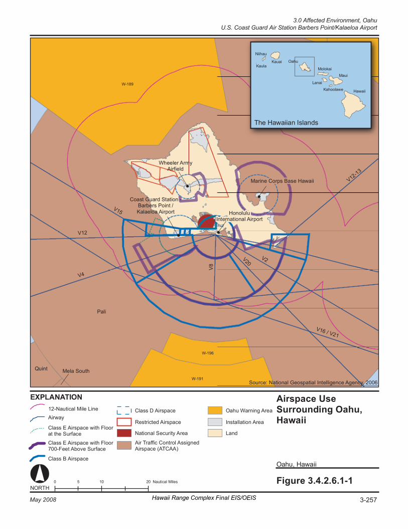
V2
V8
V1 5
V2 0
T he Ha wa iia n Is la nd s
0 1 0 2 0 5 N au ti ca l Mi le s Fi gure 3. 4. 2. 6. 1- 1
O ahu , Hawa ii
K auai
Ni i hau
K aul a
Airs p ace U se Surround i ng Oahu, Ha wa ii
EX P LA NA TI ON
NORT H
O ahu
Mo lo ka i
L anai
K ahool aw e
M aui
Hawa ii
Ma ri ne Co r ps B as e Ha wa ii
Ho no lu lu In te r na ti on al A ir po r t
Co as t Gu ar d St at io n - Ba r ber s Po in t / Ka la el oa A ir po r t
Wh ee le r A r my Air fi el d
Pa li
Qu in t Me la S out h
V1 2- 13
Cl as s D Ai rs pac e
Cl as s B Ai r sp ac e
Cl as s E Ai r sp ac e wi th F lo or 70 0- Fe et A bo ve S ur fa ce
Cl as s E Ai r sp ac e wi th F lo or at t he S ur fa ce
Air T ra ffi c Co nt r ol A ss i gne d Air sp ac e (A TCAA )
Na ti o nal S ec ur it y Ar ea La nd
In st al la ti on A r ea
O ahu War ni ng Ar ea
So ur ce : Na ti on al G eo s pat ia l In te ll ig en ce A ge ncy , 200 6
V1 2
V4
V1 6 / V2 1
W- 189
W- 196
W- 191
12 -N au ti ca l M ile L in e
Re st r ic te d Ai r sp ac e Airwa y
3-257May 2008 Hawaii Range Complex Final EIS/OEIS
3.0 Affected Environment, OahuU.S. Coast Guard Air Station Barbers Point/Kalaeloa Airport
Oahu, 3.0 Affected Environment U.S. Coast Guard Air Station Barbers Point/Kalaeloa Airport
3-258 Hawaii Range Complex Final EIS/OEIS May 2008
The affected airspace use environment in the U.S. Coast Guard Air Station Barbers Point region of influence is described below in terms of its principal attributes: controlled and uncontrolled airspace, special use airspace, en route airways and jet routes, and airports and airfields. There are no military training routes in the region of influence.
Controlled and Uncontrolled Airspace The airspace within the region of influence consists of the airspace above Kalaeloa Airport which includes Class D, surface Class E, and Class E airspace with a floor 700 ft above the surface (see Figure 3.4.2.6.1-1). Honolulu International Airport Class B airspace is located partially within and above the Kalaeloa airport airspace.
Special Use Airspace The only special use airspace in the region of influence (see Figure 3.4.2.6.1-1) is the Pali Air Traffic Control Assigned Airspace that is in effect above the entire Oahu area from flight level (FL) 250 (25,000 ft) to unlimited. The Pali airspace is scheduled through the Navy Fleet Area Control and Surveillance Facility (FACSFAC) Pearl Harbor who then coordinates with the Federal Aviation Administration (FAA) Honolulu Combined Facility.
En Route Airways and Jet Routes The closest instrument flight rules (IFR) en route low altitude airways are V12 and V15, which pass directly over the airfield and V4, which passes above the Kalaeloa Class D and E airspace.
Airports and Airfields Wheeler Army Airfield is located 10 nm to the north and Honolulu International Airport is located 8 nm to the east.
3.4.2.6.2 Biological Resources—U.S. Coast Guard Air Station Barbers Point/Kalaeloa Airport
Appendix C includes a detailed description of biological resources.
Region of Influence The region of influence includes the installation and its offshore waters.
Affected Environment
Vegetation U.S. Coast Guard Air Station Barbers Point occupies a portion of the 750-acre Kalaeola Airport. As such, there are few biological resources associated directly with the facility. Open areas are grassed and maintained. Pua pilo (Capparis sandwichiana var. zoharyi), a Federal species of concern endemic shrub, is located in the southwestern corner of Kalaeloa on the USFWS Pearl Harbor National Wildlife Refuge, Kalaeloa Unit (State of Hawaii, 2006).
3.0 Affected Environment, Oahu
U.S. Coast Guard Air Station Barbers Point/Kalaeloa Airport
May 2008 Hawaii Range Complex Final EIS/OEIS 3-259
Threatened and Endangered Plant Species The endemic, endangered `akoko shrub (Chamaesysce skottsbergii var. kalaeloana) (Table 3.4.2.6.2-1) occurs in at least three locations at the former Barbers Point Naval Air Station. The endangered round-leafed chaff-flower or ewa hina hina (Achyranthes splendens var. rotundata) is located in the southwestern corner of Kalaeloa. (State of Hawaii, 2006)
Table 3.4.2.6.2-1. Listed Species Known or Expected to Occur in the Vicinity of U.S. Coast Guard Air Station Barbers Point/Kalaeloa Airport
Scientific Name Common Name Federal Status Plants
Achyranthes splendens var. rotundata Ewa hina hina (Round-leafed chaff-flower) E
Chamaesysce skottsbergii var. kalaeloana `Akoko (Coastal sandmat) E
Birds Himantopus mexicanus knudseni Ae`o (Hawaiian black-necked stilt) E Source: U.S. Fish and Wildlife Service, 2005a; b; U.S. Department of the Interior, Office of Environmental Policy and Compliance Pacific Southwest Region, 2007 Key to Federal Status: E = Endangered
Wildlife The Kalaeloa Airport is used by birds, feral dogs and cats, rodents, and mongooses. Birds are the most common form of wildlife on the site and include the black-crowned night heron, great frigate bird, Pacific golden plover, sanderling (Calidris alba), wandering tattler, ruddy turnstone, zebra dove, Japanese white-eye, northern cardinal, red-crested cardinal (Paroaria coronata), and red-vented bulbul. (U.S. Department of the Navy, 2002a; State of Hawaii, 2001)
The State endangered Hawaiian short-eared owl, which is Federally listed as a Species of Concern, may transit through the region of influence (State of Hawaii, 2006).
Threatened and Endangered Wildlife Species Ordy Pond, an anchialine (marine) pond east of the airfield; the coastal salt flats between Runway 4R-22L and Taxiway K; and also the western boundary of Kalaeloa are frequented by the endangered Hawaiian black-necked stilt and migratory birds. (State of Hawaii, 2006)
Environmentally Sensitive Habitat The Kalaeloa Unit, which was once part of the former Barbers Point Naval Air Station, has been added to the Pearl Harbor National Wildlife Refuge. The Kalaeloa Unit supports the second largest population of endangered ewa hina hina. (U.S. Department of the Interior, Office of Environmental Policy and Compliance Pacific Southwest Region, 2007)
Oahu, 3.0 Affected Environment Marine Corps Base Hawaii
3-260 Hawaii Range Complex Final EIS/OEIS May 2008
3.4.2.7 MARINE CORPS BASE HAWAII (MCBH) MCBH is a 2,951-acre reservation on Mokapu Peninsula on the northeast side of the Island of Oahu. The base is bounded by water on three sides: Kaneohe Bay, the Pacific Ocean, and Kailua Bay. The Nu`upia Pond Wildlife Management Area lies in the isthmus between the base and the mainland.
This section describes the environmental resources that would be affected by the No-action Alternative, Alternative 1, Alternative 2, or Alternative 3 for MCBH. Of the 13 environmental resources considered for analysis, air quality, geology and soils, hazardous materials and hazardous waste, health and safety, land use, transportation, utilities, and water resources are not addressed.
3.4.2.7.1 Airspace—MCBH Appendix C includes a detailed description of airspace.
Region of Influence Based on RIMPAC, aircraft support includes space for the various types of aircraft and equipment for refueling and maintenance. U.S. and foreign aircraft (fixed wing, rotary, and airship) would be supported from several locations. For a typical RIMPAC, approximately 20 aircraft would be supported at MCBH. Housing would be provided at the installation.
The use of MCBH by aircraft during RIMPAC would be coordinated as part of the biennial planning process during three planning conferences leading up to the RIMPAC Exercise. Due to the level and extent of planning involved, and the minimal potential for significant impacts, airspace has not been evaluated under the RIMPAC EAs (U.S. Department of the Navy, 2006a; 2002a; 2000 and U.S. Department of the Navy, Commander Third Fleet, 2004).
The MCBH region of influence includes the Class D and Class E airspace (defined in Appendix C) above MCBH. Figure 3.4.2.6.1-1 shows a view of the airspace above Oahu including MCBH.
Affected Environment The affected airspace use environment in the MCBH region of influence is described below in terms of its principal attributes: controlled and uncontrolled airspace, special use airspace, en route airways and jet routes, and airports and airfields. There are no military training routes in the region of influence.
Controlled and Uncontrolled Airspace The airspace within the region of influence consists of the airspace above MCBH which includes Class D, and Class E airspace with a floor 700 ft above the surface. No Class B (U.S. terminal control areas) airspace, which usually surrounds the nation’s busiest airports, or Class C airspace is found in the MCBH region of influence.
3.0 Affected Environment, Oahu
Marine Corps Base Hawaii
May 2008 Hawaii Range Complex Final EIS/OEIS 3-261
Special Use Airspace The only special use airspace in the region of influence (see Figure 3.4.2.6.1-1) is the Pali Air Traffic Control Assigned Airspace that is in effect above the entire Oahu area from FL 250 (25,000 ft) to unlimited. The Pali airspace is scheduled through the Navy FACSFAC Pearl Harbor, which then coordinates with the FAA Honolulu Combined Facility.
En Route Airways and Jet Routes The closest IFR en route low altitude airways are V12-13 and V15, which pass outside the region of influence approximately 10 nm southeast of MCBH.
Airports and Airfields MCBH is surrounded by Class D airspace that extends from the surface to 2,500 ft. The Class E airspace extension to the north and east has a floor 700 ft above the surface. Honolulu International Airport is located southeast of MCBH, outside the region of influence.
3.4.2.7.2 Biological Resources—MCBH Appendix C includes a detailed description of biological resources.
Region of Influence The region of influence includes the installation and adjacent waters.
Affected Environment
Vegetation Dune vegetation consists of naupaka (Scaevola sericea) thickets interspersed with clusters of sea grape. Along the seaward side of the naupaka is a mat of beach dropseed grass (aki`aki) (Sporobolus virginicus) and morning glory (pohuehue) (Ipomoea pes-caprae). Ironwood trees are also present at the Hale Koa/West Field landing area. The terrestrial habitat typically consists of sparse ground cover composed of indigenous grasses and shrubs. Most of the vegetation on MCBH is dominated by introduced species. (U.S. Department of the Navy, 2002a)
Threatened and Endangered Plant Species No threatened or endangered plants have been observed at MCBH.
Wildlife Migratory birds such as the Pacific golden-plover and ruddy turnstone have been observed foraging and resting on the landing beaches. Seabirds, including the great frigate bird (`iwa) and brown noddy have been seen foraging offshore. (U.S. Department of the Navy, 2002a)
A red-footed booby nesting colony consisting of over 3,000 birds is located on the cliffs of the 23-acre Ulupau Wildlife Management Area. Wedge-tailed shearwaters and black-crowned night herons (`auku`u) are also found in the area. (U.S. Fish and Wildlife Service, 2005a; Defense Environmental Network & Information eXchange, 2005; Sierra Club, not dated)
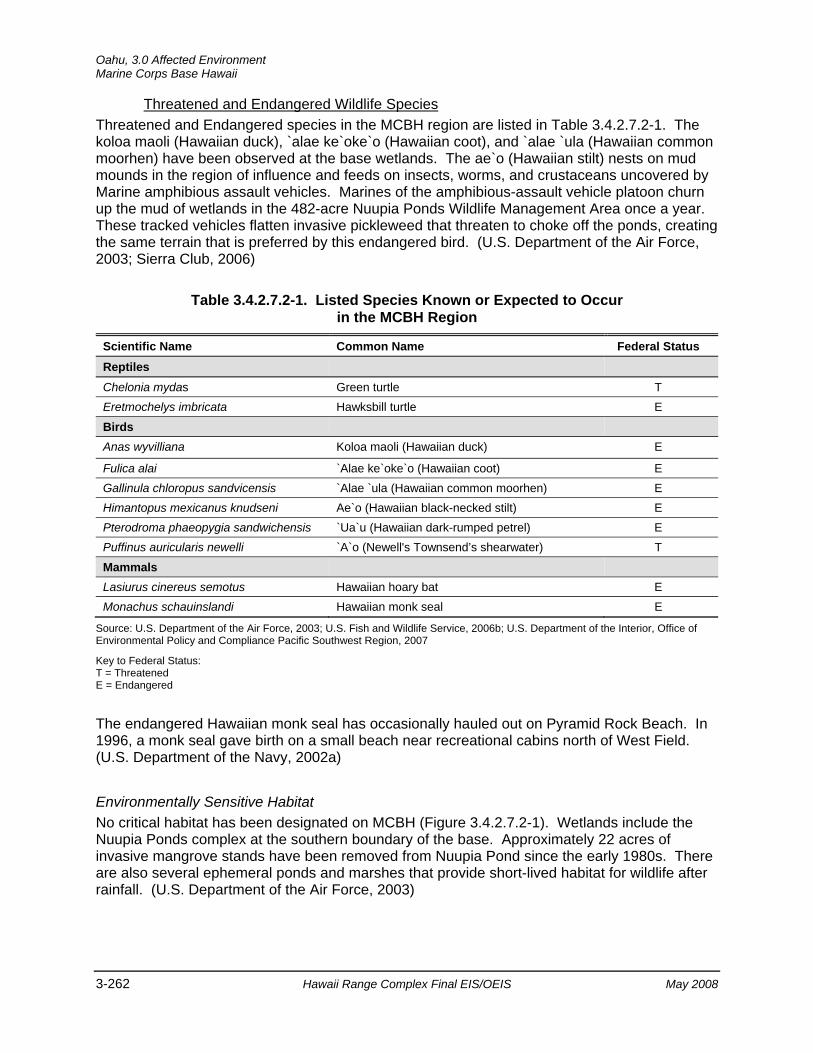
Oahu, 3.0 Affected Environment Marine Corps Base Hawaii
3-262 Hawaii Range Complex Final EIS/OEIS May 2008
Threatened and Endangered Wildlife Species Threatened and Endangered species in the MCBH region are listed in Table 3.4.2.7.2-1. The koloa maoli (Hawaiian duck), `alae ke`oke`o (Hawaiian coot), and `alae `ula (Hawaiian common moorhen) have been observed at the base wetlands. The ae`o (Hawaiian stilt) nests on mud mounds in the region of influence and feeds on insects, worms, and crustaceans uncovered by Marine amphibious assault vehicles. Marines of the amphibious-assault vehicle platoon churn up the mud of wetlands in the 482-acre Nuupia Ponds Wildlife Management Area once a year. These tracked vehicles flatten invasive pickleweed that threaten to choke off the ponds, creating the same terrain that is preferred by this endangered bird. (U.S. Department of the Air Force, 2003; Sierra Club, 2006)
Table 3.4.2.7.2-1. Listed Species Known or Expected to Occur in the MCBH Region
Scientific Name Common Name Federal Status Reptiles
Chelonia mydas Green turtle T Eretmochelys imbricata Hawksbill turtle E
Birds
Anas wyvilliana Koloa maoli (Hawaiian duck) E
Fulica alai `Alae ke`oke`o (Hawaiian coot) E Gallinula chloropus sandvicensis `Alae `ula (Hawaiian common moorhen) E Himantopus mexicanus knudseni Ae`o (Hawaiian black-necked stilt) E Pterodroma phaeopygia sandwichensis `Ua`u (Hawaiian dark-rumped petrel) E Puffinus auricularis newelli `A`o (Newell's Townsend’s shearwater) T
Mammals
Lasiurus cinereus semotus Hawaiian hoary bat E Monachus schauinslandi Hawaiian monk seal E
Source: U.S. Department of the Air Force, 2003; U.S. Fish and Wildlife Service, 2006b; U.S. Department of the Interior, Office of Environmental Policy and Compliance Pacific Southwest Region, 2007
Key to Federal Status: T = Threatened E = Endangered
The endangered Hawaiian monk seal has occasionally hauled out on Pyramid Rock Beach. In 1996, a monk seal gave birth on a small beach near recreational cabins north of West Field. (U.S. Department of the Navy, 2002a)
Environmentally Sensitive Habitat No critical habitat has been designated on MCBH (Figure 3.4.2.7.2-1). Wetlands include the Nuupia Ponds complex at the southern boundary of the base. Approximately 22 acres of invasive mangrove stands have been removed from Nuupia Pond since the early 1980s. There are also several ephemeral ponds and marshes that provide short-lived habitat for wildlife after rainfall. (U.S. Department of the Air Force, 2003)

Fi gure 3.4.2.7.2-1 0 1 2 0. 5 M il es NORT H
Crit ic al H ab it at - Eastern Oahu, Ha wa ii
O ahu , Hawa ii
Ma ri ne Co rp s Ba se H aw ai i
Ma ri ne Co rp s Tr ai ni ng A re a / Be llo ws
`E le pa io
Cy an ea cr is pa
`E le pa io
EX PL AN AT IO N Ro ad
Ins ta ll at io n Ar ea
Cr it ic al H ab it at
We tl an d Ar ea
La nd
So ur ce : St at e o f H aw a ii Of fi ce o f Pl ann in g , 2 00 5
O ahu , Hawa ii O ahu , Hawa ii
3-263May 2008 Hawaii Range Complex Final EIS/OEIS
3.0 Affected Environment, OahuMarine Corps Base Hawaii
Oahu, 3.0 Affected Environment Marine Corps Base Hawaii
3-264 Hawaii Range Complex Final EIS/OEIS May 2008
3.4.2.7.3 Cultural Resources—MCBH Appendix C includes a description of cultural resources and the laws and regulations pertaining to them.
Region of Influence The region of influence for cultural resources at MCBH encompasses locations where Humanitarian Assistance/Disaster Relief Operations will occur. About 700 acres of MCBH’s total properties are the focus of cultural resources management. Approximately 550 of the 700 acres are at Mokapu, including the Nuupia Ponds and Mokapu Burial Area (Defense Environmental Network and Information eXchange, 1999).
Affected Environment
Archaeological Resources (Prehistoric and Historic) Baseline cultural resources surveys completed in 1981 and 1986 were updated, and the data were included in the Mokapu Cultural Resources Management Plan (1997). As part of the update, a Cultural Resources Assessment of the MCBH was performed in May 1997. The report indicated that Hale Koa/West Field Beach was created with dredged fill during World War II and contains no cultural resources or human remains. Hale Koa/West Field’s additional runway was created with fill as part of the World War II base expansion and has no potential for cultural resources or the discovery of human remains. The Pyramid Rock Beach landing and staging areas contain no known cultural resources or human remains. The landing and staging areas at Fort Hase Beach are within a zone classified as having a low archaeological sensitivity. A ground-penetrating radar survey of the landing and staging areas detected no cultural deposits or burials and confirmed that the areas were previously disturbed (Yamada, 2002; U.S. Department of the Navy, 2002a).
Archaeological sites identified at MCBH include the Nuupia Ponds; the Mokapu Burial Area, which is listed in the NRHP; approximately 27 pre-contact or early-contact Hawaiian sites; and 45 post-contact sites that cover the period from early Hawaiian through World War II (Defense Environmental Network and Information eXchange, 1999).
Historic Buildings and Structures Historic buildings, structures, and other features under the control of MCBH include the following ( Defense Environmental Network and Information eXchange, 1999):
• Hangar 101 and Seaplane Ramps. Located on the Kaneohe Bay shoreline, Hangar 101 and its associated seaplane ramps are a designated National Historic Landmark. The facilities once supported the Navy's PBY Catalina patrol plane fleet and were bombed minutes before the December 7, 1941 attack on Naval Station Pearl Harbor.
• Aircraft Parts. Kaneohe Bay waters and Ulupau Crater ravines harbor the wreckage of aircraft downed during the December 7, 1941 attack on Naval Station Pearl Harbor.
• Battery Pennsylvania at Ulupau Crater Head. Battery Pennsylvania is a World War II fortification that has been determined to be eligible for inclusion in the NRHP. Seven stories deep, this massive reinforced concrete gun emplacement supported a turret with 14-inch guns from the sunken battleship, USS Arizona.
3.0 Affected Environment, Oahu
Marine Corps Base Hawaii
May 2008 Hawaii Range Complex Final EIS/OEIS 3-265
Traditional Resources Archival research and oral histories verify Mokapu as inspiration for many Hawaiian stories, songs, dance, and religious ceremonies. The exact translation of the word Mokapu is not confirmed; however, it could be a contraction of moku (district or island) and kapu (sacred or forbidden).
3.4.2.7.4 Noise—MCBH Appendix C includes a definition of noise and the main regulations and laws that govern it.
Region of Influence The region of influence for MCBH is the area within and surrounding MCBH in which humans and wildlife may suffer annoyance or disturbance from noise levels from the proposed training at MCBH.
Affected Environment The primary source of noise at MCBH is the neighboring military landing field that serves both fixed-wing and helicopter events. Helicopter and aircraft activities and amphibious training occur regularly at the landing field. During active runway use or amphibious training, noise levels typically range between 70 and 75 dBA. During periods of no runway use or training, the noise levels are equal to or less than 55 dBA during the day and fall to less than 45 dBA during the evening and night hours. The nearest sensitive noise receptor is Hale Koa Beach, approximately 328 ft southeast of helicopter landing areas and 2,198 ft northwest of an active runway. Noise levels at Hale Koa Beach are similar to the noise levels described at MCBH. (U.S. Department of the Navy, 2002a)
MCBH has established noise controls to protect base personnel and the community, including establishing flight patterns and airfield operation schedules that satisfy the community and support mission activities. In addition, a community notification plan for all short-term training that may increase noise levels is followed. (U.S. Department of the Navy, 2002a)
Figure 3.4.2.7.4-1 depicts noise contours based on annual events for MCBH in 1999, which includes 163,390 flight events during the day and 13,460 night flight events. Aircraft at MCBH include, but are not limited to P-3s, C-130s, C-17s, F/A-18s, CH-53Ds, SH-60s, and C-20Gs. The MCBH Kaneohe Bay Air Installation Compatible Use Zones (Naval Facilities Engineering Command, 2003) determined that the only off-base land areas that would be impacted by noise levels greater than Day-Night Level (DNL) 60 are Coconut Island and other small uninhabited islands. Land uses within the DNL 65 noise contour on-base include the industrial area near the runway, maintenance facilities, portions of the officers’ family housing and bachelor enlisted quarters, a portion of the golf course, beach areas, operational and maintenance uses on both sides of the runway, and the runway itself. (Naval Facilities Engineering Command, 2003)
Wildlife receptors for the MCBH area are described in Section 3.4.2.7.2, Biological Resources.
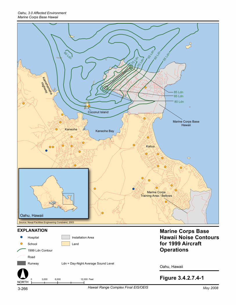
75 Ld
n70
Ldn
65 L
dn60
Ldn
85 Ldn
60 Ldn
80 Ldn
85 Ldn
55 L
dn
Figure 3.4.2.7.4-10 6,000 12,0003,000 FeetNORTH
Oahu, Hawaii
Marine Corps BaseHawaii Noise Contoursfor 1999 AircraftOperations
Oahu, Hawaii
Marine Corps BaseHawaii
Marine CorpsTraining Area / Bellows
Kaneohe Bay
EXPLANATION
Road
Runway
Land
Installation AreaHospital
Source: Naval Facilities Engineering Command, 2003
Ldn = Day-Night Average Sound Level
School
Kaneohe
Kailua
Coconut Island
Kameham
eha
Highway
1999 Ldn Contour
3-266 May 2008Hawaii Range Complex Final EIS/OEIS
Oahu, 3.0 Affected EnvironmentMarine Corps Base Hawaii
3.0 Affected Environment, Oahu
Marine Corps Base Hawaii
May 2008 Hawaii Range Complex Final EIS/OEIS 3-267
3.4.2.7.5 Socioeconomics—MCBH Appendix C includes a general definition of socioeconomics.
Region of Influence The region of influence for socioeconomic analysis is MCBH. The County of Honolulu comprises the entire island of Oahu. The base is bounded by water on three sides: Kaneohe Bay, the Pacific Ocean, and Kailua Bay.
Affected Environment The closest civilian community to MCBH is Kaneohe. Kaneohe is considered a single-family suburban “bedroom community” and is likely to be affected by MCBH airfield operations due to the nearby major flight tracks. In addition airfield operations are visible to Kaneohe residents. Kaneohe has a population of approximately 55,800, and the average household income is about $80,000 (American Dream Realty, 2006). In addition to residential land use, there are several other significant uses of the Kaneohe Bay area, including major commercial activities along Kamehameha Highway and several light industries. Kaneohe is a town and census-designated place included in the City and County of Honolulu and located in Hawaii, on the island of Oahu (Honolulu Board of Realtors, 2006b). Section 3.4.2.1.3 discusses the socioeconomic characteristic of Oahu, which encompasses the Kaneohe community.
There are several small islands within Kaneohe Bay. Coconut Island, the only inhabited island, comprises approximately 29 acres. Approximately half of this area is landfill formed by dredged materials form the main Kaneohe Bay channel, deposited on the perimeter of the island. The University of Hawaii Institute of Marine Biology, a research facility, is the primary activity on the island. The former privately owned area in the central area of the island is now owned by the University of Hawaii Foundation and leased to the University of Hawaii for the Hawaii Institute of Marine Biology’s long-term use. Daytime staffing ranges from 50 to 100 personnel. There are about 17 full-time residents on the island, which include institute staff members and their families. There are also several temporary lodging facilities on the island that are used by visiting researchers. Three other small uninhabited islands are located near MCBH Kaneohe Bay. These islands are seabird sanctuaries managed by the State of Hawaii. (Naval Facilities Engineering Command, 2003)
Oahu, 3.0 Affected Environment Marine Corps Training Area/Bellows
3-268 Hawaii Range Complex Final EIS/OEIS May 2008
3.4.2.8 MARINE CORPS TRAINING AREA/BELLOWS (MCTAB) MCTAB covers 1,078 acres on the southeastern portion of Oahu. The inactive airfield in the center of the site is limited to rotary wing activity, and is occasionally used for Marine Corps helicopter training.
This section describes the environmental resources that would be affected by the No-action Alternative, Alternative 1, Alternative 2, or Alternative 3 for MCTAB. Of the 13 environmental resources considered for analysis, air quality, airspace, geology and soils, hazardous materials and hazardous waste, health and safety, land use, noise, socioeconomics, transportation, utilities, and water resources are not addressed.
3.4.2.8.1 Biological Resources—MCTAB Appendix C includes a detailed description of biological resources.
Region of Influence The region of influence includes those areas on or adjacent to MCTAB that could be affected by existing or proposed training.
Affected Environment
Vegetation Virtually all native vegetation on MCTAB has been replaced by exotic species. Extensive second-growth forest is dominated by koa haole, Christmas berry (Schinus terebinthifolius), and ironwood. (U.S. Air Force 15th Airlift Wing, 2005) Only 12 percent of the species recorded were native species (U.S. Department of the Navy, 2002a). However, sea cliffs and sand dunes at MCTAB support unique strand vegetation (Defense Environmental Network & Information eXchange, 2001).
Threatened and Endangered Plant Species No rare, threatened, or endangered plant species are known to occur on or near MCTAB (U.S. Air Force 15th Airlift Wing, 2005).
Wildlife Shorebirds observed in the vicinity of MCTAB include the Pacific golden plover, wandering tattler, ruddy turnstone, and sanderling. The Hawaiian short-eared owl has also been seen on the station’s perimeter.
Threatened and Endangered Wildlife Species Threatened and endangered species observed or potentially occurring at MCTAB (Table 3.4.2.8.1-1) include the endangered koloa maoli (Hawaiian duck), `alae ke`ok`o (Hawaiian coot), alae ula (Hawaiian common moorhen), and ae`o (Hawaiian black-necked stilt). Forty to sixty percent of the statewide population of the ae`o (Hawaiian black-necked stilt) is found on Oahu. According to the USFWS, the Hawaiian dark-rumped petrel and Newell’s shearwater have the potential to occur on the base (U.S. Fish and Wildlife Service, 2007a). Oahu also has
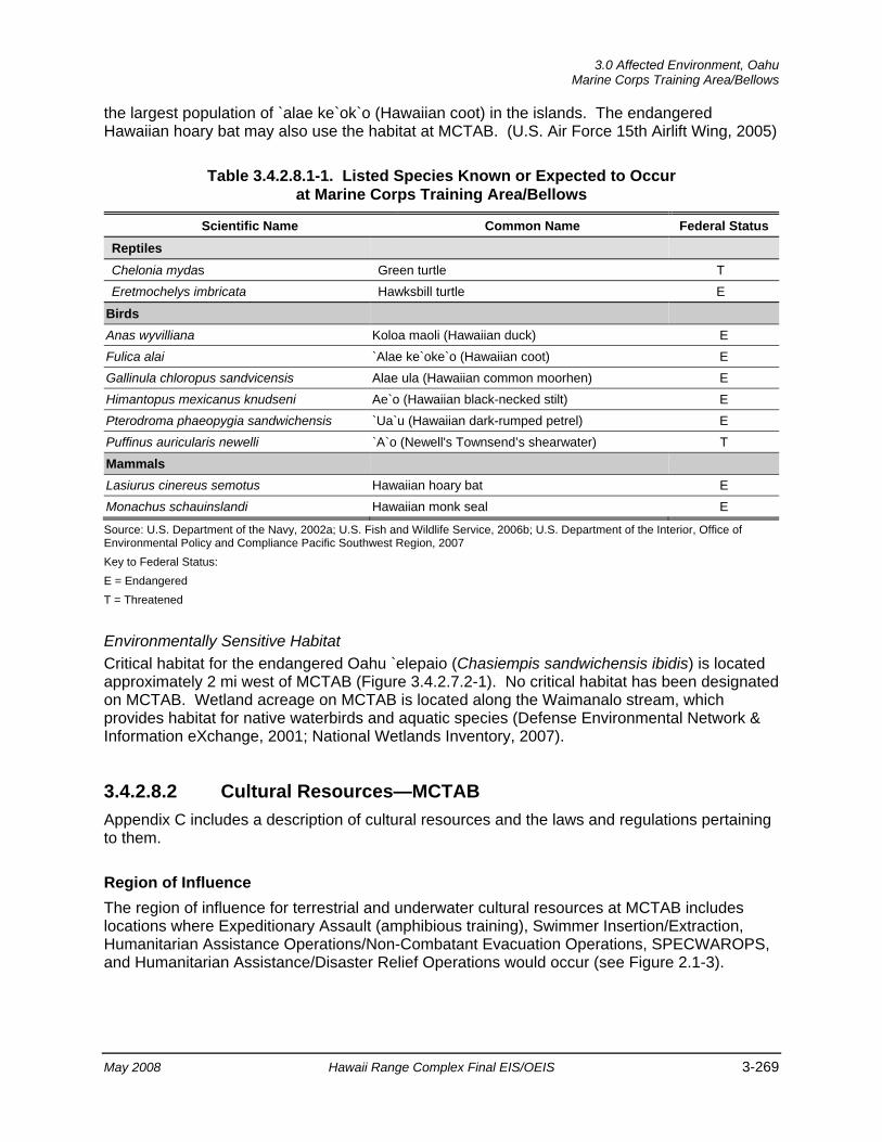
3.0 Affected Environment, Oahu
Marine Corps Training Area/Bellows
May 2008 Hawaii Range Complex Final EIS/OEIS 3-269
the largest population of `alae ke`ok`o (Hawaiian coot) in the islands. The endangered Hawaiian hoary bat may also use the habitat at MCTAB. (U.S. Air Force 15th Airlift Wing, 2005)
Table 3.4.2.8.1-1. Listed Species Known or Expected to Occur at Marine Corps Training Area/Bellows
Scientific Name Common Name Federal Status Reptiles
Chelonia mydas Green turtle T Eretmochelys imbricata Hawksbill turtle E
Birds Anas wyvilliana Koloa maoli (Hawaiian duck) E Fulica alai `Alae ke`oke`o (Hawaiian coot) E Gallinula chloropus sandvicensis Alae ula (Hawaiian common moorhen) E Himantopus mexicanus knudseni Ae`o (Hawaiian black-necked stilt) E Pterodroma phaeopygia sandwichensis `Ua`u (Hawaiian dark-rumped petrel) E Puffinus auricularis newelli `A`o (Newell's Townsend’s shearwater) T
Mammals Lasiurus cinereus semotus Hawaiian hoary bat E Monachus schauinslandi Hawaiian monk seal E
Source: U.S. Department of the Navy, 2002a; U.S. Fish and Wildlife Service, 2006b; U.S. Department of the Interior, Office of Environmental Policy and Compliance Pacific Southwest Region, 2007 Key to Federal Status: E = Endangered T = Threatened Environmentally Sensitive Habitat Critical habitat for the endangered Oahu `elepaio (Chasiempis sandwichensis ibidis) is located approximately 2 mi west of MCTAB (Figure 3.4.2.7.2-1). No critical habitat has been designated on MCTAB. Wetland acreage on MCTAB is located along the Waimanalo stream, which provides habitat for native waterbirds and aquatic species (Defense Environmental Network & Information eXchange, 2001; National Wetlands Inventory, 2007).
3.4.2.8.2 Cultural Resources—MCTAB Appendix C includes a description of cultural resources and the laws and regulations pertaining to them.
Region of Influence The region of influence for terrestrial and underwater cultural resources at MCTAB includes locations where Expeditionary Assault (amphibious training), Swimmer Insertion/Extraction, Humanitarian Assistance Operations/Non-Combatant Evacuation Operations, SPECWAROPS, and Humanitarian Assistance/Disaster Relief Operations would occur (see Figure 2.1-3).
Oahu, 3.0 Affected Environment Marine Corps Training Area/Bellows
3-270 Hawaii Range Complex Final EIS/OEIS May 2008
Affected Environment
Archaeological Resources (Prehistoric and Historic) Located on the windward coast of Oahu, MCTAB has a long history of human occupation and exploitation. Archaeological studies reveal extensive prehistoric use of beach ridges and swales for campsites, tool making, and as burial areas and, in some locations (particularly along streams and near the coast), cultural deposits are relatively thick. (Desilets, 2002)
At the time of the Great Mahele (in 1848), most of the area now encompassed by MCTAB was in the ahupuaa of Waimanalo, which during the mid 1800s was part of the Crown Lands of Kamehameha III. In 1850, the area was leased for cattle, horse, and sheep ranching, but by the late 1870s, ranching had been replaced by sugar cane fields (in non-beach areas).
In 1917, the Waimanalo Military Reservation was established with boundaries nearly identical to those of present day MCTAB. Significant use of the area by the military did not occur until 1933 when the name of the installation was changed to Waimanalo Military Reservation, Bellows Field. At the time of the Japanese attack on Naval Station Pearl Harbor, new runways were already under construction. Along with many other facilities, the runways were completed during World War II and the installation was used as an airfield. After World War II, Bellows Field transitioned from an airfield to a training, recreation, and communications facility. A Nike/Hercules missile site was added to the facility during the Cold War era, and interior areas were leased for cattle ranching. (Desilets, 2002)
Approximately 20 archaeological sites have been identified at MCTAB, several of which are located within the runway complex. There is also a high probability for additional subsurface sites to exist, particularly along stream banks and in dune areas (U.S. Air Force, 15th Airlift Wing, 2005; U.S. Department of Defense, 2006). Most of the archaeological sites at MCTAB are subsurface, including both identified and potential burial sites at isolated locations. Many of the identified sites, including Site 4852 (Bellows Dune Site), are eligible for inclusion in the NRHP. (U.S. Pacific Command, 1995; U.S. Department of the Navy, 2002a; U.S. Army Corps of Engineers, Honolulu Engineer District, 2005) A list of archaeological and traditional resources sites at MCTAB is provided in Appendix H.
Historic Buildings and Structures A complete inventory of potential historic buildings and structures was completed for MCTAB in 2002 (U.S. Army Corps of Engineers, Honolulu Engineer District, 2005). Properties were identified as eligible for inclusion in the NRHP, including World War II-era aircraft revetments for the B-17 aircraft and Pursuit Planes, runways, and taxiways. (U.S. Army Corps of Engineers, Honolulu Engineer District, 2005)
Traditional Resources Although traditional Hawaiian resources information is scant for the MCTAB area, there are several associated legend sites that have been identified and determined to be eligible for inclusion in the NRHP as Traditional Cultural Properties. These include the area of the Battle of Kukui (a 2-day battle between Kalanikupule [the ruler of Oahu in 1794] and his Uncle Kaeokulani [ruler of Kauai]) (Archaeological Site No. 4858); the legend of Haununaniho, a small hill (puuhonua), which is said to have once been a place of refuge (Archaeological Site No. 383); and the legend of the black stone (Pohaku-paakiki), which is believed to have been a

3.0 Affected Environment, Oahu
Marine Corps Training Area/Bellows
May 2008 Hawaii Range Complex Final EIS/OEIS 3-271
shrine built by sweet potato growers who used it to place offerings to their shark god, Kamohoalili. This same area is also associated with a legend about a stone watch tower and small house used to guard Oahu from approaching canoes. Archaeological Site No. 4852 (Bellows Dune Site) and three areas of nearby excavations have been listed in the NRHP. In addition, 49 burials have been recorded. (U.S. Army Corps of Engineers, Honolulu Engineer District, 2005)
Oahu, 3.0 Affected Environment Hickam AFB
3-272 Hawaii Range Complex Final EIS/OEIS May 2008
3.4.2.9 HICKAM AIR FORCE BASE (AFB) Hickam AFB is located on the south side of Oahu next to the Honolulu International Airport and consists of 2,850 acres of land and facilities. Hickam AFB, Hawaii is home to the 15th Airlift Wing and 67 partner units including Pacific Air Forces Headquarters and the Hawaii Air National Guard.
This section describes the environmental resources that would be affected by the No-action Alternative, Alternative 1, Alternative 2, or Alternative 3 for Hickam AFB. Of the 13 environmental resources considered for analysis, air quality, cultural resources, geology and soils, hazardous materials and hazardous waste, health and safety, land use, noise, socioeconomics, transportation, utilities, and water resources are not addressed.
3.4.2.9.1 Airspace—Hickam AFB Appendix C includes a detailed description of airspace.
Region of Influence Based on RIMPAC, aircraft support includes space for the various types of aircraft and equipment for refueling and maintenance. U.S. and foreign aircraft (fixed wing, rotary, and airship) would be supported from several locations. For a typical RIMPAC, approximately 50 aircraft would be supported at Hickam AFB. Housing would be provided at the installation.
The use of Hickam AFB by aircraft during RIMPAC would be coordinated as part of the biennial planning process during three planning conferences leading up to the RIMPAC Exercise. Due to the level and extent of planning involved, and the minimal potential for significant impacts, airspace has not been evaluated under the RIMPAC EAs (U.S. Department of the Navy, 2006a;; 2002a; 2000 and U.S. Department of the Navy, Commander Third Fleet, 2004).
The Hickam AFB region of influence includes the airspace above and south of Honolulu International Airport. Figure 3.4.2.6.1-1 shows a view of the airspace above Oahu including Hickam AFB/Honolulu International Airport.
Affected Environment The affected airspace use environment in the Hickam AFB region of influence is described below in terms of its principal attributes: controlled and uncontrolled airspace, special use airspace, en route airways and jet routes, and airports and airfields. There are no military training routes in the region of influence.
Controlled and Uncontrolled Airspace The airspace within the region of influence consists of the airspace above Hickam AFB/Honolulu International Airport as shown on Figure 3.4.2.6.1-1. Hickam AFB shares its runways with the adjacent Honolulu International Airport. Hickam AFB and the Honolulu International Airport constitute a single airport complex operated under a joint-use agreement.
3.0 Affected Environment, Oahu
Hickam AFB
May 2008 Hawaii Range Complex Final EIS/OEIS 3-273
The Class B airspace that lies above Hickam AFB consists of a core surface area surrounded by several layers of varying floor altitudes (FL 10, 15, 20, 30, 40) but the same ceiling altitude of FL 90. Below the Class B layers is Class E airspace with a floor 700 ft above the surface. Honolulu Combined Facility, more specifically, the Honolulu Control Tower, controls the movement of aircraft within the region of influence.
Special Use Airspace The Pali Air Traffic Control Assigned Airspace is in effect above the entire Oahu area from FL 250 (25,000 ft) to unlimited. The Pali airspace is scheduled through the Navy FACSFAC Pearl Harbor who then coordinates with the FAA Honolulu Combined Facility.
There is also a National Security Area above a portion of Naval Station Pearl Harbor as shown on Figure 3.4.2.6.1-1. For reasons of national security, pilots are requested not to fly below 5,000 ft in this area.
En Route Airways and Jet Routes Several IFR en route low altitude airways enter or transect the region of influence. These airways are Class E airspace corridors with centerlines established by navigational aids.
Airports and Airfields The Hickam AFB/Honolulu International is the primary airport within the region of influence. Kalealoa Airport is located approximately 8 nm west of Hickam AFB, Wheeler Army Airfield is located 12 nm northwest, and Kaneohe Bay Marine Corps Airfield at MCBH is located 12 nm northeast.
3.4.2.9.2 Biological Resources—Hickam AFB Region of Influence The region of influence includes the base and adjacent waters.
Affected Environment
Vegetation Vegetation on Hickam AFB has been disturbed or removed, and there are no significant, naturally occurring, native plant communities. Native plants are occasionally used in landscaping. Managed vegetation consists of herbaceous ruderal vegetation. Unmanaged vegetation exists in the southern part of the base and includes buffelgrass/kiawe woodland, kiawe forest, pickleweed flats, and mangrove. (U.S. Department of the Air Force, 2003)
Threatened and Endangered Plant Species No threatened or endangered plants have been identified on base.
Wildlife Fish and wildlife on Hickam AFB are managed through its Integrated Natural Resources Management Plan in cooperation with the USFWS and the State of Hawaii. Terrestrial wildlife

Oahu, 3.0 Affected Environment Hickam AFB
3-274 Hawaii Range Complex Final EIS/OEIS May 2008
on the base includes feral cats and mongoose. Shoreline wetlands provide a limited amount of cover, nesting, and feeding habitat for songbirds. Wedge-tailed shearwaters have been downed by lights on the base. The State endangered pueo (Hawaiian short-eared owl) has been observed on base. (U.S. Department of the Air Force, 2003)
Threatened and Endangered Wildlife Species Threatened and endangered wildlife species on or in the area of Hickam AFB are listed in Table 3.4.2.9.2-1. The ae`o (Hawaiian stilt) has been observed in the Reef Runway Lagoon, near the Manuwai Canal, and in ephemeral ponds on other parts of the base. Federally endangered Hawaiian waterbirds, primarily Hawaiian stilts, are regular visitors to Hickam AFB, having been observed foraging and nesting on base and adjacent to the runway. On March 2006, at least two separate stilt pairs nested adjacent to the runway where dewatering ponds were in place on Hickam AFB. (U.S. Department of the Interior, Office of Environmental Policy and Compliance Pacific Southwest Region, 2007) Habitat for the `alae ke`oke`o (Hawaiian coot) and the `alae`ula (Hawaiian common moorhen) exists at the Manuwai Canal, but these birds have not been recorded at this location. The koloa maoli (Hawaiian duck) has been observed on the Waipio Peninsula, which is 2 to 3 mi from Hickam AFB. The Hawaiian hoary bat, which is usually found on Kauai and Hawaii, could use portions of Hickam AFB since a few scattered sightings on Oahu have been reported. (U.S. Department of the Air Force, 2003)
Green turtles, resting Hawaiian monk seals, and transitory humpback whales are known to occur or could occur in waters off Hickam AFB.
Table 3.4.2.9.2-1. Listed Species Known or Expected to Occur in the Hickam AFB Region
Scientific Name Common Name Federal Status Reptiles
Chelonia mydas Green turtle T
Birds
Anas wyvilliana Koloa maoli (Hawaiian duck) E
Fulica alai `Alae ke`oke`o (Hawaiian coot) E
Gallinula chloropus sandvicensis Alae ula (Hawaiian common moorhen) E
Himantopus mexicanus knudseni Ae`o (Hawaiian black-necked stilt) E
Mammals
Lasiurus cinereus semotus Hawaiian hoary bat E
Monachus schauinslandi Hawaiian monk seal E Source: U.S. Department of the Air Force, 2003; U.S. Fish and Wildlife Service, 2006b; 2007 Key to Federal Status: T = Threatened E = Endangered
Environmentally Sensitive Habitat Most of the wetlands on Hickam AFB are located in the southern part of the base in flat or depressed areas, along the coast, and along the edges of canals (National Wetlands Inventory, 2007). Most wetlands, except for the coastal mangrove shrubland and sand beaches, are disturbed by human activities and are of little value to wildlife.
3.0 Affected Environment, Oahu
Wheeler Army Airfield
May 2008 Hawaii Range Complex Final EIS/OEIS 3-275
3.4.2.10 WHEELER ARMY AIRFIELD Wheeler Army Airfield consists of approximately 1,389 acres of land adjacent to Schofield Barracks. Wheeler Army Airfield is home to a variety of DoD activities including the Defense Communications Agency, the Air Force’s 6010th Aerospace Defense Group, the Hawaii Army National Guard’s Aviation Support Facility, and the 25th Infantry Division (Light) Aviation Brigade.
This section describes the environmental resources that would be affected by the No-action Alternative, Alternative 1, Alternative 2, or Alternative 3 for Wheeler Army Airfield. Of the 13 environmental resources considered for analysis, air quality, cultural resources, geology and soils, hazardous materials and hazardous waste, health and safety, land use, noise, socioeconomics, transportation, utilities, and water resources are not addressed.
3.4.2.10.1 Airspace—Wheeler Army Airfield Appendix C includes a detailed description of airspace.
Region of Influence Based on RIMPAC, aircraft support includes space for the various types of aircraft and equipment for refueling and maintenance. The use of Wheeler Army Airfield by aircraft during RIMPAC is secondary and falls within the day-to-day coordination for the movement of equipment and supplies.
The use of Wheeler Army Airfield by aircraft during RIMPAC would be coordinated as part of the biennial planning process during three planning conferences leading up to the RIMPAC Exercise. Due to the level and extent of planning involved, and the minimal potential for significant impacts, airspace has not been evaluated under the RIMPAC EAs (U.S. Department of the Navy, 2006b;; 2002a; 2000 and U.S. Department of the Navy, Commander Third Fleet, 2004).
The region of influence is defined as the area affected by the ongoing No-action Alternative and the proposed training. Figure 3.4.2.6.1-1 shows a view of the airspace above Oahu, including Wheeler Army Airfield. The region of influence includes the Class D and Class E airspace above Wheeler Army Airfield.
Affected Environment The affected airspace use environment in the Wheeler Army Airfield region of influence is described below in terms of its principal attributes: controlled and uncontrolled airspace, special use airspace, en route airways and jet routes, and airports and airfields. There are no military training routes in the region of influence.
Controlled and Uncontrolled Airspace The airspace within the region of influence consists of the airspace above Wheeler Army Airfield which includes Class D airspace from the surface to FL 33, and Class E airspace with a floor 700 ft above the surface.
Oahu, 3.0 Affected Environment Wheeler Army Airfield
3-276 Hawaii Range Complex Final EIS/OEIS May 2008
No Class B (U.S. terminal control areas) airspace, which usually surrounds the nation’s busiest airports, or Class C airspace is found in the region of influence.
Special Use Airspace Several restricted airspace areas (3109 A, B, C and 3110 A, B, C) are located immediately northwest of the Wheeler Army Airfield Class D airspace. These areas are outside the region of influence for Wheeler Army Airfield.
The Pali Air Traffic Control Assigned Airspace is in effect above the entire Oahu area from FL 250 (25,000 ft) to unlimited. The Pali airspace is scheduled through the Navy FACSFAC Pearl Harbor, which then coordinates with the FAA Honolulu Combined Facility.
En Route Airways and Jet Routes The closest IFR en route low altitude airways are located outside the region of influence, south of Oahu.
Airports and Airfields MCBH is located 15 nm to the east and Honolulu International Airport is located 12 nm to the southeast, both outside the region of influence.
3.4.2.10.2 Biological Resources—Wheeler Army Airfield Appendix C includes a detailed description of biological resources.
Region of Influence The region of influence includes the installation and adjacent land.
Affected Environment
Vegetation Wheeler Army Airfield is a developed area that contains mostly non-native urban vegetation (U.S. Department of the Army, 2004).
Threatened and Endangered Plant Species No threatened or endangered plants have been identified on Wheeler Army Airfield.
Wildlife There are no native terrestrial amphibians or reptiles on the Hawaiian Islands. Non-native amphibians and reptiles that have the potential to occur on Wheeler Army Airfield include the green and black poison dart frog, (Dendrobates auratus), bullfrog (Rana catesbeiana), giant toad (Bufo marinus), Cuban tree frog (Osteopilus septentrionalis), green anole (Anolis carolinensis), mourning gecko (Lepidodactylus lugubris), house gecko (Hemidactylus frenatus), metallic skink (Lampropholis delicata), and island blind snake (Rhamphotyphlopys braminus). (U.S. Department of the Army, 2004)
3.0 Affected Environment, Oahu
Wheeler Army Airfield
May 2008 Hawaii Range Complex Final EIS/OEIS 3-277
Several species of native and non-native birds are located in the region of influence. The black-crowned night heron, Pacific golden plover, and white-tailed tropicbird (Phaethon lepturus) are indigenous birds that are in the region of influence. Non-native birds in the region include, but are not limited to, the rock dove (Columba livia), zebra dove, common myna, and red-vented bulbul. (U.S. Department of the Army, 2004)
Threatened and Endangered Wildlife Species The Hawaiian hoary bat may occur at or in the vicinity of the airfield.
Environmentally Sensitive Habitat No critical habitat has been designated in the region of influence (Figure 3.4.2.10.2-1).
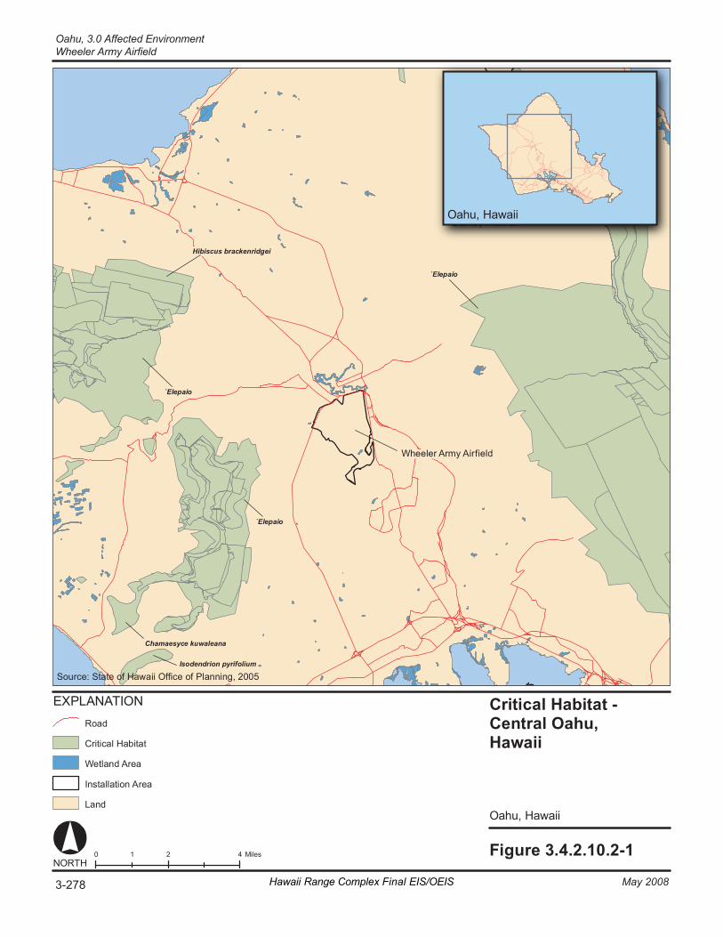
Fi gur e 3. 4. 2. 10. 2- 1 0 2 4 1 M il es NORT H
O ahu , H awai i
Criti cal H ab it at - Ce nt ral Oahu, Ha wa ii
O ahu , H awai i
Wh eel er A rm y Airfield
`E le pa io
Hibiscus br ac ken ri dg ei
Chamaesyc e ku wa lean a
Is od e ndr io n py ri fo liu m
`E le pa io
`E le pa io
EX PL AN AT IO N
Cri ti ca l Ha bi ta t
La nd
In st al la ti on A re a
Ro ad
We tl an d Ar ea
So ur ce : St at e of Haw ai i Offi ce o f Pl an ni ng , 2 00 5
O ahu , H awai i
3-278 May 2008Hawaii Range Complex Final EIS/OEIS
Oahu, 3.0 Affected EnvironmentWheeler Army Airfield
3.0 Affected Environment, Oahu
Makua Military Reservation
May 2008 Hawaii Range Complex Final EIS/OEIS 3-279
3.4.2.11 MAKUA MILITARY RESERVATION Makua Military Reservation is a Department of the Army reservation containing a total of 4,190 acres in the Makua Valley on the northwestern side of Oahu. Makua Military Reservation extends from the Farrington Highway along the west coast eastward to the ridgeline of the Waianae Mountains. The Navy would only use the Makua Military Reservation if approved by the Army.
This section describes the environmental resources that would be affected by the No-action Alternative, Alternative 1, Alternative 2, or Alternative 3 for Makua Military Reservation. Of the 13 environmental resources considered for analysis, air quality, airspace, geology and soils, hazardous materials and hazardous waste, land use, socioeconomics, transportation, utilities, and water resources are not addressed.
3.4.2.11.1 Biological Resources—Makua Military Reservation Appendix C includes a detailed description of biological resources.
Region of Influence The region of influence includes Makua Military Reservation and adjacent waters.
Affected Environment
Vegetation Three ecological zones have been identified within Makua Military Reservation. The Army delineated these zones based on elevation, topography, and prevailing climatic conditions within the Reservation, resulting in three designations: Ridge Crest Vegetation Zone, Native Shrub on Cliff and Slope Zone, and Lowland Native Forest Zone. The ecological subzones and plant and animal biota within each of these have also been well documented. Guinea grass and molasses grass are two examples of alien plant species occurring on the installation. (U.S. Department of the Army, 2005)
Threatened and Endangered Plant Species Records dating back to 1970 indicate that there are 32 endangered plants on Makua Military Reservation (Table 3.4.2.11.1-1). The majority of these plants are found along the southern and northeastern boundaries of the reservation. The removal of wild goats on the range has been beneficial to the management of the endangered plants. Another primary threat to the endangered plants on the range is fire. Recent fires have burned acreage containing some of these plants. (U.S. Department of the Army, 2005)
Wildlife In addition to native species, introduced nuisance species such as pigs, rats, and goats adversely affect range habitat. The Army has implemented measures, including more than 7 mi of fencing, to control the movement of pigs and goats onto the Makua Military Reservation. (U.S. Department of the Army, 2005)
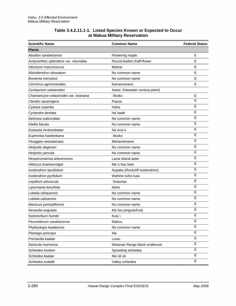
Oahu, 3.0 Affected Environment Makua Military Reservation
3-280 Hawaii Range Complex Final EIS/OEIS May 2008
Table 3.4.2.11.1-1. Listed Species Known or Expected to Occur at Makua Military Reservation
Scientific Name Common Name Federal StatusPlants Abutilon sandwicense Flowering maple E
Achyranthes splendens var. rotundata Round-leafed chaff-flower E
Alectryon macrococcus Mahoe E Alsinidendron obovatum No common name E Bonamia menziesii No common name E Cenchrus agrimonioides Kamanomano E Centaurium sebaeoides Awiwi, (Hawaiian century-plant) Chamaesyce celastroides var. keanana `Akoko E Ctenitis squamigera Pauoa E
Cyanea superba Haha E
Cyrtandra dentata Ha`iwale E
Delissea subcordata No common name E
Diellia falcata No common name E
Dubautia herbstobatae Na`ena`e E
Euphorbia haeleeleana `Akoko E
Flueggea neowawraea Mehamehame E
Hedyotis degeneri No common name E
Hedyotis parvula No common name E
Hesperomannia arborescens Lanai island-aster E
Hibiscus brackenridgei Ma`o hau hele E
Isodendrion laurifolium Aupaka (Rockcliff isodendrion) E
Isodendrion pyrifolium Wahine noho kula E
Lepidium arbuscula `Anaunau E
Lipochaeta tenuifolia Nehe E
Lobelia niihauensis No common name E
Lobelia oahuensis No common name E
Mariscus pennatiformis No common name E
Neraudia angulata Ma`loa (angularfruit) E
Nototrichium humile Kulu`i E
Peucedanum sandwicense Makou E
Phyllostegia kaalaensis No common name E
Plantago princeps Ale E
Prichardia kaalae Loulu E
Sanicula mariversa Waianae Range black snakeroot E
Schiedea hookeri Sprawling schiedea E
Schiedea kaalae Ma`oli`oli E
Schiedea nuttallii Valley schiedea E
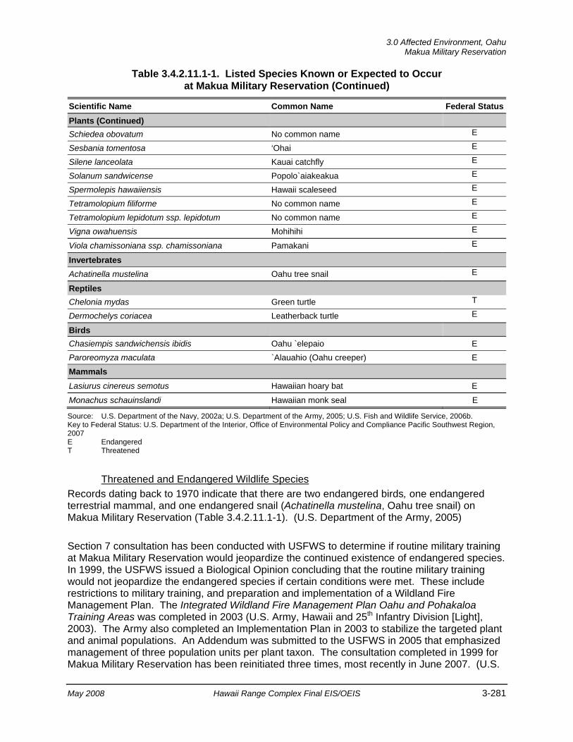
3.0 Affected Environment, Oahu
Makua Military Reservation
May 2008 Hawaii Range Complex Final EIS/OEIS 3-281
Table 3.4.2.11.1-1. Listed Species Known or Expected to Occur at Makua Military Reservation (Continued)
Scientific Name Common Name Federal StatusPlants (Continued) Schiedea obovatum No common name E
Sesbania tomentosa ‘Ohai E
Silene lanceolata Kauai catchfly E
Solanum sandwicense Popolo`aiakeakua E
Spermolepis hawaiiensis Hawaii scaleseed E
Tetramolopium filiforme No common name E
Tetramolopium lepidotum ssp. lepidotum No common name E
Vigna owahuensis Mohihihi E
Viola chamissoniana ssp. chamissoniana Pamakani E
Invertebrates Achatinella mustelina Oahu tree snail E
Reptiles Chelonia mydas Green turtle T
Dermochelys coriacea Leatherback turtle E
Birds Chasiempis sandwichensis ibidis Oahu `elepaio E Paroreomyza maculata `Alauahio (Oahu creeper) E
Mammals Lasiurus cinereus semotus Hawaiian hoary bat E
Monachus schauinslandi Hawaiian monk seal E
Source: U.S. Department of the Navy, 2002a; U.S. Department of the Army, 2005; U.S. Fish and Wildlife Service, 2006b. Key to Federal Status: U.S. Department of the Interior, Office of Environmental Policy and Compliance Pacific Southwest Region, 2007 E Endangered T Threatened
Threatened and Endangered Wildlife Species
Records dating back to 1970 indicate that there are two endangered birds, one endangered terrestrial mammal, and one endangered snail (Achatinella mustelina, Oahu tree snail) on Makua Military Reservation (Table 3.4.2.11.1-1). (U.S. Department of the Army, 2005)
Section 7 consultation has been conducted with USFWS to determine if routine military training at Makua Military Reservation would jeopardize the continued existence of endangered species. In 1999, the USFWS issued a Biological Opinion concluding that the routine military training would not jeopardize the endangered species if certain conditions were met. These include restrictions to military training, and preparation and implementation of a Wildland Fire Management Plan. The Integrated Wildland Fire Management Plan Oahu and Pohakaloa Training Areas was completed in 2003 (U.S. Army, Hawaii and 25th Infantry Division [Light], 2003). The Army also completed an Implementation Plan in 2003 to stabilize the targeted plant and animal populations. An Addendum was submitted to the USFWS in 2005 that emphasized management of three population units per plant taxon. The consultation completed in 1999 for Makua Military Reservation has been reinitiated three times, most recently in June 2007. (U.S.
Oahu, 3.0 Affected Environment Makua Military Reservation
3-282 Hawaii Range Complex Final EIS/OEIS May 2008
Department of the Navy, 2002a; U.S. Army Garrison, Hawaii, 2005; U.S. Department of the Interior, Office of Environmental Policy and Compliance Pacific Southwest Region, 2007)
Environmentally Sensitive Habitat The USFWS designated critical habitat on Makua Military Reservation in 2001 for the Oahu `elepaio (Figure 3.4.2.11.1-1). The USFWS determined that lands on Oahu that fall under Army jurisdiction do not meet the definition of critical habitat under the ESA for the listed plant species shown in Table 3.4.2.11.1-1, based on the Army’s continuing commitment to management and stabilization of sensitive species through their Integrated Natural Resources Management Plan, Integrated Wildland Fire Management Plan, Ecosystem Management Plan, and Endangered Species Management Plan. These documents/plans outline specific strategies and programs in place to stabilize species and habitats on Army land. (U.S. Department of the Army, 2005) Critical plant habitat is however, located outside the boundaries of Makua Military Reservation.
Although potential estuarine wetlands have been observed on Makua Military Reservation, no formal identification or designation has been made (U.S. Department of the Navy, 2002a). According to the 2005 Draft Environmental Impact Statement Military Training Activities at Makua Military Reservation, aquatic natural communities on the installation include intermittent streams and gulches, such as Punapohaku Stream, Makua Stream, and Kalena Stream. Although potential estuarine wetlands (muliwai or small ponds) have been noted, there has been no formal identification or designation of them (U.S. Department of the Army, 2005). The intermittent Kalena Stream with head waters in Koiahi Gulch crosses through part of the proposed managed area on the south side of Makua Valley. Intermittent streams on the reservation fit the state definition of Class 2 Inland Freshwaters, which are waters used for recreational purposes, the support and propagation of aquatic life, agricultural and industrial water supplies, shipping, and navigation. (U.S. Department of the Army Headquarters, and U.S. Department of the Army, 2006)
3.4.2.11.2 Cultural Resources—Makua Military Reservation Appendix C includes a description of cultural resources and the laws and regulations pertaining to them.
Region of Influence The cultural resources region of influence for Makua Military Reservation (Figure 2.1-3) encompasses all areas where LFX events (including major ground troop and artillery movement and munitions detonation [e.g., mortars, heavy artillery]) could be conducted.
Affected Environment
Archaeological Resources (Prehistoric and Historic) Archaeological evidence indicates that Makua Valley once supported both a coastal population (historically known as Makua Village), and permanent occupation in the middle and upper elevations. Archaeologists hypothesize that Makua has similar settlement patterns to the Makaha, Waianae, and Lualualei valleys, with more people living in the back of the valley, at the higher elevations where rainfall was more abundant. Data infer that by the mid-1800s, the middle area was claimed only as community kula (pasture) lands that had once been habitation
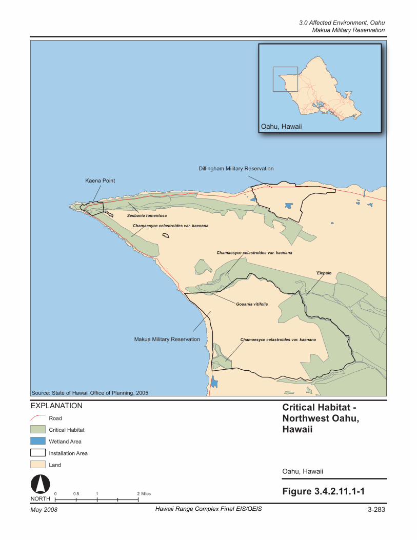
Fi gur e 3. 4. 2. 11 .1 -1 0 1 2 0. 5 M il es NORT H
Criti cal H ab it at - Northw es t Oahu, Ha wa ii
O ahu , H awai i
Dill in gh am M i lit ar y Re se rv at io n
Ma k ua M ili ta ry R es er va ti on
K ae na P oi nt
Chamaesyc e celast ro id es var . kaen an a
S esb an ia t om en to sa
Chamaesyc e celast ro id es var . kaen an a
G oua ni a vi ti fo lia
Chamaesyc e celast ro id es var . kaen an a
`E le pa io
EX PL AN AT IO N
Cr it ic al H ab it at
La nd
In st al la ti on A re a
Ro ad
We tl an d Ar ea
So ur ce : St at e of Haw ai i Offi ce o f Pl an ni ng , 2 00 5
O ahu , H awai i O ahu , H awai i
3-283May 2008 Hawaii Range Complex Final EIS/OEIS
3.0 Affected Environment, OahuMakua Military Reservation
Oahu, 3.0 Affected Environment Makua Military Reservation
3-284 Hawaii Range Complex Final EIS/OEIS May 2008
sites abandoned early in the post-contact period (Williams and Patolo, 2000). Early missionary accounts of Makua Valley note that there was a large school, suggesting more population than just the coastal village. (The Onyx Group, 2001)
Sandalwood harvesting began in Makua Valley as early as 1815, but as the wood was exhausted, ranching and agriculture (particularly sweet potatoes) became the more common land use practices. After the Great Mahele of 1848 (a system of private land division/ownership), land in Makua Valley was awarded to various claimants, including a large portion to the Hawaiian government. The lands remained under private or government ownership or lease until the Army’s use of the land in 1941. (The Onyx Group, 2001)
Since the early 1900s, a number of archaeological surveys have been conducted in the Makua Valley. Among these are Thrum (1906); McAllister (1933); Rosendahl for the Bishop Museum (1977); and Williams and Patolo (2000). Additional surveys and subsurface testing were undertaken at Makua Military Reservation by archaeologists from the Environmental Division of the Department of Public Works in 2000 and 2007. Among the identified site types are heiaus, shrines, trails, stone walls, and enclosures, terraces, platforms, and habitation sites. One site, the Ukanipo Heiau, is listed in the NRHP and other sites may qualify (Pilia`au Range Complex and Makua Military Reservation, 2006). A list of recorded archaeological sites is provided in Appendix H (The Onyx Group, 2001; U.S. Department of the Navy, 2002a).
On September 18, 2000, a Section 106 Programmatic Agreement was finalized with the Hawaii State Historic Preservation Officer and the Advisory Council on Historic Preservation. The Programmatic Agreement was developed by the Army in consultation with Native Hawaiian groups and regulatory agencies over a period of 2 years. It contains specific programs and efforts to protect and mitigate impacts on cultural resources at Makua Military Reservation. (The Onyx Group, 2001) A copy of the Programmatic Agreement is provided as Appendix H.
Historic Buildings and Structures Makua Military Reservation is a large training range. There are no identified historic buildings and structures.
Traditional Resources Makua Military Reservation is associated with a number of legends and traditional Hawaiian deities, and has significant religious and social value to local inhabitants. Among other important resources, a comprehensive investigation of the traditional complexion and resources of Makua Military Reservation entitled Cultural History Report of Makua Military Reservation, Makua Valley, Oahu, Hawaii, was prepared in 1977 by Kelley and Quintal. The report presents the history, traditional accounts, and legends of Makua Valley. (The Onyx Group, 2001)
The 2000 Programmatic Agreement described above includes provisions for access for members of the Native Hawaiian community to Ukanipo Heiau. This access is independent of training in the valley. Access to other sites within the valley has been given on a case-by-case basis, as is consistent with training and safety concerns. The potential for increased access to other sites within Makua Military Reservation is being examined (see Appendix H). (The Onyx Group, 2001)

3.0 Affected Environment, Oahu
Makua Military Reservation
May 2008 Hawaii Range Complex Final EIS/OEIS 3-285
3.4.2.11.3 Health and Safety—Makua Military Reservation Appendix C includes a detailed discussion of health and safety resources laws and regulations.
Region of Influence The region of influence for potential impact related to the health and safety of personnel and the public includes areas associated with training events at Makua Military Reservation and those off-base areas affected by training.
Affected Environment Makua Military Reservation takes every precaution during planning and execution of training events to prevent injury to human life or property. Standard Operating Procedures for LFX outline assets, personnel, safety requirements, and procedures to be used during each event. Use of the range is scheduled through the Range Division—Hawaii Scheduling Office, and Makua Range Control monitors all communications during training.
For each training event, a detailed surface danger zone is determined, in accordance with Army Regulation 385-64, Ammunition and Explosives Safety Standards. A surface danger zone ensures a proper buffer zone to the range and ordnance impact area, which prevents accidental injury and exposure to live weapons outside the designated training area. Upon completion of the training event, every effort is made to restore the range to its condition prior to use, including explosive ordnance disposal specialists destroying all identifiable unexploded ordnance.
An additional concern at Makua Military Reservation is accidental wildfires due to military training. A majority of the fires that have started on Makua Military Reservation have been contained with the boundaries of the installation. However, some fires have burned onto the adjacent land of Albert Silva, the Kuaokala Game Management Area, and the Air Force Kaena Point Satellite Tracking Station. (U.S. Department of the Army, 2005)
Fire prevention at Makua Military Reservation includes planning, managing fuels, using prescribed fire, planning water resources, and training firefighters. Makua Military Reservation has a fire danger rating system that uses the following three colors to characterize fire threat conditions:
• Green (indicating normal caution during training). Weather conditions are favorable for all authorized munitions, and smoking is permitted.
• Yellow (indicating caution because fires will start easily). For this fire danger period, smoking is permitted only in designated areas, and only ball ammunition, mortar, artillery, hand grenades, and smoke grenades are allowed.
• Red (indicating extreme caution because a fire would be difficult to control). No smoking is permitted on the ranges and no munitions or pyrotechnics are allowed. In other words, no live fire training is allowed, and the ranges are closed. (U.S. Department of the Army, 2005)
Oahu, 3.0 Affected Environment Makua Military Reservation
3-286 Hawaii Range Complex Final EIS/OEIS May 2008
3.4.2.11.4 Noise—Makua Military Reservation Appendix C includes a definition of noise and the main regulations and laws that govern it.
Region of Influence The region of influence for Makua Military Reservation is the area within and surrounding Makua Military Reservation in which humans and wildlife may suffer annoyance or disturbance from noise levels from proposed training at Makua Military Reservation and those off-base areas affected by training events.
Affected Environment Noise is generated at the Makua Military Reservation from military activities, including infantry and helicopter gunnery training events. Other noise sources include low background noise levels from wind, surf, birds, insects, and light highway traffic. Ambient noise levels at Makua Beach are estimated to be between 40 and 50 dBA, with peaks reaching noise levels greater than 70 dBA during high tide and afternoon winds. Small arms, demolition, mortar, artillery, and aircraft gunnery events all generate noise at Makua Military Reservation. Noise level contributions from Makua Military Reservation training vary greatly, depending on whether LFX are in progress. Actual noise measurements in 1989, when the Army was conducting training, showed that noise levels at the reservation boundary would ordinarily not exceed the standards of the Oahu community noise rule. (U.S. Department of the Army, 2005; Tetra Tech, Inc., 2005)
The nearest housing is approximately 1,000 to 3,000 ft down the beach that is adjacent to the Makua Military Reservation. Most military training at the reservation occurs during early morning hours, when the number of beachgoers is small. There are no schools, day-care centers, hospitals, or nursing homes within 2 mi of Makua Military Reservation. When there are no training events in progress at Makua Military Reservation, noise conditions are dominated by wind, bird songs, and insects. Under these conditions, noise levels typically vary between approximately 25 dBA and 45 dBA. (U.S. Department of the Army, 2005)
Wildlife receptors in the Makua Military Reservation area are detailed in Section 3.4.2.11.1, Biological Resources.
3.0 Affected Environment, Oahu
Kahuku Training Area
May 2008 Hawaii Range Complex Final EIS/OEIS 3-287
3.4.2.12 KAHUKU TRAINING AREA Kahuku Training Area consists of 9,355 acres of leased lands, most of which are in a state-designated conservation district. The Kahuku Training Area is one of the more widely used military training areas in Hawaii and fulfills a need for maneuver training on Oahu. Army Reserve, National Guard, and Marine Corps units also use this area.
This section describes the environmental resources that would be affected by the No-action Alternative, Alternative 1, Alternative 2, or Alternative 3 for Kahuku Training Area. Of the 13 environmental resources considered for analysis, air quality, airspace, geology and soils, hazardous materials and hazardous waste, health and safety, land use, noise, socioeconomics, transportation, utilities, and water resources are not addressed.
3.4.2.12.1 Biological Resources—Kahuku Training Area Appendix C includes a detailed description of biological resources.
Region of Influence The region of influence includes the training area and adjacent land.
Affected Environment
Vegetation Parts of Kahuku Training Area contain valuable native vegetation communities. However, much of the lower-lying vegetation is composed of introduced and invasive plants such as Christmas berry, ironwood, and strawberry guava. Manuka (New Zealand tea tree) (Leptospermum scoparium) and moho (white moho) (Heliocarpus popayanensis) are two plants recently discovered in the region of influence that can be detrimental to the native communities of the Kahuku Training Area. (U.S. Department of the Army, 2004)
Montane wet, lowland wet, lowland forest, lowland moist, lowlands dry, and intermittent aquatic natural communities are the six general categories of native natural vegetation community types. (U.S. Department of the Army, 2004)
Makou (Botrychium subbifoliatum), `oha (Cyanea lanceolata Ssp. calycina), anini (Eurya sandwicensis), Hedyotis fluviatilis, Lindsaea repens var. macraeana, keahi (Nesoluma polynesicum), Platydesma cornuta, and kaulu (Pteralyxia macrocarpa) are species of concern that have been identified on the Kahuku Training Area. (U.S. Department of the Navy, 2002a)
Threatened and Endangered Plant Species Eighteen rare plant types have been identified at Kahuku Training Area, of which 10 are Federally listed as endangered (Table 3.4.2.12.1-1). (U.S. Department of the Navy, 2002a)
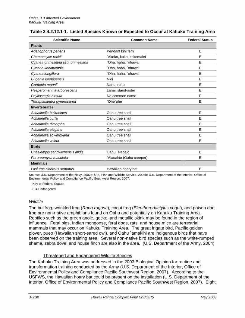
Oahu, 3.0 Affected Environment Kahuku Training Area
3-288 Hawaii Range Complex Final EIS/OEIS May 2008
Table 3.4.2.12.1-1. Listed Species Known or Expected to Occur at Kahuku Training Area
Scientific Name Common Name Federal Status
Plants Adenophorus periens Pendant kihi fern E Chamaesyce rockii `Akoko, koko, kokomalei E Cyanea grimesiana ssp. grimesiana `Oha, haha, `ohawai E Cyanea koolauensis `Oha, haha, `ohawai E Cyanea longiflora `Oha, haha, `ohawai E Eugenia koolauensis Nioi E Gardenia mannii Nanu, na`u E Hesperomannia arborescens Lanai island-aster E Phyllostegia hirsuta No common name E Tetraplasandra gymnocarpa `Ohe`ohe E Invertebrates Achatinella bulimoides Oahu tree snail E Achatinella curta Oahu tree snail E Achatinella dimorpha Oahu tree snail E Achatinella elegans Oahu tree snail E Achatinella sowerbyana Oahu tree snail E Achatinella valida Oahu tree snail E Birds Chasiempis sandwichensis ibidis Oahu `elepaio E Paroreomyza maculata `Alauahio (Oahu creeper) E Mammals Lasiurus cinereus semotus Hawaiian hoary bat E
Source: U.S. Department of the Navy, 2002a; U.S. Fish and Wildlife Service, 2006b; U.S. Department of the Interior, Office of Environmental Policy and Compliance Pacific Southwest Region, 2007.
Key to Federal Status: E = Endangered
Wildlife The bullfrog, wrinkled frog (Rana rugosa), coqui frog (Eleutherodactylus coqui), and poison dart frog are non-native amphibians found on Oahu and potentially on Kahuku Training Area. Reptiles such as the green anole, gecko, and metallic skink may be found in the region of influence. Feral pigs, Indian mongoose, feral dogs, rats, and house mice are terrestrial mammals that may occur on Kahuku Training Area. The great frigate bird, Pacific golden plover, pueo (Hawaiian short-eared owl), and Oahu `amakihi are indigenous birds that have been observed on the training area. Several non-native bird species such as the white-rumped shama, zebra dove, and house finch are also in the area. (U.S. Department of the Army, 2004)
Threatened and Endangered Wildlife Species The Kahuku Training Area was addressed in the 2003 Biological Opinion for routine and transformation training conducted by the Army (U.S. Department of the Interior, Office of Environmental Policy and Compliance Pacific Southwest Region, 2007). According to the USFWS, the Hawaiian hoary bat could be present on the installation (U.S. Department of the Interior, Office of Environmental Policy and Compliance Pacific Southwest Region, 2007). Eight
3.0 Affected Environment, Oahu
Kahuku Training Area
May 2008 Hawaii Range Complex Final EIS/OEIS 3-289
rare wildlife species have been identified at the Kahuku Training Area. These include six varieties of endangered tree snails (Achatinella sp.) and two rare birds, including the Oahu `elepaio and `alauahio (Oahu creeper), species Federally listed as endangered (Table 3.4.2.12.1-1). (U.S. Department of the Navy, 2002a; U.S. Department of the Interior, Office of Environmental Policy and Compliance Pacific Southwest Region, 2007)
Environmentally Sensitive Habitat Critical habitat was officially designated for the Oahu `elepaio on 10 December 2001 that encompasses areas in the Koolau and Waianae Mountain Ranges on Oahu south of Kahuku Training Area (Figure 3.4.2.12.1-1). Five biologically significant areas occur in the southern and midwestern portion of the training area. (U.S. Department of the Navy, 2002a)
3.4.2.12.2 Cultural Resources—Kahuku Training Area Appendix C includes a description of cultural resources and the laws and regulations pertaining to them.
Region of Influence The cultural resources region of influence for Kahuku Training Area encompasses all areas where Humanitarian Assistance/Disaster Relief Operations or any other ground disturbing or amphibious events would occur. These areas would include beach landing areas and well established trails that lead to predetermined buildings or temporary tent areas (see Appendix D).
Affected Environment
Underwater Cultural Resources Underwater cultural resources within the Kahuku offshore region of influence include scattered shipwrecks and at least one Hawaiian fishpond (see Figures 3.1.3-2 and 3.4.1.3.2-1).
Archaeological Resources (Prehistoric and Historic) Kahuku Training Area was occupied at least seasonally from the 14th century on and was used for agriculture beginning in the 15th century. Evidence of occupation prior to European contact includes rock shelters, burial sites, irrigation complexes, and habitation sites. (U.S. Department of the Army, 2004)
In 1890 James Campbell, James Castle, and Benjamin Dillingham formed the Kahuku Plantation Company and sugar cane began to replace pastureland. A sugar mill was established at Kahuku and the area of Kahuku Training Area was operated as a sugar plantation until the 1930s. Just prior to World War II, an airfield and radar station was constructed; after the war, additional land was purchased to support the Kahuku Training Area. A Nike Hercules missile battery was constructed in 1959. (U.S. Department of the Army, 2004)

Fi gur e 3. 4. 2. 12. 1- 1 0 1 2 0. 5 M il es NORT H
Criti cal H ab it at - Northe rn Oah u, Ha wa ii
O ahu , H awai i
Ka hu ku T ra in in g Ar ea
Eu ge ni a k ool au en si s
Cy an ea lo ngi fl or a
Ga rd en ia m a nni i
Cy an ea k oo la ue ns is
Cy an ea t ru n cat a
Eu ge ni a k ool au en si s
EX PL AN AT I ON
Cr it ic al H ab it at
La nd
Ins ta ll at io n Ar ea
We tl an d Ar ea
Ro ad
So ur ce : St at e of Haw ai i Offi ce o f Pl an ni ng , 2 00 5
O ahu , H awai i O ahu , H awai i
3-290 May 2008Hawaii Range Complex Final EIS/OEIS
Oahu, 3.0 Affected EnvironmentKahuku Training Area
3.0 Affected Environment, Oahu
Kahuku Training Area
May 2008 Hawaii Range Complex Final EIS/OEIS 3-291
There have been several archaeological surveys of Kahuku Training Area (Anderson and Williams 1998; Davis 1981; Drolet 2000; McAllister 1933; Rosendahl 1977; Williams and Patolo 1998; and GANDA 2003) and the area has been divided into six separate archaeological management areas (U.S. Army Garrison, Hawaii, and U.S. Army Corps of Engineers 1998). Within the six areas approximately 100 archaeological sites have been identified, including prehistoric, historic, and military-era sites. Sites include the Hanakoae Heiau, which is listed in the NRHP; several rock shelters; a possible Plantation-period site; and hearth, dwelling, and agricultural sites. Historic sites include a house, irrigation features, foxholes, and bunkers (U.S. Department of the Army, 2004). Areas closest to the coast have the highest potential for archaeological resources (U.S. Department of the Navy, 2002a). A list of identified archaeological sites and historic buildings at Kahuku Training Area is provided in Appendix H.
Historic Buildings and Structures Within the Kahuku Training Area, the World War II-era Opana Mobile Radar Station is listed in the NRHP and has been designated a National Historic Landmark. The site was operational on December 7, 1941, and is famous for its role in detecting the approaching Japanese aircraft just prior to the attack on Naval Station Pearl Harbor. (U.S. Department of the Army, 2004)
There are also 22 Cold War-era buildings and structures at Kahuku Training Area. The features are associated with the former Nike missile facility active in Hawaii between January 1961 and March 1970. The site is significant as an intact example of a Cold War Nike missile site and has been determined eligible for inclusion in the NRHP (International Archaeological Resources Institute, Inc, 2005). Preservation of the site was mandated as a result of consultation with the Hawaii State Historic Preservation Officer over the Nike site at Dillingham Military Reservation (U.S. Department of the Army, 2004).
Traditional Resources The general area of Kahuku plays an important role in Hawaiian legends. Identified legend locations are in the off-shore and coastal areas but, to date, none of the legends have been tied to Kahuku Training Area land areas. There are, however, important Native Hawaiian sites within the Kahuku Training Area, including a terrace that may have been used for religious ceremonies and burials (Drolet, 2000).
In 1998, archival information concerning traditional cultural places in and around Kahuku Training Area was collected and reviewed (Anderson, 1998). Subsequently, the Army began a traditional cultural resources survey of Kahuku Training Area, which has resulted in the identification of several traditional sites.
Oahu, 3.0 Affected Environment Dillingham Military Reservation
3-292 Hawaii Range Complex Final EIS/OEIS May 2008
3.4.2.13 DILLINGHAM MILITARY RESERVATION Dillingham Military Reservation is a 664-acre training area with a beach and an airfield on the northwestern shore of Oahu. It is on a narrow, sloping plain between the Waianae Range and the sea.
This section describes the environmental resources that would be affected by the No-action Alternative, Alternative 1, Alternative 2, or Alternative 3 for Dillingham Military Reservation. Of the 13 environmental resources considered for analysis, air quality, airspace, geology and soils, hazardous materials and hazardous waste, health and safety, land use, noise, socioeconomics, transportation, utilities, and water resources are not addressed.
3.4.2.13.1 Biological Resources—Dillingham Military Reservation Appendix C includes a detailed description of biological resources.
Region of Influence The region of influence consists of the Dillingham Military Reservation land and offshore areas.
Affected Environment
Vegetation Dillingham Military Reservation contains native natural communities that are considered rare and globally imperiled. The area is composed primarily of stands of native forest and shrubland vegetation on the cliffs and talus slopes. Ecological surveys have identified four rare plant species of concern associated with the cliff ecological zone: `ahakea (Bobea sandwicensis), koki`o `ula`ula (Hibiscus kokio ssp. kokio), `anaunau (Lepidium bidentatum var. o-waihiense), and nehe (Lipochaeta remyi).
Threatened and Endangered Plant Species Ecological surveys have identified eight rare plants associated with the cliff ecological zone, including four with endangered status (Table 3.4.2.13.1-1) (U.S. Department of the Navy, 2002a).
Wildlife Field surveys on Dillingham Military Reservation have been limited to special-status wildlife, due mainly to the rugged terrain. Non-native amphibians that have the potential to occur on Dillingham Military Reservation include bullfrogs, green and black poison dart frogs, giant toads, and coqui frogs. Non-native reptiles could include green anoles, mourning geckos, tree geckos, and metallic skinks. Feral pigs, cats, and dogs; rats and house mice are mammals that may be found on the installation. (U.S. Department of the Army, 2004)

3.0 Affected Environment, Oahu Dillingham Military Reservation
May 2008 Hawaii Range Complex Final EIS/OEIS 3-293
Table 3.4.2.13.1-1. Listed Species Known or Expected to Occur at Dillingham Military Reservation
Scientific Name Common Name Federal Status
Plants Cyperus trachysanthos Pu`uka`a (Sticky flatsedge) E Hibiscus brackenridgei ssp. Mokuleianus Ma`o hau hele (Mokulei rosemallow) E Nototrichium humile Kulu`i (Kaala rockwort) E Schiedea kealiae Ma`oli`oli E Reptiles Chelonia mydas Green turtle T Dermochelys coriacea Leatherback turtle E Birds Anas wyvilliana Koloa maoli (Hawaiian duck) E Chasiempis sandwichensis ibidis O`ahu `elepaio E Fulica alai `Alae ke`oke`o (Hawaiian coot) E Gallinula chloropus sandvicensis Alae ula (Hawaiian common moorhen) E Himantopus mexicanus knudseni Ae`o (Hawaiian black-necked stilt) E Paroreomyza maculata `Alauahio (Oahu creeper) E Mammals Lasiurus cinereus semotus Hawaiian hoary bat E
Monachus schauinslandi Hawaiian monk seal E
Source: U.S. Department of the Navy, 2002a; U.S. Department of the Army, 2004; U.S. Fish and Wildlife Service, 2006b Key to Federal Status: E = Endangered T = Threatened
Threatened and Endangered Wildlife Species The Dillingham Military Reservation was addressed in the 2003 Biological Opinion for routine and transformation training conducted by the Army (U.S. Department of the Interior, Office of Environmental Policy and Compliance Pacific Southwest Region, 2007). The endangered Hawaiian hoary bat has the potential to occur on Dillingham. The `alae ke`oke`o (Hawaiian coot), `alae`ula (Hawaiian moorhen), koloa maoli (Hawaiian duck), and ae`o (Hawaiian black-necked stilt) have been recorded on Dillingham Military Reservation. The Oahu `elepaio and `alauahio (Oahu creeper) are normally found in Native Hawaiian forest habitat. (U.S. Department of the Army, 2004)
Environmentally Sensitive Habitat Army lands were excluded from the latest critical habitat for plants (Figure 3.4.2.11.1-1) since the Army has implemented a comprehensive program of endangered species management on its lands under the Integrated Natural Resources Management Plan process. A wetland delineated on the reservation is within the region of influence, but outside of the area used for maneuver training. (U.S. Department of the Army, 2004)
Oahu, 3.0 Affected Environment Dillingham Military Reservation
3-294 Hawaii Range Complex Final EIS/OEIS May 2008
3.4.2.13.2 Cultural Resources—Dillingham Military Reservation Appendix C includes a description of cultural resources and the laws and regulations pertaining to them.
Region of Influence The cultural resources region of influence for Dillingham Military Reservation (see Figure 2.1-3) encompasses areas where Navy and Marine Corps SPECWAROPS under RIMPAC and small unit maneuvers by the Army occur (e.g., reconnaissance insertions and search and rescue).
Affected Environment
Archaeological Resources (Prehistoric and Historic) An extensive complex of agricultural and occupation features has been identified at Dillingham Military Reservation within the rocky sloping area between the airfield and the cliffs. Pre- and post-contact features have also been identified. These include platforms, boulder alignments, stone piles, walls, a ditch, and concrete foundations. There are three heiau temples also located within the Dillingham Military Reservation —two fishing shrines and “hidden waters” associated with Hawaiian legend (U.S. Army Garrison, Hawaii U.S. Army Corps of Engineers 1998; U.S. Department of the Navy, 2002a).
Historic Buildings and Structures There are several World War II-era buildings at Dillingham Military Reservation; however, they have not been evaluated for eligibility for inclusion in the NRHP (U.S. Army Garrison, Hawaii, U.S. Army Corps of Engineers 1998; U.S. Department of the Navy, 2002a).
Traditional Resources There are indications of pre-contact use of the coastal dune areas of Dillingham Military Reservation for burials. Burial remains in sand deposits would be considered significant as “properties of traditional religious and cultural importance” (U.S. Army Garrison, Hawaii, and U.S. Army Corps of Engineers 1998; U.S. Department of the Navy, 2002a).
3.0 Affected Environment, Oahu
Keehi Lagoon
May 2008 Hawaii Range Complex Final EIS/OEIS 3-295
3.4.2.14 KEEHI LAGOON Keehi Lagoon is located on Oahu's southern shore, encompassing a triangular-shaped area between the Honolulu International Airport and Honolulu Harbor. Keehi Lagoon was originally a large shallow reef and subtidal area approximately 3 to 6.5 ft deep. The lagoon has changed over the passage of time into an almost completely artificial area. A review of the 13 environmental that would be affected by the No-action Alternative, Alternative 1, Alternative 2, or Alternative 3 determined there were no impacts from HRC training at Keehi Lagoon.
Oahu, 3.0 Affected Environment Kaena Point
3-296 Hawaii Range Complex Final EIS/OEIS May 2008
3.4.2.15 KAENA POINT The Kaena Point tracking radar used by PMRF and operated by the Air Force is on the island of Oahu within the Kaena Point Air Force Station. The radar used by PMRF is on a ridge overlooking the Pacific Ocean. Kaena Point tracking site has been in existence since 1959 (U.S. Department of the Air Force, 15th Airlift Wing, 2003). Kaena Point provides real-time telemetry data to PMRF. Metric and signature tracking data are also provided by the 30th Range Squadron located at Kaena Point. Training at this site consists of using an existing tracking radar operated by the Air Force. Kaena Point provides habitat for several listed plant species, nesting habitat for wedge-tailed shearwater (Puffinus pacificus chlororhynchus) and Laysan albatross (Phoebastria immutabilis), and resting areas for the endangered monk seal. A review of the 13 environmental resources that would be affected by the No-action Alternative, Alternative 1, Alternative 2, or Alternative 3 determined there would be no impacts from HRC training at Kaena Point.
3.0 Affected Environment, Oahu
Mt. Kaala
May 2008 Hawaii Range Complex Final EIS/OEIS 3-297
3.4.2.16 MT. KAALA The Mt. Kaala site consists of leased building space only. Training at this site consists of radio frequency communication and radar tracking. A review of the 13 environmental resources that would be affected by the No-action Alternative, Alternative 1, Alternative 2, or Alternative 3 determined there would be no impacts from HRC training Mt. Kaala.
Oahu, 3.0 Affected Environment Wheeler Network Segment Control/PMRF Communication Sites
3-298 Hawaii Range Complex Final EIS/OEIS May 2008
3.4.2.17 WHEELER NETWORK SEGMENT CONTROL/PMRF COMMUNICATION SITES
Wheeler Network Communications Control is a major communications hub for PMRF located on Wheeler Army Auxiliary Airfield. Training at this site consists of support for the existing telemetry towers and communications. This facility—in conjunction with transceiver sites on Mount Kaala, Oahu, and Mount Kahili, Kauai, and computer/communication networks on Oahu and Maui—provides line-of-sight coverage of PMRF operational areas. In addition, PMRF utilizes data from a radar operated on Mount Kaala. A review of the 13 environmental resources that would be affected by the No-action Alternative, Alternative 1, Alternative 2, or Alternative 3 determined there would be no impacts from HRC training at Wheeler Network Communications Control.

3.0 Affected Environment, Oahu
Mauna Kapu Communication Site
May 2008 Hawaii Range Complex Final EIS/OEIS 3-299
3.4.2.18 MAUNA KAPU COMMUNICATION SITE The Mauna Kapu Communication Site, leased through the FAA by the Department of Energy, contains a repeater station. Training at this site consists of support for existing telemetry towers and communications. A review of the 13 environmental resources that would be affected by the No-action Alternative, Alternative 1, Alternative 2, or Alternative 3 determined there would be no impacts from HRC training at the Mauna Kapu Communication Site.
Oahu, 3.0 Affected Environment Makua Radio/Repeater/Cable Head
3-300 Hawaii Range Complex Final EIS/OEIS May 2008
3.4.2.19 MAKUA RADIO/REPEATER/CABLE HEAD Makua Radio/Repeater/Cable Head is a Department of Energy communication site. Training at this site consists of existing telemetry towers and communications. A review of the 13 environmental resources that would be affected by the No-action Alternative, Alternative 1, Alternative 2, or Alternative 3 determined there would be no impacts from HRC training at Makua Radio/Repeater/Cable Head.
3.0 Affected Environment, Maui
Maui Offshore
May 2008 Hawaii Range Complex Final EIS/OEIS 3-301
3.5 MAUI Maui is the second largest of the populated Hawaiian Islands. It covers approximately 700 square miles and was formed by two separate volcanoes: Mt. Haleakala, the world’s largest dormant volcano, and Puu Kukui. Wailuku is the county seat. Maui County includes the islands of Maui, Lanai, Molokai (except Kalaupapa peninsula), and Kahoolawe. Current and proposed Hawaii Range Complex (HRC) training and research, development, test, and evaluation (RDT&E) activities on or offshore of Maui addressed in this Environmental Impact Statement /Overseas Environmental Impact Statement (EIS/OEIS) are located at the Maui Offshore area, Maui Space Surveillance Site, Maui High Performance Computing Center, Sandia Maui Haleakala Facility, and Molokai. For organizational purposes in this document, discussions about Molokai are included under the Maui heading, although it is a separate island and is not part of the island of Maui.
3.5.1 MAUI OFFSHORE
3.5.1.1 MAUI OFFSHORE The Maui Offshore is an area situated around the islands of Maui, Kahoolawe, Lanai, and Molokai. The offshore area also includes the portion of Penguin Bank that is within 12 nautical miles (nm) of the islands’ coastlines. The area is used as a submarine training area due to the unique characteristics of its acoustic environment and shallow depths of 50 and 100 fathoms. Multiple in-water runs of exercise MK-48 torpedoes (with no warheads) using one submarine as both target and launch platform occur in the Penguin Bank area as part of training and RDT&E activities.
Of the 13 environmental resources considered for analysis, air quality, airspace, cultural resources, geology and soils, hazardous materials and hazardous waste, health and safety, land use, noise, socioeconomics, transportation, utilities, visual and aesthetics, and water resources are not addressed.
3.5.1.1.1 Biological Resources—Maui Offshore Appendix C includes a description of the primary laws and regulations regarding biological resources.
Region of Influence The region of influence is the area within 12 nm around the islands of Maui, Kahoolawe, Lanai, and Molokai.
Affected Environment
Marine Habitats, Invertebrates Detritus from nearby islands and calcareous sand and mud make up the bottom sediments in the region of influence. Sand, coral, and mud are all present in the area that formerly held
Maui, 3.0 Affected Environment Maui Offshore
3-302 Hawaii Range Complex Final EIS/OEIS May 2008
hydrophones. Since black coral has been identified near the western end of Kahoolawe, additional coral patches are expected to be in the area. (Naval Undersea Warfare Center Detachment, 1994)
Fish Bottomfish and pelagic fish occur at Penguin Bank. Bottomfish are fish species that live their lives on the ocean floor, whereas pelagic fish are species that live in the upper layers of the ocean. (Naval Undersea Warfare Center Division Newport, Rhode Island, 2007)
Lutjanid snapper (opakapaka) makes up the bulk of the bottomfish catch, although other fish, crabs, lobsters, and occasionally shrimp are present. The bottom fishery appears to be in decline or to have reached its maximum sustainable yield. A small commercial and recreational hand-line fishery for opakapaka is located in the region of influence. (Naval Undersea Warfare Center Detachment, 1994)
Pelagic fish that occur in Hawaiian waters include, but are not limited to, striped marlin (Tetrapurus audax), broadbill swordfish (Xiphias gladius), northern bluefin tuna (Thunnus thynnus), albacore (Thunnus alalunga), Bigeye tuna (Thunnus obesus), mackerel (Scomber spp.), sickle pomfret (Tatactichthys steindachnen), lustrous pomfret (Eumegistus illustris), yellowfin tuna (Thunnus albacares), kawakawa (Euthynnus affinis), and skipjack tuna (Katsuwonus pelamis). (Naval Undersea Warfare Center Division Newport, Rhode Island, 2007)
Marine Mammals Spinner dolphins (Stenella longirostris) travel in pods of 10 to 300 dolphins throughout the Hawaiian Islands, but are found most frequently in deeper water. They prefer clear, calm water close to deep water where food is found, and rest in shallow bays during the day. Spotted dolphins (Stenella attenuata), which may be the most numerous Hawaiian cetacean, are found in large pods in offshore waters less than 100 fathoms. Bottlenose dolphins (Tursiops truncatus) inhabit offshore waters along the 50- to 100-fathom isobaths around the Hawaiian Islands. (Commander, Submarine Force U.S. Pacific Fleet, 1997)
At least 28 different marine mammal species have been observed in the Penguin Bank area. Of these, 26 species are whales and dolphins and 1 is a pinniped. At least seven species are generally found in the study area in moderate to high numbers either year-round or during annual migrations into or through the proposed test area. These include humpback whale (Megaptera novaeangliae), beaked whales (family (Ziphiidae), bottlenose dolphin, Pantropical spotted dolphin, spinner dolphin, false killer whale (Pseudorca crassidens), and short-finned pilot whale (Globicephala macrorhynchus). Other cetacean species are present during part of the year based on occasional sightings, or stranding records. (Naval Undersea Warfare Center Division Newport, Rhode Island, 2007) Cetaceans are discussed in more detail in Section 3.1.2, Biological Resources—Open Ocean.
Rare, Threatened, and Endangered Species Two species of sea turtles may occur at Penguin Bank: green turtle (Chelonia mydas) and hawksbill turtle (Eretmochelys imbricata) (Naval Undersea Warfare Center Division Newport, Rhode Island, 2007). Green turtles and hawksbill turtles are the most commonly seen marine
3.0 Affected Environment, Maui
Maui Offshore
May 2008 Hawaii Range Complex Final EIS/OEIS 3-303
turtles in the Main Hawaiian Islands. Most sightings of these species have been in shallow water. The green turtle prefers to forage and rest in waters less than about 27 fathoms deep, and migrate from the Four Island Area to French Frigate Shoals every 2 to 3 years. Numerous sightings have been reported for the water off Maui. Hawksbill turtles have been observed on Molokai and Maui. No critical habitat has been designated in the Pacific for any of these species of sea turtles. (Commander, Submarine Force U.S. Pacific Fleet, 1997) Sea turtles are discussed in more detail in Section 3.1.2, Biological Resources—Open Ocean.
The presence of the endangered humpback whale in the region of influence is seasonal, with peak concentrations in mid-February to mid-March. The whales seem to prefer areas within the 100-fathom contours such as the Molokai–Lanai–Maui–Kahoolawe channels and Penguin Bank. Humpback whale sightings in the region of influence are mainly concentrated north of Kahoolawe in protected channel areas. The Hawaiian monk seal (Monachus schauinslandi), is occasionally seen in the region of influence. The first monk seal birth on Maui was recorded in June 1997. (Commander, Submarine Force U.S. Pacific Fleet, 1997; Naval Undersea Warfare Center Division Newport, Rhode Island, 2007)
Hawaiian Islands Humpback Whale National Marine Sanctuary Portions of the Maui Offshore area are included in the Hawaiian Islands Humpback Whale National Marine Sanctuary. According to the Hawaiian Islands Humpback Whale National Marine Sanctuary EIS (U.S. Department of Commerce, National Oceanic and Atmospheric Administration and State of Hawaii, Office of Planning, 1997), “… the waters adjacent to Maui, Molokai, and Lanai are important training areas for Navy ships homeported in Pearl Harbor. The channel between Maui, Lanai and Molokai is extensively used for biennial RIMPAC [Rim of the Pacific] exercises, EOD/MCM [Explosive Ordnance Disposal/Mine Countermeasures] exercises, and as well for shallow-water ASW [Anti-Submarine Warfare]… The areas inside the 100-fathom isobath surrounding Maui, Molokai and Lanai, and specifically the channel between these islands, are used for shallow-water ASW operations.”
Maui, 3.0 Affected Environment Shallow-water Minefield Sonar Training Area
3-304 Hawaii Range Complex Final EIS/OEIS May 2008
3.5.1.2 SHALLOW-WATER MINEFIELD SONAR TRAINING AREA-OFFSHORE
The Shallow-water Minefield Sonar Training Area provides Naval Station Pearl Harbor based submarines with the capability to conduct mine sonar training. A review of the 13 resources that would be affected by the No-action Alternative, Alternative 1, Alternative 2, or Alternative 3 determined there would be no impacts from HRC training and RDT&E activities at the Shallow-water Minefield Sonar Training Area. This training area, outside the Hawaiian Islands Humpback Whale National Marine Sanctuary, is utilized by submarines using high-frequency active sonar (not mid-frequency active sonar). Training in the Shallow-water Minefield Sonar Training Area can occur when humpback whales are present, as well as other marine species. During the years of use of this training area, there have been no reports of negative impacts. Section 4.1.2.4.12 includes a discussion of active acoustic devices, including submarines.
3.0 Affected Environment, Maui
Maui Space Surveillance System
May 2008 Hawaii Range Complex Final EIS/OEIS 3-305
3.5.2 MAUI ONSHORE
3.5.2.1 MAUI SPACE SURVEILLANCE SYSTEM The Maui Space Surveillance Site provides facilities that observe sub-orbital vehicles. Training and RDT&E activities at this site consist of an existing telemetry tower, communications, and tracking facilities. A review of the 13 resources that would be affected by the No-action Alternative, Alternative 1, Alternative 2, or Alternative 3 determined there would be no impacts from HRC training and RDT&E activities at the Maui Space Surveillance System site.
Maui, 3.0 Affected Environment Maui High Performance Computing Center
3-306 Hawaii Range Complex Final EIS/OEIS May 2008
3.5.2.2 MAUI HIGH PERFORMANCE COMPUTING CENTER The Maui High Performance Computing Center is an Air Force Research Laboratory managed by the University of Hawaii that provides state-of-the-art data processing. Training and RDT&E activities at this site consist of data processing. A review of the 13 resources that would be affected by the No-action Alternative, Alternative 1, Alternative 2, or Alternative 3 determined there would be no impacts from HRC training and RDT&E activities at the Maui High Performance Computing Center.
3.0 Affected Environment, Maui Sandia Maui Haleakala Facility
May 2008 Hawaii Range Complex Final EIS/OEIS 3-307
3.5.2.3 SANDIA MAUI HALEAKALA FACILITY The Sandia Maui Haleakala Facility provides telemetry receiving and recording, flight following, command control and flight termination systems for high-altitude/exoatmospheric launches from the Pacific Missile Range Facility and for high-altitude training and RDT&E activities that traverse the Hawaiian Islands Chain. Training and RDT&E activities at this site consist of support for existing telemetry towers and communications. A review of the 13 resources that would be affected by the No-action Alternative, Alternative 1, Alternative 2, or Alternative 3 determined there would be no impacts from HRC training and RDT&E activities at the Sandia Maui Haleakala Facility.
Maui, 3.0 Affected Environment Molokai Mobile Transmitter Site
3-308 Hawaii Range Complex Final EIS/OEIS May 2008
3.5.2.4 MOLOKAI MOBILE TRANSMITTER SITE A mobile command and control node is located at the Molokai Mobile Transmitter Site during Major Exercises. The transmitter site includes vehicles and portable equipment to generate low-power electronic signals that simulate various types of radar. A review of the 13 resources that would be affected by the No-action Alternative, Alternative 1, Alternative 2, or Alternative 3 determined there would be no impacts from HRC training and RDT&E activities at the Molokai Transmitter Site.
3.0 Affected Environment, Hawaii
Kawaihae Pier—Offshore
May 2008 Hawaii Range Complex Final EIS/OEIS 3-309
3.6 HAWAII The island of Hawaii is the largest of the Hawaiian Islands. It covers approximately 4,028 square miles and is still growing because of continual eruptions of Kilauea. Resorts and most residential developments are located in coastal areas. Hilo, located on the east side of the island, is the county seat. Current and proposed Hawaii Range Complex (HRC) training and research, development, test, and evaluation (RDT&E) activities on the island of Hawaii addressed in this Environmental Impact Statement/Overseas Environmental Impact Statement (EIS/OEIS) are located at Pohakuloa Training Area (PTA), Bradshaw Army Airfield, and Kawaihae Pier.
3.6.1 HAWAII OFFSHORE Hawaii Offshore addresses ocean areas within 12 nautical miles (nm) of the island of Hawaii, including ranges and training areas where activities are performed by the Navy. Discussions include the area offshore of the Kawaihae Pier. This offshore area is within the Hawaiian Islands Humpback Whale National Marine Sanctuary. The Kawaihae Pier itself is not part of the Hawaiian Islands Humpback Whale National Marine Sanctuary boundaries.
3.6.1.1 KAWAIHAE PIER—OFFSHORE Kawaihae Pier is located within the Kawaihae Harbor on the northwestern corner of the island of Hawaii. Kawaihae Harbor is a deep-water port, one of two on the island of Hawaii. Expeditionary Assault events are conducted at Kawaihae Pier. Activities primary consist of offloading and loading vehicles and equipment from a landing ship at an existing boat ramp.
This section describes the environmental resources that would be affected by the No-action Alternative, Alternative 1, Alternative 2, or Alternative 3 for Kawaihae Pier Offshore. Of the 13 environmental resources considered for analysis, airspace, air quality, cultural resources, geology and soils, hazardous material and waste, health and safety, land use, noise, socioeconomics, transportation, utilities, and water resources are not addressed.
3.6.1.1.1 Biological Resources—Kawaihae Pier—Offshore Region of Influence The region of influence includes the area up to 12 nm offshore of the pier that may be affected by proposed training.
Affected Environment
Vegetation A small beach area containing no vegetation is located immediately adjacent to the pier.
Hawaii, 3.0 Affected Environment Kawaihae Pier—Offshore
3-310 Hawaii Range Complex Final EIS/OEIS May 2008
Threatened and Endangered Plant Species
No threatened or endangered plant species have been identified within the harbor area.
Wildlife Habitat Areas of Particular Concern have not been identified within the harbor. A coral reef of management concern is located at Kawaihae Harbor. It is at risk from extensive development at the commercial harbor and from recent and continued development at the small boat harbor. Another coral reef, Puako Reef, is located approximately 3 to 4 miles (mi) from Kawaihae Harbor. (National Park Service, 2004)
A description of the coral reef area associated with the Hawaiian Islands and its management by both the State of Hawaii and the Federal government is provided in Section 3.1.2.1. The following coral information is summarized from the more extensive data provided in the Marine Resources Assessment for the Hawaiian Islands Operating Area (U.S. Department of the Navy, 2005b). Overall, coral communities of Hawaii are considered to be in good condition. The growth of coral reefs around the island of Hawaii is correlated to the intensity and frequency of wave disturbance. Coral reefs are primarily found on the western (leeward) side of the island, which includes the offshore area between Waikui and Mahukona (Figure 3.6.1.1.1-1). During summer, an occasional Kona storm generates storm swells of about 10 to 20 feet (ft) in height that can remove accreted reefs on the leeward side. (U.S. Department of the Navy, 2005b)
North of Waikui, there is a fairly large spur-and-groove reef system (1.3 nm long and 590 to 1,772 ft wide) off the Kawaihae Small Boat Harbor (Figure 3.6.1.1.1-1). This is the only spur-and-groove reef that the 2003 National Centers for Coastal Ocean Science/National Oceanic and Atmospheric Administration (U.S. Department of the Navy, 2007a) benthic habitat mapping program recorded for the island of Hawaii. From the Kawaihae Small Boat Harbor to Malae Point, the shoreline is flanked by a narrow intertidal area consisting of uncolonized volcanic rock (approximately 131 ft wide); just seaward there is a strip of colonized volcanic rock (131 to 459 ft wide) and aggregated coral heads (131 to 459 ft wide). Another 2.2 nm north of Malae Point, there is similar habitat zonation and sizes. From Malae Point to Makaohule Point the widths of colonized volcanic rock and aggregated coral head habitats range from 328 to 820 ft and 590 to 1,181 ft, respectively. (U.S. Department of the Navy, 2005b)
Threatened and Endangered Wildlife Species
No threatened or endangered species have been identified within the harbor. However, the water on this leeward side of the island provides good habitat for humpback whale (Megaptera noveangliae) mother and calf pods and for resting dolphin pods (National Park Service, 2004). No critical habitat is present (National Park Service, 2004).
Hawaiian Islands Humpback Whale National Marine Sanctuary The Kawaihae Pier area is not part of the Hawaiian Islands Humpback Whale National Marine Sanctuary boundaries (National Oceanic and Atmospheric Administration, 2001).
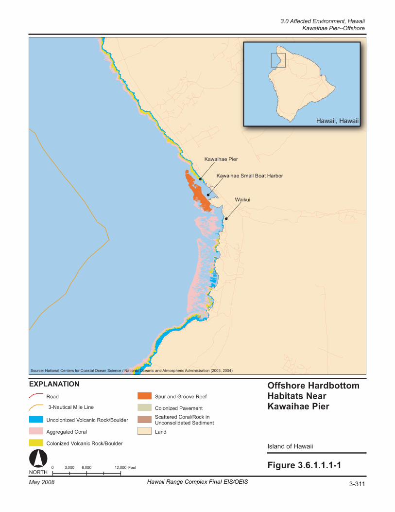
Fi gure 3. 6. 1. 1. 1- 1 0 6 ,000 12 ,000 3, 000 F eet NORT H
Hawa ii , Hawa ii
EX PL AN AT IO N O ffs hore Hardbot to m Ha bi ta ts N ear K aw aiha e Pi er
Is la nd o f Hawa ii
Ka wa i hae P ie r
S our ce : Nati onal Cent er s fo r Co as ta l Oc ean Sc i enc e / Nat io na l Oc eani c and At mos pher ic A dm in is tr ati on ( 2003, 2 004)
Co lo ni ze d Vo lc ani c R oc k/ Bo ul de r
Sp ur a nd G r oov e Re ef
Co lo ni ze d Pa ve me nt
Sc at te re d Co ra l/ Ro ck in Un c on so li da te d Se di me nt
La nd
Ro ad
3- Na ut ic al M il e Li ne
Un c ol on iz ed V ol c an ic R oc k/ Bo ul der
Ag gr eg at ed C or al
Wa ik ui
Ka wa i hae S ma ll B oa t H ar bo r
Hawaii Range Complex Final EIS/OEIS 3-311May 2008
3.0 Affected Environment, Hawaii Kawaihae Pier--Offshore
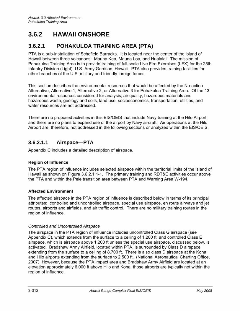
Hawaii, 3.0 Affected Environment Pohakuloa Training Area
3-312 Hawaii Range Complex Final EIS/OEIS May 2008
3.6.2 HAWAII ONSHORE
3.6.2.1 POHAKULOA TRAINING AREA (PTA) PTA is a sub-installation of Schofield Barracks. It is located near the center of the island of Hawaii between three volcanoes: Mauna Kea, Mauna Loa, and Hualalai. The mission of Pohakuloa Training Area is to provide training of full-scale Live Fire Exercises (LFX) for the 25th Infantry Division (Light), U.S. Army Garrison, Hawaii. PTA also provides training facilities for other branches of the U.S. military and friendly foreign forces.
This section describes the environmental resources that would be affected by the No-action Alternative, Alternative 1, Alternative 2, or Alternative 3 for Pohakuloa Training Area. Of the 13 environmental resources considered for analysis, air quality, hazardous materials and hazardous waste, geology and soils, land use, socioeconomics, transportation, utilities, and water resources are not addressed.
There are no proposed activities in this EIS/OEIS that include Navy training at the Hilo Airport, and there are no plans to expand use of the airport by Navy aircraft. Air operations at the Hilo Airport are, therefore, not addressed in the following sections or analyzed within the EIS/OEIS.
3.6.2.1.1 Airspace—PTA Appendix C includes a detailed description of airspace.
Region of Influence The PTA region of influence includes selected airspace within the territorial limits of the island of Hawaii as shown on Figure 3.6.2.1.1-1. The primary training and RDT&E activities occur above the PTA and within the Pele transition area between PTA and Warning Area W-194.
Affected Environment The affected airspace in the PTA region of influence is described below in terms of its principal attributes: controlled and uncontrolled airspace, special use airspace, en route airways and jet routes, airports and airfields, and air traffic control. There are no military training routes in the region of influence.
Controlled and Uncontrolled Airspace The airspace in the PTA region of influence includes uncontrolled Class G airspace (see Appendix C), which extends from the surface to a ceiling of 1,200 ft, and controlled Class E airspace, which is airspace above 1,200 ft unless the special use airspace, discussed below, is activated. Bradshaw Army Airfield, located within PTA, is surrounded by Class D airspace extending from the surface to a ceiling of 8,700 ft. There is also class D airspace at the Kona and Hilo airports extending from the surface to 2,500 ft. (National Aeronautical Charting Office, 2007) However, because the PTA impact area and Bradshaw Army Airfield are located at an elevation approximately 6,000 ft above Hilo and Kona, those airports are typically not within the region of influence.
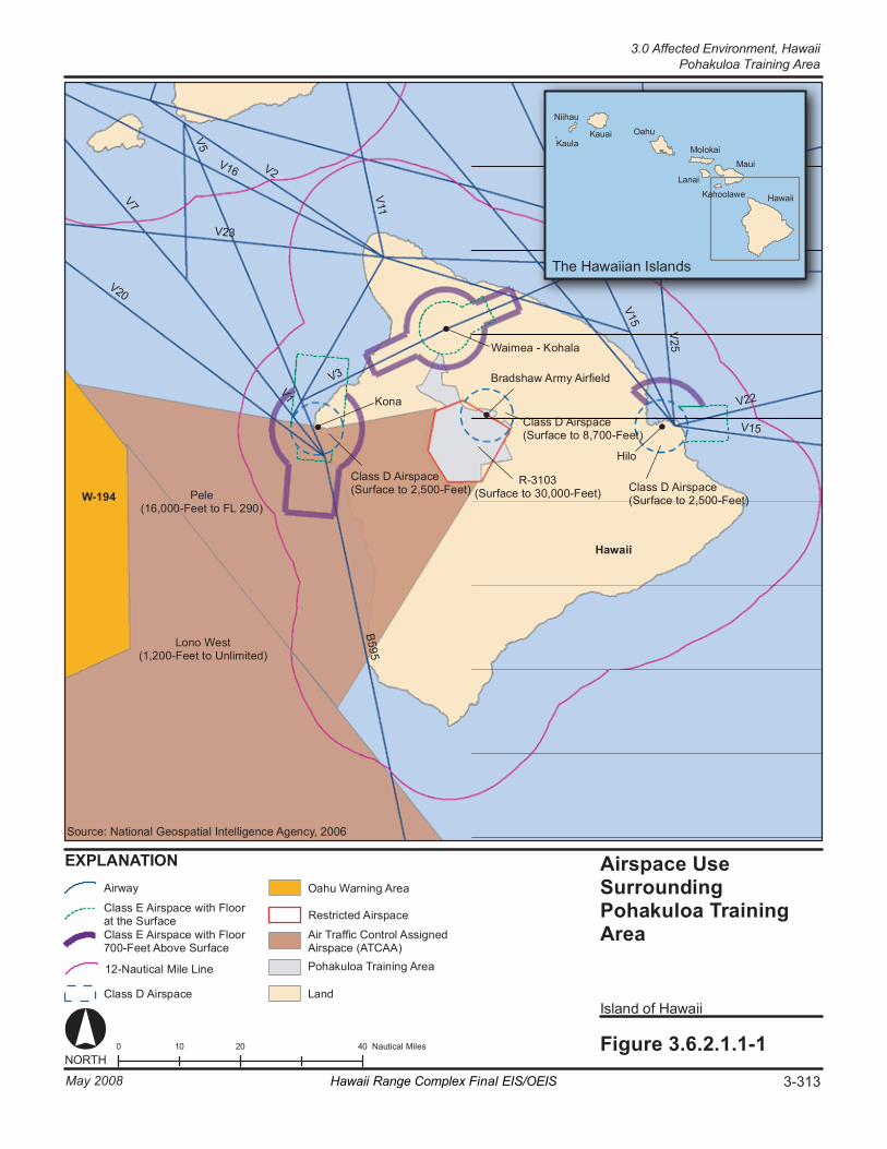
V2 V1 6
V2 3
B5 95
V7
V1 5
V5
V2 1
V1
V2 5
V1 1
V2 2
R5 78
V2 0
V3
T he Ha wa iia n Is la nd s
0 2 0 4 0 10 Na ut ic al M il es Fi gure 3. 6. 2. 1. 1- 1
Is la nd o f Hawa ii
K auai
Ni i hau
K aul a
Airs p ace U se Surround in g Poha kulo a Tr aini ng Ar ea
EX PL AN AT IO N
NORT H
O ahu
Mo lo ka i
L anai
K ahoo la we
M aui
Hawa ii
Ha wa ii
W- 194 R- 31 03
(S ur fa ce to 3 0, 00 0- Fe et )
V1 5
Br ad sh aw A rm y Ai rf ie ld
Pe le (1 6, 00 0- Fe et to FL 29 0)
Lo no W es t (1 , 200 -F ee t t o U nl im it ed )
Hilo
Ko na
Wa im ea - K o ha la
Cl as s D Ai rs pac e (S ur fa ce to 2 ,5 00 -F ee t) Cl as s D Ai rs pac e
(S ur fa ce to 2 ,5 00 -F ee t)
Cl as s D Ai rs pac e (S ur fa ce to 8 ,7 00 -F ee t)
Air Tr a ffi c Co nt ro l As si gne d Airs pa ce ( AT CA A)
La nd
Cl as s E Ai rs pa ce w it h Fl oo r at t he S ur fa ce Cl as s E Ai rs pa ce w it h Fl oo r 70 0- Fe et A bo ve S ur fa ce
Cl as s D Ai rs pac e
O ahu War ni ng Ar ea Airw ay
So ur ce : Na tio na l Ge os pat ia l In te ll ig en ce A ge ncy , 200 6
12 -N au ti ca l M ile L in e
Re st ri ct ed A ir sp ac e
Po ha ku lo a Tr ai ni ng A re a
3-313May 2008 Hawaii Range Complex Final EIS/OEIS
3.0 Affected Environment, Hawaii Pohakuloa Training Area
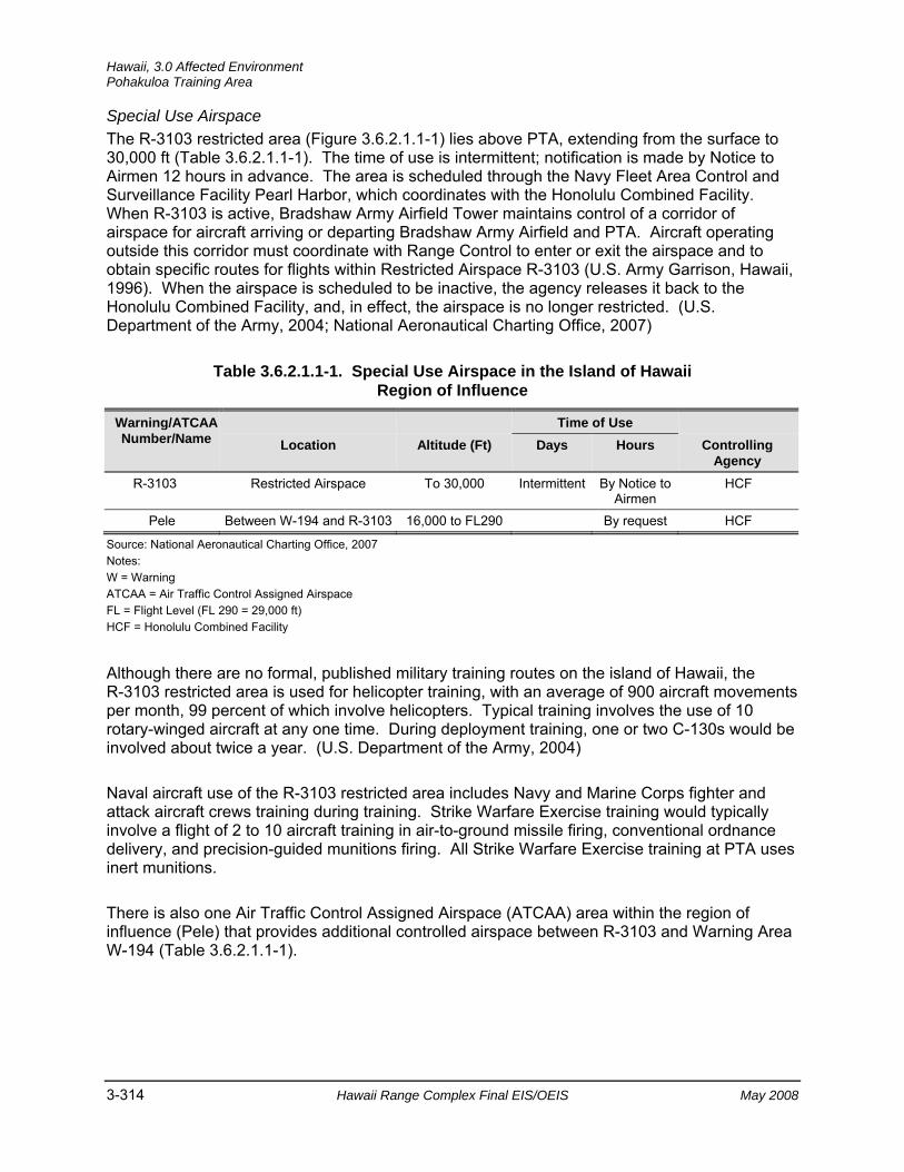
Hawaii, 3.0 Affected Environment Pohakuloa Training Area
3-314 Hawaii Range Complex Final EIS/OEIS May 2008
Special Use Airspace The R-3103 restricted area (Figure 3.6.2.1.1-1) lies above PTA, extending from the surface to 30,000 ft (Table 3.6.2.1.1-1). The time of use is intermittent; notification is made by Notice to Airmen 12 hours in advance. The area is scheduled through the Navy Fleet Area Control and Surveillance Facility Pearl Harbor, which coordinates with the Honolulu Combined Facility. When R-3103 is active, Bradshaw Army Airfield Tower maintains control of a corridor of airspace for aircraft arriving or departing Bradshaw Army Airfield and PTA. Aircraft operating outside this corridor must coordinate with Range Control to enter or exit the airspace and to obtain specific routes for flights within Restricted Airspace R-3103 (U.S. Army Garrison, Hawaii, 1996). When the airspace is scheduled to be inactive, the agency releases it back to the Honolulu Combined Facility, and, in effect, the airspace is no longer restricted. (U.S. Department of the Army, 2004; National Aeronautical Charting Office, 2007)
Table 3.6.2.1.1-1. Special Use Airspace in the Island of Hawaii Region of Influence
Warning/ATCAA Number/Name
Time of Use Location Altitude (Ft) Days Hours Controlling
Agency R-3103 Restricted Airspace To 30,000 Intermittent By Notice to
Airmen HCF
Pele Between W-194 and R-3103 16,000 to FL290 By request HCF Source: National Aeronautical Charting Office, 2007 Notes: W = Warning ATCAA = Air Traffic Control Assigned Airspace FL = Flight Level (FL 290 = 29,000 ft) HCF = Honolulu Combined Facility
Although there are no formal, published military training routes on the island of Hawaii, the R-3103 restricted area is used for helicopter training, with an average of 900 aircraft movements per month, 99 percent of which involve helicopters. Typical training involves the use of 10 rotary-winged aircraft at any one time. During deployment training, one or two C-130s would be involved about twice a year. (U.S. Department of the Army, 2004)
Naval aircraft use of the R-3103 restricted area includes Navy and Marine Corps fighter and attack aircraft crews training during training. Strike Warfare Exercise training would typically involve a flight of 2 to 10 aircraft training in air-to-ground missile firing, conventional ordnance delivery, and precision-guided munitions firing. All Strike Warfare Exercise training at PTA uses inert munitions.
There is also one Air Traffic Control Assigned Airspace (ATCAA) area within the region of influence (Pele) that provides additional controlled airspace between R-3103 and Warning Area W-194 (Table 3.6.2.1.1-1).

3.0 Affected Environment, Hawaii
Pohakuloa Training Area
May 2008 Hawaii Range Complex Final EIS/OEIS 3-315
En Route Airways and Jet Routes As shown on Figure 3.6.2.1.1-1, there is one oceanic route (B595) located approximately 18 nm west of PTA, running along the eastern side of the island, terminating near Kona. Several low altitude Air Traffic Service (ATS) routes are located near Kona, and several others are located approximately 26 nm west of PTA at Hilo. One ATS route is located approximately 15 nm north of PTA.
Airports and Airfields Bradshaw Army Airfield, located within PTA, is surrounded by Class D airspace extending from the surface to a ceiling of 8,700 ft. As described earlier, the Hilo and Kona airports and associated airspace are below the airspace typically utilized at PTA. Both Hilo and Kona are surrounded by Class D airspace. Both include surface Class E airspace extensions and additional Class E extensions, with a floor 700 ft above the surface. The Waimea airfield is located approximately 15 nm north of PTA at an altitude of 2,671 ft. It is surrounded by surface Class E airspace with additional Class E airspace extensions with a floor 700 ft above the surface. Air traffic in the region of influence is managed by the Honolulu Air Route Traffic Control Center.
3.6.2.1.2 Biological Resources—PTA For the purpose of discussion, terrestrial biological resources have been divided into the areas of vegetation and wildlife (including threatened and endangered species) and environmentally sensitive habitat. Appendix C lists some of the regulations that govern biological resources.
Region of Influence The region of influence is the area within or adjacent to PTA that could be affected by proposed training and RDT&E activities.
Affected Environment
Vegetation Lava with little vegetative development covers approximately 25 percent of the installation. Treelands are dominated primarily by `ohia lehua (Metrosideros polymorpha), which is a member of the myrtle family and is the most abundant tree in Hawaii. Shrublands are the most diverse plant communities on the installation (14 different types). Dominant shrubs include Myoporum sandwicense (naio), Sophora chrysophylla (mamane), Dodonaea viscosa (a`ali`i), Chenopodium oahuense (`aweoweo), and Styphelia tameiameiae (pukiawe). Introduced plants are components of all habitats on PTA. (U.S. Department of Agriculture, 1990; U.S. Department of the Army, 2004; 2006)
Threatened and Endangered Plant Species Fourteen Federally endangered plants and one threatened one, listed in Table 3.6.2.1.2-1, are known or expected to occur in the region of influence.
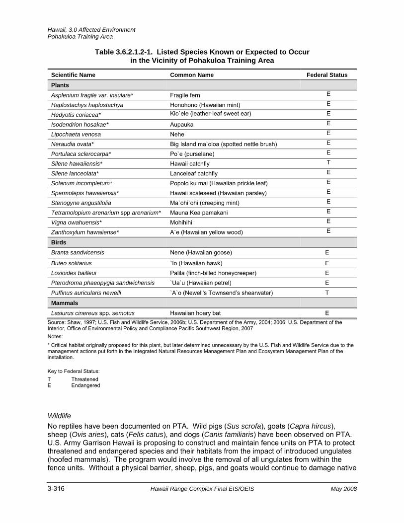
Hawaii, 3.0 Affected Environment Pohakuloa Training Area
3-316 Hawaii Range Complex Final EIS/OEIS May 2008
Table 3.6.2.1.2-1. Listed Species Known or Expected to Occur in the Vicinity of Pohakuloa Training Area
Scientific Name Common Name Federal Status Plants
Asplenium fragile var. insulare* Fragile fern E
Haplostachys haplostachya Honohono (Hawaiian mint) E
Hedyotis coriacea* Kio`ele (leather-leaf sweet ear) E
Isodendrion hosakae* Aupauka E
Lipochaeta venosa Nehe E
Neraudia ovata* Big Island ma`oloa (spotted nettle brush) E
Portulaca sclerocarpa* Po`e (purselane) E
Silene hawaiiensis* Hawaii catchfly T
Silene lanceolata* Lanceleaf catchfly E
Solanum incompletum* Popolo ku mai (Hawaiian prickle leaf) E
Spermolepis hawaiiensis* Hawaii scaleseed (Hawaiian parsley) E
Stenogyne angustifolia Ma`ohi`ohi (creeping mint) E
Tetramolopium arenarium spp arenarium* Mauna Kea pamakani E
Vigna owahuensis* Mohihihi E
Zanthoxylum hawaiiense* A`e (Hawaiian yellow wood) E
Birds
Branta sandvicensis Nene (Hawaiian goose) E
Buteo solitarius `Io (Hawaiian hawk) E Loxioides bailleui Palila (finch-billed honeycreeper) E Pterodroma phaeopygia sandwichensis `Ua`u (Hawaiian petrel) E
Puffinus auricularis newelli `A`o (Newell's Townsend’s shearwater) T
Mammals
Lasiurus cinereus spp. semotus Hawaiian hoary bat E Source: Shaw, 1997; U.S. Fish and Wildlife Service, 2006b; U.S. Department of the Army, 2004; 2006; U.S. Department of the Interior, Office of Environmental Policy and Compliance Pacific Southwest Region, 2007 Notes: * Critical habitat originally proposed for this plant, but later determined unnecessary by the U.S. Fish and Wildlife Service due to the management actions put forth in the Integrated Natural Resources Management Plan and Ecosystem Management Plan of the installation.
Key to Federal Status: T Threatened E Endangered
Wildlife No reptiles have been documented on PTA. Wild pigs (Sus scrofa), goats (Capra hircus), sheep (Ovis aries), cats (Felis catus), and dogs (Canis familiaris) have been observed on PTA. U.S. Army Garrison Hawaii is proposing to construct and maintain fence units on PTA to protect threatened and endangered species and their habitats from the impact of introduced ungulates (hoofed mammals). The program would involve the removal of all ungulates from within the fence units. Without a physical barrier, sheep, pigs, and goats would continue to damage native
3.0 Affected Environment, Hawaii
Pohakuloa Training Area
May 2008 Hawaii Range Complex Final EIS/OEIS 3-317
natural communities and threatened and endangered species. (U.S. Department of the Army, 2006) Mouflon sheep, (Ovis musimon), cows, Norway rats (Rattus norvegicus), and house mice (Mus musculus) are also present.
Endemic birds common to PTA are the `apapane (a honeycreeper) (Himatione sanguinea) and Hawaii `amakihi (a honeycreeper) (Hemignathus virens). The `i`iwi (a honeycreeper) (Vestiaria coccinea), Hawaii `elepaio (flycatcher) (Chasiempis sandwichensis), and ōma`o (Hawaiian thrush) (Myadestes obscurus) are present, but less common to PTA. The first `elepaio nest observed on PTA was discovered during a 2006 survey (U.S. Army Garrison, Hawaii, 2006). The pueo (Hawaiian owl) (Asio flammeus sandwichensis) is also present (U.S. Department of the Army, 2006). Nonnative bird species include Erckel’s francolin (Francolinus erckelii), black francolin (Francolinus francolinus), California quail (Callipepla californica), and Japanese quail (Coturnix japonica). (U.S. Department of the Army, 2004)
Threatened and Endangered Wildlife Species
Routine and transformation training actions at PTA were addressed in the 2003 biological opinion for PTA (U.S. Department of the Interior, Office of Environmental Policy and Compliance Pacific Southwest Region, 2007). The only native terrestrial mammal in the Hawaiian Islands, the endangered Hawaiian hoary bat (Lasiurus cinereus semotus), is known to occur on PTA (Table 3.6.2.1.2-1). Of the four endangered forest birds listed in Table 3.6.2.1.2-1, only the `io (Hawaiian hawk) (Buteo solitarius) and nene (Branta sandvicensis) have been recorded in the past 5 years at PTA. The Federally endangered Hawaiian petrel (Pterodroma phaeopygia sandwichensis), a seabird, and the `a`o (Newell's Townsend’s shearwater) (Puffinus auricularis newelli) have also been known to occur on PTA (Colorado State University, 2002). (U.S. Department of the Army, 2004; 2006; U.S. Department of the Interior, Office of Environmental Policy and Compliance Pacific Southwest Region, 2007)
Environmentally Sensitive Habitat The U.S. Fish and Wildlife Service determined that critical habitat for 12 plants (see Table 3.6.2.1.2-1) was not necessary since the PTA Integrated Natural Resources Management Plan and Ecosystem Management Plan encompass management actions that will benefit the listed species for which critical habitat was originally proposed (U.S. Fish and Wildlife Service, 2003c). Critical habitat has been designated on the installation (Figure 3.6.2.1.2-1) for one of the larger Hawaiian honeycreepers, the palila (Loxioides bailleui), although this bird has not been observed in recent years. Up to 96 percent of the palila population and nearly all of the successful breeding occur on the southwestern slope of Mauna Kea (U.S. Fish and Wildlife Service, 2003d). The mamane-naio forest on the central plateau of Hawaii is the prime habitat of the palila, an endangered native bird (University of Hawaii Kapiolani Community College, undated).
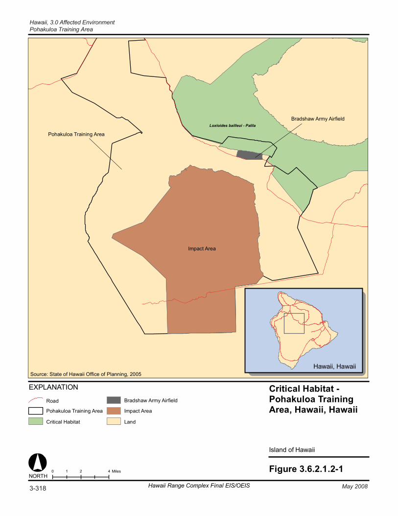
Loxioides bailleui - Palila
Figure 3.6.2.1.2-10 2 41 MilesNORTH
Hawaii, Hawaii
Critical Habitat -Pohakuloa TrainingArea, Hawaii, Hawaii
Island of Hawaii
Pohakuloa Training Area
Bradshaw Army Airfield
EXPLANATION
Road
Pohakuloa Training Area
Critical Habitat
Bradshaw Army Airfield
Impact Area
Land
Source: State of Hawaii Office of Planning, 2005
Impact Area
3-318 May 2008Hawaii Range Complex Final EIS/OEIS
Hawaii, 3.0 Affected EnvironmentPohakuloa Training Area
3.0 Affected Environment, Hawaii
Pohakuloa Training Area
May 2008 Hawaii Range Complex Final EIS/OEIS 3-319
3.6.2.1.3 Cultural Resources—PTA Appendix C includes a description of cultural resources and the laws and regulations pertaining to them.
Region of Influence The region of influence for cultural resources at PTA encompasses existing, heavily disturbed impact and training areas, trails, and roads and PTA facilities where LFX would take place and Large Area Tracking Range (ground relay stations) would be added.
Affected Environment
Archaeological Resources (Prehistoric and Historic) PTA is part of a large cultural landscape that includes Mauna Kea, Mauna Loa, and the Saddle area between them. Researchers of Hawaiian culture (Maly, 1999; McEldowney, 1979; and Langlas et al., 1997) indicate that this landscape is spiritually and historically one of the most important places in Hawaiian tradition and history. Evidence of the area’s significance is confirmed by physical and archaeological remains and through the many oral histories that describe historical events and uses of the area (U.S. Department of the Army, 2004,). Site types encompass traditional activities such as bird hunting for feathers and meat, quarrying volcanic glass, and lithic workshop locations for manufacturing the adzes made from Mauna Kea basalt. The Saddle region also displays numerous trails used for movement both cross-island and to the Mauna Kea and Mauna Loa summits. The Umi heiau on the slopes of Hualalai (south of PTA) is believed to have been built by the legendary chief “Umi a Liloa” around 1600 and derives some of its importance from its location at the juncture of several of these trails. Cave shelters are abundant due to an extensive natural lava tube system in the area; historically they have been a source of limited water and have provided refuge from the elements.
In the late 1800s, cattle and sheep ranching was the primary activity within the PTA area. There were two primary land leases during those years—the John Parker lease (ca. 1876-1891) situated in the western portion of what is now the PTA, and the Waimea Grazing and Agricultural Company lease (ca. 1860-1891) situated in the eastern portion. The latter completed a wagon road from one of its remote sheep stations near the Saddle Road (at Humuula) to Waimea to transport wool to the harbor at Kawaihae, and a portion of that road is still visible. A number of stone walls were also constructed during the 1890s (U.S. Department of the Army, 2004).
Approximately 30 percent of the PTA has been surveyed for archaeological resources, and 291 prehistoric and historic archaeological sites and traditional resources sites have been recorded (U.S. Department of the Navy, Commander, Third Fleet 2004, and 2006 and U.S. Department of the Navy, 2002a; U.S. Department of the Army, 2004,); additional sites have been recorded within adjacent areas. Typical site types include lava tubes, walls, trails, shelters (including C-shape), lithic scatters, quarries, shrines, cairns (ahu), platforms, and pits of unclear origin. Appendix H contains a list of PTA sites recommended as eligible for inclusion in the National Register of Historic Places (NRHP). One site, the Bobcat Trail Habitation Cave, is already listed in the NRHP. (U.S. Department of the Army, 2004)
Hawaii, 3.0 Affected Environment Pohakuloa Training Area
3-320 Hawaii Range Complex Final EIS/OEIS May 2008
Historic Buildings and Structures PTA’s first use as a military installation began in 1938 with the building of the Kaumana Road for military access between Hilo and Waimea (i.e., the Saddle Road). The new road allowed development of the Saddle Training Area, which consisted of the Bradshaw Army Airfield and the PTA. Permanent and consistent use of PTA began in the 1950s (Hays, 2002). In 2002, a historic evaluation of 129 buildings and structures was conducted of the cantonments within the PTA and Bradshaw Army Airfield (Hays, 2002). Of the 129 facilities evaluated, 107 were recommended as historic with 20 recommended for retention; however, the report has not been submitted to the Hawaii State Historic Preservation Office for concurrence (Godby, 2007). Eleven of the 20 were recommended for indefinite maintenance (Buildings T-001, T-39, T-90, T-109, T-184, T-230, T-246, T-285, T-286, T-290, and T-293.) (Hays, 2002) (see Section 3.6.2.2.3).
Traditional Resources An oral history survey of PTA that included both interviews and a field visit with eight of the informants was conducted by Social Research Pacific, Inc. in 2002. The survey focused on place names, trail systems, and known Native Hawaiian structures. The report from this survey includes information gleaned from previous works, including McEldowney (1982), which contains oral accounts and written evidence about the Mauna Kea summit area; other early accounts from western visitors passing through the area (Maly, 1999); and myth and legend material found in Elbert (1959) and Kamakau (1992). Specific types of traditional sites identified in the region include agricultural terraces and enclosures, habitation shelters, and rock art sites. Some of the archaeological sites described above may have traditional components or be considered traditional sites as well.
3.6.2.1.4 Health and Safety—PTA Appendix C includes a detailed discussion of health and safety resources laws and regulations.
Region of Influence The region of influence is the area of the PTA where proposed training and RDT&E activities are planned.
Affected Environment The affected environment is in an isolated area in the center of PTA with restricted access and located away from the civilian population. Safety and health precautions are covered in Pohakuloa Training Area External Standing Operating Procedures and are briefed by the PTA Operations Center.
For missile and weapons systems, the Range Safety Office at PTA establishes criteria for the safe execution of the test activity in the form of Range Safety Approval and Range Safety Operational Plan documents. These plans are required for all weapon and target systems using PTA. The plans include the allowable launch and flight conditions and flight control methods necessary to contain the missile flight and impacts within the predetermined impact hazard areas. All hazard areas are checked and determined to be clear of nonessential personnel and aircraft prior to an exercise.
3.0 Affected Environment, Hawaii
Pohakuloa Training Area
May 2008 Hawaii Range Complex Final EIS/OEIS 3-321
Ammunition is brought from Wheeler Army Airfield or Lualualei to PTA via boat or helicopter. If boats are used, the ammunition is driven from Kawaihae Harbor to PTA. Once ammunition is brought to PTA, it is temporarily stored in ammunition holding areas on PTA. At completion of training, unused ammunition is returned to the ammunition supply point on Wheeler Army Airfield. Permanent ammunition storage is not authorized on PTA. Ranges at PTA have designated surface danger zones, whose construction is based on information in Army Regulation 385-63 and the draft update of this regulation. There have been no accidents involving the transportation of ammunition in the last 5 years. (U.S. Department of the Army, 2004; 2008)
Depleted Uranium Uranium is a naturally occurring, slightly radioactive heavy metal found in many parts of the world. Natural uranium becomes depleted uranium (DU) when the more radioactive isotopes are removed to create nuclear fuel, which is used in commercial nuclear power plants for production of electricity and in nuclear weapons. DU is 40 percent less radioactive than natural uranium and is not nuclear waste. People are routinely exposed to natural uranium through food, water, and air. It has been estimated that the average person ingests 1.3 micrograms (µg) of uranium per day and inhales 0.6 µg every year. Most (more than 95 percent) of uranium that enters the body is not absorbed, but is eliminated through waste within a few days and never reaches the blood stream. Approximately 67 percent of the uranium that is absorbed into the blood will be filtered by the kidney and excreted within 24 hours. (International Atomic Energy Agency, 2003, U.S. Army Center for Health Promotion and Preventive Medicine, 2002, and World Health Organization, 2001)
All uranium mixtures (natural, depleted, and enriched) have the same chemical effect on the human body. Large amounts of uranium can react with human tissues and damage the kidneys. The radiation damage from exposure to high levels of natural or depleted uranium is not known to cause cancer. The Occupational Safety and Health and Administration occupational exposure limits for uranium in breathing air over an 8-hour workday, 40-hour work week are 0.05 milligrams per cubic meter (mg/m3). (U.S. Army Center for Health Promotion and Preventive Medicine, 2002)
Current military use of DU includes making armor-piercing ammunitions. In addition, DU is a very dense metal, making it suitable for several commercial uses, such as a counter weight to balance aircraft and boats. (International Atomic Energy Agency, 2003) Current U.S. Army policy prohibits the use of DU ammunition for training events (U.S. Department of the Army, 2008).
In August 2007 the Army confirmed the presence of DU on remote sections of PTA. The Army has begun a three-part process to assess DU on Army ranges in Hawaii, including PTA. First, a historical assessment was performed of all Hawaii Army ranges where DU ammunition could have been fired. Next, a scoping survey was conducted to determine the presence of DU on the ranges. Finally, a full characterization survey will be performed to determine the extent of contamination and the possible health hazards. Once the surveys are completed, a plan will be developed to fully address the issue of DU. Part of the Army’s plan is to work with the State of Hawaii and the Nuclear Regulatory Commission to determine an appropriate response. (U.S. Army, Pacific Public Affairs, 2007) All Navy activities at PTA will follow existing standard operating procedures and will comply with future plans and regulations for DU.

Hawaii, 3.0 Affected Environment Pohakuloa Training Area
3-322 Hawaii Range Complex Final EIS/OEIS May 2008
3.6.2.1.5 Noise—PTA Appendix C includes a definition of noise and the main regulations and laws that govern it.
Region of Influence The region of influence for noise analysis is the area within and surrounding PTA in which humans and wildlife may suffer annoyance or disturbance from proposed training and RDT&E activities noise sources at PTA.
Affected Environment The Army’s noise evaluation program is known as the Installation Compatible Use Zone (ICUZ). The following three broad noise exposure zones are used as the basis for characterizing various land use compatibility conditions at PTA:
• Zone I – areas with day-night average sound level (Ldn) levels below 65 dBA;
• Zone II – areas with Ldn levels of 65 to 75 dBA; and
• Zone III – areas with Ldn levels above 75 dBA.
The ICUZ program states that all land uses are compatible with Zone I noise levels. Unless special acoustic designs or treatments are used to ensure acceptable interior noise levels, educational, medical, and residential land uses are not typically compatible with Zone II areas. Educational, medical, and residential areas are not compatible with Zone III noise levels; however, industrial, manufacturing, and office land uses may be acceptable in Zone II areas if special building designs or other measures are implemented. (U.S. Department of the Army, 2004; 2008)
Noise levels surrounding PTA are typically low due to the area having a low population and low volume of traffic on nearby roads. The noise levels within PTA can be high due to military training, such as military aircraft (primarily helicopters, but including jet fighters), military vehicle traffic, and ordnance used during LFX and other training events. Figure 3.6.2.1.5-1 depicts the existing Zone II and III noise levels at PTA. All Zone III noise levels occur within the boundaries of PTA. With the exception of the cantonment area, no noise-sensitive land uses are affected by existing Zone II noise levels. Because troops are not permanently based at PTA, all troop housing is used for troops who are visiting PTA to participate in training events. (U.S. Department of the Army, 2004; 2008)
The Army is developing an environmental noise management plan for PTA in accordance with the Army’s Environmental Noise Management Program (described in Army Regulation 200-1). This plan is intended to improve land use compatibility and notification to surrounding communities about the scheduling and nature of military training events. (U.S. Department of the Army, 2004; 2008)
Wildlife receptors at PTA are described in Section 3.6.2.1.2, Biological Resources.
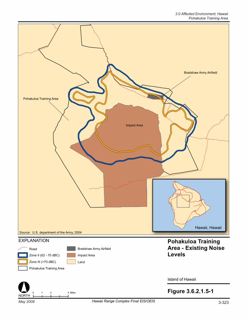
3-323May 2008 Hawaii Range Complex Final EIS/OEIS
Pohakuloa Training Area
Bradshaw Army Airfield
Impact Area
Figure 3.6.2.1.5-10 2 41 MilesNORTH
Hawaii, Hawaii
Pohakuloa TrainingArea - Existing NoiseLevels
Island of Hawaii
EXPLANATION
Road
Zone II (62 - 70 dBC)
Zone III (>70 dBC)
Pohakuloa Training Area
Bradshaw Army Airfield
Impact Area
Land
Source: U.S. department of the Army, 2004
3.0 Affected Environment, HawaiiPohakuloa Training Area
Hawaii, 3.0 Affected Environment Bradshaw Army Airfield
3-324 Hawaii Range Complex Final EIS/OEIS May 2008
3.6.2.2 BRADSHAW ARMY AIRFIELD Bradshaw Army Airfield is located on the northern boundary of PTA and supports maneuver training. It has a 3,700-ft airstrip and a small cantonment area.
This section describes the environmental resources that would be affected by the No-action Alternative, Alternative 1, Alternative 2, or Alternative 3 for Bradshaw Army Airfield. Of the 13 environmental resources considered for analysis, air quality, geology and soils, hazardous materials and hazardous waste, health and safety, land use, noise, socioeconomics, transportation, utilities, and water resources are not addressed.
3.6.2.2.1 Airspace—Bradshaw Army Airfield Appendix C includes a detailed description of airspace.
Region of Influence The region of influence for Bradshaw Army Airfield is similar to that described for airspace at PTA (Section 3.6.2.1.1).
Affected Environment The affected airspace for Bradshaw Army Airfield is the same as that described in Section 3.6.2.1.1 for PTA.
3.6.2.2.2 Biological Resources—Bradshaw Army Airfield Appendix C includes a detailed description of biological resources.
Region of Influence The region of influence is the area within or adjacent to Bradshaw Army Airfield that could be affected by proposed training.
Affected Environment Since Bradshaw Army Airfield is located on the northern boundary of PTA, its affected environment is similar to that described in Section 3.6.2.1.2.
Vegetation The majority of the open area is vegetated with native plants and is identified as Subalpine dryland.
Threatened and Endangered Plant Species
Plant species listed in Table 3.6.2.1.2-1 could also potentially be located on Bradshaw Army Airfield.
3.0 Affected Environment, Hawaii
Bradshaw Army Airfield
May 2008 Hawaii Range Complex Final EIS/OEIS 3-325
Wildlife Since the area has been cleared for the runway, only small mammals and birds are likely to be in the region of influence. However, other wildlife species listed above at PTA could also potentially occur at Bradshaw Army Airfield.
Threatened and Endangered Wildlife Species
Routine and transformation training actions at Bradshaw Army Airfield were addressed in the 2003 biological opinion for PTA (U.S. Department of the Interior, Office of Environmental Policy and Compliance Pacific Southwest Region, 2007). The endangered Hawaiian hoary bat could pass through the area, as well as the `io and nene.
Environmentally Sensitive Habitat Critical habitat for the endangered palila has been established both north and southeast of Bradshaw Army Airfield (see Figure 3.6.2.1.2-1), but none is located in the immediate vicinity of the airfield.
3.6.2.2.3 Cultural Resources—Bradshaw Army Airfield Appendix C includes a description of cultural resources and the laws and regulations pertaining to them.
Region of Influence The region of influence for cultural resources at Bradshaw Army Airfield encompasses the building where a new ground relay station will be added.
Affected Environment
Archaeological Resources (Prehistoric and Historic) Bradshaw Army Airfield is located within PTA (see Figure 2.1-5); therefore, the prehistoric and historic context for the facility is the same as described for PTA. There are no known significant archaeological resources within Bradshaw Army Airfield; however, there are numerous archaeological sites identified within the adjacent PTA (see Section 3.6.2.1.3). (U.S. Department of the Navy, 2002a)
Historic Buildings and Structures Identification of historic buildings and structures at Bradshaw Army Airfield is the same as described for PTA (see Section 3.6.2.1.3.)
Traditional Resources Bradshaw Army Airfield is within the PTA; therefore, the traditional resources context for the facility is the same as described for PTA. There are no known traditional resources sites within Bradshaw Army Airfield (see Section 3.6.2.1.3). (U.S. Department of the Army, 2004)
Hawaii, 3.0 Affected Environment Kawaihae Pier
3-326 Hawaii Range Complex Final EIS/OEIS May 2008
3.6.2.3 KAWAIHAE PIER Kawaihae Pier is located within the Kawaihae Harbor on the northwestern corner of the island of Hawaii. Kawaihae Harbor is a deep-water port, one of two on the island of Hawaii. Expeditionary Assault events are conducted at Kawaihae Pier. Activities primarily consist of offloading and loading vehicles and equipment from a landing ship at an existing boat ramp.
This section describes the environmental resources that would be affected by the No-action Alternative, Alternative 1, Alternative 2, or Alternative 3 for Kawaihae Pier. Of the 13 environmental resources considered for analysis, airspace, air quality, cultural resources, geology and soils, hazardous material and waste, health and safety, land use, noise, socioeconomics, transportation, utilities, and water resources are not addressed.
3.6.2.3.1 Biological Resources—Kawaihae Pier Appendix C includes a detailed description of biological resources.
Region of Influence The region of influence includes the beach and other areas adjacent to the pier that may be affected by proposed training.
Affected Environment
Vegetation A small beach area containing no vegetation is located immediately adjacent to the pier.
Threatened and Endangered Plant Species
No threatened or endangered plant species have been identified within the harbor area.
Wildlife Terrestrial wildlife at Kawaihae Pier is limited to transitory birds and small mammals.
Threatened and Endangered Wildlife Species
No threatened or endangered species have been identified within the harbor.
Environmentally Sensitive Habitat No critical habitat is present (National Park Service, 2004).
3.0 Affected Environment, Hawaii
Hawaiian Islands Humpback Whale National Marine Sanctuary
May 2008 Hawaii Range Complex Final EIS/OEIS 3-327
3.7 HAWAIIAN ISLANDS HUMPBACK WHALE NATIONAL MARINE SANCTUARY (HIHWNMS)
The National Marine Sanctuaries Act (NMSA),16 United States Code § 1431 et seq., authorizes the Secretary of Commerce to designate areas of the marine environment that possess conservation, recreational, ecological, historical, research, and educational, or aesthetic resources and qualities of national significance as National Marine Sanctuaries, and to provide comprehensive management and protection of these areas. To protect the area designated, any Federal action that is likely to destroy, cause the loss of, or injure a sanctuary resource must consult with the Secretary of Commerce prior to commencement and adhere to reasonable and prudent alternatives set by the Secretary of Commerce. To the extent practicable, consultation may be consolidated with other consultation efforts under other Federal laws, such as the Endangered Species Act.
The Hawaiian Islands Humpback Whale National Marine Sanctuary (HIHWNMS) (Figure 3.3.1.1.1-2) is one of 14 established sanctuaries under the NMSA. It was established in 1992 by the Hawaiian Islands National Marine Sanctuary Act, Title II, subtitle C of the Oceans Act of 1992. At the inception of the HIHWNMS and by virtue of the Hawaiian Islands Humpback Whale National Marine Sanctuary Final Environmental Impact Statement/Management Plan (February 1997) and implementing regulations (15 CFR § 922.180), certain military activities were identified as exempt from the interagency consultation requirements and the prohibited activities designated under the NMSA.
Specifically, the HIHWNMS Final Environmental Impact Statement (EIS)/Management Plan identified 28 offshore training events and 20 open ocean training events as “classes of military activities” conducted in the Hawaiian waters. Offshore activities are conducted within the 100-fathom isobath demarcation of the HIHWNMS around the Hawaiian Islands. These classes of activities were noted to be conducted “by all the military services of the United States and, during combined exercises, by military units from cooperating foreign nations or the State of Hawaii Department of Defense/National Guard” (U.S. Department of Commerce, National Oceanic and Atmospheric Administration and State of Hawaii, Office of Planning, 1997). The HIHWNMS EIS described seven examples of “types” of Department of Defense (DoD) military activities that occur in or around the Sanctuary, then further described 31 “Other DoD Military Operations in the Hawaiian Islands”, noting whether each activity occurred within the 100 fathom isobath (the designated demarcation boundary of the HIHWNMS around the Hawaiian Islands). Included in the list of seven examples of types is “Anti-submarine Warfare (ASW) Exercises.” The example indicates that ASW exercises take place “usually two per year, lasting several days with surface ships and submarines and including the use of expendable equipment such as smoke floats and bathythermograph probes.” The bulleted types of activities and Appendix F of the HIHWNMS EIS/Management Plan (see Exhibit C-1 of Appendix C) more thoroughly list the ASW events as both within and outside the 100-fathom isobath, using sonar, sonobuoys, and mine countermeasures using sonar. Additionally, non-ASW activities such as air-to-surface gunnery exercises, air combat maneuvers, air-to-surface missile/bombing exercises, air-to-ground Strike Warfare Exercises, and Amphibious Exercises are listed as potential activities both outside and within the boundaries of the HIHWNMS. These types of activities can be combined into the Undersea Warfare Exercises (USWEX) or Rim of the Pacific (RIMPAC) exercise.
Hawaii, 3.0 Affected Environment Hawaiian Islands Humpback Whale National Marine Sanctuary
3-328 Hawaii Range Complex Final EIS/OEIS May 2008
Under the HIHWNMS regulations, military activities are allowed within the HIHWNMS and are not subject to vessel/aircraft approach distances, discharge of materials prohibitions and consultation requirements if they are “classes of military activities, internal and external to the HIHWNMS, that are being or have been conducted before the effective date of these regulations, as identified in the Final Environmental Impact Statement/Management Plan.” If the military activity is proposed after the effective date of the regulations, then the activity is also allowable, but is subject to the prohibited activities provisions of 15 CFR § 922.184 unless the activity is not subject to consultation under NMSA (that is, not likely to destroy, cause the loss of, or injury to any sanctuary resource). Regulatory prohibition provisions include distance restrictions on vessel and aircraft approaches to humpback whales, prohibitions on depositing materials within or near the Sanctuary, and prohibitions on the taking or possessing of humpback whales. Finally, any military activity that is subsequently modified in a way that causes the activity to be “likely to destroy, cause the loss of, or injure a HIHWNMS resource in a manner significantly greater than was considered in previous consultation” is treated as a new military activity for which consultation may be necessary.
In April 1995, before the completion of the HIHWNMS Final EIS/Management Plan, the Department of the Navy provided the Department of Commerce with a “Report on Military Activities in Hawaiian Waters.” This document detailed to National Oceanic and Atmospheric Administration (NOAA) the varying military activities that occur around Hawaii, specifically explaining the nature of RIMPAC as well as other Major Exercises, unit-level training, and additional military activities. This document’s specificity aided NOAA in listing “classes” of activities for purposes of brevity in its EIS. (See Exhibit C-2 of Appendix C for the complete Report.)
In October 1995, the Department of Navy and the Department of Commerce entered into a Memorandum of Understanding regarding the military activities and the HIHWNMS. That Memorandum reflected the parties’ completion of consultation required by NMSA Section 304(d) regarding existing classes of military activities. The activities were found not likely to destroy, cause loss of, or injure a humpback whale. It was determined that the existing classes of military activities, therefore, were not subject to further consultation unless they became modified in a way that is likely to destroy, cause loss of, or injure a Sanctuary resource in a manner significantly greater than was considered in previous consultation. (See Exhibit C-3 of Appendix C for the complete Navy/NOAA Memorandum of Understanding Concerning Military Activities and the Hawaiian Islands Humpback Whale National Marine Sanctuary).
Humpback whales are seen in the winter months in the shallow waters surrounding the Hawaiian Islands where they congregate to mate and calve. The humpback whale population is growing by an average of 7 percent annually. The best available estimate of the central west pacific stock humpback whale abundance is 4,491 individuals. (Mobley et al., 2001) The whales travel more than 3,500 mi from Alaska to Hawaii's warm waters to mate, give birth, and care for their calves. The first whales of the season usually arrive around October, with the greatest number seen around Hawaii between 1 December and 15 May. (National Oceanic and Atmospheric Administration, 2007a; Mobley, 2002)
The following sections describe areas of the HIHWNMS, by island, that could be affected by proposed Hawaii Range Complex (HRC) training and research, development, test, and evaluation (RDT&E) activities.
3.0 Affected Environment, Hawaii
Hawaiian Islands Humpback Whale National Marine Sanctuary
May 2008 Hawaii Range Complex Final EIS/OEIS 3-329
3.7.1 BIOLOGICAL RESOURCES—HIHWNMS
3.7.1.1 KAUAI—BIOLOGICAL RESOURCES—HIHWNMS The HIHWNMS (Figure 3.3.1.1.1-2) includes a portion of the ocean north of Kauai, but not within the Pacific Missile Range Facility vicinity or in the Barking Sands Tactical Underwater Range (BARSTUR) and the Barking Sands Underwater Ranges Expansion (BSURE) coverage areas (U.S. Department of the Navy, 2001a). (U.S. Department of Commerce, National Oceanic and Atmospheric Administration and State of Hawaii, Office of Planning, 1997)
No training or RDT&E activities are planned to occur in the area north of Kauai that is included in HIHWNMS. Warning Areas W-186 and W-188 airspace over the Open Ocean are outside the HIHWNMS boundary. The Warning Areas are used for missile, bomb, and gunnery exercises. Air, surface, and underwater exercises are conducted in the surface area of W-186 and W-188.
Instrumentation at BARSTUR provides the capability to conduct ASW and Anti-surface Underwater Warfare training. BSURE is also used for ASW and Anti-surface Underwater Warfare training and to track submarines and torpedo firing.
3.7.1.2 OAHU—BIOLOGICAL RESOURCES—HIHWNMS HIHWNMS (Figure 3.3.1.1.1-2) areas are located off the northern and southeastern coastlines of Oahu. No current HRC activities are being performed within the HIHWNMS’s boundaries, and none are being proposed.
3.7.1.3 MAUI—BIOLOGICAL RESOURCES—HIHWNMS The Maui Offshore is an area situated around the islands of Maui, Kahoolawe, Lanai, and Molokai, portions of which are within the HIHWNMS (Figure 3.3.1.1.1-2). The waters adjacent to Maui, Molokai, and Lanai are important Navy training areas. The offshore area also includes the portion of Penguin Bank that is within 12 nautical miles (nm) of the islands’ coastlines. The area is used as a submarine training area due to the unique characteristics of its acoustic environment and shallow depths of 50 and 100 fathoms. Multiple in-water runs of exercise MK-48 torpedoes (with no warheads) using one submarine as both target and launch platform also occur in the Penguin Bank area. According to the HIHWNMS EIS/Management Plan, submarines conduct post-overhaul shallow water dives and shallow water ASW events in the vicinity of Penguin Bank. Penguin Bank is the only shallow water area in Hawaiian waters suitable for initial submerged testing, which is necessary for crew rescue. Submarines also conduct mine warfare training at Penguin Bank.
According to the HIHWNMS EIS (U.S. Department of Commerce, National Oceanic and Atmospheric Administration and State of Hawaii, Office of Planning, 1997), “… the waters adjacent to Maui, Molokai, and Lanai are important training areas for Navy ships homeported in Pearl Harbor. The channel between Maui, Lanai and Molokai is extensively used for biennial RIMPAC [Rim of the Pacific] exercises, EOD/MCM [explosive ordnance disposal/mine countermeasures] exercises, and as well for shallow-water ASW [anti-submarine warfare]…
Hawaii, 3.0 Affected Environment Hawaiian Islands Humpback Whale National Marine Sanctuary
3-330 Hawaii Range Complex Final EIS/OEIS May 2008
The areas inside the 100-fathom isobath surrounding Maui, Molokai and Lanai, and specifically the channel between these islands, are used for shallow-water ASW operations.”
The presence of the endangered humpback whale in the region of influence is seasonal, with peak concentrations in mid-February to mid-March. The whales seem to prefer areas within the 100-fathom contours such as the Molokai–Lanai–Maui–Kahoolawe channels and Penguin Bank. Humpback whale sightings in the region of influence are mainly concentrated north of Kahoolawe in protected channel areas. (Commander, Submarine Force U.S. Pacific Fleet, 1997; Naval Undersea Warfare Center Division Newport, Rhode Island, 2007)
3.7.1.4 HAWAII—BIOLOGICAL RESOURCES—HIHWNMS The Kawaihae Pier area is not included within the HIHWNMS (Figure 3.3.1.1.1-2), which is located off the northwestern shore of Hawaii. Other than transiting the HIHWNMS to reach Kawaihae Pier, no current HRC activities are being performed within the HIHWNMS’s boundaries, and none are being proposed.