Embed Size (px)
Citation preview
HAZARD RANKING SYSTEM (IIRS) DOCUMENTATION RECORD COVER SHEET
Name of Site
EPAIDNo
Contact Persons
Documentation Record
Macon Naval Ordnance Plant
GAD003302676
Cathy Amoroso National Priorities List Coordinator US Environmental Protection Agency Region 4 61 Forsyth Street SW 11th Floor Atlanta Georgia 30303 (404) 562-8637
Donna Seadler Remedial Project Manager US Enviromnental Protection Agency Region 4 61 Forsyth Street SW 11th Floor Atlanta Georgia 30303 (404) 562-8870
Quinn Kelley Site Manager Tetra Tech EM Inc 1955 Evergreen Boulevard Duluth Georgia 30096 (678) 775-3101
Pathways Components or Threats Not Scored
The ground water migration soil exposure and air migration pathways as well as the surface water pathway drinking water threat were not scored in this Hazard Ranking System (HRS) documentation record These pathways are of concern to EPA and may be considered during future evaluation The human food chain and enviromnental threats for the surface water migration pathway are sufficient to qualify the site for the National Priorities List (NPL)
HAZARD RANKING SYSTEM (HRS) DOCUMENTATION RECORD
Name of Site Macon Naval Ordnance Plant
EPA Region 4
Date Prepared March 2012
Street Address of Site 600 Guy Paine Road
City County State Macon Bibb County Georgia 31206
General Location in the State Central Portion of the State
Topographic Map Macon West Georgia 1985
Latitude 32deg 46 3957 North
Longitude 83deg 38 2283 West
The coordinates listed above for the former Macon Naval Ordnance Plant were measured from the approximate location of surface soil sample MNOP-04-SF collected during the EPA June 2011 Supplemental Sampling Event (Ref 4)
The street address coordinates and contaminant locations presented in this HRS documentation record identify the general area where the site is located They represent one or more locations the US Environmental Protection Agency (EPA) considers part of the site based on the screening information EPA used to evaluate the site for National Priorities List (NPL) listing EPA lists national priorities among the known releases or threatened releases of hazardous substances thus the focus is on the release and not on precisely delineated boundaries A site is defined as an area where a hazardous substance has been deposited stored placed or otherwise come to be located Generally HRS scoring and the subsequent listing of a release represent the initial determination that a certain area may need to be addressed under the Comprehensive Environmental Response Compensation and Liability Act (CERCLA) Accordingly EPA contemplates that the preliminary description of facility boundaries at the time of scoring will be refmed as more information is developed about where the contamination has come to be located
Pathway Ground Water Migration
Surface Water Migration
Soil Exposure
Air Migration
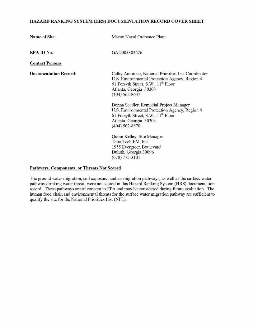
HRS SITE SCORE
Pathway Score Not Scored
9794
Not Scored
Not Scored
4897
WORKSHEET FOR COMPUTING HRS SITE SCORE
S Pathway S2 Pathway
Ground Water Migration Pathway Score (Sgw) Not Scored Not Scored
Surface Water Migration Pathway Score (Ssw) 9794 95922436
Soil Exposure Pathway Score (Ss) Not Scored Not Scored
Air Migration Pathway Score (S) Not Scored Not Scored
s zgw + szsw + s zs + sz 95922436
(Szgw + szsw + sz + sz) I 4 23980609
-J (S2gw + S2
sw + S + S2) I 4 4897
2
Table 4-1-Surface Water OverlandFlood Migration Component Scoresheet
Factor Cate2ories and Factors Maximum Value Value Assi2ned Drinking Water Threat
Likelihood of Release 1 Observed Release 550 550 550
2 Potential to Release by Overland Flow I ~a Containment 10 NS
~b Runoff t-
25 NS
2c Distance to Surface Water 25 NS ~d Potential to Release by Overland Flow [lines 2a(2b + 2c)]_ 500 NS -
3 Potential to Release by Flood 3a Containment (Flood) 10 NS
3b Flood Frequency 50 NS
3c Potential to Release by Flood (lines 3a x 3b) 500 NS
~- Potential to Release (lines 2d + 3c subject to a maximum of 500) 500 NS t5 Likelihood of Release (higher oflines 1 and 4) 550 550
Maste Characteristics
16 ToxicityPersistence (a) 10000
7 Hazardous Waste Quantity (a) I 10000 8 Waste Characteristics 100 NS
Targets 9 Nearest Intake 50 NS
10 Population 1 Oa Level I Concentrations (b) NS
-1 Ob Level II Concentrations (b) NS --1 Oc Potential Contamination (b) NS 1 Od Population (lines 1 Oa + 1 Ob + 1 Oc) (b) NS
11 Resources 5 NS 112 Targets (lines 9 + 10d + 11) (b) NS
Drinking Water Threat Score 113 Drinking Water Threat Score [(lines 5x8x12)82500 subject to a maximum of 100] 100 NS
Human Food Chain Threat Likelihood of Release
14 Likelihood of Release (same value as line 5) 550 I 550
~aste Characteristics t~
15 ToxicityPersistenceBioaccumulation (a) I 500000000 16 Hazardous Waste Quantity (a) 100 17 Waste Characteristics 1000 320
Tar2ets 118 Food Chain Individual 50 20 I
3
Table 4-1 -Surface Water OverlandFlood Migration Component Scoresheet (Continued) I
Factor Categories and Factors Maximum Value Value Assigned 19 Population
19a Level I Concentration
19b Level II Concentration 19c Potential Human Food Chain Contamination ----
- f-19d Po_pulation (lines 19a + 19b + 19S)
2 0 Targets (lines 18 + 19d)
Human Food Chain Threat Score
~21 Human Food Chain Threat Score [(lines 114x17x20)82500 subject to maximum of 100]
Environmental Threat
Likelihood of Release 22 Likelihood of Release (same value as line 5)
~aste Char acteristics f-
i23 Ecosystem ToxicityPersistenceBioaccumulation 24 Hazardous Waste Quantity
25 Waste Characteristics
Tar2ets 26 Sensitive Environments
~6a Level I Concentrations
~6b Level II Concentrations t-
26c Potential Contamination ~6d Sensitive Environments (lines 26a + 26b +
I 26c) ~7 Targets (value from line 26d)
Environmental Threat Score 28 Environmental Threat Score [(lines 22x25x27)82500 subject to a maximum of 60]
Surface Water OverlandFlood Migration Component Score for a Watershed
129 Watershed Scorec (lines 13+21+28 subject to a _E1aximum of 100)
-----
Surface Water OverlandFlood liligration Component Score 30 Component Score (Sort (highest score from line 29 for all watersheds evaluated subject to a maximum of 100)
Notes
b
NS
Maximum value applies to waste characteristics category Maximum va lue not applicable Do not round to nearest integer Not scored
4
(b) 0 (b) 0
(b) 00003 (b) 00003 (b) 200003
100 4266
550 550
(a) 500000000 (a) 100
1000 320
(b) 0 (b) 25 (b) 0915
(b) 25915 (b) 25915
60 5528
100 _l_ 9794
100 9794
-
--
-
A
LEGEND
D Property Boundary
O~llllllllllllllllllll~500~1iiOOO Feet
112000
MAP SOURCE USGS MACON WEST GA TOPOGRAPHIC QUADRANGLE 1985 PROPERTY BOUNDARY SOURCE MACON-BIBB COUNTY BOARD OF TAX ASSESSORS_ REFERENCES 8 17 pp 5 17
BIBB COUNTY GEORGIA
fJ
~ m United States Environmental Protection Agency
MACON NAVAL ORDNANCE PLANT
MACON BIBB COUNTY
GEORGIA TOO NoTTEMI-05-003-0127
FIGURE 1 PROPERTY LOCATION
bull t ~ ~
~ ~ ~ laquo
~ i ~ ~
J ~ ~
sect I
i
j
I 1
~
( 11) TETRA TECH ~
~--------------------~ i
Legend
[Q) WWTP Discharge r---1 Former Waste Water L__j Treatment Plant
~ ~ ~ ~
r==l Former Macon Naval Ordnance t~ Plant Structures ~
Former Macon Naval Ordnance ~ ~ Explosives Handling and ~
Storage Areas ~ W New Structures ~ ~ --~ Property Boundary
Note
0 150 300 600
~~~F~e~e~t~~~ 17200
Aerial Photograph 8109 Maps 2009 References 6 8 13 pp 52 54 17 p 25
~
~ United States ~ ~ Environmental Protection Agency ~
~ MACON NAVAL ORDNANCE PLANT
MACON BIBB COUNTY
GEORGIA TDD No TTEMI-05-003-01 27
FIGURE2 PROPERTY LAYOUT
z
~
~ ~ ~
~ ~
[1tJ TETRA TECH c
~~- L------------------------_J~
Legend
June 2011 Sample Locations
Sediment Sample
Soil Sample
Background Wetland Sediment Sample
Background Soil Sample
Map Features
Creek
Drainage Ditch
Former Macon Naval Ordnance Plant
Wetland Areas
e3 C3
Freshw ater Palustrine Emergent Wetland
Freshw ater Palustrine ForestedShrub Wetland
500
Feet
112000
Map Source Aerial Photogaph ~Bing Maps 2009
1000
Property Boundary ~Ma con~Bibb County Board of Tax Assessors Wetlands - U S Fish and Wildlrte Service National Wetlands Inventory Reference 9 pp 1 3
Notes D -or ainage D~ch Hg ~Mercury
MNOP -Ma con Naval Ordnance Plant PPE - Probable Point of Entry SD ~sediment Sample SF - Swface Soil Sample W - Wetland
United States Environmental Protection Agency ~
MACON NAVAL ORDNANCE PLANT MACON
BIBB COUNTY GEORGIA
TOO No TTEMI-05-003-0127
FIGURE 3 SAMPLING LOCATIONS
z sect
~
~
I (11) TETRA TECH ~ L_ ____________________________ _J ~
REFERENCES
1 US Environmental Protection Agency (EPA) Hazard Ranking System Title 40 Code of Federal Regulations Part 300 55 Federal Register 51532 December 14 1990 138 Pages A complete copy of the Hazard Ranking System is available at httpwwwepagovsuperfundsitesnpVhrsresindexhtmHRS Rule
2 EPA Superfund Chemical Data Matrix (SCDM) January 2004 Updated December 2011 Excerpt 75 Pages A complete copy of SCDM is available at http epa gov I superfund sitesnpVhrsrestoo ls scdm htm
3 Tetra Tech EM Inc (Tetra Tech) 15-Mile Surface Water Migration Pathway with NWI Wetlands US Geological Survey (USGS) 75 Minute Series Topographic Maps of Georgia Quadrangles Macon West (1985) Macon East (1985) Warner Robins NW (1986) Warner Robins NE (1985) 1 Map
4 Tetra Tech Project Note to File with Attachment Subject Coordinates for Macon Naval Ordnance Plant Attachment Google Earth Map November 2 2011 2 Pages
5 EPA Envirofacts Warehouse Macon Naval Ordnance Plant Query Comprehensive Environmental Response Compensation and Liability Information System (CERCUS) (Data Extracted August 15 2011) Accessed on August 31 2011 2 Pages CERCUS Accessed on-line at httpiaspubepagovenvirocerclisqueryget reportpgm sys id=GAD003302676
6 Tetra Tech Project Note to File with Attachments Subject Macon-Bibb County Parcel Maps and Property Cards for the Former Macon Naval Ordnance Plant Property Attachment Parcel Maps and Property Cards September 7 2011 64 Pages
7 Tetra Tech Final Expanded Site Inspection Report Allied Industrial Park Macon Bibb County Georgia September 29 2009 Excerpt 197 Pages
8 Department of the Navy Bureau of Yards and Docks US Naval Ordnance Plant Macon GA Master Shore Station Development Plan Part II Section 2 General Development Plan- Existing Approved March 19 1965 1 Page
9 Tetra Tech Project Note to File with Attachments Subject June 2011 Supplemental Sampling Event Attachments Figure and Logbook Notes September 1 2011 10 Pages
10 Tetra Tech Draft Quality Assurance Project Plan Macon Naval Ordnance Plant June 20 2011 20 Pages
11 EPA Region 4 Science and Ecosystem Support Division (SESD) Final Analytical Report Project No 11-0536 August 1 2011 24 Pages
12 Science Applications International Corporation (SAIC) Draft Hazardous Site Response Act (HSRA) Compliance Status Report Former Macon Naval Ordnance Plant Allied Industrial Park Macon Georgia Prepared for the US Army Corp of Engineers (USACE) Savannah District August 2000 1 626 Pages
13 RUST Environment and Infrastructure Inc Site Investigation Report Allied Industrial Park Site Macon Georgia Prepared for the USACE Savannah District May 1997 390 Pages
14 Environmental Science amp Engineering Inc (ESE) Final Engineering Report Confirmation Study of Former Macon Naval Ordnance Plant Macon Bibb Co Georgia Prepared for the Defense Environmental Restoration Program USACE Mobile District September 1990 129 Pages
8
15 Tetra Tech Project Note to File Subject Allied Industrial Park Property Owners Internet Search September 9 2011 1 Page
16 Tetra Tech Final Expanded Site Inspection Report Former Macon Naval Ordnance Landfill Macon Bibb County Georgia September 29 2009 Excerpt 135 Pages
17 EPA Environmental Sciences Division Aerial Photographic Analysis Former Macon Naval Ordnance Plant Landfill Site Macon Georgia November 1999 57 Pages
18 RUST Environment and Infrastructure Inc Final Site Investigation Report Former Naval Ordnance Plant Landfill (FMNOL) Site Macon Georgia Prepared for the Savannah District US Army Corps of Engineers (USACE) September 1997 142 Pages
19 Georgia Environmental Protection Division Hazardous Waste Management Branch Preliminary Assessment Armstrong World Industries Inc Prepared for the US EPA August 10 2007 18 Pages
20 SAIC Final Phase I Remedial Investigation Report Former Macon Naval Ordnance Plant Landfill Site Macon Georgia Prepared for the USACE Savannah District October 2000 483 Pages
2 1 SAIC Letter to the US Army Corps of Engineers Subject Monitoring Report for Post-Test Groundwater Sampling (October-November 2004) Pilot-Scale Alternatives Assessment and Implementation Plan for Groundwater VOC Reduction at the Former Macon Naval Ordnance Plant January 19 2005 240 Pages
22 Georgia Environmental Protection Division (EPD) Preliminary Assessment Former Macon Naval Ordnance Landftll and Allied Industrial Park Macon Bibb County Georgia February 1992 21 Pages
23 Department of the Army Technical Manual TM 9-1300-214 Military Explosives September 1984 Most Recent Revision September 1990 355 Pages
24 EPA Region 4 SESD Operating Procedure for Soil Sampling Number SESDPROC-300-Rl November 1 2007 22 Pages Accessed on-line at httpwwwepagovregion4sesdlfbgstpSoilshySampling pdf
25 EPA Region 4 SESD Operating Procedure for Sediment Sampling Number SESDPROC-200-R2 September 8 2010 23 Pages Accessed on-line at httpwww epa govregion4sesdlfbq stpSediment-Sampling pdf
26 EPA Region 4 Macon Naval Ordnance Plant Chain of Custody Record No 063011-0001 Project No 11-0536 July 1 2011 2 Pages
27 EPA Region 4 SESD Analytical Support Branch Laboratory Operations and Quality Assurance Manual January 6 2011 205 Pages
28 Tetra Tech Project Note to File Subject Data Review Validation and Verification Conducted at the Science and Ecosystem Support Division (SESD) Analytical Support Branch January 6 2009 1 Page
29 Tetra Tech Record of Telephone Conversation Subject Definitions of Minimum Reporting Limit Minimum Quantitation Limit Contract Required Quantitation Limit and Sample Quantitation Limit Between Shanna Davis Environmental Scientist and Charlie Appleby Quality Assurance Section SESD Management and Technical Services Branch EPA Region 4 July 9 2008 1 Page
9
30 Tetra Tech Project Note to File with Attachments Subject Soil Map for Macon Naval Ordnance Plant Attachments Soil Map Map Legend and Map Unit Legend September 2 2011 4 Pages
31 Tetra Tech Project Note to File with Attachment Subject Summary of J-Qualified Data Attachment J-Qualified Data September 6 2011 2 Pages
32 EPA Office of Emergency and Remedial Response Using Qualified Data to Document an Observed Release and Observed Contamination Quick Reference Fact Sheet EPA-540-F-94-028 November 1996 18 Pages
33 Tetra Tech Project Note to File Subject June 2011 Supplemental Sampling Event Observations September 2 2011 1 Page
34 EPA Region 4 SESD Final Analytical Report Project No 09-0441 August 22 2011 181 Pages
35 EPA Region 4 SESD Final Analytical Report Project No 09-0441 August 22 2011 155 Pages
36 US Department of the Interior Fish and Wildlife Service National Wetlands Inventory Maps of Georgia Macon West Macon East Warner Robins NE Warner Robins SE 1995 4 Maps
37 Tetra Tech Record of Telephone Conversation Subject Fishing on Rocky Creek in Macon Bibb County Georgia Between Quinn Kelley Environmental Scientist and Steve Schleiger Biologist GADNR Wildlife Resources Division September 9 2011 1 Page
38 Tetra Tech Project Note to File with Attachment Subject Stream Flow Data for Tobesofkee Creek and the Ocmulgee River in Macon Bibb County Georgia Attachment USGS 2010 Water-Data Reports for Tobesofkee Creek and the Ocmulgee River September 6 2011 17 Pages
39 Tetra Tech Project Note to File with Attachment Subject Ocmulgee Watershed Stream Evaluations Attachment 2002 Georgia Section 303(d) Listed Streams Ocmulgee River Water Management Plan Table 2-6 September 9 2011 3 Pages
40 GADNR Environmental Protection Division Water Quality in Georgia 2008-2009 Approved November 10 2010 505 Pages Accessed on-line at httpwwwgaepdorgDocuments305bhtml
41 Macon-Bibb County Planning and Zoning Commission Comprehensive Plan 2030 Community Assessment February 2006 415 Pages Accessed on-line at httpwwwmaconbibbpzorgartman2uploads1CP2030 1pdf
42 GADNR EPD Site Reconnaissance Inspection Trip Report Armstrong World Industries Inc Macon GA July 192007 11 Pages
43 GADNR Guidelines for Eating Fish from Georgia Waters 2010 Update 30 Pages Accessed onshyline at httpwwwgaepdorgDocumentsfish guidehtml
44 Federal Emergency Management Agency Flood Insurance Rate Map for Bibb County and Incorporated areas Georgia Excerpt ofPanel144 of265 Community-Panel Number 130011 0144 F Effective April2 2007 3 Pages
45 Macon Water Authority Operations Water Reclamation Facilities Accessed on September 7 2011 4 Pages Accessed on-line at httpmaconwaterorgwater-reclamation-facilities
10
46 EPA Enforcement and Compliance History Online (ECHO) with Attachments Macon Water Authority Rocky Creek Water Reclamation Facility Report Generated November 1 2011 8 Pages Attachments ECHO Effluent Data and Google Earth Map Depicting NPDES Permit Outfall Accessed on-line at httpwwwepa-echogovcgishybinget1cReportcgitool=echoampIDNumber=ll0007498412
47 Regulationsgov Docket Folder Sutmnary National Priorities List Notice of Proposed Rulemaking ~Armstrong World Industries Docket ID EPA-HQ-SFUND-2010-0640 Accessed on January 3 2012 1 Page Accessed on-line at httpwwwregulationsgov docketDetaildct=FR252BPR252BN252B0252BSRmp= lOp o=OD=EPA-HQ-SFUND-201 0-0640
11
SITE DESCRIPTION
The former Macon Naval Ordnance Plant (MNOP) property currently the Allied Industrial Park (AlP) covers about 433 acres in area and is located in an industrialized area in the southern portion of Macon Bibb County Georgia (Refs 3 7 p 2 8) (see Figure 1 of this Hazard Ranking System [HRS] documentation record) Specifically the geographic coordinates for the MNOP property are latitude 32deg 46 3957 north and longitude 83deg 38 2283 west (as measured from the approximate location of surface soil sample MNOP-04-SF collected during the EPA June 2011 Supplemental Sampling Event) (Ref 4) The US Environmental Protection Agency (EPA) identification number for the MNOP property as recorded in the Comprehensive Environmental Response Compensation and Liability Information System (CERCUS) database is GAD003302676 (Ref 5)
Land uses on the MNOP property are predominantly commercial and heavy industrial (Refs 6 pp 2 5 12 13 15 21 24 25 26 27 28 29 32 33 36 41 45 47 49 51 54 57 59 60 15) The MNOP property is bordered to the north by Guy Paine Road to the east by Mead Road and the Norfolk Southern railroad tracks to the southeast by Graphic Packaging to the south by the Macon Water Authority (MWA) Rocky Creek Water Reclamation Facility and by the Armstrong World Industries (A WI) remote landfill the former Macon Naval Ordnance Landfill (FMNOL) and Rocky Creek and to the west by the AWl plant property (Refs 3 4 p 2 7 p 2 Appendix A p A-2)
For HRS scoring the site consists of one source and associated releases Source No 1 is contaminated soil on the eastern section of the MNOP property Source No 1 contains mercury (see Section 22 of this HRS documentation record) Mercury has also been detected at significant levels in sediments collected in wetlands that receive runoff from Source No 1 via Drainage Ditch 4 indicating that a release has occurred to the surface water migration pathway (see Section 40 of this HRS documentation record) (also see Figures 2 and 3 of this HRS documentation record)
OPERATIONAL AND REGULATORY IDSTORY
MNOP was constructed and operated by the Reynolds Corporation before World War II for production of ordnance (Refs 12 p 1-1 14 p 2-9) The Navy assumed operations in 1941 and continued to manufacture ordnance until1965 Ordnance manufactured at the MNOP included flares small primers detonators and other triggering mechanisms (Ref 13 p 2 14 p 2-9) The total area of the MNOP was approximately 433 acres which extended from Guy Paine Road to the north Mead Road to the east Rocky Creek to the south and the Central of Georgia Railroad tracks to the west (Refs 8 12 p 2-9 14 p 2-9)
Mter it was declared surplus by the Navy the property was sold in December 1965 to the Maxson Electronics Company (Maxson) ofNew York Maxson continued to manufacture ordnance under contract with the Navy until it sold the property to Allied Chemical Corporation (Allied Chemical) in 1973 Allied Chemical manufactured automobile seat belts at the property and used all or nearly all of the buildings underground storage tanks (UST) and aboveground storage tanks (AST) and utilities Allied Chemical sold the property in 1980 to the Macon-Bibb County Industrial Authority (MBCIA) which renamed the property the Allied Industrial Park MBCIA currently leases or sells buildings as office and warehouse space to various industrial and commercial businesses on the AlP property (Refs 7 Appendix A p A-3 13 pp 1 2 3 14 p 2-9 15)
During ordnance manufacturing operations structures at the MNOP included numerous buildings several miles of paved roads fueling facilities ASTs and USTs solvent storage buildings explosives storage magazines a bunker area a metals plating facility and a sewage treatment plant (also referred to as a wastewater treatment plant [WWTP]) and the FMNOL (Refs 8 13 p 2 14 pp 2-9 2-102-11 2-12 Appendix A pp A-3 through A-8)
The MNOP WWTP was located near the western boundary of the property was constructed in the early 1940s and operated until the early 1970s The WWTP was designed to handle only sewage generated by
12 Site Description
the ordnance plant however chemicals used in the ordnance plant may have been disposed of in drains that connected to the WWTP (Ref 13 pp 10 52) (see Figure 2 of this HRS documentation record)
The primary metal plating facility at MNOP was located in Building 5 The metal plating operation began in the 1940s and continued through Maxsons and Allied Chemical s operation of the facility until 1980 The metal plating facility used cyanide solvents acid baths caustic baths and hydraulic oil Records indicate that the plating operation generated chrome sludge during Allied Chemical s use of the facility It is not known how this sludge was managed or disposed of (Ref 13 pp 11 52) Metal shavings were centrifuged to remove excess oils in the oil recovery area These oils were reportedly allowed to drain onto the ground surface (Ref 13 pp 11 52) (see Figure 2 of this HRS documentation record)
Explosive compounds were either handled or stored at many areas throughout the MNOP property including numerous small dryer buildings ordnance magazines and blending and weighing houses (Ref 13 pp 11 12 54) (see Figure 2 of this HRS documentation record) According to a technical manual prepared by the Department of the Arn1y military explosives such as those that were manufactured at the MNOP contained mercury compounds as initiating agents including mercury fulminate (Ref 23 pp 7-5 7-8) Building 109 located in the eastern portion of the MNOP was a primary explosives production site (Ref 13 pp 11 12 54) (see Figure 2 of this HRS documentation record) Soil samples collected from this area during the US Army Corps of Engineers (USACE) 1996 site investigation contained mercury (Ref 13 pp 58 83 84)
FMNOL was reportedly used for disposal of solid wastes and ordnance throughout the operational history (1941 to 1974) of the MNOP facility and intermittent dumping continued thereafter throughout the 1980s (Refs 16 p 3 17 pp 42 43 46 47 18 p 2 20 p i) The landfill was also used for disposal of used parts and construction debris (Refs 14 p 2-11 18 p 2) A fenced explosives demolition area located near the toe of the landfill was used for testing and demolishing explosives primarily detonators flares and primers manufactured at the MNOP Flammable materials were reportedly burned in this area as well (Ref 14 pp 2-11 3-9) The FMNOL is scored as part of the AWl site listed on the EPA NPL under CERCUS ID No GAN000410033 at docket number EPA-HQ-SFUND-2010-0640-0002 (Ref 47)
PREVIOUS INVESTIGATIONS
Several investigations have been conducted at MNOP between 1989 and 2011 Table 1lists the previous investigations at MNOP including the hazardous substances detected in the samples collected
TABLE 1 Summary of P revious Investigations
Hazardous Company Samples Substances
Agency Investigation Date Collected Detected R efer ences Beaver Environmental 1989 Soil Metals 13 p 3 Engineering Assessment
Environmental Confirmation 1990 Soil ground Arsenic 14 pp I 2-1 3-4 3-6 Science and Study of the water and Cadmium 3-9 3-11 4-2 4-3 4-Engineering Former Macon sediment Chromium 11 4-12
Naval Ordnance Lead Plant TCE
USACE Site Investigation 1996 Soil ground Cadmium 13 pp vi 1 13 20 Savannah District water surface Chromium 27 28 55 through 60
water and Lead 63 71 through 92 94 sediment Mercury through 104 106 107
13 Site Description
TABLE 1 Summary of P revious Investigations
Hazardous Company Samples Substances
Agency Investigation Date Collected Detected References USACE Hazardous Site 1998 to 2000 Soil ground Arsenic 12 pp i ii1-1 1-10 Savannah District Response Act water surface Cadmium 2-9 2-19 2-33
(HSRA) water and Chromium Appendix 0 pp 015 Compliance Status sediment Lead through 053 Report Zinc
TCE PCE Benzo( a )pyrene
USACE Post-Test 2004 Ground water DCE 21 pp 1 2 5 11 Savannah District Groundwater TCE
EPA
EPA
Notes
DCE EPA PCB PCE svoc TCE USACE voc
Sampling
Expanded Site May 2009 Inspection
Supplemental June 2011 Sampling Event
Dichloroethane US Environmental Protection Agency Polychlorinated biphenyl Tetrachloroethylene Semivolatile organic compound Trichloroethylene US Army Corps of Engineers Volatile organic compound
Soil ground water surface water and sediment
Soil and sediment
PCE Vinyl Chloride Cadmium 7 pp 1 6 7 Chromium Appendix B pp B-12 Copper through B-69 B-71 Lead through B-75 B-77 Manganese through B-113 Mercury Nickel PCBs Pesticides SVOCs VOCs Mercury 9 pp 1 3 11 pp 5
8 192 1
In June 2011 EPA conducted a supplemental sampling event at the MNOP property The purpose of the supplemental sampling was to further delineate mercury contamination previously found in Drainage Ditch 4 that runs along the eastern portion of the property (Refs 3 7 Appendix A p A-4 Appendix B p B-95 (also see Figure 3 of this HRS documentation record) Six surface soil samples (0 to 6 inches below ground surface [bgs]) were collected (including one background and one duplicate) from the eastern portion of the MNOP and 10 sediment samples (0 to 3 inches bgs) were collected (including one duplicate) from Drainage Ditch 4 which receives runoff from the eastern portion ofMNOP and flows south to Rocky Creek (Refs 9 10 pp 3 4 Appendix B p B-1 ) All soil and sediment samples were analyzed for mercury (Refs 9 10 pp 5 10 Appendix B p B-3) Mercury was detected in surface soil sample MNOP-04-SF at a concentration of 040 milligrams per kilogram (mgkg) in Drainage Ditch 4 sediment sample MNOP-D4-07-SD at a concentration of 046 mgkg and in Drainage Ditch 4 wetland sediment sample MNOP-D4-W-09-SD at a concentration of 11 mgkg (Ref 11 pp 8 19 21)
14 Site Description
Source No 1
22 SOURCE CHARACTERIZATION
221 SOURCE IDENTIFICATION
Number of source 1
Name of source Contaminated soil on the MNOP property
Source Type Contaminated Soil
Description and Location of Source (with reference to a map of the site)
Source No 1 consists of contaminated soil on the eastern portion of the MNOP property (Refs 9 p 3 11 p 8) (see Figure 3 of this HRS documentation record) MNOP operated as an ordnance manufacturing facility from before World War II until1973 (Ref 12 p 1-1 1-7) Ordnance manufactured at MNOP included flares small primers detonators and other triggering mechanisms (Ref 13 p 2)
According to a technical manual prepared by the Department of the Army military explosives such as those that were manufactured at the MNOP contained mercury compounds as initiating agents including mercury fulminate (Ref 23 pp 7-5 7-8) Explosive compounds were either handled or stored in many areas throughout the MNOP property including numerous small dryer buildings ordnance magazines and blending and weighing houses Specifically Building 109 located in the eastern portion of the MNOP near Source No 1 was a primary explosives production site (Ref 13 pp 11 12 54) (see Figures 2 and 3 of this HRS documentation record) Soil samples collected from this area during the US Army Corps ofEngineers (USACE) 1996 site investigation and the EPA June 201 1 supplemental sampling event contained mercury (Refs 9 p 1 11 p 8 13 pp 58 83 84)
15 Site Description
Source No 1
222 HAZARDOUS SUBSTANCES ASSOCIATED WITH THE SOURCE
EPA J une 2011 Supplemental Sampling
Background and Source Samples
The background and source soil samples listed in Table 2 were collected during the EPA June 2011 supplemental sampling event (Refs 9 pp 1 3 7 9 11 p 3) The background soil sample was collected from the north-central portion of the MNOP property where no site-related activities have been known to occur (Refs 8 9 pp 1 3 17 pp 11 17 21 25 29 33 37 41 45) The source soil sample was collected from the eastern portion of the MNOP property where mercury has been previously detected near where facility operations were known to have occurred and where explosives were handled and stored (Refs 7 Appendix A p A-4 9 p 3 13 pp 11 12 54) The background and source surface soil samples were collected at a depth ofO to 6 inches bgs (Refs 9 p 1 10 Appendix B p B-1)
Background and Source No 1 surface soil samples were collected during the same sampling event from the same type of soil (sandy loam) and in accordance with the same sampling procedures (Refs 9 pp 1 6 9 10 p 4 30 pp 1 3) Surface soil samples were collected in accordance with the EPA Region 4 SESD Field Branch Quality System and Technical Procedures for Soil Sampling SESDPROC-300-R1 (Refs 9 p 6 10 p 4 24) The locations of the background and source soil samples are depicted in Reference 9 page 3 and are listed in Reference 10 Appendix B page B-1 (see Figure 3 of this HRS documentation record) Chain-of-custody records are provided in Reference 26 Logbook notes are provided in Reference 9 Attachment 2
TABLE 2 Background and Source Soil Sample Descriptions - June 2011
SampleiD Sample Location
Background sample collected MNOP-01-SF from the north-central portion
of the MNOP property
Source sample collected from the eastern portion of the
MNOP-04-SF MNOP property where
Notes
bgs ID MNOP No SF
explosives were handled and stored
Below ground surface Identification munber Macon Naval Ordnance Plant Number Surface sample
Depth Date (inches bgs) Sampled References
0 to 6 06292011 9 pp3 726 p 1
9 pp3 9 13 p 54 0 to 6 06302011 26 p 1
16 Site Description
Source No 1
Background and Source Concentrations
Background and Source No 1 samples listed in Table 3 were analyzed for mercury in accordance with EPA Method 2455 and the EPA Region 4 Analytical Support Branch (ASB) Laboratory Operations and Quality Assurance Manual (LOQAM) January 2011 (Refs 9 p 1 11 p 1 27) EPA Region 4 SESD reviewed all data according to the contract statement of work (SOW) and EPA guidelines (Refs 28 11 p 1) The minimum reporting limits (MRL) are listed on the analytical data sheets in Reference 11 Each MRL is sample-specific and corresponds to the lowest quantitative point on the calibration curve it is adjusted for the amount of sample prepared and any dilutions performed as well as for percent moisture The MRLs are equivalent to sample quantitation limits (SQL) (Ref 29)
TABLE3 Analytical Results for Background and Source No 1 Samples - June 2011
Hazardous Sample Hazardous Substance
Designation SampleiD Substance Concentration MRL
Background MNOP-01-SF Mercury 0073J (013) mgkg 0050mgkg
Source No 1 MNOP-04-SF Mercury 040 mgkg 0050mgkg
Notes
() ID
Concentrations shown in parentheses were adjusted in accordance with References 31 and 32 Identification number
J mglkg MNOP MRL No SF
The identification of the analyte is acceptable the reported value is an estimate (Ref 11 p 4) Milligram per kilogram Macon Naval Ordnance Plant Minimum reporting limit Number Surface sample
17
References
11 pp 4 5 31
11 p 8
Site Description
Source No 1
223 HAZARDOUS SUBSTANCES AVAILABLE TO A PATHWAY
The sample collected from Source No 1 contains mercury (Refs 9 p 3 11 p 8) (also see Table 3 of this HRS documentation record) Source No 1 consists of contaminated soil on the eastern portion of the MNOP property (Refs 9 p 3 11 p 8) The MNOP operated as an ordnance manufacturing facility from before World War II until1973 (Ref 12 pp 1-1 1-7) Ordnance manufactured at the MNOP included flares small primers detonators and other triggering mechanisms (Ref 13 p 2) Military explosives such as those that were manufactured at the MNOP contained mercury compounds (mercury fulminate) as initiating agents (Ref 23 pp 7-1 7-5 7-8) Building 109 located in the eastern portion of the MNOP near Source No 1 was a primary explosives production site (Ref 13 pp 11 12 54) (see Figure 2 of this HRS documentation record) Soil samples collected from this area during the USACE 1996 site investigation contained mercury (Ref 13 pp 58 83 84) Analytical results for sediment samples collected from Drainage Ditch 4 indicate overland migration of mercury from Source No 1 (see Additional Supporting Data in Section 41211 of this HRS documentation record) Analytical results for sediment samples collected from wetlands contiguous with Rocky Creek and downstream of Source No 1 indicate that a release of hazardous substances has occurred to the surface water migration pathway as documented in Section 40 of this HRS documentation record No run-on or runoff control systems were observed during the EPA June 2011 supplemental sampling at MNOP specifically in the area of Source No 1 (Ref 33) Drainage Ditch 4 drains the eastern portion of MNOP and directs runoff to Rocky Creek and adjacent wetlands (Refs 7 Appendix A p A-4 9 p 3) (see Figure 3 of this HRS documentation record) Therefore a containment factor value of 10 as noted in Table 4 was assigned for the surface water migration pathway (Ref 1 Section 4121211)
TABLE 4 Containment Factors for Source No1
Containment Containment Description Factor Value References
Gas release to air NS NA
Particulate release to air NS NA
Release to ground water NS NA
Release via overland migration or flood no run-on 1 Section4121211 9p 3 33 or runoff control system runoff from Source No 1 10 see Figure 3 of this HRS enters Rocky Creek via Drainage Ditch 4 documentation record
Notes
NA Not applicable NS Not scored
18 Site Description
Source No 1
2421 SOURCE HAZARDOUS WASTE QUANTITY
24211 Hazardous Constituent Quantity
The information available is not sufficient to evaluate Tier A hazardous constituent quantity as required by Reference 1 Section 24211 Available Source No 1 data may not represent the extent of contamination associated with the source and are insufficient to determine constituent quantity
Hazardous Constituent Quantity Assigned Value NS
24212 Hazardous Wastestream Quantity
The information available is not sufficient to evaluate Tier B hazardous wastestream quantity as required by Reference 1 Section 24212 Available Source No 1 data may not represent the extent of the wastestream associated with the source
Hazardous Wastestream Quantity Assigned Value NS
24213 Volume
The information available is not sufficient to evaluate Tier C volume as required by Reference 1 Section 24213
Volume Assigned Value 0
24214 Area
One soil sample was collected from Source No 1 during the EPA June 2011 supplemental sampling event (Ref 9 pp 3 9) As a result it is not possible to determine a source area for Source No 1 Therefore the area of Source No 1 is undetermined but is greater than zero
Sum (square feet [ff]) gt0 Equation for Assigning Value (Table 2-5) Area (A)34000
Area Assigned Value gt0
24215 Calculation of Source Hazardous Waste Quantity Value
Source No 1 is assigned a source HWQ value of greater than zero but unknown (Ref 1 Section 242 15)
Source HWQ Value gt0
19 Site Description
SUMMARY OF SOURCE DESCRIPTIONS
TABLES Summary of Source Descriptions
Containment Factor Value by Pathway
Source Surface Air Source Hazardous Water Hazardous Constituent Ground Overland Waste Quantity Water Flood Gas Particulate
Source Quantity Complete (Ref 1 (Ref 1 (Ref 1 (Ref 1 No Value (YesNo) Table 3-2) Table 4-2) Table 6-3) Table 6-9)
1 gt0 No NS 10 NS NS
Notes
NS Not scored Total Source Hazard Waste Quantity Value gt0
Other Possible Source
Contaminated Soil on Western Portion of MNOP - During the EPA May 2009 expanded site inspection (ESI) conducted at the MNOP (currently known as AlP) soil samples were collected on the western portion of the MNOP property (Ref 7 pp 1 6 Appendix A p A-4) Soil samples AIP-124-SB and AIP-134-SF contained mercury at concentrations of088 mglkg and 13 mgkg (Ref 34 pp 120 166) Soil sample AIP-124-SB was collected from the area where the BlendingMixing Houses were located (Refs 7 Appendix A p A-4 13 p 54) The BlendingMixing Houses were where MNOP mixed the explosives (Ref 13 pp 11 12) Military explosives such as those that were manufactured at MNOP contained mercury compounds (mercury fulminate) as initiating agents (Ref 23 pp 7-1 7-5 7-8) Soil sample AIP-134-SF was collected from the northwestern portion of the MNOP in the area where the MNOP WWTP was formerly located (Refs 7 Appendix A p A-4 13 p 52) (see Figure 2 of this HRS documentation record) These areas drain into Drainage Ditch 2 which flows south and merges with the AWl drainage easement then flows into Rocky Creek (Ref 7 Appendix A p A-4) Contaminated soil on the western portion of MNOP drains towards the A WI site to the west of MNOP and not towards the PPE and observed release scored in this HRS documentation record (see Figure 3) therefore this other possible source is not scored in this HRS documentation record
20 Site Description
40 SURFACE WATERlflGRATION PATHWAY
41 OVERLANDFLOOD lflGRA TION COMPONENT- Drainage Ditch 4
4111 Definition of Hazardous Substance Migration Path for OverlandFlood Component
The hazardous substance migration pathway includes both the overland segment and the in-water segment that hazardous substances would take as they migrate away from sources The overland segment begins at the source and proceeds downgradient to the probable point of entry (PPE) to surface water The inshywater segment at the PPE continues in the direction of flow (Ref 1 Section 4 111)
Overland flow from Source No 1 (contaminated soil in the eastern portion of the MNOP property) is directed to Drainage Ditch 4 Drainage Ditch 4 is an intermittent drainage route located up gradient of the PPE along the eastern boundary of the MNOP property (Ref 9 pp 1 3) Surface water runofffrom Source No 1 flows overland about 625 feet and enters Drainage Ditch 4 Drainage Ditch 4 flows south for about 3250 feet and enters HRS-eligible palustrine forested wetlands adjacent to Rocky Creek The point where Drainage Ditch 4 enters the palustrine forested wetlands is PPE 1 Drainage Ditch 4 continues south within palustrine forested wetlands for about 1250 feet and enters Rocky Creek (Refs 3 36 Map 1) (also see Figure 3 of this HRS documentation record)
Rocky Creek flows east-southeast for about 1 mile before it converges with Tobesofkee Creek Tobesofkee Creek flows south-southeast for about 4 miles before it converges with the Ocmulgee River which flows for more than 95 miles thus completing the 15-mile surface water migration pathway target distance limit (TDL) east-southeast of Elberta Georgia (Ref 3)
The flow rate for Rocky Creek is estimated to be between 10 and 15 cubic feet per second (cfs) (Ref 37) Rocky Creek has several branches Specific stream channels are difficult to discern because of the extensive wetlands in the area (Refs 3 36) According to the US Geological Survey the mean flow rate for Tobesofkee Creek for water years 1937 to 2010 was 183 cfs and the mean flow rate for the Ocmulgee River for water years 1911 to 2010 was 2657 cfs (Ref 38 pp 3 10)
The southern portion of Drainage Ditch 4 is located within wetlands and the 100-year floodplain of Rocky Creek This area is prone to frequent flooding resulting in the mixing of water in the surrounding area (Refs 7 Appendix A p A-4 36 Map 1 44)
21 SW-OverlandFlood Migration Component
41 21 LIKELlliOOD OF RELEASE
41 211 OBSERVED RELEASE- Chemical Analysis
EPA June 2011 Supplemental Sampling
Background and Contaminated Samples
During the EPA June 2011 supplemental sampling event one background sediment sample MNOP-W-01-SD was collected from HRS-eligible palustrine forested wetlands west of and upgradient from Drainage Ditch 4 Contaminated sediment sample MNOP-D4-W-09-SD was collected from Drainage Ditch 4 within HRS-eligible palustrine forested wetlands downstream of the PPE Background and contaminated sediment samples were collected from HRS-eligible palustrine forested wetlands at depths ranging from 0 to 3 inches bgs (Refs 9 pp 1 3 8 9 36 Map 1)
The sediment samples were collected in accordance with the EPA Region 4 SESD Field Branches Quality System and Technical Procedures for Sediment Sampling SESDPROC-200-R2 (Refs 9 pp 1 6 10 p 4 25) The location of the background sediment sample is depicted on Figure 3 of this HRS documentation record Chain-of-custody records are provided in Reference 26 Logbook notes are provided in Reference 9 pages 8 and 9
The background and contaminated sediment samples were collected during the same sampling event in accordance with the same sampling procedures and from the same type of HRS-eligible wetland (palustrine forested) (Refs 9 pp 1 3 6 36) (see Figure 3 of this HRS documentation record)
TABLE6 Background and Contaminated Sediment Samples - June 2011
Sample ID Sample Location
Background HRS-eligible palustrine forested wetlands
MNOP-W-01-SD west and upgradient of Drainage Ditch 4 upstream from site drainage
Drainage Ditch 4
MNOP-D4-W-09-SD HRS-eligible palustrine forested
Notes
bgs D HRS ID MNOP NA PPE SD w
wetlands
Below ground surface Ditch Hazard Ranking System Identification number Macon Naval Ordnance Plant Not applicable Probable point of entry Sediment sample Wetland
Distance Depth Date fromPPE 1 (bgs) Sampled References
9 p 8 26 p 2 36 Map 1
NA 0 to 3
06292011 Figure 3 of this
inches HRS documentation record
700 feet 0 to 3 06302011
9 pp 3 9 26 downstream inches p 2 36 Map 1
22 SW-Observed Release
Background and Contaminated Concentrations
The sediment samples listed in Table 7 were collected during the EPA June 2011 supplemental sampling event (Ref 9 pp 3 8 9) Sediment samples were analyzed for mercury in accordance with EPA Method 2455 and the EPA Region 4 ASB LOQAM January 201 1 (Refs 9 p 1 11 p 1 27) EPA Region 4 SESD reviewed all data according to the contract SOW and EPA guidelines (Refs 28 11 p 1 ) The MRLs are listed on the analytical data sheets in Reference 11 pages 21 and 22 Each MRL is sampleshyspecific and corresponds to the lowest quantitative point on the calibration curve it is adjusted for the amount of sample prepared and any dilutions performed as well as for percent moisture The MRLs are equivalent to SQLs (Ref 29)
TABLE 7 Analytical Results for Background and Contaminated Sediment Samples- June 2011
Sample Hazardous Description Sample ID Substance Concentration MRL
Background MNOP-W-01-SD Mercury 016J (0 29)
0050mgkg mgkg
Release
Notes
() D ID J mglkg MNOP MRL SD w
MNOP-D4-W-09-SD Mercury 11 mgkg 0050mgkg
Concentrations shown in parentheses were adjusted in accordance with References 31 and 32 Ditch Identification number The identification of the aualyte is acceptable the reported value is an estimate (Ref 11 p 4) Milligram per kilogram Macon Naval Ordnance Plant Minimum reporting limit Sediment sample Wetland
References
11 pp 4 22 31 32 pp8 18
11 p 21
23 SW-Observed Release
Additional Supporting Data
The sediment samples listed in Table 8 below were collected from Drainage Ditch 4 during the June 2011 supplemental sampling event (Ref 9 pp 1 3 9) Sediment sample MNOP-D4-W-08-SD was collected at PPE 1 The samples presented below show the presence of mercury along the overland drainage route Drainage Ditch 4 from Source No 1 to PPE 1 Because Drainage Ditch 4 is an intermittent water body up gradient of PPE 1 these sediment samples were not included as part of the surface water pathway inshywater segment discussion (Ref 9 pp 1 3) (see Figure 3 of this HRS documentation record)
TABLE 8 Drainage Ditch 4 Sediment Samples- June 2011
SampleiD
MNOP-D4-02-SD
MNOP-D4-04-SD
MNOP-D4-07-SD
MNOP-D4-W-08-SD
Notes
D4 ID
Drainage Ditch 4 Identification
Hazardous Substance
Mercury
Mercmy
Mercury
Mercmy
Concentration MRL
00511 mgkg 0050 mgkg
0083J mgkg 0050 mgkg
046 mgkg 0050 mgkg
0 19J mgkg 0050 mgkg
J mglkg MNOP MRL SD
The identification ofthe analyte is acceptable the rep011ed value is an estimate (Ref 11 p 4) Milligrams per kilogram Macon Naval Ordnance Plant Minimum rep011ing lirnit Sediment
w Wetland
24
Reference
11 pp 4 13
11 pp 4 16
ll p19
11 pp4 20
SW-Observed Release
Attribution
The MNOP was constructed before World War II and was operated as an ordnance manufacturing facility until1973 (Refs 12 p 1-1 13 p 2) Ordnance manufactured at the MNOP included flares small primers detonators and other triggering mechanisms (Ref 13 p 2) The total area of the MNOP was approximately 433 acres which extended from Guy Paine Road in the north to Rocky Creek in the south and Mead Road to the east and the Central of Georgia Railroad tracks to the west (Refs 8 18 p 2 22 pp 1 2)
Explosive compounds were either handled or stored in many areas throughout the MNOP property including numerous small dryer buildings ordnance magazines and blending and mixing houses (Ref 13 pp 11 12 54) According to a technical manual prepared by the Department of the Army military explosives such as those that were manufactured at the MNOP contained mercury compounds as initiating agents including mercury fulminate (Ref 23 pp 7-1 7-5 7-8) Building 109 located in the eastern portion of the MNOP near Source No 1 was a primary explosives production site (Ref 13 pp 11 12 54) (see Figures 2 and 3 of this HRS documentation record) Soil samples collected from this area during the US ACE 1996 site investigation and EPA June 2011 supplemental sampling event contained mercury (Refs 9 p 3 13 pp 58 83 84)
Other facilities in the area include the MBCIA which renamed the MNOP property the Allied Industrial Park and currently leases or sells buildings as office and warehouse space to various industrial and commercial businesses on the AlP property (Refs 7 Appendix A p A-3 13 pp 1 2 3 14 p 2-9 15) Politex US Inc (Politex) is the only manufacturing business that is currently located at the AlP Politex is a textile manufacturing firm that produces roofing membranes clothing and furniture padding and building materials (Ref 15) Politex is located on the western portion of the MNOP property (Refs 6 pp 42 through 49 7 Appendix A p A-3) Runoff and drainage originating from Politex does not enter Drainage Ditch 4 (Ref 7 Appendix A pp A-2 A-3) (see Figure 3 of this HRS documentation record) The propetty where Source No 1 soil sample MNOP-04-SF was collected is owned by the City of Macon and is operated as a recreational park that includes baseball fields (Refs 6 pp 7 8 7 Appendix A pp A-2 A-3 9 p 3)
Possible off-site sources also include the FMNOL A WI and the Rocky Creek water reclamation facility (RC WRF) A WI and FMNOL are currently listed on the EPA NPL under CERCUS ID No GAN000410033 at docket number EPA-HQ-SFUND-2010-0640-0002 (Ref 47) Runoff from FMNOL and A WI flows into Rocky Creek via a drainage easement The drainage easement enters Rocky Creek west and upstream of Source No 1 soil sample MNOP-04-SF and Drainage Ditch 4 Drainage Ditch 4 is located just west of the RC WRF (Ref 7 Appendix A p A-2)
The FMNOL was reportedly used for disposal of solid wastes and ordnance throughout the operational history (1941 to 1974) of the MNOP (Refs 8 17 pp 42 43 46 47 18 p 2) The landfill was also used for disposal of used parts and construction debris (Refs 14 p 2-11 18 p 2) During the EPA May 2009 ESI mercury was detected in soil samples collected from the FMNOL at concentrations ranging from 047 mgkg (FML-303-SF) to 47 mglkg (FML-304-SB) (Ref 35 pp 130 132)
Since 1948 AWl has operated an acoustic ceiling tile manufacturing plant on 130 acres of land west of the MNOP property (Ref 19 p 3) In 1980 A WI notified the Georgia Environmental Protection Division (GAEPD) that it was a generator of hazardous waste and A WI was classified as a conditionally exempt small quantity generator under the Resource Conservation and Recovery Act (RCRA) PCBs are the primary hazardous substance of concern for this facility not metals (Ref 19 pp 5 6)
The RC WRF located southeast of and downstream from MNOP provides wastewater treatment for the southern and western portions of the City of Macon Treated wastewater from this facility is discharged into the Ocmulgee River however RC WRF maintains a National Pollutant Discharge Elimination System (NPDES)-permitted discharge point at the southern property boundary (Refs 9 p 3 45 pp 2 3 46 pp 1 8) The NPDES permit requires RC WRF to monitor outfall discharges for biochemical oxygen
25 SW-Observed Release
demand total suspended solids pH chlorine fecal coliform nitrogen dissolved oxygen PCBs and phosphorus (Ref 46 pp 6 7) There are currently no documented releases of mercury at this location (Refs 9 p 3 46 pp 6 7)
The source sample collected from Source No 1 (contaminated soil on the eastern portion ofMNOP) during the EPA June 2011 supplemental sampling event contained mercury (Refs 9 p 3 11 p 8) (see Table 3 in Section 222 for Source No 1 of this HRS documentation record) Sediment samples collected from Drainage Ditch 4 which receives runoff from Source No 1 also contained mercury The presence of mercury in Drainage Ditch 4 documents the migration of releases from Source No 1 at the MNOP (Refs 9 p 3 11 pp 13 16 19 20 21) (also see Tables 6 and 7 in Section 41211 Observed Release of this HRS documentation record) Furthennore an observed release of mercury has been documented in HRS-eligible wetlands along Drainage Ditch 4 (Refs 9 p 3 11 p 21 36)
Mercury has been documented in Source No 1 in Drainage Ditch 4 and in palustrine forested wetlands indicating migration of hazardous substances from the MNOP property (see Table 3 in Section 222 for Source No 1 and Table 7 in Section 41211 Observed Release of this HRS documentation record)
Hazardous Substance in the Release
Mercury
Surface Water Observed Release Factor Value 55000
26 SW-Observed Release
412 DRINKING WATER THREAT
The drinking water threat was not scored because it is not expected to contribute significantly to the overall score
27 SW-Drinking Water Threat
4132 HUMAN FOOD CHAIN THREAT WASTE CHARACTERISTICS
41321 ToxicityPersistenceBioaccumulation
The toxicity persistence and bioaccumulation factor value for mercury detected in Source No 1 with containment factor values of greater than 0 is summarized in Table 9 The combined toxicity persistence and bioaccumulation factor value is assigned in accordance with Reference 1 Section 41321
TABLE 9 ToxicityPersistenceBioaccumulation
Toxicity Persistence
Toxicity Persistence Bioaccu- Bioaccumulation Hazardous Source Factor Factor mulation Factor Value (Ref Substance No Value Value1 Value2 1 Table 4-16) Reference
Mercury 1 10000 1 50000 5 X 10⁸ 2 p BI-8
Notes
Persistence factor value for rivers Bioaccumulation factor value for fresh water
ToxicityPersistenceBioaccumulation Factor Value 50000000000 (Ref 1 Section413214)
28 SW-Human Food Chain Threat
41322 HAZARDOUS WASTE QUANTITY
TABLE 10 Hazardous Waste Quantity
Source No Source Type Source Hazardous Waste Quantity
1 Contaminated soil gt0
Total Source Hazardous Waste Quantity gt0
One soil sample MNOP-04-SF was collected to represent Source No 1 (Ref 9 pp 3 9 see Table 3 in Section 222 for Source No 1 of this HRS documentation record) As a result it is not possible to calculate an area measurement for Source No 1 Therefore the area of Source No 1 is undetermined but is greater than zero In addition the hazardous waste quantity receives a minimum factor value of 100 for the surface water migration pathway because actual contamination at Level II concentrations is present in HRS-eligible palustrine forested wetlands and hazardous constituent quantity is not adequately determined (Ref 1 Section 2422)
Hazardous Waste Quantity Factor Value 100 (Ref 1 Table 2-6)
41323 CALCULATION OF HUMAN FOOD CHAIN THREAT WASTE CHARACTERISTICS FACTOR CATEGORY VALUE
The waste characteristics factor category was obtained by multiplying the toxicity persistence and hazardous waste quantity (HWQ) factor values subject to a maximum product of 1 x 10⁸
Then this product was multiplied by the bioaccumulation potential factor value subject to a maximum product of 1 x 10¹²
Based on this product a value was assigned in accordance with Reference 1 Table 2-7
ToxicityPersistence Factor Value 1000000 Hazardous Waste Quantity Factor Value 100
ToxicityPersistence Factor Value x Hazardous Waste Quantity Factor Value 1 x 10⁶
ToxicityPersistence Factor Value x Hazardous Waste Quantity Factor Value x Bioaccumulation Factor Value (50000) 5 x 10¹⁰
29
Waste Characteristics Factor Category Value 320 (Ref I Table2-7)
SW-Human Food Chain Threat
4133 HUMAN FOOD CHAIN THREATT ARGETS
41331 Food Chain Individual
An observed release of a hazardous substance having a bioaccumulation factor value of 500 or greater is documented in perennial surface water with a fishery downstream- specifically an observed release to Drainage Ditch 4 within HRS-eligible palustrine forested wetlands (Refs 9 p 3 11 pp 21 22 36 Map 1) (see Figure 3 of this HRS documentation record) Drainage Ditch 4 flows south for about 1250 feet within palustrine forested wetlands and joins Rocky Creek (Ref 9 p 3) Rocky Creek Tobesofkee Creek and the Ocmulgee River are designated as fisheries by the State of Georgias Ocmulgee River Watershed Management Plan (Refs 39 p 2 40 Appendix A pp A-89 A-91 41 p 4-14) Rocky Creek is fished between Broadway and its confluence with Tobesofkee Creek within the site TDL where it is accessible to the public fish are also harvested for consumption (Refs 3 37 42 pp 3 10 11) In 2007 GAEPD personnel observed people fishing in Rocky Creek east of Highway 41 The fishermen indicated to GAEPD personnel that they clean and eat the fish that they catch (Refs 19 p 9 42 pp 3 10 11) In addition Tetra Tech observed fishing gear including a fishing line and weight along Rocky Creek during the EPA 2009 ESI sampling event (Ref 7 Appendix D p D-14) Fish species caught for consumption in Rocky Creek include bream blackfish bass redear sunfish redbreast sunfish bluegill and brown bullhead catfish (Refs 19 p 9 37 42 p 3) The State of Georgia has issued fish consumption guidelines for the Ocmulgee River as a result of mercury contamination (Refs 9 p 9 43 p 41)
41332 Population
413321 Level I Concentrations
No Level I samples were collected
413322 Level II Concentrations
No Level II samples were collected
Food Chain Individual Factor Value 20 (Ref 1 Section41331)
413323 Potential Human Food Chain Contamination
Drainage Ditch 4 flows south for about 1250 feet within HRS-eligible palustrine forested wetlands and joins Rocky Creek (Ref 9 p 3) Rocky Creek is fished between Broadway and its confluence with Tobesofkee Creek within the site TDL where it is accessible to the public fish are also harvested for consumption (Refs 3 37 42 pp 3 10 11) Information is not available on the annual production offish caught in Rocky Creek therefore the annual production is undetermined but greater than 0
TABLE 11 Potential Population Targets
Population Dilution Type of Value (P) Weight
Annual Surface Average (Ref 1 (D) (Ref Identity Production Water Annual Table 4- 1 Table
of Fishery ~nds) _____Jody Flow (cfs) 18) 4-13_) P XD R eferences - - -
Small to 37 39 p 2
Rocky gt0 Moderate 10 to 15 003 01 0003
40 Appendix Creek
Stream A p A-91
I 41 p 4-14 Notes cfs Cubic feet per second
30 SW-Human Food Chain Threat
For the potential human food chain contamination factor value the sum of Pi x Di is divided by 10
31
Potential Human Food Chain Factor Value 00003 (Ref 1 Section 413323)
SW-Human Food Chain Threat
4142 ENVIRONMENTAL THREAT WASTE CHARACTERISTICS
41421 Ecosystem ToxicityPersistenceBioaccumulation
The ecosystem toxicity persistence and bioaccumulation factor value for mercury detected in Source No 1 with a containment factor value of greater than 0 is summarized in Table 12 The combined ecosystem toxicity persistence and bioaccumulation factor value is assigned in accordance with Reference 1 Section 4 1421
TABLE 12 Ecosystem ToxicityPersistenceBioaccumulation
Hazardous Source Substances No
Mercury 1
Notes
Ecotoxicity for fresh water Persistence value for rivers
Ecosystem Toxicity Persistence Factor Factor Value1 Value2
10000 1
Ecosystem Toxicity
Bioaccumula tion Bioaccu- Factor Value mulation (Ref 1 Table Value3 4-21) Reference
50000 5 X 10⁸ 2 p BI-8
Bioaccurnulation factor value for fresh water envirournental threat
Ecosystem ToxicityPersistenceBioaccumulation Factor Value 5 x 10⁸
(Reference 1 Section 414214)
32 SW-Environmental Threat
41422 HAZARDOUS WASTE QUANTITY
TABLE 13 Hazardous Waste Quantity
Source No Source Type Source Hazardous Waste Quantity
1 Contaminated soil gt0
Total Source Hazardous Waste Quantity gt0
One soil sample MNOP-04-SF was collected to represent Source No 1 (Ref 9 pp 3 9 see Table 3 in Section 222 for Source No 1 of this HRS documentation record) (Ref 9 pp 3 9) As a result it is not possible to calculate an area measurement for Source No 1 Therefore the area of Source No 1 is undetermined but is greater than zero In addition the hazardous waste quantity receives a minimum factor value of 100 for the surface water migration pathway because actual contamination at Level II concentrations is present in HRS-eligible palustrine forested wetlands and hazardous constituent quantity is not adequately determined (Ref 1 Section 2422)
Hazardous Waste Quantity Factor Value 100 (Ref 1 Table 2-6)
41423 CALCULATION OF ENVIRONMENTAL CHAIN THREAT WASTE CHARACTERISTICS FACTOR CATEGORY VALUE
The waste characteristics factor category was obtained by multiplying the ecosystem toxicity persistence and HWQ factor values subject to a maximum product of 1 x 10⁸
Then this product was multiplied by the bioaccumulation potential factor value subject to a maximum product of 1 x 10¹²
Based on this product a value was assigned in accordance with Reference 1 Table 2-7
Ecosystem ToxicityPersistence Factor Value 1000000 Hazardous Waste Quantity Factor Value 100
Ecosystem ToxicityPersistence Factor Value x Hazardous Waste Quantity Factor Value 1 x 10⁶
Ecosystem ToxicityPersistence Factor Value x Hazardous Waste Quantity Factor Value x Bioaccumulation Factor Value (50000) 5 x 10¹⁰
33
Waste Characteristics Factor Category Value 320 (Ref I Table2-7)
SW-Environmental Threat
4143 Environmental Threat Targets
Level I Concentrations
No Level I concentrations have been documented
Level II Concentrations
Actual contamination has been documented in wetland areas along Drainage Ditch 4 in Section 41211 of this HRS documentation record The sampling locations are shown in Reference 9 page 3 Wetland areas were identified from Reference 36 Wetlands Inventory Maps The wetland areas evaluated are palustrine forested (Refs 3 9 p 3 36)
Most Distant Level II Sample
Investigation Sample ID Sample Medium Hazardous Substance
June 2011 Supplemental Sampling MNOP-D4-W-09-SD Sediment Mercury
Location Drainage Ditch 4 about 700 feet downstream from PPE 1 References record)
3 9 p 3 11 p 21 36 (also see Table 7 of this HRS documentation
41431 Sensitive Environments
414311 Level I Concentrations
Sensitive Environments
Sensitive environments other than wetlands have not been identified within the 15-rnile surface water migration pathway TDL
Wetlands
No Level I wetlands were scored
414312 Level IT Concentrations
Sensitive Enviromnents
Sensitive environments other than wetlands have not been identified within the 15-rnile surface water migration pathway TDL
Wetlands
The wetlands were identified from Reference 36 Wetlands Inventory Maps The wetlands evaluated are palustrine forested (Refs 3 9 p 3 36) The southern portion of Drainage Ditch 4 is located within HRSshyeligible wetlands (Refs 3 9 p 3 36) The sediment sample evaluated at a Level II concentration is located in palustrine forested wetlands along Drainage Ditch 4 (Refs 3 9 p 3 36) The total wetland frontage from PPE 1 to the most downstream sample that contained Level II concentrations (MNOP-D4-W-090SD) is about 1400 feet or 026 mile (Refs 3 9 p 3 36) Both sides of Drainage Ditch4 within this segment contain HRS eligible wetlands so both sides of Drainage Ditch 4 were included in the calculation of the wetland frontage (Refs 3 9 p 3 36)
34 SW-Environmental Threat
TABLE 14 Level II Wetland Frontage
Wetland Water Body Wetland Fronta~e References
Palustrine forested Drainage Ditch 4 1400 feet or 026 mile 39p336
Total Wetland Frontage 1400 feet or 026 mile 3 9 p336
Total Wetland Frontage 1400 feet
The wetland ratings value for 026 mile is obtained from Reference 1 Table 4-24 and is 25
Wetland Value 25 (Ref 1 Table 4-24)
For wetlands subject to Level II concentrations the wetland value (25) is multiplied by 1 (Ref 1 Section 414311)
414313 Potential Contamination
Sensitive Environments
Wetland Value 25 x 1 Level II Concentrations Factor Value 25
(Ref 1 Section 414311)
Potential sensitive environments were not evaluated because the presence of sensitive environments other than wetlands has not been identified
Wetlands
The wetlands were identified from Reference 36 Wetlands Inventory Maps The wetlands evaluated for potential contamination are palustrine forested (Refs 3 9 p 3 36) Wetlands were measured from the farthest downstream sediment sample (MNOP-D4-W-09-SD) collected on Drainage Ditch 4 to the completion of the 15-mile surface water migration pathway TDL Wetland frontage from both sides of Drainage Ditch 4 Rocky Creek Tobesofkee Creek and the Ocmulgee River were measured (Refs 3 36) Wetlands that were evaluated as Level II were not included in the potential contamination wetland frontage The flow rate for Rocky Creek is estimated to be between 10 and 15 cfs (Ref 37) According to the US Geological Survey the mean flow rate for Tobesotkee Creek water years 1937 to 2010 was 183 cfs and the mean flow rate for the Ocmulgee River water years 1911 to 2010 was 2657 cfs (Ref 38 pp 3 10)
35 SW-Environmental Threat
TABLE 15 Wetland Frontage
Wetlands Value Based
Surface Water Type of Surface Wetland on Wetland Body Water Body Fronta~e Fronta~e References
Small to Moderate About 25 miles 75
1 Tables 4-13 4-24 3 36 Rocky Creek Stream 37
Moderate to Large About 775 150
1 Tables 4-13 4-24 3 36 Tobesoflcee Creek Stream miles 38 p3
Ocmulgee River Large Stream to
About 7 miles 150 1 Tables 4-13 4-24 3 36
River 38 p 10
Total Wetlands Value 375 1 Tables 4-13 4-24 3 36
TABLE 16 Potential Contamination
Sum of Wetlands Dilution D1 (W1 + S1)
Sensitive Value (WJ Weight (D1) (Ref 1 Surface Water Environments (Ref 1 Table (Ref 1 Section
Body Values (S1) 4-24) Table 4-13) 414333) References
Rocky Creek 0 75 01 75 33637
T obesoflcee Creek 0 150 001 15 33638 p 3
Ocmulgee River 0 150 0001 015 33638 p 10
Total Potential Contamination Factor Value 91 5
For wetlands subject to potential contamination the wetland value (915) is multiplied by 0 1 (Ref 1 Section 414313)
36
Wetland Value 9 15 x 01 Potential Contamination Factor Value 0915
(Ref 1 Section 4143 13)
SW-Environmental Threat

HAZARD RANKING SYSTEM (HRS) DOCUMENTATION RECORD
Name of Site Macon Naval Ordnance Plant
EPA Region 4
Date Prepared March 2012
Street Address of Site 600 Guy Paine Road
City County State Macon Bibb County Georgia 31206
General Location in the State Central Portion of the State
Topographic Map Macon West Georgia 1985
Latitude 32deg 46 3957 North
Longitude 83deg 38 2283 West
The coordinates listed above for the former Macon Naval Ordnance Plant were measured from the approximate location of surface soil sample MNOP-04-SF collected during the EPA June 2011 Supplemental Sampling Event (Ref 4)
The street address coordinates and contaminant locations presented in this HRS documentation record identify the general area where the site is located They represent one or more locations the US Environmental Protection Agency (EPA) considers part of the site based on the screening information EPA used to evaluate the site for National Priorities List (NPL) listing EPA lists national priorities among the known releases or threatened releases of hazardous substances thus the focus is on the release and not on precisely delineated boundaries A site is defined as an area where a hazardous substance has been deposited stored placed or otherwise come to be located Generally HRS scoring and the subsequent listing of a release represent the initial determination that a certain area may need to be addressed under the Comprehensive Environmental Response Compensation and Liability Act (CERCLA) Accordingly EPA contemplates that the preliminary description of facility boundaries at the time of scoring will be refmed as more information is developed about where the contamination has come to be located
Pathway Ground Water Migration
Surface Water Migration
Soil Exposure
Air Migration
HRS SITE SCORE
Pathway Score Not Scored
9794
Not Scored
Not Scored
4897
WORKSHEET FOR COMPUTING HRS SITE SCORE
S Pathway S2 Pathway
Ground Water Migration Pathway Score (Sgw) Not Scored Not Scored
Surface Water Migration Pathway Score (Ssw) 9794 95922436
Soil Exposure Pathway Score (Ss) Not Scored Not Scored
Air Migration Pathway Score (S) Not Scored Not Scored
s zgw + szsw + s zs + sz 95922436
(Szgw + szsw + sz + sz) I 4 23980609
-J (S2gw + S2
sw + S + S2) I 4 4897
2
Table 4-1-Surface Water OverlandFlood Migration Component Scoresheet
Factor Cate2ories and Factors Maximum Value Value Assi2ned Drinking Water Threat
Likelihood of Release 1 Observed Release 550 550 550
2 Potential to Release by Overland Flow I ~a Containment 10 NS
~b Runoff t-
25 NS
2c Distance to Surface Water 25 NS ~d Potential to Release by Overland Flow [lines 2a(2b + 2c)]_ 500 NS -
3 Potential to Release by Flood 3a Containment (Flood) 10 NS
3b Flood Frequency 50 NS
3c Potential to Release by Flood (lines 3a x 3b) 500 NS
~- Potential to Release (lines 2d + 3c subject to a maximum of 500) 500 NS t5 Likelihood of Release (higher oflines 1 and 4) 550 550
Maste Characteristics
16 ToxicityPersistence (a) 10000
7 Hazardous Waste Quantity (a) I 10000 8 Waste Characteristics 100 NS
Targets 9 Nearest Intake 50 NS
10 Population 1 Oa Level I Concentrations (b) NS
-1 Ob Level II Concentrations (b) NS --1 Oc Potential Contamination (b) NS 1 Od Population (lines 1 Oa + 1 Ob + 1 Oc) (b) NS
11 Resources 5 NS 112 Targets (lines 9 + 10d + 11) (b) NS
Drinking Water Threat Score 113 Drinking Water Threat Score [(lines 5x8x12)82500 subject to a maximum of 100] 100 NS
Human Food Chain Threat Likelihood of Release
14 Likelihood of Release (same value as line 5) 550 I 550
~aste Characteristics t~
15 ToxicityPersistenceBioaccumulation (a) I 500000000 16 Hazardous Waste Quantity (a) 100 17 Waste Characteristics 1000 320
Tar2ets 118 Food Chain Individual 50 20 I
3
Table 4-1 -Surface Water OverlandFlood Migration Component Scoresheet (Continued) I
Factor Categories and Factors Maximum Value Value Assigned 19 Population
19a Level I Concentration
19b Level II Concentration 19c Potential Human Food Chain Contamination ----
- f-19d Po_pulation (lines 19a + 19b + 19S)
2 0 Targets (lines 18 + 19d)
Human Food Chain Threat Score
~21 Human Food Chain Threat Score [(lines 114x17x20)82500 subject to maximum of 100]
Environmental Threat
Likelihood of Release 22 Likelihood of Release (same value as line 5)
~aste Char acteristics f-
i23 Ecosystem ToxicityPersistenceBioaccumulation 24 Hazardous Waste Quantity
25 Waste Characteristics
Tar2ets 26 Sensitive Environments
~6a Level I Concentrations
~6b Level II Concentrations t-
26c Potential Contamination ~6d Sensitive Environments (lines 26a + 26b +
I 26c) ~7 Targets (value from line 26d)
Environmental Threat Score 28 Environmental Threat Score [(lines 22x25x27)82500 subject to a maximum of 60]
Surface Water OverlandFlood Migration Component Score for a Watershed
129 Watershed Scorec (lines 13+21+28 subject to a _E1aximum of 100)
-----
Surface Water OverlandFlood liligration Component Score 30 Component Score (Sort (highest score from line 29 for all watersheds evaluated subject to a maximum of 100)
Notes
b
NS
Maximum value applies to waste characteristics category Maximum va lue not applicable Do not round to nearest integer Not scored
4
(b) 0 (b) 0
(b) 00003 (b) 00003 (b) 200003
100 4266
550 550
(a) 500000000 (a) 100
1000 320
(b) 0 (b) 25 (b) 0915
(b) 25915 (b) 25915
60 5528
100 _l_ 9794
100 9794
-
--
-
A
LEGEND
D Property Boundary
O~llllllllllllllllllll~500~1iiOOO Feet
112000
MAP SOURCE USGS MACON WEST GA TOPOGRAPHIC QUADRANGLE 1985 PROPERTY BOUNDARY SOURCE MACON-BIBB COUNTY BOARD OF TAX ASSESSORS_ REFERENCES 8 17 pp 5 17
BIBB COUNTY GEORGIA
fJ
~ m United States Environmental Protection Agency
MACON NAVAL ORDNANCE PLANT
MACON BIBB COUNTY
GEORGIA TOO NoTTEMI-05-003-0127
FIGURE 1 PROPERTY LOCATION
bull t ~ ~
~ ~ ~ laquo
~ i ~ ~
J ~ ~
sect I
i
j
I 1
~
( 11) TETRA TECH ~
~--------------------~ i
Legend
[Q) WWTP Discharge r---1 Former Waste Water L__j Treatment Plant
~ ~ ~ ~
r==l Former Macon Naval Ordnance t~ Plant Structures ~
Former Macon Naval Ordnance ~ ~ Explosives Handling and ~
Storage Areas ~ W New Structures ~ ~ --~ Property Boundary
Note
0 150 300 600
~~~F~e~e~t~~~ 17200
Aerial Photograph 8109 Maps 2009 References 6 8 13 pp 52 54 17 p 25
~
~ United States ~ ~ Environmental Protection Agency ~
~ MACON NAVAL ORDNANCE PLANT
MACON BIBB COUNTY
GEORGIA TDD No TTEMI-05-003-01 27
FIGURE2 PROPERTY LAYOUT
z
~
~ ~ ~
~ ~
[1tJ TETRA TECH c
~~- L------------------------_J~
Legend
June 2011 Sample Locations
Sediment Sample
Soil Sample
Background Wetland Sediment Sample
Background Soil Sample
Map Features
Creek
Drainage Ditch
Former Macon Naval Ordnance Plant
Wetland Areas
e3 C3
Freshw ater Palustrine Emergent Wetland
Freshw ater Palustrine ForestedShrub Wetland
500
Feet
112000
Map Source Aerial Photogaph ~Bing Maps 2009
1000
Property Boundary ~Ma con~Bibb County Board of Tax Assessors Wetlands - U S Fish and Wildlrte Service National Wetlands Inventory Reference 9 pp 1 3
Notes D -or ainage D~ch Hg ~Mercury
MNOP -Ma con Naval Ordnance Plant PPE - Probable Point of Entry SD ~sediment Sample SF - Swface Soil Sample W - Wetland
United States Environmental Protection Agency ~
MACON NAVAL ORDNANCE PLANT MACON
BIBB COUNTY GEORGIA
TOO No TTEMI-05-003-0127
FIGURE 3 SAMPLING LOCATIONS
z sect
~
~
I (11) TETRA TECH ~ L_ ____________________________ _J ~
REFERENCES
1 US Environmental Protection Agency (EPA) Hazard Ranking System Title 40 Code of Federal Regulations Part 300 55 Federal Register 51532 December 14 1990 138 Pages A complete copy of the Hazard Ranking System is available at httpwwwepagovsuperfundsitesnpVhrsresindexhtmHRS Rule
2 EPA Superfund Chemical Data Matrix (SCDM) January 2004 Updated December 2011 Excerpt 75 Pages A complete copy of SCDM is available at http epa gov I superfund sitesnpVhrsrestoo ls scdm htm
3 Tetra Tech EM Inc (Tetra Tech) 15-Mile Surface Water Migration Pathway with NWI Wetlands US Geological Survey (USGS) 75 Minute Series Topographic Maps of Georgia Quadrangles Macon West (1985) Macon East (1985) Warner Robins NW (1986) Warner Robins NE (1985) 1 Map
4 Tetra Tech Project Note to File with Attachment Subject Coordinates for Macon Naval Ordnance Plant Attachment Google Earth Map November 2 2011 2 Pages
5 EPA Envirofacts Warehouse Macon Naval Ordnance Plant Query Comprehensive Environmental Response Compensation and Liability Information System (CERCUS) (Data Extracted August 15 2011) Accessed on August 31 2011 2 Pages CERCUS Accessed on-line at httpiaspubepagovenvirocerclisqueryget reportpgm sys id=GAD003302676
6 Tetra Tech Project Note to File with Attachments Subject Macon-Bibb County Parcel Maps and Property Cards for the Former Macon Naval Ordnance Plant Property Attachment Parcel Maps and Property Cards September 7 2011 64 Pages
7 Tetra Tech Final Expanded Site Inspection Report Allied Industrial Park Macon Bibb County Georgia September 29 2009 Excerpt 197 Pages
8 Department of the Navy Bureau of Yards and Docks US Naval Ordnance Plant Macon GA Master Shore Station Development Plan Part II Section 2 General Development Plan- Existing Approved March 19 1965 1 Page
9 Tetra Tech Project Note to File with Attachments Subject June 2011 Supplemental Sampling Event Attachments Figure and Logbook Notes September 1 2011 10 Pages
10 Tetra Tech Draft Quality Assurance Project Plan Macon Naval Ordnance Plant June 20 2011 20 Pages
11 EPA Region 4 Science and Ecosystem Support Division (SESD) Final Analytical Report Project No 11-0536 August 1 2011 24 Pages
12 Science Applications International Corporation (SAIC) Draft Hazardous Site Response Act (HSRA) Compliance Status Report Former Macon Naval Ordnance Plant Allied Industrial Park Macon Georgia Prepared for the US Army Corp of Engineers (USACE) Savannah District August 2000 1 626 Pages
13 RUST Environment and Infrastructure Inc Site Investigation Report Allied Industrial Park Site Macon Georgia Prepared for the USACE Savannah District May 1997 390 Pages
14 Environmental Science amp Engineering Inc (ESE) Final Engineering Report Confirmation Study of Former Macon Naval Ordnance Plant Macon Bibb Co Georgia Prepared for the Defense Environmental Restoration Program USACE Mobile District September 1990 129 Pages
8
15 Tetra Tech Project Note to File Subject Allied Industrial Park Property Owners Internet Search September 9 2011 1 Page
16 Tetra Tech Final Expanded Site Inspection Report Former Macon Naval Ordnance Landfill Macon Bibb County Georgia September 29 2009 Excerpt 135 Pages
17 EPA Environmental Sciences Division Aerial Photographic Analysis Former Macon Naval Ordnance Plant Landfill Site Macon Georgia November 1999 57 Pages
18 RUST Environment and Infrastructure Inc Final Site Investigation Report Former Naval Ordnance Plant Landfill (FMNOL) Site Macon Georgia Prepared for the Savannah District US Army Corps of Engineers (USACE) September 1997 142 Pages
19 Georgia Environmental Protection Division Hazardous Waste Management Branch Preliminary Assessment Armstrong World Industries Inc Prepared for the US EPA August 10 2007 18 Pages
20 SAIC Final Phase I Remedial Investigation Report Former Macon Naval Ordnance Plant Landfill Site Macon Georgia Prepared for the USACE Savannah District October 2000 483 Pages
2 1 SAIC Letter to the US Army Corps of Engineers Subject Monitoring Report for Post-Test Groundwater Sampling (October-November 2004) Pilot-Scale Alternatives Assessment and Implementation Plan for Groundwater VOC Reduction at the Former Macon Naval Ordnance Plant January 19 2005 240 Pages
22 Georgia Environmental Protection Division (EPD) Preliminary Assessment Former Macon Naval Ordnance Landftll and Allied Industrial Park Macon Bibb County Georgia February 1992 21 Pages
23 Department of the Army Technical Manual TM 9-1300-214 Military Explosives September 1984 Most Recent Revision September 1990 355 Pages
24 EPA Region 4 SESD Operating Procedure for Soil Sampling Number SESDPROC-300-Rl November 1 2007 22 Pages Accessed on-line at httpwwwepagovregion4sesdlfbgstpSoilshySampling pdf
25 EPA Region 4 SESD Operating Procedure for Sediment Sampling Number SESDPROC-200-R2 September 8 2010 23 Pages Accessed on-line at httpwww epa govregion4sesdlfbq stpSediment-Sampling pdf
26 EPA Region 4 Macon Naval Ordnance Plant Chain of Custody Record No 063011-0001 Project No 11-0536 July 1 2011 2 Pages
27 EPA Region 4 SESD Analytical Support Branch Laboratory Operations and Quality Assurance Manual January 6 2011 205 Pages
28 Tetra Tech Project Note to File Subject Data Review Validation and Verification Conducted at the Science and Ecosystem Support Division (SESD) Analytical Support Branch January 6 2009 1 Page
29 Tetra Tech Record of Telephone Conversation Subject Definitions of Minimum Reporting Limit Minimum Quantitation Limit Contract Required Quantitation Limit and Sample Quantitation Limit Between Shanna Davis Environmental Scientist and Charlie Appleby Quality Assurance Section SESD Management and Technical Services Branch EPA Region 4 July 9 2008 1 Page
9
30 Tetra Tech Project Note to File with Attachments Subject Soil Map for Macon Naval Ordnance Plant Attachments Soil Map Map Legend and Map Unit Legend September 2 2011 4 Pages
31 Tetra Tech Project Note to File with Attachment Subject Summary of J-Qualified Data Attachment J-Qualified Data September 6 2011 2 Pages
32 EPA Office of Emergency and Remedial Response Using Qualified Data to Document an Observed Release and Observed Contamination Quick Reference Fact Sheet EPA-540-F-94-028 November 1996 18 Pages
33 Tetra Tech Project Note to File Subject June 2011 Supplemental Sampling Event Observations September 2 2011 1 Page
34 EPA Region 4 SESD Final Analytical Report Project No 09-0441 August 22 2011 181 Pages
35 EPA Region 4 SESD Final Analytical Report Project No 09-0441 August 22 2011 155 Pages
36 US Department of the Interior Fish and Wildlife Service National Wetlands Inventory Maps of Georgia Macon West Macon East Warner Robins NE Warner Robins SE 1995 4 Maps
37 Tetra Tech Record of Telephone Conversation Subject Fishing on Rocky Creek in Macon Bibb County Georgia Between Quinn Kelley Environmental Scientist and Steve Schleiger Biologist GADNR Wildlife Resources Division September 9 2011 1 Page
38 Tetra Tech Project Note to File with Attachment Subject Stream Flow Data for Tobesofkee Creek and the Ocmulgee River in Macon Bibb County Georgia Attachment USGS 2010 Water-Data Reports for Tobesofkee Creek and the Ocmulgee River September 6 2011 17 Pages
39 Tetra Tech Project Note to File with Attachment Subject Ocmulgee Watershed Stream Evaluations Attachment 2002 Georgia Section 303(d) Listed Streams Ocmulgee River Water Management Plan Table 2-6 September 9 2011 3 Pages
40 GADNR Environmental Protection Division Water Quality in Georgia 2008-2009 Approved November 10 2010 505 Pages Accessed on-line at httpwwwgaepdorgDocuments305bhtml
41 Macon-Bibb County Planning and Zoning Commission Comprehensive Plan 2030 Community Assessment February 2006 415 Pages Accessed on-line at httpwwwmaconbibbpzorgartman2uploads1CP2030 1pdf
42 GADNR EPD Site Reconnaissance Inspection Trip Report Armstrong World Industries Inc Macon GA July 192007 11 Pages
43 GADNR Guidelines for Eating Fish from Georgia Waters 2010 Update 30 Pages Accessed onshyline at httpwwwgaepdorgDocumentsfish guidehtml
44 Federal Emergency Management Agency Flood Insurance Rate Map for Bibb County and Incorporated areas Georgia Excerpt ofPanel144 of265 Community-Panel Number 130011 0144 F Effective April2 2007 3 Pages
45 Macon Water Authority Operations Water Reclamation Facilities Accessed on September 7 2011 4 Pages Accessed on-line at httpmaconwaterorgwater-reclamation-facilities
10
46 EPA Enforcement and Compliance History Online (ECHO) with Attachments Macon Water Authority Rocky Creek Water Reclamation Facility Report Generated November 1 2011 8 Pages Attachments ECHO Effluent Data and Google Earth Map Depicting NPDES Permit Outfall Accessed on-line at httpwwwepa-echogovcgishybinget1cReportcgitool=echoampIDNumber=ll0007498412
47 Regulationsgov Docket Folder Sutmnary National Priorities List Notice of Proposed Rulemaking ~Armstrong World Industries Docket ID EPA-HQ-SFUND-2010-0640 Accessed on January 3 2012 1 Page Accessed on-line at httpwwwregulationsgov docketDetaildct=FR252BPR252BN252B0252BSRmp= lOp o=OD=EPA-HQ-SFUND-201 0-0640
11
SITE DESCRIPTION
The former Macon Naval Ordnance Plant (MNOP) property currently the Allied Industrial Park (AlP) covers about 433 acres in area and is located in an industrialized area in the southern portion of Macon Bibb County Georgia (Refs 3 7 p 2 8) (see Figure 1 of this Hazard Ranking System [HRS] documentation record) Specifically the geographic coordinates for the MNOP property are latitude 32deg 46 3957 north and longitude 83deg 38 2283 west (as measured from the approximate location of surface soil sample MNOP-04-SF collected during the EPA June 2011 Supplemental Sampling Event) (Ref 4) The US Environmental Protection Agency (EPA) identification number for the MNOP property as recorded in the Comprehensive Environmental Response Compensation and Liability Information System (CERCUS) database is GAD003302676 (Ref 5)
Land uses on the MNOP property are predominantly commercial and heavy industrial (Refs 6 pp 2 5 12 13 15 21 24 25 26 27 28 29 32 33 36 41 45 47 49 51 54 57 59 60 15) The MNOP property is bordered to the north by Guy Paine Road to the east by Mead Road and the Norfolk Southern railroad tracks to the southeast by Graphic Packaging to the south by the Macon Water Authority (MWA) Rocky Creek Water Reclamation Facility and by the Armstrong World Industries (A WI) remote landfill the former Macon Naval Ordnance Landfill (FMNOL) and Rocky Creek and to the west by the AWl plant property (Refs 3 4 p 2 7 p 2 Appendix A p A-2)
For HRS scoring the site consists of one source and associated releases Source No 1 is contaminated soil on the eastern section of the MNOP property Source No 1 contains mercury (see Section 22 of this HRS documentation record) Mercury has also been detected at significant levels in sediments collected in wetlands that receive runoff from Source No 1 via Drainage Ditch 4 indicating that a release has occurred to the surface water migration pathway (see Section 40 of this HRS documentation record) (also see Figures 2 and 3 of this HRS documentation record)
OPERATIONAL AND REGULATORY IDSTORY
MNOP was constructed and operated by the Reynolds Corporation before World War II for production of ordnance (Refs 12 p 1-1 14 p 2-9) The Navy assumed operations in 1941 and continued to manufacture ordnance until1965 Ordnance manufactured at the MNOP included flares small primers detonators and other triggering mechanisms (Ref 13 p 2 14 p 2-9) The total area of the MNOP was approximately 433 acres which extended from Guy Paine Road to the north Mead Road to the east Rocky Creek to the south and the Central of Georgia Railroad tracks to the west (Refs 8 12 p 2-9 14 p 2-9)
Mter it was declared surplus by the Navy the property was sold in December 1965 to the Maxson Electronics Company (Maxson) ofNew York Maxson continued to manufacture ordnance under contract with the Navy until it sold the property to Allied Chemical Corporation (Allied Chemical) in 1973 Allied Chemical manufactured automobile seat belts at the property and used all or nearly all of the buildings underground storage tanks (UST) and aboveground storage tanks (AST) and utilities Allied Chemical sold the property in 1980 to the Macon-Bibb County Industrial Authority (MBCIA) which renamed the property the Allied Industrial Park MBCIA currently leases or sells buildings as office and warehouse space to various industrial and commercial businesses on the AlP property (Refs 7 Appendix A p A-3 13 pp 1 2 3 14 p 2-9 15)
During ordnance manufacturing operations structures at the MNOP included numerous buildings several miles of paved roads fueling facilities ASTs and USTs solvent storage buildings explosives storage magazines a bunker area a metals plating facility and a sewage treatment plant (also referred to as a wastewater treatment plant [WWTP]) and the FMNOL (Refs 8 13 p 2 14 pp 2-9 2-102-11 2-12 Appendix A pp A-3 through A-8)
The MNOP WWTP was located near the western boundary of the property was constructed in the early 1940s and operated until the early 1970s The WWTP was designed to handle only sewage generated by
12 Site Description
the ordnance plant however chemicals used in the ordnance plant may have been disposed of in drains that connected to the WWTP (Ref 13 pp 10 52) (see Figure 2 of this HRS documentation record)
The primary metal plating facility at MNOP was located in Building 5 The metal plating operation began in the 1940s and continued through Maxsons and Allied Chemical s operation of the facility until 1980 The metal plating facility used cyanide solvents acid baths caustic baths and hydraulic oil Records indicate that the plating operation generated chrome sludge during Allied Chemical s use of the facility It is not known how this sludge was managed or disposed of (Ref 13 pp 11 52) Metal shavings were centrifuged to remove excess oils in the oil recovery area These oils were reportedly allowed to drain onto the ground surface (Ref 13 pp 11 52) (see Figure 2 of this HRS documentation record)
Explosive compounds were either handled or stored at many areas throughout the MNOP property including numerous small dryer buildings ordnance magazines and blending and weighing houses (Ref 13 pp 11 12 54) (see Figure 2 of this HRS documentation record) According to a technical manual prepared by the Department of the Arn1y military explosives such as those that were manufactured at the MNOP contained mercury compounds as initiating agents including mercury fulminate (Ref 23 pp 7-5 7-8) Building 109 located in the eastern portion of the MNOP was a primary explosives production site (Ref 13 pp 11 12 54) (see Figure 2 of this HRS documentation record) Soil samples collected from this area during the US Army Corps of Engineers (USACE) 1996 site investigation contained mercury (Ref 13 pp 58 83 84)
FMNOL was reportedly used for disposal of solid wastes and ordnance throughout the operational history (1941 to 1974) of the MNOP facility and intermittent dumping continued thereafter throughout the 1980s (Refs 16 p 3 17 pp 42 43 46 47 18 p 2 20 p i) The landfill was also used for disposal of used parts and construction debris (Refs 14 p 2-11 18 p 2) A fenced explosives demolition area located near the toe of the landfill was used for testing and demolishing explosives primarily detonators flares and primers manufactured at the MNOP Flammable materials were reportedly burned in this area as well (Ref 14 pp 2-11 3-9) The FMNOL is scored as part of the AWl site listed on the EPA NPL under CERCUS ID No GAN000410033 at docket number EPA-HQ-SFUND-2010-0640-0002 (Ref 47)
PREVIOUS INVESTIGATIONS
Several investigations have been conducted at MNOP between 1989 and 2011 Table 1lists the previous investigations at MNOP including the hazardous substances detected in the samples collected
TABLE 1 Summary of P revious Investigations
Hazardous Company Samples Substances
Agency Investigation Date Collected Detected R efer ences Beaver Environmental 1989 Soil Metals 13 p 3 Engineering Assessment
Environmental Confirmation 1990 Soil ground Arsenic 14 pp I 2-1 3-4 3-6 Science and Study of the water and Cadmium 3-9 3-11 4-2 4-3 4-Engineering Former Macon sediment Chromium 11 4-12
Naval Ordnance Lead Plant TCE
USACE Site Investigation 1996 Soil ground Cadmium 13 pp vi 1 13 20 Savannah District water surface Chromium 27 28 55 through 60
water and Lead 63 71 through 92 94 sediment Mercury through 104 106 107
13 Site Description
TABLE 1 Summary of P revious Investigations
Hazardous Company Samples Substances
Agency Investigation Date Collected Detected References USACE Hazardous Site 1998 to 2000 Soil ground Arsenic 12 pp i ii1-1 1-10 Savannah District Response Act water surface Cadmium 2-9 2-19 2-33
(HSRA) water and Chromium Appendix 0 pp 015 Compliance Status sediment Lead through 053 Report Zinc
TCE PCE Benzo( a )pyrene
USACE Post-Test 2004 Ground water DCE 21 pp 1 2 5 11 Savannah District Groundwater TCE
EPA
EPA
Notes
DCE EPA PCB PCE svoc TCE USACE voc
Sampling
Expanded Site May 2009 Inspection
Supplemental June 2011 Sampling Event
Dichloroethane US Environmental Protection Agency Polychlorinated biphenyl Tetrachloroethylene Semivolatile organic compound Trichloroethylene US Army Corps of Engineers Volatile organic compound
Soil ground water surface water and sediment
Soil and sediment
PCE Vinyl Chloride Cadmium 7 pp 1 6 7 Chromium Appendix B pp B-12 Copper through B-69 B-71 Lead through B-75 B-77 Manganese through B-113 Mercury Nickel PCBs Pesticides SVOCs VOCs Mercury 9 pp 1 3 11 pp 5
8 192 1
In June 2011 EPA conducted a supplemental sampling event at the MNOP property The purpose of the supplemental sampling was to further delineate mercury contamination previously found in Drainage Ditch 4 that runs along the eastern portion of the property (Refs 3 7 Appendix A p A-4 Appendix B p B-95 (also see Figure 3 of this HRS documentation record) Six surface soil samples (0 to 6 inches below ground surface [bgs]) were collected (including one background and one duplicate) from the eastern portion of the MNOP and 10 sediment samples (0 to 3 inches bgs) were collected (including one duplicate) from Drainage Ditch 4 which receives runoff from the eastern portion ofMNOP and flows south to Rocky Creek (Refs 9 10 pp 3 4 Appendix B p B-1 ) All soil and sediment samples were analyzed for mercury (Refs 9 10 pp 5 10 Appendix B p B-3) Mercury was detected in surface soil sample MNOP-04-SF at a concentration of 040 milligrams per kilogram (mgkg) in Drainage Ditch 4 sediment sample MNOP-D4-07-SD at a concentration of 046 mgkg and in Drainage Ditch 4 wetland sediment sample MNOP-D4-W-09-SD at a concentration of 11 mgkg (Ref 11 pp 8 19 21)
14 Site Description
Source No 1
22 SOURCE CHARACTERIZATION
221 SOURCE IDENTIFICATION
Number of source 1
Name of source Contaminated soil on the MNOP property
Source Type Contaminated Soil
Description and Location of Source (with reference to a map of the site)
Source No 1 consists of contaminated soil on the eastern portion of the MNOP property (Refs 9 p 3 11 p 8) (see Figure 3 of this HRS documentation record) MNOP operated as an ordnance manufacturing facility from before World War II until1973 (Ref 12 p 1-1 1-7) Ordnance manufactured at MNOP included flares small primers detonators and other triggering mechanisms (Ref 13 p 2)
According to a technical manual prepared by the Department of the Army military explosives such as those that were manufactured at the MNOP contained mercury compounds as initiating agents including mercury fulminate (Ref 23 pp 7-5 7-8) Explosive compounds were either handled or stored in many areas throughout the MNOP property including numerous small dryer buildings ordnance magazines and blending and weighing houses Specifically Building 109 located in the eastern portion of the MNOP near Source No 1 was a primary explosives production site (Ref 13 pp 11 12 54) (see Figures 2 and 3 of this HRS documentation record) Soil samples collected from this area during the US Army Corps ofEngineers (USACE) 1996 site investigation and the EPA June 201 1 supplemental sampling event contained mercury (Refs 9 p 1 11 p 8 13 pp 58 83 84)
15 Site Description
Source No 1
222 HAZARDOUS SUBSTANCES ASSOCIATED WITH THE SOURCE
EPA J une 2011 Supplemental Sampling
Background and Source Samples
The background and source soil samples listed in Table 2 were collected during the EPA June 2011 supplemental sampling event (Refs 9 pp 1 3 7 9 11 p 3) The background soil sample was collected from the north-central portion of the MNOP property where no site-related activities have been known to occur (Refs 8 9 pp 1 3 17 pp 11 17 21 25 29 33 37 41 45) The source soil sample was collected from the eastern portion of the MNOP property where mercury has been previously detected near where facility operations were known to have occurred and where explosives were handled and stored (Refs 7 Appendix A p A-4 9 p 3 13 pp 11 12 54) The background and source surface soil samples were collected at a depth ofO to 6 inches bgs (Refs 9 p 1 10 Appendix B p B-1)
Background and Source No 1 surface soil samples were collected during the same sampling event from the same type of soil (sandy loam) and in accordance with the same sampling procedures (Refs 9 pp 1 6 9 10 p 4 30 pp 1 3) Surface soil samples were collected in accordance with the EPA Region 4 SESD Field Branch Quality System and Technical Procedures for Soil Sampling SESDPROC-300-R1 (Refs 9 p 6 10 p 4 24) The locations of the background and source soil samples are depicted in Reference 9 page 3 and are listed in Reference 10 Appendix B page B-1 (see Figure 3 of this HRS documentation record) Chain-of-custody records are provided in Reference 26 Logbook notes are provided in Reference 9 Attachment 2
TABLE 2 Background and Source Soil Sample Descriptions - June 2011
SampleiD Sample Location
Background sample collected MNOP-01-SF from the north-central portion
of the MNOP property
Source sample collected from the eastern portion of the
MNOP-04-SF MNOP property where
Notes
bgs ID MNOP No SF
explosives were handled and stored
Below ground surface Identification munber Macon Naval Ordnance Plant Number Surface sample
Depth Date (inches bgs) Sampled References
0 to 6 06292011 9 pp3 726 p 1
9 pp3 9 13 p 54 0 to 6 06302011 26 p 1
16 Site Description
Source No 1
Background and Source Concentrations
Background and Source No 1 samples listed in Table 3 were analyzed for mercury in accordance with EPA Method 2455 and the EPA Region 4 Analytical Support Branch (ASB) Laboratory Operations and Quality Assurance Manual (LOQAM) January 2011 (Refs 9 p 1 11 p 1 27) EPA Region 4 SESD reviewed all data according to the contract statement of work (SOW) and EPA guidelines (Refs 28 11 p 1) The minimum reporting limits (MRL) are listed on the analytical data sheets in Reference 11 Each MRL is sample-specific and corresponds to the lowest quantitative point on the calibration curve it is adjusted for the amount of sample prepared and any dilutions performed as well as for percent moisture The MRLs are equivalent to sample quantitation limits (SQL) (Ref 29)
TABLE3 Analytical Results for Background and Source No 1 Samples - June 2011
Hazardous Sample Hazardous Substance
Designation SampleiD Substance Concentration MRL
Background MNOP-01-SF Mercury 0073J (013) mgkg 0050mgkg
Source No 1 MNOP-04-SF Mercury 040 mgkg 0050mgkg
Notes
() ID
Concentrations shown in parentheses were adjusted in accordance with References 31 and 32 Identification number
J mglkg MNOP MRL No SF
The identification of the analyte is acceptable the reported value is an estimate (Ref 11 p 4) Milligram per kilogram Macon Naval Ordnance Plant Minimum reporting limit Number Surface sample
17
References
11 pp 4 5 31
11 p 8
Site Description
Source No 1
223 HAZARDOUS SUBSTANCES AVAILABLE TO A PATHWAY
The sample collected from Source No 1 contains mercury (Refs 9 p 3 11 p 8) (also see Table 3 of this HRS documentation record) Source No 1 consists of contaminated soil on the eastern portion of the MNOP property (Refs 9 p 3 11 p 8) The MNOP operated as an ordnance manufacturing facility from before World War II until1973 (Ref 12 pp 1-1 1-7) Ordnance manufactured at the MNOP included flares small primers detonators and other triggering mechanisms (Ref 13 p 2) Military explosives such as those that were manufactured at the MNOP contained mercury compounds (mercury fulminate) as initiating agents (Ref 23 pp 7-1 7-5 7-8) Building 109 located in the eastern portion of the MNOP near Source No 1 was a primary explosives production site (Ref 13 pp 11 12 54) (see Figure 2 of this HRS documentation record) Soil samples collected from this area during the USACE 1996 site investigation contained mercury (Ref 13 pp 58 83 84) Analytical results for sediment samples collected from Drainage Ditch 4 indicate overland migration of mercury from Source No 1 (see Additional Supporting Data in Section 41211 of this HRS documentation record) Analytical results for sediment samples collected from wetlands contiguous with Rocky Creek and downstream of Source No 1 indicate that a release of hazardous substances has occurred to the surface water migration pathway as documented in Section 40 of this HRS documentation record No run-on or runoff control systems were observed during the EPA June 2011 supplemental sampling at MNOP specifically in the area of Source No 1 (Ref 33) Drainage Ditch 4 drains the eastern portion of MNOP and directs runoff to Rocky Creek and adjacent wetlands (Refs 7 Appendix A p A-4 9 p 3) (see Figure 3 of this HRS documentation record) Therefore a containment factor value of 10 as noted in Table 4 was assigned for the surface water migration pathway (Ref 1 Section 4121211)
TABLE 4 Containment Factors for Source No1
Containment Containment Description Factor Value References
Gas release to air NS NA
Particulate release to air NS NA
Release to ground water NS NA
Release via overland migration or flood no run-on 1 Section4121211 9p 3 33 or runoff control system runoff from Source No 1 10 see Figure 3 of this HRS enters Rocky Creek via Drainage Ditch 4 documentation record
Notes
NA Not applicable NS Not scored
18 Site Description
Source No 1
2421 SOURCE HAZARDOUS WASTE QUANTITY
24211 Hazardous Constituent Quantity
The information available is not sufficient to evaluate Tier A hazardous constituent quantity as required by Reference 1 Section 24211 Available Source No 1 data may not represent the extent of contamination associated with the source and are insufficient to determine constituent quantity
Hazardous Constituent Quantity Assigned Value NS
24212 Hazardous Wastestream Quantity
The information available is not sufficient to evaluate Tier B hazardous wastestream quantity as required by Reference 1 Section 24212 Available Source No 1 data may not represent the extent of the wastestream associated with the source
Hazardous Wastestream Quantity Assigned Value NS
24213 Volume
The information available is not sufficient to evaluate Tier C volume as required by Reference 1 Section 24213
Volume Assigned Value 0
24214 Area
One soil sample was collected from Source No 1 during the EPA June 2011 supplemental sampling event (Ref 9 pp 3 9) As a result it is not possible to determine a source area for Source No 1 Therefore the area of Source No 1 is undetermined but is greater than zero
Sum (square feet [ff]) gt0 Equation for Assigning Value (Table 2-5) Area (A)34000
Area Assigned Value gt0
24215 Calculation of Source Hazardous Waste Quantity Value
Source No 1 is assigned a source HWQ value of greater than zero but unknown (Ref 1 Section 242 15)
Source HWQ Value gt0
19 Site Description
SUMMARY OF SOURCE DESCRIPTIONS
TABLES Summary of Source Descriptions
Containment Factor Value by Pathway
Source Surface Air Source Hazardous Water Hazardous Constituent Ground Overland Waste Quantity Water Flood Gas Particulate
Source Quantity Complete (Ref 1 (Ref 1 (Ref 1 (Ref 1 No Value (YesNo) Table 3-2) Table 4-2) Table 6-3) Table 6-9)
1 gt0 No NS 10 NS NS
Notes
NS Not scored Total Source Hazard Waste Quantity Value gt0
Other Possible Source
Contaminated Soil on Western Portion of MNOP - During the EPA May 2009 expanded site inspection (ESI) conducted at the MNOP (currently known as AlP) soil samples were collected on the western portion of the MNOP property (Ref 7 pp 1 6 Appendix A p A-4) Soil samples AIP-124-SB and AIP-134-SF contained mercury at concentrations of088 mglkg and 13 mgkg (Ref 34 pp 120 166) Soil sample AIP-124-SB was collected from the area where the BlendingMixing Houses were located (Refs 7 Appendix A p A-4 13 p 54) The BlendingMixing Houses were where MNOP mixed the explosives (Ref 13 pp 11 12) Military explosives such as those that were manufactured at MNOP contained mercury compounds (mercury fulminate) as initiating agents (Ref 23 pp 7-1 7-5 7-8) Soil sample AIP-134-SF was collected from the northwestern portion of the MNOP in the area where the MNOP WWTP was formerly located (Refs 7 Appendix A p A-4 13 p 52) (see Figure 2 of this HRS documentation record) These areas drain into Drainage Ditch 2 which flows south and merges with the AWl drainage easement then flows into Rocky Creek (Ref 7 Appendix A p A-4) Contaminated soil on the western portion of MNOP drains towards the A WI site to the west of MNOP and not towards the PPE and observed release scored in this HRS documentation record (see Figure 3) therefore this other possible source is not scored in this HRS documentation record
20 Site Description
40 SURFACE WATERlflGRATION PATHWAY
41 OVERLANDFLOOD lflGRA TION COMPONENT- Drainage Ditch 4
4111 Definition of Hazardous Substance Migration Path for OverlandFlood Component
The hazardous substance migration pathway includes both the overland segment and the in-water segment that hazardous substances would take as they migrate away from sources The overland segment begins at the source and proceeds downgradient to the probable point of entry (PPE) to surface water The inshywater segment at the PPE continues in the direction of flow (Ref 1 Section 4 111)
Overland flow from Source No 1 (contaminated soil in the eastern portion of the MNOP property) is directed to Drainage Ditch 4 Drainage Ditch 4 is an intermittent drainage route located up gradient of the PPE along the eastern boundary of the MNOP property (Ref 9 pp 1 3) Surface water runofffrom Source No 1 flows overland about 625 feet and enters Drainage Ditch 4 Drainage Ditch 4 flows south for about 3250 feet and enters HRS-eligible palustrine forested wetlands adjacent to Rocky Creek The point where Drainage Ditch 4 enters the palustrine forested wetlands is PPE 1 Drainage Ditch 4 continues south within palustrine forested wetlands for about 1250 feet and enters Rocky Creek (Refs 3 36 Map 1) (also see Figure 3 of this HRS documentation record)
Rocky Creek flows east-southeast for about 1 mile before it converges with Tobesofkee Creek Tobesofkee Creek flows south-southeast for about 4 miles before it converges with the Ocmulgee River which flows for more than 95 miles thus completing the 15-mile surface water migration pathway target distance limit (TDL) east-southeast of Elberta Georgia (Ref 3)
The flow rate for Rocky Creek is estimated to be between 10 and 15 cubic feet per second (cfs) (Ref 37) Rocky Creek has several branches Specific stream channels are difficult to discern because of the extensive wetlands in the area (Refs 3 36) According to the US Geological Survey the mean flow rate for Tobesofkee Creek for water years 1937 to 2010 was 183 cfs and the mean flow rate for the Ocmulgee River for water years 1911 to 2010 was 2657 cfs (Ref 38 pp 3 10)
The southern portion of Drainage Ditch 4 is located within wetlands and the 100-year floodplain of Rocky Creek This area is prone to frequent flooding resulting in the mixing of water in the surrounding area (Refs 7 Appendix A p A-4 36 Map 1 44)
21 SW-OverlandFlood Migration Component
41 21 LIKELlliOOD OF RELEASE
41 211 OBSERVED RELEASE- Chemical Analysis
EPA June 2011 Supplemental Sampling
Background and Contaminated Samples
During the EPA June 2011 supplemental sampling event one background sediment sample MNOP-W-01-SD was collected from HRS-eligible palustrine forested wetlands west of and upgradient from Drainage Ditch 4 Contaminated sediment sample MNOP-D4-W-09-SD was collected from Drainage Ditch 4 within HRS-eligible palustrine forested wetlands downstream of the PPE Background and contaminated sediment samples were collected from HRS-eligible palustrine forested wetlands at depths ranging from 0 to 3 inches bgs (Refs 9 pp 1 3 8 9 36 Map 1)
The sediment samples were collected in accordance with the EPA Region 4 SESD Field Branches Quality System and Technical Procedures for Sediment Sampling SESDPROC-200-R2 (Refs 9 pp 1 6 10 p 4 25) The location of the background sediment sample is depicted on Figure 3 of this HRS documentation record Chain-of-custody records are provided in Reference 26 Logbook notes are provided in Reference 9 pages 8 and 9
The background and contaminated sediment samples were collected during the same sampling event in accordance with the same sampling procedures and from the same type of HRS-eligible wetland (palustrine forested) (Refs 9 pp 1 3 6 36) (see Figure 3 of this HRS documentation record)
TABLE6 Background and Contaminated Sediment Samples - June 2011
Sample ID Sample Location
Background HRS-eligible palustrine forested wetlands
MNOP-W-01-SD west and upgradient of Drainage Ditch 4 upstream from site drainage
Drainage Ditch 4
MNOP-D4-W-09-SD HRS-eligible palustrine forested
Notes
bgs D HRS ID MNOP NA PPE SD w
wetlands
Below ground surface Ditch Hazard Ranking System Identification number Macon Naval Ordnance Plant Not applicable Probable point of entry Sediment sample Wetland
Distance Depth Date fromPPE 1 (bgs) Sampled References
9 p 8 26 p 2 36 Map 1
NA 0 to 3
06292011 Figure 3 of this
inches HRS documentation record
700 feet 0 to 3 06302011
9 pp 3 9 26 downstream inches p 2 36 Map 1
22 SW-Observed Release
Background and Contaminated Concentrations
The sediment samples listed in Table 7 were collected during the EPA June 2011 supplemental sampling event (Ref 9 pp 3 8 9) Sediment samples were analyzed for mercury in accordance with EPA Method 2455 and the EPA Region 4 ASB LOQAM January 201 1 (Refs 9 p 1 11 p 1 27) EPA Region 4 SESD reviewed all data according to the contract SOW and EPA guidelines (Refs 28 11 p 1 ) The MRLs are listed on the analytical data sheets in Reference 11 pages 21 and 22 Each MRL is sampleshyspecific and corresponds to the lowest quantitative point on the calibration curve it is adjusted for the amount of sample prepared and any dilutions performed as well as for percent moisture The MRLs are equivalent to SQLs (Ref 29)
TABLE 7 Analytical Results for Background and Contaminated Sediment Samples- June 2011
Sample Hazardous Description Sample ID Substance Concentration MRL
Background MNOP-W-01-SD Mercury 016J (0 29)
0050mgkg mgkg
Release
Notes
() D ID J mglkg MNOP MRL SD w
MNOP-D4-W-09-SD Mercury 11 mgkg 0050mgkg
Concentrations shown in parentheses were adjusted in accordance with References 31 and 32 Ditch Identification number The identification of the aualyte is acceptable the reported value is an estimate (Ref 11 p 4) Milligram per kilogram Macon Naval Ordnance Plant Minimum reporting limit Sediment sample Wetland
References
11 pp 4 22 31 32 pp8 18
11 p 21
23 SW-Observed Release
Additional Supporting Data
The sediment samples listed in Table 8 below were collected from Drainage Ditch 4 during the June 2011 supplemental sampling event (Ref 9 pp 1 3 9) Sediment sample MNOP-D4-W-08-SD was collected at PPE 1 The samples presented below show the presence of mercury along the overland drainage route Drainage Ditch 4 from Source No 1 to PPE 1 Because Drainage Ditch 4 is an intermittent water body up gradient of PPE 1 these sediment samples were not included as part of the surface water pathway inshywater segment discussion (Ref 9 pp 1 3) (see Figure 3 of this HRS documentation record)
TABLE 8 Drainage Ditch 4 Sediment Samples- June 2011
SampleiD
MNOP-D4-02-SD
MNOP-D4-04-SD
MNOP-D4-07-SD
MNOP-D4-W-08-SD
Notes
D4 ID
Drainage Ditch 4 Identification
Hazardous Substance
Mercury
Mercmy
Mercury
Mercmy
Concentration MRL
00511 mgkg 0050 mgkg
0083J mgkg 0050 mgkg
046 mgkg 0050 mgkg
0 19J mgkg 0050 mgkg
J mglkg MNOP MRL SD
The identification ofthe analyte is acceptable the rep011ed value is an estimate (Ref 11 p 4) Milligrams per kilogram Macon Naval Ordnance Plant Minimum rep011ing lirnit Sediment
w Wetland
24
Reference
11 pp 4 13
11 pp 4 16
ll p19
11 pp4 20
SW-Observed Release
Attribution
The MNOP was constructed before World War II and was operated as an ordnance manufacturing facility until1973 (Refs 12 p 1-1 13 p 2) Ordnance manufactured at the MNOP included flares small primers detonators and other triggering mechanisms (Ref 13 p 2) The total area of the MNOP was approximately 433 acres which extended from Guy Paine Road in the north to Rocky Creek in the south and Mead Road to the east and the Central of Georgia Railroad tracks to the west (Refs 8 18 p 2 22 pp 1 2)
Explosive compounds were either handled or stored in many areas throughout the MNOP property including numerous small dryer buildings ordnance magazines and blending and mixing houses (Ref 13 pp 11 12 54) According to a technical manual prepared by the Department of the Army military explosives such as those that were manufactured at the MNOP contained mercury compounds as initiating agents including mercury fulminate (Ref 23 pp 7-1 7-5 7-8) Building 109 located in the eastern portion of the MNOP near Source No 1 was a primary explosives production site (Ref 13 pp 11 12 54) (see Figures 2 and 3 of this HRS documentation record) Soil samples collected from this area during the US ACE 1996 site investigation and EPA June 2011 supplemental sampling event contained mercury (Refs 9 p 3 13 pp 58 83 84)
Other facilities in the area include the MBCIA which renamed the MNOP property the Allied Industrial Park and currently leases or sells buildings as office and warehouse space to various industrial and commercial businesses on the AlP property (Refs 7 Appendix A p A-3 13 pp 1 2 3 14 p 2-9 15) Politex US Inc (Politex) is the only manufacturing business that is currently located at the AlP Politex is a textile manufacturing firm that produces roofing membranes clothing and furniture padding and building materials (Ref 15) Politex is located on the western portion of the MNOP property (Refs 6 pp 42 through 49 7 Appendix A p A-3) Runoff and drainage originating from Politex does not enter Drainage Ditch 4 (Ref 7 Appendix A pp A-2 A-3) (see Figure 3 of this HRS documentation record) The propetty where Source No 1 soil sample MNOP-04-SF was collected is owned by the City of Macon and is operated as a recreational park that includes baseball fields (Refs 6 pp 7 8 7 Appendix A pp A-2 A-3 9 p 3)
Possible off-site sources also include the FMNOL A WI and the Rocky Creek water reclamation facility (RC WRF) A WI and FMNOL are currently listed on the EPA NPL under CERCUS ID No GAN000410033 at docket number EPA-HQ-SFUND-2010-0640-0002 (Ref 47) Runoff from FMNOL and A WI flows into Rocky Creek via a drainage easement The drainage easement enters Rocky Creek west and upstream of Source No 1 soil sample MNOP-04-SF and Drainage Ditch 4 Drainage Ditch 4 is located just west of the RC WRF (Ref 7 Appendix A p A-2)
The FMNOL was reportedly used for disposal of solid wastes and ordnance throughout the operational history (1941 to 1974) of the MNOP (Refs 8 17 pp 42 43 46 47 18 p 2) The landfill was also used for disposal of used parts and construction debris (Refs 14 p 2-11 18 p 2) During the EPA May 2009 ESI mercury was detected in soil samples collected from the FMNOL at concentrations ranging from 047 mgkg (FML-303-SF) to 47 mglkg (FML-304-SB) (Ref 35 pp 130 132)
Since 1948 AWl has operated an acoustic ceiling tile manufacturing plant on 130 acres of land west of the MNOP property (Ref 19 p 3) In 1980 A WI notified the Georgia Environmental Protection Division (GAEPD) that it was a generator of hazardous waste and A WI was classified as a conditionally exempt small quantity generator under the Resource Conservation and Recovery Act (RCRA) PCBs are the primary hazardous substance of concern for this facility not metals (Ref 19 pp 5 6)
The RC WRF located southeast of and downstream from MNOP provides wastewater treatment for the southern and western portions of the City of Macon Treated wastewater from this facility is discharged into the Ocmulgee River however RC WRF maintains a National Pollutant Discharge Elimination System (NPDES)-permitted discharge point at the southern property boundary (Refs 9 p 3 45 pp 2 3 46 pp 1 8) The NPDES permit requires RC WRF to monitor outfall discharges for biochemical oxygen
25 SW-Observed Release
demand total suspended solids pH chlorine fecal coliform nitrogen dissolved oxygen PCBs and phosphorus (Ref 46 pp 6 7) There are currently no documented releases of mercury at this location (Refs 9 p 3 46 pp 6 7)
The source sample collected from Source No 1 (contaminated soil on the eastern portion ofMNOP) during the EPA June 2011 supplemental sampling event contained mercury (Refs 9 p 3 11 p 8) (see Table 3 in Section 222 for Source No 1 of this HRS documentation record) Sediment samples collected from Drainage Ditch 4 which receives runoff from Source No 1 also contained mercury The presence of mercury in Drainage Ditch 4 documents the migration of releases from Source No 1 at the MNOP (Refs 9 p 3 11 pp 13 16 19 20 21) (also see Tables 6 and 7 in Section 41211 Observed Release of this HRS documentation record) Furthennore an observed release of mercury has been documented in HRS-eligible wetlands along Drainage Ditch 4 (Refs 9 p 3 11 p 21 36)
Mercury has been documented in Source No 1 in Drainage Ditch 4 and in palustrine forested wetlands indicating migration of hazardous substances from the MNOP property (see Table 3 in Section 222 for Source No 1 and Table 7 in Section 41211 Observed Release of this HRS documentation record)
Hazardous Substance in the Release
Mercury
Surface Water Observed Release Factor Value 55000
26 SW-Observed Release
412 DRINKING WATER THREAT
The drinking water threat was not scored because it is not expected to contribute significantly to the overall score
27 SW-Drinking Water Threat
4132 HUMAN FOOD CHAIN THREAT WASTE CHARACTERISTICS
41321 ToxicityPersistenceBioaccumulation
The toxicity persistence and bioaccumulation factor value for mercury detected in Source No 1 with containment factor values of greater than 0 is summarized in Table 9 The combined toxicity persistence and bioaccumulation factor value is assigned in accordance with Reference 1 Section 41321
TABLE 9 ToxicityPersistenceBioaccumulation
Toxicity Persistence
Toxicity Persistence Bioaccu- Bioaccumulation Hazardous Source Factor Factor mulation Factor Value (Ref Substance No Value Value1 Value2 1 Table 4-16) Reference
Mercury 1 10000 1 50000 5 X 10⁸ 2 p BI-8
Notes
Persistence factor value for rivers Bioaccumulation factor value for fresh water
ToxicityPersistenceBioaccumulation Factor Value 50000000000 (Ref 1 Section413214)
28 SW-Human Food Chain Threat
41322 HAZARDOUS WASTE QUANTITY
TABLE 10 Hazardous Waste Quantity
Source No Source Type Source Hazardous Waste Quantity
1 Contaminated soil gt0
Total Source Hazardous Waste Quantity gt0
One soil sample MNOP-04-SF was collected to represent Source No 1 (Ref 9 pp 3 9 see Table 3 in Section 222 for Source No 1 of this HRS documentation record) As a result it is not possible to calculate an area measurement for Source No 1 Therefore the area of Source No 1 is undetermined but is greater than zero In addition the hazardous waste quantity receives a minimum factor value of 100 for the surface water migration pathway because actual contamination at Level II concentrations is present in HRS-eligible palustrine forested wetlands and hazardous constituent quantity is not adequately determined (Ref 1 Section 2422)
Hazardous Waste Quantity Factor Value 100 (Ref 1 Table 2-6)
41323 CALCULATION OF HUMAN FOOD CHAIN THREAT WASTE CHARACTERISTICS FACTOR CATEGORY VALUE
The waste characteristics factor category was obtained by multiplying the toxicity persistence and hazardous waste quantity (HWQ) factor values subject to a maximum product of 1 x 10⁸
Then this product was multiplied by the bioaccumulation potential factor value subject to a maximum product of 1 x 10¹²
Based on this product a value was assigned in accordance with Reference 1 Table 2-7
ToxicityPersistence Factor Value 1000000 Hazardous Waste Quantity Factor Value 100
ToxicityPersistence Factor Value x Hazardous Waste Quantity Factor Value 1 x 10⁶
ToxicityPersistence Factor Value x Hazardous Waste Quantity Factor Value x Bioaccumulation Factor Value (50000) 5 x 10¹⁰
29
Waste Characteristics Factor Category Value 320 (Ref I Table2-7)
SW-Human Food Chain Threat
4133 HUMAN FOOD CHAIN THREATT ARGETS
41331 Food Chain Individual
An observed release of a hazardous substance having a bioaccumulation factor value of 500 or greater is documented in perennial surface water with a fishery downstream- specifically an observed release to Drainage Ditch 4 within HRS-eligible palustrine forested wetlands (Refs 9 p 3 11 pp 21 22 36 Map 1) (see Figure 3 of this HRS documentation record) Drainage Ditch 4 flows south for about 1250 feet within palustrine forested wetlands and joins Rocky Creek (Ref 9 p 3) Rocky Creek Tobesofkee Creek and the Ocmulgee River are designated as fisheries by the State of Georgias Ocmulgee River Watershed Management Plan (Refs 39 p 2 40 Appendix A pp A-89 A-91 41 p 4-14) Rocky Creek is fished between Broadway and its confluence with Tobesofkee Creek within the site TDL where it is accessible to the public fish are also harvested for consumption (Refs 3 37 42 pp 3 10 11) In 2007 GAEPD personnel observed people fishing in Rocky Creek east of Highway 41 The fishermen indicated to GAEPD personnel that they clean and eat the fish that they catch (Refs 19 p 9 42 pp 3 10 11) In addition Tetra Tech observed fishing gear including a fishing line and weight along Rocky Creek during the EPA 2009 ESI sampling event (Ref 7 Appendix D p D-14) Fish species caught for consumption in Rocky Creek include bream blackfish bass redear sunfish redbreast sunfish bluegill and brown bullhead catfish (Refs 19 p 9 37 42 p 3) The State of Georgia has issued fish consumption guidelines for the Ocmulgee River as a result of mercury contamination (Refs 9 p 9 43 p 41)
41332 Population
413321 Level I Concentrations
No Level I samples were collected
413322 Level II Concentrations
No Level II samples were collected
Food Chain Individual Factor Value 20 (Ref 1 Section41331)
413323 Potential Human Food Chain Contamination
Drainage Ditch 4 flows south for about 1250 feet within HRS-eligible palustrine forested wetlands and joins Rocky Creek (Ref 9 p 3) Rocky Creek is fished between Broadway and its confluence with Tobesofkee Creek within the site TDL where it is accessible to the public fish are also harvested for consumption (Refs 3 37 42 pp 3 10 11) Information is not available on the annual production offish caught in Rocky Creek therefore the annual production is undetermined but greater than 0
TABLE 11 Potential Population Targets
Population Dilution Type of Value (P) Weight
Annual Surface Average (Ref 1 (D) (Ref Identity Production Water Annual Table 4- 1 Table
of Fishery ~nds) _____Jody Flow (cfs) 18) 4-13_) P XD R eferences - - -
Small to 37 39 p 2
Rocky gt0 Moderate 10 to 15 003 01 0003
40 Appendix Creek
Stream A p A-91
I 41 p 4-14 Notes cfs Cubic feet per second
30 SW-Human Food Chain Threat
For the potential human food chain contamination factor value the sum of Pi x Di is divided by 10
31
Potential Human Food Chain Factor Value 00003 (Ref 1 Section 413323)
SW-Human Food Chain Threat
4142 ENVIRONMENTAL THREAT WASTE CHARACTERISTICS
41421 Ecosystem ToxicityPersistenceBioaccumulation
The ecosystem toxicity persistence and bioaccumulation factor value for mercury detected in Source No 1 with a containment factor value of greater than 0 is summarized in Table 12 The combined ecosystem toxicity persistence and bioaccumulation factor value is assigned in accordance with Reference 1 Section 4 1421
TABLE 12 Ecosystem ToxicityPersistenceBioaccumulation
Hazardous Source Substances No
Mercury 1
Notes
Ecotoxicity for fresh water Persistence value for rivers
Ecosystem Toxicity Persistence Factor Factor Value1 Value2
10000 1
Ecosystem Toxicity
Bioaccumula tion Bioaccu- Factor Value mulation (Ref 1 Table Value3 4-21) Reference
50000 5 X 10⁸ 2 p BI-8
Bioaccurnulation factor value for fresh water envirournental threat
Ecosystem ToxicityPersistenceBioaccumulation Factor Value 5 x 10⁸
(Reference 1 Section 414214)
32 SW-Environmental Threat
41422 HAZARDOUS WASTE QUANTITY
TABLE 13 Hazardous Waste Quantity
Source No Source Type Source Hazardous Waste Quantity
1 Contaminated soil gt0
Total Source Hazardous Waste Quantity gt0
One soil sample MNOP-04-SF was collected to represent Source No 1 (Ref 9 pp 3 9 see Table 3 in Section 222 for Source No 1 of this HRS documentation record) (Ref 9 pp 3 9) As a result it is not possible to calculate an area measurement for Source No 1 Therefore the area of Source No 1 is undetermined but is greater than zero In addition the hazardous waste quantity receives a minimum factor value of 100 for the surface water migration pathway because actual contamination at Level II concentrations is present in HRS-eligible palustrine forested wetlands and hazardous constituent quantity is not adequately determined (Ref 1 Section 2422)
Hazardous Waste Quantity Factor Value 100 (Ref 1 Table 2-6)
41423 CALCULATION OF ENVIRONMENTAL CHAIN THREAT WASTE CHARACTERISTICS FACTOR CATEGORY VALUE
The waste characteristics factor category was obtained by multiplying the ecosystem toxicity persistence and HWQ factor values subject to a maximum product of 1 x 10⁸
Then this product was multiplied by the bioaccumulation potential factor value subject to a maximum product of 1 x 10¹²
Based on this product a value was assigned in accordance with Reference 1 Table 2-7
Ecosystem ToxicityPersistence Factor Value 1000000 Hazardous Waste Quantity Factor Value 100
Ecosystem ToxicityPersistence Factor Value x Hazardous Waste Quantity Factor Value 1 x 10⁶
Ecosystem ToxicityPersistence Factor Value x Hazardous Waste Quantity Factor Value x Bioaccumulation Factor Value (50000) 5 x 10¹⁰
33
Waste Characteristics Factor Category Value 320 (Ref I Table2-7)
SW-Environmental Threat
4143 Environmental Threat Targets
Level I Concentrations
No Level I concentrations have been documented
Level II Concentrations
Actual contamination has been documented in wetland areas along Drainage Ditch 4 in Section 41211 of this HRS documentation record The sampling locations are shown in Reference 9 page 3 Wetland areas were identified from Reference 36 Wetlands Inventory Maps The wetland areas evaluated are palustrine forested (Refs 3 9 p 3 36)
Most Distant Level II Sample
Investigation Sample ID Sample Medium Hazardous Substance
June 2011 Supplemental Sampling MNOP-D4-W-09-SD Sediment Mercury
Location Drainage Ditch 4 about 700 feet downstream from PPE 1 References record)
3 9 p 3 11 p 21 36 (also see Table 7 of this HRS documentation
41431 Sensitive Environments
414311 Level I Concentrations
Sensitive Environments
Sensitive environments other than wetlands have not been identified within the 15-rnile surface water migration pathway TDL
Wetlands
No Level I wetlands were scored
414312 Level IT Concentrations
Sensitive Enviromnents
Sensitive environments other than wetlands have not been identified within the 15-rnile surface water migration pathway TDL
Wetlands
The wetlands were identified from Reference 36 Wetlands Inventory Maps The wetlands evaluated are palustrine forested (Refs 3 9 p 3 36) The southern portion of Drainage Ditch 4 is located within HRSshyeligible wetlands (Refs 3 9 p 3 36) The sediment sample evaluated at a Level II concentration is located in palustrine forested wetlands along Drainage Ditch 4 (Refs 3 9 p 3 36) The total wetland frontage from PPE 1 to the most downstream sample that contained Level II concentrations (MNOP-D4-W-090SD) is about 1400 feet or 026 mile (Refs 3 9 p 3 36) Both sides of Drainage Ditch4 within this segment contain HRS eligible wetlands so both sides of Drainage Ditch 4 were included in the calculation of the wetland frontage (Refs 3 9 p 3 36)
34 SW-Environmental Threat
TABLE 14 Level II Wetland Frontage
Wetland Water Body Wetland Fronta~e References
Palustrine forested Drainage Ditch 4 1400 feet or 026 mile 39p336
Total Wetland Frontage 1400 feet or 026 mile 3 9 p336
Total Wetland Frontage 1400 feet
The wetland ratings value for 026 mile is obtained from Reference 1 Table 4-24 and is 25
Wetland Value 25 (Ref 1 Table 4-24)
For wetlands subject to Level II concentrations the wetland value (25) is multiplied by 1 (Ref 1 Section 414311)
414313 Potential Contamination
Sensitive Environments
Wetland Value 25 x 1 Level II Concentrations Factor Value 25
(Ref 1 Section 414311)
Potential sensitive environments were not evaluated because the presence of sensitive environments other than wetlands has not been identified
Wetlands
The wetlands were identified from Reference 36 Wetlands Inventory Maps The wetlands evaluated for potential contamination are palustrine forested (Refs 3 9 p 3 36) Wetlands were measured from the farthest downstream sediment sample (MNOP-D4-W-09-SD) collected on Drainage Ditch 4 to the completion of the 15-mile surface water migration pathway TDL Wetland frontage from both sides of Drainage Ditch 4 Rocky Creek Tobesofkee Creek and the Ocmulgee River were measured (Refs 3 36) Wetlands that were evaluated as Level II were not included in the potential contamination wetland frontage The flow rate for Rocky Creek is estimated to be between 10 and 15 cfs (Ref 37) According to the US Geological Survey the mean flow rate for Tobesotkee Creek water years 1937 to 2010 was 183 cfs and the mean flow rate for the Ocmulgee River water years 1911 to 2010 was 2657 cfs (Ref 38 pp 3 10)
35 SW-Environmental Threat
TABLE 15 Wetland Frontage
Wetlands Value Based
Surface Water Type of Surface Wetland on Wetland Body Water Body Fronta~e Fronta~e References
Small to Moderate About 25 miles 75
1 Tables 4-13 4-24 3 36 Rocky Creek Stream 37
Moderate to Large About 775 150
1 Tables 4-13 4-24 3 36 Tobesoflcee Creek Stream miles 38 p3
Ocmulgee River Large Stream to
About 7 miles 150 1 Tables 4-13 4-24 3 36
River 38 p 10
Total Wetlands Value 375 1 Tables 4-13 4-24 3 36
TABLE 16 Potential Contamination
Sum of Wetlands Dilution D1 (W1 + S1)
Sensitive Value (WJ Weight (D1) (Ref 1 Surface Water Environments (Ref 1 Table (Ref 1 Section
Body Values (S1) 4-24) Table 4-13) 414333) References
Rocky Creek 0 75 01 75 33637
T obesoflcee Creek 0 150 001 15 33638 p 3
Ocmulgee River 0 150 0001 015 33638 p 10
Total Potential Contamination Factor Value 91 5
For wetlands subject to potential contamination the wetland value (915) is multiplied by 0 1 (Ref 1 Section 414313)
36
Wetland Value 9 15 x 01 Potential Contamination Factor Value 0915
(Ref 1 Section 4143 13)
SW-Environmental Threat
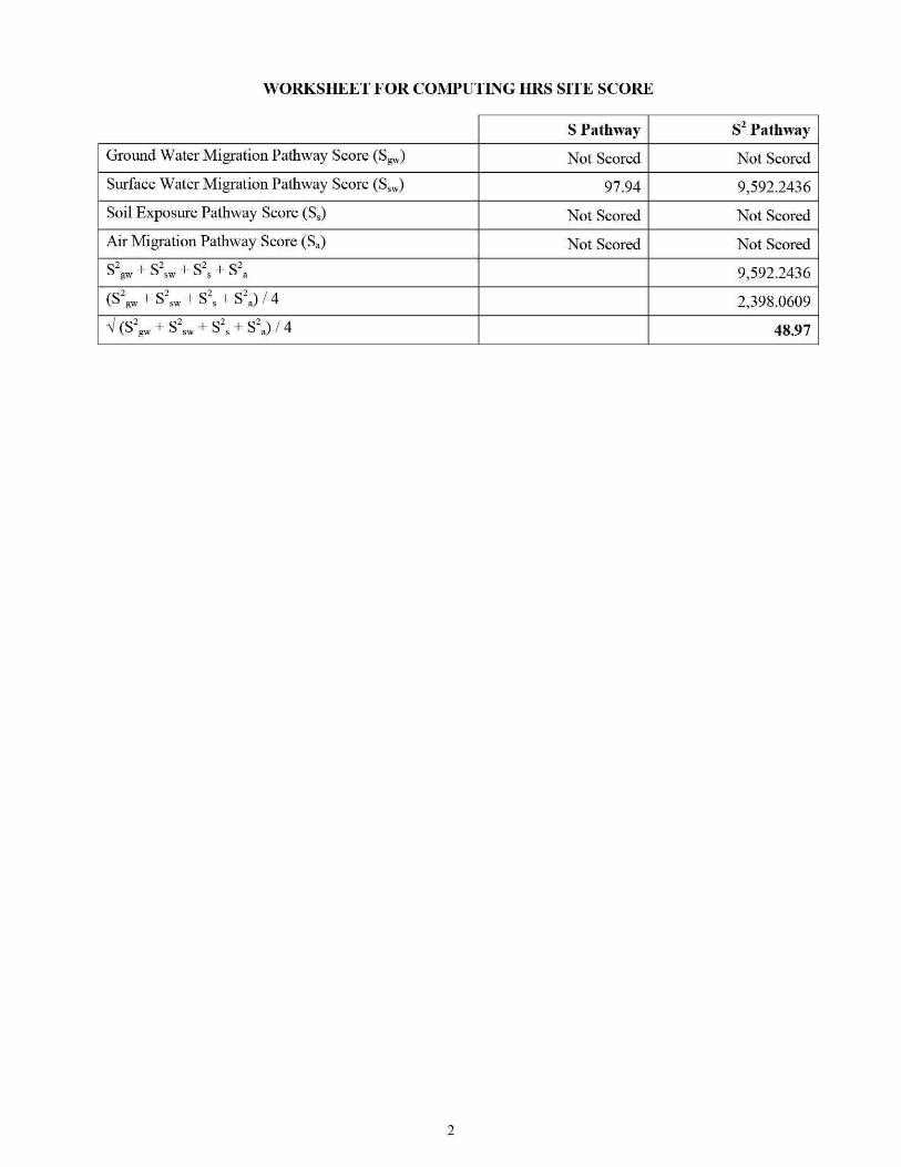
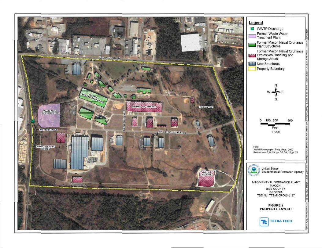
Legend
[Q) WWTP Discharge r---1 Former Waste Water L__j Treatment Plant
~ ~ ~ ~
r==l Former Macon Naval Ordnance t~ Plant Structures ~
Former Macon Naval Ordnance ~ ~ Explosives Handling and ~
Storage Areas ~ W New Structures ~ ~ --~ Property Boundary
Note
0 150 300 600
~~~F~e~e~t~~~ 17200
Aerial Photograph 8109 Maps 2009 References 6 8 13 pp 52 54 17 p 25
~
~ United States ~ ~ Environmental Protection Agency ~
~ MACON NAVAL ORDNANCE PLANT
MACON BIBB COUNTY
GEORGIA TDD No TTEMI-05-003-01 27
FIGURE2 PROPERTY LAYOUT
z
~
~ ~ ~
~ ~
[1tJ TETRA TECH c
~~- L------------------------_J~
Legend
June 2011 Sample Locations
Sediment Sample
Soil Sample
Background Wetland Sediment Sample
Background Soil Sample
Map Features
Creek
Drainage Ditch
Former Macon Naval Ordnance Plant
Wetland Areas
e3 C3
Freshw ater Palustrine Emergent Wetland
Freshw ater Palustrine ForestedShrub Wetland
500
Feet
112000
Map Source Aerial Photogaph ~Bing Maps 2009
1000
Property Boundary ~Ma con~Bibb County Board of Tax Assessors Wetlands - U S Fish and Wildlrte Service National Wetlands Inventory Reference 9 pp 1 3
Notes D -or ainage D~ch Hg ~Mercury
MNOP -Ma con Naval Ordnance Plant PPE - Probable Point of Entry SD ~sediment Sample SF - Swface Soil Sample W - Wetland
United States Environmental Protection Agency ~
MACON NAVAL ORDNANCE PLANT MACON
BIBB COUNTY GEORGIA
TOO No TTEMI-05-003-0127
FIGURE 3 SAMPLING LOCATIONS
z sect
~
~
I (11) TETRA TECH ~ L_ ____________________________ _J ~
REFERENCES
1 US Environmental Protection Agency (EPA) Hazard Ranking System Title 40 Code of Federal Regulations Part 300 55 Federal Register 51532 December 14 1990 138 Pages A complete copy of the Hazard Ranking System is available at httpwwwepagovsuperfundsitesnpVhrsresindexhtmHRS Rule
2 EPA Superfund Chemical Data Matrix (SCDM) January 2004 Updated December 2011 Excerpt 75 Pages A complete copy of SCDM is available at http epa gov I superfund sitesnpVhrsrestoo ls scdm htm
3 Tetra Tech EM Inc (Tetra Tech) 15-Mile Surface Water Migration Pathway with NWI Wetlands US Geological Survey (USGS) 75 Minute Series Topographic Maps of Georgia Quadrangles Macon West (1985) Macon East (1985) Warner Robins NW (1986) Warner Robins NE (1985) 1 Map
4 Tetra Tech Project Note to File with Attachment Subject Coordinates for Macon Naval Ordnance Plant Attachment Google Earth Map November 2 2011 2 Pages
5 EPA Envirofacts Warehouse Macon Naval Ordnance Plant Query Comprehensive Environmental Response Compensation and Liability Information System (CERCUS) (Data Extracted August 15 2011) Accessed on August 31 2011 2 Pages CERCUS Accessed on-line at httpiaspubepagovenvirocerclisqueryget reportpgm sys id=GAD003302676
6 Tetra Tech Project Note to File with Attachments Subject Macon-Bibb County Parcel Maps and Property Cards for the Former Macon Naval Ordnance Plant Property Attachment Parcel Maps and Property Cards September 7 2011 64 Pages
7 Tetra Tech Final Expanded Site Inspection Report Allied Industrial Park Macon Bibb County Georgia September 29 2009 Excerpt 197 Pages
8 Department of the Navy Bureau of Yards and Docks US Naval Ordnance Plant Macon GA Master Shore Station Development Plan Part II Section 2 General Development Plan- Existing Approved March 19 1965 1 Page
9 Tetra Tech Project Note to File with Attachments Subject June 2011 Supplemental Sampling Event Attachments Figure and Logbook Notes September 1 2011 10 Pages
10 Tetra Tech Draft Quality Assurance Project Plan Macon Naval Ordnance Plant June 20 2011 20 Pages
11 EPA Region 4 Science and Ecosystem Support Division (SESD) Final Analytical Report Project No 11-0536 August 1 2011 24 Pages
12 Science Applications International Corporation (SAIC) Draft Hazardous Site Response Act (HSRA) Compliance Status Report Former Macon Naval Ordnance Plant Allied Industrial Park Macon Georgia Prepared for the US Army Corp of Engineers (USACE) Savannah District August 2000 1 626 Pages
13 RUST Environment and Infrastructure Inc Site Investigation Report Allied Industrial Park Site Macon Georgia Prepared for the USACE Savannah District May 1997 390 Pages
14 Environmental Science amp Engineering Inc (ESE) Final Engineering Report Confirmation Study of Former Macon Naval Ordnance Plant Macon Bibb Co Georgia Prepared for the Defense Environmental Restoration Program USACE Mobile District September 1990 129 Pages
8
15 Tetra Tech Project Note to File Subject Allied Industrial Park Property Owners Internet Search September 9 2011 1 Page
16 Tetra Tech Final Expanded Site Inspection Report Former Macon Naval Ordnance Landfill Macon Bibb County Georgia September 29 2009 Excerpt 135 Pages
17 EPA Environmental Sciences Division Aerial Photographic Analysis Former Macon Naval Ordnance Plant Landfill Site Macon Georgia November 1999 57 Pages
18 RUST Environment and Infrastructure Inc Final Site Investigation Report Former Naval Ordnance Plant Landfill (FMNOL) Site Macon Georgia Prepared for the Savannah District US Army Corps of Engineers (USACE) September 1997 142 Pages
19 Georgia Environmental Protection Division Hazardous Waste Management Branch Preliminary Assessment Armstrong World Industries Inc Prepared for the US EPA August 10 2007 18 Pages
20 SAIC Final Phase I Remedial Investigation Report Former Macon Naval Ordnance Plant Landfill Site Macon Georgia Prepared for the USACE Savannah District October 2000 483 Pages
2 1 SAIC Letter to the US Army Corps of Engineers Subject Monitoring Report for Post-Test Groundwater Sampling (October-November 2004) Pilot-Scale Alternatives Assessment and Implementation Plan for Groundwater VOC Reduction at the Former Macon Naval Ordnance Plant January 19 2005 240 Pages
22 Georgia Environmental Protection Division (EPD) Preliminary Assessment Former Macon Naval Ordnance Landftll and Allied Industrial Park Macon Bibb County Georgia February 1992 21 Pages
23 Department of the Army Technical Manual TM 9-1300-214 Military Explosives September 1984 Most Recent Revision September 1990 355 Pages
24 EPA Region 4 SESD Operating Procedure for Soil Sampling Number SESDPROC-300-Rl November 1 2007 22 Pages Accessed on-line at httpwwwepagovregion4sesdlfbgstpSoilshySampling pdf
25 EPA Region 4 SESD Operating Procedure for Sediment Sampling Number SESDPROC-200-R2 September 8 2010 23 Pages Accessed on-line at httpwww epa govregion4sesdlfbq stpSediment-Sampling pdf
26 EPA Region 4 Macon Naval Ordnance Plant Chain of Custody Record No 063011-0001 Project No 11-0536 July 1 2011 2 Pages
27 EPA Region 4 SESD Analytical Support Branch Laboratory Operations and Quality Assurance Manual January 6 2011 205 Pages
28 Tetra Tech Project Note to File Subject Data Review Validation and Verification Conducted at the Science and Ecosystem Support Division (SESD) Analytical Support Branch January 6 2009 1 Page
29 Tetra Tech Record of Telephone Conversation Subject Definitions of Minimum Reporting Limit Minimum Quantitation Limit Contract Required Quantitation Limit and Sample Quantitation Limit Between Shanna Davis Environmental Scientist and Charlie Appleby Quality Assurance Section SESD Management and Technical Services Branch EPA Region 4 July 9 2008 1 Page
9
30 Tetra Tech Project Note to File with Attachments Subject Soil Map for Macon Naval Ordnance Plant Attachments Soil Map Map Legend and Map Unit Legend September 2 2011 4 Pages
31 Tetra Tech Project Note to File with Attachment Subject Summary of J-Qualified Data Attachment J-Qualified Data September 6 2011 2 Pages
32 EPA Office of Emergency and Remedial Response Using Qualified Data to Document an Observed Release and Observed Contamination Quick Reference Fact Sheet EPA-540-F-94-028 November 1996 18 Pages
33 Tetra Tech Project Note to File Subject June 2011 Supplemental Sampling Event Observations September 2 2011 1 Page
34 EPA Region 4 SESD Final Analytical Report Project No 09-0441 August 22 2011 181 Pages
35 EPA Region 4 SESD Final Analytical Report Project No 09-0441 August 22 2011 155 Pages
36 US Department of the Interior Fish and Wildlife Service National Wetlands Inventory Maps of Georgia Macon West Macon East Warner Robins NE Warner Robins SE 1995 4 Maps
37 Tetra Tech Record of Telephone Conversation Subject Fishing on Rocky Creek in Macon Bibb County Georgia Between Quinn Kelley Environmental Scientist and Steve Schleiger Biologist GADNR Wildlife Resources Division September 9 2011 1 Page
38 Tetra Tech Project Note to File with Attachment Subject Stream Flow Data for Tobesofkee Creek and the Ocmulgee River in Macon Bibb County Georgia Attachment USGS 2010 Water-Data Reports for Tobesofkee Creek and the Ocmulgee River September 6 2011 17 Pages
39 Tetra Tech Project Note to File with Attachment Subject Ocmulgee Watershed Stream Evaluations Attachment 2002 Georgia Section 303(d) Listed Streams Ocmulgee River Water Management Plan Table 2-6 September 9 2011 3 Pages
40 GADNR Environmental Protection Division Water Quality in Georgia 2008-2009 Approved November 10 2010 505 Pages Accessed on-line at httpwwwgaepdorgDocuments305bhtml
41 Macon-Bibb County Planning and Zoning Commission Comprehensive Plan 2030 Community Assessment February 2006 415 Pages Accessed on-line at httpwwwmaconbibbpzorgartman2uploads1CP2030 1pdf
42 GADNR EPD Site Reconnaissance Inspection Trip Report Armstrong World Industries Inc Macon GA July 192007 11 Pages
43 GADNR Guidelines for Eating Fish from Georgia Waters 2010 Update 30 Pages Accessed onshyline at httpwwwgaepdorgDocumentsfish guidehtml
44 Federal Emergency Management Agency Flood Insurance Rate Map for Bibb County and Incorporated areas Georgia Excerpt ofPanel144 of265 Community-Panel Number 130011 0144 F Effective April2 2007 3 Pages
45 Macon Water Authority Operations Water Reclamation Facilities Accessed on September 7 2011 4 Pages Accessed on-line at httpmaconwaterorgwater-reclamation-facilities
10
46 EPA Enforcement and Compliance History Online (ECHO) with Attachments Macon Water Authority Rocky Creek Water Reclamation Facility Report Generated November 1 2011 8 Pages Attachments ECHO Effluent Data and Google Earth Map Depicting NPDES Permit Outfall Accessed on-line at httpwwwepa-echogovcgishybinget1cReportcgitool=echoampIDNumber=ll0007498412
47 Regulationsgov Docket Folder Sutmnary National Priorities List Notice of Proposed Rulemaking ~Armstrong World Industries Docket ID EPA-HQ-SFUND-2010-0640 Accessed on January 3 2012 1 Page Accessed on-line at httpwwwregulationsgov docketDetaildct=FR252BPR252BN252B0252BSRmp= lOp o=OD=EPA-HQ-SFUND-201 0-0640
11
SITE DESCRIPTION
The former Macon Naval Ordnance Plant (MNOP) property currently the Allied Industrial Park (AlP) covers about 433 acres in area and is located in an industrialized area in the southern portion of Macon Bibb County Georgia (Refs 3 7 p 2 8) (see Figure 1 of this Hazard Ranking System [HRS] documentation record) Specifically the geographic coordinates for the MNOP property are latitude 32deg 46 3957 north and longitude 83deg 38 2283 west (as measured from the approximate location of surface soil sample MNOP-04-SF collected during the EPA June 2011 Supplemental Sampling Event) (Ref 4) The US Environmental Protection Agency (EPA) identification number for the MNOP property as recorded in the Comprehensive Environmental Response Compensation and Liability Information System (CERCUS) database is GAD003302676 (Ref 5)
Land uses on the MNOP property are predominantly commercial and heavy industrial (Refs 6 pp 2 5 12 13 15 21 24 25 26 27 28 29 32 33 36 41 45 47 49 51 54 57 59 60 15) The MNOP property is bordered to the north by Guy Paine Road to the east by Mead Road and the Norfolk Southern railroad tracks to the southeast by Graphic Packaging to the south by the Macon Water Authority (MWA) Rocky Creek Water Reclamation Facility and by the Armstrong World Industries (A WI) remote landfill the former Macon Naval Ordnance Landfill (FMNOL) and Rocky Creek and to the west by the AWl plant property (Refs 3 4 p 2 7 p 2 Appendix A p A-2)
For HRS scoring the site consists of one source and associated releases Source No 1 is contaminated soil on the eastern section of the MNOP property Source No 1 contains mercury (see Section 22 of this HRS documentation record) Mercury has also been detected at significant levels in sediments collected in wetlands that receive runoff from Source No 1 via Drainage Ditch 4 indicating that a release has occurred to the surface water migration pathway (see Section 40 of this HRS documentation record) (also see Figures 2 and 3 of this HRS documentation record)
OPERATIONAL AND REGULATORY IDSTORY
MNOP was constructed and operated by the Reynolds Corporation before World War II for production of ordnance (Refs 12 p 1-1 14 p 2-9) The Navy assumed operations in 1941 and continued to manufacture ordnance until1965 Ordnance manufactured at the MNOP included flares small primers detonators and other triggering mechanisms (Ref 13 p 2 14 p 2-9) The total area of the MNOP was approximately 433 acres which extended from Guy Paine Road to the north Mead Road to the east Rocky Creek to the south and the Central of Georgia Railroad tracks to the west (Refs 8 12 p 2-9 14 p 2-9)
Mter it was declared surplus by the Navy the property was sold in December 1965 to the Maxson Electronics Company (Maxson) ofNew York Maxson continued to manufacture ordnance under contract with the Navy until it sold the property to Allied Chemical Corporation (Allied Chemical) in 1973 Allied Chemical manufactured automobile seat belts at the property and used all or nearly all of the buildings underground storage tanks (UST) and aboveground storage tanks (AST) and utilities Allied Chemical sold the property in 1980 to the Macon-Bibb County Industrial Authority (MBCIA) which renamed the property the Allied Industrial Park MBCIA currently leases or sells buildings as office and warehouse space to various industrial and commercial businesses on the AlP property (Refs 7 Appendix A p A-3 13 pp 1 2 3 14 p 2-9 15)
During ordnance manufacturing operations structures at the MNOP included numerous buildings several miles of paved roads fueling facilities ASTs and USTs solvent storage buildings explosives storage magazines a bunker area a metals plating facility and a sewage treatment plant (also referred to as a wastewater treatment plant [WWTP]) and the FMNOL (Refs 8 13 p 2 14 pp 2-9 2-102-11 2-12 Appendix A pp A-3 through A-8)
The MNOP WWTP was located near the western boundary of the property was constructed in the early 1940s and operated until the early 1970s The WWTP was designed to handle only sewage generated by
12 Site Description
the ordnance plant however chemicals used in the ordnance plant may have been disposed of in drains that connected to the WWTP (Ref 13 pp 10 52) (see Figure 2 of this HRS documentation record)
The primary metal plating facility at MNOP was located in Building 5 The metal plating operation began in the 1940s and continued through Maxsons and Allied Chemical s operation of the facility until 1980 The metal plating facility used cyanide solvents acid baths caustic baths and hydraulic oil Records indicate that the plating operation generated chrome sludge during Allied Chemical s use of the facility It is not known how this sludge was managed or disposed of (Ref 13 pp 11 52) Metal shavings were centrifuged to remove excess oils in the oil recovery area These oils were reportedly allowed to drain onto the ground surface (Ref 13 pp 11 52) (see Figure 2 of this HRS documentation record)
Explosive compounds were either handled or stored at many areas throughout the MNOP property including numerous small dryer buildings ordnance magazines and blending and weighing houses (Ref 13 pp 11 12 54) (see Figure 2 of this HRS documentation record) According to a technical manual prepared by the Department of the Arn1y military explosives such as those that were manufactured at the MNOP contained mercury compounds as initiating agents including mercury fulminate (Ref 23 pp 7-5 7-8) Building 109 located in the eastern portion of the MNOP was a primary explosives production site (Ref 13 pp 11 12 54) (see Figure 2 of this HRS documentation record) Soil samples collected from this area during the US Army Corps of Engineers (USACE) 1996 site investigation contained mercury (Ref 13 pp 58 83 84)
FMNOL was reportedly used for disposal of solid wastes and ordnance throughout the operational history (1941 to 1974) of the MNOP facility and intermittent dumping continued thereafter throughout the 1980s (Refs 16 p 3 17 pp 42 43 46 47 18 p 2 20 p i) The landfill was also used for disposal of used parts and construction debris (Refs 14 p 2-11 18 p 2) A fenced explosives demolition area located near the toe of the landfill was used for testing and demolishing explosives primarily detonators flares and primers manufactured at the MNOP Flammable materials were reportedly burned in this area as well (Ref 14 pp 2-11 3-9) The FMNOL is scored as part of the AWl site listed on the EPA NPL under CERCUS ID No GAN000410033 at docket number EPA-HQ-SFUND-2010-0640-0002 (Ref 47)
PREVIOUS INVESTIGATIONS
Several investigations have been conducted at MNOP between 1989 and 2011 Table 1lists the previous investigations at MNOP including the hazardous substances detected in the samples collected
TABLE 1 Summary of P revious Investigations
Hazardous Company Samples Substances
Agency Investigation Date Collected Detected R efer ences Beaver Environmental 1989 Soil Metals 13 p 3 Engineering Assessment
Environmental Confirmation 1990 Soil ground Arsenic 14 pp I 2-1 3-4 3-6 Science and Study of the water and Cadmium 3-9 3-11 4-2 4-3 4-Engineering Former Macon sediment Chromium 11 4-12
Naval Ordnance Lead Plant TCE
USACE Site Investigation 1996 Soil ground Cadmium 13 pp vi 1 13 20 Savannah District water surface Chromium 27 28 55 through 60
water and Lead 63 71 through 92 94 sediment Mercury through 104 106 107
13 Site Description
TABLE 1 Summary of P revious Investigations
Hazardous Company Samples Substances
Agency Investigation Date Collected Detected References USACE Hazardous Site 1998 to 2000 Soil ground Arsenic 12 pp i ii1-1 1-10 Savannah District Response Act water surface Cadmium 2-9 2-19 2-33
(HSRA) water and Chromium Appendix 0 pp 015 Compliance Status sediment Lead through 053 Report Zinc
TCE PCE Benzo( a )pyrene
USACE Post-Test 2004 Ground water DCE 21 pp 1 2 5 11 Savannah District Groundwater TCE
EPA
EPA
Notes
DCE EPA PCB PCE svoc TCE USACE voc
Sampling
Expanded Site May 2009 Inspection
Supplemental June 2011 Sampling Event
Dichloroethane US Environmental Protection Agency Polychlorinated biphenyl Tetrachloroethylene Semivolatile organic compound Trichloroethylene US Army Corps of Engineers Volatile organic compound
Soil ground water surface water and sediment
Soil and sediment
PCE Vinyl Chloride Cadmium 7 pp 1 6 7 Chromium Appendix B pp B-12 Copper through B-69 B-71 Lead through B-75 B-77 Manganese through B-113 Mercury Nickel PCBs Pesticides SVOCs VOCs Mercury 9 pp 1 3 11 pp 5
8 192 1
In June 2011 EPA conducted a supplemental sampling event at the MNOP property The purpose of the supplemental sampling was to further delineate mercury contamination previously found in Drainage Ditch 4 that runs along the eastern portion of the property (Refs 3 7 Appendix A p A-4 Appendix B p B-95 (also see Figure 3 of this HRS documentation record) Six surface soil samples (0 to 6 inches below ground surface [bgs]) were collected (including one background and one duplicate) from the eastern portion of the MNOP and 10 sediment samples (0 to 3 inches bgs) were collected (including one duplicate) from Drainage Ditch 4 which receives runoff from the eastern portion ofMNOP and flows south to Rocky Creek (Refs 9 10 pp 3 4 Appendix B p B-1 ) All soil and sediment samples were analyzed for mercury (Refs 9 10 pp 5 10 Appendix B p B-3) Mercury was detected in surface soil sample MNOP-04-SF at a concentration of 040 milligrams per kilogram (mgkg) in Drainage Ditch 4 sediment sample MNOP-D4-07-SD at a concentration of 046 mgkg and in Drainage Ditch 4 wetland sediment sample MNOP-D4-W-09-SD at a concentration of 11 mgkg (Ref 11 pp 8 19 21)
14 Site Description
Source No 1
22 SOURCE CHARACTERIZATION
221 SOURCE IDENTIFICATION
Number of source 1
Name of source Contaminated soil on the MNOP property
Source Type Contaminated Soil
Description and Location of Source (with reference to a map of the site)
Source No 1 consists of contaminated soil on the eastern portion of the MNOP property (Refs 9 p 3 11 p 8) (see Figure 3 of this HRS documentation record) MNOP operated as an ordnance manufacturing facility from before World War II until1973 (Ref 12 p 1-1 1-7) Ordnance manufactured at MNOP included flares small primers detonators and other triggering mechanisms (Ref 13 p 2)
According to a technical manual prepared by the Department of the Army military explosives such as those that were manufactured at the MNOP contained mercury compounds as initiating agents including mercury fulminate (Ref 23 pp 7-5 7-8) Explosive compounds were either handled or stored in many areas throughout the MNOP property including numerous small dryer buildings ordnance magazines and blending and weighing houses Specifically Building 109 located in the eastern portion of the MNOP near Source No 1 was a primary explosives production site (Ref 13 pp 11 12 54) (see Figures 2 and 3 of this HRS documentation record) Soil samples collected from this area during the US Army Corps ofEngineers (USACE) 1996 site investigation and the EPA June 201 1 supplemental sampling event contained mercury (Refs 9 p 1 11 p 8 13 pp 58 83 84)
15 Site Description
Source No 1
222 HAZARDOUS SUBSTANCES ASSOCIATED WITH THE SOURCE
EPA J une 2011 Supplemental Sampling
Background and Source Samples
The background and source soil samples listed in Table 2 were collected during the EPA June 2011 supplemental sampling event (Refs 9 pp 1 3 7 9 11 p 3) The background soil sample was collected from the north-central portion of the MNOP property where no site-related activities have been known to occur (Refs 8 9 pp 1 3 17 pp 11 17 21 25 29 33 37 41 45) The source soil sample was collected from the eastern portion of the MNOP property where mercury has been previously detected near where facility operations were known to have occurred and where explosives were handled and stored (Refs 7 Appendix A p A-4 9 p 3 13 pp 11 12 54) The background and source surface soil samples were collected at a depth ofO to 6 inches bgs (Refs 9 p 1 10 Appendix B p B-1)
Background and Source No 1 surface soil samples were collected during the same sampling event from the same type of soil (sandy loam) and in accordance with the same sampling procedures (Refs 9 pp 1 6 9 10 p 4 30 pp 1 3) Surface soil samples were collected in accordance with the EPA Region 4 SESD Field Branch Quality System and Technical Procedures for Soil Sampling SESDPROC-300-R1 (Refs 9 p 6 10 p 4 24) The locations of the background and source soil samples are depicted in Reference 9 page 3 and are listed in Reference 10 Appendix B page B-1 (see Figure 3 of this HRS documentation record) Chain-of-custody records are provided in Reference 26 Logbook notes are provided in Reference 9 Attachment 2
TABLE 2 Background and Source Soil Sample Descriptions - June 2011
SampleiD Sample Location
Background sample collected MNOP-01-SF from the north-central portion
of the MNOP property
Source sample collected from the eastern portion of the
MNOP-04-SF MNOP property where
Notes
bgs ID MNOP No SF
explosives were handled and stored
Below ground surface Identification munber Macon Naval Ordnance Plant Number Surface sample
Depth Date (inches bgs) Sampled References
0 to 6 06292011 9 pp3 726 p 1
9 pp3 9 13 p 54 0 to 6 06302011 26 p 1
16 Site Description
Source No 1
Background and Source Concentrations
Background and Source No 1 samples listed in Table 3 were analyzed for mercury in accordance with EPA Method 2455 and the EPA Region 4 Analytical Support Branch (ASB) Laboratory Operations and Quality Assurance Manual (LOQAM) January 2011 (Refs 9 p 1 11 p 1 27) EPA Region 4 SESD reviewed all data according to the contract statement of work (SOW) and EPA guidelines (Refs 28 11 p 1) The minimum reporting limits (MRL) are listed on the analytical data sheets in Reference 11 Each MRL is sample-specific and corresponds to the lowest quantitative point on the calibration curve it is adjusted for the amount of sample prepared and any dilutions performed as well as for percent moisture The MRLs are equivalent to sample quantitation limits (SQL) (Ref 29)
TABLE3 Analytical Results for Background and Source No 1 Samples - June 2011
Hazardous Sample Hazardous Substance
Designation SampleiD Substance Concentration MRL
Background MNOP-01-SF Mercury 0073J (013) mgkg 0050mgkg
Source No 1 MNOP-04-SF Mercury 040 mgkg 0050mgkg
Notes
() ID
Concentrations shown in parentheses were adjusted in accordance with References 31 and 32 Identification number
J mglkg MNOP MRL No SF
The identification of the analyte is acceptable the reported value is an estimate (Ref 11 p 4) Milligram per kilogram Macon Naval Ordnance Plant Minimum reporting limit Number Surface sample
17
References
11 pp 4 5 31
11 p 8
Site Description
Source No 1
223 HAZARDOUS SUBSTANCES AVAILABLE TO A PATHWAY
The sample collected from Source No 1 contains mercury (Refs 9 p 3 11 p 8) (also see Table 3 of this HRS documentation record) Source No 1 consists of contaminated soil on the eastern portion of the MNOP property (Refs 9 p 3 11 p 8) The MNOP operated as an ordnance manufacturing facility from before World War II until1973 (Ref 12 pp 1-1 1-7) Ordnance manufactured at the MNOP included flares small primers detonators and other triggering mechanisms (Ref 13 p 2) Military explosives such as those that were manufactured at the MNOP contained mercury compounds (mercury fulminate) as initiating agents (Ref 23 pp 7-1 7-5 7-8) Building 109 located in the eastern portion of the MNOP near Source No 1 was a primary explosives production site (Ref 13 pp 11 12 54) (see Figure 2 of this HRS documentation record) Soil samples collected from this area during the USACE 1996 site investigation contained mercury (Ref 13 pp 58 83 84) Analytical results for sediment samples collected from Drainage Ditch 4 indicate overland migration of mercury from Source No 1 (see Additional Supporting Data in Section 41211 of this HRS documentation record) Analytical results for sediment samples collected from wetlands contiguous with Rocky Creek and downstream of Source No 1 indicate that a release of hazardous substances has occurred to the surface water migration pathway as documented in Section 40 of this HRS documentation record No run-on or runoff control systems were observed during the EPA June 2011 supplemental sampling at MNOP specifically in the area of Source No 1 (Ref 33) Drainage Ditch 4 drains the eastern portion of MNOP and directs runoff to Rocky Creek and adjacent wetlands (Refs 7 Appendix A p A-4 9 p 3) (see Figure 3 of this HRS documentation record) Therefore a containment factor value of 10 as noted in Table 4 was assigned for the surface water migration pathway (Ref 1 Section 4121211)
TABLE 4 Containment Factors for Source No1
Containment Containment Description Factor Value References
Gas release to air NS NA
Particulate release to air NS NA
Release to ground water NS NA
Release via overland migration or flood no run-on 1 Section4121211 9p 3 33 or runoff control system runoff from Source No 1 10 see Figure 3 of this HRS enters Rocky Creek via Drainage Ditch 4 documentation record
Notes
NA Not applicable NS Not scored
18 Site Description
Source No 1
2421 SOURCE HAZARDOUS WASTE QUANTITY
24211 Hazardous Constituent Quantity
The information available is not sufficient to evaluate Tier A hazardous constituent quantity as required by Reference 1 Section 24211 Available Source No 1 data may not represent the extent of contamination associated with the source and are insufficient to determine constituent quantity
Hazardous Constituent Quantity Assigned Value NS
24212 Hazardous Wastestream Quantity
The information available is not sufficient to evaluate Tier B hazardous wastestream quantity as required by Reference 1 Section 24212 Available Source No 1 data may not represent the extent of the wastestream associated with the source
Hazardous Wastestream Quantity Assigned Value NS
24213 Volume
The information available is not sufficient to evaluate Tier C volume as required by Reference 1 Section 24213
Volume Assigned Value 0
24214 Area
One soil sample was collected from Source No 1 during the EPA June 2011 supplemental sampling event (Ref 9 pp 3 9) As a result it is not possible to determine a source area for Source No 1 Therefore the area of Source No 1 is undetermined but is greater than zero
Sum (square feet [ff]) gt0 Equation for Assigning Value (Table 2-5) Area (A)34000
Area Assigned Value gt0
24215 Calculation of Source Hazardous Waste Quantity Value
Source No 1 is assigned a source HWQ value of greater than zero but unknown (Ref 1 Section 242 15)
Source HWQ Value gt0
19 Site Description
SUMMARY OF SOURCE DESCRIPTIONS
TABLES Summary of Source Descriptions
Containment Factor Value by Pathway
Source Surface Air Source Hazardous Water Hazardous Constituent Ground Overland Waste Quantity Water Flood Gas Particulate
Source Quantity Complete (Ref 1 (Ref 1 (Ref 1 (Ref 1 No Value (YesNo) Table 3-2) Table 4-2) Table 6-3) Table 6-9)
1 gt0 No NS 10 NS NS
Notes
NS Not scored Total Source Hazard Waste Quantity Value gt0
Other Possible Source
Contaminated Soil on Western Portion of MNOP - During the EPA May 2009 expanded site inspection (ESI) conducted at the MNOP (currently known as AlP) soil samples were collected on the western portion of the MNOP property (Ref 7 pp 1 6 Appendix A p A-4) Soil samples AIP-124-SB and AIP-134-SF contained mercury at concentrations of088 mglkg and 13 mgkg (Ref 34 pp 120 166) Soil sample AIP-124-SB was collected from the area where the BlendingMixing Houses were located (Refs 7 Appendix A p A-4 13 p 54) The BlendingMixing Houses were where MNOP mixed the explosives (Ref 13 pp 11 12) Military explosives such as those that were manufactured at MNOP contained mercury compounds (mercury fulminate) as initiating agents (Ref 23 pp 7-1 7-5 7-8) Soil sample AIP-134-SF was collected from the northwestern portion of the MNOP in the area where the MNOP WWTP was formerly located (Refs 7 Appendix A p A-4 13 p 52) (see Figure 2 of this HRS documentation record) These areas drain into Drainage Ditch 2 which flows south and merges with the AWl drainage easement then flows into Rocky Creek (Ref 7 Appendix A p A-4) Contaminated soil on the western portion of MNOP drains towards the A WI site to the west of MNOP and not towards the PPE and observed release scored in this HRS documentation record (see Figure 3) therefore this other possible source is not scored in this HRS documentation record
20 Site Description
40 SURFACE WATERlflGRATION PATHWAY
41 OVERLANDFLOOD lflGRA TION COMPONENT- Drainage Ditch 4
4111 Definition of Hazardous Substance Migration Path for OverlandFlood Component
The hazardous substance migration pathway includes both the overland segment and the in-water segment that hazardous substances would take as they migrate away from sources The overland segment begins at the source and proceeds downgradient to the probable point of entry (PPE) to surface water The inshywater segment at the PPE continues in the direction of flow (Ref 1 Section 4 111)
Overland flow from Source No 1 (contaminated soil in the eastern portion of the MNOP property) is directed to Drainage Ditch 4 Drainage Ditch 4 is an intermittent drainage route located up gradient of the PPE along the eastern boundary of the MNOP property (Ref 9 pp 1 3) Surface water runofffrom Source No 1 flows overland about 625 feet and enters Drainage Ditch 4 Drainage Ditch 4 flows south for about 3250 feet and enters HRS-eligible palustrine forested wetlands adjacent to Rocky Creek The point where Drainage Ditch 4 enters the palustrine forested wetlands is PPE 1 Drainage Ditch 4 continues south within palustrine forested wetlands for about 1250 feet and enters Rocky Creek (Refs 3 36 Map 1) (also see Figure 3 of this HRS documentation record)
Rocky Creek flows east-southeast for about 1 mile before it converges with Tobesofkee Creek Tobesofkee Creek flows south-southeast for about 4 miles before it converges with the Ocmulgee River which flows for more than 95 miles thus completing the 15-mile surface water migration pathway target distance limit (TDL) east-southeast of Elberta Georgia (Ref 3)
The flow rate for Rocky Creek is estimated to be between 10 and 15 cubic feet per second (cfs) (Ref 37) Rocky Creek has several branches Specific stream channels are difficult to discern because of the extensive wetlands in the area (Refs 3 36) According to the US Geological Survey the mean flow rate for Tobesofkee Creek for water years 1937 to 2010 was 183 cfs and the mean flow rate for the Ocmulgee River for water years 1911 to 2010 was 2657 cfs (Ref 38 pp 3 10)
The southern portion of Drainage Ditch 4 is located within wetlands and the 100-year floodplain of Rocky Creek This area is prone to frequent flooding resulting in the mixing of water in the surrounding area (Refs 7 Appendix A p A-4 36 Map 1 44)
21 SW-OverlandFlood Migration Component
41 21 LIKELlliOOD OF RELEASE
41 211 OBSERVED RELEASE- Chemical Analysis
EPA June 2011 Supplemental Sampling
Background and Contaminated Samples
During the EPA June 2011 supplemental sampling event one background sediment sample MNOP-W-01-SD was collected from HRS-eligible palustrine forested wetlands west of and upgradient from Drainage Ditch 4 Contaminated sediment sample MNOP-D4-W-09-SD was collected from Drainage Ditch 4 within HRS-eligible palustrine forested wetlands downstream of the PPE Background and contaminated sediment samples were collected from HRS-eligible palustrine forested wetlands at depths ranging from 0 to 3 inches bgs (Refs 9 pp 1 3 8 9 36 Map 1)
The sediment samples were collected in accordance with the EPA Region 4 SESD Field Branches Quality System and Technical Procedures for Sediment Sampling SESDPROC-200-R2 (Refs 9 pp 1 6 10 p 4 25) The location of the background sediment sample is depicted on Figure 3 of this HRS documentation record Chain-of-custody records are provided in Reference 26 Logbook notes are provided in Reference 9 pages 8 and 9
The background and contaminated sediment samples were collected during the same sampling event in accordance with the same sampling procedures and from the same type of HRS-eligible wetland (palustrine forested) (Refs 9 pp 1 3 6 36) (see Figure 3 of this HRS documentation record)
TABLE6 Background and Contaminated Sediment Samples - June 2011
Sample ID Sample Location
Background HRS-eligible palustrine forested wetlands
MNOP-W-01-SD west and upgradient of Drainage Ditch 4 upstream from site drainage
Drainage Ditch 4
MNOP-D4-W-09-SD HRS-eligible palustrine forested
Notes
bgs D HRS ID MNOP NA PPE SD w
wetlands
Below ground surface Ditch Hazard Ranking System Identification number Macon Naval Ordnance Plant Not applicable Probable point of entry Sediment sample Wetland
Distance Depth Date fromPPE 1 (bgs) Sampled References
9 p 8 26 p 2 36 Map 1
NA 0 to 3
06292011 Figure 3 of this
inches HRS documentation record
700 feet 0 to 3 06302011
9 pp 3 9 26 downstream inches p 2 36 Map 1
22 SW-Observed Release
Background and Contaminated Concentrations
The sediment samples listed in Table 7 were collected during the EPA June 2011 supplemental sampling event (Ref 9 pp 3 8 9) Sediment samples were analyzed for mercury in accordance with EPA Method 2455 and the EPA Region 4 ASB LOQAM January 201 1 (Refs 9 p 1 11 p 1 27) EPA Region 4 SESD reviewed all data according to the contract SOW and EPA guidelines (Refs 28 11 p 1 ) The MRLs are listed on the analytical data sheets in Reference 11 pages 21 and 22 Each MRL is sampleshyspecific and corresponds to the lowest quantitative point on the calibration curve it is adjusted for the amount of sample prepared and any dilutions performed as well as for percent moisture The MRLs are equivalent to SQLs (Ref 29)
TABLE 7 Analytical Results for Background and Contaminated Sediment Samples- June 2011
Sample Hazardous Description Sample ID Substance Concentration MRL
Background MNOP-W-01-SD Mercury 016J (0 29)
0050mgkg mgkg
Release
Notes
() D ID J mglkg MNOP MRL SD w
MNOP-D4-W-09-SD Mercury 11 mgkg 0050mgkg
Concentrations shown in parentheses were adjusted in accordance with References 31 and 32 Ditch Identification number The identification of the aualyte is acceptable the reported value is an estimate (Ref 11 p 4) Milligram per kilogram Macon Naval Ordnance Plant Minimum reporting limit Sediment sample Wetland
References
11 pp 4 22 31 32 pp8 18
11 p 21
23 SW-Observed Release
Additional Supporting Data
The sediment samples listed in Table 8 below were collected from Drainage Ditch 4 during the June 2011 supplemental sampling event (Ref 9 pp 1 3 9) Sediment sample MNOP-D4-W-08-SD was collected at PPE 1 The samples presented below show the presence of mercury along the overland drainage route Drainage Ditch 4 from Source No 1 to PPE 1 Because Drainage Ditch 4 is an intermittent water body up gradient of PPE 1 these sediment samples were not included as part of the surface water pathway inshywater segment discussion (Ref 9 pp 1 3) (see Figure 3 of this HRS documentation record)
TABLE 8 Drainage Ditch 4 Sediment Samples- June 2011
SampleiD
MNOP-D4-02-SD
MNOP-D4-04-SD
MNOP-D4-07-SD
MNOP-D4-W-08-SD
Notes
D4 ID
Drainage Ditch 4 Identification
Hazardous Substance
Mercury
Mercmy
Mercury
Mercmy
Concentration MRL
00511 mgkg 0050 mgkg
0083J mgkg 0050 mgkg
046 mgkg 0050 mgkg
0 19J mgkg 0050 mgkg
J mglkg MNOP MRL SD
The identification ofthe analyte is acceptable the rep011ed value is an estimate (Ref 11 p 4) Milligrams per kilogram Macon Naval Ordnance Plant Minimum rep011ing lirnit Sediment
w Wetland
24
Reference
11 pp 4 13
11 pp 4 16
ll p19
11 pp4 20
SW-Observed Release
Attribution
The MNOP was constructed before World War II and was operated as an ordnance manufacturing facility until1973 (Refs 12 p 1-1 13 p 2) Ordnance manufactured at the MNOP included flares small primers detonators and other triggering mechanisms (Ref 13 p 2) The total area of the MNOP was approximately 433 acres which extended from Guy Paine Road in the north to Rocky Creek in the south and Mead Road to the east and the Central of Georgia Railroad tracks to the west (Refs 8 18 p 2 22 pp 1 2)
Explosive compounds were either handled or stored in many areas throughout the MNOP property including numerous small dryer buildings ordnance magazines and blending and mixing houses (Ref 13 pp 11 12 54) According to a technical manual prepared by the Department of the Army military explosives such as those that were manufactured at the MNOP contained mercury compounds as initiating agents including mercury fulminate (Ref 23 pp 7-1 7-5 7-8) Building 109 located in the eastern portion of the MNOP near Source No 1 was a primary explosives production site (Ref 13 pp 11 12 54) (see Figures 2 and 3 of this HRS documentation record) Soil samples collected from this area during the US ACE 1996 site investigation and EPA June 2011 supplemental sampling event contained mercury (Refs 9 p 3 13 pp 58 83 84)
Other facilities in the area include the MBCIA which renamed the MNOP property the Allied Industrial Park and currently leases or sells buildings as office and warehouse space to various industrial and commercial businesses on the AlP property (Refs 7 Appendix A p A-3 13 pp 1 2 3 14 p 2-9 15) Politex US Inc (Politex) is the only manufacturing business that is currently located at the AlP Politex is a textile manufacturing firm that produces roofing membranes clothing and furniture padding and building materials (Ref 15) Politex is located on the western portion of the MNOP property (Refs 6 pp 42 through 49 7 Appendix A p A-3) Runoff and drainage originating from Politex does not enter Drainage Ditch 4 (Ref 7 Appendix A pp A-2 A-3) (see Figure 3 of this HRS documentation record) The propetty where Source No 1 soil sample MNOP-04-SF was collected is owned by the City of Macon and is operated as a recreational park that includes baseball fields (Refs 6 pp 7 8 7 Appendix A pp A-2 A-3 9 p 3)
Possible off-site sources also include the FMNOL A WI and the Rocky Creek water reclamation facility (RC WRF) A WI and FMNOL are currently listed on the EPA NPL under CERCUS ID No GAN000410033 at docket number EPA-HQ-SFUND-2010-0640-0002 (Ref 47) Runoff from FMNOL and A WI flows into Rocky Creek via a drainage easement The drainage easement enters Rocky Creek west and upstream of Source No 1 soil sample MNOP-04-SF and Drainage Ditch 4 Drainage Ditch 4 is located just west of the RC WRF (Ref 7 Appendix A p A-2)
The FMNOL was reportedly used for disposal of solid wastes and ordnance throughout the operational history (1941 to 1974) of the MNOP (Refs 8 17 pp 42 43 46 47 18 p 2) The landfill was also used for disposal of used parts and construction debris (Refs 14 p 2-11 18 p 2) During the EPA May 2009 ESI mercury was detected in soil samples collected from the FMNOL at concentrations ranging from 047 mgkg (FML-303-SF) to 47 mglkg (FML-304-SB) (Ref 35 pp 130 132)
Since 1948 AWl has operated an acoustic ceiling tile manufacturing plant on 130 acres of land west of the MNOP property (Ref 19 p 3) In 1980 A WI notified the Georgia Environmental Protection Division (GAEPD) that it was a generator of hazardous waste and A WI was classified as a conditionally exempt small quantity generator under the Resource Conservation and Recovery Act (RCRA) PCBs are the primary hazardous substance of concern for this facility not metals (Ref 19 pp 5 6)
The RC WRF located southeast of and downstream from MNOP provides wastewater treatment for the southern and western portions of the City of Macon Treated wastewater from this facility is discharged into the Ocmulgee River however RC WRF maintains a National Pollutant Discharge Elimination System (NPDES)-permitted discharge point at the southern property boundary (Refs 9 p 3 45 pp 2 3 46 pp 1 8) The NPDES permit requires RC WRF to monitor outfall discharges for biochemical oxygen
25 SW-Observed Release
demand total suspended solids pH chlorine fecal coliform nitrogen dissolved oxygen PCBs and phosphorus (Ref 46 pp 6 7) There are currently no documented releases of mercury at this location (Refs 9 p 3 46 pp 6 7)
The source sample collected from Source No 1 (contaminated soil on the eastern portion ofMNOP) during the EPA June 2011 supplemental sampling event contained mercury (Refs 9 p 3 11 p 8) (see Table 3 in Section 222 for Source No 1 of this HRS documentation record) Sediment samples collected from Drainage Ditch 4 which receives runoff from Source No 1 also contained mercury The presence of mercury in Drainage Ditch 4 documents the migration of releases from Source No 1 at the MNOP (Refs 9 p 3 11 pp 13 16 19 20 21) (also see Tables 6 and 7 in Section 41211 Observed Release of this HRS documentation record) Furthennore an observed release of mercury has been documented in HRS-eligible wetlands along Drainage Ditch 4 (Refs 9 p 3 11 p 21 36)
Mercury has been documented in Source No 1 in Drainage Ditch 4 and in palustrine forested wetlands indicating migration of hazardous substances from the MNOP property (see Table 3 in Section 222 for Source No 1 and Table 7 in Section 41211 Observed Release of this HRS documentation record)
Hazardous Substance in the Release
Mercury
Surface Water Observed Release Factor Value 55000
26 SW-Observed Release
412 DRINKING WATER THREAT
The drinking water threat was not scored because it is not expected to contribute significantly to the overall score
27 SW-Drinking Water Threat
4132 HUMAN FOOD CHAIN THREAT WASTE CHARACTERISTICS
41321 ToxicityPersistenceBioaccumulation
The toxicity persistence and bioaccumulation factor value for mercury detected in Source No 1 with containment factor values of greater than 0 is summarized in Table 9 The combined toxicity persistence and bioaccumulation factor value is assigned in accordance with Reference 1 Section 41321
TABLE 9 ToxicityPersistenceBioaccumulation
Toxicity Persistence
Toxicity Persistence Bioaccu- Bioaccumulation Hazardous Source Factor Factor mulation Factor Value (Ref Substance No Value Value1 Value2 1 Table 4-16) Reference
Mercury 1 10000 1 50000 5 X 10⁸ 2 p BI-8
Notes
Persistence factor value for rivers Bioaccumulation factor value for fresh water
ToxicityPersistenceBioaccumulation Factor Value 50000000000 (Ref 1 Section413214)
28 SW-Human Food Chain Threat
41322 HAZARDOUS WASTE QUANTITY
TABLE 10 Hazardous Waste Quantity
Source No Source Type Source Hazardous Waste Quantity
1 Contaminated soil gt0
Total Source Hazardous Waste Quantity gt0
One soil sample MNOP-04-SF was collected to represent Source No 1 (Ref 9 pp 3 9 see Table 3 in Section 222 for Source No 1 of this HRS documentation record) As a result it is not possible to calculate an area measurement for Source No 1 Therefore the area of Source No 1 is undetermined but is greater than zero In addition the hazardous waste quantity receives a minimum factor value of 100 for the surface water migration pathway because actual contamination at Level II concentrations is present in HRS-eligible palustrine forested wetlands and hazardous constituent quantity is not adequately determined (Ref 1 Section 2422)
Hazardous Waste Quantity Factor Value 100 (Ref 1 Table 2-6)
41323 CALCULATION OF HUMAN FOOD CHAIN THREAT WASTE CHARACTERISTICS FACTOR CATEGORY VALUE
The waste characteristics factor category was obtained by multiplying the toxicity persistence and hazardous waste quantity (HWQ) factor values subject to a maximum product of 1 x 10⁸
Then this product was multiplied by the bioaccumulation potential factor value subject to a maximum product of 1 x 10¹²
Based on this product a value was assigned in accordance with Reference 1 Table 2-7
ToxicityPersistence Factor Value 1000000 Hazardous Waste Quantity Factor Value 100
ToxicityPersistence Factor Value x Hazardous Waste Quantity Factor Value 1 x 10⁶
ToxicityPersistence Factor Value x Hazardous Waste Quantity Factor Value x Bioaccumulation Factor Value (50000) 5 x 10¹⁰
29
Waste Characteristics Factor Category Value 320 (Ref I Table2-7)
SW-Human Food Chain Threat
4133 HUMAN FOOD CHAIN THREATT ARGETS
41331 Food Chain Individual
An observed release of a hazardous substance having a bioaccumulation factor value of 500 or greater is documented in perennial surface water with a fishery downstream- specifically an observed release to Drainage Ditch 4 within HRS-eligible palustrine forested wetlands (Refs 9 p 3 11 pp 21 22 36 Map 1) (see Figure 3 of this HRS documentation record) Drainage Ditch 4 flows south for about 1250 feet within palustrine forested wetlands and joins Rocky Creek (Ref 9 p 3) Rocky Creek Tobesofkee Creek and the Ocmulgee River are designated as fisheries by the State of Georgias Ocmulgee River Watershed Management Plan (Refs 39 p 2 40 Appendix A pp A-89 A-91 41 p 4-14) Rocky Creek is fished between Broadway and its confluence with Tobesofkee Creek within the site TDL where it is accessible to the public fish are also harvested for consumption (Refs 3 37 42 pp 3 10 11) In 2007 GAEPD personnel observed people fishing in Rocky Creek east of Highway 41 The fishermen indicated to GAEPD personnel that they clean and eat the fish that they catch (Refs 19 p 9 42 pp 3 10 11) In addition Tetra Tech observed fishing gear including a fishing line and weight along Rocky Creek during the EPA 2009 ESI sampling event (Ref 7 Appendix D p D-14) Fish species caught for consumption in Rocky Creek include bream blackfish bass redear sunfish redbreast sunfish bluegill and brown bullhead catfish (Refs 19 p 9 37 42 p 3) The State of Georgia has issued fish consumption guidelines for the Ocmulgee River as a result of mercury contamination (Refs 9 p 9 43 p 41)
41332 Population
413321 Level I Concentrations
No Level I samples were collected
413322 Level II Concentrations
No Level II samples were collected
Food Chain Individual Factor Value 20 (Ref 1 Section41331)
413323 Potential Human Food Chain Contamination
Drainage Ditch 4 flows south for about 1250 feet within HRS-eligible palustrine forested wetlands and joins Rocky Creek (Ref 9 p 3) Rocky Creek is fished between Broadway and its confluence with Tobesofkee Creek within the site TDL where it is accessible to the public fish are also harvested for consumption (Refs 3 37 42 pp 3 10 11) Information is not available on the annual production offish caught in Rocky Creek therefore the annual production is undetermined but greater than 0
TABLE 11 Potential Population Targets
Population Dilution Type of Value (P) Weight
Annual Surface Average (Ref 1 (D) (Ref Identity Production Water Annual Table 4- 1 Table
of Fishery ~nds) _____Jody Flow (cfs) 18) 4-13_) P XD R eferences - - -
Small to 37 39 p 2
Rocky gt0 Moderate 10 to 15 003 01 0003
40 Appendix Creek
Stream A p A-91
I 41 p 4-14 Notes cfs Cubic feet per second
30 SW-Human Food Chain Threat
For the potential human food chain contamination factor value the sum of Pi x Di is divided by 10
31
Potential Human Food Chain Factor Value 00003 (Ref 1 Section 413323)
SW-Human Food Chain Threat
4142 ENVIRONMENTAL THREAT WASTE CHARACTERISTICS
41421 Ecosystem ToxicityPersistenceBioaccumulation
The ecosystem toxicity persistence and bioaccumulation factor value for mercury detected in Source No 1 with a containment factor value of greater than 0 is summarized in Table 12 The combined ecosystem toxicity persistence and bioaccumulation factor value is assigned in accordance with Reference 1 Section 4 1421
TABLE 12 Ecosystem ToxicityPersistenceBioaccumulation
Hazardous Source Substances No
Mercury 1
Notes
Ecotoxicity for fresh water Persistence value for rivers
Ecosystem Toxicity Persistence Factor Factor Value1 Value2
10000 1
Ecosystem Toxicity
Bioaccumula tion Bioaccu- Factor Value mulation (Ref 1 Table Value3 4-21) Reference
50000 5 X 10⁸ 2 p BI-8
Bioaccurnulation factor value for fresh water envirournental threat
Ecosystem ToxicityPersistenceBioaccumulation Factor Value 5 x 10⁸
(Reference 1 Section 414214)
32 SW-Environmental Threat
41422 HAZARDOUS WASTE QUANTITY
TABLE 13 Hazardous Waste Quantity
Source No Source Type Source Hazardous Waste Quantity
1 Contaminated soil gt0
Total Source Hazardous Waste Quantity gt0
One soil sample MNOP-04-SF was collected to represent Source No 1 (Ref 9 pp 3 9 see Table 3 in Section 222 for Source No 1 of this HRS documentation record) (Ref 9 pp 3 9) As a result it is not possible to calculate an area measurement for Source No 1 Therefore the area of Source No 1 is undetermined but is greater than zero In addition the hazardous waste quantity receives a minimum factor value of 100 for the surface water migration pathway because actual contamination at Level II concentrations is present in HRS-eligible palustrine forested wetlands and hazardous constituent quantity is not adequately determined (Ref 1 Section 2422)
Hazardous Waste Quantity Factor Value 100 (Ref 1 Table 2-6)
41423 CALCULATION OF ENVIRONMENTAL CHAIN THREAT WASTE CHARACTERISTICS FACTOR CATEGORY VALUE
The waste characteristics factor category was obtained by multiplying the ecosystem toxicity persistence and HWQ factor values subject to a maximum product of 1 x 10⁸
Then this product was multiplied by the bioaccumulation potential factor value subject to a maximum product of 1 x 10¹²
Based on this product a value was assigned in accordance with Reference 1 Table 2-7
Ecosystem ToxicityPersistence Factor Value 1000000 Hazardous Waste Quantity Factor Value 100
Ecosystem ToxicityPersistence Factor Value x Hazardous Waste Quantity Factor Value 1 x 10⁶
Ecosystem ToxicityPersistence Factor Value x Hazardous Waste Quantity Factor Value x Bioaccumulation Factor Value (50000) 5 x 10¹⁰
33
Waste Characteristics Factor Category Value 320 (Ref I Table2-7)
SW-Environmental Threat
4143 Environmental Threat Targets
Level I Concentrations
No Level I concentrations have been documented
Level II Concentrations
Actual contamination has been documented in wetland areas along Drainage Ditch 4 in Section 41211 of this HRS documentation record The sampling locations are shown in Reference 9 page 3 Wetland areas were identified from Reference 36 Wetlands Inventory Maps The wetland areas evaluated are palustrine forested (Refs 3 9 p 3 36)
Most Distant Level II Sample
Investigation Sample ID Sample Medium Hazardous Substance
June 2011 Supplemental Sampling MNOP-D4-W-09-SD Sediment Mercury
Location Drainage Ditch 4 about 700 feet downstream from PPE 1 References record)
3 9 p 3 11 p 21 36 (also see Table 7 of this HRS documentation
41431 Sensitive Environments
414311 Level I Concentrations
Sensitive Environments
Sensitive environments other than wetlands have not been identified within the 15-rnile surface water migration pathway TDL
Wetlands
No Level I wetlands were scored
414312 Level IT Concentrations
Sensitive Enviromnents
Sensitive environments other than wetlands have not been identified within the 15-rnile surface water migration pathway TDL
Wetlands
The wetlands were identified from Reference 36 Wetlands Inventory Maps The wetlands evaluated are palustrine forested (Refs 3 9 p 3 36) The southern portion of Drainage Ditch 4 is located within HRSshyeligible wetlands (Refs 3 9 p 3 36) The sediment sample evaluated at a Level II concentration is located in palustrine forested wetlands along Drainage Ditch 4 (Refs 3 9 p 3 36) The total wetland frontage from PPE 1 to the most downstream sample that contained Level II concentrations (MNOP-D4-W-090SD) is about 1400 feet or 026 mile (Refs 3 9 p 3 36) Both sides of Drainage Ditch4 within this segment contain HRS eligible wetlands so both sides of Drainage Ditch 4 were included in the calculation of the wetland frontage (Refs 3 9 p 3 36)
34 SW-Environmental Threat
TABLE 14 Level II Wetland Frontage
Wetland Water Body Wetland Fronta~e References
Palustrine forested Drainage Ditch 4 1400 feet or 026 mile 39p336
Total Wetland Frontage 1400 feet or 026 mile 3 9 p336
Total Wetland Frontage 1400 feet
The wetland ratings value for 026 mile is obtained from Reference 1 Table 4-24 and is 25
Wetland Value 25 (Ref 1 Table 4-24)
For wetlands subject to Level II concentrations the wetland value (25) is multiplied by 1 (Ref 1 Section 414311)
414313 Potential Contamination
Sensitive Environments
Wetland Value 25 x 1 Level II Concentrations Factor Value 25
(Ref 1 Section 414311)
Potential sensitive environments were not evaluated because the presence of sensitive environments other than wetlands has not been identified
Wetlands
The wetlands were identified from Reference 36 Wetlands Inventory Maps The wetlands evaluated for potential contamination are palustrine forested (Refs 3 9 p 3 36) Wetlands were measured from the farthest downstream sediment sample (MNOP-D4-W-09-SD) collected on Drainage Ditch 4 to the completion of the 15-mile surface water migration pathway TDL Wetland frontage from both sides of Drainage Ditch 4 Rocky Creek Tobesofkee Creek and the Ocmulgee River were measured (Refs 3 36) Wetlands that were evaluated as Level II were not included in the potential contamination wetland frontage The flow rate for Rocky Creek is estimated to be between 10 and 15 cfs (Ref 37) According to the US Geological Survey the mean flow rate for Tobesotkee Creek water years 1937 to 2010 was 183 cfs and the mean flow rate for the Ocmulgee River water years 1911 to 2010 was 2657 cfs (Ref 38 pp 3 10)
35 SW-Environmental Threat
TABLE 15 Wetland Frontage
Wetlands Value Based
Surface Water Type of Surface Wetland on Wetland Body Water Body Fronta~e Fronta~e References
Small to Moderate About 25 miles 75
1 Tables 4-13 4-24 3 36 Rocky Creek Stream 37
Moderate to Large About 775 150
1 Tables 4-13 4-24 3 36 Tobesoflcee Creek Stream miles 38 p3
Ocmulgee River Large Stream to
About 7 miles 150 1 Tables 4-13 4-24 3 36
River 38 p 10
Total Wetlands Value 375 1 Tables 4-13 4-24 3 36
TABLE 16 Potential Contamination
Sum of Wetlands Dilution D1 (W1 + S1)
Sensitive Value (WJ Weight (D1) (Ref 1 Surface Water Environments (Ref 1 Table (Ref 1 Section
Body Values (S1) 4-24) Table 4-13) 414333) References
Rocky Creek 0 75 01 75 33637
T obesoflcee Creek 0 150 001 15 33638 p 3
Ocmulgee River 0 150 0001 015 33638 p 10
Total Potential Contamination Factor Value 91 5
For wetlands subject to potential contamination the wetland value (915) is multiplied by 0 1 (Ref 1 Section 414313)
36
Wetland Value 9 15 x 01 Potential Contamination Factor Value 0915
(Ref 1 Section 4143 13)
SW-Environmental Threat
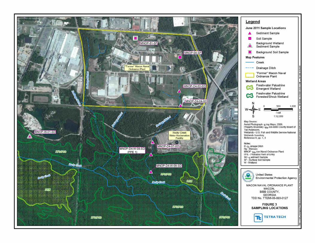
Legend
June 2011 Sample Locations
Sediment Sample
Soil Sample
Background Wetland Sediment Sample
Background Soil Sample
Map Features
Creek
Drainage Ditch
Former Macon Naval Ordnance Plant
Wetland Areas
e3 C3
Freshw ater Palustrine Emergent Wetland
Freshw ater Palustrine ForestedShrub Wetland
500
Feet
112000
Map Source Aerial Photogaph ~Bing Maps 2009
1000
Property Boundary ~Ma con~Bibb County Board of Tax Assessors Wetlands - U S Fish and Wildlrte Service National Wetlands Inventory Reference 9 pp 1 3
Notes D -or ainage D~ch Hg ~Mercury
MNOP -Ma con Naval Ordnance Plant PPE - Probable Point of Entry SD ~sediment Sample SF - Swface Soil Sample W - Wetland
United States Environmental Protection Agency ~
MACON NAVAL ORDNANCE PLANT MACON
BIBB COUNTY GEORGIA
TOO No TTEMI-05-003-0127
FIGURE 3 SAMPLING LOCATIONS
z sect
~
~
I (11) TETRA TECH ~ L_ ____________________________ _J ~
REFERENCES
1 US Environmental Protection Agency (EPA) Hazard Ranking System Title 40 Code of Federal Regulations Part 300 55 Federal Register 51532 December 14 1990 138 Pages A complete copy of the Hazard Ranking System is available at httpwwwepagovsuperfundsitesnpVhrsresindexhtmHRS Rule
2 EPA Superfund Chemical Data Matrix (SCDM) January 2004 Updated December 2011 Excerpt 75 Pages A complete copy of SCDM is available at http epa gov I superfund sitesnpVhrsrestoo ls scdm htm
3 Tetra Tech EM Inc (Tetra Tech) 15-Mile Surface Water Migration Pathway with NWI Wetlands US Geological Survey (USGS) 75 Minute Series Topographic Maps of Georgia Quadrangles Macon West (1985) Macon East (1985) Warner Robins NW (1986) Warner Robins NE (1985) 1 Map
4 Tetra Tech Project Note to File with Attachment Subject Coordinates for Macon Naval Ordnance Plant Attachment Google Earth Map November 2 2011 2 Pages
5 EPA Envirofacts Warehouse Macon Naval Ordnance Plant Query Comprehensive Environmental Response Compensation and Liability Information System (CERCUS) (Data Extracted August 15 2011) Accessed on August 31 2011 2 Pages CERCUS Accessed on-line at httpiaspubepagovenvirocerclisqueryget reportpgm sys id=GAD003302676
6 Tetra Tech Project Note to File with Attachments Subject Macon-Bibb County Parcel Maps and Property Cards for the Former Macon Naval Ordnance Plant Property Attachment Parcel Maps and Property Cards September 7 2011 64 Pages
7 Tetra Tech Final Expanded Site Inspection Report Allied Industrial Park Macon Bibb County Georgia September 29 2009 Excerpt 197 Pages
8 Department of the Navy Bureau of Yards and Docks US Naval Ordnance Plant Macon GA Master Shore Station Development Plan Part II Section 2 General Development Plan- Existing Approved March 19 1965 1 Page
9 Tetra Tech Project Note to File with Attachments Subject June 2011 Supplemental Sampling Event Attachments Figure and Logbook Notes September 1 2011 10 Pages
10 Tetra Tech Draft Quality Assurance Project Plan Macon Naval Ordnance Plant June 20 2011 20 Pages
11 EPA Region 4 Science and Ecosystem Support Division (SESD) Final Analytical Report Project No 11-0536 August 1 2011 24 Pages
12 Science Applications International Corporation (SAIC) Draft Hazardous Site Response Act (HSRA) Compliance Status Report Former Macon Naval Ordnance Plant Allied Industrial Park Macon Georgia Prepared for the US Army Corp of Engineers (USACE) Savannah District August 2000 1 626 Pages
13 RUST Environment and Infrastructure Inc Site Investigation Report Allied Industrial Park Site Macon Georgia Prepared for the USACE Savannah District May 1997 390 Pages
14 Environmental Science amp Engineering Inc (ESE) Final Engineering Report Confirmation Study of Former Macon Naval Ordnance Plant Macon Bibb Co Georgia Prepared for the Defense Environmental Restoration Program USACE Mobile District September 1990 129 Pages
8
15 Tetra Tech Project Note to File Subject Allied Industrial Park Property Owners Internet Search September 9 2011 1 Page
16 Tetra Tech Final Expanded Site Inspection Report Former Macon Naval Ordnance Landfill Macon Bibb County Georgia September 29 2009 Excerpt 135 Pages
17 EPA Environmental Sciences Division Aerial Photographic Analysis Former Macon Naval Ordnance Plant Landfill Site Macon Georgia November 1999 57 Pages
18 RUST Environment and Infrastructure Inc Final Site Investigation Report Former Naval Ordnance Plant Landfill (FMNOL) Site Macon Georgia Prepared for the Savannah District US Army Corps of Engineers (USACE) September 1997 142 Pages
19 Georgia Environmental Protection Division Hazardous Waste Management Branch Preliminary Assessment Armstrong World Industries Inc Prepared for the US EPA August 10 2007 18 Pages
20 SAIC Final Phase I Remedial Investigation Report Former Macon Naval Ordnance Plant Landfill Site Macon Georgia Prepared for the USACE Savannah District October 2000 483 Pages
2 1 SAIC Letter to the US Army Corps of Engineers Subject Monitoring Report for Post-Test Groundwater Sampling (October-November 2004) Pilot-Scale Alternatives Assessment and Implementation Plan for Groundwater VOC Reduction at the Former Macon Naval Ordnance Plant January 19 2005 240 Pages
22 Georgia Environmental Protection Division (EPD) Preliminary Assessment Former Macon Naval Ordnance Landftll and Allied Industrial Park Macon Bibb County Georgia February 1992 21 Pages
23 Department of the Army Technical Manual TM 9-1300-214 Military Explosives September 1984 Most Recent Revision September 1990 355 Pages
24 EPA Region 4 SESD Operating Procedure for Soil Sampling Number SESDPROC-300-Rl November 1 2007 22 Pages Accessed on-line at httpwwwepagovregion4sesdlfbgstpSoilshySampling pdf
25 EPA Region 4 SESD Operating Procedure for Sediment Sampling Number SESDPROC-200-R2 September 8 2010 23 Pages Accessed on-line at httpwww epa govregion4sesdlfbq stpSediment-Sampling pdf
26 EPA Region 4 Macon Naval Ordnance Plant Chain of Custody Record No 063011-0001 Project No 11-0536 July 1 2011 2 Pages
27 EPA Region 4 SESD Analytical Support Branch Laboratory Operations and Quality Assurance Manual January 6 2011 205 Pages
28 Tetra Tech Project Note to File Subject Data Review Validation and Verification Conducted at the Science and Ecosystem Support Division (SESD) Analytical Support Branch January 6 2009 1 Page
29 Tetra Tech Record of Telephone Conversation Subject Definitions of Minimum Reporting Limit Minimum Quantitation Limit Contract Required Quantitation Limit and Sample Quantitation Limit Between Shanna Davis Environmental Scientist and Charlie Appleby Quality Assurance Section SESD Management and Technical Services Branch EPA Region 4 July 9 2008 1 Page
9
30 Tetra Tech Project Note to File with Attachments Subject Soil Map for Macon Naval Ordnance Plant Attachments Soil Map Map Legend and Map Unit Legend September 2 2011 4 Pages
31 Tetra Tech Project Note to File with Attachment Subject Summary of J-Qualified Data Attachment J-Qualified Data September 6 2011 2 Pages
32 EPA Office of Emergency and Remedial Response Using Qualified Data to Document an Observed Release and Observed Contamination Quick Reference Fact Sheet EPA-540-F-94-028 November 1996 18 Pages
33 Tetra Tech Project Note to File Subject June 2011 Supplemental Sampling Event Observations September 2 2011 1 Page
34 EPA Region 4 SESD Final Analytical Report Project No 09-0441 August 22 2011 181 Pages
35 EPA Region 4 SESD Final Analytical Report Project No 09-0441 August 22 2011 155 Pages
36 US Department of the Interior Fish and Wildlife Service National Wetlands Inventory Maps of Georgia Macon West Macon East Warner Robins NE Warner Robins SE 1995 4 Maps
37 Tetra Tech Record of Telephone Conversation Subject Fishing on Rocky Creek in Macon Bibb County Georgia Between Quinn Kelley Environmental Scientist and Steve Schleiger Biologist GADNR Wildlife Resources Division September 9 2011 1 Page
38 Tetra Tech Project Note to File with Attachment Subject Stream Flow Data for Tobesofkee Creek and the Ocmulgee River in Macon Bibb County Georgia Attachment USGS 2010 Water-Data Reports for Tobesofkee Creek and the Ocmulgee River September 6 2011 17 Pages
39 Tetra Tech Project Note to File with Attachment Subject Ocmulgee Watershed Stream Evaluations Attachment 2002 Georgia Section 303(d) Listed Streams Ocmulgee River Water Management Plan Table 2-6 September 9 2011 3 Pages
40 GADNR Environmental Protection Division Water Quality in Georgia 2008-2009 Approved November 10 2010 505 Pages Accessed on-line at httpwwwgaepdorgDocuments305bhtml
41 Macon-Bibb County Planning and Zoning Commission Comprehensive Plan 2030 Community Assessment February 2006 415 Pages Accessed on-line at httpwwwmaconbibbpzorgartman2uploads1CP2030 1pdf
42 GADNR EPD Site Reconnaissance Inspection Trip Report Armstrong World Industries Inc Macon GA July 192007 11 Pages
43 GADNR Guidelines for Eating Fish from Georgia Waters 2010 Update 30 Pages Accessed onshyline at httpwwwgaepdorgDocumentsfish guidehtml
44 Federal Emergency Management Agency Flood Insurance Rate Map for Bibb County and Incorporated areas Georgia Excerpt ofPanel144 of265 Community-Panel Number 130011 0144 F Effective April2 2007 3 Pages
45 Macon Water Authority Operations Water Reclamation Facilities Accessed on September 7 2011 4 Pages Accessed on-line at httpmaconwaterorgwater-reclamation-facilities
10
46 EPA Enforcement and Compliance History Online (ECHO) with Attachments Macon Water Authority Rocky Creek Water Reclamation Facility Report Generated November 1 2011 8 Pages Attachments ECHO Effluent Data and Google Earth Map Depicting NPDES Permit Outfall Accessed on-line at httpwwwepa-echogovcgishybinget1cReportcgitool=echoampIDNumber=ll0007498412
47 Regulationsgov Docket Folder Sutmnary National Priorities List Notice of Proposed Rulemaking ~Armstrong World Industries Docket ID EPA-HQ-SFUND-2010-0640 Accessed on January 3 2012 1 Page Accessed on-line at httpwwwregulationsgov docketDetaildct=FR252BPR252BN252B0252BSRmp= lOp o=OD=EPA-HQ-SFUND-201 0-0640
11
SITE DESCRIPTION
The former Macon Naval Ordnance Plant (MNOP) property currently the Allied Industrial Park (AlP) covers about 433 acres in area and is located in an industrialized area in the southern portion of Macon Bibb County Georgia (Refs 3 7 p 2 8) (see Figure 1 of this Hazard Ranking System [HRS] documentation record) Specifically the geographic coordinates for the MNOP property are latitude 32deg 46 3957 north and longitude 83deg 38 2283 west (as measured from the approximate location of surface soil sample MNOP-04-SF collected during the EPA June 2011 Supplemental Sampling Event) (Ref 4) The US Environmental Protection Agency (EPA) identification number for the MNOP property as recorded in the Comprehensive Environmental Response Compensation and Liability Information System (CERCUS) database is GAD003302676 (Ref 5)
Land uses on the MNOP property are predominantly commercial and heavy industrial (Refs 6 pp 2 5 12 13 15 21 24 25 26 27 28 29 32 33 36 41 45 47 49 51 54 57 59 60 15) The MNOP property is bordered to the north by Guy Paine Road to the east by Mead Road and the Norfolk Southern railroad tracks to the southeast by Graphic Packaging to the south by the Macon Water Authority (MWA) Rocky Creek Water Reclamation Facility and by the Armstrong World Industries (A WI) remote landfill the former Macon Naval Ordnance Landfill (FMNOL) and Rocky Creek and to the west by the AWl plant property (Refs 3 4 p 2 7 p 2 Appendix A p A-2)
For HRS scoring the site consists of one source and associated releases Source No 1 is contaminated soil on the eastern section of the MNOP property Source No 1 contains mercury (see Section 22 of this HRS documentation record) Mercury has also been detected at significant levels in sediments collected in wetlands that receive runoff from Source No 1 via Drainage Ditch 4 indicating that a release has occurred to the surface water migration pathway (see Section 40 of this HRS documentation record) (also see Figures 2 and 3 of this HRS documentation record)
OPERATIONAL AND REGULATORY IDSTORY
MNOP was constructed and operated by the Reynolds Corporation before World War II for production of ordnance (Refs 12 p 1-1 14 p 2-9) The Navy assumed operations in 1941 and continued to manufacture ordnance until1965 Ordnance manufactured at the MNOP included flares small primers detonators and other triggering mechanisms (Ref 13 p 2 14 p 2-9) The total area of the MNOP was approximately 433 acres which extended from Guy Paine Road to the north Mead Road to the east Rocky Creek to the south and the Central of Georgia Railroad tracks to the west (Refs 8 12 p 2-9 14 p 2-9)
Mter it was declared surplus by the Navy the property was sold in December 1965 to the Maxson Electronics Company (Maxson) ofNew York Maxson continued to manufacture ordnance under contract with the Navy until it sold the property to Allied Chemical Corporation (Allied Chemical) in 1973 Allied Chemical manufactured automobile seat belts at the property and used all or nearly all of the buildings underground storage tanks (UST) and aboveground storage tanks (AST) and utilities Allied Chemical sold the property in 1980 to the Macon-Bibb County Industrial Authority (MBCIA) which renamed the property the Allied Industrial Park MBCIA currently leases or sells buildings as office and warehouse space to various industrial and commercial businesses on the AlP property (Refs 7 Appendix A p A-3 13 pp 1 2 3 14 p 2-9 15)
During ordnance manufacturing operations structures at the MNOP included numerous buildings several miles of paved roads fueling facilities ASTs and USTs solvent storage buildings explosives storage magazines a bunker area a metals plating facility and a sewage treatment plant (also referred to as a wastewater treatment plant [WWTP]) and the FMNOL (Refs 8 13 p 2 14 pp 2-9 2-102-11 2-12 Appendix A pp A-3 through A-8)
The MNOP WWTP was located near the western boundary of the property was constructed in the early 1940s and operated until the early 1970s The WWTP was designed to handle only sewage generated by
12 Site Description
the ordnance plant however chemicals used in the ordnance plant may have been disposed of in drains that connected to the WWTP (Ref 13 pp 10 52) (see Figure 2 of this HRS documentation record)
The primary metal plating facility at MNOP was located in Building 5 The metal plating operation began in the 1940s and continued through Maxsons and Allied Chemical s operation of the facility until 1980 The metal plating facility used cyanide solvents acid baths caustic baths and hydraulic oil Records indicate that the plating operation generated chrome sludge during Allied Chemical s use of the facility It is not known how this sludge was managed or disposed of (Ref 13 pp 11 52) Metal shavings were centrifuged to remove excess oils in the oil recovery area These oils were reportedly allowed to drain onto the ground surface (Ref 13 pp 11 52) (see Figure 2 of this HRS documentation record)
Explosive compounds were either handled or stored at many areas throughout the MNOP property including numerous small dryer buildings ordnance magazines and blending and weighing houses (Ref 13 pp 11 12 54) (see Figure 2 of this HRS documentation record) According to a technical manual prepared by the Department of the Arn1y military explosives such as those that were manufactured at the MNOP contained mercury compounds as initiating agents including mercury fulminate (Ref 23 pp 7-5 7-8) Building 109 located in the eastern portion of the MNOP was a primary explosives production site (Ref 13 pp 11 12 54) (see Figure 2 of this HRS documentation record) Soil samples collected from this area during the US Army Corps of Engineers (USACE) 1996 site investigation contained mercury (Ref 13 pp 58 83 84)
FMNOL was reportedly used for disposal of solid wastes and ordnance throughout the operational history (1941 to 1974) of the MNOP facility and intermittent dumping continued thereafter throughout the 1980s (Refs 16 p 3 17 pp 42 43 46 47 18 p 2 20 p i) The landfill was also used for disposal of used parts and construction debris (Refs 14 p 2-11 18 p 2) A fenced explosives demolition area located near the toe of the landfill was used for testing and demolishing explosives primarily detonators flares and primers manufactured at the MNOP Flammable materials were reportedly burned in this area as well (Ref 14 pp 2-11 3-9) The FMNOL is scored as part of the AWl site listed on the EPA NPL under CERCUS ID No GAN000410033 at docket number EPA-HQ-SFUND-2010-0640-0002 (Ref 47)
PREVIOUS INVESTIGATIONS
Several investigations have been conducted at MNOP between 1989 and 2011 Table 1lists the previous investigations at MNOP including the hazardous substances detected in the samples collected
TABLE 1 Summary of P revious Investigations
Hazardous Company Samples Substances
Agency Investigation Date Collected Detected R efer ences Beaver Environmental 1989 Soil Metals 13 p 3 Engineering Assessment
Environmental Confirmation 1990 Soil ground Arsenic 14 pp I 2-1 3-4 3-6 Science and Study of the water and Cadmium 3-9 3-11 4-2 4-3 4-Engineering Former Macon sediment Chromium 11 4-12
Naval Ordnance Lead Plant TCE
USACE Site Investigation 1996 Soil ground Cadmium 13 pp vi 1 13 20 Savannah District water surface Chromium 27 28 55 through 60
water and Lead 63 71 through 92 94 sediment Mercury through 104 106 107
13 Site Description
TABLE 1 Summary of P revious Investigations
Hazardous Company Samples Substances
Agency Investigation Date Collected Detected References USACE Hazardous Site 1998 to 2000 Soil ground Arsenic 12 pp i ii1-1 1-10 Savannah District Response Act water surface Cadmium 2-9 2-19 2-33
(HSRA) water and Chromium Appendix 0 pp 015 Compliance Status sediment Lead through 053 Report Zinc
TCE PCE Benzo( a )pyrene
USACE Post-Test 2004 Ground water DCE 21 pp 1 2 5 11 Savannah District Groundwater TCE
EPA
EPA
Notes
DCE EPA PCB PCE svoc TCE USACE voc
Sampling
Expanded Site May 2009 Inspection
Supplemental June 2011 Sampling Event
Dichloroethane US Environmental Protection Agency Polychlorinated biphenyl Tetrachloroethylene Semivolatile organic compound Trichloroethylene US Army Corps of Engineers Volatile organic compound
Soil ground water surface water and sediment
Soil and sediment
PCE Vinyl Chloride Cadmium 7 pp 1 6 7 Chromium Appendix B pp B-12 Copper through B-69 B-71 Lead through B-75 B-77 Manganese through B-113 Mercury Nickel PCBs Pesticides SVOCs VOCs Mercury 9 pp 1 3 11 pp 5
8 192 1
In June 2011 EPA conducted a supplemental sampling event at the MNOP property The purpose of the supplemental sampling was to further delineate mercury contamination previously found in Drainage Ditch 4 that runs along the eastern portion of the property (Refs 3 7 Appendix A p A-4 Appendix B p B-95 (also see Figure 3 of this HRS documentation record) Six surface soil samples (0 to 6 inches below ground surface [bgs]) were collected (including one background and one duplicate) from the eastern portion of the MNOP and 10 sediment samples (0 to 3 inches bgs) were collected (including one duplicate) from Drainage Ditch 4 which receives runoff from the eastern portion ofMNOP and flows south to Rocky Creek (Refs 9 10 pp 3 4 Appendix B p B-1 ) All soil and sediment samples were analyzed for mercury (Refs 9 10 pp 5 10 Appendix B p B-3) Mercury was detected in surface soil sample MNOP-04-SF at a concentration of 040 milligrams per kilogram (mgkg) in Drainage Ditch 4 sediment sample MNOP-D4-07-SD at a concentration of 046 mgkg and in Drainage Ditch 4 wetland sediment sample MNOP-D4-W-09-SD at a concentration of 11 mgkg (Ref 11 pp 8 19 21)
14 Site Description
Source No 1
22 SOURCE CHARACTERIZATION
221 SOURCE IDENTIFICATION
Number of source 1
Name of source Contaminated soil on the MNOP property
Source Type Contaminated Soil
Description and Location of Source (with reference to a map of the site)
Source No 1 consists of contaminated soil on the eastern portion of the MNOP property (Refs 9 p 3 11 p 8) (see Figure 3 of this HRS documentation record) MNOP operated as an ordnance manufacturing facility from before World War II until1973 (Ref 12 p 1-1 1-7) Ordnance manufactured at MNOP included flares small primers detonators and other triggering mechanisms (Ref 13 p 2)
According to a technical manual prepared by the Department of the Army military explosives such as those that were manufactured at the MNOP contained mercury compounds as initiating agents including mercury fulminate (Ref 23 pp 7-5 7-8) Explosive compounds were either handled or stored in many areas throughout the MNOP property including numerous small dryer buildings ordnance magazines and blending and weighing houses Specifically Building 109 located in the eastern portion of the MNOP near Source No 1 was a primary explosives production site (Ref 13 pp 11 12 54) (see Figures 2 and 3 of this HRS documentation record) Soil samples collected from this area during the US Army Corps ofEngineers (USACE) 1996 site investigation and the EPA June 201 1 supplemental sampling event contained mercury (Refs 9 p 1 11 p 8 13 pp 58 83 84)
15 Site Description
Source No 1
222 HAZARDOUS SUBSTANCES ASSOCIATED WITH THE SOURCE
EPA J une 2011 Supplemental Sampling
Background and Source Samples
The background and source soil samples listed in Table 2 were collected during the EPA June 2011 supplemental sampling event (Refs 9 pp 1 3 7 9 11 p 3) The background soil sample was collected from the north-central portion of the MNOP property where no site-related activities have been known to occur (Refs 8 9 pp 1 3 17 pp 11 17 21 25 29 33 37 41 45) The source soil sample was collected from the eastern portion of the MNOP property where mercury has been previously detected near where facility operations were known to have occurred and where explosives were handled and stored (Refs 7 Appendix A p A-4 9 p 3 13 pp 11 12 54) The background and source surface soil samples were collected at a depth ofO to 6 inches bgs (Refs 9 p 1 10 Appendix B p B-1)
Background and Source No 1 surface soil samples were collected during the same sampling event from the same type of soil (sandy loam) and in accordance with the same sampling procedures (Refs 9 pp 1 6 9 10 p 4 30 pp 1 3) Surface soil samples were collected in accordance with the EPA Region 4 SESD Field Branch Quality System and Technical Procedures for Soil Sampling SESDPROC-300-R1 (Refs 9 p 6 10 p 4 24) The locations of the background and source soil samples are depicted in Reference 9 page 3 and are listed in Reference 10 Appendix B page B-1 (see Figure 3 of this HRS documentation record) Chain-of-custody records are provided in Reference 26 Logbook notes are provided in Reference 9 Attachment 2
TABLE 2 Background and Source Soil Sample Descriptions - June 2011
SampleiD Sample Location
Background sample collected MNOP-01-SF from the north-central portion
of the MNOP property
Source sample collected from the eastern portion of the
MNOP-04-SF MNOP property where
Notes
bgs ID MNOP No SF
explosives were handled and stored
Below ground surface Identification munber Macon Naval Ordnance Plant Number Surface sample
Depth Date (inches bgs) Sampled References
0 to 6 06292011 9 pp3 726 p 1
9 pp3 9 13 p 54 0 to 6 06302011 26 p 1
16 Site Description
Source No 1
Background and Source Concentrations
Background and Source No 1 samples listed in Table 3 were analyzed for mercury in accordance with EPA Method 2455 and the EPA Region 4 Analytical Support Branch (ASB) Laboratory Operations and Quality Assurance Manual (LOQAM) January 2011 (Refs 9 p 1 11 p 1 27) EPA Region 4 SESD reviewed all data according to the contract statement of work (SOW) and EPA guidelines (Refs 28 11 p 1) The minimum reporting limits (MRL) are listed on the analytical data sheets in Reference 11 Each MRL is sample-specific and corresponds to the lowest quantitative point on the calibration curve it is adjusted for the amount of sample prepared and any dilutions performed as well as for percent moisture The MRLs are equivalent to sample quantitation limits (SQL) (Ref 29)
TABLE3 Analytical Results for Background and Source No 1 Samples - June 2011
Hazardous Sample Hazardous Substance
Designation SampleiD Substance Concentration MRL
Background MNOP-01-SF Mercury 0073J (013) mgkg 0050mgkg
Source No 1 MNOP-04-SF Mercury 040 mgkg 0050mgkg
Notes
() ID
Concentrations shown in parentheses were adjusted in accordance with References 31 and 32 Identification number
J mglkg MNOP MRL No SF
The identification of the analyte is acceptable the reported value is an estimate (Ref 11 p 4) Milligram per kilogram Macon Naval Ordnance Plant Minimum reporting limit Number Surface sample
17
References
11 pp 4 5 31
11 p 8
Site Description
Source No 1
223 HAZARDOUS SUBSTANCES AVAILABLE TO A PATHWAY
The sample collected from Source No 1 contains mercury (Refs 9 p 3 11 p 8) (also see Table 3 of this HRS documentation record) Source No 1 consists of contaminated soil on the eastern portion of the MNOP property (Refs 9 p 3 11 p 8) The MNOP operated as an ordnance manufacturing facility from before World War II until1973 (Ref 12 pp 1-1 1-7) Ordnance manufactured at the MNOP included flares small primers detonators and other triggering mechanisms (Ref 13 p 2) Military explosives such as those that were manufactured at the MNOP contained mercury compounds (mercury fulminate) as initiating agents (Ref 23 pp 7-1 7-5 7-8) Building 109 located in the eastern portion of the MNOP near Source No 1 was a primary explosives production site (Ref 13 pp 11 12 54) (see Figure 2 of this HRS documentation record) Soil samples collected from this area during the USACE 1996 site investigation contained mercury (Ref 13 pp 58 83 84) Analytical results for sediment samples collected from Drainage Ditch 4 indicate overland migration of mercury from Source No 1 (see Additional Supporting Data in Section 41211 of this HRS documentation record) Analytical results for sediment samples collected from wetlands contiguous with Rocky Creek and downstream of Source No 1 indicate that a release of hazardous substances has occurred to the surface water migration pathway as documented in Section 40 of this HRS documentation record No run-on or runoff control systems were observed during the EPA June 2011 supplemental sampling at MNOP specifically in the area of Source No 1 (Ref 33) Drainage Ditch 4 drains the eastern portion of MNOP and directs runoff to Rocky Creek and adjacent wetlands (Refs 7 Appendix A p A-4 9 p 3) (see Figure 3 of this HRS documentation record) Therefore a containment factor value of 10 as noted in Table 4 was assigned for the surface water migration pathway (Ref 1 Section 4121211)
TABLE 4 Containment Factors for Source No1
Containment Containment Description Factor Value References
Gas release to air NS NA
Particulate release to air NS NA
Release to ground water NS NA
Release via overland migration or flood no run-on 1 Section4121211 9p 3 33 or runoff control system runoff from Source No 1 10 see Figure 3 of this HRS enters Rocky Creek via Drainage Ditch 4 documentation record
Notes
NA Not applicable NS Not scored
18 Site Description
Source No 1
2421 SOURCE HAZARDOUS WASTE QUANTITY
24211 Hazardous Constituent Quantity
The information available is not sufficient to evaluate Tier A hazardous constituent quantity as required by Reference 1 Section 24211 Available Source No 1 data may not represent the extent of contamination associated with the source and are insufficient to determine constituent quantity
Hazardous Constituent Quantity Assigned Value NS
24212 Hazardous Wastestream Quantity
The information available is not sufficient to evaluate Tier B hazardous wastestream quantity as required by Reference 1 Section 24212 Available Source No 1 data may not represent the extent of the wastestream associated with the source
Hazardous Wastestream Quantity Assigned Value NS
24213 Volume
The information available is not sufficient to evaluate Tier C volume as required by Reference 1 Section 24213
Volume Assigned Value 0
24214 Area
One soil sample was collected from Source No 1 during the EPA June 2011 supplemental sampling event (Ref 9 pp 3 9) As a result it is not possible to determine a source area for Source No 1 Therefore the area of Source No 1 is undetermined but is greater than zero
Sum (square feet [ff]) gt0 Equation for Assigning Value (Table 2-5) Area (A)34000
Area Assigned Value gt0
24215 Calculation of Source Hazardous Waste Quantity Value
Source No 1 is assigned a source HWQ value of greater than zero but unknown (Ref 1 Section 242 15)
Source HWQ Value gt0
19 Site Description
SUMMARY OF SOURCE DESCRIPTIONS
TABLES Summary of Source Descriptions
Containment Factor Value by Pathway
Source Surface Air Source Hazardous Water Hazardous Constituent Ground Overland Waste Quantity Water Flood Gas Particulate
Source Quantity Complete (Ref 1 (Ref 1 (Ref 1 (Ref 1 No Value (YesNo) Table 3-2) Table 4-2) Table 6-3) Table 6-9)
1 gt0 No NS 10 NS NS
Notes
NS Not scored Total Source Hazard Waste Quantity Value gt0
Other Possible Source
Contaminated Soil on Western Portion of MNOP - During the EPA May 2009 expanded site inspection (ESI) conducted at the MNOP (currently known as AlP) soil samples were collected on the western portion of the MNOP property (Ref 7 pp 1 6 Appendix A p A-4) Soil samples AIP-124-SB and AIP-134-SF contained mercury at concentrations of088 mglkg and 13 mgkg (Ref 34 pp 120 166) Soil sample AIP-124-SB was collected from the area where the BlendingMixing Houses were located (Refs 7 Appendix A p A-4 13 p 54) The BlendingMixing Houses were where MNOP mixed the explosives (Ref 13 pp 11 12) Military explosives such as those that were manufactured at MNOP contained mercury compounds (mercury fulminate) as initiating agents (Ref 23 pp 7-1 7-5 7-8) Soil sample AIP-134-SF was collected from the northwestern portion of the MNOP in the area where the MNOP WWTP was formerly located (Refs 7 Appendix A p A-4 13 p 52) (see Figure 2 of this HRS documentation record) These areas drain into Drainage Ditch 2 which flows south and merges with the AWl drainage easement then flows into Rocky Creek (Ref 7 Appendix A p A-4) Contaminated soil on the western portion of MNOP drains towards the A WI site to the west of MNOP and not towards the PPE and observed release scored in this HRS documentation record (see Figure 3) therefore this other possible source is not scored in this HRS documentation record
20 Site Description
40 SURFACE WATERlflGRATION PATHWAY
41 OVERLANDFLOOD lflGRA TION COMPONENT- Drainage Ditch 4
4111 Definition of Hazardous Substance Migration Path for OverlandFlood Component
The hazardous substance migration pathway includes both the overland segment and the in-water segment that hazardous substances would take as they migrate away from sources The overland segment begins at the source and proceeds downgradient to the probable point of entry (PPE) to surface water The inshywater segment at the PPE continues in the direction of flow (Ref 1 Section 4 111)
Overland flow from Source No 1 (contaminated soil in the eastern portion of the MNOP property) is directed to Drainage Ditch 4 Drainage Ditch 4 is an intermittent drainage route located up gradient of the PPE along the eastern boundary of the MNOP property (Ref 9 pp 1 3) Surface water runofffrom Source No 1 flows overland about 625 feet and enters Drainage Ditch 4 Drainage Ditch 4 flows south for about 3250 feet and enters HRS-eligible palustrine forested wetlands adjacent to Rocky Creek The point where Drainage Ditch 4 enters the palustrine forested wetlands is PPE 1 Drainage Ditch 4 continues south within palustrine forested wetlands for about 1250 feet and enters Rocky Creek (Refs 3 36 Map 1) (also see Figure 3 of this HRS documentation record)
Rocky Creek flows east-southeast for about 1 mile before it converges with Tobesofkee Creek Tobesofkee Creek flows south-southeast for about 4 miles before it converges with the Ocmulgee River which flows for more than 95 miles thus completing the 15-mile surface water migration pathway target distance limit (TDL) east-southeast of Elberta Georgia (Ref 3)
The flow rate for Rocky Creek is estimated to be between 10 and 15 cubic feet per second (cfs) (Ref 37) Rocky Creek has several branches Specific stream channels are difficult to discern because of the extensive wetlands in the area (Refs 3 36) According to the US Geological Survey the mean flow rate for Tobesofkee Creek for water years 1937 to 2010 was 183 cfs and the mean flow rate for the Ocmulgee River for water years 1911 to 2010 was 2657 cfs (Ref 38 pp 3 10)
The southern portion of Drainage Ditch 4 is located within wetlands and the 100-year floodplain of Rocky Creek This area is prone to frequent flooding resulting in the mixing of water in the surrounding area (Refs 7 Appendix A p A-4 36 Map 1 44)
21 SW-OverlandFlood Migration Component
41 21 LIKELlliOOD OF RELEASE
41 211 OBSERVED RELEASE- Chemical Analysis
EPA June 2011 Supplemental Sampling
Background and Contaminated Samples
During the EPA June 2011 supplemental sampling event one background sediment sample MNOP-W-01-SD was collected from HRS-eligible palustrine forested wetlands west of and upgradient from Drainage Ditch 4 Contaminated sediment sample MNOP-D4-W-09-SD was collected from Drainage Ditch 4 within HRS-eligible palustrine forested wetlands downstream of the PPE Background and contaminated sediment samples were collected from HRS-eligible palustrine forested wetlands at depths ranging from 0 to 3 inches bgs (Refs 9 pp 1 3 8 9 36 Map 1)
The sediment samples were collected in accordance with the EPA Region 4 SESD Field Branches Quality System and Technical Procedures for Sediment Sampling SESDPROC-200-R2 (Refs 9 pp 1 6 10 p 4 25) The location of the background sediment sample is depicted on Figure 3 of this HRS documentation record Chain-of-custody records are provided in Reference 26 Logbook notes are provided in Reference 9 pages 8 and 9
The background and contaminated sediment samples were collected during the same sampling event in accordance with the same sampling procedures and from the same type of HRS-eligible wetland (palustrine forested) (Refs 9 pp 1 3 6 36) (see Figure 3 of this HRS documentation record)
TABLE6 Background and Contaminated Sediment Samples - June 2011
Sample ID Sample Location
Background HRS-eligible palustrine forested wetlands
MNOP-W-01-SD west and upgradient of Drainage Ditch 4 upstream from site drainage
Drainage Ditch 4
MNOP-D4-W-09-SD HRS-eligible palustrine forested
Notes
bgs D HRS ID MNOP NA PPE SD w
wetlands
Below ground surface Ditch Hazard Ranking System Identification number Macon Naval Ordnance Plant Not applicable Probable point of entry Sediment sample Wetland
Distance Depth Date fromPPE 1 (bgs) Sampled References
9 p 8 26 p 2 36 Map 1
NA 0 to 3
06292011 Figure 3 of this
inches HRS documentation record
700 feet 0 to 3 06302011
9 pp 3 9 26 downstream inches p 2 36 Map 1
22 SW-Observed Release
Background and Contaminated Concentrations
The sediment samples listed in Table 7 were collected during the EPA June 2011 supplemental sampling event (Ref 9 pp 3 8 9) Sediment samples were analyzed for mercury in accordance with EPA Method 2455 and the EPA Region 4 ASB LOQAM January 201 1 (Refs 9 p 1 11 p 1 27) EPA Region 4 SESD reviewed all data according to the contract SOW and EPA guidelines (Refs 28 11 p 1 ) The MRLs are listed on the analytical data sheets in Reference 11 pages 21 and 22 Each MRL is sampleshyspecific and corresponds to the lowest quantitative point on the calibration curve it is adjusted for the amount of sample prepared and any dilutions performed as well as for percent moisture The MRLs are equivalent to SQLs (Ref 29)
TABLE 7 Analytical Results for Background and Contaminated Sediment Samples- June 2011
Sample Hazardous Description Sample ID Substance Concentration MRL
Background MNOP-W-01-SD Mercury 016J (0 29)
0050mgkg mgkg
Release
Notes
() D ID J mglkg MNOP MRL SD w
MNOP-D4-W-09-SD Mercury 11 mgkg 0050mgkg
Concentrations shown in parentheses were adjusted in accordance with References 31 and 32 Ditch Identification number The identification of the aualyte is acceptable the reported value is an estimate (Ref 11 p 4) Milligram per kilogram Macon Naval Ordnance Plant Minimum reporting limit Sediment sample Wetland
References
11 pp 4 22 31 32 pp8 18
11 p 21
23 SW-Observed Release
Additional Supporting Data
The sediment samples listed in Table 8 below were collected from Drainage Ditch 4 during the June 2011 supplemental sampling event (Ref 9 pp 1 3 9) Sediment sample MNOP-D4-W-08-SD was collected at PPE 1 The samples presented below show the presence of mercury along the overland drainage route Drainage Ditch 4 from Source No 1 to PPE 1 Because Drainage Ditch 4 is an intermittent water body up gradient of PPE 1 these sediment samples were not included as part of the surface water pathway inshywater segment discussion (Ref 9 pp 1 3) (see Figure 3 of this HRS documentation record)
TABLE 8 Drainage Ditch 4 Sediment Samples- June 2011
SampleiD
MNOP-D4-02-SD
MNOP-D4-04-SD
MNOP-D4-07-SD
MNOP-D4-W-08-SD
Notes
D4 ID
Drainage Ditch 4 Identification
Hazardous Substance
Mercury
Mercmy
Mercury
Mercmy
Concentration MRL
00511 mgkg 0050 mgkg
0083J mgkg 0050 mgkg
046 mgkg 0050 mgkg
0 19J mgkg 0050 mgkg
J mglkg MNOP MRL SD
The identification ofthe analyte is acceptable the rep011ed value is an estimate (Ref 11 p 4) Milligrams per kilogram Macon Naval Ordnance Plant Minimum rep011ing lirnit Sediment
w Wetland
24
Reference
11 pp 4 13
11 pp 4 16
ll p19
11 pp4 20
SW-Observed Release
Attribution
The MNOP was constructed before World War II and was operated as an ordnance manufacturing facility until1973 (Refs 12 p 1-1 13 p 2) Ordnance manufactured at the MNOP included flares small primers detonators and other triggering mechanisms (Ref 13 p 2) The total area of the MNOP was approximately 433 acres which extended from Guy Paine Road in the north to Rocky Creek in the south and Mead Road to the east and the Central of Georgia Railroad tracks to the west (Refs 8 18 p 2 22 pp 1 2)
Explosive compounds were either handled or stored in many areas throughout the MNOP property including numerous small dryer buildings ordnance magazines and blending and mixing houses (Ref 13 pp 11 12 54) According to a technical manual prepared by the Department of the Army military explosives such as those that were manufactured at the MNOP contained mercury compounds as initiating agents including mercury fulminate (Ref 23 pp 7-1 7-5 7-8) Building 109 located in the eastern portion of the MNOP near Source No 1 was a primary explosives production site (Ref 13 pp 11 12 54) (see Figures 2 and 3 of this HRS documentation record) Soil samples collected from this area during the US ACE 1996 site investigation and EPA June 2011 supplemental sampling event contained mercury (Refs 9 p 3 13 pp 58 83 84)
Other facilities in the area include the MBCIA which renamed the MNOP property the Allied Industrial Park and currently leases or sells buildings as office and warehouse space to various industrial and commercial businesses on the AlP property (Refs 7 Appendix A p A-3 13 pp 1 2 3 14 p 2-9 15) Politex US Inc (Politex) is the only manufacturing business that is currently located at the AlP Politex is a textile manufacturing firm that produces roofing membranes clothing and furniture padding and building materials (Ref 15) Politex is located on the western portion of the MNOP property (Refs 6 pp 42 through 49 7 Appendix A p A-3) Runoff and drainage originating from Politex does not enter Drainage Ditch 4 (Ref 7 Appendix A pp A-2 A-3) (see Figure 3 of this HRS documentation record) The propetty where Source No 1 soil sample MNOP-04-SF was collected is owned by the City of Macon and is operated as a recreational park that includes baseball fields (Refs 6 pp 7 8 7 Appendix A pp A-2 A-3 9 p 3)
Possible off-site sources also include the FMNOL A WI and the Rocky Creek water reclamation facility (RC WRF) A WI and FMNOL are currently listed on the EPA NPL under CERCUS ID No GAN000410033 at docket number EPA-HQ-SFUND-2010-0640-0002 (Ref 47) Runoff from FMNOL and A WI flows into Rocky Creek via a drainage easement The drainage easement enters Rocky Creek west and upstream of Source No 1 soil sample MNOP-04-SF and Drainage Ditch 4 Drainage Ditch 4 is located just west of the RC WRF (Ref 7 Appendix A p A-2)
The FMNOL was reportedly used for disposal of solid wastes and ordnance throughout the operational history (1941 to 1974) of the MNOP (Refs 8 17 pp 42 43 46 47 18 p 2) The landfill was also used for disposal of used parts and construction debris (Refs 14 p 2-11 18 p 2) During the EPA May 2009 ESI mercury was detected in soil samples collected from the FMNOL at concentrations ranging from 047 mgkg (FML-303-SF) to 47 mglkg (FML-304-SB) (Ref 35 pp 130 132)
Since 1948 AWl has operated an acoustic ceiling tile manufacturing plant on 130 acres of land west of the MNOP property (Ref 19 p 3) In 1980 A WI notified the Georgia Environmental Protection Division (GAEPD) that it was a generator of hazardous waste and A WI was classified as a conditionally exempt small quantity generator under the Resource Conservation and Recovery Act (RCRA) PCBs are the primary hazardous substance of concern for this facility not metals (Ref 19 pp 5 6)
The RC WRF located southeast of and downstream from MNOP provides wastewater treatment for the southern and western portions of the City of Macon Treated wastewater from this facility is discharged into the Ocmulgee River however RC WRF maintains a National Pollutant Discharge Elimination System (NPDES)-permitted discharge point at the southern property boundary (Refs 9 p 3 45 pp 2 3 46 pp 1 8) The NPDES permit requires RC WRF to monitor outfall discharges for biochemical oxygen
25 SW-Observed Release
demand total suspended solids pH chlorine fecal coliform nitrogen dissolved oxygen PCBs and phosphorus (Ref 46 pp 6 7) There are currently no documented releases of mercury at this location (Refs 9 p 3 46 pp 6 7)
The source sample collected from Source No 1 (contaminated soil on the eastern portion ofMNOP) during the EPA June 2011 supplemental sampling event contained mercury (Refs 9 p 3 11 p 8) (see Table 3 in Section 222 for Source No 1 of this HRS documentation record) Sediment samples collected from Drainage Ditch 4 which receives runoff from Source No 1 also contained mercury The presence of mercury in Drainage Ditch 4 documents the migration of releases from Source No 1 at the MNOP (Refs 9 p 3 11 pp 13 16 19 20 21) (also see Tables 6 and 7 in Section 41211 Observed Release of this HRS documentation record) Furthennore an observed release of mercury has been documented in HRS-eligible wetlands along Drainage Ditch 4 (Refs 9 p 3 11 p 21 36)
Mercury has been documented in Source No 1 in Drainage Ditch 4 and in palustrine forested wetlands indicating migration of hazardous substances from the MNOP property (see Table 3 in Section 222 for Source No 1 and Table 7 in Section 41211 Observed Release of this HRS documentation record)
Hazardous Substance in the Release
Mercury
Surface Water Observed Release Factor Value 55000
26 SW-Observed Release
412 DRINKING WATER THREAT
The drinking water threat was not scored because it is not expected to contribute significantly to the overall score
27 SW-Drinking Water Threat
4132 HUMAN FOOD CHAIN THREAT WASTE CHARACTERISTICS
41321 ToxicityPersistenceBioaccumulation
The toxicity persistence and bioaccumulation factor value for mercury detected in Source No 1 with containment factor values of greater than 0 is summarized in Table 9 The combined toxicity persistence and bioaccumulation factor value is assigned in accordance with Reference 1 Section 41321
TABLE 9 ToxicityPersistenceBioaccumulation
Toxicity Persistence
Toxicity Persistence Bioaccu- Bioaccumulation Hazardous Source Factor Factor mulation Factor Value (Ref Substance No Value Value1 Value2 1 Table 4-16) Reference
Mercury 1 10000 1 50000 5 X 10⁸ 2 p BI-8
Notes
Persistence factor value for rivers Bioaccumulation factor value for fresh water
ToxicityPersistenceBioaccumulation Factor Value 50000000000 (Ref 1 Section413214)
28 SW-Human Food Chain Threat
41322 HAZARDOUS WASTE QUANTITY
TABLE 10 Hazardous Waste Quantity
Source No Source Type Source Hazardous Waste Quantity
1 Contaminated soil gt0
Total Source Hazardous Waste Quantity gt0
One soil sample MNOP-04-SF was collected to represent Source No 1 (Ref 9 pp 3 9 see Table 3 in Section 222 for Source No 1 of this HRS documentation record) As a result it is not possible to calculate an area measurement for Source No 1 Therefore the area of Source No 1 is undetermined but is greater than zero In addition the hazardous waste quantity receives a minimum factor value of 100 for the surface water migration pathway because actual contamination at Level II concentrations is present in HRS-eligible palustrine forested wetlands and hazardous constituent quantity is not adequately determined (Ref 1 Section 2422)
Hazardous Waste Quantity Factor Value 100 (Ref 1 Table 2-6)
41323 CALCULATION OF HUMAN FOOD CHAIN THREAT WASTE CHARACTERISTICS FACTOR CATEGORY VALUE
The waste characteristics factor category was obtained by multiplying the toxicity persistence and hazardous waste quantity (HWQ) factor values subject to a maximum product of 1 x 10⁸
Then this product was multiplied by the bioaccumulation potential factor value subject to a maximum product of 1 x 10¹²
Based on this product a value was assigned in accordance with Reference 1 Table 2-7
ToxicityPersistence Factor Value 1000000 Hazardous Waste Quantity Factor Value 100
ToxicityPersistence Factor Value x Hazardous Waste Quantity Factor Value 1 x 10⁶
ToxicityPersistence Factor Value x Hazardous Waste Quantity Factor Value x Bioaccumulation Factor Value (50000) 5 x 10¹⁰
29
Waste Characteristics Factor Category Value 320 (Ref I Table2-7)
SW-Human Food Chain Threat
4133 HUMAN FOOD CHAIN THREATT ARGETS
41331 Food Chain Individual
An observed release of a hazardous substance having a bioaccumulation factor value of 500 or greater is documented in perennial surface water with a fishery downstream- specifically an observed release to Drainage Ditch 4 within HRS-eligible palustrine forested wetlands (Refs 9 p 3 11 pp 21 22 36 Map 1) (see Figure 3 of this HRS documentation record) Drainage Ditch 4 flows south for about 1250 feet within palustrine forested wetlands and joins Rocky Creek (Ref 9 p 3) Rocky Creek Tobesofkee Creek and the Ocmulgee River are designated as fisheries by the State of Georgias Ocmulgee River Watershed Management Plan (Refs 39 p 2 40 Appendix A pp A-89 A-91 41 p 4-14) Rocky Creek is fished between Broadway and its confluence with Tobesofkee Creek within the site TDL where it is accessible to the public fish are also harvested for consumption (Refs 3 37 42 pp 3 10 11) In 2007 GAEPD personnel observed people fishing in Rocky Creek east of Highway 41 The fishermen indicated to GAEPD personnel that they clean and eat the fish that they catch (Refs 19 p 9 42 pp 3 10 11) In addition Tetra Tech observed fishing gear including a fishing line and weight along Rocky Creek during the EPA 2009 ESI sampling event (Ref 7 Appendix D p D-14) Fish species caught for consumption in Rocky Creek include bream blackfish bass redear sunfish redbreast sunfish bluegill and brown bullhead catfish (Refs 19 p 9 37 42 p 3) The State of Georgia has issued fish consumption guidelines for the Ocmulgee River as a result of mercury contamination (Refs 9 p 9 43 p 41)
41332 Population
413321 Level I Concentrations
No Level I samples were collected
413322 Level II Concentrations
No Level II samples were collected
Food Chain Individual Factor Value 20 (Ref 1 Section41331)
413323 Potential Human Food Chain Contamination
Drainage Ditch 4 flows south for about 1250 feet within HRS-eligible palustrine forested wetlands and joins Rocky Creek (Ref 9 p 3) Rocky Creek is fished between Broadway and its confluence with Tobesofkee Creek within the site TDL where it is accessible to the public fish are also harvested for consumption (Refs 3 37 42 pp 3 10 11) Information is not available on the annual production offish caught in Rocky Creek therefore the annual production is undetermined but greater than 0
TABLE 11 Potential Population Targets
Population Dilution Type of Value (P) Weight
Annual Surface Average (Ref 1 (D) (Ref Identity Production Water Annual Table 4- 1 Table
of Fishery ~nds) _____Jody Flow (cfs) 18) 4-13_) P XD R eferences - - -
Small to 37 39 p 2
Rocky gt0 Moderate 10 to 15 003 01 0003
40 Appendix Creek
Stream A p A-91
I 41 p 4-14 Notes cfs Cubic feet per second
30 SW-Human Food Chain Threat
For the potential human food chain contamination factor value the sum of Pi x Di is divided by 10
31
Potential Human Food Chain Factor Value 00003 (Ref 1 Section 413323)
SW-Human Food Chain Threat
4142 ENVIRONMENTAL THREAT WASTE CHARACTERISTICS
41421 Ecosystem ToxicityPersistenceBioaccumulation
The ecosystem toxicity persistence and bioaccumulation factor value for mercury detected in Source No 1 with a containment factor value of greater than 0 is summarized in Table 12 The combined ecosystem toxicity persistence and bioaccumulation factor value is assigned in accordance with Reference 1 Section 4 1421
TABLE 12 Ecosystem ToxicityPersistenceBioaccumulation
Hazardous Source Substances No
Mercury 1
Notes
Ecotoxicity for fresh water Persistence value for rivers
Ecosystem Toxicity Persistence Factor Factor Value1 Value2
10000 1
Ecosystem Toxicity
Bioaccumula tion Bioaccu- Factor Value mulation (Ref 1 Table Value3 4-21) Reference
50000 5 X 10⁸ 2 p BI-8
Bioaccurnulation factor value for fresh water envirournental threat
Ecosystem ToxicityPersistenceBioaccumulation Factor Value 5 x 10⁸
(Reference 1 Section 414214)
32 SW-Environmental Threat
41422 HAZARDOUS WASTE QUANTITY
TABLE 13 Hazardous Waste Quantity
Source No Source Type Source Hazardous Waste Quantity
1 Contaminated soil gt0
Total Source Hazardous Waste Quantity gt0
One soil sample MNOP-04-SF was collected to represent Source No 1 (Ref 9 pp 3 9 see Table 3 in Section 222 for Source No 1 of this HRS documentation record) (Ref 9 pp 3 9) As a result it is not possible to calculate an area measurement for Source No 1 Therefore the area of Source No 1 is undetermined but is greater than zero In addition the hazardous waste quantity receives a minimum factor value of 100 for the surface water migration pathway because actual contamination at Level II concentrations is present in HRS-eligible palustrine forested wetlands and hazardous constituent quantity is not adequately determined (Ref 1 Section 2422)
Hazardous Waste Quantity Factor Value 100 (Ref 1 Table 2-6)
41423 CALCULATION OF ENVIRONMENTAL CHAIN THREAT WASTE CHARACTERISTICS FACTOR CATEGORY VALUE
The waste characteristics factor category was obtained by multiplying the ecosystem toxicity persistence and HWQ factor values subject to a maximum product of 1 x 10⁸
Then this product was multiplied by the bioaccumulation potential factor value subject to a maximum product of 1 x 10¹²
Based on this product a value was assigned in accordance with Reference 1 Table 2-7
Ecosystem ToxicityPersistence Factor Value 1000000 Hazardous Waste Quantity Factor Value 100
Ecosystem ToxicityPersistence Factor Value x Hazardous Waste Quantity Factor Value 1 x 10⁶
Ecosystem ToxicityPersistence Factor Value x Hazardous Waste Quantity Factor Value x Bioaccumulation Factor Value (50000) 5 x 10¹⁰
33
Waste Characteristics Factor Category Value 320 (Ref I Table2-7)
SW-Environmental Threat
4143 Environmental Threat Targets
Level I Concentrations
No Level I concentrations have been documented
Level II Concentrations
Actual contamination has been documented in wetland areas along Drainage Ditch 4 in Section 41211 of this HRS documentation record The sampling locations are shown in Reference 9 page 3 Wetland areas were identified from Reference 36 Wetlands Inventory Maps The wetland areas evaluated are palustrine forested (Refs 3 9 p 3 36)
Most Distant Level II Sample
Investigation Sample ID Sample Medium Hazardous Substance
June 2011 Supplemental Sampling MNOP-D4-W-09-SD Sediment Mercury
Location Drainage Ditch 4 about 700 feet downstream from PPE 1 References record)
3 9 p 3 11 p 21 36 (also see Table 7 of this HRS documentation
41431 Sensitive Environments
414311 Level I Concentrations
Sensitive Environments
Sensitive environments other than wetlands have not been identified within the 15-rnile surface water migration pathway TDL
Wetlands
No Level I wetlands were scored
414312 Level IT Concentrations
Sensitive Enviromnents
Sensitive environments other than wetlands have not been identified within the 15-rnile surface water migration pathway TDL
Wetlands
The wetlands were identified from Reference 36 Wetlands Inventory Maps The wetlands evaluated are palustrine forested (Refs 3 9 p 3 36) The southern portion of Drainage Ditch 4 is located within HRSshyeligible wetlands (Refs 3 9 p 3 36) The sediment sample evaluated at a Level II concentration is located in palustrine forested wetlands along Drainage Ditch 4 (Refs 3 9 p 3 36) The total wetland frontage from PPE 1 to the most downstream sample that contained Level II concentrations (MNOP-D4-W-090SD) is about 1400 feet or 026 mile (Refs 3 9 p 3 36) Both sides of Drainage Ditch4 within this segment contain HRS eligible wetlands so both sides of Drainage Ditch 4 were included in the calculation of the wetland frontage (Refs 3 9 p 3 36)
34 SW-Environmental Threat
TABLE 14 Level II Wetland Frontage
Wetland Water Body Wetland Fronta~e References
Palustrine forested Drainage Ditch 4 1400 feet or 026 mile 39p336
Total Wetland Frontage 1400 feet or 026 mile 3 9 p336
Total Wetland Frontage 1400 feet
The wetland ratings value for 026 mile is obtained from Reference 1 Table 4-24 and is 25
Wetland Value 25 (Ref 1 Table 4-24)
For wetlands subject to Level II concentrations the wetland value (25) is multiplied by 1 (Ref 1 Section 414311)
414313 Potential Contamination
Sensitive Environments
Wetland Value 25 x 1 Level II Concentrations Factor Value 25
(Ref 1 Section 414311)
Potential sensitive environments were not evaluated because the presence of sensitive environments other than wetlands has not been identified
Wetlands
The wetlands were identified from Reference 36 Wetlands Inventory Maps The wetlands evaluated for potential contamination are palustrine forested (Refs 3 9 p 3 36) Wetlands were measured from the farthest downstream sediment sample (MNOP-D4-W-09-SD) collected on Drainage Ditch 4 to the completion of the 15-mile surface water migration pathway TDL Wetland frontage from both sides of Drainage Ditch 4 Rocky Creek Tobesofkee Creek and the Ocmulgee River were measured (Refs 3 36) Wetlands that were evaluated as Level II were not included in the potential contamination wetland frontage The flow rate for Rocky Creek is estimated to be between 10 and 15 cfs (Ref 37) According to the US Geological Survey the mean flow rate for Tobesotkee Creek water years 1937 to 2010 was 183 cfs and the mean flow rate for the Ocmulgee River water years 1911 to 2010 was 2657 cfs (Ref 38 pp 3 10)
35 SW-Environmental Threat
TABLE 15 Wetland Frontage
Wetlands Value Based
Surface Water Type of Surface Wetland on Wetland Body Water Body Fronta~e Fronta~e References
Small to Moderate About 25 miles 75
1 Tables 4-13 4-24 3 36 Rocky Creek Stream 37
Moderate to Large About 775 150
1 Tables 4-13 4-24 3 36 Tobesoflcee Creek Stream miles 38 p3
Ocmulgee River Large Stream to
About 7 miles 150 1 Tables 4-13 4-24 3 36
River 38 p 10
Total Wetlands Value 375 1 Tables 4-13 4-24 3 36
TABLE 16 Potential Contamination
Sum of Wetlands Dilution D1 (W1 + S1)
Sensitive Value (WJ Weight (D1) (Ref 1 Surface Water Environments (Ref 1 Table (Ref 1 Section
Body Values (S1) 4-24) Table 4-13) 414333) References
Rocky Creek 0 75 01 75 33637
T obesoflcee Creek 0 150 001 15 33638 p 3
Ocmulgee River 0 150 0001 015 33638 p 10
Total Potential Contamination Factor Value 91 5
For wetlands subject to potential contamination the wetland value (915) is multiplied by 0 1 (Ref 1 Section 414313)
36
Wetland Value 9 15 x 01 Potential Contamination Factor Value 0915
(Ref 1 Section 4143 13)
SW-Environmental Threat
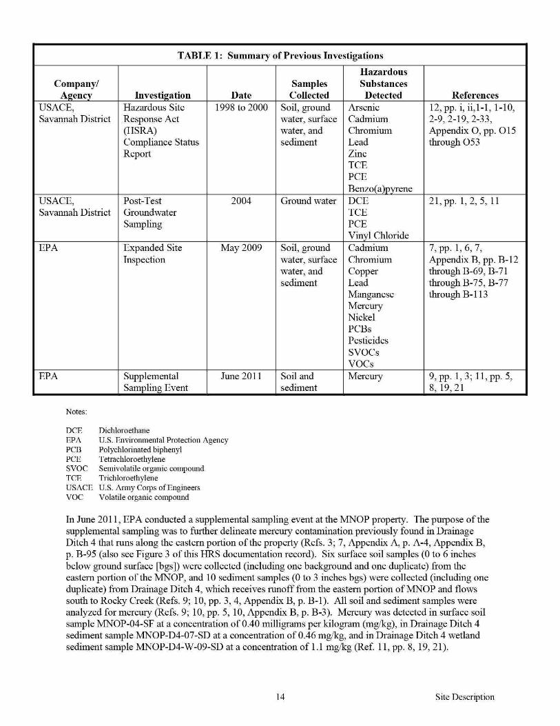

Source No 1
Background and Source Concentrations
Background and Source No 1 samples listed in Table 3 were analyzed for mercury in accordance with EPA Method 2455 and the EPA Region 4 Analytical Support Branch (ASB) Laboratory Operations and Quality Assurance Manual (LOQAM) January 2011 (Refs 9 p 1 11 p 1 27) EPA Region 4 SESD reviewed all data according to the contract statement of work (SOW) and EPA guidelines (Refs 28 11 p 1) The minimum reporting limits (MRL) are listed on the analytical data sheets in Reference 11 Each MRL is sample-specific and corresponds to the lowest quantitative point on the calibration curve it is adjusted for the amount of sample prepared and any dilutions performed as well as for percent moisture The MRLs are equivalent to sample quantitation limits (SQL) (Ref 29)
TABLE3 Analytical Results for Background and Source No 1 Samples - June 2011
Hazardous Sample Hazardous Substance
Designation SampleiD Substance Concentration MRL
Background MNOP-01-SF Mercury 0073J (013) mgkg 0050mgkg
Source No 1 MNOP-04-SF Mercury 040 mgkg 0050mgkg
Notes
() ID
Concentrations shown in parentheses were adjusted in accordance with References 31 and 32 Identification number
J mglkg MNOP MRL No SF
The identification of the analyte is acceptable the reported value is an estimate (Ref 11 p 4) Milligram per kilogram Macon Naval Ordnance Plant Minimum reporting limit Number Surface sample
17
References
11 pp 4 5 31
11 p 8
Site Description
Source No 1
223 HAZARDOUS SUBSTANCES AVAILABLE TO A PATHWAY
The sample collected from Source No 1 contains mercury (Refs 9 p 3 11 p 8) (also see Table 3 of this HRS documentation record) Source No 1 consists of contaminated soil on the eastern portion of the MNOP property (Refs 9 p 3 11 p 8) The MNOP operated as an ordnance manufacturing facility from before World War II until1973 (Ref 12 pp 1-1 1-7) Ordnance manufactured at the MNOP included flares small primers detonators and other triggering mechanisms (Ref 13 p 2) Military explosives such as those that were manufactured at the MNOP contained mercury compounds (mercury fulminate) as initiating agents (Ref 23 pp 7-1 7-5 7-8) Building 109 located in the eastern portion of the MNOP near Source No 1 was a primary explosives production site (Ref 13 pp 11 12 54) (see Figure 2 of this HRS documentation record) Soil samples collected from this area during the USACE 1996 site investigation contained mercury (Ref 13 pp 58 83 84) Analytical results for sediment samples collected from Drainage Ditch 4 indicate overland migration of mercury from Source No 1 (see Additional Supporting Data in Section 41211 of this HRS documentation record) Analytical results for sediment samples collected from wetlands contiguous with Rocky Creek and downstream of Source No 1 indicate that a release of hazardous substances has occurred to the surface water migration pathway as documented in Section 40 of this HRS documentation record No run-on or runoff control systems were observed during the EPA June 2011 supplemental sampling at MNOP specifically in the area of Source No 1 (Ref 33) Drainage Ditch 4 drains the eastern portion of MNOP and directs runoff to Rocky Creek and adjacent wetlands (Refs 7 Appendix A p A-4 9 p 3) (see Figure 3 of this HRS documentation record) Therefore a containment factor value of 10 as noted in Table 4 was assigned for the surface water migration pathway (Ref 1 Section 4121211)
TABLE 4 Containment Factors for Source No1
Containment Containment Description Factor Value References
Gas release to air NS NA
Particulate release to air NS NA
Release to ground water NS NA
Release via overland migration or flood no run-on 1 Section4121211 9p 3 33 or runoff control system runoff from Source No 1 10 see Figure 3 of this HRS enters Rocky Creek via Drainage Ditch 4 documentation record
Notes
NA Not applicable NS Not scored
18 Site Description
Source No 1
2421 SOURCE HAZARDOUS WASTE QUANTITY
24211 Hazardous Constituent Quantity
The information available is not sufficient to evaluate Tier A hazardous constituent quantity as required by Reference 1 Section 24211 Available Source No 1 data may not represent the extent of contamination associated with the source and are insufficient to determine constituent quantity
Hazardous Constituent Quantity Assigned Value NS
24212 Hazardous Wastestream Quantity
The information available is not sufficient to evaluate Tier B hazardous wastestream quantity as required by Reference 1 Section 24212 Available Source No 1 data may not represent the extent of the wastestream associated with the source
Hazardous Wastestream Quantity Assigned Value NS
24213 Volume
The information available is not sufficient to evaluate Tier C volume as required by Reference 1 Section 24213
Volume Assigned Value 0
24214 Area
One soil sample was collected from Source No 1 during the EPA June 2011 supplemental sampling event (Ref 9 pp 3 9) As a result it is not possible to determine a source area for Source No 1 Therefore the area of Source No 1 is undetermined but is greater than zero
Sum (square feet [ff]) gt0 Equation for Assigning Value (Table 2-5) Area (A)34000
Area Assigned Value gt0
24215 Calculation of Source Hazardous Waste Quantity Value
Source No 1 is assigned a source HWQ value of greater than zero but unknown (Ref 1 Section 242 15)
Source HWQ Value gt0
19 Site Description
SUMMARY OF SOURCE DESCRIPTIONS
TABLES Summary of Source Descriptions
Containment Factor Value by Pathway
Source Surface Air Source Hazardous Water Hazardous Constituent Ground Overland Waste Quantity Water Flood Gas Particulate
Source Quantity Complete (Ref 1 (Ref 1 (Ref 1 (Ref 1 No Value (YesNo) Table 3-2) Table 4-2) Table 6-3) Table 6-9)
1 gt0 No NS 10 NS NS
Notes
NS Not scored Total Source Hazard Waste Quantity Value gt0
Other Possible Source
Contaminated Soil on Western Portion of MNOP - During the EPA May 2009 expanded site inspection (ESI) conducted at the MNOP (currently known as AlP) soil samples were collected on the western portion of the MNOP property (Ref 7 pp 1 6 Appendix A p A-4) Soil samples AIP-124-SB and AIP-134-SF contained mercury at concentrations of088 mglkg and 13 mgkg (Ref 34 pp 120 166) Soil sample AIP-124-SB was collected from the area where the BlendingMixing Houses were located (Refs 7 Appendix A p A-4 13 p 54) The BlendingMixing Houses were where MNOP mixed the explosives (Ref 13 pp 11 12) Military explosives such as those that were manufactured at MNOP contained mercury compounds (mercury fulminate) as initiating agents (Ref 23 pp 7-1 7-5 7-8) Soil sample AIP-134-SF was collected from the northwestern portion of the MNOP in the area where the MNOP WWTP was formerly located (Refs 7 Appendix A p A-4 13 p 52) (see Figure 2 of this HRS documentation record) These areas drain into Drainage Ditch 2 which flows south and merges with the AWl drainage easement then flows into Rocky Creek (Ref 7 Appendix A p A-4) Contaminated soil on the western portion of MNOP drains towards the A WI site to the west of MNOP and not towards the PPE and observed release scored in this HRS documentation record (see Figure 3) therefore this other possible source is not scored in this HRS documentation record
20 Site Description
40 SURFACE WATERlflGRATION PATHWAY
41 OVERLANDFLOOD lflGRA TION COMPONENT- Drainage Ditch 4
4111 Definition of Hazardous Substance Migration Path for OverlandFlood Component
The hazardous substance migration pathway includes both the overland segment and the in-water segment that hazardous substances would take as they migrate away from sources The overland segment begins at the source and proceeds downgradient to the probable point of entry (PPE) to surface water The inshywater segment at the PPE continues in the direction of flow (Ref 1 Section 4 111)
Overland flow from Source No 1 (contaminated soil in the eastern portion of the MNOP property) is directed to Drainage Ditch 4 Drainage Ditch 4 is an intermittent drainage route located up gradient of the PPE along the eastern boundary of the MNOP property (Ref 9 pp 1 3) Surface water runofffrom Source No 1 flows overland about 625 feet and enters Drainage Ditch 4 Drainage Ditch 4 flows south for about 3250 feet and enters HRS-eligible palustrine forested wetlands adjacent to Rocky Creek The point where Drainage Ditch 4 enters the palustrine forested wetlands is PPE 1 Drainage Ditch 4 continues south within palustrine forested wetlands for about 1250 feet and enters Rocky Creek (Refs 3 36 Map 1) (also see Figure 3 of this HRS documentation record)
Rocky Creek flows east-southeast for about 1 mile before it converges with Tobesofkee Creek Tobesofkee Creek flows south-southeast for about 4 miles before it converges with the Ocmulgee River which flows for more than 95 miles thus completing the 15-mile surface water migration pathway target distance limit (TDL) east-southeast of Elberta Georgia (Ref 3)
The flow rate for Rocky Creek is estimated to be between 10 and 15 cubic feet per second (cfs) (Ref 37) Rocky Creek has several branches Specific stream channels are difficult to discern because of the extensive wetlands in the area (Refs 3 36) According to the US Geological Survey the mean flow rate for Tobesofkee Creek for water years 1937 to 2010 was 183 cfs and the mean flow rate for the Ocmulgee River for water years 1911 to 2010 was 2657 cfs (Ref 38 pp 3 10)
The southern portion of Drainage Ditch 4 is located within wetlands and the 100-year floodplain of Rocky Creek This area is prone to frequent flooding resulting in the mixing of water in the surrounding area (Refs 7 Appendix A p A-4 36 Map 1 44)
21 SW-OverlandFlood Migration Component
41 21 LIKELlliOOD OF RELEASE
41 211 OBSERVED RELEASE- Chemical Analysis
EPA June 2011 Supplemental Sampling
Background and Contaminated Samples
During the EPA June 2011 supplemental sampling event one background sediment sample MNOP-W-01-SD was collected from HRS-eligible palustrine forested wetlands west of and upgradient from Drainage Ditch 4 Contaminated sediment sample MNOP-D4-W-09-SD was collected from Drainage Ditch 4 within HRS-eligible palustrine forested wetlands downstream of the PPE Background and contaminated sediment samples were collected from HRS-eligible palustrine forested wetlands at depths ranging from 0 to 3 inches bgs (Refs 9 pp 1 3 8 9 36 Map 1)
The sediment samples were collected in accordance with the EPA Region 4 SESD Field Branches Quality System and Technical Procedures for Sediment Sampling SESDPROC-200-R2 (Refs 9 pp 1 6 10 p 4 25) The location of the background sediment sample is depicted on Figure 3 of this HRS documentation record Chain-of-custody records are provided in Reference 26 Logbook notes are provided in Reference 9 pages 8 and 9
The background and contaminated sediment samples were collected during the same sampling event in accordance with the same sampling procedures and from the same type of HRS-eligible wetland (palustrine forested) (Refs 9 pp 1 3 6 36) (see Figure 3 of this HRS documentation record)
TABLE6 Background and Contaminated Sediment Samples - June 2011
Sample ID Sample Location
Background HRS-eligible palustrine forested wetlands
MNOP-W-01-SD west and upgradient of Drainage Ditch 4 upstream from site drainage
Drainage Ditch 4
MNOP-D4-W-09-SD HRS-eligible palustrine forested
Notes
bgs D HRS ID MNOP NA PPE SD w
wetlands
Below ground surface Ditch Hazard Ranking System Identification number Macon Naval Ordnance Plant Not applicable Probable point of entry Sediment sample Wetland
Distance Depth Date fromPPE 1 (bgs) Sampled References
9 p 8 26 p 2 36 Map 1
NA 0 to 3
06292011 Figure 3 of this
inches HRS documentation record
700 feet 0 to 3 06302011
9 pp 3 9 26 downstream inches p 2 36 Map 1
22 SW-Observed Release
Background and Contaminated Concentrations
The sediment samples listed in Table 7 were collected during the EPA June 2011 supplemental sampling event (Ref 9 pp 3 8 9) Sediment samples were analyzed for mercury in accordance with EPA Method 2455 and the EPA Region 4 ASB LOQAM January 201 1 (Refs 9 p 1 11 p 1 27) EPA Region 4 SESD reviewed all data according to the contract SOW and EPA guidelines (Refs 28 11 p 1 ) The MRLs are listed on the analytical data sheets in Reference 11 pages 21 and 22 Each MRL is sampleshyspecific and corresponds to the lowest quantitative point on the calibration curve it is adjusted for the amount of sample prepared and any dilutions performed as well as for percent moisture The MRLs are equivalent to SQLs (Ref 29)
TABLE 7 Analytical Results for Background and Contaminated Sediment Samples- June 2011
Sample Hazardous Description Sample ID Substance Concentration MRL
Background MNOP-W-01-SD Mercury 016J (0 29)
0050mgkg mgkg
Release
Notes
() D ID J mglkg MNOP MRL SD w
MNOP-D4-W-09-SD Mercury 11 mgkg 0050mgkg
Concentrations shown in parentheses were adjusted in accordance with References 31 and 32 Ditch Identification number The identification of the aualyte is acceptable the reported value is an estimate (Ref 11 p 4) Milligram per kilogram Macon Naval Ordnance Plant Minimum reporting limit Sediment sample Wetland
References
11 pp 4 22 31 32 pp8 18
11 p 21
23 SW-Observed Release
Additional Supporting Data
The sediment samples listed in Table 8 below were collected from Drainage Ditch 4 during the June 2011 supplemental sampling event (Ref 9 pp 1 3 9) Sediment sample MNOP-D4-W-08-SD was collected at PPE 1 The samples presented below show the presence of mercury along the overland drainage route Drainage Ditch 4 from Source No 1 to PPE 1 Because Drainage Ditch 4 is an intermittent water body up gradient of PPE 1 these sediment samples were not included as part of the surface water pathway inshywater segment discussion (Ref 9 pp 1 3) (see Figure 3 of this HRS documentation record)
TABLE 8 Drainage Ditch 4 Sediment Samples- June 2011
SampleiD
MNOP-D4-02-SD
MNOP-D4-04-SD
MNOP-D4-07-SD
MNOP-D4-W-08-SD
Notes
D4 ID
Drainage Ditch 4 Identification
Hazardous Substance
Mercury
Mercmy
Mercury
Mercmy
Concentration MRL
00511 mgkg 0050 mgkg
0083J mgkg 0050 mgkg
046 mgkg 0050 mgkg
0 19J mgkg 0050 mgkg
J mglkg MNOP MRL SD
The identification ofthe analyte is acceptable the rep011ed value is an estimate (Ref 11 p 4) Milligrams per kilogram Macon Naval Ordnance Plant Minimum rep011ing lirnit Sediment
w Wetland
24
Reference
11 pp 4 13
11 pp 4 16
ll p19
11 pp4 20
SW-Observed Release
Attribution
The MNOP was constructed before World War II and was operated as an ordnance manufacturing facility until1973 (Refs 12 p 1-1 13 p 2) Ordnance manufactured at the MNOP included flares small primers detonators and other triggering mechanisms (Ref 13 p 2) The total area of the MNOP was approximately 433 acres which extended from Guy Paine Road in the north to Rocky Creek in the south and Mead Road to the east and the Central of Georgia Railroad tracks to the west (Refs 8 18 p 2 22 pp 1 2)
Explosive compounds were either handled or stored in many areas throughout the MNOP property including numerous small dryer buildings ordnance magazines and blending and mixing houses (Ref 13 pp 11 12 54) According to a technical manual prepared by the Department of the Army military explosives such as those that were manufactured at the MNOP contained mercury compounds as initiating agents including mercury fulminate (Ref 23 pp 7-1 7-5 7-8) Building 109 located in the eastern portion of the MNOP near Source No 1 was a primary explosives production site (Ref 13 pp 11 12 54) (see Figures 2 and 3 of this HRS documentation record) Soil samples collected from this area during the US ACE 1996 site investigation and EPA June 2011 supplemental sampling event contained mercury (Refs 9 p 3 13 pp 58 83 84)
Other facilities in the area include the MBCIA which renamed the MNOP property the Allied Industrial Park and currently leases or sells buildings as office and warehouse space to various industrial and commercial businesses on the AlP property (Refs 7 Appendix A p A-3 13 pp 1 2 3 14 p 2-9 15) Politex US Inc (Politex) is the only manufacturing business that is currently located at the AlP Politex is a textile manufacturing firm that produces roofing membranes clothing and furniture padding and building materials (Ref 15) Politex is located on the western portion of the MNOP property (Refs 6 pp 42 through 49 7 Appendix A p A-3) Runoff and drainage originating from Politex does not enter Drainage Ditch 4 (Ref 7 Appendix A pp A-2 A-3) (see Figure 3 of this HRS documentation record) The propetty where Source No 1 soil sample MNOP-04-SF was collected is owned by the City of Macon and is operated as a recreational park that includes baseball fields (Refs 6 pp 7 8 7 Appendix A pp A-2 A-3 9 p 3)
Possible off-site sources also include the FMNOL A WI and the Rocky Creek water reclamation facility (RC WRF) A WI and FMNOL are currently listed on the EPA NPL under CERCUS ID No GAN000410033 at docket number EPA-HQ-SFUND-2010-0640-0002 (Ref 47) Runoff from FMNOL and A WI flows into Rocky Creek via a drainage easement The drainage easement enters Rocky Creek west and upstream of Source No 1 soil sample MNOP-04-SF and Drainage Ditch 4 Drainage Ditch 4 is located just west of the RC WRF (Ref 7 Appendix A p A-2)
The FMNOL was reportedly used for disposal of solid wastes and ordnance throughout the operational history (1941 to 1974) of the MNOP (Refs 8 17 pp 42 43 46 47 18 p 2) The landfill was also used for disposal of used parts and construction debris (Refs 14 p 2-11 18 p 2) During the EPA May 2009 ESI mercury was detected in soil samples collected from the FMNOL at concentrations ranging from 047 mgkg (FML-303-SF) to 47 mglkg (FML-304-SB) (Ref 35 pp 130 132)
Since 1948 AWl has operated an acoustic ceiling tile manufacturing plant on 130 acres of land west of the MNOP property (Ref 19 p 3) In 1980 A WI notified the Georgia Environmental Protection Division (GAEPD) that it was a generator of hazardous waste and A WI was classified as a conditionally exempt small quantity generator under the Resource Conservation and Recovery Act (RCRA) PCBs are the primary hazardous substance of concern for this facility not metals (Ref 19 pp 5 6)
The RC WRF located southeast of and downstream from MNOP provides wastewater treatment for the southern and western portions of the City of Macon Treated wastewater from this facility is discharged into the Ocmulgee River however RC WRF maintains a National Pollutant Discharge Elimination System (NPDES)-permitted discharge point at the southern property boundary (Refs 9 p 3 45 pp 2 3 46 pp 1 8) The NPDES permit requires RC WRF to monitor outfall discharges for biochemical oxygen
25 SW-Observed Release
demand total suspended solids pH chlorine fecal coliform nitrogen dissolved oxygen PCBs and phosphorus (Ref 46 pp 6 7) There are currently no documented releases of mercury at this location (Refs 9 p 3 46 pp 6 7)
The source sample collected from Source No 1 (contaminated soil on the eastern portion ofMNOP) during the EPA June 2011 supplemental sampling event contained mercury (Refs 9 p 3 11 p 8) (see Table 3 in Section 222 for Source No 1 of this HRS documentation record) Sediment samples collected from Drainage Ditch 4 which receives runoff from Source No 1 also contained mercury The presence of mercury in Drainage Ditch 4 documents the migration of releases from Source No 1 at the MNOP (Refs 9 p 3 11 pp 13 16 19 20 21) (also see Tables 6 and 7 in Section 41211 Observed Release of this HRS documentation record) Furthennore an observed release of mercury has been documented in HRS-eligible wetlands along Drainage Ditch 4 (Refs 9 p 3 11 p 21 36)
Mercury has been documented in Source No 1 in Drainage Ditch 4 and in palustrine forested wetlands indicating migration of hazardous substances from the MNOP property (see Table 3 in Section 222 for Source No 1 and Table 7 in Section 41211 Observed Release of this HRS documentation record)
Hazardous Substance in the Release
Mercury
Surface Water Observed Release Factor Value 55000
26 SW-Observed Release
412 DRINKING WATER THREAT
The drinking water threat was not scored because it is not expected to contribute significantly to the overall score
27 SW-Drinking Water Threat
4132 HUMAN FOOD CHAIN THREAT WASTE CHARACTERISTICS
41321 ToxicityPersistenceBioaccumulation
The toxicity persistence and bioaccumulation factor value for mercury detected in Source No 1 with containment factor values of greater than 0 is summarized in Table 9 The combined toxicity persistence and bioaccumulation factor value is assigned in accordance with Reference 1 Section 41321
TABLE 9 ToxicityPersistenceBioaccumulation
Toxicity Persistence
Toxicity Persistence Bioaccu- Bioaccumulation Hazardous Source Factor Factor mulation Factor Value (Ref Substance No Value Value1 Value2 1 Table 4-16) Reference
Mercury 1 10000 1 50000 5 X 10⁸ 2 p BI-8
Notes
Persistence factor value for rivers Bioaccumulation factor value for fresh water
ToxicityPersistenceBioaccumulation Factor Value 50000000000 (Ref 1 Section413214)
28 SW-Human Food Chain Threat
41322 HAZARDOUS WASTE QUANTITY
TABLE 10 Hazardous Waste Quantity
Source No Source Type Source Hazardous Waste Quantity
1 Contaminated soil gt0
Total Source Hazardous Waste Quantity gt0
One soil sample MNOP-04-SF was collected to represent Source No 1 (Ref 9 pp 3 9 see Table 3 in Section 222 for Source No 1 of this HRS documentation record) As a result it is not possible to calculate an area measurement for Source No 1 Therefore the area of Source No 1 is undetermined but is greater than zero In addition the hazardous waste quantity receives a minimum factor value of 100 for the surface water migration pathway because actual contamination at Level II concentrations is present in HRS-eligible palustrine forested wetlands and hazardous constituent quantity is not adequately determined (Ref 1 Section 2422)
Hazardous Waste Quantity Factor Value 100 (Ref 1 Table 2-6)
41323 CALCULATION OF HUMAN FOOD CHAIN THREAT WASTE CHARACTERISTICS FACTOR CATEGORY VALUE
The waste characteristics factor category was obtained by multiplying the toxicity persistence and hazardous waste quantity (HWQ) factor values subject to a maximum product of 1 x 10⁸
Then this product was multiplied by the bioaccumulation potential factor value subject to a maximum product of 1 x 10¹²
Based on this product a value was assigned in accordance with Reference 1 Table 2-7
ToxicityPersistence Factor Value 1000000 Hazardous Waste Quantity Factor Value 100
ToxicityPersistence Factor Value x Hazardous Waste Quantity Factor Value 1 x 10⁶
ToxicityPersistence Factor Value x Hazardous Waste Quantity Factor Value x Bioaccumulation Factor Value (50000) 5 x 10¹⁰
29
Waste Characteristics Factor Category Value 320 (Ref I Table2-7)
SW-Human Food Chain Threat
4133 HUMAN FOOD CHAIN THREATT ARGETS
41331 Food Chain Individual
An observed release of a hazardous substance having a bioaccumulation factor value of 500 or greater is documented in perennial surface water with a fishery downstream- specifically an observed release to Drainage Ditch 4 within HRS-eligible palustrine forested wetlands (Refs 9 p 3 11 pp 21 22 36 Map 1) (see Figure 3 of this HRS documentation record) Drainage Ditch 4 flows south for about 1250 feet within palustrine forested wetlands and joins Rocky Creek (Ref 9 p 3) Rocky Creek Tobesofkee Creek and the Ocmulgee River are designated as fisheries by the State of Georgias Ocmulgee River Watershed Management Plan (Refs 39 p 2 40 Appendix A pp A-89 A-91 41 p 4-14) Rocky Creek is fished between Broadway and its confluence with Tobesofkee Creek within the site TDL where it is accessible to the public fish are also harvested for consumption (Refs 3 37 42 pp 3 10 11) In 2007 GAEPD personnel observed people fishing in Rocky Creek east of Highway 41 The fishermen indicated to GAEPD personnel that they clean and eat the fish that they catch (Refs 19 p 9 42 pp 3 10 11) In addition Tetra Tech observed fishing gear including a fishing line and weight along Rocky Creek during the EPA 2009 ESI sampling event (Ref 7 Appendix D p D-14) Fish species caught for consumption in Rocky Creek include bream blackfish bass redear sunfish redbreast sunfish bluegill and brown bullhead catfish (Refs 19 p 9 37 42 p 3) The State of Georgia has issued fish consumption guidelines for the Ocmulgee River as a result of mercury contamination (Refs 9 p 9 43 p 41)
41332 Population
413321 Level I Concentrations
No Level I samples were collected
413322 Level II Concentrations
No Level II samples were collected
Food Chain Individual Factor Value 20 (Ref 1 Section41331)
413323 Potential Human Food Chain Contamination
Drainage Ditch 4 flows south for about 1250 feet within HRS-eligible palustrine forested wetlands and joins Rocky Creek (Ref 9 p 3) Rocky Creek is fished between Broadway and its confluence with Tobesofkee Creek within the site TDL where it is accessible to the public fish are also harvested for consumption (Refs 3 37 42 pp 3 10 11) Information is not available on the annual production offish caught in Rocky Creek therefore the annual production is undetermined but greater than 0
TABLE 11 Potential Population Targets
Population Dilution Type of Value (P) Weight
Annual Surface Average (Ref 1 (D) (Ref Identity Production Water Annual Table 4- 1 Table
of Fishery ~nds) _____Jody Flow (cfs) 18) 4-13_) P XD R eferences - - -
Small to 37 39 p 2
Rocky gt0 Moderate 10 to 15 003 01 0003
40 Appendix Creek
Stream A p A-91
I 41 p 4-14 Notes cfs Cubic feet per second
30 SW-Human Food Chain Threat
For the potential human food chain contamination factor value the sum of Pi x Di is divided by 10
31
Potential Human Food Chain Factor Value 00003 (Ref 1 Section 413323)
SW-Human Food Chain Threat
4142 ENVIRONMENTAL THREAT WASTE CHARACTERISTICS
41421 Ecosystem ToxicityPersistenceBioaccumulation
The ecosystem toxicity persistence and bioaccumulation factor value for mercury detected in Source No 1 with a containment factor value of greater than 0 is summarized in Table 12 The combined ecosystem toxicity persistence and bioaccumulation factor value is assigned in accordance with Reference 1 Section 4 1421
TABLE 12 Ecosystem ToxicityPersistenceBioaccumulation
Hazardous Source Substances No
Mercury 1
Notes
Ecotoxicity for fresh water Persistence value for rivers
Ecosystem Toxicity Persistence Factor Factor Value1 Value2
10000 1
Ecosystem Toxicity
Bioaccumula tion Bioaccu- Factor Value mulation (Ref 1 Table Value3 4-21) Reference
50000 5 X 10⁸ 2 p BI-8
Bioaccurnulation factor value for fresh water envirournental threat
Ecosystem ToxicityPersistenceBioaccumulation Factor Value 5 x 10⁸
(Reference 1 Section 414214)
32 SW-Environmental Threat
41422 HAZARDOUS WASTE QUANTITY
TABLE 13 Hazardous Waste Quantity
Source No Source Type Source Hazardous Waste Quantity
1 Contaminated soil gt0
Total Source Hazardous Waste Quantity gt0
One soil sample MNOP-04-SF was collected to represent Source No 1 (Ref 9 pp 3 9 see Table 3 in Section 222 for Source No 1 of this HRS documentation record) (Ref 9 pp 3 9) As a result it is not possible to calculate an area measurement for Source No 1 Therefore the area of Source No 1 is undetermined but is greater than zero In addition the hazardous waste quantity receives a minimum factor value of 100 for the surface water migration pathway because actual contamination at Level II concentrations is present in HRS-eligible palustrine forested wetlands and hazardous constituent quantity is not adequately determined (Ref 1 Section 2422)
Hazardous Waste Quantity Factor Value 100 (Ref 1 Table 2-6)
41423 CALCULATION OF ENVIRONMENTAL CHAIN THREAT WASTE CHARACTERISTICS FACTOR CATEGORY VALUE
The waste characteristics factor category was obtained by multiplying the ecosystem toxicity persistence and HWQ factor values subject to a maximum product of 1 x 10⁸
Then this product was multiplied by the bioaccumulation potential factor value subject to a maximum product of 1 x 10¹²
Based on this product a value was assigned in accordance with Reference 1 Table 2-7
Ecosystem ToxicityPersistence Factor Value 1000000 Hazardous Waste Quantity Factor Value 100
Ecosystem ToxicityPersistence Factor Value x Hazardous Waste Quantity Factor Value 1 x 10⁶
Ecosystem ToxicityPersistence Factor Value x Hazardous Waste Quantity Factor Value x Bioaccumulation Factor Value (50000) 5 x 10¹⁰
33
Waste Characteristics Factor Category Value 320 (Ref I Table2-7)
SW-Environmental Threat
4143 Environmental Threat Targets
Level I Concentrations
No Level I concentrations have been documented
Level II Concentrations
Actual contamination has been documented in wetland areas along Drainage Ditch 4 in Section 41211 of this HRS documentation record The sampling locations are shown in Reference 9 page 3 Wetland areas were identified from Reference 36 Wetlands Inventory Maps The wetland areas evaluated are palustrine forested (Refs 3 9 p 3 36)
Most Distant Level II Sample
Investigation Sample ID Sample Medium Hazardous Substance
June 2011 Supplemental Sampling MNOP-D4-W-09-SD Sediment Mercury
Location Drainage Ditch 4 about 700 feet downstream from PPE 1 References record)
3 9 p 3 11 p 21 36 (also see Table 7 of this HRS documentation
41431 Sensitive Environments
414311 Level I Concentrations
Sensitive Environments
Sensitive environments other than wetlands have not been identified within the 15-rnile surface water migration pathway TDL
Wetlands
No Level I wetlands were scored
414312 Level IT Concentrations
Sensitive Enviromnents
Sensitive environments other than wetlands have not been identified within the 15-rnile surface water migration pathway TDL
Wetlands
The wetlands were identified from Reference 36 Wetlands Inventory Maps The wetlands evaluated are palustrine forested (Refs 3 9 p 3 36) The southern portion of Drainage Ditch 4 is located within HRSshyeligible wetlands (Refs 3 9 p 3 36) The sediment sample evaluated at a Level II concentration is located in palustrine forested wetlands along Drainage Ditch 4 (Refs 3 9 p 3 36) The total wetland frontage from PPE 1 to the most downstream sample that contained Level II concentrations (MNOP-D4-W-090SD) is about 1400 feet or 026 mile (Refs 3 9 p 3 36) Both sides of Drainage Ditch4 within this segment contain HRS eligible wetlands so both sides of Drainage Ditch 4 were included in the calculation of the wetland frontage (Refs 3 9 p 3 36)
34 SW-Environmental Threat
TABLE 14 Level II Wetland Frontage
Wetland Water Body Wetland Fronta~e References
Palustrine forested Drainage Ditch 4 1400 feet or 026 mile 39p336
Total Wetland Frontage 1400 feet or 026 mile 3 9 p336
Total Wetland Frontage 1400 feet
The wetland ratings value for 026 mile is obtained from Reference 1 Table 4-24 and is 25
Wetland Value 25 (Ref 1 Table 4-24)
For wetlands subject to Level II concentrations the wetland value (25) is multiplied by 1 (Ref 1 Section 414311)
414313 Potential Contamination
Sensitive Environments
Wetland Value 25 x 1 Level II Concentrations Factor Value 25
(Ref 1 Section 414311)
Potential sensitive environments were not evaluated because the presence of sensitive environments other than wetlands has not been identified
Wetlands
The wetlands were identified from Reference 36 Wetlands Inventory Maps The wetlands evaluated for potential contamination are palustrine forested (Refs 3 9 p 3 36) Wetlands were measured from the farthest downstream sediment sample (MNOP-D4-W-09-SD) collected on Drainage Ditch 4 to the completion of the 15-mile surface water migration pathway TDL Wetland frontage from both sides of Drainage Ditch 4 Rocky Creek Tobesofkee Creek and the Ocmulgee River were measured (Refs 3 36) Wetlands that were evaluated as Level II were not included in the potential contamination wetland frontage The flow rate for Rocky Creek is estimated to be between 10 and 15 cfs (Ref 37) According to the US Geological Survey the mean flow rate for Tobesotkee Creek water years 1937 to 2010 was 183 cfs and the mean flow rate for the Ocmulgee River water years 1911 to 2010 was 2657 cfs (Ref 38 pp 3 10)
35 SW-Environmental Threat
TABLE 15 Wetland Frontage
Wetlands Value Based
Surface Water Type of Surface Wetland on Wetland Body Water Body Fronta~e Fronta~e References
Small to Moderate About 25 miles 75
1 Tables 4-13 4-24 3 36 Rocky Creek Stream 37
Moderate to Large About 775 150
1 Tables 4-13 4-24 3 36 Tobesoflcee Creek Stream miles 38 p3
Ocmulgee River Large Stream to
About 7 miles 150 1 Tables 4-13 4-24 3 36
River 38 p 10
Total Wetlands Value 375 1 Tables 4-13 4-24 3 36
TABLE 16 Potential Contamination
Sum of Wetlands Dilution D1 (W1 + S1)
Sensitive Value (WJ Weight (D1) (Ref 1 Surface Water Environments (Ref 1 Table (Ref 1 Section
Body Values (S1) 4-24) Table 4-13) 414333) References
Rocky Creek 0 75 01 75 33637
T obesoflcee Creek 0 150 001 15 33638 p 3
Ocmulgee River 0 150 0001 015 33638 p 10
Total Potential Contamination Factor Value 91 5
For wetlands subject to potential contamination the wetland value (915) is multiplied by 0 1 (Ref 1 Section 414313)
36
Wetland Value 9 15 x 01 Potential Contamination Factor Value 0915
(Ref 1 Section 4143 13)
SW-Environmental Threat
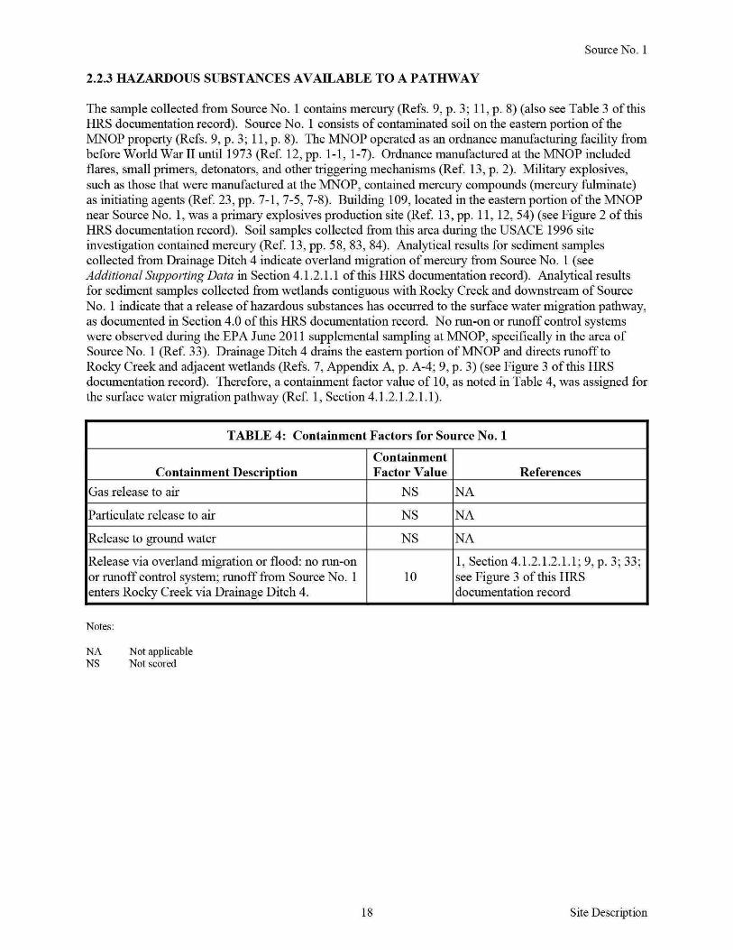
Source No 1
223 HAZARDOUS SUBSTANCES AVAILABLE TO A PATHWAY
The sample collected from Source No 1 contains mercury (Refs 9 p 3 11 p 8) (also see Table 3 of this HRS documentation record) Source No 1 consists of contaminated soil on the eastern portion of the MNOP property (Refs 9 p 3 11 p 8) The MNOP operated as an ordnance manufacturing facility from before World War II until1973 (Ref 12 pp 1-1 1-7) Ordnance manufactured at the MNOP included flares small primers detonators and other triggering mechanisms (Ref 13 p 2) Military explosives such as those that were manufactured at the MNOP contained mercury compounds (mercury fulminate) as initiating agents (Ref 23 pp 7-1 7-5 7-8) Building 109 located in the eastern portion of the MNOP near Source No 1 was a primary explosives production site (Ref 13 pp 11 12 54) (see Figure 2 of this HRS documentation record) Soil samples collected from this area during the USACE 1996 site investigation contained mercury (Ref 13 pp 58 83 84) Analytical results for sediment samples collected from Drainage Ditch 4 indicate overland migration of mercury from Source No 1 (see Additional Supporting Data in Section 41211 of this HRS documentation record) Analytical results for sediment samples collected from wetlands contiguous with Rocky Creek and downstream of Source No 1 indicate that a release of hazardous substances has occurred to the surface water migration pathway as documented in Section 40 of this HRS documentation record No run-on or runoff control systems were observed during the EPA June 2011 supplemental sampling at MNOP specifically in the area of Source No 1 (Ref 33) Drainage Ditch 4 drains the eastern portion of MNOP and directs runoff to Rocky Creek and adjacent wetlands (Refs 7 Appendix A p A-4 9 p 3) (see Figure 3 of this HRS documentation record) Therefore a containment factor value of 10 as noted in Table 4 was assigned for the surface water migration pathway (Ref 1 Section 4121211)
TABLE 4 Containment Factors for Source No1
Containment Containment Description Factor Value References
Gas release to air NS NA
Particulate release to air NS NA
Release to ground water NS NA
Release via overland migration or flood no run-on 1 Section4121211 9p 3 33 or runoff control system runoff from Source No 1 10 see Figure 3 of this HRS enters Rocky Creek via Drainage Ditch 4 documentation record
Notes
NA Not applicable NS Not scored
18 Site Description
Source No 1
2421 SOURCE HAZARDOUS WASTE QUANTITY
24211 Hazardous Constituent Quantity
The information available is not sufficient to evaluate Tier A hazardous constituent quantity as required by Reference 1 Section 24211 Available Source No 1 data may not represent the extent of contamination associated with the source and are insufficient to determine constituent quantity
Hazardous Constituent Quantity Assigned Value NS
24212 Hazardous Wastestream Quantity
The information available is not sufficient to evaluate Tier B hazardous wastestream quantity as required by Reference 1 Section 24212 Available Source No 1 data may not represent the extent of the wastestream associated with the source
Hazardous Wastestream Quantity Assigned Value NS
24213 Volume
The information available is not sufficient to evaluate Tier C volume as required by Reference 1 Section 24213
Volume Assigned Value 0
24214 Area
One soil sample was collected from Source No 1 during the EPA June 2011 supplemental sampling event (Ref 9 pp 3 9) As a result it is not possible to determine a source area for Source No 1 Therefore the area of Source No 1 is undetermined but is greater than zero
Sum (square feet [ff]) gt0 Equation for Assigning Value (Table 2-5) Area (A)34000
Area Assigned Value gt0
24215 Calculation of Source Hazardous Waste Quantity Value
Source No 1 is assigned a source HWQ value of greater than zero but unknown (Ref 1 Section 242 15)
Source HWQ Value gt0
19 Site Description
SUMMARY OF SOURCE DESCRIPTIONS
TABLES Summary of Source Descriptions
Containment Factor Value by Pathway
Source Surface Air Source Hazardous Water Hazardous Constituent Ground Overland Waste Quantity Water Flood Gas Particulate
Source Quantity Complete (Ref 1 (Ref 1 (Ref 1 (Ref 1 No Value (YesNo) Table 3-2) Table 4-2) Table 6-3) Table 6-9)
1 gt0 No NS 10 NS NS
Notes
NS Not scored Total Source Hazard Waste Quantity Value gt0
Other Possible Source
Contaminated Soil on Western Portion of MNOP - During the EPA May 2009 expanded site inspection (ESI) conducted at the MNOP (currently known as AlP) soil samples were collected on the western portion of the MNOP property (Ref 7 pp 1 6 Appendix A p A-4) Soil samples AIP-124-SB and AIP-134-SF contained mercury at concentrations of088 mglkg and 13 mgkg (Ref 34 pp 120 166) Soil sample AIP-124-SB was collected from the area where the BlendingMixing Houses were located (Refs 7 Appendix A p A-4 13 p 54) The BlendingMixing Houses were where MNOP mixed the explosives (Ref 13 pp 11 12) Military explosives such as those that were manufactured at MNOP contained mercury compounds (mercury fulminate) as initiating agents (Ref 23 pp 7-1 7-5 7-8) Soil sample AIP-134-SF was collected from the northwestern portion of the MNOP in the area where the MNOP WWTP was formerly located (Refs 7 Appendix A p A-4 13 p 52) (see Figure 2 of this HRS documentation record) These areas drain into Drainage Ditch 2 which flows south and merges with the AWl drainage easement then flows into Rocky Creek (Ref 7 Appendix A p A-4) Contaminated soil on the western portion of MNOP drains towards the A WI site to the west of MNOP and not towards the PPE and observed release scored in this HRS documentation record (see Figure 3) therefore this other possible source is not scored in this HRS documentation record
20 Site Description
40 SURFACE WATERlflGRATION PATHWAY
41 OVERLANDFLOOD lflGRA TION COMPONENT- Drainage Ditch 4
4111 Definition of Hazardous Substance Migration Path for OverlandFlood Component
The hazardous substance migration pathway includes both the overland segment and the in-water segment that hazardous substances would take as they migrate away from sources The overland segment begins at the source and proceeds downgradient to the probable point of entry (PPE) to surface water The inshywater segment at the PPE continues in the direction of flow (Ref 1 Section 4 111)
Overland flow from Source No 1 (contaminated soil in the eastern portion of the MNOP property) is directed to Drainage Ditch 4 Drainage Ditch 4 is an intermittent drainage route located up gradient of the PPE along the eastern boundary of the MNOP property (Ref 9 pp 1 3) Surface water runofffrom Source No 1 flows overland about 625 feet and enters Drainage Ditch 4 Drainage Ditch 4 flows south for about 3250 feet and enters HRS-eligible palustrine forested wetlands adjacent to Rocky Creek The point where Drainage Ditch 4 enters the palustrine forested wetlands is PPE 1 Drainage Ditch 4 continues south within palustrine forested wetlands for about 1250 feet and enters Rocky Creek (Refs 3 36 Map 1) (also see Figure 3 of this HRS documentation record)
Rocky Creek flows east-southeast for about 1 mile before it converges with Tobesofkee Creek Tobesofkee Creek flows south-southeast for about 4 miles before it converges with the Ocmulgee River which flows for more than 95 miles thus completing the 15-mile surface water migration pathway target distance limit (TDL) east-southeast of Elberta Georgia (Ref 3)
The flow rate for Rocky Creek is estimated to be between 10 and 15 cubic feet per second (cfs) (Ref 37) Rocky Creek has several branches Specific stream channels are difficult to discern because of the extensive wetlands in the area (Refs 3 36) According to the US Geological Survey the mean flow rate for Tobesofkee Creek for water years 1937 to 2010 was 183 cfs and the mean flow rate for the Ocmulgee River for water years 1911 to 2010 was 2657 cfs (Ref 38 pp 3 10)
The southern portion of Drainage Ditch 4 is located within wetlands and the 100-year floodplain of Rocky Creek This area is prone to frequent flooding resulting in the mixing of water in the surrounding area (Refs 7 Appendix A p A-4 36 Map 1 44)
21 SW-OverlandFlood Migration Component
41 21 LIKELlliOOD OF RELEASE
41 211 OBSERVED RELEASE- Chemical Analysis
EPA June 2011 Supplemental Sampling
Background and Contaminated Samples
During the EPA June 2011 supplemental sampling event one background sediment sample MNOP-W-01-SD was collected from HRS-eligible palustrine forested wetlands west of and upgradient from Drainage Ditch 4 Contaminated sediment sample MNOP-D4-W-09-SD was collected from Drainage Ditch 4 within HRS-eligible palustrine forested wetlands downstream of the PPE Background and contaminated sediment samples were collected from HRS-eligible palustrine forested wetlands at depths ranging from 0 to 3 inches bgs (Refs 9 pp 1 3 8 9 36 Map 1)
The sediment samples were collected in accordance with the EPA Region 4 SESD Field Branches Quality System and Technical Procedures for Sediment Sampling SESDPROC-200-R2 (Refs 9 pp 1 6 10 p 4 25) The location of the background sediment sample is depicted on Figure 3 of this HRS documentation record Chain-of-custody records are provided in Reference 26 Logbook notes are provided in Reference 9 pages 8 and 9
The background and contaminated sediment samples were collected during the same sampling event in accordance with the same sampling procedures and from the same type of HRS-eligible wetland (palustrine forested) (Refs 9 pp 1 3 6 36) (see Figure 3 of this HRS documentation record)
TABLE6 Background and Contaminated Sediment Samples - June 2011
Sample ID Sample Location
Background HRS-eligible palustrine forested wetlands
MNOP-W-01-SD west and upgradient of Drainage Ditch 4 upstream from site drainage
Drainage Ditch 4
MNOP-D4-W-09-SD HRS-eligible palustrine forested
Notes
bgs D HRS ID MNOP NA PPE SD w
wetlands
Below ground surface Ditch Hazard Ranking System Identification number Macon Naval Ordnance Plant Not applicable Probable point of entry Sediment sample Wetland
Distance Depth Date fromPPE 1 (bgs) Sampled References
9 p 8 26 p 2 36 Map 1
NA 0 to 3
06292011 Figure 3 of this
inches HRS documentation record
700 feet 0 to 3 06302011
9 pp 3 9 26 downstream inches p 2 36 Map 1
22 SW-Observed Release
Background and Contaminated Concentrations
The sediment samples listed in Table 7 were collected during the EPA June 2011 supplemental sampling event (Ref 9 pp 3 8 9) Sediment samples were analyzed for mercury in accordance with EPA Method 2455 and the EPA Region 4 ASB LOQAM January 201 1 (Refs 9 p 1 11 p 1 27) EPA Region 4 SESD reviewed all data according to the contract SOW and EPA guidelines (Refs 28 11 p 1 ) The MRLs are listed on the analytical data sheets in Reference 11 pages 21 and 22 Each MRL is sampleshyspecific and corresponds to the lowest quantitative point on the calibration curve it is adjusted for the amount of sample prepared and any dilutions performed as well as for percent moisture The MRLs are equivalent to SQLs (Ref 29)
TABLE 7 Analytical Results for Background and Contaminated Sediment Samples- June 2011
Sample Hazardous Description Sample ID Substance Concentration MRL
Background MNOP-W-01-SD Mercury 016J (0 29)
0050mgkg mgkg
Release
Notes
() D ID J mglkg MNOP MRL SD w
MNOP-D4-W-09-SD Mercury 11 mgkg 0050mgkg
Concentrations shown in parentheses were adjusted in accordance with References 31 and 32 Ditch Identification number The identification of the aualyte is acceptable the reported value is an estimate (Ref 11 p 4) Milligram per kilogram Macon Naval Ordnance Plant Minimum reporting limit Sediment sample Wetland
References
11 pp 4 22 31 32 pp8 18
11 p 21
23 SW-Observed Release
Additional Supporting Data
The sediment samples listed in Table 8 below were collected from Drainage Ditch 4 during the June 2011 supplemental sampling event (Ref 9 pp 1 3 9) Sediment sample MNOP-D4-W-08-SD was collected at PPE 1 The samples presented below show the presence of mercury along the overland drainage route Drainage Ditch 4 from Source No 1 to PPE 1 Because Drainage Ditch 4 is an intermittent water body up gradient of PPE 1 these sediment samples were not included as part of the surface water pathway inshywater segment discussion (Ref 9 pp 1 3) (see Figure 3 of this HRS documentation record)
TABLE 8 Drainage Ditch 4 Sediment Samples- June 2011
SampleiD
MNOP-D4-02-SD
MNOP-D4-04-SD
MNOP-D4-07-SD
MNOP-D4-W-08-SD
Notes
D4 ID
Drainage Ditch 4 Identification
Hazardous Substance
Mercury
Mercmy
Mercury
Mercmy
Concentration MRL
00511 mgkg 0050 mgkg
0083J mgkg 0050 mgkg
046 mgkg 0050 mgkg
0 19J mgkg 0050 mgkg
J mglkg MNOP MRL SD
The identification ofthe analyte is acceptable the rep011ed value is an estimate (Ref 11 p 4) Milligrams per kilogram Macon Naval Ordnance Plant Minimum rep011ing lirnit Sediment
w Wetland
24
Reference
11 pp 4 13
11 pp 4 16
ll p19
11 pp4 20
SW-Observed Release
Attribution
The MNOP was constructed before World War II and was operated as an ordnance manufacturing facility until1973 (Refs 12 p 1-1 13 p 2) Ordnance manufactured at the MNOP included flares small primers detonators and other triggering mechanisms (Ref 13 p 2) The total area of the MNOP was approximately 433 acres which extended from Guy Paine Road in the north to Rocky Creek in the south and Mead Road to the east and the Central of Georgia Railroad tracks to the west (Refs 8 18 p 2 22 pp 1 2)
Explosive compounds were either handled or stored in many areas throughout the MNOP property including numerous small dryer buildings ordnance magazines and blending and mixing houses (Ref 13 pp 11 12 54) According to a technical manual prepared by the Department of the Army military explosives such as those that were manufactured at the MNOP contained mercury compounds as initiating agents including mercury fulminate (Ref 23 pp 7-1 7-5 7-8) Building 109 located in the eastern portion of the MNOP near Source No 1 was a primary explosives production site (Ref 13 pp 11 12 54) (see Figures 2 and 3 of this HRS documentation record) Soil samples collected from this area during the US ACE 1996 site investigation and EPA June 2011 supplemental sampling event contained mercury (Refs 9 p 3 13 pp 58 83 84)
Other facilities in the area include the MBCIA which renamed the MNOP property the Allied Industrial Park and currently leases or sells buildings as office and warehouse space to various industrial and commercial businesses on the AlP property (Refs 7 Appendix A p A-3 13 pp 1 2 3 14 p 2-9 15) Politex US Inc (Politex) is the only manufacturing business that is currently located at the AlP Politex is a textile manufacturing firm that produces roofing membranes clothing and furniture padding and building materials (Ref 15) Politex is located on the western portion of the MNOP property (Refs 6 pp 42 through 49 7 Appendix A p A-3) Runoff and drainage originating from Politex does not enter Drainage Ditch 4 (Ref 7 Appendix A pp A-2 A-3) (see Figure 3 of this HRS documentation record) The propetty where Source No 1 soil sample MNOP-04-SF was collected is owned by the City of Macon and is operated as a recreational park that includes baseball fields (Refs 6 pp 7 8 7 Appendix A pp A-2 A-3 9 p 3)
Possible off-site sources also include the FMNOL A WI and the Rocky Creek water reclamation facility (RC WRF) A WI and FMNOL are currently listed on the EPA NPL under CERCUS ID No GAN000410033 at docket number EPA-HQ-SFUND-2010-0640-0002 (Ref 47) Runoff from FMNOL and A WI flows into Rocky Creek via a drainage easement The drainage easement enters Rocky Creek west and upstream of Source No 1 soil sample MNOP-04-SF and Drainage Ditch 4 Drainage Ditch 4 is located just west of the RC WRF (Ref 7 Appendix A p A-2)
The FMNOL was reportedly used for disposal of solid wastes and ordnance throughout the operational history (1941 to 1974) of the MNOP (Refs 8 17 pp 42 43 46 47 18 p 2) The landfill was also used for disposal of used parts and construction debris (Refs 14 p 2-11 18 p 2) During the EPA May 2009 ESI mercury was detected in soil samples collected from the FMNOL at concentrations ranging from 047 mgkg (FML-303-SF) to 47 mglkg (FML-304-SB) (Ref 35 pp 130 132)
Since 1948 AWl has operated an acoustic ceiling tile manufacturing plant on 130 acres of land west of the MNOP property (Ref 19 p 3) In 1980 A WI notified the Georgia Environmental Protection Division (GAEPD) that it was a generator of hazardous waste and A WI was classified as a conditionally exempt small quantity generator under the Resource Conservation and Recovery Act (RCRA) PCBs are the primary hazardous substance of concern for this facility not metals (Ref 19 pp 5 6)
The RC WRF located southeast of and downstream from MNOP provides wastewater treatment for the southern and western portions of the City of Macon Treated wastewater from this facility is discharged into the Ocmulgee River however RC WRF maintains a National Pollutant Discharge Elimination System (NPDES)-permitted discharge point at the southern property boundary (Refs 9 p 3 45 pp 2 3 46 pp 1 8) The NPDES permit requires RC WRF to monitor outfall discharges for biochemical oxygen
25 SW-Observed Release
demand total suspended solids pH chlorine fecal coliform nitrogen dissolved oxygen PCBs and phosphorus (Ref 46 pp 6 7) There are currently no documented releases of mercury at this location (Refs 9 p 3 46 pp 6 7)
The source sample collected from Source No 1 (contaminated soil on the eastern portion ofMNOP) during the EPA June 2011 supplemental sampling event contained mercury (Refs 9 p 3 11 p 8) (see Table 3 in Section 222 for Source No 1 of this HRS documentation record) Sediment samples collected from Drainage Ditch 4 which receives runoff from Source No 1 also contained mercury The presence of mercury in Drainage Ditch 4 documents the migration of releases from Source No 1 at the MNOP (Refs 9 p 3 11 pp 13 16 19 20 21) (also see Tables 6 and 7 in Section 41211 Observed Release of this HRS documentation record) Furthennore an observed release of mercury has been documented in HRS-eligible wetlands along Drainage Ditch 4 (Refs 9 p 3 11 p 21 36)
Mercury has been documented in Source No 1 in Drainage Ditch 4 and in palustrine forested wetlands indicating migration of hazardous substances from the MNOP property (see Table 3 in Section 222 for Source No 1 and Table 7 in Section 41211 Observed Release of this HRS documentation record)
Hazardous Substance in the Release
Mercury
Surface Water Observed Release Factor Value 55000
26 SW-Observed Release
412 DRINKING WATER THREAT
The drinking water threat was not scored because it is not expected to contribute significantly to the overall score
27 SW-Drinking Water Threat
4132 HUMAN FOOD CHAIN THREAT WASTE CHARACTERISTICS
41321 ToxicityPersistenceBioaccumulation
The toxicity persistence and bioaccumulation factor value for mercury detected in Source No 1 with containment factor values of greater than 0 is summarized in Table 9 The combined toxicity persistence and bioaccumulation factor value is assigned in accordance with Reference 1 Section 41321
TABLE 9 ToxicityPersistenceBioaccumulation
Toxicity Persistence
Toxicity Persistence Bioaccu- Bioaccumulation Hazardous Source Factor Factor mulation Factor Value (Ref Substance No Value Value1 Value2 1 Table 4-16) Reference
Mercury 1 10000 1 50000 5 X 10⁸ 2 p BI-8
Notes
Persistence factor value for rivers Bioaccumulation factor value for fresh water
ToxicityPersistenceBioaccumulation Factor Value 50000000000 (Ref 1 Section413214)
28 SW-Human Food Chain Threat
41322 HAZARDOUS WASTE QUANTITY
TABLE 10 Hazardous Waste Quantity
Source No Source Type Source Hazardous Waste Quantity
1 Contaminated soil gt0
Total Source Hazardous Waste Quantity gt0
One soil sample MNOP-04-SF was collected to represent Source No 1 (Ref 9 pp 3 9 see Table 3 in Section 222 for Source No 1 of this HRS documentation record) As a result it is not possible to calculate an area measurement for Source No 1 Therefore the area of Source No 1 is undetermined but is greater than zero In addition the hazardous waste quantity receives a minimum factor value of 100 for the surface water migration pathway because actual contamination at Level II concentrations is present in HRS-eligible palustrine forested wetlands and hazardous constituent quantity is not adequately determined (Ref 1 Section 2422)
Hazardous Waste Quantity Factor Value 100 (Ref 1 Table 2-6)
41323 CALCULATION OF HUMAN FOOD CHAIN THREAT WASTE CHARACTERISTICS FACTOR CATEGORY VALUE
The waste characteristics factor category was obtained by multiplying the toxicity persistence and hazardous waste quantity (HWQ) factor values subject to a maximum product of 1 x 10⁸
Then this product was multiplied by the bioaccumulation potential factor value subject to a maximum product of 1 x 10¹²
Based on this product a value was assigned in accordance with Reference 1 Table 2-7
ToxicityPersistence Factor Value 1000000 Hazardous Waste Quantity Factor Value 100
ToxicityPersistence Factor Value x Hazardous Waste Quantity Factor Value 1 x 10⁶
ToxicityPersistence Factor Value x Hazardous Waste Quantity Factor Value x Bioaccumulation Factor Value (50000) 5 x 10¹⁰
29
Waste Characteristics Factor Category Value 320 (Ref I Table2-7)
SW-Human Food Chain Threat
4133 HUMAN FOOD CHAIN THREATT ARGETS
41331 Food Chain Individual
An observed release of a hazardous substance having a bioaccumulation factor value of 500 or greater is documented in perennial surface water with a fishery downstream- specifically an observed release to Drainage Ditch 4 within HRS-eligible palustrine forested wetlands (Refs 9 p 3 11 pp 21 22 36 Map 1) (see Figure 3 of this HRS documentation record) Drainage Ditch 4 flows south for about 1250 feet within palustrine forested wetlands and joins Rocky Creek (Ref 9 p 3) Rocky Creek Tobesofkee Creek and the Ocmulgee River are designated as fisheries by the State of Georgias Ocmulgee River Watershed Management Plan (Refs 39 p 2 40 Appendix A pp A-89 A-91 41 p 4-14) Rocky Creek is fished between Broadway and its confluence with Tobesofkee Creek within the site TDL where it is accessible to the public fish are also harvested for consumption (Refs 3 37 42 pp 3 10 11) In 2007 GAEPD personnel observed people fishing in Rocky Creek east of Highway 41 The fishermen indicated to GAEPD personnel that they clean and eat the fish that they catch (Refs 19 p 9 42 pp 3 10 11) In addition Tetra Tech observed fishing gear including a fishing line and weight along Rocky Creek during the EPA 2009 ESI sampling event (Ref 7 Appendix D p D-14) Fish species caught for consumption in Rocky Creek include bream blackfish bass redear sunfish redbreast sunfish bluegill and brown bullhead catfish (Refs 19 p 9 37 42 p 3) The State of Georgia has issued fish consumption guidelines for the Ocmulgee River as a result of mercury contamination (Refs 9 p 9 43 p 41)
41332 Population
413321 Level I Concentrations
No Level I samples were collected
413322 Level II Concentrations
No Level II samples were collected
Food Chain Individual Factor Value 20 (Ref 1 Section41331)
413323 Potential Human Food Chain Contamination
Drainage Ditch 4 flows south for about 1250 feet within HRS-eligible palustrine forested wetlands and joins Rocky Creek (Ref 9 p 3) Rocky Creek is fished between Broadway and its confluence with Tobesofkee Creek within the site TDL where it is accessible to the public fish are also harvested for consumption (Refs 3 37 42 pp 3 10 11) Information is not available on the annual production offish caught in Rocky Creek therefore the annual production is undetermined but greater than 0
TABLE 11 Potential Population Targets
Population Dilution Type of Value (P) Weight
Annual Surface Average (Ref 1 (D) (Ref Identity Production Water Annual Table 4- 1 Table
of Fishery ~nds) _____Jody Flow (cfs) 18) 4-13_) P XD R eferences - - -
Small to 37 39 p 2
Rocky gt0 Moderate 10 to 15 003 01 0003
40 Appendix Creek
Stream A p A-91
I 41 p 4-14 Notes cfs Cubic feet per second
30 SW-Human Food Chain Threat
For the potential human food chain contamination factor value the sum of Pi x Di is divided by 10
31
Potential Human Food Chain Factor Value 00003 (Ref 1 Section 413323)
SW-Human Food Chain Threat
4142 ENVIRONMENTAL THREAT WASTE CHARACTERISTICS
41421 Ecosystem ToxicityPersistenceBioaccumulation
The ecosystem toxicity persistence and bioaccumulation factor value for mercury detected in Source No 1 with a containment factor value of greater than 0 is summarized in Table 12 The combined ecosystem toxicity persistence and bioaccumulation factor value is assigned in accordance with Reference 1 Section 4 1421
TABLE 12 Ecosystem ToxicityPersistenceBioaccumulation
Hazardous Source Substances No
Mercury 1
Notes
Ecotoxicity for fresh water Persistence value for rivers
Ecosystem Toxicity Persistence Factor Factor Value1 Value2
10000 1
Ecosystem Toxicity
Bioaccumula tion Bioaccu- Factor Value mulation (Ref 1 Table Value3 4-21) Reference
50000 5 X 10⁸ 2 p BI-8
Bioaccurnulation factor value for fresh water envirournental threat
Ecosystem ToxicityPersistenceBioaccumulation Factor Value 5 x 10⁸
(Reference 1 Section 414214)
32 SW-Environmental Threat
41422 HAZARDOUS WASTE QUANTITY
TABLE 13 Hazardous Waste Quantity
Source No Source Type Source Hazardous Waste Quantity
1 Contaminated soil gt0
Total Source Hazardous Waste Quantity gt0
One soil sample MNOP-04-SF was collected to represent Source No 1 (Ref 9 pp 3 9 see Table 3 in Section 222 for Source No 1 of this HRS documentation record) (Ref 9 pp 3 9) As a result it is not possible to calculate an area measurement for Source No 1 Therefore the area of Source No 1 is undetermined but is greater than zero In addition the hazardous waste quantity receives a minimum factor value of 100 for the surface water migration pathway because actual contamination at Level II concentrations is present in HRS-eligible palustrine forested wetlands and hazardous constituent quantity is not adequately determined (Ref 1 Section 2422)
Hazardous Waste Quantity Factor Value 100 (Ref 1 Table 2-6)
41423 CALCULATION OF ENVIRONMENTAL CHAIN THREAT WASTE CHARACTERISTICS FACTOR CATEGORY VALUE
The waste characteristics factor category was obtained by multiplying the ecosystem toxicity persistence and HWQ factor values subject to a maximum product of 1 x 10⁸
Then this product was multiplied by the bioaccumulation potential factor value subject to a maximum product of 1 x 10¹²
Based on this product a value was assigned in accordance with Reference 1 Table 2-7
Ecosystem ToxicityPersistence Factor Value 1000000 Hazardous Waste Quantity Factor Value 100
Ecosystem ToxicityPersistence Factor Value x Hazardous Waste Quantity Factor Value 1 x 10⁶
Ecosystem ToxicityPersistence Factor Value x Hazardous Waste Quantity Factor Value x Bioaccumulation Factor Value (50000) 5 x 10¹⁰
33
Waste Characteristics Factor Category Value 320 (Ref I Table2-7)
SW-Environmental Threat
4143 Environmental Threat Targets
Level I Concentrations
No Level I concentrations have been documented
Level II Concentrations
Actual contamination has been documented in wetland areas along Drainage Ditch 4 in Section 41211 of this HRS documentation record The sampling locations are shown in Reference 9 page 3 Wetland areas were identified from Reference 36 Wetlands Inventory Maps The wetland areas evaluated are palustrine forested (Refs 3 9 p 3 36)
Most Distant Level II Sample
Investigation Sample ID Sample Medium Hazardous Substance
June 2011 Supplemental Sampling MNOP-D4-W-09-SD Sediment Mercury
Location Drainage Ditch 4 about 700 feet downstream from PPE 1 References record)
3 9 p 3 11 p 21 36 (also see Table 7 of this HRS documentation
41431 Sensitive Environments
414311 Level I Concentrations
Sensitive Environments
Sensitive environments other than wetlands have not been identified within the 15-rnile surface water migration pathway TDL
Wetlands
No Level I wetlands were scored
414312 Level IT Concentrations
Sensitive Enviromnents
Sensitive environments other than wetlands have not been identified within the 15-rnile surface water migration pathway TDL
Wetlands
The wetlands were identified from Reference 36 Wetlands Inventory Maps The wetlands evaluated are palustrine forested (Refs 3 9 p 3 36) The southern portion of Drainage Ditch 4 is located within HRSshyeligible wetlands (Refs 3 9 p 3 36) The sediment sample evaluated at a Level II concentration is located in palustrine forested wetlands along Drainage Ditch 4 (Refs 3 9 p 3 36) The total wetland frontage from PPE 1 to the most downstream sample that contained Level II concentrations (MNOP-D4-W-090SD) is about 1400 feet or 026 mile (Refs 3 9 p 3 36) Both sides of Drainage Ditch4 within this segment contain HRS eligible wetlands so both sides of Drainage Ditch 4 were included in the calculation of the wetland frontage (Refs 3 9 p 3 36)
34 SW-Environmental Threat
TABLE 14 Level II Wetland Frontage
Wetland Water Body Wetland Fronta~e References
Palustrine forested Drainage Ditch 4 1400 feet or 026 mile 39p336
Total Wetland Frontage 1400 feet or 026 mile 3 9 p336
Total Wetland Frontage 1400 feet
The wetland ratings value for 026 mile is obtained from Reference 1 Table 4-24 and is 25
Wetland Value 25 (Ref 1 Table 4-24)
For wetlands subject to Level II concentrations the wetland value (25) is multiplied by 1 (Ref 1 Section 414311)
414313 Potential Contamination
Sensitive Environments
Wetland Value 25 x 1 Level II Concentrations Factor Value 25
(Ref 1 Section 414311)
Potential sensitive environments were not evaluated because the presence of sensitive environments other than wetlands has not been identified
Wetlands
The wetlands were identified from Reference 36 Wetlands Inventory Maps The wetlands evaluated for potential contamination are palustrine forested (Refs 3 9 p 3 36) Wetlands were measured from the farthest downstream sediment sample (MNOP-D4-W-09-SD) collected on Drainage Ditch 4 to the completion of the 15-mile surface water migration pathway TDL Wetland frontage from both sides of Drainage Ditch 4 Rocky Creek Tobesofkee Creek and the Ocmulgee River were measured (Refs 3 36) Wetlands that were evaluated as Level II were not included in the potential contamination wetland frontage The flow rate for Rocky Creek is estimated to be between 10 and 15 cfs (Ref 37) According to the US Geological Survey the mean flow rate for Tobesotkee Creek water years 1937 to 2010 was 183 cfs and the mean flow rate for the Ocmulgee River water years 1911 to 2010 was 2657 cfs (Ref 38 pp 3 10)
35 SW-Environmental Threat
TABLE 15 Wetland Frontage
Wetlands Value Based
Surface Water Type of Surface Wetland on Wetland Body Water Body Fronta~e Fronta~e References
Small to Moderate About 25 miles 75
1 Tables 4-13 4-24 3 36 Rocky Creek Stream 37
Moderate to Large About 775 150
1 Tables 4-13 4-24 3 36 Tobesoflcee Creek Stream miles 38 p3
Ocmulgee River Large Stream to
About 7 miles 150 1 Tables 4-13 4-24 3 36
River 38 p 10
Total Wetlands Value 375 1 Tables 4-13 4-24 3 36
TABLE 16 Potential Contamination
Sum of Wetlands Dilution D1 (W1 + S1)
Sensitive Value (WJ Weight (D1) (Ref 1 Surface Water Environments (Ref 1 Table (Ref 1 Section
Body Values (S1) 4-24) Table 4-13) 414333) References
Rocky Creek 0 75 01 75 33637
T obesoflcee Creek 0 150 001 15 33638 p 3
Ocmulgee River 0 150 0001 015 33638 p 10
Total Potential Contamination Factor Value 91 5
For wetlands subject to potential contamination the wetland value (915) is multiplied by 0 1 (Ref 1 Section 414313)
36
Wetland Value 9 15 x 01 Potential Contamination Factor Value 0915
(Ref 1 Section 4143 13)
SW-Environmental Threat
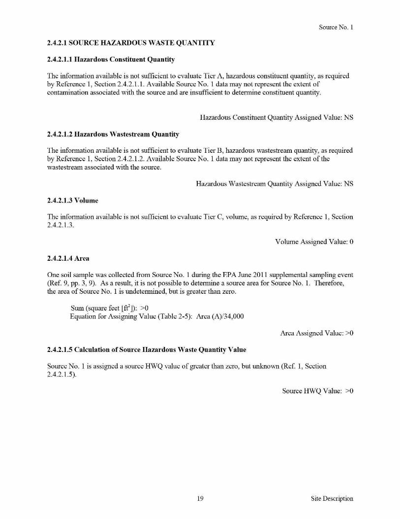
Source No 1
2421 SOURCE HAZARDOUS WASTE QUANTITY
24211 Hazardous Constituent Quantity
The information available is not sufficient to evaluate Tier A hazardous constituent quantity as required by Reference 1 Section 24211 Available Source No 1 data may not represent the extent of contamination associated with the source and are insufficient to determine constituent quantity
Hazardous Constituent Quantity Assigned Value NS
24212 Hazardous Wastestream Quantity
The information available is not sufficient to evaluate Tier B hazardous wastestream quantity as required by Reference 1 Section 24212 Available Source No 1 data may not represent the extent of the wastestream associated with the source
Hazardous Wastestream Quantity Assigned Value NS
24213 Volume
The information available is not sufficient to evaluate Tier C volume as required by Reference 1 Section 24213
Volume Assigned Value 0
24214 Area
One soil sample was collected from Source No 1 during the EPA June 2011 supplemental sampling event (Ref 9 pp 3 9) As a result it is not possible to determine a source area for Source No 1 Therefore the area of Source No 1 is undetermined but is greater than zero
Sum (square feet [ff]) gt0 Equation for Assigning Value (Table 2-5) Area (A)34000
Area Assigned Value gt0
24215 Calculation of Source Hazardous Waste Quantity Value
Source No 1 is assigned a source HWQ value of greater than zero but unknown (Ref 1 Section 242 15)
Source HWQ Value gt0
19 Site Description
SUMMARY OF SOURCE DESCRIPTIONS
TABLES Summary of Source Descriptions
Containment Factor Value by Pathway
Source Surface Air Source Hazardous Water Hazardous Constituent Ground Overland Waste Quantity Water Flood Gas Particulate
Source Quantity Complete (Ref 1 (Ref 1 (Ref 1 (Ref 1 No Value (YesNo) Table 3-2) Table 4-2) Table 6-3) Table 6-9)
1 gt0 No NS 10 NS NS
Notes
NS Not scored Total Source Hazard Waste Quantity Value gt0
Other Possible Source
Contaminated Soil on Western Portion of MNOP - During the EPA May 2009 expanded site inspection (ESI) conducted at the MNOP (currently known as AlP) soil samples were collected on the western portion of the MNOP property (Ref 7 pp 1 6 Appendix A p A-4) Soil samples AIP-124-SB and AIP-134-SF contained mercury at concentrations of088 mglkg and 13 mgkg (Ref 34 pp 120 166) Soil sample AIP-124-SB was collected from the area where the BlendingMixing Houses were located (Refs 7 Appendix A p A-4 13 p 54) The BlendingMixing Houses were where MNOP mixed the explosives (Ref 13 pp 11 12) Military explosives such as those that were manufactured at MNOP contained mercury compounds (mercury fulminate) as initiating agents (Ref 23 pp 7-1 7-5 7-8) Soil sample AIP-134-SF was collected from the northwestern portion of the MNOP in the area where the MNOP WWTP was formerly located (Refs 7 Appendix A p A-4 13 p 52) (see Figure 2 of this HRS documentation record) These areas drain into Drainage Ditch 2 which flows south and merges with the AWl drainage easement then flows into Rocky Creek (Ref 7 Appendix A p A-4) Contaminated soil on the western portion of MNOP drains towards the A WI site to the west of MNOP and not towards the PPE and observed release scored in this HRS documentation record (see Figure 3) therefore this other possible source is not scored in this HRS documentation record
20 Site Description
40 SURFACE WATERlflGRATION PATHWAY
41 OVERLANDFLOOD lflGRA TION COMPONENT- Drainage Ditch 4
4111 Definition of Hazardous Substance Migration Path for OverlandFlood Component
The hazardous substance migration pathway includes both the overland segment and the in-water segment that hazardous substances would take as they migrate away from sources The overland segment begins at the source and proceeds downgradient to the probable point of entry (PPE) to surface water The inshywater segment at the PPE continues in the direction of flow (Ref 1 Section 4 111)
Overland flow from Source No 1 (contaminated soil in the eastern portion of the MNOP property) is directed to Drainage Ditch 4 Drainage Ditch 4 is an intermittent drainage route located up gradient of the PPE along the eastern boundary of the MNOP property (Ref 9 pp 1 3) Surface water runofffrom Source No 1 flows overland about 625 feet and enters Drainage Ditch 4 Drainage Ditch 4 flows south for about 3250 feet and enters HRS-eligible palustrine forested wetlands adjacent to Rocky Creek The point where Drainage Ditch 4 enters the palustrine forested wetlands is PPE 1 Drainage Ditch 4 continues south within palustrine forested wetlands for about 1250 feet and enters Rocky Creek (Refs 3 36 Map 1) (also see Figure 3 of this HRS documentation record)
Rocky Creek flows east-southeast for about 1 mile before it converges with Tobesofkee Creek Tobesofkee Creek flows south-southeast for about 4 miles before it converges with the Ocmulgee River which flows for more than 95 miles thus completing the 15-mile surface water migration pathway target distance limit (TDL) east-southeast of Elberta Georgia (Ref 3)
The flow rate for Rocky Creek is estimated to be between 10 and 15 cubic feet per second (cfs) (Ref 37) Rocky Creek has several branches Specific stream channels are difficult to discern because of the extensive wetlands in the area (Refs 3 36) According to the US Geological Survey the mean flow rate for Tobesofkee Creek for water years 1937 to 2010 was 183 cfs and the mean flow rate for the Ocmulgee River for water years 1911 to 2010 was 2657 cfs (Ref 38 pp 3 10)
The southern portion of Drainage Ditch 4 is located within wetlands and the 100-year floodplain of Rocky Creek This area is prone to frequent flooding resulting in the mixing of water in the surrounding area (Refs 7 Appendix A p A-4 36 Map 1 44)
21 SW-OverlandFlood Migration Component
41 21 LIKELlliOOD OF RELEASE
41 211 OBSERVED RELEASE- Chemical Analysis
EPA June 2011 Supplemental Sampling
Background and Contaminated Samples
During the EPA June 2011 supplemental sampling event one background sediment sample MNOP-W-01-SD was collected from HRS-eligible palustrine forested wetlands west of and upgradient from Drainage Ditch 4 Contaminated sediment sample MNOP-D4-W-09-SD was collected from Drainage Ditch 4 within HRS-eligible palustrine forested wetlands downstream of the PPE Background and contaminated sediment samples were collected from HRS-eligible palustrine forested wetlands at depths ranging from 0 to 3 inches bgs (Refs 9 pp 1 3 8 9 36 Map 1)
The sediment samples were collected in accordance with the EPA Region 4 SESD Field Branches Quality System and Technical Procedures for Sediment Sampling SESDPROC-200-R2 (Refs 9 pp 1 6 10 p 4 25) The location of the background sediment sample is depicted on Figure 3 of this HRS documentation record Chain-of-custody records are provided in Reference 26 Logbook notes are provided in Reference 9 pages 8 and 9
The background and contaminated sediment samples were collected during the same sampling event in accordance with the same sampling procedures and from the same type of HRS-eligible wetland (palustrine forested) (Refs 9 pp 1 3 6 36) (see Figure 3 of this HRS documentation record)
TABLE6 Background and Contaminated Sediment Samples - June 2011
Sample ID Sample Location
Background HRS-eligible palustrine forested wetlands
MNOP-W-01-SD west and upgradient of Drainage Ditch 4 upstream from site drainage
Drainage Ditch 4
MNOP-D4-W-09-SD HRS-eligible palustrine forested
Notes
bgs D HRS ID MNOP NA PPE SD w
wetlands
Below ground surface Ditch Hazard Ranking System Identification number Macon Naval Ordnance Plant Not applicable Probable point of entry Sediment sample Wetland
Distance Depth Date fromPPE 1 (bgs) Sampled References
9 p 8 26 p 2 36 Map 1
NA 0 to 3
06292011 Figure 3 of this
inches HRS documentation record
700 feet 0 to 3 06302011
9 pp 3 9 26 downstream inches p 2 36 Map 1
22 SW-Observed Release
Background and Contaminated Concentrations
The sediment samples listed in Table 7 were collected during the EPA June 2011 supplemental sampling event (Ref 9 pp 3 8 9) Sediment samples were analyzed for mercury in accordance with EPA Method 2455 and the EPA Region 4 ASB LOQAM January 201 1 (Refs 9 p 1 11 p 1 27) EPA Region 4 SESD reviewed all data according to the contract SOW and EPA guidelines (Refs 28 11 p 1 ) The MRLs are listed on the analytical data sheets in Reference 11 pages 21 and 22 Each MRL is sampleshyspecific and corresponds to the lowest quantitative point on the calibration curve it is adjusted for the amount of sample prepared and any dilutions performed as well as for percent moisture The MRLs are equivalent to SQLs (Ref 29)
TABLE 7 Analytical Results for Background and Contaminated Sediment Samples- June 2011
Sample Hazardous Description Sample ID Substance Concentration MRL
Background MNOP-W-01-SD Mercury 016J (0 29)
0050mgkg mgkg
Release
Notes
() D ID J mglkg MNOP MRL SD w
MNOP-D4-W-09-SD Mercury 11 mgkg 0050mgkg
Concentrations shown in parentheses were adjusted in accordance with References 31 and 32 Ditch Identification number The identification of the aualyte is acceptable the reported value is an estimate (Ref 11 p 4) Milligram per kilogram Macon Naval Ordnance Plant Minimum reporting limit Sediment sample Wetland
References
11 pp 4 22 31 32 pp8 18
11 p 21
23 SW-Observed Release
Additional Supporting Data
The sediment samples listed in Table 8 below were collected from Drainage Ditch 4 during the June 2011 supplemental sampling event (Ref 9 pp 1 3 9) Sediment sample MNOP-D4-W-08-SD was collected at PPE 1 The samples presented below show the presence of mercury along the overland drainage route Drainage Ditch 4 from Source No 1 to PPE 1 Because Drainage Ditch 4 is an intermittent water body up gradient of PPE 1 these sediment samples were not included as part of the surface water pathway inshywater segment discussion (Ref 9 pp 1 3) (see Figure 3 of this HRS documentation record)
TABLE 8 Drainage Ditch 4 Sediment Samples- June 2011
SampleiD
MNOP-D4-02-SD
MNOP-D4-04-SD
MNOP-D4-07-SD
MNOP-D4-W-08-SD
Notes
D4 ID
Drainage Ditch 4 Identification
Hazardous Substance
Mercury
Mercmy
Mercury
Mercmy
Concentration MRL
00511 mgkg 0050 mgkg
0083J mgkg 0050 mgkg
046 mgkg 0050 mgkg
0 19J mgkg 0050 mgkg
J mglkg MNOP MRL SD
The identification ofthe analyte is acceptable the rep011ed value is an estimate (Ref 11 p 4) Milligrams per kilogram Macon Naval Ordnance Plant Minimum rep011ing lirnit Sediment
w Wetland
24
Reference
11 pp 4 13
11 pp 4 16
ll p19
11 pp4 20
SW-Observed Release
Attribution
The MNOP was constructed before World War II and was operated as an ordnance manufacturing facility until1973 (Refs 12 p 1-1 13 p 2) Ordnance manufactured at the MNOP included flares small primers detonators and other triggering mechanisms (Ref 13 p 2) The total area of the MNOP was approximately 433 acres which extended from Guy Paine Road in the north to Rocky Creek in the south and Mead Road to the east and the Central of Georgia Railroad tracks to the west (Refs 8 18 p 2 22 pp 1 2)
Explosive compounds were either handled or stored in many areas throughout the MNOP property including numerous small dryer buildings ordnance magazines and blending and mixing houses (Ref 13 pp 11 12 54) According to a technical manual prepared by the Department of the Army military explosives such as those that were manufactured at the MNOP contained mercury compounds as initiating agents including mercury fulminate (Ref 23 pp 7-1 7-5 7-8) Building 109 located in the eastern portion of the MNOP near Source No 1 was a primary explosives production site (Ref 13 pp 11 12 54) (see Figures 2 and 3 of this HRS documentation record) Soil samples collected from this area during the US ACE 1996 site investigation and EPA June 2011 supplemental sampling event contained mercury (Refs 9 p 3 13 pp 58 83 84)
Other facilities in the area include the MBCIA which renamed the MNOP property the Allied Industrial Park and currently leases or sells buildings as office and warehouse space to various industrial and commercial businesses on the AlP property (Refs 7 Appendix A p A-3 13 pp 1 2 3 14 p 2-9 15) Politex US Inc (Politex) is the only manufacturing business that is currently located at the AlP Politex is a textile manufacturing firm that produces roofing membranes clothing and furniture padding and building materials (Ref 15) Politex is located on the western portion of the MNOP property (Refs 6 pp 42 through 49 7 Appendix A p A-3) Runoff and drainage originating from Politex does not enter Drainage Ditch 4 (Ref 7 Appendix A pp A-2 A-3) (see Figure 3 of this HRS documentation record) The propetty where Source No 1 soil sample MNOP-04-SF was collected is owned by the City of Macon and is operated as a recreational park that includes baseball fields (Refs 6 pp 7 8 7 Appendix A pp A-2 A-3 9 p 3)
Possible off-site sources also include the FMNOL A WI and the Rocky Creek water reclamation facility (RC WRF) A WI and FMNOL are currently listed on the EPA NPL under CERCUS ID No GAN000410033 at docket number EPA-HQ-SFUND-2010-0640-0002 (Ref 47) Runoff from FMNOL and A WI flows into Rocky Creek via a drainage easement The drainage easement enters Rocky Creek west and upstream of Source No 1 soil sample MNOP-04-SF and Drainage Ditch 4 Drainage Ditch 4 is located just west of the RC WRF (Ref 7 Appendix A p A-2)
The FMNOL was reportedly used for disposal of solid wastes and ordnance throughout the operational history (1941 to 1974) of the MNOP (Refs 8 17 pp 42 43 46 47 18 p 2) The landfill was also used for disposal of used parts and construction debris (Refs 14 p 2-11 18 p 2) During the EPA May 2009 ESI mercury was detected in soil samples collected from the FMNOL at concentrations ranging from 047 mgkg (FML-303-SF) to 47 mglkg (FML-304-SB) (Ref 35 pp 130 132)
Since 1948 AWl has operated an acoustic ceiling tile manufacturing plant on 130 acres of land west of the MNOP property (Ref 19 p 3) In 1980 A WI notified the Georgia Environmental Protection Division (GAEPD) that it was a generator of hazardous waste and A WI was classified as a conditionally exempt small quantity generator under the Resource Conservation and Recovery Act (RCRA) PCBs are the primary hazardous substance of concern for this facility not metals (Ref 19 pp 5 6)
The RC WRF located southeast of and downstream from MNOP provides wastewater treatment for the southern and western portions of the City of Macon Treated wastewater from this facility is discharged into the Ocmulgee River however RC WRF maintains a National Pollutant Discharge Elimination System (NPDES)-permitted discharge point at the southern property boundary (Refs 9 p 3 45 pp 2 3 46 pp 1 8) The NPDES permit requires RC WRF to monitor outfall discharges for biochemical oxygen
25 SW-Observed Release
demand total suspended solids pH chlorine fecal coliform nitrogen dissolved oxygen PCBs and phosphorus (Ref 46 pp 6 7) There are currently no documented releases of mercury at this location (Refs 9 p 3 46 pp 6 7)
The source sample collected from Source No 1 (contaminated soil on the eastern portion ofMNOP) during the EPA June 2011 supplemental sampling event contained mercury (Refs 9 p 3 11 p 8) (see Table 3 in Section 222 for Source No 1 of this HRS documentation record) Sediment samples collected from Drainage Ditch 4 which receives runoff from Source No 1 also contained mercury The presence of mercury in Drainage Ditch 4 documents the migration of releases from Source No 1 at the MNOP (Refs 9 p 3 11 pp 13 16 19 20 21) (also see Tables 6 and 7 in Section 41211 Observed Release of this HRS documentation record) Furthennore an observed release of mercury has been documented in HRS-eligible wetlands along Drainage Ditch 4 (Refs 9 p 3 11 p 21 36)
Mercury has been documented in Source No 1 in Drainage Ditch 4 and in palustrine forested wetlands indicating migration of hazardous substances from the MNOP property (see Table 3 in Section 222 for Source No 1 and Table 7 in Section 41211 Observed Release of this HRS documentation record)
Hazardous Substance in the Release
Mercury
Surface Water Observed Release Factor Value 55000
26 SW-Observed Release
412 DRINKING WATER THREAT
The drinking water threat was not scored because it is not expected to contribute significantly to the overall score
27 SW-Drinking Water Threat
4132 HUMAN FOOD CHAIN THREAT WASTE CHARACTERISTICS
41321 ToxicityPersistenceBioaccumulation
The toxicity persistence and bioaccumulation factor value for mercury detected in Source No 1 with containment factor values of greater than 0 is summarized in Table 9 The combined toxicity persistence and bioaccumulation factor value is assigned in accordance with Reference 1 Section 41321
TABLE 9 ToxicityPersistenceBioaccumulation
Toxicity Persistence
Toxicity Persistence Bioaccu- Bioaccumulation Hazardous Source Factor Factor mulation Factor Value (Ref Substance No Value Value1 Value2 1 Table 4-16) Reference
Mercury 1 10000 1 50000 5 X 10⁸ 2 p BI-8
Notes
Persistence factor value for rivers Bioaccumulation factor value for fresh water
ToxicityPersistenceBioaccumulation Factor Value 50000000000 (Ref 1 Section413214)
28 SW-Human Food Chain Threat
41322 HAZARDOUS WASTE QUANTITY
TABLE 10 Hazardous Waste Quantity
Source No Source Type Source Hazardous Waste Quantity
1 Contaminated soil gt0
Total Source Hazardous Waste Quantity gt0
One soil sample MNOP-04-SF was collected to represent Source No 1 (Ref 9 pp 3 9 see Table 3 in Section 222 for Source No 1 of this HRS documentation record) As a result it is not possible to calculate an area measurement for Source No 1 Therefore the area of Source No 1 is undetermined but is greater than zero In addition the hazardous waste quantity receives a minimum factor value of 100 for the surface water migration pathway because actual contamination at Level II concentrations is present in HRS-eligible palustrine forested wetlands and hazardous constituent quantity is not adequately determined (Ref 1 Section 2422)
Hazardous Waste Quantity Factor Value 100 (Ref 1 Table 2-6)
41323 CALCULATION OF HUMAN FOOD CHAIN THREAT WASTE CHARACTERISTICS FACTOR CATEGORY VALUE
The waste characteristics factor category was obtained by multiplying the toxicity persistence and hazardous waste quantity (HWQ) factor values subject to a maximum product of 1 x 10⁸
Then this product was multiplied by the bioaccumulation potential factor value subject to a maximum product of 1 x 10¹²
Based on this product a value was assigned in accordance with Reference 1 Table 2-7
ToxicityPersistence Factor Value 1000000 Hazardous Waste Quantity Factor Value 100
ToxicityPersistence Factor Value x Hazardous Waste Quantity Factor Value 1 x 10⁶
ToxicityPersistence Factor Value x Hazardous Waste Quantity Factor Value x Bioaccumulation Factor Value (50000) 5 x 10¹⁰
29
Waste Characteristics Factor Category Value 320 (Ref I Table2-7)
SW-Human Food Chain Threat
4133 HUMAN FOOD CHAIN THREATT ARGETS
41331 Food Chain Individual
An observed release of a hazardous substance having a bioaccumulation factor value of 500 or greater is documented in perennial surface water with a fishery downstream- specifically an observed release to Drainage Ditch 4 within HRS-eligible palustrine forested wetlands (Refs 9 p 3 11 pp 21 22 36 Map 1) (see Figure 3 of this HRS documentation record) Drainage Ditch 4 flows south for about 1250 feet within palustrine forested wetlands and joins Rocky Creek (Ref 9 p 3) Rocky Creek Tobesofkee Creek and the Ocmulgee River are designated as fisheries by the State of Georgias Ocmulgee River Watershed Management Plan (Refs 39 p 2 40 Appendix A pp A-89 A-91 41 p 4-14) Rocky Creek is fished between Broadway and its confluence with Tobesofkee Creek within the site TDL where it is accessible to the public fish are also harvested for consumption (Refs 3 37 42 pp 3 10 11) In 2007 GAEPD personnel observed people fishing in Rocky Creek east of Highway 41 The fishermen indicated to GAEPD personnel that they clean and eat the fish that they catch (Refs 19 p 9 42 pp 3 10 11) In addition Tetra Tech observed fishing gear including a fishing line and weight along Rocky Creek during the EPA 2009 ESI sampling event (Ref 7 Appendix D p D-14) Fish species caught for consumption in Rocky Creek include bream blackfish bass redear sunfish redbreast sunfish bluegill and brown bullhead catfish (Refs 19 p 9 37 42 p 3) The State of Georgia has issued fish consumption guidelines for the Ocmulgee River as a result of mercury contamination (Refs 9 p 9 43 p 41)
41332 Population
413321 Level I Concentrations
No Level I samples were collected
413322 Level II Concentrations
No Level II samples were collected
Food Chain Individual Factor Value 20 (Ref 1 Section41331)
413323 Potential Human Food Chain Contamination
Drainage Ditch 4 flows south for about 1250 feet within HRS-eligible palustrine forested wetlands and joins Rocky Creek (Ref 9 p 3) Rocky Creek is fished between Broadway and its confluence with Tobesofkee Creek within the site TDL where it is accessible to the public fish are also harvested for consumption (Refs 3 37 42 pp 3 10 11) Information is not available on the annual production offish caught in Rocky Creek therefore the annual production is undetermined but greater than 0
TABLE 11 Potential Population Targets
Population Dilution Type of Value (P) Weight
Annual Surface Average (Ref 1 (D) (Ref Identity Production Water Annual Table 4- 1 Table
of Fishery ~nds) _____Jody Flow (cfs) 18) 4-13_) P XD R eferences - - -
Small to 37 39 p 2
Rocky gt0 Moderate 10 to 15 003 01 0003
40 Appendix Creek
Stream A p A-91
I 41 p 4-14 Notes cfs Cubic feet per second
30 SW-Human Food Chain Threat
For the potential human food chain contamination factor value the sum of Pi x Di is divided by 10
31
Potential Human Food Chain Factor Value 00003 (Ref 1 Section 413323)
SW-Human Food Chain Threat
4142 ENVIRONMENTAL THREAT WASTE CHARACTERISTICS
41421 Ecosystem ToxicityPersistenceBioaccumulation
The ecosystem toxicity persistence and bioaccumulation factor value for mercury detected in Source No 1 with a containment factor value of greater than 0 is summarized in Table 12 The combined ecosystem toxicity persistence and bioaccumulation factor value is assigned in accordance with Reference 1 Section 4 1421
TABLE 12 Ecosystem ToxicityPersistenceBioaccumulation
Hazardous Source Substances No
Mercury 1
Notes
Ecotoxicity for fresh water Persistence value for rivers
Ecosystem Toxicity Persistence Factor Factor Value1 Value2
10000 1
Ecosystem Toxicity
Bioaccumula tion Bioaccu- Factor Value mulation (Ref 1 Table Value3 4-21) Reference
50000 5 X 10⁸ 2 p BI-8
Bioaccurnulation factor value for fresh water envirournental threat
Ecosystem ToxicityPersistenceBioaccumulation Factor Value 5 x 10⁸
(Reference 1 Section 414214)
32 SW-Environmental Threat
41422 HAZARDOUS WASTE QUANTITY
TABLE 13 Hazardous Waste Quantity
Source No Source Type Source Hazardous Waste Quantity
1 Contaminated soil gt0
Total Source Hazardous Waste Quantity gt0
One soil sample MNOP-04-SF was collected to represent Source No 1 (Ref 9 pp 3 9 see Table 3 in Section 222 for Source No 1 of this HRS documentation record) (Ref 9 pp 3 9) As a result it is not possible to calculate an area measurement for Source No 1 Therefore the area of Source No 1 is undetermined but is greater than zero In addition the hazardous waste quantity receives a minimum factor value of 100 for the surface water migration pathway because actual contamination at Level II concentrations is present in HRS-eligible palustrine forested wetlands and hazardous constituent quantity is not adequately determined (Ref 1 Section 2422)
Hazardous Waste Quantity Factor Value 100 (Ref 1 Table 2-6)
41423 CALCULATION OF ENVIRONMENTAL CHAIN THREAT WASTE CHARACTERISTICS FACTOR CATEGORY VALUE
The waste characteristics factor category was obtained by multiplying the ecosystem toxicity persistence and HWQ factor values subject to a maximum product of 1 x 10⁸
Then this product was multiplied by the bioaccumulation potential factor value subject to a maximum product of 1 x 10¹²
Based on this product a value was assigned in accordance with Reference 1 Table 2-7
Ecosystem ToxicityPersistence Factor Value 1000000 Hazardous Waste Quantity Factor Value 100
Ecosystem ToxicityPersistence Factor Value x Hazardous Waste Quantity Factor Value 1 x 10⁶
Ecosystem ToxicityPersistence Factor Value x Hazardous Waste Quantity Factor Value x Bioaccumulation Factor Value (50000) 5 x 10¹⁰
33
Waste Characteristics Factor Category Value 320 (Ref I Table2-7)
SW-Environmental Threat
4143 Environmental Threat Targets
Level I Concentrations
No Level I concentrations have been documented
Level II Concentrations
Actual contamination has been documented in wetland areas along Drainage Ditch 4 in Section 41211 of this HRS documentation record The sampling locations are shown in Reference 9 page 3 Wetland areas were identified from Reference 36 Wetlands Inventory Maps The wetland areas evaluated are palustrine forested (Refs 3 9 p 3 36)
Most Distant Level II Sample
Investigation Sample ID Sample Medium Hazardous Substance
June 2011 Supplemental Sampling MNOP-D4-W-09-SD Sediment Mercury
Location Drainage Ditch 4 about 700 feet downstream from PPE 1 References record)
3 9 p 3 11 p 21 36 (also see Table 7 of this HRS documentation
41431 Sensitive Environments
414311 Level I Concentrations
Sensitive Environments
Sensitive environments other than wetlands have not been identified within the 15-rnile surface water migration pathway TDL
Wetlands
No Level I wetlands were scored
414312 Level IT Concentrations
Sensitive Enviromnents
Sensitive environments other than wetlands have not been identified within the 15-rnile surface water migration pathway TDL
Wetlands
The wetlands were identified from Reference 36 Wetlands Inventory Maps The wetlands evaluated are palustrine forested (Refs 3 9 p 3 36) The southern portion of Drainage Ditch 4 is located within HRSshyeligible wetlands (Refs 3 9 p 3 36) The sediment sample evaluated at a Level II concentration is located in palustrine forested wetlands along Drainage Ditch 4 (Refs 3 9 p 3 36) The total wetland frontage from PPE 1 to the most downstream sample that contained Level II concentrations (MNOP-D4-W-090SD) is about 1400 feet or 026 mile (Refs 3 9 p 3 36) Both sides of Drainage Ditch4 within this segment contain HRS eligible wetlands so both sides of Drainage Ditch 4 were included in the calculation of the wetland frontage (Refs 3 9 p 3 36)
34 SW-Environmental Threat
TABLE 14 Level II Wetland Frontage
Wetland Water Body Wetland Fronta~e References
Palustrine forested Drainage Ditch 4 1400 feet or 026 mile 39p336
Total Wetland Frontage 1400 feet or 026 mile 3 9 p336
Total Wetland Frontage 1400 feet
The wetland ratings value for 026 mile is obtained from Reference 1 Table 4-24 and is 25
Wetland Value 25 (Ref 1 Table 4-24)
For wetlands subject to Level II concentrations the wetland value (25) is multiplied by 1 (Ref 1 Section 414311)
414313 Potential Contamination
Sensitive Environments
Wetland Value 25 x 1 Level II Concentrations Factor Value 25
(Ref 1 Section 414311)
Potential sensitive environments were not evaluated because the presence of sensitive environments other than wetlands has not been identified
Wetlands
The wetlands were identified from Reference 36 Wetlands Inventory Maps The wetlands evaluated for potential contamination are palustrine forested (Refs 3 9 p 3 36) Wetlands were measured from the farthest downstream sediment sample (MNOP-D4-W-09-SD) collected on Drainage Ditch 4 to the completion of the 15-mile surface water migration pathway TDL Wetland frontage from both sides of Drainage Ditch 4 Rocky Creek Tobesofkee Creek and the Ocmulgee River were measured (Refs 3 36) Wetlands that were evaluated as Level II were not included in the potential contamination wetland frontage The flow rate for Rocky Creek is estimated to be between 10 and 15 cfs (Ref 37) According to the US Geological Survey the mean flow rate for Tobesotkee Creek water years 1937 to 2010 was 183 cfs and the mean flow rate for the Ocmulgee River water years 1911 to 2010 was 2657 cfs (Ref 38 pp 3 10)
35 SW-Environmental Threat
TABLE 15 Wetland Frontage
Wetlands Value Based
Surface Water Type of Surface Wetland on Wetland Body Water Body Fronta~e Fronta~e References
Small to Moderate About 25 miles 75
1 Tables 4-13 4-24 3 36 Rocky Creek Stream 37
Moderate to Large About 775 150
1 Tables 4-13 4-24 3 36 Tobesoflcee Creek Stream miles 38 p3
Ocmulgee River Large Stream to
About 7 miles 150 1 Tables 4-13 4-24 3 36
River 38 p 10
Total Wetlands Value 375 1 Tables 4-13 4-24 3 36
TABLE 16 Potential Contamination
Sum of Wetlands Dilution D1 (W1 + S1)
Sensitive Value (WJ Weight (D1) (Ref 1 Surface Water Environments (Ref 1 Table (Ref 1 Section
Body Values (S1) 4-24) Table 4-13) 414333) References
Rocky Creek 0 75 01 75 33637
T obesoflcee Creek 0 150 001 15 33638 p 3
Ocmulgee River 0 150 0001 015 33638 p 10
Total Potential Contamination Factor Value 91 5
For wetlands subject to potential contamination the wetland value (915) is multiplied by 0 1 (Ref 1 Section 414313)
36
Wetland Value 9 15 x 01 Potential Contamination Factor Value 0915
(Ref 1 Section 4143 13)
SW-Environmental Threat
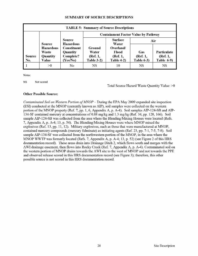
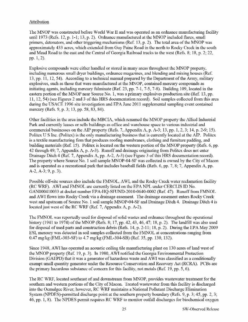
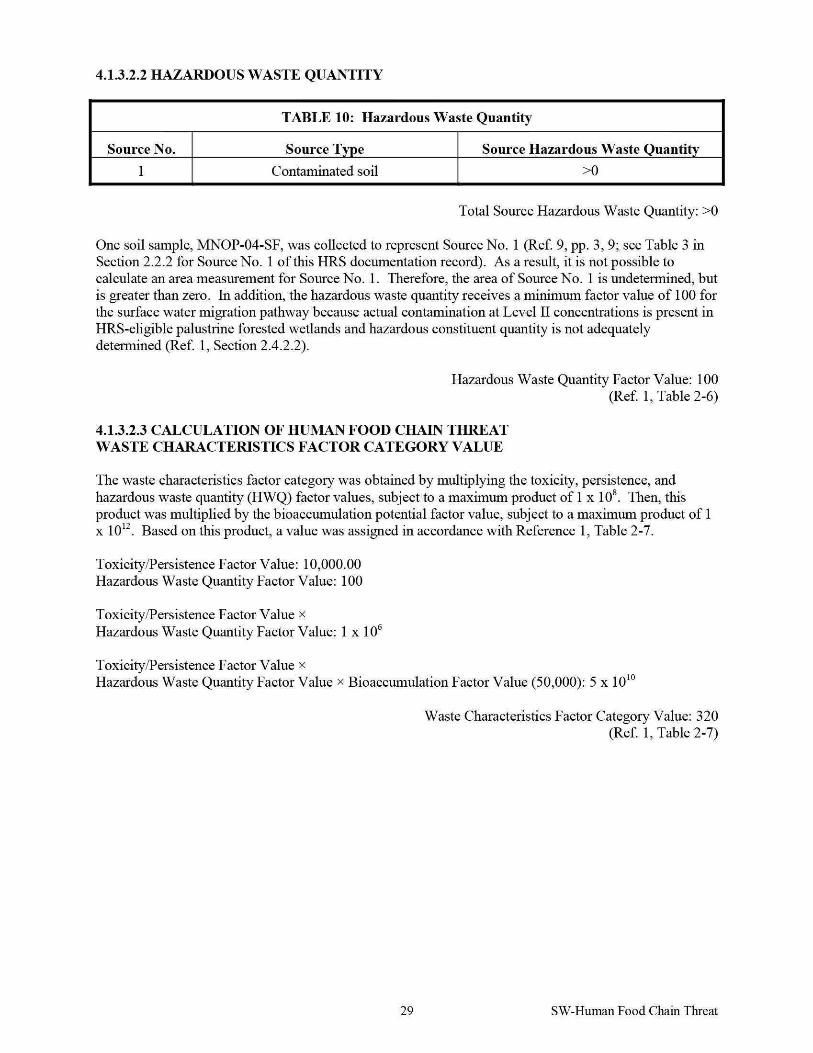
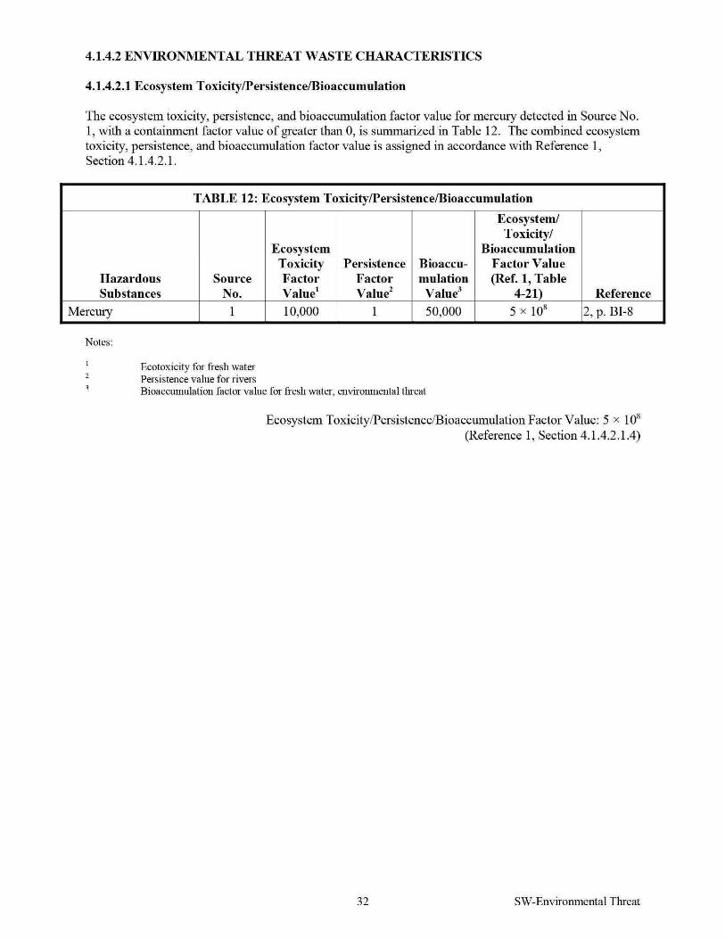
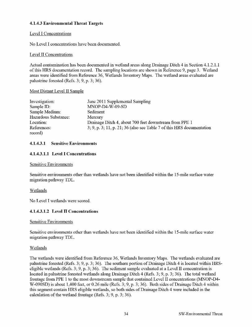
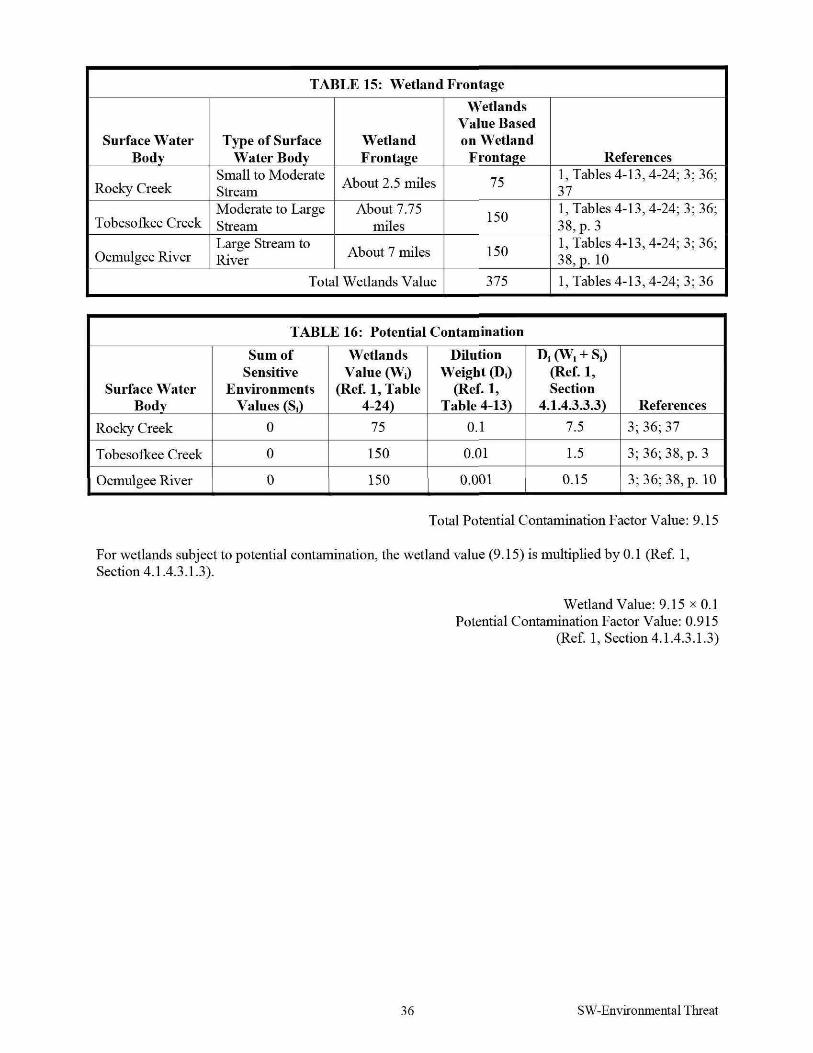


![IIRS Report on ISRS Symposium in Dec. 2016[1] · organisation to the Chipko Andolan (Hug the Trees Movement). Dr. A. Senthil Kumar, Chair, ISRS - Dehradun Chapter and Director, IIRS](https://img.pdfslide.net/doc/110x75/5eb52a47993af937be54127a/iirs-report-on-isrs-symposium-in-dec-20161-organisation-to-the-chipko-andolan.jpg)