Embed Size (px)
Citation preview
8.1
Paul Davies Pty Ltd Architects Heritage Consultants FINAL REPORT August 2009
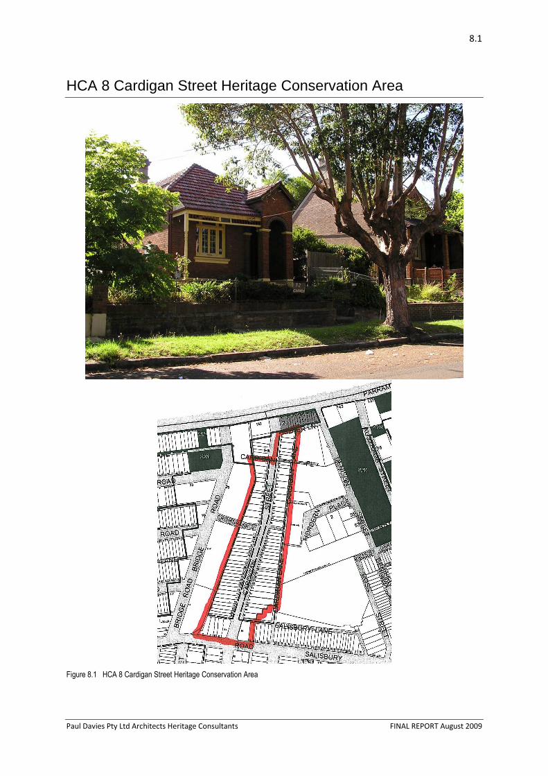
HCA 8 Cardigan Street Heritage Conservation Area
Figure 8.1 HCA 8 Cardigan Street Heritage Conservation Area
HCA 8 – CARDIGAN STREET – STANMORE 8-2
Paul Davies Pty Ltd Architects Heritage Consultants FINAL REPORT August 2009
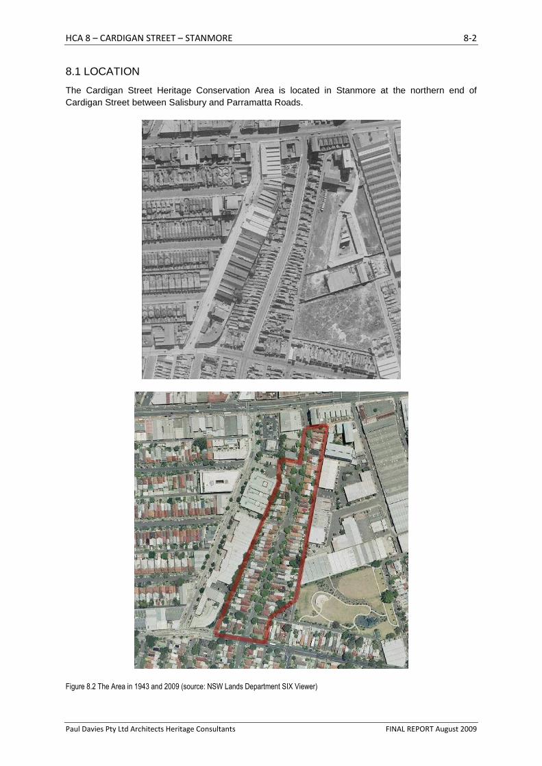
8.1 LOCATION
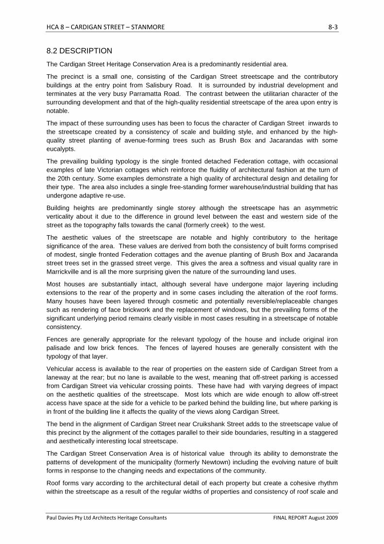
The Cardigan Street Heritage Conservation Area is located in Stanmore at the northern end of Cardigan Street between Salisbury and Parramatta Roads.
Figure 8.2 The Area in 1943 and 2009 (source: NSW Lands Department SIX Viewer)
HCA 8 – CARDIGAN STREET – STANMORE 8-3
Paul Davies Pty Ltd Architects Heritage Consultants FINAL REPORT August 2009
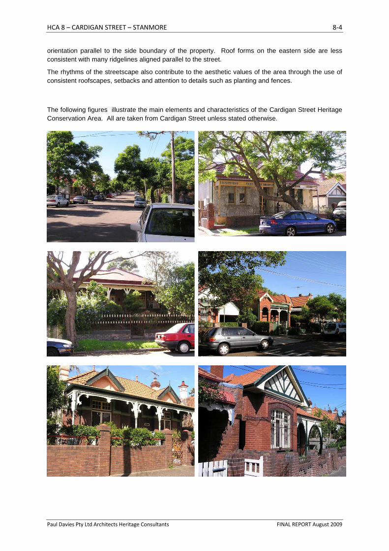
8.2 DESCRIPTION
The Cardigan Street Heritage Conservation Area is a predominantly residential area.
The precinct is a small one, consisting of the Cardigan Street streetscape and the contributory buildings at the entry point from Salisbury Road. It is surrounded by industrial development and terminates at the very busy Parramatta Road. The contrast between the utilitarian character of the surrounding development and that of the high-quality residential streetscape of the area upon entry is notable.
The impact of these surrounding uses has been to focus the character of Cardigan Street inwards to the streetscape created by a consistency of scale and building style, and enhanced by the high-quality street planting of avenue-forming trees such as Brush Box and Jacarandas with some eucalypts.
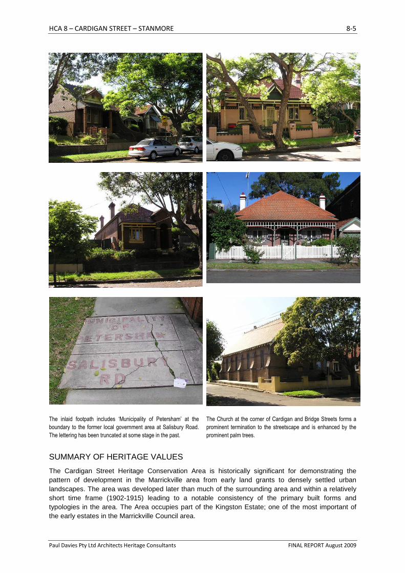
The prevailing building typology is the single fronted detached Federation cottage, with occasional examples of late Victorian cottages which reinforce the fluidity of architectural fashion at the turn of the 20th century. Some examples demonstrate a high quality of architectural design and detailing for their type. The area also includes a single free-standing former warehouse/industrial building that has undergone adaptive re-use.
Building heights are predominantly single storey although the streetscape has an asymmetric verticality about it due to the difference in ground level between the east and western side of the street as the topography falls towards the canal (formerly creek) to the west.
The aesthetic values of the streetscape are notable and highly contributory to the heritage significance of the area. These values are derived from both the consistency of built forms comprised of modest, single fronted Federation cottages and the avenue planting of Brush Box and Jacaranda street trees set in the grassed street verge. This gives the area a softness and visual quality rare in Marrickville and is all the more surprising given the nature of the surrounding land uses.
Most houses are substantially intact, although several have undergone major layering including extensions to the rear of the property and in some cases including the alteration of the roof forms. Many houses have been layered through cosmetic and potentially reversible/replaceable changes such as rendering of face brickwork and the replacement of windows, but the prevailing forms of the significant underlying period remains clearly visible in most cases resulting in a streetscape of notable consistency.
Fences are generally appropriate for the relevant typology of the house and include original iron palisade and low brick fences. The fences of layered houses are generally consistent with the typology of that layer.
Vehicular access is available to the rear of properties on the eastern side of Cardigan Street from a laneway at the rear; but no lane is available to the west, meaning that off-street parking is accessed from Cardigan Street via vehicular crossing points. These have had with varying degrees of impact on the aesthetic qualities of the streetscape. Most lots which are wide enough to allow off-street access have space at the side for a vehicle to be parked behind the building line, but where parking is in front of the building line it affects the quality of the views along Cardigan Street.
The bend in the alignment of Cardigan Street near Cruikshank Street adds to the streetscape value of this precinct by the alignment of the cottages parallel to their side boundaries, resulting in a staggered and aesthetically interesting local streetscape.
The Cardigan Street Conservation Area is of historical value through its ability to demonstrate the patterns of development of the municipality (formerly Newtown) including the evolving nature of built forms in response to the changing needs and expectations of the community.
Roof forms vary according to the architectural detail of each property but create a cohesive rhythm within the streetscape as a result of the regular widths of properties and consistency of roof scale and
HCA 8 – CARDIGAN STREET – STANMORE 8-4
Paul Davies Pty Ltd Architects Heritage Consultants FINAL REPORT August 2009
orientation parallel to the side boundary of the property. Roof forms on the eastern side are less consistent with many ridgelines aligned parallel to the street.
The rhythms of the streetscape also contribute to the aesthetic values of the area through the use of consistent roofscapes, setbacks and attention to details such as planting and fences.
The following figures illustrate the main elements and characteristics of the Cardigan Street Heritage Conservation Area. All are taken from Cardigan Street unless stated otherwise.
HCA 8 – CARDIGAN STREET – STANMORE 8-5
Paul Davies Pty Ltd Architects Heritage Consultants FINAL REPORT August 2009
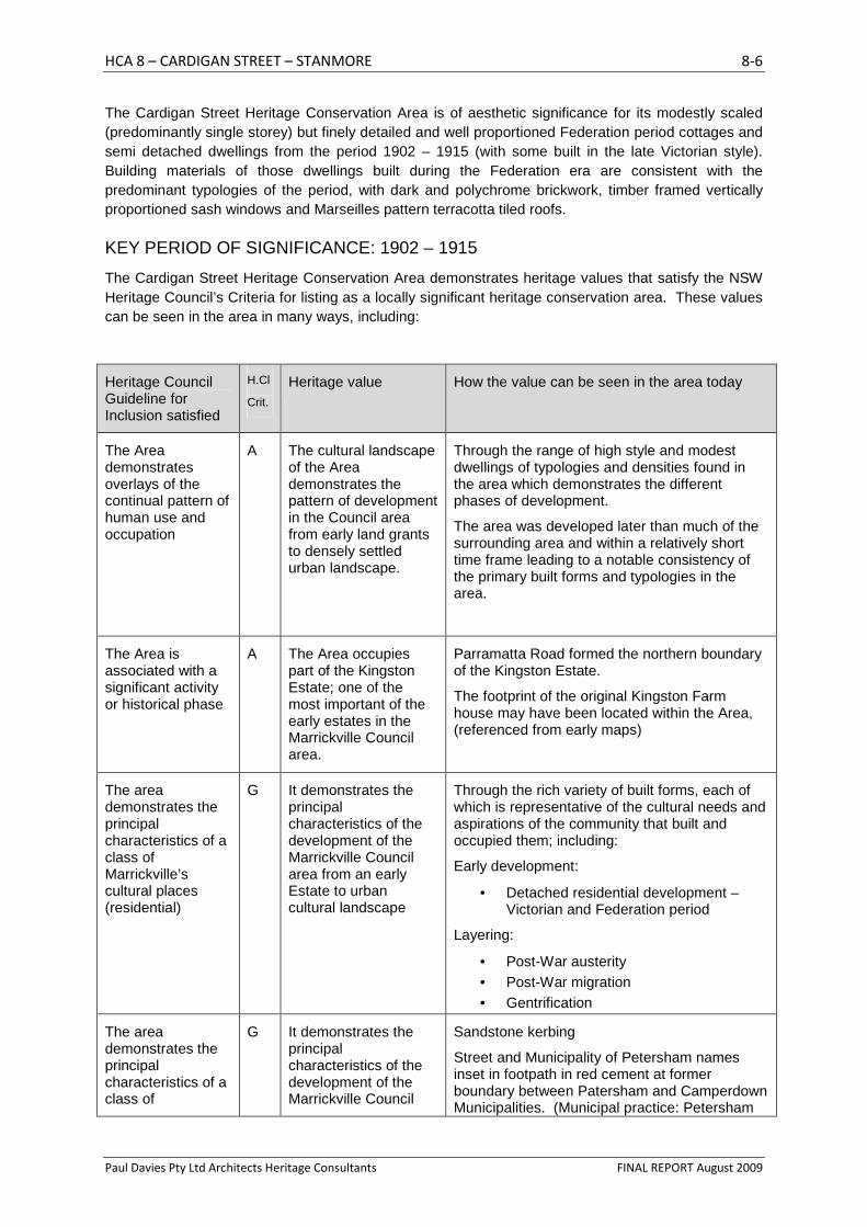
The inlaid footpath includes ‘Municipality of Petersham’ at the
boundary to the former local government area at Salisbury Road.
The lettering has been truncated at some stage in the past.
The Church at the corner of Cardigan and Bridge Streets forms a
prominent termination to the streetscape and is enhanced by the
prominent palm trees.
SUMMARY OF HERITAGE VALUES
The Cardigan Street Heritage Conservation Area is historically significant for demonstrating the pattern of development in the Marrickville area from early land grants to densely settled urban landscapes. The area was developed later than much of the surrounding area and within a relatively short time frame (1902-1915) leading to a notable consistency of the primary built forms and typologies in the area. The Area occupies part of the Kingston Estate; one of the most important of the early estates in the Marrickville Council area.
HCA 8 – CARDIGAN STREET – STANMORE 8-6
Paul Davies Pty Ltd Architects Heritage Consultants FINAL REPORT August 2009
The Cardigan Street Heritage Conservation Area is of aesthetic significance for its modestly scaled (predominantly single storey) but finely detailed and well proportioned Federation period cottages and semi detached dwellings from the period 1902 – 1915 (with some built in the late Victorian style). Building materials of those dwellings built during the Federation era are consistent with the predominant typologies of the period, with dark and polychrome brickwork, timber framed vertically proportioned sash windows and Marseilles pattern terracotta tiled roofs.
KEY PERIOD OF SIGNIFICANCE: 1902 – 1915
The Cardigan Street Heritage Conservation Area demonstrates heritage values that satisfy the NSW Heritage Council’s Criteria for listing as a locally significant heritage conservation area. These values can be seen in the area in many ways, including:
Heritage Council Guideline for Inclusion satisfied
H.Cl
Crit.
Heritage value How the value can be seen in the area today
The Area demonstrates overlays of the continual pattern of human use and occupation
A The cultural landscape of the Area demonstrates the pattern of development in the Council area from early land grants to densely settled urban landscape.
Through the range of high style and modest dwellings of typologies and densities found in the area which demonstrates the different phases of development.
The area was developed later than much of the surrounding area and within a relatively short time frame leading to a notable consistency of the primary built forms and typologies in the area.
The Area is associated with a significant activity or historical phase
A The Area occupies part of the Kingston Estate; one of the most important of the early estates in the Marrickville Council area.
Parramatta Road formed the northern boundary of the Kingston Estate.
The footprint of the original Kingston Farm house may have been located within the Area, (referenced from early maps)
The area demonstrates the principal characteristics of a class of Marrickville’s cultural places (residential)
G It demonstrates the principal characteristics of the development of the Marrickville Council area from an early Estate to urban cultural landscape
Through the rich variety of built forms, each of which is representative of the cultural needs and aspirations of the community that built and occupied them; including:
Early development:
• Detached residential development – Victorian and Federation period
Layering:
• Post-War austerity • Post-War migration • Gentrification
The area demonstrates the principal characteristics of a class of
G It demonstrates the principal characteristics of the development of the Marrickville Council
Sandstone kerbing
Street and Municipality of Petersham names inset in footpath in red cement at former boundary between Patersham and Camperdown Municipalities. (Municipal practice: Petersham
HCA 8 – CARDIGAN STREET – STANMORE 8-7
Paul Davies Pty Ltd Architects Heritage Consultants FINAL REPORT August 2009
Heritage Council Guideline for Inclusion satisfied
H.Cl
Crit.
Heritage value How the value can be seen in the area today
Marrickville’s cultural places (public domain)
The area has attributes typical of the particular philosophy and design of Marrickville Council (and its predecessors)
area from an early Estate to a suburban cultural landscape and contains high quality streetscapes and public domain elements representative of civic management and improvement programs.
Municipality)
High quality street tree planting including Jacaranda and BrushBox; with additional planting representative of the late 20th Century Environmental movement (native species, e.g. bottlebrush, melaleuca )
Is important in demonstrating aesthetic characteristics and/ or a high degree of creative or technical achievement in the Marrickville area.
C
The area contains groups and streetscapes which collectively illustrate representative types of Marrickville’s cultural landscape.
G
It contains many buildings and elements of individual and group aesthetic value
19th and early 20th Century terraces and houses (detached and semi-detached) and their setting
The area was developed later than much of the surrounding area and within a relatively short time frame leading to a notable consistency of the primary built forms and typologies in the area.
The area is also notable for its modestly scaled (predominantly single storey) but finely detailed and well proportioned examples of cottages and semi-detached dwellings.
Building materials of those dwellings built during the Federation era are consistent with the predominant typologies of the period, with dark and duochrome brickwork, timber framed vertically proportioned sash windows and Marseilles pattern terracotta tiled roofs. Many of these are in danger of being devalued by the current fashion for rendering and painting brickwork and replacing timber windows.
Land uses in the area are single-family residential in character
Many individual properties within this area have been layered, including some notable examples of the different typologies found throughout the Marrickville area. Not all are reversible but few obscure the original form of the building and its setting to the extent where they must be considered intrusive.
8.4 DEFINING THE EXTENT OF THE HERITAGE CONSERVATION AREA
The boundary of the heritage conservation areas reflect the identified heritage values of the area and the ability of the fabric of the houses and streetscapes to demonstrate these values. They recognise the impact that the changing role and character of the land uses and buildings have had on the layer of development from the significant era of development (1902-1915).
The boundaries of this area are defined clearly by the surrounding industrial and commercial uses to the east, north and west. Fieldwork revealed that the properties fronting Salisbury Road, particularly
HCA 8 – CARDIGAN STREET – STANMORE 8-8
Paul Davies Pty Ltd Architects Heritage Consultants FINAL REPORT August 2009
those to the west of Cardigan Street, demonstrate a scale and built form generally consistent with the properties in Cardigan Street and are recommended for inclusion in the area. They are also part of the same subdivision of land and building construction phase. They are heavily layered but their scale and form is consistent with the Area. The property adjacent to the west of these cottages at 74 Salisbury Rd is occupied by a small c1960s residential facility. Its current built form is not particularly contributory to the heritage value of this area but its location and character suggest that it will be a likely infill site at some time in the future; and any development on this site has the potential to read as part of the setting of the Cardigan Street/Salisbury Road group. It is recommended therefore that it be included within the boundary of the conservation area.
The Uniting Church and Hall at 84 Cardigan Street, including the Canary Island Palm specimen tree adjacent to the hall, provide a focal/entry point and termination to the streetscapes of Cardigan Street. Properties to the east of the Church on Salisbury Road are compatible in their scale and overall built form but do not demonstrate the high-quality or consistency of architectural form demonstrated by the Cardigan Street precinct and are not recommended for inclusion in the conservation area.
8.5 ELEMENTS THAT CONTRIBUTE TO THE HERITAGE SIGNIFICANCE OF THE AREA
The table above outlined the ways in which the heritage significance of the Cardigan Street Heritage Conservation Area are expressed through the contemporary cultural landscape.
The relevant planning controls to conserve the evidence of the area’s heritage significance are contained in the Mixed Residential Streetscapes section of the DCP (see the DCP for details).
The Cardigan Street Heritage Conservation Area also contains many details, or fine-grained elements that are found throughout the area on buildings of different styles and types that contribute to the integrity and heritage significance of the area. The elements are not found on all buildings; but if they are present they need to be retained in any new development. Further details about how to protect these details and incorporate them in new development can be found in the detailed DCP sheets.
SUBDIVISION AND PUBLIC DOMAIN ELEMENTS:
• Street layout
• Mature street trees creating avenue quality to streetscape
• Street and Municipal names set into footpath
• Sandstone block kerbing and guttering
• Low-density and modestly scaled residential character
ELEMENTS THAT CONTRIBUTE TO THE CONSISTENCY OF THE STREETSCAPE (VISIBLE FROM THE PUBLIC DOMAIN)
• good groups of substantially intact late Victorian and Federation freestanding cottages (1902-1915)
• prevailing character of the area is modest with high-quality detailing
• Original fabric
• Consistent setbacks
• Setbacks aligned to side boundaries creating stepped streetscape due to oblique lot frontage
• Predominantly single storey building heights
• Quality of streetscape patterns, rhythms and textures
• Aesthetically pleasing serrated roofscapes created by consistent building height and form aligned to side boundaries set obliquely to the street.
• Building typologies reinforce the urban grain.
HCA 8 – CARDIGAN STREET – STANMORE 8-9
Paul Davies Pty Ltd Architects Heritage Consultants FINAL REPORT August 2009
o Groups of similar types and runs of terraces demonstrate strong streetscape qualities including cohesiveness of form, scale, rhythm and materials.
o High quality original detailing to front elevation
o Increasing simplification of scale and detailing towards rear – including window size, bulk and visual prominence in view from street
• Roof forms appropriate to typology and period of construction
o Intact roof forms
o Primary ridgelines of roofs are aligned parallel to the street
o Gabled roofs to terraces with ridge running parallel to the street alignment
o Roof forms of groups or runs of buildings demonstrating consistent pitch and rhythm
o Lack of major alterations to roof form and volumes
o Original chimneys contribute to the quality and visual interest of roofscapes
o Original dormer windows - small and vertically proportioned
• Intact or substantially intact built elements
o Consistency of form and detailing to intact and substantially intact original dwellings and streetscapes
o Any additions visible from the public domain that are of a minor scale, respect original built form and are unobtrusive in the context of the streetscape
• Building heights appropriate to typology and period of construction
• Detailing and finishes appropriate to typology and period of construction
o Vertical proportions to windows pre mid 20th Century
o Window openings appropriate for architectural type
o Timber framed windows
o Complex timber framed windows to main bay of front elevation
o Un-painted and un-rendered face brickwork to 20th Century fabric
o Use of appropriate colour schemes for detailing
• Fences appropriate to typology and period of construction
o Original Iron Palisade fences
o Original low face-brick (not rendered or painted) walls
• Vehicular access provided from rear lane (east side) - lack of driveway crossovers to principal frontage. Emphasised by retaining walls to street elevation
• Lack of car parking infrastructure forward of the building line
• Garden plantings in front of dwellings
ELEMENTS THAT CONTRIBUTE TO THE INTEGRITY OF THE OVERALL PATTERN OF DEVELOPMENT IN THE AREA (NOT NECESSARILY VISIBLE FROM THE STREET)
• Central placement of development within lot
• Footprints of additions to the rear respect the traditional pattern of development (including service wing/pavilion/recessive scale)
• Vehicle access from rear lanes (where available)
8.6 ELEMENTS THAT DETRACT FROM THE HERITAGE SIGNIFICANCE OF THE AREA
The Cardigan Street Heritage Conservation Area has undergone many layers of change and alteration over the years since it was first developed. Some of these contribute to the cumulative heritage significance of the area but others do not because they are of an irreversible nature or result
HCA 8 – CARDIGAN STREET – STANMORE 8-10
Paul Davies Pty Ltd Architects Heritage Consultants FINAL REPORT August 2009
in a visual fabric that destroys, overwrites or otherwise confuses the identified values of the area. These include:
• Overscaled and poorly proportioned additions • Alterations to roof forms and volumes visible from the street, including poorly sited and
proportioned dormer windows and lifted ridgelines. • Inappropriate use of dormers (contrary to typology) • Application of conjectural detailing to new work • Concrete tiles or inappropriate use of metal panels to roof. • Painting and rendering original face brick • Removal of original detailing • Alteration to fenestration patterns (including reconfiguration/re-orientation of vertical openings
to horizontal) • Removal/replacement of timber windows with aluminium-framed windows • Roller shutters to windows • Historically inappropriate fence design and details not relevant to building typology and/or
incongruous/visually intrusive in streetscape views • Visually intrusive security measures (eg security bars painted a light colour, roller shutters
and enclosing grilles to verandahs) • Replacement fences of type or form inappropriate to building typology and/or intrusive on
aesthetic qualities of the streetscape • High/solid front fences and walls • Infilled verandahs