Embed Size (px)
Citation preview

DOI 10.1007/s10346-019-01265-wReceived: 28 December 2018Accepted: 21 August 2019
Xiaojie Liu I Chaoying Zhao I Qin Zhang I Chengsheng Yang I Wu Zhu
Heifangtai loess landslide type and failure mode anal-ysis with ascending and descending Spot-modeTerraSAR-X datasets
Abstract The Heifangtai loess terrace in northwest China is a well-known area to study loess landslides because of its frequentoccurrence, various types, and complex trigger factors. The deter-mination of loess landslide type and failure mode is of greatsignificance for the landslide risk assessment, hazard mitigation,and prevention. In this study, ascending and descending Spot-mode TerraSAR-X datasets are employed to analyze the deforma-tion patterns and failure modes of loess landslides in Xinyuanlandslide group, Heifangtai terrace, by using multidimensionalsmall baseline subsets (MSBAS) technique. First, the locations ofthree active landslides are delineated by independent InSAR ob-servations from both ascending and descending TerraSAR-Xdatasets. Then, two-dimensional deformation rates and time seriesresults in both vertical and horizontal east-west directions of theidentified landslides are calculated using MSBAS technique. Final-ly, the deformation types and failure modes of landslides in thestudy sites are analyzed by jointly using the two-dimensionaldeformation rates and time series results, topographic map, re-mote sensing images, and previous studies on the loess landslidefailure modes. With the aid of complementary data includingtopographic map, remote sensing image, previous studies on theloess landslide failure modes, and field investigations, two-dimensional deformation results derived from ascending and de-scending SAR images are compatible with three typical failuremodes of loess landslide including loess-bedrock planar slide,retrogressive failure, and loess slide. Furthermore, the two-dimensional deformation derived from InSAR technique can givemuch detailed deformation characteristics and movement of loesslandslide.
Keywords Loess landslide . Heifangtai . Failuremodes . InSAR . Multidimensional small baseline subsets(MSBAS)
IntroductionLandslides are widely distributed in the world and cause enor-mous direct and indirect damages each year. The loess plateau,located in northwest China, is the most concentrated and largestloess area in the world. In the past decades, landslide disastersoccurred on the loess plateau have caused enormous casualtiesand huge economic losses. Heifangtai loess terrace (13.7 km2), as awell-known loess landslides area, has about 200 landslides distrib-uted on the edge of the terrace caused by heavy agriculturalirrigations (Peng et al. 2017).
It is of great significance to find efficient and reliable methodsto analyze the deformation pattern and failure mode of loesslandslide for effective disaster assessment and prevention. Nowa-days, four methods are mainly focused on the study of deforma-tion pattern and failure mode of loess landslide, i.e., field
geological investigations, in-situ monitoring and tests, aerialphotographs, and laboratory experiments. Peng et al. (2015) stud-ied the moving characteristics of loess landslide in Tianshui citytriggered by continuous and heavy precipitation based on aerialphotograph interpretation, field mapping, three-dimensional laserscanning, and laboratory tests. Qi et al. (2017) analyzed the failuremechanism of loess flow slides and the characteristic of sloperetreat in Heifangtai terrace based on field investigations andmonitoring, aerial and remote sensing images, and laboratoryexperiments. These methods are becoming very challenging whenthey are applied in the large-area loess landslide analysis due tothe high cost and low efficiency.
On the contrary, the spaceborne Synthetic Aperture Radar(SAR) interferometry (InSAR) technique is characterized by largespatial coverage and high sensitivity to the deformation of theearth’s surface, which has been widely used in the landslide inves-tigation (Zhao et al. 2012; Iglesias et al. 2015a, 2015b; Kang et al.2017; Zhao et al. 2018a; Bru et al. 2018; Zhao et al. 2018b). As mostlandslides move along both horizontal and vertical directions (Heet al. 2015), the classical InSAR technique including Stacking-InSAR (Lyons and Sandwell 2003), PS-InSAR (Ferretti et al.2001), and SBAS-InSAR (Berardino et al. 2002) can only obtainone-dimensional deformation along the line-of-sight (LOS) direc-tion. There still exist several limitations in the detailed landslideinvestigation, such as (1) it is challenging to analyze the deforma-tion mechanism of landslide and easy to misunderstand it in caseof a complex situation; (2) it is hard to observe the deformationwhich is orthogonal to the LOS direction. Therefore, two- and/orthree-dimensional surface deformation monitoring technique ison high demand.
With the increasing availability of multi-tracking SAR data,some advanced two and/or three-dimensional InSAR deformationmonitoring techniques have been developed, which allow us tohave an intensive understanding for the landslide deformationcharacteristics and make it possible to study the landslidedeformation type and failure mode. Liu et al. (2013) calculatedtwo-dimensional deformation rates for both north and verticaldirections of Huangtupo landslide in China using ascending anddescending Envisat SAR images. Singleton et al. (2014) employedsub-pixel offset time series technique to monitor two-dimensionalmovements of Shuping landslide in the Three Gorges region,China. He et al. (2015) performed a feasibility study of the large-scale landslide two-dimensional monitoring in Fushun west open-pit mine of China by combining multi-aperture InSAR (MAI) andDInSAR.
Loess landslides are characterized by small spatial extent andsmall deformation magnitude (Zhao et al . 2016). Theabovementioned offset-tracking and MAI methods are overallnot applicable for two- and/or three-dimensional deformation
Technical Note
Landslides (2020) 17:205–215
Published online: 6 September 2019© The Author(s) 2019
Landslides 17 & (2020) 205

monitoring of loess landslides due to the low measurement accu-racy (between 1/10 and 1/30 pixels size) (Hu et al. 2014) and largegradient deformation requirement (Jung et al. 2009). In this study,Spot-mode ascending and descending TerraSAR-X images areinvolved and a multidimensional small baseline subset (MSBAS)technique (Samsonov et al. 2013) is employed to recover the two-dimensional deformation rates and time series deformation ofloess landslides in both east-west and vertical directions. Threetypical failure modes of loess landslide are then analyzed based onthe obtained two-dimensional deformation results, topographicmap, remote sensing images, and previous studies. The reliabilityof the obtained results is verified and evaluated by field geologicalsurvey.
Study area and SAR datasets
Study areaHeifangtai loess terrace (Fig. 1) is taken as the study area, which islocated at 42 km west of Lanzhou, Gansu province, China. Itcomprises two terraces, that is Heitai and Fangtai. Due to thestrong uplift of the adjacent Tibetan Plateau, the early gulliesand the Yellow River cut down into the pre-Pleistocene(Cretaceous) bedrocks, which results in the formation of rock-seated river terraces (i.e., Heifangtai terrace) (Liu 1985). Duringthis process, fluvial deposits remained on the surface of the bed-rocks. At the time of upper Pleistocene, the loess transported bywind fell and settled down on the terrace (Xu et al. 2014). There-fore, the engineering geology of Heifangtai terrace can be dividedinto four units as shown in Fig. 2 (Qi et al. 2017), including fromthe top to the bottom of Manlan loess (Qeol
3 ) with a thickness of
approximately 26–48 m, a low permeability alluvial clay layer (Qal3 )
with about 3 to 19 m thick, an underlying layer of fluvial gravel(Qal
3 ) mixed with sands about 1 to 6 m thick, and bedrocks (K1hk)consist of sandstone partings with a dip angle of about 8–12° anddip direction of about 125–220°.
The average annual evaporation capacity is about 5.4 times theprecipitation in the terrace (Zeng et al. 2016). Therefore, a largeamount of water has been pumped from the Yellow River foragricultural irrigation on the surface of the terrace (Fig. 1b). As aresult, the groundwater level of Heifangtai terrace has significantlyincreased, which caused dense cracks and loess landslides (about200 landslides) along the edge of the terrace (Peng et al. 2017). Liuet al. (2018) identified about 48 active loess landslides distributedalong the edge of Heifangtai terrace from 2016 to 2017 using multi-source SAR datasets, which are divided into nine landslide groups.Xinyuan landslide group is chosen as the test site to investigate thedeformation characteristic and failure mode of loess landslideowing to its visibility for both ascending and descending SARdata. Peng et al. (2017) summarized five failure modes of loesslandslide in Heifangtai terrace based on aerial images, digitalelevation model (DEM), and field investigations, that is loess-bedrock planar slide, loess-bedrock irregular slide, loess flow slide,loess slide, and loess flow. The deformation data involved in thestudy were obtained from the single-point crack measurementsand the difference of unmanned aerial vehicle (UAV) DEMs. Giventhe small deformation magnitude of the loess landslides and thelow height accuracy of the UAV DEMs, it is challengeable tomonitor them with the method of UAV DEM difference.
SAR datasetsIn order to accurately monitor the deformation of small-scaleloess landslides in Heifangtai terrace, high-resolution SAR datasetsfrom both ascending and descending Spot-mode TerraSAR-X arecollected. In total, 23 ascending SAR images acquired with track 21from February 2016 to November 2016, and 19 descending SARimages acquired with track 165 from January 2016 to November2016 are used. The basic parameters for two SAR datasets are listedin Table 1, while their coverages are shown in Fig. 1a. According tothe special characteristics of loess landslides, i.e., small spatialextent, and to meet the requirement of high-resolution SAR dataprocessing, the UAV DEM with 3-m spatial resolution is used toremove the topographic phase from the SAR interferograms.
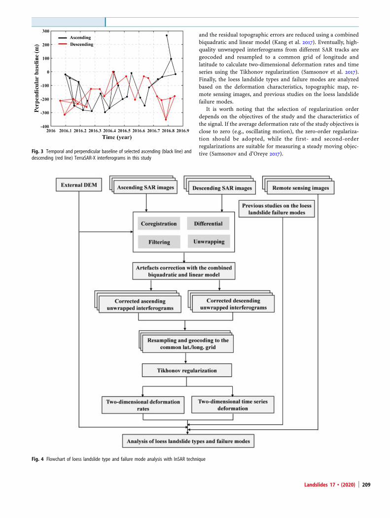
All interferograms with the temporal baseline less than 60 daysand the perpendicular baseline less than 250 m are generated. Themultilooking factors of 2× 2 for the interferograms are set todecrease the influences of the decorrelation; hence, the spatialspacing of the multi-looked interferograms is about 3 m in bothrange and azimuth directions. Then, interferograms contaminatedby heavy decorrelation due to dense vegetation and heavy rainfallin the summer season are excluded for the following processing.Finally, a total of 60 high-quality interferograms including 33ascending and 27 descending tracks are left, which are shown inFig. 3.
Methodology
Calculation of two-dimensional deformation rates and time seriesAs single SAR datasets can only get the surface deformationin the LOS direction, it can hardly retrieve more than one-dimensional surface deformation simultaneously. An advancedmultidimensional small baseline subset (MSBAS) techniquewas developed to combine multiple DInSAR datasets to gen-erate multidimensional surface deformation with dense tem-poral sampling and low noise (Samsonov and d’Oreye 2012).Once ascending and descending SAR datasets have time over-lap for their acquisition periods, MSBAS can produce densertime series deformation than each individual SAR datasets.The problem of data redundancy and multidimensionality isaddressed in MSBAS processing by decomposing one-dimensional LOS deformation into the vertical and horizontaleast-west directions using ascending and descending SARimages.
When a single SAR dataset acquired by one sensor with anincidence angle θ and azimuth α, the time series deformation canbe retrieved by the SBAS method (Berardino et al. 2002):
BV los ¼ ϕobs;V los ¼ Bþϕobs; dilos ¼ di−1los þ Vi
losΔti ð1Þ
where B is anM ×Nmatrix (M is the number of interferogramsand N + 1 is the number of SAR images), Vlos represents the LOSaverage deformation rates, ϕobs represents the observed interfer-ometric phases, B+ is a pseudo-inverse of matrix B calculated by
applying the singular value decomposition (SVD), and dilos is theLOS displacement at the epoch ti.
In case of Kmultiple SAR datasets acquired by different sensorswith different incidence angles and azimuths, the Eq. (1) can be
Technical Note
Landslides 17 & (2020)206

rewritten in the following form for each dataset k = 1⋯K(Samsonov et al. 2013):
SkNB SkEB SkUB�� ��⋅ VN VE VUj jT ¼ ϕk
obs ð2Þ
assuming,
Vlos ¼ SV ¼ SNVN þ SEVE þ SUVU ð3Þ
Fig. 1 Study area and SAR datasets coverage. a Location of the study area indicated by the red rectangle. The black and white rectangles show the coverage of thedescending (track 165) and ascending (track 21) Spot-mode TerraSAR-X data. b Landsat-8 remote sensing image of the zoomed study area acquired in February 2017
Landslides 17 & (2020) 207

S ¼ SN ; SE; SUf g ¼ sinαsinθ;−cosαsinθ; cosθf g ð4Þ
where S is a unit vector of LOS with north, east and up com-ponents SN, SE, SU, and V is a deformation rate vector with com-ponents VN, VE, and VU.
Therefore, the MSBAS approach can be expressed in the fol-lowing equation once all K independent SAR datasets are involved:
B1
B2
−−−BK
0BB@
1CCA�
VN
VE
VU
0@
1A ¼
ϕ1
ϕ2
−−−ϕK
0BB@
1CCA or B̂ V̂ los ¼ ϕ̂ obs ð5Þ
where B̂ is a new matrix with 3 ∑K
k¼1Nk−1
� �� ∑
K
k¼1Mk dimensions, V̂
is a new unknown velocity vector with dimensions1� 3 ∑
K
k¼1Nk−1
� �, and ϕ̂obs is a new observation vector with 1� ∑
K
k¼1Mk dimensions. The near-polar orbit spaceborne SAR satellite canacquire data insensitive to the motion in the north-south directiondue to its inherent SAR geometry (Samsonov et al. 2013). ForTerraSAR data listed in Table 1, the contributions of the realthree-dimensional (i.e., north-south, east-west, and vertical)ground deformation projection to the LOS direction are about11%, 65%, and 75%, respectively. Therefore, the contribution ofthe north-south direction can be neglected in general (Samsonov
and d’Oreye 2017). Equation (5) can be further simplified by excludingthe north-south component VN, and thereby, the dimensions ofmatrix B̂ can be reduced to 2 ∑
K
k¼1Nk−1
� �� ∑
K
k¼1Mk. Equation (5) is
rank deficient because the number of unknown parameters isgreater than the number of linearly independent equations. Itcan be solved by using the SVD and the zero-, first-, or second-order Tikhonov regularization (Samsonov and d’Oreye 2017).Two-dimensional time series deformation can be retrieved fromthe obtained deformation rates by numerical integration usingthe following equation:
dUp ¼ ∑p
i¼1VU
i Δt; dEp ¼ ∑
p
i¼1VE
i Δti ð6Þ
where p ¼ 1; 2; 3;…;∑Kk¼1N
k, dUp , and dEp are the cumulativevertical and horizontal east-west deformations, respectively.
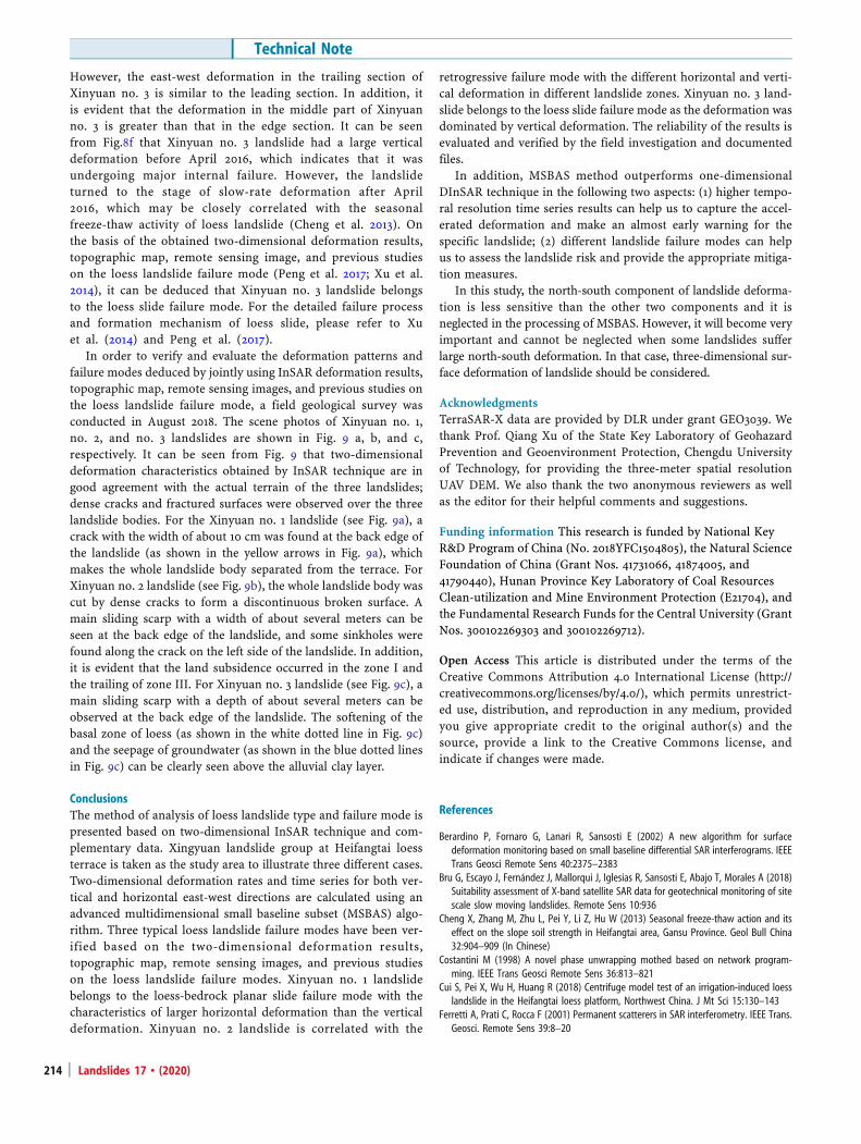
Analysis of loess landslide types and failure modesThe detailed flowchart of loess landslide type and failure modeanalysis is depicted in Fig. 4 based on InSAR technique andcomplementary data. First, ascending and descending SARdatasets covering common period and region are acquired withdifferent SAR acquisition parameters, including incidence angleand azimuth. Then, for each SAR dataset, the SAR images are firstco-registered. All possible interferograms are generated, filtered(Goldstein and Werner 1998), and unwrapped (Costantini 1998).The artifacts of atmospheric disturbance, residual baseline effects,
Fig. 2 Geological profile of Heifangtai loess terrace (revised after Qi et al. 2017 and Peng et al. 2017). a Scenic photo of a representative slope. b Geological profile
Table 1 Basic parameters of the SAR datasets used in this study
SAR sensor TerraSAR-X TerraSAR-X
Track 21 165
Orbit direction Ascending Descending
Incidence angle (°) 41.2 41.8
Azimuth angle (°) − 9.7 189.6
Resolution (azimuth × range) 1.26 m × 0.91 m 1.26 m × 0.91 m
Number of SAR images 23 19
Acquisition period 20160206–20161107 20160124–20161105
Technical Note
Landslides 17 & (2020)208
and the residual topographic errors are reduced using a combinedbiquadratic and linear model (Kang et al. 2017). Eventually, high-quality unwrapped interferograms from different SAR tracks aregeocoded and resampled to a common grid of longitude andlatitude to calculate two-dimensional deformation rates and timeseries using the Tikhonov regularization (Samsonov et al. 2017).Finally, the loess landslide types and failure modes are analyzedbased on the deformation characteristics, topographic map, re-mote sensing images, and previous studies on the loess landslidefailure modes.
It is worth noting that the selection of regularization orderdepends on the objectives of the study and the characteristics ofthe signal. If the average deformation rate of the study objectives isclose to zero (e.g., oscillating motion), the zero-order regulariza-tion should be adopted, while the first- and second-orderregularizations are suitable for measuring a steady moving objec-tive (Samsonov and d’Oreye 2017).Fig. 3 Temporal and perpendicular baseline of selected ascending (black line) and
descending (red line) TerraSAR-X interferograms in this study
Fig. 4 Flowchart of loess landslide type and failure mode analysis with InSAR technique
Landslides 17 & (2020) 209

Results and discussionsOne-dimensional LOS average deformation rates for each pixel forthe ascending and descending datasets were calculated
individually by weighted averaging of the high-quality interfero-grams (i.e., stacking; Lyons and Sandwell 2003), as shown inFig. 5a, b. Note that positive value indicates the displacement away
Fig. 5 Average deformation rate maps over the whole Xinyuan landslide group of Heifangtai terrace. a Average deformation rate map from track 21 (ascending) fromFebruary 2016 to November 2016. b Average deformation rate map from track 165 (descending) from January 2016 to November 2016. c Vertical deformation rate map. dHorizontal east-west deformation rate map
Fig. 6 Landsat-8 remote sensing images of Xinyuan no. 1 (a), no. 2 (b), and no. 3 (c) landslides acquired on 12 November 2017. The red dotted lines indicate theboundary of the landslides, and the yellow arrows indicate the main sliding direction. Dashed lines indicate the location of deformation profiles, and red dots show thelocation of InSAR time series deformation
Technical Note
Landslides 17 & (2020)210

from the sensor and negative value represents the displacementtowards the sensor. Two-dimensional deformation rates and timeseries are retrieved based on Eqs. (5) and (6). The first-orderregularization is used in this study. The vertical and horizontaleast-west deformation rate maps over the whole Xinyuan landslidegroup of Heifangtai terrace are shown in Fig. 5 c and d,
respectively. It can be seen from Fig. 5a, b that the deformationextent and magnitude of landslides measured by ascending anddescending data show a big difference due to the different imaginggeometries. Two potential loess landslides namely Xinyuan no. 2and no. 3 are successfully identified by both deformation mapsfrom ascending and descending SAR data, while Xinyuan no. 1
Fig. 7 Two-dimensional deformation rates from January 2016 to November 2016 and elevation of Xinyuan no. 1, no. 2, and no. 3 landslides along the profiles of AA’ – FF’;the locations of the profiles of AA’ – FF’ are marked in Fig. 6
Landslides 17 & (2020) 211

landslide is only detected by descending SAR data. As for theascending geometry of Xinyuan no. 1 landslide, the LOS deforma-tion projected from the vertical component and east-west compo-nent is around zero. It is proved that ascending and descendingSAR data are complementary for the potential landslide identifi-cation. Moreover, the different deformation feature for Xingyuanno. 2 landslide can be explained as the different sensitivities of theascending and descending SAR data to the specific landslide de-formation. The maximum deformation rate in LOS direction ismeasured by descending data in the Xinyuan no. 2 as − 60 mm/year. The maximum deformation rates in vertical and east-westdirections for three landslides are 22 mm/year and 28 mm/year,38 mm/year and − 60 mm/year, and 30 mm/year and 20 mm/year,respectively.
Xinyuan no. 1 landslide is located on the left side of Hulanggully, Xinyuan no. 2 landslide is located in Xinyuan village, andXinyuan no. 3 landslide is located on the north side of Zheda road,Heifangtai. The full views of the three landslides are shown onLandsat-8 remote sensing images acquired on 12 November 2017 inFig. 6. The lengths of three landslides are about 130 m, 170 m, and86 m, respectively, and the widths are about 135 m, 165 m, and50 m, respectively. Two-dimensional deformation rates and eleva-tion of the three landslides are extracted along six profiles of AA’-FF’ to analyze the deformation characteristics of landslides indetail, as shown in Fig. 7, while two-dimensional time seriesdeformations for points P1-P6 marked in Fig. 6 are shown inFig. 8 to analyze the landslide evolution.
It can be clearly seen from Figs. 5c, d and 7a, a’ that Xinyuan no.1 landslide is dominated by horizontal east-west deformation (i.e.,westward movement) and relatively small vertical deformation. Inaddition, the landslide experiences uneven deformation, which iscontrolled obviously by the development of cracks. It can be seenfrom Fig. 8a that there is a continuous horizontal deformation of
the landslide before October 2016; however, the horizontal defor-mation is almost unchangeable after October 2016. The landslidecontinues to deform in the vertical direction during the InSARmonitoring. Based on the two-dimensional deformation results,topographic map, remote sensing image, and previous studies onthe loess landslide failure mode (Peng et al. 2017; Xu et al. 2014), itcan be deduced that Xinyuan no. 1 landslide belongs to the loess-bedrock planar slide failure mode. For the detailed failure processand formation mechanism of the loess-bedrock planar slide,please refer to Xu et al. (2014) and Peng et al. (2017).
It can be seen from Fig. 5c, d that the whole Xinyuan no. 2landslide moves eastward, and the vertical deformation is onlyobserved at the edge of the landslide. The landslide can befurther divided into four zones based on the two-dimensionaldeformation results, that is zones I, II, III, and IV, as shownin Fig. 6b. On the basis of Fig. 7 b and b’, we can see (1) thedeformation in vertical and east-west direction are observedsimultaneously in zone I; however, the vertical deformation islarger than the one in the east-west direction; (2) there is onlythe east-west deformation in zone II; (3) the vertical and east-west deformations are also observed simultaneously in zoneIII; however, the east-west deformation is greater than the onein the vertical direction; (4) there is only the vertical defor-mation in zone IV; (5) the deformation along the transverseline of DD’ is also controlled by the development of thecracks; as a result, abrupt deformation changes are observedacross the cracks. It can be seen from Fig. 8b–e that eachzone of Xinyuan no. 2 deforms continuously in the verticaland/or horizontal east-west directions from 2016 to 2017. Themaximum cumulative displacement in vertical direction oc-curred in zone I amounting to 33 mm, and the maximumcumulative displacement in east-west direction appeared inzone II amounting to − 54 mm. Based on the two-
Fig. 8 Two-dimensional time series deformation of Xinyuan no. 1, no. 2, and no. 3 landslides for points P1-P6 marked in Fig. 6
Technical Note
Landslides 17 & (2020)212

dimensional deformation results, topographic map, remotesensing image, and previous studies on the loess landslidefailure mode (Qi et al. 2017; Cui et al. 2018), it can bededuced that Xinyuan no. 2 landslide is correlated to theretrogressive failure mode of loess landslide. A large scarpcan be seen from Figs. 6b and 9b formed at the back edgeof the landslide, which makes the whole landslide completelyseparated from the terrace. Subsequently, the retrogressivefailure is started at the edge of the landslide. For the detailedfailure process and formation mechanism of retrogressive
failure, please refer to Xu et al. (2012), Qi et al. (2017) andCui et al. (2018).
Compared with Xinyuan no. 1 and no. 2 landslides, it canbe seen from Fig. 5c, d that Xinyuan no. 3 landslide shows thedifferent deformation patterns, which is dominated by thevertical deformation, along with a slight east-west deforma-tion. In addition, Xinyuan no. 3 landslide has a smaller spatialscale than the first two landslides. It can be seen from Fig.7c, c’ that the vertical deformation in the trailing section ofXinyuan no. 3 is larger than that in the leading section.
Fig. 9 Scene photos of Xinyuan no. 1 (a), no. 2 (b), and no. 3 (c) landslides taken in August 2018. The red dotted lines indicate the boundary of the landslides and theboundary of the zones
Landslides 17 & (2020) 213
However, the east-west deformation in the trailing section ofXinyuan no. 3 is similar to the leading section. In addition, itis evident that the deformation in the middle part of Xinyuanno. 3 is greater than that in the edge section. It can be seenfrom Fig.8f that Xinyuan no. 3 landslide had a large verticaldeformation before April 2016, which indicates that it wasundergoing major internal failure. However, the landslideturned to the stage of slow-rate deformation after April2016, which may be closely correlated with the seasonalfreeze-thaw activity of loess landslide (Cheng et al. 2013). Onthe basis of the obtained two-dimensional deformation results,topographic map, remote sensing image, and previous studieson the loess landslide failure mode (Peng et al. 2017; Xu et al.2014), it can be deduced that Xinyuan no. 3 landslide belongsto the loess slide failure mode. For the detailed failure processand formation mechanism of loess slide, please refer to Xuet al. (2014) and Peng et al. (2017).
In order to verify and evaluate the deformation patterns andfailure modes deduced by jointly using InSAR deformation results,topographic map, remote sensing images, and previous studies onthe loess landslide failure mode, a field geological survey wasconducted in August 2018. The scene photos of Xinyuan no. 1,no. 2, and no. 3 landslides are shown in Fig. 9 a, b, and c,respectively. It can be seen from Fig. 9 that two-dimensionaldeformation characteristics obtained by InSAR technique are ingood agreement with the actual terrain of the three landslides;dense cracks and fractured surfaces were observed over the threelandslide bodies. For the Xinyuan no. 1 landslide (see Fig. 9a), acrack with the width of about 10 cm was found at the back edge ofthe landslide (as shown in the yellow arrows in Fig. 9a), whichmakes the whole landslide body separated from the terrace. ForXinyuan no. 2 landslide (see Fig. 9b), the whole landslide body wascut by dense cracks to form a discontinuous broken surface. Amain sliding scarp with a width of about several meters can beseen at the back edge of the landslide, and some sinkholes werefound along the crack on the left side of the landslide. In addition,it is evident that the land subsidence occurred in the zone I andthe trailing of zone III. For Xinyuan no. 3 landslide (see Fig. 9c), amain sliding scarp with a depth of about several meters can beobserved at the back edge of the landslide. The softening of thebasal zone of loess (as shown in the white dotted line in Fig. 9c)and the seepage of groundwater (as shown in the blue dotted linesin Fig. 9c) can be clearly seen above the alluvial clay layer.
ConclusionsThe method of analysis of loess landslide type and failure mode ispresented based on two-dimensional InSAR technique and com-plementary data. Xingyuan landslide group at Heifangtai loessterrace is taken as the study area to illustrate three different cases.Two-dimensional deformation rates and time series for both ver-tical and horizontal east-west directions are calculated using anadvanced multidimensional small baseline subset (MSBAS) algo-rithm. Three typical loess landslide failure modes have been ver-ified based on the two-dimensional deformation results,topographic map, remote sensing images, and previous studieson the loess landslide failure modes. Xinyuan no. 1 landslidebelongs to the loess-bedrock planar slide failure mode with thecharacteristics of larger horizontal deformation than the verticaldeformation. Xinyuan no. 2 landslide is correlated with the
retrogressive failure mode with the different horizontal and verti-cal deformation in different landslide zones. Xinyuan no. 3 land-slide belongs to the loess slide failure mode as the deformation wasdominated by vertical deformation. The reliability of the results isevaluated and verified by the field investigation and documentedfiles.
In addition, MSBAS method outperforms one-dimensionalDInSAR technique in the following two aspects: (1) higher tempo-ral resolution time series results can help us to capture the accel-erated deformation and make an almost early warning for thespecific landslide; (2) different landslide failure modes can helpus to assess the landslide risk and provide the appropriate mitiga-tion measures.
In this study, the north-south component of landslide deforma-tion is less sensitive than the other two components and it isneglected in the processing of MSBAS. However, it will become veryimportant and cannot be neglected when some landslides sufferlarge north-south deformation. In that case, three-dimensional sur-face deformation of landslide should be considered.
AcknowledgmentsTerraSAR-X data are provided by DLR under grant GEO3039. Wethank Prof. Qiang Xu of the State Key Laboratory of GeohazardPrevention and Geoenvironment Protection, Chengdu Universityof Technology, for providing the three-meter spatial resolutionUAV DEM. We also thank the two anonymous reviewers as wellas the editor for their helpful comments and suggestions.
Funding information This research is funded by National KeyR&D Program of China (No. 2018YFC1504805), the Natural ScienceFoundation of China (Grant Nos. 41731066, 41874005, and41790440), Hunan Province Key Laboratory of Coal ResourcesClean-utilization and Mine Environment Protection (E21704), andthe Fundamental Research Funds for the Central University (GrantNos. 300102269303 and 300102269712).
Open Access This article is distributed under the terms of theCreative Commons Attribution 4.0 International License (http://creativecommons.org/licenses/by/4.0/), which permits unrestrict-ed use, distribution, and reproduction in any medium, providedyou give appropriate credit to the original author(s) and thesource, provide a link to the Creative Commons license, andindicate if changes were made.
References
Berardino P, Fornaro G, Lanari R, Sansosti E (2002) A new algorithm for surfacedeformation monitoring based on small baseline differential SAR interferograms. IEEETrans Geosci Remote Sens 40:2375–2383
Bru G, Escayo J, Fernández J, Mallorqui J, Iglesias R, Sansosti E, Abajo T, Morales A (2018)Suitability assessment of X-band satellite SAR data for geotechnical monitoring of sitescale slow moving landslides. Remote Sens 10:936
Cheng X, Zhang M, Zhu L, Pei Y, Li Z, Hu W (2013) Seasonal freeze-thaw action and itseffect on the slope soil strength in Heifangtai area, Gansu Province. Geol Bull China32:904–909 (In Chinese)
Costantini M (1998) A novel phase unwrapping mothed based on network program-ming. IEEE Trans Geosci Remote Sens 36:813–821
Cui S, Pei X, Wu H, Huang R (2018) Centrifuge model test of an irrigation-induced loesslandslide in the Heifangtai loess platform, Northwest China. J Mt Sci 15:130–143
Ferretti A, Prati C, Rocca F (2001) Permanent scatterers in SAR interferometry. IEEE Trans.Geosci. Remote Sens 39:8–20
Technical Note
Landslides 17 & (2020)214

Goldstein R, Werner C (1998) Radar interferogram filtering for geophysical applications.Geophys Res Lett 25:4035–4038
He L, Wu L, Liu S, Wang Z, Su C, Liu S (2015) Mapping two-dimensional deformationfield time-series of large slope by coupling DInSAR-SBAS with MAI-SBAS. Remote Sens7:12440–12458
Hu J, Li Z, Ding X, Zhu J, Zhang L, Sun Q (2014) Resolving three-dimensional surfacedisplacements from InSAR measurements: a review. Earth Sci Rev 133:1–17
Iglesias R, Mallorqui J, Modells D, López-Martínez C, Fabregas X, Aguasca A, Gili J,Corominas J (2015a) PSI deformation map retrieval by means of temporal sublookcoherence on reduced sets of SAR images. Remote Sens 7:530–563
Iglesias R, Monells D, López-Martínez C, Mallorqui J, Fabregas X, Aguasca A (2015b)Polarimetric optimization of temporal sublook coherence for DInSAR applications. IEEEGeosci Remote Sens Lett 12:87–91
Jung H, Won J, Kim S (2009) An improvement of the performance of multiple-apertureSAR interferometry (MAI). IEEE Trans. Geosci. Remote Sens 47:2859–2869
Kang Y, Zhao C, Zhang Q, Lu Z, Li B (2017) Application of InSAR techniques to an analysisof the Guanling landslide. Remote Sens 9:1–17
Liu T (1985) Loess and the environment. China Ocean Press 1985:1–481 (In Chinese)Liu P, Li Z, Hoey T, Kincal C, Zhang J, Zeng Q, Muller J (2013) Using advanced InSAR time
series techniques to monitoring landslide movements in Badong of the Three Gorgesregion, China. Int J Appl Earth Obs Geoinf 21:253–264
Liu X, Zhao C, Qin Z, Peng J, Zhu W, Lu Z (2018) Multi-temporal loess landslide inventorymapping with C-, X- and L-band SAR datasets—a case study of Heifangtai loesslandslides, China. Remote Sens 10:1756
Lyons S, Sandwell D (2003) Fault creep along the southern San Andreas from interfer-ometric synthetic aperture radar, permanent scatterers, and stacking. J Geophys ResSolid Earth 108
Peng D, Xu Q, Liu F, He Y, Zhang S, Qi X, Zhao K, Zhang X (2017) Distribution and failuremodes of the landslides in Heitai terrace, China. Eng Geol:1–14
Peng J, Fan Z, Wu D, Zhuang J, Dai F, Chen W, Zhao C (2015) Heavy rainfall triggeredloess-mudstone landslide and subsequent debris flow in Tianshui, China. Eng Geol186:79–90
Qi X, Xu Q, Liu F (2017) Analysis of retrogressive loess flowslides in Heifangtai, China. EngGeol:1–10
Samsonov S, d’Oreye N (2012) Multidimensional time series analysis of ground defor-mation from multiple InSAR data sets applied to Virunga Volcanic Province. Geophys JInt 191:1095–1108
Samsonov S, d’Oreye N (2017) Multidimensional small baseline subset (MSBAS) for two-dimensional deformation analysis: case study Mexico City. Can J Remote Sens 43:1–12
Samsonov S, d’Oreye N, Smets B (2013) Ground deformation associated with post-mining activity at the French-German border revealed by novel InSAR time seriesmethod. Int J Appl Earth Obs Geoinf 23:142–154
Samsonov S, Feng W, Peltier A, Geirsson H, d’Oreye N, Tiampo K (2017) Multidimensionalsmall baseline subset (MSBAS) for volcano monitoring in two dimensions: opportu-nities and challenges. Case study Piton de la Fournaise volcano. J Volcanol GeothermRes 06077:1–18
Singleton A, Li Z, Hoey T, Muller J (2014) Evaluation sub-pixel offset techniques as analternative to D-InSAR for monitoring episodic landslide movements in vegetatedterrain. Remote Sens Environ 147:133–144
Xu L, Dai F, Tham L, Zhou Y, Wu C (2012) Investigating landslide-related cracks along theedge of two loess platforms in Northwest China. Earth Surf Process Landf 37:1023–1033
Xu L, Dai F, Tu X, Tham L, Zhou Y, Iqbal J (2014) Landslides in a loess platform, North-West China. Landslides 11:993–1005
Zeng R, Meng X, Zhang F, Wang S, Cui Z, Zhang M, Zhang Y, Chen G (2016)Characterizing hydrological processes on loess slopes using electrical resistivitytomography- a case study of the Heifangtai terrace, Northwest China. J Hydrol541:742–753
Zhao C, Kang Y, Zhang Q, Lu Z, Li B (2018a) Landslide identification and monitoringalong the Jinsha river catchment (Wudongde reservoir area), China, using the InSARmethod. Remote Sens 10:993
Zhao C, Lu Z, Zhang Q, Fuente J (2012) Large-area landslide detection and monitoringwith ALOS/PALSAR imagery data over Northern California and Southern Oregon, USA.Remote Sens Environ 124:348–359
Zhao C, Zhang Q, He Y, Peng J, Yang C, Kang Y (2016) Small-scale loess landslidemonitoring with small baseline subsets interferometric synthetic aperture radartechnique—case study of Xingyuan landslide, Shaanxi, China. J Appl Remote Sens10:1–14
Zhao F, Mallorqui J, Iglesias R, Gili J, Corominas J (2018b) Landslide monitoring usingmulti-temporal SAR interferometry with advanced persistent scatterers identifiedmethods and super high-spatial resolution TerraSAR-X images. Remote Sens 10:921
X. Liu : C. Zhao ()) : Q. Zhang ()) : C. Yang :W. ZhuSchool of Geological Engineering and Geomatics,Chang’an University,Xi’an, 710054, People’s Republic of ChinaEmail: [email protected]: [email protected]
C. Zhao : Q. Zhang : C. Yang :W. ZhuNational Administration of Surveying, Mapping and Geoinformation, EngineeringResearch Center of National Geographic Conditions Monitoring,Xi’an, 710054, People’s Republic of China
Landslides 17 & (2020) 215