Embed Size (px)
Citation preview

Helping the Lone Operator in the Vast Frontier
Thomas PötschNYU-AD
Paul SchmittUCSB
Jay ChenNYU-AD
Barath RaghavanICSI
AbstractWhile the networking literature is replete with work on man-aging and operating networks—from the specifics of proto-cols to the design of management tools and architectures—there is comparatively little work on planning a network tobe rolled out. In part this is because the task of networkplanning typically falls to carriers (for backbones) and cloudproviders (for datacenters), which have the resources andthe control to meet their specific needs. Here we considernetwork planning in situations that are quite different: re-source poor and highly constrained.
Frontier networks are often planned by lone operators,and while these networks are small in size, they are largein number: they individually serve relatively few users but inaggregate serve millions of users. The key challenge here isthe mismatch between the resources of these small operatorsand the complexity of their network planning. In this pa-per we detail the difficulties in this context, building on ourteam’s first-hand knowledge of many networks of this type.We then present our initial efforts at frontier network plan-ning, discuss next steps, and outline several open problems.
1. INTRODUCTIONA number of years ago we set out on a mission to identify
and eliminate barriers to the universal adoption of Internetaccess. As is still true today, we knew that Internet access isas much about economics as it is about technology. There-fore, despite ISPs being unwilling to build expensive infras-tructure to serve regions with low user densities, we werecertain of our inevitable success so long as cheaper, faster,longer range, and more rugged wireless equipment contin-ued to become available [23].
Permission to make digital or hard copies of all or part of this work for personalor classroom use is granted without fee provided that copies are not made ordistributed for profit or commercial advantage and that copies bear this noticeand the full citation on the first page. Copyrights for components of this workowned by others than the author(s) must be honored. Abstracting with credit ispermitted. To copy otherwise, or republish, to post on servers or to redistribute tolists, requires prior specific permission and/or a fee. Request permissions [email protected].
HotNets-XV, November 09-10, 2016, Atlanta, GA, USAc© 2016 Copyright held by the owner/author(s). Publication rights licensed to
ACM. ISBN 978-1-4503-4661-0/16/11. . . $15.00
DOI: http://dx.doi.org/10.1145/3005745.3005757
Today, commodity wireless equipment is cheap, Internetis a basic human right, and major companies have joinedthe effort. However, despite buzz about high-cost, high-complexity, high-tech solutions to the problem, we havemade only slow progress toward universal access. Nearhighly-connected cities there are communities connectingvia dialup and their connections are getting slower—nowcrawling along at 9600 bps. Such neglected rural areas arehome to 45% of the world’s population.
In this paper we explore how to meet the challenges facedby the lone operator in the vast unconnected frontier. Build-ing basic infrastructure in this frontier, even in wealthy na-tions, is an enormous endeavor. If universal connectivity isto be achieved, it will be not through the few, large operatorsconnecting the last billions. Instead, connectivity will flowthrough the thousands of lone operators, often one-personoutfits, who have a stake in bringing access to their owncommunities.
The key challenge for these operators is not one ofhardware—commodity hardware is widely available andeasy to set up—nor is it of management, as there are a num-ber of free systems to aid them once up and running. In-stead, it is a mismatch between the skills of to-be operatorsand the task at hand: planning a frontier network often re-quires a combination of extensive knowledge and practicalexpertise seldom found in one individual. As we discuss inSection 2, even for our expert team it was difficult to buildsuch a network quickly, at low cost, and with few missteps;for unskilled lone operators who do not have our resourcesthe difficulty is far greater.
Our remedy is a not purely technological, but a mix of atechnological approach—automating the planning of fron-tier networks—and a social approach—identifying lone op-erators as the key enablers of universal access, and meetingtheir needs. The task of network planning typically falls tolarge carriers (in the case of backbones) and cloud providers(in the case of datacenters), both of which have the finan-cial and political resources to overcome physical obstacles(e.g. dig trenches, acquire spectrum, build large towers, buyland). In contrast, frontier network operators must plan andoperate within existing constraints and cope with the com-plex myriad of network planning tasks.
1

Figure 1: Map of 50 km × 20 km frontier network region and locations of a subset of (potential) customers.
No one task dominates others in importance when plan-ning frontier networks, but the accumulation of poorly madedecisions can easily bring down a network, leaving users inthe dark once again as is the history of numerous rural oper-ators. In this paper we motivate the problem by describingone of our own experiences planning and deploying a fron-tier network. We highlight the practicalities of building suchnetworks, what distinguishes them from other types of net-works, what can and cannot be automated, our initial workon this challenge, and what remains to be done.
2. PLANNING FRONTIER NETWORKSTo make the challenges of planning frontier networks ap-
parent, we present a shortened case study on a network wedeployed in a previously-unconnected region in rural North-ern California [11]. Our experience illustrates some of theproblems faced by a team of networking professionals whendesigning and deploying a frontier network infrastructure.While all networks are unique to their circumstances, thechallenges are broadly similar, as found when we spoke withmany dozens of rural network operators in North America,Asia, and Africa and given our firsthand knowledge of manyof these networks. Our aim is to give the reader a sense ofthe challenges faced in frontier network design and the op-erational issues that should be taken into account.
2.1 Case Study ContextWe learned of a region, about 50 km by 20 km, that was
without broadband Internet connectivity. Local users whowanted Internet access either used a small regional dialupInternet provider or used slow satellite Internet. Figure 1 isa rotated map of the region populated with data of a subsetof (potential) customer sites.1
The region had no coaxial infrastructure and poorly-distributed twisted-pair copper infrastructure, and thus nocable or DSL service. Cellular coverage was spotty, with no4G service and unreliable 3G service; incumbent telcos had
1This data is a subset because these sites are only those who di-rectly reported a desire to be connected, and therefore does notrepresent all households, businesses, civic buildings, and other lo-cations that might need connectivity.
expressed no interest in improving service to the region, andeven left backup generators in disrepair, resulting in frequentoutages due to unreliable grid power. Several rivers andcreeks cross the main road, which flood frequently cuttingoff road access. The region as a whole was economicallydepressed, including a local tribal community, with about aquarter of households living in poverty; however, there werepockets of affluence. Over the past decade at least three otheroperators have provided service to the region for a time, onlyto fail due to poor network planning and infrastructure andother challenges, resulting in poor network reliability andperformance and leading to eventual business failure. Giventhis context, our challenge was this: how do we build a cost-effective, performant network to provide connectivity to thepopulation depicted in Figure 1?
2.2 Deployment ProcessOur deployment team consisted of several engineers and
technicians. Despite being a skilled and experienced groupwe encountered numerous complex issues in planning, de-ploying, and managing the network and had to grapple withthese issues with few tools at our disposal. As a result, whilewe were careful to weigh the decisions we made in design-ing and deploying the network, many decisions were still ad-hoc, and some decisions we made turned out to be mistakesthat took time and money to undo.
Our initial task was to identify a source of upstream band-width. No universal map of this information exists, and largetelecoms (that are the usual providers of such service) do notpublicize locations of their fiber facilities in such regions.After hearing local reports of a facility in the region, wecontacted a large provider who, after months of our effortfollowing up with them, confirmed for us that they would beable to sell us upstream bandwidth.
The lack of wireline infrastructure and the cost of buildingcell infrastructure and acquiring spectrum made microwavelinks (e.g., directional WiFi) a natural choice [18]. Thishardware is cheap, low power, and easy to set up. How-ever, such links require line-of-sight, have distance limita-tions, and can struggle with reflections, intermittent obstruc-tions (i.e., severe weather), and is spectrum constrained.
2

Our first challenge was to determine how to distribute con-nectivity from the upstream gateway site. The telecom re-jected our proposal to mount gear at their facility at low cost,leaving us with no option but to trench fiber from their siteto another location nearby where this could be distributed.An ideal nearby site was a large, empty hillside near the fa-cility. After another two months of tracking down and nego-tiating with the reclusive, elderly owner of the empty land,we were told that we could use the hill only for an exor-bitant monthly fee. In parallel we considered several otherneighboring sites, all of which were further away and noneof which had any elevation. After the hillside was elimi-nated from consideration, we opted to trench fiber furtherto an alternative, low-lying location, from which we thenhad to set up backhaul links to a more distant hilltop loca-tion we secured, which would serve as a major distributionhub. In each area that we aimed to expand connectivity, wefirst spent many weeks using existing rudimentary planningtools [13] to manually identify multiple locations in concertthat had line-of-sight and were located with good proximityto user populations. This was ultimately a guess-and-checkapproach. Once we had narrowed the list of sites, we thenspent additional time to negotiate with land owners, busi-nesses, and civic institutions.
The topography of the region—a narrow stretch of landbetween ocean and mountains that rise 1,000 m—dictatedwhere we could place relay sites. Our constraints were fur-ther modulated by additional factors: where we could getpower2, where line-of-sight existed, where we had access tosites, and where potential users were situated. Existing toolsonly serve to compute line-of-sight between pairs of nodes,something available in many GIS planning tools. Since suchnetworks have been built for a number of years, we expectedthat existing tools might be capable of doing semi-automatedplanning, but we found that the state of the art has scarcelyadvanced over the last decade.
The choice of frequencies for our radios at our sites wasalso decided manually and after many considerations. Spec-trum contention was commonplace; despite our heavy useof unlicensed 5 GHz spectrum, in which there are numerousnon-overlapping channels, we were forced to use other unli-censed bands as well due to contention at major sites. Oneother network began serving the region after us, in primarilydifferent areas and providing significantly lower speeds.
After over six months of extensive planning, negotiation,and rollout efforts, our modest network consisted of aboutsix sites and provided coverage to perhaps fifty users; iteventually took years for our network to expand to serve themajority of the region’s userbase. When unthrottled, manysubscribers could receive 30-60 Mbps symmetric through-put to the Internet with less than 5ms latency within our net-work. At major infrastructure sites we also deploy batteries
2The devices also tend to require DC power as they are sensitive tofluctuations in AC power.
and networked power monitors, and power all key networkdevices using Power-over-Ethernet (PoE).
Several aspects of our network still did not perform well,leading us to attempt to use certain sites only to give up later.We deployed multiple parallel high speed backhaul links be-tween major sites using different bands. However these dif-ferent bands exhibited dramatically different performancecharacteristics during different types of severe weather. An-other link in our network was from a peninsula to a point upthe coast and had poor link quality in certain seasons of theyear due to the sea.
2.3 Other NetworksAs another example, we worked with one operator in
North America, ‘Bob’, who had built his network over thecourse of over a decade and serves a few hundred users.Bob is a one-man operation who serves a region of about60 km × 50 km. His network has been built in an entirelyad-hoc fashion, and to date he has no definitive map of all hissites and hardware, of spectrum use, of planning constraints,of capacity/traffic engineering considerations, of address al-location, or of other important information. Consequently,Bob’s network suffers frequent outages that can last for daysat a time, but due to the lack of alternatives, customers con-tinue to subscribe to his service.
Bob is a diligent and sincere individual, and the longevityof his network where others have failed is evidence of thisfact, but he is not a networking expert. Bob’s network isconstantly on the brink of failure. He requires money andtime to repair and upgrade his network, which suffers fre-quent outages, but has little of either. There is a pressingneed to design a network planning tool for non-experts likeBob. Such a tool would allow unskilled network operators torun reliable, high-performance frontier networks, potentiallyproviding thousands of communities and millions of users inthese communities with network access.
2.4 Complexity ChallengesFrontier networks, unlike ad-hoc networks, require com-
plex planning to ensure high performance, robustness, andcost efficiency. As such, network operators must invest sig-nificant effort in planning, or deal with the consequenceslater. Almost all networking research, however, focuses onnetwork complexity problems internal to the network (e.g.,wiring, cooling, protocols, management, etc.); networkingresearchers and engineers are typically insulated from themany external planning problems (e.g., facility siting, towersiting, fiber path planning, power management, etc.) thatother well-resourced teams are responsible for handling inmost large organizations. In frontier networks, when all ofthese problems are borne by a single individual or a verysmall team, the task becomes overwhelming. Furthermore,frontier networks do not have the financial or political capi-tal to mitigate the sources of complexity and therefore mustaddress them directly. Here we briefly highlight the differ-
3
ences in external complexity between a few network types.Datacenter Networks. In a datacenter network, the num-ber of possible options for deployment is limited by physi-cal constraints within the region being considered, includingwhere the planning department will permit construction andwhere sufficient power is available from the grid. While sig-nificant effort must go into obtaining a list of these potentialsites, there are few degrees of freedom and only one locationneeds to be selected after evaluation. Within a conventionaldatacenter, considering a typical topology such as a Clos,there are a key design choices but they are internal (e.g., mand n for the Clos and its number of stages, rack design,transport protocols).Enterprise Wireless Networks. In an enterprise wirelessnetwork that must provide wireless service across a numberof buildings, we might consider each site to be a floor ofa building, all of which must have service. Across a com-pany’s campus, for example, this may be on the order of 100sites. Thus the number of potential sites is equal to the num-ber of sites for the network deployment. Within each site—each floor of a building—there are only a modest numberof choices for equipment locations. While coverage mustbe established despite physical obstructions and hardwarechoices, the complexity of these considerations is still rel-atively low as the antennas are omnidirectional.Regional Wireline ISP Networks. In a regional wirelineISP network, which is most comparable to a frontier net-work in terms of the number of network nodes and in termsof its service goals, much of the network’s design is prede-termined by existing wireline copper infrastructure (twisted-pair for DSL and coaxial for cable). Network hardware, suchas DSLAMs, is relegated to sites where existing head-endequipment can be placed, such as the regional telco’s centraloffice or existing neighborhood-level cabinets.Frontier Networks. In contrast to the above categories ofnetworks, a typical frontier network is deployed across alarge and topographically diverse area (e.g., 50 km × 20 km,or 1000 square km). In such an area, considering, crudely,that sites are typically parcels of rural land on the order ofa couple of hectares each, there are about 50,000 poten-tial sites. Even if we immediately aggregate or discard asnon-viable 80% of these potential sites using various heuris-tics, some 10,000 possible site options remain. At each site,the number of constraints to be considered for placementof devices (which are directional, not omnidirectional) is onthe order of twenty, including power availability, tree cover,slope of terrain, orientation, type of radio, type of antenna,type of tower or mast, type of hardware, and more.
Across these potential sites, the network only needs on theorder of a dozen sites to serve the area, and such sites mustbe selected jointly, as the best set of sites (and their configu-rations) out of the thousands of options. This selection of thebest small set from a large set of options results in combina-torial explosion, yielding many orders of magnitude greater
design complexity than in other types of network design. Itis the inability to cope with the combinatorics of the prob-lem that frequently pushes network operators to make manyad-hoc design decisions that result in networks that are un-reliable and slow—and thus expensive and short-lived.
3. TOWARD AUTOMATED PLANNINGOur goal is to enable the semi-automated design of a fron-
tier network. We envision the process involving a would-benetwork operator (who may or may not have any networkdesign or management expertise) articulating the geographiclocations to be served, policy aims, and other limitations orcriteria, and being given a fully-specified network design bythe system, including the relay/backhaul locations and thenetwork hardware to deploy, device configurations includ-ing spectrum allocation, and physical deployment specificsincluding elevation and power considerations. Such a de-sign could then be improved through iteration with the de-sign system—for example, as land use is negotiated—and afinal design could be used as a blueprint for deployment.
To enable this, the system we aim to build must translateconstraints from the wild along with user-specified policiesinto a cohesive model that then enables the construction ofa network design by a solver. Eventually, the design gener-ated by the system’s solver must be re-represented to enablethe operator to refine and converge upon a network design.At the core of this iterative design process is a solver thatcombines the operator’s design specifications and physicalmodels to produce a network design. Thus, we must designan appropriate representation for the solver, write translationtools from the varied and large datasets of constraints, anddesign a specification language for the user. Here we takethe first steps toward automated planning by modeling andrepresenting constraints.
3.1 ModelingThe interactions between elements that compose frontier
networks make the problem of automated design particularlycomplex. There are numerous design elements that must beconsidered in a frontier network design, including site topog-raphy, upstream bandwidth availability, line-of-sight occlu-sion, spectrum, hardware choice, cost, tower/mount choice,power availability, and more. It is these physical elementswe aim to model.
To build the models we require, we must first begin withtwo sources: raw data (e.g., land topography datasets) andexisting research on the behavior of specific elements (e.g.,on wireless signal propagation). We must identify high-quality data sources for all of the elements we consider.Many of these data sources are incomplete, vary in granu-larity in different regions, and can disagree with each other.Since such variability in the data sources can confuse thesolver, we must clean these sources.3 We must then ex-3Ordinarily this is not a research challenge, but no existing stake-holder has both the incentive and means to do so.
4

press uncertainty explicitly in the models we build for eachof these elements.
Each element itself has numerous important properties,and some are inherently difficult to model accurately. How-ever, unlike work that is fundamentally about modeling, ouraim in modeling them is not for their own sake, but towardsthe goal of automated design, and incomplete but practicalmodels can be valuable to this end. Thus we must identifythose properties of each design element most salient to thedesign task at hand, and focus our modeling work on those.
3.2 Solver RepresentationDesign specifications include three key components: 1)
operator goals (e.g., bisection bandwidth, reliability, servedgeographic areas), 2) operator constraints (e.g., financiallimits, deployment time, spectrum/hardware limits, knownland availability), and 3) physical models.
The network planning problem naturally lends itself to agraph optimization representation where the vertices repre-sent potential sites and edges represent connectivity (basedon line-of-sight and transmission range). Within this opti-mization problem further specification by the network op-erator or dictated our physical models may be incorporatedinto edge weights. The remaining optimization problem ofconnecting the vertices with the minimum total weight edgescan be performed by a solver.
We do not view the theoretical development of a solverin this context as a novel research contribution, nor do weexpect to definitively solve this problem from a theoreticalperspective. Given that multiple aspects of the design prob-lem are NP-Hard, such as site selection and spectrum allo-cation [19], the underlying constraint datasets are rife witherror, and the policies expressed by the operator are ambigu-ous, there is limited room for or value in developing an “opti-mal” algorithm. Instead, it is sufficient to develop a practicalsystem that is capable of producing a result that is substan-tially better than the status quo today. The resulting decreasein life-cycle cost over the course of the network’s design, de-ployment, and management will make all the difference forthe viability and longevity of frontier networks.
4. PROTOTYPE IMPLEMENTATIONOur prototype planning system is built on top of the
GRASS GIS library [10], which provides routines to access,modify and analyse geospatial data. Furthermore, the libraryprovides useful functions for frontier network planning suchas terrain analysis, network analysis, data visualization, etc.We use elevation data from the latest SRTM dataset [9] post-processed using GRASS GIS. We model the planning prob-lem as a graph problem that can be solved by the calculationof a Steiner Tree; since this is NP-Hard, we leverage an ap-proximation algorithm. Our system currently consists of thefollowing stages:Rasterize possible tower locations. Since the number ofpotential relay tower locations within the region of interest
is large, we define a fixed raster of possible locations on theelevation map. That is, the raster defines possible tower lo-cations so that they are equidistant and narrows the numberof possible locations to a finite set (vertices). Although theselocations are an approximation and have a lower resolutioncompared to actual possible locations, this is a reasonableinitial approximation before the actual mounting point of theantenna is known.Determine visibility to other locations. For every possi-ble site location on the pre-defined raster and also giventheir surrounding terrain, the geographical area that is visiblefrom every location, or viewsheds, can be calculated to de-termine visibility. These viewsheds include all surroundinglocations that are within line-of-sight and exclude points thatare beyond the transmission range. If two nodes are visibleto each other, the potential network link is represented by theaddition of an edge between the two vertices. We apply thisprocess pairwise to test the visibility of all tower locationswith each other for all combinations of equipment transmis-sion ranges to produce a basic visibility network graph forall possible equipment combinations.Weight Edges with Costs. The edges in the visibility net-work are assigned weights that represent the cost associatedwith the link such as hardware costs, etc. In our current im-plementation, we use uniform weights for simplicity.Find optimal tower locations. Given the visibility networkgraph G = (V,E,w) and desired service locations S ⊆ V ,the Steiner Tree calculation aims to produce the minimumcost tree that spans the vertices of S where extra verticesfrom V may be included in the tree so as to reduce the totalweight. We leverage a heuristic Steiner Tree solver that pro-duces an approximate minimum-weight Steiner Tree for S.
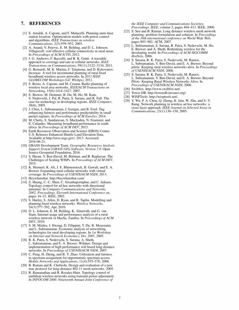
Figure 2 shows a sequence of steps from our implementationfinding the best interconnect among several, arbitrarily cho-sen customer sites (indicated by red markers). Figure 2(a)shows the elevation data as colored regions where darker in-dicates a higher altitude of the terrain. The pre-defined pos-sible tower locations (vertices) are projected on the elevationmap as orange crosses. For illustration purposes, the hori-zontal and vertical distances between two locations are cho-sen to be ∼750 m and only a restricted region (∼170 km2)of the map is shown in this example. Figure 2(b) depicts thevisibility range of each location in a different color and rep-resents the viewsheds of each location. The viewsheds arefurther processed and locations that are visible to each otherare connected by edges. The resulting visibility network isshown in Figure 2(c) and indicated by gray lines. Finally,intermediate nodes (blue markers) are added to construct aSteiner Tree (red lines) from the 8 initial customer sites.
5. DISCUSSIONMany obvious improvements can be made to our cur-
rent system including: reducing the raster size, incorporat-ing variable mounting height, antenna sizes, power output,
5

(a) Elevation data with 8 pre-defined sites (b) Viewsheds of all sites (c) Visibility graph and Steiner tree
Figure 2: Finding the best relay tower locations (blue markers) and links to interconnect 8 sites (red markers).
tree cover, Fresnel zones, spectrum, equipment costs, reli-ability metrics, bandwidth, etc. The incorporation of theseconstraints (at the resolutions we require) will increase theproblem size by at least two orders of magnitude. Cur-rently, our implementation—not considering the additionalvariables above—takes approximately 40 minutes to com-pute the visibility graph for a region on a single standardmachine. Given that the compute time of our algorithms in-crease quadratically with the problem size, a high fidelityoptimization will take about five orders of magnitude morecomputation, and adding the above variables will increasethe complexity by another four orders of magnitude.
We presented a very clean representation of the problemas a set of fixed specifications to optimize against knownconstraints. However, the real world is messy and there aremany unpredictable events. Consider what happens whenan operator builds two sites of a five site backhaul networksegment, only to lose land rights to the third site, or to findthat the third site is in fact blocked by a new obstruction.While the planner’s constraints can be changed to reflectthis, this change might otherwise cause our system to pro-duce a wholly different design without the first two sites thatwere already built. In this situation, the operator needs theability to express the cost of abandoning work that has al-ready been done (i.e., if there is truly no other way to buildthe network without abandoning the already-built sites, thenour system should find those options, but should prefer lever-aging already-completed work).
Another problem is that the Steiner Tree formulation (andother off-the-shelf solvers) may not capture the goals of thenetwork designer. In this initial implementation we used theSteiner Tree optimization because it is a natural fit for the ba-sic planning task, but we did so knowing it would prove in-adequate. For example, the output of the algorithm producesa tree, which by definition has no redundant links. Given thegeneral unreliability of wireless links in these settings, it isimportant to consider backup and parallel links.
6. RELATED WORKNetworking in developing and rural regions is a topic that
has attracted attention over the last decade [6, 17]. This fo-cus has intensified in recent years and researchers have rec-ognized that the challenges presented in these networkingregimes are substantially different and require different so-lutions [2,7,8,12,16,18,20,24]. While there has been workon protocols and techniques for faster and more reliable net-works, research often does not extend far enough to keepsuch networks alive after the research is done [25].
Determining the topology of wireless networks was a sig-nificant topic [5, 21, 29] and there are numerous patents onplanning cellular networks [1]. Within wireless, variationsof topology planning considered hardware factors such astransmission power and directional antenna [14, 21]. Theclosest work to ours is an algorithm by Sen and Raman thatattempts to minimize the overall network cost by consider-ing tower height, antenna type, and transmit power [22].
When deploying their networks today, rural operators usea mix of incomplete planning tools. Some tools build uponterrain data to estimate line-of-sight between two locations,enabling an operator to perform rudimentary topographyplanning for relay sites [13], other tools [26,28] provide nu-merous tools to manually plan, understand, and deploy wire-less networks. Other systems, such as TowerDB and Celer-ate, attempt to simplify network management by juxtaposinggeographic locations of devices with network information(e.g. IP-address, frequency, and SSID) [11, 27].
A few alternative planning models have also been pro-posed. IncrEase [4] is planning paradigm that incrementallyintroduces sets of additional transmission sites. In [15], theauthors describe a mathematical model for automated net-work planning that considers economic and technical con-straints. Several approaches have been proposed in cellu-lar network planning for the placement of base stations (e.g.Andrews et al. [3]), but these generally focus on spectrumand interference rather than physical topography.
6
7. REFERENCES
[1] E. Amaldi, A. Capone, and F. Malucelli. Planning umts basestation location: Optimization models with power controland algorithms. IEEE Transactions on wirelessCommunications, 2(5):939–952, 2003.
[2] A. Anand, V. Pejovic, E. M. Belding, and D. L. Johnson.Villagecell: cost effective cellular connectivity in rural areas.In Proceedings of ACM ICTD, 2012.
[3] J. G. Andrews, F. Baccelli, and R. K. Ganti. A tractableapproach to coverage and rate in cellular networks. IEEETransactions on Communications, 59(11):3122–3134, 2011.
[4] G. Bernardi, M. K. Marina, F. Talamona, and D. Rykovanov.Increase: A tool for incremental planning of rural fixedbroadband wireless access networks. In 2011 IEEEGLOBECOM Workshops (GC Wkshps), 2011.
[5] S. Bosio, A. Capone, and M. Cesana. Radio planning ofwireless local area networks. IEEE/ACM Transactions onNetworking, 15(6):1414–1427, 2007.
[6] E. Brewer, M. Demmer, B. Du, M. Ho, M. Kam,S. Nedevschi, J. Pal, R. Patra, S. Surana, and K. Fall. Thecase for technology in developing regions. IEEE Computer,38(6), 2005.
[7] J. Chen, L. Subramanian, J. Iyengar, and B. Ford. Taq:enhancing fairness and performance predictability in smallpacket regimes. In Proceedings of ACM EuroSys, 2014.
[8] M. Chetty, S. Sundaresan, S. Muckaden, N. Feamster, andE. Calandro. Measuring broadband performance in southafrica. In Proceedings of ACM DEV, 2013.
[9] Earth Resources Observation and Science (EROS) Center.U.S. Releases Enhanced Shuttle Land Elevation Data.Available at http://eros.usgs.gov/, 2013. Accessed:2016-06-21.
[10] GRASS Development Team. Geographic Resources AnalysisSupport System (GRASS GIS) Software, Version 7.0. OpenSource Geospatial Foundation, 2016.
[11] S. Hasan, Y. Ben-David, M. Bittman, and B. Raghavan. TheChallenges of Scaling WISPs. In Proceedings of ACM DEV,2015.
[12] K. Heimerl, K. Ali, J. E. Blumenstock, B. Gawalt, and E. A.Brewer. Expanding rural cellular networks with virtualcoverage. In Proceedings of USENIX/ACM NSDI, 2013.
[13] Heywhatsthat. http://heywhatsthat.com/.[14] Z. Huang, C.-C. Shen, C. Srisathapornphat, and C. Jaikaeo.
Topology control for ad hoc networks with directionalantennas. In Computer Communications and Networks,2002. Proceedings. Eleventh International Conference on,pages 16–21. IEEE, 2002.
[15] S. Hurley, S. Allen, D. Ryan, and R. Taplin. Modelling andplanning fixed wireless networks. Wireless Networks,16(3):577–592, Apr. 2010.
[16] D. L. Johnson, E. M. Belding, K. Almeroth, and G. vanStam. Internet usage and performance analysis of a ruralwireless network in Macha, Zambia. In Proceedings of ACMDEV, 2010.
[17] S. M. Mishra, J. Hwang, D. Filippini, T. Du, R. Moazzami,and L. Subramanian. Economic analysis of networkingtechnologies for rural developing regions. In 1st Workshopon Internet and Network Economics, Dec 2005, 2005.
[18] R. K. Patra, S. Nedevschi, S. Surana, A. Sheth,L. Subramanian, and E. A. Brewer. Wildnet: Design andimplementation of high performance wifi based long distancenetworks. In Proceedings of USENIX/ACM NSDI, 2007.
[19] C. Peng, H. Zheng, and B. Y. Zhao. Utilization and fairnessin spectrum assignment for opportunistic spectrum access.Mobile Networks and Applications, 11(4):555–576, 2006.
[20] B. Raman and K. Chebrolu. Design and evaluation of a newmac protocol for long-distance 802.11 mesh networks. 2005.
[21] R. Ramanathan and R. Rosales-Hain. Topology control ofmultihop wireless networks using transmit power adjustment.In INFOCOM 2000. Nineteenth Annual Joint Conference of
the IEEE Computer and Communications Societies.Proceedings. IEEE, volume 2, pages 404–413. IEEE, 2000.
[22] S. Sen and B. Raman. Long distance wireless mesh networkplanning: problem formulation and solution. In Proceedingsof the 16th international conference on World Wide Web,pages 893–902. ACM, 2007.
[23] L. Subramanian, S. Surana, R. Patra, S. Nedevschi, M. Ho,E. Brewer, and A. Sheth. Rethinking wireless for thedeveloping world. In Proceedings of ACM SIGCOMMHotNets, 2006.
[24] S. Surana, R. K. Patra, S. Nedevschi, M. Ramos,L. Subramanian, Y. Ben-David, and E. A. Brewer. Beyondpilots: Keeping rural wireless networks alive. In Proceedingsof USENIX/ACM NSDI, 2008.
[25] S. Surana, R. K. Patra, S. Nedevschi, M. Ramos,L. Subramanian, Y. Ben-David, and E. A. Brewer. BeyondPilots: Keeping Rural Wireless Networks Alive. InProceedings of USENIX/ACM NSDI, 2008.
[26] Swiftfox. http://www.swiftfox.net/.[27] Tower DB. http://towerdb.inveneo.org/.[28] WISPTools. http://wisptools.net/.[29] Y. Wu, P. A. Chou, Q. Zhang, K. Jain, W. Zhu, and S.-Y.
Kung. Network planning in wireless ad hoc networks: across-layer approach. IEEE Journal on Selected Areas inCommunications, 23(1):136–150, 2005.
7