Embed Size (px)
Citation preview
Henrys Fork Basin Study Final Report
Produced in partnership with the State of Idaho Water Resource Board
U.S. Department of the Interior Idaho Water Resource Board Bureau of Reclamation State of Idaho Pacific Northwest Region Boise, Idaho Snake River Area Office Boise, Idaho January 2015
MISSION OF THE U.S. DEPARTMENT OF THE INTERIOR
PROTECTING AMERICA'S GREAT OUTDOORS AND POWERING OUR FUTURE
The U.S. Department of the Interior protects America's natural resources and heritage, honors our cultures and tribal communities, and supplies the energy to power our future.
MISSION OF THE BUREAU OF RECLAMATION
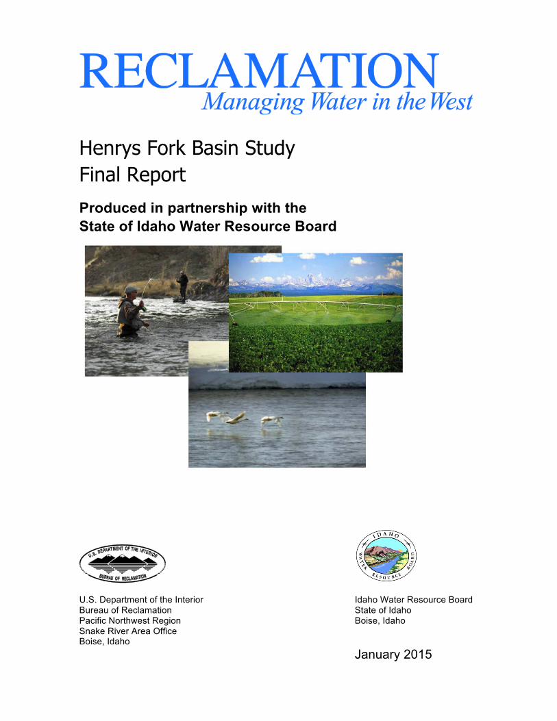
The mission of the Bureau of Reclamation is to manage, develop, and protect water and related resources in an environmentally and economically sound manner in the interest of the American public. Photograph on front cover: Fly fishing, irrigated agriculture, and wildlife habitat are important activities in the Henrys Fork River basin
Disclaimer The Henrys Fork Basin Study was funded jointly by the Bureau of Reclamation (Reclamation) and the Idaho Water Resource Board (IWRB), and is a collaborative product of the study participants as identified in Section 1.3, page 5 of this report. The purpose of the study is to assess current and future water supply and demand in the Henrys Fork Basin and adjacent areas that receive water from the basin, and to identify a range of potential strategies to address any projected imbalances. The study is a technical assessment and does not provide recommendations or represent a statement of policy or position of the Bureau of Reclamation, the Department of the Interior, or the funding partners. The study does not propose or address the feasibility of any specific project, program or plan. Nothing in the study is intended, nor shall the study be construed, to interpret, diminish, or modify the rights of any participant under applicable law. Nothing in the study represents a commitment for provision of Federal funds. All cost estimates included in this study are preliminary and intended only for comparative purposes.
.
Henrys Fork Basin Study Final Report
Produced in partnership with the State of Idaho Water Resource Board
U.S. Department of the Interior Idaho Water Resource Board Bureau of Reclamation State of Idaho Pacific Northwest Region Boise, Idaho Snake River Area Office Boise, Idaho January 2015

This page intentionally left blank
Abbreviations and Acronyms
AWEP Agricultural Water Enhancement Program
Basin Study Henrys Fork Basin Study
CBWTP Columbia Basin Water Transaction Program
cfs Cubic feet per second
CIG Conservation Innovation Grant Program
CRP Conservation Reserve Program
ESA Endangered Species Act
ESPA Eastern Snake Plain Aquifer
ESPA CAMP Eastern Snake Plain Aquifer Comprehensive Aquifer Management Plan
ESPAM Eastern Snake Plain Aquifer Model
FERC Federal Energy Regulatory Commission
FMID Fremont-Madison Irrigation District
GCMs Global Circulation Models
Henrys Fork River Henrys Fork of the Snake River
Idaho CREP Idaho Conservation Reserve Enhancement Program
IDFG Idaho Department of Fish and Game
IDWR Idaho Department of Water Resources
IWRB Idaho Water Resource Board
IWTP Idaho Water Transactions Program
LRP Local rental pools
LW/D Less warming and drier climate scenario
LW/W Less warming and wetter climate scenario
MC Minor change climate scenario
NEPA National Environmental Policy Act
NFRC North Fork Reservoir Company
NRCS U.S. Department of Agriculture, Natural Resources Conservation Service
NWSRS National Wild and Scenic River System
Plan Comprehensive State Water Plan
Recharge Program Managed Aquifer Recharge Program
Reclamation U.S. Department of the Interior, Bureau of Reclamation
RMP Teton River Canyon Resource Management Plan
State State of Idaho
USGS U.S. Geological Survey
Watershed Council Henry’s Fork Watershed Council
Workgroup Henry’s Fork Watershed Council and other interested stakeholders
Executive Summary
January 2015 - Henrys Fork Study Final Report ES-1
EXECUTIVE SUMMARY Introduction
The Bureau of Reclamation (Reclamation), in partnership with the Idaho Water Resource Board (IWRB), conducted a Henrys Fork Basin Study (Basin Study) and the results of this Basin Study are documented in this Final Report of the Henrys Fork Basin Study (Final Report). While the overall purpose of the Basin Study is to assess current and future water supply and demand in the Henrys Fork Basin and adjacent areas that receive water from the basin, and to identify a range of potential strategies to address any projected imbalances, it also assists the State and local planning efforts by exploring potential action alternatives for (1) meeting the complex water supply and management challenges in the basin, (2) meeting the goals of the Eastern Snake Plain Aquifer (ESPA) Comprehensive Aquifer Management Plan (CAMP) and Idaho State Water Plan, and (3) identifying risks posed to water supply by climate change and opportunities to mitigate that risk through developing water supplies, improving water management, and sustaining or improving environmental quality and ecological resiliency. This Basin Study complements the objectives of ESPA CAMP and policies of the State Water Plan by identifying specific alternatives to improve water supplies and water management in the upper Snake River basin.
Reclamation and IWRB worked with the Henry’s Fork Watershed Council (Watershed Council) in developing alternatives to address the purposes of the Basin Study. The Watershed Council functioned as a stakeholder workgroup (Workgroup) throughout most of the process, providing review and input both collectively and as individuals. Throughout the Basin Study, the Watershed Council and many of its participating members elevated public awareness of the Basin Study process and clearly advertised opportunities for public review and involvement.
The Henrys Fork of the Snake River (Henrys Fork River) is located in eastern Idaho, in the upper Snake River watershed. The river provides irrigation water for over 280,000 acres, sustains a world-class trout fishery, and is a strong hold for native Yellowstone cutthroat trout. Agricultural changes, population growth and its consequent urban development, drought conditions, and climate changes are impacting water resources. These factors are increasing the need to identify adaptation and mitigation strategies to resolve water supply imbalances and preserve ecological resiliency in the basin, especially with respect to climate change.
Current water demands in the Henrys Fork River basin vary from year to year with varying annual precipitation amounts. Future water needs will vary with climate change impacts, population growth, changes in farming methods, water conservation, and other factors that
Executive Summary
ES-2 Henrys Fork Study Final Report – January 2015
may not be fully understood or predicted at this point in time. Declining aquifer levels and spring discharges, changing flows in the Snake River, and actions that have placed demands on already scarce water supplies (e.g., flow augmentation for anadromous fish survival) have resulted in insufficient supplies to satisfy existing beneficial uses across the upper Snake River basin. The ESPA CAMP identified an annual water budget deficit in the ESPA of 600,000 acre-feet, and established a long-term goal to adjust this deficit by implementing a mix of management strategies over a 20-year period (Reclamation 2012). The western portion of the Henrys Fork River basin overlies the ESPA so opportunities in the basin could support the objectives of the ESPA CAMP for stabilizing the ESPA. The Henrys Fork River basin contributes about 25 percent of the upper Snake River supply in eastern Idaho and also contributes to groundwater recharge in local aquifers and the ESPA.
Climate change studies projected a shift in timing and increase in inflow volume to earlier in the year, which resulted in an increase in the end-of-month storage earlier in the year and a greater need to use reservoir storage to provide irrigation water later in the summer months (Reclamation 2011). A decrease of streamflows was shown to occur in the latter part of the summer in warmer months (Reclamation 2011). A decrease in instream flow in the late summer to early fall months would result in less water available for natural flow diversions and more pressure for deliveries from storage. For irrigation, reservoir management and ecological flow objectives, it was found that late season flow and reservoir objectives would be impacted the most by climate change, especially in the driest conditions (Reclamation 2011).
The Workgroup, Reclamation, and IWRB initially identified 51 alternatives to address the Henrys Fork River basin water needs. From these 51 alternatives, a screened group of about 18 alternatives were evaluated, and the results were documented in the Final Henrys Fork Basin Special Study Interim Report dated July 2013 (Reclamation 2013a). Those alternatives were assessed so that only the most viable alternatives were passed on for more scrutiny and detail. The results of these assessments were presented to the Workgroup for input and the proposed alternatives were further filtered down to a group of 11 that were carried forward for additional analyses in this Basin Study. The IWRB and other water users requested the Teton Dam alternative be retained and evaluated for comparative purposes.
The final analyses refined and revised the alternatives to a group of 12 alternatives, which were grouped into three major categories: surface storage, managed groundwater recharge, and water conservation. The water conservation alternative was broken into three separate alternatives (canal piping in North Fremont region, demand reduction, and canal automation) and the water marketing alternative essentially became a potential component of all of the final alternatives. The final alternatives include a range of structural and water management strategies that provide:
Executive Summary
January 2015 - Henrys Fork Study Final Report ES-3
• Reasonable options for implementation and have met multiple assessments for viability (i.e., acceptability, effectiveness, efficiency, and completeness).
• Opportunities to develop new water supplies (water that would otherwise flow past Milner Dam and out of the upper Snake River system) as well as methods of improving water management to optimize existing supplies within the Henrys Fork Basin.
• Potential options for additional surface storage and more efficient management of water resources that may allow the irrigation season to be extended and provide flows for ecological flow targets if the climate changes as projected.
Summary Evaluations of Alternatives
The 12 alternatives formulated by Reclamation, IWRB, and the Workgroup during the Basin Study were evaluated and compared to understand how they met the Basin Study objectives. The comparison considered four key parameters traditionally used by Reclamation when examining alternatives for fatal flaws: 1) effectiveness of an alternative to enhance water reliability; 2) costs; 3) environmental effects; and 4) local acceptance by stakeholders. The key parameters were based on how well an alternative meets the stated objectives of the Basin Study which are to reduce risks to water supply from climate change through improved water supply and improved water management and to sustain or improve environmental quality and ecological resiliency in the Henrys Fork River basin.
The following tables illustrate the comparison of the alternatives in two formats. Table 1 and Table 2 are qualitative and illustrate the criteria on a scale of worse to better for each alternative. Table 3 compares the available quantitative information for costs and water supply improvements for each alternative. Costs for the water management alternatives were difficult to calculate because State and Federal programs may be involved and participation is voluntary. Costs in the table are based on averages. Cost estimates given in this Final Report are relative, comparative, and preliminary and are not intended for budgeting.

Executive Summary
ES-4 Henrys Fork Study Final Report – January 2015
Table 1. Summary of surface storage alternatives from the Henrys Fork Basin Study.
Teton Dam ReplacementWater supply
Total Cost
Cost/Acre-‐foot
Impacts
Acceptability
Lane Lake Water supply
Cost
Cost/Acre-‐foot
Impacts
Acceptability
Upper Badger CreekWater supply
Cost
Cost/Acre-‐foot
Impacts
Acceptability
Island Park Dam EnlargementWater supply
Cost
Cost/Acre-‐foot
Impacts
Acceptability
Spring CreekWater supply
Cost
Cost/Acre-‐foot
Impacts
Acceptability
Moody CreekWater supply
Cost
Cost/Acre-‐foot
Impacts
Acceptability
Ashton Dam RaiseWater supply
Cost
Cost/Acre-‐foot
Impacts
Acceptability
Worse Moderate Better
Executive Summary
January 2015 - Henrys Fork Study Final Report ES-5
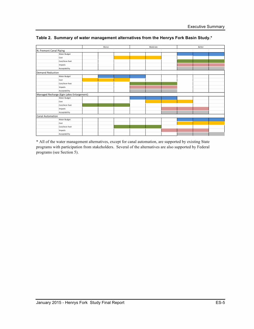
Table 2. Summary of water management alternatives from the Henrys Fork Basin Study.*
* All of the water management alternatives, except for canal automation, are supported by existing State programs with participation from stakeholders. Several of the alternatives are also supported by Federal programs (see Section 5).
N. Fremont Canal Piping Water Budget
Cost
Cost/Acre-‐foot
Impacts
Acceptability
Demand ReductionWater Budget
Cost
Cost/Acre-‐foot
Impacts
Acceptability
Managed Recharge (Egin Lakes Enlargement)Water Budget
Cost
Cost/Acre-‐foot
Impacts
Acceptability
Canal Automation Water Budget
Cost
Cost/Acre-‐foot
Impacts
Acceptability
Worse Moderate Better

Executive Summary
ES-6 Henrys Fork Study Final Report – January 2015
Table 3. Quantitative comparison of alternatives.*
Alternative Total Cost Cost per acre-foot Effect to Water Budget Effects to
Environment
Lane Lake Dam $462,000,000 $4,600 101,000 acre-feet new stored water
Moderate
Spring Creek Dam $41,760,000 $3,900 10,800 acre-feet new stored water
Significant
Moody Creek Dam $123,920,000 $3,600 10,800 acre-feet new stored water
Significant
Upper Badger Creek Dam
$128,940,000 $2,700 47,000 acre-feet new stored water
Significant
Teton Dam $492,210,000 $1,900 202,000 acre-feet new stored water
Significant
Island Park Dam Storage Increase
$6,400,000 $240 26,700 acre-feet new stored water
Low
Ashton Dam Raise $28,210,000 $1,382 20,400 acre-feet new stored water
Low
Groundwater Recharge
$10,000,000- to 13,620,000
$2,700- $4000
7,500 – 10,000 acre-feet recharged or 1.6-3.2 cfs increase in fall streamflows
Low
Water Market Varies with the program
Better management of existing supply
Low
Canal Automation $1,588,000 $491-2,843
Better management of existing supply, improved streamflows
Low
Piping in North Fremont Region
$97,000,000 $361 Eliminates canal seepage. Recent projects demonstrate 10,000 acre-feet saved annually
Low
Demand Reduction Varies with the program
$1,860- $3,600
2 to 5 acre-feet are saved per acre of demand reduction.
Moderate, potential for secondary economic impacts
*Costs for the non-structural alternatives are difficult to calculate because State and Federal programs may be involved and participation is voluntary. Costs in the table are based on averages. See Section 5.0 for more details on how these costs were derived.
Of the seven storage alternatives, three appear to have more local acceptance and support than the others: Lane Lake Dam, Island Park storage increase, and Ashton Dam raise. There is also broad acceptance and support for water conservation alternatives (canal automation and irrigation canal piping) and water markets. Recharge is supported in the context of the existing State recharge program, and while there is general support for the demand reduction
Executive Summary
January 2015 - Henrys Fork Study Final Report ES-7
concept, support for projects would be judged on a site-by-site basis.
The four storage alternatives that do not have broad stakeholder acceptance and support involve dams located on a river or creek (Spring Creek Dam, Moody Creek Dam, Upper Badger Creek Dam, and Teton Dam). Conservation groups have clearly articulated their objection to these alternatives because of potential impacts to Yellowstone cutthroat trout, scenic beauty, and free-flowing rivers. While there is significant potential for new surface water storage in these alternatives, social, cultural, and environmental considerations would be challenging to overcome.
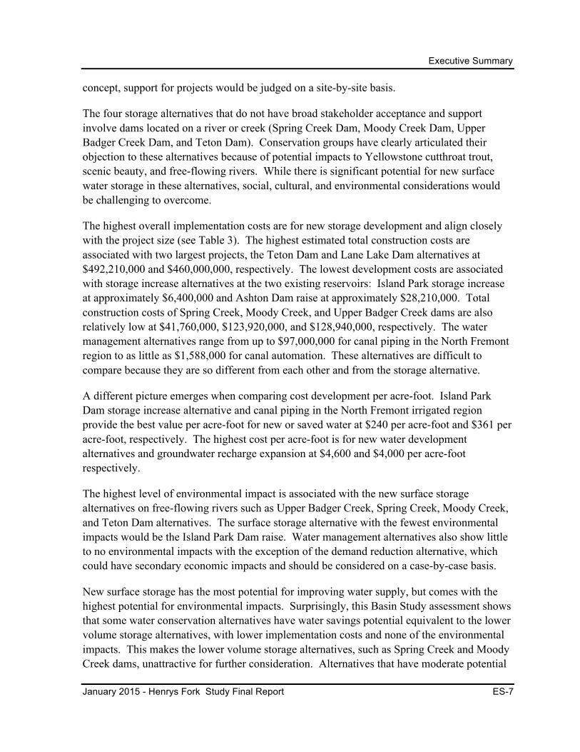
The highest overall implementation costs are for new storage development and align closely with the project size (see Table 3). The highest estimated total construction costs are associated with two largest projects, the Teton Dam and Lane Lake Dam alternatives at $492,210,000 and $460,000,000, respectively. The lowest development costs are associated with storage increase alternatives at the two existing reservoirs: Island Park storage increase at approximately $6,400,000 and Ashton Dam raise at approximately $28,210,000. Total construction costs of Spring Creek, Moody Creek, and Upper Badger Creek dams are also relatively low at $41,760,000, $123,920,000, and $128,940,000, respectively. The water management alternatives range from up to $97,000,000 for canal piping in the North Fremont region to as little as $1,588,000 for canal automation. These alternatives are difficult to compare because they are so different from each other and from the storage alternative.
A different picture emerges when comparing cost development per acre-foot. Island Park Dam storage increase alternative and canal piping in the North Fremont irrigated region provide the best value per acre-foot for new or saved water at $240 per acre-foot and $361 per acre-foot, respectively. The highest cost per acre-foot is for new water development alternatives and groundwater recharge expansion at $4,600 and $4,000 per acre-foot respectively.
The highest level of environmental impact is associated with the new surface storage alternatives on free-flowing rivers such as Upper Badger Creek, Spring Creek, Moody Creek, and Teton Dam alternatives. The surface storage alternative with the fewest environmental impacts would be the Island Park Dam raise. Water management alternatives also show little to no environmental impacts with the exception of the demand reduction alternative, which could have secondary economic impacts and should be considered on a case-by-case basis.
New surface storage has the most potential for improving water supply, but comes with the highest potential for environmental impacts. Surprisingly, this Basin Study assessment shows that some water conservation alternatives have water savings potential equivalent to the lower volume storage alternatives, with lower implementation costs and none of the environmental impacts. This makes the lower volume storage alternatives, such as Spring Creek and Moody Creek dams, unattractive for further consideration. Alternatives that have moderate potential
Executive Summary
ES-8 Henrys Fork Study Final Report – January 2015
for water savings or new water supply include Island Park Dam enlargement, Ashton Dam raise, and canal automation which balance water supply savings with environmental impacts and per acre-foot costs.
While each of the alternatives has the potential to decrease the gap between demand and supply for water in the Henrys Fork River basin and the ESPA, no single alternative will satisfy all of the water resource needs. The degree of complexity varies among the alternatives as does the obstacles that exist for implementation. Permitting, planning, and design may be simple for a canal automation project while a new storage alternative may be considerably more complex and take more time and effort. Public acceptability, funding, legal ramifications, and regulatory compliance issues would need to be resolved before moving any of these alternatives toward implementation.
While this Final Report does not include recommendations and is not intended to be a decision document, it meets the requirements of the Basin Study program, including an assessment of the water supplies, demands, and climate change risks; an analysis of how existing infrastructure and operations will perform in response to changing water realities; identification and evaluation of viable adaptation strategies to improve operation and infrastructure to supply adequate water supply in the future; and a comparison analysis of all viable adaptation strategies identified (comparison of cost, environmental impacts, risks, contribution to meeting water needs, stakeholder response, or other attributes).
The findings of this Basin Study make it clear that a meaningful contribution to meeting the existing and future water supply needs of the Henrys Fork River basin, as well as such high State priorities as the ESPA, will not result from the implementation of any single action. Rather, meeting these needs successfully will require an integrated program of actions. Pursuing multiple alternatives identified in this and other studies is likely to be necessary.
Drawing upon the results of this Basin Study, the IWRB intends to release an independent report that will outline possible implementation actions by the IWRB and the State to support the objectives of the ESPA CAMP and to comply with Idaho House Joint Memorial 8, Senate Bill 1511, and the State Water Plan. The information generated through the Basin Study and recommendations identified in the independent report are intended to be used by the State of Idaho to inform decisions regarding potential options to pursue, where to focus investments in water management infrastructure, and explore financing strategies to implement identified options.
More rigorous analyses would be necessary before progressing with an alternative or combination of alternatives. Public acceptability will likely require compromise and finding a balance that all participants can support. Maximizing the benefits for all categories of need is most likely not feasible, and as a result, projects that meet the identified agricultural, environmental, and ESPA water supply needs will likely take priority.
Executive Summary
January 2015 - Henrys Fork Study Final Report ES-9
Obtaining sufficient funding for a publicly acceptable action would be a necessary initial step toward implementation. Depending on the total cost, an interested stakeholder could move forward with funding on its own or seek partnerships with Federal, state, and/or local entities. State and Federal appropriations are difficult to secure. A number of funding sources may be required to implement any action.
Actions may also require resolution of legal issues, permitting requirements, and in some instances, private ownership of land and facilities. If project implementation were to trigger litigation, additional costs could require the diversion of funds from implementation of the action.
Any Federal involvement would likely require compliance with the National Environmental Policy Act, Endangered Species Act, National Historic Preservation Act, and other Federal statutes. Changing administrative actions such as potential new Endangered Species Act listings and designations of National Wild and Scenic Rivers System streams in the Basin Study area could arise, requiring adjustments not considered in this Basin Study.
Executive Summary
ES-10 Henrys Fork Study Final Report – January 2015
This page intentionally left blank
Table of Contents
January 2015 – Henrys Fork Study Final Report i
Table of Contents
Executive Summary ....................................................................................................................... 1 Introduction .......................................................................................................................... 1 Summary Evaluations of Alternatives ................................................................................. 3
1.0 Introduction ........................................................................................................................ 1 1.1 Purpose and Objectives ............................................................................................ 1 1.2 Federal and State Study Authorities ........................................................................ 5 1.3 Collaboration and Outreach ..................................................................................... 5 1.4 Relevant Previous and Current Studies .................................................................... 6 1.5 Interrelated Programs and Activities ....................................................................... 8
1.5.1 Federal ......................................................................................................... 8 1.5.2 State ............................................................................................................. 9 1.5.3 Local .......................................................................................................... 13
2.0 Overview of Study Area .................................................................................................. 14 2.1 Setting .................................................................................................................... 14 2.2 Geology .................................................................................................................. 14 2.3 Climate ................................................................................................................... 17 2.4 Hydrology .............................................................................................................. 17 2.5 Fish and Wildlife .................................................................................................... 18 2.6 Land Use ................................................................................................................ 21 2.7 Socioeconomics ..................................................................................................... 23 2.8 Hydropower Facilities ............................................................................................ 24
3.0 Water Supply and Demand ............................................................................................. 25 3.1 Surface Water Supplies .......................................................................................... 25
3.1.1 Minidoka Project ....................................................................................... 27 3.1.2 Teton Exchange Wells ............................................................................... 32 3.1.3 Henrys Lake and Dam ............................................................................... 32
3.2 Groundwater Supplies ............................................................................................ 33 3.3 Water Demands ...................................................................................................... 35
3.3.1 Surface Water Demand .............................................................................. 36 3.3.2 Groundwater Demand ................................................................................ 38
3.4 Characterization of Future Conditions ................................................................... 39
Table of Contents
ii Henrys Fork Study Final Report – January 2015
3.5 Potential Effects of Climate Change on Supply and Demand ............................... 40 3.5.1 Potential Effects on Agricultural Water .................................................... 40 3.5.2 Potential Effects on Fish and Wildlife Habitat .......................................... 41 3.5.3 Potential Effects on Groundwater and the ESPA ...................................... 41
3.6 Future Challenges and Considerations .................................................................. 42
4.0 Screening and Selection of Alternatives ........................................................................ 43 4.1 Identification of Potential Alternatives .................................................................. 43
4.1.1 Combination of Alternatives ..................................................................... 44 4.2 Preliminary Screening – Opportunities and Constraints Assessment .................... 44 4.3 Final Screening of Alternatives ............................................................................. 47
4.3.1 Surface Storage Site Alternatives .............................................................. 48 4.3.2 Managed Groundwater Recharge Site Alternatives .................................. 49 4.3.3 Water Market Alternatives ........................................................................ 50 4.3.4 Conservation, Water Management and Demand Reduction
Alternatives ............................................................................................... 50
5.0 Evaluation of Alternatives .............................................................................................. 52 5.1 Findings Common to Majority of Alternatives ...................................................... 53
5.1.1 Capability of Alternatives to Meet Henrys Fork River Basin and/or ESPA Needs ................................................................................... 53
5.1.2 Potential Climate Change Impacts ............................................................ 54 5.2 Surface Storage Alternatives ................................................................................. 55
5.2.1 Elements Relevant to All Surface Storage Alternatives ............................ 57 5.2.2 Lane Lake Dam ......................................................................................... 59 5.2.3 Spring Creek Dam ..................................................................................... 65 5.2.4 Moody Creek Dam .................................................................................... 67 5.2.5 Upper Badger Creek Dam ......................................................................... 70 5.2.6 Teton Dam ................................................................................................. 72 5.2.7 Island Park Storage Increase ..................................................................... 77 5.2.8 Ashton Dam Raise ..................................................................................... 81
5.3 Managed Recharge Alternative ............................................................................. 83 5.3.1 Introduction ............................................................................................... 83 5.3.2 Egin Lakes Recharge Site Expansion ........................................................ 85
5.4 Water Markets ........................................................................................................ 88
Table of Contents
January 2015 - Henrys Fork Study Final Report iii
5.5 Conservation Alternatives ...................................................................................... 93 5.5.1 Canal Automation Alternative ................................................................... 93 5.5.2 Irrigation Canal Piping Alternative ........................................................... 99 5.5.3 Demand Reduction Option ...................................................................... 101
6.0 Trade-off Analysis and Conclusions ............................................................................ 105 6.1 Summary Comparison of Alternatives ................................................................. 106 6.2 Evaluation ............................................................................................................ 109
6.2.1 Surface Storage ........................................................................................ 110 6.2.2 Managed Groundwater Recharge Alternative ......................................... 114 6.2.3 Water Marketing ...................................................................................... 115 6.2.4 Conservation Alternatives ....................................................................... 116
7.0 Next Steps ....................................................................................................................... 120
8.0 Documents Completed During the Basin Study ......................................................... 122
9.0 Literature Cited ............................................................................................................. 123
List of Figures Figure 1. Map of Henrys Fork River basin and its subbasins, major tributaries, and
reservoirs. .............................................................................................................................. 2 Figure 2. Map showing the spatial relation of the Henrys Fork River basin to the
Eastern Snake Plain Aquifer. ................................................................................................ 3 Figure 3. Aerial photo of the landscape and geologic features of the Henrys Fork
River basin. ......................................................................................................................... 15 Figure 4. Yellowstone cutthroat trout. ..................................................................................... 19 Figure 5. Sage grouse. ............................................................................................................. 21 Figure 6. Map showing land ownership in the Henrys Fork River basin. ............................... 22 Figure 7. Felt hydro powerplant on the Teton River. .............................................................. 24 Figure 8. Water budget for Henrys Fork River basin surface supply ...................................... 27 Figure 9. Map of the Minidoka Project facilities in or adjacent to the Henrys Fork
Basin Study area ................................................................................................................. 28 Figure 10. Island Park Dam and Reservoir on the Henrys Fork River, Idaho. ........................ 30 Figure 11. Grassy Lake Dam and Reservoir, Grassy Creek, Wyoming. ................................. 31 Figure 12. Cross Cut Diversion Dam and radial headgate on the Henrys Fork
River. .................................................................................................................................. 32 Figure 13. Henrys Lake. ........................................................................................................... 33 Figure 14. Map of the Eastern Snake River Plain (ESPA). ..................................................... 34
Table of Contents
iv Henrys Fork Study Final Report – January 2015
Figure 15. The four irrigated regions in the Henrys Fork Basin Study area. .......................... 37 Figure 16. Map of the Henrys Fork River basin and the proposed locations of the
seven surface storage alternatives. ..................................................................................... 56 Figure 17. Map showing the proposed dam and reservoir of the Lane Lake
Alternative .......................................................................................................................... 60 Figure 18. Volume stored in the new reservoir from the Fall River and Teton
River per water year ........................................................................................................... 62 Figure 19. Volume stored by the new reservoir per water year for the Lane Lake
alternative. .......................................................................................................................... 63 Figure 20. Map showing the proposed dam and reservoir of the Spring Creek Dam
Alternative. ......................................................................................................................... 66 Figure 21. Map showing the proposed dam and reservoir of the Moody Creek
Dam Alternative. ................................................................................................................ 68 Figure 22. Map showing the proposed dam and reservoir of the Upper Badger
Creek Dam Alternative ....................................................................................................... 70 Figure 23. Map showing the proposed dam and reservoir of the Teton Dam
Alternative .......................................................................................................................... 73 Figure 24. Volume stored in the new reservoir from the Teton River per water
year ..................................................................................................................................... 74 Figure 25. Volume stored by the new reservoir per water year .............................................. 75 Figure 26. Additional water volume stored per water year with the Island Park
storage increase alternative ................................................................................................. 79 Figure 27. Volume accrued by the new reservoir water right per water year. ........................ 80 Figure 28. Aerial photo with the projected inundation area associated with the
Ashton Dam raise alternative. ............................................................................................ 82 Figure 29. Photo of an automated canal system with a Langemann gates structure. .............. 96
List of Tables Table 1. Summary of surface storage alternatives from the Henrys Fork Basin
Study. .................................................................................................................................... 4 Table 2. Summary of water management alternatives from the Henrys Fork Basin
Study. .................................................................................................................................... 5 Table 3. Quantitative comparison of alternatives ...................................................................... 6 Table 4. Estimated acreages of major crops in 2010. .............................................................. 23 Table 5. Estimated number of cattle during 2010. .................................................................. 23 Table 6. Average annual natural flows for Henrys Fork River basin. ..................................... 26 Table 7. Summary of average annual water demands in the Henrys Fork River
basin based on current practices and uses. ......................................................................... 35 Table 8. Evaluation categories, factors, and scoring (rating) system. ..................................... 45
Table of Contents
January 2015 - Henrys Fork Study Final Report v
Table 9. Final screening results for the surface storage alternatives ....................................... 48 Table 10. Final screening results for the managed groundwater recharge
alternatives. ......................................................................................................................... 49 Table 11. Final screening results for the water market alternatives. ....................................... 50 Table 12. Final screening results for the conservation, water management, and
demand reduction alternatives. ........................................................................................... 51 Table 13. Priority ranking of canal systems, estimated cost for automated canals at
main diversion, and estimated storage volume saved ......................................................... 95 Table 14. Comparison of the Henrys Fork Basin Study surface storage alternatives
based on the four key criteria. ........................................................................................... 107 Table 15. Comparison of the Henrys Fork Basin Study water management
alternatives based on the four key criteria. ....................................................................... 108 Table 16. Quantitative comparison of alternatives. ............................................................... 109 Table 17. Biophysical resources impact evaluation .............................................................. 112 Table 18. Sociocultural resources impact evaluation for the surface storage
alternatives.. ...................................................................................................................... 113 Table 19. List of reports produced during the course of the Henrys Fork Basin
Study. ................................................................................................................................ 122

Table of Contents
vi Henrys Fork Study Final Report – January 2015
This page intentionally left blank
1.0 Introduction
January 2015 - Henrys Fork Basin Study Final Report 1
1.0 INTRODUCTION
1.1 Purpose and Objectives
The Henrys Fork Basin Study (Basin Study) is sponsored and led by the Bureau of Reclamation (Reclamation) in partnership with State of Idaho Water Resource Board (IWRB). While the overall purpose of the Basin Study is to assess current and future water supply and demand in the Henrys Fork Basin and adjacent areas that receive water from the basin, and to identify a range of potential strategies to address any projected imbalances, it also assists the State and local planning efforts by exploring potential action alternatives for (1) meeting the complex water supply and management challenges in the basin, (2) meeting the goals of the Eastern Snake Plain Aquifer (ESPA) Comprehensive Aquifer Management Plan (CAMP) and Idaho State Water Plan, and (3) identifying risks posed to water supply by climate change and opportunities to mitigate that risk through developing water supplies, improving water management, and sustaining or improving environmental quality and ecological resiliency. This Basin Study complements the objectives of ESPA CAMP and policies of the State Water Plan by identifying specific alternatives to improve water supplies and water management in the upper Snake River basin.
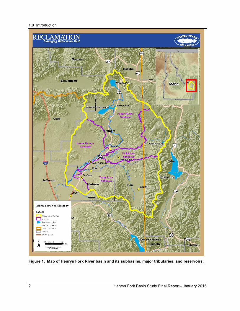
The Henrys Fork River basin provides irrigation water for over 280,000 acres and sustains a world-class trout fishery (Figure 1). Agricultural changes; population growth and its consequent urban development; drought conditions; and climate changes are impacting water resources. These factors are increasing the need to identify adaptation and mitigation strategies to resolve water supply imbalances and preserve ecological resiliency in the basin.
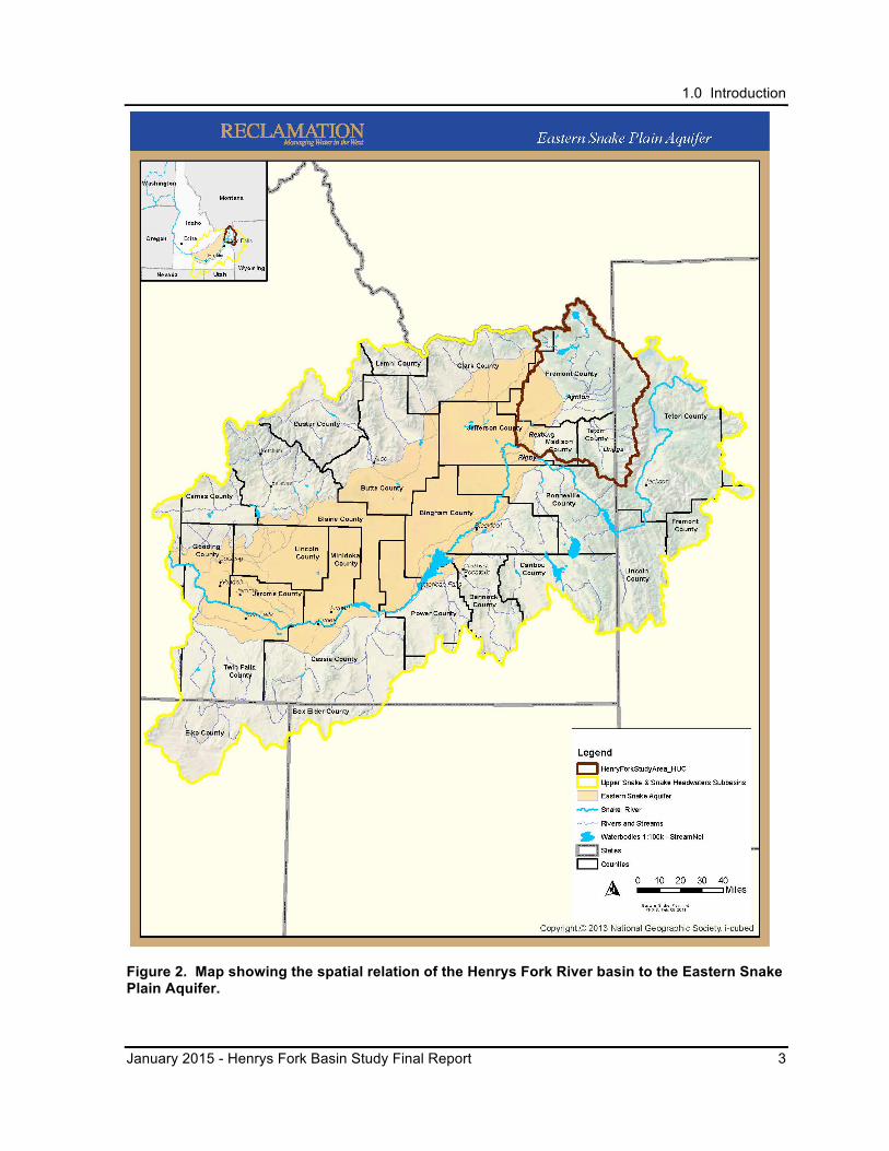
In a broader context, the western portion of the Henrys Fork River basin overlies the ESPA so opportunities in the basin could support the objectives of the ESPA CAMP for stabilizing the ESPA (Figure 2). The Henrys Fork River basin contributes about 25 percent of the upper Snake River supply in eastern Idaho and also contributes to groundwater recharge in local aquifers and the ESPA. These aquifers are tapped for municipal, industrial, and agricultural water. The upper Snake River region, including the Henrys Fork River basin, produces approximately 21 percent of all goods and services in the State of Idaho, resulting in an estimated value of $10 billion annually (IDWR 2009). Water is the critical element for this productivity.
1.0 Introduction
2 Henrys Fork Basin Study Final Report– January 2015
Figure 1. Map of Henrys Fork River basin and its subbasins, major tributaries, and reservoirs.
1.0 Introduction
January 2015 - Henrys Fork Basin Study Final Report 3
Figure 2. Map showing the spatial relation of the Henrys Fork River basin to the Eastern Snake Plain Aquifer.
1.0 Introduction
4 Henrys Fork Basin Study Final Report– January 2015
This Basin Study focused on identifying opportunities for developing water supplies, improving surface water and groundwater management, and sustaining environmental quality in the Henrys Fork River basin. The objectives of the Basin Study were to analyze projected water supplies and demands, including the possible effects of climate changes, and formulate potential strategies and alternatives that would address supply and management challenges and improve water supply reliability in the future. A stakeholder group made up of Federal, State, regional, and local stakeholders, using the existing Henrys Fork Watershed Council as a forum (Workgroup), assisted in formulating the strategies and alternatives. The alternatives were analyzed and this information was provided to the IWRB. The most potentially viable alternatives included surface water storage, managed groundwater recharge, water marketing, and water conservation.
This Henrys Fork Basin Study Final Report (Final Report) is organized as follows:
• Section 1.0 - Introduction: summary of Federal and State study authorities; collaboration and outreach; relevant previous and current studies; and interrelated programs and activities.
• Section 2.0 - Overview of Study Area: summary description of the study area and its resources.
• Section 3.0 - Water Supply and Demand: current and projected water supplies and demands and the potential effects of climate change.
• Section 4.0 - Screening and Selection of Alternatives: determination of which alternatives for surface storage, groundwater recharge, water markets, and conservation, water management, and demand reduction warranted more detailed investigation.
• Section 5.0 - Evaluation of Alternatives: evaluation of alternatives that emerged from the screening process.
• Section 6.0 – Trade-Off Analysis and Conclusions: comparative assessment of the alternatives in terms of water supply, cost, environmental effects, and the perspectives of involved agencies, organizations and stakeholders.
• Section 7.0 - Next Steps: next steps to pursue the alternatives described in the evaluation and comparison sections.
• Section 8.0 – Documents Completed during the Basin Study: list of reports produced during the Basin Study.
1.0 Introduction
January 2015 - Henrys Fork Basin Study Final Report 5
1.2 Federal and State Study Authorities
The Basin Study Program, as part of the U.S. Department of the Interior’s WaterSMART Program, addresses 21st century water supply challenges such as increased competition for limited water supplies and climate change. The Federal SECURE Water Act of 2009 and Secretarial Order 3297 established the WaterSMART Program, which authorizes Federal water and science agencies to work with State and local water managers to pursue and protect sustainable water supplies and plan for future climate change by providing leadership and technical assistance on the efficient use of water.
The 2008 Idaho State Legislature recognized the need for additional water supplies and determined that it was in the interest of the State to invest in short-term and long-term water projects that provide a balance between water use and water supply for both surface water and groundwater. State Senate Bill 1511, passed and approved by the 2008 Idaho State Legislature, authorized appropriation of $400,000 for IWRB to study replacing Teton Dam and $1.4 million to determine the feasibility of enlarging the Minidoka Dam.
Reclamation and IWRB entered into a partnership under the auspices of Reclamation’s WaterSMART Basin Study program. The $400,000 appropriation was used as the State’s contribution to the Basin Study, which included the replacement of Teton Dam as an alternative. Under this partnership, the Henrys Fork Basin Study was conducted. The results of the Basin Study are presented in this Final Report.
1.3 Collaboration and Outreach
Reclamation and IWRB collaborated with the Henry’s Fork Watershed Council (Watershed Council) to form a Workgroup that included members of the Watershed Council and other interested stakeholders. The Watershed Council is made up of State and Federal agencies, irrigation entities, conservation organizations, universities, and the farming community and is co-facilitated by the Fremont-Madison Irrigation District (FMID) and the Henrys Fork Foundation. During the course of the Basin Study, the Watershed Council as a whole, the Watershed Council’s Native Trout Subcommittee, and a smaller subset of the Watershed Council stakeholders representing water users and conservation groups provided valuable technical information and local perspectives and input throughout the process.
The Workgroup helped develop and provide input and feedback on a set of alternatives for developing new water supplies and improving water supply reliability for streamflows, irrigation water, municipal and industrial water supplies, groundwater recharge, and fish habitat. In June 2010, the Watershed Council hosted the first session for the Basin Study. For more than 3 years, Reclamation and representatives from the IWRB met both collectively and individually with the Workgroup through the Watershed Council forum, the Native Trout Subcommittee, and small workgroups, to develop alternatives and discuss the analyses and
1.0 Introduction
6 Henrys Fork Basin Study Final Report– January 2015
evaluation processes. Interests represented through this process included conservation groups, irrigators, other interested organizations, and Federal, State, and local agencies.
Reclamation created a Basin Study website1 containing the meeting notes, presentations, research materials, and reports generated during the Basin Study. Input and comments were solicited from the Workgroup, through the Watershed Council forum, and the general public before reports were finalized and published. Comments and responses to the comments were also included on the Basin Study website.
1.4 Relevant Previous and Current Studies
At the start of the Basin Study, an extensive literature search was conducted for previous studies in the Basin Study area, many of which are posted on Reclamation’s website. A list of documents produced during the course of this Basin Study can be found in Section 8.0. The following studies and programs were not part of the Basin Study, but were crucial in the analyses conducted during the study.
ESPA Managed Aquifer Recharge Program
As mandated by the Idaho Legislature, the IWRB operates a managed aquifer recharge program consistent with the goals set forth in the ESPA CAMP and State Water Plan. Several criteria are used to prioritize the location of the IWRB’s recharge activities on the ESPA:
• Stabilization of the ESPA through long-term aquifer storage.
• Maintain minimum streamflows at the Murphy gage consistent with the State Water Plan.
• Surface water availability for recharge within the water administration system at specific locations.
• Noninterference with the optimal capture of surface water in the upper Snake River basin reservoir system.
• Availability of willing partners with water delivery systems in priority areas.
• Avoidance of significant environmental impacts.
The ESPA CAMP, approved by the State Legislature in 2009, identifies an annual average water budget improvement target of 100,000 acre-feet in Phase 1 (through 2017) and 250,000
1 See http://www.usbr.gov/pn/programs/studies/idaho/henrysfork/index.html.

1.0 Introduction
January 2015 - Henrys Fork Basin Study Final Report 7
acre-feet in Phase 2. The IWRB has invested over $1 million since 2009 in recharge activities, which include recharge water delivery contracts and development of additional capacity and new recharge infrastructure. Under the IWRB’s program and water right permit, an average of 117,111 acre-feet per year was recharged across the ESPA from 2009 through 2012. The Fremont-Madison Irrigation District (FMID) has participated in this effort, delivering water under the IWRB’s recharge water right to the aquifer through various unlined canals and making use of the existing Egin Lakes recharge facilities.
Managed aquifer recharge is accomplished both through unlined irrigation canals and in dedicated constructed recharge sites. Recharge in existing unlined canals takes place both before and after the irrigation season. Constructed recharge sites further increase recharge capacity and provide a delivery location if recharge water is available during the irrigation season. Several dedicated recharge sites have been constructed on the ESPA, including the Egin Lakes site inside the Basin Study area. Additional sites are being evaluated and prioritized based on the State’s goals. The IWRB and FMID have a cost-sharing agreement in place to conduct an investigation of expansion of the Egin Lakes site.
IWRB and the Idaho Department of Water Resources (IDWR) are continuing to implement and refine IWRB’s managed recharge program with cooperation from key leadership, stakeholders, water users, and the public throughout the ESPA and with the support of the Idaho Legislature and Governor’s Office. A fundamental component of the program is the continual evaluation, revision, and application of the ESPA groundwater model (ESPAM 2.1) to ensure that the IWRB’s recharge activities are implemented in a manner that maximizes stabilization of the ESPA while minimizing water use conflict
Humboldt State University Water Budget Study
Humboldt State University developed a computer model to estimate the water budget for the Henrys Fork watershed’s surface irrigation system. Field research was conducted by graduate students supervised by university faculty and additional data were compiled from existing water resource and land use databases under a grant from the U.S. Department of Agriculture, Cooperative State Research, Education and Extension Service.2 The Watershed Council served in an advisory role during the study. Irrigation withdrawals were modeled under historic, current, and future land and water use scenarios. The study resulted in a water budget and analysis of water supplies and use in the watershed, which was shared with decision makers and stakeholders via University masters theses. This information was provided to Reclamation, IDWR, and the Workgroup to assist with the development of strategies to increase water availability while enhancing ecological benefits in key stream reaches. Reclamation used the modeling and study results during this Basin Study to evaluate potential water management alternatives.
2 Humboldt State University website for the study is located at http://www.humboldt.edu/henrysfork/.
1.0 Introduction
8 Henrys Fork Basin Study Final Report– January 2015
1.5 Interrelated Programs and Activities
Federal, State, and local entities are currently overseeing a number of programs and ongoing activities related to water management in the Henrys Fork River basin. Participation in the majority of these programs is voluntary so participation and enrollment may vary from year-to-year. Most of these programs are expected to continue into the foreseeable future with the exception of the Agricultural Water Enhancement Program (AWEP), which expires in 2014. In this section, Federal, State, and local activities and programs that have been or are currently being utilized in the basin are discussed.
1.5.1 Federal
Minidoka Project
The U.S. Geological Survey (USGS) investigated the irrigation possibilities of the Minidoka Project in the early 1890s and the project was already under consideration when the Reclamation Act of 1902 was passed. One of Reclamation’s earliest projects, the Minidoka Project provides irrigation water across the upper Snake River basin, including the Henrys Fork River basin. The project is discussed in more detail in Section 3.1.1.
Cooperative Watershed Management Program (CWMP)
A U.S. Department of the Interior program, CWMP was implemented in 2009 as part of the SECURE Water Act. The program supports local watershed groups and facilitates multi-stakeholder watershed management projects. Through WaterSMART grants, Reclamation provides 50/50 cost-share funding to water or power delivery entities for programs or actions that seek to conserve and use water more efficiently, increase the use of renewable energy, protect endangered species, or facilitate water markets.
Conservation Innovation Grant Program (CIG)
Natural Resources Conservation Service (NRCS) administers this voluntary program, which is intended to stimulate the development and adoption of innovative conservation practices and natural resource protection approaches and technologies for agriculture.
Conservation Reserve Program (CRP)
The goal of CRP, administered by the Farm Service Agency, is to re-establish valuable land cover, and thereby help improve water quality, prevent soil erosion, and reduce loss of wildlife habitat. In exchange for yearly payments over 10- to 15-year contracts, farmers enrolled in the program agree to remove environmentally sensitive land from agricultural production and establish plant species to conserve soil and water resources, provide a suitable
1.0 Introduction
January 2015 - Henrys Fork Basin Study Final Report 9
quality forage base, and provide cover and habitat for wildlife.
Targhee National Forest Plan
Parts of the Basin Study area are included in the Caribou-Targhee National Forest, which is managed by the U.S. Forest Service. The Forest Service developed a Forest Plan for the conservation, protection, management, and utilization of the lands and resources in the Caribou-Targhee National Forest. During the course of the Basin Study, the Moose Creek Dam alternative was eliminated from consideration based in part on that Forest Plan, which designated the site as a Research Natural Area and suitable for a National Wild and Scenic Rivers System designation.
National Wild and Scenic River System (NWSRS)
The NWSRS, instituted under the Wild and Scenic Rivers Act, protects rivers based upon three classifications: wild, scenic, or recreational. The Bureau of Land Management has determined that four streams in the Henrys Fork River basin meet the eligibility criteria for designation as a wild and scenic river: Teton River (split into four segments), Badger Creek, Bitch Creek, and Canyon Creek. The river segments determined to be eligible are granted interim protective management until a suitability study can be completed (BLM 2009).
Teton River Canyon Resource Management Plan (RMP)
Reclamation released the Teton River Canyon RMP in 2006. This plan guides the future use and management of Reclamation lands along 22 miles of the Teton River above the original Teton Dam site. The RMP provides balance between public demand for multiple uses of the river and natural resource protection and enhancement.
1.5.2 State
Eastern Snake Plain Aquifer Comprehensive Aquifer Management Plan (ESPA CAMP)
The ESPA CAMP was developed to address water use conflicts that were threatening to severely disrupt the economy of the ESPA. The ESPA CAMP identifies actions to stabilize spring flows, aquifer levels, and river flows across the ESPA. The long-term objective of the ESPA CAMP is to incrementally achieve a net ESPA water budget change of 600,000 acre-feet annually by implementing a mix of management strategies over a 20-year period. The ESPA CAMP approaches the 600,000-acre-foot target in phases. The hydrologic target for Phase I (years 1 to 10) is a water budget change of between 200,000 and 300,000 acre-feet through groundwater-to-surface-water conversion projects, managed aquifer recharge, demand reductions, and a pilot weather modification program. The hydrologic target for aquifer recharge during Phase I is 100,000 acre-feet on an average annual basis. The long-
1.0 Introduction
10 Henrys Fork Basin Study Final Report– January 2015
term target at the end of Phase II (years 11 to 20) for aquifer recharge is 150,000-250,000 acre-feet on an average annual basis.
Agricultural Water Enhancement Program (AWEP)
AWEP is a voluntary conservation initiative administered by NRCS. It provides financial and technical assistance to agricultural producers to implement agricultural water enhancement activities on agricultural land for the purposes of conserving surface water and groundwater and improving water quality.
IWRB’s AWEP Project to support stabilization of the ESPA was first approved in 2009. Projects eligible for consideration include 1) groundwater to surface water conversions, which allow for the delivery of additional surface water in order to reduce groundwater pumping; 2) improvements to water delivery systems in the Thousand Springs area; 3) regulating reservoirs; and 4) demand reduction projects such as end gun removal and conversion to dryland farming.
Idaho Conservation Reserve Enhancement Program (Idaho CREP)
Since 2006, the Idaho CREP agreement between the State, U.S. Department of Agriculture, and Commodity Credit Corporation has promoted the improvement of water quantity and quality in Idaho by enhancing wildlife habitat through establishment of vegetative cover to reduce irrigation water consumptive use and reducing agricultural chemical and sediment runoff to surface water and groundwater. The Idaho CREP is a part of the CRP operated by the Farm Service Agency (see Section 1.5.1). Other entities involved with this program include Idaho Soil and Water Conservation Commission, IDWR, Idaho Department of Fish and Game (IDFG), local Soil and Water Conservation Districts, Pheasants Forever, and the Idaho Ground Water Appropriators.
The Idaho CREP was established with the goal of retiring up to 100,000 acres of groundwater-irrigated land, which was expected to provide water savings of up to 200,000 acre-feet annually to assist in stabilizing the ESPA (ISWCC 2013). The Idaho CREP also addresses issues related to water shortages in the ESPA due to increased use of groundwater, drought, and changing irrigation practices that have resulted in decreased spring flows to the Snake River.
Water Supply Bank (Water Bank) and Water District 01 Rental Pool
The Idaho Water Supply Bank (Water Bank), administered by IWRB, provides a centralized mechanism to promote trading and leasing of valid, but temporarily unused water rights. The Water Bank was created to encourage the highest beneficial use of water and provide a source of adequate water supplies to benefit new and supplemental water uses. It also provides a
1.0 Introduction
January 2015 - Henrys Fork Basin Study Final Report 11
source of funding for infrastructure, improvements to water user facilities and efficiencies across the state.
There are two types of exchange markets: 1) the Water Bank, which generally refers to transactions executed across the state using natural flow groundwater and surface water rights and 2) local rental pools, which manage exchanges of reservoir storage water primarily within a specific water district. Both the Water Bank and the local rental pools allow water exchanges for all beneficial uses recognized under State law. Any valid water right can be leased to the Water Bank during which time the right is protected from forfeiture. IDWR administers transactions through the Water Bank while local rental pools are administered by individual rental pool committees approved by the IWRB. Five rental pools are currently operated in Idaho under the IWRB’s authorization. The upper Snake River rental pool is represented by the Upper Snake/Water District 01 (upstream of Milner Dam) and includes the Henrys Fork River basin area. The Shoshone-Bannock rental pool is also operated in the Upper Snake region, but is run independently by the Tribes.
The Water District 01 Rental Pool is the largest in the state, exchanging 311,430 acre-feet of water and providing over $290,000 of revenue to the IWRB in 2012. Rental prices range from $6 to $22 per acre-foot depending on annual water availability. Participation in the IWRB’s bank has increased in the last decade particularly in areas of limited supply, such as the ESPA. As a result of increased transaction activity, the Water Bank rented a total volume of 57,306.9 acre-feet of water in 2012, an increase from 28,816 acre-feet in 2011. The total revenue generated from rental applications in 2012 was over $540,000, of which approximately $95,000 was retained by the IWRB for administrative costs. The total rental revenue increased from over approximately $190,000 in 2011, in part due to application fees approved by the 2011 State Legislature (IDWR 2012a).
Idaho Water Transactions Program (IWTP)
In 2003, IWRB became a Qualified Local Entity of the Columbia Basin Water Transaction Program and initiated activities through the IWTP. The purpose of this program is to help restore water to streams and rivers and improve habitat for imperiled fish species and populations while maintaining the agricultural economic base of the area. Mechanisms used include water right leases (partial or full-season), minimum flow agreements, negotiated changes in points of diversion, long-term agreements not to divert, and water right acquisitions and conservation easements. All of these actions are accomplished using existing administrative programs or processes.
This program has been focused in the upper Salmon River basin. Based on program success in the Salmon River basin, the Friends of the Teton River entered into a partnership with IWRB in 2011 to expand the IWTP to the Teton River basin to enhance flows and improve resident fish habitat. Efforts in the Teton Valley are focused on the Yellowstone cutthroat trout, currently listed by IDFG as a Species of Greatest Conservation Need.
1.0 Introduction
12 Henrys Fork Basin Study Final Report– January 2015
Comprehensive State Water Plan (Plan)
The Comprehensive State Water Plan (Plan) represents the State’s position on water development, management, conservation, and optimum use of all unappropriated water resources and waterways (IDWR 2012b). The Plan seeks to ensure that through cooperation, conservation, and good management, future conflicts will be minimized and the optimum use of the State’s water resources will benefit the citizens of Idaho.
In 1992, the IWRB adopted the Comprehensive State Water Plan basin component for the Henrys Fork River basin. This plan includes Falls River and Teton River, tributaries to the Henrys Fork River. Each resource element is addressed in the Plan with 17 recommendations that cover a wide range of water resource issues, including promotion of water conservation, groundwater recharge, and minimum streamflows for aquatic life. Approximately 200 miles of the basin's 3,000 miles of streams were designated for State recreational or natural river protection (IDWR 1992; IDWR 2014).
Managed Recharge Program
The interaction between surface water and groundwater in the Basin Study area and the ESPA are discussed in Section 3.2 and demands on ESPA water supply resulting from declining aquifer levels is discussed in Section 3.3.2. The Recharge Program provides for development of managed recharge as part of the program to stabilize the ESPA, consistent with in the ESPA CAMP. While the focus of the IWRB’s recharge activities is currently being prioritized based on available funding, water supplies, hydrogeologic characteristics, and technical information regarding the most effective locations for long-term aquifer storage, a significant amount of managed recharge has occurred in the eastern part of the aquifer. From 2009 through 2012, a total of nearly 150,000 acre-feet of water under the IWRB’s water right permit was delivered by FMID.
Relationship to State Law
State government agencies with responsibility for water resource related activities generally include the IWRB and the Idaho Departments of Water Resources, Environmental Quality, Parks and Recreation, Fish and Game, Lands, and Agriculture. Title 42, Idaho Code, vests authority over the appropriation and use of public surface water and groundwater of the state in the IDWR. IDWR programs include water rights administration, dam safety, water distribution (measurement and enforcement), groundwater protection (including well drilling licensing and permitting), stream channel protection, flood plain management, and technical services.
The IWRB is responsible for formulating and implementing the State Water Plan and basin-specific plans, including comprehensive aquifer management plans, subject to legislative approval (Idaho Code § 42-1732 through 42-1734; Idaho Constitution Article XV, Section 7).
1.0 Introduction
January 2015 - Henrys Fork Basin Study Final Report 13
All state agencies must exercise their duties in a manner consistent with these plans (Idaho Code § 42-1734B [4]). Additional programs operated by the IWRB include the Water Bank, water project development and funding, minimum streamflows, natural and recreational designations, as well as the managed aquifer recharge program on the ESPA, the Idaho Water Transactions program, Idaho AWEP, and Idaho CREP.
1.5.3 Local
Henrys Fork Drought Management Plan
In 2003, the Fremont-Madison Conveyance Act (PL 108-85) transferred title of the Cross Cut Diversion Dam, Cross Cut Canal, and Teton Exchange Wells to FMID. This legislation also established an advisory board to initiate a drought management plan to address all water uses in the Henrys Fork River basin. The purpose of the Henrys Fork Drought Management Plan is to maintain or enhance watershed health and ecology in below-average water years and to balance agricultural and environmental needs through flexible and adaptive water management within the context of State water law. Advisory members represent FMID, Reclamation, IDFG, Henry’s Fork Foundation, The Nature Conservancy, Trout Unlimited, and the North Fork Reservoir Company. Meetings with the advisory members occur at regular intervals to determine the best management actions.
2.0 Overview of Study Area
14 Henrys Fork Basin Study Final Report– January 2015
2.0 OVERVIEW OF STUDY AREA
2.1 Setting
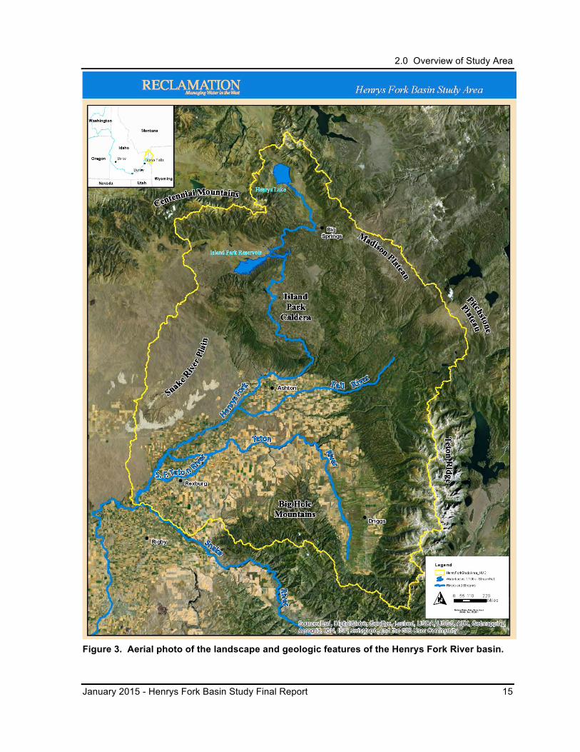
The Henrys Fork River flows for 120 miles in the eastern part of Idaho, joining the upper Snake River from the north near Rexburg, Idaho (Figure 3). The Basin Study area encompasses the watershed, approximately 3,300 square miles, bound by high desert areas of the Eastern Snake River Plain on the west and by the Continental Divide along the Centennial and Henry’s Lake mountains on the north. The Yellowstone Plateau and Teton Mountains form the eastern boundary, and the southern boundary is marked by the Snake River. Elevations in the Basin Study area range from over 10,000 feet along the Centennial Mountains on the north side of the basin to approximately 4800 feet near the Henrys Fork River’s confluence with the Snake River on the south.
The Basin Study area includes most of Fremont, Madison, and Teton counties. Cities and towns within the basin include Rexburg, St. Anthony, Teton, Ashton, Island Park, Drummond, and Driggs (Figure 1 and Figure 6).
2.2 Geology
The Henry’s Fork watershed as defined in this Basin Study is bounded to the northwest by the Centennial Mountains, to the northeast by the Madison Plateau, to the east by the Pitchstone Plateau and Teton Range, to the south by the Big Hole Mountains, and to the west by the Eastern Snake River Plain (Figure 3). The Henry’s Fork watershed is located in the southeastern part of the Greater Yellowstone Area which encompasses parts of Idaho, Wyoming, and Montana.
The geology of the Henry’s Fork watershed is part of the driving processes associated with the Yellowstone hotspot and hotspot track, a thermal plume rising through the Earth’s mantle into the base of the North American plate as it moves to the southwest. The Yellowstone hotspot processes are responsible for the Earth-surface volcanism, geothermal activity, active faulting, and uplift followed by subsidence. Some features associated with the Yellowstone hotspot and hotspot track include (1) the silica rich rhyolite eruptions of the Yellowstone Plateau (the Madison Plateau is part of the broader Yellowstone Plateau) and Eastern Snake River Plain, (2) the basin and range type faulting, and (3) uplift that resulted in the generally high altitude of the Greater Yellowstone Area and its radial pattern of major rivers (Pierce and Morgan 1992).
2.0 Overview of Study Area
January 2015 - Henrys Fork Basin Study Final Report 15
Figure 3. Aerial photo of the landscape and geologic features of the Henrys Fork River basin.
2.0 Overview of Study Area
16 Henrys Fork Basin Study Final Report– January 2015
The Yellowstone hotspot is presently located beneath the higher altitude plateaus in the Greater Yellowstone Area where there are two distinct types of rhyolite present: (1) relatively viscous lava flows with irregular surfaces and steep margins along the edge of the lava fields with heights of 300 feet or more, and (2) ash-flow tuffs that were created when explosive eruptions released hot ash and steam called a pyroclastic flow that cooled and congealed with a nearly flat surface (Pierce et al. 2007). Along the Yellowstone hotspot track, the axis of the Eastern Snake River Plain, these types of rhyolite flows are also present at depth and are associated with buried calderas. Following the rhyolite eruptions the plain has subsided creating a trough that has been covered by younger basalt flows. These buried calderas along the axis of the Eastern Snake River Plain, from oldest to youngest, include the Twin Falls, Picabo, and Heise volcanic fields (Pierce and Morgan 1992).
At the northeastern end of the Eastern Snake River Plain is the Island Park Caldera that is geologically transitional between the Eastern Snake River Plain and the Yellowstone Plateau. The caldera was formed from the eruption of silica-rich rhyolite flows and ash-flow tuffs followed by the collapse of the shield volcano. As the caldera-forming rhyolite eruptions waned, the flows transitioned to more calcium-rich basalt flows that became increasingly predominant from scattered vents flooding the interior of the caldera (Hamilton 1965).
Linear mountains and valleys of the older Basin-and-Range Province that flank the north and east sides of the Eastern Snake River Plain have experienced relatively high rates of normal faulting activity associated with the Yellowstone hotspot due to uplift of the Earth’s surface. These older mountain and valley morphologies that have been affected by the Yellowstone hotspot include the Madison Range/Madison Valley, Centennial Range/Centennial Valley, Teton Range/Jackson Hole, and Snake-Salt River Range/Star and Grand Valleys (Pierce et al. 2007).
During the Pleistocene, both deep snowfall facilitated by the lowland hotspot track and cold temperatures resulting from hotspot uplift combined to generate glaciers that covered much of the Greater Yellowstone Area. The glaciation of the Yellowstone National Park area had two modes (Pierce 1979; Sturchio et al. 1994; Pierce and Good 1998): (1) a mode during both the early and late part of a glacial cycle when glaciers formed and flowed down valleys from the mountains surrounding the Yellowstone Plateau, and (2) a climax mode when a large ice cap built up on the Yellowstone Plateau to a thickness of more than 3,000 feet and dominated the glacial flow from the surrounding mountains (Pierce et al. 2007).
Further work on the Henrys Fork River basin’s aquifers and spring-feed stream systems by Bayrd (2006) found that under natural conditions the basin’s morphology and relief has the most significant effect on the hydrologic regime and not necessarily the type or lithology of the rocks. Steeper topography generally associated with the basin and range type structures (i.e., Teton Range) produced flashier, snowmelt-dominated stream systems that did not effectively recharge local aquifers. Conversely, the large catchment, flatter topography
2.0 Overview of Study Area
January 2015 - Henrys Fork Basin Study Final Report 17
associated with the plateaus and calderas (i.e., Yellowstone and Madison plateaus, and Island Park caldera) allowed for greater infiltration that effectively recharged the local aquifer systems. Bayrd (2006) also found that recharge of the lower elevation Teton Valley and Eastern Snake River Plain aquifers are largely affected by human influences associated with agricultural practices such as seepage from irrigation canals and direct application of irrigation water from flood irrigation.
2.3 Climate
The climate in the Basin Study area varies with elevation and proximity to the mountain ranges on the north and east. The landscape created by the Yellowstone hotspot and hotspot track traps winter moisture moving in from the northern Pacific Ocean eastward and is channeled by the Eastern Snake River Plain. This moisture-laden air mass travels to the upper end of the Eastern Snake River Plain into a cul-de-sac created by the Yellowstone Plateau and surrounding highlands. The moist air mass must then rise over these orographic barriers that produce the deep snowfall associated with this region of the Greater Yellowstone Area.
Historically, the minimum annual average temperatures have ranged from 22° F near the headwaters of the Henrys Fork River to 30° F at its confluence with the Snake River. The maximum annual average temperatures have ranged from 52° F in the headwaters area to 57° F at the confluence. Precipitation varies with elevation, with an average of over 43 inches of precipitation in the headwaters area and about 14 inches near the confluence. Over 70 percent of the precipitation occurs between November and May, mainly in the form of snow (Reclamation 1980).
The effects of climate change in the upper Snake River basin have been studied by Reclamation, Bonneville Power Administration, and U.S. Army Corps of Engineers. In general, results of these studies suggest a shift in the annual precipitation to earlier in the year, with more falling as rain. This shift reflects the probability of a longer warm/growing season with less precipitation in the latter part of the season. More detailed discussion of climate change parameters and effects is provided in Section 3.5. Climate change studies by Federal agencies, universities, and researchers are ongoing and when new science and results become available, they will likely be incorporated into future analyses.
2.4 Hydrology
Originating at Big Springs in the northern part of the basin, the mainstem of the Henrys Fork River flows generally southward, supplemented by water from tributaries flowing from the mountains to the east. The Henrys Fork watershed has four major subbasins: upper Henrys Fork, lower Henrys Fork, Fall River, and Teton River. USGS identifies the upper Henrys
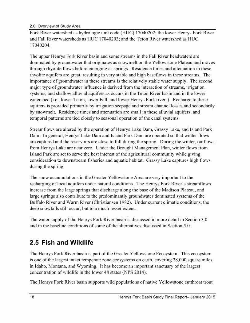
2.0 Overview of Study Area
18 Henrys Fork Basin Study Final Report– January 2015
Fork River watershed as hydrologic unit code (HUC) 17040202; the lower Henrys Fork River and Fall River watersheds as HUC 17040203; and the Teton River watershed as HUC 17040204.
The upper Henrys Fork River basin and some streams in the Fall River headwaters are dominated by groundwater that originates as snowmelt on the Yellowstone Plateau and moves through rhyolite flows before emerging as springs. Residence times and attenuation in these rhyolite aquifers are great, resulting in very stable and high baseflows in these streams. The importance of groundwater in these streams is the relatively stable water supply. The second major type of groundwater influence is derived from the interaction of streams, irrigation systems, and shallow alluvial aquifers as occurs in the Teton River basin and in the lower watershed (i.e., lower Teton, lower Fall, and lower Henrys Fork rivers). Recharge to these aquifers is provided primarily by irrigation seepage and stream channel losses and secondarily by snowmelt. Residence times and attenuation are small in these alluvial aquifers, and temporal patterns are tied closely to seasonal operation of the canal systems.
Streamflows are altered by the operation of Henrys Lake Dam, Grassy Lake, and Island Park Dam. In general, Henrys Lake Dam and Island Park Dam are operated so that winter flows are captured and the reservoirs are close to full during the spring. During the winter, outflows from Henrys Lake are near zero. Under the Drought Management Plan, winter flows from Island Park are set to serve the best interest of the agricultural community while giving consideration to downstream fisheries and aquatic habitat. Grassy Lake captures high flows during the spring.
The snow accumulations in the Greater Yellowstone Area are very important to the recharging of local aquifers under natural conditions. The Henrys Fork River’s streamflows increase from the large springs that discharge along the base of the Madison Plateau, and large springs also contribute to the predominantly groundwater dominated systems of the Buffalo River and Warm River (Christiansen 1982). Under current climatic conditions, the deep snowfalls still occur, but to a much lesser extent.
The water supply of the Henrys Fork River basin is discussed in more detail in Section 3.0 and in the baseline conditions of some of the alternatives discussed in Section 5.0.
2.5 Fish and Wildlife The Henrys Fork River basin is part of the Greater Yellowstone Ecosystem. This ecosystem is one of the largest intact temperate zone ecosystems on earth, covering 28,000 square miles in Idaho, Montana, and Wyoming. It has become an important sanctuary of the largest concentration of wildlife in the lower 48 states (NPS 2014).
The Henrys Fork River basin supports wild populations of native Yellowstone cutthroat trout
2.0 Overview of Study Area
January 2015 - Henrys Fork Basin Study Final Report 19
(Figure 4) and nonnative rainbow trout and brown trout. IDFG operates the Henrys Lake Hatchery near the town of Island Park part of the year for egg collections from Yellowstone cutthroat trout for later release into Henrys Lake.
Figure 4. Yellowstone cutthroat trout.3
Migratory Yellowstone cutthroat trout can be found in Henrys Lake, the Teton River, and the lower Henrys Fork River (DeRito 2012). Rainbow trout have largely displaced cutthroat trout throughout most of the mainstem Henrys Fork River and the Fall River drainages, but have not displaced cutthroat trout in the Teton River drainage. The reason for the difference is likely due to hydrology. The Henrys Fork River hydrograph is representative of groundwater-dominated streams in the Henrys Fork River basin, while the Teton River at South Leigh Creek and Snake River at Heise (just outside the Henrys Fork River basin) hydrographs are representative of snowmelt-dominated streams in the Henrys Fork River basin.
Nonnative rainbow trout have difficulty reproducing in streams that have a high peak flow immediately before and during fry emergence in the spring months because the peak flow displaces eggs and fry. The Yellowstone cutthroat trout fry generally emerge in late summer and early fall when they are not displaced by high flows. In the Henrys Fork River drainage, peak flows are low during rainbow trout egg incubation and fry emergence; consequently, rainbow trout have displaced cutthroat trout throughout most of the Henrys Fork watershed (Van Kirk and Jenkins 2005). In the Teton River drainage, peak flows are high during rainbow trout egg incubation and fry emergence in the spring, which may be one reason why 3 Photo catalog of yellowstone cutthroat trout can be found at http://www.nps.gov/yell/naturescience/fishid_yct.htm, accessed on September 27, 2013.
2.0 Overview of Study Area
20 Henrys Fork Basin Study Final Report– January 2015
rainbow trout have been less successful in the Teton River basin.
As a result of the Yellowstone cutthroat trout population status, IDFG has designated the Yellowstone cutthroat trout as a Species of Greatest Conservation Need (IDFG 2005). IDFG’s Management Plan for Conservation of Yellowstone Cutthroat Trout in Idaho provides details on Yellowstone cutthroat trout population status, distribution, habitat, history of Endangered Species Act (ESA) actions, threats, and management actions (IDFG 2007).
As part of the Greater Yellowstone Ecosystem, the Basin Study area provides habitat for a variety of large and small mammals and birds. Over 50 IDFG Species of Greatest Conservation Need are found throughout the watershed. Grizzly bears, listed under ESA, are found in the Henrys Fork River basin. ESA-listed lynx appear to be occasional visitors to the area.4 Black bears, deer, moose, elk, and pronghorn also inhabit the forested uplands, grassland steppe, and canyons. Small mammals such as beaver, river otters, raccoons, marmots, bats, and a large variety of rodents are year-round residents across the entire Basin Study area. Species such as fisher, wolverine, and lynx use the watershed as transitional habitat. Low elevation areas of the Henrys Fork River basin that are located in the Sand Creek desert provide wintering grounds for thousands of mule deer, elk, and moose.
Fish in the rivers and creeks draw hawks, osprey, owls, kestrels, and eagles to nest in the area during the summers. Columbian sharp-tailed grouse are found throughout the watershed in suitable grassland steppe and agricultural habitats and are considered a Species of Concern by the U.S. Fish and Wildlife Service and a Sensitive Species by the U.S. Forest Service and Bureau of Land Management. Sage grouse are found in intact sagebrush habitats of the watershed and are a candidate species for ESA listing by the U.S Fish and Wildlife Service. Northern goshawks have been seen in the Basin Study area and are considered a Sensitive Species by the U.S. Forest Service (Reclamation 2006).
4 The Targhee Forest Plan Lynx Amendment is in progress.
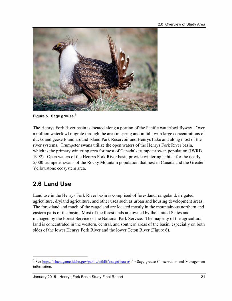
2.0 Overview of Study Area
January 2015 - Henrys Fork Basin Study Final Report 21
Figure 5. Sage grouse.5
The Henrys Fork River basin is located along a portion of the Pacific waterfowl flyway. Over a million waterfowl migrate through the area in spring and in fall, with large concentrations of ducks and geese found around Island Park Reservoir and Henrys Lake and along most of the river systems. Trumpeter swans utilize the open waters of the Henrys Fork River basin, which is the primary wintering area for most of Canada’s trumpeter swan population (IWRB 1992). Open waters of the Henrys Fork River basin provide wintering habitat for the nearly 5,000 trumpeter swans of the Rocky Mountain population that nest in Canada and the Greater Yellowstone ecosystem area.
2.6 Land Use
Land use in the Henrys Fork River basin is comprised of forestland, rangeland, irrigated agriculture, dryland agriculture, and other uses such as urban and housing development areas. The forestland and much of the rangeland are located mostly in the mountainous northern and eastern parts of the basin. Most of the forestlands are owned by the United States and managed by the Forest Service or the National Park Service. The majority of the agricultural land is concentrated in the western, central, and southern areas of the basin, especially on both sides of the lower Henrys Fork River and the lower Teton River (Figure 6).
5 See http://fishandgame.idaho.gov/public/wildlife/sageGrouse/ for Sage-grouse Conservation and Management information.
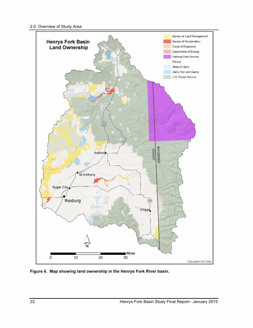
2.0 Overview of Study Area
22 Henrys Fork Basin Study Final Report– January 2015
Figure 6. Map showing land ownership in the Henrys Fork River basin.
2.0 Overview of Study Area
January 2015 - Henrys Fork Basin Study Final Report 23
2.7 Socioeconomics
The 2010 Census recorded 13,242 people in Fremont County, 37,536 people in Madison County, and 10,170 people in Teton County (IDOL 2012). The average county population of the Basin Study area has increased by about 34 percent since 2000, with Fremont County population increasing 7.4 percent, Madison County increasing 39.9 percent, and Teton County increasing 55.7 percent (Census 2011). To meet the needs of the growing population, farms and ranches have been subdivided into housing developments, many of which were platted on lands formerly irrigated for agriculture (Reclamation 2012).
Irrigated agriculture and its related food processing are the main economic activities in the Henrys Fork River basin (IWRB 1992), with the FMID lands generating over $100 million annually in crop sales (Reclamation 2004). Water for the majority of irrigated lands comes from natural flows supplemented by storage from Henrys Lake and Reclamation’s Minidoka Project (see Section 3.1.1). The irrigated lands consist of highly productive soils, which primarily produce grain, alfalfa, and potato crops and support dairy and beef operations (Table 4 and Table 5). Livestock water supplies come from irrigation canals or from livestock access to streams and springs (Reclamation 2012).
Table 4. Estimated acreages of major crops in 2010 (NASS 2012 as cited in Reclamation 2012).
Crop Fremont County (acres)
Madison County (acres)
Teton County (acres) Total Acres
Alfalfa 25,900 20,100 16,800 62,800
Barley 42,800 38,100 28,300 109,200
Potatoes 22,500 28,000 5,300 55,800
Winter Wheat 0 2,600 2,000 4,600
Table 5. Estimated number of cattle during 2010 (NASS 2012 as cited in Reclamation 2012).
Fremont County Madison County Teton County
Head of Cattle 13,100 11,100 8,200
Tourists come to the upper Henrys Fork River basin area to visit the nearby Yellowstone and Grand Teton National Parks and to participate in a variety of outdoor recreational activities on National Forest system lands. The Henrys Fork River’s world-class fly fishing and the National Forest system lands provide summer and winter outdoor recreational opportunities, drawing tourists from all over the world, and sustaining the tourism/recreation businesses in the area. On the Henrys Fork River alone (Fremont and Madison Counties), angling contributed $29 million and 851 jobs to eastern Idaho’s economy. Improved stream conditions could lead to higher catch rates and larger fish, resulting in larger benefits to the
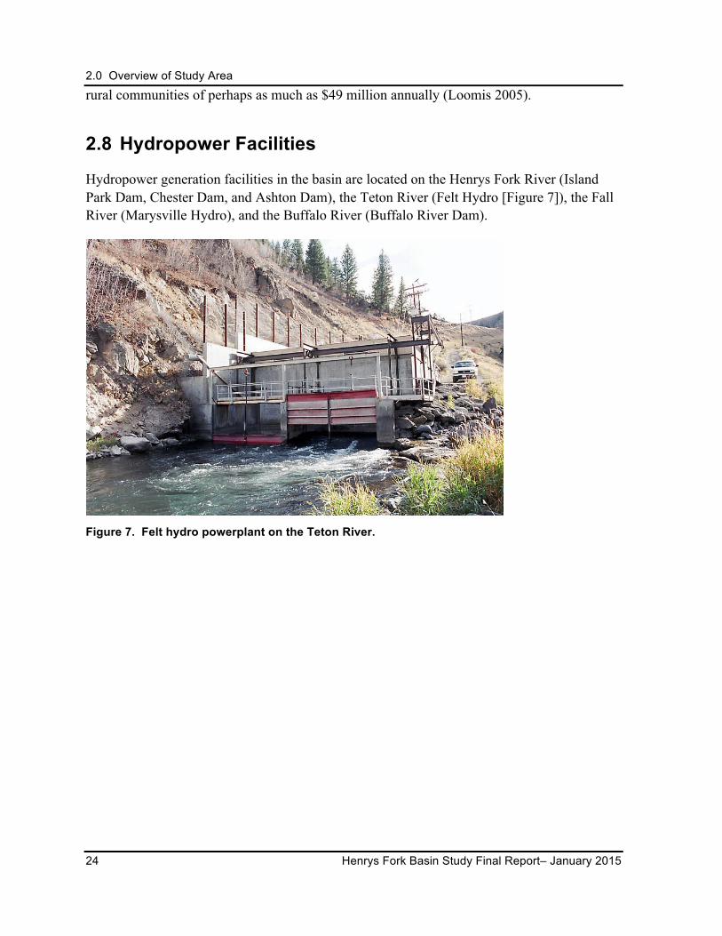
2.0 Overview of Study Area
24 Henrys Fork Basin Study Final Report– January 2015
rural communities of perhaps as much as $49 million annually (Loomis 2005).
2.8 Hydropower Facilities
Hydropower generation facilities in the basin are located on the Henrys Fork River (Island Park Dam, Chester Dam, and Ashton Dam), the Teton River (Felt Hydro [Figure 7]), the Fall River (Marysville Hydro), and the Buffalo River (Buffalo River Dam).
Figure 7. Felt hydro powerplant on the Teton River.
3.0 Water Supply and Demand
January 2015 - Henrys Fork Basin Study Final Report 25
3.0 WATER SUPPLY AND DEMAND The hydrology and associated water supplies and demands in the Henrys Fork River basin are complex and involve a variety of activities and users. In the Henrys Fork Watershed Basin Study Water Needs Assessment (Appendix A of Reclamation 2012), the Basin Study area’s water needs were discussed in detail for agriculture; hydropower; domestic, commercial, municipal, and industrial water; fish and wildlife habitat; and stabilization of the ESPA. While all water needs are acknowledged as important to the Basin Study area, IWRB, Reclamation, and the Workgroup prioritized three water needs above the others for study: agriculture; fish and wildlife habitat; and groundwater supply for the ESPA.
The following sections describe the surface water and groundwater supplies and water demands as related to the three prioritized needs in the basin as they existed in 2012. The information collected for the Henrys Fork Watershed Basin Study, Water Needs Assessment represents a snapshot in time and may change as more research and new information become available. The climate change projections that may come about in the next 40 years are discussed, as well as how climate change may affect future water supplies and demands.
3.1 Surface Water Supplies
The Henrys Fork River is one of the largest tributaries of the Snake River, which in turn, is the largest tributary to the Columbia River. Under natural, unregulated conditions, the total watershed supply would be around 2.5 million acre-feet per year, with the largest tributaries, Fall River and Teton River, collectively contributing about 1.3 million acre-feet per year (Table 6; Van Kirk 2011).

3.0 Water Supply and Demand
26 Henrys Fork Basin Study Final Report– January 2015
Table 6. Average annual natural flows for Henrys Fork River basin (Van Kirk 2011 as cited in Reclamation 2012).
Source Segment
30-Year Average
Annual Natural Flow (acre-feet)
30-Year Average
Annual Flow (acre-feet)
Percent of Total
Upper Henrys Fork River
1,225,356 48.2%
Henrys Lake 41,768
1.6% Henrys Lake to Island
Park 439,072 17.3%
Island Park to Ashton 744,516 29.3%
Fall River 699,914 27.5%
Teton River
618,863 24.3%
Teton Above S. Leigh 304,084
12.0% Teton S. Leigh to
St. Anthony 314,779 12.4%
Total Henrys Fork watershed
2,544,133 100.0%
The natural flow regime of the Henrys Fork River has been altered by irrigation diversions, increased evapotranspiration of irrigation, water storage, and canal conveyances. This alteration is highest during low water years and in the upper portion of the basin (Reclamation 2004).
The average annual basin outflow over the past 30 years is about 1.6 million acre-feet (Figure 8; Van Kirk 2012a). Much of the water lost to reservoir, stream, and conveyance system seepage and irrigation is recaptured as recharge to the aquifers (Appendix A of Reclamation 2013a). Computer modeling has shown that the lower Henrys Fork River would be a losing reach in the absence of irrigation return flow so that under natural conditions, the basin outflow would still be somewhat less than the supply of about 2.5 million acre-feet, due to river seepage to the ESPA (Van Kirk 2012a).
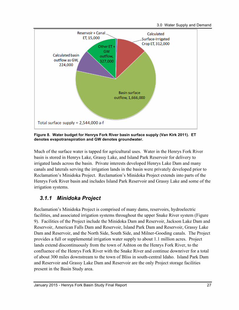
3.0 Water Supply and Demand
January 2015 - Henrys Fork Basin Study Final Report 27
Figure 8. Water budget for Henrys Fork River basin surface supply (Van Kirk 2011). ET denotes evapotranspiration and GW denotes groundwater.
Much of the surface water is tapped for agricultural uses. Water in the Henrys Fork River basin is stored in Henrys Lake, Grassy Lake, and Island Park Reservoir for delivery to irrigated lands across the basin. Private interests developed Henrys Lake Dam and many canals and laterals serving the irrigation lands in the basin were privately developed prior to Reclamation’s Minidoka Project. Reclamation’s Minidoka Project extends into parts of the Henrys Fork River basin and includes Island Park Reservoir and Grassy Lake and some of the irrigation systems.
3.1.1 Minidoka Project
Reclamation’s Minidoka Project is comprised of many dams, reservoirs, hydroelectric facilities, and associated irrigation systems throughout the upper Snake River system (Figure 9). Facilities of the Project include the Minidoka Dam and Reservoir, Jackson Lake Dam and Reservoir, American Falls Dam and Reservoir, Island Park Dam and Reservoir, Grassy Lake Dam and Reservoir, and the North Side, South Side, and Milner-Gooding canals. The Project provides a full or supplemental irrigation water supply to about 1.1 million acres. Project lands extend discontinuously from the town of Ashton on the Henrys Fork River, to the confluence of the Henrys Fork River with the Snake River and continue downriver for a total of about 300 miles downstream to the town of Bliss in south-central Idaho. Island Park Dam and Reservoir and Grassy Lake Dam and Reservoir are the only Project storage facilities present in the Basin Study area.
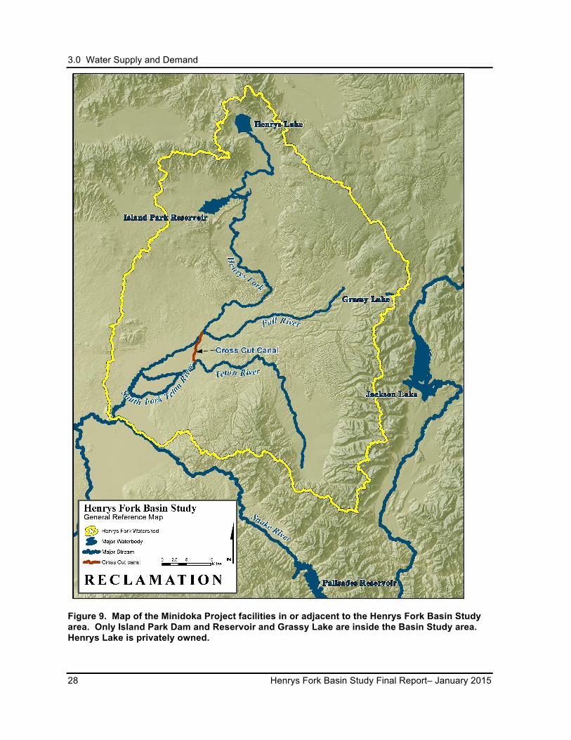
3.0 Water Supply and Demand
28 Henrys Fork Basin Study Final Report– January 2015
Figure 9. Map of the Minidoka Project facilities in or adjacent to the Henrys Fork Basin Study area. Only Island Park Dam and Reservoir and Grassy Lake are inside the Basin Study area. Henrys Lake is privately owned.
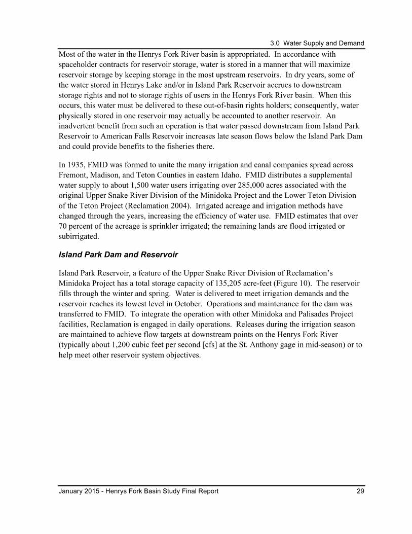
3.0 Water Supply and Demand
January 2015 - Henrys Fork Basin Study Final Report 29
Most of the water in the Henrys Fork River basin is appropriated. In accordance with spaceholder contracts for reservoir storage, water is stored in a manner that will maximize reservoir storage by keeping storage in the most upstream reservoirs. In dry years, some of the water stored in Henrys Lake and/or in Island Park Reservoir accrues to downstream storage rights and not to storage rights of users in the Henrys Fork River basin. When this occurs, this water must be delivered to these out-of-basin rights holders; consequently, water physically stored in one reservoir may actually be accounted to another reservoir. An inadvertent benefit from such an operation is that water passed downstream from Island Park Reservoir to American Falls Reservoir increases late season flows below the Island Park Dam and could provide benefits to the fisheries there.
In 1935, FMID was formed to unite the many irrigation and canal companies spread across Fremont, Madison, and Teton Counties in eastern Idaho. FMID distributes a supplemental water supply to about 1,500 water users irrigating over 285,000 acres associated with the original Upper Snake River Division of the Minidoka Project and the Lower Teton Division of the Teton Project (Reclamation 2004). Irrigated acreage and irrigation methods have changed through the years, increasing the efficiency of water use. FMID estimates that over 70 percent of the acreage is sprinkler irrigated; the remaining lands are flood irrigated or subirrigated.
Island Park Dam and Reservoir
Island Park Reservoir, a feature of the Upper Snake River Division of Reclamation’s Minidoka Project has a total storage capacity of 135,205 acre-feet (Figure 10). The reservoir fills through the winter and spring. Water is delivered to meet irrigation demands and the reservoir reaches its lowest level in October. Operations and maintenance for the dam was transferred to FMID. To integrate the operation with other Minidoka and Palisades Project facilities, Reclamation is engaged in daily operations. Releases during the irrigation season are maintained to achieve flow targets at downstream points on the Henrys Fork River (typically about 1,200 cubic feet per second [cfs] at the St. Anthony gage in mid-season) or to help meet other reservoir system objectives.
3.0 Water Supply and Demand
30 Henrys Fork Basin Study Final Report– January 2015
Figure 10. Island Park Dam and Reservoir on the Henrys Fork River, Idaho.
The objective of the Drought Management Plan (March 2005) is to increase benefits of winter flow regimes to the fisheries and related resources without compromise to the operation of Island Park Reservoir for Project purposes. After the irrigation season, there is often an opportunity to reduce flows and store water. Once severe cold is observed in December, the early storage may allow increased flows through the winter. By the time temperatures moderate in March, data is available to forecast springtime inflow and flow is adjusted to fill the reservoir. Whenever possible, flow is kept high enough to operate the Island Park hydroelectric plant, during low flows in the fall, and to avoid bypass in the spring. The Fall River Rural Electric Cooperative owns the Island Park Hydroelectric Project. Ramping rates in accordance with the project’s Federal Energy Regulatory Commission (FERC) license are observed except in emergencies or when delayed releases would result in or prolong dry reaches of river downstream.
Grassy Lake Dam and Reservoir
Constructed and operated by Reclamation, Grassy Lake Dam is located on Grassy Creek in Wyoming near the southern edge of Yellowstone National Park on Reclamation-withdrawn National Forest system lands (Figure 11). Its storage capacity of 15,500 acre-feet provides supplemental water for FMID. No releases are made during the winter, and summer releases are based on demand, usually in July and August. Additional releases may be made in late summer, if needed, to draft Grassy Lake to its winter operation level of 12,200 acre-feet.
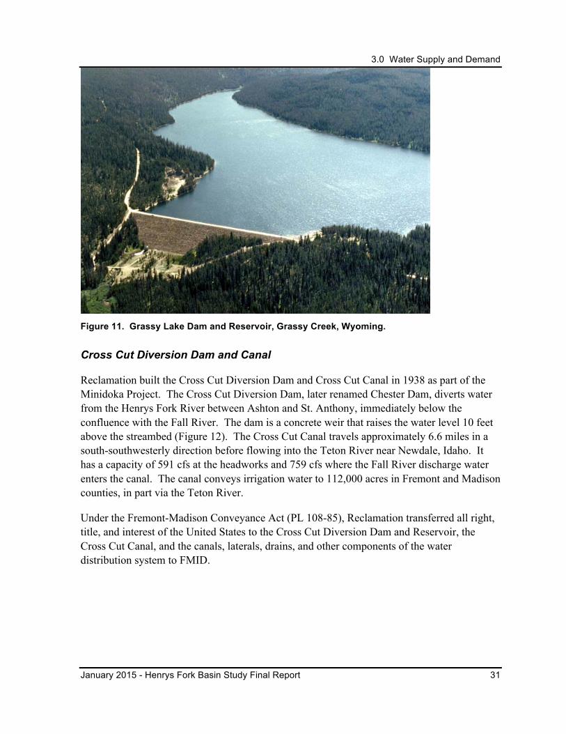
3.0 Water Supply and Demand
January 2015 - Henrys Fork Basin Study Final Report 31
Figure 11. Grassy Lake Dam and Reservoir, Grassy Creek, Wyoming.
Cross Cut Diversion Dam and Canal
Reclamation built the Cross Cut Diversion Dam and Cross Cut Canal in 1938 as part of the Minidoka Project. The Cross Cut Diversion Dam, later renamed Chester Dam, diverts water from the Henrys Fork River between Ashton and St. Anthony, immediately below the confluence with the Fall River. The dam is a concrete weir that raises the water level 10 feet above the streambed (Figure 12). The Cross Cut Canal travels approximately 6.6 miles in a south-southwesterly direction before flowing into the Teton River near Newdale, Idaho. It has a capacity of 591 cfs at the headworks and 759 cfs where the Fall River discharge water enters the canal. The canal conveys irrigation water to 112,000 acres in Fremont and Madison counties, in part via the Teton River.
Under the Fremont-Madison Conveyance Act (PL 108-85), Reclamation transferred all right, title, and interest of the United States to the Cross Cut Diversion Dam and Reservoir, the Cross Cut Canal, and the canals, laterals, drains, and other components of the water distribution system to FMID.

3.0 Water Supply and Demand
32 Henrys Fork Basin Study Final Report– January 2015
Figure 12. Cross Cut Diversion Dam and radial headgate on the Henrys Fork River.
3.1.2 Teton Exchange Wells
In the early 1970s, Reclamation drilled five wells to serve the Lower Teton Division of the Teton Basin Project. In 1977, FMID and Reclamation entered into a contract to allow use of the wells as a supplemental water supply in exchange for the water that would have been stored behind the failed Teton Dam. Under the Fremont-Madison Conveyance Act (PL 108-85), Reclamation transferred all right, title, and interest of the United States in and to the Teton Exchange Wells to FMID.
During low water years, FMID pumps up to 30,000 acre-feet of water from the wells into the lower Henrys Fork River, the lower Teton River, and the North Branch Independent Canal to increase the water supply. Although the well permit allows for additional well developments, FMID has agreed to limit well expansion to supply a maximum of 80,000 acre-feet per year during low water years. The well water is discharged directly into the Henrys Fork River, but it does not provide a net benefit to the streamflows. Instead, the well water replaces storage water released from Island Park Reservoir for irrigators downstream of FMID. Exchange well pumping and additional exchange well development may impact the Henrys Fork River and Snake River by slightly decreasing river flows.
3.1.3 Henrys Lake and Dam
In the early 1920s, the North Fork Reservoir Company (NFRC) constructed a dam across the outlet of the natural Henrys Lake to increase the storage capacity of the lake and supply irrigation water to the St. Anthony area (Figure 13). NFRC owns the dam and reservoir, and operates the 90,000 acre-feet of storage in conjunction with the Minidoka Project.
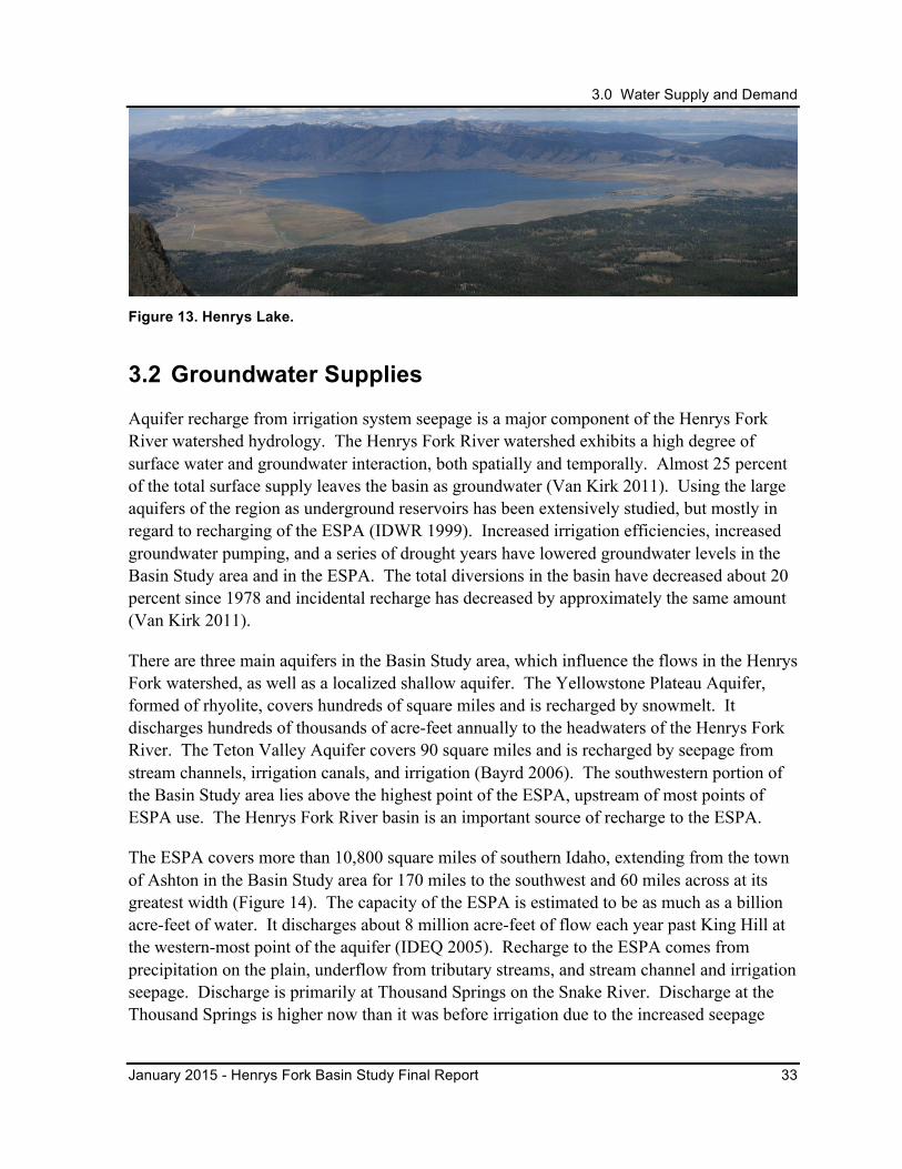
3.0 Water Supply and Demand
January 2015 - Henrys Fork Basin Study Final Report 33
Figure 13. Henrys Lake.
3.2 Groundwater Supplies
Aquifer recharge from irrigation system seepage is a major component of the Henrys Fork River watershed hydrology. The Henrys Fork River watershed exhibits a high degree of surface water and groundwater interaction, both spatially and temporally. Almost 25 percent of the total surface supply leaves the basin as groundwater (Van Kirk 2011). Using the large aquifers of the region as underground reservoirs has been extensively studied, but mostly in regard to recharging of the ESPA (IDWR 1999). Increased irrigation efficiencies, increased groundwater pumping, and a series of drought years have lowered groundwater levels in the Basin Study area and in the ESPA. The total diversions in the basin have decreased about 20 percent since 1978 and incidental recharge has decreased by approximately the same amount (Van Kirk 2011).
There are three main aquifers in the Basin Study area, which influence the flows in the Henrys Fork watershed, as well as a localized shallow aquifer. The Yellowstone Plateau Aquifer, formed of rhyolite, covers hundreds of square miles and is recharged by snowmelt. It discharges hundreds of thousands of acre-feet annually to the headwaters of the Henrys Fork River. The Teton Valley Aquifer covers 90 square miles and is recharged by seepage from stream channels, irrigation canals, and irrigation (Bayrd 2006). The southwestern portion of the Basin Study area lies above the highest point of the ESPA, upstream of most points of ESPA use. The Henrys Fork River basin is an important source of recharge to the ESPA.
The ESPA covers more than 10,800 square miles of southern Idaho, extending from the town of Ashton in the Basin Study area for 170 miles to the southwest and 60 miles across at its greatest width (Figure 14). The capacity of the ESPA is estimated to be as much as a billion acre-feet of water. It discharges about 8 million acre-feet of flow each year past King Hill at the western-most point of the aquifer (IDEQ 2005). Recharge to the ESPA comes from precipitation on the plain, underflow from tributary streams, and stream channel and irrigation seepage. Discharge is primarily at Thousand Springs on the Snake River. Discharge at the Thousand Springs is higher now than it was before irrigation due to the increased seepage
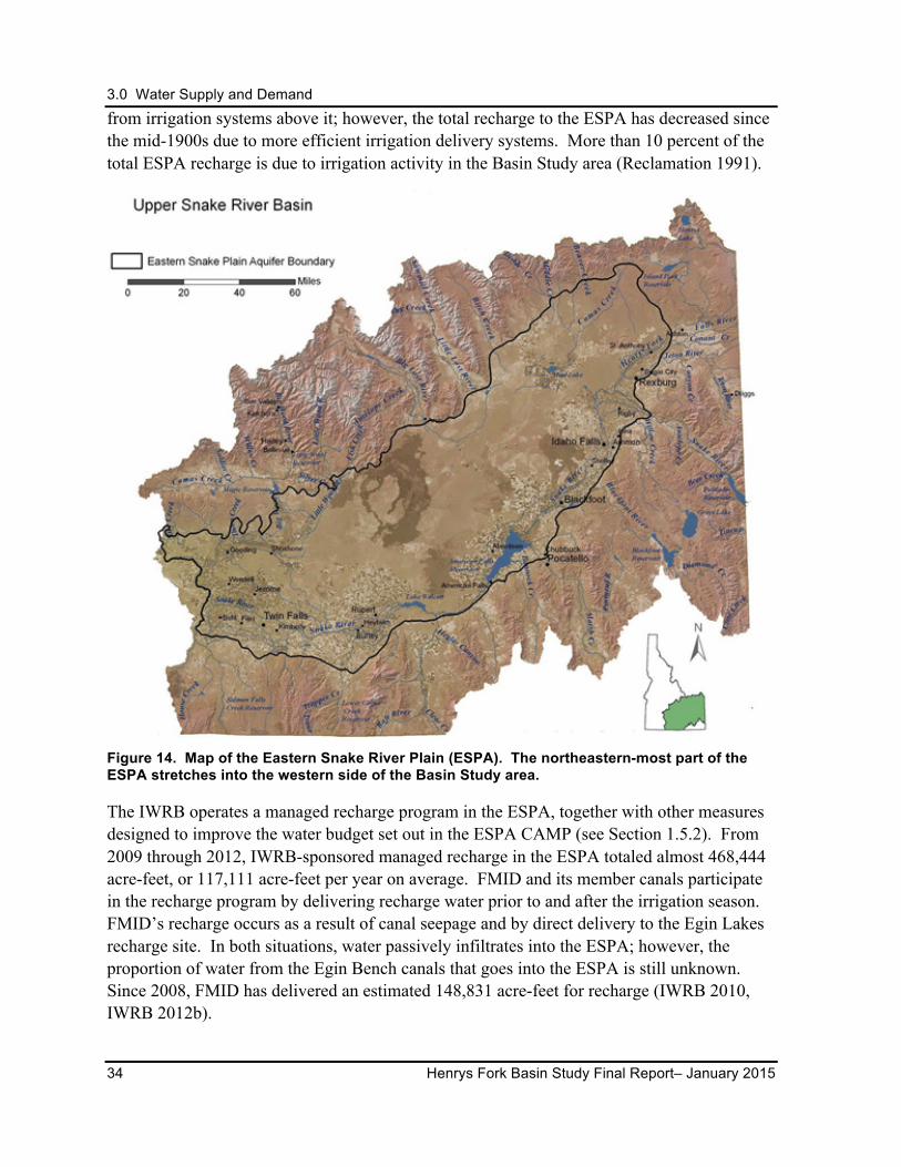
3.0 Water Supply and Demand
34 Henrys Fork Basin Study Final Report– January 2015
from irrigation systems above it; however, the total recharge to the ESPA has decreased since the mid-1900s due to more efficient irrigation delivery systems. More than 10 percent of the total ESPA recharge is due to irrigation activity in the Basin Study area (Reclamation 1991).
Figure 14. Map of the Eastern Snake River Plain (ESPA). The northeastern-most part of the ESPA stretches into the western side of the Basin Study area.
The IWRB operates a managed recharge program in the ESPA, together with other measures designed to improve the water budget set out in the ESPA CAMP (see Section 1.5.2). From 2009 through 2012, IWRB-sponsored managed recharge in the ESPA totaled almost 468,444 acre-feet, or 117,111 acre-feet per year on average. FMID and its member canals participate in the recharge program by delivering recharge water prior to and after the irrigation season. FMID’s recharge occurs as a result of canal seepage and by direct delivery to the Egin Lakes recharge site. In both situations, water passively infiltrates into the ESPA; however, the proportion of water from the Egin Bench canals that goes into the ESPA is still unknown. Since 2008, FMID has delivered an estimated 148,831 acre-feet for recharge (IWRB 2010, IWRB 2012b).
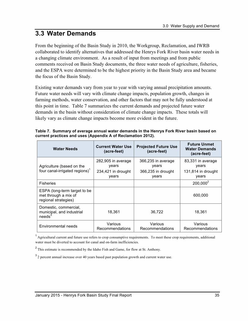
3.0 Water Supply and Demand
January 2015 - Henrys Fork Basin Study Final Report 35
3.3 Water Demands
From the beginning of the Basin Study in 2010, the Workgroup, Reclamation, and IWRB collaborated to identify alternatives that addressed the Henrys Fork River basin water needs in a changing climate environment. As a result of input from meetings and from public comments received on Basin Study documents, the three water needs of agriculture, fisheries, and the ESPA were determined to be the highest priority in the Basin Study area and became the focus of the Basin Study.
Existing water demands vary from year to year with varying annual precipitation amounts. Future water needs will vary with climate change impacts, population growth, changes in farming methods, water conservation, and other factors that may not be fully understood at this point in time. Table 7 summarizes the current demands and projected future water demands in the basin without consideration of climate change impacts. These totals will likely vary as climate change impacts become more evident in the future.
Table 7. Summary of average annual water demands in the Henrys Fork River basin based on current practices and uses (Appendix A of Reclamation 2012).
Water Needs Current Water Use (acre-feet)
Projected Future Use (acre-feet)
Future Unmet Water Demands
(acre-feet)
Agriculture (based on the four canal-irrigated regions)1
282,905 in average years
234,421 in drought years
366,235 in average years
366,235 in drought years
83,331 in average years
131,814 in drought years
Fisheries 200,0002
ESPA (long-term target to be met through a mix of regional strategies)
600,000
Domestic, commercial, municipal, and industrial needs3
18,361 36,722 18,361
Environmental needs Various Recommendations
Various Recommendations
Various Recommendations
1 Agricultural current and future use refers to crop consumptive requirements. To meet these crop requirements, additional water must be diverted to account for canal and on-farm inefficiencies. 2 This estimate is recommended by the Idaho Fish and Game, for flow at St. Anthony. 3 2 percent annual increase over 40 years based past population growth and current water use.
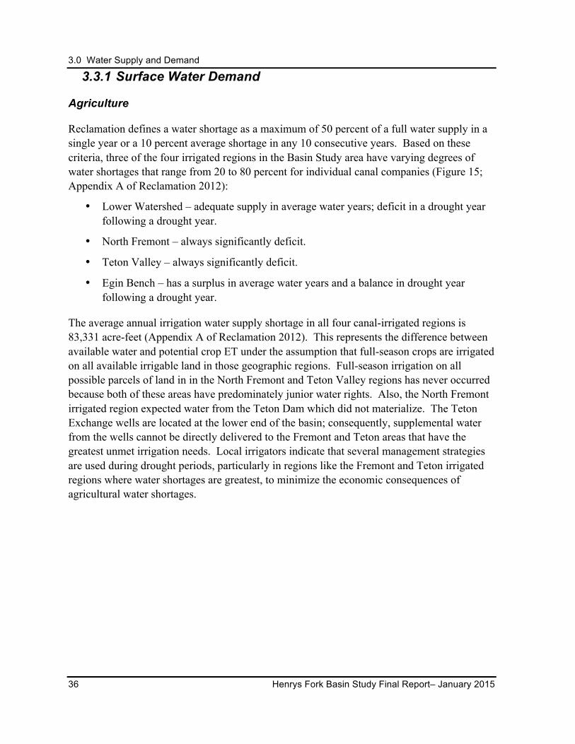
3.0 Water Supply and Demand
36 Henrys Fork Basin Study Final Report– January 2015
3.3.1 Surface Water Demand
Agriculture
Reclamation defines a water shortage as a maximum of 50 percent of a full water supply in a single year or a 10 percent average shortage in any 10 consecutive years. Based on these criteria, three of the four irrigated regions in the Basin Study area have varying degrees of water shortages that range from 20 to 80 percent for individual canal companies (Figure 15; Appendix A of Reclamation 2012):
• Lower Watershed – adequate supply in average water years; deficit in a drought year following a drought year.
• North Fremont – always significantly deficit.
• Teton Valley – always significantly deficit.
• Egin Bench – has a surplus in average water years and a balance in drought year following a drought year.
The average annual irrigation water supply shortage in all four canal-irrigated regions is 83,331 acre-feet (Appendix A of Reclamation 2012). This represents the difference between available water and potential crop ET under the assumption that full-season crops are irrigated on all available irrigable land in those geographic regions. Full-season irrigation on all possible parcels of land in in the North Fremont and Teton Valley regions has never occurred because both of these areas have predominately junior water rights. Also, the North Fremont irrigated region expected water from the Teton Dam which did not materialize. The Teton Exchange wells are located at the lower end of the basin; consequently, supplemental water from the wells cannot be directly delivered to the Fremont and Teton areas that have the greatest unmet irrigation needs. Local irrigators indicate that several management strategies are used during drought periods, particularly in regions like the Fremont and Teton irrigated regions where water shortages are greatest, to minimize the economic consequences of agricultural water shortages.
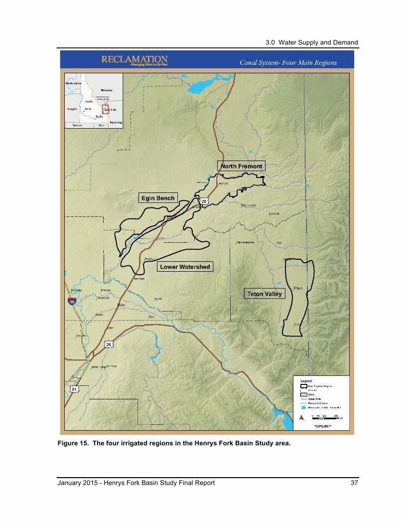
3.0 Water Supply and Demand
January 2015 - Henrys Fork Basin Study Final Report 37
Figure 15. The four irrigated regions in the Henrys Fork Basin Study area.
3.0 Water Supply and Demand
38 Henrys Fork Basin Study Final Report– January 2015
Fish and Wildlife
Minimum streamflow is defined by statute as “the minimum flow of water in cubic feet per second of time or minimum lake level in feet above mean sea level required to protect the fish and wildlife habitat, aquatic life, recreation, aesthetic beauty, navigation, transportation, or water quality of a stream in the public interest” (Idaho Code § 42-1502[f]). Various recommended minimum streamflow targets to preserve stream values have been planned by the IDFG (IDFG 1999; IDFG 1978), the Snake River Resources Review panel (SR3 2001), and other entities. Under the Henrys Fork River Drought Management Plan, Reclamation cooperates with IDFG and FMID to maximize winter flows downstream of Island Park Reservoir to maintain habitat for juvenile trout.
Current water management practices allow Teton Valley irrigators to purchase water from storage facilities outside of the Teton River basin (most commonly out of Island Park Reservoir) to provide water for downstream senior users when IDWR curtails surface water usage. This practice results in out-of-basin water exchanges and tends to exacerbate tributary dewatering issues. While groundwater recharge from irrigation activities helps replenish downstream flows, diversions often have a negative impact on fish and fish habitat.
The timing and magnitude of peak and seasonal flows in the Henrys Fork River and its tributaries are important to sustain its fisheries (see Section 2.5). The current alteration of flows below storage and power facilities on the rivers in the basin is offset to a small extent by inflows from the tributaries and groundwater recharge from irrigation activities. Additional water to reduce the impacts to fisheries is most needed in the tributary basins where there is less inflow and recharge and the water shortages are the greatest (Van Kirk et al. 2011).
3.3.2 Groundwater Demand
The ESPA was designated as a sole source aquifer by the U.S. Environmental Protection Agency because it supplies at least 50 percent of the drinking water to the population living above the aquifer and there is no other source of drinking water that can be physically, legally, or economically used to supply that population (IDEQ 2005). A large part of Idaho’s agricultural product, valued at approximately $10 billion annually, is dependent on water from the ESPA (IDWR 2009). Fish farms fed by the ESPA provide about three-fourths of the nation’s farm-raised trout (IDEQ 2005).
In the ESPA, more water is being used than is being recharged. Declining aquifer levels and spring discharges (e.g., Thousand Springs area), changing flows in the Snake River, and other actions (e.g., flow augmentation for anadromous fish survival) have resulted in insufficient supplies to satisfy existing beneficial uses across the upper Snake River basin. As described in Section 1.5.2, the ESPA CAMP outlines a long-term objective of incrementally achieving a
3.0 Water Supply and Demand
January 2015 - Henrys Fork Basin Study Final Report 39
net ESPA water budget increase of 600,000 acre-feet annually through implementation of a mix of management actions including, but not limited to, aquifer recharge, groundwater-to-surface water conversions, and demand reduction strategies (IWRB 2009).
3.4 Characterization of Future Conditions
Looking 40 years into the future, dependable water supplies will be needed to sustain irrigated agriculture, recreation, fish and wildlife resources, and economic development. Future water needs will likely fluctuate with varying annual precipitation amounts, climate change impacts, population growth, changes in farming methods, water conservation, and other factors that may not be fully understood at this point in time. While the quantity of available water is not expected to change in the future, the timing of peak flows and an extended warm-weather season could increase future demands across all areas and needs (see Section 3.5).
For the Basin Study, Reclamation assumed there would be no increase in the number of irrigated acres. Instead, fewer acres may be irrigated as farms and ranches are subdivided into housing developments to meet the growing population needs. Future irrigation water demands could be affected by the continued conversion of agriculture lands to urban areas; changes in crop types in response to the market or climate conditions; and the employment of new conservation measures in agricultural practices or irrigation delivery systems. Whether these impacts will increase or decrease future demands is unclear at this time.
The Henrys Fork River is expected to maintain its reputation for world-class fly fishing and the adjacent National Forest system and National Park lands will likely continue to draw tourists from all over the world.
Streams in the Henrys Fork River basin are expected to continue to support wild populations of native Yellowstone cutthroat trout and nonnative rainbow trout and brown trout. The Basin Study area is expected to continue to provide habitat for a variety of large and small mammals and birds; however, recharge from irrigation has decreased with the installation of more efficient irrigation systems, which in turn has decreased groundwater inflows to the rivers. Over time, this could potentially impact wildlife and fisheries and their habitats (Van Kirk 2011).
IWRB expects to continue the managed recharge program and implementation of other measures to improve the ESPA water supply consistent with the ESPA CAMP and State Water Plan.
3.0 Water Supply and Demand
40 Henrys Fork Basin Study Final Report– January 2015
3.5 Potential Effects of Climate Change on Supply and Demand
The impacts of climate change in the Henrys Fork River basin are uncertain. Ongoing research indicates that the basin may experience warmer air temperatures and more variable precipitation amounts. There may be a shift in the timing of peak flows to earlier in the year and a decrease of summer flows during the warmer months. The projected warmer air temperatures could extend the start and end of the irrigation season from that which is currently experienced.
Reclamation, the Bonneville Power Administration, and the U.S. Army Corps of Engineers collaborated to adopt climate change and hydrologic datasets to better understand how potential changes in water supply due to climate change may affect reservoir operations in the Columbia River Basin. Output (e.g., temperatures, precipitation) from Global Circulation Models (GCMs) was spatially downscaled and bias corrected, then used in a hydrologic model that generated supply or flow values at various locations in the Columbia River Basin. Two future time periods called Hybrid-Delta were defined as the 30-year period surrounding the 2020s (2010 to 2039) and the 30-year period surrounding the 2040s (2030 to 2059). Those supply data were provided to stakeholders for use in their long-term planning models for several basins, including the upper Snake River basin, which included the Henrys Fork watershed. For the analyses of the Basin Study alternatives, the 2040s period was used in the computer modeling activities.
3.5.1 Potential Effects on Agricultural Water
Using hydrologic models, Reclamation generated projected inflows influenced by climate change. Those data were used in existing water management models for the upper Snake River above Brownlee Reservoir. The modeling results indicated a shift in the timing of the peak flow to a month earlier. Flow volume increased above historical flows earlier in the cool season (October or November to April) and decreased in the summer and fall seasons (May through September or October).
This shift in peak flow timing and increased cool season inflow occurred when reservoirs would be at or near capacity or constrained by a flood control rule curve that may increase the probability of passing floodwaters downstream. The lower flows that are projected in future summer months may result in less water in the rivers and creeks to fulfill natural flow water rights, subsequent increased use of stored water by those that hold contracted storage space, and potential impacts to reservoir carryover during particularly long-term drier periods.
Given the modeled warming global temperatures and changes in precipitation, the growing season for agriculture is expected to begin earlier in the season and end later in the season than it currently does, depending on geography. While the shift of peak flow timing to earlier
3.0 Water Supply and Demand
January 2015 - Henrys Fork Basin Study Final Report 41
in the year may be counterbalanced by the shift in the volume of flow, the extension of the growing season will likely exacerbate any drought conditions currently experienced.
These shifts may also affect the operations of dams and management of irrigation systems, increasing the need to release more water from the reservoirs and divert more water for irrigation later in the summer months (Reclamation 2011). A decrease in natural streamflow in the late summer to early fall months could result in less water available for natural flow diversions thus increasing stored water usage.
3.5.2 Potential Effects on Fish and Wildlife Habitat
Environmental objectives for both anadromous and resident fish species were evaluated in the climate change study. Climate-induced changes in the hydrologic regime of the Henrys Fork River could impact early life stages of fish (i.e., Yellowstone cutthroat trout and rainbow trout). Earlier peak flows due to climate changes in the Basin Study area could potentially impact the timing of spawning and fry emergence (see Section 2.1). Warmer air temperatures may increase water temperatures enough that fish will move to higher elevations in search of cold water (Gresswell 2011).
Since 1992, consultations between Reclamation and NOAA National Marine Fisheries Service under Section 7(a)(2) of the ESA have included the consideration of flow augmentation from Reclamation’s upper Snake Projects (including Island Park Reservoir) to augment flows in the lower Snake and Columbia rivers through acquisitions from willing sellers. In the reservoirs that require minimum pools or flows, the climate change modeling showed that in some cases, it may be more difficult to meet these augmentation objectives in some of the reservoirs in the driest conditions (Reclamation 2011).
3.5.3 Potential Effects on Groundwater and the ESPA
Climate change in the Henrys Fork River basin has the potential to impact the quantity of groundwater recharge and the quantity of water pumped from the shallow aquifer. Three climate change scenarios were used to evaluate potential impacts to streamflow in the Henrys Fork River basin (see Section 5.1.2). The modeling results indicated an increase in precipitation from historical norms in the winter months and a decrease in the summer months (Reclamation 2013b). These changes in precipitation patterns would result in increased base streamflows in the winter months and a decrease in the summer months.
Based on the climate change projections, recharge that occurs directly from precipitation has the potential to increase during the winter months and decrease during the summer months. Since a large portion of the groundwater recharge in the Henrys Fork River basin occurs due to canal losses and on-farm inefficiencies, changes in farming practices and methods in response to climate change have the potential to impact the aquifer more than climate change
3.0 Water Supply and Demand
42 Henrys Fork Basin Study Final Report– January 2015
alone. Irrigators may be more likely to implement conservation measures, such as converting to sprinkler irrigation or lining/piping canals, to improve the efficiencies of their systems if late summer flows are limited. These activities could result in decreased recharge to the aquifers.
The Teton exchange wells are operated by FMID in years when FMID’s full water allotment from Island Park Reservoir storage is not available. This type of operation may occur less often under the projections evaluated. Island Park Reservoir fills more often under the climate change projections. Because these projected future climates increase inflow to the reservoir during the winter and thereby increases the reliability of filling the reservoir, the operation of the exchange wells may be required less often, resulting in less water pumped from the aquifer.
The changes to aquifer storage as a result of changes in recharge would impact groundwater returns to streams, though the extent of the impact would depend on the quantity of increased or decreased recharge.
3.6 Future Challenges and Considerations
Future growth in Idaho’s population and commercial and industrial expansion will require a sustainable water supply. In general, for any new consumptive use of water, applicants must demonstrate to the State that their new diversion and consumptive use of water will not injure senior water rights or that mitigation measures can be implemented during times in which injury would otherwise occur. The interconnection between surface and groundwater in the area is a critical component of evaluating the potential for injury to senior water rights. Meeting these criteria may limit new water uses in the future for municipalities and industries.
Climate change studies by Federal agencies, universities, and researchers are ongoing across the globe. When available, new science and results would become part of future analyses and considerations.
4.0 Screening and Selection of Alternatives
January 2015 - Henrys Fork Basin Study Final Report 43
4.0 SCREENING AND SELECTION OF ALTERNATIVES As a first step in the planning process, Reclamation, IWRB, and the Workgroup met to discuss the issues, opportunities, and constraints to be considered in formulating alternatives for the Basin Study. Through these discussions, the following process was developed to both identify the full range of alternatives and determine which ones held the most promise and warranted more detailed investigations:
1. Identify a full range of potentially viable alternatives for augmenting water storage and for optimizing and conserving water supply in the Henrys Fork River basin. In the case of storage, alternatives needed to provide additional water supply for use in both the Henrys Fork River basin and the ESPA. For water supply optimization and conservation, the focus would be on in-basin needs.
2. Screen the full list of potential alternatives using available information and a straightforward scoping system to determine which alternatives warranted more detailed consideration. This screening process was primarily focused on fatal flaws associated with environmental and social issues. Hydrology, water rights, and associated issues related to climate change were evaluated on the final short list of alternatives.
3. Review results of initial screening to verify accuracy and credibility; refine results based on professional judgment of the study team and preliminary analysis, including field reconnaissance, to define the final short list of the most promising alternatives that would become the focus of this Basin Study.
4.1 Identification of Potential Alternatives
The full range of potential alternatives to provide additional water storage and to optimize and conserve water resources in the Henrys Fork River basin was identified through a review of existing sources6 and through discussions with the Workgroup. Four general categories emerged from the 51 alternatives put forward by the Workgroup: 1) surface storage; 2) groundwater recharge; 3) water markets; and 4) conservation water management and demand reduction in agricultural and municipal uses.
6 Many of these published sources may be found at http://www.usbr.gov/pn/programs/studies/idaho/henrysfork/reference/index.html.
4.0 Screening and Selection of Alternatives
44 Henrys Fork Basin Study Final Report– January 2015
4.1.1 Combination of Alternatives
Reclamation, IWRB, and the Workgroup recognized that the potential to combine alternatives aimed at increasing storage and improving management of water resources held significant promise for meeting local and regional/State needs. At this early stage of planning, too little was known about the characteristics of the individual elements, how viable they would be, and how they might synchronize with each other. Consequently, the study of potential combination options or water supply and management programs was deferred until sufficient study of individual actions were completed.
4.2 Preliminary Screening – Opportunities and Constraints Assessment
All of the alternatives put forward by the Workgroup were assigned scores based on the evaluation categories and factors listed in Table 8. The scores provided a ranking of the alternatives that emphasized constraints and impacts of each alternative for comparative purposes.
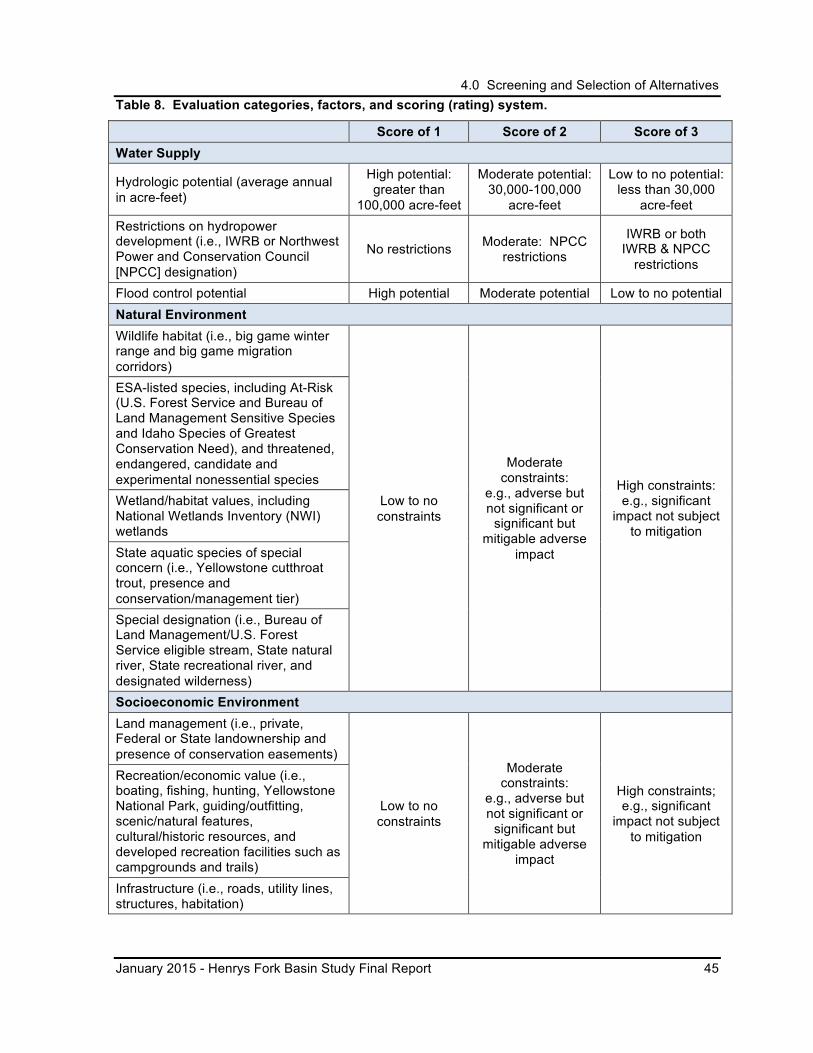
4.0 Screening and Selection of Alternatives
January 2015 - Henrys Fork Basin Study Final Report 45
Table 8. Evaluation categories, factors, and scoring (rating) system.
Score of 1 Score of 2 Score of 3 Water Supply
Hydrologic potential (average annual in acre-feet)
High potential: greater than
100,000 acre-feet
Moderate potential: 30,000-100,000
acre-feet
Low to no potential: less than 30,000
acre-feet Restrictions on hydropower development (i.e., IWRB or Northwest Power and Conservation Council [NPCC] designation)
No restrictions Moderate: NPCC restrictions
IWRB or both IWRB & NPCC
restrictions
Flood control potential High potential Moderate potential Low to no potential Natural Environment Wildlife habitat (i.e., big game winter range and big game migration corridors)
Low to no constraints
Moderate constraints:
e.g., adverse but not significant or
significant but mitigable adverse
impact
High constraints: e.g., significant
impact not subject to mitigation
ESA-listed species, including At-Risk (U.S. Forest Service and Bureau of Land Management Sensitive Species and Idaho Species of Greatest Conservation Need), and threatened, endangered, candidate and experimental nonessential species Wetland/habitat values, including National Wetlands Inventory (NWI) wetlands State aquatic species of special concern (i.e., Yellowstone cutthroat trout, presence and conservation/management tier) Special designation (i.e., Bureau of Land Management/U.S. Forest Service eligible stream, State natural river, State recreational river, and designated wilderness) Socioeconomic Environment Land management (i.e., private, Federal or State landownership and presence of conservation easements)
Low to no constraints
Moderate constraints:
e.g., adverse but not significant or
significant but mitigable adverse
impact
High constraints; e.g., significant
impact not subject to mitigation
Recreation/economic value (i.e., boating, fishing, hunting, Yellowstone National Park, guiding/outfitting, scenic/natural features, cultural/historic resources, and developed recreation facilities such as campgrounds and trails) Infrastructure (i.e., roads, utility lines, structures, habitation)
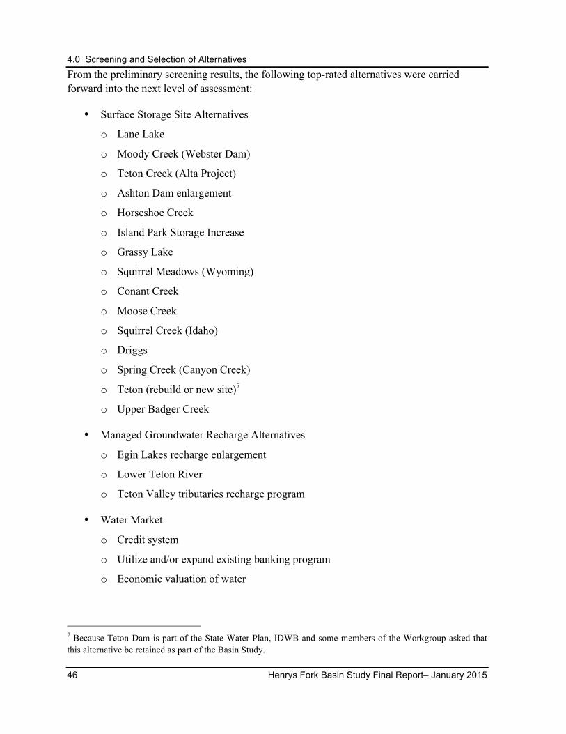
4.0 Screening and Selection of Alternatives
46 Henrys Fork Basin Study Final Report– January 2015
From the preliminary screening results, the following top-rated alternatives were carried forward into the next level of assessment:
• Surface Storage Site Alternatives
o Lane Lake
o Moody Creek (Webster Dam)
o Teton Creek (Alta Project)
o Ashton Dam enlargement
o Horseshoe Creek
o Island Park Storage Increase
o Grassy Lake
o Squirrel Meadows (Wyoming)
o Conant Creek
o Moose Creek
o Squirrel Creek (Idaho)
o Driggs
o Spring Creek (Canyon Creek)
o Teton (rebuild or new site)7
o Upper Badger Creek
• Managed Groundwater Recharge Alternatives
o Egin Lakes recharge enlargement
o Lower Teton River
o Teton Valley tributaries recharge program
• Water Market
o Credit system
o Utilize and/or expand existing banking program
o Economic valuation of water
7 Because Teton Dam is part of the State Water Plan, IDWB and some members of the Workgroup asked that this alternative be retained as part of the Basin Study.
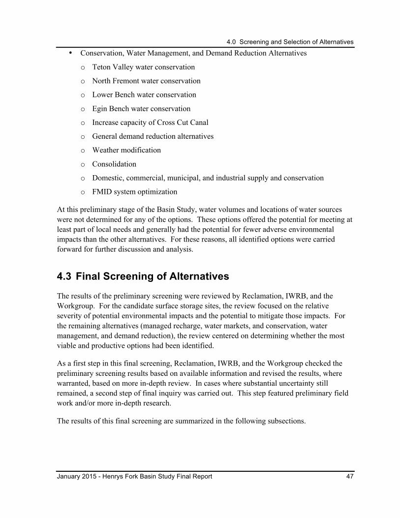
4.0 Screening and Selection of Alternatives
January 2015 - Henrys Fork Basin Study Final Report 47
• Conservation, Water Management, and Demand Reduction Alternatives
o Teton Valley water conservation
o North Fremont water conservation
o Lower Bench water conservation
o Egin Bench water conservation
o Increase capacity of Cross Cut Canal
o General demand reduction alternatives
o Weather modification
o Consolidation
o Domestic, commercial, municipal, and industrial supply and conservation
o FMID system optimization
At this preliminary stage of the Basin Study, water volumes and locations of water sources were not determined for any of the options. These options offered the potential for meeting at least part of local needs and generally had the potential for fewer adverse environmental impacts than the other alternatives. For these reasons, all identified options were carried forward for further discussion and analysis.
4.3 Final Screening of Alternatives
The results of the preliminary screening were reviewed by Reclamation, IWRB, and the Workgroup. For the candidate surface storage sites, the review focused on the relative severity of potential environmental impacts and the potential to mitigate those impacts. For the remaining alternatives (managed recharge, water markets, and conservation, water management, and demand reduction), the review centered on determining whether the most viable and productive options had been identified.
As a first step in this final screening, Reclamation, IWRB, and the Workgroup checked the preliminary screening results based on available information and revised the results, where warranted, based on more in-depth review. In cases where substantial uncertainty still remained, a second step of final inquiry was carried out. This step featured preliminary field work and/or more in-depth research.
The results of this final screening are summarized in the following subsections.
4.0 Screening and Selection of Alternatives
48 Henrys Fork Basin Study Final Report– January 2015
4.3.1 Surface Storage Site Alternatives
Fifteen candidate surface storage sites were evaluated and scored using the preliminary screening process described in Table 8. A more in-depth review found that eight of these storage site alternatives had other constraints that were both significant and not subject to mitigation. As shown in Table 9, these eight sites were removed from further consideration and the remaining seven sites were carried forward into the full study.
Table 9. Final screening results for the surface storage alternatives
Preliminary Alternatives Carried Forward for Further Study
Remove from Consideration Rationale for Removal
Ashton Dam Enlargement X
Conant Creek X Impact on Yellowstone cutthroat trout
Driggs X Impact on community (infrastructure inundation)
Grassy Lake X Limited additional capacity; within National Park boundary
Horseshoe Creek
X
Undefined; Horseshoe Creek is on the west side of a bifurcation of Teton River near Bates Road. This would be a partial alternative of Driggs.
Island Park Storage Increase X
Lane Lake X
Moody Creek (Webster Dam) X
Moose Creek
X
Further investigation revealed that this alternative would have severe impacts on wildlife habitat and protected landmark features.
Spring Creek (Canyon Creek) X
Squirrel Creek (Idaho)
X
Significant Endangered Species Act concerns; grizzly bear habitat; contiguous with National Forest and National Park boundaries.
4.0 Screening and Selection of Alternatives
January 2015 - Henrys Fork Basin Study Final Report 49
Preliminary Alternatives Carried Forward for Further Study
Remove from Consideration Rationale for Removal
Squirrel Meadows (Wyoming) X
Significant Endangered Species Act concerns; grizzly bear habitat; contiguous with National Forest and National Park boundaries.
Teton (rebuild or new site) X
The evaluation categories, factors, and scoring system process alone may have eliminated the Teton Dam alternative. At the request of the IWRB and other stakeholders and given its unique history, it was retained for comparative purposes and long-term future consideration.
Teton Creek (Alta Project) X Geologic fatal flaw
Upper Badger Creek X
4.3.2 Managed Groundwater Recharge Site Alternatives
A more in-depth review by Reclamation, IWRB, and the Workgroup resulted in restating the alternatives to provide better focus on the most promising actions or sets of actions related to groundwater recharge; however, the review of the alternatives resulted in the elimination of all but the Egin Lakes enlargement alternative. The overall review and selection process is shown in Table 10.
Table 10. Final screening results for the managed groundwater recharge alternatives.
Preliminary Alternatives
Carried Forward for
Further study
Removed from Further
Consideration Rationale for removal
Egin Lakes enlargement X Retain for further study by IWRB (see
Section 5.3)
Teton Valley Tributary Recharge Program, recharge using existing irrigation canals
X Eliminated due to low viability due to significant challenges in obtaining water rights, limited benefits, and potential environmental impact conflicts
Lower Teton River, Teton Island X
4.0 Screening and Selection of Alternatives
50 Henrys Fork Basin Study Final Report– January 2015
4.3.3 Water Market Alternatives
The three alternatives related to water markets identified in the preliminary screening process represented different aspects of or approaches to a water marketing program. During the final screening, discussion of the potential for water markets resulted in the decision to consolidate these aspects and further consider the broad concept of water markets as a whole (Table 11).
Table 11. Final screening results for the water market alternatives.
Preliminary Alternatives
Carried Forward for
Further study
Removed from Further
Consideration Rationale for removal
Credit system X
These alternatives were replaced with evaluating the existing and potential market-based mechanisms.
Utilize and/or expand existing banking program
X
Economic valuation of water X
4.3.4 Conservation, Water Management and Demand Reduction Alternatives
As with the managed groundwater recharge and water market alternatives, discussions during the final screening process resulted in substantial restatements of candidate alternatives related to conservation, water management, and demand reduction. Some alternatives were grouped or restated; others were eliminated as too general or speculative. This restatement of the alternatives is shown in Table 12. Overall, the restatement was intended to more clearly describe potentially feasible options as more detailed analyses were initiated. The final screening process for conservation, water management, and demand reduction alternatives involved further assessment. The results of this assessment are shown in Table 12.
It should also be noted that assessment of on-farm conservation practices was also originally considered as part of this study. This analysis would have evaluated the conversion of surface irrigation systems to sprinkler irrigation systems; however, the large majority of irrigation systems in the basin have already been converted from surface to sprinkler application, leaving little potential for water savings from future conversions.
4.0 Screening and Selection of Alternatives
January 2015 - Henrys Fork Basin Study Final Report 51
Table 12. Final screening results for the conservation, water management, and demand reduction alternatives.
Preliminary Alternatives
Restatement of
alternative
Carried Forward
for Future Study
Removed from Further
consideration Rationale for Removal
Teton Valley water conservation Piping and
lining
X Carry forward into more detailed study. North Fremont
water conservation
X
Lower Bench water conservation Demand
reduction
X Carry forward into more detailed study. Egin Bench
water conservation
X
Increase capacity of Cross Cut Canal (CCC)
Recharge using existing irrigation canals
X Eliminated due to significant challenges related to obtaining additional water rights and the limited and/or conflicting benefits/impacts.
General demand reduction alternatives
X
Weather modification X Eliminated as too speculative.
Consolidation Domestic, commercial, municipal, and industrial supply & conservation
Municipal and industrial conservation
X
This option is considered viable to help basin cities meet their population growth needs, but would not be a benefit to the Henrys Fork River basin water budget or the ESPA. The municipalities would be able to implement conservation on their own to meet their needs; therefore, this alternative was removed from consideration.
FMID system optimization
Canal automation X Carry forward into more detailed
study.
5.0 Evaluation of Alternatives
52 Henrys Fork Basin Study Final Report– January 2015
5.0 EVALUATION OF ALTERNATIVES The screening process described in Section 4 resulted in 12 alternatives being carried forward for more detailed analysis. The array of alternatives selected for further study included the most promising actions in the four main categories: surface storage, managed recharge, water marketing, and conservation, management and demand reduction. The selected alternatives were:
• Surface storage alternatives
o Lane Lake Dam
o Spring Creek Dam
o Moody Creek Dam
o Upper Badger Creek Dam
o Teton Dam
o Island Park Dam storage increase
o Ashton Dam raise
• Managed recharge alternative
• Water marketing (common to all alternatives)
• Conservation alternatives
o Canal automation
o Canal piping
o Demand reduction
The reporting of study results begins in Section 5.1 with a discussion of characteristics and/or findings that are common to all or a significant subset of the alternatives. Study results for each alternative are organized according to the following general outline:
• Description
• Impact to Water Budget
• Benefits and Impacts
• Key Points from Evaluation and Feedback
• Additional Limitations of Analysis
Four alternatives, Lane Lake, Teton Dam, Island Park Dam storage increase, and canal
5.0 Evaluation of Alternatives
January 2015 - Henrys Fork Basin Study Final Report 53
automation, were selected for in-depth hydrology and climate change analyses at the request of IWRB and the Workgroup (Reclamation 2013b). These four alternatives represented a storage alternative with pumped water as a source, a storage alternative with impoundment of a major river, a storage alternative that would alter an existing facility, and a water management alternative. The results could be used to extrapolate information about the other alternatives.
For the hydrologic analyses, some assumptions on minimum ecological flow targets for the hydrologic modeling had to be made. After discussions with the Native Trout Subcommittee of the Watershed Council, ecological flow targets were developed for modeling purposes only. The ecological flow targets were modeled as 200 cfs from September to November, 400 cfs from December to February, and 300 cfs the rest of the year (Reclamation 2013b).
5.1 Findings Common to Majority of Alternatives
5.1.1 Capability of Alternatives to Meet Henrys Fork River Basin and/or ESPA Needs
The Henrys Fork River basin is fortunate to be a water-rich basin, with thousands of acre-feet leaving the basin in an average year. Additionally, this basin is situated high in the watershed such that water savings and water supply alternatives implemented in the basin have the potential to benefit the basin needs as well as potentially downstream needs, including the ESPA. The candidate actions, either individually or in combination, represent a partial solution to meeting the basin’s needs.
In consideration of future climate changes, a review of existing projects and water needs in the Henrys Fork River basin revealed significant current and future unmet needs. Climate analysis indicated that late season streamflows (i.e., August, September, and October) will be the most impacted by future changes in climate. Climate analysis indicated precipitation may increase in this region in the winter which may result in improved reliability of filling current and future water storage facilities.
Future actions in the basin for any alternative or combination of alternatives would need additional evaluation of environmental impacts, engineering analysis based on the needs of specific areas and/or uses. Some combinations of the alternatives may provide significant progress toward meeting the needs.
Available in-basin storage is only a partial solution for changing the water budget in the ESPA. Mechanisms to deliver storage water to areas served by groundwater downstream on the ESPA would need to be developed. With respect to the Egin Lakes recharge alternative, IWRB would continue to work with stakeholders to determine whether recharge activities at
5.0 Evaluation of Alternatives
54 Henrys Fork Basin Study Final Report– January 2015
this site would contribute to stabilization of the ESPA and meet the goals and objectives set out in the ESPA CAMP and State Water Plan.
5.1.2 Potential Climate Change Impacts
As noted in Section 3.4, climate change scenarios indicate a shift in the timing of peak precipitation and runoff and an increase in winter streamflows in most locations. The timing of peak runoff is generally projected to shift to a month earlier, with streamflows increasing above historical levels earlier in the cool season (November to April) and decreasing in the summer and fall seasons (May through September). This shift in timing and increase in winter streamflows in the winter would mean a possible increase in reservoir storage earlier in the year and a greater reliance on storage water later in the summer months as base streamflows decrease (Reclamation 2011).
The baseline conditions in the Henrys Fork River basin were compared to these climate change scenarios:
• Less Warming and Drier (LW/D).
• Minor Change (MC).
• Less Warming and Wetter (LW/W).
Another probable effect of climate change was observed as a result of a more detailed hydrologic analysis performed in conjunction with the Lane Lake, Teton Dam, and Island Park storage increase alternatives. Climate change analysis performed for these three surface storage alternatives suggested an increase in precipitation in the winter and spring months, thereby allowing for increased reservoir accrual (see individual sections for more details). Reliability of filling the new reservoir space would improve from the current 50 to 80 percent of years to approximately 95 percent or more with projected climate changes. All climate change simulations were based on current irrigation and operational practices; however, under future changes in climate, irrigation activities could possibly change.
The findings from these climate change studies show the potential benefits of additional storage space in capturing and storing increased spring flows for use during the longer dry season during the late summer and fall seasons. The results of these findings are likely relevant for the other storage options.
Implementation Options
Due to the relatively low prices for water and limitations on agricultural payment capacity in the Henrys Fork River basin and ESPA, development of water supply projects that can be funded solely by payments from direct beneficiaries may be challenging.
5.0 Evaluation of Alternatives
January 2015 - Henrys Fork Basin Study Final Report 55
5.2 Surface Storage Alternatives
The alternative reservoir sites discussed in this section emerged from the screening process described in Section 4.0. Each alternative was analyzed to determine potentially viable reservoir configurations, including water sources and dam configurations. The locations of these potential reservoir sites are shown on Figure 16. The configuration described for each site is the option that emerged from these studies as most potentially viable and most responsive to site opportunities and environmental resources. For all of the alternatives except the Island Park storage increase and Ashton Dam raise alternatives, the estimated water storage volumes are based on normal reservoir levels, typically 14 feet below the crest of the dam. The full process of alternatives analysis and decision making related to the selected alternative for each site is documented in the technical reports listed in Section 8.0.
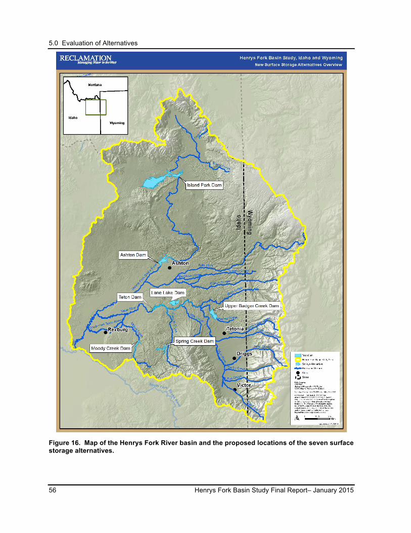
5.0 Evaluation of Alternatives
56 Henrys Fork Basin Study Final Report– January 2015
Figure 16. Map of the Henrys Fork River basin and the proposed locations of the seven surface storage alternatives.
5.0 Evaluation of Alternatives
January 2015 - Henrys Fork Basin Study Final Report 57
5.2.1 Elements Relevant to All Surface Storage Alternatives
Benefits and Impacts
Stored water provides the most flexibility for addressing downstream water needs later in the season for numerous in-basin and out-of-basin uses, including agricultural needs; domestic, commercial, municipal, and industrial needs; ecological needs; and as an additional water supply to offset groundwater pumping in the ESPA. The increase in stored water may also alleviate some of the effects of climate change by making water available later in the extended irrigation season. The large majority of the water available for new storage would accumulate during the peak runoff period; however, consideration should be given to mitigating the impact to downstream environments during the entirety of the storage season.
While any of the surface storage alternatives would be a barrier to fish migration, fish ladder facilities could help facilitate upstream and downstream migration around the structures. While on-stream dam structures would inhibit upstream and downstream movements of fluvial Yellowstone cutthroat trout, the greater impact would be from replacing free-flowing stream reaches with long stretches of slack water which would potentially increase water temperatures, inundate and harm upstream riparian and wetland areas, and prevent downriver movement of gravel and cobble.
Dams and reservoir operations should consider and minimize potential impacts to downstream river environments, including riparian-wetland areas.
No matter where water could potentially be stored in the system, senior water rights would be filled first before any new junior water rights in a new reservoir could be accrued. Climate change analysis in the basin indicates that the probability of filling existing and new storage facilities could improve from the current conditions, making storage a favorable option in this basin.
Limitations of Analysis
Geologic and geotechnical site analysis was based on available geologic literature, soil mapping, and review of geotechnical literature and reports. No field reconnaissance or geologic mapping was conducted as part of this investigation and analysis. No quantitative hazards analysis was performed. Earthquake risks were not evaluated. Further analysis would be necessary if any of the storage alternatives were carried forward for further study
A limited number of site and alignment alternatives were explored, and professional judgment was used to balance maximum storage potential with efficient embankment configurations. Embankment configurations were generalized and site-specific materials and material properties were not evaluated. No optimized dam approaches were proposed. Potential impacts along the canal and pipeline routes were not assessed during this evaluation and
5.0 Evaluation of Alternatives
58 Henrys Fork Basin Study Final Report– January 2015
would require further investigation. Some of the canals needed for water delivery would be very long and may have high water losses due to seepage if not lined.
The hydrologic and environmental impacts on the supply sources would need to be investigated more thoroughly, as well as the impacts overall to the Henrys Fork River basin and ESPA system. Stream habitat changes in the affected tributaries and streams due to constructing a proposed dam and reservoir were not evaluated in detail. Analysis would be needed to demonstrate how water storage in the proposed reservoirs meets the defined needs.
No accounting was done for direct precipitation on the reservoir and seepage and evaporation losses from the reservoir. Water balance considerations were not evaluated and would depend on the elevation-capacity relationship, reservoir operations, and drought conditions.
Cost estimates given in this Final Report are relative, comparative, and preliminary and are not intended for budgeting. Planning costs for designs, compliance with National Environmental Policy Act (NEPA) and the National Historical Preservation Act, land acquisitions, and other actions necessary for implementation were not included in the cost estimates. Some dam and canal sites may be prone to high seepage rates, and mitigation measures intended to ensure stability and limit seepage could lead to higher construction costs. Future concept refinements and mitigation requirements could potentially change the alternatives’ costs (see Section 6.0).
Water rights issues were not fully identified and water availability was approximated. Actual runoff was not measured and firm yield was not evaluated. All water supply issues and balances and refined operations would need to be evaluated.
Implementation Options
Analyses to fill in the data gaps as detailed in the Limitations of Analysis sections would need to be conducted. For example, some of the alternatives would require more geologic analyses for spillway designs or tunneling. Alternatives that have pump-back systems would need analyses for their impacts on fish and wildlife and operational costs. Hydrologic impacts would need to be further investigated. Some canals may be prone to high rates of seepage, if not lined, and additional evaluations would need to be completed.
Construction of any surface storage alternative would require a Corps of Engineers 404 permit under the Clean Water Act, with the attendant requirements. The environmental, social, and economic analysis required to construct a dam would be extensive. The use of Federal funds (e.g., Reclamation Secure Water Act) would require meeting the funding agencies’ environmental/policy requirements.
Due to the size and complexity of the surface storage alternatives, an environmental impact statement, including ESA Section 7 and National Historic Preservation Act Section 106
5.0 Evaluation of Alternatives
January 2015 - Henrys Fork Basin Study Final Report 59
consultations, would likely be required as part of the 404 permit process. Compliance with these laws may cost upwards of $1 to $2 million and take 5 to 7 years.
Financing for the implementation of any of the surface storage alternatives may be difficult to obtain. IWRB is authorized to work with state-wide irrigation entities in securing State-backed bonds with a suitable irrigator payback schedule. Traditional sources for dam construction, such as Reclamation, may be limited in their ability to secure funding for a single-benefit project (i.e., irrigation). Funding may be more available for a water storage project, which could directly benefit the environment in addition to irrigation. Congressional authorization would be required for Federal financing.
If hydropower generation facilities are constructed with any of the alternatives, a FERC license may be required. In the Basin Study area, the Northwest Power and Conservation Council designated protected areas where hydroelectric power development may result in unacceptable impacts to fish and wildlife resources. Protected area status would need to be considered in any hydroelectric development.
If any surface storage alternative is implemented, an operations and management plan would need to be developed for operation of the facilities with consideration to timing of storage and releases to meet ecological flow targets. The purpose of the management plan would be to provide the greatest benefit to irrigation and ecological flows.
5.2.2 Lane Lake Dam
Description
The Lane Lake Dam alternative features a proposed off-channel 101,000-acre-foot reservoir contained by a 160-foot-tall main dam and a smaller saddle dam (Figure 17). The dam site is located on a generally dry drainage that is situated about 1 mile north of the Teton River and 5 miles downstream of the Bitch Creek confluence (Figure 16). When full, Lane Lake could provide a roughly 145-foot drop to potential hydropower facility at the base of the dam (CH2M HILL 2013); however, this addition was not considered as part of this cost estimate.
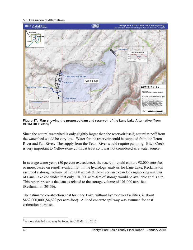
5.0 Evaluation of Alternatives
60 Henrys Fork Basin Study Final Report– January 2015
Figure 17. Map showing the proposed dam and reservoir of the Lane Lake Alternative (from CH2M HILL 2013).8
Since the natural watershed is only slightly larger than the reservoir itself, natural runoff from the watershed would be very low. Water for the reservoir could be supplied from the Teton River and Fall River. The supply from the Teton River would require pumping. Bitch Creek is very important to Yellowstone cutthroat trout so it was not considered as a water source.
In average water years (50 percent exceedence), the reservoir could capture 98,000 acre-feet or more, based on runoff availability. In the hydrology analysis for Lane Lake, Reclamation assumed a storage volume of 120,000 acre-feet; however, an expanded engineering analysis of Lane Lake concluded that only 101,000 acre-feet of storage would be available at this site. This report presents the data as related to the storage volume of 101,000 acre-feet (Reclamation 2013b).
The estimated construction cost for Lane Lake, without hydropower facilities, is about $462,000,000 ($4,600 per acre-foot). A lined concrete spillway was assumed for cost estimation purposes.
8 A more detailed map may be found in CH2MHILL 2013.
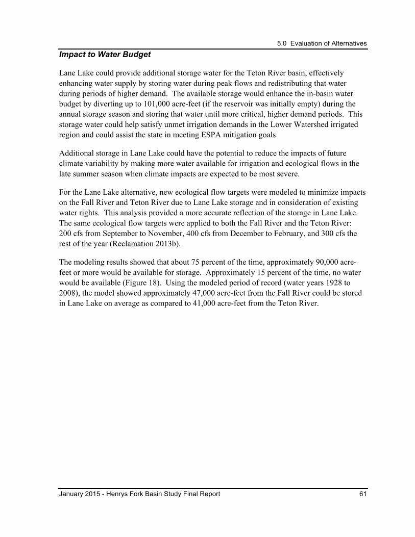
5.0 Evaluation of Alternatives
January 2015 - Henrys Fork Basin Study Final Report 61
Impact to Water Budget
Lane Lake could provide additional storage water for the Teton River basin, effectively enhancing water supply by storing water during peak flows and redistributing that water during periods of higher demand. The available storage would enhance the in-basin water budget by diverting up to 101,000 acre-feet (if the reservoir was initially empty) during the annual storage season and storing that water until more critical, higher demand periods. This storage water could help satisfy unmet irrigation demands in the Lower Watershed irrigated region and could assist the state in meeting ESPA mitigation goals
Additional storage in Lane Lake could have the potential to reduce the impacts of future climate variability by making more water available for irrigation and ecological flows in the late summer season when climate impacts are expected to be most severe.
For the Lane Lake alternative, new ecological flow targets were modeled to minimize impacts on the Fall River and Teton River due to Lane Lake storage and in consideration of existing water rights. This analysis provided a more accurate reflection of the storage in Lane Lake. The same ecological flow targets were applied to both the Fall River and the Teton River: 200 cfs from September to November, 400 cfs from December to February, and 300 cfs the rest of the year (Reclamation 2013b).
The modeling results showed that about 75 percent of the time, approximately 90,000 acre-feet or more would be available for storage. Approximately 15 percent of the time, no water would be available (Figure 18). Using the modeled period of record (water years 1928 to 2008), the model showed approximately 47,000 acre-feet from the Fall River could be stored in Lane Lake on average as compared to 41,000 acre-feet from the Teton River.
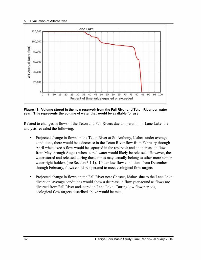
5.0 Evaluation of Alternatives
62 Henrys Fork Basin Study Final Report– January 2015
Figure 18. Volume stored in the new reservoir from the Fall River and Teton River per water year. This represents the volume of water that would be available for use.
Related to changes in flows of the Teton and Fall Rivers due to operation of Lane Lake, the analysis revealed the following:
• Projected change in flows on the Teton River at St. Anthony, Idaho: under average conditions, there would be a decrease in the Teton River flow from February through April when excess flow would be captured in the reservoir and an increase in flow from May through August when stored water would likely be released. However, the water stored and released during those times may actually belong to other more senior water right holders (see Section 3.1.1). Under low flow conditions from December through February, flows could be operated to meet ecological flow targets.
• Projected change in flows on the Fall River near Chester, Idaho: due to the Lane Lake diversion, average conditions would show a decrease in flow year-round as flows are diverted from Fall River and stored in Lane Lake. During low flow periods, ecological flow targets described above would be met.

5.0 Evaluation of Alternatives
January 2015 - Henrys Fork Basin Study Final Report 63
Potential Climate Change Impacts
In the hydrologic models,9 additional water would be stored more reliably in Lane Lake (Figure 19). This additional water would enter the reservoir during the winter and by April or May, the reservoir would be full or nearly full in up to 95 percent of years.
Figure 19. Volume stored by the new reservoir per water year for the Lane Lake alternative. This represents the volume of water that would be available for use. An increase in water year storage was seen for all climate change scenarios.
This increase in the reliability of the reservoir filling would not improve the extent to which ecological flow targets or other demands will be met in the late summer and fall months when compared with the baseline condition. Further, analysis indicates that ecological flow targets in the Fall River would not be satisfied from December through March in dry years because either downstream demand has priority for the water or natural flow would be insufficient.
Benefits and Impacts
Reservoir releases for downstream irrigation use during low flow periods could improve fish habitat in downstream river segments, including the North Fork Teton River and South Fork Teton River, which have been identified as having additional ecological streamflow needs. Pumping and diversion for water storage into Lane Lake would typically occur during the storage season and may impact conservation populations of Yellowstone cutthroat trout in the 9 A hydrologic model run for "climate change" is simply run with precipitation, temperature, and other inputs from a GCM rather than historical inputs. The hydrologic model itself is not changed.
5.0 Evaluation of Alternatives
64 Henrys Fork Basin Study Final Report– January 2015
Fall River and Teton River.
This alternative could also involve impacts to lands used as habitat by ESA-listed terrestrial species (grizzly bear [designated as threatened] and wolverine [designated as a candidate for listing]). The Teton River is eligible for listing under the National Wild and Scenic Rivers System; therefore, a large scale pumping plant on Teton River is inconsistent with this proposed designation.
Key Points from Evaluation and Feedback
Local conservation stakeholders have indicated cautious support for further study of this alternative, due largely to its off-stream location and potential to enhance steam connectivity. Those stakeholders, however, remain focused on the imperative of no impacts to the aquatic ecosystem at the proposed Fall and Teton river diversion points. As long as that concern can be addressed, conservation stakeholders remain willing to explore this alternative further.
Lane Lake has the advantage of being off-stream; however, the proposed site is on private irrigated farmland and includes residences and numerous farm-related structures. Negotiations for acquiring the site could potentially be difficult.
Local water users in the Teton River drainage support this alternative as one of the few that would enhance their water supplies; however, Lane Lake is one of the most costly alternatives. Irrigators have expressed a willingness to explore possibilities for investment only if costs can be reduced or shared by other beneficiaries.
While the IWRB remains interested in retaining this alternative for long-term consideration because of its large storage volume potential and its ability to address statewide water supply issues, the high cost of Lane Lake, combined with the existence of other less expensive options to mitigate local water shortfalls, make short-term action unlikely.
Similarly, Reclamation is interested in retaining this alternative since it potentially has multi-purpose benefits to address statewide supply issues, provide more operational flexibility in the upper Snake River system, and increase the reliability for flow augmentation for ESA responsibilities. Given these potential benefits, Reclamation would be interested in participating if other parties wish to explore this option further.
Study participants suggested the investigation of a pump-back power system using a Lane Lake reservoir with the Teton River as a water source. Such a system would pump when power is abundant in the early spring and generate power when the power supply is constrained in the late summer or early fall; however, the costs to operate such a system was not explored in this Basin Study.
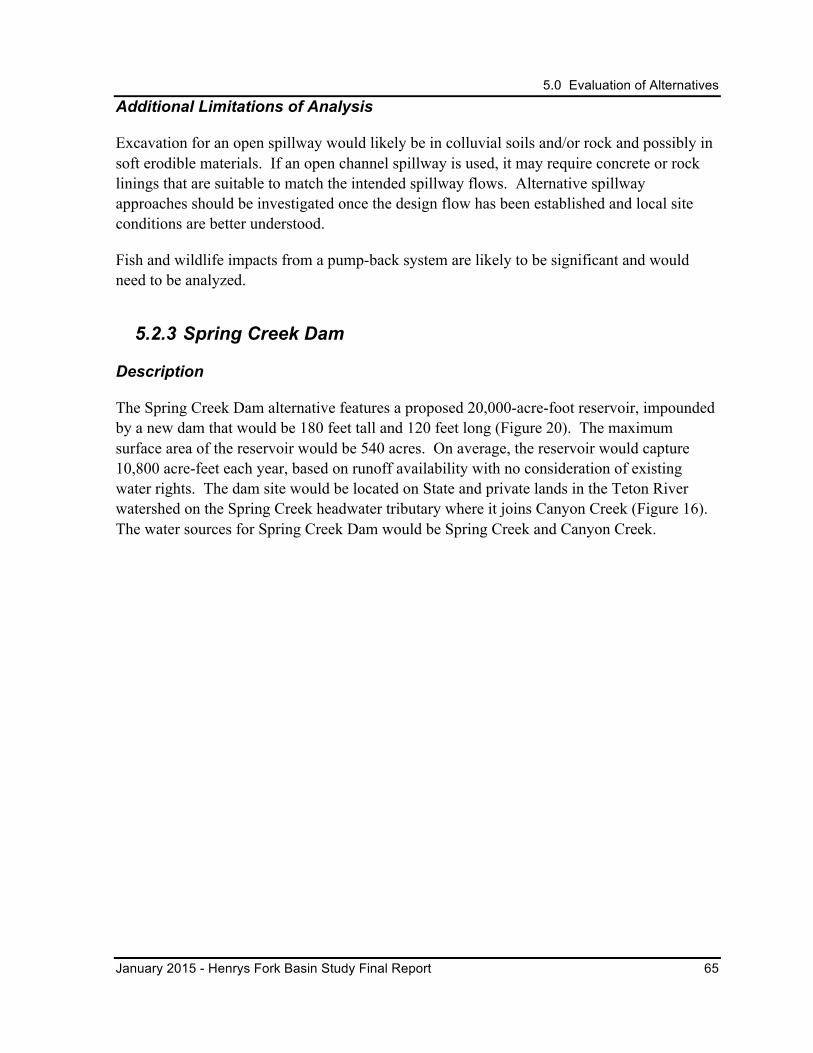
5.0 Evaluation of Alternatives
January 2015 - Henrys Fork Basin Study Final Report 65
Additional Limitations of Analysis
Excavation for an open spillway would likely be in colluvial soils and/or rock and possibly in soft erodible materials. If an open channel spillway is used, it may require concrete or rock linings that are suitable to match the intended spillway flows. Alternative spillway approaches should be investigated once the design flow has been established and local site conditions are better understood.
Fish and wildlife impacts from a pump-back system are likely to be significant and would need to be analyzed.
5.2.3 Spring Creek Dam
Description
The Spring Creek Dam alternative features a proposed 20,000-acre-foot reservoir, impounded by a new dam that would be 180 feet tall and 120 feet long (Figure 20). The maximum surface area of the reservoir would be 540 acres. On average, the reservoir would capture 10,800 acre-feet each year, based on runoff availability with no consideration of existing water rights. The dam site would be located on State and private lands in the Teton River watershed on the Spring Creek headwater tributary where it joins Canyon Creek (Figure 16). The water sources for Spring Creek Dam would be Spring Creek and Canyon Creek.
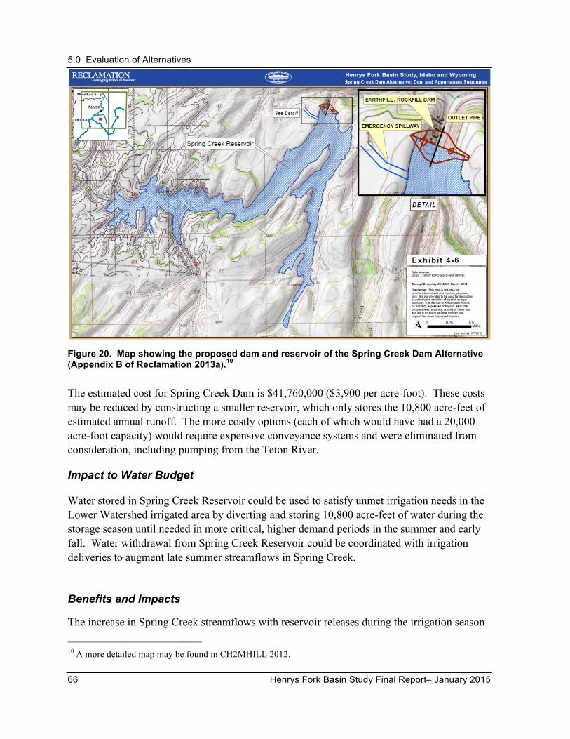
5.0 Evaluation of Alternatives
66 Henrys Fork Basin Study Final Report– January 2015
Figure 20. Map showing the proposed dam and reservoir of the Spring Creek Dam Alternative (Appendix B of Reclamation 2013a).10
The estimated cost for Spring Creek Dam is $41,760,000 ($3,900 per acre-foot). These costs may be reduced by constructing a smaller reservoir, which only stores the 10,800 acre-feet of estimated annual runoff. The more costly options (each of which would have had a 20,000 acre-foot capacity) would require expensive conveyance systems and were eliminated from consideration, including pumping from the Teton River.
Impact to Water Budget
Water stored in Spring Creek Reservoir could be used to satisfy unmet irrigation needs in the Lower Watershed irrigated area by diverting and storing 10,800 acre-feet of water during the storage season until needed in more critical, higher demand periods in the summer and early fall. Water withdrawal from Spring Creek Reservoir could be coordinated with irrigation deliveries to augment late summer streamflows in Spring Creek.
Benefits and Impacts
The increase in Spring Creek streamflows with reservoir releases during the irrigation season
10 A more detailed map may be found in CH2MHILL 2012.
5.0 Evaluation of Alternatives
January 2015 - Henrys Fork Basin Study Final Report 67
may benefit both irrigators and fish populations in Spring Creek and Teton River, or augment the ESPA. Yellowstone cutthroat trout are present in the proposed reservoir inundation area; consequently, the alternative would impact Spring Creek and Teton River’s conservation population (Reclamation 2013a, Appendix B). The hydrology of Canyon Creek and the Teton River would be modified and possibly impact conservation populations as well. In Spring and Canyon creeks, potential decreases to river flows could occur where and when water is diverted; however, these diversions would occur during high spring flows, and releases from the reservoir would be made during low flow periods. Downstream segments of Spring Creek and Canyon Creek were identified as needing additional ecological streamflows and would benefit from augmented late summer flows.
Impacts may occur on big game migration corridors of one ESA-listed threatened species (grizzly bear) and one candidate species (wolverine). The Teton River and Canyon Creek are eligible for listing under the National Wild and Scenic Rivers System.
Key Points from Evaluation and Feedback
Conservation stakeholders expressed concerns about the Spring Creek Dam alternative, which they regard as a new on-stream dam. Concerns center on impacts to the free-flowing creek created by the impoundment, stream blockage created by the dam, and impacts to the Yellowstone cutthroat trout conservation area.
Local water users, IWRB, and Reclamation recognize this alternative would provide water to users in the Teton River drainage, where the need is greatest; however, support of this alternative is limited due to its comparatively small water yield, high cost, and small contribution to local needs or State needs in the larger upper Snake River basin. Water users may be interested in investing in this option only if the costs could be reduced or shared by other parties.
5.2.4 Moody Creek Dam
Description
The Moody Creek Dam alternative features a proposed 37,000-acre-foot reservoir contained by a new dam that would be 220 feet tall and 1,300 feet long (Figure 21). The maximum surface area of the reservoir would be 520 acres. On average, the reservoir would capture 34,400 acre-feet each year, based on runoff availability. The proposed dam site would be located on State and private lands on Moody Creek, just downstream of the Dry Canyon Creek confluence (Figure 16). The water sources for the Moody Creek Dam would be Moody Creek and Canyon Creek.
The estimated cost for Moody Creek Dam would be $123,920,000 ($3,600 per acre-foot). A lined concrete spillway was assumed for costing purposes. More costly options requiring
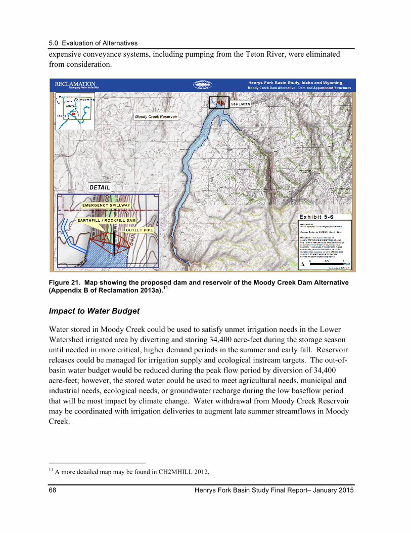
5.0 Evaluation of Alternatives
68 Henrys Fork Basin Study Final Report– January 2015
expensive conveyance systems, including pumping from the Teton River, were eliminated from consideration.
Figure 21. Map showing the proposed dam and reservoir of the Moody Creek Dam Alternative (Appendix B of Reclamation 2013a).11
Impact to Water Budget
Water stored in Moody Creek could be used to satisfy unmet irrigation needs in the Lower Watershed irrigated area by diverting and storing 34,400 acre-feet during the storage season until needed in more critical, higher demand periods in the summer and early fall. Reservoir releases could be managed for irrigation supply and ecological instream targets. The out-of-basin water budget would be reduced during the peak flow period by diversion of 34,400 acre-feet; however, the stored water could be used to meet agricultural needs, municipal and industrial needs, ecological needs, or groundwater recharge during the low baseflow period that will be most impact by climate change. Water withdrawal from Moody Creek Reservoir may be coordinated with irrigation deliveries to augment late summer streamflows in Moody Creek.
11 A more detailed map may be found in CH2MHILL 2012.
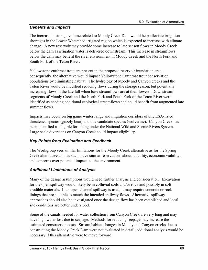
5.0 Evaluation of Alternatives
January 2015 - Henrys Fork Basin Study Final Report 69
Benefits and Impacts
The increase in storage volume related to Moody Creek Dam would help alleviate irrigation shortages in the Lower Watershed irrigated region which is expected to increase with climate change. A new reservoir may provide some increase to late season flows in Moody Creek below the dam as irrigation water is delivered downstream. This increase in streamflows below the dam may benefit the river environment in Moody Creek and the North Fork and South Fork of the Teton River.
Yellowstone cutthroat trout are present in the proposed reservoir inundation area; consequently, the alternative would impact Yellowstone Cutthroat trout conservation populations by eliminating habitat. The hydrology of Moody and Canyon creeks and the Teton River would be modified reducing flows during the storage season, but potentially increasing flows in the late fall when base streamflows are at their lowest. Downstream segments of Moody Creek and the North Fork and South Fork of the Teton River were identified as needing additional ecological streamflows and could benefit from augmented late summer flows.
Impacts may occur on big game winter range and migration corridors of one ESA-listed threatened species (grizzly bear) and one candidate species (wolverine). Canyon Creek has been identified as eligible for listing under the National Wild and Scenic Rivers System. Large scale diversions on Canyon Creek could impact eligibility.
Key Points from Evaluation and Feedback
The Workgroup sees similar limitations for the Moody Creek alternative as for the Spring Creek alternative and, as such, have similar reservations about its utility, economic viability, and concerns over potential impacts to the environment.
Additional Limitations of Analysis
Many of the design assumptions would need further analysis and consideration. Excavation for the open spillway would likely be in colluvial soils and/or rock and possibly in soft erodible materials. If an open channel spillway is used, it may require concrete or rock linings that are suitable to match the intended spillway flows. Alternative spillway approaches should also be investigated once the design flow has been established and local site conditions are better understood.
Some of the canals needed for water collection from Canyon Creek are very long and may have high water loss due to seepage. Methods for reducing seepage may increase the estimated construction costs. Stream habitat changes in Moody and Canyon creeks due to constructing the Moody Creek Dam were not evaluated in detail, additional analysis would be necessary if this alternative were to move forward.
5.0 Evaluation of Alternatives
70 Henrys Fork Basin Study Final Report– January 2015
5.2.5 Upper Badger Creek Dam
Description
The Upper Badger Creek Dam alternative features a proposed 47,000-acre-foot reservoir contained by a new dam that would be 290 feet tall and 2,400 feet long (Figure 22). The maximum surface area of the reservoir would be 520 acres. On average, the reservoir would capture 47,000 acre-feet each year, based on runoff availability. Water for the reservoir would be supplied from Badger Creek and pumped from the Teton River. The conveyance system from the Teton River would be pressurized pipelines and a pump system, which would pump when power is abundant in the early spring and generate power when the power supply is constrained in the late summer or early fall. The dam site would be located in the Teton River watershed on Badger Creek approximately 5 miles upstream of the Teton River (Figure 16). Stream diversions, intake and fish screen structures, pump stations, and siphons were also assessed during the evaluation.
Figure 22. Map showing the proposed dam and reservoir of the Upper Badger Creek Dam Alternative (Appendix B of Reclamation 2013a).12
12 A more detailed map may be found in CH2MHILL 2012.
5.0 Evaluation of Alternatives
January 2015 - Henrys Fork Basin Study Final Report 71
The cost estimates for Upper Badger Creek Dam would be $128,940,000 for 47,000 acre-feet of storage volume ($2,700 per acre-foot). Operating a pump system using water from the Teton River as a water source may be very costly even with the assumption that pumping would take place during the periods when electricity is at its lowest value and power could be generated at higher value periods to offset operational costs. A lined concrete spillway was assumed for costing purposes.
Impact to Water Budget
Water stored in Upper Badger Creek Reservoir could be used to satisfy unmet irrigation needs in the Lower Watershed irrigated area by diverting 47,000 acre-feet during the storage season and storing that water until more critical, higher demand periods. This storage water could help satisfy unmet irrigation demands in the Lower Watershed irrigated region and could assist the state in meeting ESPA mitigation goals
As with all new storage alternatives additional storage could have the potential to reduce the impacts of future climate variability by making more water available for irrigation and ecological flows in the late summer season when climate impacts are expected to be most severe.
Benefits and Impacts
The increase in storage volume related to Upper Badger Creek Reservoir would help alleviate irrigation shortages which are expected to increase with climate change. Water stored may be delivered much farther downstream on the Snake River. In such situations, late season irrigation deliveries may also benefits the river environment downstream from Badger Creek Dam. Other possible benefits are that water stored in Badger Creek could be used to mitigate for impact on the ESPA.
Potential impacts would be decreased flow in Badger Creek and Teton River where and when water is diverted. These diversions would occur during storage season and releases from the reservoir could be made during critical periods of low flow to improve the river ecology.
Upper Badger Creek was identified as containing a core conservation population of Yellowstone cutthroat trout. The proposed location of Upper Badger Creek Dam currently goes dry during the summer, isolating a local Yellowstone cutthroat trout population in creek segments above the proposed site. The construction of Upper Badger Creek Dam may result in a change in behavior for this population, which may be detrimental. Furthermore, the presence of a reservoir may increase the likelihood of a nonnative fish population being introduced into the reservoir and increase competition for the local Yellowstone cutthroat trout population.
Impacts may occur on big game winter range and migration corridors of one ESA-listed
5.0 Evaluation of Alternatives
72 Henrys Fork Basin Study Final Report– January 2015
threatened species (grizzly bear) and one candidate species (wolverine). The Teton River and Badger Creek are eligible for listing under the National Wild and Scenic Rivers System.
Key Points from Evaluation and Feedback
The Workgroup sees this option as having the similar limitations as the Spring Creek and Moody Creek alternatives and, as such, have similar reservations about its utility, economic viability, and concerns over potential impacts to the environment.
Additional Limitations of Analysis
Many of the design assumptions would need further analysis and consideration. Excavation for the open spillway would likely be in colluvial soils and/or rock and possibly in soft erodible materials. If an open channel spillway is used, it may require concrete or rock linings that are suitable to match the intended spillway flows. Alternative spillway approaches should also be investigated once the design flow has been established and local site conditions are better understood.
Fish and wildlife impacts from a pump system on Teton River are likely to be significant and would need to be analyzed.
5.2.6 Teton Dam
Description
The Teton Dam alternative features a proposed 265,000-acre-foot reservoir impounded by a new dam 300 feet tall and 2,300 feet long (Figure 23). In 50 percent of years, the reservoir would capture 202,000 acre-feet or more, based on runoff availability (Reclamation 2013b). The dam site is located on the Teton River approximately 16 miles upstream of the City of Rexburg at the site of the old Teton Dam and would require no secondary water sources (Figure 16). When full, Teton Reservoir could provide a roughly 285-foot drop to a proposed new hydropower facility at the base of the dam, but that option is not included in the cost estimate.
The estimated cost of Teton Dam construction, without fish passage or hydropower costs included in the total, is $492,210,000 ($1,900 per acre-foot). The site is prone to high seepage rates, and measures required to maintain stability and limit seepage may lead to increased construction costs (CH2MHILL 2013).
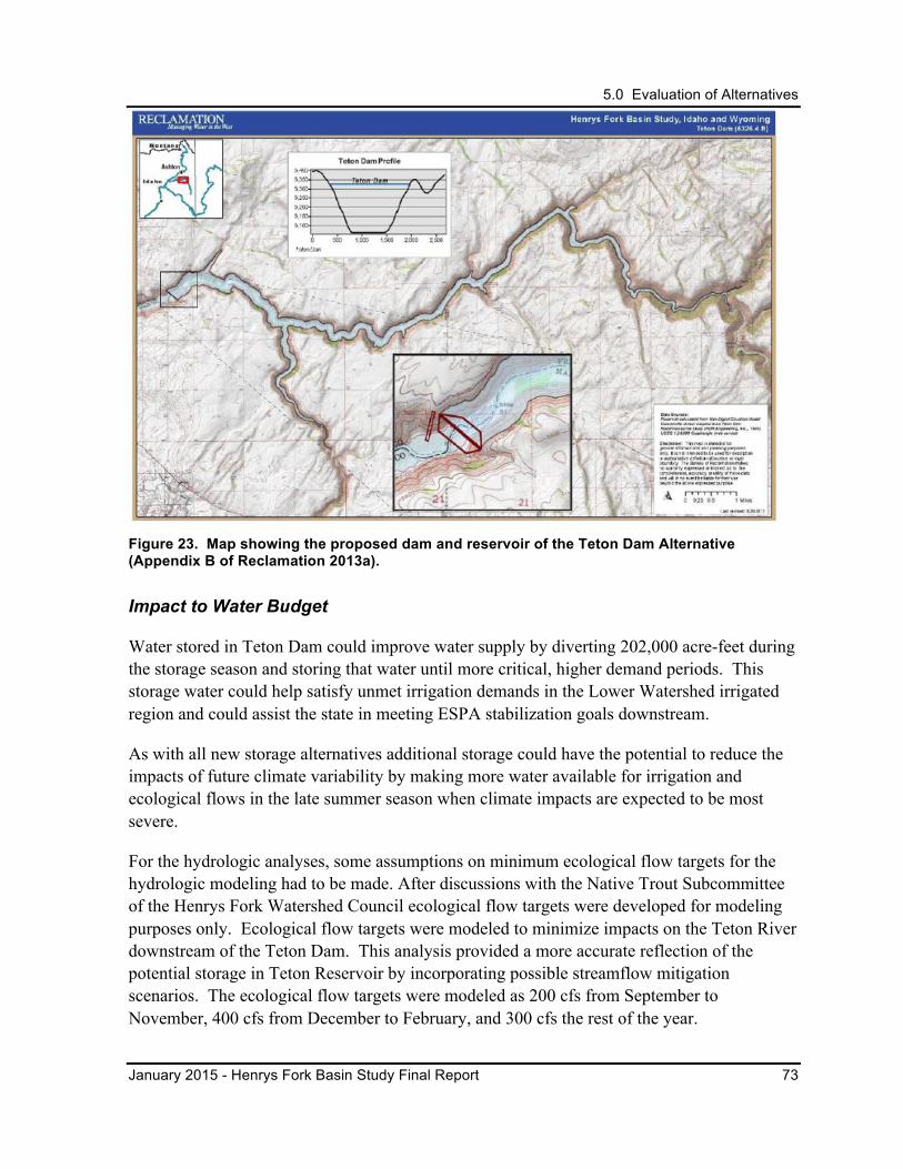
5.0 Evaluation of Alternatives
January 2015 - Henrys Fork Basin Study Final Report 73
Figure 23. Map showing the proposed dam and reservoir of the Teton Dam Alternative (Appendix B of Reclamation 2013a).
Impact to Water Budget
Water stored in Teton Dam could improve water supply by diverting 202,000 acre-feet during the storage season and storing that water until more critical, higher demand periods. This storage water could help satisfy unmet irrigation demands in the Lower Watershed irrigated region and could assist the state in meeting ESPA stabilization goals downstream.
As with all new storage alternatives additional storage could have the potential to reduce the impacts of future climate variability by making more water available for irrigation and ecological flows in the late summer season when climate impacts are expected to be most severe.
For the hydrologic analyses, some assumptions on minimum ecological flow targets for the hydrologic modeling had to be made. After discussions with the Native Trout Subcommittee of the Henrys Fork Watershed Council ecological flow targets were developed for modeling purposes only. Ecological flow targets were modeled to minimize impacts on the Teton River downstream of the Teton Dam. This analysis provided a more accurate reflection of the potential storage in Teton Reservoir by incorporating possible streamflow mitigation scenarios. The ecological flow targets were modeled as 200 cfs from September to November, 400 cfs from December to February, and 300 cfs the rest of the year.
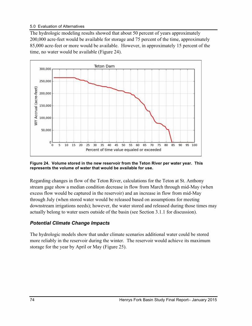
5.0 Evaluation of Alternatives
74 Henrys Fork Basin Study Final Report– January 2015
The hydrologic modeling results showed that about 50 percent of years approximately 200,000 acre-feet would be available for storage and 75 percent of the time, approximately 85,000 acre-feet or more would be available. However, in approximately 15 percent of the time, no water would be available (Figure 24).
Figure 24. Volume stored in the new reservoir from the Teton River per water year. This represents the volume of water that would be available for use.
Regarding changes in flow of the Teton River, calculations for the Teton at St. Anthony stream gage show a median condition decrease in flow from March through mid-May (when excess flow would be captured in the reservoir) and an increase in flow from mid-May through July (when stored water would be released based on assumptions for meeting downstream irrigations needs); however, the water stored and released during those times may actually belong to water users outside of the basin (see Section 3.1.1 for discussion).
Potential Climate Change Impacts
The hydrologic models show that under climate scenarios additional water could be stored more reliably in the reservoir during the winter. The reservoir would achieve its maximum storage for the year by April or May (Figure 25).
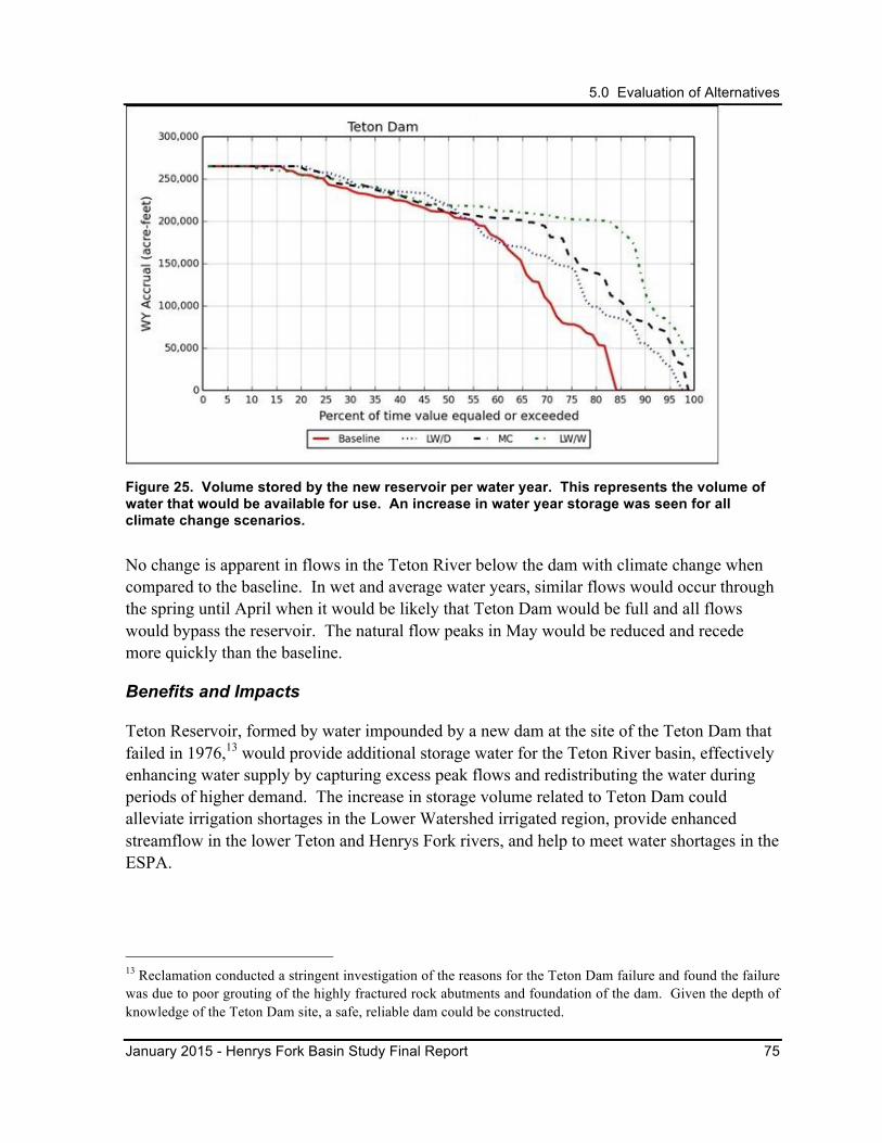
5.0 Evaluation of Alternatives
January 2015 - Henrys Fork Basin Study Final Report 75
Figure 25. Volume stored by the new reservoir per water year. This represents the volume of water that would be available for use. An increase in water year storage was seen for all climate change scenarios.
No change is apparent in flows in the Teton River below the dam with climate change when compared to the baseline. In wet and average water years, similar flows would occur through the spring until April when it would be likely that Teton Dam would be full and all flows would bypass the reservoir. The natural flow peaks in May would be reduced and recede more quickly than the baseline.
Benefits and Impacts
Teton Reservoir, formed by water impounded by a new dam at the site of the Teton Dam that failed in 1976,13 would provide additional storage water for the Teton River basin, effectively enhancing water supply by capturing excess peak flows and redistributing the water during periods of higher demand. The increase in storage volume related to Teton Dam could alleviate irrigation shortages in the Lower Watershed irrigated region, provide enhanced streamflow in the lower Teton and Henrys Fork rivers, and help to meet water shortages in the ESPA.
13 Reclamation conducted a stringent investigation of the reasons for the Teton Dam failure and found the failure was due to poor grouting of the highly fractured rock abutments and foundation of the dam. Given the depth of knowledge of the Teton Dam site, a safe, reliable dam could be constructed.
5.0 Evaluation of Alternatives
76 Henrys Fork Basin Study Final Report– January 2015
Stored water may be delivered downstream during the irrigation season when streamflows are typically lower. Flows could be released during the fall and winter low flow periods after irrigation deliveries have ceased. This may benefit the downstream river segments, including the North Fork and South Fork of the Teton River, both identified as having additional ecological streamflow needs.
Teton Dam would have a major impact on fish populations by blocking migration in Teton River and inundating riverine habitats currently occupied by Yellowstone cutthroat trout. Free-flowing river miles would be converted to slack water, which would negatively impact fisheries dependent on river environments, but would provide lake fish habitat.
Yellowstone cutthroat trout are a State Aquatic Species of Greatest Conservation Need. Fluvial Yellowstone cutthroat trout are found above and below the proposed dam site. Implementation of Teton Dam would impact conservation populations of Yellowstone cutthroat trout in the Teton River and Bitch Creek, a tributary to the Teton River, by eliminating important migration and foraging habitat. The proposed Teton Reservoir inundation area contains winter range and migration corridors for big game. The U.S. Fish and Wildlife Service tracks one candidate species in the area, the wolverine. The bald eagle, trumpeter swan, and Wyoming ground squirrel make their homes here and are considered at risk by the Bureau of Land Management and the U.S. Forest Service. Data from the National Wetlands Inventory indicate construction at this site could have an impact on mapped wetlands, which could affect an area greater than 200 acres. Hydrologic changes to the water source brought about by the proposed construction would also have direct impacts on a stretch of Teton River that is eligible for National Wild and Scenic River System designation (CH2M HILL 2013). There could be impacts to Bitch, Badger, and Canyon creeks where the reservoir would back up into their lower reaches. Those creeks are also eligible for National Wild and Scenic River System designation.
Recreational benefits related to whitewater rafting, kayaking, hunting, wildlife viewing, commercial outfitting, fishing, and fly fishing would be reduced or eliminated, which could impact the local economy. Opportunities for slack water recreation such as boating and swimming would increase.
One of the purposes of the original Teton Dam was flood control, which could be included as a purpose of this alternative.
Key Points from Evaluation and Feedback
Teton Dam presents an opportunity for storing a large amount of water, but the potential environmental impacts would be challenging to resolve. The impact to Yellowstone cutthroat trout may be the most significant environmental impact, but loss of wildlife habitat, including important mule deer and elk winter range, and free-flowing river miles would also need to be considered.
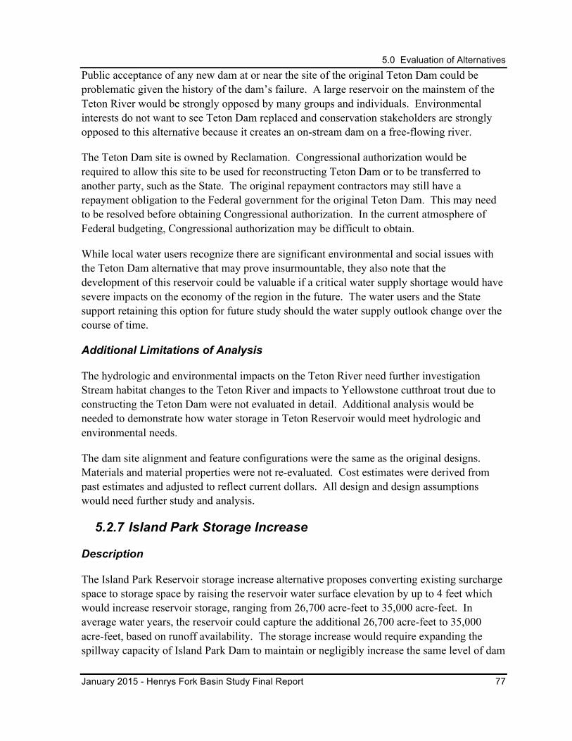
5.0 Evaluation of Alternatives
January 2015 - Henrys Fork Basin Study Final Report 77
Public acceptance of any new dam at or near the site of the original Teton Dam could be problematic given the history of the dam’s failure. A large reservoir on the mainstem of the Teton River would be strongly opposed by many groups and individuals. Environmental interests do not want to see Teton Dam replaced and conservation stakeholders are strongly opposed to this alternative because it creates an on-stream dam on a free-flowing river.
The Teton Dam site is owned by Reclamation. Congressional authorization would be required to allow this site to be used for reconstructing Teton Dam or to be transferred to another party, such as the State. The original repayment contractors may still have a repayment obligation to the Federal government for the original Teton Dam. This may need to be resolved before obtaining Congressional authorization. In the current atmosphere of Federal budgeting, Congressional authorization may be difficult to obtain.
While local water users recognize there are significant environmental and social issues with the Teton Dam alternative that may prove insurmountable, they also note that the development of this reservoir could be valuable if a critical water supply shortage would have severe impacts on the economy of the region in the future. The water users and the State support retaining this option for future study should the water supply outlook change over the course of time.
Additional Limitations of Analysis
The hydrologic and environmental impacts on the Teton River need further investigation Stream habitat changes to the Teton River and impacts to Yellowstone cutthroat trout due to constructing the Teton Dam were not evaluated in detail. Additional analysis would be needed to demonstrate how water storage in Teton Reservoir would meet hydrologic and environmental needs.
The dam site alignment and feature configurations were the same as the original designs. Materials and material properties were not re-evaluated. Cost estimates were derived from past estimates and adjusted to reflect current dollars. All design and design assumptions would need further study and analysis.
5.2.7 Island Park Storage Increase
Description
The Island Park Reservoir storage increase alternative proposes converting existing surcharge space to storage space by raising the reservoir water surface elevation by up to 4 feet which would increase reservoir storage, ranging from 26,700 acre-feet to 35,000 acre-feet. In average water years, the reservoir could capture the additional 26,700 acre-feet to 35,000 acre-feet, based on runoff availability. The storage increase would require expanding the spillway capacity of Island Park Dam to maintain or negligibly increase the same level of dam

5.0 Evaluation of Alternatives
78 Henrys Fork Basin Study Final Report– January 2015
safety risk. Additional storage in Island Park Reservoir would be managed with consideration of the Henrys Fork Drought Management Plan.
Alternative Analysis
Due to promising preliminary findings and interest from the Workgroup, the Island Park Reservoir storage increase alternative was evaluated in more depth than most other storage alternatives. Eight floodwater routing scenarios were evaluated for increasing Island Park Reservoir storage and raising the normal reservoir water surface elevation of 6303 feet (Reclamation 2013c).
The cost estimate for adding a 5-foot bladder, corresponding to a 4-foot increase in the normal water surface, to the service spillway and enlarging the existing emergency spillway would be approximately $6,400,000 for a minimum of 26,700 acre-feet of storage volume ($240 per acre-foot). Benefits and cost to the existing power-generation facilities were not included in the analysis; however, the existing power facilities would generate additional power, due to an increase in water surface elevations, with only minor modification. Shoreline protection, which may be necessary due to raising the normal water surface elevation, was not considered in the cost estimate.
The purpose of the flood routing analysis was to identify the optimum elevation related to flood risks. A 5-foot bladder with an increase in emergency spillway width to 1,130 feet is currently considered the preferred option. This option would replace the 1-foot bladder that currently exists with a 5-foot bladder to increase reservoir storage by 26,700 acre-feet to 35,000 acre-feet. Flood routing studies also revealed that this increase in reservoir capacity could potentially affect two structures located within the surcharge space.
Impact to Water Budget
Water stored in Island Park Reservoir could be used to satisfy unmet irrigation needs in the Lower Watershed irrigated area by storing a minimum of 26,700 acre-feet more during the storage season and releasing it in more critical, higher demand periods in the summer and early fall. Reservoir releases from Island Park Dam could also enhance ecological instream flows. Detailed modeling of local hydrology indicates that this additional water storage would not be available in all years. As shown in Figure 26, the additional 26,700 acre-feet of storage would be available approximately 78 percent of the time. Conversely, no additional water would be stored in approximately 20 percent of the time.
5.0 Evaluation of Alternatives
January 2015 - Henrys Fork Basin Study Final Report 79
Figure 26. Additional water volume stored per water year with the Island Park storage increase alternative. This represents the volume of water that would be available; that is, about 70 percent of the time there would be approximately 37,000 acre-feet or more available and about 20 percent of the time no water would be available as additional storage.
The additional storage may affect flows downstream of the reservoir. Under median conditions, a decrease in downstream flows could occur in the spring when excess flows would be stored in the reservoir and an increase in flows in July or August when the stored water would likely be released. In wet years, the full 26,700 acre-feet to 35,000 acre-feet would be stored and delivered; hence, it is possible flows could increase from June through September due to increased irrigation deliveries. In dry years, less water would be stored in the spring and less would be delivered in the late summer.
Potential Climate Change Impacts
The baseline conditions described in Section 5.1.2 were compared to the same climate change scenarios specified for Lane Lake. In the hydrologic models under the climate scenarios, additional water would be stored more reliably in Island Park reservoir (Figure 27). This additional water would be captured in the reservoir during the winter and by April or May, the reservoir would be full or nearly full in most years.

5.0 Evaluation of Alternatives
80 Henrys Fork Basin Study Final Report– January 2015
Figure 27. Volume accrued by the new reservoir water right per water year. This represents the volume of water that would be available for any new use. An increase in storage (water year accrual) was seen for all climate change projects.
The increased storage potential in average and above average water years could provide opportunities for increased flow below Island Park Reservoir. Because more water could be stored, additional water could possibly be released downstream from July through September to satisfy unmet downstream demands or increased storage could provide increased flexibility to improve winter flow regimes for the benefit of fisheries and related resources. Even in the drier years, enough additional water could be captured to help decrease downstream water shortages.
Benefits and Impacts
The increase in storage volume in Island Park Reservoir would help alleviate problems associated with the shift in the timing of flows from climate change. By providing additional water storage, some of the additional water runoff expected from wetter years may be stored in the early spring and released under the Island Park Dam management plan. This increase in Henrys Fork River flows during the irrigation season may benefit irrigators and fish populations in the river or be used to augment ESPA recharge.
The critical time period for flows related to fish occur during low flow periods associated with extreme cold and overwintering needs of juvenile trout. Increases in storage may provide additional flexibility in the system to help manage water releases during these critical periods
Bird habitat in the fringe wetlands and on Trude Island may be inundated by an increased storage pool.
5.0 Evaluation of Alternatives
January 2015 - Henrys Fork Basin Study Final Report 81
Key Points from Evaluation and Feedback
Conservation stakeholders support retention and further exploration of this alternative because environmental impacts would be less significant than with any alternative calling for construction of a new dam. They further recognize the potential for an enlarged Island Park Reservoir to provide, under very specific conditions, additional winter flows in the reach immediately below the dam and higher summer flows in the St. Anthony reach.
Local water users are interested in the Island Park storage increase alternative because its relative low cost makes this alternative economically viable. This alternative has the potential to address state-wide as well as local water supply issues.
Island Park Dam is a Federally owned dam, operated by FMID; consequently, any proposed modifications to Island Park Dam would require Federal involvement. Reclamation has the ability to collaborate with interested stakeholders to further explore increasing storage in Island Park Reservoir under existing authorities and programs. Homeowners adjacent to the reservoir would be very involved in a pool raise due to concerns over the impacts to their properties.
Additional Limitations of Analysis
Cost estimates and design concepts are preliminary and a more detailed analysis of the design alternatives and costs would be needed. Depending on the design configuration and other factors, the site analysis could lead to increased estimated construction costs. Hydrologic and environmental impacts would need to be further evaluated. Analyses to demonstrate how additional water storage in Island Park Reservoir would be managed and operated to meet defined needs would also need to be conducted.
5.2.8 Ashton Dam Raise
Description
Ashton Dam is owned by PacifiCorp Energy and operated as a run-of-river project that generates hydropower (LIHI 2010). The Ashton Dam raise alternative would involve increasing the height of Ashton Dam by approximately 43 feet to a total height of 100 feet. This increase in height would increase the reservoir storage by 20,400 acre-feet to a total of 30,200 acre-feet, which would inundate additional areas around the existing reservoir (Figure 28). Ashton Reservoir is located on the Henrys Fork River adjacent to the Town of Ashton and would require no secondary water sources. In average water years, the reservoir would capture 24,000 acre-feet, based on runoff availability.
The cost estimate for enlarging Ashton Dam would be approximately $28,210,000 for 20,400
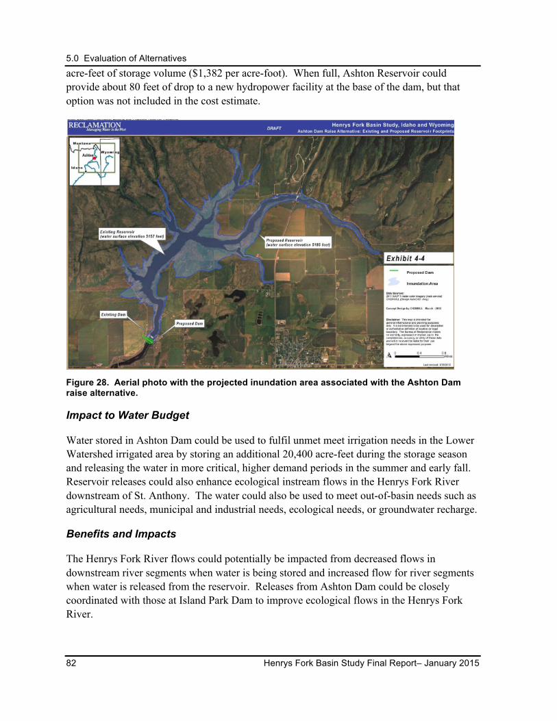
5.0 Evaluation of Alternatives
82 Henrys Fork Basin Study Final Report– January 2015
acre-feet of storage volume ($1,382 per acre-foot). When full, Ashton Reservoir could provide about 80 feet of drop to a new hydropower facility at the base of the dam, but that option was not included in the cost estimate.
Figure 28. Aerial photo with the projected inundation area associated with the Ashton Dam raise alternative.
Impact to Water Budget
Water stored in Ashton Dam could be used to fulfil unmet meet irrigation needs in the Lower Watershed irrigated area by storing an additional 20,400 acre-feet during the storage season and releasing the water in more critical, higher demand periods in the summer and early fall. Reservoir releases could also enhance ecological instream flows in the Henrys Fork River downstream of St. Anthony. The water could also be used to meet out-of-basin needs such as agricultural needs, municipal and industrial needs, ecological needs, or groundwater recharge.
Benefits and Impacts
The Henrys Fork River flows could potentially be impacted from decreased flows in downstream river segments when water is being stored and increased flow for river segments when water is released from the reservoir. Releases from Ashton Dam could be closely coordinated with those at Island Park Dam to improve ecological flows in the Henrys Fork River.
5.0 Evaluation of Alternatives
January 2015 - Henrys Fork Basin Study Final Report 83
Key Points from Evaluation and Feedback
Similar to the Island Park storage increase alternative, conservation stakeholders cautiously support the Ashton Dam alternative for further study. Given the existing dam structure, modification of the structure would translate to less significant environmental impacts than construction of a new dam.
Local water users remain interested in this alternative, given its cost relative to other alternatives. This alternative may have the ability to address unmet water needs in the lower watershed and contribute to meeting ESPA goals.
Ashton Dam is a privately owned by PacifiCorp and operated for power generation. Any future studies for potential modification to Ashton Dam would require involvement and cooperation from PacifiCorp. Future proposals would likely include maintaining or improving hydropower benefits.
Additional Limitations of Analysis
Embankment configurations were generalized and site-specific materials and material properties were not evaluated. No optimized dam approaches were proposed. A detailed evaluation of dam-raise design considerations would need to be performed in future phases to assess feasibility.
5.3 Managed Recharge Alternative
5.3.1 Introduction
Managed recharge in the Henrys Fork River basin was evaluated as a potential source of water supply for the basin as well as for stabilization of the ESPA. The importance of groundwater and its close link with the basin’s surface hydrology is widely recognized. It is clear that managed recharge activities may improve late season instream flow conditions in the basin downstream of the recharge sites by improving groundwater return flows. Additionally, managed recharge in the Henrys Fork River basin may have some positive effects on stabilizing the ESPA especially during above average water years.
Recent studies by IDWR related to the ESPA stabilization objectives indicate that recharge in the Henrys Fork River basin for the purpose of improving the condition of the ESPA is not as effective as focused recharge in locations downstream of American Falls Reservoir. These studies have also highlighted the importance of recharge in the Henrys Fork River basin during above average water years to contribute to system-wide recharge capacity when water is available in excess of that needed to recharge in the downstream locations. Historically, the IWRB has partnered with FMID in the managed recharge program, recharging a total of
5.0 Evaluation of Alternatives
84 Henrys Fork Basin Study Final Report– January 2015
nearly 150,000 acre-feet from 2008 to 2012.
Three locations in the Henrys Fork River basin were identified by Basin Study participants: 1) Egin Lakes recharge site expansion, 2) lower Teton River, and 3) Teton Valley tributaries. Of these, only the expansion of the existing Egin Lakes recharge site was carried forward for further consideration
Lower Teton River
Managed recharge near the lower Teton River has been identified for its potential to support unmet irrigation demands in the lower Teton Valley irrigated region in the late summer and to enhance ecological flows in adjacent river reaches. A candidate site between the North and South Forks of the Teton River was evaluated in the early phases of the Basin Study. Initial modeling suggested that a portion of the water recharged in this area could be retained in the ESPA and the remaining volume would be discharged to the Teton and South Fork Teton rivers. This water could help satisfy both late season irrigation and fisheries needs. However, while this area was included in the ESPAM, it remains an area of uncertainty even in the newer version of the model (ESPAM 2.1). The surface and groundwater hydrology in the area is known to be complex. The contribution of surface water from the Henrys Fork and Fall rivers through the Cross Cut Canal and the corresponding canal seepage complicates the system hydrology even further.
Teton Valley Tributaries
Groundwater recharge in the upper Teton River Valley was also identified during the Basin Study process. Most of the Teton River tributaries contain Yellowstone cutthroat trout while nonnative trout are located primarily in valley-bottom spring creeks throughout the Teton River (Van Kirk et al. 2011). Surface water flow dries up in the alluvial fan reaches of the Teton Valley in the late summer of most years. While many of the stream channels would dry naturally, irrigation diversions have likely extended the period of desiccation. The purpose of managed recharge activities in the area, as proposed by conservation groups, would primarily be to increase the period of hydraulic connectivity between spawning and rearing areas and the mainstem river by increasing return flows to the tributary reaches later in the summer. This may improve late season flows for irrigation in the lower Teton as well (Van Kirk et al. 2011).
Given the complexity of the hydrology, ecology, and water use in the Teton Valley, the effects of new management practices may have consequences throughout the watershed. Administrators, water users, and advocates for ecological streamflows acknowledge that thorough consideration and evaluation should be given to any proposed changes in water management practices.
5.0 Evaluation of Alternatives
January 2015 - Henrys Fork Basin Study Final Report 85
Future Program and Actions
The potential effects of managed recharge at all of the identified sites or possible future sites must be considered within a legal, scientific, and social framework and the objective of stabilizing the ESPA set out in the ESPA CAMP and State Water Plan. To refine recharge proposals at specific locations, future actions could include collection of additional data related to flow, fish and aquatic life, and quantification of the effects of low and modified flows in a specific reach as well as the watershed. Continued development and integration of watershed and basin-wide hydrologic models are also a critical component for identifying practical and effective changes in water management practices.
Any appropriation of water for managed recharge must be consistent with the State Water Plan and the ESPA CAMP. Projects involving the diversion of natural flow water appropriated pursuant to Idaho Code § 42-234 for managed recharge in excess of 10,000 acre-feet on an average annual basis must be submitted to the IWRB for approval prior to construction (Idaho Code § 42-1737).
The IWRB holds recharge water right permits (1980 priority dates), which authorize diversion of water from the Snake and Big/Little Wood rivers. IWRB resubmitted its 1998 applications on behalf of the State for groundwater recharge permits throughout the ESPA, including locations within the Basin Study area. The applications state that the IWRB will establish an environmental consultation committee to review potential impacts of recharge activities on fish and wildlife resources within the Henrys Fork and South Fork of the Snake Rivers, and the mainstem Snake River above American Falls Dam. The IWRB also intends to consult with IDFG to develop a protocol for evaluating and minimizing potential adverse impacts on these resources. This information will assist the IWRB and stakeholders in determining whether recharge activities in the Henrys Fork and Teton watersheds can address some of the water needs in the basin.
5.3.2 Egin Lakes Recharge Site Expansion
Description
Expansion of the Egin Lakes recharge site has the potential to enhance water supplies in the Henrys Fork River basin by improving groundwater table levels, increasing ecological flows in the river, and contributing to stabilization of the ESPA. Expansion of the site was initially evaluated during the Basin Study process using the ESPAM1.1 and by estimating costs associated with enlargement of the recharge facilities. An updated version of the model, ESPAM2.1, was released later in the study process and was used by IWRB in a broader analysis intended to prioritize aquifer recharge sites across the ESPA based on hydrogeologic characteristics and recharge water availability. The studies were initiated to help clarify where recharge activities would be most effective in achieving ESPA stabilization.
5.0 Evaluation of Alternatives
86 Henrys Fork Basin Study Final Report– January 2015
The hydrogeologic analysis compared the potential effectiveness of recharge locations across the ESPA relative to the retention time of water in the aquifer and capacity to receive recharge water (acre-feet per month). To evaluate potential retention time, IDWR modeled a recharge event of 100 cfs over one month in the spring and a second event in the fall at 13 recharge locations across the ESPA, including the Egin Lakes site. The sites were first ranked based on the percentage of water retained in the aquifer after 5 years. They were ranked further based on recharge limitations corresponding to potential physical capacity (i.e., diversion, infiltration, and groundwater capabilities). Evaluating recharge in the spring and fall was an important consideration given that increased water table elevations in the fall limit additional recharge capacity at some sites and in some cases, may result in infrastructure flooding/damage, with water returning to the river through the extensive drainage systems in some areas.
Results of the hydrogeologic analysis indicated that the Egin Lakes recharge site had highest 5-year retention potential relative to other sites across the ESPA; however, the total volume of recharge is limited by the site capacity. The analysis showed that of the 13 sites evaluated, the top 5 are located below American Falls Reservoir.
In addition to hydrogeologic considerations, the amount and frequency of water available for recharge upstream of Milner Dam at different locations across the ESPA is an important factor in prioritizing recharge activities. There are several fundamental assumptions in the water availability analysis: 1) recharge should be an opportunistic use of available natural flow; 2) recharge should not interfere with optimal capture of water in the storage system; 3) the recharge water right must be in priority at the point of diversion; 4) Reclamation’s hydropower water right at Minidoka Dam must be fully satisfied (2,700 cfs); 5) volume of water available for recharge was limited to water spilling past Milner or water at the recharge point of diversion less an assumed minimum streamflow (minimum streamflows were assumed as 0 cfs at Milner, 2,700 cfs at Minidoka, 200 cfs at Blackfoot, 900 cfs at South Fork, and 200 cfs at Henrys Fork).
Water District 01 used water right accounting data for a period of record from 2000 through 2012 from five significant gage locations to represent all of the recharge points of diversion: Milner, Minidoka, Snake River near Blackfoot, the Snake River near Heise (South Fork of the Snake River), and the Henrys Fork near St. Anthony. Results indicated that upstream of American Falls Reservoir, there is sufficient annual volume of water available for recharge in nearly half of the water years and zero water available for recharge in the other half. The volume of water for which there is at least a 50 percent likelihood of availability (exceedance) for recharge has been calculated and combined with the retention and capacity characteristics of each site. Sites with the best available supply are generally located below American Falls Reservoir. This is in part due to the fact that flows are not in priority for recharge during nearly half of the years evaluated.
5.0 Evaluation of Alternatives
January 2015 - Henrys Fork Basin Study Final Report 87
Conclusions drawn from the analyses are that the best ranked sites are located below American Falls Reservoir, between the Minidoka-to-Milner reach of the Snake River, and that significant additional recharge capacity would be needed in this area of the aquifer. Recharge above American Falls Reservoir was determined to have value, but water supply is more limited (50 percent of years recharge water is not likely to be available). These sites, which included two locations in the Henrys Fork River basin, are generally ranked lower than sites downstream of American Falls, but can provide important additional recharge capacity in above-average water years. In addition, existing sites above American Falls have large canal capacities so minimal infrastructure investment would be required. The Egin Lakes site has been identified as an exception, which may warrant enlargement of the conveyance capacity.
The hydrogeologic and water availability analyses indicated that recharge in the Henrys Fork basin for the purpose of improving the condition of the ESPA is not as effective as focused recharge in locations downstream of American Falls Reservoir. Nevertheless, the studies indicate that recharge in the Henrys Fork during above average water years can contribute to system-wide recharge capacity. While an expansion of Egin Lakes recharge site was not evaluated using the ESPAM2.1 as part of the Basin Study, IWRB, through its managed recharge program, is actively considering how to proceed with further development of infrastructure in critical locations across the ESPA that will provide for system-wide recharge capacity.
Impact to Water Budget
Impacts to the water budget can be minimized if diversions for recharge occur during high spring runoff when water is being passed downriver for flood control purpose and when there is an adequate water supply for diversion at high-priority recharge sites that have been shown to increase long-term aquifer storage. Some of that water may be recovered when subsurface flow returns to the river, at which time it may be available for numerous out-of-basin uses, including needs resulting from climate change; agricultural needs; domestic, municipal, and industrial needs; ecological needs; and for recharge of the ESPA (CH2M HILL 2012).
Benefits and Impacts
Diversions to the recharge site would typically occur during periods when adequate flows are available to avoid any adverse effect on substantial populations of Yellowstone cutthroat trout. Diversions would need to be screened to prevent trout entrainment. Return flows to the river resulting from increased diversion to the recharge site may benefit a priority rainbow trout fishery in the Henrys Fork River by improving flows in downstream river segments and temperature conditions in the lower Henrys Fork River. Specifically, increased groundwater return flows would likely help mitigate temperature conditions associated with surface water diversions below the St. Anthony gage.
The Egin Lakes recharge site is located within the Nine Mile Knoll Area of Critical
5.0 Evaluation of Alternatives
88 Henrys Fork Basin Study Final Report– January 2015
Environmental Concern, the St. Anthony Sand Dunes Special Recreation Management Area, and is directly adjacent to the Sand Mountain Wilderness Study Area. No ESA-listed threatened or at-risk species have been noted in the area, but the St. Anthony Sand Dunes host a Bureau of Land Management sensitive plant (St. Anthony Sand Dunes evening primrose) and the largest and most viable population of a rare tiger beetle. These issues will need to be considered in evaluating expansion of the recharge capacity of the site.
The National Wetland Inventory dataset indicates that further development of the site would have minimal impact on mapped wetlands, affecting an area less than 1 acre in size.
Key Points from Evaluation and Feedback
Recharge to support needs within the Henrys Fork River basin and the ESPA generally received wide support from involved agencies and the public. Expansion of these actions must be accompanied by the appropriate environmental impact analysis and assessment of benefits versus costs.
Conservation stakeholders recognize and support managed recharge for its local benefits of cooler/late season return flows as well as the contributions from the incidental recharge associated with irrigation delivery.
Local water users support continuation and expansion of the Egin Lakes recharge site to enhance the local economic benefit of the IWRB’s managed recharge program. While IWRB will continue to prioritize recharge activities that result in long-term aquifer storage, it will continue to work with local water users and stakeholders to implement where feasible recharge activities within the study area that further the objectives of the ESPA CAMP and State Water Plan.
Limitations of Analysis
More detailed studies would be required to evaluate the optimal increase in volume of recharge at this site, including evaluation of the potential impact on streamflows and stream reconnection.
5.4 Water Markets Description
The water marketing alternative consists of continued implementation of the State’s water transactions programs as well as transactions among private entities. Such transactions can provide a source of adequate water supplies to facilitate all types of water use for improved economic returns, improved stream connection, and enhanced streamflows.
There is currently a significant amount of activity in the upper Snake River basin using
5.0 Evaluation of Alternatives
January 2015 - Henrys Fork Basin Study Final Report 89
existing administrative mechanisms such as the State’s water supply bank, Upper Snake Water District 01 Rental Pool, and permanent water right transfers (see Section 1.5.2). Water marketing is often used to maximize the economic value of water by exchanging water rights that would have otherwise been unused and/or forfeited and to minimize the economic consequences of water shortages. Typically water marketing involves a voluntary water transfer agreement for a temporary or permanent change in the type, period, or place of use of water and/or a water right. Water transfers can be local or in specific cases, regional; be in the form of a permanent sale, temporary lease, or donation; and can move water among agricultural, municipal, industrial, and in some cases, to environmental uses.
The recently published Water Transfers in the West documented the extent of water transfers in Idaho from 1988 to 2009 (Western 2012). During this period, approximately 6.6 million acre-feet of water was transferred within Idaho, primarily through lease programs. Idaho ranked third among 12 western states in the volume of water transfers and has a highly developed water marketing system.
The primary water exchange market in Idaho is the water bank operated by IWRB (see Section 1.5.2). The water bank has two distinct categories of water marketing: the state-wide water supply bank and basin-specific rental pools. The exchange of natural flow water rights (both surface water and groundwater) is processed through the water supply bank and is administered by IDWR on behalf of IWRB. Rental pools are administered by the local water district advisory committee for a given water district and primarily rent reservoir storage water rights.
In general, water prices are low in Idaho as compared to other more urban markets largely as a result of the limited payment capacity of agricultural producers. A portion of the fees assessed for the lease and rental of water through the water bank is retained by the IWRB to assist with water bank administrative costs. Similarly, a portion of the fees assessed for the lease and rental of water through the rental pools is retained by the IWRB as a source of funding for water infrastructure across the state, while a portion is also retained by the local water district advisory committee to assist with rental pool administrative costs.
The water supply bank provides a centralized mechanism to lease (deposit water to the bank) and rent (withdraw water from the bank) surface water and groundwater rights throughout Idaho. Water rights are traded and leased to the water supply bank and made available for rent by other water users. Several criteria must be met for IDWR to process a rental agreement through the water supply bank. IDWR must determine (among other criteria):
5.0 Evaluation of Alternatives
90 Henrys Fork Basin Study Final Report– January 2015
1. There is a hydrological connection between the water right leased and the proposed rental location.
2. The rental causes no injury to other water users from the rental.
3. The water will be put to beneficial use.
4. The rental does not require a permanent water right (unless the renter can demonstrate a reasonable effort is being made to provide a permanent source for the long-term water use).
5. The rental does not result in an enlargement of the water right.
The rental pools are a central component of IWRB’s water marketing activities. They almost exclusively rent storage water allocations and allow reservoir spaceholders to make excess water available to those with limited water supplies in a given year.
Idaho is a leading state in leasing water between water users and the Water District 1 Rental Pool, which serves the Basin Study area, is the most active in the state. The local water district advisory committee, under appointment by the IWRB, establishes the pricing and operating procedures that govern each rental pool. The procedures define the priority for rentals, the order of assignments and the rental prices, which may vary depending on the type of use and water supply. Rental pools serve an important role in water transactions given the significant volume of water and efficiency with which transactions are processed. While the water supply bank is relatively active in the Henrys Fork River basin, the Water District 01 Rental Pool handles much larger volumes of water.
Facilitating Water Markets
Assessment of the successes and limitations of Idaho’s water bank focused on increasing the economic, environmental, and social benefits resulting from water transfers. These opportunities were evaluated by 1) removing transaction costs, 2) having a better understanding of the marginal value of water, 3) improving market clearing mechanisms, and 4) developing region-specific solutions. Due to the complexity of water market transactions, developing region-specific solutions offers the greatest potential for facilitating an increase in water market transfers. The following provides examples of existing programs, which attempt to address region-specific solutions and reflect IWRB’s efforts to support and expand the existing market system.
Idaho Water Transaction Program
As discussed in Section 1.5.2, the IWRB is a Qualified Local Entity (QLE) of the Columbia Basin Water Transactions Program (CBWTP) and manages water transaction activities in the upper Salmon River basin through the IWTP. Funding for the CBWTP is used to support projects that provide flows necessary for ESA-listed fish species while maintaining the
5.0 Evaluation of Alternatives
January 2015 - Henrys Fork Basin Study Final Report 91
agricultural economic base of the upper Salmon River basin. These projects are carried out using mechanisms such as water right leases (partial or full-season), water right subordination agreements, negotiated changes in points of diversion, and conservation easements. All of these mechanisms exist independent of the IWTP and can be utilized by any entity. The IWTP and the IWRB’s QLE status under the CBWTP provide funding from the Bonneville Power Administration to the IWRB to carry out these projects. IWTP is a good example of successful implementation of a region-specific solution to address fisheries issues, and illustrates the importance of an established funding mechanism in combination with the use of existing legal and administrative tools.
The recent partnership between IWRB and the Friends of the Teton River to evaluate the effectiveness of directing IWTP funds into the Teton River basin (see section 1.5.2) may provide a method, through existing administrative systems, to achieve certain conservation goals in the Teton River basin.
Potential Aquifer Recharge and Mitigation Credit Bank
The concept of an aquifer credit and mitigation bank has been under consideration by the IWRB, the State Legislature, the Governor’s Office, and water users across the state. If enacted it would authorize the IWRB to develop a program, initially focused on the ESPA, and perhaps extended to other areas as needed, which would allow local entities to conduct managed aquifer recharge consistent with administrative rules promulgated by the IWRB and receive marketable mitigation credits after a “cut to the aquifer.” The credits may allow for some new water uses and economic development while incentivizing additional managed recharge within the framework of IWRB’s overall managed recharge efforts consistent with the ESPA CAMP and State Water Plan.
Impact to Water Budget
The current water market programs provide a mechanism for improvement of the Henrys Fork River basin’s water budget. Continued support of existing water market programs and development of expanded programs in the region can provide additional system flexibility and opportunities to assist in managing available water supplies to satisfy the goals of the ESPA CAMP as well as meeting water needs in the Henrys Fork River basin. While water markets are not capable of increasing water supply, localized improvements to water budgets and mitigation of the economic consequences of water shortages may benefit from market activities.
Benefits and Impacts
Water marketing will help mitigate the economic consequences of increased demand and of
5.0 Evaluation of Alternatives
92 Henrys Fork Basin Study Final Report– January 2015
water shortages during drought cycles and due to the effects of climate change throughout the Henrys Fork River basin, and may improve stream connectivity associated with lower summer streamflows.
Key Points from Evaluation and Group Feedback
Market activity may increase if constraints to market participation were addressed (e.g., the current $17 per acre-foot Water Bank-suggested rental rate). Expansion of competitive water markets is likely to experience obstacles related to the costs of payments, which could be more than the direct beneficiaries could bear. In order to expand the use of water markets in the region to improve aquifer conditions and meet projected future demands, some level of public funding or a broader funding base will likely be required.
A high degree of pressure is placed on the existing surface water storage system and rental pool in the upper Snake River basin to help provide water for a variety of needs, including in-basin agricultural and downstream ESA needs. IWRB passed a resolution on January 27, 2012, stating that in order to avoid impacting reservoir fill, its managed recharge efforts would not utilize storage water and would utilize only excess natural flows. This places a significant limitation on the use of the water marketing system to meet aquifer management goals.
All stakeholders accept and support the water market alternative, with conservation groups actively working with IWRB to explore methods for ecosystem restoration by improving markets. IWRB, recognizing that modifications to the State water markets program are ongoing, continues to work within the boundaries of the existing program and law to address challenges with interested stakeholders. Reclamation sees existing water markets as a valuable management tool and supports expanding and improving water markets through competitive grants from the WaterSMART program.
Some conservation groups believe the current institutional barriers limiting the use of markets in the State include 1) the restriction or inability to transfer a consumptive use water right (such as an irrigation right) to an instream flow right and protect that water instream; 2) failure to apply conjunctive management principles throughout the state; and 3) incomplete accounting of water use, both by failing to include the Upper Teton Valley area in accounting for water delivery and for the failure to accurately and consistently regulate irrigation diversion in certain locations.
Limitations of Analysis
Stream reconnection through streamflows is of significant importance to stakeholders in the Basin Study area. Potential benefits of water transactions in the upper Teton Valley are currently being explored. While existing administrative mechanisms for leasing, transferring, subordinating and selling water rights are available, there are inherent challenges in applying
5.0 Evaluation of Alternatives
January 2015 - Henrys Fork Basin Study Final Report 93
those processes to a specific situation. For example, throughout Idaho, water rights for water delivered through a canal system are generally owned by the water entity. Individual landowners do not have the authority to lease or sell water shares without canal company approval. In the upper Teton Valley, some landowners have expressed interest in leasing water with canal company approval. These types of challenges are not unique to this basin, but do reflect the need for localized solutions. This level of evaluation did not provide recommendations about any new proposed market structure or recommendations to mitigate constraints to using existing water markets.
Water markets can be regulated in a variety of ways to satisfy water supply objectives, including regulatory constraints on certain types of market transfers or the development of market demand through regulatory drivers that create incentives for trades. The existing regulatory environment for market-based mechanisms was not evaluated, but was considered.
The relationship between water pricing for water transfers and water needs is difficult to estimate due to insufficient (large enough) real time data. In many regions, water supplied to the water market is associated with surplus water supplies or obtained through fallowing irrigated land; however, the greatest demand for water transactions occur during periods of water shortages.
Implementation Options
IWRB has an advanced water market system and is coordinating efforts to enhance existing programs and advance new programs. Should legislation authorizing the establishment of an aquifer credit and mitigation bank be enacted, IWRB will develop rules for implementation consistent with the ESPA CAMP and State Water Plan. In combination with the necessary funding, existing programs may be used by all water users to address regional and local water demands.
5.5 Conservation Alternatives
5.5.1 Canal Automation Alternative
Description
The canal automation alternative consists of installing automated gates on large diversion canals that divert water from Henrys Fork, Teton, or Fall Rivers in the Henrys Fork Basin. Automated canals more accurately adjust and divert water than manual systems and are a useful tool that allows irrigators to match diversions with irrigation requirements.
Canal automation could potentially improve the management of water diversions by
5.0 Evaluation of Alternatives
94 Henrys Fork Basin Study Final Report– January 2015
minimizing waste through improving response time for diversion changes and reducing the need for travel to and from the diversion to make changes. This could be particularly beneficial when managing movement and diversion of water during low flow periods and managing stored water.
Reclamation simulated the automation of over 44 canal headworks in the FMID area to evaluate potential waters savings. The canals with the highest potential to save stored water are listed in Table 13.
Using information from another Reclamation project, estimated costs were developed for the installation of automated canal gates located at the principal stream diversion points and included costs for reworking of headgates, construction of concrete control sections, installation of the radial arm headgates with 200 cfs to 600 cfs capacities (Figure 29), and the installation of a telemetric data acquisition system. A regression equation was developed that directly estimated the cost of totally automated canal systems per cfs capacity:
Cost = $392/cfs x cfs capacity + $14,988.
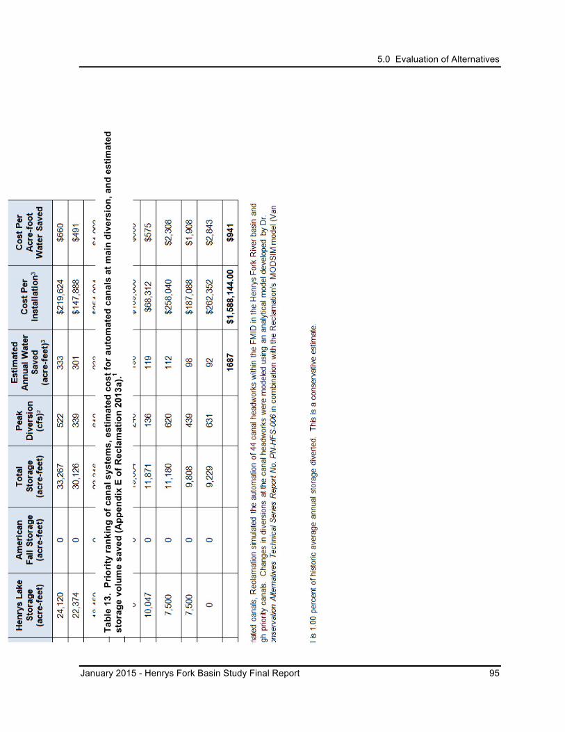
5.0 Evaluation of Alternatives
January 2015 - Henrys Fork Basin Study Final Report 95
Tabl
e 13
. Pr
iorit
y ra
nkin
g of
can
al s
yste
ms,
est
imat
ed c
ost f
or a
utom
ated
can
als
at m
ain
dive
rsio
n, a
nd e
stim
ated
st
orag
e vo
lum
e sa
ved
(App
endi
x E
of R
ecla
mat
ion
2013
a).1
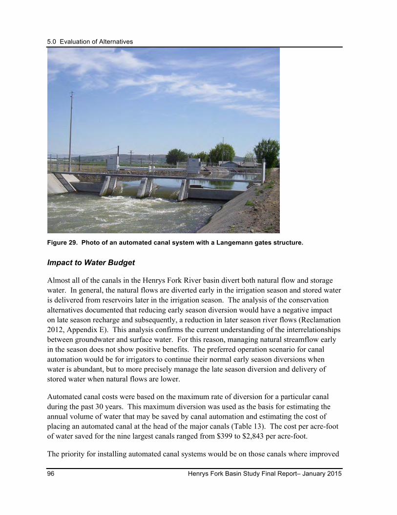
5.0 Evaluation of Alternatives
96 Henrys Fork Basin Study Final Report– January 2015
Figure 29. Photo of an automated canal system with a Langemann gates structure.
Impact to Water Budget
Almost all of the canals in the Henrys Fork River basin divert both natural flow and storage water. In general, the natural flows are diverted early in the irrigation season and stored water is delivered from reservoirs later in the irrigation season. The analysis of the conservation alternatives documented that reducing early season diversion would have a negative impact on late season recharge and subsequently, a reduction in later season river flows (Reclamation 2012, Appendix E). This analysis confirms the current understanding of the interrelationships between groundwater and surface water. For this reason, managing natural streamflow early in the season does not show positive benefits. The preferred operation scenario for canal automation would be for irrigators to continue their normal early season diversions when water is abundant, but to more precisely manage the late season diversion and delivery of stored water when natural flows are lower.
Automated canal costs were based on the maximum rate of diversion for a particular canal during the past 30 years. This maximum diversion was used as the basis for estimating the annual volume of water that may be saved by canal automation and estimating the cost of placing an automated canal at the head of the major canals (Table 13). The cost per acre-foot of water saved for the nine largest canals ranged from $399 to $2,843 per acre-foot.
The priority for installing automated canal systems would be on those canals where improved
5.0 Evaluation of Alternatives
January 2015 - Henrys Fork Basin Study Final Report 97
efficiencies result in more water being held longer in the reservoirs. Table 13 lists the canals which divert the greatest amount of stored water.
In terms of changes in streamflow in the Henrys Fork River near Rexburg, the canal automation alternative would result in a slight increase in flow in June due to the decreased diversion. A very slight decrease in winter flows would occur because the decreased summer diversions would result in a decrease in winter groundwater returns.
Potential Climate Change Impacts
Using the best available datasets and data development methodologies, the modeling results showed little difference in future streamflows with canal automation in any of the climate change projections compared to the baseline conditions. However, climate change predictions indicate that there will be lower base streamflows later in the irrigation season which may result in water users having a greater dependence on storage supplies. Management of those supplies could be improved through canal automation.
Benefits and Impacts
For all four of the irrigated regions shown in Figure 15, canal automation would increase both total annual and peak flow volumes and would have a positive impact on the overall water budget of the Henrys Fork River basin. Automated canals would reduce the demand for storage water, which would improve management options in both the Henrys Fork River basin and the ESPA. Installation of fish screens, in conjunction with construction of automated canal systems, would have a positive environmental impact, and should be considered in any specific potential canal automation project.
For the North Fremont region, canal automation shows potential to increase nonpeak flows. The increase of nonpeak flows would be a positive effect during periods of normally low flows. Canal automation in combination with the ongoing conservation efforts in the North Fremont region to pipe and line canals could cumulatively make a positive impact on local streamflows.
For the Teton Valley, Lower Watershed, and Egin Bench regions, canal automation has the potential to decrease nonpeak flows if applied in the early high flow period. Canal operations should be carefully considered when developing these alternatives to minimize negative impacts to streamflows. The preferred operation scenario for canal automation would be for irrigators to continue their normal early season diversions when water is abundant, but to more precisely manage the late season diversion and delivery of stored water when natural flows are lower.
Key Points from Evaluation and Feedback
The analysis of automated canals in the Henrys Fork River basin only documented
5.0 Evaluation of Alternatives
98 Henrys Fork Basin Study Final Report– January 2015
streamflows at existing USGS gaging stations. While model results show increased flows in the Henrys Fork River and Teton River, these increases would likely reduce recharge to the Snake River or the ESPA below Rexburg.
Automated canals appear to have a high degree of acceptance by irrigators, environmental interests, and water managers. Automated canal projects could qualify for funding from the State’s loan program.
Reclamation sees existing canal automation as a valuable management tool and supports individual canal automation projects through competitive grants from the WaterSMART program.
The support of environmental stakeholders is tempered by concerns that incidental canal recharge to rivers could be affected. At the same time, conservation stakeholders support the improved management of storage water, which could contribute to higher carry-over volumes and promotion of market activity. Similarly, conservation stakeholders recognize and support the benefit of automation to canal measurement and the positive impact that measurement could have in future market activity.
Limitations of Analysis
Existing data from previous projects using a limited number of factors and coupled with high- level assumptions were used to estimate the costs for canal automation and water savings. These costs were relative and meant to be used only for planning purposes. The cost analysis only considered the cost of installing an automated canal gate at the principal river or stream diversion point. Procedures to estimate actual water savings when automated canals are installed are not available. The estimated water savings shown in Table 11 are assumed to be very low and result in a relatively higher cost per acre-foot of water saved. Even with this relatively high cost per acre-foot of water saved estimate, automated canals have lower costs to conserve water than most other alternatives.
No detailed evaluations of stream habitat changes were made for the installation of automated canals.
Modeling estimates were used to determine potential impacts and benefits to the water budget. Hydrologic and hydraulic modeling inherently contains assumptions, simplifications, and estimations. The modeling protocol allowed for impacts to be analyzed for many stream reaches in the Henrys Fork River basin, but the model was not linked to the ESPAM groundwater model. Consequently, the impacts of changes in diversions and subsequent changes in groundwater and surface water related to each conservation alternative were not calculated as to how they might meet out-of-basin needs (Appendix E of Reclamation 2013a).
Additional study and analysis specific to local projects would be necessary to fully evaluate

5.0 Evaluation of Alternatives
January 2015 - Henrys Fork Basin Study Final Report 99
environmental impacts, design options, and optimal operational scenarios.
Implementation Options
The canal automation alternative shows the potential for relatively low cost, high social acceptance, and economic benefits through the potential to reduce labor costs. Automating canals could be a good candidate for early implementation. IWRB’s Financial Program provides loans for developing the water resources of the State through the construction of water projects. Projects eligible for financing include new construction or rehabilitation of existing water projects. As such, automated canals to improve irrigation water management meeting program criteria would be qualifying projects.
It is likely that local sponsors interested in moving this alternative forward (e.g., a canal company or irrigation district) could utilized the IWRB Financial Program coupled with Reclamations WaterSMART grant program or any USDA NRCS financial assistance program to move local projects forward. Further refinement of designs and cost estimates should be conducted. While the cost estimates for automated canals in this report do not include fish screening, opportunities to partner with conservation groups to include fish screening should be considered. Installation of automated canals adjacent to waters of the United States with non-Federal dollars would require a Corps of Engineers’ 404 permit under the Clean Water Act and its attendant requirements. The use of Federal funds (e.g., under Reclamation Secure Water Act) would also require meeting that particular agency's environmental/policy requirements.
5.5.2 Irrigation Canal Piping Alternative Description
The irrigation canal piping alternative consists of the installation of pipelines in irrigation canals to limit water loss due to canal seepage. This is a routine conservation practice in many parts of the country, but because of the interconnectedness of the groundwater and surface water in the Henrys Fork River basin and the influence canal seepage has on return flows to the river, this conservation practice is generally not applied in the Henrys Fork River basin. After initial analysis, pipelines and canal linings were shown to be of positive benefit only in the North Fremont irrigated region. Because of the interconnection between groundwater and surface water, piping canals in the other irrigated regions were shown to reduce irrigation return flows to the river; consequently, canal piping does not show positive benefits for those areas.
Impact to Water Budget
For the Teton Valley, Lower Watershed, and Egin Bench irrigated regions (Figure 15), piping canals would reduce both total annual and nonpeak flows and would have a relatively small
5.0 Evaluation of Alternatives
100 Henrys Fork Basin Study Final Report– January 2015
impact on peak flows. The reduction in total annual flows and nonpeak flows would have a negative impact on the Henrys Fork River basin’s water budget.
In the North Fremont region, piping irrigation canals would increase total annual flows, peak flows, and nonpeak flows. This would have positive benefits to the Henrys Fork River basin’s water budget.
Pipeline systems already constructed in the North Fremont irrigated region have helped to reduce the need for deliveries from upstream storage. Evidence indicates piping systems have saved approximately 10,000 acre-feet of storage annually that were historically lost to canal seepage. Additionally pipeline systems in the North Fremont region have had and could continue to have a positive impact on streamflows in the Fall River by reducing instream withdrawals.
Water savings realized through water conservation projects such as piping could make more water available later in the irrigation season. This could help mitigate for current water supply shortages in the region and help to mitigate the expected increase in late season demands predicted due to climate change.
Benefits and Impacts
The installation of pipelines in canals would likely reduce the number of irrigation-induced wetlands within the Henrys Fork River basin, due to decreased canal seepage. However, pipelines would reduce the demand for stored water withdrawal, which would improve management options in both the Henrys Fork River basin and the ESPA.
Key Points from Evaluation and Feedback
Piping and lining of irrigation canals would be expensive, but pipelines would provide pressurized water, which would reduce pumping needs and conserve electricity. The installation of piping systems should continue in the North Fremont irrigated region.
Local sponsors have already made great strides in implementing this alternative through cooperation with IWRB and USDA financial assistance programs. In 2013, IWRB approved a loan application from the North Fremont irrigators for $2.5 million, which would provide match money for about $6 million in Federal NRCS funds for Phase 4 of the North Fremont Gravity Pipeline Project. The project is being implemented in five phases. Both the IWRB and NRCS provided financial assistance for the previous phases of the project as well. The IWRB Financial Program coupled with Reclamations WaterSMART grant program or any USDA financial assistance programs should continue to be utilized to move this alternative forward.
5.0 Evaluation of Alternatives
January 2015 - Henrys Fork Basin Study Final Report 101
5.5.3 Demand Reduction Option
Description
The demand reduction alternative consists of reducing the number of irrigated acres, changing to lower water demand crop types or implementing rotational fallowing practices to reduce water needs. To a certain extent, water users currently utilize these practices in dealing with water shortage and drought situations. This alternative could also be a practical water management tool to address localized streamflow issues that cannot be reached through other alternatives. This type of program is currently being implemented as one of the ESPA CAMP goals to reducing overall pumping of groundwater to minimize impacts to the ESPA. The Henrys Fork River basin is within the boundaries of the ESPA demand reduction program and has the opportunity to utilize the existing program infrastructure. As part of this alternative, IWRB would continue to support the Idaho ESPA CREP and AWEP (see Sections 1.5.1 and 1.5.2 for details about the programs). CREP targets the enrollment of up to 100,000 acres of eligible irrigated cropland primarily to reduce irrigation water use with secondary benefits of improved water quality, reduce soil erosion and sedimentation, and enhance wildlife populations.
IWRB’s AWEP award encourages projects that reduce groundwater pumping within the ESPA. It provides a Federal project cost contribution of up to 75 percent while the producer is required to provide the remaining non-Federal portion. In specific cases, IWRB has provided additional financial assistance, particularly where measuring devices are required for water management compliance purposes. Eligible projects include 1) groundwater to surface water conversions, which allow for the delivery of additional surface water in order to reduce groundwater pumping; 2) improvements to water delivery systems in the Thousand Springs area; 3) regulating reservoirs;14 and 4) demand reduction projects such as end gun removal and conversion to dryland farming.
Estimating the cost to achieve an acre of demand reduction is complex and variable. During this evaluation, the estimated cost to reduce irrigation, meaning the acre would no longer be irrigated, was $1,820 per acre. The estimated cost for deficit irrigation, meaning the acre would be partially irrigated (e.g., irrigation may be stopped after only the second cutting of alfalfa hay), was $3,600 per acre-foot.
Deficit Irrigation Option
Deficit irrigation is an irrigation technique where farmers attempt to maximize crops produced per acre-foot of water used. This is sometimes used in regions where water resources are restricted and also incorporates concepts related to water marketing. In general, 14 A regulating reservoir is an impoundment along the irrigation delivery system that allows for better management of irrigation water deliveries over a long distance.
5.0 Evaluation of Alternatives
102 Henrys Fork Basin Study Final Report– January 2015
this is a common practice in the Basin Study area, especially during dry water years. Water savings from deficit irrigation may remain in storage, be transferred to other users, or simply be water not available, depending on the region’s volume of water shortage, infrastructure, and legal requirements.
Costs were difficult to estimate due to a scarcity of information related to land prices, crop prices, reductions in yield under deficit irrigation, the economic impact to rural economies, and other socioeconomic factors. A simplified model was developed to estimate the cost of deficit irrigation in the Henrys Fork River basin by using alfalfa hay as the sample crop.
Using the methodology described in Orloff et al. (2005), the estimated costs to use deficit irrigation for alfalfa hay, where irrigation is stopped after the first cutting, were estimated as:
1. $161 per acre-foot of water saved. This is a onetime savings.
2. $3,612 per acre-foot saved with costs amortized over a project life of 50 years, with consideration only to the farm gate. The farm gate is the value of an agricultural product when it leaves the farm, which is typically lower than the retail price.
Deficit irrigation would likely continue to be applied by water users in the Henrys Fork River basin during periods of low water supplies. In these dry years, crop prices would generally rise due to the scarcity of a commodity. Consequently, the costs estimated for deficit irrigation are higher than average, but are relative to the supply and demand for water and crops during dry years.
Impact to Water Budget
The impacts to the water budget for demand reduction were evaluated using an analytical model developed by Dr. Rob Van Kirk (Van Kirk 2013). Quantitative impacts discussed here are based on reductions to irrigation withdrawals of up to 50 percent in the irrigated regions of the Henrys Fork River basin. For the purpose of the analysis, it was assumed that water saved through demand reduction would stay in the river.
For all four of the irrigated regions in the Basin Study area (Figure 15), demand reduction could increase total annual flows and peak period flows. This would have a positive impact on the Henrys Fork River basin’s streamflows.
For the North Fremont and Egin Bench regions, demand reduction could increase nonpeak period flows, which could have a positive impact on the Henrys Fork River and Fall River.
For the Teton Valley and Lower Watershed regions, demand reduction would decrease nonpeak period flows in the North Fork and South for Teton River, which would be a negative impact during periods of normally low flows. The result of the analysis is somewhat
5.0 Evaluation of Alternatives
January 2015 - Henrys Fork Basin Study Final Report 103
counterintuitive, but illustrates the close connection groundwater and surface water have in the Teton drainage. Irrigation early in the spring results in important groundwater return flows later in the summer; hence, if irrigation acreage were reduced through a demand reduction alternative, less return flow later would occur in the summer, which would have a negative impact to the river environment in the critical low flow period. In some localized areas, this alternative may be beneficial; however, this would need to be evaluated on a case-by-case basis.
Benefits and Impacts
For the North Fremont and Egin Bench irrigated regions, the demand reduction option would be beneficial to the water budget and environmental needs due to increased nonpeak flows. For the Teton Valley irrigated region, a negative impact would be expected due to a decrease in nonpeak flows. For the Lower Watershed irrigated region, demand reduction would have negligible impacts to the water budget or the environment.
Key Points from Evaluation and Feedback
Demand reduction could have other economic impacts due to the economic importance of agriculture in the Henrys Fork River basin. Implementation of this alternative should include further study and careful evaluation of economic impacts.
Due to the limited ability to store the conserved water in the Henrys Fork River basin, the value of the water saved through deficit irrigation may be limited. Much of the irrigated land in the basin relies on natural flows that can only be saved in downstream reservoirs. If there is insufficient natural flow to meet demands in the basin, water stored downstream is of limited value. This situation would most likely occur in consecutive years of below normal water supplies.
There could potentially be localized benefits from this alternative, especially in tributaries where no other water supply or marketing strategies may apply. The success of such an alternative would depend on local stakeholder grass root efforts to seek out opportunities.
Limitations of Analysis
There is not a readily available, large, and directly comparable database of land transactions involving water rights so the determination of the market value of water would be difficult.
Demand reduction involves producing fewer crops and would have a ripple effect on agriculturally based economies. The extent of this impact would be difficult to assess.

5.0 Evaluation of Alternatives
104 Henrys Fork Basin Study Final Report– January 2015
Implementation Options
IWRB would continue using the demand reduction programs that are currently in place.
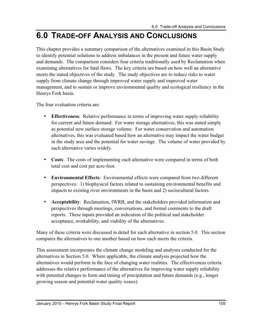
6.0 Trade-off Analysis and Conclusions
January 2015 - Henrys Fork Basin Study Final Report 105
6.0 TRADE-OFF ANALYSIS AND CONCLUSIONS This chapter provides a summary comparison of the alternatives examined in this Basin Study to identify potential solutions to address imbalances in the present and future water supply and demands. The comparison considers four criteria traditionally used by Reclamation when examining alternatives for fatal flaws. The key criteria are based on how well an alternative meets the stated objectives of the study. The study objectives are to reduce risks to water supply from climate change through improved water supply and improved water management, and to sustain or improve environmental quality and ecological resiliency in the Henrys Fork basin.
The four evaluation criteria are:
• Effectiveness: Relative performance in terms of improving water supply reliability for current and future demand. For water storage alternatives, this was stated simply as potential new surface storage volume. For water conservation and automation alternatives, this was evaluated based how an alternative may impact the water budget in the study area and the potential for water savings. The volume of water provided by each alternative varies widely.
• Costs: The costs of implementing each alternative were compared in terms of both total cost and cost per acre-foot.
• Environmental Effects: Environmental effects were compared from two different perspectives: 1) biophysical factors related to sustaining environmental benefits and impacts to existing river environments in the basin and 2) sociocultural factors.
• Acceptability: Reclamation, IWRB, and the stakeholders provided information and perspectives through meetings, conversations, and formal comments to the draft reports. These inputs provided an indication of the political and stakeholder acceptance, workability, and viability of the alternatives.
Many of these criteria were discussed in detail for each alternative in section 5.0. This section compares the alternatives to one another based on how each meets the criteria.
This assessment incorporates the climate change modeling and analyses conducted for the alternatives in Section 5.0. Where applicable, the climate analysis projected how the alternatives would perform in the face of changing water realities. The effectiveness criteria addresses the relative performance of the alternatives for improving water supply reliability with potential changes to form and timing of precipitation and future demands (e.g., longer growing season and potential water quality issues).
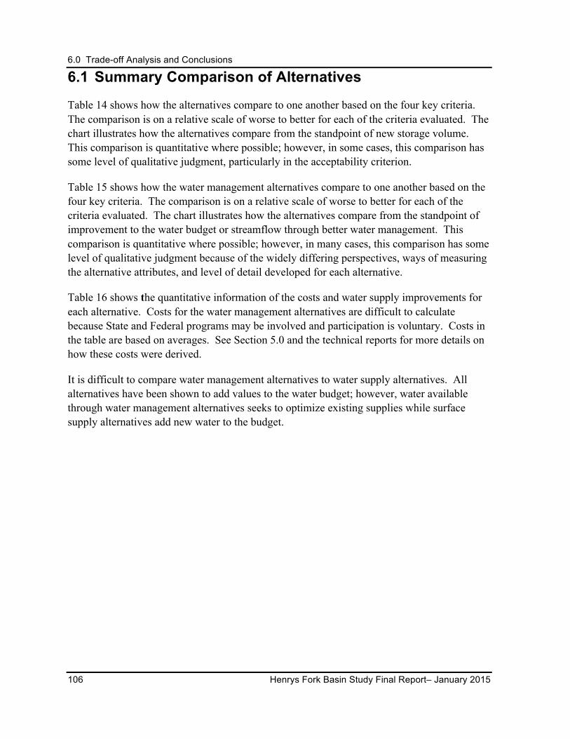
6.0 Trade-off Analysis and Conclusions
106 Henrys Fork Basin Study Final Report– January 2015
6.1 Summary Comparison of Alternatives
Table 14 shows how the alternatives compare to one another based on the four key criteria. The comparison is on a relative scale of worse to better for each of the criteria evaluated. The chart illustrates how the alternatives compare from the standpoint of new storage volume. This comparison is quantitative where possible; however, in some cases, this comparison has some level of qualitative judgment, particularly in the acceptability criterion.
Table 15 shows how the water management alternatives compare to one another based on the four key criteria. The comparison is on a relative scale of worse to better for each of the criteria evaluated. The chart illustrates how the alternatives compare from the standpoint of improvement to the water budget or streamflow through better water management. This comparison is quantitative where possible; however, in many cases, this comparison has some level of qualitative judgment because of the widely differing perspectives, ways of measuring the alternative attributes, and level of detail developed for each alternative.
Table 16 shows the quantitative information of the costs and water supply improvements for each alternative. Costs for the water management alternatives are difficult to calculate because State and Federal programs may be involved and participation is voluntary. Costs in the table are based on averages. See Section 5.0 and the technical reports for more details on how these costs were derived.
It is difficult to compare water management alternatives to water supply alternatives. All alternatives have been shown to add values to the water budget; however, water available through water management alternatives seeks to optimize existing supplies while surface supply alternatives add new water to the budget.
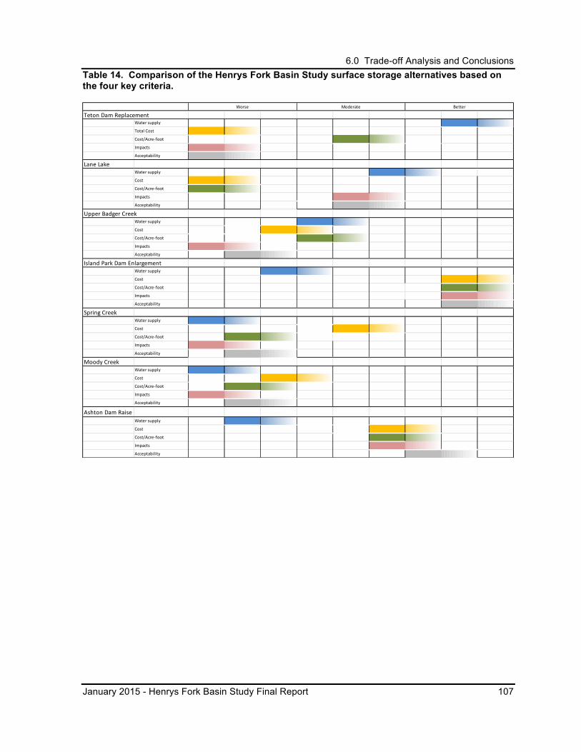
6.0 Trade-off Analysis and Conclusions
January 2015 - Henrys Fork Basin Study Final Report 107
Table 14. Comparison of the Henrys Fork Basin Study surface storage alternatives based on the four key criteria.
Teton Dam ReplacementWater supply
Total Cost
Cost/Acre-‐foot
Impacts
Acceptability
Lane Lake Water supply
Cost
Cost/Acre-‐foot
Impacts
Acceptability
Upper Badger CreekWater supply
Cost
Cost/Acre-‐foot
Impacts
Acceptability
Island Park Dam EnlargementWater supply
Cost
Cost/Acre-‐foot
Impacts
Acceptability
Spring CreekWater supply
Cost
Cost/Acre-‐foot
Impacts
Acceptability
Moody CreekWater supply
Cost
Cost/Acre-‐foot
Impacts
Acceptability
Ashton Dam RaiseWater supply
Cost
Cost/Acre-‐foot
Impacts
Acceptability
Worse Moderate Better
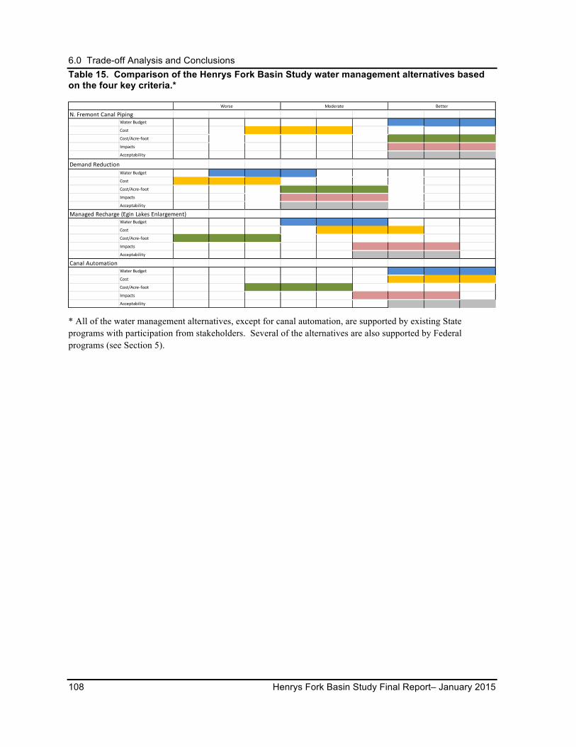
6.0 Trade-off Analysis and Conclusions
108 Henrys Fork Basin Study Final Report– January 2015
Table 15. Comparison of the Henrys Fork Basin Study water management alternatives based on the four key criteria.*
* All of the water management alternatives, except for canal automation, are supported by existing State programs with participation from stakeholders. Several of the alternatives are also supported by Federal programs (see Section 5).
N. Fremont Canal Piping Water Budget
Cost
Cost/Acre-‐foot
Impacts
Acceptability
Demand ReductionWater Budget
Cost
Cost/Acre-‐foot
Impacts
Acceptability
Managed Recharge (Egin Lakes Enlargement)Water Budget
Cost
Cost/Acre-‐foot
Impacts
Acceptability
Canal Automation Water Budget
Cost
Cost/Acre-‐foot
Impacts
Acceptability
Worse Moderate Better
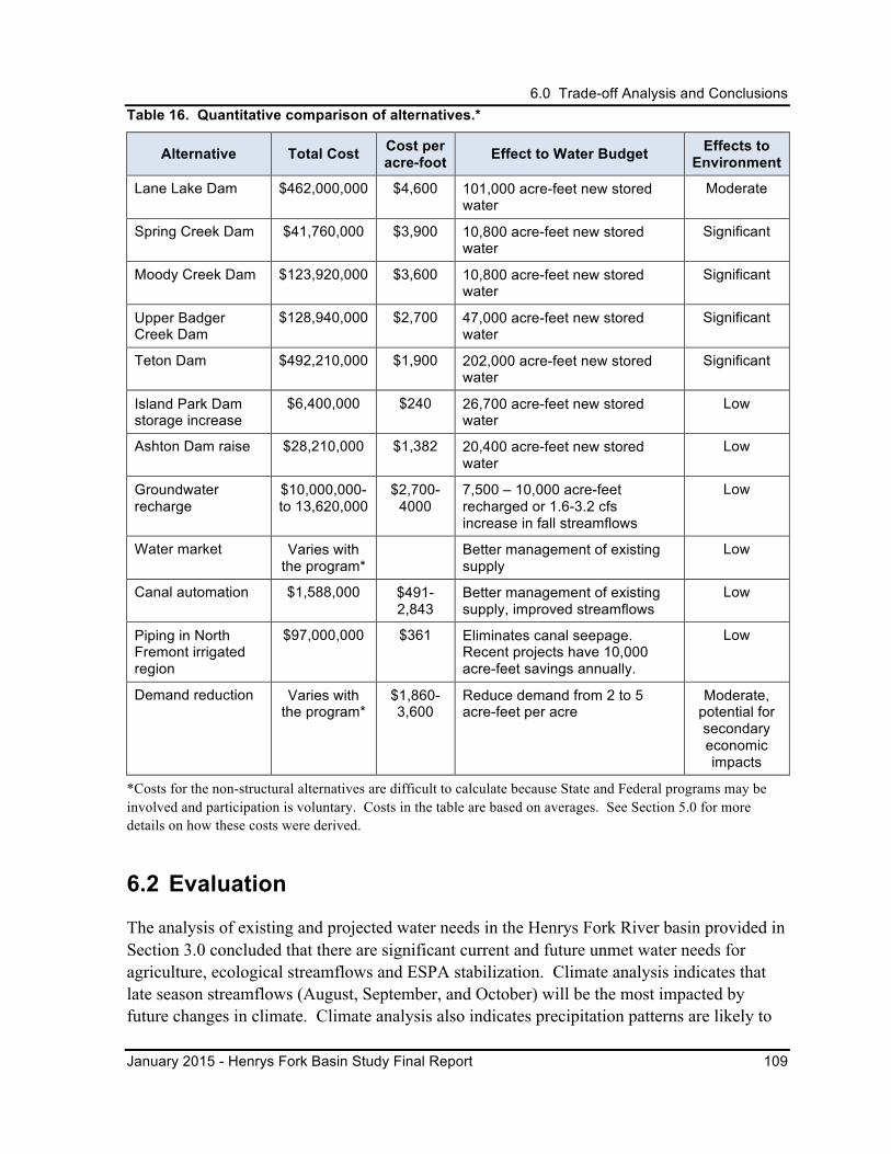
6.0 Trade-off Analysis and Conclusions
January 2015 - Henrys Fork Basin Study Final Report 109
Table 16. Quantitative comparison of alternatives.*
Alternative Total Cost Cost per acre-foot Effect to Water Budget Effects to
Environment
Lane Lake Dam $462,000,000 $4,600 101,000 acre-feet new stored water
Moderate
Spring Creek Dam $41,760,000 $3,900 10,800 acre-feet new stored water
Significant
Moody Creek Dam $123,920,000 $3,600 10,800 acre-feet new stored water
Significant
Upper Badger Creek Dam
$128,940,000 $2,700 47,000 acre-feet new stored water
Significant
Teton Dam $492,210,000 $1,900 202,000 acre-feet new stored water
Significant
Island Park Dam storage increase
$6,400,000 $240 26,700 acre-feet new stored water
Low
Ashton Dam raise $28,210,000 $1,382 20,400 acre-feet new stored water
Low
Groundwater recharge
$10,000,000- to 13,620,000
$2,700- 4000
7,500 – 10,000 acre-feet recharged or 1.6-3.2 cfs increase in fall streamflows
Low
Water market Varies with the program*
Better management of existing supply
Low
Canal automation $1,588,000 $491-2,843
Better management of existing supply, improved streamflows
Low
Piping in North Fremont irrigated region
$97,000,000 $361 Eliminates canal seepage. Recent projects have 10,000 acre-feet savings annually.
Low
Demand reduction Varies with the program*
$1,860- 3,600
Reduce demand from 2 to 5 acre-feet per acre
Moderate, potential for secondary economic impacts
*Costs for the non-structural alternatives are difficult to calculate because State and Federal programs may be involved and participation is voluntary. Costs in the table are based on averages. See Section 5.0 for more details on how these costs were derived.
6.2 Evaluation
The analysis of existing and projected water needs in the Henrys Fork River basin provided in Section 3.0 concluded that there are significant current and future unmet water needs for agriculture, ecological streamflows and ESPA stabilization. Climate analysis indicates that late season streamflows (August, September, and October) will be the most impacted by future changes in climate. Climate analysis also indicates precipitation patterns are likely to
6.0 Trade-off Analysis and Conclusions
110 Henrys Fork Basin Study Final Report– January 2015
improve in this region in the winter, which may result in improved streamflows in the winter and improve reliability of filling current and future water storage facilities.
The Henrys Fork River basin is a water rich basin, with thousands of acre-feet leaving the basin in an average year. Additionally, this basin is uniquely situated high in the watershed so that water savings and water supply alternatives implemented in this basin have the potential to benefit in-basin needs as well as downstream regions, including the ESPA. The candidate actions, either individually or in combination, represent a partial solution to meeting the basin’s and ESPA needs.
Future actions in the basin for any alternative or combination of alternatives would need additional evaluations of environmental impacts and engineering analysis based on the needs of specific areas and/or uses.
6.2.1 Surface Storage
Conceptually, the new storage alternatives evaluated in this Basin Study have been found to be plausible from an engineering perspective only. Considerably more evaluation, study, and design are needed before any alternative could be seriously considered for implementation.
The surface storage alternatives were evaluated on a conceptual level in the Basin Study and determined to be viable from an engineering perspective. New surface storage comes with the potential for significant environmental impacts to river environments and surrounding land uses. Considerably more study and design are required before any alternative could be seriously considered for implementation.
Effectiveness
As described in Section 5.2, the Teton Dam alternative would provide the largest amount of storage at a median annual volume of approximately 202,000 acre-feet, followed by Lane Lake, Badger Creek, and Moody Creek, with the lowest volume of storage being provided by Spring Creek Dam at 10,800 acre-feet. This Basin Study assessment shows that some water conservation alternatives have new water supply potential equivalent to the lower volume storage alternatives, with lower implementation costs and limited or no environmental impacts.
Based on hydrologic studies performed for the Teton Dam, Lane Lake Dam, and Island Park Dam alternatives, probability-of-fill projections based on climate change modeling indicate that the percentage of years in which the alternatives would meet or exceed the 80-percent fill level would increase, with the percentage of years in which no or a low level of fill would occur being reduced to less than 5 percent (Reclamation 2013b). The same conditions related to fill variability may be anticipated for other reservoir sites under study in this Final Report, based on both historic and climate change conditions.
6.0 Trade-off Analysis and Conclusions
January 2015 - Henrys Fork Basin Study Final Report 111
Public acceptability appears greater for alternatives that propose modifications to existing dams such as Island Park or Ashton Dam than for the alternatives that propose building a dam on a currently free-flowing river. The new storage potential for these two alternatives is 26,000 acre-feet and 20,000 acre-feet, respectively. Further study is necessary to quantify the probabilities of fill under historic and climate change conditions for the Ashton Dam alternative.
Secondary Benefit – Hydropower
A secondary benefit of surface storage reservoirs could be hydropower production. The Teton Dam alternative, as the largest alternative considered, would provide the most power at a median generation of over 5,870 kW. Other surface storage alternatives have potential to provide power depending on head and operational criteria. Based on the assumptions in this study, the highest potential among the remaining storage alternatives are 2,430 kW at the Upper Badger Creek Dam location and 1,500 kW at the Lane Lake Dam location. The remainder of the alternatives would provide less than 1,000 kW, with Spring Creek Dam alternative providing the least, at 177 kW. Hydropower development costs were not included in the total and unit costs. The kW values presented represent peak power potential and do not consider the hours of operation expected, which impacts total power production.
Estimated Total Construction Costs
The highest estimated total construction costs are for the Teton Dam and Lane Lake Dam alternatives at $492,210,000 and $462,000,000, respectively. The lowest development costs are associated with storage increase alternatives at the two existing reservoirs: Island Park storage increase alternative at approximately $6,400,000, and Ashton Dam raise alternative at approximately $28,210,000. Total construction costs of Spring Creek, Moody Creek, and Upper Badger Creek dams are also relatively low at $41,760,000, $123,920,000, and $128,940,000, respectively.
Estimated Costs per Acre-‐Foot
The cost per acre-foot of new stored water presents a somewhat different picture than total construction costs. While the Lane Lake Dam alternative is the most expensive alternative at $4,600 per acre-foot, the difference between it and other new storage alternatives is not as great as the difference in total costs would suggest. The estimated cost per acre-foot for the Spring Creek Dam alternative would be $3,900; for the Moody Creek Dam alternative, $3,600 per acre-foot; for the Badger Creek Dam alternative, $2,700 per acre-foot; for the Teton Dam alternative, $1,900 per acre-foot; and for the Ashton Dam alternative, $1,382 per acre-foot.
The enlargement of existing reservoirs, especially Island Park Dam at $240 per acre-foot, shows a clear cost advantage of altering existing structures over constructing new reservoirs.
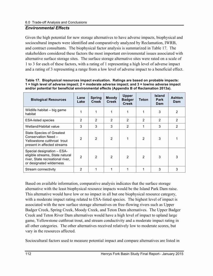
6.0 Trade-off Analysis and Conclusions
112 Henrys Fork Basin Study Final Report– January 2015
Environmental Effects
Given the high potential for new storage alternatives to have adverse impacts, biophysical and sociocultural impacts were identified and comparatively analyzed by Reclamation, IWRB, and contract consultants. The biophysical factor analysis is summarized in Table 17. The stakeholders considered these factors the most important environmental issues associated with alternative surface storage sites. The surface storage alternative sites were rated on a scale of 1 to 3 for each of these factors, with a rating of 1 representing a high level of adverse impact and a rating of 3 representing a range from a low level of adverse impact to a beneficial effect.
Table 17. Biophysical resources impact evaluation. Ratings are based on probable impacts: 1 = high level of adverse impact; 2 = moderate adverse impact; and 3 = low/no adverse impact and/or potential for beneficial environmental effects (Appendix B of Reclamation 2013a).
Biological Resources Lane Lake
Spring Creek
Moody Creek
Upper Badger Creek
Teton Island Park Dam
Ashton Dam
Wildlife habitat – big game habitat 1 1 1 1 1 3 2
ESA-listed species 2 2 2 2 2 2 2
Wetland/Habitat value 3 3 3 2 1 3 2
State Species of Greatest Conservation Need – Yellowstone cutthroat trout present in affected streams
2 2 2 1 2 3 1
Special designation – ESA-eligible streams, State natural river, State recreational river, or designated wilderness
2 2 2 2 2 3 3
Stream connectivity 2 1 1 1 1 3 3
Based on available information, comparative analysis indicates that the surface storage alternative with the least biophysical resource impacts would be the Island Park Dam raise. This alternative would have low or no impact in all but one biophysical resource category, with a moderate impact rating related to ESA-listed species. The highest level of impact is associated with the new surface storage alternatives on free-flowing rivers such as Upper Badger Creek, Spring Creek, Moody Creek, and Teton Dam alternatives. The Upper Badger Creek and Teton River Dam alternatives would have a high level of impact to upland large game, Yellowstone cutthroat trout, and stream conductivity and a moderate impact rating in all other categories. The other alternatives received relatively low to moderate scores, but vary in the resources affected.
Sociocultural factors used to measure potential impact and compare alternatives are listed in
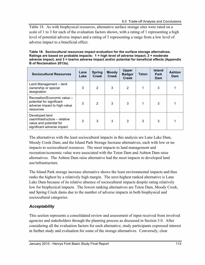
6.0 Trade-off Analysis and Conclusions
January 2015 - Henrys Fork Basin Study Final Report 113
Table 18. As with biophysical resources, alternative surface storage sites were rated on a scale of 1 to 3 for each of the evaluation factors shown, with a rating of 1 representing a high level of potential adverse impact and a rating of 3 representing a range from a low level of adverse impact to a beneficial effect.
Table 18. Sociocultural resources impact evaluation for the surface storage alternatives. Ratings are based on probable impacts: 1 = high level of adverse impact; 2 = moderate adverse impact; and 3 = low/no adverse impact and/or potential for beneficial effects (Appendix B of Reclamation 2013a).
Sociocultural Resources Lane Lake
Spring Creek
Moody Creek
Upper Badger Creek
Teton Island Park Dam
Ashton Dam
Land Management – land ownership or special designation
3 2 3 2 1 3 1
Recreation/Economic value – potential for significant adverse impact to high-value resources
3 2 3 3 1 3 1
Developed land use/infrastructure – relative value and potential for significant adverse impact
3 3 3 3 3 3 1
The alternatives with the least sociocultural impacts in this analysis are Lane Lake Dam, Moody Creek Dam, and the Island Park Storage Increase alternatives, each with low or no impacts to sociocultural resources. The most impacts to land management and recreation/economic value were associated with the Teton Dam and Ashton Dam raise alternatives. The Ashton Dam raise alternative had the most impacts to developed land use/infrastructure.
The Island Park storage increase alternative shows the least environmental impacts and thus ranks the highest by a relatively high margin. The next-highest ranked alternative is Lane Lake Dam because of its relative absence of sociocultural impacts despite rating relatively low for biophysical impacts. The lowest ranking alternatives are Teton Dam, Moody Creek, and Spring Creek dams due to the number of adverse impacts in both biophysical and sociocultural categories.
Acceptability
This section represents a consolidated review and assessment of input received from involved agencies and stakeholders through the planning process as discussed in Section 5.0. After considering all the evaluation factors for each alternative, study participants expressed interest in further study and evaluation for some of the storage alternatives. Conversely, clear
6.0 Trade-off Analysis and Conclusions
114 Henrys Fork Basin Study Final Report– January 2015
indications were provided regarding alternatives that either do not have broad support or would be actively opposed by participating stakeholder groups.
The Island Park Storage Increase alternative appears to have the highest degree of acceptance and support by irrigators, conservation groups, and IWRB for further evaluation and study. Since Island Park Dam is a Federal facility owned by Reclamation, there is a clear Federal nexus associated with this alternative and future Federal involvement in the planning processes would be necessary. IWRB and water users consider this to be a high State priority and are interested in further investigation of this alternative in the near future.
The Ashton Dam raise alternative also appears to have a certain degree of acceptance by the irrigators, conservation groups, and IWRB for further study; however, the willingness of its private owners to raise Ashton Dam has not yet been explored. The Ashton Dam status as a privately owned dam may eliminate any Federal nexus by Reclamation, but future Federal involvement in studies would be necessary because the Ashton Dam hydropower project is a FERC licensed project.
The two water storage alternatives in the Teton River basin have received mixed support. Conservation groups cautiously support further study of Lane Lake while water users and IWRB consider this alternative an option for long-term consideration if the economic value of water improves. This is also true for Teton Dam replacement. The Teton Dam alternative has the highest potential for new storage, but it also has the highest potential for adverse environmental impacts without obvious mitigation strategies.
6.2.2 Managed Groundwater Recharge Alternative
Effectiveness
Expansion of the Egin Lakes recharge site has the potential to enhance water supplies in the Henrys Fork River basin by improving groundwater table levels, increasing ecological flows to the Henrys Fork River in the late fall through groundwater return flows. Hydrogeologic and water availability analyses indicate that recharge in the Henrys Fork basin for the purpose of improving the condition of the ESPA is not as effective as focused recharge in locations downstream of American Falls Reservoir (Appendix C of Reclamation 2012b). Nevertheless, the studies indicate that recharge in the Henrys Fork River basin during above average water years can contribute to system-wide recharge capacity in the ESPA.
Recharge has been shown to have a positive effect on the late season streamflows, with much of the recharged water returning to the river in the late fall through groundwater return flows as measured at the St. Anthony stream gage. Hydrologic modeling of the proposed Egin Lakes recharge site expansion alternative shows an increase over the expected base flow conditions in the Ashton and Rexburg reaches in the late fall. Analysis shows this alternative to have a positive effect to the in-basin and out-of-basin water budgets and a clear benefit to
6.0 Trade-off Analysis and Conclusions
January 2015 - Henrys Fork Basin Study Final Report 115
late fall streamflows, which is predicted to be the area most impacted by projected climate changes.
Costs
Total costs for developing and expanding the Egin Lakes recharge site are lower than for developing new storage; however, unit costs are comparable to the unit costs associated with development of Lane Lake, which has the highest unit costs of new storage development ($4,600 per acre-foot) (Appendix C of Reclamation 2013b).
Environmental Impacts
Expanding recharge volume at the Egin Lakes would require consideration of potential impacts to the St. Anthony Dunes Special Recreation Management Area and the Sand Mountain Wilderness Study Area. Expansion of the recharge site is expected to have few other potential adverse biophysical and sociocultural impacts and may have beneficial impacts on streamflow below the St. Anthony gage. Flows would need to be managed with consideration to fisheries needs.
Acceptability
Recharge to support needs in the Henrys Fork River basin and the ESPA generally received wide support from involved agencies and the public. This support is also reflected in the State’s existing managed recharge program.
6.2.3 Water Marketing
The water marketing alternative does not lend itself to the kind of comparative analysis provided for the other alternatives, but it is common to all of the alternatives put forward in this Final Report. While markets (water banks and rental pools) are not capable of physically increasing water supply in the region, they are an important tool in managing existing water supplies. They are used to maximize the economic and/or environmental value of water by exchanging water rights that would have otherwise been unused and/or forfeited and to minimize the economic and/or environmental consequences of water shortages. These water management tools are already in use in the Henrys Fork River basin and throughout Water District 01 and can be expected to expand over time, especially in light of the predictions for climate change.
Effectiveness
The successes and limitation of Idaho’s water supply bank were analyzed and efforts to support and expand the existing water market system were identified (Appendix D of Reclamation 2013b). Improvement and/or expansion of the water market are difficult to quantify in terms of acre-feet or cfs and include many variables that do not fit in this Basin
6.0 Trade-off Analysis and Conclusions
116 Henrys Fork Basin Study Final Report– January 2015
Study’s evaluation criteria. Henrys Fork River basin alternatives that create water savings or new water development would play a role in future water markets statewide. There could be a wide range of benefits to the water budget in the basin and outside of the basin, but it would depend on site-specific details of each alternative.
Costs
Costs associated with improvement and expansion of the water markets in the Henrys Fork River basin would depend on many variables and range widely. Costs could be considered part of the existing IWRB water market program or considerable investment could be made in further study, analysis, and development of region-specific solutions.
Environmental Impacts
Environmental impacts caused by modifications to water markets would need further site-specific evaluations; however, local water budgets and related biophysical and sociocultural factors would be expected to benefit from modifications to market activity. The Water Transaction Program in the Teton River basin is the only alternative discussed that addresses stream connectivity and Yellowstone cutthroat trout issues in the basin. Modifications to water markets would also be part of the long-term water management program in the basin.
Acceptability
Stakeholders accept and support the water market alternative. Conservation groups are actively working with IWRB to improve markets specific to the Henrys Fork River basin.
6.2.4 Conservation Alternatives
The conservation alternatives (automation, piping, and agricultural demand reduction) do not lend themselves to the comparative analysis provided for the surface storage alternatives. Instead, each alternative is discussed individually with available indications of water volume, cost, and environmental effects addressed to the extent information is available. In each case, more information is provided in the corresponding sections of Section 5.5.
Effectiveness
Automating canals would allow irrigators to match diversions with irrigation requirements and reduce the demand for water, particularly late-season storage withdrawals, especially given the effects of projected climate changes. These benefits could have a significant value in the Henrys Fork River basin. Installation of automated gates at the nine principal stream diversion points in the basin could conserve a minimum of 1,687 acre-feet annually. Among the nine diversion points, individual water savings from gate installation would range from 92 to 333 acre-feet (Appendix E of Reclamation 2013b).
The replacement of canals with pipelines to limit water loss due to canal seepage was shown
6.0 Trade-off Analysis and Conclusions
January 2015 - Henrys Fork Basin Study Final Report 117
to be of practical benefit only in the North Fremont irrigated region (Appendix E of Reclamation 2013b). Irrigators in this region, in cooperation with the NRCS and IWRB, have installed several gravity pressurized pipeline systems, which have (1) increased total annual flows in the river, peak flows, and nonpeak flows; (2) reduced the demand for Fall River flows (both natural and stored water); and (3) saved energy. Overall, the pipelines and canal linings installed to date have reduced withdrawal from upstream storage by approximately 10,000 acre-feet annually. These water savings could help to mitigate for the expected increase in late season demands on storage throughout the Henrys Fork River basin due to climate change. Because of the interconnection between groundwater and surface water, pipelines in canals in the other irrigated regions (Teton Valley, Lower Watershed, and Egin Bench) would reduce later summer return flows to the Henrys Fork or Teton rivers and overall have a negligible effect on the water budget.
Agricultural demand reduction, as a means of managing local water supply and meeting State needs, would be implemented by changing farming practices to use less water or reducing the number of irrigated acres. Reducing or stopping irrigation would have different consequences to the water budget in different parts of the Henrys Fork River basin. In the North Fremont, Egin Bench, and Upper Teton Valley irrigated regions, reduced irrigation would generally have small positive effects on streamflows, mainly resulting in increases in nonpeak streamflows in the late summer season. In the Teton Valley and Lower Watershed irrigated regions, the modeled results showed a decrease in nonpeak flows, with varying degrees of adverse impact dependent on the percentage reduction in irrigation (Appendix E of Reclamation 2013b).
There are active State programs pursuing each of these strategies, including a program that provides financial assistance for irrigated-to-dryland crop conversions. Another program focuses on aquifer stabilization by promoting conversion of irrigation from groundwater to surface water sources.
Though specific data related to these programs in the Henrys Fork River basin was not gathered for this study, the programs are active in the basin and would be part of any water management strategy in the future.
Costs
The total cost for canal automation and gate installation at all nine principal stream diversion points is estimated to be $1,588,000, with individual location/facility costs ranging from approximately $68,000 to $262,000. The average cost per acre-foot would be $941, with individual location costs ranging from $491 to $2,843 per acre-foot. This unit cost is relatively low compared to the costs associated with developing new surface storage.
Current proposed projects for piping canals in the North Fremont irrigated region are estimated to cost $10 million. The total volume of water to be conserved by this project was
6.0 Trade-off Analysis and Conclusions
118 Henrys Fork Basin Study Final Report– January 2015
not determined for this report. Although the unit costs associated with conserved water are known to be high, the benefits are very positive for the ecological flows in the Henrys Fork River, as well as for the water users who would be able to apply the unused water to future unmet needs.
The cost for demand reduction through converting irrigated cropland to dryland farming or simply ceasing irrigation was estimated to be $1,860 per acre. For every acre placed in demand reduction, 2 to 5 acre-feet per acre are saved. The estimate for deficit irrigation, meaning the acre would be partially irrigated (e.g., irrigation may be stopped after only the second cutting of alfalfa hay), was estimated to be $3,600 per acre. The cost for deficit irrigation considered the loss of crop production during drought years which results in a higher lost crop value than simply ceasing irrigation during all years. This unit cost is relatively low compared to the costs associated with developing new storage.
Environmental Impacts
Overall, automated canals would reduce the demand for stored water withdrawal, which would improve management options in both the Henrys Fork River basin and the ESPA, have a positive impact on the basin’s overall water budget, and therefore, be expected to have positive biophysical and sociocultural impacts. For the North Fremont region, canal automation is estimated to increase nonpeak flows slightly. While this increase is relatively small, it still represents a positive environmental biophysical effect during periods of normally low flows. For the Teton Valley, Lower Watershed, and Egin Bench irrigated regions, canal automation could decrease nonpeak flows unless careful consideration of spring time operations was included as part of the alternative. Effects on the world-class rainbow trout fisheries in the Henrys Fork River, in the form of entrainment of trout in new diversions, could be mitigated by designing diversion structures with fish screens to prevent entrainment.
The canal piping alternative in the North Fremont region appears to benefit the Fall River and riverine biophysical environment by reducing diversion volume. Piping would eliminate canal seepage, thus reducing the irrigation-induced wetlands along the piped canals. Hydrologic analysis has shown that the Fall River and North Fremont irrigated regions do not have an interrelated groundwater-surface water relationship so piping in this region would not have negative biophysical effects to late season return flows to Fall River (Appendix E of Reclamation 2013b).
Demand reduction as an overall program may result in a reduction of flows during the critical low flow period throughout the basin. Further reduction of these flows from current baseline conditions would have negative environmental consequences; however, there may be some localized positive impacts on tributaries in the Teton Valley irrigated region that have flow connectivity issues late in the irrigation season.
Sociocultural impacts generally were not considered for conservation alternatives and would
6.0 Trade-off Analysis and Conclusions
January 2015 - Henrys Fork Basin Study Final Report 119
require additional analysis.
Acceptability
Water conservation is accepted by water users and conservation groups as a positive water management tool in the Henrys Fork River basin. Some water conservation and canal automation alternatives have similar water savings potential as the low-volume storage alternatives, such as Spring Creek Dam and Moody Creek Dam, but conservation alternatives may have fewer environmental impacts, and, in some cases, have lower implementation costs.
There are several State and Federal programs specifically designed to support implementation of water conservation projects. Local sponsors’ interested in moving water conservation alternatives forward could utilize State and Federal grant/financial assistance programs.
7.0 Next Steps
120 Henrys Fork Basin Study Final Report– January 2015
7.0 NEXT STEPS The findings of this study make it clear that a meaningful contribution to meeting the existing and future water supply needs of the Henrys Fork River basin, as well as such high State priorities as the ESPA, will not result from the implementation of any single action. Rather, meeting these needs successfully will require implementing a long-term integrated program of actions over a period of years. Pursuing multiple alternatives identified in this and other studies is likely to be necessary.
This Final Report provides a summary of the final evaluations of alternatives that were the most viable or in which there was significant interest by stakeholders. All of the alternatives could potentially address one or more of the water needs, but each alternative or group of alternatives has different requirements and potential obstacles for implementation. This report is not a decision document, but is intended to be a resource for any individual or group, private or public, who may seek to advance an alternative(s).
Drawing upon the results of this Basin Study, IWRB intends to release an independent report outlining possible implementation actions by IWRB and the State to support the objectives of the ESPA CAMP and to comply with Idaho House Joint Memorial 8, Senate Bill 1511 and the State Water Plan. The information generated through the Basin Study and recommendations identified in the independent report are intended to be used by the State of Idaho to inform immediate and future decisions to pursue potential options, where to focus current investments in water management infrastructure, and explore financing strategies to implement identified options.
More rigorous analyses would be necessary before progressing with an alternative or combination of alternatives. Public acceptability will likely require compromise and finding a balance that all participants can support. Maximizing the benefits for all categories of need is most likely not feasible, and as a result, projects that meet the identified agricultural, environmental, and ESPA water supply needs will likely take priority.
Obtaining sufficient funding for a publicly acceptable action would be a necessary initial step toward implementation of any alternative. Depending on the total cost, an interested stakeholder could move forward with funding on its own or seek partnerships with Federal, state, and/or local entities. State and Federal appropriations are difficult to secure. A number of funding sources may be required to implement any action.
Actions may also require resolution of legal issues, permitting requirements, and in some instances, private ownership of land and facilities. If project implementation were to trigger litigation, additional costs could divert funds from implementation of the action.
Any Federal involvement would likely require compliance with the NEPA, ESA, National
7.0 Next Steps
January 2015 - Henrys Fork Basin Study Final Report 121
Historic Preservation Act, and other Federal statutes. New administrative actions such as potential new ESA listings and designations of National Wild and Scenic Rivers System streams in the Basin Study area could arise, requiring adjustments not considered in this Basin Study.
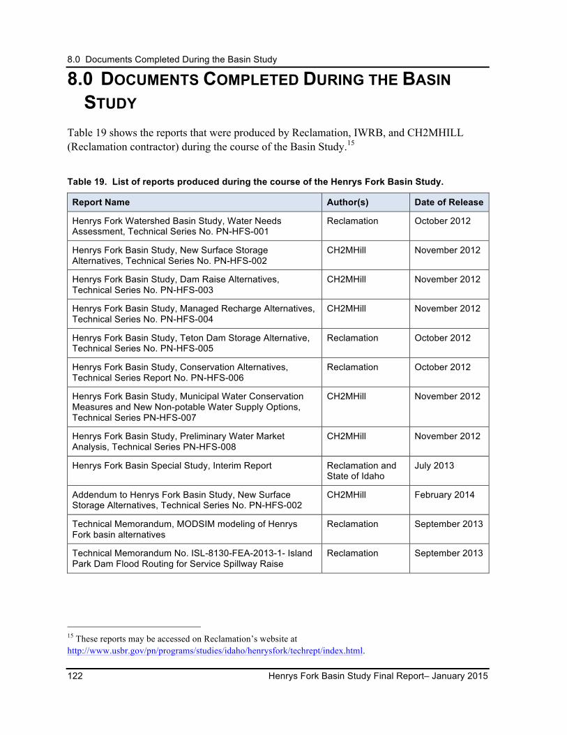
8.0 Documents Completed During the Basin Study
122 Henrys Fork Basin Study Final Report– January 2015
8.0 DOCUMENTS COMPLETED DURING THE BASIN STUDY
Table 19 shows the reports that were produced by Reclamation, IWRB, and CH2MHILL (Reclamation contractor) during the course of the Basin Study.15
Table 19. List of reports produced during the course of the Henrys Fork Basin Study.
Report Name Author(s) Date of Release
Henrys Fork Watershed Basin Study, Water Needs Assessment, Technical Series No. PN-HFS-001
Reclamation October 2012
Henrys Fork Basin Study, New Surface Storage Alternatives, Technical Series No. PN-HFS-002
CH2MHill November 2012
Henrys Fork Basin Study, Dam Raise Alternatives, Technical Series No. PN-HFS-003
CH2MHill November 2012
Henrys Fork Basin Study, Managed Recharge Alternatives, Technical Series No. PN-HFS-004
CH2MHill November 2012
Henrys Fork Basin Study, Teton Dam Storage Alternative, Technical Series No. PN-HFS-005
Reclamation October 2012
Henrys Fork Basin Study, Conservation Alternatives, Technical Series Report No. PN-HFS-006
Reclamation October 2012
Henrys Fork Basin Study, Municipal Water Conservation Measures and New Non-potable Water Supply Options, Technical Series PN-HFS-007
CH2MHill November 2012
Henrys Fork Basin Study, Preliminary Water Market Analysis, Technical Series PN-HFS-008
CH2MHill November 2012
Henrys Fork Basin Special Study, Interim Report Reclamation and State of Idaho
July 2013
Addendum to Henrys Fork Basin Study, New Surface Storage Alternatives, Technical Series No. PN-HFS-002
CH2MHill February 2014
Technical Memorandum, MODSIM modeling of Henrys Fork basin alternatives
Reclamation September 2013
Technical Memorandum No. ISL-8130-FEA-2013-1- Island Park Dam Flood Routing for Service Spillway Raise
Reclamation September 2013
15 These reports may be accessed on Reclamation’s website at http://www.usbr.gov/pn/programs/studies/idaho/henrysfork/techrept/index.html.
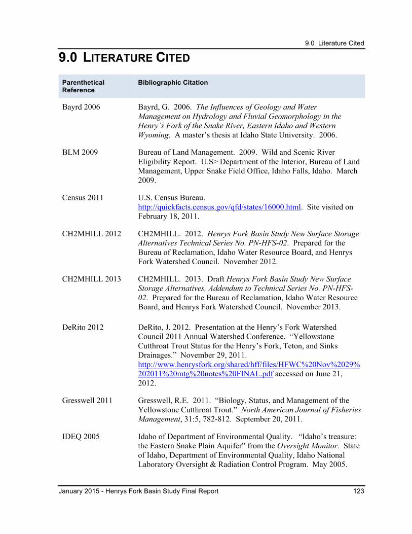
9.0 Literature Cited
January 2015 - Henrys Fork Basin Study Final Report 123
9.0 LITERATURE CITED Parenthetical Reference
Bibliographic Citation
Bayrd 2006 Bayrd, G. 2006. The Influences of Geology and Water Management on Hydrology and Fluvial Geomorphology in the Henry’s Fork of the Snake River, Eastern Idaho and Western Wyoming. A master’s thesis at Idaho State University. 2006.
BLM 2009 Bureau of Land Management. 2009. Wild and Scenic River Eligibility Report. U.S> Department of the Interior, Bureau of Land Management, Upper Snake Field Office, Idaho Falls, Idaho. March 2009.
Census 2011 U.S. Census Bureau. http://quickfacts.census.gov/qfd/states/16000.html. Site visited on February 18, 2011.
CH2MHILL 2012 CH2MHILL. 2012. Henrys Fork Basin Study New Surface Storage Alternatives Technical Series No. PN-HFS-02. Prepared for the Bureau of Reclamation, Idaho Water Resource Board, and Henrys Fork Watershed Council. November 2012.
CH2MHILL 2013 CH2MHILL. 2013. Draft Henrys Fork Basin Study New Surface Storage Alternatives, Addendum to Technical Series No. PN-HFS-02. Prepared for the Bureau of Reclamation, Idaho Water Resource Board, and Henrys Fork Watershed Council. November 2013.
DeRito 2012 DeRito, J. 2012. Presentation at the Henry’s Fork Watershed Council 2011 Annual Watershed Conference. “Yellowstone Cutthroat Trout Status for the Henry’s Fork, Teton, and Sinks Drainages.” November 29, 2011. http://www.henrysfork.org/shared/hff/files/HFWC%20Nov%2029%202011%20mtg%20notes%20FINAL.pdf accessed on June 21, 2012.
Gresswell 2011 Gresswell, R.E. 2011. “Biology, Status, and Management of the Yellowstone Cutthroat Trout.” North American Journal of Fisheries Management, 31:5, 782-812. September 20, 2011.
IDEQ 2005 Idaho of Department of Environmental Quality. “Idaho’s treasure: the Eastern Snake Plain Aquifer” from the Oversight Monitor. State of Idaho, Department of Environmental Quality, Idaho National Laboratory Oversight & Radiation Control Program. May 2005.
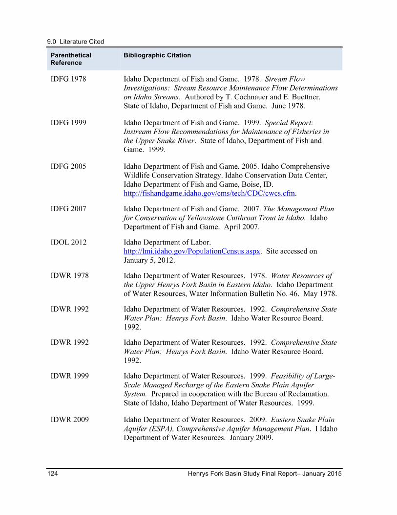
9.0 Literature Cited
124 Henrys Fork Basin Study Final Report– January 2015
Parenthetical Reference
Bibliographic Citation
IDFG 1978 Idaho Department of Fish and Game. 1978. Stream Flow Investigations: Stream Resource Maintenance Flow Determinations on Idaho Streams. Authored by T. Cochnauer and E. Buettner. State of Idaho, Department of Fish and Game. June 1978.
IDFG 1999 Idaho Department of Fish and Game. 1999. Special Report: Instream Flow Recommendations for Maintenance of Fisheries in the Upper Snake River. State of Idaho, Department of Fish and Game. 1999.
IDFG 2005 Idaho Department of Fish and Game. 2005. Idaho Comprehensive Wildlife Conservation Strategy. Idaho Conservation Data Center, Idaho Department of Fish and Game, Boise, ID. http://fishandgame.idaho.gov/cms/tech/CDC/cwcs.cfm.
IDFG 2007 Idaho Department of Fish and Game. 2007. The Management Plan for Conservation of Yellowstone Cutthroat Trout in Idaho. Idaho Department of Fish and Game. April 2007.
IDOL 2012 Idaho Department of Labor. http://lmi.idaho.gov/PopulationCensus.aspx. Site accessed on January 5, 2012.
IDWR 1978 Idaho Department of Water Resources. 1978. Water Resources of the Upper Henrys Fork Basin in Eastern Idaho. Idaho Department of Water Resources, Water Information Bulletin No. 46. May 1978.
IDWR 1992 Idaho Department of Water Resources. 1992. Comprehensive State Water Plan: Henrys Fork Basin. Idaho Water Resource Board. 1992.
IDWR 1992 Idaho Department of Water Resources. 1992. Comprehensive State Water Plan: Henrys Fork Basin. Idaho Water Resource Board. 1992.
IDWR 1999 Idaho Department of Water Resources. 1999. Feasibility of Large-Scale Managed Recharge of the Eastern Snake Plain Aquifer System. Prepared in cooperation with the Bureau of Reclamation. State of Idaho, Idaho Department of Water Resources. 1999.
IDWR 2009 Idaho Department of Water Resources. 2009. Eastern Snake Plain Aquifer (ESPA), Comprehensive Aquifer Management Plan. I Idaho Department of Water Resources. January 2009.
9.0 Literature Cited
January 2015 - Henrys Fork Basin Study Final Report 125
Parenthetical Reference
Bibliographic Citation
IDWR 2012a Idaho Department of Water Resources. 2012. Idaho Department of Water Resources Annual Report 2012. http://www.idwr.idaho.gov/WaterManagement/WaterRights/WaterSupply/pdfs/2012%20annual%20report.pdf accessed on February 4, 2014. Idaho Department of Water Resources 2012.
IDWR 2013 Idaho Department of Water Resources. 2013. 2013 Water District 1 Rental Pool Procedures. Accessed at http://www.idwr.idaho.gov/WaterManagement/WaterRights/waterSupply/PDFs/2013%20Rental%20Pool%20Rules-Proposed%201-3-13.pdf on September 9, 2013.
IDWR 2014a Idaho Department of Water Resources. 2014. http://maps.idwr.idaho.gov/StateProtectedStreams/Plan accessed on January 10, 2014.
ISWCC 2013 Idaho Soil and Water Conservation Commission. 2013. Accessed at http://swc.idaho.gov/what-we-do/district-support on September 9, 2013.
IWRB 1992 Idaho Water Resource Board. 1992. Comprehensive State Water Plan: Henrys Fork Basin. Idaho Water Resource Board. 1992.
IWRB 2009 Idaho Water Resource Board. 2009. Eastern Snake Plain Aquifer Comprehensive Aquifer Management Plan. Boise, Idaho. January 2009.
IWRB 2010 Memorandum to the Idaho Water Resource Board from Bill Quinn, Recharge Coordinator, dated September 14, 2010. Subject: 2010 Early Season ESPA Recharge Summary and Late Season Plan.
IWRB 2012a Idaho Department of Water Resources. 2012. Idaho State Water Plan. Idaho Water Resource Board, Boise Idaho. November 2012.
IWRB 2012b Memorandum to the Idaho Water Resource Board from Bill Quinn, Recharge Coordinator, dated January 17, 2012. Subject: 2012 Eastern Snake Plain Aquifer Recharge Summary Expected Recharge Activities for 2012.
LIHI 2010 Low Impact Hydropower Institute. http://www.lowimpacthydro.org/lihi-pending-application-ferc-no.-2381-ashton-hydroelectric-project-henrys-fork-river-idaho.html. Accessed on June 12, 2012.
9.0 Literature Cited
126 Henrys Fork Basin Study Final Report– January 2015
Parenthetical Reference
Bibliographic Citation
Loomis 2005 Loomis, John. 2005. The Economic Value of Recreational Fishing & Boating to Visitors & Communities along the Upper Snake River. Dr. John Loomis, Department of Agricultural and Resource Economics, Coloration State University. May 2005. http://www.tu.org/atf/cf/%7B0D18ECB7-7347-445B-A38E-65B282BBBD8A%7D/Final%20Loomis%20%20HFF%20TU%20SR%20Full%20Report%205-02-05.pdf accessed on June 11, 2012.
NASS 2012 National Agricultural Statistics Service. U.S. Department of Agriculture. Idaho Statistics, County Estimates. http://www.nass.usda.gov/Statistics_by_State/Idaho/Publications/County_Estimates/index.asp accessed on January 17, 2012.
NPS 2014 National Park Service. “Greater Yellowstone Ecosystem.” U.S. Department of the Interior, National Park Service. http://www.nps.gov/yell/planyourvisit/upload/RI_2013_ecosystem.pdf accessed on February 3, 2014.
Orloff et al. 2005 Orloff, S., D. Putnam, B. Hanson, and H. Carlson. 2005. Implications of Deficit Irrigation Management of Alfalfa. California Alfalfa and Forage Symposium, Visalia, California. University of California, Davis, California. December 2005.
Reclamation 1980 Bureau of Reclamation. 1980. Modification of Island Park Dam, Stage Two, Minidoka Project, Idaho-Wyoming. U.S. Department of the Interior, Bureau of Reclamation, Pacific Northwest Regional Office, Boise, Idaho. June 1980.
Reclamation 1991 Bureau of Reclamation. 1980. Teton Dam Reappraisal Working Document. U.S. Department of the Interior, Bureau of Reclamation, Pacific Northwest Regional Office, Boise, Idaho. February 1991.
Reclamation 2004 Bureau of Reclamation. 2004. Final Environmental Assessment, Fremont-Madison Irrigation District Proposed Title Transfer, Minidoka Project, Idaho-Wyoming. U.S. Department of the Interior, Bureau of Reclamation, Pacific Northwest Regional Office, Boise, Idaho. September 2004.
Reclamation 2006 Bureau of Reclamation. 2006. Teton River Canyon Resource Management Plan. U.S. Department of the Interior, Bureau of Reclamation, Pacific Northwest Regional Office, Boise, Idaho. December 2006.
9.0 Literature Cited
January 2015 - Henrys Fork Basin Study Final Report 127
Parenthetical Reference
Bibliographic Citation
Reclamation 2011 Bureau of Reclamation. 2011. Climate and Hydrology Datasets for Use in the RMJOC Agencies’ Longer-Term Planning Studies: Part II – Reservoir Operations Assessment for Reclamation Tributary Basins. U.S. Department of the Interior, Bureau of Reclamation, Pacific Northwest Regional Office, Boise, Idaho. January 2011.
Reclamation 2012 Bureau of Reclamation. 2012. Henrys Fork Basin Study Water Needs Assessment. U.S. Department of the Interior, Bureau of Reclamation, Pacific Northwest Regional Office, Boise, Idaho. October 2012.
Reclamation 2013a Bureau of Reclamation. 2012. Henrys Fork Basin Special Study Interim Report. U.S. Department of the Interior, Bureau of Reclamation, Pacific Northwest Regional Office, Boise, Idaho. July 2013.
Reclamation 2013b Bureau of Reclamation. 2013. Technical Memorandum, MODSIM modeling of Henrys Fork basin alternatives. U.S. Department of the Interior, Bureau of Reclamation, Pacific Northwest Regional Office, Boise, Idaho. September 2013.
Reclamation 2013c Bureau of Reclamation. 2013. Technical Memorandum No. ISL-8130-FEA-2013-1- Island Park Dam Flood Routing for Service Spillway Raise, Minidoka Project, Idaho, Pacific Northwest Region. Sensitive – For Official Use Only. U.S. Department of the Interior, Bureau of Reclamation, Technical Service Center, Denver Colorado. September 2013.
SR3 2001 Snake River Resources Review. 2001. Aquatics Resources Parameters Manual. March 2001.
Van Kirk 2011 Van Kirk, R. 2011. “Conservation of surface and groundwater in a Western watershed experiencing rapid loss of irrigated agricultural land to development.” Presentation to the Henrys Fork Watershed Council, Boise, Idaho. January 11, 2011.
Van Kirk 2012 Van Kirk, R. 2012. “Components of Irrigation Water Budget Related Sprinkler Application.” http://www.humboldt.edu/henrysfork/Documents_Presentations/sprinkler%20irrig.pdf accessed on June 20, 2012.
9.0 Literature Cited
128 Henrys Fork Basin Study Final Report– January 2015
Parenthetical Reference
Bibliographic Citation
Van Kirk 2013 Van Kirk, R. 2013. “Teton Valley Groundwater – Surface Water Model.” September 23, 2013. May be found at http://www.humboldt.edu/henrysfork/Documents_Presentations/TV%20GW-SW%20model.pdf. Accessed on December 9, 2013.
Van Kirk and Jenkins 2005
Van Kirk, R. and A. Jenkins. 2005. Hydrologic Alteration in the Upper Teton Watershed and Its Implications for Cutthroat Trout Restoration. Completed for Friends of the Teton River, Driggs, Idaho. January 2005.
Van Kirk et al. 2011 Van Kirk, R., S. Rupp, and J. De Rito. Ecological Streamflow Needs in the Henry’s Fork Watershed. Paper presented to Henry’s Fork Watershed Council by Van Kirk (Humboldt State University), Rupp (Friends of the Teton River), and De Rito (Henry’s Fork Foundation). September 2011.
Western 2012 Western Governors’ Association and Western States Water Council. 2012. Water Transfers in the West: Projects, Trends, and Leading Practices in Voluntary Water Trading. The Western Governors’ Association, Denver, Colorado and Western States Water Council, Murray, Utah. December 2012.