Embed Size (px)
Citation preview
Prepared by: Andre Pentz Pr.Arch Pr.Plan UDISA APHP Urban Design Services cc
PO Box 30595 TOKAI 7966 E-mail: [email protected] Tel: 021 7121861 Fax: 021 7128014
HERITAGE IMPACT ASSESSMENT (HIA) REPORT Draft for Comment
HWC CASE NO. 14102807AS1029E
The Conradie Better Living Model Exemplar Project (“BLMEP”) Unregistered Erf 169125 of Rem. 112657 Pinelands-Thornton
08 April 2016 Prepared by Urban Design Services cc
for the Western Cape Government Department of Transport and Public Works
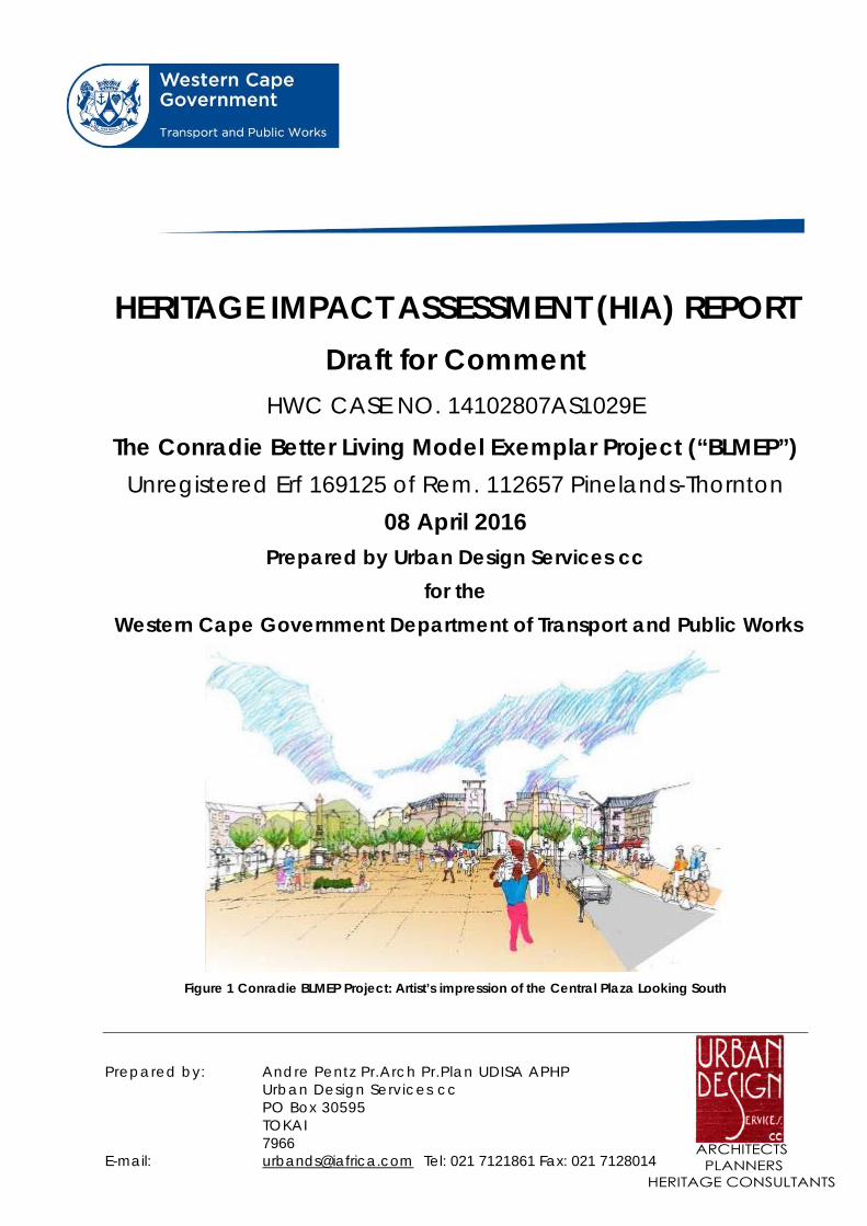
Figure 1 Conradie BLMEP Project: Artist’s impression of the Central Plaza Looking South

CONRADIE BLMEP HIA (Draft for Comment) Urban Design Services cc APRIL 2016 Page 1 of 40
CONTENTS
1 Executive Summary .................................................................................................................................... 4
2 Background ................................................................................................................................................ 5
2.1 Terms of Reference ................................................................................................................................ 5
2.2 Property Details: .................................................................................................................................... 6
2.3 Context ................................................................................................................................................... 7
2.4 Planning Context .................................................................................................................................. 12
2.5 Town Planning ...................................................................................................................................... 12
2.6 Environmental and Heritage Approvals ............................................................................................... 12
3 Heritage Resources .................................................................................................................................. 13
3.1 Brief History of the Site ........................................................................................................................ 13
3.2 Description and Mapping of Heritage Resources ................................................................................ 15
3.3 Heritage Resources in the Environs ..................................................................................................... 20
4 Significance and Grading .......................................................................................................................... 22
4.1 Heritage Significance ............................................................................................................................ 22
4.2 Statement of Significance .................................................................................................................... 22
4.3 Grading of Heritage Resources ............................................................................................................ 22
5 Heritage Indicators ................................................................................................................................... 22
6 Proposed Development ........................................................................................................................... 23
6.1 General Description of the Proposed Development ............................................................................ 23
6.2 Concept Development and Exploration of Alternatives (ARG Design) ................................................ 23
7 Impacts and Mitigation ............................................................................................................................ 31
7.1 Anticipated Impacts on Heritage Resources on the Site ..................................................................... 31
7.2 Anticipated Impacts on Heritage Resources External to the Site ........................................................ 35
7.3 Visual Impact Assessment (Annexure 2) .............................................................................................. 35
7.4 Summary Statement of Impacts and Mitigation .................................................................................. 35
8 Draft Recommendations .......................................................................................................................... 36
Annexures ........................................................................................................................................................ 37
Annexure 1/ HWC Response to Notification of Intent to Develop 12‐11‐2014 .............................................. 38
Annexure 2/ VIA Report Prepared by OVP Associates ..................................................................................... 39

CONRADIE BLMEP HIA (Draft for Comment) Urban Design Services cc APRIL 2016 Page 2 of 40
Table of Figures
Figure 1 Conradie BLMEP Project: Artist’s impression of the Central Plaza Looking South .............................. 0
Figure 2 Locality Plan ......................................................................................................................................... 6
Figure 3 View of the site with demolished buildings looking west towards Table Mountain ........................... 7
Figure 4 Aerial Photograph (Source: Google Maps: 08‐04‐2016) .................................................................... 8
Figure 5 Proposed Odin‐Aerodrome link (Source: Google Earth 12‐01‐2016) .................................................. 9
Figure 6 Constraints Plan (ARG Design) ........................................................................................................... 11
Figure 7 Zoning Map Extract (COCT) ................................................................................................................ 12
Figure 8 Maitland and Pinelands environs, c1931 ........................................................................................... 13
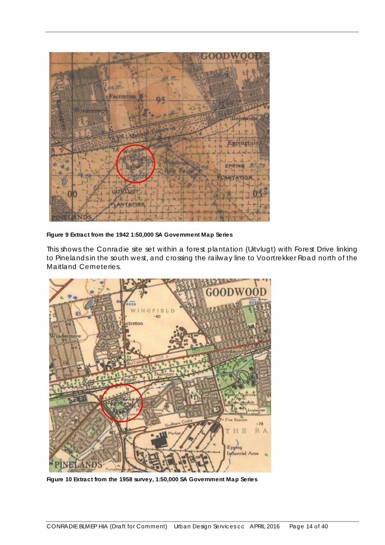
Figure 9 Extract from the 1942 1:50,000 SA Government Map Series ............................................................ 14
Figure 10 Extract from the 1958 survey, 1:50,000 SA Government Map Series ............................................. 14
Figure 11 Heritage Resources on the site, general location (Source: Google Earth 04‐04‐2016) ................... 15
Figure 12 Heritage Resources on the site, detail of Gateway Precinct (Source: Google Earth 04‐04‐2016) ... 16
Figure 13 View from Forest Drive of the entrance gateways and porter’s lodge ........................................... 16
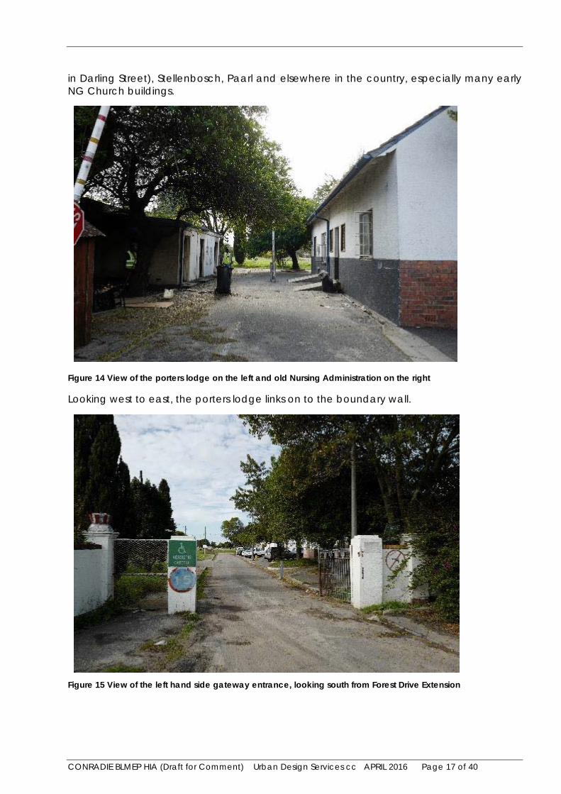
Figure 14 View of the porters lodge on the left and old Nursing Administration on the right ....................... 17
Figure 15 View of the left hand side gateway entrance, looking south from Forest Drive Extension ............ 17
Figure 16 View of the old Hall from the south east. ........................................................................................ 18
Figure 17 Interior view of the old Hall ............................................................................................................. 18
Figure 18 Old Nursing Administration Building, viewed from the south east ................................................. 19
Figure 19 Old Nursing Administration Building, internal view. The interior has been vandalized .................. 19
Figure 20 Heritage resources in the environs (Google Earth).......................................................................... 20
Figure 21 Heritage resources in the environs, Pinelands Jewish Cemeteries (Google Earth) ......................... 20
Figure 22 Entrance to Pinelands No 1 Jewish Cemetery off Forest Drive Extension ....................................... 21
Figure 23 Entrance to Pinelands No 2 Jewish Cemetery off Forest Drive Extension ....................................... 21
Figure 24 Variation 3a (ARG Design) ................................................................................................................ 24
Figure 25 Variation 3b (ARG Design) ................................................................................................................ 25
Figure 26 Variation 3c (ARG Design) ................................................................................................................ 26
Figure 27 Precinct plan (ARG Design) .............................................................................................................. 27
Figure 28 Building Heights (ARG Design) ......................................................................................................... 28
Figure 29 Landscape concept plan (ARG Design) ............................................................................................. 29
Figure 30 Phasing plan (ARG Design) ............................................................................................................... 30
Figure 31 3D view of the proposed development seen from the north (ARG Design) .................................... 31
Figure 32 Assessment of potential impacts: .................................................................................................... 32
Figure 33 Location of widening of existing gateway for road access .............................................................. 32
Figure 34 Detail Study of Gateway Precinct: Plan (ARG Design) ..................................................................... 33
Figure 35 Detail Study of Gateway Precinct: Sections (ARG Design) ............................................................... 34
Figure 36 Detail Study of Gateway Precinct: Axonometric (ARG Design) ........................................................ 34

CONRADIE BLMEP HIA (Draft for Comment) Urban Design Services cc APRIL 2016 Page 3 of 40
STATEMENT OF INDEPENDENCE AND EXPERTISE
Andre Pentz of Urban Design Services cc is an independent service provider and apart from fair remuneration for services rendered has no financial interest in the proposed development.
Andre Pentz is registered with SACAP (South African Council for the Architectural Profession) and SACPLAN (South African Council of Planners), is a member of UDISA (Urban Design Institute of South Africa) and APHP (Association of Professional Heritage Practitioners). He has over 30 years of experience working as a built environment professional, including 15 years as a heritage practitioner.

CONRADIE BLMEP HIA (Draft for Comment) Urban Design Services cc APRIL 2016 Page 4 of 40
1 Executive Summary
Urban Design Services cc has been authorised by the Western Cape Government Department of Transport and Public Works to prepare and submit an HIA for the proposed re-development of the former Conradie Hospital site.
This HIA (Draft for Comment) is confined to the potential impact of the proposed development on heritage resources within the site and immediate environs. A separate heritage scoping assessment is being conducted for the proposed Odin-Aerodrome Road link that will be required to meet the transportation needs of the full development. The HIA (Draft for Comment) will be finalized following a round of public comment. Comments received will be incorporated into a final HIA report to be submitted to HWC (Heritage Western Cape).
The Conradie Hospital was formally opened in 1938 as an institution for adults suffering from various chronic diseases. The main section of the hospital was closed in 2006, and the site has been dormant since. Following the closure of the facility most of the vacant buildings were vandalised and subsequently demolished. Remaining heritage resources include the old Hall, Nursing Administration building, porter’s lodge and entrance gateways. Other heritage resources include the remaining plantings of mature trees and remnants of the former internal road layout. North and east of the site are the Jewish (Pinelands 1 and 2) and Maitland Cemeteries.
The preferred design option provides a phased development that will accommodate in excess of 3600 residential units, commercial development and supporting infrastructure and amenities (schools, a clinic, community halls, green spaces and canal realignment).
Potential Impacts pertaining to the scale, height and massing of new buildings relative to the heritage buildings in the Gateway Precinct were assessed and mitigated.
A visual impact assessment was undertaken by OVP Associates. Apart from the existing heritage resources on the site and the adjoining Jewish Cemeteries, there are no other heritage resources in the vicinity that could be impacted by the proposed development. The significance of visual impacts on the Jewish cemetery adjoining the site were assessed in the VIA as being of medium impact. However this will not detract from the heritage significance of the cemetery as such.
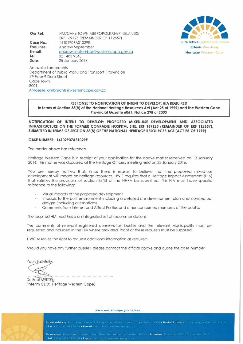
The objective of the HIA (Draft for Comment) report is to fulfil the requirements of HWC (Heritage Western Cape) as outlined in their Response to the NID (Notification of Intent to Develop) issued on the 25-01-2016, and Section 38(3) of the NHRA (National Heritage Resources Act No. 25 of 1999. The HIA fulfils these requirements apart from Section 38(3) (e): “the results of consultation with communities affected by the proposed development and other interested parties regarding the impact of the development on heritage resources”, which is the purpose of this report.
The draft recommendations are that Heritage Western Cape issues a ROD (Record of Decision) to endorse the HIA and allow the development to proceed subject to certain conditions.
CONRADIE BLMEP HIA (Draft for Comment) Urban Design Services cc APRIL 2016 Page 5 of 40
2 Background
2.1 Terms of Reference
Further to the submission by this firm of a Notification of Intent to Develop (NID) to Heritage Western Cape (HWC) on the 13th January 2016, HWC issued a Response to the NID on the 25th January 2016 (Annexure 1), requiring a Heritage Impact Assessment to be prepared in terms of Section 38 (3) of the National Heritage Resources Act (NHRA) no. 25 of 1999. (Annexure 1).
The following is required in terms of Section 38 (3) of the NHRA:
1 The identification and mapping of all heritage resources in the area affected;
2 an assessment of the significance of such resources in terms of the heritage assessment criteria set out in section 6(2) or prescribed under section 7;
3 an assessment of the impact of the development on such heritage resources;
4 an evaluation of the impact of the development on heritage resources relative to the sustainable social and economic benefits to be derived from the development:
a. the results of consultation with communities affected by the proposed development and other interested parties regarding the impact of the development on heritage resources;
b. if heritage resources will be adversely affected by the proposed development, the consideration of alternatives; and
c. plans for mitigation of any adverse effects during and after the completion of the proposed development.
The Response from HWC required the HIA to have specific reference to the following:
1 Visual impacts of the proposed development.
2 Impacts to the built environment including a detailed site development plan and conceptual designs (including alternatives),
3 Comments from Interested and Affected Parties and other concerned members of the public.
The required HIA must have an integrated set of recommendations.
The comments of relevant registered conservation bodies and the relevant Municipality must be requested and included in the HIA where provided. Proof of these requests must be supplied.
CONRADIE BLMEP HIA (Draft for Comment) Urban Design Services cc APRIL 2016 Page 6 of 40
Urban Design Services cc, the appointed Heritage Consultant, has been authorised by the Western Cape Government Department of Transport and Public Works to prepare and submit an HIA for the Comrade site. This HIA is confined to the potential impact of the proposed development on heritage resources within the site and immediate environs. A separate HIA is being conducted by Cindy Postlethwayt for the proposed Odin- Aerodrome Road link that will be required to meet the transportation needs of the proposed development.
This Draft for Comment HIA report will be finalised following a round of public comment. Comments including those of the City of Cape Town’s ERM Department will be incorporated into the final report to be submitted to HWC.
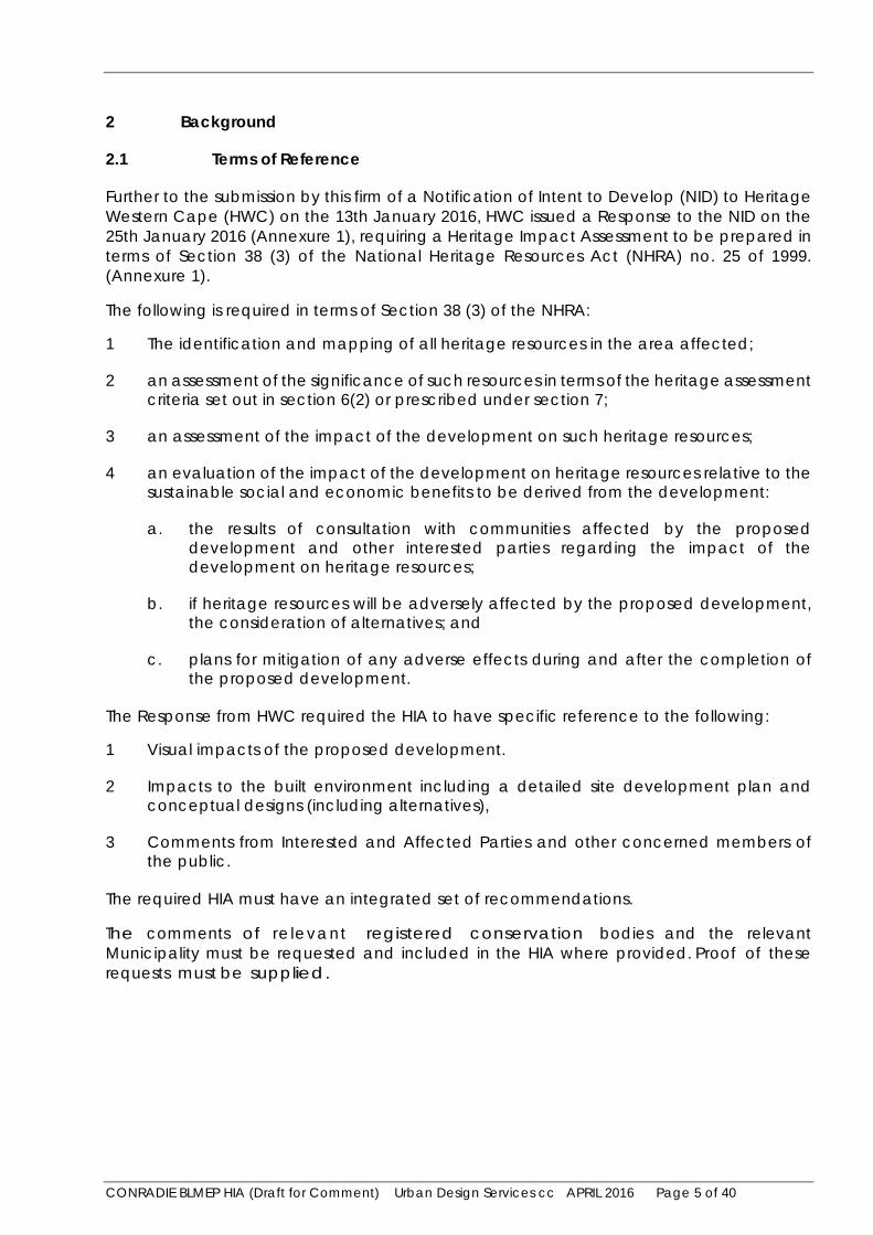
2.2 Property Details:
Name: Conradie Site. Unregistered Erf 169125 of Rem 112657. The existing Orthotics and Prosthetics Centre centre on the north east boundary of the site will remain on a separate Erf.
Location: Forest Drive Extension, Thornton.
Extent: 22ha
Responsible Local Authority: City of Cape Town
Current use: Vacant land and buildings
Surrounding land use: Residential, industry and cemeteries.
Registered owner: Western Cape Government (no restrictive conditions in the title deeds)
Figure 2 Locality Plan
THE
SITE
CONRADIE BLMEP HIA (Draft for Comment) Urban Design Services cc APRIL 2016 Page 7 of 40
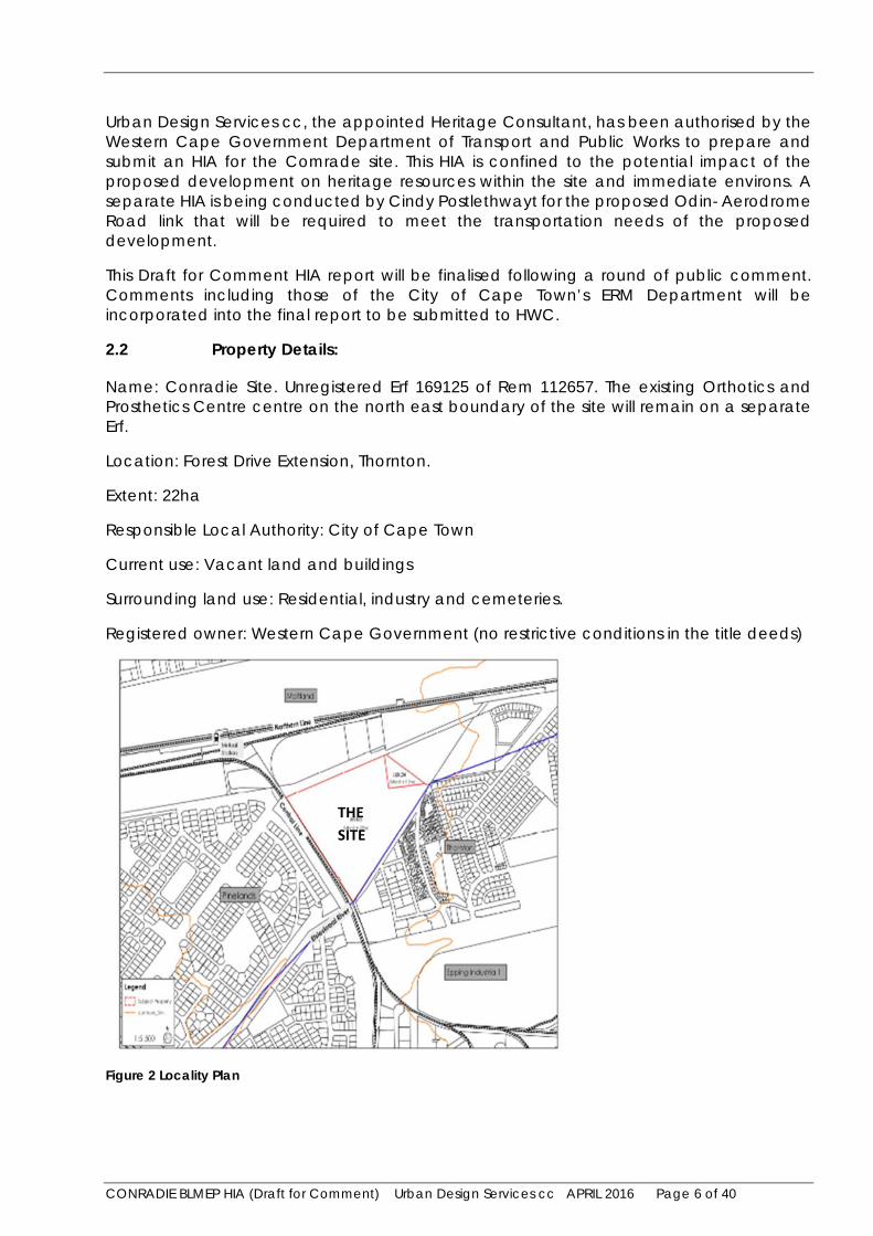
Figure 3 View of the site with demolished buildings looking west towards Table Mountain
(Note: the rubble from the demolished structures has subsequently been removed from the site).
2.3 Context
(Also refer to Figure 4 Aerial Photograph (Source: Google Maps: 08-04-2016) and Figure 7 Zoning Map Extract (COCT))
2.3.1 Views
Sweeping views of Table Mountain are located to the west of the site.
2.3.2 Edges
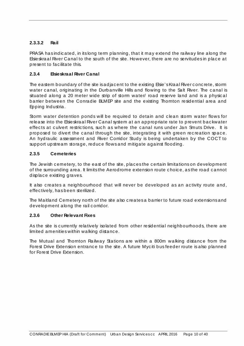
To the south of the site is the Elsieskraal River Canal and industrial area (Viking Industrial Park), which is characterized by vibracrete walls and does not allow for surveillance over the edge.
The design response to the Elsieskraal River Canal is important as it must also mitigate against flooding.
To the west of the site, the boundary is created by Jan Smuts Drive and the railway line. This does not allow for permeability and creates a hard edge to the site.
To the north is Forest Drive Extension. The interface of the future development with Forest Drive Extension is a further consideration. This would be the preferred location for commercial opportunities, related to the development of the site.

CONRADIE BLMEP HIA (Draft for Comment) Urban Design Services cc APRIL 2016 Page 8 of 40
To the east is the existing Orthotics and Prosthetics Centre (which will remain), and beyond this, the Pineland Jewish Cemetery No. 2.
Figure 4 Aerial Photograph (Source: Google Maps: 08-04-2016)
The aerial photograph (Figure 4) indicates the site cleared of redundant former hospital buildings and remnants of the internal layout and surrounding development.
Pinelands Jewish Cemetery No. 2
CONRADIE BLMEP HIA (Draft for Comment) Urban Design Services cc APRIL 2016 Page 9 of 40
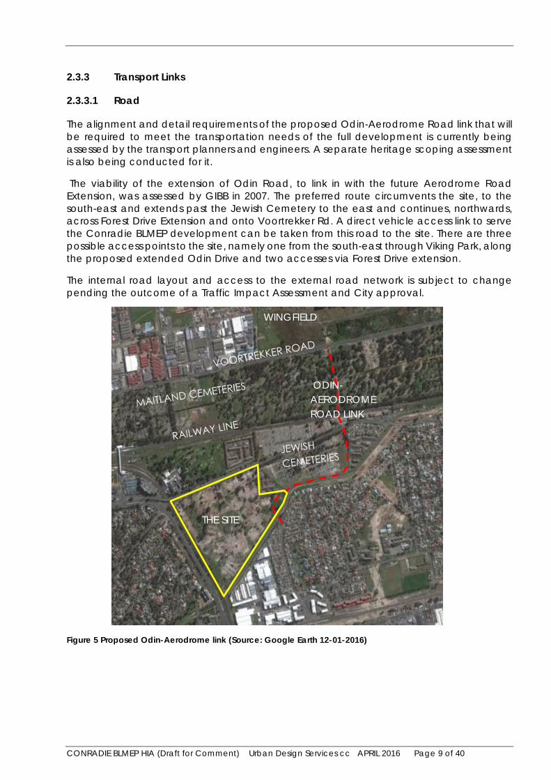
2.3.3 Transport Links
2.3.3.1 Road
The alignment and detail requirements of the proposed Odin-Aerodrome Road link that will be required to meet the transportation needs of the full development is currently being assessed by the transport planners and engineers. A separate heritage scoping assessment is also being conducted for it.
The viability of the extension of Odin Road, to link in with the future Aerodrome Road Extension, was assessed by GIBB in 2007. The preferred route circumvents the site, to the south-east and extends past the Jewish Cemetery to the east and continues, northwards, across Forest Drive Extension and onto Voortrekker Rd. A direct vehicle access link to serve the Conradie BLMEP development can be taken from this road to the site. There are three possible access points to the site, namely one from the south-east through Viking Park, along the proposed extended Odin Drive and two accesses via Forest Drive extension.
The internal road layout and access to the external road network is subject to change pending the outcome of a Traffic Impact Assessment and City approval.
Figure 5 Proposed Odin-Aerodrome link (Source: Google Earth 12-01-2016)
WINGFIELD
THE SITE
ODIN-AERODROME ROAD LINK
CONRADIE BLMEP HIA (Draft for Comment) Urban Design Services cc APRIL 2016 Page 10 of 40
2.3.3.2 Rail
PRASA has indicated, in its long term planning, that it may extend the railway line along the Elsieskraal River Canal to the south of the site. However, there are no servitudes in place at present to facilitate this.
2.3.4 Elsieskraal River Canal
The eastern boundary of the site is adjacent to the existing Elsie’s Kraal River concrete, storm water canal, originating in the Durbanville Hills and flowing to the Salt River. The canal is situated along a 20 meter wide strip of storm water/ road reserve land and is a physical barrier between the Conradie BLMEP site and the existing Thornton residential area and Epping Industria.
Storm water detention ponds will be required to detain and clean storm water flows for release into the Elsieskraal River Canal system at an appropriate rate to prevent backwater effects at culvert restrictions, such as where the canal runs under Jan Smuts Drive. It is proposed to divert the canal through the site, integrating it with green recreation space. An hydraulic assessment and River Corridor Study is being undertaken by the COCT to support upstream storage, reduce flows and mitigate against flooding.
2.3.5 Cemeteries
The Jewish cemetery, to the east of the site, places the certain limitations on development of the surrounding area. It limits the Aerodrome extension route choice, as the road cannot displace existing graves.
It also creates a neighbourhood that will never be developed as an activity route and, effectively, has been sterilized.
The Maitland Cemetery north of the site also creates a barrier to future road extensions and development along the rail corridor.
2.3.6 Other Relevant Fixes
As the site is currently relatively isolated from other residential neighbourhoods, there are limited amenities within walking distance.
The Mutual and Thornton Railway Stations are within a 800m walking distance from the Forest Drive Extension entrance to the site. A future Myciti bus feeder route is also planned for Forest Drive Extension.
CONRADIE BLMEP HIA (Draft for Comment) Urban Design Services cc APRIL 2016 Page 11 of 40
Figure 6 Constraints Plan (ARG Design)

CONRADIE BLMEP HIA (Draft for Comment) Urban Design Services cc APRIL 2016 Page 12 of 40
2.4 Planning Context
Figure 7 Zoning Map Extract (COCT)
2.5 Town Planning
The zoning of the site is currently Limited Use (LU) and a rezoning of the site to sub-divisional area to cater for the proposed mixed-use higher intensity development will have to be submitted to the City of Cape Town, and in terms of the City of Cape Town Municipal Planning Bylaw (CT MPBL).
The site is located within a TOD (Transit Oriented Development) proritisation zone that includes the Voortrekker Road Corridor.
2.6 Environmental and Heritage Approvals
An EIA (Environmental Impact Assessment) is not required to be done for the site (DEADP directive dated 2nd December 2015). Where there is no environmental process but there are heritage issues and an HIA is required, Heritage Western Cape is the decision making authority.
CONRADIE BLMEP HIA (Draft for Comment) Urban Design Services cc APRIL 2016 Page 13 of 40
3 Heritage Resources
3.1 Brief History of the Site
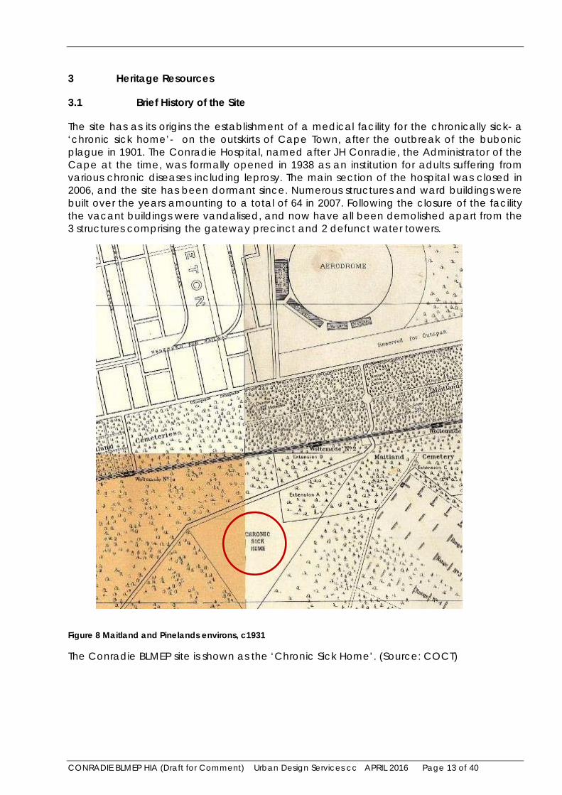
The site has as its origins the establishment of a medical facility for the chronically sick- a ‘chronic sick home’- on the outskirts of Cape Town, after the outbreak of the bubonic plague in 1901. The Conradie Hospital, named after JH Conradie, the Administrator of the Cape at the time, was formally opened in 1938 as an institution for adults suffering from various chronic diseases including leprosy. The main section of the hospital was closed in 2006, and the site has been dormant since. Numerous structures and ward buildings were built over the years amounting to a total of 64 in 2007. Following the closure of the facility the vacant buildings were vandalised, and now have all been demolished apart from the 3 structures comprising the gateway precinct and 2 defunct water towers.
Figure 8 Maitland and Pinelands environs, c1931
The Conradie BLMEP site is shown as the ‘Chronic Sick Home’. (Source: COCT)
CONRADIE BLMEP HIA (Draft for Comment) Urban Design Services cc APRIL 2016 Page 14 of 40
Figure 9 Extract from the 1942 1:50,000 SA Government Map Series
This shows the Conradie site set within a forest plantation (Uitvlugt) with Forest Drive linking to Pinelands in the south west, and crossing the railway line to Voortrekker Road north of the Maitland Cemeteries.
Figure 10 Extract from the 1958 survey, 1:50,000 SA Government Map Series

CONRADIE BLMEP HIA (Draft for Comment) Urban Design Services cc APRIL 2016 Page 15 of 40
This shows the expansion of Pinelands from the south west towards the site, the new suburb of Thornton to the east, and the Epping Industrial Area to the south. The Forest Drive link over the railway line has now been closed.
3.2 Description and Mapping of Heritage Resources
Heritage resources are contained within the Gateway Precinct of the former Conradie hospital and include the old Hall, Nursing Administration building, porter’s lodge and the entrance gateways. These structures are in various states of repair. Other heritage resources include the remaining plantings of mature trees and remnants of the former internal road layout. The structures were previously graded by Chris Snelling in the July 2007 heritage scoping report. The old hall and gateway structure including the porters lodge were was graded 3B and the Nursing Administration building a 3C.
Figure 11 Heritage Resources on the site, general location (Source: Google Earth 04-04-2016)
The internal road network of the former hospital, with diagonal axes centred on the administration centre, is typical of institutional planning of the period and “Garden Cities” town plans. The pyramidal arrangement of the layout also facilitated the staggering of ward buildings to maximise views for the occupants and exposure to sunlight, which was at the time considered essential for the treatment of patients in hospitals and convalescent homes.
GATEWAY PRECINCT
REMAINING
MATURE
TREES
REMNANTS OF
FORMER LAYOUT

CONRADIE BLMEP HIA (Draft for Comment) Urban Design Services cc APRIL 2016 Page 16 of 40
The buildings generally have pitched roofs with red Marseilles tiles, masonry walls plastered and painted externally and internally, skimmed plasterboard ceilings, timber doors and steel window frames. Floors are mainly suspended timber boards. The structures have red brick trimmings including window cills, copings and plinths (sometimes extended to window-cill height). The interior of the hall is classically detailed and includes teak paneling.
Figure 12 Heritage Resources on the site, detail of Gateway Precinct (Source: Google Earth 04-04-2016)
Figure 13 View from Forest Drive of the entrance gateways and porter’s lodge
Some of the buildings at the Conradie site are reputed 1to have been designed by the firm of Louw and Louw, established in Paarl in 1928. Wynand Louw was the first formally trained ‘Afrikaans-speaking‘ architect in South Africa, and his firm was responsible for many buildings in Cape Town (e.g. the Santam building in Wale Street and the Old Mutual building
1 Refer to the Artefacts website (Pretoria) for further information and also to Wikipedia for biographical details.
OLD HALL
ENTRANCE
GATEWAYS
AND PORTER’S
LODGE
OLD NURSING
ADMINISTRATION
BUILDING
CONRADIE BLMEP HIA (Draft for Comment) Urban Design Services cc APRIL 2016 Page 17 of 40
in Darling Street), Stellenbosch, Paarl and elsewhere in the country, especially many early NG Church buildings.
Figure 14 View of the porters lodge on the left and old Nursing Administration on the right
Looking west to east, the porters lodge links on to the boundary wall.
Figure 15 View of the left hand side gateway entrance, looking south from Forest Drive Extension
CONRADIE BLMEP HIA (Draft for Comment) Urban Design Services cc APRIL 2016 Page 18 of 40
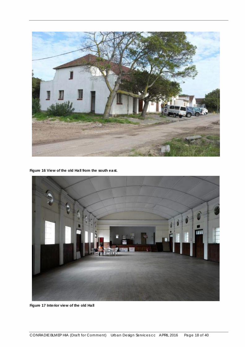
Figure 16 View of the old Hall from the south east.
Figure 17 Interior view of the old Hall
CONRADIE BLMEP HIA (Draft for Comment) Urban Design Services cc APRIL 2016 Page 19 of 40
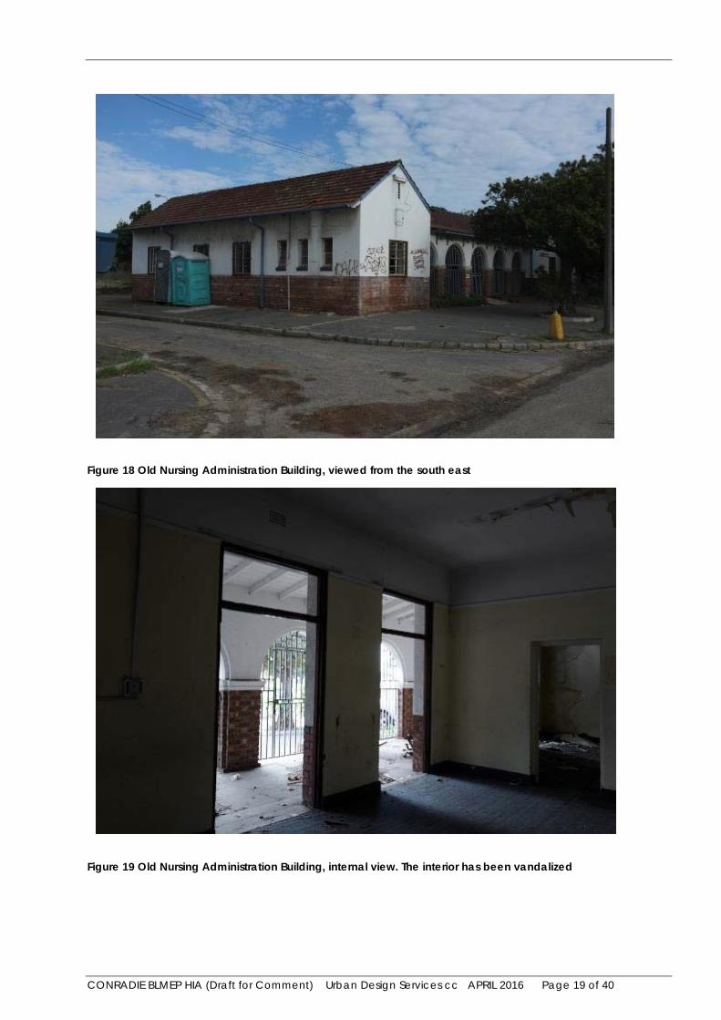
Figure 18 Old Nursing Administration Building, viewed from the south east
Figure 19 Old Nursing Administration Building, internal view. The interior has been vandalized

CONRADIE BLMEP HIA (Draft for Comment) Urban Design Services cc APRIL 2016 Page 20 of 40
3.3 Heritage Resources in the Environs
North-east and east of the site are the Jewish Cemeteries, Pinelands 1 and 2, respectively, and north of that the railway line, Maitland Cemeteries, Voortrekker Road and Wingfield, all of heritage and cultural significance. Further away, 3km to the south west of the site, is the early 20th century Pinelands ‘Garden City’ urban conservation area, defined by the Pinelands Heritage Protection Overlay Zone, part of the COCT’s Zoning Scheme.
Figure 20 Heritage resources in the environs (Google Earth)
Figure 21 Heritage resources in the environs, Pinelands Jewish Cemeteries (Google Earth)
WINGFIELD
PINELANDS
THE SITE
Pinelands Jewish
Cemetery No. 1
Pinelands Jewish
Cemetery No. 2 Anfield Village
CONRADIE SITE
Orthotics and
Prosthetic
Centre
C t
CONRADIE BLMEP HIA (Draft for Comment) Urban Design Services cc APRIL 2016 Page 21 of 40
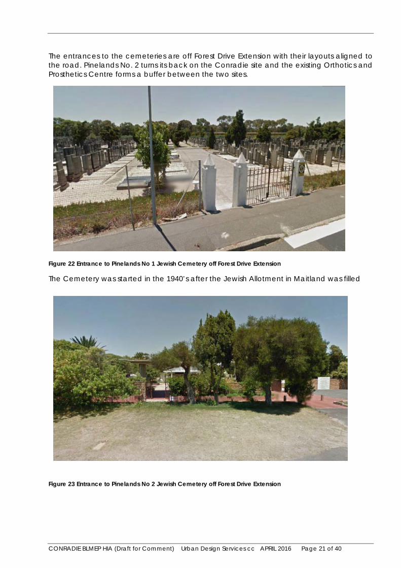
The entrances to the cemeteries are off Forest Drive Extension with their layouts aligned to the road. Pinelands No. 2 turns its back on the Conradie site and the existing Orthotics and Prosthetics Centre forms a buffer between the two sites.
Figure 22 Entrance to Pinelands No 1 Jewish Cemetery off Forest Drive Extension
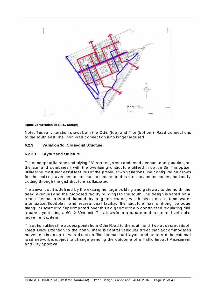
The Cemetery was started in the 1940’s after the Jewish Allotment in Maitland was filled
Figure 23 Entrance to Pinelands No 2 Jewish Cemetery off Forest Drive Extension

CONRADIE BLMEP HIA (Draft for Comment) Urban Design Services cc APRIL 2016 Page 22 of 40
The Cemetery was started after Pinelands No. 1 was filled. The Cemetery is not over 6o years in age and is not formally protected in terms of Section 34 of the NHRA Act (structures over 60 years in age), but is of social and cultural significance.
4 Significance and Grading
4.1 Heritage Significance
Apart from the Gateway Precinct that contained the administrative hub of the former hospital, and some mature trees that lined the internal road layout, there is little remaining of the hospital complex. The site as a whole is of limited heritage significance.
4.2 Statement of Significance
The site is a remnant of an institutional landscape with its origins related to an important event in Cape Town’s history (the 1901 Bubonic Plague), and following that the systematic displacement of social outcasts to the outskirts of the City - leading to the establishment of a ‘chronic sick home’ on the site, and then later in 1938 the Conradie Hospital. There are some remaining structures that formed the administrative core of an extensive medical facility and these have some intrinsic and associational value, albeit of local significance only. The Jewish cemeteries to the north and east of the site are of cultural, spiritual and social significance.
4.3 Grading of Heritage Resources
The Conradie site as a whole is ungradeable as there is limited heritage significance remaining. The Gateway Precinct is a 3B (some local significance), with individual structures therein 3B and 3C. E.g. the old Hall: 3B (some local significance), old Nursing Administration Building: 3C (limited local significance, mainly contextual); gateway structures including the porter’s lodge 3B (some local significance). The Jewish Cemeteries would be graded 3A (considerable local significance).
5 Heritage Indicators
The future development around the Gateway Precinct should be sympathetic in terms of its height, massing and scale relative to the existing heritage buildings on the site.
Heritage indicators arising out of the comments made by the Belcomm of HWC on the 22/11/20072 include:
1 The “gateway precinct” with its layout to be retained.
2 An information display on the history of the site to be incorporated into the development.
3 That element (sic) of the overall original layout was incorporated into the development.
2 This was in response to a heritage scoping document development prepared by Chris Snelling for a previous development application for the site. This was not implemented.

CONRADIE BLMEP HIA (Draft for Comment) Urban Design Services cc APRIL 2016 Page 23 of 40
4 That the recommendations as made in the tree survey were adhered to and that an attempt is made to incorporate any significant open spaces or avenues into the development.
These need to be implemented in any future development, including the adaptive re-use of existing gateway precinct structures for community facilities. There should be a visitors’ centre housing an interpretative display outlining the history of the site. The retention of suitable trees /avenues / open spaces to enhance the ‘sense of place’ is also indicated.
6 Proposed Development
6.1 General Description of the Proposed Development
6.1.1 Introduction
The Conradie Better Living Model Exemplar Project (Conradie BLMEP) seeks to deliver a model to efficiently plan, design and fund and develop the former Conradie Hospital site with residentially led, integrated and affordable mixed-use mixed-income and mixed-tenure development. The intention of the development is to address the apartheid spatial planning legacies and establish key, replicable levers to unlock state property. The project aims to develop the site into an integrated and inviting place where people can live, work and play.
The Western Cape Government Department of Transport and Public Works (The Department) received a mandate from the Provincial Cabinet and Inter-governmental Committee (IGC) to lead the project. The Department was set 1 April 2018 as the latest date for “sod-turning” and aims to deliver on its mandate with maximum integration and support of other government departments and the City of Cape Town. The development of the site will be procured through a Public-Private Partnership or other alternative mechanism.
The development is expected to deliver the following outcomes:
1 It must result in a changed social and economic role for site
2 It must allow for the development of a suitable housing model, across all income levels, replicable and viable
3 It should facilitate an effective and efficient government response
4 It should have a number of characteristics that position it as “class leading” if not “best in class”
6.2 Concept Development and Exploration of Alternatives (ARG Design)
ARG Design, the appointed urban designers and town planners, developed three design concept options that meet the criteria for a mixed use, residential based, green alternative. These options were numbered 3a, 3b and 3c. The preferred design option, known as Option 3c, provides a phased development that will accommodate in excess of 3600 units, commercial development and supporting infrastructure (schools, a clinic and green spaces).

CONRADIE BLMEP HIA (Draft for Comment) Urban Design Services cc APRIL 2016 Page 24 of 40
6.2.1 Option 3a: Current Street/Avenue Structure
6.2.1.1 Layout and Structure
This concept utilizes the underlying street and treed avenues configuration existing on the site, which is “A” shaped, as illustrated below. The configuration allows for the existing avenues to be maintained as movement routes in their current form. The arrival court is defined by the existing heritage buildings and gateway to the north, the treed avenues and the proposed facility buildings to the south. The design is based on a strong central axis and framed by a green space, which also acts a storm water attenuation/floodplain and recreational facility. The structure has a strong baroque triangular symmetry. Superimposed over this is a geometrically constructed regulating grid square layout using a 60m X 60m unit.
Figure 24 Variation 3a (ARG Design)
6.2.2 Variation 3b: Grid Structure
6.2.2.1 Layout and Structure
This concept overlays a grid structure on the site. This is also a geometrically constructed regulating grid square layout using a 60mX 60m unit as illustrated below. The grid creates greater regularity and allows for a square plaza in the center. The existing heritage building and gateway to the north and the block-like buildings to the south define the arrival court.
CONRADIE BLMEP HIA (Draft for Comment) Urban Design Services cc APRIL 2016 Page 25 of 40
Figure 25 Variation 3b (ARG Design)
Note: This early iteration shows both the Odin (top) and Thor (bottom) Road connections to the south east. The Thor Road connection is no longer required.
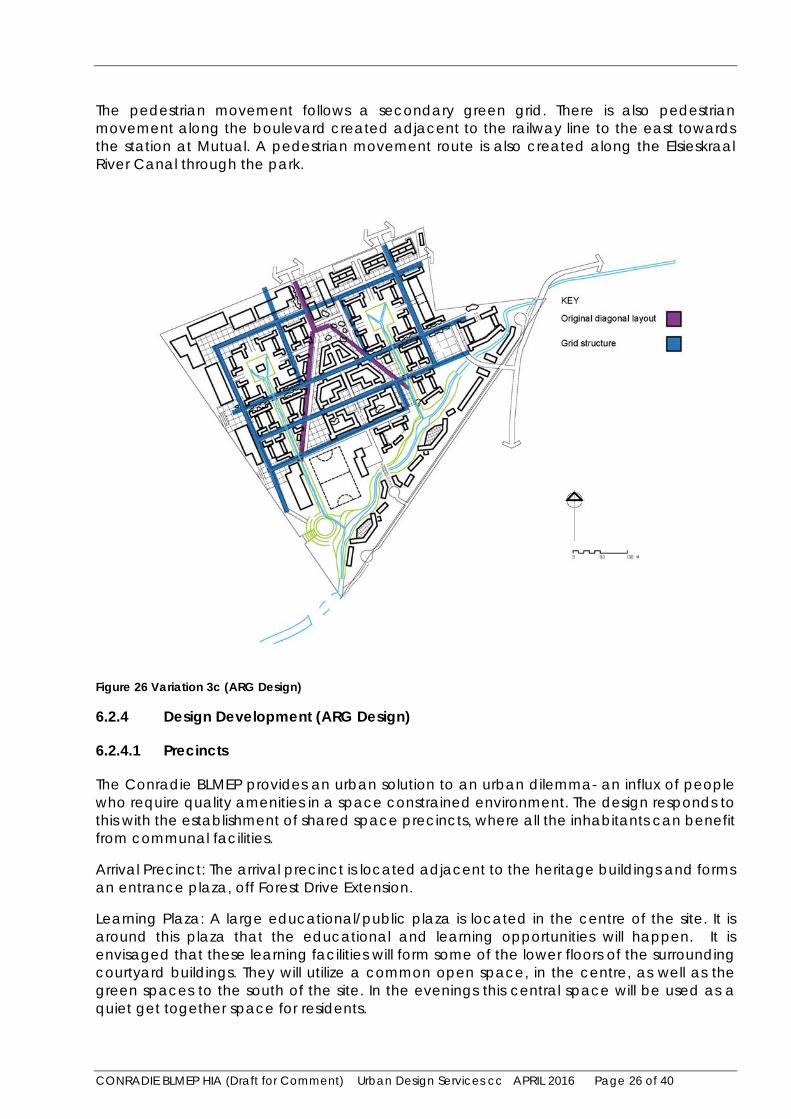
6.2.3 Variation 3c: Cross-grid Structure
6.2.3.1 Layout and Structure
This concept utilizes the underlying “A” shaped, street and treed avenues configuration, on the site, and combines it with the overlain grid structure utilized in option 3b. This option utilizes the most successful features of the previous two variations. The configuration allows for the existing avenues to be maintained as pedestrian movement routes, notionally cutting through the grid structure as illustrated
The arrival court is defined by the existing heritage building and gateway to the north, the treed avenues and the proposed facility buildings to the south. The design is based on a strong central axis and framed by a green space, which also acts a storm water attenuation/floodplain and recreational facility. The structure has a strong baroque triangular symmetry. Superimposed over this is a geometrically constructed regulating grid square layout using a 60mX 60m unit. This allows for a separate pedestrian and vehicular movement system.
This option utilizes the access points from Odin Road to the south and two access points off Forest Drive Extension to the north. There is central vehicular street that accommodates movement in an east – west direction. The internal road layout and access to the external road network is subject to change pending the outcome of a Traffic Impact Assessment and City approval.
CONRADIE BLMEP HIA (Draft for Comment) Urban Design Services cc APRIL 2016 Page 26 of 40
The pedestrian movement follows a secondary green grid. There is also pedestrian movement along the boulevard created adjacent to the railway line to the east towards the station at Mutual. A pedestrian movement route is also created along the Elsieskraal River Canal through the park.
Figure 26 Variation 3c (ARG Design)
6.2.4 Design Development (ARG Design)
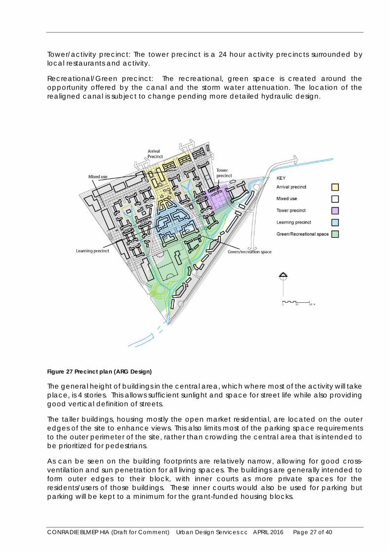
6.2.4.1 Precincts
The Conradie BLMEP provides an urban solution to an urban dilemma- an influx of people who require quality amenities in a space constrained environment. The design responds to this with the establishment of shared space precincts, where all the inhabitants can benefit from communal facilities.
Arrival Precinct: The arrival precinct is located adjacent to the heritage buildings and forms an entrance plaza, off Forest Drive Extension.
Learning Plaza: A large educational/public plaza is located in the centre of the site. It is around this plaza that the educational and learning opportunities will happen. It is envisaged that these learning facilities will form some of the lower floors of the surrounding courtyard buildings. They will utilize a common open space, in the centre, as well as the green spaces to the south of the site. In the evenings this central space will be used as a quiet get together space for residents.
CONRADIE BLMEP HIA (Draft for Comment) Urban Design Services cc APRIL 2016 Page 27 of 40
Tower/activity precinct: The tower precinct is a 24 hour activity precincts surrounded by local restaurants and activity.
Recreational/Green precinct: The recreational, green space is created around the opportunity offered by the canal and the storm water attenuation. The location of the realigned canal is subject to change pending more detailed hydraulic design.
Figure 27 Precinct plan (ARG Design)
The general height of buildings in the central area, which where most of the activity will take place, is 4 stories. This allows sufficient sunlight and space for street life while also providing good vertical definition of streets.
The taller buildings, housing mostly the open market residential, are located on the outer edges of the site to enhance views. This also limits most of the parking space requirements to the outer perimeter of the site, rather than crowding the central area that is intended to be prioritized for pedestrians.
As can be seen on the building footprints are relatively narrow, allowing for good cross-ventilation and sun penetration for all living spaces. The buildings are generally intended to form outer edges to their block, with inner courts as more private spaces for the residents/users of those buildings. These inner courts would also be used for parking but parking will be kept to a minimum for the grant-funded housing blocks.

CONRADIE BLMEP HIA (Draft for Comment) Urban Design Services cc APRIL 2016 Page 28 of 40
The tallest buildings will wrap around the southern and western edge of the site (5-7 floors). This is to fully take advantage of the views to the west as well as to respond to the hard edges created by the rail infrastructure to the west. This doughnut configuration is a response to the hard edges. The buildings will reduce in height towards the centre and in response to the heritage buildings on the site. The layout will respond to the existing diagonal tree-lines.
Figure 28 Building Heights (ARG Design)
6.2.4.2 Visual Impact (ARG Design)
The massing of the higher buildings to the edges of the site is a particular approach to the development and is not the only one. If the higher buildings were embedded in the centre of the development their overall visual impact would be reduced.
However, the current approach is regarded as a “worst case” option and the visual impact needs to be thoroughly assessed and mitigated. Mitigation may require a reduction in heights and breaking up of the building masses to soften the impact of large buildings. This would all form part of the design development in the future. The impact of building heights on existing heritage resources is negligible.

CONRADIE BLMEP HIA (Draft for Comment) Urban Design Services cc APRIL 2016 Page 29 of 40
Open space and landscape (ARG Design)
The design of the Conradie BLMEP’s public open space can all provide multiple opportunities for active and passive recreation that can be linked to developmental programs by the City of Cape Town’s Sport and Recreation department and to increased community participation and healthy lifestyle choices.
Attractive public spaces are attractors for developers. The treatment of the greenbelt will also contribute towards flood water attenuation for the site.
Figure 29 Landscape concept plan (ARG Design)
CONRADIE BLMEP HIA (Draft for Comment) Urban Design Services cc APRIL 2016 Page 30 of 40
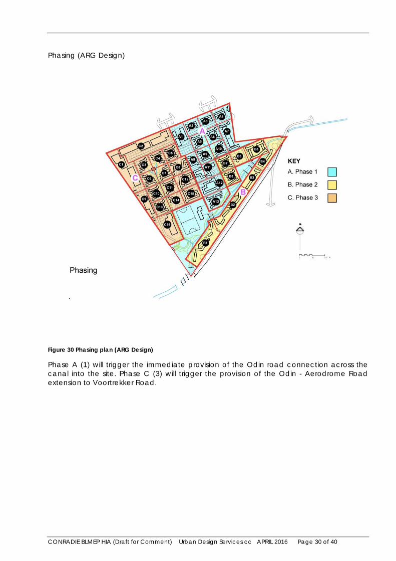
Phasing (ARG Design)
Figure 30 Phasing plan (ARG Design)
Phase A (1) will trigger the immediate provision of the Odin road connection across the canal into the site. Phase C (3) will trigger the provision of the Odin - Aerodrome Road extension to Voortrekker Road.
CONRADIE BLMEP HIA (Draft for Comment) Urban Design Services cc APRIL 2016 Page 31 of 40
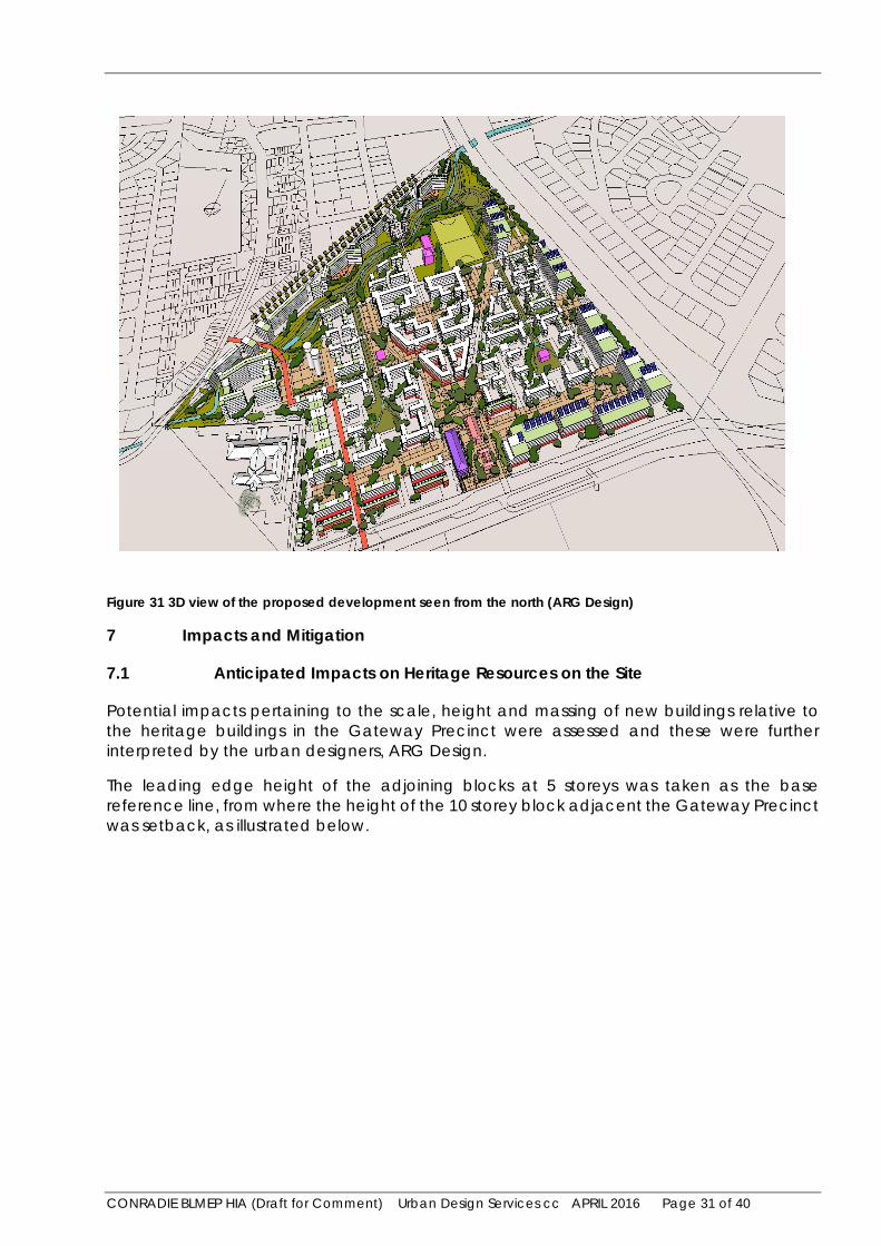
Figure 31 3D view of the proposed development seen from the north (ARG Design)
7 Impacts and Mitigation
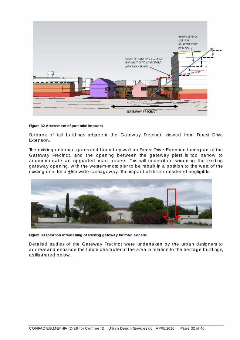
7.1 Anticipated Impacts on Heritage Resources on the Site
Potential impacts pertaining to the scale, height and massing of new buildings relative to the heritage buildings in the Gateway Precinct were assessed and these were further interpreted by the urban designers, ARG Design.
The leading edge height of the adjoining blocks at 5 storeys was taken as the base reference line, from where the height of the 10 storey block adjacent the Gateway Precinct was setback, as illustrated below.
CONRADIE BLMEP HIA (Draft for Comment) Urban Design Services cc APRIL 2016 Page 32 of 40
Figure 32 Assessment of potential impacts:
Setback of tall buildings adjacent the Gateway Precinct, viewed from Forest Drive Extension.
The existing entrance gates and boundary wall on Forest Drive Extension forms part of the Gateway Precinct, and the opening between the gateway piers is too narrow to accommodate an upgraded road access. This will necessitate widening the existing gateway opening, with the western-most pier to be rebuilt in a position to the west of the existing one, for a +5m wide carriageway. The impact of this is considered negligible.
Figure 33 Location of widening of existing gateway for road access
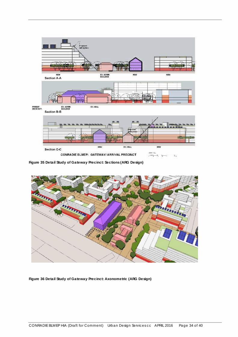
Detailed studies of the Gateway Precinct were undertaken by the urban designers to address and enhance the future character of the area in relation to the heritage buildings, as illustrated below.

CONRADIE BLMEP HIA (Draft for Comment) Urban Design Services cc APRIL 2016 Page 33 of 40
Figure 34 Detail Study of Gateway Precinct: Plan (ARG Design)
CONRADIE BLMEP HIA (Draft for Comment) Urban Design Services cc APRIL 2016 Page 34 of 40
Figure 35 Detail Study of Gateway Precinct: Sections (ARG Design)
Figure 36 Detail Study of Gateway Precinct: Axonometric (ARG Design)

CONRADIE BLMEP HIA (Draft for Comment) Urban Design Services cc APRIL 2016 Page 35 of 40
The axonometric view illustrates how the setting back of the tall building adjacent to the Gateway Precinct mitigates its potential impact.
7.2 Anticipated Impacts on Heritage Resources External to the Site
The Jewish Cemeteries are the only heritage resources in the vicinity that could be potentially impacted by the proposed development. Refer to Figure 20: Heritage resources in the environs, Pinelands Jewish Cemeteries. Both cemeteries have their entrances off Forest Drive Extension and their layouts are aligned to relate towards the road. Pinelands Jewish Cemetery No. 1 is separated from the site with Forest Drive Extension and Anfield Village providing a spatial buffer between them.
Pinelands Jewish Cemetery No. 2 turns its back on the Conradie site and the existing Orthotics and Prosthetics Centre forms a buffer between the two sites. The Cemetery is not over 6o years in age and therefore is not formally protected in terms of Section 34 of the NHRA Act (structures over 60 years in age).
The proposed development on the Conradie site includes tall buildings and where the site adjoins Pinelands Jewish Cemetery No. 2 in the south west corner of the site these may have some visual impact. However this visual impact will not detract from the intrinsic, associational and contextual significance of the cemetery.
7.3 Visual Impact Assessment (Annexure 2)
A visual impact assessment was undertaken by OVP associates (Annexure 2). This study addressed the visual impact of the proposed development on the built environment as a whole. Apart from the existing heritage resources on the site and the adjoining Jewish Cemeteries, there are no other heritage resources in the vicinity that could be impacted by the proposed development on the site. The influence of visual impact on the central heritage area was described as medium with low significance, as the existing heritage precinct will be enhanced with the development. The influence of the visual impact on the Jewish cemetery will be high for areas close to the site and medium for areas of the cemetery further east. The overall significance of the visual impact on the cemetery is medium. Concern was expressed with the possible overlooking of burial ceremonies.
7.4 Summary Statement of Impacts and Mitigation
Potential impacts pertaining to the scale, height and massing of new buildings relative to the heritage buildings in the Gateway Precinct were assessed and mitigated. Detailed studies of the Gateway Precinct were undertaken to address and enhance the future character of the area, and in relation to the heritage buildings. Potential visual impacts on the Jewish cemetery adjoining the site are mitigated by the fact that the cemetery turns its back on the site and the existing Orthotics and Prosthetics Centre between the Conradie site and the cemetery forms a spatial buffer. The future tall buildings in the south west corner of the site may have some visual impact but this will not detract from the heritage significance of the cemetery including its intrinsic and associational attributes. There is no heritage principle that precludes the possible event of cemeteries being overlooked, however unintended, and cemeteries have almost always been integral to urban areas.

CONRADIE BLMEP HIA (Draft for Comment) Urban Design Services cc APRIL 2016 Page 36 of 40
8 Draft Recommendations
That Heritage Western Cape issue a ROD (Record of Decision) to endorse this report and recommend that the development as outlined in the proposals (Variation 3c) may proceed subject to the following conditions:
1 The future re-development of the site must provide for the retention of the structures within the “gateway precinct” and the detail design thereof must conform in principle with the proposals indicated in Figures 34, 35 and 36 of this report.
2 An information display on the history of the site must be incorporated into the development.
3 The mitigation measures to limit the visual and noise impact on public spaces, particularly the Jewish Cemetry, as described in Section 5.3 of the VIA prepared by OVP Associates (Annexure 2 of this document), must be implemented
4 Trees that are considered worth saving must be kept and protected during construction.
5 Any alterations or renovations to the existing heritage buildings including adaptive re-use must be done in a sympathetic manner and an architect with heritage experience must be appointed to supervise the works.
6 The widening of the existing gateway opening, with the western-most pier to be rebuilt in a position to the west of the existing one, must take into account the existing architectural treatment of the boundary wall. Records must be made of the existing gateway elements prior to demolition and rebuild.
7 A Landscape Plan must be prepared for the development.
8 The services of an archaeologist must be retained for the development. In the event of the discovery or excavation of any human remains, the archaeologist must be immediately notified before any further work or excavation takes place.
9 The Department of Public Works and Transport must ensure that the heritage buildings are properly secured to prevent any further vandalism and undertake essential maintenance, particularly waterproofing, to prevent further damage to heritage fabric.

CONRADIE BLMEP HIA (Draft for Comment) Urban Design Services cc APRIL 2016 Page 37 of 40
Annexures
Annexure Annexure 1/ HWC Response to Notification of Intent to Develop 12-11-2014
Annexure 2/ VIA Report Prepared by OVP Associates
CONRADIE BLMEP HIA (Draft for Comment) Urban Design Services cc APRIL 2016 Page 38 of 40
Annexure 1/ HWC Response to Notification of Intent to Develop 12-11-2014
CONRADIE BLMEP HIA (Draft for Comment) Urban Design Services cc APRIL 2016 Page 39 of 40
Annexure 2/ VIA Report Prepared by OVP Associates
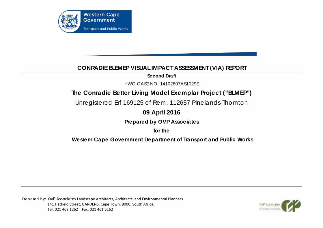
Prepared by: OvP Associates Landscape Architects, Architects, and Environmental Planners 141 Hatfield Street, GARDENS, Cape Town, 8000, South Africa; Tel: 021 462 1262 | Fax: 021 461 6162
CONRADIE BLEMEP VISUAL IMPACT ASSESSMENT (VIA) REPORT Second Draft
HWC CASE NO. 14102807AS1029E
The Conradie Better Living Model Exemplar Project (“BLMEP”) Unregistered Erf 169125 of Rem. 112657 Pinelands-Thornton
09 April 2016 Prepared by OVP Associates
for the Western Cape Government Department of Transport and Public Works

CONRADIE BLMEP VIA OvP Associates Landscape Architects, Architects, and Environmental Planners APRIL 2016 Page 2 of 37
CONRADIE BLEMEP VISUAL IMPACT ASSESSMENT
Contents
1 Introduction ..................................................................................... 8 1.1 Visual Assessment Team and Expertise ................................... 8 1.2 Statement of Independence ................................................... 8 1.3 Scope of Work ............................................................................. 8 1.4 Assumptions and Limitations ..................................................... 8 1.5 Methodology .............................................................................. 9 1.6 Key Issues ..................................................................................... 9 2 Status of Study Area..................................................................... 10 3 Description of Visual Characteristics ........................................ 11 3.1 General Description of the Site and Surrounding Area ..... 11 3.2 Visual Significance of the Area .............................................. 12 3.3 Geology / Landform ................................................................ 13 3.4 Description of the Proposed Development ......................... 13 4 Visual Impact Assessment ........................................................... 15 4.1 Viewshed ................................................................................... 15 4.2 Visual Impact Assessment ....................................................... 17 5 Recommended Mitigation Measures ....................................... 31 5.1 Changes to Forest Drive .......................................................... 31 5.2 Overall High Density of Construction .................................... 32 5.3 Impact on Public Space ......................................................... 32 5.4 Green Character of the Area ................................................ 33 5.5 Controlling future development: ........................................... 33 6 Monitoring and Review Programme ........................................ 33 7 Conclusion and Recommendations ......................................... 33 8 Visual Impact Assessment - Definitions And Ratings .............. 34 8.1 Viewshed ................................................................................... 34 8.2 Visibility of Site ........................................................................... 34 8.3 Visual absorption capacity of the area ............................... 35 8.4 Compatibility with surrounding landscape .......................... 35 8.5 Intensity of impact .................................................................... 36 8.6 Significance of impact ............................................................ 36 8.7 Status of impact ........................................................................ 36
8.8 Duration of impact ................................................................... 36 8.9 Probability .................................................................................. 37 8.10 Confidence ............................................................................... 37
CONRADIE BLMEP VIA OvP Associates Landscape Architects, Architects, and Environmental Planners APRIL 2016 Page 3 of 37
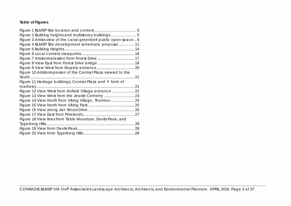
Table of Figures
Figure 1 BLMEP Site location and context ......................................... 5 Figure 2 Building heights and multistorey buildings ......................... 5 Figure 3 Artists view of the canal greenbelt public open space .. 6 Figure 4 BLMEP Site development schematic proposal ............... 11 Figure 5 Building Heights ..................................................................... 14 Figure 6 Local context viewpoints .................................................... 16 Figure 7 Artists impression from Forest Drive .................................... 17 Figure 8 View East from Forest Drive bridge .................................... 18 Figure 9 View West from Mupine entrance ..................................... 20 Figure 10 Artists impresion of the Central Plaza viewed to the South ...................................................................................................... 21 Figure 11 Heritage buildings, Central Plaza and Y- form of roadway ................................................................................................ 21 Figure 12 View West from Anfield Village entrance ...................... 22 Figure 13 View West from the Jewish Cemetry .............................. 23 Figure 14 View North from Viking Village, Thornton ....................... 24 Figure 15 View North from Viking Park ............................................. 25 Figure 16 View along Jan Smuts Drive ............................................. 26 Figure 17 View East from Pinelands .................................................. 27 Figure 18 View lines from Table Mountain, Devils Peak, and Tygerberg Hills ....................................................................................... 28 Figure 19 View from Devils Peak ........................................................ 28 Figure 20 View form Tygerberg Hills .................................................. 29

CONRADIE BLMEP VIA OvP Associates Landscape Architects, Architects, and Environmental Planners APRIL 2016 Page 4 of 37
EXECUTIVE SUMMARY
The scope of work of this visual impact assessment is to assess the visual impact of the construction of the Conradie Game Better Living Exemplar Project (BLMEP), a mixed-use development on the 22ha site of the Old Conradie hospital campus near Pinelands in Cape Town for the Government of the Western Cape.
The assessments of this document are limited in that the final design work for the structures that the VIA assessment has been conducted against a concept, the outcomes of which will inform the DF that will, the basis on which detailed design will be done by the future Developer. The layout and intended heights of the buildings along with the proposed architectural guidelines have been drawn from the ’The Conradie Better Living Model Exemplar Project (“BLMEP”) First Draft Development Framework Report by the BLMEP project team dated December 2015, and this document has been used as a basis for the visual assessments.
In order to create adequate access to the site, a road will have to be constructed to link the existing Odin Drive in Viking Park to Voortrekker Road. The cumulative visual impacts of the development and the required road are briefly examined. A separate VIA is being prepared for the road.
The Conradie Better Living Model Exemplar Project (“Conradie BLMEP”) seeks to efficiently plan, design, funding and develop the former Conradie Hospital site with residentially led, integrated and affordable mixed-use mixed-income mixed-tenure development. The intention of the development is to address the apartheid spatial planning legacies and establish key, replicable levers to unlock state property. The project aims to develop the Conradie into an integrated place of mixed-use where people can live, work and play.
The preferred design option provides a phased development that will accommodate in excess of 3600 residential units, commercial development and supporting infrastructure and amenities (schools, a clinic, community halls, green spaces and canal realignment).
Potential Impacts pertaining to the scale, height and massing of new buildings relative to the heritage buildings in the Gateway Precinct were assessed and mitigated
The property is located between Pinelands, Maitland, Goodwood, Thornton and Epping Industria 1. The property boundaries are formed by Forest Drive to the north, Metro Rail’s central line adjacent to Jan Smuts Drive to the west, the canalised Elsie’s Kraal River and the Pinelands Jewish Cemetery to the east, as illustrated in.

CONRADIE BLMEP VIA OvP Associates Landscape Architects, Architects, and Environmental Planners APRIL 2016 Page 5 of 37
Figure 1 BLMEP Site location and context
The site is largely isolated from the surrounding area as it is flanked on three sides by the Langa Railway line, the Elsieskraal River Canal, and the Orthotics and Prosthetics Centre/New Jewish Cemetery. These act as barriers to access to the site on three sides. It is only along Forest Drive Extension that the site currently interfaces with a public road.
Following the closure of the facility most of the vacant buildings were vandalised and subsequently demolished. Remaining heritage resources include the old Hall, Nursing Administration building, porter’s lodge and entrance gateways. Other heritage resources include the remaining plantings of mature trees and remnants of the former internal road layout. North and east of the site are the Jewish (Pinelands 1 and 2) and Maitland Cemeteries.
The general visual ethos of the area is park-like with a significant number of mature trees in the surrounding area, along the roads and on the site, and the presence of open spaces in the form of the two Jewish cemeteries, the Maitland Cemetery, the Mashie golf course and the wide road verges adds to this ethos.
Figure 2 Building heights and multistorey buildings

CONRADIE BLMEP VIA OvP Associates Landscape Architects, Architects, and Environmental Planners APRIL 2016 Page 6 of 37
Figure 3 Artists view of the canal greenbelt public open space

CONRADIE BLMEP VIA OvP Associates Landscape Architects, Architects, and Environmental Planners APRIL 2016 Page 7 of 37
This concept utilizes the underlying street and tree lined avenue configuration existing on the site, which is “A” shaped. The configuration allows for the existing avenues to be maintained as movement routes in their current form. The site arrival court is defined by the existing heritage building and gateway to the north, the tree lined avenues and the proposed facility buildings to the south. The design is based on a strong central axis and framed by a green space, which also acts a storm water attenuation/floodplain and recreational facility. This is illustrated in Figure 2.
The tallest buildings will be located adjacent to the existing Orthotics and Prosthetics Centre, to the east of the site (± 9 floors), and will wrap around the southern and western edge of the site (5-6 floors). This is to fully take advantage of the views to the west as well as to respond to the hard edges created by the rail infrastructure to the west. This doughnut configuration is a response to the hard edges. The buildings will reduce in height towards the centre and in response to the heritage buildings on the site as illustrated in Figure 4.
The visual impact ratings have been largely informed by the fact that the surrounding development has turned its back on the site, with primary views being away from the site and backyard views being towards the site. This is even largely true of Anfield village where the edge facing the site consist of mainly access corridors and kitchen windows.
The overall significance of the visual impact for BLMEP is therefore rated as being medium for most areas even after full mitigation.
The visual impact on the New Jewish Cemetery needs to be rated separately as it is believed that the construction of the development will alter the sense of place and the ethos of the cemetery. Views over the cemetery from the buildings in the development are anticipated to affect the sense of privacy of mourners. The construction of the link road around another two sides of the cemetery is anticipated to also add significantly to the change in the urban experience.
The overall significance of the visual impact on the cemetery is therefore rated as high. Great care will therefore have to be exercised in the design and implementation of the southern interface edge in order to minimise the effect on visitors to the cemetery.
Various mitigation measures have been outlined in Section 5 that will help to retain some of the green ethos in the area.
The proposed development will undoubtedly bring about a significant change in the visual character of the area but it is believed that with careful design and implementation these changes can be made acceptable, and as in the case of the intended open space network including the canal edge, may be perceived as positive and as an amenity of value to the local and larger community.

CONRADIE BLMEP VIA OvP Associates Landscape Architects, Architects, and Environmental Planners APRIL 2016 Page 8 of 37
1 Introduction
1.1 Visual Assessment Team and Expertise
This visual assessment by Johan van Papendorp (B.Arch. (UCT) M.L.Arch (UP) MILASA, Pr. L.Arch), head of the landscape firm OvP Associates. Mr van Papendorp has had more than 30 years’ experience in preparing visual impact assessments.
OvP Associates have been responsible for several high profile visual impact assessments for projects such as:
V&A Waterfront: Silo Precinct Development: September 2014
V&A Waterfront: Victoria Wharf Extension: April 2014
Vergelegen: Proposed Training Centre: April 2014
UCT: Proposed Training and Learning Building: October 2012
Ceres: Proposed Hotel and Housing Estate: October 2007
1.2 Statement of Independence
Neither OvP Associates nor any of its staff members are involved in, or stand to gain financially in any way, from the design, construction or future management of the proposed development assessed in this document.
1.3 Scope of Work
The scope of work of this report is to assess the visual impact of the construction of a high density mixed use development on the old Frans Conradie Hospital site, Pinelands, Cape Town.
The scope of work included in this specialist study is to:
1 Describe the existing visual characteristics of the site and its environs.
2 Determine the area from which the proposed development will be potentially visible (i.e. the viewshed).
3 Assess the visual impact of the development from key areas within the viewshed.
4 Propose mitigation measures to limit the visual impact.
1.4 Assumptions and Limitations
Information concerning the proposed character and layout of the development has been obtained from the following documents:
’The Conradie Better Living Model Exemplar Project (“BLMEP”) and this VIA document has been used as a basis for the visual assessments (see Addendum 1).
CONRADIE BLMEP VIA OvP Associates Landscape Architects, Architects, and Environmental Planners APRIL 2016 Page 9 of 37
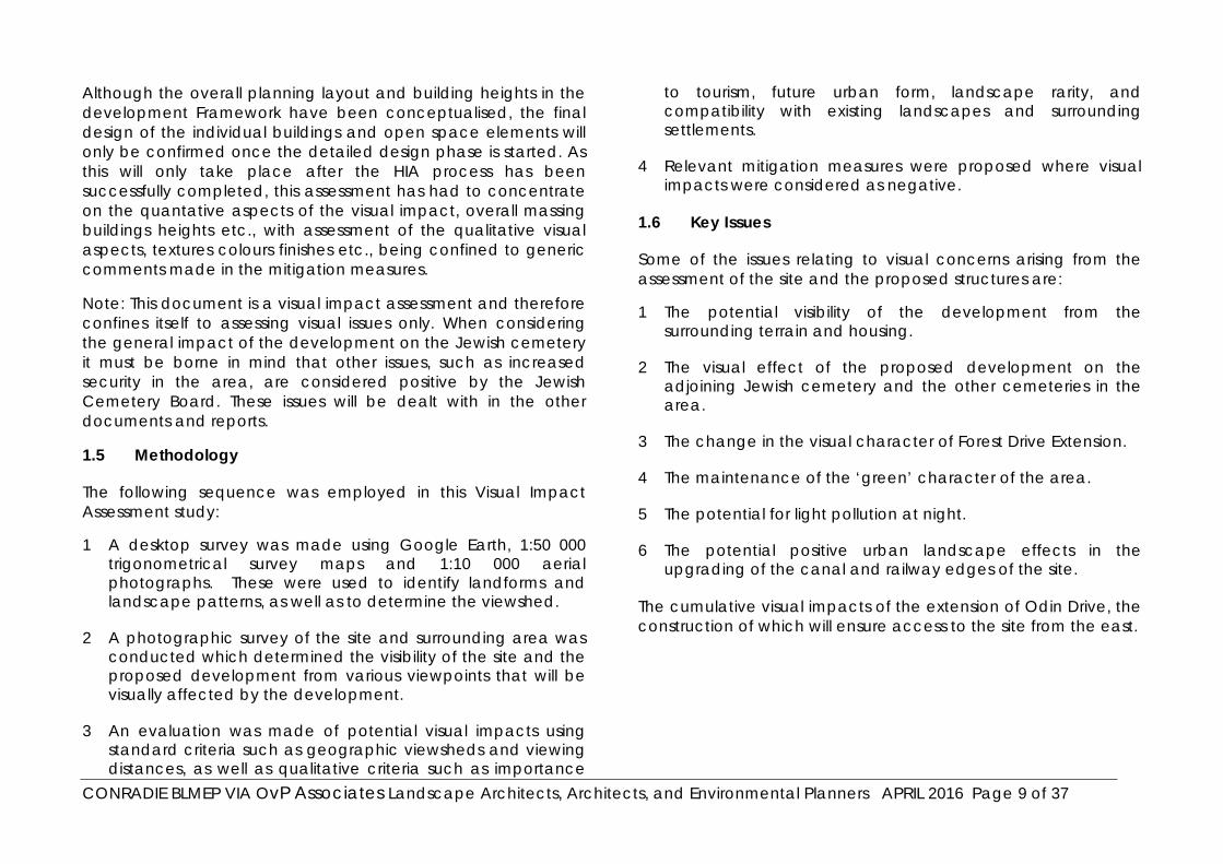
Although the overall planning layout and building heights in the development Framework have been conceptualised, the final design of the individual buildings and open space elements will only be confirmed once the detailed design phase is started. As this will only take place after the HIA process has been successfully completed, this assessment has had to concentrate on the quantative aspects of the visual impact, overall massing buildings heights etc., with assessment of the qualitative visual aspects, textures colours finishes etc., being confined to generic comments made in the mitigation measures.
Note: This document is a visual impact assessment and therefore confines itself to assessing visual issues only. When considering the general impact of the development on the Jewish cemetery it must be borne in mind that other issues, such as increased security in the area, are considered positive by the Jewish Cemetery Board. These issues will be dealt with in the other documents and reports.
1.5 Methodology
The following sequence was employed in this Visual Impact Assessment study:
1 A desktop survey was made using Google Earth, 1:50 000 trigonometrical survey maps and 1:10 000 aerial photographs. These were used to identify landforms and landscape patterns, as well as to determine the viewshed.
2 A photographic survey of the site and surrounding area was conducted which determined the visibility of the site and the proposed development from various viewpoints that will be visually affected by the development.
3 An evaluation was made of potential visual impacts using standard criteria such as geographic viewsheds and viewing distances, as well as qualitative criteria such as importance
to tourism, future urban form, landscape rarity, and compatibility with existing landscapes and surrounding settlements.
4 Relevant mitigation measures were proposed where visual impacts were considered as negative.
1.6 Key Issues
Some of the issues relating to visual concerns arising from the assessment of the site and the proposed structures are:
1 The potential visibility of the development from the surrounding terrain and housing.
2 The visual effect of the proposed development on the adjoining Jewish cemetery and the other cemeteries in the area.
3 The change in the visual character of Forest Drive Extension.
4 The maintenance of the ‘green’ character of the area.
5 The potential for light pollution at night.
6 The potential positive urban landscape effects in the upgrading of the canal and railway edges of the site.
The cumulative visual impacts of the extension of Odin Drive, the construction of which will ensure access to the site from the east.
CONRADIE BLMEP VIA OvP Associates Landscape Architects, Architects, and Environmental Planners APRIL 2016 Page 10 of 37
2 Status of Study Area
The site on which the proposed development is planned is designated Remainder Erf 112557, (unregistered Erf 169125,) and is the disused campus of the Frans Conradie Hospital. It is 22.15 hectares in extent.
The Conradie Better Living Model Exemplar Project (“Conradie BLMEP”) seeks to efficiently plan, design, funding and develop the former Conradie Hospital site with residentially led, integrated and affordable mixed-use mixed-income mixed-tenure development. The intention of the development is to address the apartheid spatial planning legacies and establish key, replicable levers to unlock state property. The project aims to develop the Conradie into an integrated place where people can live, work and play.
The Western Cape Government Department of Transport and Public Works (The Department) received a mandate from the Provincial Cabinet and Inter-governmental Committee (IGC) to lead the project. The Department was set 1 April 2018 as the latest date for “sod-turning” and aims to deliver on its mandate with maximum integration and support of other government departments and the City of Cape Town. The development of the site will be procured through a Public-Private Partnership or other alternative mechanism.
The development is expected to deliver the following outcomes:
1 It must result in a changed social and economic role for site
2 It must allow for the development of a suitable housing model, that is replicable and viable
3 It should facilitate an effective and efficient government response
4 It should have a number of characteristics that position it as “class leading” if not “best in class”
At present the site is zoned ‘undetermined’ and a change in the zoning to commercial and general business is being sought to enable the construction of a mixed use development with residential, commercial, and retail usage.
Heritage resources are contained within the Gateway Precinct of the former Conradie hospital and include the old Hall, Nursing Administration building, porter’s lodge and the entrance gateways. These structures are in various states of repair. Other heritage resources include the remaining plantings of mature trees and remnants of the former internal road layout. At present two disused water towers have also been retained for possible reuse. The site needs to be permanently guarded against invasion by criminal elements and squatters.
CONRADIE BLMEP VIA OvP Associates Landscape Architects, Architects, and Environmental Planners APRIL 2016 Page 11 of 37
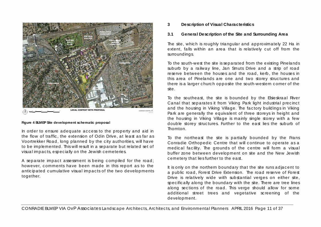
Figure 4 BLMEP Site development schematic proposal
In order to ensure adequate access to the property and aid in the flow of traffic, the extension of Odin Drive, at least as far as Voortrekker Road, long planned by the city authorities, will have to be implemented. This will result in a separate but related set of visual impacts, especially on the Jewish cemeteries.
A separate impact assessment is being compiled for the road; however, comments have been made in this report as to the anticipated cumulative visual impacts of the two developments together.
3 Description of Visual Characteristics
3.1 General Description of the Site and Surrounding Area
The site, which is roughly triangular and approximately 22 Ha in extent, falls within an area that is relatively cut off from the surroundings.
To the south-west the site is separated from the existing Pinelands suburb by a railway line, Jan Smuts Drive and a strip of road reserve between the houses and the road, kerb, the houses in this area of Pinelands are one and two storey structures and there is a larger church opposite the south-western corner of the site.
To the southeast, the site is bounded by the Elsieskraal River Canal that separates it from Viking Park light industrial precinct and the housing in Viking Village. The factory buildings in Viking Park are generally the equivalent of three storeys in height and the housing in Viking Village is mainly single storey with a few double storey structures. Further to the east lies the suburb of Thornton.
To the northeast the site is partially bounded by the Frans Conradie Orthopedic Centre that will continue to operate as a medical facility. The grounds of the centre will form a visual buffer zone between development on site and the New Jewish cemetery that lies further to the east.
It is only on the northern boundary that the site runs adjacent to a public road, Forest Drive Extension. The road reserve of Forest Drive is relatively wide with substantial verges on either site, specifically along the boundary with the site. There are tree lines along sections of the road. This verge should allow for some additional street trees and vegetative screening of the development.

CONRADIE BLMEP VIA OvP Associates Landscape Architects, Architects, and Environmental Planners APRIL 2016 Page 12 of 37
From west to east along the northern side of Forest Drive Extension opposite the site boundary lie the Mupine Training College, (3 storeys,) a mashie golf course, and Anfield Village residential complex, (3 storeys). Beyond this to the north lies the Thornton railway line.
The Old Jewish Cemetery lies to the east of Anfield Village on the northern side of Forest Drive to the site, while the New Jewish Cemetery lies on the southern side of Forest Drive Extension east of the site towards Thornton Station.
The Thornton railway line runs parallel to Forest Drive Extension between the Mupine college/Mashie course/Anfield Village developments and the Maitland cemetery.
The Maitland Cemetery forms a significant green open space. It lies between the Railway line and Voortrekker Road and extends a considerable distance in both an easterly and westerly direction.
Facreton industrial area lies on the northern side of Voortrekker road to the west, and the old Wingfield Air Force Base, which is now partially used by the S A Navy but is planned for later residential development, lies along Voortrekker Road to the east.
To the north-west, adjacent to the railway line and Mutual station lie the buildings of the Old Mutual Head Office, (10 storeys.) Mutual Station will serve as the main rail access for commuters from the proposed development.
The only existing access to the site at present is along Forest Drive Extension. The Langa railway line, the canal and the Orthopedic Centre/New Jewish Cemetery preclude access to the site from the other sides at present.
A characteristic of the area is the number of established trees both on and around the site. There are existing tree lines on both sides of Forest Drive Extension in places, mainly east of the site. The mature vegetation will be able to act as a significant visual buffer to much of the development.
The entire area of the site and its surroundings is relatively flat with the bridges over the railway lines forming elevated high points in the landscape.
3.2 Visual Significance of the Area
In the late 1800’s the site and the surrounding area was planted with trees, mainly pines, in order to control the drift sands. This altered the visual landscape from a typical Cape Flats sandy landscape to the characteristic treed landscape that is the hallmark of ‘Pinelands.’
Although industrial developments such as Ndabeni, Viking Park and Facreton sprung up around Pinelands, the presence of the Maitland cemetery, the Frans Conradie Campus, the Jewish Cemeteries and other green spaces and the character of Pinelands itself ensured that the ‘green’ feel of the area was maintained in a very different way to elsewhere on the Cape Flats. This feel is exemplified in the existing open nature of the visual experience while driving past the site along Forest Drive Extension.
It is important in view of both the historical treed nature of the area, and also the current thinking about the greening of our cities, that as much as possible of the green nature of the area be preserved.

CONRADIE BLMEP VIA OvP Associates Landscape Architects, Architects, and Environmental Planners APRIL 2016 Page 13 of 37
There are few tall buildings in the area, the Old Mutual campus with its 10 storey main building being a significant exception. It is essential that if more tall buildings are introduced, their architectural character and finishes should strive to minimise their visual intrusion and that planting, both at ground level and on the structures themselves, should be used to soften their outlines and break up their perceived mass and scale.
Other than the Jewish cemeteries, there is nothing of significance in the area that would attract large numbers of visitors or tourists. Any changes to the visual nature of the area would therefore mainly affect the local inhabitants and those who use Jan Smuts Drive, Forest Drive Extension, or either of the two local railway lines to commute.
Cemeteries create tranquil green spaces, but also require tranquility and privacy to operate within the purpose for which they were created. This is specifically true of the New Jewish Cemetery to the east of the site that is still operational. Its visual character will be considerably altered by the proposed development and the extension of Odin Drive.
3.3 Geology / Landform
The site is entirely flat with a very gentle slope from Forest Drive Extension on the northern boundary down towards the Elsieskraal River Canal along its southeast boundary.
The entire site has been reworked over the years with the construction of the various building in the hospital complex and the surrounding roads and the canal. There are therefore no visually significant geological features that require preserving.
3.4 Description of the Proposed Development
3.4.1 Better Living Model
The Better Living Model option proposes the establishment of a new residential led mixed use, mixed income development that incorporates the concept of “Live—work-play-learn” in one truly integrated settlement.
It would include the development of 22ha of well-located land, close to the Central Business District of Cape Town, for a mixed-use development. This development would be an example of how to redress some of the apartheid spatial inequalities found in the City.
The exact mix of uses cannot be predicted precisely over the long term. However, it will comprise at least 3 500 residential units, of which 49% are in the subsidy (affordable) band. The remainder will be open market units.
It will include associated community facilities and recreational open space, at least one primary and high school, a community hall and opportunities for early childhood development centres.
Limited commercial, retail and office uses will be provided on the site to serve the residents and provide local work opportunities,
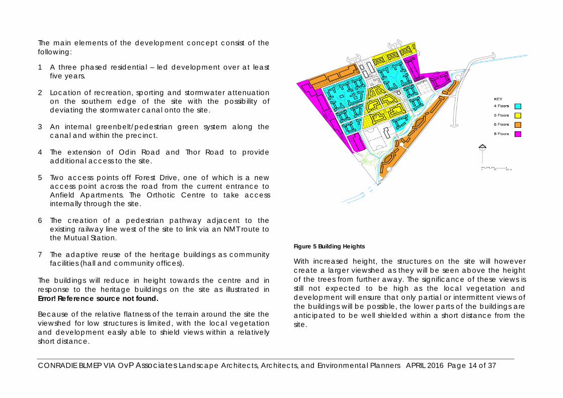
CONRADIE BLMEP VIA OvP Associates Landscape Architects, Architects, and Environmental Planners APRIL 2016 Page 14 of 37
The main elements of the development concept consist of the following:
1 A three phased residential – led development over at least five years.
2 Location of recreation, sporting and stormwater attenuation on the southern edge of the site with the possibility of deviating the stormwater canal onto the site.
3 An internal greenbelt/pedestrian green system along the canal and within the precinct.
4 The extension of Odin Road and Thor Road to provide additional access to the site.
5 Two access points off Forest Drive, one of which is a new access point across the road from the current entrance to Anfield Apartments. The Orthotic Centre to take access internally through the site.
6 The creation of a pedestrian pathway adjacent to the existing railway line west of the site to link via an NMT route to the Mutual Station.
7 The adaptive reuse of the heritage buildings as community facilities (hall and community offices).
The buildings will reduce in height towards the centre and in response to the heritage buildings on the site as illustrated in Error! Reference source not found.
Because of the relative flatness of the terrain around the site the viewshed for low structures is limited, with the local vegetation and development easily able to shield views within a relatively short distance.
Figure 5 Building Heights
With increased height, the structures on the site will however create a larger viewshed as they will be seen above the height of the trees from further away. The significance of these views is still not expected to be high as the local vegetation and development will ensure that only partial or intermittent views of the buildings will be possible, the lower parts of the buildings are anticipated to be well shielded within a short distance from the site.
CONRADIE BLMEP VIA OvP Associates Landscape Architects, Architects, and Environmental Planners APRIL 2016 Page 15 of 37
4 Visual Impact Assessment
4.1 Viewshed
The ‘viewshed’ refers to the theoretical outer-most extent or area from which a site can be seen. It must, however, be remembered that visibility may be obscured in reality by objects within the viewshed such as existing buildings, trees, lower ridges, outcrops and other geographical or natural features, and also by distance where an object can visually blend into its background or be completely lost to sight.
Views of the site from Table Mountain, Devil’s Peak and limited other elevated viewpoints are possible but are not expected to be overly significant because any development on the site will be seen in the context of the existing surrounding development. This context includes Viking Park adjacent and to the south of the site, the Old Mutual Headquarters to the west, Facreton to the north and Epping Industria to the south-east, all of which will be in the same visual frame when viewed from an elevated distance.
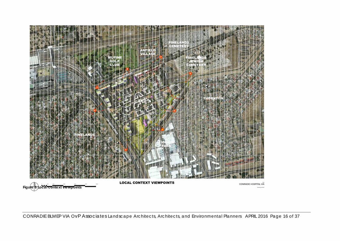
CONRADIE BLMEP VIA OvP Associates Landscape Architects, Architects, and Environmental Planners APRIL 2016 Page 16 of 37
Figure 6 Local context viewpoints

CONRADIE BLMEP VIA OvP Associates Landscape Architects, Architects, and Environmental Planners APRIL 2016 Page 17 of 37
4.2 Visual Impact Assessment
Figure 7 Artists impression from Forest Drive
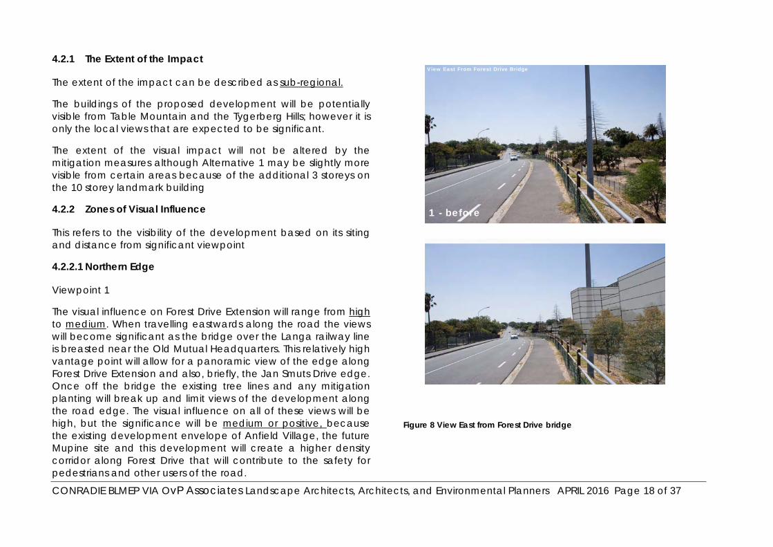
CONRADIE BLMEP VIA OvP Associates Landscape Architects, Architects, and Environmental Planners APRIL 2016 Page 18 of 37
4.2.1 The Extent of the Impact
The extent of the impact can be described as sub-regional.
The buildings of the proposed development will be potentially visible from Table Mountain and the Tygerberg Hills; however it is only the local views that are expected to be significant.
The extent of the visual impact will not be altered by the mitigation measures although Alternative 1 may be slightly more visible from certain areas because of the additional 3 storeys on the 10 storey landmark building
4.2.2 Zones of Visual Influence
This refers to the visibility of the development based on its siting and distance from significant viewpoint
4.2.2.1 Northern Edge
Viewpoint 1
The visual influence on Forest Drive Extension will range from high to medium. When travelling eastwards along the road the views will become significant as the bridge over the Langa railway line is breasted near the Old Mutual Headquarters. This relatively high vantage point will allow for a panoramic view of the edge along Forest Drive Extension and also, briefly, the Jan Smuts Drive edge. Once off the bridge the existing tree lines and any mitigation planting will break up and limit views of the development along the road edge. The visual influence on all of these views will be high, but the significance will be medium or positive, because the existing development envelope of Anfield Village, the future Mupine site and this development will create a higher density corridor along Forest Drive that will contribute to the safety for pedestrians and other users of the road.
Figure 8 View East from Forest Drive bridge
View East From Forest Drive Bridge
1 - before

CONRADIE BLMEP VIA OvP Associates Landscape Architects, Architects, and Environmental Planners APRIL 2016 Page 19 of 37
The visual influence on the Old Mutual Headquarters will be limited to south-easterly views and will be low to medium. The main reason for this relatively high rating is the height of the Old Mutual building that raises these views above the screening capabilities of the trees and other local structures.
Views from the top of this building will be the only proximate views that will be able to take in the entire development
Viewpoint 2
The visual influence on views of the development when viewed from the entrance to Mupine of the heritage entrance to the development and the two retained heritage buildings will be medium because of the new building of the same scale to the east of the heritage buildings. .
This new building will be a central feature of the development with administration and community facilities arranged around a tree lined central piazza with large existing trees and the new buildings along Forest drive stepping down to bring the scale of the higher buildings more down to the scale of the heritage buildings and at the same time forming a frame to the entrance of site.
This combination of celebrating the old and enhancing it with new functions will result in the visual impact to the central heritage area of the site being medium.
The significance of the impact will be low, as the above-mentioned measures will bring a new value to these relatively insignificant buildings.
The retention of the existing Y-form of the old roads with their accompanying tree formations, will further contribute to a suitable interpretation to a form that celebrates as in a palimpsest or overlay, the history of the site and its form, these should be commemorated in the heritage community facilities with suitable signage illustrating and description of the sites historical significance.
The visual influence on views of the development when approaching from the east along Forest Drive Extension will be medium because they will be significantly mitigated by the existing tree lines along the edge of the road and the trees and structures of the orthopedic centre.
Once alongside the development the visual influence will be the same when travelling in either direction. The presence of the 8 storey buildings on the North-western edge of the site will raise the visual influence on Forest Drive significantly.

CONRADIE BLMEP VIA OvP Associates Landscape Architects, Architects, and Environmental Planners APRIL 2016 Page 20 of 37
Figure 9 View West from Mupine entrance
The treatment of this road edge, in architectural design, tree planting, lighting and signage will be key to creating an attractive visual experience along the road.
The new intersections that will be required to cater for traffic entering and leaving the site will incur a high local visual influence also changing the perceived character of the road.
The visual influence on Mupine Site is expected to be medium to low. Mupine College is partly shielded to visual influence from the site by the adjacent bridge over the railway line, and the local trees will lower the visual influence significantly.
2 - before
2 - after
View West From Golf Course Entrance
View West From Golf Course Entrance
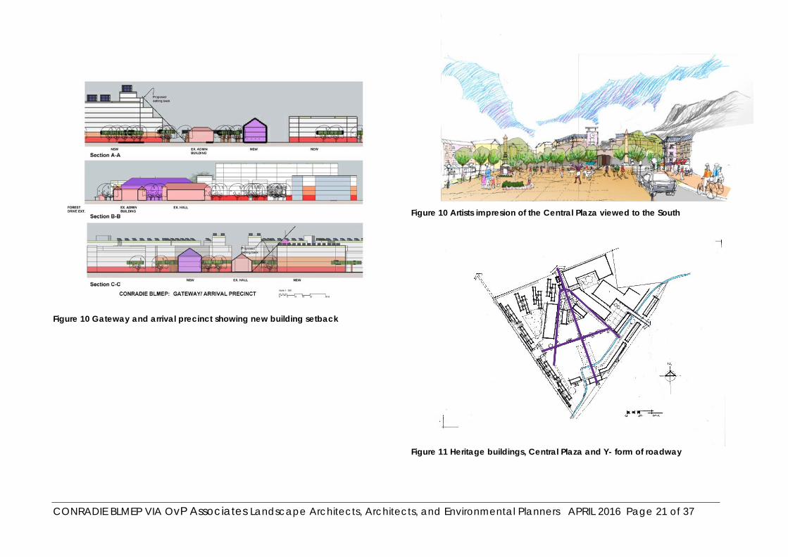
CONRADIE BLMEP VIA OvP Associates Landscape Architects, Architects, and Environmental Planners APRIL 2016 Page 21 of 37
Figure 10 Gateway and arrival precinct showing new building setback
Figure 10 Artists impresion of the Central Plaza viewed to the South
Figure 11 Heritage buildings, Central Plaza and Y- form of roadway
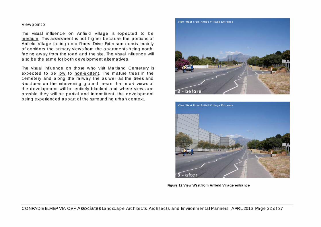
CONRADIE BLMEP VIA OvP Associates Landscape Architects, Architects, and Environmental Planners APRIL 2016 Page 22 of 37
Viewpoint 3
The visual influence on Anfield Village is expected to be medium. This assessment is not higher because the portions of Anfield Village facing onto Forest Drive Extension consist mainly of corridors, the primary views from the apartments being north-facing away from the road and the site. The visual influence will also be the same for both development alternatives.
The visual influence on those who visit Maitland Cemetery is expected to be low to non-existent. The mature trees in the cemetery and along the railway line as well as the trees and structures on the intervening ground mean that most views of the development will be entirely blocked and where views are possible they will be partial and intermittent, the development being experienced as part of the surrounding urban context.
Figure 12 View West from Anfield Village entrance
3 - before
3 - after
View West From Anfie
l
d V illage Entrance
View West From Anfie
l
d V illage Entrance

CONRADIE BLMEP VIA OvP Associates Landscape Architects, Architects, and Environmental Planners APRIL 2016 Page 23 of 37
4.2.2.2 The Eastern Edge
Viewpoint 4
The visual influence on views from the Orthopedic Centre will be medium-high for Alternative 1 and high for Alternative 2. This is mainly because the structures along the eastern edge of the development will be 7 storeys for Alternative 2 compared to 5 storeys for Alternative 1.
The sense of place along this edge will be considerably changed and mitigation planting will be of limited effectiveness because of the proximity of the structures and the contrast in scale from the 1-2 storey buildings of the Orthopedic Centre.
The visual influence on the New Jewish Cemetery will range from high closer to the site to medium for the eastern sections of the cemetery.
The buildings along this edge of the site will present windows that overlook the cemetery and affect the sense of privacy of funerals taking place. The intervening Orthopedic Centre will form a limited visual buffer for the lower floors but the upper floors will look over the shielding capabilities of the trees and structures. The mitigation of these impacts will include new tree planting both the site at the building and along the boundary of the Jewish cemetery that will reduce the impacts over time.
The visual influence on the houses and apartments in Thornton to the east of the cemetery will not rise above medium for limited views. Once again the primary views are oriented to the north and south and there are few direct views to the west over the site. Distance will also be a mitigating factor for these views as they are over the intervening expanse of the cemetery.
Figure 13 View West from the Jewish Cemetry
4 - before
4 - after
View West From the Jewish Cemetery
View West From the Jewish Cemetery

CONRADIE BLMEP VIA OvP Associates Landscape Architects, Architects, and Environmental Planners APRIL 2016 Page 24 of 37
Of more concern will be the cumulative visual effect of Odin Drive Extension as it skirts the cemetery and passes the Thornton apartments where it begins a ramp to cross the railway line. This ramp will in fact shield certain views of the buildings on the site.
The visual influence on the Old Jewish Cemetery will range from medium to low.
The visual influence on the users of the Thornton Railway line will be low. The intervening trees and structures when viewed from the height of the average viewer in the train at Mutual Station will block most views of the development, but the 8-storey building will be clearly visible from the Old Jewish Cemetery.
4.2.2.3 The South-eastern Edge
Viewpoint 5
The visual influence on the canal will be high but positive. One of the reasons for this is that it is intended that the canal be diverted throughout the site and directly linked to the development as a green recreational space. Changes to the canal edge will therefore be considerable but they should improve the visual character of the area from its present degraded state.
The visual influence on the houses in Viking Village will also be medium to low. In general the houses have their backs turned on the canal and there are existing solid walls and fences that shield most views of the site. Most houses are single storey. The few second storey windows that look out over the site and the cemetery will however have significant views of the development.
Figure 14 View North from Viking Village, Thornton
View North From Thornton
View North From Thornton
5 - before
5 - after
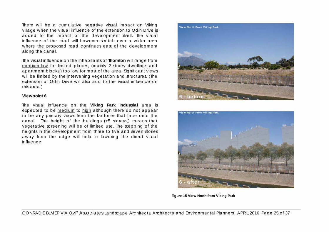
CONRADIE BLMEP VIA OvP Associates Landscape Architects, Architects, and Environmental Planners APRIL 2016 Page 25 of 37
There will be a cumulative negative visual impact on Viking village when the visual influence of the extension to Odin Drive is added to the impact of the development itself. The visual influence of the road will however stretch over a wider area where the proposed road continues east of the development along the canal.
The visual influence on the inhabitants of Thornton will range from medium-low for limited places, (mainly 2 storey dwellings and apartment blocks,) too low for most of the area. Significant views will be limited by the intervening vegetation and structures. (The extension of Odin Drive will also add to the visual influence on this area.)
Viewpoint 6
The visual influence on the Viking Park industrial area is expected to be medium to high although there do not appear to be any primary views from the factories that face onto the canal. The height of the buildings (±5 storeys,) means that vegetative screening will be of limited use. The stepping of the heights in the development from three to five and seven stories away from the edge will help in lowering the direct visual influence.
Figure 15 View North from Viking Park
View North From Viking Park
View North From Viking Park
6 - before
6 - after

CONRADIE BLMEP VIA OvP Associates Landscape Architects, Architects, and Environmental Planners APRIL 2016 Page 26 of 37
4.2.2.4 The South-western Edge
Viewpoint 7
The visual influence on the users of the Langa Railway line as it passes the south-western boundary of the site is expected to be medium. The existing trees, which must be kept, the mitigation planting, and the limited height of the buildings along this edge will minimise the direct visual influence of the development.
The visual influence on Jan Smuts Drive will be medium. The buildings along the edge will be more readily visible above the vegetation than from the train, and from the western side of the Drive some of the taller buildings at the heart of the development may be visible. These views are however mitigated by distance.
Figure 16 View along Jan Smuts Drive
View North From Jan Smuts Drive
View North From Jan Smuts Drive
7 - before
7 - after
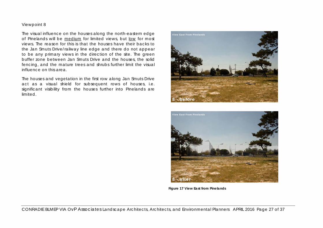
CONRADIE BLMEP VIA OvP Associates Landscape Architects, Architects, and Environmental Planners APRIL 2016 Page 27 of 37
Viewpoint 8
The visual influence on the houses along the north-eastern edge of Pinelands will be medium for limited views, but low for most views. The reason for this is that the houses have their backs to the Jan Smuts Drive/railway line edge and there do not appear to be any primary views in the direction of the site. The green buffer zone between Jan Smuts Drive and the houses, the solid fencing, and the mature trees and shrubs further limit the visual influence on this area.
The houses and vegetation in the first row along Jan Smuts Drive act as a visual shield for subsequent rows of houses, i.e. significant visibility from the houses further into Pinelands are limited.
Figure 17 View East from Pinelands
View East From Pinelands
View East From Pinelands
8 - after
8 - before
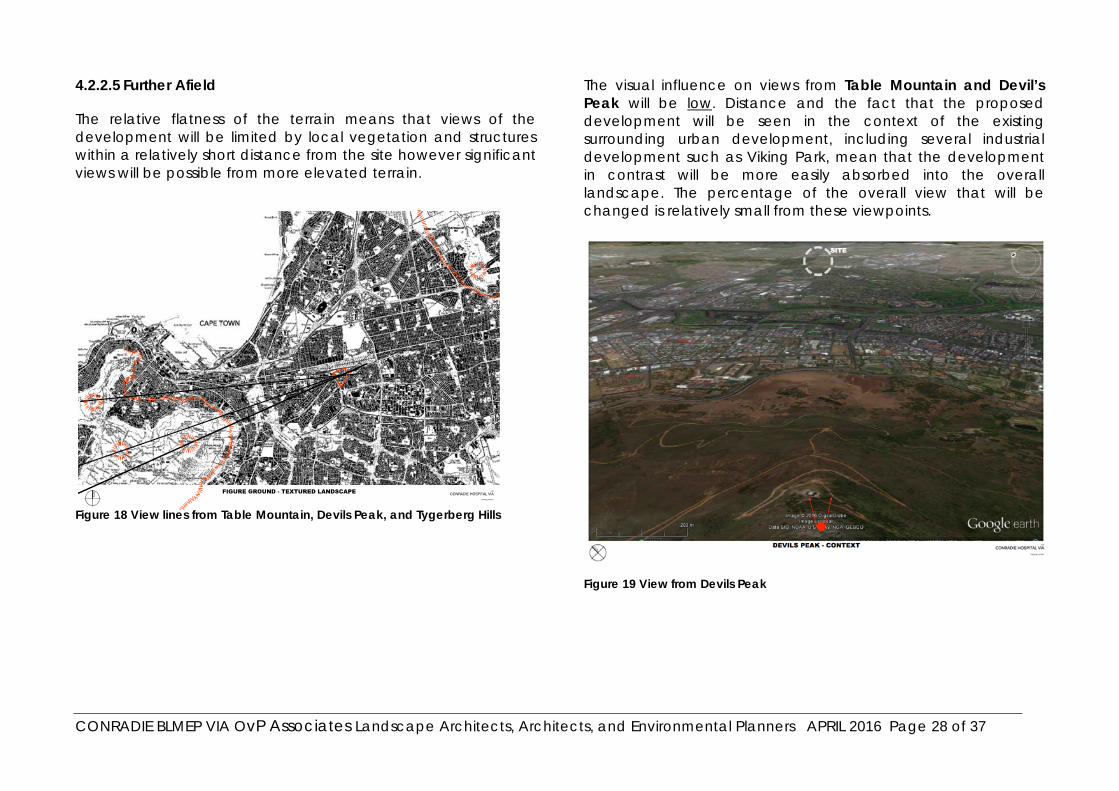
CONRADIE BLMEP VIA OvP Associates Landscape Architects, Architects, and Environmental Planners APRIL 2016 Page 28 of 37
4.2.2.5 Further Afield
The relative flatness of the terrain means that views of the development will be limited by local vegetation and structures within a relatively short distance from the site however significant views will be possible from more elevated terrain.
Figure 18 View lines from Table Mountain, Devils Peak, and Tygerberg Hills
The visual influence on views from Table Mountain and Devil’s Peak will be low. Distance and the fact that the proposed development will be seen in the context of the existing surrounding urban development, including several industrial development such as Viking Park, mean that the development in contrast will be more easily absorbed into the overall landscape. The percentage of the overall view that will be changed is relatively small from these viewpoints.
Figure 19 View from Devils Peak

CONRADIE BLMEP VIA OvP Associates Landscape Architects, Architects, and Environmental Planners APRIL 2016 Page 29 of 37
Views will also be possible from the slopes of Tygerberg but the same comments as above apply.
The fine grain of the site development proposal will match that of the surrounding and relative to the visibility of the industrial buildings of Viking Park and Epping, the visual influence and impact of the development will be low form both Table Mountain and the Tygerberg Hills. The significance of these impacts will be Low.
Figure 20 View form Tygerberg Hills
4.2.3 Visual Absorption Capacity of the Area
This refers to the ability of the surrounding area to visually absorb the development.
The visual absorption capacity for the area is high. This is because of the relative flatness of the terrain and the presence of significant mature vegetation across the entire area prevents long panoramic views and softens and fragments local views. This is however affected by the height of the buildings which means that any views that are not obstructed by local vegetation and structures will be significant, with buildings seeming to float above the visual vegetation shielding.
The planting of balconies and roofs introducing vegetation to the upper floors of the buildings will result in softening the visual impact and making the development less obtrusive and more easily visually absorbed
4.2.4 Compatibility with Surrounding Landscape
This refers to the extent to which the proposed development and land usage is in line with the surrounding development and land usage.
The rating of the compatibility of the development with the surrounding landscape will depend on the area from which the development is viewed. i.e. when viewed from the Viking Park Industrial area, the development should be seen as appropriate whereas when viewed from the Jewish Cemetery it will be perceived as being inappropriate.

CONRADIE BLMEP VIA OvP Associates Landscape Architects, Architects, and Environmental Planners APRIL 2016 Page 30 of 37
The type of development proposed represents a complete change of purpose and visual context for the site and therefore, at least initially, many will consider it to be visually inappropriate, but it is believed that, in the long-term, the new visual context will be accepted and, provided that the mitigation measures are applied and every care is taken to maintain the green feel of the area, will eventually be accepted as appropriate.
Most people will see the upgrading of the canal area as a viable public space as appropriate.
There is considerable evidence that higher density development and more developed urban environments are becoming more socially acceptable and desirable as indicated by the trends towards central city living vs suburban sprawl, which is seen as becoming less sustainable. Furthermore the difficulty of affording and obtaining bonds for large properties, tenants and owners are not wanting to care for large unused suburban lots and the high costs of rates and taxes as well as the shortages of water, all make higher density living a positive rather than the traditional views of the present day suburbanites.
This changing point of view supports our view that, although the visual impact is medium to high, the significance of the impact will be considered low in the context of the site, except for a relatively low number of property owners along the Southern side and some users of the cemetery.
4.2.5 Duration of Impact
The duration of the construction period for the infrastructure is unknown but will be short-term.
The duration of the construction period for the buildings is also not known but will be limited and is therefore short-term.
The duration of the visual impact of the completed developments is expected to be permanent.
4.2.6 Overall Significance of Visual Impact
This rating combines the ratings for the extent of the impact, the duration of the impact and the intensity of the impact to arrive at a rating for the impact as a whole.
For the purposes of this assessment the overall significance of the visual impact of the proposed development has been broken into two areas; the significance of the visual impact on the New Jewish Cemetery, and the significance of the visual impact on all other areas.
This is because the visual impact on the cemetery has the potential to affect the functioning of the cemetery by making it a less private space for the conducting of funerals and the visiting of graves.
The cemetery will also be most significantly affected by the cumulative visual impact of the development and the necessary extension of Odin Drive. The cemetery will have its visual context changed on three sides with only the Forest Drive boundary being left unchanged, although this boundary will also be affected by the additional traffic that will be generated by the development.
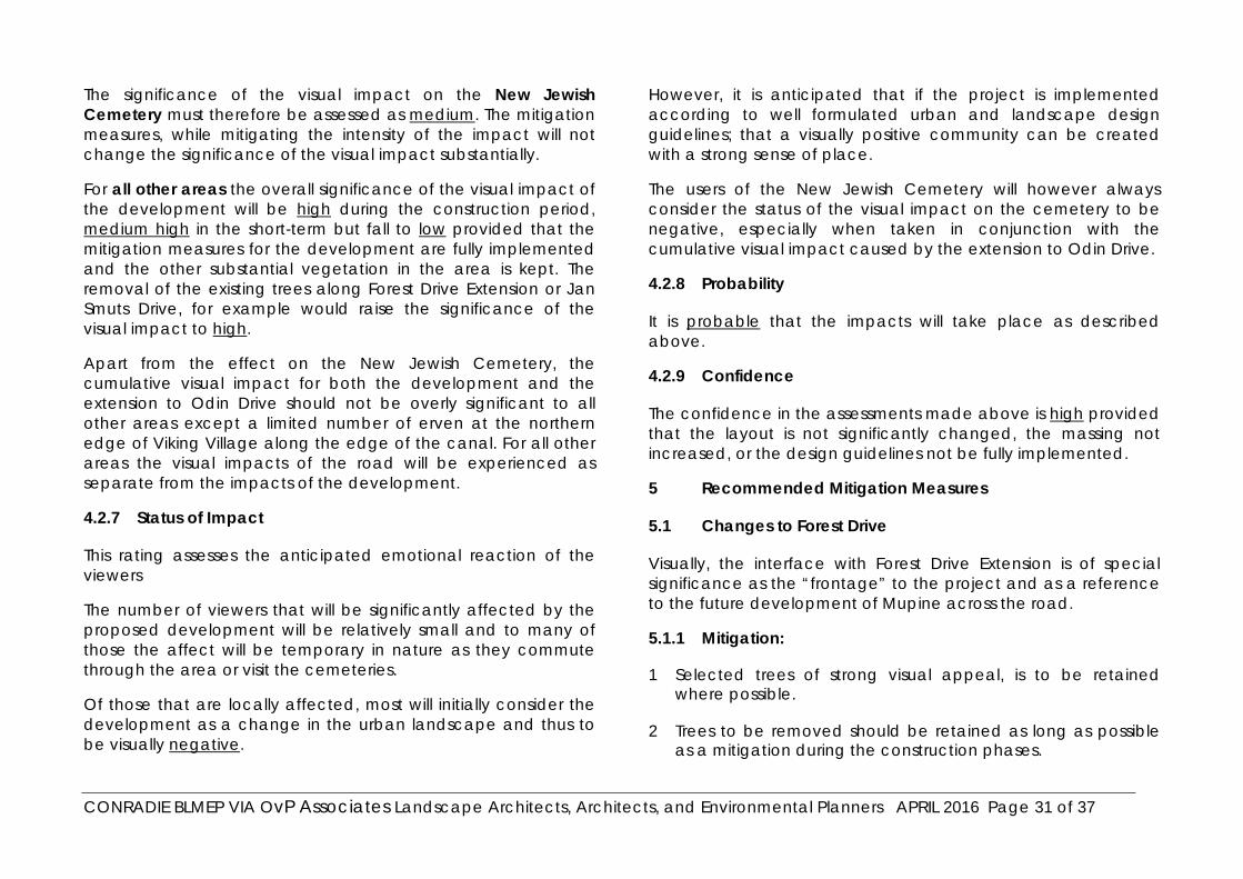
CONRADIE BLMEP VIA OvP Associates Landscape Architects, Architects, and Environmental Planners APRIL 2016 Page 31 of 37
The significance of the visual impact on the New Jewish Cemetery must therefore be assessed as medium. The mitigation measures, while mitigating the intensity of the impact will not change the significance of the visual impact substantially.
For all other areas the overall significance of the visual impact of the development will be high during the construction period, medium high in the short-term but fall to low provided that the mitigation measures for the development are fully implemented and the other substantial vegetation in the area is kept. The removal of the existing trees along Forest Drive Extension or Jan Smuts Drive, for example would raise the significance of the visual impact to high.
Apart from the effect on the New Jewish Cemetery, the cumulative visual impact for both the development and the extension to Odin Drive should not be overly significant to all other areas except a limited number of erven at the northern edge of Viking Village along the edge of the canal. For all other areas the visual impacts of the road will be experienced as separate from the impacts of the development.
4.2.7 Status of Impact
This rating assesses the anticipated emotional reaction of the viewers
The number of viewers that will be significantly affected by the proposed development will be relatively small and to many of those the affect will be temporary in nature as they commute through the area or visit the cemeteries.
Of those that are locally affected, most will initially consider the development as a change in the urban landscape and thus to be visually negative.
However, it is anticipated that if the project is implemented according to well formulated urban and landscape design guidelines; that a visually positive community can be created with a strong sense of place.
The users of the New Jewish Cemetery will however always consider the status of the visual impact on the cemetery to be negative, especially when taken in conjunction with the cumulative visual impact caused by the extension to Odin Drive.
4.2.8 Probability
It is probable that the impacts will take place as described above.
4.2.9 Confidence
The confidence in the assessments made above is high provided that the layout is not significantly changed, the massing not increased, or the design guidelines not be fully implemented.
5 Recommended Mitigation Measures
5.1 Changes to Forest Drive
Visually, the interface with Forest Drive Extension is of special significance as the “frontage” to the project and as a reference to the future development of Mupine across the road.
5.1.1 Mitigation:
1 Selected trees of strong visual appeal, is to be retained where possible.
2 Trees to be removed should be retained as long as possible as a mitigation during the construction phases.
CONRADIE BLMEP VIA OvP Associates Landscape Architects, Architects, and Environmental Planners APRIL 2016 Page 32 of 37
3 Tree and screen planting should be integral to the building and open space development facing Forest Drive.
4 Necessary fencing is to be visually permeable and be implemented in such a way that there is no sense of being a solid barrier between the road and the new development.
5 The buildings are not to be monolithic but their faces are to be broken up by the use of steps in the facades, balconies, interesting textures etc. so that the perceived bulk is reduced.
6 Signage is to be strictly limited with no large billboards, brightly coloured or large neon or uplit signs. It is proposed that all signage is designed within the parameters of a design manual.
7 Street lighting must be shielded so that only the area needing to be lit is lit. Light pollution and spillage must be kept to a minimum.
8 The up-lighting of buildings is not appropriate.
5.2 Overall High Density of Construction
The scale of the architecture being visually overpowering or inappropriate for the environment,
5.2.1 Mitigation:
1 An architectural guidelines document must be drawn up that sets an overall architectural theme for the development and ensures that the development is read as a unity without being uniform.
2 All building forms to be broken to allow for the perceived bulk of the buildings to be minimised.
3 No shear, bland, solid, featureless walls are to be allowed along, or within view, of any of the public access routes.
4 The colours used are to be subdued but with variation.
5 Use must be made of fenestration balconies and outdoor areas so that the living is orientated outwards and the presence of people suggested.
6 The use of planters on all levels of the buildings the encouragement of balcony and roof planting and the use of pergolas with vines etc. will aid in visually softening the development and minimising its perceived scale.
5.3 Impact on Public Space
The need to create public spaces that are vibrant and that are used and enjoyed by all.
Maintenance of the public spaces into the future.
5.3.1 Mitigation:
1 An adequate budget for development of the public spaces must be included and be part of the planning of infrastructure for the entire development.
2 Trees that are considered worth saving must be kept and protected during construction.
3 The streets and public spaces must be lined with trees that are able to provide for shade, wind screening and visual appeal.
4 Lighting should be adequate but screened so as to prevent light pollution and spillage.

CONRADIE BLMEP VIA OvP Associates Landscape Architects, Architects, and Environmental Planners APRIL 2016 Page 33 of 37
5 A creative scheme should be investigated whereby the owner’s associations/bodies corporate can take aesthetic ‘ownership’ of the adjacent public spaces thereby ensuring the maintenance of standards over the long term.
5.4 Green Character of the Area
5.4.1 Landscaping:
It is suggested that, in the light of the limited number of local species that can offer the vegetative shielding that the development requires, the use of the alien trees that have become part of the cultural heritage in the area be encouraged, provided that they are not invasive.
5.5 Controlling future development:
Any changes, improvements or extensions to the development that are not represented in the development plans assessed in this document must be subject to a separate visual impact assessment.
6 Monitoring and Review Programme
A review of the final plans and designs must be required once they have been completed to ascertain whether they still fall within the assessments of this document and will be visually acceptable.
7 Conclusion and Recommendations
The overall significance of the visual impact for the proposed development is assessed as Medium for both the New Jewish Cemetery and for all other areas.
In general, all developments around the site have turned their backs on it and therefore very few, if any, primary views will be affected, however, the visual effect on the New Jewish Cemetery, especially when taken with the cumulative effect of the extension to Odin Drive, will be considerable, affecting the sense of place and the privacy for mourners.
The implementation of the proposed development will undoubtedly change the existing visual character of the area significantly. It is believed, however, that through careful design, the retention of conservation-worthy existing trees and planting of new trees, and the conscientious implementation of the mitigation measures it will be possible to retain much of the ‘green’ nature of the area while at the same time creating a dynamic development that is in line with the provisions of the Provincial Spatial Development Framework and should eventually be experienced as neutral within the landscape.
It is recommended therefore that, in terms of its visual impact, the development proposal be approved provided that all mitigation measures are fully applied in the final design and implementation stages.
CONRADIE BLMEP VIA OvP Associates Landscape Architects, Architects, and Environmental Planners APRIL 2016 Page 34 of 37
8 Visual Impact Assessment - Definitions And Ratings
The following pages define the assessments used in section 5 of this document and their ratings.
Additional ratings that fall between the ratings defined here, but not specifically defined here, are sometimes used to differentiate between, for example, the comparisons between two options that are both high. The option with the slightly lower rating will be rated medium high and the other option will be rated high.
8.1 Viewshed
Definition: The "viewshed" refers to the outer-most extent or area from which a site can theoretically be seen. It must, however be remembered that visibility may be obscured in reality by objects within the viewshed such as existing buildings, trees, lower ridges, outcrops and other geographical or natural features.
Rating: no rating, only description
8.2 Visibility of Site
Definition: A description of the actual places within the viewshed from which the site can be seen. Only significant viewpoints are discussed in detail.
Rating: No rating only description
8.2.1 The Extent of the Impact
Definition: This rates the impact in terms of the size of the geographical area that will be influenced by the visual impact.
Ratings:
No impact: no visual impact is anticipated
Limited: Very small extent of visual influence – usually limited to the site
Local: Limited to the site and immediate surrounding area (1-5km)
Sub regional: The visual influence covers a greater area (5-10km)
Regional: The influence covers an area that includes an entire region or allows the visual impact to be extend beyond one region into another
National: The visual impact can be experienced across national boundaries and has national implications.
8.2.2 Zone of visual influence
Definition: This describes, in words, and possibly diagrams, the areas that will be influenced by the proposed development and rates them according to the perceived amount of influence on a specific area. It differs from describing the visibility of the development in that it concentrates on rating zones according to the amount of influence expected within a certain area.
CONRADIE BLMEP VIA OvP Associates Landscape Architects, Architects, and Environmental Planners APRIL 2016 Page 35 of 37
Ratings:
Nonexistent: there is no zone of visual influence because the site can not be seen from the surrounding areas
Low: from these areas the development will be seen but the influence of what is seen on the landscape is expected to have minimal influence on the perceived view
Medium: From these areas the development will be seen in such a way that it influences peoples perceptions of the view but without becoming a focal point.
High: The development will be seen in such a way that it is focal to the view, will influence it, and cannot be ignored.
8.3 Visual absorption capacity of the area
This refers to the ability of the surrounding areas to absorb the development in terms of its sameness to its surroundings. Important to its rating are the concepts of sameness, scale, diversity, texture and colour i.e. an area of houses would have a high absorption capacity for another house of the same size and style, but would have a low absorption capacity for a factory building on the same site, or a house of a completely different style or scale.
This concept is firmly linked to the concept of compatibility with surrounding landscape but the emphasis is on the area’s ability to absorb the development and not on the development’s ability to fit into its surroundings.
Ratings:
Low: The area is inherently incapable of visually absorbing the development
Medium: The area can absorb the development to a certain extent but it will remain essentially visually foreign to the area.
High: The area is of such a nature that it is easily able to visually absorb the proposed development
8.4 Compatibility with surrounding landscape
This rating places the emphasis on the proposed development as opposed to the area in which it is to be placed. To what extent does the proposed development conform to its surrounding landscape?
Ratings:
Appropriate: the proposed development fits in well with the type and style of the surrounding landscape. No new or different elements are introduced into the landscape.
Moderately appropriate: the proposed development has the ability to blend with its surroundings even though the type and style may be different to them. A new element is introduced into the surrounding landscape but is not jarring in any way
Inappropriate: the proposed development is at odds with its surroundings and introduces new and jarring elements into the landscape.
CONRADIE BLMEP VIA OvP Associates Landscape Architects, Architects, and Environmental Planners APRIL 2016 Page 36 of 37
8.5 Intensity of impact
This assessment refers to the degree to which the visual nature of the landscape will be altered.
Ratings:
Very low: The visual nature of the landscape is altered in a way that is hardly noticeable.
Low: The visual nature of the landscape is altered in a way that is noticeable but the visual impact does not intrude into the overall landscape in a way the grabs attention.
Medium: The visual nature of the landscape is altered in a way that is noticeable and the visual impact does intrude into the overall landscape in a way that calls attention to itself.
High: The visual nature of the landscape is altered in a way that is very noticeable and the visual impact intrudes into the overall landscape in a way that cannot but escape calling attention to itself.
8.6 Significance of impact
This rating combines the above ratings and determines the impact as a whole.
Ratings:
No change: this describes a potential concern which, after assessment, has proven to have no impact.
Very low: the visual impacts will be site specific or of a temporary nature.
Low: the impacts will be local or short to medium term
Medium: the impacts will be experienced locally and perhaps sub-regionally for the lifespan of the development or may lead to permanent change.
High: these impacts will be experienced regionally for the lifespan of the project, or will be irreversible
8.7 Status of impact
This describes the anticipated global perception of the visual impact of the completed project.
Positive: The visual impact of the completed project is expected to be perceived as positive, adding to the visual value of the landscape.
Neutral: The visual impact of the completed project is expected to be perceived as neutral, neither adding nor detracting from the value of the landscape.
Negative: The visual impact of the completed project is expected to be perceived as detracting from the value of the landscape.
8.8 Duration of impact
This describes the duration of the impact on its surroundings. (The construction period is rated separately.)
Ratings:
Temporary: 1 year or less
Short Term: – 5 years
Medium Term: 5-15 years
CONRADIE BLMEP VIA OvP Associates Landscape Architects, Architects, and Environmental Planners APRIL 2016 Page 37 of 37
Long Term: more than 15 years
8.9 Probability
This rates the project in terms of its likelihood of occurring. Certain projects, (i.e. Projects of national importance,) may not be stopped even if the visual impacts are unacceptable. In these cases the emphasis of the visual impact assessment would be on the mitigation methods that can be applied to minimise the impacts.
Ratings:
Probable: The project is likely to take place in one form or another.
Highly Probable: The project will take place no matter what the VIA ratings.
8.10 Confidence
This describes the confidence that the writers of the report have in their assessments. At times there is insufficient information about certain aspects of a project and this may call for a provisional assessment to be made. These assessments will have a low confidence.
Ratings:
High: All relevant information has been received so that the ratings are not expected to be changed.
Medium: There are areas of information that have not been received for evaluation, but the ratings are not expected to change significantly even with the new information.
Low: Relevant information has been incomplete or obtained form sources that are out of date or may lack integrity. The ratings may therefore change significantly with the obtaining of better information.
NB Care must be taken to read all ratings in context. A rating of high is not always bad! i.e. if the ‘zone of visual influence’ is rated high this is generally taken to be negative. At the same time a visual absorption capacity that is high would generally be taken as positive. If, however a development was meant to have high visual prominence, i.e. a national monument, a large zone of visual influence that is rated high could be positive and a high visual absorption capacity could be seen as negative. This is the reason why the rating of ‘Status of impact’ has been included.