Embed Size (px)
Citation preview

Heritage-led Planning for Rural Community Resilience: Terrace Landscapes
in Peru
By
Sampoorna Bhattacharya
A Thesis
presented to
The University of Guelph
In partial fulfillment of the requirements
for the degree of
Master of Science
In
Rural Planning and Development
With collaborative specialization in International Development Studies
Guelph, Ontario, Canada
© Sampoorna Bhattacharya, September, 2021
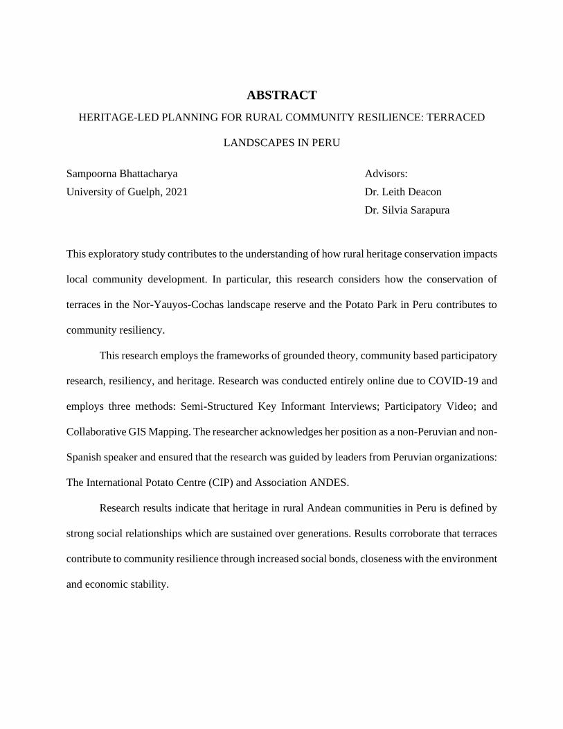
ABSTRACT
HERITAGE-LED PLANNING FOR RURAL COMMUNITY RESILIENCE: TERRACED
LANDSCAPES IN PERU
Sampoorna Bhattacharya Advisors:
University of Guelph, 2021 Dr. Leith Deacon
Dr. Silvia Sarapura
This exploratory study contributes to the understanding of how rural heritage conservation impacts
local community development. In particular, this research considers how the conservation of
terraces in the Nor-Yauyos-Cochas landscape reserve and the Potato Park in Peru contributes to
community resiliency.
This research employs the frameworks of grounded theory, community based participatory
research, resiliency, and heritage. Research was conducted entirely online due to COVID-19 and
employs three methods: Semi-Structured Key Informant Interviews; Participatory Video; and
Collaborative GIS Mapping. The researcher acknowledges her position as a non-Peruvian and non-
Spanish speaker and ensured that the research was guided by leaders from Peruvian organizations:
The International Potato Centre (CIP) and Association ANDES.
Research results indicate that heritage in rural Andean communities in Peru is defined by
strong social relationships which are sustained over generations. Results corroborate that terraces
contribute to community resilience through increased social bonds, closeness with the environment
and economic stability.
iii
ACKNOWLEDGEMENTS
Many people aided in the fruition of this research. I am incredibly grateful for the endless support
provided by my advisors Leith Deacon and Silvia Sarapura-Escobar, for their critical insights and
their encouragement. I am also indebted to Regan Zink and Jorge Novo for providing expert advice
and support with GIS and presentations. I am grateful for the invaluable guidance I received from
Stef de Haan and Henry Juarez from the International Potato Centre (CIP) and Tammy Stenner
and Alejandro Argumedo from Association ANDES.
I wish to thank each and every member of the ‘tecnicos locales’ in the Potato Park who
dedicated their time and research skills to conduct and participate in this research:
Ricardina Pacco Ccapa, Aniceto Ccoyo Ccoyo, Nazario Quispe Amao, Lino
Mamani Huarka, Mariano Sutta Apocusi, Daniel Pacco Condori, Bacilides
Hancco Palomino, and Ciprian Ccoyo Banda.
I wish to thank the residents and friends of the communities in the Nor Yauyos Cochas
Landscape Reserve and the Potato Park. Thank you for your dedication to your communities.
I wish to express my gratitude to Adam Sneyd, and my fellow classmates in the
International Development specialization and the Rural Planning and Development department
who have helped me broaden my understanding.
Thank you to my wonderful life partner, Zeyad, for listening to all my presentations, editing
my papers and providing motivation throughout this process. Finally, thank you and amar pronam
niyo to my family who shapes everything I do and who nurtured my love for culture and heritage,
and who continue to be thrilled with any new adventures that grace my life.
iv
PREFACE AND ETHICAL CONSIDERATIONS
This thesis is an original work by Sampoorna Bhattacharya. This research study was conducted in
collaboration with the International Potato Center (CIP) and Association ANDES. This
exploratory research study is intended to contribute locally based knowledge about rural heritage
systems to academia, non-profit organizations, government bodies, and the general public, with
the recommendation to scale this research up and out.
The COVID-19 pandemic began shortly after the research topic, goal and objectives were
finalized, and impacted the research design, methods and data.
This research study received research ethics approval from the University of Guelph’s
Research Ethics Board (See Appendix A). Due to participant comfortability, consent was gathered
orally through video recordings or in conversation. Participants in the Potato Park communities,
many of whom identify as Indigenous, were especially uncomfortable in signing paper documents.
A document stating the researcher’s intentions with the research was signed by the student
researcher and given to the community members.
No identifiable information of participants is provided in this thesis or in any other means
of dissemination. Participants were informed that there were no consequences of refusing to
participate or stopping at any point. Participants were informed that participation is voluntary and
were given time to ask any questions.
Research title: Heritage-led Planning for Rural Resilience: Terraced Landscapes in Peru. REB #
20-10-022, January 12, 2021.
v
TABLE OF CONTENTS
Chapter 1 Introduction .....................................................................................................................1
1.1 Background ............................................................................................................................1
1.2 Research Goal and Objectives ................................................................................................3
1.3 Significance and Contributions of Research ..........................................................................4
1.4 Researcher Reflexivity and Positionality ..............................................................................5
1.5 Overview of Thesis ................................................................................................................7
Chapter 2 Literature Review ............................................................................................................8
2.0 Introduction ............................................................................................................................8
2.1 Heritage ..................................................................................................................................8
2.1.1 Overview .........................................................................................................................8
2.1.2 Definitions and Perceptions .............................................................................................8
2.1.3 Indigenous Peoples and Heritage ..................................................................................12
2.1.4 Biocultural Heritage ......................................................................................................13
2.1.5 Rural Contexts ...............................................................................................................15
2.2 Resilience .............................................................................................................................16
2.2.1 Overview .......................................................................................................................16
2.2.2 Defining Resilience .......................................................................................................16
2.2.3 Small Community and Rural Contexts ..........................................................................18
2.2.4 Resilience in Development Policy.................................................................................19
2.2.5 Frameworks for Measuring Resilience ..........................................................................20
2.3 Common Ground ..................................................................................................................21
2.3.1 Overview .......................................................................................................................21
2.3.2 Heritage and Development ............................................................................................21
2.3.3 Heritage and Resilience .................................................................................................22
2.3.4 Rural and Heritage .........................................................................................................23
2.3.5 Heritage, Development and Resilience .........................................................................23
2.4 Conclusion ............................................................................................................................24
Chapter 3 Methods and Context ....................................................................................................26
3.0 Introduction ..........................................................................................................................26
3.1 The Impact of COVID-19 on Research ................................................................................26
3.2 Research Goal and Objectives ..............................................................................................27
3.3 Theoretical Frameworks .......................................................................................................28
3.3.1 Grounded Theory...........................................................................................................28
3.3.2 Community Based Participatory Research ....................................................................28
3.3.3 Resiliency and Heritage Frameworks ............................................................................29
3.4 Mixed Methods Design: Hybrid Approach ..........................................................................29
3.4.1 Semi-structured Key Informant Interviews ...................................................................30
3.4.2 Participatory Video ........................................................................................................31
3.4.3 Collaborative GIS Mapping ..........................................................................................31
3.4.4 Participant Selection ......................................................................................................32
3.4.5 Analysis .........................................................................................................................34
3.4.5.1 NVivo .....................................................................................................................34
3.4.5.2 Google Earth Pro and ArcGIS ...............................................................................35
3.4.6 Triangulation .................................................................................................................35
vi
3.5 Qualitative Rigour ................................................................................................................36
3.5.1 Credibility ......................................................................................................................36
3.5.2 Dependability ................................................................................................................37
3.5.3 Confirmability ...............................................................................................................37
3.5.4 Transferability ...............................................................................................................38
3.5.4 Summary of Qualitative Rigour Approaches ................................................................39
3.6 Regional Context and Site Selection ....................................................................................39
3.6.1 Cultural Heritage in the Peruvian Andes .......................................................................41
3.6.2 The Andean Cosmovision .............................................................................................42
3.7 Study Sites ............................................................................................................................44
3.7.1 Nor Yauyos Cochas Landscape Reserve .......................................................................45
3.7.2 Potato Park/Parque de la Papa .......................................................................................47
3.8 Conclusion ............................................................................................................................48
Chapter 4 Results ...........................................................................................................................49
4.0 Introduction ..........................................................................................................................49
4.1 Semi-structured Key Informant Interview Results ...............................................................49
4.1.1 Overview .......................................................................................................................49
4.1.2 Society and Culture .......................................................................................................50
4.1.2.1 Heritage ..................................................................................................................52
4.1.2.2 Social Relationships ...............................................................................................52
4.1.2.2 A: Youth and Older Generations ...............................................................52
4.1.2.2 B: Tourists and Urban Residents ...............................................................53
4.1.2.2 C: Governance and Political Power ...........................................................55
4.1.3 Environment ..................................................................................................................57
4.1.3.1 Climate Change ......................................................................................................57
4.1.3.2 Agriculture .............................................................................................................58
4.1.4 Economy ........................................................................................................................59
4.1.4.1 Innovation ..............................................................................................................59
4.1.4.2 COVID-19..............................................................................................................60
4.1.5 Conclusion .....................................................................................................................60
4.2 Participatory Video Results ..................................................................................................61
4.2.1 Overview .......................................................................................................................61
4.2.2 Environment ..................................................................................................................62
4.2.3 Society and Culture .......................................................................................................66
4.2.4 Economy ........................................................................................................................69
4.2.5 Conclusion .....................................................................................................................72
4.3 Collaborative GIS Results ....................................................................................................72
4.3.1 Overview .......................................................................................................................72
4.3.2 Terraces .........................................................................................................................74
4.3.2 Elements of the Cultural Landscape ..............................................................................76
4.3.2 Conclusion .....................................................................................................................80
4.4 Conclusion of Results ...........................................................................................................80
Chapter 5 Discussion .....................................................................................................................81
5.0 Introduction ..........................................................................................................................81
5.1 Addressing the Goal and Objectives ....................................................................................81
5.1.1 Goal ...............................................................................................................................81
vii
5.1.2 Objective 1.....................................................................................................................81
5.1.3 Objective 2.....................................................................................................................82
5.1.4 Objective 3.....................................................................................................................83
5.1.5 Objective 4.....................................................................................................................84
5.2 Relevance to Heritage Studies ..............................................................................................84
5.2.1 Rural Heritage ...............................................................................................................84
5.2.2 Biocultural Heritage System..........................................................................................86
5.2.3 Traditional Ecological Knowledge ................................................................................87
5.3 Connecting to Community Resilience ..................................................................................88
5.3.1 Environment ..................................................................................................................89
5.3.2 Political ..........................................................................................................................90
5.3.3 Economy ........................................................................................................................91
5.3.4 Society and Culture .......................................................................................................92
5.4 Connecting to Development .................................................................................................92
5.4.1 Tourism..........................................................................................................................92
5.4.2 Rural Heritage-led Development Models ......................................................................93
5.4.3 Agriculture and Entrepreneurship .................................................................................93
5.5 Limitations ...........................................................................................................................95
5.5.1 COVID-19 .....................................................................................................................95
5.5.2 Limitations in Methods..................................................................................................96
5.6 Recommendations and Conclusions .....................................................................................97
5.6.1 Scaling Up and Out .......................................................................................................97
5.6.2 Knowledge Mobilization ...............................................................................................98
5.7 Conclusion ............................................................................................................................99
5.7.1 Lessons ..........................................................................................................................99
5.7.2 Further Research ..........................................................................................................100
Bibliography ................................................................................................................................101
Appendix A: Ethics Approval Certificate ....................................................................................111
Appendix B: Interview Guide ......................................................................................................112
Appendix C: Participant Information Letters and Graphics ........................................................114
viii
LIST OF TABLES
Table 1: Summary of Qualitative Rigour Criteria and Approaches in this Research ....................39
Table 2: Active and inactive terraced areas in Laraos and Carania. .............................................76
Table 3: Water sources in Laraos and Carania. ............................................................................78
Table 4: Major themes in resiliency frameworks identified through literature review. ...............89
ix
LIST OF FIGURES
Figure 1: Map of Peru with indicated study sites. ........................................................................45
Figure 2: Map showing the Nor Yauyos Cochas Landscape Reserve communities. ...................46
Figure 3: Map showing the communities in Parque de la Papa or Potato Park. ...........................47
Figure 4: Word cloud of interview participants’ definitions of heritage. ....................................50
Figure 5: Traditional ditch in Potato Park. ....................................................................................63
Figure 6: Cunca and wachu in Potato Park. .................................................................................64
Figure 7: Old terraces in Potato Park. ...........................................................................................64
Figure 8: Water source in Potato Park. .........................................................................................65
Figure 9: Terrace cultivation areas in Potato Park. .......................................................................66
Figure 10: Landscape panorama in Potato Park. ..........................................................................67
Figure 11: Relationship with grandparents in Potato Park. ..........................................................67
Figure 12: Relationship with animals and children in Potato Park. ..............................................68
Figure 13: Lagoon water source in Potato Park. ...........................................................................69
Figure 14: Cultivation of maize in Potato Park. ...........................................................................70
Figure 15: Cultivation of tarwi in Potato Park. .............................................................................71
Figure 16: Native potato cultivation with crop rotation cycle of 7 years. ....................................71
Figure 17: Screenshot of the basins of Laraos (right) and Carania (left). .....................................73
Figure 18: Screenshot of delineation of red, orange and green zones in Laraos. .........................74
Figure 19: Screenshot of close up of green zone in Carania. ........................................................75
Figure 20: Screenshot of close up of red zone in Laraos. .............................................................75
Figure 21: Screenshot of main Laraos water source. ....................................................................77
Figure 22: Cultural Landscape of Laraos. .....................................................................................79
Figure 23: Cultural Landscape of Carania. ...................................................................................79
1
CHAPTER 1
Introduction
1.1 Background
Systemic challenges such as out-migration, insufficient provision of governmental services, and
poor infrastructure are prevalent in rural regions around the world (IFAD, 2016; CRRF, 2015).
Rapid modernization and development are common responses to combat these deficiencies
(Chigbu et. al, 2017). However, this ‘push for progress’ has resulted in the erosion of cultural and
natural heritage, such as sacred spaces, historical buildings, traditional cuisine, and language, often
as an unintended consequence (Nepravishta, 2020).
Recently, international organizations have attempted to bring focus to the degradation of
rural heritage. Examples include The United Nations Educational, Scientific and Cultural
Organization (UNESCO) declaring 2019 to be the year of Indigenous Languages, the International
Council on Monuments and Sites (ICOMOS) declaring the 2019 theme to be ‘Rural Landscapes’,
and the launch of Ruritage, a pan-European heritage-driven rural regeneration program, in 2020
(UNESCO, 2018; ICOMOS, 2019; Ruritage, n.d.). These events signify that rural heritage is an
emerging theme in global heritage institutions and establish the significance of rural regions in
heritage discourse.
Rural heritage expresses the unique histories and traditions of communities and fosters a
sense of pride, identity and togetherness and nurtures relationships with ancestors and one another
(Schmitz and Pepe, 2021). However, one of the least researched aspects of community
development is the impact caused by loss of cultural heritage (Chigbu et. al, 2017). Additionally,
although there exists well-established support for strengthening resiliency of heritage prior to or
after disaster from organizations such as Blue Shield International and ALIPH, there are few
2
organizations or studies which examine the role of heritage as agents in contributing to community
resiliency (Blue Shield, 2021; ALIPH, n.d.; Murthy, 2013).
In the past year, the COVID-19 pandemic has impacted the way in which people around
the world, as well as within small communities, interact, work, buy and live (OECD, 2020; Jackson
et al., 2021). Rural communities have been affected deeply, due to the high numbers of elderly
residents who are more prone to risk, and the difficulty in accessing healthcare services (OECD,
2020). The Peruvian Andes region is home to Indigenous and peasant communities who embrace
rural lifestyles and are subject to harsh climate conditions. The intersection of heritage and
resiliency for these communities and the COVID-19 pandemic is unforeseen.
The Andean region of Peru also faces a myriad of heritage challenges which are influenced
by global threats such as urbanization, modernization, over-tourism and climate change. Over-
tourism is a persistent issue in Peru’s many world heritage sites including Machu Picchu. Over-
tourism can often make communities dependent on tourism for their livelihoods and encourage a
simplified and therefore inauthentic perspective on the culture of the region, causing an erosion in
cultural heritage (Goodwin, H., 2017; Schmitz and Pepe, 2021). The World Monuments Fund
placed the Sacred Valley of the Incas on their 2020 list of 25 most endangered sites due to demands
for the construction of an airport close to Machu Picchu (WMF, 2019). Another pressing challenge
is the slow erasure of traditional knowledge due to discrimination, a lack of access to services, and
disconnect from governments and institutions (Amnesty International, n.d.). In order to promote
authenticity in rural heritage, there should be an encouragement of endogenous cultural
preservation.
The most abundant heritage structures in Peru are the agricultural terraces (Chapagain and
Raizada, 2017). Through moisture and temperature control and irrigation systems, the terraces can
3
grow diverse varieties of potatoes along with the diversified inclusion of other roots, tubers and
crops such as shrubs, herbs and fruit, encouraging biodiversity and market competitiveness at the
community level and local and regional markets. The terraces are maintained through
generationally transferred local Indigenous knowledge. Recently, pressures to modernize to
accommodate for growing market demands has led to many abandoning the terraces. The terrace
method for cultivation is labour intensive and faces challenges in incorporating new techniques or
machinery (Chapagain and Raizada, 2017). Additionally, climate change has negatively impacted
cultivation: due to warming temperatures, higher levels of the terraces are now used to grow crops
that would have grown in lower levels, and there has been an observed movement of grazing
animals to higher altitudes as well (INMIP, 2014).
1.2 Research Goal and Objectives
The goal of this study is to conduct an exploratory study that contributes to the understanding of
how rural heritage conservation impacts local community development. In particular, this research
considers how the conservation of terrace constructions in the Nor-Yauyos-Cochas landscape
reserve and the Potato Park in Pisac contributes to resiliency, crisis management and risk
preparedness in the respective communities. The following research objectives guide this research
study:
1. Determine local community members’ perceptions about the terraces and understand
their interactions with the terraces.
2. Compare uses of terraces during past crises with current crises (COVID-19, food
crisis).
4
3. Examine the role of terraces in providing local communities with food security and
opportunities for Indigenous governance.
4. Explore the function and capacities of terraces in combating threats such as climate
change, food crises and marginalization.
1.3 Significance and Contributions of Research
This research study contributes to the broadening discourse on heritage conservation and
management, in the aim to contribute to the understanding of rural heritage, and the prospects of
heritage for rural community resilience. This study also explores participatory research methods
during the COVID-19 pandemic.
Terrace agriculture is a significant agricultural system in rural mountainous communities
in several countries in Asia, South America, Central America, East Africa, and in Italy and Yemen
(Chapagain and Raizada, 2017). The Globally Important Agricultural Heritage Systems (GIAHS)
program initiated by the UN Food and Agricultural Organization (FAO) safeguards and
encourages heritage-conscious development for 59 agricultural landscapes around the world,
including the Andean terraces (FAO, n.d.). Therefore, this exploratory research study provides a
strong foundation which has the potential to be scaled up and out for improved rural resilience in
various locations worldwide.
This research project is significant to two specialized emerging global movements:
decolonizing heritage praxis, and combatting climate change and improving risk preparedness
through traditional local knowledge systems.
5
1.4 Researcher Reflexivity and Positionality
Positionality of the researcher encompasses their identities, background, and perspectives (Bourke,
2014; Sultana, 2007). Reflexivity refers to critical reflection of how the researcher conducts
research and the how knowledge transfer in the research study is being influenced through the
researcher’s lived experiences and personal viewpoints (Sultana, 2007; Guillemin and Gillam,
2004). The researcher’s positionality and reflexivity in the research process must be addressed as
the research is cross-cultural, participatory, international, and centers Indigenous peoples. The
following statement is written by the researcher to effectively communicate their positionality and
reflexivity.
My name is Sampoorna Bhattacharya. I was born in Kolkata, India and was raised partially
in Ontario, Canada and partially in Kolkata. I have the privilege of being a graduate candidate with
a B.A. degree in the subject I am passionate about. I am not Peruvian, I do not speak Spanish, and
I have not had the experience of living in a rural region for longer than one month. In preparation
for this research, I also conducted a well-rounded literature review of the Andean region of Peru,
including using unorthodox methods such as listening to Andean music, becoming immersed in
Peruvian media and pop culture, reading news from Peruvian outlets such as ANDINA and
Peruvian Times, and watching documentaries relevant to life in the Peruvian Andes.
Before beginning this research study, I took the course titled ‘International Research
Methods’ in the department of International Development Studies at the University of Guelph,
which introduced me to the importance of reflexivity in research. I was cautious through every
step of the research process to be mindful of cultural differences, difficulties in translation between
English, Spanish, and Quechua, and the potential of being viewed as a threatening presence due to
6
my positionality as a student in the West. I am grateful for the guidance I have received from the
International Potato Center and Asociacion ANDES in each step of the process, including
communications with local organizations, research design, methods, and dissemination of results.
I am also grateful to Silvia Sarapura, my co-advisor and interview translator. Silvia Sarapura is
Peruvian-Canadian, demonstrates her pride for her rural hometown in Peru, and speaks the
Peruvian dialect of Spanish. Her presence as my superior may have been able to comfort interview
participants who were unsure of my inexperience with the region.
Through my experiences having grown up in two completely different regions of the world,
and being bilingual in English and Bengali, I was able to resonate with community members when
there was a word or phrase that was difficult to translate, or when culturally sensitive matters were
discussed. For example, as someone who grew up surrounded by spirituality, rites and traditions,
I was able to quickly understand the Andean Cosmovision and the role it plays in Andean peoples’
lives. However, I am aware that my life experiences have been entirely different to that of the
participants. In one of the first meetings with community members in the Potato Park, I became
aware of the lack of trust participants have with outsiders after having been exploited in the past.
The Andean region of Peru has historically been attacked by the Spanish and stripped of
its Indigenous cultures. The Andean peoples have been reclaiming and restoring their lands and
identity since these attacks and are navigating through poverty and the lack of pride that continues
to exist. I honour the resilience of the Andean peoples and realize that I will never fully be able to
comprehend these struggles.
7
1.5 Overview of Thesis
This thesis is divided into five chapters. This chapter provided the introduction to the research
study. The next chapter is the literature review of the key concepts of this research. Chapter 3
describes the methodology and methods used in this research. Chapter 4 presents and examines
the findings from the three methods which are explained in Chapter 3. The last chapter is the
conclusion for the thesis and includes recommendations and next steps after the completion of this
research study.
8
CHAPTER 2
Literature Review
2.0 Introduction
This chapter presents the literature review conducted for the research study. The literature review
is divided into three broad areas: heritage, resilience, and the intersections of rural heritage,
development and community resilience.
2.1 Heritage
2.1.1 Overview
The discourse surrounding heritage is vast and diverse, pertaining to both global and local contexts,
involving both human and natural elements, and proving itself to be an empowering or dangerous
tool depending on the user and context. The following literature review was conducted to inform
about the various uses and capacities of heritage, particularly as it relates to Indigenous, local and
rural perspectives. This section includes ideas about mainstream definitions and perceptions of
heritage, Indigenous cultures and heritage, rural heritage and biocultural heritage.
2.1.2 Definitions and Perceptions
Heritage is a term which seems universal and understood as a concept inherently. However, its
definition and in turn, its management, ownership, exploitation and politicization has been
examined and contested increasingly since the 1970s. Before the 70s, the term heritage was widely
recognized to be synonymous with individual inheritance from deceased ancestors (Watkins and
Beaver, 2008; Jones et al., 2020).
9
Today heritage holds no single definition as it is interpreted differently through distinct
perspectives. This section aims to identify definitions of heritage from the perspectives of
practitioners and the general public and in the contexts of community development, rural regions
and personal connections.
Heritage as understood by the professional sector, derives from UNESCO’s 1972
Convention Concerning the Protection of the World Cultural and Natural Heritage, commonly
referred to as World Heritage Convention, in which heritage was formally categorized into natural
and cultural (Watkins and Beaver, 2008). Natural heritage refers to natural features and geological
and physiographical formations. They include the habitats of threatened plant and animal species
and natural sites considered globally significant in beauty or to science and conservation (Watkins
and Beaver, 2008). Classifications of cultural heritage listed in the World Heritage Convention
included monuments, which comprised of architectural work, sculpture and painting,
archaeological items, inscriptions, cave dwellings and the combination of elements; groups of
buildings; and landscapes or archaeological sites which can owe their significance to humans or
the combined forces of humans and nature.
UNESCO’s World Heritage Committee is advised by prolific international heritage
organizations such as The International Centre for the Study of the Preservation and Restoration
of Cultural Property (ICCROM) and The International Council on Monuments and Sites
(ICOMOS). Thus, their definitions are fortified as the universal standard for all stakeholders
involved in heritage practice around the world. However, the categories reflected the upper class,
Euro-centric perceptions of history, and therefore was not holistic to world heritage (Wells, 2018).
In many countries of the Global South, and in small, Indigenous or tribal communities, heritage is
passed down generationally and preserved or evolved through intangible methods (Wells, 2018).
10
Folklorists, an integral group of practitioners in the heritage sector, also study heritage through its
intangible qualities (Wells, 2018). In the 2003 Convention for the Safeguarding of the Intangible
Cultural Heritage, cultural heritage was further categorized into tangible and intangible. The
definition of intangible is not only inclusive of non-physical heritage such as languages, music,
craft processes, etc. but also dictates that it must be relevant and owned by the community from
where it originates (UNESCO, 2003). Stealing or appropriating a culture’s Indigenous heritage
makes it invalid (UNESCO, 2003). Tangible heritage is also further divided into movable and
immovable, the former applying to paintings, sculptures, books or relics while the latter refers to
sites, monuments and items which are rooted in place (UNESCO, 2003).
Due to the cultural significance of heritage sites, objects or practices, their management is
not tethered to UNESCO and international organizations with pluralistic visions. Instead, heritage
is also managed by the politics of individual countries and their national and regional governments,
falling prey to marketing, propaganda, and financial exploitation. Shouten (1995) explains that
heritage is history commodified, as it is influenced by factors such as local and national ideologies,
romanticized notions and marketing. Similarly, Herbert (1995) warns of the danger of heritage,
explaining that history can be easily inverted and heritage can be transformed into a sensationalized
and marketed product without consideration for authenticity. Furthermore, UNESCO is a subset
of the United Nations, which is composed of a multilateral membership of 193 countries. Political
rivalry and alliance between these countries is intertwined with heritage matters. Aplin (2002)
explains that heritage embodies a duality of personal and political, and that the subjectivity of
decided importance in heritage can infiltrate into political spheres. Cheung (2003) writes that while
heritage allows people to reflect and connect with their identity, it can ultimately be a tool for
instigating personal political agendas.
11
Setting aside the aspect of politics from the previously mentioned interpretations of
heritage, what remains is the understanding that heritage has an undeniable personal quality. The
emotional or spiritual pull of a site, object or practice is experienced by different people in varying
fortitudes. Although organizations such as UNESCO, ICCROM and ICOMOS aim to set global
benchmarks for significant heritage sites and practices, sites that are not part of the World Heritage
register may also have special significance to people due to individual beliefs or upbringings.
Laurajane Smith (Wells 2018) is an anthropologist whose research entails interviewing members
of the general public in Australia, the United States and Canada about their understanding of the
term heritage. Smith has concluded that her interviewees generally expressed that heritage is not
about historical objects but about how people think and act in the present.
Heritage has also been described an evolving concept, and relevant not only to the past but
to the present and the future. Reflecting on the distinction between heritage and history, Welsh
(1992, p. 893) writes “The preservation of culture cannot simply mean preservation of the outer
veneer of a previous way of life". Heritage instead must be preserved in a manner that respects and
values the local wants and needs of the present and can be adapted to continue in the future. Smith
(2006) defined heritage as a ‘cultural process’. Loulanski (2006) reflected these sentiments,
asserting that the concept of cultural heritage is susceptible to change and is always changing.
The concept of heritage as a continually evolving process, similar to the concept of
intangible heritage, is embraced by Indigenous cultures, rural and small communities and
folklorists, and is found relevant when analyzing natural landscapes or landscapes of mixed
cultural and natural significance. The following sections will focus more specifically on the ideas,
perceptions and value of heritage in distinct contexts, specifically, Indigenous peoples and
cultures, animal and plant biodiversity and biodiverse landscapes, and rural communities.
12
2.1.3 Indigenous Peoples and Heritage
According to the analysis of several global organizations, there exist around 370 million
Indigenous peoples in over 90 countries around the world (UNESCO, n.d.; Amnesty International,
n.d.). There are over 5000 distinct Indigenous communities and over 4000 Indigenous languages
around the world (Amnesty International, n.d.).
‘Indigenous’ cannot be constricted to one definition due to the diversity of belief systems
and legacies, and due to peoples’ rights for self-identification (United Nations, 2013). Indigenous
peoples are generally considered to be the descendants of the first peoples of their land (United
Nations, 2013; Sarivaara et al., 2013). Therefore, ‘Indigenous heritage’ is diverse and varies across
regions. Indigenous peoples and heritage, however, is presented as a section in this chapter because
of their core common perceptions and challenges of representation in heritage conservation,
management and documentation. Indigenous peoples globally have been faced with colonial and
neo-colonial oppression in the forms of forced Western education or ‘modernization’, forced
labour, religious intolerance, cultural annihilation, and destruction, extraction and stealing of
Indigenous lands (Sabbarwal, 2017; Survival International, 2016; Behrendt and Saleem, 2001).
Such brutal forces emerged through colonial empires in the early sixteenth century but its impacts
continue on to present day; as exemplified through factory schools for tribal people in Africa, Asia
and South America, the myriad of mining corporations in encroaching upon Indigenous lands,
sustained intergenerational trauma from the residential school system in Canada and poverty
cycles which are difficult to escape (Sabbarwal, 2017; Survival International, 2016; Behrendt and
Saleem, 2001). This has resulted in a clear distinction between the way heritage is perceived and
theorized by Indigenous peoples and majority narratives of heritage conservation.

13
Smith (2006) provides several reasons why Indigenous heritage should be written about as
separate from other understandings of heritage including misinterpretation in the heritage industry,
the reluctance towards archaeology, the continual quality of Indigenous heritage, and the flow
between real and supernatural worlds. To Indigenous peoples, heritage is considered to be
continually evolving and must be inclusive of the past, present and future (Smith, 2006).
Indigenous heritage is often depicted in a historical lens, written about in the past tense, with no
indication to their existence in the present (Smith, 2006). It is often wrongly confined to pre-
historic remains and therefore considered archaeological data. Furthermore, archaeologists are
considered significant actors with established and authorized protocols and policy in mainstream
heritage perspectives. Indigenous heritage not only transcends through time but embodies distinct
spiritual beliefs which incorporate movement and unity between the real and spirit realms. Many
Indigenous cultures embody cyclical or spiral worldviews as opposed to linear. Additionally, Van
Opstal and Huge (2013) list several conflicts between Indigenous and non-Indigenous worldviews.
These include the priority placed by Indigenous worldviews on eco-centrism instead of
anthropocentrism, spirituality instead of secularism or monotheism, the idea that everything is
alive instead of materialism approaches, and a focus on land as sacred as opposed to owned (Van
Opstal and Huge, 2013).
2.1.4 Biocultural Heritage
Bio-cultural heritage, or biological cultural heritage, is an emerging paradigm comprising of the
concepts of cultural landscapes, traditional ecological knowledge systems and ecosystem services.
It is often used in research and planning practice involving Indigenous or rural communities.
14
Biocultural heritage is understood to be the natural and cultural products generated through
the relationship between the biogenetic diversity of landscapes and cultural fabric of Indigenous
and rural communities, comprising of elements such as languages and dialects, memory and sense
of place, traditional knowledge and values and belief systems (Ekblom et al., 2019; Poole, 2018).
UNESCO first defined biocultural heritage in 2008, as living organisms and habitats whose
persistence is attributed to cultural activity over time (UNESCO, 2008). Similarly, cultural
landscapes is defined as “the combined works of nature and humankind”, and their
interrelationship over time (UNESCO, 1992). Another term for this phenomenon, coined by
Rotherham, is ecocultural landscapes (Rotherham, 2015).
Traditional ecological knowledge or TEK is a significant component in examining context
specificity in biocultural heritage, especially considering histories of oppression and colonial
injustices faced by many Indigenous and small communities. TEK is understood as any regionally
specific information received, maintained and bestowed over generations (Saylor et al., 2017).
TEK is often passed down through intangible means, such as storytelling, music, or oral instruction
which has caused top down and authoritative institutions to undermine or neglect its significance
(Wenzel, 1999; Berkes, 1993; Bruchac, 2014). However, TEK systems are integral components in
understanding environments and changes that occur in them (Jigyasu, 2002, 2016; Bridgewater,
2017).
Ecosystem services is understood as the quantification of qualities associated with the
natural environment which are beneficial to humans (Saylor et al., 2017; Rotherham, 2015). This
current definition of the concept originally emerged in the 1970s as an interdisciplinary effort
between the fields of biology and economics, to better manage the existing reciprocal relationship
between humans and nature (Lele et al., 2013).
15
2.1.5 Rural Contexts
Rural heritage as a topic is closely tied to intangible, biocultural, and Indigenous heritage concepts.
Rural heritage has no universal definition but is understood to include architecture in the rural
landscape, as well as the broader geographies, political histories, cultures and traditions that make
up that environment (Du and Shi, 2019).
Rurality is most often defined by low population size, but can also be characterized through
low population density, small land size, and remoteness from urban centers (Hardy et al., 2019;
Wineman et al., 2020; Bennett, K. J. et al., 2019). Due to these characteristics, rural regions often
have specific worldviews resulting in heritage that is under-documented or misunderstood due to
difficulty in accessing these areas, language differences, and cultural barriers.
Insensitive or unsustainable tourism is an unsuspecting danger threatening many rural
regions around the world. ‘Venice syndrome’ was a term coined by Tielsch and Pichler in their
2012 documentary film of the same title, to express the social detriments of excess and
unsustainable tourism in Venice, Italy, and is continued to be used to describe the phenomenon in
other case studies (Visentin and Bertocchi, 2019). In Venice, the influx of massive amounts of
tourists and cruise ships has caused gradual local outmigration, with the few remaining locals being
solely dependent on tourism for their livelihoods. Additionally, the ecosystem of the lagoon is
endangered by increasing crowds and cruise ships (Capocchi et al., 2019). The economic gain from
excessive tourism can also encourage local residents and governments to display a simplified and
therefore inauthentic perspective on the culture of the region, causing an erosion in cultural
heritage (Goodwin, 2017; Minca, 2000).
Examples of rural heritage may include world heritage sites which are situated in rural
areas, rural festivals, agricultural or industrial systems, languages and dialects, traditional crafts
16
and practices and vernacular architectural heritage. ‘Vernacular’ refers to built structures which
represent the contextual specificity of where they are located, and usually are not the work of a
well-known architect but instead a community effort, such as wood engineered stave churches
which are found throughout the Norwegian landscape or the water management mill network in
Kinderdijk-Elshout, Netherlands (UNESCO, n.d., a). Shantiniketan, an open air and nature centric
school in India designed in 1901 by prolific poet and artist, Rabindranath Tagore, promotes and
involves distinct rural values of the Baul people and other regional tribal communities (UNESCO,
n.d., b). Its existence is rooted in rural cultures and lifestyles.
2.2 Resilience
2.2.1 Overview
Resilience is a recently emerged topic which is rapidly growing and evolving in definition and
measurability (Jones and Comfort, 2017; Rosowsky, 2019). This section aims to enhance
understanding on the term ‘resilience’ and its applications in various disciplines, particularly in
relation to rural community development. This section includes definitions and key terminology
used across disciplines, the connection between resilience and sustainability, overviews of
resilience in relation to community development and rural contexts, and evolving methodologies
for measuring resilience.
2.2.2 Defining Resilience
Resilience is a term which is gaining popularity across various industries such as environmental
sciences and biology, health and wellness, engineering, social and economic development and
disaster management (Heijman et al., 2007). Resilience does not have, and cannot have one single
17
definition, due to the term’s usage across diverse and distinct fields of study (Steen and Morsut,
2020; Demiroz and Haase, 2019). A cluster created from a literature review of 60 papers indicates
that the term is most used in the fields of environmental sciences and ecology, and psychology
(Hosseini et al., 2015).
The term was introduced in the ecological sciences context by Holling in 1973
(Angeler and Allen, 2016; Folke, 2016; Roostaie et al., 2019). Holling defined resilience as the
persistence of an ecosystem while being subject to disturbances (Angeler and Allen, 2016; Folke,
2020). Holling’s definition continues to be widely referenced. Variances in definition exist in
determining the state to which the system returns after experiencing disturbance. Some definitions
mention absorbing or adapting to disturbances, while others insist a recovery to
the original state (Hosseini et al., 2015). Disturbances may refer to a range of potential impact on
the system. For example, Aldrich (2020) identifies five areas of disruption: political, technological,
economic, environmental, and societal, and Adger’s definition of social
resilience identifies disturbances caused by social, political and environmental forces (Roostaie et
al., 2019).
Folke introduces resilience thinking, which is a way of analyzing the gradual evolution of
a period of resilience. It involves understanding the adaptation and transformation capacities
of individuals, communities, societies, and cultures during and after uncertain or deliberate
disturbance (Folke, 2016).
Resilience is often considered intertwined with concepts of crisis and risk management,
and often considered as a separate paradigm (Tiernan et al., 2019; Odiase et al., 2020). Odiase et
al. (2020) observe crisis management in literature and conclude that crisis management divides
into three categories: pre-crisis, which involves action geared towards prevention/mitigation and
18
preparedness; acute crisis, which is about the reaction to crisis, and implementing responses which
minimize impact; and post-crisis, which involves recovery strategies and plans, as well as
identifying and advising ways to improve pre-crisis and acute crisis periods.
2.2.3 Small Community and Rural Contexts
Community development is understood as the dynamic process of collective action geared towards
enabling a community to improve its social, economic and environmental conditions (Cavaye and
Ross, 2019). Community resilience, which falls under the umbrella of social resilience, is largely
focused on building capacity to recover from disasters (Cavaye and Ross, 2019). While
communities possess the capacity to intentionally build resilience, community resilience remains
unfulfilled until collective action takes place (Magis, 2010).
Rural communities exist in varying sizes, densities, geographies and governance systems
(Dax, 1996). Rural resilience considerations are different from urban focused frameworks and
theories due to the specific requirements and challenges of rural communities. Rural regions are
prone to economic regressions, extreme climates, industrialization of systems and shifting
demographics (Rapaport et al., 2018). However, rural communities have also been observed to
inhabit stronger social relationships between residents and inhabit greater confidence in sense of
belonging (Rapaport et al., 2018; Cutter et al., 2016). Additionally, rural communities are self-
dependent for resources and for social, governmental and environmental management (Rapaport
et al., 2018; Pandey, 2019). Historical patterns of crisis management within communities prior to
established centralized governments, indicate that, through collective action, communities were
able to heal themselves or adapt after disaster (Pandey, 2019). Top down and one-size-fits-all crisis
19
management and resilience strategies are often incompatible to rural and small communities, and
are sometimes found to be counterproductive (Pandey, 2019; Imperiale and Vanclay, 2020).
Community-based disaster risk reduction (CBDRM), which is globally recognized as a
disaster management approach, is the process of endogenous crisis and risk management in which
members of the community being impacted are directly and actively involved in the solution-
seeking, resource allocation, monitoring and evaluation and management processes (Pandey,
2019; Khan and Jan, 2015). CBDRM approaches not only prioritize context specificity and
transparency between stakeholders, but also encourage local people to participate, as the outcomes
benefit their community. The participation of local community members is important and valuable
especially in hazard mapping and vulnerability assessments because it builds and improves upon
adaptive capacity within the community, and generates and provides direct knowledge of spatial
systems, local sites, landscapes or intangible components at risk (Odiase et al., 2020).
2.2.4 Resilience in Development Policy
Three types of approaches for resilience have been observed employed in policy: type 1, focusing
on maintaining the current system; type 2, improving upon some parts of the current system; and
type 3, stimulating transformational change and making effort for adapting to new circumstances
(Tiernan et al., 2019). This is similar to the three types of crisis management strategies observed
by Odiase et al., pre-crisis, acute crisis and post-crisis (see 2.2.1). While the focal point for all of
these approaches are to foster resilience, the outcomes are different based on the severity, timeline
and other specific details of the situation.
After the gathering of the UN’s The First World Conference on Natural Disasters in the
1990s, the Yokohama Strategy (1994) became the first policy introducing guidelines for the
20
disaster prevention and mitigation on an international scale (Tiernan et al, 2019). This strategy was
aimed at building capacity within local communities by recognizing and improving upon existing
local crisis management knowledge. The Hyogo Framework for Action (HFA) in 2005 was the
next international protocol to emerge, shifting focus to strengthening disaster risk preparedness
and coping strategies (Tiernan et al., 2019; Imperiale and Vanclay, 2020). However, criticism
emerged that the impacts of the Hyogo Framework were undeterminable and difficult to measure,
and that systemic challenges which were part of assessing vulnerability were overlooked (Tiernan
et al., 2019). Reflecting on the criticisms of the Hyogo Framework, the Sendai Framework for
Disaster Risk Reduction was introduced in 2015 to be ongoing until 2030 (Tiernan et al., 2019).
The Sendai Framework was richer and carried a more holistic perspective, including disasters that
were of varying forces, natural as well as manmade, and recognized global contemporary
challenges such as climate change risks, globalization, technical evolutions, and the impact on
health (Tiernan et al., 2019). The Sendai Framework has also been compared with the Sustainable
Development Goals, with observable shared goals and outcomes (Tiernan et al., 2019).
2.2.5 Frameworks for Measuring Resilience
There currently exists no common best practice for measuring resilience as it is an evolving
concept (Liu et al., 2017; Koliou et al., 2020). Most academic studies establish dimensions of
community resilience through a preliminary literature review.
The six dimensions of resilience commonly addressed are social capacity, economic
capacity, community capital, institutional capacity, infrastructure capacity, and
environmental/ecological capacity (Cutter et al., 2016; Demiroz and Haase, 2019). These
dimensions were established by the Baseline Resilience Indicators for Communities (BRIC)
21
framework (Koliou et al., 2020). Varying definitions and contexts for applying resilience result in
varying established dimensions for measurement. For example, Rapaport et al. measure six aspects
of community resilience, and compare results between rural, suburban and urban residents in
Israel: general community resilience, leadership, collective efficacy, preparedness, attachment to
place of residence and social trust (Rapaport et al., 2018). The PEOPLES framework addresses
seven dimensions, which are population and demographics, environment/ecosystem, organized
governmental services, physical infrastructure, lifestyle and community competence, economic
development, and social-cultural capital (Renschler et al., 2010).
Sharifi (2016) provides a table containing 36 tools for measuring and assessing community
resilience which emerged between 2000 and 2015. While most of the tools address more than one
risk, the majority aimed to measure natural disasters such as drought, wildfire, earthquake and
coastal resilience, with the remaining risks measured being economic downfall, health and poverty
(Sharifi, 2016).
2.3 Common Ground
2.3.1 Overview
This section is a literature review of ideas and discourse generated through the intersection of the
four distinct fields that are part of this thesis: heritage, resilience and sustainability, rurality and
development, planning and policy.
2.3.2 Heritage and Development
Heritage conservation and development are often considered contrasting ideas with no common
ground (Linholm and Ekblom, 2019). While development has connotations of physical change and
22
restructuring for the future, heritage conservation has the opposite connotations, of holding on and
relying on the past. These are, however, incomplete notions of two complex paradigms, each with
continually evolving structures and definitions. Heritage conservation is less about the
preservation of history and more about planning for the future with experiences, knowledge and
resources locally formed and collected over time (Loulanski, 2006). Development can utilize
heritage conservation to bring about local, sustainable change through participatory processes
(Loulanski, 2006). Linholm and Ekblom (2019) conclude that these perceived differences between
the two fields have resulted in unexplored paradigms pertaining to the potential of biocultural
heritage studies for conservation and planning.
2.3.3 Heritage and Resilience
International heritage conservation organizations have increasingly extended their mandates to
include implications for resilience and rural development. Several heritage organizations
specifically cater to resilience and disaster risk management, such as the International alliance for
the protection of heritage in conflict areas (ALIPH), Smithsonian Cultural Rescue Initiative (CRI)
and Blue Shield International. However, the potential for heritage to build resilience is a relatively
new field of study. It is commonly accepted that cultural heritage promotes community resilience,
for example, as demonstrated by the following joint statement from the Federal, Provincial and
Territorial Directors of Culture and Heritage in Canada: “Heritage conservation contributes to
creating a sustainable built environment and resilient communities.” (FPTHPC, 2016, p. IV, p. V).
Specifically, ICCROM’s Vice President Rohit Jigyasu’s research has yielded evidentiary support
for building resilience in both rural and urban contexts through conservation and integration of
traditional knowledge systems into mainstream disaster mitigation strategies (Jigyasu, 2002;
23
2016). Overall, however, there exist few conducted studies and frameworks recognizing,
discussing or assessing the impact of heritage on community resilience.
2.3.4 Rural and Heritage
A rural focus or rural-centric heritage investigation is rare in academia as well as in practice,
stemming from the documentation of ‘canon’ cultural heritage which is accompanied by famous
and large-scale historical events and figures. Under built heritage, the concept of vernacular
architecture contrasts the ‘canon’, as it refers to the style of building representing a communal
effort and regional uniqueness. To combat inequities on family owned and traditionally sustained
agricultural systems, in 2002 the UN Food and Agriculture Organizations debuted the Globally
Important Agricultural Heritage Systems (GIAHS) which promotes generationally and locally
maintained methods for farming, cultivation, fisheries, irrigation and forestry management. The
GIAHS program currently safeguards and encourages heritage-conscious development for 59
agricultural landscapes around the world (FAO, n.d.). Attention has also been brought to rural
heritage through the launch of European program ‘Ruritage’, which implements a community-
oriented role model and replicator strategy for knowledge exchange and capacity building between
towns and neighbourhoods (Ruritage, n.d.).
2.3.5 Heritage, Development and Resilience
At the confluence of heritage, development, resilience and planning, is tourism. Tourism has been
both praised and contested, as it is recognized as a successful means to recover from economic
distress, sustain local and national economies, and from a social perspective, restore pride in
culture and identity, while also encouraging a heavy dependence on the industry which may result
24
in exploitation (see section 2.1.4). An emerging occurrence in rural regions especially, is
specialized, local and participatory tourism models. In assessing the systems of rural tourism, Tian
M. et al. (2016) identify three typologies: agritourism, cultural heritage tourism and ecotourism,
and three basins of resources: natural, including water bodies, forests, biodiversity, air quality, etc.;
agricultural, including technology, cultural landscapes, etc.; and folk culture, including traditional
villages, festivals, music, folklore etc.
Another area of intersection between heritage, development and resilience are the
philosophies surrounding local governance and endogenous development. An example is
geographical indicators, which is the branding of products and experiences to tether them to their
place of origin (Jena and Grote, 2010; Alonso and Northcote, 2009). This branding offers
protection for the communities who are involved in the design, value, and hard work processes for
the product against large corporations and unethical treatment.
2.4 Conclusion
This chapter has presented the available and widely accessible knowledge surrounding heritage,
resilience, and topics arising from their intersection. The first section includes definitions of
heritage and discourse on heritage through the lenses of Indigenous cultures, rurality and nature.
This section concludes that there is no singular definition of heritage, and that heritage is a concept
which is personal as well as political and can be used for a tool for growth, pride and honour as
well as exploitation, commodification, and propaganda. The second section includes definitions of
resilience, discourse on resilience through the lenses of rural communities, international
development and frameworks for measuring resilience. Community resilience is found most
commonly defined as the community’s ability to absorb or bounce back from disruptions. This
25
section of the literature review also presents several frameworks of resilience in which resilience
is categorized into six or seven dimensions. The next chapter will present the methodology and
methods used for conducting this research.
26
CHAPTER 3
Methods and Context
3.0 Introduction
This chapter provides information about the rationale behind this research, the design and methods,
and site selection and regional context. This research occurred between September 2019 and
August 2021 and utilized an entirely online research approach due to the COVID-19 pandemic.
Constant and iterative local consultation and guidance was a highly important component in this
research as the researcher is neither Peruvian nor a Spanish speaker. The methodological approach
and methods chosen are aimed to remove barriers of cultural differences between researcher and
participants through active and meaningful exchange, dialogue, and collaboration.
3.1 The Impact of COVID-19 on Research
The unforeseen COVID-19 pandemic has impacted academics and researchers around the world.
The spread of the virus and the number of cases of COVID-19 have been evolving throughout this
research. International travel as well as domestic travel in some countries have been banned. The
communities in Peru also decided to close their frontiers in order to protect citizens. In the case
that travel restrictions are lifted, air travel is strongly advised against, and quarantining for two
weeks upon landing is mandatory in most countries. The initial intention for this research was to
travel by flight from Guelph, Ontario to the two study sites in Peru for direct data collection.
However, this was not ultimately possible due to the risk of acquiring and further spreading the
Coronavirus. The limitation on international research posed by COVID-19 caused the shift to
collecting data through online means. To ensure collaboration from participants, an adequate
internet connection and supported devices were therefore necessary. To combat this, arrangements
27
were made through local organizations for town centers or communal spaces where participants
could use the internet service or computers. However, the process of going to these spaces may be
time consuming or difficult for some residents. ‘WhatsApp’, a popular and common mode of
communication in the communities, was used for ease and accessibility for participants.
3.2 Research Goal and Objectives
The goal of this research is to conduct an exploratory study that contributes knowledge of how
rural heritage conservation impacts local community development. More specifically, this research
will consider how preservation of the Incan and pre-Incan terrace constructions in the Nor-Yauyos-
Cochas landscape reserve and the Potato Park in Pisac, Peru contributes to resiliency, crisis
management and risk preparedness in the respective communities. The following research
objectives contribute to this goal:
5. Determine local community members’ perceptions about the terraces and understand
their interactions with the terraces.
6. Compare uses of terraces during past crises with current crises (COVID-19, food
crisis).
7. Examine the role of terraces in providing local communities with food security and
opportunities for Indigenous governance.
8. Explore the function and capacities of terraces in combating threats such as climate
change, food crises and marginalization.
28
3.3 Theoretical Frameworks
3.3.1 Grounded Theory
This research employs inductive reasoning and is guided by the principles of grounded theory.
Grounded theory is a research methodology which implies that the theory will be generated
through the process of systematically collecting and analyzing data (Strauss and Corbin, 1998).
The grounded theory methodology supports inductive reasoning, requiring coding, sampling and
an openness to the resulting theory (Bryant, 2017; Belgrave and Seide, 2019). Grounded theory is
also widely used in research that utilizes multiple methods (Belgrave and Seide, 2019). This
research follows the grounded theory methodology through selective coding and triangulation of
data. The openness to any theoretical findings is supported by the importance of reflexivity in this
research.
3.3.2 Community Based Participatory Research
In addition to Grounded Theory, this research follows a community based participatory research
(CBPR) approach. CBPR is used for research that has the intention to reduce inequities or amplify
voices in marginalized communities (Jull et al., 2017; Wilson et al., 2018). CBPR is a collaborative
process, in which members of the community that is being researched, are research partners and
are the ones to identify injustices or inequalities present (Jull et al., 2017). In order to adhere to the
principles of CBPR, local organizations CIP and ANDES were consulted throughout the research
design phase, and the local worldview and belief system, which is known as the Andean
Cosmovision is given respect and importance throughout the research process (see Section 3.3.2).
29
3.3.3 Resiliency and Heritage Frameworks
Community resilience and rural heritage are at the core of this research design. A literature review
on resiliency and heritage was conducted to best inform the research goal and objectives, the data
collection and the data analysis for this research. This literature review, presented in Chapter 2,
concluded that no one overarching tool or framework exists for measuring community resilience
or rural heritage (Demiroz and Haase, 2019; Koliou et al., 2020). However, rural heritage is closely
aligned with the concepts of ‘biocultural heritage’ and ‘cultural landscape’ (Ekblom et al., 2019;
Poole, 2018; UNESCO, 1992). Frameworks for measuring resilience identify several dimensions
which must be fulfilled for achieving community resilience, including environment,
society/culture, economy, etc. This is explained further in ‘Data Analysis’ (Section 3.4.5) and in
Chapter 4.
3.4 Mixed Methods Design: Hybrid Approach
This research employs an exploratory mixed method hybrid approach, including qualitative and
spatial analysis. Following several discussions with CIP and ANDES, three methods were decided
upon for data collection. These methods were determined due to various factors, including the
organizations’ familiarity with the methods, the diversity in approaches, and because local
residents in the study areas will be able to participate without risking health or privacy. The three
methods are semi-structured key informant interviews, participatory photo and video, and
mapping.
30
3.4.1 Semi-structured Key Informant Interviews
The primary method chosen for this research was semi structured interviews. Semi structured
interviews is a qualitative research method which is well suited for deep inquiry, to best understand
contextual variances (Adams, 2015). Semi structured interviews allow for a conversation, which
is important in keeping with the values of CBPR and is useful for creating a bridge between the
non-Spanish-speaking Western influenced researcher and the Spanish speaking locally informed
interview participant.
Eight local residents of communities in the Nor Yauyos Cochas Landscape Reserve were
interviewed (see 3.3.3). Interviews ranged from one hour to two hours and were conducted in
Spanish with an English-Spanish translator present. The aim of the interviews was to fulfill
objectives 1, 2, 3, and 4, by engaging participants in conversation about heritage and their
community, as informed by content from the literature review (Chapter 2). The interview guide
incorporates questions which aim to understand local perceptions of heritage, terrace conservation,
agriculture as an economic resource, and relationships with other community members, youth, and
residents of urban areas, and determine types of support required (Appendix B).
One limitation to this method is the small sample size (Adams, 2015). The eight interview
participants do not reflect the perspectives of all residents of the Nor Yauyos Cochas Landscape
Reserve. However, recruitment posters and emails emphasize the inclusion for participants of all
genders and all ages over 18. Additionally, this research is considered to be an exploratory study,
which has the potential to be scaled up and expanded.
31
3.4.2 Participatory Video
The second method employed in this research study was participatory video. Participatory video
research is a qualitative method which allows individuals and communities to express their
perceptions and experiences through film, as directors and co-producers (Milne, 2016; Whiting et
al, 2016). This method enables reflexivity for the language and cultural barriers present between
the researcher and participants and builds trust instead. A limitation to this method is potentially
inadequate access to cameras required for the filming. To combat this, tablet devices are provided
to the participants, courtesy of ANDES. The researcher invited the participants to a training session
and explained the process of asking for consent before recording any people, how to best hold and
position the camera, and gave ideas for the subject matter to be recorded. The participants had
conducted research for ANDES prior to this, and are known as ‘tecnicos locales’. A stipend of
$3000 CAD was agreed upon and paid by the researcher to ANDES, which was divided partly
between the seven participants and was partly placed in the Potato Park’s communal funds. Around
20 videos and photos were captured, of which 15 were thematically analyzed as part of this thesis
due to quality. The photos and videos captured by the ‘tecnicos locales’ complement the interview
data by displaying the terrace sites, terrace construction details, water sources and flowers and
crops grown. The researcher also held a group session for obtaining feedback and learnt that the
process was at times tedious, requiring a lot of walking, but was enjoyable nonetheless, and
allowed members to explore their communities anew.
3.4.3 Collaborative GIS Mapping
The third method used was collaborative GIS mapping. Inspired by themes presented by Balram,
Dragicevic, and Meredith (2001), collaborative GIS mapping is a method in which a group
32
comprising of local knowledge holders and individuals trained in GIS or mapping systems, join in
discussion together.
Terraces are products of cultural interventions on the landscape and are vividly identifiable
in maps and aerial photography. Using the technology of Google Earth, terraces in two
communities in the Nor Yauyos Cochas Landscape reserve, Laraos and Carania, were identified
(see Section 3.3.3). Then, identified terraces were delineated by appearance into three categories:
active, inactive/abandoned and other. ‘Other’ included areas which may be difficult to determine,
or areas that may have become newly abandoned, after 2010. Other features which contribute to
the overall system of both communities were mapped as well, including: cocha (lakes),
huyu/kancha (pens), bofedales, champa (dams), acequia (aqueducts), mines, landslide prone areas,
and archaeological ruins. Regan Zink, PhD student in Rural Studies, and Jorge Novo, mapping
expert and affiliate to the International Terraced Landscapes Alliance, offered their expertise and
guidance for this method. The main limitation for this method is the reliance on aerial imagery and
content available on the internet. In an effort to provide ground-truthing, three workshops were
organized to connect with residents of Laraos and Carania, and experts in mapping terraces, in
May and June of 2021. The maps were then modified after receiving feedback and alterations
provided by workshop participants. This method uses spatial analysis. After delineation of all
features, spatial calculation was carried out in ArcMap.
3.4.4 Participant Selection
Some interview participants were identified by CIP, and more were recruited through snowball
sampling. Snowball sampling is a widely used procedure in qualitative social sciences research in
which interview participants are requested to identify one or two more potential participants for
33
the study, who are then approached (Noy, 2008; Goodman, 1961). Snowball sampling is a method
often used with ‘hidden’ populations, or people who are difficult to reach (Noy, 2008). This
procedure allows for trust building, as participants become aware that others have been
interviewed and have suggested them as participants. In this study, participants were requested but
not pressured to identify other potential participants. Out of 16 total people approached, 9
responded with the interest of participating in the semi structured interview. Eight interviews were
conducted because the ninth interested person was not able to follow through due to time restraints.
This may have occurred because of uncertainties in personal lives of participants due to COVID-
19. Additionally, towards the end of recruiting participants, the season for harvest emerged,
requiring additional attention on the fields or terraces. Five participants identified as female and 3
participants identified as male. Ages of participants ranged from between mid-20s to 80s. During
analysis of interviews, participants’ names were replaced with the letters A, B, C, D, E, F, G and
H (Chapter 4).
Participants were recruited based on their knowledge or lived experience in any community
within the Nor Yauyos Cochas landscape reserve (NYCLR) in Central Peru (see section 3.6).
Conversations with the Peruvian Service of Protected Natural Areas or Servicio Nacional de Áreas
Naturales Protegidas (SERNANP) concluded that only the communities of Miraflores, Laraos,
Carania, Alis and Huancaya within NYCLR have significant terraces. The interview participants
expressed familiarity with the communities of Laraos, Carania, Miraflores, Tanta, Huancaya and
the smaller communities of Llapay and Huancachi from within NYCLR, as well as general regions
of the Chillon watershed, Rimac watershed, Lurin valley and Lima.
Participatory video participants were recruited through Association ANDES and were
finalized after an initial meeting was conducted with the lead researcher, a representative from
34
Association ANDES and interested participants, in which the research goal, objectives,
participatory video method and ethics and health protocols were explained.
3.4.5 Analysis
3.4.5.1 NVivo
NVivo is a qualitative data analysis software which was developed by QSR International Pty Ltd.
(Godau, 2004). NVivo is useful for coding line by line or phrase by phrase, as well as full
documents and photographs. NVIVO also allows users to store and organize raw and coded data
by displaying word or phrase frequency to assist in identifying patterns.
This research used thematic analysis to organize and present results. Thematic analysis is
a widely used tool in the social sciences which establishes major themes and often, subsequent
sub-themes in the results through the identification of emergent patterns in the data (Joffe and
Yardley, 2004; Riger and Sigurvinsdottir, 2016). The English translations of the Spanish semi-
structured interviews were coded using thematic analysis through NVIVO into ‘society and
culture’, ‘environment’ and ‘economy’, reflecting the various types of resilience found in the
literature (see 2.2). Sub themes were identified from the three broad themes.
Participatory video results were textually analyzed by first converting audio from Quechua
to Spanish and then from Spanish to English. Any confusion was addressed by the Dr. Silvia
Sarapura, co-advisor and Spanish to English translator for this research. The same three themes of
‘society and culture’, ‘environment’ and ‘economy’ were used to code participatory video texts.
35
3.4.5.2 Google Earth Pro and ArcGIS
Google Earth Pro is an inexpensive and effective platform for accessing detailed imagery of the
Earth’s surface (Taylor et al., 2011; Kaimaris et al., 2011). Google Earth Pro was employed in the
research for most of the collaborative GIS mapping method. Polygons, lines and points were drawn
on Google Earth Pro to delineate activity levels of terraces and other features (see 3.4.3). The
polygons, lines and points were then exported as KML file types and imported into ArcGIS
Desktop 10.7.1. Each layer of data was reprojected to UTM18S as was recommended by Henry
Juarez from CIP. ArcGIS was employed as it allows for calculations to be made using the
delineated data.
3.4.6 Triangulation
This research study uses methodological triangulation, which refers to using more than one
research method to conduct the same study (Oppermann, 2000; Carter et al., 2014). This research
study also uses data triangulation which refers to applying the same approach in analyzing separate
data sets (Oppermann, 2000; Carter et al., 2014). Results from semi structured key informant
interviews and participatory video are analyzed using the same approach for this study.
Collaborative GIS results are complementary to the results provided by the other two methods.
Triangulation is considered a useful tool in social science research as it mitigates data-set or
researcher bias which may emerge from using only one method (Oppermann, 2000; Carter et al.,
2014).
36
3.5 Qualitative Rigour
In this section, the qualitative rigour for this research is assessed. Qualitative rigour is a system of
verification and reflection implemented for each stage of the research process to ensure reliability
and validity in qualitative research (De Wet and Erasmus, 2005). Four criteria are commonly used
to determine qualitative rigour: credibility, dependability, confirmability, and transferability (De
Wet and Erasmus, 2005; Forero et al., 2018; Hamberg et al., 1994). Other criteria include
trustworthiness and auditability (Daniel, 2019).
3.5.1 Credibility
Credibility refers to the level of believability and authenticity in the results from the perspectives
of participants (Forero et al., 2018; Hamberg et al., 1994). Creditability is determined through the
rationale behind the methods, tools, and processes used in the research (Daniel, 2019). Similarly,
trustworthiness has been defined to be a measure determined by the level of authenticity in the
research outcome (Daniel, 2019).
To achieve credibility, reflexivity was applied throughout the research process.
Deliberation with CIP and ANDES informed the construction of the research design including
research frameworks, methods, and early communications with participants. In interviews,
participants were encouraged to answer the questions in whichever way they wished and were not
interrupted or asked to align themselves to any certain point of view. This allowed participants to
speak freely. Participatory video participants were given prompts for their videos upon asking.
However, the participants were the directors and actors within the videos they produced and they
were encouraged to display their answers to the prompts in any way they deemed fit.
37
3.5.2 Dependability
Dependability refers to the consistency in the research processes (Hamberg et al., 1994). For
example, dependability ensures that the relevance in coding is consistent in all coded data.
Dependability is assessed by the precision of the research findings, measured by evaluating
whether or not the research findings would yield the same result if the process was repeated (Forero
et al., 2018).
Grounded theory was used as a framework in this research. Grounded theory methodology
ensures an inductive process in which theories are formed guided by the collected and analyzed
data (Hamberg et al., 1994; Strauss and Corbin, 1998; Bryant, 2017; Belgrave and Seide, 2019).
Dependability was also addressed by ensuring consistency through all of the methods. All
participants were informed about the research goals, objectives, methods and plans for knowledge
mobilization, asked for consent and given the time to ask any questions prior to the start of the
interview. All participants were asked the same root questions and encouraged to answer in the
manner of their choice (See Appendix B). Due to the conversational nature of the interviews,
probing questions often strayed from the interview guide, but the researcher returned to the root
questions. All ‘tecnicos locales’ were addressed together and given the same information relayed
to the interview participants. Each member of the ‘tecnicos locales’ also spoke with the researcher
individually about individual questions and answers.
3.5.3 Confirmability
Confirmability supports objectivity and neutrality in the research process and results (Hamberg et
al., 1994). Confirmability in research ensures that results may be corroborated by other researchers
(Forero et al., 2018).
38
Confirmability may be achieved through reflexivity and triangulation of data (Forero et al.,
2018). This research employs reflexivity at every stage of the research process. The researcher
makes it clear that they identify as a Bengali Indian and Canadian woman, and is not Peruvian or
a Spanish speaker. All efforts were made to remove cultural bias, including a thorough literature
review on regional context (see 3.6), collaboration with local organizations CIP and ANDES and
introducing a Peruvian Spanish speaker as the translator and co-supervisor of this researcher. The
full reflexivity statement is included in Chapter 1. Method triangulation and data triangulation is
used in this research (see 3.4.6).
3.5.4 Transferability
Transferability in qualitative research gauges the extent to which the results can be applied to other
contexts, settings or groups of people (Daniel, 2019; Forero et al, 2018; Hamberg et al., 1994). To
allow for clarity in the potential for transferability, detailed contextual information should be
provided (Hamberg et al., 1994).
The triangulation utilized in this research incorporates participatory video data from
communities in the Potato Park with semi-structured interview data from Nor-Yauyos-Cochas
Landscape Reserve (see 3.6). Although both locations are in the Peruvian Andes, they are
separately managed and around 1 thousand kilometers apart in driving distance. The triangulation
of methods and data from this research exemplifies transferability. However, it is mentioned
throughout the thesis that this research is exploratory and scaling up and scaling out will benefit
the transferability of the findings (see Chapter 5).
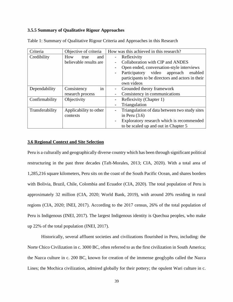
39
3.5.5 Summary of Qualitative Rigour Approaches
Table 1: Summary of Qualitative Rigour Criteria and Approaches in this Research
Criteria Objective of criteria How was this achieved in this research?
Credibility How true and
believable results are
- Reflexivity
- Collaboration with CIP and ANDES
- Open ended, conversation-style interviews
- Participatory video approach enabled
participants to be directors and actors in their
own videos
Dependability Consistency in
research process
- Grounded theory framework
- Consistency in communications
Confirmability Objectivity - Reflexivity (Chapter 1)
- Triangulation
Transferability Applicability to other
contexts
- Triangulation of data between two study sites
in Peru (3.6)
- Exploratory research which is recommended
to be scaled up and out in Chapter 5
3.6 Regional Context and Site Selection
Peru is a culturally and geographically diverse country which has been through significant political
restructuring in the past three decades (Taft-Morales, 2013; CIA, 2020). With a total area of
1,285,216 square kilometers, Peru sits on the coast of the South Pacific Ocean, and shares borders
with Bolivia, Brazil, Chile, Colombia and Ecuador (CIA, 2020). The total population of Peru is
approximately 32 million (CIA, 2020; World Bank, 2019), with around 20% residing in rural
regions (CIA, 2020; INEI, 2017). According to the 2017 census, 26% of the total population of
Peru is Indigenous (INEI, 2017). The largest Indigenous identity is Quechua peoples, who make
up 22% of the total population (INEI, 2017).
Historically, several affluent societies and civilizations flourished in Peru, including: the
Norte Chico Civilization in c. 3000 BC, often referred to as the first civilization in South America;
the Nazca culture in c. 200 BC, known for creation of the immense geoglyphs called the Nazca
Lines; the Mochica civilization, admired globally for their pottery; the opulent Wari culture in c.
40
700 AD; and most famously, the Inca civilization in c. 1400, led by emperor Pachacuti, which
solidified Cusco as its capital and created the world famous Machu Picchu (Oxford Reference,
2012). After a series of invasions from the Spanish conquistadors, in 1533, Cusco was captured
and overthrown (Taft-Morales, 2013). In 1537, the Spanish forces gained control of the entirety of
the country (Taft-Morales, 2013). Peru declared independence in 1821, and since then has had
alternating periods of political instability. After a decade of military rule, Peru entered democratic
leadership in 1980 (Taft-Morales, 2013; CIA, 2020). However, the following decade oversaw a
struggled effort to subdue the uprising of the radical Maoist movement known as the Shining Path,
or Sendero Luminoso (Taft-Morales, 2013; CIA, 2020). Alberto Fujimori was sworn in as
President in 1990. Fujimori left a complicated legacy of attempting to restore economic structure
to the country and defeating the Shining Path, but using authoritarian control, eventually being
arrested in 2009 for human rights violations (Taft-Morales, 2013; CIA, 2020). In 2001, Alejandro
Toledo became Peru’s first Indigenous democratically elected president, bringing awareness of
challenges faced by Indigenous, Amazonian, Andean, and rural communities to the forefront
(Greene, 2006). Peru’s last directly elected President was Pedro Pablo Kuczynski in 2016, who
resigned in 2018 due to controversy surrounding buying votes, which led Vice President Martin
Vizcarra to assume the position of President (CIA, 2020).
This turbulent political landscape, beginning from and including the Spanish conquest, has
resulted in a nuanced lived experience of trauma, growth and resurgence for Peruvians, which
today defines the resilience of the country’s geologically diverse, multi-ethnic and multicultural
landscape.
41
3.6.1 Cultural Heritage in the Peruvian Andes
Peru is composed of a multitude of distinct cultures and communities whose traditions, values and
lifestyles are guided by geography and belief systems (Mayer, 2016; CIA, 2020; INEI, 2017). Peru
boasts a vast amount of cultural and natural heritage, ranging from the ruins of the ancient city of
Chan Chan in the north, to the Peruvian Amazon, which contains the confounding boiling river,
Shanay-Timpishka, to South America’s largest freshwater lake, Lake Titicaca, in the South, which
additionally contains archaeological data underwater (UNESCO c., n.d. ; Stevens et al., 2020;
UNESCO, 2019).
Terraced landscapes are abundant in the Andean highland regions in Peru (Chapagain and
Raizada, 2017). As they are agricultural systems and are embedded within natural landscapes, they
are prime examples of rural heritage, cultural landscapes and biocultural heritage (see 2.1.3, 2.1.4).
While terraces are difficult to date, it is commonly known that the terraces were built before the
Inca civilization, as there are well-documented and in situ terrace landscapes currently in Peru
which have existed since the Wari period (Guillet, 1987; Londono et al., 2017; Sáez and Canziani,
2020). According to Guillet (1987), the terraces may have originated as early as c. 500 AD. With
every succeeding civilization, the terraces were adapted to suit changing needs (Guillet, 1987).
The terraces serve multiple purposes. Through climate and temperature control and natural
ventilation and irrigation systems, the terraces can grow thousands of varieties of potatoes along
with the diversified inclusion of other crops, roots and tubers (Scott, 2011). Channels and
aqueducts dug into the terraces also served as waterways in the past, channeling the flow of water
from higher locations to lower areas (Kendall, 2009). Additionally, terraces absorb soil erosion
impact and protect against landslide (Kendall, 2009).
42
The terraces are maintained through generationally transferred, local, Indigenous
knowledge. Recently, pressures to modernize to accommodate for growing market demands has
led to many abandoning the terraces. The terrace method for cultivation is labour intensive and
faces challenges in incorporating new techniques or machinery (Chapagain and Raizada, 2017).
Additionally, climate change has negatively impacted cultivation: due to warming temperatures,
higher levels of the terraces are now used to grow crops that would have grown in lower levels,
and there has been an observed movement of grazing animals to higher altitudes as well (INMIP,
2014).
3.6.2 The Andean Cosmovision
Communities in the Andean highlands in Peru follow a distinct way of life guided by a particular
worldview referred to as the Andean Cosmovision. The Andean Cosmovision takes into
consideration the cyclical changes of nature, the processes of life and death and the movement of
the sun and the moon, with consideration of the Andean geography. This section will outline the
key aspects of the Andean Cosmovision including significant concepts which govern belief
systems, including ayni, ayllu, yanantin, chanincha and chacra, sacred aspects such as Apus and
Pachamama, and the traditionally practiced and reemerging way of living known as Sumak
Kawsay in Quechua, Suma Qamana in Aymara and Buen Vivir in Spanish.
Pachamama and Apus are two spiritual elements which are crucially significant to Andean
peoples (Sayre et al., 2017; Scoville-Simonds, 2018). Pachamama is contemporarily known as
Mother Earth, embodying the cycles of life of earth, in birth, growth, death and regeneration (Sayre
et al., 2017; Ardeleanu, 2014; Scoville-Simonds, 2018). Apus is the term for the spiritual power of
the mountains and high areas (Sayre et al., 2017; Scoville-Simonds, 2018).
43
Ayni, ayllu, yanantin, chaninca and chacra are words in the Quechua and Aymara
languages that represent cultural values which are integrated within the daily practices and
lifestyles of communities in the high Andes. Ayni translates to reciprocity. Ayni is the most
commonly referenced and most researched value in the Andean cosmovision system (Walshe and
Argumedo, 2016). The practice of reciprocity extends beyond human action and includes mutual
interaction between all natural elements and components to ensure a holistic balance (Ardeleanu,
2014; Walshe and Argumedo, 2016). Ayllu refers to collectiveness, togetherness and community
and originates from the Inca culture (Walshe and Argumedo, 2016). Ayllu mandates responsibility
and equality between all community members, promoting united and organized land stewardship.
Yanantin is the philosophy of existing dualism; it is the belief that an equilibrium is achieved
through integrating opposite qualities or polarities that are considered interdependent and equally
important (Walshe and Argumedo, 2016). Yanantin can be observed often as part of the
agricultural process, for example, in dry and wet season (Walshe and Argumedo, 2016).
Chanincha refers to solidarity based on social relationships. Although Chanincha rarely appears
in literature, it is a significant component of Andean communities in Peru (Walshe and Argumedo,
2016). Chanincha applies not only between humans but brings togetherness between the human,
the natural and the spiritual realms (Walshe and Argumedo, 2016). Chacra is the cultivated field
plot which is tended to by Andean farmers (Saylor et al., 2017). In an interview study conducted
in altiplano, or high plain regions in Peru, by Saylor et al. (2017), all respondents spoke about the
chacra in response to questions asked about the environment, climate change and water
management. The chacra is also revered as a manifestation of Pachamama (Saylor et al., 2017).
Buen vivir, deriving from the concepts of sumac kawsay and suma qamana, translates to
‘good living’ but is described as different from global notions of well-being. Furthermore, these
44
various concepts, as well as similar beliefs held by Guarani, Achuar, Mapuche and other
Indigenous cultures in Latin America, are understood to differ from each other, although
sometimes sprouting from common origins (Thomson, 2011). Buen vivir can only be achieved
when the three ayllus of runa ayllu, Auki ayllu and sallka ayllu, which are respectively the human
and domesticated animals’ realm, the spiritual and sacred realm and the wild beings and landscapes
realm, are in collective harmony (Sayre et al., 2017). Sumac kawsay, similarly, has been described
as a non-linear, continually evolving philosophy which emphasizes harmony and peace between
humans and nature, and ensuring unrestricted flow of love, evolution, contemplation and capacities
to allow society to adapt and flourish with time (Thomson, 2011). One of the main tenets of sumac
kawsay is to embrace goodness and to be grateful for how one’s life is, instead of aspiring to make
one’s life better than others’ or continuously trying to improve it (Thomson, 2011; Tortosa, 2011).
3.7 Study Sites
The two study sites for this research are the Nor-Yauyos Cochas Landscape Reserve (NYCLR)
and the Potato Park, Pisac Peru. Figure 1 shows a map of Peru with Nor-Yauyos-Cochas
Landscape Reserve indicated with an orange pin and the Potato Park indicated with a white pin.
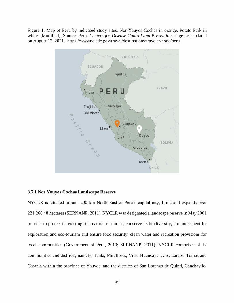
45
Figure 1: Map of Peru by indicated study sites. Nor-Yauyos-Cochas in orange, Potato Park in
white. [Modified]. Source: Peru. Centers for Disease Control and Prevention. Page last updated
on August 17, 2021. https://wwwnc.cdc.gov/travel/destinations/traveler/none/peru
3.7.1 Nor Yauyos Cochas Landscape Reserve
NYCLR is situated around 200 km North East of Peru’s capital city, Lima and expands over
221,268.48 hectares (SERNANP, 2011). NYCLR was designated a landscape reserve in May 2001
in order to protect its existing rich natural resources, conserve its biodiversity, promote scientific
exploration and eco-tourism and ensure food security, clean water and recreation provisions for
local communities (Government of Peru, 2019; SERNANP, 2011). NYCLR comprises of 12
communities and districts, namely, Tanta, Miraflores, Vitis, Huancaya, Alis, Laraos, Tomas and
Carania within the province of Yauyos, and the districts of San Lorenzo de Quinti, Canchayllo,
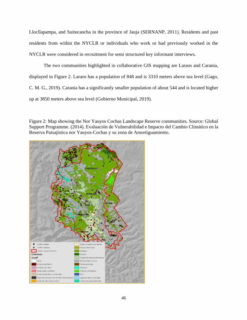
46
Llocllapampa, and Suitucancha in the province of Jauja (SERNANP, 2011). Residents and past
residents from within the NYCLR or individuals who work or had previously worked in the
NYCLR were considered in recruitment for semi structured key informant interviews.
The two communities highlighted in collaborative GIS mapping are Laraos and Carania,
displayed in Figure 2. Laraos has a population of 848 and is 3310 meters above sea level (Gago,
C. M. G., 2019). Carania has a significantly smaller population of about 544 and is located higher
up at 3850 meters above sea level (Gobierno Municipal, 2019).
Figure 2: Map showing the Nor Yauyos Cochas Landscape Reserve communities. Source: Global
Support Programme. (2014). Evaluación de Vulnerabilidad e Impacto del Cambio Climático en la
Reserva Paisajística nor Yauyos-Cochas y su zona de Amortiguamiento.
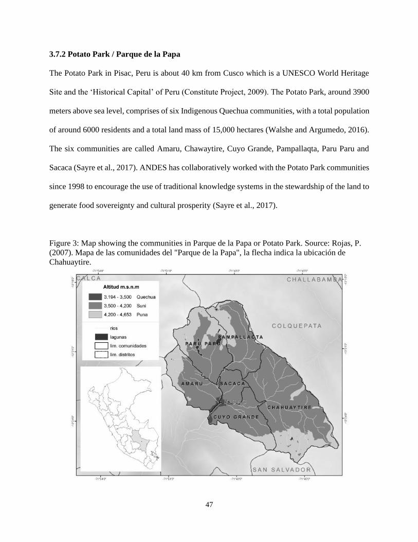
47
3.7.2 Potato Park / Parque de la Papa
The Potato Park in Pisac, Peru is about 40 km from Cusco which is a UNESCO World Heritage
Site and the ‘Historical Capital’ of Peru (Constitute Project, 2009). The Potato Park, around 3900
meters above sea level, comprises of six Indigenous Quechua communities, with a total population
of around 6000 residents and a total land mass of 15,000 hectares (Walshe and Argumedo, 2016).
The six communities are called Amaru, Chawaytire, Cuyo Grande, Pampallaqta, Paru Paru and
Sacaca (Sayre et al., 2017). ANDES has collaboratively worked with the Potato Park communities
since 1998 to encourage the use of traditional knowledge systems in the stewardship of the land to
generate food sovereignty and cultural prosperity (Sayre et al., 2017).
Figure 3: Map showing the communities in Parque de la Papa or Potato Park. Source: Rojas, P.
(2007). Mapa de las comunidades del "Parque de la Papa", la flecha indica la ubicación de
Chahuaytire.
48
3.8 Conclusion
This chapter introduced the methodology, methods and regional context for this research study.
Several other elements described in this chapter, including the impacts of COVID-19, the goal and
objectives for this research, the participatory aspect for this research and close consideration for
regional context and the Andean Cosmovision, are integral to the research and continue to be
described in the following chapters. The next chapter will present the results from the three
methods described in this chapter.
49
Chapter 4
Results
4.0 Introduction
This chapter presents the results of the research study. The chapter is divided into three sections,
pertaining to the results of each method used outlined in Chapter 3. Section 4.1 presents semi
structured key informant interview results, which are categorized into three broad themes of
society/culture, environment, and economy. Sub-themes which emerged within broad themes as
well as cross cutting sub-themes are also presented and defined. In Section 4.2, participatory video
results are textually analyzed and presented as categorized to the same three categories of
environment, economy, and society/culture. Section 4.3 presents the collaborative GIS results,
categorized by delineations made in the process.
4.1 Semi Structured Key Informant Interview Results
4.1.1 Overview
This section presents results from the semi-structured interviews (N=8). The interview questions
were designed to contribute to all four research objectives. This section highlights participant
responses regarding local perceptions of heritage, local knowledge about terraces, changes in uses
of terraces, challenges of working in terraces, perceptions from outside of communities, tourists,
and urban residents, and existing support and support needed for community resilience and
heritage conservation.
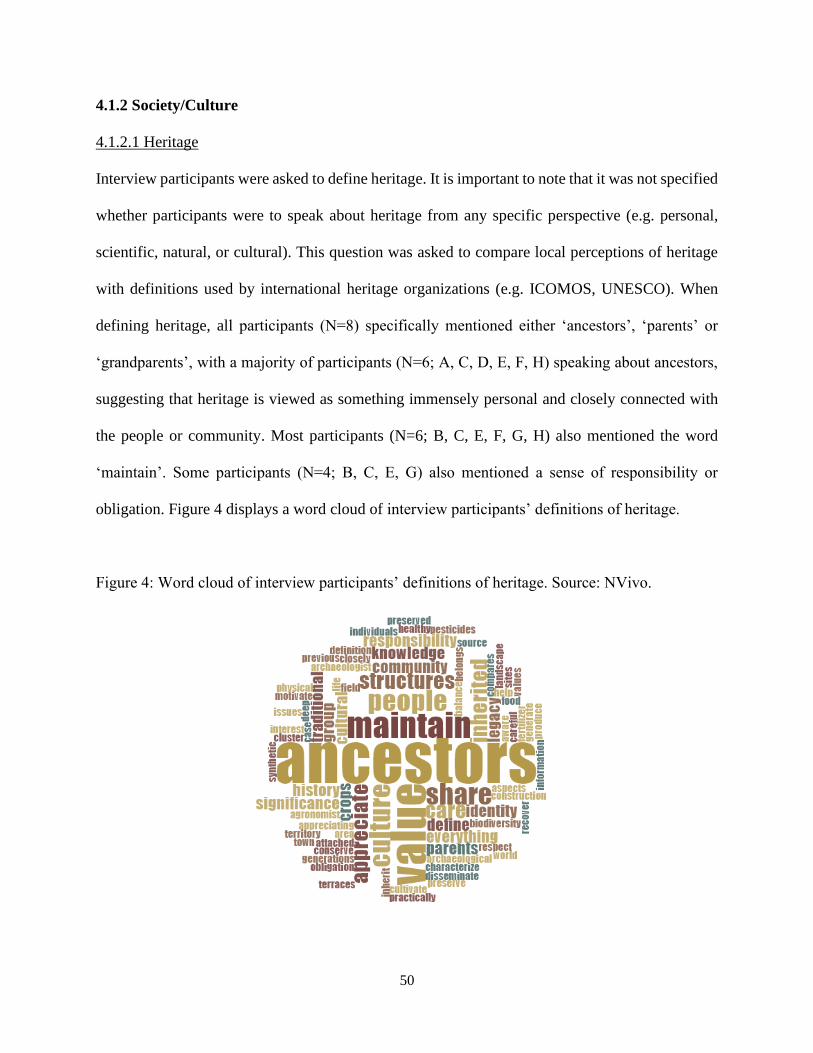
50
4.1.2 Society/Culture
4.1.2.1 Heritage
Interview participants were asked to define heritage. It is important to note that it was not specified
whether participants were to speak about heritage from any specific perspective (e.g. personal,
scientific, natural, or cultural). This question was asked to compare local perceptions of heritage
with definitions used by international heritage organizations (e.g. ICOMOS, UNESCO). When
defining heritage, all participants (N=8) specifically mentioned either ‘ancestors’, ‘parents’ or
‘grandparents’, with a majority of participants (N=6; A, C, D, E, F, H) speaking about ancestors,
suggesting that heritage is viewed as something immensely personal and closely connected with
the people or community. Most participants (N=6; B, C, E, F, G, H) also mentioned the word
‘maintain’. Some participants (N=4; B, C, E, G) also mentioned a sense of responsibility or
obligation. Figure 4 displays a word cloud of interview participants’ definitions of heritage.
Figure 4: Word cloud of interview participants’ definitions of heritage. Source: NVivo.
51
Participant B defines heritage as follows:
“It is a group or a cluster or could be construction, could be cultural values that characterize
a community and are part of the identity of a community or group of people or individuals.
And it is also a responsibility to maintain and to conserve them.”
Participant G defines heritage as follows:
“…something that is ours, belongs to us and to our area, in some ways to our territory, and
our obligation is to preserve it for next generations, as others preserved it for us.”
Participant E defines heritage as follows:
“Traditional knowledge that is translated into structures and physical structures in this case,
andenes, and it is our responsibility to maintain and to recover them in order to respect our
ancestors because it is what we inherited from our ancestors.”
Participant C defines heritage as follows:
“Heritage is legacy… it has enormous significance, it has very deep significance, because
it is what our parents, our ancestors left for us, and because they left these to us, we have to
take care of it, and we have to maintain it…But if we do that, it means also that, as they
generate this, we can do a lot from this, and it is, for example, to disseminate information
about it and to let it be known to the world, but also we have to be careful what we share,
because there are things that we can share or there are aspects or issues that we can share,
but there are also others that we cannot share.”
In addition to the sentiments of inheritance from ancestors and responsibility, Participants G, E
and C expressed a notion of reciprocity in their definition, reflecting the principle of ayni which is
a significant concept in the Andean Cosmovision, as outlined in 3.5.2. Participant C’s definition
further included a unique perspective of uncertainty and frailty of heritage if it is shared too openly,
which may reflect concerns of commodification or appropriation of heritage or a general lack of
trust.
52
4.1.2.2 Social relationships
Participants also spoke about relationships between community members and youth, tourists, and
residents in urban regions. Although some questions asked participants to describe these
relationships, participants also often spoke about them unprovoked.
4.1.2.2 A: Youth and older generations
Participants were asked about the relationship between youth and the terraces. Most of the
participants (N=7; A, B, C, D, E, F, H) indicated that a barrier exists between youth and the culture
and traditions of the community. This barrier is the growing need and desire for youth to emigrate
from the small communities to urban areas for education and building a career. Some participants
(N=3; A, F, H) express empathy and understanding for youth who have to leave the communities
in order to enrich their livelihoods and life experiences. However, most participants (N=7; A, B,
C, D, E, F, H) express discontentment about youth out-migration.
Participant F describes the difference between youth and older populations in the communities in
their perceptions of terraces:
“…older people, mature people, value more - the terraces. It is a tradition, it is part of the
culture, it is part of historical package that they bring, and they value this. And for children,
it’s different, or for youth - especially those who go to the city, those who want to study and
learn other things and they come back and they don't understand the significance that it has
for the communities.”
Participant H and Participant D, respectively, explain reasons for youth out-migration.
“Elders that came back from Lima will stay in the town, because they realize that they have
a piece of land, life is simple and healthy in the community and they are saying that they are
going to stay after COVID 19. But they were in some ways obligated to go to Lima to support
their children, to stay with the children, but they realized that it is a better life in
(community). On the other hand, youth have to come back to Lima, because they study there,
53
they work there, their lives are there, and it is difficult to sensitize them and to say to them
to stay here, because it is nothing to do here, only to work in agriculture.”
“The main factor for young people not appreciating to be identified with the terraces and
agriculture activities in the terraces is globalization. Globalization has influence on their
decisions… If they have to choose a career they don't choose any career that is related to
agriculture, because agriculture for them is not a career, it is not a source of income. And
if they choose, they choose careers that are more profitable and they can work more in other
areas that is not (community). And so they have to leave the town. But if they don't choose a
career and they want to get money they go to mining and they work as labourers in mining.
And they are happy getting the money and coming back, go to the town to visit and that’s
all. It is the way that they have some income –steady or not…permanent or not – but they
are happy because they are young… Another factor is that the work in terraces is hard. It
requires more work because no mechanized tractors or machinery can enter into the andenes
and they have to use only ancestral tools in order to maintain the terraces. And it requires
more work, more effort than other activities.”
Participants E and Participant F, respectively, explain the broader implications of youth out-
migration. When asked about challenges of working on the terraces, Participant E explained:
“…the distance of andenes to the community, so where the population live and, for example,
when they have to transport the inputs for planting and they need transportation, or they
need animals to transport the inputs and it turns out to be more difficult when people don't
have these means and also when they become older, they depend more on young people and
sometimes that are no young people in the community.”
When describing new challenges in the terraces, Participant F explained:
“The community used to control these plagues and the parrots before when they came
because there were more younger populations and they asked the children to do that, but
now nowadays, the population is aging. And there are more older people and seniors and
they cannot do this as they did before. It is the reason that it has become a problem.”
4.1.2.2 B: Tourists and Urban Residents
Participants were also asked about the perceptions of tourists and urban residents toward the
terraces. These responses reflect the opinions formed through lived experiences of participants
who were interviewed and may be different from true perceptions of tourists and urban residents.
Most participants (N=7; A, C, D, E, F, G H) expressed mixed feelings, with several participants
54
(N=6; A, C, D, F, G, H) mentioning that tourists or outsiders to the community can be categorized
into two groups – one group that respects the culture and terraces in small communities, and
another group that does not.
For example, Participant A explains:
“There are two groups and thankfully the group that has more number of people is those
who respect the culture, respect the terraces, respect the andenes and value all the produce
that is generated in these areas and they are careful when they come to the community - they
leave everything clean. But there is a minority group of people who come and they don't
value, don’t respect the communities, they leave everything dirty, and garbage on the, yeah,
surface or the land and but this is some minority group of people in comparison to those
who respect.”
Participant C refers to out-migration and youth when expressing their perceptions on urban
residents:
“We have to think about two aspects here when we say what is the perception, what is the
value that people in urban areas give to this, andenes and terraces […]
most of the people who are leaving cities have immigrated, okay, from rural areas to urban
areas, because the population has changed in rural areas due to migration, local, national
migration […]
we have two types of populations, we have those who emigrated and feel nostalgic about
their communities and what types of food that we had in our communities, what we used to
do in our communities, we still have in our minds the crops that we produced 30 years ago
and we have in some ways, that idea that when we, if we come back to our towns, we can do
the same as our parents did, but it is more about a dream, it is ideas that we have, because
we are forced to be in the cities to give education to our children, to get some income we
cannot come back and we don't know if we come back, we don't know if it is going to be the
same as before […]
The second aspect that we have to consider is about our children, that are young children,
who are in urban areas. They don't know the reality, they didn’t live, they didn’t experience
this life with us. They hear about it through us, but maybe we are not doing our work and
they don't value it, they don't care about it because they were not engaged with this … we
have a lot to work on this in order to sensitize urban communities, urban youth and
children.”
Several participants (N=4; D, F, G, H) also provide more explanation for the two groups, indicating
that international tourists or visitors are the ones to show respect and interest, while local or
55
national visitors do not display the same amount of care for the culture or terraces. It is important
to note that participants may express this because the interviewer is a foreigner and to encourage
tourism from foreigners.
Participant G explains:
“Well, we have two groups of tourists, one national and international. National very few,
Peruvian people don’t go to visit the town. And the international tourists, yes, they go, they
make suggestions, they admire what the community has, encourage them to maintain, to fix
the andenes, to take care of the andenes and terraces.”
Participant D refers to youth while describing differences in attitudes toward culture between
foreigners and locals:
“There are two groups – people who come visit (community) and get involved with our
identity, our culture, appreciate our culture. And this is foreigners who come to (community)
and they live all the experiences and they are motivated and happy and they enjoy but also
they compare their culture with our culture – the differences, similarities, if there are, and
they learn, are hoping to learn, but also they share their ideas with us, for
example…production of artisanal blankets and this has been lost in (community)…But also
they have tourists that are young, from schools…they don't care, they even don't listen, they
are distracted and they don't pay attention to what they are saying, and she says, we have
two groups – one group that appreciates what we have, what we have conserved in our
communities, but there are other groups that don’t care. They go because they have to go
and that's it – no interest.”
4.1.2.2 C: Governance and political power
Participants were asked about what kind of support is currently missing and needed for agriculture,
revitalizing terrace use or heritage conservation. This question generated mixed answers, with five
participants (N=5; D, E, F, G, H) expressing that no support exists. The remaining three
participants indicated that support fluctuates (N=3; A, B, C) and identified sources of support to
include NGO Yanapai group, SERNANP, CIP, Potato Guardians, the municipal government and
community leaders.
56
A major point of importance for this question is the type of support that is needed. The
answers to this question may influence policy recommendations and planning for resource
allocation. Several participants (N=5; A, B, D, E, F) expressed a desire to increase production and
add value to products grown on the terraces when asked about support required, and the remaining
participants (N=3; C, G, H) indicated the same desire in other parts of their interviews.
Participant D states:
“…Our intention, my intention… is that people become entrepreneurs - Okay, that they are
educated in entrepreneurship. Because we want to generate income from what we have. And
we know that, for example, cultivating in the terraces, what we can cultivate will require a
little bit of sophistication and we do that - we cultivate flowers, we are cultivating niche
crops – aguaymanto - so yeah, we have it here, it’s very expensive. Very, very expensive and
they want to produce that and also what I want is to target exclusive markets – that may be
wealthy people who are doing better or people who are aware of good food…”
Some participants (N=3; C, D, H) mentioned that people in general must be made more aware of
the heritage and the value of traditional knowledge, with two participants specifically mentioning
that youth should be re-introduced to the heritage of the communities (N=2; D, H). Other ideas of
support included integrating different entrepreneurs and trades-workers together to form a strong
alliance (N=1, D), disseminating and mobilizing information and experiences relating to
agriculture and heritage to other communities and the world (N=1, G) and to improve relationships
between community members and local governments (N=2; D, F).
Participant H explains:
“…we have the Huacis, the ruins…And the irony is that the ruins are there but these are
considered heritage, national heritage, but nobody has done anything. Not the government
or NGOs, and the worst is that because nothing is done, it is full of trees, shrubs, vegetation,
and it has been destroyed by nature and they say – don’t touch, it is natural heritage, but
they don’t do anything and everything is being destroyed.”
57
4.1.3 Environment
A major theme which emerged from the interview answers was conversations about the
environment. None of the questions posed asked participants to speak about the environment, but
most participants (N=7; A, B, C, E, F, G, H) mentioned the environment. Their discussion is
categorized into two contexts: agriculture and climate change.
4.1.3.1 Climate Change
Most participants (N=6; A, B, C, F, G, H) specifically used the term “climate change”. All
participants (N=6) spoke about climate change when asked about challenges of maintaining or
working in the terraces. One participant mentioned climate change when describing their
community. Within climate change, lack of water was identified by several participants (N=5; A,
C, E, G, H) to be a challenge in their community. Other aspects of climate change mentioned
include arrival of pests (N=3; A, F, G), soil erosion (N=1; B) and sudden and unpredictable frost
(N=1; G).
Participant A describes how the arrival of pests impacts daily life and individual and local
economies (as translated):
“There are two important challenges that they have faced when they cultivate in the terraces
and because of climate change, now they have new insects, new plagues, okay, and one of
that is the moths. And they destroy the crops, especially potatoes and the Andean tubers.
And because they try cultivating organic - organically but now they can’t because they have
to use pesticides in order to control it”
Participant B explains:
“The main problem is soil or erosion and it makes more difficult the maintenance of the
terraces and andenes, and this are due to landslides and effects of climate change. That is
the main problem of the andenes in the community.”
58
Participant C and Participant H, respectively, describe the challenges of water shortage and explain
its impact on community members and changing cultural practices, such as the traditional acequias
or aqueducts:
“We cannot be blind to what is happening, has happened in our communities, for example
we are not having water as we had before, because the glaciers have disappeared, and we
are suffering from water scarcity. And it is very detrimental because people are forced to
leave the andenes or to change activities and they are more depending on the rain, not on
irrigation as they did before.”
“They don't maintain the canals, the acequias, because it is a lot of uncertainty… For
example… we have rain from November to March, but this last year's rain comes in
December for a few days and after, it stops. Now we have some rain but it is not regular as
it was before. We don't have water, the springs and the lagoons, the cochas are dry, the
rivers are dry.”
4.1.3.2 Agriculture
The environment was also referenced in the context of agriculture. Agriculture and the
environment are intrinsically connected, especially in the high Andean region in Peru. Participants’
comments on agricultural practices provided insights into the function and value of the
environment. Participants (N=2; A, F) explained that communities practice crop rotation and
fallowing on the terraces.
Participant A explains:
“In (community A), they have eight sectors of terraces. And why 8 sectors? Because they
rotate the cropping systems and in one year they can cultivate potato, another year they keep
the soil, the land, rests for 8 years and, after eight years they plant another crop. It is in
order to promote healthy soils and in other places, in (community B), for example, they use
irrigation systems. And they don't rotate because they don't have more land… there are some
communities that rotate the crops, and others, no…And in - in (community C), it is very
interesting because they have 11 sectors. It means eleven plots, and every year they rotate.
Every year. For example, one year they plant maize or corn and the second year in that
specific plot they plant potatoes. And after they can plant oka – Oka is an Andean tuber. And
at the end, the following year, they plant fava beans, because this helps to fix the nitrogen in
the soil. They leave it after the harvest, they leave the land to rest… also another aspect is
59
that they are changing crops, they are introducing new crops or crops that they never
cultivated, it is in some ways, they are intensifying the crop production”
Participant C provided an explanation of crops cultivated in the terraced landscape with reference
to altitude. Participant E mentioned that community members have recently started to do
agricultural work closer to the settlement area because it is less labour intensive.
4.1.4 Economy
Matters relating to economic structure and viability were brought up throughout the interviews by
participants. All participants (N=8) indicated their interest in increasing production of crops to
generate income, as mentioned in 4.2.3.3 C. Some participants (N=4; A, D, E, F) spoke about their
interest in entering into niche markets, and some participants (N=3; C, E, F) mentioned benefits
of diversifying their products. In conversation about the economy, participants described the desire
for the introduction of innovative solutions as well as recent changes due to the COVID-19
pandemic.
4.1.4.1 Innovation
Most participants (N=6; B, C, D, E, G, H) spoke encouragingly about tourism as a source of income
for the community.
Participant D remarked:
“…for me, it is important to generate tourism, and we have we have been working in this
field for some years, but it requires a lot of income - to build a structure, for example, we
don't have lodges or hostels, and we can have people and give some life experiences, to
involve them with our life experiences. For example, now they have started to promote eco
agricultural tourism and they put people with a customs and traditional clothes and they go
to the field, they cultivate, they dance, they eat the food that they produce…it is the best way
to generate income.”
60
Participant E explained:
“…now, the fashion in Peru is agro-eco tourism. Well, it is paralyzed because of COVID
19, but when things become better agro-eco tourism would be a good source of income for
the communities if they know how to take care of the andenes and also how to do the
marketing in order to attract more tourists.”
Participant G also spoke personally about tourism (translated):
“…her dad brought the idea of doing tourism in (community), it was in 2001. But ten years
ago, it increased, the idea of putting more interest and tourism became stronger. And people
didn't cultivate, most of the people, because andenes and terraces are private. For example,
G owns four terraces – four andenes and she uses it to cultivate the alfalfa and some of the
areas to cultivate oka, fava beans and potatoes but she was more dedicated to tourism,
because it was the activity that generated more income to them.”
Participants C and F also mentioned the inclusion of innovative ways to involve youth in caring
about the terraces. Participant F spoke about terrace agriculture and traditional knowledge being
included in elementary and high school curricula.
4.1.4.2 COVID-19
Most participants (N=7; A, C, D, E, F, G, H) indicated a reverse migration from cities to the
communities and an increase in number of people working in the terraces. The remaining
participant (N=1; B) reported no change in levels of activity. Participant D mentioned a 20% to
30% increase in production in the terraces in their community and Participant H mentioned a 10%
to 30% increase.
4.1.5 Conclusion
This section presented interview data categorized into broad themes of ‘society and culture’,
‘environment’ and ‘economy’. The dominant theme which was the most coded and rich in
61
information was ‘society and culture’. Sub-themes of society and culture included ‘heritage’ and
‘social relationships’. Participant definitions of heritage were related to relationships with
ancestors and next generations. The definitions demonstrated a circularity and continuation as
participants expressed a sense of responsibility to conserve heritage for youth the way it has been
conserved for participants. The theme of ‘environment’ provided clarity on the connection heritage
shares with the environment for communities in NYCLR, and the role of agriculture in everyday
life. Participants also provided descriptions of climate change. The theme of ‘economy’ indicated
motivation for economic development and entrepreneurship in communities as well as changes
that have occurred during the recent COVID-19 pandemic.
4.2 Participatory Video Results
4.2.1 Overview
The participatory video portion of this research was conducted in the Potato Park region. Several
local researchers, known as tecnicos locales assisted in taking videos and photos following
objectives 1 and 3 of the study. Twenty-five videos and seven photos were captured. Participants
were comfortable with showing their faces in the videos, but for privacy reasons, effort was made
to reduce faces in the screenshots provided. The photos and videos captured by the tecnicos locales
complement the interview data by displaying the terrace sites, terrace construction details, water
sources and flowers and crops grown (Section 3.4.2). The text in the videos is thematically
analyzed and complemented with screenshot visuals. In this section, the three themes of culture
and society, environment and economy are used to compare the interview results with participatory
video results and triangulate findings. Of the 25 videos, 20 were recorded in Quechua and
62
remaining five were in Spanish, indicating that Quechua is more commonly used in the Potato
Park communities.
4.2.2 Environment
The environment is the prime focus for all of the videos. Several videos (N=12) mention erosion
and landslide control as a benefit of terraced landscapes. Some videos (N=4) also mention
humidity control as a result of terrace construction. The practice of crop rotation and fallowing is
also brought up in four videos.
For example, one participant explains:
“So that our soil is not poor, we usually rotate our land every 7 years and while these
platforms rest, our animals graze there.” (No image provided)
Some videos (N=7) also mention the function of collecting and distributing rainwater by
opening a ditch and enabling water irrigation. Although respondents mention that this tradition is
continued in the present, one video displays a traditional ditch built 15 to 20 years ago. The
translated quote is provided below in italics. Figure 5 is a screenshot taken from this video.
“In the old days, we used to make the terraces with clumps of earth to avoid erosion, 15 to
20 years ago. When there was drought, these ditches helped to avoid aridity and also helped
the lower land plots to store water to ensure production.”
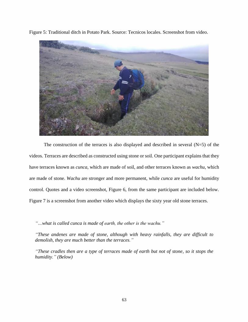
63
Figure 5: Traditional ditch in Potato Park. Source: Tecnicos locales. Screenshot from video.
The construction of the terraces is also displayed and described in several (N=5) of the
videos. Terraces are described as constructed using stone or soil. One participant explains that they
have terraces known as cunca, which are made of soil, and other terraces known as wachu, which
are made of stone. Wachu are stronger and more permanent, while cunca are useful for humidity
control. Quotes and a video screenshot, Figure 6, from the same participant are included below.
Figure 7 is a screenshot from another video which displays the sixty year old stone terraces.
“…what is called cunca is made of earth, the other is the wachu.”
“These andenes are made of stone, although with heavy rainfalls, they are difficult to
demolish, they are much better than the terraces.”
“These cradles then are a type of terraces made of earth but not of stone, so it stops the
humidity.” (Below)
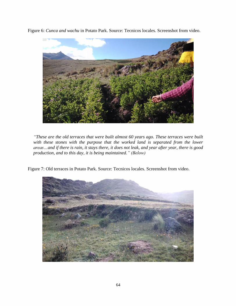
64
Figure 6: Cunca and wachu in Potato Park. Source: Tecnicos locales. Screenshot from video.
“These are the old terraces that were built almost 60 years ago. These terraces were built
with these stones with the purpose that the worked land is separated from the lower
areas…and if there is rain, it stays there, it does not leak, and year after year, there is good
production, and to this day, it is being maintained.” (Below)
Figure 7: Old terraces in Potato Park. Source: Tecnicos locales. Screenshot from video.
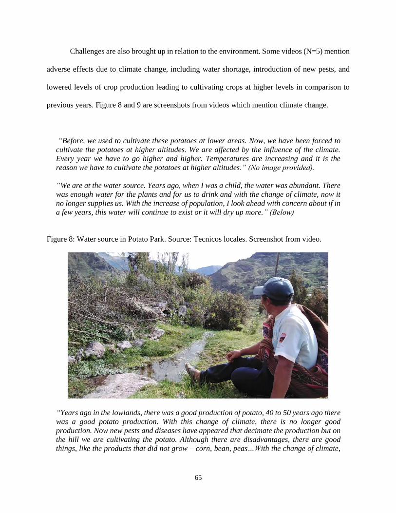
65
Challenges are also brought up in relation to the environment. Some videos (N=5) mention
adverse effects due to climate change, including water shortage, introduction of new pests, and
lowered levels of crop production leading to cultivating crops at higher levels in comparison to
previous years. Figure 8 and 9 are screenshots from videos which mention climate change.
“Before, we used to cultivate these potatoes at lower areas. Now, we have been forced to
cultivate the potatoes at higher altitudes. We are affected by the influence of the climate.
Every year we have to go higher and higher. Temperatures are increasing and it is the
reason we have to cultivate the potatoes at higher altitudes.” (No image provided).
“We are at the water source. Years ago, when I was a child, the water was abundant. There
was enough water for the plants and for us to drink and with the change of climate, now it
no longer supplies us. With the increase of population, I look ahead with concern about if in
a few years, this water will continue to exist or it will dry up more.” (Below)
Figure 8: Water source in Potato Park. Source: Tecnicos locales. Screenshot from video.
“Years ago in the lowlands, there was a good production of potato, 40 to 50 years ago there
was a good potato production. With this change of climate, there is no longer good
production. Now new pests and diseases have appeared that decimate the production but on
the hill we are cultivating the potato. Although there are disadvantages, there are good
things, like the products that did not grow – corn, bean, peas…With the change of climate,
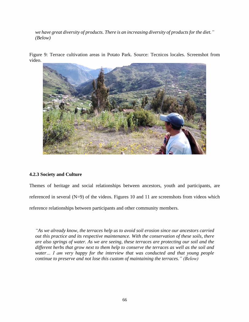
66
we have great diversity of products. There is an increasing diversity of products for the diet.”
(Below)
Figure 9: Terrace cultivation areas in Potato Park. Source: Tecnicos locales. Screenshot from
video.
4.2.3 Society and Culture
Themes of heritage and social relationships between ancestors, youth and participants, are
referenced in several (N=9) of the videos. Figures 10 and 11 are screenshots from videos which
reference relationships between participants and other community members.
“As we already know, the terraces help us to avoid soil erosion since our ancestors carried
out this practice and its respective maintenance. With the conservation of these soils, there
are also springs of water. As we are seeing, these terraces are protecting our soil and the
different herbs that grow next to them help to conserve the terraces as well as the soil and
water… I am very happy for the interview that was conducted and that young people
continue to preserve and not lose this custom of maintaining the terraces.” (Below)
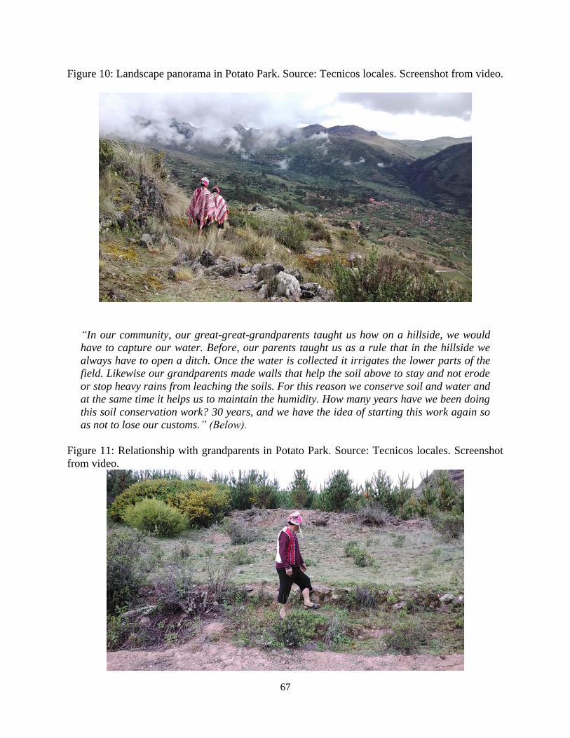
67
Figure 10: Landscape panorama in Potato Park. Source: Tecnicos locales. Screenshot from video.
“In our community, our great-great-grandparents taught us how on a hillside, we would
have to capture our water. Before, our parents taught us as a rule that in the hillside we
always have to open a ditch. Once the water is collected it irrigates the lower parts of the
field. Likewise our grandparents made walls that help the soil above to stay and not erode
or stop heavy rains from leaching the soils. For this reason we conserve soil and water and
at the same time it helps us to maintain the humidity. How many years have we been doing
this soil conservation work? 30 years, and we have the idea of starting this work again so
as not to lose our customs.” (Below).
Figure 11: Relationship with grandparents in Potato Park. Source: Tecnicos locales. Screenshot
from video.
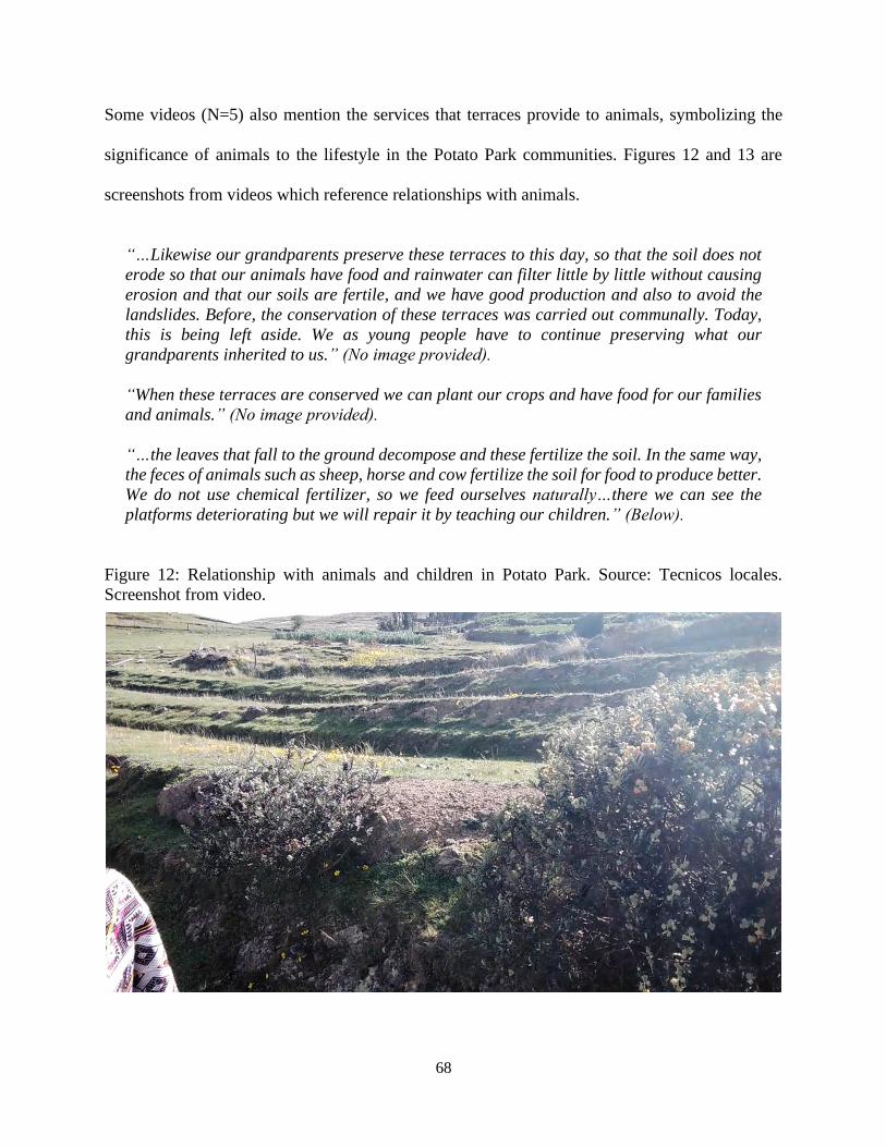
68
Some videos (N=5) also mention the services that terraces provide to animals, symbolizing the
significance of animals to the lifestyle in the Potato Park communities. Figures 12 and 13 are
screenshots from videos which reference relationships with animals.
“…Likewise our grandparents preserve these terraces to this day, so that the soil does not
erode so that our animals have food and rainwater can filter little by little without causing
erosion and that our soils are fertile, and we have good production and also to avoid the
landslides. Before, the conservation of these terraces was carried out communally. Today,
this is being left aside. We as young people have to continue preserving what our
grandparents inherited to us.” (No image provided).
“When these terraces are conserved we can plant our crops and have food for our families
and animals.” (No image provided).
“…the leaves that fall to the ground decompose and these fertilize the soil. In the same way,
the feces of animals such as sheep, horse and cow fertilize the soil for food to produce better.
We do not use chemical fertilizer, so we feed ourselves naturally…there we can see the
platforms deteriorating but we will repair it by teaching our children.” (Below).
Figure 12: Relationship with animals and children in Potato Park. Source: Tecnicos locales.
Screenshot from video.
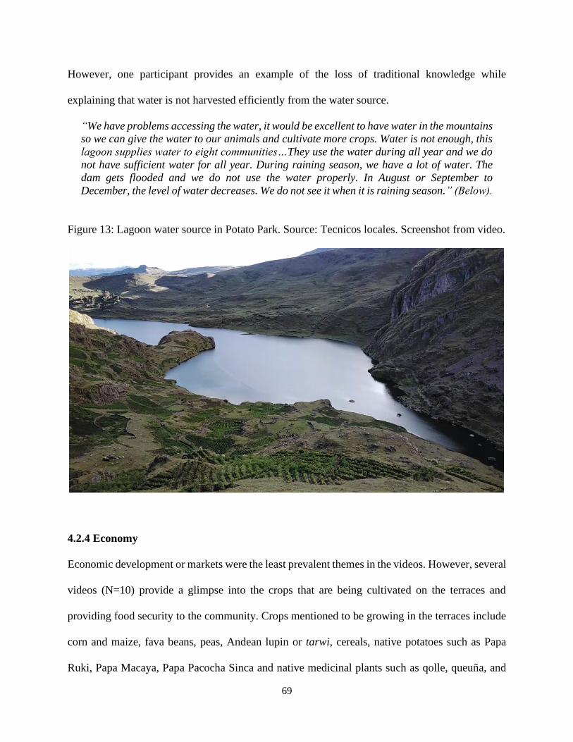
69
However, one participant provides an example of the loss of traditional knowledge while
explaining that water is not harvested efficiently from the water source.
“We have problems accessing the water, it would be excellent to have water in the mountains
so we can give the water to our animals and cultivate more crops. Water is not enough, this
lagoon supplies water to eight communities…They use the water during all year and we do
not have sufficient water for all year. During raining season, we have a lot of water. The
dam gets flooded and we do not use the water properly. In August or September to
December, the level of water decreases. We do not see it when it is raining season.” (Below).
Figure 13: Lagoon water source in Potato Park. Source: Tecnicos locales. Screenshot from video.
4.2.4 Economy
Economic development or markets were the least prevalent themes in the videos. However, several
videos (N=10) provide a glimpse into the crops that are being cultivated on the terraces and
providing food security to the community. Crops mentioned to be growing in the terraces include
corn and maize, fava beans, peas, Andean lupin or tarwi, cereals, native potatoes such as Papa
Ruki, Papa Macaya, Papa Pacocha Sinca and native medicinal plants such as qolle, queuña, and
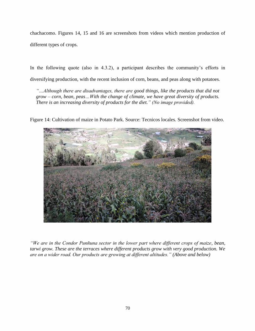
70
chachacomo. Figures 14, 15 and 16 are screenshots from videos which mention production of
different types of crops.
In the following quote (also in 4.3.2), a participant describes the community’s efforts in
diversifying production, with the recent inclusion of corn, beans, and peas along with potatoes.
“…Although there are disadvantages, there are good things, like the products that did not
grow – corn, bean, peas…With the change of climate, we have great diversity of products.
There is an increasing diversity of products for the diet.” (No image provided).
Figure 14: Cultivation of maize in Potato Park. Source: Tecnicos locales. Screenshot from video.
“We are in the Condor Punñuna sector in the lower part where different crops of maize, bean,
tarwi grow. These are the terraces where different products grow with very good production. We
are on a wider road. Our products are growing at different altitudes.” (Above and below)
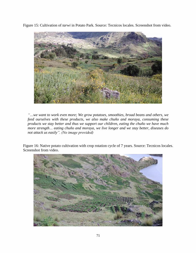
71
Figure 15: Cultivation of tarwi in Potato Park. Source: Tecnicos locales. Screenshot from video.
“…we want to work even more; We grow potatoes, smoothies, broad beans and others, we
feed ourselves with these products, we also make chuño and moraya, consuming these
products we stay better and thus we support our children, eating the chuño we have much
more strength… eating chuño and moraya, we live longer and we stay better, diseases do
not attack us easily”. (No image provided)
Figure 16: Native potato cultivation with crop rotation cycle of 7 years. Source: Tecnicos locales.
Screenshot from video.
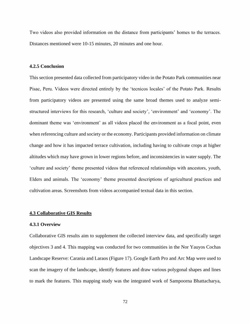
72
Two videos also provided information on the distance from participants’ homes to the terraces.
Distances mentioned were 10-15 minutes, 20 minutes and one hour.
4.2.5 Conclusion
This section presented data collected from participatory video in the Potato Park communities near
Pisac, Peru. Videos were directed entirely by the ‘tecnicos locales’ of the Potato Park. Results
from participatory videos are presented using the same broad themes used to analyze semi-
structured interviews for this research, ‘culture and society’, ‘environment’ and ‘economy’. The
dominant theme was ‘environment’ as all videos placed the environment as a focal point, even
when referencing culture and society or the economy. Participants provided information on climate
change and how it has impacted terrace cultivation, including having to cultivate crops at higher
altitudes which may have grown in lower regions before, and inconsistencies in water supply. The
‘culture and society’ theme presented videos that referenced relationships with ancestors, youth,
Elders and animals. The ‘economy’ theme presented descriptions of agricultural practices and
cultivation areas. Screenshots from videos accompanied textual data in this section.
4.3 Collaborative GIS Results
4.3.1 Overview
Collaborative GIS results aim to supplement the collected interview data, and specifically target
objectives 3 and 4. This mapping was conducted for two communities in the Nor Yauyos Cochas
Landscape Reserve: Carania and Laraos (Figure 17). Google Earth Pro and Arc Map were used to
scan the imagery of the landscape, identify features and draw various polygonal shapes and lines
to mark the features. This mapping study was the integrated work of Sampoorna Bhattacharya,
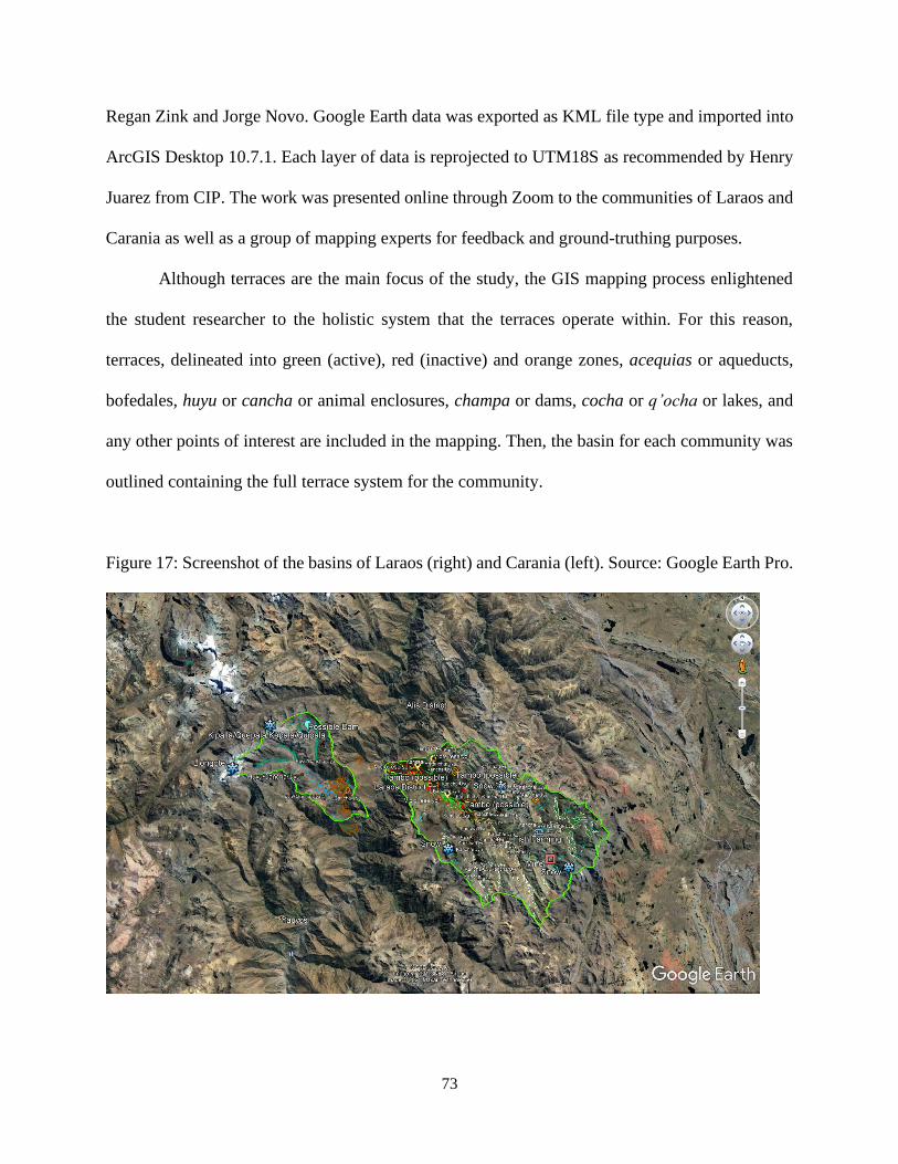
73
Regan Zink and Jorge Novo. Google Earth data was exported as KML file type and imported into
ArcGIS Desktop 10.7.1. Each layer of data is reprojected to UTM18S as recommended by Henry
Juarez from CIP. The work was presented online through Zoom to the communities of Laraos and
Carania as well as a group of mapping experts for feedback and ground-truthing purposes.
Although terraces are the main focus of the study, the GIS mapping process enlightened
the student researcher to the holistic system that the terraces operate within. For this reason,
terraces, delineated into green (active), red (inactive) and orange zones, acequias or aqueducts,
bofedales, huyu or cancha or animal enclosures, champa or dams, cocha or q’ocha or lakes, and
any other points of interest are included in the mapping. Then, the basin for each community was
outlined containing the full terrace system for the community.
Figure 17: Screenshot of the basins of Laraos (right) and Carania (left). Source: Google Earth Pro.
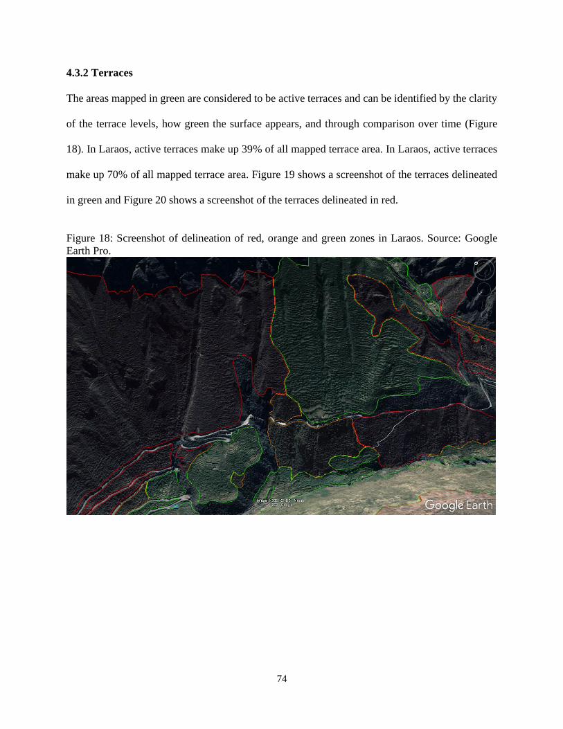
74
4.3.2 Terraces
The areas mapped in green are considered to be active terraces and can be identified by the clarity
of the terrace levels, how green the surface appears, and through comparison over time (Figure
18). In Laraos, active terraces make up 39% of all mapped terrace area. In Laraos, active terraces
make up 70% of all mapped terrace area. Figure 19 shows a screenshot of the terraces delineated
in green and Figure 20 shows a screenshot of the terraces delineated in red.
Figure 18: Screenshot of delineation of red, orange and green zones in Laraos. Source: Google
Earth Pro.
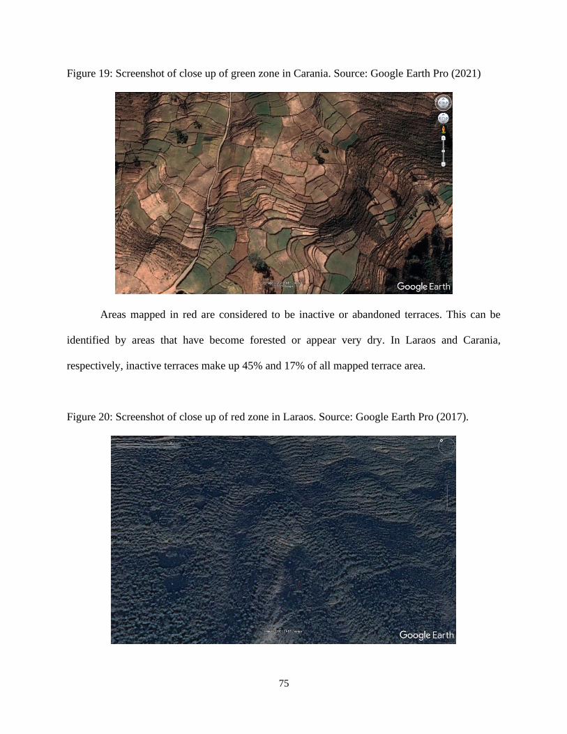
75
Figure 19: Screenshot of close up of green zone in Carania. Source: Google Earth Pro (2021)
Areas mapped in red are considered to be inactive or abandoned terraces. This can be
identified by areas that have become forested or appear very dry. In Laraos and Carania,
respectively, inactive terraces make up 45% and 17% of all mapped terrace area.
Figure 20: Screenshot of close up of red zone in Laraos. Source: Google Earth Pro (2017).
76
The third delineation is mapped in orange. These areas may or may not be active and are
difficult to determine.
Table 2: Active and inactive terraced areas in Laraos and Carania.
Laraos (km2) Carania (km2)
Green (active) 2.801 2.256
Red (inactive) 3.225 0.557
Orange (unsure) 1.186 0.425
Total mapped terrace area 7.211 3.238
4.3.3 Elements of the Cultural Landscape
Other elements that were mapped include acequias or aqueducts, bofedales, huyu or cancha or
animal enclosures, champa or traditional dams, cocha or q’ocha or lakes and other points of
interest such as snow peaks, mines, landslides, fishing and tambo or traditional grain storage.
Cocha, snow peaks and bofedales provide the source of water for the terraces and
community. Champa and huyu/cancha provide a hint of recent human activity that indicates that
cochas and bofedales are active, as champas are found in cochas and huyu/canchas are often seen
near bofedales. Examining the lines on the landscape, potential routes for acequias can be drawn.
These may, however be walking pathways, and acequias may not be active. Acequias are important
traditional structures which carry water from higher regions to be distributed to terraces and the
settlement area. Mapping mines indicates potential disturbance in the quality of water and
distribution of water. Landslides indicate areas which may benefit from terrace landscapes. Fishing
and tambo display human activity and the varying economies in the region.
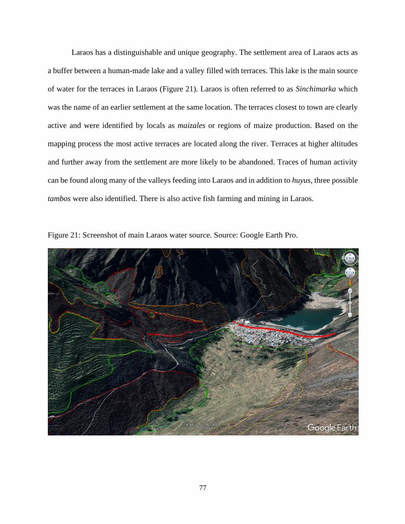
77
Laraos has a distinguishable and unique geography. The settlement area of Laraos acts as
a buffer between a human-made lake and a valley filled with terraces. This lake is the main source
of water for the terraces in Laraos (Figure 21). Laraos is often referred to as Sinchimarka which
was the name of an earlier settlement at the same location. The terraces closest to town are clearly
active and were identified by locals as maizales or regions of maize production. Based on the
mapping process the most active terraces are located along the river. Terraces at higher altitudes
and further away from the settlement are more likely to be abandoned. Traces of human activity
can be found along many of the valleys feeding into Laraos and in addition to huyus, three possible
tambos were also identified. There is also active fish farming and mining in Laraos.
Figure 21: Screenshot of main Laraos water source. Source: Google Earth Pro.
78
Carania has a smaller basin and a smaller settlement compared to Laraos. Carania’s main
source of water is from a major peak known as Llongote and a minor peak known as Kipala (See
Index). Carania has several regions that are known by alternative names as well: the most well-
known name is Huamanmarca which refers to the southern tip of the Carania basin, where
remnants of a tower are found from an earlier civilization. On the Southern side of Huamanmarca,
there are two regions locally known as Huanchan and Quichualla. This area surrounding Huanchan
and Quichilla contains steep terraces, used for growing maize. In conversation with residents, it
was revealed that regions closest to the settlements and with the lowest slopes are used to grow
tubers, native potatoes, mashua and oka. Main terraced areas with slightly more slope are used to
grow alfalfa and potatoes. Residents indicated a terraced region in which a variety of garlic was
produced. This venture was unsuccessful and the area is currently abandoned. Carania also hosts
a semi-circular terraced region which is regarded as significant by locals as well as those from
other parts of Peru, resembling the Incan Moray structure. This region is abandoned but is known
to be home to various fauna and medicinal herbs and plants.
The holistic cultural landscapes of Laraos and Carania are displayed in Figures 22 and 23.
Results from ArcGIS calculations about water sources in the two communities are listed in Table
3 below.
Table 3: Water sources in Laraos and Carania.
Laraos Carania
Full basin area 184.2 km2 55.25 km2
Bofedales area 6.05 km2 1.43 km2
# of Cochas 65 27
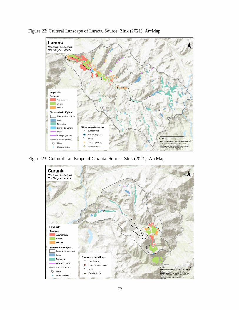
79
Figure 22: Cultural Lanscape of Laraos. Source: Zink (2021). ArcMap.
Figure 23: Cultural Landscape of Carania. Source: Zink (2021). ArcMap.
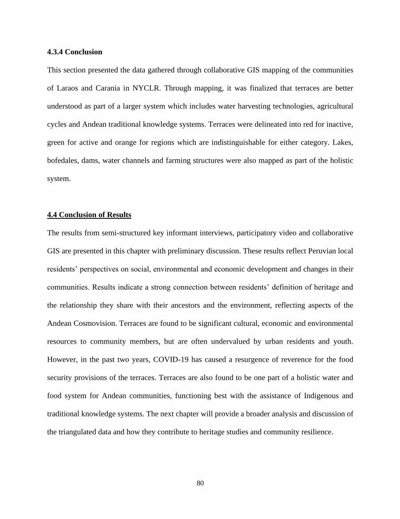
80
4.3.4 Conclusion
This section presented the data gathered through collaborative GIS mapping of the communities
of Laraos and Carania in NYCLR. Through mapping, it was finalized that terraces are better
understood as part of a larger system which includes water harvesting technologies, agricultural
cycles and Andean traditional knowledge systems. Terraces were delineated into red for inactive,
green for active and orange for regions which are indistinguishable for either category. Lakes,
bofedales, dams, water channels and farming structures were also mapped as part of the holistic
system.
4.4 Conclusion of Results
The results from semi-structured key informant interviews, participatory video and collaborative
GIS are presented in this chapter with preliminary discussion. These results reflect Peruvian local
residents’ perspectives on social, environmental and economic development and changes in their
communities. Results indicate a strong connection between residents’ definition of heritage and
the relationship they share with their ancestors and the environment, reflecting aspects of the
Andean Cosmovision. Terraces are found to be significant cultural, economic and environmental
resources to community members, but are often undervalued by urban residents and youth.
However, in the past two years, COVID-19 has caused a resurgence of reverence for the food
security provisions of the terraces. Terraces are also found to be one part of a holistic water and
food system for Andean communities, functioning best with the assistance of Indigenous and
traditional knowledge systems. The next chapter will provide a broader analysis and discussion of
the triangulated data and how they contribute to heritage studies and community resilience.
81
Chapter 5
Discussion
5.0 Introduction
This chapter provides an analysis and discussion of the results presented in the previous chapter.
The goal and objectives of the research study are re-introduced and examined in reference to the
findings. The results are also used as a basis for discussion on heritage studies and community
resilience.
5.1 Addressing the Goal and Objectives
5.1.1 Goal
The goal of this study is to conduct an exploratory study that contributes to the understanding of
how rural heritage conservation impacts local community development.
5.1.2 Objective 1
Objective 1 is stated as “Determine local community members’ perceptions about the terraces and
understand their interactions with the terraces.” This objective was the focus for key informant
interviews and participatory video. This objective provides insight into how important the terraces
are as a resource from a local standpoint.
The results indicate that local community members hold a strong sense of value for the
terraces. This is evident in the answer to the interview question, “do you consider terraces to be
part of heritage?” All interview participants responded “yes”. These sentiments were reflected in
the participatory video results as well, with participants describing practices associated with the
terraces, or the terraces themselves to be passed down through generations, from ancestors, to
82
grandparents, to participants, to their children. Interview results indicate a strong value for terraces
from locals within the community, an interest from international tourists, but lower levels of
appreciation from Peruvian urban residents. A major identified obstacle is youth out-migration
from communities to urban areas, leading to growing unfamiliarity with the cultures and values
related to the terraces.
5.1.3 Objective 2
Objective 2 is stated as “Compare uses of terraces during past crises with current crises (COVID-
19, food crisis).” This objective is fulfilled through the key informant interviews. Interview results
indicate that terraces may have originated to address food insecurity and famine. This theory comes
from the local legend of Pariacaca which was explained by one of the participants. Pariacaca was
described to be a powerful person of influence who strove to create a cultural shift from
unproductive practices to instead cultivating the land for sustenance. Pariacaca is also the name
of a major peak in the Nor Yauyos Cochas Landscape Reserve (NYCLR) (Ryder et al., 2012). The
global COVID-19 pandemic is the most recent crisis to affect the region. The interview results
indicate a significant increase in production on the terraces and reverse migration into the
communities from urban regions as a result of the arrival of COVID-19. Interview results also
indicate that older and newer residents to the communities are re-learning and valuing the
provisions and reliability of the terraces. Another ongoing crisis is climate change. Residents are
aware that climate change is a crisis that has been ongoing for many years. The climate crisis
disproportionately impacts rural and Indigenous peoples, including the Andean agrarian people,
even though they are not major contributors, if at all (Sayre et al., 2017). This crisis has affected
terrace agriculture through the introduction of new pests, unpredictable weather changes, and
83
water shortages. Terrace agriculture is adapting to climate change, such as cultivating crops at
higher altitudes which would previously grow at lower levels.
5.1.4 Objectives 3
Objective 3 is stated as “Examine the role of terraces in providing local communities with food
security and opportunities for Indigenous governance.” This objective was fulfilled through results
from key informant interviews, participatory video and collaborative GIS. The results of the study
indicate that terrace agriculture integrated with Indigenous traditional knowledge systems is key
in providing local communities with nutritious food, economic control and strengthened social
relationships. The maintenance of traditional knowledge allows Andean agricultural workers to
adapt to climate change and continue to produce crops found only in the Andes such as native
potatoes, oca and mashua. Better understanding of the water systems will allow communities to
be in control of their resources and prepared against climate change impacts. For example,
reconstructing acequias which connect bofedales or champas (lakes) to terraces will re-introduce
water to the terraces, allowing for more crop production. Another role of the terraces in providing
communities with opportunities for governance and economic stability is eco-tourism or agri-
tourism. This type of tourism has been endogenously implemented in several communities in Peru
and generates a revenue while reinstating cultural pride and conserving heritage for next
generations. Endogenous activities also ensure approval from locals and may include tourism
activities such as attending a traditional Andean cooking class, attempting a day of farming on the
terraces, walking to higher altitudes and assisting with herding alpaca, learning Indigenous Andean
languages such as Quechua and Aymara, etc.
84
5.1.5 Objective 4
Objective 4 is stated as “Explore the function and capacities of terraces in combating threats such
as climate change, food crises and marginalization.” Interview and collaborative GIS data is used
to fulfill this objective. Results indicate that terraces offer great potential in combating the
aforementioned threats due to their cultural significance and food security provisions. Terrace
agriculture contributes to the mitigation of climate change in several ways including increased
consumption of locally grown produce and biodiversity through increased agricultural work on
terraces results (Abi-Jaoude et al., 2007; Huey, 2005). Eco-tourism measures implemented on the
terraces provide environmentally friendly vacationing options for tourists. The terraces also hold
cultural significance. Activities to involve youth in terraces preserves this significance and the
relationship with ancestors invoked by the terraces.
5.2 Relevance to Heritage Studies
5.2.1 Rural Heritage
Heritage is a concept that is difficult to define, with no existing formal definition (Chapter 2). The
international authorities on heritage are the International Council of Monuments and Sites
(ICOMOS) and UNESCO. These organizations have categorized heritage into several distinctions
including natural heritage and cultural heritage. Within cultural heritage, there are two further
categories of tangible and intangible. Sites or practices of “outstanding universal value” are
nominated to the UNESCO World Heritage Center, and then are designated as world heritage
(Badman et al., 2008; UNESCO, n.d., d.). However, heritage is a part of all humans and can be
viewed as personal (Smith, 2006). Sites and practices not included in the World Heritage Register
85
may still be considered heritage to certain people or communities, and are no less significant (see
2.2.1).
In rural contexts, nature and culture are often inseparable. Terms such as cultural
landscape, which is defined as the combined works of humans and the environment, and
biocultural heritage, which entails the symbiotic relationship between landscapes and the cultural
practices and worldviews upheld by communities, better encapsulate rural heritage (Poole, 2018;
UNESCO, 1992). This research study aims to contribute to understanding how to define rural
heritage through the perspectives of rural people.
This thesis highlights that rural heritage is a concept that is deeply personal. For example,
when interview participants were asked to define heritage, the word appearing most often is
‘ancestors’, suggesting that heritage is viewed as something immensely personal and closely
connected with the people or community. The definitions provided by participants also indicate a
strong sense of responsibility for communities to maintain or conserve heritage, as opposed to the
notion of an international organization being the responsible party for conservation. This is
complemented through the participatory video results, in which several participants speak about
their ancestors as the creators of the terraces, their grandparents as the ones who have worked to
conserve the terraces, children as the ones to whom this knowledge will be passed on to, and
animals as equal users of the terraces.
The understanding that rural heritage is linked to both natural and cultural elements is
corroborated through the results as well. Terraces, which are a type of cultural landscape, as
human-made constructions which are holistic with the land, are the main focus of this study
(UNESCO, 1992). Participatory video results centered the environment in their documentation,
proving its inevitability in the Andean region. When interview participants were asked to explain
86
whether or not they believe terraces exemplify heritage, and why or why not, all participants
answered that they believe terraces are heritage. Reasons provided for the terraces being heritage
included that they were built by participants’ ancestors for them to use and be preserved and that
they provide food security and economic benefits. Based on the perspectives of interview and
participatory video participants, the definitions of heritage provided align closely to the
understanding of inheritance from ancestors, which was the widely used definition of heritage pre-
1970 (Watkins and Beaver, 2008; Jones et al., 2020).
5.2.2 Biocultural Heritage System
As explained above, ‘rural heritage’ combines both natural and cultural aspects, and terraces are
cultural landscapes as they are environmental landscapes created by both humans and nature
(UNESCO, 1992). However, to best understand terraces and their relationships with communities,
the approach of examining the regions as biocultural heritage systems is applied. Biocultural
heritage is defined as the natural and cultural products of interactions between places and local
values, cultures and worldviews maintained by communities (Ekblom et al., 2019; Poole, 2018).
Terraces are found to exist as part of a system which includes water management,
agricultural production, animal movement and grazing patterns, and human activity. Terraces
share a symbiotic relationship with humans, as they were constructed by humans, are maintained
by humans and in turn provide sustenance and security to communities. The biocultural heritage
system is constructed through interview and participatory video data and articulated through maps
created as part of the collaborative GIS method. The components of this system include water
sources such as snow peaks, lakes, bofedales, animal farming structures known as huyu or cancha
87
in local languages, and water irrigation technologies which are part of traditional ecological
knowledge systems such as acequia or channels and traditional dams or champa.
5.3.3 Traditional Ecological Knowledge
Traditional ecological knowledge or TEK is knowledge which is received from experience or from
the land, used to contribute to ecological conservation and passed on through generations (Wenzel,
1999; Berkes, 1993). TEK is locally significant and often passed on in intangible forms. TEK is
important in the process of understanding environments and their changes (Saylor et al., 2017;
Bruchac, 2014; Jigyasu, 2002, 2016; Bridgewater, 2017). The loss of TEK systems leads to
mismanagement and eventual degradation of environmental resources (Poole, 2018).
Residents of the communities in the study sites are the key knowledge holders about local
terrace systems. Results demonstrate residents’ knowledge of distinct terrace types, including the
difference between andenes and terrazas, and production zones based on altitudes. However, the
results of the study identify the loss of TEK to be a significant challenge and a contributor to issues
such as lack of water through the year and difficulty in using terraces for agricultural purposes.
One of the causes identified for the loss of TEK from communities in the NYCLR region is the
out-migration of youth, as identified in key informant interview results. Youth are an important
sector of the TEK system as they must be the ones to receive knowledge, preserve it and pass it on
to the next generation. As youth, they are in the crucial point of receiving and preserving the
knowledge. Cycles of youth out-migration pose the threat of diminished preservation of TEK.
Water shortage is identified as a challenge in the interviews, participatory video and
collaborative GIS. A reason for water shortage in the communities is the mismanagement of water
resources due to loss of TEK. Participatory video results indicate both maintained and forgotten
88
water management practices. For example creating drainage ditches to distribute rain water and
construction of terraces with control of water retention are two TEK systems that are being
continued in the Potato Park. However, a large lagoon in the Potato Park supplies water to eight
communities throughout the year, becomes flooded during the wet season, and yet, communities
face water scarcity during some parts of the year.
Similarly, interview results indicate maintained and forgotten water management practices
as well. A few participants spoke about ‘Limpia Acequia’, an annual festival which takes place in
some communities, in which all residents communally clean the acequias and celebrate. However,
acequias in Carania were found to be neglected during the collaborative GIS process.
Another sustained TEK system in NYCLR and Potato Park communities is agricultural
work. Cultivation according to altitudes, crop rotation and fallowing are all integral parts of food
security and economic prosperity through agriculture.
5.3 Connecting to Community Resilience
This research study examines how conservation of the terraces can contribute to local community
resilience. Resilience is commonly understood to be the level of persistence of a system as it
endures stresses and disturbances (Holling, 1973; Renschler et al., 2010). There is no overarching
framework or tool to best define or measure resilience at this time (Demiroz and Haase, 2019;
Koliou et al., 2020). Table 4 presents a summary of the major themes for different frameworks for
measuring resilience and displays that the most common cross cutting themes in measuring
resilience are environmental, economic, political, and societal factors. Additionally, Table 4 lists
the thematic codes which were identified during the analysis of interview and participatory video
results.
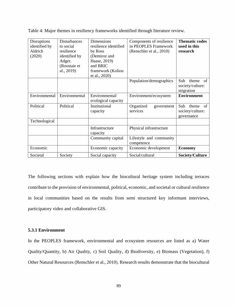
89
Table 4: Major themes in resiliency frameworks identified through literature review.
Disruptions
identified by
Aldrich
(2020)
Disturbances
to social
resilience
identified by
Adger.
(Roostaie et
al., 2019)
Dimensions
resilience identified
by Ross
(Demiroz and
Haase, 2019)
and BRIC
framework (Koliou
et al., 2020)
Components of resilience
in PEOPLES Framework
(Renschler et al., 2010)
Thematic codes
used in this
research
Population/demographics Sub theme of
society/culture:
migration
Environmental Environmental Environmental/
ecological capacity
Environment/ecosystem Environment
Political Political Institutional
capacity
Organized government
services
Sub theme of
society/culture:
governance
Technological
Infrastructure
capacity
Physical infrastructure
Community capital Lifestyle and community
competence
Economic Economic capacity Economic development Economy
Societal Society Social capacity Social/cultural Society/Culture
The following sections with explain how the biocultural heritage system including terraces
contribute to the provision of environmental, political, economic, and societal or cultural resilience
in local communities based on the results from semi structured key informant interviews,
participatory video and collaborative GIS.
5.3.1 Environment
In the PEOPLES framework, environmental and ecosystem resources are listed as a) Water
Quality/Quantity, b) Air Quality, c) Soil Quality, d) Biodiversity, e) Biomass (Vegetation), f)
Other Natural Resources (Renschler et al., 2010). Research results demonstrate that the biocultural
90
heritage systems benefit the conservation of water, soil, biomass and biodiversity through terraced
landscapes and integrated TEK systems.
Ross explains that the environmental dimension of resilience “Speaks to how community
development has affected natural coastal barriers such as wetlands.” (Demiroz and Haase, 2019).
The study sites for this research are not located near coastal areas, but are surrounded by bofedales,
lakes and lagoons.
5.3.2 Political
Questions or prompts regarding politics were not asked for this research study due to the current
turbulent political landscape in Peru. The research team was not able to travel to Peru due to
COVID-19 and did not want to encourage participants to answer any questions online that may be
uncomfortable to them.
The PEOPLES framework describes political resiliency as access to organized
governmental services (Renschler et al., 2010). This framework measures political resiliency
through the number of institutions present to provide support against disaster and their
accessibility. This framework also emphasizes the importance of collaborative action as a
strengthening tool for resilience, over the top-down approach.
Ross does not identify a political resiliency, but two closely related dimensions. The first
is institutional capacity which is about preparedness of a community against disasters. The second
is infrastructure capacity which refers to local access to public service provisions such as shelter,
roads, and health facilities required to face the disruption (Demiroz and Haase, 2019).
Although interview participants were not specifically asked about politics, results indicate
that support to conserve terraces or energize and sustain crop production from governments,
91
NGOs, INGOs, and research institutions fluctuate. However, interview and participatory video
results indicate a provision of local governance through terrace cultivation. Terraces allow locals
to grow food for sustenance and medicine for health, following the Andean Cosmovision value of
sumac kawsay, a traditional way of life which ensures good health in body and mind (Thomson,
2011). Results identify that the practice of communal terracing is being replaced by private
ownership of terraces. This may be creating a division in hierarchy which signifies a deficiency in
political resiliency.
5.3.3 Economy
The PEOPLES framework as well as Ross’ description of economic resiliency in a community is
primarily about diversification of local economies (Renschler et al., 2010; Demiroz and Haase,
2019). Other considerations for economic resiliency listed as part of the PEOPLES framework
include local ownership of major institutions of employment, the existence of a local strategy for
increasing independent local ownership, potential for alternate routes for income, the community’s
eagerness to explore outside of its borders to broaden its economic prospects and foster
competition and the community’s self-awareness in regard to economic position (Renschler et al.,
2010).
Interview, participatory video and collaborative GIS results corroborate the economic
resiliency contributions of the terraces through diversified crop production on terraces. Interviews
indicate a growing interest for entrepreneurship in relation to the terraces, both in producing and
marketing value added and niche Andean foods and crafts, as well as diversifying economies such
as venturing into eco-tourism and conducting research. Collaborative GIS results also indicate
diversified economies such as trout fishing.
92
5.3.4 Society and Culture
Ross (2013) explains societal resilience as the assemblage of various social characteristics of
members of a community, including “age, educational levels, wealth, and language capacity”
which can allow communities to form together persevere against disaster or disruption (Demiroz
and Haase, 2019). The PEOPLES framework includes elements such as services for children and
Elders, commercial centers, community participation, culture and heritage, educational services,
non-profit organizations and emotional attachment to the place (Renschler et al., 2010).
Results indicate strong relationships between local residents. However, youth are noticed
to be a key demographic for contributing to resiliency but are leaving communities due to pressures
of globalization, modernization, and opportunities for other kinds of work in urban areas. The
PEOPLES framework further explains that people with stronger attachment to place are more
likely to be involved in helping their community persevere through disruptions (Renschler et al.,
2010). This sentiment is corroborated through the data, as participants explain that locals who
value and respect the terraces have stayed in the communities or retuned to the communities. This
was especially noticed during the recent COVID-19 pandemic.
5.4 Connecting to Development
5.4.1 Tourism
Tourism can be both beneficial and detrimental to communities, combatting economic constraints
and instilling pride in local culture and identity, but if mismanaged, it can stimulate dependence
on the industry and encourage inauthentic depictions of culture and heritage (Goodwin, 2017;
Minca, 2000). Tian et al. (2016) identify three rural heritage typologies: agritourism, cultural
heritage tourism and ecotourism, and three respective basins of resources: agricultural, including
93
agro-ecological technology and cultural landscapes; folk culture which encapsulates intangible and
tangible cultural heritage associated with communities etc. and natural, including water bodies,
forests, biodiversity, air quality, etc.
Results corroborate the great potential of establishing all three rural heritage typologies in
the NYCLR and Potato Park communities. Results have also indicated a strong interest in tourism
in the NYCLR communities as well as successful ecotourism and agritourism economies in some
NYCLR communities. Agro-ecological technology such as Incan tools including taclla or
chaquitaclla are used in terrace agriculture and integrated in tourism. The process of crop rotation
and fallowing is also an educational component to agri-tourism and eco-tourism. Incan and pre-
Incan cuisine and cooking lessons are related to the agri-tourism and cultural heritage tourism
typologies and enrichened if integrated with cultivation, for example, in a “terrace to table” model.
The majority of locals in the Potato Park communities who participated in the participatory video
work felt most comfortable to speak in Quechua. However, interview participants from the
NYCLR communities expressed unfamiliarity with Quechua and Aymara languages, with only the
knowledge of certain terms and phrases. Language classes are another option for cultural heritage
tourism which may attract both local and international tourism and newly trained local Quechua
speakers may then begin new tourism ventures of their own, establishing a new tourism circuit.
5.4.2 Rural Heritage-led Development Models
The site selection for this research study includes communities in the NYCLR and the Potato Park.
Both regions chosen are sites that are protected due to natural heritage and ecosystem services
aspects. NYCLR was designated a landscape reserve in 2001 by National Service of Natural Areas
Protected by the State or Servicio Nacional de Areas Naturales Protegidas por el Estado
94
(SERNANP), the government authority responsible for protection of natural areas (Government
of Peru, 2019). The Potato Park is an autonomous biocultural heritage territory (BCHT),
collaboratively managed by the residents of the Potato Park communities and local non-profit
organization Association ANDES since around the year 2000 (Sayre et al., 2017).
Although this research draws from the perspectives of locals from both of these model
regions, no comparisons were made about the resiliency capacities for both systems. It should be
noted that some interview participants from NYCLR communities expressed admiration towards
the Potato Park and their ability to conserve heritage and yield products which were competitive
in local markets. With more data, a comparative study between resiliency capacities of the
landscape reserve model, the BCHT model and communities without any protective systems would
yield informative results for constructing best practices for communities in the Andes.
5.4.3 Agriculture and Entrepreneurship
The research results have presented a strong desire for community members to introduce
innovation and entrepreneurship in relation to terrace agriculture. 5.4.1 describes agri-tourism as
an effective way to preserve and reinstate pride in agricultural practices. However, other methods
exist as well, including adding geographical indicators or branding to improve marketability, and
collaborating across sectors to create unique products. Geographical indicators placed on
regionally specific products consolidates the place of origin of the product and protects against
inauthentic reproductions or labour and value exploitation from large corporations (Jena and Grote,
2010; Alonso and Northcote, 2009). Branding products with visually impressive logos, for
example, with a sketch of the landscape of Laraos, also provides the same effect. Another avenue
of entrepreneurship is collaboration across sectors. For example, CIP is working toward creating
95
a recipe book which highlights the use of native plants and recipes through the work of Peru’s
award winning gastronomy sector as well as agrarian community members.
5.5 Limitations
5.5.1 COVID-19
The major limitation of this research is the COVID-19 pandemic. As explained in the foreword
and in Chapter 3, the global COVID-19 pandemic which emerged in December, 2019, left
economies and institutions around the world devastated in 2020. Coronavirus has since then
evolved into new variants and continues to be a threat in 2021. International travel and tourism
was halted and is beginning to open up with caution. Although the initial intention was to travel to
Peru to the study locations, health hazards to the research team as well as the broader implications
of travel had to be considered. The research was then shifted entirely online, requiring participants
to have adequate internet connection and access as well as devices which support Zoom, Skype or
similar programs. This limitation was addressed by encouraging participants to use whichever
software they were accustomed to, and participatory video participants to access internet services
from a central location in the Potato Park. WhatsApp, which is commonly used by locals in Peru,
was used to communicate with interview participants in occasions such as sending information
about the research or to remind participants about interview times or dates. Communication with
the tecnicos locales in the Potato Park was done through Tammy Stenner who is familiar with the
team and their daily schedules. Although participating online has limitations, there are also some
benefits. The online aspect of this research allows participants to join in on calls from their home
or wherever they wanted to participate from, which allowed them to have a discussion more
comfortably without the suspicion of being overheard.
96
Apart from the impact on this research study, COVID-19 impacted and continues to impact
the lives of locals in NYCLR and Potato Park communities. This may have led to lower levels of
trust from community members to participate in this research, and increased activities and
deficiency of time in their daily lives.
5.5.2 Limitations in Methods
The primary limitation for the interviews was the small sample size (Adams, 2015). Only about
half of the people who were contacted responded with agreement to participate. This may have
been due to changes in lifestyles during the brink of COVID-19, when this research was conducted.
This may have also occurred because participants were recruited online. Efforts were made to
diversify the results of the research by encouraging locals of all ages 18 and above and all genders
to participate.
A second limitation, which impacted interview and participatory video data was the
multilingual component of this research. The interviews were translated immediately, segment by
segment, between English and Spanish. Although this process created an interview that was twice
as long as it may have been without any translation, it also ensured that no information was being
left out in translation. The researcher’s familiarity with the translator also strengthened the
comprehension, and in turn, the analysis of the interview data. The participatory videos with
Spanish audio were translated to English by the same translator for the interview data. However,
videos with audio in Quechua had to be translated into Spanish first, and then were put through
online translators to generate English translation. It is possible that there may have been a slight
loss or misinterpretation of the translations through this process.
97
The limitation for GIS is the reliance placed on aerial data on Google Earth. This limitation
was addressed by using time controls and sun and shade controls to examine changes in the
landscape since 2010, as well as setting up open meetings with community members in Laraos and
Carania, and one with GIS experts, to receive feedback and comments on the maps made. The
results from the collaborative GIS work presents another limitation, which is the amount of terrace
area that is delineated as orange, or not known for certain to be active or inactive. This limitation
can be addressed with more time and by remaining dedicated to the project and motivating
community members to investigate the areas or visiting the sites in person.
5.6 Recommendations and Conclusions
5.6.1 Scaling Up and Out
This research study is exploratory and has garnered significant momentum and interest in the study
sites and the broader scientific community in Peru. To continue to foster this collaborative energy,
the research should be scaled up and scaled out. Scaling up and scaling out are strategies that are
commonly used by research and non-profit organizations in development projects. Scaling up
refers to introducing greater depth to the research to analyze broader institutional or systemic roots,
while scaling out refers to multiplying the research data, for example, through reaching more
participants or introducing new study sites (Wigboldus and Leeuwis, 2013; Pitt and Jones, 2016).
This research should be scaled up and out by conducting more interviews, generating more
conversations, and integrating more focused questions specifically relevant to the dimensions and
sub-dimensions of resilience presented in Table 4 and identified through the literature review
(Chapter 2). This research should also be scaled up to specifically include the perspectives of youth
98
and women, the interactions between SERNANP and the NYCLR communities and Association
ANDES and Potato Park communities, as well as the impact of political changes to communities.
5.6.2 Knowledge Mobilization
Knowledge mobilization is an important part of this research. It is important to disseminate
findings from this research in order to encourage rural communities to preserve their cultures and
take pride in their heritage, to encourage heritage practitioners to invest in rural heritage, to
encourage tourists to practice, cultural heritage tourism, ecotourism or agri-tourism in rural areas,
to alert policy officials about the significance of preserving rural heritage and traditional ecological
knowledge systems, and to alert policy officials about the consequences of neglecting and
abandoning rural heritage.
The targeted audience for knowledge mobilization of this research includes policy makers
and program designers, for example, the Ministry of Culture in Peru, the Ministry of Environment
in Peru, the International Council on Monuments and Sites (ICOMOS), Food and Agriculture
Organization (FAO), and IFAD; researchers and practitioners in the fields of heritage
conservation, rural planning, agriculture, tourism, sustainability and community resilience; and the
general public. Policy makers are part of the target audience as they are able to propagate a
systemic change in which rural communities are safe, independent, and celebrated instead of
discriminated against for their cultures and traditions. Policy makers can advocate for access to
resources and services for rural people. Program designers are included as they are able to prioritize
and nurture cultural heritage to protect against its degradation and neglect. Researchers and
practitioners are included as they can improve this research by scaling it up and out. Finally,
heritage is a part of every person, and many members of the general public engage in tourism
99
activities. This research may cause an interest in visiting rural areas or encourage people to
incorporate their heritage in their own lives.
Impact of knowledge mobilization for this research can be measured by the following
indicators: number of presentations at conferences, webinars and symposia and number of articles
published in journals, books, magazines and blogs. This research has been presented at several
conferences including the Latornell Student Symposium in 2020 and the New York University’s
Just Food Conference in 2021. Although numeric indicators can be used to measure success, it is
difficult to know whether knowledge is being mobilized. Non-numeric indicators used to measure
successful mobilization for this research will include continued good relationships with both
partner organizations and community members, and interest expressed by audience after
presenting or sharing research.
5.7 Conclusion
5.7.1 Lessons
This research study has presented multiple lessons. The first conclusion is that the understanding
of heritage is immensely personal for rural communities in the Andes, and closely linked with
social relationships to one another, ancestors, children and animals. The second conclusion from
this research is that terraces do not operate by themselves, but instead are part of a holistic system
which may be termed a biocultural heritage system, whose sub-systems and parts contribute to
community resiliency. The third conclusion is that traditional ecological knowledge systems must
be preserved for greatest levels of resiliency.
The biocultural heritage system which includes terraces, offers resiliency opportunities in
the dimensions or capacities of society or culture, economy and environment. However, without
100
the conservation of traditional ecological knowledge systems and communal work, there is a risk
of the system disintegrating. Resiliency can be improved in the biocultural heritage systems by
fueling interest in youth, introducing new opportunities for career building and entrepreneurship,
and investigating deeper systemic challenges through scaling up.
5.7.2 Further Research
Further research avenues include scaling up the research to include youth and investigate the
reasons for youth out-migration from communities, how communities can be made attractive to
youth, and youth satisfactions levels in communities and outside communities. This study also did
not venture into women’s cultural roles on terraces and in communities, women’s perspectives on
challenges and opportunities. This study can also be scaled up to deeply examine attitudes towards
rural people, rural places, and Indigenous cultures from urban and national perspectives. Finally,
conducting a comparative study between the resiliency capacities of the landscape reserve model
implemented in NYCLR, the BCHT model implemented in the Potato Park and communities
without any protective models may help inform about best practices in resiliency management for
communities in the Andes.
101
Bibliography
Abi-Jaoude, A. (2007). A fork in the road: The impact of eating locally.
http://www.onesky.ca/files/uploads/ARX_Research_paper.pdf
Adams, W. C. (2015). Conducting Semi-Structured Interviews, Handbook of Practical Program
Evaluation, Fourth, https://doi.org/10.1002/9781119171386.ch19
Aldrich, R. (2020). Understanding Resilience. EBSCO Publishing: eBook Academic Collection.
ALIPH. (n.d.). Mission. https://www.aliph-foundation.org/en/our-ambition
Alonso, A. D. and Northcote, J. (2009). Wine, history, landscape: origin branding in Western Australia,
British Food Journal, 111(11). Emerald Group Publishing Limited. doi:
10.1108/00070700911001068
Amnesty International. (n.d.) Indigenous Peoples. https://www.amnesty.org/en/what-we-do/Indigenous-
peoples/
Angeler, D. G. & Allen, C. R. (2016). Quantifying resilience. Journal of Applied Ecology, 53. British
Ecological Society. DOI: 10.1111/1365-2664.12649
Aplin, G. (2002). Heritage Identification, Conservation, and Management. Oxford, Melbourne.
Ardeleanu, C. (2014). An Analysis of An Andean Cosmovisión: Nature, Culture, Ecology, and Cosmos.
Master's Theses. 4490. DOI: https://doi.org/10.31979/etd.aw68-gssx
Badman, T., Bomhard, B., Fincke, A., Langley, J., Rosabal, P. and D. Sheppard. (2008). Outstanding
universal value: Standards for natural world heritage. Gland, Switzerland: IUCN. 52pp.
Balram, S. Dragicevic, S. and T. Meredith (2001). A collaborative GIS method for integrating local and
technical knowledge in establishing biodiversity conservation priorities, Biodiversity and
Conservation 13: 1195–1208. Kluwer Academic Publishers
Behrendt, L. and Saleem, H. A. (2001). Cultural Survival Quarterly: Mining and Indigenous Rights: Can
Impacts and Benefits be Reconciled? Cultural Survival Quarterly. Cultural Survival Inc.
Belgrave, L. L. and Seide, K. (2019). Grounded Theory Methodology: Principles and Practices. In Ed.
Liamputtong, P. Handbook of Research Methods in Health Social Sciences. Springer: Singapore.
https://doi.org/10.1007/978-981-10-5251-4_84
Bennett, K. J., Borders, T. F., Holmes, G. M., Kozhimannil, K. B., and E. Ziller. (2019). What Is Rural?
Challenges and Implications of Definitions that Inadequately Encompass Rural People and
Places, Health Affairs, 38(12). doi: 10.1377/hlthaff.2019.00910
Berkes, F. (1993). Traditional Ecological Knowledge in Perspective, Ed. Inglis, J. T. Traditional
Ecological Knowledge Concepts and Cases. Chapter 1. International Development Research
Centre: Ottawa.
102
Blue Shield. (2017). The Blue Shield Approach. https://theblueshield.org/wp-
content/uploads/2021/02/The-Blue-Shield-Approach-24-2-21.pdf
Bourke, B. (2014). Positionality: Reflecting on the research process. The Qualitative Report, 19(How To
Article 18), 1-9. Retrieved from http://www.nova.edu/ssss/QR/QR19/bourke18.pdf
Bridgewater, P. (2017). The intergovernmental platform for biodiversity and ecosystem services (IPBES)
– a role for heritage? International Journal of Heritage Studies, 23(1), 65–73.
https://doi.org/10.1080/13527258.2016.1232657
Bruchac, M. (2014). Indigenous Knowledge and Traditional Knowledge. In Smith, C. (Ed.), Encyclopedia
of Global Archaeology, 3814-3824. New York: Springer.
Bryant, A. (2017). Grounded Theory and Grounded Theorizing: Pragmatism in Research Practice. Oxford
University Press.
Capocchi, A., Vallone, C., Pierotti, M., & Amaduzzi, A. (2019). Overtourism: A Literature Review to
Assess Implications and Future Perspectives. Sustainability, 11(12), 3303.
https://doi.org/10.3390/su11123303
Carter, N. et al. (2014). The Use of Triangulation in Qualitative Research, Oncology Nursing Forum,
41(5). doi: 10.1188/14.ONF.545-547
Cavaye, J. and Helen Ross, (2019), Community resilience and community development: What
mutual opportunities arise from interactions between the two concepts?, Community
Development, 50,(2), 181-200.
Chapagain, T. & Raizada, M. (2017). Agronomic Challenges and Opportunities for Smallholder Terrace,
Agriculture in Developing Countries. Front. Plant Sci.
https://www.frontiersin.org/articles/10.3389/fpls.2017.00331/full
Cheung, S. C. H. (2003). Remembering through Space: The Politics of Heritage in Hong Kong.
International Journal of Heritage Studies 9(1). 7–26.
Chigbu, U., Izugbara, C.O., and de Vries, W.T. (2017). Land, Culture, Culture Loss and Community. In
Kenny, S., McGrath, B., and Phillips, R. (Eds.), The Routledge Handbook of Community
Development (ch. 39). London and New York: Routledge.
CIA. (2020). The World Factbook. https://www.cia.gov/library/publications/the-world-
factbook/geos/pe.html
Constitute Project. (2009). Peru’s Constitution of 1993 with Amendments through 2009.
https://www.constituteproject.org/constitution/Peru_2009.pdf
CRRF. (2015). State of Rural Canada Report. Markey, Breen, Lauzon, Gibson, Ryser, Mealy (ed.).
Cutter, S. L., Ash, K. D. & Emrich, C. T. (2016) Urban–Rural Differences in Disaster
Resilience, Annals of the American Association of Geographers, 106(6), 1236-
1252. DOI: 10.1080/24694452.2016.1194740
103
Daniel, B. K. (2019). Using the TACT Framework to Learn the Principles of Rigour in Qualitative
Research. The Electronic Journal of Business Research Methods, 17(3). 118 – 129. DOI:
10.34190/JBRM.17.3.002
Dax, T. (1996). Defining rural areas – International comparisons and the OECD indicators, Rural Society,
6(3). 3-18. DOI: 10.5172/rsj.6.3.3
De Wet, J. and Erasmus, Z. (2005). Towards Rigour in Qualitative Analysis. Qualitative Research
Journal, 5(1). 27 – 40.
Demiroz, F. & Haase, T. W. (2019). The concept of resilience: a bibliometric analysis of the emergency
and disaster management literature. Local Government Studies, 45(3), 308-327. doi:
10.1080/03003930.2018.1541796
Du, X., & Shi, D. (2019). Rural Heritage: Value, Conservation and Revitalisation—From the Perspective
of the Human-Land Relationship. Built Heritage, 3(2), 1–6. https://doi.org/10.1186/BF03545723
Ekblom, A. et al. (2019). Conservation through Biocultural Heritage—Examples from Sub-Saharan
Africa, Land, 8(5). doi:10.3390/land8010005
FAO. (n.d.) GIAHS Around the World. Accessed on April 4, 2020.
http://www.fao.org/giahs/giahsaroundtheworld/en/
Folke, C. (2016). Resilience (republished). Ecology and Society, 21(4). Resilience Alliance Inc.
Forero, R. et al. (2018). BMC Health Services Research, 18(120).
https://doi.org/10.1186/s12913-018-2915-2
FPTHPC. (2016). Building Resilience: Practical Guidelines to Sustainable Rehabilitation of Buildings in
Canada. Federal Provincial Territorial Ministers of Culture and Heritage in Canada.
https://www.historicplaces.ca/media/49493/resilience_en_june%202016.pdf
Gago, C. G. M. (2019). Plan de Gobierno Municipal 2019 - 2022. Distrito de Laraos. Movimiento
Regional Patria Joven.
https://declara.jne.gob.pe/ASSETS/PLANGOBIERNO/FILEPLANGOBIERNO/4632.pdf?fbclid
=IwAR1Hd-WTZP_pCQnif31-RJhn6cBPjwoqj9J6IaVt5mS83sNkqwRsp5r3fcQ
Global Support Programme. (2014). Evaluación de Vulnerabilidad e Impacto del Cambio Climático en la
Reserva Paisajística nor Yauyos-Cochas y su zona de Amortiguamiento.
Gobierno Municipal (2019). Plan de Gobierno 2019 – 2022. Carania Yauyos.
https://declara.jne.gob.pe/ASSETS/PLANGOBIERNO/FILEPLANGOBIERNO/11864.pdf
Godau, R. (2004). Qualitative Data Analysis Software: NVivo. Qualitative Research Journal.
Goodman, L. A. (1961). Snowball Sampling, The Annals of Mathematical Statistics, 32(1). Institute of
Mathematical Statistics. 148-170.
Goodwin, H. (2017). The Challenge of Overtourism. Responsible Tourism Partnership Working Paper 4.
https://haroldgoodwin.info/pubs/RTP'WP4Overtourism01'2017.pdf
104
Government of Peru. (2019). Reserva Paisajística Nor Yauyos Cochas.
https://www.gob.pe/institucion/sernanp/informes-publicaciones/1833915-reserva-paisajistica-nor-
yauyos-cochas
Guillemin, Marilys & Gillam, Lynn. (2004). Ethics, Reflexivity, and “Ethically Important Moments”,
Research Qualitative Inquiry. 10. 261-280. 10.1177/1077800403262360.
Guillet, D. et al. (1987). Terracing and Irrigation in the Peruvian Highlands. Current Anthropology, 28(4).
The Wenner-Gren Foundation for Anthropological Research. The University of Chicago Press.
Hamberg, K., Johansson, E., Lindgren, G., and G. Westman. (1994). Scientific Rigour in Qualitative
Research—Examples From a Study of Women's Health in Family Practice. Family Practice,
11(2). 176 – 181. https://doi.org/10.1093/fampra/11.2.176
Hardy, J., Wyche, S. and T. Veinot. (2019). Rural HCI Research: Definitions, Distinctions, Methods, and
Opportunities, PACM on Human-Computer Interaction, 3(196). https://doi.org/10.1145/3359298
Heijman, W., Hagelaar, G., & Van der Heide, M. (2007). Rural Resilience as a New
Development Concept, in Tomic, D. & Sevarlic, M. (eds.), Development of Agriculture and Rural
Areas in Central and Eastern Europe. European Association of Agricultural Economists.
Herbert, D. T. (1995) Preface. In Herbert, D. T. (ed.), Heritage Tourism and Society. Mansell, London.
Holling, C. S. (1973). Resilience and Stability of Ecological Systems. Annual Review of Ecology and
Systematics, 4. https://doi.org/10.1146/annurev.es.04.110173.000245
Hosseini, S., Barker, K. & Ramirez-Marquez, J. E. (2015). A Review of Definitions and Measures
of System Resilience, Reliability Engineering and System Safety, 145. Elsevier Ltd.
Huey, T. A. (2005). Thinking Globally, Eating Locally: Website Linking and the Performance of
Solidarity in Global and Local Food Movements, Social Movement Studies, 4(2). 123-137. DOI:
10.1080/14742830500191469
ICOMOS. (2019). 18 April 2019 International Day on Monuments and Sites.
https://www.icomos.org/images/DOCUMENTS/18_April/2019/18_april_2019_biliography-
16042019.pdf
IFAD. (2016). Rural Development Report 2016. https://www.ifad.org/documents/30600024/e8e9e986-
2fd9-4ec4-8fe3-77e99af934c4
Imperiale, A. J., & Vanclay, F. (2020). Top-down reconstruction and the failure to “build back better”
resilient communities after disaster: Lessons from the 2009 L’Aquila Italy earthquake. Disaster
Prevention and Management: An International Journal. https://doi.org/10.1108/DPM-11-2019-
0336
INEI. (2017). Population. Instituto Nacional De Estadia E Informatica.
https://www.inei.gob.pe/estadisticas/indice-tematico/population/
INMIP. (2014). The Bhutan Declaration on Climate Change and Mountain Indigenous Peoples.
https://pubs.iied.org/pdfs/G03798.pdf
105
Jackson, J. K. et al. (2021). Global Economic Effects of COVID-19. Congressional Research Service.
https://fas.org/sgp/crs/row/R46270.pdf
Jena, P. and Grote, U. (2010). Changing Institutions to Protect Regional Heritage: A Case for
Geographical Indications in the Indian Agrifood Sector, Development Policy Review, 28(2).
Jigyasu R. (2016) Reducing Disaster Risks to Urban Cultural Heritage: Global Challenges and
Opportunities. Journal of Heritage Management, 1(1), 59-67. doi:10.1177/2455929616649476
Jigyasu, R. (2002). Reducing disaster vulnerability through local knowledge and capacity: The Case of
Earthquake Prone Rural Communities in India and Nepal. (ISSN 0809-103X)[Doctoral
dissertation/ Norwegian University of Science and Technology].
Joffe, H. and Yardley, L. (2004). Content and Thematic Analysis. In Ed. Marks, D. F. and Yardley, L.
Research Methods for Clinical and Health Psychology. Chapter 4. 56 – 68. Sage Publications
Ltd.: London, Thousand Oaks, New Delhi.
Jones, P. & Comfort, D. (2017). Bouncing back: A commentary on resilience in sustainability
narratives. J Public Affairs, 18. John Wiley & Sons: Wiley Online Library. DOI:
10.1002/pa.1689
Jones, T., Jasper, J. M., & Mozaffari, Ali. (2020). Understanding Heritage Activism: Learning from
Social Movement Studies. In T. Jones & Mozaffari, Ali, Heritage Movements in Asia: Cultural
Heritage Activism, Politics, and Identity (1st ed., Vol. 2). Berghahn Books.
Jull, J., Giles, A. and D. Graham. (2017). Community-based participatory research and integrated
knowledge translation: advancing the co-creation of knowledge. Implementation Science,
12(150). DOI 10.1186/s13012-017-0696-3
Kaimaris, D. et al. (2011). Comparative analysis on the archaeological content of imagery from Google
Earth. Journal of Cultural Heritage, 12. 263-269. Elsevier. doi:10.1016/j.culher.2010.12.007
Kendall, A. and A. Rodriguez (2009). Desarrollo y Perspectivas de los Sistemas de Andenería de los
Andes Centrales del Perú Institut français d’études andines. Cuzco: Institut français d’études
andines, Centro de Estudios Regionales Andinos Bartolomé de Las Casas.
Khan, A. N. and M. A. Jan. (2015). Community Based Disaster Risk Management in Pakistan. In
Rahman, A. U., Khan, A. N., & Shaw, R. (Eds.), Disaster Risk Reduction Approaches in
Pakistan. Springer: Japan. https://doi.org/10.1007/978-4-431-55369-4
Koliou, M., van de Lindt, J. W., McAllister, T. P., Ellingwood, B. R., Dillard, M. & H. Cutler. (2020).
State of the research in community resilience: progress and challenges, Sustainable and Resilient
Infrastructure, 5(3), 131-151. doi: 10.1080/23789689.2017.1418547
Lele S., Springate-Baginski O., Lakerveld R., Deb D. & P. Dash (2013). Ecosystem Services: Origins,
Contributions, Pitfalls, and Alternatives. Conservation & Society, 11(4).
http://www.conservationandsociety.org/text.asp?2013/11/4/343/125752
Linholm, K. and Ekblom, A. (2019). A framework for exploring and managing biocultural heritage,
Anthropocene, 25. doi: 10.1016/j.ancene.2019.100195
106
Liu, J. J. W., Reed, M. & T. A. Girard. (2017). Advancing resilience: An integrative, multi-system model
of resilience, Personality and Individual Differences, 111. Elsevier Ltd.
Londoño, A. C., Williams, P. R. and M. L. Hart. (2013) A change in landscape: Lessons learned from
abandonment of ancient Wari agricultural terraces in Southern Peru, Journal of Environmental
Management 202, (3), 532-542. https://doi.org/10.1016/j.jenvman.2017.01.012
Loulanski, T. (2006). Revising the Concept for Cultural Heritage: The Argument for a Functional
Approach, International Journal of Cultural Property, 13(2). doi: 10.1017/S0940739106060085
Magis, K. (2010). Community Resilience: An Indicator of Social Sustainability, Society & Natural
Resources: An International Journal, 23(5). https://doi.org/10.1080/08941920903305674
Mayer, E. (2016). In love with comunidades. In Ferreira F. & Isbell B. (Eds.), A return to the village:
Community ethnographies and the study of Andean culture in retrospective (pp. 233-264).
London: University of London Press. Retrieved from http://www.jstor.org/stable/j.ctv13pk8pt.15
Milne, E-J. (2016). Critiquing participatory video: experiences from around the world, Royal
Geographical Society. https://doi.org/10.1111/area.12271
Minca, C. (2000) 'The Bali Syndrome': The explosion and implosion of 'exotic' tourist spaces, Tourism
Geographies, 2(4), 389-403. doi: 10.1080/146166800750035503
Murthy, M. (2013). HERITAGE AND RESILIENCE Issues and Opportunities for Reducing Disaster
Risks. UNISDR.
Nepravishta, F. (2018). The fragility of cultural heritage in the era of globalization: Skanderbeg Square
Modernization, Fragile Territories. https://www.researchgate.net/publication/328876515
Noy, C. (2008). Sampling Knowledge: The Hermeneutics of Snowball Sampling in Qualitative Research,
International Journal of Social Research Methodology, 11(4). 327-344, DOI:
10.1080/13645570701401305
Odiase, O., Wilkinson, S., & A. Neef. (2020). Risk of a disaster: Risk knowledge, interpretation and
resilience. Jàmbá Journal of Disaster Risk Studies, 12(1).
https://doi.org/10.4102/jamba.v12i1.845
OECD. (June, 2020). Policy implications of Coronavirus crisis for rural development.
http://www.oecd.org/coronavirus/policy-responses/policy-implications-of-coronavirus-crisis-for-
rural-development-6b9d189a/
Oppermann, M. (2000). Triangulation – A Methodological Discussion, International Journal of Tourism
Research, 2. 141–146.
Oxford Reference. Timeline: Civilizations of Peru.
https://www.oxfordreference.com/view/10.1093/acref/9780191736773.timeline.0001
Pandey, C. L. (2019) Making communities disaster resilient Challenges and prospects for community
engagement in Nepal, Disaster Prevention and Management, 28(1), 106-118. Emerald Publishing
Limited. doi: 10.1108/DPM-05-2018-0156
107
Peru. Centers for Disease Control and Prevention. Page last updated on August 17, 2021.
https://wwwnc.cdc.gov/travel/destinations/traveler/none/peru
Pitt, H. and Jones, M. (2016). Scaling up and out as a Pathway for Food System Transitions.
Sustainability, 8(10). https://doi.org/10.3390/su8101025
Poole, A. (2018). Where is Goal 18? The Need for Biocultural Heritage in the Sustainable Development
Goals, Environmental Values, 27(1). doi: 10.3197/096327118X15144698637522
Rapaport, C., Hornik-Lurieb, T., Cohen, O., Lahad, M., Leykin, D., & Aharonson-Daniel, L. (2018). The
relationship between community type and community resilience, International Journal
of Disaster Risk Reduction, 31. 470–477. Elsevier.
Renschler, C. S., Fraizer, A. E., Arendt, L. A., Cimellaro, G.-P., Reinhorn, A. M., & M, Bruneau. (2010).
A Framework for Defining and Measuring Resilience at the Community Scale: The PEOPLES
Resilience Framework.
Riger, S. and Sigurvinsdottir, R. (2016). Thematic Analysis. In Ed. Jason, L. and Glenwick, D. Handbook
of Methodological Approaches to Community-based Research. Chapter 4. 33 – 41. Oxford
University Press.
Roostaie, S., Nawari, N. & Kibert, C.J. (2019). A review of definitions, relationships,
and their integration into a combined building assessment framework, Building and Environment,
154. Elsevier Ltd. 132 – 144.
Rojas, P. (2007). Mapa de las comunidades del "Parque de la Papa", la flecha indica la ubicación de
Chahuaytire.
Rosowsky, D. V. (2019). Defining resilience, Sustainable and Resilient Infrastructure, 5(3). doi:
10.1080/23789689.2019.1578166
Rotherham, I. (2015). Bio-cultural heritage and biodiversity: emerging paradigms in conservation and
planning, Biodivers Conserv, 24(13). DOI: 10.1007/s10531-015-1006-5
Ruritage. (n.d.). https://www.ruritage.eu
Ryder, Grainne, et al. (2012). "Notes from the field: four places around the globe exemplify four different
approaches to ecotourism." Alternatives Journal, 38(4). Gale Academic OneFile,
link.gale.com/apps/doc/A296841797/AONE?u=anon~6c9835c&sid=googleScholar&xid=c2c8f5
3c. Accessed 6 July 2021
Sabbarwal, S. (2017). Indigenous peoples’ concerns for environment: Examining the role of non-
governmental organizations, Fourth World Journal, 15(2), 27-39.
Sáez, E. and J. Canziani. (2020). Vernacular architecture and cultural landscapes in the Sondondo valley
(Peru), Int. Arch. Photogramm. Remote Sens. Spatial Inf. Sci., XLIV-M-1-2020, 175–180.
Sarivaara, E., Maatta, K. and S. Usiautti. (2013). Who is Indigenous? Definitions of Indigeneity.
European Scientific Journal, 1. ISSN: 1857 – 7881. 369-378.
Saylor, C., Alsharif, K., and H. Torres. (2017). The importance of traditional ecological knowledge in
108
agroecological systems in Peru, International Journal of Biodiversity Science, Ecosystem Services
& Management, 13(1). doi:10.1080/21513732.2017.1285814
Sayre, M. Stenner, T. and Argumedo, A. (2017). You Can’t Grow Potatoes in the Sky: Building
Resilience in the Face of Climate Change in the Potato Park of Cuzco, Peru, The Journal of
Culture and Agriculture. Culture, Agriculture, Food and Environment, 39 (2), 100–108,
American Anthropological Association. DOI: 10.1111/cuag.12100
Schmitz, S. & Pepe, L. (2021). Does Local Rural Heritage Still Matter In A Global Urban World?
Geographical Review, DOI: 10.1080/00167428.2021.1890996
Scott, G. J. (2011). Plants, People, and the Conservation of Biodiversity of Potatoes in Peru. Natureza &
Conservação, 9(1). 21 – 38.
Scoville-Simonds, M. (2018). Climate, the Earth, and God – Entangled narratives of cultural and climatic
change in the Peruvian Andes, World Development. DOI: 10.1016/j.worlddev.2018.06.012
SERNANP. (2011). Plan Maestro 2006-2011. Reserva Paisajistica Nor Yauyos Cochas.
http://old.sernanp.gob.pe/sernanp/archivos/biblioteca/publicaciones/R.P._Nor_Yauyos/Plan%
20Maestro%202006%20-%202011%20RP%20Nor%20Yauyos%20Cochas.pdf
SERNANP. (n.d.). Nor Yauyos Cochas. Servicio Nacional de Areas Naturales Protegidas por el Estado.
https://www.sernanp.gob.pe/nor-yauyos-cochas
Sharifi, A. (2016). A critical review of selected tools for assessing community resilience. Ecological
Indicators, 69. 629–647. https://doi.org/10.1016/j.ecolind.2016.05.023
Shouten, F. (1995). Heritage as Historical Reality. In Herbert, D. T. (ed.), Heritage Tourism and Society.
Mansell, London.
Smith, L. (2006). The Issue is Control: Indigenous Politics and the Discourse of Heritage. In Uses of
Heritage, (pp. 276-298). Routledge: London and New York.
Steen, R., & Morsut, C. (2020). Resilience in Crisis Management at the Municipal Level: The Synne
Storm in Norway. Risks, Hazards & Crisis in Public Policy, 11(1) doi: 10.1002/rhc3.12178
Stevens, L. E., Johnson, R. R. and C. Estes. (2020). The Watershed Continuum: A Conceptual Model of
Fluvial-Riparian Ecosystems: Chapter 5, in Carothers, Steven W.; Johnson, R. Roy; Finch,
Deborah M.; Kingsley, Kenneth J.; Hamre, Robert H., tech. eds. Riparian research and
management: Past, present, future, 2. Gen. Tech. Rep. RMRS-GTR-411. Fort Collins, CO: U.S.
Department of Agriculture, Forest Service, Rocky Mountain Research Station. 80-137.
Strauss, A., & Corbin, J. (1998). Basics of qualitative research: Techniques and procedures for
developing grounded theory (2nd ed.). Sage Publications, Inc.
Sultana, F. (2007). Reflexivity, Positionality andParticipatory Ethics: Negotiating Fieldwork Dilemmas in
International Research, ACME: An International E-Journal for Critical Geographies, 6(3). 374-
385.
Survival International. (2016). Factory Schools: Erasing Indigenous identity.
https://www.survivalinternational.org/factoryschools
109
Taft-Morales, M. (2013). Peru in Brief: Political and Economic Conditions and Relations with the United
States. https://fas.org/sgp/crs/row/R42523.pdf
Taylor et al. (2011). Measuring the Quality of Public Open Space Using Google Earth. American Journal
of Preventive Medicine, 40(2). 105-112. Elsevier Inc.
The World Bank. Population, total – Peru.
https://data.worldbank.org/indicator/SP.POP.TOTL?locations=PE Twenty-First Century Inca
Empire. Journal of Latin American Studies, 38(2), 327-354.
Thomson, B. (2011). Pachakuti: Indigenous perspectives, buen vivir, sumaq kawsay and degrowth,
Development 54(4), 448 – 454. doi:10.1057/dev.2011.85
Tian, M., Min, Q., Jiao, W., Yuan, Z., Fuller, A., Zhang, Y., Zhou, J., and B. Cheng. (2016). Agricultural
Heritage Systems Tourism: definition, characteristics and development framework, Journal of
Mountain Science, 13(3). doi: 10.1007/s11629-015-3724-2
Tielsch, T. (Producer), & Pichler, A. (Director). (2012). The Venice Syndrome [Motion
picture]. Germany, Italy, Austria: Filmtank, Golden Girls, Filmproduktion, Miramonte Film,
Österreichischer Rundfunk (ORF).
Tiernan, A., Drennan, L., Nalau, J., Onyango, E., Morrissey, L. & B. Mackey. (2019). A review of themes
in disaster resilience literature and international practice since 2012. Policy Design and Practice,
2(1). 53 – 74. doi:10.1080/25741292.2018.1507240
Tortosa, J. M. (2011). Sumak kawsay, suma qamaña, buen vivir. Aportes Andinos No. 28.
http://hdl.handle.net/10644/2789
UNESCO, (n.d.). Indigenous Peoples. https://en.unesco.org/Indigenous-peoples
UNESCO, (n.d. a.). Mill Network at Kinderdijk-Elshout. UNESCO World Heritage Centre.
https://whc.unesco.org/en/list/818/
UNESCO, (n.d. b.). Santiniketan. UNESCO World Heritage Centre.
https://whc.unesco.org/en/tentativelists/5495/
UNESCO. (n.d. c.). Chan Chan Archaeological Zone. https://whc.unesco.org/en/list/366/
UNESCO. (n.d. d.). The Criteria for Selection. https://whc.unesco.org/en/criteria/
UNESCO. (1992). Convention Concerning the Protection of the World Cultural and Natural Heritage.
World Heritage Committee. 16th Session. https://whc.unesco.org/archive/1992/whc-92-conf002-
12e.pdf
UNESCO. (2003). Convention for the Safeguarding of the Intangible Cultural Heritage 2003.
http://portal.unesco.org/en/ev.php-
URL_ID=17716&URL_DO=DO_TOPIC&URL_SECTION=201.html
UNESCO. (2008). Links between biological and cultural diversity: report of the International Workshop,
International Workshop on Links between Biological and Cultural Diversity: Concepts, Methods
and Experiences, Paris. https://unesdoc.unesco.org/ark:/48223/pf0000159255
110
UNESCO. (2018). 2019 International Year of Indigenous Languages. https://en.iyil2019.org
UNESCO. (2019). Protecting Underwater Cultural Heritage in Lake Titicaca.
https://en.unesco.org/news/protecting-underwater-cultural-heritage-lake-titicaca
United Nations. (2013). Indigenous Peoples and the United Nations Human Rights System. Fact Sheet
No. 9, Rev.2. https://www.ohchr.org/documents/publications/fs9rev.2.pdf
Van Opstal, M. and Huge, J. (2013). Knowledge for sustainable development: a worldviews perspective,
Environ Dev Sustain, 15. DOI 10.1007/s10668-012-9401-5
Visentin, F., and D., Bertocchi. (2019). Venice: An analysis of tourism excesses in an overtourism icon.
In C. Milano, J. M. Cheer, & M. Novelli (Eds.), Overtourism: Excesses, discontents and
measures in travel and tourism (pp. 18–38). CABI. https://doi.org/10.1079/9781786399823.0018
Walshe, R. and Argumedo, A. (2016). Ayni, Ayllu, Yanantin and Chanincha: The Cultural Values
Enabling Adaptation to Climate Change in Communities of the Potato Park, in the Peruvian
Andes, GAIA - Ecological Perspectives for Science and Society, 25(3). 166 – 173.
https://doi.org/10.14512/gaia.25.3.7
Watkins, J.E. and Beaver, J. (2008). What Do We Mean by “Heritage”?: Whose Heritage Do We
Manage, and What Rights Have We to Do So? Heritage Management, 1(1). doi:
10.1179/hma.2008.1.1.9
Wells, J.C. (2018). Is There Such a Thing as Tangible Heritage? Forum Journal, 32(4). doi:
10.1353/fmj.2018.0025
Welsh, P. (1992). Repatriation and Cultural Preservation: Potent Objects, Potent Pasts. University of
Michigan Journal of Law Reform, 25(3-4). 837–865.
Wenzel, G. W. (1999). Traditional Ecological Knowledge and Inuit: Reflections on TEK Research and
Ethics, Arctic, 52(2). 113 – 124.
Whiting, R. et al. (2016). Who’s Behind the Lens?: A Reflexive Analysis of Roles in Participatory Video
Research, Organizational Research Methods, 21(2). 316-340.
https://doi.org/10.1177/1094428116669818
Wigboldus, S. and C. Leeuwis. (2013). “Towards responsible scaling up and out in agricultural
development: An exploration of concepts and principles.” Centre for Development Innovation.
Wilson, E., Kenny, A. and V. Dickson-Swift. (2018). Ethical Challenges in Community-Based
Participatory Research: A Scoping Review. Qualitative Health Research, 28(2). 189 – 199. Sage.
Wineman, A., Alia, D. Y., and L. Anderson. (2020). Definitions of “rural” and “urban” and
understandings of economic transformation: Evidence from Tanzania, Journal of Rural Studies,
79. Elsevier. https://doi.org/10.1016/j.jrurstud.2020.08.014
World Monuments Fund. (n.d.). 2020 World Monuments Watch. https://www.wmf.org/2020Watch
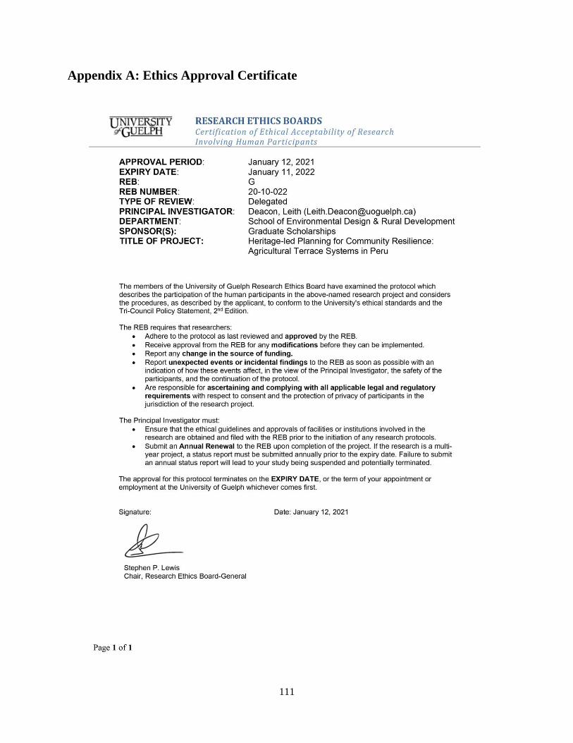
111
Appendix A: Ethics Approval Certificate
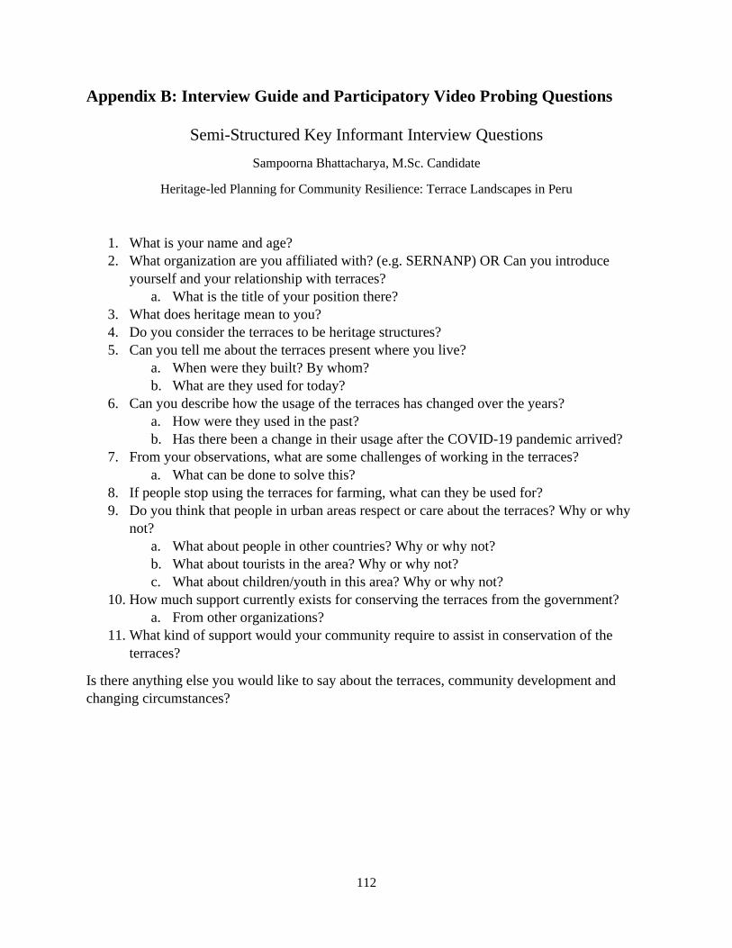
112
Appendix B: Interview Guide and Participatory Video Probing Questions
Semi-Structured Key Informant Interview Questions
Sampoorna Bhattacharya, M.Sc. Candidate
Heritage-led Planning for Community Resilience: Terrace Landscapes in Peru
1. What is your name and age?
2. What organization are you affiliated with? (e.g. SERNANP) OR Can you introduce
yourself and your relationship with terraces?
a. What is the title of your position there?
3. What does heritage mean to you?
4. Do you consider the terraces to be heritage structures?
5. Can you tell me about the terraces present where you live?
a. When were they built? By whom?
b. What are they used for today?
6. Can you describe how the usage of the terraces has changed over the years?
a. How were they used in the past?
b. Has there been a change in their usage after the COVID-19 pandemic arrived?
7. From your observations, what are some challenges of working in the terraces?
a. What can be done to solve this?
8. If people stop using the terraces for farming, what can they be used for?
9. Do you think that people in urban areas respect or care about the terraces? Why or why
not?
a. What about people in other countries? Why or why not?
b. What about tourists in the area? Why or why not?
c. What about children/youth in this area? Why or why not?
10. How much support currently exists for conserving the terraces from the government?
a. From other organizations?
11. What kind of support would your community require to assist in conservation of the
terraces?
Is there anything else you would like to say about the terraces, community development and
changing circumstances?
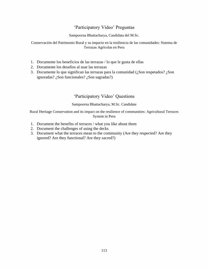
113
‘Participatory Video’ Preguntas
Sampoorna Bhattacharya, Candidata del M.Sc.
Conservación del Patrimonio Rural y su impacto en la resiliencia de las comunidades: Sistema de
Terrazas Agrícolas en Peru
1. Documente los beneficios de las terrazas / lo que le gusta de ellas
2. Documente los desafíos al usar las terrazas
3. Documente lo que significan las terrazas para la comunidad (¿Son respetados? ¿Son
ignoradas? ¿Son funcionales? ¿Son sagradas?)
‘Participatory Video’ Questions
Sampoorna Bhattacharya, M.Sc. Candidate
Rural Heritage Conservation and its impact on the resilience of communities: Agricultural Terraces
System in Peru
1. Document the benefits of terraces / what you like about them
2. Document the challenges of using the decks
3. Document what the terraces mean to the community (Are they respected? Are they
ignored? Are they functional? Are they sacred?)
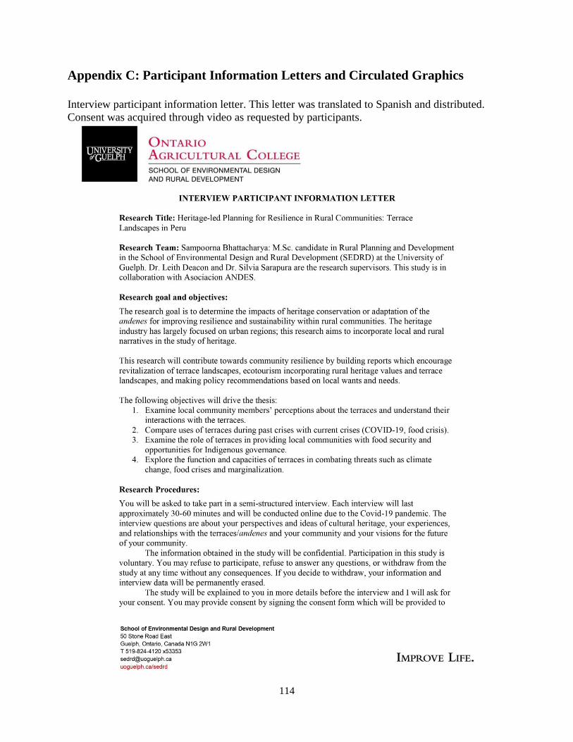
114
Appendix C: Participant Information Letters and Circulated Graphics
Interview participant information letter. This letter was translated to Spanish and distributed.
Consent was acquired through video as requested by participants.
115
116
Participatory video information letter. This letter was translated to Spanish and distributed.
Consent was acquired through video as requested by participants.
117
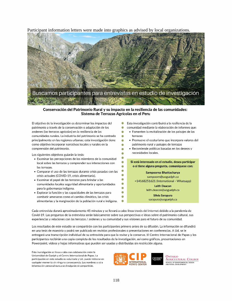
118
Participant information letters were made into graphics as advised by local organizations.
119
The following document was signed by the student researcher and sent to the ‘Tecnicos locales’
to ensure the researcher’s commitment to the process and encourage transparency.
120