Embed Size (px)
Citation preview

ASX Announcement
18 October 2021
Gladiator Resources Ltd. | www.gladiatorresources.net | ASX: GLA
4/91 William Street | Melbourne VIC | T: +61 3 8611 5333
HIGH GRADE SURFACE RADIOACTIVITY CONFIRMED FOR
MINJINGU PROJECT - TANZANIA HIGHLIGHTS
• Maiden site visit completed to Minjingu Uranium project in Northern Tanzania • Site visit confirms High Grade surface radioactivity • Data review is continuing
Gladiator Resources Ltd (ASX: GLA) (Gladiator or the Company) is pleased to announce that its newly acquired Tanzanian investment Zeus Resources (T) Limited (Zeus Resources), which holds seven Tanzanian licenses prospective for Uranium and other commodities, has successfully acquired data for the Minjingu Uranium Project based in Northern Tanzania (Minjingu Project), which encompasses licence PL11706.
Gladiator Resources Chairman Ian Hastings commented:
“We are encouraged by the data that shows attractive levels of surface Uranium and Phosphate mineralisation at Minjingu. In addition, the Tanzanian on ground team recently conducted a site visit to Minjingu to validate and ground truth the recently acquired project database. The Tanzanian team is looking forward to aggressively exploring the Minjingu Project further and to commencing work unearthing the numerous opportunities across the other Tanzanian Projects acquired by Gladiator.”
About the Minjingu Project – (Uranium, Phosphate) 100% Gladiator
The Minjingu Project covers a total area of 296.9km2 and is in northern Tanzania, 106km southwest of Arusha, the main administrative city in the area and 520km northwest of Dar es Salaam. The Minjingu Project area possesses great infrastructure such as quality tarmac roads, power lines, airport services via both Arusha and Kilimanjaro International airports and ample water resources.
Previous Exploration
The earliest reported mineral exploration and development activity on ground now covered by the Eastern Rift Property was in 1956, when New Consolidated Goldfields Ltd. discovered phosphate mineralization at Minjingu
(Bianconi, et al, 1978). Further studies on the Minjingu phosphate deposits were carried out by the Japan Consulting Institute, Geomin, Kloeckner Industrieanlagen, and Stamico (Bianconi, et al, 1978). In 1977-78, all of Tanzania was covered by an airborne geophysical survey comprising gamma spectrometry and magnetometry (Bianconi, 1987). The survey was carried out by Geosurvey International Ltd. on behalf of the Tanzanian government.
Uranerzbergbau GmbH (Uranerz) first investigated the Minjingu Project in 1978 via a country-wide airborne radiometric survey followed by groundwork with significant results achieved. Between 1978 to 1981, Uranerzbergbau GMBH carried out ground examination of about 110 radiometric anomalies identified by the country wide airborne survey (Bianconi, 1987) in joint venture with the Tanzanian government and the United Nations as part of a uranium evaluation program. The work resulted in the identification of many uranium occurrences and prospects throughout Tanzania, including the identification of anomalous uranium values in the Minjingu phosphate deposit (Bianconi, et al, 1978; Ingovatov, et al, 1982).

ASX Announcement
18 October 2021
www.gladiatorresources.net
In addition, Montero Mining and Exploration Ltd (2007-08), Tanganyika Uranium Corp (2010) and East Africa Resources (2012) have conducted further pitting, trenching and drilling activities within the Lake Manyara Region, targeting Calcrete style Uranium mineralisation.
Site Visit Program
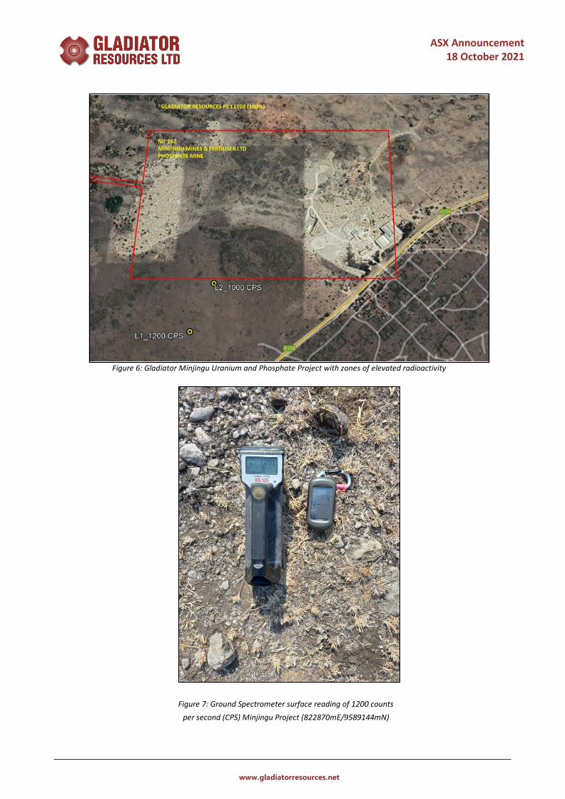
The Zeus Resources exploration team have now conducted a site visit to the Minjingu Uranium and Phosphate Project. The site visit was primarily aimed at assessing regional infrastructure and logistics in line with the Company’s forthcoming exploration plans. In addition, the team clearly established the Minjingu Project licence boundaries (Licence Area) in the field and collected background radioactivity measurements. Two zones of elevated radioactivity were located and measured above 1000 CPS, within average background 500 CPS. A summary of the radioactivity measurements are set out in the below table:
Point ID East _m North_m RL Scintillometer (CPS) Grid ID
L1 822870 9589419 1012 1000 ARC1960_UTM36S L2 822984 9589144 1000 1200 ARC1960_UTM36S
Future Program
Currently the exploration team is continuing to review the substantial historical datasets for further ground truthing and sampling aimed at validating the previous historical exploration results and to generate further exploration targets. Future work programs include regional scale ground radiometric surveys, auger drilling/ pitting and trenching followed by RC drilling and downhole gamma logs surveys programs.
Figure 1: Gladiator project locations in Tanzania
ASX Announcement
18 October 2021
www.gladiatorresources.net
Regional Geology
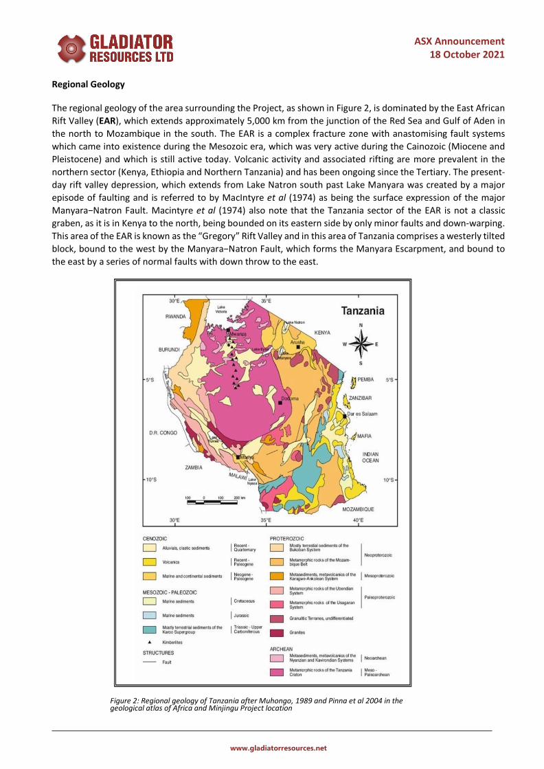
The regional geology of the area surrounding the Project, as shown in Figure 2, is dominated by the East African Rift Valley (EAR), which extends approximately 5,000 km from the junction of the Red Sea and Gulf of Aden in the north to Mozambique in the south. The EAR is a complex fracture zone with anastomising fault systems which came into existence during the Mesozoic era, which was very active during the Cainozoic (Miocene and Pleistocene) and which is still active today. Volcanic activity and associated rifting are more prevalent in the northern sector (Kenya, Ethiopia and Northern Tanzania) and has been ongoing since the Tertiary. The present-day rift valley depression, which extends from Lake Natron south past Lake Manyara was created by a major episode of faulting and is referred to by MacIntyre et al (1974) as being the surface expression of the major Manyara−Natron Fault. Macintyre et al (1974) also note that the Tanzania sector of the EAR is not a classic graben, as it is in Kenya to the north, being bounded on its eastern side by only minor faults and down-warping. This area of the EAR is known as the “Gregory” Rift Valley and in this area of Tanzania comprises a westerly tilted block, bound to the west by the Manyara−Natron Fault, which forms the Manyara Escarpment, and bound to the east by a series of normal faults with down throw to the east.
Figure 2: Regional geology of Tanzania after Muhongo, 1989 and Pinna et al 2004 in the geological atlas of Africa and Minjingu Project location

ASX Announcement
18 October 2021
www.gladiatorresources.net
Local Geology
The geology of the Licence Area largely comprises young undifferentiated flat lying Neogene lake beds which are part of the Lake Manyara Formation. Minjingu Hill and also the Mbulu Highlands to the west (outside of the licence area) however are comprised of Precambrian igneous and metamorphic lithologies such as granitoids, banded gneisses, amphibolites quartzites and metagabbros. The only outcrops observed in the Licence Area are those of quartzite and amphibolite on Minjingu Hill and the phosphate horizons being mined in the existing open pit which is immediately adjacent to its eastern flank.
Figure 3: Gladiator Geologist conducting limited Ground Spectrometer readings at Minjingu Project. (Minjingu Hill looking North)
Mineralisation
Zeus has not yet undertaken any mineralogical work and it is too early in the exploration process to comment definitively on the nature of the uranium mineralisation, the host rocks or the distribution of the uranium within the deposit. Generally however, uranium occurs in close proximity with phosphate mineralisation and is hosted by lake sediments of Neogene Age.

ASX Announcement
18 October 2021
www.gladiatorresources.net
Figure 4: Schematic diagram of the Minjingu calcrete
Uranium mineralisation deposit style
Figure 5: Gladiator Minjingu Uranium and Phosphate Project Licence
Area PL11706, surrounding the Minjingu Fertiliser Ltd Phosphate mine.
ASX Announcement
18 October 2021
www.gladiatorresources.net
Figure 6: Gladiator Minjingu Uranium and Phosphate Project with zones of elevated radioactivity
Figure 7: Ground Spectrometer surface reading of 1200 counts per second (CPS) Minjingu Project (822870mE/9589144mN)

ASX Announcement
18 October 2021
www.gladiatorresources.net
-ENDS-
Released with the authority of the Board.
For further information please visit: www.gladiatorresources.net
contact:
Ian Hastings Chairman [email protected] +61 408 581 022
Andrew Draffin Company Secretary [email protected] +61 3 8611 5333
Mark Flynn Investor Relations [email protected] +61 416 068 733
Competent Person’s Statement Information in this “ASX Announcement” relating to Exploration Targets, Exploration Results, Mineral Resources or Ore Reserves has been compiled by Mr James Sullivan who is a Member and Registered Professional Geoscientist, MAIG RPGeo (No 10271) of the Australian Institute of Geoscientists and is a consultant to Gladiator Resources Ltd. Mr. Sullivan has sufficient experience that is relevant to the types of deposits being explored for and qualifies as a Competent Person as defined in the 2012 Edition of the “Australasian Code for Reporting of Exploration Results, Mineral Resources and Ore Reserves” (JORC Code 2012 Edition). Mr. Sullivan consents to the inclusion in this document of the matters based on the information in the form and context in which it appears. Mr Sullivan does not currently hold any securities in the company, either directly or indirectly.
About Gladiator Resources
Gladiator is an ASX listed (ASX: GLA) exploration and mining company with a focus on gold and uranium. The Company was recently granted seven exploration licenses covering over 1,764km2 of highly prospective exploration tenements located in Tanzania, East Africa.
Gladiator also has three gold projects in Australia including Marymia located in Western Australia and Rutherglen and Bendoc which are each located in Victoria.
All the Company’s projects are located in areas that have experienced significant exploration attention and investment whilst also recording highly encouraging results. Victoria, in particular, is currently experiencing a revival in exploration and production which is attracting significant investment attention both domestically and abroad.
The Company’s primary focus is to advance its current portfolio of projects whilst also evaluating other opportunities that are complimentary.

ASX Announcement
18 October 2021
www.gladiatorresources.net
JORC Code, 2012 Edition – Table 1 Sampling Techniques and Data Criteria JORC Code explanation Commentary
Sampling techniques
• Nature and quality of sampling (e.g., cut channels, random chips, or specific specialised industry standard measurement tools appropriate to the minerals under investigation, such as down hole gamma sondes, or handheld XRF instruments, etc). These examples should not be taken as limiting the broad meaning of sampling.
• Include reference to measures taken to ensure sample representivity and the appropriate calibration of any measurement tools or systems used.
• Aspects of the determination of mineralisation that are Material to the Public Report.
• In cases where ‘industry standard’ work has been done this would be relatively simple (e.g., ‘reverse circulation drilling was used to obtain 1 m samples from which 3 kg was pulverised to produce a 30 g charge for fire assay’). In other cases, more explanation may be required, such as where there is coarse gold that has inherent sampling problems. Unusual commodities or mineralisation types (e.g., submarine nodules) may warrant disclosure of detailed information.
• Background radiation results published were completed utilising a Radiation Solutions RS-125 Spectrometer using ‘survey mode’ and recorded background radiation in Counts Per Second (CPS).
• Pre-survey, the RS-125 spectrometer was calibrated outside of the target area, averaging 100 CPS (background).
• Background radiation ranged from 100 to 1200 CPS, with an average of 500CPS
Drilling techniques
• Drill type (e.g., core, reverse circulation, open-hole hammer, rotary air blast, auger, Bangka, sonic, etc) and details (e.g., core diameter, triple or standard tube, depth of diamond tails, face-sampling bit or other type, whether core is oriented and if so, by what method, etc).
• No drilling activities were undertaken
Drill sample recovery
• Method of recording and assessing core and chip sample recoveries and results assessed.
• Measures taken to maximise sample recovery and ensure representative nature of the samples.
• Whether a relationship exists between sample recovery and grade and whether sample bias may have occurred due to preferential loss/gain of fine/coarse material.
• No drilling activities were undertaken
Logging • Whether core and chip samples have been geologically and geotechnically logged to a level of detail to support appropriate Mineral Resource estimation, mining studies and metallurgical studies.
• Whether logging is qualitative or quantitative in nature. Core (or costean, channel, etc) photography.
• The total length and percentage of the relevant intersections logged.
• No drilling activities were undertaken
Sub-sampling techniques and sample preparation
• If core, whether cut or sawn and whether quarter, half or all core taken.
• If non-core, whether riffled, tube sampled, rotary split, etc and whether sampled wet or dry.
• For all sample types, the nature, quality and appropriateness of the sample preparation technique.
• Quality control procedures adopted for all sub-sampling stages to maximise representivity of samples.
• Measures taken to ensure that the sampling is representative of the in-situ material collected, including for instance results for field duplicate/second-half sampling.
• Whether sample sizes are appropriate to the grain size of the material being sampled.
• No chemical assays were undertaken

ASX Announcement
18 October 2021
www.gladiatorresources.net
Criteria JORC Code explanation Commentary
Quality of assay data and laboratory tests
• The nature, quality and appropriateness of the assaying and laboratory procedures used and whether the technique is considered partial or total.
• For geophysical tools, spectrometers, handheld XRF instruments, etc, the parameters used in determining the analysis including instrument make and model, reading times, calibrations factors applied and their derivation, etc.
• Nature of quality control procedures adopted (eg standards, blanks, duplicates, external laboratory checks) and whether acceptable levels of accuracy (ie lack of bias) and precision have been established.
• A Radiation Solution RS-125 was used to measure radioactivity (in counts per second - CPS) using survey mode and specific locations during the brief survey.
• No chemical assay data is provided in this report.
Verification of sampling and assaying
• The verification of significant intersections by either independent or alternative company personnel.
• The use of twinned holes. • Documentation of primary data, data entry
procedures, data verification, data storage (physical and electronic) protocols.
• Discuss any adjustment to assay data.
• No adjustments to collected and reported data have been undertaken.
Location of data points
• Accuracy and quality of surveys used to locate drill holes (collar and down-hole surveys), trenches, mine workings and other locations used in Mineral Resource estimation.
• Specification of the grid system used. • Quality and adequacy of topographic control.
• Data was surveyed using a Garmin handheld unit with accuracies between 1-3m.
• The grid system used is Universal Transverse Mercator (ARC1960), Zone 36 Southern Hemisphere.
• Topographic control to date has used GPS data, which is adequate considering the low relief (>50m) in the area.
Data spacing and distribution
• Data spacing for reporting of Exploration Results. • Whether the data spacing and distribution is
sufficient to establish the degree of geological and grade continuity appropriate for the Mineral Resource and Ore Reserve estimation procedure(s) and classifications applied.
• Whether sample compositing has been applied.
• A random traverse was undertaken over an area reported.
• Results collected was real time • No Mineral Resource or Ore Reserve have been
estimated in this ASX Release. • No chemical assays/sample compositing are reported
Orientation of data in relation to geological structure
• Whether the orientation of sampling achieves unbiased sampling of possible structures and the extent to which this is known, considering the deposit type.
• If the relationship between the drilling orientation and the orientation of key mineralised structures is considered to have introduced a sampling bias, this should be assessed and reported if material.
• The current survey was limited in nature. Therefore, there is insufficient data in the licence to determine to orientation of host structures.
• No chemical assays were undertaken
Sample security • The measures taken to ensure sample security. • No chemical assays were undertaken
Audits or reviews • The results of any audits or reviews of sampling techniques and data.
• No audits have been undertaken for this phase of work
Section 2 Reporting of Exploration Results Criteria JORC Code explanation Commentary
Mineral tenement and land tenure status
• Type, reference name/number, location and ownership including agreements or material issues with third parties such as joint ventures, partnerships, overriding royalties, native title interests, historical sites, wilderness or national park and environmental settings.
• The security of the tenure held at the time of reporting along with any known impediments to obtaining a licence to operate in the area.
• All results were undertaken on PL 11706 (Minjingu Project) which is held by Zeus Resources (Tanzania) Limited (100%).
• There are no other known impediments pertaining to operating in the current licence.
Exploration done by other parties
• Acknowledgment and appraisal of exploration by other parties.
• The Minjingu Deposit was discovered by New Consolidated Goldfields Ltd (NCG) in 1956 who explored Minjingu for Phosphate. Japan Consulting Institute and Geomin, carried out further studies in 1970 and in the same year Kloeckner Industrieanlagen carried out a feasibility study on the phosphate deposit. The phosphate mine was ultimately operated by the state until 1989-1990.
• During the period 1978 to 1981, Uranerzbergbau GMBH

ASX Announcement
18 October 2021
www.gladiatorresources.net
Criteria JORC Code explanation Commentary
carried out ground examination of about 110 radiometric anomalies identified by the airborne survey (Bianconi, 1987) in joint venture with the Tanzanian government and the United Nations as part of a uranium evaluation program. The work resulted in the identification of many uranium occurrences and prospects throughout Tanzania, including the identification of anomalous uranium values in the Minjingu phosphate deposit
ranging from 11 to 849 ppm U308 (Bianconi, et al, 1978; Ingovatov, et al, 1982). Uranerzbergbau carried out reconnaissance mapping, ground radiometrics, ground magnetics, ground electromagnetics, with limited auger drilling
• In 2005 Tanganyika Uranium Corp and later, East African Resources (2010) have also conducted uranium exploration in the PL11706 licence area.
Geology • Deposit type, geological setting and style of mineralisation.
• The regional geology of the Minjingu Hill area is dominated by the East African Rift Valley (EAR), which extends approximately 5000km from the from the junction of the Red Sea and Gulf of Aden to Mozambique. The EAR is a complex fracture zone with anastomising fault systems which came into existence during the Mesozoic era was very active during the Cenozoic (Miocene and Pleistocene) and is still active today. Volcanic activity and associated rifting is more prevalent in the northern sector (Kenya, Ethiopia and Northern Tanzania) and has been ongoing since the Tertiary. The present-day rift valley depression, which extends from Lake Natron south past Lake Manyara was created by a major episode of faulting and is referred to by MacIntyre et al (1974) as being the surface expression of the major Manyara−Natron Fault. Macintyre et al (1974) also state that the Tanzania sector of the EAR is not a classic graben, as in Kenya to the north, and is bounded on its eastern side only by minor faults or down-warping. This area of the EAR is known as the “Gregory” rift valley and in this area of Tanzania is formed by a westerly tilted block, bound to the west by the Manyara−Natron Fault which forms the Manyara Escarpment and bound to the east by a series of normal faults with down throw to the east. The Manyara−Natron Fault and Manyara Escarpment define the EAR system to the west. To the east of the Manyara−Natron Fault are the continuous plains of the Masai Steppe. Locally, the geology of the licence area comprises undifferentiated Neogene lake beds from the Lake Manyara Formation. Minjingu Hill and also the Mbulu Highlands to the west, outside of the licence area are assigned to the Usagaran; a Precambrian unit comprising igneous and metamorphic lithologies such as granitoids, banded gneisses, amphibolites quartzites and metagabbros. The only outcrops observed in the licence area are those of quartzite and amphibolite on Minjingu Hill.

ASX Announcement
18 October 2021
www.gladiatorresources.net
Criteria JORC Code explanation Commentary
Drill hole Information
• A summary of all information material to the understanding of the exploration results including a tabulation of the following information for all Material drill holes: o easting and northing of the drill hole collar o elevation or RL (Reduced Level – elevation
above sea level in meters) of the drill hole collar o dip and azimuth of the hole o down hole length and interception depth o hole length.
• If the exclusion of this information is justified on the basis that the information is not Material and this exclusion does not detract from the understanding of the report, the Competent Person should clearly explain why this is the case.
• No drilling activities were undertaken
Data aggregation methods
• In reporting Exploration Results, weighting averaging techniques, maximum and/or minimum grade truncations (e.g., cutting of high grades) and cut-off grades are usually Material and should be stated.
• Where aggregate intercepts incorporate short lengths of high-grade results and longer lengths of low-grade results, the procedure used for such aggregation should be stated and some typical examples of such aggregations should be shown in detail.
• The assumptions used for any reporting of metal equivalent values should be clearly stated.
• No drilling activities were undertaken
Relationship between mineralisation widths and intercept lengths
• These relationships are particularly important in the reporting of Exploration Results.
• If the geometry of the mineralisation with respect to the drill hole angle is known, its nature should be reported.
• If it is not known and only the down hole lengths are reported, there should be a clear statement to this effect (e.g., ‘down hole length, true width not known’).
• No drilling activities were undertaken
Diagrams • Appropriate maps and sections (with scales) and tabulations of intercepts should be included for any significant discovery being reported These should include, but not be limited to a plan view of drill hole collar locations and appropriate sectional views.
• Refer to the main body of this report.
Balanced reporting
• Where comprehensive reporting of all Exploration Results is not practicable, representative reporting of both low and high grades and/or widths should be practiced to avoid misleading reporting of Exploration Results.
• All results of significance have been reported within this ASX report
Other substantive exploration data
• Other exploration data, if meaningful and material, should be reported including (but not limited to): geological observations; geophysical survey results; geochemical survey results; bulk samples – size and method of treatment; metallurgical test results; bulk density, groundwater, geotechnical and rock characteristics; potential deleterious or contaminating substances.
The phosphate mineralisation at Minjingu was discovered by New Consolidated Goldfields Ltd (NCG) in 1956. Japan Consulting Institute and Geomin then carried out further studies in 1970 and in the same year Kloeckner Industrieanlagen completed a feasibility study to determine the potential economics of exploiting the phosphate ore. The phosphate mine was ultimately commissioned by the government in 1989.
• Uranerzbergbau GmbH (Uranerzbergbau) first investigated the uranium potential of the area in 1978 and carried out an airborne geophysical survey to investigate this further. A report dated 12 March 1979, written by Uranerzbergbau, details the geology, radiometry and uranium content of the Minjingu Phosphate prospect. Grab samples were collected from the two types of phosphate identified by NCG (hard and soft). Although values of over 800 ppm U308 were recorded from both the hard and soft phosphate, Uranerzbergbau reported that the soft phosphate was the most promising host as only in this were the values

ASX Announcement
18 October 2021
www.gladiatorresources.net
Criteria JORC Code explanation Commentary
continuous over several metres (the highest composited value reported being 728 ppm U308 over 1.10 m). Although the base of the soft phosphate interval was not exposed, Uranerzbergbau projected this to have a total thickness of 40 m.
• Tanganyika Uranium Corp (2008) and later East Africa Resources (2012) conducted further exploration in the region.
Further work • The nature and scale of planned further work (e.g., tests for lateral extensions or depth extensions or large-scale step-out drilling).
• Diagrams clearly highlighting the areas of possible extensions, including the main geological interpretations and future drilling areas, provided this information is not commercially sensitive.
• A number of targets have been identified and further detailed assessments are being planned. Further regional scale and systematic ground radiometrics surveys will also be carried out to determine further drill targets, which will be followed up with auger/Aircore/RC drilling phases.