Embed Size (px)
Citation preview
High Lane Village NDP First Draft Plan v7 05 March 2019
1
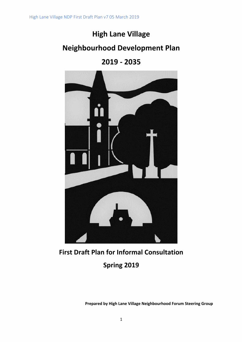
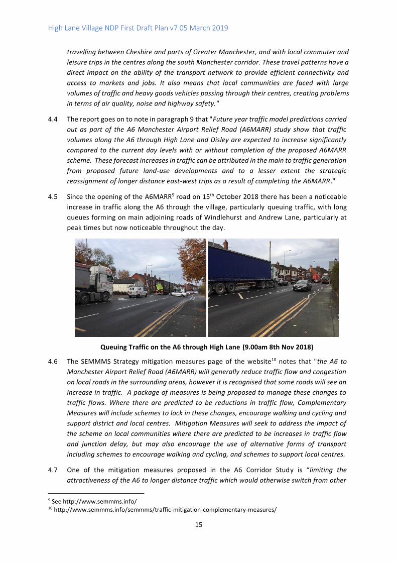
High Lane Village
Neighbourhood Development Plan
2019 - 2035
First Draft Plan for Informal Consultation
Spring 2019
Prepared by High Lane Village Neighbourhood Forum Steering Group
High Lane Village NDP First Draft Plan v7 05 March 2019
2
Contents
HOW TO COMMENT ..................................................................................................................... 3
EXECUTIVE SUMMARY ................................................................................................................. 4
LIST OF HLVNDP POLICIES ............................................................................................................. 5
1.0 WHAT IS A NEIGHBOURHOOD DEVELOPMENT PLAN (NDP)? ................................................. 6
2.0 HIGH LANE VILLAGE NDP ..................................................................................................... 8
3.0 NDP DRAFT VISION AND OBJECTIVES ................................................................................. 12
HIGH LANE NDP PLANNING POLICIES .......................................................................................... 14
4.0 TRANSPORT ....................................................................................................................... 14
5.0 HOUSING........................................................................................................................... 26
6.0 GREEN OPEN SPACES, RECREATIONAL ACTIVITIES AND NATURAL HERITAGE ....................... 36
7.0 HERITAGE AND DESIGN ...................................................................................................... 55
8.0 NEXT STEPS ....................................................................................................................... 64
9.0 REVIEW ............................................................................................................................. 64
APPENDIX 1 PUBLIC CONSULTATION 2017 - COMMENTS FROM QUESTIONNAIRE ........................ 65
APPENDIX 2 MITIGATION MEASURES ......................................................................................... 68
APPENDIX 3 MIDDLEWOOD STATION USERS SURVEY, JANUARY 2019 ......................................... 75
APPENDIX 4 GMSF JANUARY 2019 POLICY GM ALLOCATION 38 ................................................... 78
APPENDIX 5 AFFORDABLE HOUSING (NPPF ANNEX 2: GLOSSARY) ............................................... 80
APPENDIX 6 INFORMAL PUBLIC CONSULTATION ON HOUSING ISSUES USING FACEBOOK, SUMMER
2018 .......................................................................................................................................... 81
APPENDIX 7 INFORMAL CONSULTATIONS ON RECREATIONAL ACTIVITY IN HIGH LANE ................. 83
APPENDIX 8 BIODIVERSITY ......................................................................................................... 86
APPENDIX 9 LISTED BUILDINGS ................................................................................................... 90

High Lane Village NDP First Draft Plan v7 05 March 2019
3
How to Comment
Welcome to the High Lane Village Neighbourhood Development Plan (HLVNDP). This First Draft
Plan is published for informal public consultation until the end of March 2019. The Plan has
been prepared by the High Lane Village Neighbourhood Forum (HLVNF) Management
Committee made up of local residents and Councillors.
Public consultation is a very important part of preparing NDPs and this is your opportunity to
input on the emerging draft planning policies which will be used by SMBC to help guide
development in High Lane up to 2035.
Hopefully our NDP reflects the various priorities and concerns of High Lane residents and those
who work in the area so that we have more say in the planning process.
The First Draft Plan has been prepared following the public consultation on the Issues and
Options document from 30th June 2018 to 30th July 2018. We have considered the many
responses to the consultation questions, including your comments and concerns, and used
these to inform the draft planning policies in this document.
We need to know if the draft planning policies are suitable, or if there is anything important
that we have missed. Overall, how we want to guide new development in a positive way to
ensure that changes are sensitive to High Lane’s attractive character and setting in the Green
Belt.
You can find out more and comment on the document on the following ways:
• Download the document from the NDP website http://hlvnf.org/
• Borrow a hard copy of the document from High Lane Library
• Complete the accompanying feedback form.
Please return any comments in writing / email or use the feedback form to
or drop them off in the post box in the library.
Thank you for your time and interest.
All responses will be considered very carefully by the Neighbourhood Plan Steering Groups
(NPSG) and used to inform the Draft NDP which will be published for 6 weeks formal
consultation later in 2019.
HLVNF
High Lane Village NDP First Draft Plan v7 05 March 2019
4
Executive Summary
This is the Draft Neighbourhood Development Plan (NDP) for High Lane. This Plan has been
prepared by the High Lane Village Neighbourhood Forum of local residents with the support
and advice of officers from Stockport MBC and other stakeholder groups such as Sustrans and
the Greater Manchester Ecological Unit.
The NDP sets out draft local planning policies which will be used to help SMBC determine
planning applications in the area up to 2035. These policies have been prepared taking into
account the concerns and ideas of local residents, which have been put forward during
numerous informal public consultation processes since 2017.
The NDP provides planning policies and proposals to help address local transport issues
including congestion and poor air quality, and promotes more liveable neighbourhoods which
provide an appealing and safe environment to encourage more walking and cycling. A policy
for new housing within the existing built up area should guide new development to provide the
type of housing most needed in the area. Open spaces, recreation areas and walking and cycling
routes are identified for protection, and policies support their enhancement. Natural heritage
including local landscape character, important views and wildlife are protected as significant
local assets for future generations to enjoy.
Going Forward
The NDP will be a statutory planning document and therefore it is required to go through a
number of stages before it can be made (adopted) by Stockport MBC and used to help
determine planning applications.
Following several informal and then formal periods of public consultation, it will be examined
by an independent examiner against a set of 'basic conditions' and then, provided it is found to
meet these conditions (subject to any recommended modifications by the examiner) the NDP
will be subjected to a local referendum and residents in High Lane will be asked whether they
think the Plan should be used to guide decisions on planning applications in their area.

High Lane Village NDP First Draft Plan v7 05 March 2019
5
List of HLVNDP Policies
Policy Page Number
Draft Policy T1 Mitigating Local Traffic Impacts of Development and
Improving Air Quality
18
Draft Policy T2 Middlewood Station 22
Draft Policy T3 Supporting Cycling, Walking and Liveable Neighbourhoods 24
Draft Policy H1 Housing Scale and Mix 34
Draft Policy R1 Protecting and Enhancing Parks and Recreational Areas 40
Draft Policy R2 Walking, Cycling and Horse Riding 45
Draft Policy NH1 Protecting Local Landscape Character in the High Lane Area
49
Draft Policy NH2 Protecting Important Views and Vistas
52
Draft Policy NH3 Protecting and Enhancing Local Wildlife
53
Draft Policy HD1 Protecting Built Heritage Assets and their Settings 61
Draft Policy HD2 High Quality Design and Design Codes 62
High Lane Village NDP First Draft Plan v7 05 March 2019
6
1.0 What is a Neighbourhood Development Plan (NDP)?
1.1 Neighbourhood Development Plans (NDPs) are a new type of planning policy document,
prepared by Neighbourhood Forum or Parish Councils to guide new development within a
defined local area. They are used alongside local authority (here, Stockport Metropolitan
Borough Council) and national planning policy documents, to help determine planning
applications. NDPs are powerful tools and present significant opportunities for local people to
have a real say in how, and where, development should happen within their local area.
1.2 An NDP can cover a range of planning related issues, or just have one, single policy. It is also
worth noting that NDPs cannot address some strategic planning matters such as Minerals and
Waste and Strategic Infrastructure Projects as these are dealt with by the local planning
authority (Stockport MBC and GMCA) and Central Government. This First Draft Plan has been
prepared building on the responses to the Issues and Options public consultation undertaken
in summer 2018. It provides more detail about the identified planning issues relevant to the
High Lane Village NDP and sets out draft planning policies to address these issues.
1.3 NDPs cannot be prepared in isolation and all NDP planning policies and proposals have to be
underpinned by a clear and robust evidence base of local opinion and technical resources.
1.4 Overall the Plan has to meet a set of “basic conditions” set out in national guidance and these
will be tested through an examination at the end of the process. The basic conditions include
the requirement that NDPs have to be in general conformity with local strategic planning
policies. The local strategic planning policies are set out in the Stockport Adopted Core Strategy
20111. Saved policies from the Stockport Unitary Development Plan Review 20062 may also
apply but these are generally not strategic in nature. The NDP should also take into account the
reasoning and evidence informing the emerging Local Plan process (see Planning Practice
Guidance)3 - in relation to HLNDP this includes the emerging new Stockport Local Plan4 and the
emerging Greater Manchester Spatial Framework.5
1.5 NDPs also are required to have regard to national planning policy (National Planning Policy
Framework NPPF, 2018, Planning Practice Guidance6 and other Ministerial statements and
guidance) and to comply with European (including Environmental) Regulations.
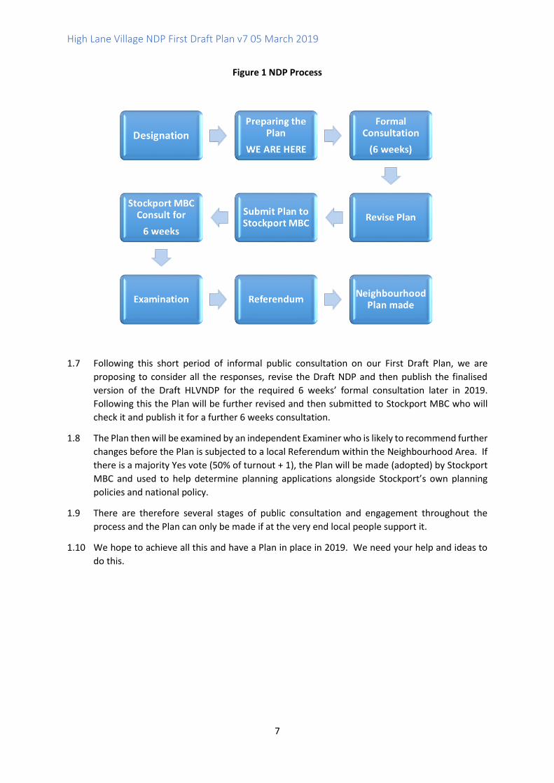
1.6 Preparing an NDP is therefore a complex and lengthy process. The main steps are set out in
Figure 1.
1 http://old.stockport.gov.uk/ldf/corestrategy/ 2 http://old.stockport.gov.uk/ldf/udp/ 3 Planning Practice Guidance Para 009 Reference ID: 41-009-20160211 4 https://www.stockport.gov.uk/what-is-the-stockport-local-plan 5 https://www.greatermanchester-ca.gov.uk/GMSF 6 This is an online resource available at https://www.gov.uk/government/collections/planning-practice-guidance
High Lane Village NDP First Draft Plan v7 05 March 2019
7
Figure 1 NDP Process
1.7 Following this short period of informal public consultation on our First Draft Plan, we are
proposing to consider all the responses, revise the Draft NDP and then publish the finalised
version of the Draft HLVNDP for the required 6 weeks’ formal consultation later in 2019.
Following this the Plan will be further revised and then submitted to Stockport MBC who will
check it and publish it for a further 6 weeks consultation.
1.8 The Plan then will be examined by an independent Examiner who is likely to recommend further
changes before the Plan is subjected to a local Referendum within the Neighbourhood Area. If
there is a majority Yes vote (50% of turnout + 1), the Plan will be made (adopted) by Stockport
MBC and used to help determine planning applications alongside Stockport’s own planning
policies and national policy.
1.9 There are therefore several stages of public consultation and engagement throughout the
process and the Plan can only be made if at the very end local people support it.
1.10 We hope to achieve all this and have a Plan in place in 2019. We need your help and ideas to
do this.
High Lane Village NDP First Draft Plan v7 05 March 2019
8
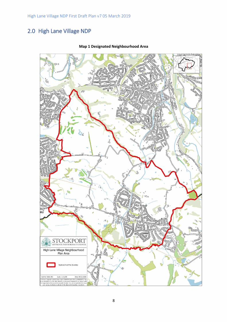
2.0 High Lane Village NDP
Map 1 Designated Neighbourhood Area

High Lane Village NDP First Draft Plan v7 05 March 2019
9
2.1 High Lane is located in the local authority area of Stockport Metropolitan Borough Council in Greater Manchester. It is about 5 miles (8km) south west of Stockport and is separated from the urban area by open countryside, which is protected as Green Belt. The Peak District National Park lies to the south and east. The A6 runs through the village east / west and the Macclesfield Canal and a section of the Conservation Area bisect the area north / south.
2.2 The Village has some historical buildings dating back to the 1600s and is surrounded by farms
and woodland. The wider area has history of open cast mining and the Macclesfield Canal links to Marple, the Peak Forest and to the wider canal network beyond. The old rail line to the west is now the Middlewood Way, a popular recreational route for walkers, runners, cyclists and
horse riders. 2.3 High Lane Built up area had a population of 4,608 usual residents on Census day 20117 and
covers an area of 838 hectares.
High Lane Village Neighbourhood Forum and Neighbourhood Area Designation
2.4 The area does not have a parish council and therefore a Neighbourhood Forum has been set up
to oversee the preparation of the NDP.
2.5 On 11th January 2017 a "pathfinder meeting" was held at Windlehurst Church hall after the
distribution of around 2000 leaflets in High Lane area with direct e-mail to attendees,
announcements on social media and via the High Lane Residents’ Association. This led to a
follow-up open meeting on 28th February 2017. This meeting outlined the needs and benefits
of a neighbourhood forum to allow the community to influence future developments in High
Lane.
2.6 The boundary for the High Lane Neighbourhood Area was identified since it predominantly
follows the electoral boundary for High Lane and is aligned to the local councillors who
supported the forum application and to the people who live in the community and vote for
those councillors. The boundary for the designated area was broadly defined by three existing
boundaries as per the Plan Boundary Statement 2017: on the west and south sides it follows
the Marple Area electoral boundary for councils; on the east side it follows the Peak Forest
canal, also part of this electoral boundary, and to the north it follows the boundary set by the
Marple Forum Designated Area, so that the 2 plans are aligned. The map of the proposed
Neighbourhood Area was reviewed at the meeting on 28th February 2017 and there were no
objections or proposed changes.
2.7 The Neighbourhood Forum formally applied for the designation of the neighbourhood area to
Stockport MBC who consulted on the proposed Neighbourhood Area from 16th June 2017 to
28th July 2017 and formally approved the High Lane Village Neighbourhood Area on 14th
September 2017. The Terms of Reference of the Forum can be found on the NDP website.
Early Informal Consultation and Emerging Themes
2.8 There were subsequent meetings in March, April and May 2017 to plan for Open Meetings on
Friday 26th and Saturday 27th May 2017 at High Lane Village Hall. The flyer for the meeting had
an A4 version of the Area map in colour on one side and 1,800 were distributed to houses and
businesses in the proposed Area.
7 See Nomis Local Area Reports - High Lane Built-up area: https://www.nomisweb.co.uk/reports/localarea
High Lane Village NDP First Draft Plan v7 05 March 2019
10
2.9 The aim of the Consultation Event was:
• To explain the council led planning system
• To explain a community led Neighbourhood Plan
• To outline the process of Neighbourhood Planning
• To ascertain local support for the development of a Neighbourhood Plan
2.10 In all over 200 people participated in one or more of the meetings and the open days. Everyone
was given the opportunity to complete a questionnaire that asked whether they supported the
establishment of a Neighbourhood Forum and whether they wished to be involved. 103
questionnaires were completed with 100 responses in favour, none against and 3 asking for
more information.
Other questions included:
• What do you see as the main aims of the plan?
• As High Lane evolves in to the 21st century in what ways can it continue to sustain you and
your family, friends or business?
• How many new homes does High Lane need: 0-4,000?
2.11 A website dedicated to the NDP was set up in November 2017 ( http://hlvnf.org/ ) and a
Facebook page ( https://en-gb.facebook.com/groups/HighLane/ ) was set up in January 2018.
2.12 The comments submitted from the Questionnaire are provided in Appendix I.
Key Planning Themes
2.13 The comments were considered by the HLVNF and used to help identify some key planning
themes for the NDP. Each theme is being progressed by a subgroup. The Themes are:
• Transport
Looking at commuting and access.
Assessing existing transport systems and anticipating future needs for public
transport, cycling, parking and pedestrians.
• Housing
Looking at our future housing needs.
Seeking the right type and scale of developments in the right place.
• Greenspace
Looking at our open Greenspaces
To explore how we can enhance and safeguard our recreational and green needs.
• Heritage
How to protect our history in the village
Identifying, protecting and enhancing local heritage that is valued by the community.
2.14 The NDP Working Groups progressed more detailed work on these key themes, identifying the
main issues that the NDP should address in an Issues and Options public consultation.

High Lane Village NDP First Draft Plan v7 05 March 2019
11
Public Consultation on Issues and Options
2.15 The Issues and Options (I&O) document was published for informal public consultation from
30th June 2018 to 30th July 2018. The consultation invited responses to 21 questions and
consultees were also encouraged to provide additional comments on the draft vision and the
four focus areas: transport, housing, green spaces/ recreation and heritage.
2.16 There were 246 responses which represents 10% of the 2,070 households polled in the Forums
plan area. The Issues and Options summary sheet which is published on the NDP website,
highlights the community’s responses to each question in numbers and percentage of
respondents. The comments were reviewed with the most common themes, along with new
ideas highlighted and all comments were provided in the appendix for record.
2.17 The responses to the Issues and Options Consultation have been considered very carefully and
used to inform the draft vision and objectives and draft planning policies in this First Draft Plan.
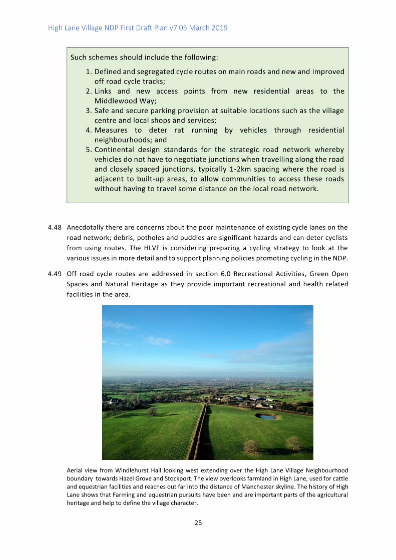
Aerial view from Windlehurst looking east over High Lane toward Disley and the High Peak. Windlehurst
Methodist Church and Windlehurst Park (Community Asset) are clearly shown in the left foreground. The
picture also shows the range of house types in the area and the countryside surrounding the village.

High Lane Village NDP First Draft Plan v7 05 March 2019
12
3.0 NDP Draft Vision and Objectives
3.1 Taking into account the key themes emerging from the public consultations, the HLVNF has
prepared the following Draft Vision and Objectives for the NDP.
3.2 In the Issues and Options consultation, of the 47 comments made, 28 (60%) were directly
supportive of the vision. Only 3 (6%) had negative comments on the vision or forum, but some
of these appeared not to understand the Forum's purpose. 10 responses suggested that there
was a need to prioritise the protection of the Green Belt and green spaces. Comments also
suggested that there should be a higher priority given to brownfield sites over greenfield sites
and there were comments about housing development, mostly opposing the 4,000 homes in
GMSF. Some supported limited new housing.
NDP Draft Vision In 2035 High Lane’s rural identity and heritage will be retained and enhanced. The strong sense of community in the village remains a key benefit of living here and supports a high quality of life for all. New development, transport facilities and other infrastructure should be proportionate to the area, taking into account the village’s location within greenbelt. A good mix of small scale housing is provided to meet local needs and support long term benefits for the whole community, prioritising brownfield sites enabling protection of greenbelt and ensuring positive impact on the air quality for the village and wider Stockport area. Open spaces and recreational facilities are fully accessible to all and provide a network of green infrastructure to protect and enhance biodiversity and wildlife.
NDP Draft Objectives
Transport and Air Quality Objectives
1. To improve traffic issues within and to/from High Lane; 2. To support measures that improve air quality and resist proposals which
lead to unacceptable levels of pollutants and further deterioration of local air quality;
3. To recognise the need for integration between different means of transport; 4. To improve roads and footpaths in the village centre and elsewhere; 5. To support improvements to Middlewood Station; 6. To recognise the importance of public transport services to and from High
Lane Village in meeting the needs of both residents and visitors and improve bus services and access to other forms of public transport;
7. To improve access points to the Middlewood Way; 8. To improve cycle routes and access to cycle routes and address any local
issues of conflict with walkers; 9. To improve access to schools, shops and other community facilities;
High Lane Village NDP First Draft Plan v7 05 March 2019
13
10. To improve the provision for people with limited mobility; 11. To continue to improve canal towpaths working with the Canal and River
Trust and to promote and ensure continued good and safe access to all Public Rights of Way.
(Through NDP Policies T1, T2, T3, R2 and HD2)
Housing Objectives 1. To preserve the rural character and identity of the area through sensitive, high
quality design in new small scale development; 2. To enhance the mix of house types in the Village, housing priorities are
provided to allow for starter, new family and retirement homes; 3. To provide environmentally sustainable properties with ample provision for
the needs of local residents; 4. To provide housing for those who wish to rent rather than buy homes; 5. To ensure local people have first options / preference in new housing
development schemes. (Through NDP Policies H1, HD1 and HD2)
Recreational Activities and Green Open Spaces Objectives 1. To protect existing recreational facilities and support investment in new and
improved facilities for all ages and abilities; and 2. To work with existing clubs/societies/landowners who have land for
recreational purpose to determine if there is a need for them to expand their facilities; and
3. To protect and enhance biodiversity and other natural heritage assets. (Through NDP Policies R1, R2, R3, NH1, NH2 and NH3)
Heritage Objectives 1. To identify and assess any local heritage sites in High Lane Village
Neighbourhood Area for protection; 2. To identify possible archaeological sites e.g. those related to industrial
heritage such as mining, and agricultural heritage; 3. To encourage any new development to value and enhance the distinct
character of High Lane Village 4. To protect the local landscape character and important views. (Through NDP Policies NH1, NH2, DH1 and DH2)

High Lane Village NDP First Draft Plan v7 05 March 2019
14
High Lane NDP Planning Policies
4.0 Transport
Introduction and Background
4.1 At the Forum open day held in the Village Hall in May 2017, a key area of concern for the
community was transport and related issues. New development should not increase the
problems of traffic congestion and air pollution and indeed, where possible, should provide
opportunities for walking, cycling and improvements to public transport. The issue of traffic
congestion, high levels of air pollution and a lack of adequate access to public transport is
therefore of much concern to the community and has been repeatedly raised at
Neighbourhood Plan consultation events.
4.2 Transport has a very important role in helping to make High Lane a better, and more
sustainable place in which to live, work, shop and play but is also important both in
facilitating development and in catering for the travel demand that it creates. Whilst cars
are essential for many people, the provision of public transport and the encouragement
of walking and cycling routes are vital in order to help to address the issues of climate
change, reduce congestion and parking problems, and provide equality of o pportunity.
Congestion
4.3 Congestion is a real problem in High Lane and is of great concern to many residents. Traffic
congestion in the area is concentrated along the A6, particularly at peak times. The A6
Corridor Study Final Summary Report8 notes (Overview, paragraph 4 p1) that "The mix of
local and strategic traffic is one of the major causes of congestion on the highway network.
Freight traffic from Derbyshire and the Peak District to the M60, distribution centres and
other destinations across the North West, mixes with commuter and business traffic
8 A6 Corridor Study Final Report, Stockport Metropolitan Borough Council, August 2014
High Lane Village NDP First Draft Plan v7 05 March 2019
15
travelling between Cheshire and parts of Greater Manchester, and with local commuter and
leisure trips in the centres along the south Manchester corridor. These travel patterns have a
direct impact on the ability of the transport network to provide efficient connectivity and
access to markets and jobs. It also means that local communities are faced with large
volumes of traffic and heavy goods vehicles passing through their centres, creating problems
in terms of air quality, noise and highway safety."
4.4 The report goes on to note in paragraph 9 that "Future year traffic model predictions carried
out as part of the A6 Manchester Airport Relief Road (A6MARR) study show that traffic
volumes along the A6 through High Lane and Disley are expected to increase significantly
compared to the current day levels with or without completion of the proposed A6MARR
scheme. These forecast increases in traffic can be attributed in the main to traffic generation
from proposed future land-use developments and to a lesser extent the strategic
reassignment of longer distance east-west trips as a result of completing the A6MARR."
4.5 Since the opening of the A6MARR9 road on 15th October 2018 there has been a noticeable
increase in traffic along the A6 through the village, particularly queuing traffic, with long
queues forming on main adjoining roads of Windlehurst and Andrew Lane, particularly at
peak times but now noticeable throughout the day.
Queuing Traffic on the A6 through High Lane (9.00am 8th Nov 2018)
4.6 The SEMMMS Strategy mitigation measures page of the website10 notes that "the A6 to
Manchester Airport Relief Road (A6MARR) will generally reduce traffic flow and congestion
on local roads in the surrounding areas, however it is recognised that some roads will see an
increase in traffic. A package of measures is being proposed to manage these changes to
traffic flows. Where there are predicted to be reductions in traffic flow, Complementary
Measures will include schemes to lock in these changes, encourage walking and cycling and
support district and local centres. Mitigation Measures will seek to address the impact of
the scheme on local communities where there are predicted to be increases in traffic flow
and junction delay, but may also encourage the use of alternative forms of transport
including schemes to encourage walking and cycling, and schemes to support local centres.
4.7 One of the mitigation measures proposed in the A6 Corridor Study is “limiting the
attractiveness of the A6 to longer distance traffic which would otherwise switch from other
9 See http://www.semmms.info/ 10 http://www.semmms.info/semmms/traffic-mitigation-complementary-measures/
High Lane Village NDP First Draft Plan v7 05 March 2019
16
cross country routes with the A6 Marr in place. This will be achieved through a combination
of gateway treatments and reduced speed limits.” The HLVNF and NDP supports mitigation
measures aimed at deterring more HGVs from using the A6 route and other measures such
as the creation of a car sharing data base and the laying of a quiet road surface to reduce
noise pollution - See Appendix 2. Such measures should all assist with helping the High Lane
community deal with the projected 23% increase in traffic which is forecast now that the
SEMMS road is open.
4.8 Once the M60 extension is open or approved, research into the feasibility of a bypass for
Disley / High Lane could be undertaken. However this may not be for some time.
4.9 The new A6 MARR has led to traffic rat running through residential areas of the vi llage. The
main affected roads are (but not limited to) Torkington Lane, Russel Avenue, Park Road, and
Threapurst Lane. There is also significant congestion on Windlehurst Road; at peak times
traffic is backed up past Andrew Lane increasing journey times and pollution levels from
idling engines.
Air Quality
4.10 In addition to impacts on accessibility and movement for local residents and businesses,
high volumes of traffic are associated with increased levels of air pollution. Poor air quality
is a significant issue for High Lane.
4.11 Air pollution is defined as a mixture of gases and particles that have been emitted into
the atmosphere by man-made or natural processes. Man-made inputs generally result
from the combustion of fossil fuels. The main source of air pollution in the UK is from
road traffic. Nitrogen Dioxide (NO2) is generally formed as oxides of nitrogen are emitted
from vehicle exhausts, which react with other pollutants in the atmosphere to create NO2.
Particulate Matter (PM10 and PM2.5) are fine particles which can be solid or liquid (solid
generally formed via combustion, liquid formed in the atmosphere). Other chemicals can
attach onto particles increasing toxicity such as heavy metals and hydrocarbons.
4.12 It is estimated that there are about 40,000 annual deaths in the UK as a result of air
pollution exposure11. Air pollution is linked to respiratory illness, cardiovascular
conditions, reduced life expectancy, reproductive issues and cancer. Air pollution can also
have adverse impacts on plant species, habitats and wildlife which relies on them and
designated sites.
4.13 Planning Practice Guidance sets out that "air quality concerns can be relevant to
neighbourhood planning, and it is important to consider air quality when drawing up a
neighbourhood plan or considering a neighbourhood development order. The local
planning and environmental health departments will be able to advise whether air quality
could be a concern.12"
11 See: Royal College of Physicians and the Royal College of Paediatrics and Child Health. Every breath we take: the lifelong impact of air pollution February 2016 https://www.nhs.uk/news/heart-and-lungs/air-pollution-kills-40000-a-year-in-the-uk-says-report/ 12 Paragraph: 003 Reference ID: 32-003-20140306 Revision date: 06 03 2014 https://www.gov.uk/guidance/air-quality--3
High Lane Village NDP First Draft Plan v7 05 March 2019
17
4.14 The Greater Manchester Air Quality Action Plan 2016-202113 sets out measures which will
reduce air pollution while supporting the sustainable economic growth of the region. The
Plan identifies ‘Key Priority Areas’ which are areas of relevant exposure that tend to be
adjacent to major roads and heavily trafficked or congested areas with poor air quality,
where improvement actions would achieve the greatest effects. A6 Hazel Grove / High
Lane is identified in Table 1 (p24) and Figure 11 (p26) as a priority road for HGVs where
the modelled annual mean concentration of nitrogen dioxide (NO2) exceeds the 35μg/m3
target, and also where the road is within 50m of a property.
4.15 Greater Manchester is developing a Clean Air Plan14 to tackle harmful and illegally high
levels of roadside air pollution across the city-region. In July 2017 the Government
instructed many areas across the UK to develop measures to tackle high levels of nitrogen
dioxide (NO2) on local roads. The Government has identified 12 road-links in eight of the
10 Greater Manchester local authorities as likely to have levels of NO2 in breach of legal
limits beyond 2020. Buxton Road High Lane is identified as one such area on the list. The
Government is in favour of Clean Air Zones as the quickest way of reducing harmful
emissions together with other methods. Greater Manchester is considering a wide range
of measures that could help reduce roadside NO2 levels as part of work to develop a Clean
Air Plan and these will be the subject of public consultation.
Air Quality Monitoring in High Lane
4.16 Air quality monitoring was carried out for a period of 6-months commencing on 14th
August 2014, ending on 12th February 2015 prior to the commencement of construction
of the A6 to Manchester Airport Relief Road (A6MARR) in March 2015. Monitoring was
undertaken at various locations near the proposed route of the A6 to Manchester Airport
Relief Road (A6MARR).
4.17 Eight sites exceeded the annual mean objective of 40 g/m3 including HL1 in High Lane
(measured at 43.1 g/m3).
4.18 The next air quality-monitoring project is planned when the Poynton By-pass has opened.
The HLVNF will encourage Stockport MBC to provide a regular or permanent air-quality
monitoring station to be positioned in the village. In 2018 trees will be planted, as part of
a national project to help mitigate air pollution; the NDP supports tree planting in suitable
areas in the village as part of development schemes to help mitigate traffic impacts.
4.19 In the consultation on Issues and Options, there were several comments relating to local
concerns about traffic and air pollution in High Lane. Respondents noted that air pollution
is a particular problem on the A6, exposing children waiting for buses to smog. Children
are also exposed walking to and from school, to local facilities and to the nursery, as well
as whilst using the outdoor play areas on the corner of the A6 and Russell Avenue. 91%
of respondents (221 responses) identified air pollution as a major issue affecting the
community from proposed increases in road development in High Lane and 94% (230)
13 https://www.greatermanchester-ca.gov.uk/airquality 14 https://cleanairgm.com/clean-air-plan
High Lane Village NDP First Draft Plan v7 05 March 2019
18
considered congestion was a major issue. There was a strong agreement to encouraging
new development to link existing routes and improving accessibility to local facilities, with
190 of 231 (82%) of the 231 supporting this. Only 41 (18%) of respondents were against
this proposal.
4.20 Stockport Core Strategy Core Policy CS8 Safeguarding and Improving the Environment sets
out that "Development should be located and designed in such a way as take account of
natural and man-made environmental constraints and hazards including: Contamination,
Air, water, noise and vibration, light or other pollution (including air-quality management
areas)". SMBC is considering planning policies for new developments (including
conversions) to promote Ultra Low Emission Vehicles by requiring the provision of
dedicated parking bays and charging points and the standards under consideration have
been incorporated into Policy T1 of the NDP.
4.21 Draft Policy T1 resists new development which would have an adverse effect on areas of
poor air quality. The Policy also promotes suitable mitigation measures to reduce air
quality impacts from traffic associated with new development proposals, and encourages
other means of transport such as walking and cycling to reduce local reliance on cars.
Draft Policy T1 Mitigating Local Traffic Impacts of Development and Improving Air Quality
Applications for new development should be accompanied by a detailed Air Quality Assessment considering both construction impact mitigation and ongoing impacts once the development is occupied and operational. Development proposals are required to provide evidence that they would not lead to further deterioration of air quality in those areas of High Lane which already exceed legal limits for Nitrogen Oxide (NO2) or other pollutants. Where development proposals are likely to generate air quality impacts in areas of High Lane where air quality is poor, they will be required to provide suitable mitigation measures. In such areas development schemes should incorporate the following principles:
1. The design and layout of development should maximise separation distances from different sources of air pollution such as traffic, and industrial and commercial uses;
2. New residential development should include a suitable minimum separation distance between houses (including their garden areas) and main roads, taking into account density and local character;
3. Schemes should make use of changes in height in local topography and consider prevailing wind direction to minimise noise disturbance as well as air pollution for occupiers;
4. Landscaping schemes and buffer zones should incorporate green walls and barriers including tree planting and other planting to provide screening and absorb dust and other pollutants;
High Lane Village NDP First Draft Plan v7 05 March 2019
19
5. Buildings should include appropriate means of ventilation and filtration for occupiers;
6. Schemes should incorporate accessible and safe linkages to local walking and cycling networks, public transport facilities and local services to reduce reliance on the car, particularly for short journeys;
7. Provision for safe cycle storage should be integrated into development schemes; and
8. New developments should incorporate electric vehicle (EV) charging points to the following standards wherever possible:
A. One electric vehicle dedicated charging point per house with garage or driveway;
B. At least 10% of parking bays for flats to be provided with dedicated
charging points and all other spaces to be provided with passive wiring to allow future charging point connection; and
C. All other developments to have 4% of parking bays (minimum 2 bays)
marked out for use by electric vehicles only, together with charging infrastructure and cabling.
Developers will be required to provide contributions towards measures, including those identified in air quality action plans and low emission strategies, to offset the impacts on air quality arising from new development.
Middlewood Railway Station
4.22 High Lane is fortunate to have a railway station at Middlewood, which is on the line between
Manchester and Buxton. However, access to the station is both limited and unsafe due to the
poor condition of the road and paths leading to the station and a complete lack of any lighting.
4.23 The HLNF Transport Subgroup undertook some further informal consultation with rail users and
people in the immediate area around Middlewood Station in December 2018 to January 2019.
The results are provided in Appendix 3 and show a mixed response with some for and others
against improvements such as lighting, and concerns such as 'the station is unsafe at night /after
dark as unlit woodland access'.
High Lane Village NDP First Draft Plan v7 05 March 2019
20
Poor Passenger Facilities and Access at Middlewood Station
4.24 In addition to poor access and facilities, the number of services that stop at the station is very
limited; the A6 Corridor Final Summary Report notes in paragraph 23 that "the Buxton Line is
operated by Northern Rail and connects Manchester with Buxton. …. from Middlewood and
Dove Holes the service pattern is reduced to a train every two-hours." The Report goes on to
note (in paragraph 43) that "analysis of passenger count data shows that typically there are
around 1,200 daily weekday rail trips each way crossing the screenline between Middlewood
and Hazel Grove, of which around 50% are made during the morning or evening peak three-hour
periods. On Saturdays the figure is around 1,000 trips per day in each direction, with demand
spread more evenly across the day. To put these figures into context, the two-way 2009 AADT
flow on a similarly placed screenline on the A6 is 24,500." Table 5-9 of the Report (p79) Buxton
Line Survey (Service Improvements) records answers by users in 2011 to the Question: 'If you
could make one improvement to the train service you are on, what would it be?' 100% of users
originating from Middlewood station suggested this would be 'Increased Service Frequency.'
Existing Access Path to Middlewood Station
4.25 Improved access to Middlewood Station is identified as a potential intervention in the A6
Corridor Report. The location and distance from local residential communities is also
recognised in the Report and an alternative intervention is suggested for a new rail station at
High Lane. However there is a clear preference for the existing Middlewood station to be part
of any enhanced public transport plan. The station has viable options for road, parking and
High Lane Village NDP First Draft Plan v7 05 March 2019
21
pedestrian access, via the Middlewood Way, that are far quicker to deliver and more sustainable
than any new build at alternatively locations.
Map 2 Location of Middlewood Station in relation to Village Centre
4.26 In the consultation on Issues and Options there was a high level of support for the HLVNDP to
include a policy promoting improved access to Middlewood Station and supporting investment
in improved facilities. 206 (92%) of 225 respondents supported improvements in day and night
access to Middlewood Station. Only 19 (8%) of respondents were against this proposal, of which
9 stated this was because the station was too far from the village.
4.27 Comments included: “Much underused station, access, lighting, mud… all terrible.” “Signage to
station very poor” “ Definitely Yes, there needs to be a footpath, lights, signposts,” “Yes but
Middlewood Station too far from the village,” “ Current access is dreadful, need proper vehicle
access and proper footway."
4.28 Planning has a role in promoting sustainable transport alternatives to reduce reliance on the
car and to support improved access to employment opportunities and services. Paragraph 102
of the NPPF sets out that "Transport issues should be considered from the earliest stages
of plan-making and development proposals, so that: …. (b) opportunities from existing or
proposed transport infrastructure, and changing transport technology and usage, are
realised."
4.29 Stockport Core Strategy Policy CS9 Transport and Development sets out that "the Council
will support development which reduces the need to travel by car." Policy CS10 An Effective
and Sustainable Transport Network goes on to advise that "The Council will support
measures to upgrade the existing fixed track network and associated infrastructure ."
4.30 Middlewood Station is located in the Green Belt. However, NPPF paragraph 46 sets out
that "certain other forms of development are also not inappropriate in the Green Belt
provided they preserve its openness and do not conflict with the purposes of including land
within it." These include: "c) local transport infrastructure which can demonstrate a
requirement for a Green Belt location."
High Lane Village NDP First Draft Plan v7 05 March 2019
22
4.31 Due to the levels of congestion and volumes of traffic experienced in the village, along with the
need to encourage sustainable forms of transport, it is considered important for the NDP to
support appropriate improvements to Middlewood Station.
4.32 Middlewood Station is a potentially valuable local asset and could be well used by residents,
visitors and commuters if the access to the station, station facilities and the number of services
significantly improved. Draft Policy T2 supports improvements to Middlewood Station and
associated accessibility to the station as part of measures to promote more sustainable
transport alternatives in the High Lane area.
Draft Policy T2 Middlewood Station Proposals to improve passenger facilities at Middlewood Station will be supported subject to Green Belt policies. Such facilities could include (but not be limited to) the following:
1. Improvements in access to the station from the A6 vehicular as well as pedestrian and cycle access. This could include for instance provision of adequate street lighting, CCTV, road and pavement surface treatment and separation of vehicular, pedestrian and cycle routes, as well as siting of prominent signage from the village centre;
2. Car Access and parking and cycle storage facilities at the station; and 3. Investment in passenger facilities at the station including a ticket office,
waiting facilities, public toilets and catering facilities.
Bus Services
4.33 In terms of bus service provision High Lane has recently lost bus services 303 and 304. The
199 service runs from Buxton to Stockport and Manchester Airport daily, via A6 only and
the 394 runs between Glossop and Stepping Hill Hospital via Marple and High Lane (A6)
every 2 hours excluding weekends. There were many comments submitted during the
Issues and Options consultation related to bus service provision; these included: " More
public transport required", "Local transport to Marple etc would be used more frequently
if the service was better", "192 bus needs to run up to High Lane", and a suggestion for a
"shuttle bus to prevent people driving to the station". If the road to Middlewood Station
is improved, a turning circle could be created close to the junction with the A6 and
Middlewood Road allowing the 192 to be extended from Hazel Grove. The NDP cannot
address bus service provision in planning policies, but Draft Policy T1 requires
developments to include accessible linkages to public transport services.
Creating Liveable Neighbourhoods and Encouraging Cycling and Walking
4.34 The area is well used by cyclists. However the proposals for the cycle lanes on the A6 have
been withdrawn by Stockport Council. The Forum is concentrating on off road cycling as
part of the Recreational Activities, Green Open Space and Natural Heritage Subgroup's
activities.
High Lane Village NDP First Draft Plan v7 05 March 2019
23
4.35 Safety is the key in planning for cyclists and walkers. There is a need to identify how any
proposed new cycle routes can link with existing networks such as the Middlewood Way
and to consider how other infrastructure provision such as safe and secure cycle parking
could promote increased cycling in the area.
4.36 The responses to the consultation on Issues and Options demonstrated that there was local
support for protecting and improving cycling routes in High Lane. There was a strong
agreement that the NDP should include planning policies to protect and enhance local
walking and cycling routes with 239 (98%) of the 244 responding supporting the protection
local walking and cycling routes. Only 5 (2%) were against this proposal. There were also
comments that different user groups should be separated to reduce conflict.
4.37 The Forum is working with Sustrans to consider possible schemes for improving the local
road network to enhance provision for walking and cycling.
4.38 Holland, Denmark and other European countries that experience very high levels of cycling
achieve this by having high quality strategic road networks that help to displace traffic out
of communities, therefore making these communities better places for walking, cycling
and living in. Bypasses are seen as a key component in helping to develop a transport
network that allows more people to walk and cycle. There have been proposals for a
bypass for High Lane for many years due to the number of properties fronting directly
onto the A6 and the large volumes of traffic including HGVs.
4.39 Continental design standards for the strategic road network result in free-flow designs
whereby vehicles do not have to negotiate junctions when travelling along the road but
can travel in a similar way to being on the motorway. Traffic is therefore able to travel
more efficiently without having to brake and accelerate at junctions, thus helping to
reduce air pollution levels.
4.40 The strategic road network on the continent also has closely spaced junctions, typically 1-
2km spacing where the road is adjacent to built-up areas, to allow communities to access
these roads without having to travel some distance on the local road network.
4.41 It is important that any future road schemes around Hall Lane take these factors in to
consideration. For example, having junctions with 1-2km spacing would allow a significant
proportion of the traffic associated with the proposed housing site (GM Allocation 38 in
the GMSF 2019) to access any future extension of the Manchester Airport Eastern Link
Road without the need to travel into High Lane. Similarly, southern areas of Marple would
also be able to access the Link Road without the need to travel in to High Lane.
4.42 Any future bypass of Disley and High Lane should have junctions with 1-2km spacing so
that traffic with an origin/destination within Disley or High Lane can travel the shortest
distance through these villages and thus minimise the impact that traffic has on the ability
to encourage walking and cycling within these villages.
4.43 It is important in both instances that these bypasses are designed as free-flow to ensure
that the journey time through High Lane village is not quicker than travelling along the
bypass.
High Lane Village NDP First Draft Plan v7 05 March 2019
24
4.44 Within the village the road layouts within the residential areas should be reconfigured to
prevent or deter rat-running and encourage motorists to get on to the key road within the
village and ultimately the bypass as soon as possible so as to minimise the number of
roads along which motorists are travelling within the village. The aim is to ensure that the
local road networks within the residential areas have the minimum number of vehicles
using them and thus make the on-road environment feel significantly more attractive and
safe to cycle along or to cross as a pedestrian.
4.45 These proposals are shown on Map 3.
Map 3 Sustrans Proposals for High Lane Area
4.46 Core Strategy Policy CS10 an Effective And Sustainable Transport Network sets out that
"The Council will continue to provide a network of safe, good quality walking and cycling
routes and other Rights of Way……The cycling network will cater for direct cycling routes
(which in some cases may be on busier roads) and also for routes on quieter residential
roads and off-road links (e.g. the Halls Route), which are required not only for recreational
cycling, but also utility cycling trips for less confident cyclists ."
4.47 Draft Policy T3 supports improvements in cycle route provision in the area as part of a
package of measures to reduce congestion, improve air quality and promote sustainable
transport alternatives. By making High Lane a more cycle friendly environment, more
cyclists may be encouraged to visit the area and use local shops, pubs and other facilities.
Draft Policy T3 Supporting Cycling, Walking and Liveable Neighbourhoods
Proposals for improved and new cycle tracks along the A6 and other routes, and schemes to reduce through traffic on residential streets to make a High Lane a more liveable neighbourhood as shown on Map 3, will be supported.
High Lane Village NDP First Draft Plan v7 05 March 2019
25
Such schemes should include the following:
1. Defined and segregated cycle routes on main roads and new and improved off road cycle tracks;
2. Links and new access points from new residential areas to the Middlewood Way;
3. Safe and secure parking provision at suitable locations such as the village centre and local shops and services;
4. Measures to deter rat running by vehicles through residential neighbourhoods; and
5. Continental design standards for the strategic road network whereby vehicles do not have to negotiate junctions when travelling along the road and closely spaced junctions, typically 1-2km spacing where the road is adjacent to built-up areas, to allow communities to access these roads without having to travel some distance on the local road network.
4.48 Anecdotally there are concerns about the poor maintenance of existing cycle lanes on the
road network; debris, potholes and puddles are significant hazards and can deter cyclists
from using routes. The HLVF is considering preparing a cycling strategy to look at the
various issues in more detail and to support planning policies promoting cycling in the NDP.
4.49 Off road cycle routes are addressed in section 6.0 Recreational Activities, Green Open
Spaces and Natural Heritage as they provide important recreational and health related
facilities in the area.
Aerial view from Windlehurst Hall looking west extending over the High Lane Village Neighbourhood boundary towards Hazel Grove and Stockport. The view overlooks farmland in High Lane, used for cattle and equestrian facilities and reaches out far into the distance of Manchester skyline. The history of High Lane shows that Farming and equestrian pursuits have been and are important parts of the agricultural heritage and help to define the village character.

High Lane Village NDP First Draft Plan v7 05 March 2019
26
5.0 Housing
Introduction and Background
5.1 The provision of new housing is an important issue for residents in High Lane. A site allocation
for 4,000 homes to the north and west of the Village on existing Green Belt land (Site Allocation
OA21 High Lane (Stockport)) was proposed in the first draft version of the Greater Manchester
Spatial Framework (GMSF) and this was met with widespread local opposition. The NDP Open
Day in May 2017 showed the strength of feeling in the area and the vast majority who answered
the questionnaire (87% or 108 responses) believed that 500 or fewer houses would be a more
suitable growth figure for the village.
5.2 The GMSF has been revised following consideration of the responses to the first draft. The
Greater Manchester Spatial Framework Revised Draft - January 201915 sets out three clear
principles:
• a brownfield-first approach to the release of sites for development
• a new priority on town centres for more residential development
• a new drive to protect the existing Green Belt as far as possible.
5.3 The revised proposal for High Lane is set out under Policy GM Allocation 38 High Lane which
aims to deliver around 500 new homes with associated infrastructure improvements - see
Appendix 4.
5.4 Changes to the Green Belt boundary can be only be undertaken through a Local Plan Review
process. The NPPF sets out in paragraph 136 that "Once established, Green Belt boundaries
should only be altered where exceptional circumstances are fully evidenced and justified,
through the preparation or updating of plans."
15 https://www.greatermanchester-ca.gov.uk/gmsf

High Lane Village NDP First Draft Plan v7 05 March 2019
27
5.5 Paragraph 136 goes on to advise that " Where a need for changes to Green Belt boundaries has
been established through strategic policies, detailed amendments to those boundaries may be
made through non-strategic policies, including neighbourhood plans." This is a new power for
NDPs and HLVNF would like to promote suitably worded strategic planning policies in the GMSF
and / or the emerging new Stockport Local Plan which would support the HLVNDP taking a lead
on any detailed amendments to the Green Belt boundary around High Lane. As at the current
time the strategic policies are not yet in place to support this, it is proposed to review the
HLVNDP once the new GMSF and / or emerging new Stockport Local Plan are adopted and to
address the detailed amendments to the Green Belt boundary in a new planning policy and site
allocation.
5.6 As the HLVNDP is being prepared ahead of the GMSF and new emerging new Stockport Local
Plan, its policies and proposals are required to be in general conformity with the existing
strategic planning policy framework for Stockport; these are set out in the Stockport Adopted
Core Strategy 2011. Saved policies from the Unitary Development Plan (UDP) Adopted 2006
may also apply. The interactive proposals map shows that High Lane Village is inset within the
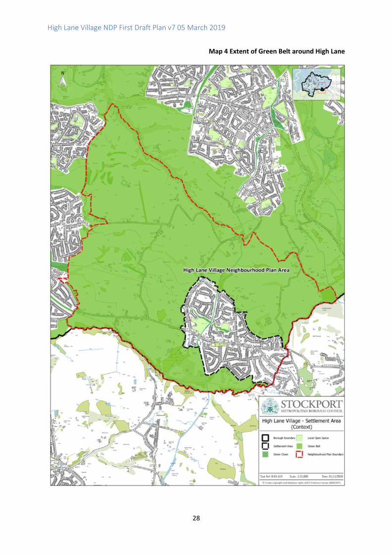
Green Belt to the north, west and south. The extent of the Green Belt is shown on Map 4.
5.7 NPPF paragraph 143 sets out that "Inappropriate development is, by definition, harmful to the
Green Belt and should not be approved except in very special circumstances."
5.8 Stockport Core Strategy Core Policy CS4 Distribution of Housing sets out that "the focus is on
making effective use of land within accessible urban areas. The priority for development is
therefore previously developed land within urban areas." Urban Greenfield and Green Belt
development should accord with a sequential approach set out within the policy. It was
proposed in Policy CS4 that a Site Allocations DPD should be prepared but this has not been
progressed and there are no site allocations identified in the Green Belt for High Lane
5.9 Therefore in order to be in general conformity with national and strategic planning policies new
housing development in High Lane would be restricted to infill and brownfield sites within the
existing built up area.
High Lane Village NDP First Draft Plan v7 05 March 2019
28
Map 4 Extent of Green Belt around High Lane

High Lane Village NDP First Draft Plan v7 05 March 2019
29
Existing House Types and Tenure in High Lane
5.10 Existing housing in High Lane is predominantly owner-occupied family housing. Statistics from
the 2011 Census (see Nomis Local Area Report for High Lane Built-up area16) shows that 59.6%
of dwellings were detached houses or bungalows in 2011 and 30.2% were semi-detached.
Figure 2 provides a more detailed breakdown.
Figure 2 Accommodation Types in High Lane
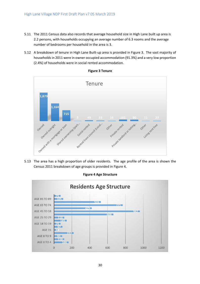
No. %
All household spaces 2,122 100.0
Household spaces with at least one usual resident 2,057 96.9
Household spaces with no usual residents 65 3.1
Whole house or bungalow: Detached 1,264 59.6
Whole house or bungalow: Semi-detached 640 30.2
Whole house or bungalow: Terraced (including end-terrace) 123 5.8
Flat, maisonette or apartment: Purpose-built block of flats or tenement 61 2.9
Flat, maisonette or apartment: Part of a converted or shared house (including bed-sits) 7 0.3
Flat, maisonette or apartment: In a commercial building 24 1.1
Caravan or other mobile or temporary structure 3 0.1
16 https://www.nomisweb.co.uk/reports/localarea
High Lane Village NDP First Draft Plan v7 05 March 2019
30
5.11 The 2011 Census data also records that average household size in High Lane built up area is
2.2 persons, with households occupying an average number of 6.3 rooms and the average
number of bedrooms per household in the area is 3.
5.12 A breakdown of tenure in High Lane Built-up area is provided in Figure 3. The vast majority of
households in 2011 were in owner occupied accommodation (91.3%) and a very low proportion
(2.4%) of households were in social rented accommodation.
Figure 3 Tenure
5.13 The area has a high proportion of older residents. The age profile of the area is shown the
Census 2011 breakdown of age groups is provided in Figure 4.
Figure 4 Age Structure
High Lane Village NDP First Draft Plan v7 05 March 2019
31
Informal Consultation Responses: Planning for New Housing in High Lane Village
5.14 The HLVNDP provides an opportunity for local people and stakeholders to influence the types,
sizes and tenure of new houses to be built in High Lane Village over the plan period. The results
of public consultations undertaken by the HLVNF for the NDP could be used to inform a planning
policy for housing in the village.
5.15 High Lane Village Neighbourhood Forum (HLVNF) has undertaken significant informal
community engagement and consultation to better understand the needs of the current
population and to help ensure any small-scale new development that comes forward is
appropriate in terms of house type, size and tenure.
5.16 Feedback from the Open Day in May 2017 provided an insight into the types of homes that the
current residents feel should be built: not four-bedroom executive homes, but affordable
homes - so local children can afford to live here - or smaller retirement homes that will allow
older residents to down-size without moving from the area they love to live in.
5.17 The High Lane Neighbourhood Forum Face book (FB) page was created on January 26th 2018.
In a survey on Facebook in which 129 people voted (on 15th February 2018) 77 of them stated
the Forum should focus on the issue of where to build houses rather than what kind of houses
to build.
5.18 A second question invited people to suggest places where 10 or fewer houses could be built. A
range of places were suggested. In another survey affordable homes came out as people’s
favoured choice for development followed by family homes.
5.19 Following on from this initial survey the housing group then asked a number of more detailed
questions using a survey tool (survey monkey). Further information about the questions and
responses is provided in Appendix 6.
5.20 In the consultation on Issues and Options the question was asked "What types of new build
housing do you think High Lane village needs?" 89% of High Lane residents (226) responded to
this and of these 87% (196) wished to see affordable homes built in High Lane. The lowest
response was 22% (49) for market housing (defined by the committee as Executive Detached,
et al,). Affordable to rent homes came second with 45% (101) of the 226 supporting this type
of tenure. There was some qualitative comment that social housing is not desirable, though the
committee feel the inclusion of registered housing providers in future conversations should be
considered as shared ownership had 55 (24%) respondents. Any such developments should also
provide for the ability to rent. A significant proportion of respondents also suggested that no
new homes should be built in the area (10% or 23) and 13% or 29 did not answer the question
at all.
5.21 A further question at Issues and Options stage asked respondents to rank the type and sizes of
houses required in High Lane. Figure 5 provides the responses.
High Lane Village NDP First Draft Plan v7 05 March 2019
32
Figure 5 House Types and Sizes, Issues and Options Consultation, 2018
Type of Houses Total Position
A Starter homes (1-2 bedrooms) 352 1st
B Small family (2-3 bedrooms) 371 2nd
C Larger Executive (4+ bedrooms) 747 6th
D Sheltered / retirement home 498 3rD
E Apartments 593 4th
F Terraced 619 5th
5.22 Starter homes and small family homes were clearly the most popular choices, followed by
housing for older people (sheltered / retirement homes). Large family housing, apartments and
terraced housing were less favoured.
5.23 In the Issues and Options consultation a further question was asked about the scale of
development proposals. The overwhelming response was for any development to have ten or
fewer dwellings, with 43% of respondents (89) supporting this proposal, and 38% (78)
supporting schemes of 11 to 20 units.
5.24 The public consultations, including the Issues and Options consultation, asked local residents to
suggest suitable areas where new housing schemes may be appropriate within the built up area
of the Village. Both the Middlewood and Scotch Produce Centre sites which were put forward
as suggestions for housing sites are located in the Green Belt. Therefore following
consideration of the existing settlement boundary around the Village and constraints of Green
Belt the HLVNF Management Committee has taken the view that the NDP should not include
site allocations in the Green Belt. In addition, the HLVNF proposes that the NDP should not
allocate sites within the existing built up area due to the limited opportunities within the
settlement boundary. The planning policies set out in the NDP, alongside national, Greater
Manchester and Stockport level planning policies should be sufficient to provide a positive
planning framework to guide development in the High lane area over the plan period.
Stockport Housing Needs Assessment, 201517
5.25 Stockport Housing Needs Assessment 2015 (HNA) provides the latest published technical
evidence and will be used to help to shape the future planning and housing policies of the
Stockport area. The study will inform the Council’s emerging new Local Plan and Housing
Strategy. The research provides an up-to-date analysis of the social, economic, housing and
demographic situation across the area.
5.26 Table ES1 Net annual affordable housing imbalance by township, property size and designation
2014/15 to 2018/19 (p11) shows that for the sub-area of Woodley (East), Greave, Romiley,
17 https://s3-eu-west-1.amazonaws.com/live-iag-static-assets/pdf/LDF/Evidence/Housing_needs_assessment_2015.pdf

High Lane Village NDP First Draft Plan v7 05 March 2019
33
Marple, High Lane, Mellor, Torkington and Offerton (East) there is a need for 18 1/2 bed and 79
3+bed general needs affordable housing and 16 1/2 bed older person homes - a total of 113
homes.
5.27 The HNA goes on to set out stakeholders' views about the types of housing needed in Stockport.
Paragraph 4.46 sets out that "the general view was that a broad range of new housing is
required in Stockport to meet a spectrum of needs and demands including:
• Family homes offering between 2 and 5 bedrooms;
• Older persons housing; and
• Affordable homes for first time buyers and those looking to downsize."
Paragraph 5.12 notes that "overall, building properties designed for older people was identified
by stakeholders as the highest priority by 85.7% of respondents."
5.28 Table 5.6 (reproduced below as NDP Figure 6) sets out the current open market dwelling stock
in Stockport and preferences.
Figure 6 Stockport HNA 2015, Open Market Dwelling Stock and Preferences
5.29 Paragraph 5.18 of the HNA advises that "this analysis would suggest that on the basis of
household aspirations (likes), demand for the delivery of three and four-plus bedroom detached
houses is highest. There is a desire for three bedroom semi-detached houses, but a much greater
stock of this type of dwelling. By contrast, the aspiration for bungalows is much greater than the
current stock. Development more reflective of household expectation would result in an
increased emphasis on developing larger detached family houses along with smaller
bungalows."
Affordable Housing
5.30 It should be noted that affordable housing has a specific meaning in planning and is defined in
the NPPF Glossary. The definition is reproduced in Appendix 5. Affordable housing does not
mean smaller homes for sale on the private housing market.
5.31 Affordable housing can only be required on market housing schemes of 11 or more units which
have a maximum combined gross floorspace of no more than 1,000 square metres (gross
High Lane Village NDP First Draft Plan v7 05 March 2019
34
internal area)18. In some other limited circumstances, affordable housing may be provided, for
example as exceptions to Green Belt (see NPPF paragraph 145 f) or as rural exception sites
(NPPF paragraph 77) where there is a proven local need.
5.32 Stockport Core Strategy Core Policy CS3 Mix of Housing sets out that "the overall strategic
affordable housing target is 50% of total provision" and that this will be achieved with the
assistance of Stockport Homes and developments by other affordable housing providers
delivering up to 100% affordable housing; by maximising various opportunities.
5.33 The Management Committee supports the principle of a local connections policy which would
set out a hierarchy for allocating affordable housing, with local residents having priority. This
would be a housing allocations policy rather than a planning policy however and would depend
upon negotiations with Stockport Council and Housing Providers. Such a policy could set out
for instance that "In the first instance, affordable housing should be targeted for a period of 6
months to occupiers with a local connection. Such occupiers should be resident in High Lane
neighbourhood area for 3 out of the 5 previous years at the time of the application or have close
family such as partners, parents, siblings, grown up children, or grandparents who have been
resident for a continuous period of 3 years at the time of the application."
5.34 The HLVNDP aims to support a broader mix of housing in the area to address the issues raised
through the informal public consultations. Draft Policy H1 has been prepared to provide a
supportive and positive planning framework to help ensure new development proposals are of
a suitable scale and support a broader mix of new housing in the built up area of High Lane,
including provision of affordable housing wherever possible. The HLVNF supports GMSF Policy
GM-H 2 Affordability of New Housing and affordable housing in High Lane should be delivered
proportionately within each stage of the master plan.
5.35 Stockport Core Strategy Policy CS3 Mix of Housing sets out that " A mix of housing, in terms of
tenure, price, type and size will be provided to meet the requirements of new forming
households, first time buyers, families with children, disabled people and older people. New
development should contribute to the creation of more mixed, balanced communities by
providing affordable housing in areas with high property prices and by increasing owner
occupation in areas of predominantly social rented housing."
Draft Policy H1 Housing Scale and Mix Proposals for new housing development will be supported within the existing built up area of High Lane Village where schemes are for small to medium scale housing developments of up to 9 units or comprise major schemes of 10 to around 20 units19. Schemes for 11 or more units will be supported where a suitable proportion of affordable housing is provided subject to viability as part of the development scheme.
18 See Planning Practice Guidance Planning obligations https://www.gov.uk/guidance/planning-obligations Paragraph: 031 Reference ID: 23b-031-20161116 19 See NPPF definition of Major Development: For housing, development where 10 or more homes will be provided, or the site has an area of 0.5 hectares or more. For non-residential development it means additional floorspace of 1,000m2 or more, or a site of 1 hectare or more, or as otherwise provided in the Town and Country Planning (Development Management Procedure) (England) Order 2015
High Lane Village NDP First Draft Plan v7 05 March 2019
35
New development proposals should contribute to a suitable and sustainable mix of house types and sizes in High Lane in line with the most up to date assessments of local housing need. Wherever possible new housing schemes should include one or more of the following house types and sizes:
1. Smaller units of 1 to 3 bedrooms suitable for young families and starter homes for first time buyers;
2. Housing suitable for older people including smaller single storey housing or supported accommodation;
3. Affordable housing, where priority is given to occupiers with a local connection20.
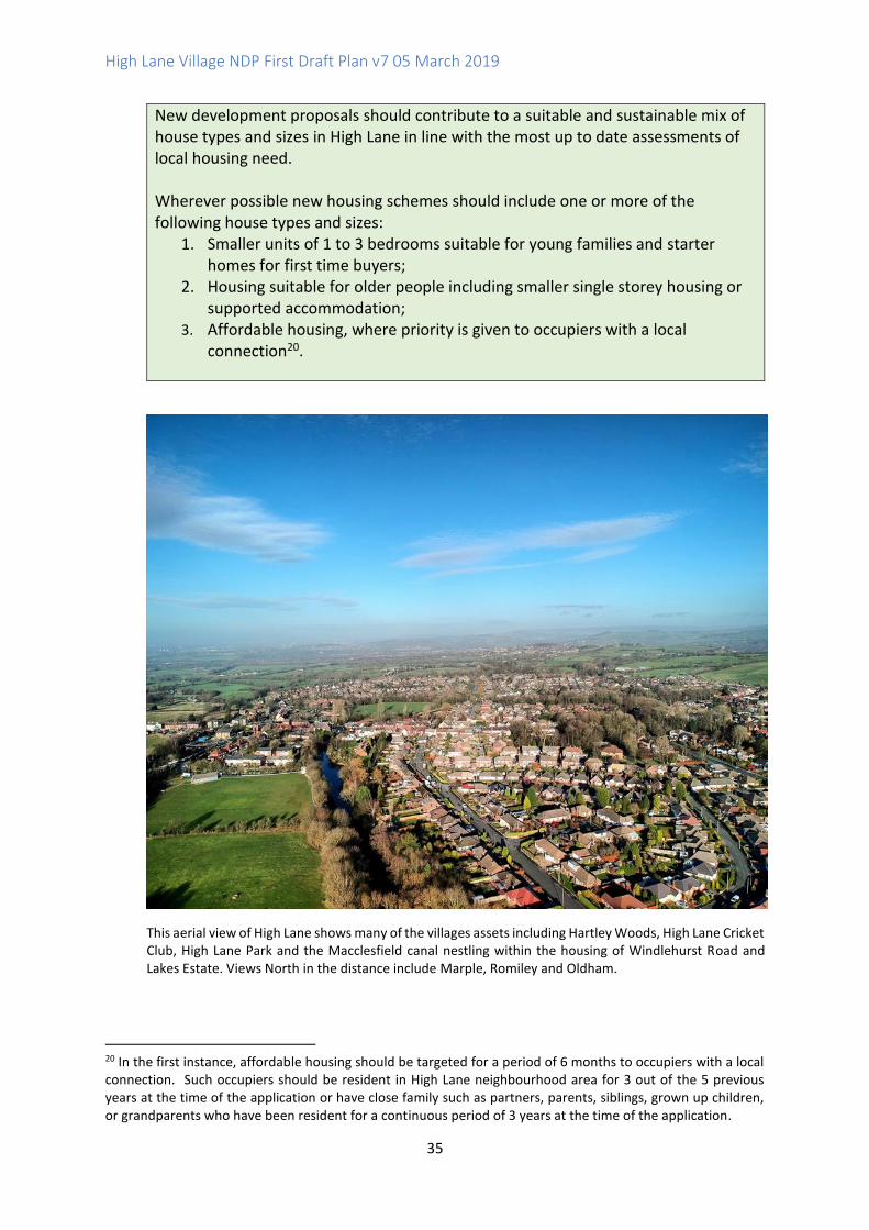
This aerial view of High Lane shows many of the villages assets including Hartley Woods, High Lane Cricket Club, High Lane Park and the Macclesfield canal nestling within the housing of Windlehurst Road and Lakes Estate. Views North in the distance include Marple, Romiley and Oldham.
20 In the first instance, affordable housing should be targeted for a period of 6 months to occupiers with a local connection. Such occupiers should be resident in High Lane neighbourhood area for 3 out of the 5 previous years at the time of the application or have close family such as partners, parents, siblings, grown up children, or grandparents who have been resident for a continuous period of 3 years at the time of the application.
High Lane Village NDP First Draft Plan v7 05 March 2019
36
6.0 Green Open Spaces, Recreational Activities and Natural Heritage
Introduction and Background
6.1 High Lane sits within the Green Belt and is surrounded by countryside linking to the National
Trust property of Lyme Park. There are many opportunities for the community to participate
in outdoor activity pursuits and to utilise the area's range of recreational facilities. The Forum
has a commitment and passion to enhance and protect the neighbourhood of High Lane,
including its village status, green open spaces and recreational facilities.
6.2 NPPF paragraph 91 sets out that "planning policies and decisions should aim to achieve
healthy, inclusive and safe places which: … c) enable and support healthy lifestyles,
especially where this would address identified local health and well -being needs – for
example through the provision of safe and accessible green infrastructure, sports
facilities, local shops, access to healthier food, allotments and layouts that encourage
walking and cycling."
6.3 The HLVNF recognises that there is a need to promote all off road forms of recreational activity
available in the area and to support existing recreational and sports related venues. The NDP
has an important role in enabling health and wellbeing by supporting safe access to
recreational activities and green open spaces, for all age groups and abilities. The openness of
the Green Belt affords the opportunity for outdoor sport and recreational pursuits and is
utilised and highly valued by the community.
6.4 Map 5 identifies several areas of Local Open Space which are given general protection
in Core Strategy Core Policy CS8 Safeguarding and Improving the Environment. Green
Chains are also identified which are protected under UDP Policy NE3.1, a saved policy
carried over into the Development Plan and supported by Core Strategy Policy CS8.
High Lane Village NDP First Draft Plan v7 05 March 2019
37
Map 5 Green Spaces
High Lane Village NDP First Draft Plan v7 05 March 2019
38
Windlehurst Park
6.5 Identified local open spaces and community assets in the HLVNDP area include the following:
• Local parks of which there are three: High Lane Park, Brookside Park and Windlehurst
Park. All three are listed as community assets and have established Friends of the
Parks groups. The Neighbourhood Forum supports initiatives to improve all three
local parks in High Lane and to work with the Friends of the Parks groups. Following
community surveys undertaken in 2018 by HLVNF both High Lane Park and Brookside
Park were listed by the Forum as community assets in March 2018.
Brookside Park High Lane Park

High Lane Village NDP First Draft Plan v7 05 March 2019
39
• Community assets within open spaces and adjacent to the village and woodlands.
High Lane Allotments was awarded Community Asset status in September 2018. It
has 44 plots and lies within green open space adjacent to High Lane Park. A well-
used, valued commodity it affords the community of High Lane the opportunity to
undertake outdoor recreational activity.
• Walking and cycling off road routes, bridleways and trails, and their access, including
the Macclesfield Canal and towpath and Middlewood Way. Issues related to clear
signage for all and indication of inclusiveness for disabled use is also being explored.
6.6 The Village does not have a recreation centre, but recreational and sporting activities use
various venues and facilities in the area such as sports clubs, primary schools, local churches,
the Village Hall and High Lane Scouts. The Junior Football Club trains in the summer on High
Lane Park and then at Disley Amalgamated when it gets darker due to there being no floodlights
in High Lane.
6.7 The Village Hall is located within High Lane Park and is utilised by many independent clubs for
various forms of non-sporting recreational activities. It is used predominantly by mother and
baby group and for activities for those over fifty. It has the capacity to accept more groups. Car
parking there however is an issue when several groups are in attendance.
Informal Consultations and Sports and Recreational Activity
6.8 Comments received at the open meeting in May 2017 indicated concerns about the lack of
recreational activities for young people in High Lane.
6.9 Responses from an online survey of adults conducted over a 7 day period in February 2018
showed that people value the local Green Belt and open spaces as assets but would like further
improvements relating to maintenance and signage in particular.
6.10 The Working Group has led on several consultations to which there have been good responses.
Both primary schools have responded to questionnaires in February 2018 about their usage of
local parks and their use of local green spaces. These responses showed that the parks are highly
valued but young people would like to see improvements in them particularly relating to
drainage, additional playground equipment and facilities. The opinions of those aged 11 to 18
years were sought utilising questionnaires involving High School peer mentors and the local
scout group in March 2018.
6.11 In February 2018 the Working Group collated data from sporting clubs in the area and the
local venues that support recreational activities. The findings from this data showed that
there are limited local opportunities for young people aged 11 to 18 years of age. From the
data collected from the younger population of High Lane a high percentage expressed a
wish for an improved provision of playing pitches on both Brookside and High L ane Parks.
Further detailed information about the consultation process and results can be found in
Appendix 7.
6.12 The responses from the younger generation demonstrated support for both local parks as
highly used community assets as well as retention of the countryside surrounding High Lane
for family activities such as cycling and walking. Issues were raised concerning the need to
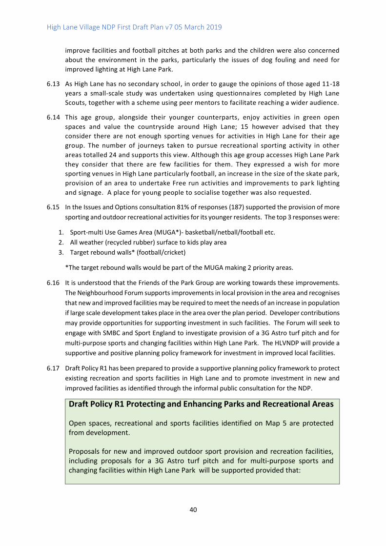
High Lane Village NDP First Draft Plan v7 05 March 2019
40
improve facilities and football pitches at both parks and the children were also concerned
about the environment in the parks, particularly the issues of dog fouling and need for
improved lighting at High Lane Park.
6.13 As High Lane has no secondary school, in order to gauge the opinions of those aged 11-18
years a small-scale study was undertaken using questionnaires completed by High Lane
Scouts, together with a scheme using peer mentors to facilitate reaching a wider audience.
6.14 This age group, alongside their younger counterparts, enjoy activities in green open
spaces and value the countryside around High Lane; 15 however advised that they
consider there are not enough sporting venues for activities in High Lane for their age
group. The number of journeys taken to pursue recreational sporting activity in other
areas totalled 24 and supports this view. Although this age group accesses High Lane Park
they consider that there are few facilities for them. They expressed a wish for more
sporting venues in High Lane particularly football, an increase in the size of the skate park,
provision of an area to undertake Free run activities and improvements to park lighting
and signage. A place for young people to socialise together was also requested.
6.15 In the Issues and Options consultation 81% of responses (187) supported the provision of more
sporting and outdoor recreational activities for its younger residents. The top 3 responses were:
1. Sport-multi Use Games Area (MUGA*)- basketball/netball/football etc.
2. All weather (recycled rubber) surface to kids play area
3. Target rebound walls* (football/cricket)
*The target rebound walls would be part of the MUGA making 2 priority areas.
6.16 It is understood that the Friends of the Park Group are working towards these improvements.
The Neighbourhood Forum supports improvements in local provision in the area and recognises
that new and improved facilities may be required to meet the needs of an increase in population
if large scale development takes place in the area over the plan period. Developer contributions
may provide opportunities for supporting investment in such facilities. The Forum will seek to
engage with SMBC and Sport England to investigate provision of a 3G Astro turf pitch and for
multi-purpose sports and changing facilities within High Lane Park. The HLVNDP will provide a
supportive and positive planning policy framework for investment in improved local facilities.
6.17 Draft Policy R1 has been prepared to provide a supportive planning policy framework to protect
existing recreation and sports facilities in High Lane and to promote investment in new and
improved facilities as identified through the informal public consultation for the NDP.
Draft Policy R1 Protecting and Enhancing Parks and Recreational Areas
Open spaces, recreational and sports facilities identified on Map 5 are protected from development. Proposals for new and improved outdoor sport provision and recreation facilities, including proposals for a 3G Astro turf pitch and for multi-purpose sports and changing facilities within High Lane Park will be supported provided that:
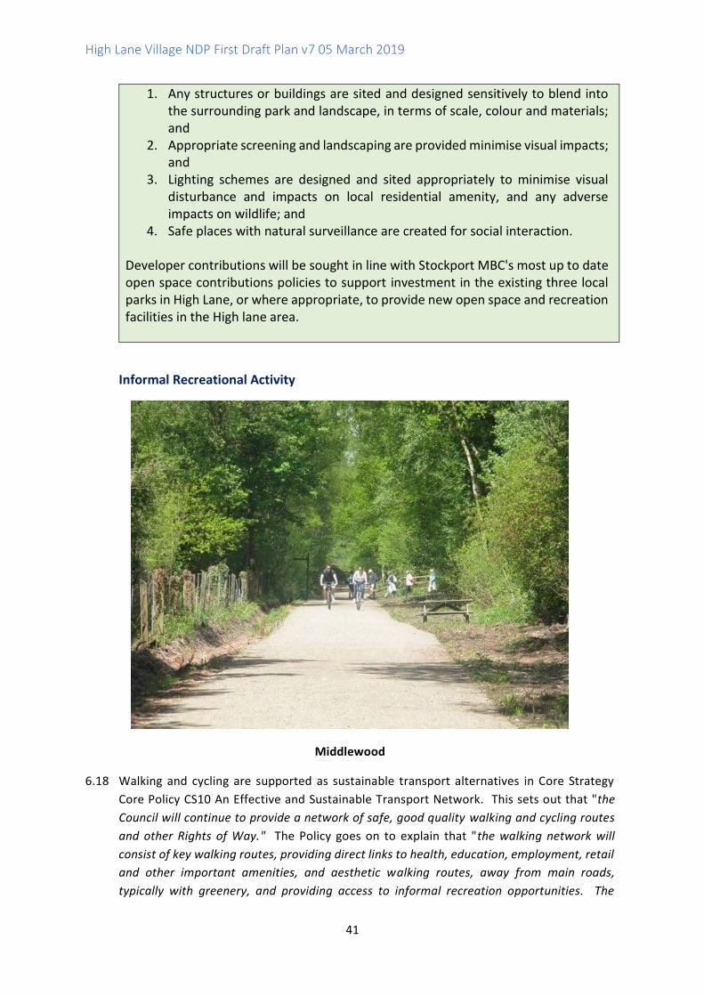
High Lane Village NDP First Draft Plan v7 05 March 2019
41
1. Any structures or buildings are sited and designed sensitively to blend into the surrounding park and landscape, in terms of scale, colour and materials; and
2. Appropriate screening and landscaping are provided minimise visual impacts; and
3. Lighting schemes are designed and sited appropriately to minimise visual disturbance and impacts on local residential amenity, and any adverse impacts on wildlife; and
4. Safe places with natural surveillance are created for social interaction. Developer contributions will be sought in line with Stockport MBC's most up to date open space contributions policies to support investment in the existing three local parks in High Lane, or where appropriate, to provide new open space and recreation facilities in the High lane area.
Informal Recreational Activity
Middlewood
6.18 Walking and cycling are supported as sustainable transport alternatives in Core Strategy
Core Policy CS10 An Effective and Sustainable Transport Network. This sets out that "the
Council will continue to provide a network of safe, good quality walking and cycling routes
and other Rights of Way." The Policy goes on to explain that "the walking network will
consist of key walking routes, providing direct links to health, education, employment, retail
and other important amenities, and aesthetic walking routes, away from main roads,
typically with greenery, and providing access to informal recreation opportunities. The
High Lane Village NDP First Draft Plan v7 05 March 2019
42
Borough's walking network will also include long distance routes (e.g. Midshires Way). The
cycling network will cater for direct cycling routes (which in some cases may be on busier
roads) and also for routes on quieter residential roads and off-road links (e.g. the Halls
Route), which are required not only for recreational cycling, but also utility cycling trips for
less confident cyclists."
6.19 Stockport MBC has recently published a Cycling and Walking Plan21 for public consultation.
This includes a long term vision for cycling and walking in Stockport, and provides an
overarching framework and evidence base to set out:
• The value of cycling and walking in delivering wider policies and strategies.
• The current context of cycling and walking in Stockport, including opportunities and
challenges.
• Future opportunities to encourage more cycling and walking.
• A targeted action plan to direct delivery of the above.
Informal Consultation Responses
6.20 The Working Group undertook a ten question Facebook survey aimed at adults, to explore
how the community participate locally in terms of the type and frequency of recreational
activity, and in other areas (incorporating travel mode and time to activity).
6.21 Results indicated many enjoy walking and cycling and value all open countryside and the
greenbelt as assets, recognising their importance in terms of health and well-being as well
as their contribution to the character of High Lane Village. The openness of the Green Belt
and the views it afforded to residents are significant to the rural identity of the village.
Woods at Middlewood Way
6.22 There were suggestions that that more could be undertaken to promote the network of
footpaths, trails and green corridors as links for alternative traffic free routes to areas.
21 https://consultation.stockport.gov.uk/policy-performance-and-reform/stockport-cycling-and-walking-plan/

High Lane Village NDP First Draft Plan v7 05 March 2019
43
Issues were raised re dog fouling and accessing local green spaces. Of concern were boggy
and poorly maintained walking routes, access to/signage of off road paths, particularly
Middlewood Way and the Macclesfield Canal as well as maintaining habitats for wildlife and
the environment.
6.23 In November 2017 the SMBC 2007 Rights of Way Improvement Plan was reviewed by Marple
Area Committee and their decision was to support the continuation of the plan adopted in
the initial document. This plan sought to improve off road access for all , improved signage
to pathways and the provision of bridleways. In the ten years since this plan was adopted
High Lane has seen very little evidence of any of these initiatives in the area despite it having
an extensive network of off road footpaths, long distance walking and cycling routes and a
high proportion of equestrian pursuits. Data collected in our surveys from all age groups
supports the community concerns regarding these routes and access to them.
6.24 Long distance walking and cycling routes within the area include the Middlewood Way,
Cheshire Ring Canal Walk and Ladybrook Valley Interest Trail and are enjoyed by all ages
of the local population and attracting tourists. Walking and cycling in High Lane are
predominantly undertaken as off-road recreational activities and accessed through multi-
purpose routes. They are therefore addressed in this section of the NDP rather than the
Transport section (4.0).
6.25 Macclesfield Canal is a wetland canal corridor used by walkers and cyclists with rich wildlife
interest. Issues with the footpaths and their lack of maintenance are a long-standing
problem for High Lane residents. Volunteers through The Residents Association are
currently involved working with the Canal and Rivers Trust in restoring small lengths of the
footpath. However more needs to be done to maintain user safety. The residents that
volunteered to improve the tow path with slate dust have now adopted this stretch of the
tow path and plan to maintain it monthly.
6.26 Respondents to our survey advised that the canal wall is subsiding at various points through
High Lane. There is an entry point off a path in High Lane park which provides disabled
access onto the canal tow path , although there is no signposting anywhere to indicate this
access. The entry point is suitable for wheelchair users and mobility scooters as there are
no steps but since there is no handrail it is not suitable for pedestrians who cannot manage
steps and have mobility issues. Routes onto the canal via the A6 or within High Lane Park
are unsuitable for the disabled as steps are present. All are poorly sign posted.
6.27 The Middlewood Way is a green corridor forming part of Route 55 of the National Cycle
Network. A multi-user route it is shared by walkers, pedestrians, horses and their riders.
Issues regarding the surface of this route have recently been addressed following a long
campaign by The Save Middlewood Way support group. Access to the Middlewood Way
for the disabled and wheelchair users is via Middlewood Road. There is no signage to
indicate disabled access here. Following rainfall this route becomes very muddy and
unpassable.
High Lane Village NDP First Draft Plan v7 05 March 2019
44
6.28 Issues raised in our surveys by those respondents who use this route are provided in
Appendices 6 and 7 and include concerns about conflict between walkers and cyclists, poor
accessibility and signage.
6.29 The Ladybrook Valley Trail offers off road access for cyclists and horse riders to pursue a
route which extends from Coppice Lane in Disley passing through Middlewood and on
towards to Bramhall and Cheadle, Stockport. The route links to many areas of Stockport
and facilitates access to the A6 MARR cycle route. The terrain in parts requires attention.
With council investment this cycle route could provide an alternative to on road cycling.
6.30 South East Area Bridleways Association advised that there are safety issues for both horses
and their riders who have to ride on busy public roads as a result of the loss of bridleways
in the area. A lack of access onto the Middlewood Way (a recognised bridleway) from
Windlehurst Road is causing significant problems as cars speed on this route. There are
194 members who access the Middlewood Way. The society advised that many farmers in
the area are turning to equestrian and livery for income, generating millions in revenue for
the area. They are asking for the support of the forum for inclusion into our NDP for the
re-instatement and establishment of more bridleways in the area to accommodate this
growing equestrian activity.
6.31 The responses to the Issues and Options consultation showed that there was a high level of
support for the HLVNF to work with SMBC to improve accessibility/signage for all, inclusive of
those with disabilities to off road footpaths (222 (93% of respondents) said Yes to this). 201
(84% of respondents) also supported the creation of a multi-user access route from Windlehurst
Road onto the Middlewood Way. There was also support for the possible creation of new
bridleways (85% of respondents or 200 people supported this suggestion).
6.32 Map 6 shows the extent of existing walking and cycling routes in High Lane Neighbourhood
Area. Development proposals should include linkages to these routes to encourage walking
and cycling as part of more sustainable transport choices and to promote health and
wellbeing. The NDP supports improvements to existing networks and provision of new
networks to enhance and extend facilities in the area. Developer contributions and other
funding may be sought towards investment in such infrastructure.
High Lane Village NDP First Draft Plan v7 05 March 2019
45
Map 6 Walking, Cycling and Bridleway Networks
Key
----- Footpaths
___ Middlewood Way -for walking, cycling and equestrian use but permissive, not
a PROW)
____ A555 junction with shared path ----- Canal and towpath PROW
---- Bridleways __ HLVNDP Area Boundary
Draft Policy R2 Walking, Cycling and Horse Riding
The existing network of walking, cycling and horse riding routes in High Lane NDP area as shown on Map 6 is protected. Improvements to these routes are supported including the following:
High Lane Village NDP First Draft Plan v7 05 March 2019
46
1. Provision of safe and accessible surfaces which are designed to be suitable for all user groups and particularly those reliant on scooters, wheelchairs and pushchairs;
2. Replacement of stiles with accessible gates or other entrances at access points;
3. Improved signage and lighting including from main access points and at appropriate points along the routes such as at interchanges with other routes; and
4. Informal segregation of different user groups such as walkers, riders and cyclists to reduce conflict, through for example changes in surface texture or colour.
Development proposals should include linkages to footpaths, cycle routes and bridleways in order to improve connectivity between existing networks and enhance the attractiveness of walking, cycling and riding in and around the High Lane. Development proposals should ensure that existing Public Rights of Way (PROW) including footpaths, cycle routes and bridleways, which cross or adjoin their sites, are retained and improved to support walking and cycling. New and existing routes within development schemes should not be enclosed on both sides by high fences, walls or hedging which can lead to narrow, unattractive corridors with limited overlooking.
Protecting Local Landscape Character
View from footpath on Middlewood looking through woods towards
landmark bridge and Poynton
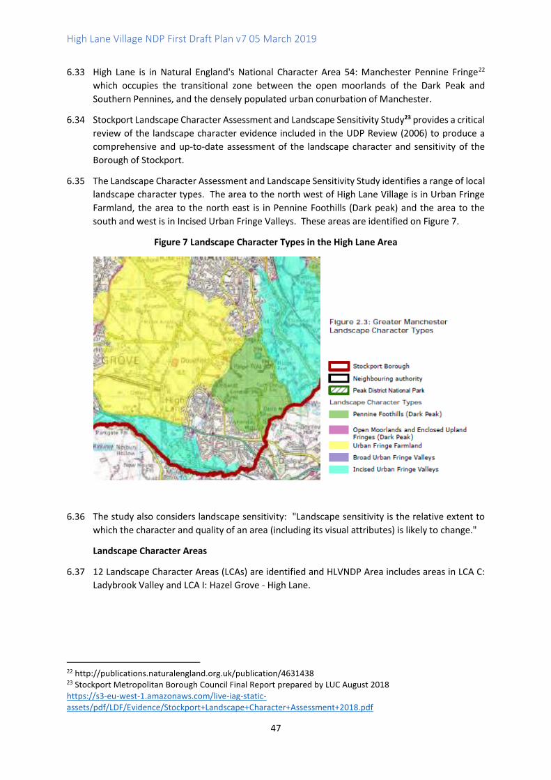
High Lane Village NDP First Draft Plan v7 05 March 2019
47
6.33 High Lane is in Natural England's National Character Area 54: Manchester Pennine Fringe22
which occupies the transitional zone between the open moorlands of the Dark Peak and
Southern Pennines, and the densely populated urban conurbation of Manchester.
6.34 Stockport Landscape Character Assessment and Landscape Sensitivity Study23 provides a critical
review of the landscape character evidence included in the UDP Review (2006) to produce a
comprehensive and up-to-date assessment of the landscape character and sensitivity of the
Borough of Stockport.
6.35 The Landscape Character Assessment and Landscape Sensitivity Study identifies a range of local
landscape character types. The area to the north west of High Lane Village is in Urban Fringe
Farmland, the area to the north east is in Pennine Foothills (Dark peak) and the area to the
south and west is in Incised Urban Fringe Valleys. These areas are identified on Figure 7.
Figure 7 Landscape Character Types in the High Lane Area
6.36 The study also considers landscape sensitivity: "Landscape sensitivity is the relative extent to
which the character and quality of an area (including its visual attributes) is likely to change."
Landscape Character Areas
6.37 12 Landscape Character Areas (LCAs) are identified and HLVNDP Area includes areas in LCA C:
Ladybrook Valley and LCA I: Hazel Grove - High Lane.
22 http://publications.naturalengland.org.uk/publication/4631438 23 Stockport Metropolitan Borough Council Final Report prepared by LUC August 2018 https://s3-eu-west-1.amazonaws.com/live-iag-static-assets/pdf/LDF/Evidence/Stockport+Landscape+Character+Assessment+2018.pdf
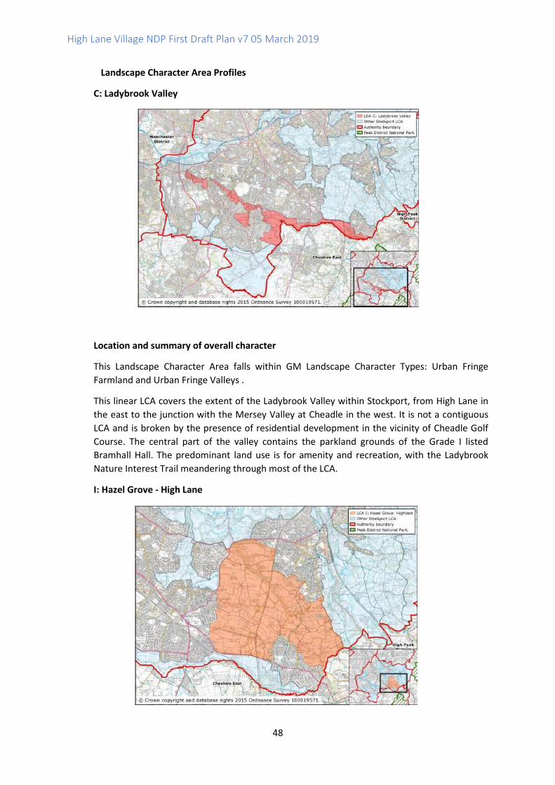
High Lane Village NDP First Draft Plan v7 05 March 2019
48
Landscape Character Area Profiles
C: Ladybrook Valley
Location and summary of overall character
This Landscape Character Area falls within GM Landscape Character Types: Urban Fringe
Farmland and Urban Fringe Valleys .
This linear LCA covers the extent of the Ladybrook Valley within Stockport, from High Lane in
the east to the junction with the Mersey Valley at Cheadle in the west. It is not a contiguous
LCA and is broken by the presence of residential development in the vicinity of Cheadle Golf
Course. The central part of the valley contains the parkland grounds of the Grade I listed
Bramhall Hall. The predominant land use is for amenity and recreation, with the Ladybrook
Nature Interest Trail meandering through most of the LCA.
I: Hazel Grove - High Lane

High Lane Village NDP First Draft Plan v7 05 March 2019
49
Location and summary of overall character
This Landscape Character Area falls within GM Landscape Character Types: Urban Fringe
Farmland and Pennine Foothills (Dark Peak)
This LCA is situated between Marple, High Lane, Hazel Grove and Offerton Green. Brooks and
streams are a consistent feature with Torkington Brook being the more prominent with an
extensive band of ancient woodland following its course. The Middlewood Way and
Macclesfield Canal (Conservation Area) form two major access routes running north-south
through the LCA. A network of other access routes and tracks provide good connectivity and
views are generally dominated by a well wooded horizon revealing the occasional farmhouse.
6.38 The guidance and opportunities in relation to future development within these Landscape
Character Area have been used to inform NDP Policy NH1.
Draft Policy NH1 Protecting Local Landscape Character in the High Lane Area
Development proposals should be designed to protect and enhance local landscape character in High Lane. Schemes should refer to the guidance set out in the Stockport Landscape Character Assessment and Landscape Sensitivity Study. Site layouts, designs and landscaping proposals address the following design principles where appropriate:
1. Avoiding built form in visually prominent locations such as on the sides of the Ladybrook Valley or in open areas;
2. Protecting and where possible restoring and re-creating important semi-natural habitats to reduce their fragmentation, including woodlands linking to an intact hedgerow network, individual oak specimens and characteristic field ponds. Ensuring the role of the valley as an important wildlife corridor in a densely developed area is retained;
3. Utilising existing woodland to screen development where appropriate; 4. Ensuring that the setting and integrity of the historic landscapes and heritage
features within the valley is respected and retained; 5. Maintaining important historical, industrial elements of the landscape such as
former railway routes, bridges and the Macclesfield Canal, as these features play a major role in local identity and sense of place;
6. Enhancing the recreational value along these industrial transportation routes through promotional encouragement, heritage and wildlife information provision;
7. Designing-in the introduction of SuDS to any new development, addressing any changes in hydrology and flood risk (and subsequent knock-on effects such as increased diffuse pollution from agricultural run-off and new development);
8. Protecting and promoting the important views out of the valley into Cheshire East (including the Peak Fringe Local Landscape Designation Area and the Grade II* Registered Lyme Park) and glimpses of the Peak District National Park; and
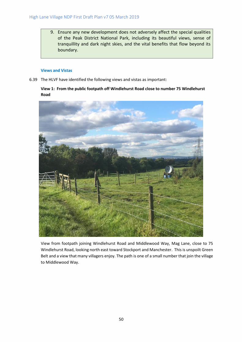
High Lane Village NDP First Draft Plan v7 05 March 2019
50
9. Ensure any new development does not adversely affect the special qualities of the Peak District National Park, including its beautiful views, sense of tranquillity and dark night skies, and the vital benefits that flow beyond its boundary.
Views and Vistas
6.39 The HLVF have identified the following views and vistas as important:
View 1: From the public footpath off Windlehurst Road close to number 75 Windlehurst
Road
View from footpath joining Windlehurst Road and Middlewood Way, Mag Lane, close to 75
Windlehurst Road, looking north east toward Stockport and Manchester. This is unspoilt Green
Belt and a view that many villagers enjoy. The path is one of a small number that join the village
to Middlewood Way.

High Lane Village NDP First Draft Plan v7 05 March 2019
51
View 2: From car park at Brookside Park, looking south towards Lyme Park with The Cage in
the centre and wider views of the Peak District National Park.
High Lane sits within the Pennine Fringe and backs onto the National Trust property of Lyme
Park. This photo shows the view from Fletcher Drive, High Lane looking South towards Lyme
Park with The Cage nestling on the hill stretching to Kettleshulme and Pott Shrigley beyond.
The many footpaths in this area are frequently used by residents and visitors for several
recreational purposes including walking, running, cycling and dog walking.
This view is enjoyed by many people including the children playing at Brookside Park, local
walkers who pass here to enjoy the park or enter Lyme Park by the access point further on and
the children, staff and parents at Brookside Primary school which is 100 yards away . The view
enables local people to feel a connection with the wilder countryside some distance away. The
view is an inclusive one because the car park is easily accessible for people in wheelchairs or
with limited mobility and for parents/carers with children in buggies.
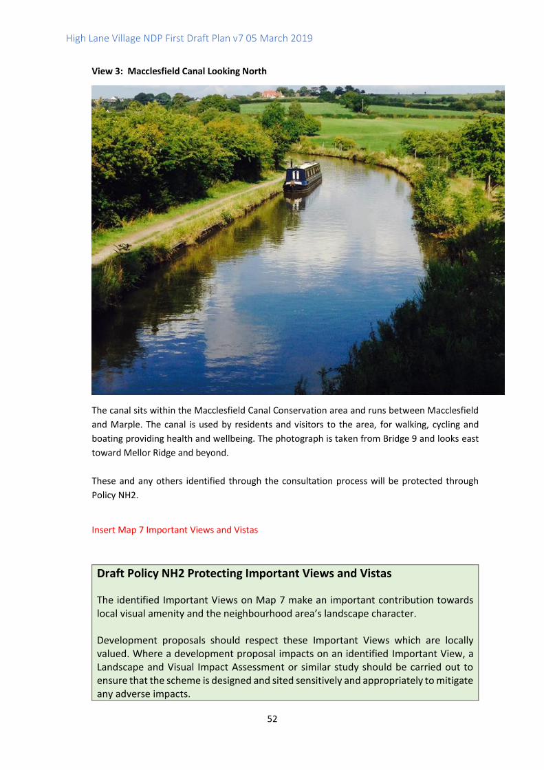
High Lane Village NDP First Draft Plan v7 05 March 2019
52
View 3: Macclesfield Canal Looking North
The canal sits within the Macclesfield Canal Conservation area and runs between Macclesfield
and Marple. The canal is used by residents and visitors to the area, for walking, cycling and
boating providing health and wellbeing. The photograph is taken from Bridge 9 and looks east
toward Mellor Ridge and beyond.
These and any others identified through the consultation process will be protected through
Policy NH2.
Insert Map 7 Important Views and Vistas
Draft Policy NH2 Protecting Important Views and Vistas
The identified Important Views on Map 7 make an important contribution towards local visual amenity and the neighbourhood area’s landscape character. Development proposals should respect these Important Views which are locally valued. Where a development proposal impacts on an identified Important View, a Landscape and Visual Impact Assessment or similar study should be carried out to ensure that the scheme is designed and sited sensitively and appropriately to mitigate any adverse impacts.
High Lane Village NDP First Draft Plan v7 05 March 2019
53
Wildlife
6.40 High Lane Neighbourhood Area includes a number of areas of wildlife value. Ancient and
Semi Natural Woodland can be found around Torkington Brook, Middlewood, Hartley
Woods and Marple Woods (see Appendix 8). Other areas of woodland are also to be
found across the neighbourhood. These areas along with the many brooks which run
through High Lane (Bollin Brook, Ladybrook, Daisy Brook and Ochreley Brook) provide
important natural wildlife habitats.
6.41 Appendix 8 also includes maps showing the presence of key species kindly provided by
Greater Manchester Ecological Unit. The Unit have advised that the presence of great
crested newts in the west is of some significance and there are records of Polecats which
are very unusual in Greater Manchester. There are also records of badgers.
6.42 Sites of Biological Interest (SBIs) are shown on Map 8.
Draft Policy NH3 Protecting and Enhancing Local Wildlife
The priority for new development should be to avoid direct and indirect impacts upon biodiversity and/or geodiversity. Where impacts cannot be avoided, mitigation and then compensation measures should be provided. Development proposals should demonstrate how biodiversity will be protected and enhanced including the local wildlife, ecological networks, non-statutory locally designated wildlife sites and habitats, and how schemes contribute to biodiversity net gain. Landscaping schemes should include wildlife enhancements wherever possible, for example incorporating ponds, and retaining existing, and planting new areas of trees, woodlands and hedgerows using locally appropriate native species. Rivers and the lines of water courses should be protected and water courses managed sustainably to protect water quality and flow rates. The use of permeable surfaces to reduce run off is encouraged. Any building demolitions or conversions should be supported by bat surveys and barn owl surveys. Development should take into consideration the need to protect existing wildlife which may be using the building(s) as habitats. Buildings should incorporate bird nest boxes (including for swifts) and roosting opportunities for bats (such as bat roosting boxes) wherever possible. Lighting schemes should be designed sensitively to reduce any adverse impacts on wildlife.
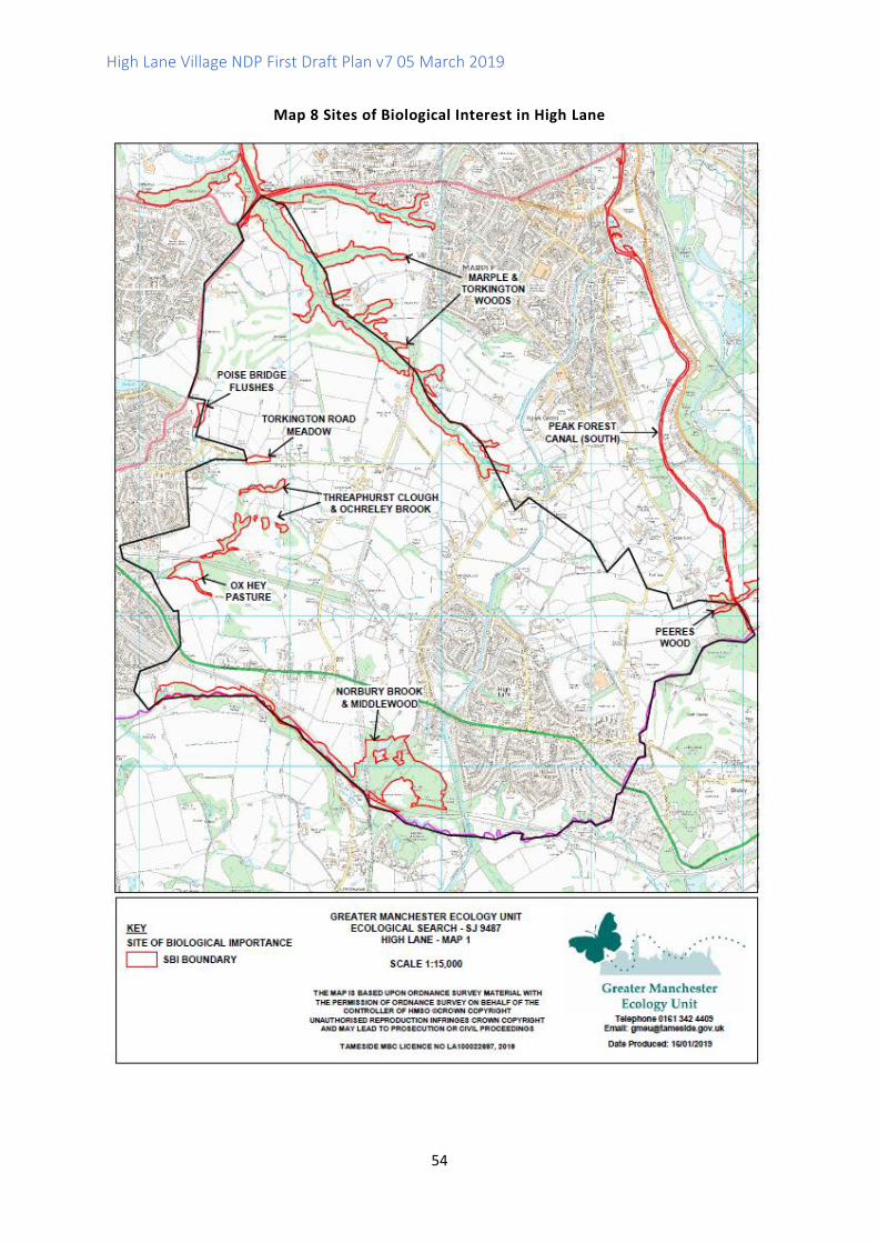
High Lane Village NDP First Draft Plan v7 05 March 2019
54
Map 8 Sites of Biological Interest in High Lane
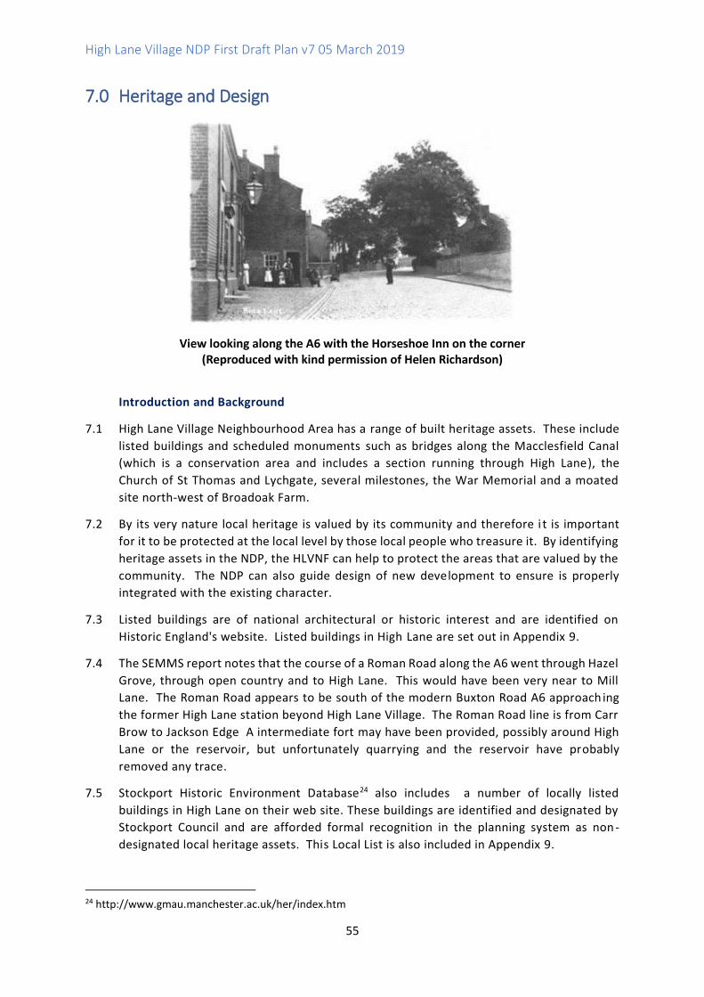
High Lane Village NDP First Draft Plan v7 05 March 2019
55
7.0 Heritage and Design
View looking along the A6 with the Horseshoe Inn on the corner (Reproduced with kind permission of Helen Richardson)
Introduction and Background
7.1 High Lane Village Neighbourhood Area has a range of built heritage assets. These include
listed buildings and scheduled monuments such as bridges along the Macclesfield Canal
(which is a conservation area and includes a section running through High Lane), the
Church of St Thomas and Lychgate, several milestones, the War Memorial and a moated
site north-west of Broadoak Farm.
7.2 By its very nature local heritage is valued by its community and therefore i t is important
for it to be protected at the local level by those local people who treasure it. By identifying
heritage assets in the NDP, the HLVNF can help to protect the areas that are valued by the
community. The NDP can also guide design of new development to ensure is properly
integrated with the existing character.
7.3 Listed buildings are of national architectural or historic interest and are identified on
Historic England's website. Listed buildings in High Lane are set out in Appendix 9.
7.4 The SEMMS report notes that the course of a Roman Road along the A6 went through Hazel
Grove, through open country and to High Lane. This would have been very near to Mill
Lane. The Roman Road appears to be south of the modern Buxton Road A6 approach ing
the former High Lane station beyond High Lane Village. The Roman Road line is from Carr
Brow to Jackson Edge A intermediate fort may have been provided, possibly around High
Lane or the reservoir, but unfortunately quarrying and the reservoir have probably
removed any trace.
7.5 Stockport Historic Environment Database24 also includes a number of locally listed
buildings in High Lane on their web site. These buildings are identified and designated by
Stockport Council and are afforded formal recognition in the planning system as non -
designated local heritage assets. This Local List is also included in Appendix 9.
24 http://www.gmau.manchester.ac.uk/her/index.htm
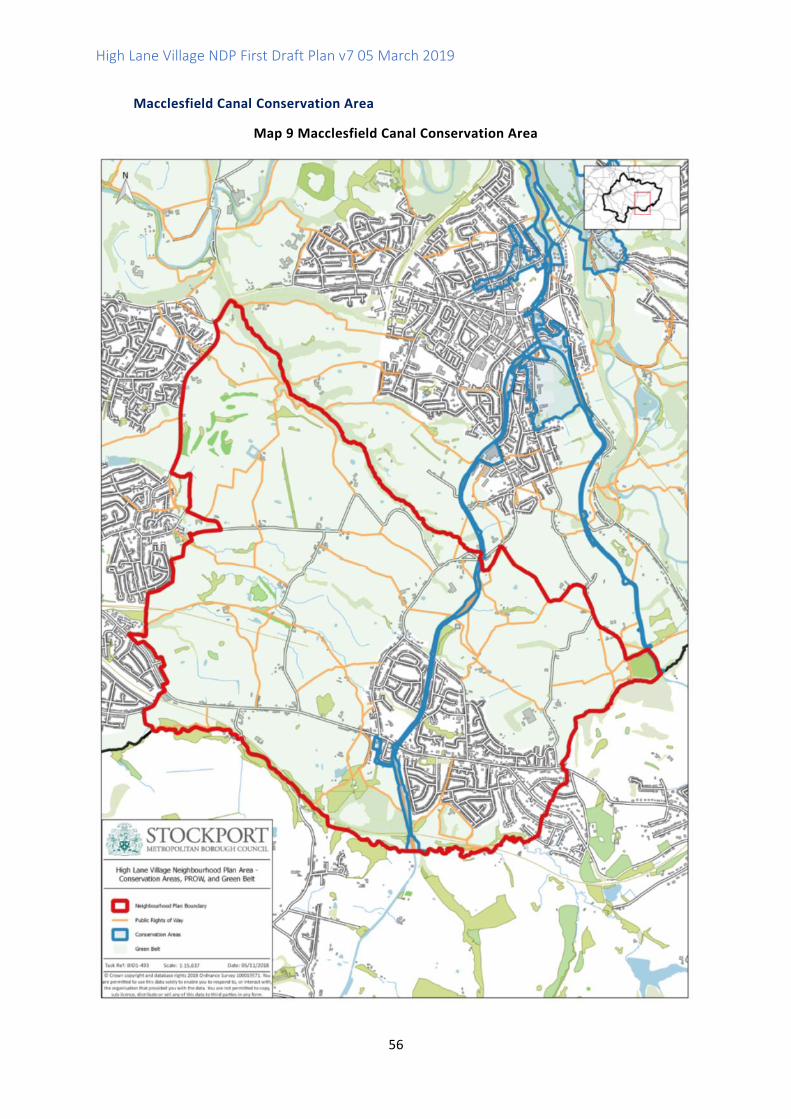
High Lane Village NDP First Draft Plan v7 05 March 2019
56
Macclesfield Canal Conservation Area
Map 9 Macclesfield Canal Conservation Area
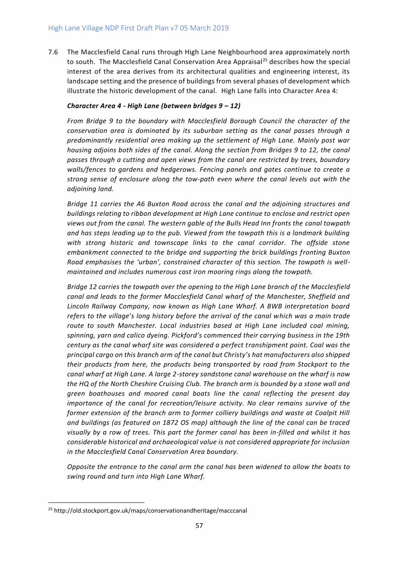
High Lane Village NDP First Draft Plan v7 05 March 2019
57
7.6 The Macclesfield Canal runs through High Lane Neighbourhood area approximately north
to south. The Macclesfield Canal Conservation Area Appraisal25 describes how the special
interest of the area derives from its architectural qualities and engineering interest, its
landscape setting and the presence of buildings from several phases of development which
illustrate the historic development of the canal. High Lane falls into Character Area 4:
Character Area 4 - High Lane (between bridges 9 – 12)
From Bridge 9 to the boundary with Macclesfield Borough Council the character of the
conservation area is dominated by its suburban setting as the canal passes through a
predominantly residential area making up the settlement of High Lane. Mainly post war
housing adjoins both sides of the canal. Along the section from Bridges 9 to 12, the canal
passes through a cutting and open views from the canal are restricted by trees, boundary
walls/fences to gardens and hedgerows. Fencing panels and gates continue to create a
strong sense of enclosure along the tow-path even where the canal levels out with the
adjoining land.
Bridge 11 carries the A6 Buxton Road across the canal and the adjoining structures and
buildings relating to ribbon development at High Lane continue to enclose and restrict open
views out from the canal. The western gable of the Bulls Head Inn fronts the canal towpath
and has steps leading up to the pub. Viewed from the towpath this is a landmark building
with strong historic and townscape links to the canal corridor. The offside stone
embankment connected to the bridge and supporting the brick buildings fronting Buxton
Road emphasises the ‘urban’, constrained character of this section. The towpath is well -
maintained and includes numerous cast iron mooring rings along the towpath.
Bridge 12 carries the towpath over the opening to the High Lane branch of the Macclesfield
canal and leads to the former Macclesfield Canal wharf of the Manchester, Sheffield and
Lincoln Railway Company, now known as High Lane Wharf. A BWB interpretation board
refers to the village’s long history before the arrival of the canal which was a main trade
route to south Manchester. Local industries based at High Lane included coal mining,
spinning, yarn and calico dyeing. Pickford’s commenced their carrying business in the 19th
century as the canal wharf site was considered a perfect transhipment point. Coal was the
principal cargo on this branch arm of the canal but Christy’s hat manufacturers also shipped
their products from here, the products being transported by road from Stockport to the
canal wharf at High Lane. A large 2-storey sandstone canal warehouse on the wharf is now
the HQ of the North Cheshire Cruising Club. The branch arm is bounded by a stone wall and
green boathouses and moored canal boats line the canal reflecting the present day
importance of the canal for recreation/leisure activity. No clear remains survive of the
former extension of the branch arm to former colliery buildings and waste at Coalpit Hill
and buildings (as featured on 1872 OS map) although the line of the canal can be traced
visually by a row of trees. This part the former canal has been in-filled and whilst it has
considerable historical and archaeological value is not considered appropriate for inclusion
in the Macclesfield Canal Conservation Area boundary.
Opposite the entrance to the canal arm the canal has been widened to allow the boats to
swing round and turn into High Lane Wharf.
25 http://old.stockport.gov.uk/maps/conservationandheritage/macccanal
High Lane Village NDP First Draft Plan v7 05 March 2019
58
As it approaches the railway line the canal passes through a cutting, lined by wooded slopes
on the offside of the canal towpath. Also screened off is the modern housing development
behind it (32-58 Cromley Road) and the wooded former Middlewood pit area bordering the
towpath which runs close to the Middlewood Way. The land falls away as the canal crosses
the railway line following an embankment built over the Bollinhurst Brook, and its elevated
position offers wide open views over the valley and Cheshire Plain to the boundary with
Macclesfield.
Canal Bridge 11 under the A6
(Reproduced with kind permission of Helen Richardson)
7.7 In addition there are several local features that are not statutorily or locally listed, but
which are considered to be of local heritage interest:
• The Coach House - which is now a garage and formed part of the Orford Estate
• The Old School - 1846 which has been used as residential and commercial property.
Thomas Legh gave the land for the school to be built. In 1862 further land was given
to the school and the building was extended. It was used as a C of E School until
1959 when it was taken over by Cheshire County Council as a County Primary
School. Before the village hall was built in 1956, the old school building was used
for a variety of activities including a library, the Mother’s Union, Townswomen’s
Guild, concerts, dances and whist drives.
• Hartley Woods - formerly Hartley House opposite St Thomas’ Church. Unusual
species of trees - The Friends of Hartley Woods/ SMBC manage it.
• The Red Lion Public House - 1762
7.8 These are potential candidates for local listing and the HLVNF will put these forward to
SMBC for consideration.
7.9 The area also includes the site of a possible Roman Road as suggested in the SEMMMs
Report.
7.10 The HLVNF is looking at developing a heritage trail that would include both statutorily
listed built heritage assets and some features of local interest. Following on from the Open
Day when there was a lot of interest in the local heritage, the Working Group decided to
continue to research the local history and create three lists; Listed Buildings, locally listed
buildings and other buildings that have significance to the community. A booklet has been
High Lane Village NDP First Draft Plan v7 05 March 2019
59
produced by the heritage steering group, in conjunction with Stockport Heritage Trust. It
includes a brief history of the village and a heritage walk. Care has been taken to include
buildings and people as noted in the Issues and Options document.
Coal Mining
7.11 High Lane Colliery was established by Joseph Wright after the closure of Norbury Colliery
in 1892. It is believed that Wright was at one time the Secretary of the Norbury Colliery for
Messrs Clayton and Brooke. In 1907 the Great Central Railway granted Wright permission
to drive an adit to the New (Accommodation) Seam from the bank of the High Lane Canal
Branch. This ran under the cricket club and subsequently under the Buxton branch railway
for which the LNWR gave permission for a heading 4ft square under its property.
7.12 Wright wasted no time in getting to work and these workings started production of coal
on January 1st 1908. From Jan 1st to June 30th 1908 the output was 614t 19cwt 0qr @ 6d
per ton royalty to the Legh estate at Lyme Hall = 15 17s 6d. He laid down a tramway from
the mine entrance along the towpath to the old abandoned Norbury Colliery canal branch
and filled it with spoil from driving the tunnel. The mine closed in 1917 and Joseph Wright
retired.26
7.13 Further information on coal mining in the area can be found in the publication ‘High Lane
Resident No 6 1951'. There is a copy in Stockport Heritage Library. Stockport Image Archive
has a photo of the colliery. Existing coalfields can be found on a series of maps at
https://www.gov.uk/government/publications/coalfield-plans-stockport-area .
7.14 The coal mining development risk plan shows the boundaries of high risk (dark-hatched)
and lower risk (lighter-hatched) coalfield areas. This information helps determine the need
to submit a coal mining risk assessment for a site.
Farming
7.15 There are still several working farms in the area today including Clough House Farm and
Higher Fold Farm on Threaphurst Lane and Lomber Hey farm on Andrew Lane.
7.16 School Farm was situated on the land used to build the ‘Lakes estate’. Grange Farm ,
Andrew Lane is one of the oldest farms of wattle and daub construction. It has been
suggested that it was built in 12th century. It is now the site of Grange Farm Cattery. Mosely
Hall Farm stood where the Spar is now. Pump Farm stood opposite the Red Lion Hotel and
Windlehust Farm stood on the corner of Keswick Road.
7.17 Other farms that are mainly residential are Wybersley Farm, Station Farm, Shores Farm,
Buxton Road, Oxhey Farm, Threaphurst Lane, Threaphurst Farm, Oakfield Farm and Green
Clough Farm all on Threaphurst Lane, Brookside Farm and Springfield Farm are on
Torkington Road.
Railways
7.18 High Lane Station was opened in 1869. High Lane Station was lit by oil for 101 years of its
life - never receiving gaslight or electricity. It had a staff of 7. The last train ran through
26 See http://www.ipernity.com/doc/302581/46291036
High Lane Village NDP First Draft Plan v7 05 March 2019
60
the station on 5th January 1970. Efforts were made to preserve the line by Lyme Handley
Preservation Society. There is a photo in Stockport Heritage library of people having
picnics in the field by the station having travelled to High Lane by train.
Disley Tunnel27
7.19 Disley Tunnel was on the most important line to pass through High Lane and it survives to
this day. Ventilation shafts are clearly visible. It was part of the Midland main line from St
Pancras to Manchester. The Tunnel was built by the Midland Railway in 1902 on its line
between New Mills South Junction and Manchester Central, which was more direct than
the congested and difficult lines through Stockport Tiviot Dale.
7.20 It was the most expensive work on the line and at 2 miles, 346 yards (3,535 m), the second
longest tunnel on the Midland system. By means of a connection on to the old LNWR line
from Buxton at Hazel Grove that was opened in 1986, it is now part of the Hope Valley Line
into the present-day Stockport railway station. There is also a short (174 yard) Disley
Tunnel nearby on the Buxton Line.
7.21 The tunnel runs under High Lane and Disley. The New Mills and Heaton Mersey Railway
line goes underground where the Middlewood Way (the old Macclesfield, Bollington and
Marple Railway), crosses the line, about 1/4 mile north of the A6 in High Lane. The tunnel
passes under a housing estate, the Macclesfield Canal, Disley golf course and finally the
Peak Forest Canal, just before emerging at Disley, meeting the Buxton to Stockport line.
7.22 The construction method used was to drive the tunnel bore from both ends, while also
sinking 11 shafts from the top of the hill along the path of the railway. Work began in 1900,
and the miners worked both directions from each shaft, which allowed 24 simultaneous
working faces. Ten of the shafts were later used for ventilation and are still in use - they
are visible as large blue brick towers following the line of the tunnel.
7.23 The Midland Railway purchased the land above the tunnel in order to sink the shafts -
boundary markers made of old rails, with the initials "M.R.", remain along the line of the
tunnel. A surface standard gauge contractors' line was set up, using steam locos and a
"steam navvy", following the subterranean path of the tunnel.
7.24 The construction of the tunnel brought a small army of navvies into the area. They were
housed in temporary villages at New Mills and Wybersley, and in specially-built houses
near the Rising Sun pub in Hazel Grove, which still exist, and are known as the "Navvy
Mansions".
7.25 A church made of tin was erected at Wybersley, where the Midland Railway had a local
administration office.
7.26 The NPPF sets out in paragraph 184 that heritage assets "are an irreplaceable resource,
and should be conserved in a manner appropriate to their significance, so that they can be
enjoyed for their contribution to the quality of life of existing and future generations ."
7.27 Core Strategy Core Policy CS8 Safeguarding and Improving the Environment sets out that
"the historic environment is a non-renewable resource and its fragile and finite nature will
be a particularly important consideration in the allocation of sites in the Allocations DPD
27 From Graces Guide https://www.gracesguide.co.uk/Disley_Tunnel

High Lane Village NDP First Draft Plan v7 05 March 2019
61
and in Development Management decision-making." The Policy goes on to say that "
Development will be expected to make a positive contribution to the protection and/or
enhancement of the borough's heritage assets."
7.28 The Issues and Options consultation demonstrated that local heritage is very significant to
the community of High Lane. There was strong agreement with the features of local
heritage already identified in the Issues and Options document including buildings, the
canal and its bridges, railway (current and historical) and features associated with farming
and mining history.
7.29 Draft Policy HD1 protects built heritage assets in the Neighbourhood Area and draws on
the key aspects of the Macclesfield Canal identified in the Conservation Area Appraisal to
guide new development and ensure it is sensitive to the conservation area and its setting.
Draft Policy HD1 Protecting Built Heritage Assets and their Settings
Historic buildings, structures and archaeological sites (whether inside or outside the Macclesfield Canal Conservation Area) are protected according to their significance. Development within or affecting the setting of the Macclesfield Canal Conservation Area should protect and enhance the area's special character. Development should aim to enhance and better reveal existing buildings and structures related to the canal including canal warehouses, toll houses, boundary and retaining walls, wharves and boathouses. Open views along the canal should be maintained together with panoramic views of the Pennine hills and open countryside. Development proposals must take account of known surface and subsurface archaeology and ensure unknown and potentially significant deposits are identified and appropriately considered during development.
High Quality Design in New Development
7.30 The HLVNDP aims to promote high quality design in new development. In the Issues and
Options consultation 70% of respondents (180) agreed that new development should be
in keeping with the character of different areas of High Lane.
7.31 Stockport Core Strategy Core Policy CS1 Overarching Principles: Sustainable Development
- Addressing Inequalities and Climate Change sets out that "the Council will seek to ensure
that all development meets an appropriate recognised sustainable design and construction
standard where viable to do so, in order to address both the causes and consequences of
climate change." Core Policy CS8 Safeguarding and Improving the Environment promotes
Quality Places; "High quality design which promotes a sense of place is of importance
throughout the borough and should be an integral part of all development proposals,
paying high regard to important local natural and built environment features, including the
historic environment, and contributing to addressing key issues such as climate change and
inequalities."

High Lane Village NDP First Draft Plan v7 05 March 2019
62
7.32 Draft Policy HD2 provides general design guidance for new development but more local
detail is provided in the supporting NDP background document on Design Codes.
Draft Policy HD2 High Quality Design and Design Codes
New development in High Lane Village Neighbourhood Area should demonstrate a commitment to high quality and innovative design. This should be achieved through the consideration and incorporation of the Design Codes which are provided as an accompanying document to the Neighbourhood Development Plan. In general:
1. Development should take cues from the character of the surrounding area and follow a consistent design approach in the use of materials, fenestration and the roofline of the building, as well as in scale, height and massing.
2. Materials should be chosen to complement the design of a development and add to the quality or character of the surrounding environment. Traditional local materials in High Lane include red brick and rendering but around the conservation and in historic buildings local quarried sandstone has been used. Roofing materials tend to comprise slate or tiles.
3. Materials and construction techniques should provide noise insulation and protection from air pollution where development is located close to main roads.
4. New development proposals need not imitate earlier architectural periods or styles and could be the stimulus for the use of imaginative modern design using high quality traditional materials such as local stone in innovative ways.
5. Schemes should aim to support sustainable development objectives and maximise energy and resource efficiency.
6. Schemes should be designed to protect and enhance local biodiversity and development is encouraged to incorporate wildlife friendly features such as bat and bird boxes and hedgehog friendly fencing.
7. In areas where surface water flood risk is a known issue, proposals will be resisted unless suitable mitigation can be provided which does not exacerbate run off elsewhere and wherever possible seeks to provide a betterment. Development proposals will be required to provide effective surface water drainage measures to protect existing and future residential areas from flooding. New development should be designed to maximise the retention of surface water on the development site and to minimise runoff. Sustainable drainage systems (SuDS) should be implemented in accordance with the SuDS hierarchy unless deemed inappropriate.
8. Proposals to alter, reuse or extend residential properties, particularly where adding bedrooms, will be supported provided that they enhance the property, use suitable materials and are of a proportionate scale which is subordinate to the main dwelling.

High Lane Village NDP First Draft Plan v7 05 March 2019
63
9. New houses should be designed to be accessible, adaptable and well orientated, providing suitable indoor and outdoor space to support a high quality of life and promote well-being.
High Lane Village NDP First Draft Plan v7 05 March 2019
64
8.0 Next Steps
8.1 This First Draft Plan for High Lane NDP is published for public consultation until the end of March
2019.
8.2 The HLVNF and Working Groups will consider all submitted comments and responses very
carefully and then revise this First Draft Plan for formal (Regulation 14) public consultation in
2019.
9.0 Review
9.1 The HLVNF are committed to reviewing the NDP within 3 years of the adoption of the GMSF
and Stockport Local Plan.
High Lane Village NDP First Draft Plan v7 05 March 2019
65
Appendix 1 Public Consultation 2017 - Comments from Questionnaire
Housing
• Affordable housing on brown field sites
• New housing needs to be sympathetic and proportionate thought to the existing village and the
community’s needs. Some consideration to the demographic in terms of older people and
providing affordable retirement developments to free up existing housing stock
• Supported living accommodation for the elderly
• Need for a plan
• Starter Homes/Retirement, Different age groups, Show interest in Mining history, Light Rail,
• No idea how many houses are needed
• Definitely not 4000
• Rate of growth should be broadly similar to that in recent times. i.e. no steep changes please.
• Need affordable housing for new buyers in real terms and not big housing estates and houses
that people can’t afford. I know we need more housing but in the right places and the right type
of housing
• I like living in the village as it is
• New Housing? not if it means destroying greenbelt land
• Not all in one place
• All Brownfield sites in Stockport should be used first before any greenbelt is used
• Brownfield sites first
• No more than is strictly necessary, use brown field sites first
• Will support all you do but already have 3 village projects to deal with
• We need some homes for the younger generation, affordable homes/housing association which
should be built first so developers back out of the deal and just build large executive houses
• We do not need larger houses but affordable housing suitable for a variety of ages
• Must be affordable
• Small pockets of new housing, first time buyers with help on mortgages, bungalows for elderly
community., check drug dealing in the local park
• Stopping mass development
• Almost impossible to answer, it should grow in a way that can easily cope with the demands of
those living in the village already plus a reasonable and sustainable increase for external growth,
maintaining a way of living that is rapidly disappearing from all large conurbations maintain a
quality of life for those already living in the village
• Maybe a mix of homes, a limited number. Try to keep High Lane in its own space, with its own
identity. The space of High Lane was added to with new homes over the years, with the estate
around Alderdale Dr and the lakes estate and other smallish developments, we do not want a
high developments on green belt land
• Most new housing around here is too expensive, e.g. Woodford
• Housing should be provided in self-contained settlements not adjacent to existing settlements
even if this requires use of green field sites and suggests Equestrian development
• Small pockets of building bungalows/flats
• Starter homes and buy to rent homes needed also bungalows
• We need starter homes, well designed and eco-friendly and a sheltered housing complex for
older people
High Lane Village NDP First Draft Plan v7 05 March 2019
66
• Don’t Know a number
• Preferable affordable homes for young people. Mills for living and workspace. Retail on ground
floor, one bed rental (Canal) flats on other floors
• 100 houses is quite a big estate - brown field sites must be used. If we start building on greenbelt
a precedent will be set
• To be given the power to veto any inappropriate housing developments. I would only support
building more houses if there were no more Brownfield sites available.
• Affordable housing on brown field sites
Infrastructure and Services
• Infrastructure first, taking care of Facilities/Spaces, encourage new business to add to area.
• Improve the paths along the canal. There is a need to bring young families to High Lane
• More shops and businesses
• Proper co-ordinated approach, consultation, consultation, consultation, Green Corridor must
remain
• Just don’t know
• Retailing and other services
• Subject to improved services/infrastructure
• Involvement in planning decisions. We are a small village with limited facilities, schools,
doctors/dentists
• Supporting the community
• Increase social interaction between people, encourage more exercise for all age groups,
mitigate against isolation of old people
• More community activities, i.e. shows carnivals events, Affordable family and single person
properties. Support for local businesses and traders.
Green Spaces and Footpaths
• Maintaining green spaces that give the area its pleasant character and is one of the main
reasons for living here. Smaller retirement type homes & houses suitable for first time buyers,
built in small pockets so that new people integrate and identify with High Lane rather than a
new estate
• Please use brown field site before considering green
High Lane Village NDP First Draft Plan v7 05 March 2019
67
Design and Heritage
• Ensuring high quality development is brought forward that will benefit the village as a whole.
Ensure sustainable development and address surface water drainage issues. New houses should
be affordable for people that are struggling to buy property in High Lane
• Protect our village identity
• Carefully located small pockets of housing, so as not to destroy green spaces or village
atmosphere
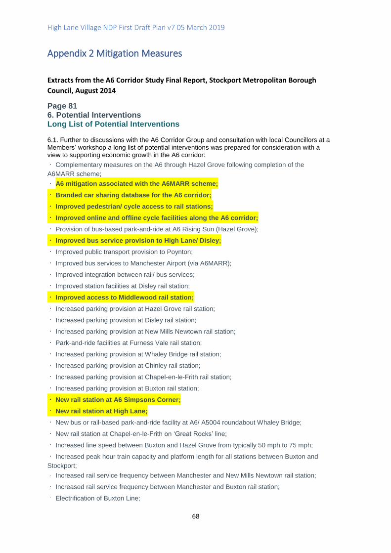
High Lane Village NDP First Draft Plan v7 05 March 2019
68
Appendix 2 Mitigation Measures
Extracts from the A6 Corridor Study Final Report, Stockport Metropolitan Borough
Council, August 2014
Page 81 6. Potential Interventions Long List of Potential Interventions 6.1. Further to discussions with the A6 Corridor Group and consultation with local Councillors at a Members’ workshop a long list of potential interventions was prepared for consideration with a view to supporting economic growth in the A6 corridor:
Complementary measures on the A6 through Hazel Grove following completion of the
A6MARR scheme;
A6 mitigation associated with the A6MARR scheme;
Branded car sharing database for the A6 corridor;
Improved pedestrian/ cycle access to rail stations;
Improved online and offline cycle facilities along the A6 corridor;
Provision of bus-based park-and-ride at A6 Rising Sun (Hazel Grove);
Improved bus service provision to High Lane/ Disley;
Improved public transport provision to Poynton;
Improved bus services to Manchester Airport (via A6MARR);
Improved integration between rail/ bus services;
Improved station facilities at Disley rail station;
Improved access to Middlewood rail station;
Increased parking provision at Hazel Grove rail station;
Increased parking provision at Disley rail station;
Increased parking provision at New Mills Newtown rail station;
Park-and-ride facilities at Furness Vale rail station;
Increased parking provision at Whaley Bridge rail station;
Increased parking provision at Chinley rail station;
Increased parking provision at Chapel-en-le-Frith rail station;
Increased parking provision at Buxton rail station;
New rail station at A6 Simpsons Corner;
New rail station at High Lane;
New bus or rail-based park-and-ride facility at A6/ A5004 roundabout Whaley Bridge;
New rail station at Chapel-en-le-Frith on ‘Great Rocks’ line;
Increased line speed between Buxton and Hazel Grove from typically 50 mph to 75 mph;
Increased peak hour train capacity and platform length for all stations between Buxton and
Stockport;
Increased rail service frequency between Manchester and New Mills Newtown rail station;
Increased rail service frequency between Manchester and Buxton rail station;
Electrification of Buxton Line;
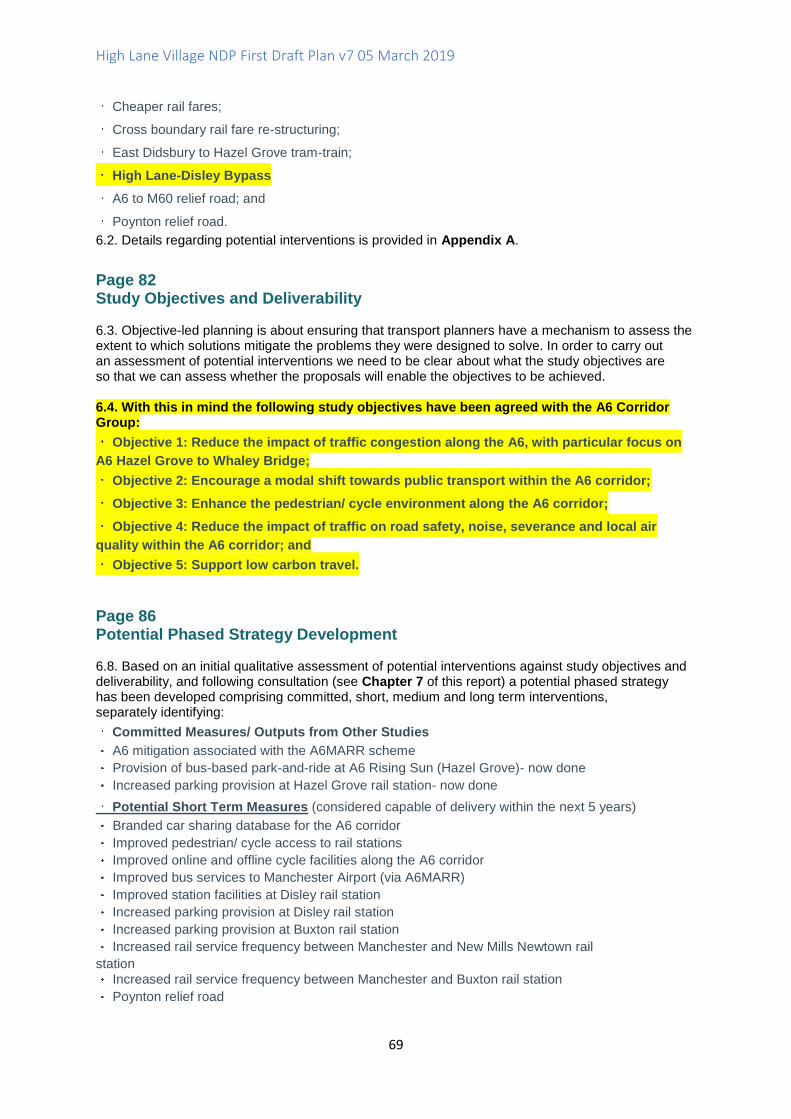
High Lane Village NDP First Draft Plan v7 05 March 2019
69
Cheaper rail fares;
Cross boundary rail fare re-structuring;
East Didsbury to Hazel Grove tram-train;
High Lane-Disley Bypass
A6 to M60 relief road; and
Poynton relief road.
6.2. Details regarding potential interventions is provided in Appendix A.
Page 82 Study Objectives and Deliverability 6.3. Objective-led planning is about ensuring that transport planners have a mechanism to assess the extent to which solutions mitigate the problems they were designed to solve. In order to carry out an assessment of potential interventions we need to be clear about what the study objectives are so that we can assess whether the proposals will enable the objectives to be achieved.
6.4. With this in mind the following study objectives have been agreed with the A6 Corridor Group:
Objective 1: Reduce the impact of traffic congestion along the A6, with particular focus on
A6 Hazel Grove to Whaley Bridge;
Objective 2: Encourage a modal shift towards public transport within the A6 corridor;
Objective 3: Enhance the pedestrian/ cycle environment along the A6 corridor;
Objective 4: Reduce the impact of traffic on road safety, noise, severance and local air
quality within the A6 corridor; and
Objective 5: Support low carbon travel.
Page 86 Potential Phased Strategy Development 6.8. Based on an initial qualitative assessment of potential interventions against study objectives and deliverability, and following consultation (see Chapter 7 of this report) a potential phased strategy has been developed comprising committed, short, medium and long term interventions, separately identifying:
Committed Measures/ Outputs from Other Studies
A6 mitigation associated with the A6MARR scheme
Provision of bus-based park-and-ride at A6 Rising Sun (Hazel Grove)- now done
Increased parking provision at Hazel Grove rail station- now done
Potential Short Term Measures (considered capable of delivery within the next 5 years)
Branded car sharing database for the A6 corridor
Improved pedestrian/ cycle access to rail stations
Improved online and offline cycle facilities along the A6 corridor
Improved bus services to Manchester Airport (via A6MARR)
Improved station facilities at Disley rail station
Increased parking provision at Disley rail station
Increased parking provision at Buxton rail station
Increased rail service frequency between Manchester and New Mills Newtown rail
station Increased rail service frequency between Manchester and Buxton rail station
Poynton relief road
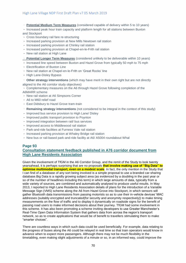
High Lane Village NDP First Draft Plan v7 05 March 2019
70
Potential Medium Term Measures (considered capable of delivery within 5 to 10 years)
Increased peak hour train capacity and platform length for all stations between Buxton
and Stockport Cross boundary rail fare re-structuring
Increased parking provision at New Mills Newtown rail station
Increased parking provision at Chinley rail station
Increased parking provision at Chapel-en-le-Frith rail station
New rail station at High Lane
Potential Longer Term Measures (considered unlikely to be deliverable within 10 years)
Increased line speed between Buxton and Hazel Grove from typically 50 mph to 75 mph
Electrification of Buxton Line
New rail station at Chapel-en-le-Frith on ‘Great Rocks’ line
High Lane-Disley Bypass
Other strategy interventions (which may have merit in their own right but are not directly
aligned to the A6 corridor study objectives) Complementary measures on the A6 through Hazel Grove following completion of the
A6MARR scheme New rail station at A6 Simpsons Corner
A6 to M60 relief road
East Didsbury to Hazel Grove tram-train
Remaining strategy interventions (not considered to be integral in the context of this study)
Improved bus service provision to High Lane/ Disley
Improved public transport provision to Poynton
Improved integration between rail/ bus services
Improved access to Middlewood rail station
Park-and-ride facilities at Furness Vale rail station
Increased parking provision at Whaley Bridge rail station
New bus or rail-based park-and-ride facility at A6/ A5004 roundabout Whal
Page 93 Consultation statement feedback published in A76 corridor document from High Lane Residents Association Given the involvement of TfGM in the A6 Corridor Group, and the remit of the Study to look twenty yearsahead, it is perhaps surprising that are no proposals that involve making use of “Big Data” to optimise multimodal transport, even on a modest scale. In fact, the only mention in the Study that I can find of a database of any sort being involved is a simple proposal to use a branded car-sharing database.Big Data is a rapidly growing subject area (as evidenced by a doubling in the past year or so of the number of headlines including this term) in which large amounts of data, typically from a wide variety of sources, are combined and automatically analysed to produce useful results. In May 2013, I reported to High Lane Residents Association details of plans for the introduction of a Variable Message Sign (VMS) scheme along the A6 from Hazel Grove into Stockport, in which sensors will gather Bluetooth data transmissions from passing motorists so as to use their in-vehicle devices’ MAC addresses (suitably encrypted and truncated(for security and anonymity respectively)) to make timing measurements on the flow of traffic and to display it dynamically on roadside signs for the benefit of passing road users to make informed decisions about their journey. TfGM had some involvement in this scheme. It has also been promoting a scheme inviting developers to use Greater Manchester’s Real-Time Open Data Information System that gathers data from across the region’s transport network, so as to create applications that would be of benefit to travellers stimulating them to make “smarter choices”. There are countless ways in which such data could be used beneficially. For example, data relating to the progress of buses along the A6 could be relayed in real time so that train operators would know in advance when to expect more passengers. Although there may not be much flexibility in the timetabling, even making slight adjustments of a minute or so, in an informed way, could improve the

High Lane Village NDP First Draft Plan v7 05 March 2019
71
matching of demand to capacity. Alternatively, this data could be released to passengers (e.g. via smartphone apps or electronic display boards) to help plan their journey, rather than having to rely on scheduled timetables that may not be accurate. There is an ever-increasing number of data-gathering projects springing up. One recent local example is the Smart Citizen project in Manchester. However, this is only open to those resident or working within 3 miles of the city centre, but those who are eligible can apply for a free sensor unit by registering before 15th April 2014. The unit includes a board with sensors for measuring air pollutants (CO and NO2), temperature, light intensity, sound levels and humidity, and a board with data processing and radio comms capability that canstream the data over a WiFi link. Response from A6 Corridor report The study team fully endorse the use of intelligent transport technology to make better use of real-time data to enable people to make smarter travel choices. Indeed, Greater Manchester has consistently placed connectivity and transport investment at the heart of its economic strategy. There is already significant investment, both underway and planned, which will deliver a transformational step-change in connectivity this includes the Local Sustainable Transport Fund providing over £50 million investment in active travel, smarter choices and intelligent transport technologies, which aims to at least double the levels of commuter cycling in Greater Manchester and enable all commuters to make more sustainable choices in how they travel.
Page 95 A6 Mitigation Measures Associated with A6MARR Scheme 8.6. As previously presented in Chapter 2 of this report the traffic modelling predicts significant increases in traffic flow on the A6 through High Lane and Disley with the A6MARR in place. This increase is a result of both background traffic growth and the reassignment of longer distance traffic as a result of the introduction of the A6MARR. The nature of the A6 through High Lane and Disley means that it is neither possible nor desirable to significantly increase network capacity along this corridor. The A6MARR Project Team has been sensitive to the concerns raised by the public and stakeholders alike in relation to the predicted increases in traffic through High Lane and Disley, both as a result of background traffic growth and the reassignment of longer distance traffic movements following completion of the A6MARR scheme. 8.7. Following the Phase Two Consultation the promoting Authorities resolved to implement a package of enhanced mitigation measures on the A6 tailored to limiting, as far as practicable, the impacts of the A6MARR scheme through a combination of; discrete local junction improvements, environmental enhancement measures, and speed management measures. 8.8. These enhanced mitigation measures seek a balanced approach to managing the predicted traffic on the A6 through High Lane and Disley by:
better managing traffic flows for local residents at the A6 Buxton Road/ Windlehurst Road
junction through a local junction improvement scheme;
enhancing the local district centre environment in Disley village through the introduction of
shared-space type interventions; and
limiting the attractiveness of the A6 to longer distance traffic which would otherwise switch
from other cross-county routes with the A6MARR in place. This will be achieved through a combination of gateway treatments and reduced speed limits. 8.9. These enhanced measures build upon the package of mitigation measures promoted as part of the Phase Two Consultation which focussed on improvements to non-motorised user facilities, including:
cycle lanes on uphill sections of the A6 between Hazel Grove and New Mills Newton where
practicable;
a new pedestrian refuge on the A6 Buxton Road at Wellington Road;
a new Puffin crossing on the A6 Buxton Road outside the Church/ War memorial in High
Lane;
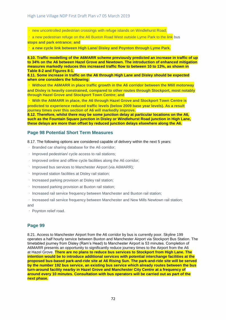
High Lane Village NDP First Draft Plan v7 05 March 2019
72
new uncontrolled pedestrian crossings with refuge islands on Windlehurst Road;
a new pedestrian refuge on the A6 Buxton Road West outside Lyme Park to the link bus
stops and park entrance; and
a new cycle link between High Lane/ Disley and Poynton through Lyme Park.
8.10. Traffic modelling of the A6MARR scheme previously predicted an increase in traffic of up to 34% on the A6 between Hazel Grove and Newtown. The introduction of enhanced mitigation measures markedly reduces this increased traffic flow to between 10 to 13%, as shown in Table 8-2 and Figures 8-1. 8.11. Some increase in traffic on the A6 through High Lane and Disley should be expected when one considers the following:
Without the A6MARR in place traffic growth in the A6 corridor between the M60 motorway
and Disley is heavily constrained, compared to other routes through Stockport, most notably through Hazel Grove and Stockport Town Centre; and
With the A6MARR in place, the A6 through Hazel Grove and Stockport Town Centre is
predicted to experience reduced traffic levels (below 2009 base year levels). As a result journey times over this section of A6 will markedly improve. 8.12. Therefore, whilst there may be some junction delay at particular locations on the A6, such as the Fountain Square junction in Disley or Windlehurst Road junction in High Lane, these delays are more than offset by reduced junction delays elsewhere along the A6.
Page 98 Potential Short Term Measures 8.17. The following options are considered capable of delivery within the next 5 years:
Branded car sharing database for the A6 corridor;
Improved pedestrian/ cycle access to rail stations;
Improved online and offline cycle facilities along the A6 corridor;
Improved bus services to Manchester Airport (via A6MARR);
Improved station facilities at Disley rail station;
Increased parking provision at Disley rail station;
Increased parking provision at Buxton rail station;
Increased rail service frequency between Manchester and Buxton rail station;
Increased rail service frequency between Manchester and New Mills Newtown rail station;
and
Poynton relief road.
Page 99 8.21. Access to Manchester Airport from the A6 corridor by bus is currently poor. Skyline 199 operates a half hourly service between Buxton and Manchester Airport via Stockport Bus Station. The timetabled journey from Disley (Ram’s Head) to Manchester Airport is 53 minutes. Completion of A6MARR presents an opportunity to significantly reduce journey times to the Airport from the A6 at Hazel Grove. There are no plans to reduce bus services to Stockport from High Lane. The intention would be to introduce additional services with potential interchange facilities at the proposed bus-based park-and-ride site at A6 Rising Sun. The park-and-ride site will be served by the number 192 bus service, an existing bus service which already routes between the bus turn-around facility nearby in Hazel Grove and Manchester City Centre at a frequency of around every 10 minutes. Consultation with bus operators will be carried out as part of the next phase.
High Lane Village NDP First Draft Plan v7 05 March 2019
73
Page 105 Potential Medium Term Measures 8.66. The following options are considered capable of delivery within a 5 to 10 years:
Increased peak hour train capacity and platform length for all stations between Buxton and
Stockport;
Cross boundary rail fare re-structuring;
Increased parking provision at New Mills Newtown rail station;
Increased parking provision at Chinley rail station;
Increased parking provision at Chapel-en-le-Frith rail station; and
New rail station at High Lane.
Page 108-109 New rail station at High Lane 8.89. A high-level demand forecast has-been produced for a potential new station located on the Buxton line at High Lane. A simple trip-rate approach has been used, consistent with PDFH advice for new station assessments at an early stage of development. Population-based trip rates for Disley have been applied to the settlement of High Lane. While High Lane has a larger population than Disley, the location of the railway relative to the village is more remote, reducing the overall catchment population. 8.90. Trip-rate forecasts suggest that a station at High Lane would attract similar levels of patronage to Disley with the demand forecasts assuming that both Disley and High Lane would have a half hourly service frequency in each direction. For the purpose of appraisal, it has been assumed that High Lane would replace Middlewood station calls, resulting in a small increase in average journey times as Middlewood would only receive an hourly service in the enhanced frequencytimetable. 8.91. A WebTAG-based 60-year appraisal has been undertaken for the new station, making use of high-level estimates of capital expenditure and operating costs for a new station at High Lane. Capital Costs have been estimated at £6m based upon recently delivered or planned stations in urban areas. The location of the proposed station means that cost would need to include provision of step-free access to both platforms via footbridge, as well as improvements to road access as the site is located on the edge of a residential area. Ongoing operating costs have been assumed on the basis that the station would be unstaffed, but would include Customer Information Screens and CCTV (as provided at Disely). A Network Rail Long Term Charge similar to that charged for Disley has been assumed. No allowance has been made for renewal costs. 8.92. The proposed station location at High Lane is less than two miles from the station at Disley, and less than three miles from the station at Hazel Grove. While a station at High Lane may attract similar levels of patronage as Disley using a simple population-based trip rate analysis, it is reasonable to assume that a proportion of these passengers would be existing rail passengers abstracted from either Disley or Hazel Grove. Such passengers would gain from reduced access times, but do not generate additional revenue for the rail industry. 8.93. Using a 66% Optimism Bias on capital costs, a new station at High Lane is forecast to have aprovisional BCR of 1.3. The result is, however, quite sensitive to the assumed level of potential
Page 109 Potential Longer Term Measures 8.94. The following options are considered unlikely to be deliverable within 10 years:
Increased line speed between Buxton and Hazel Grove from typically 50 mph to 75 mph;
Electrification of Buxton Line;
New rail station at Chapel-en-le-Frith on ‘Great Rocks’ line; and
High Lane-Disley Bypass.
High Lane Village NDP First Draft Plan v7 05 March 2019
74
Remaining Strategy Interventions 8.125. The following options are not considered to be integral in the context of this study:
Improved bus service provision to High Lane/ Disley;
Improved public transport provision to Poynton;
Improved integration between rail/ bus services;
Improved access to Middlewood rail station;
Park-and-ride facilities at Furness Vale rail station;
Increased parking provision at Whaley Bridge rail station;
New bus or rail-based park-and-ride facility at A6/ A5004 roundabout Whaley Bridge; and
Cheaper rail fares.
Page 113 Improved bus service provision to High Lane/ Disley 8.126. The A6 corridor through High Lane and Disley is currently served by the Skyline 199 half hourly service (Buxton to Manchester Airport via Stockport), TransPeak every two hour service (Derby to Manchester) and 360 morning only service (Hayfield to Stockport). There is no direct high frequency bus service from High Lane/ Disley to Manchester City Centre. Having said that, the timetabled journey time for the TransPeak bus service from Disley (Rams Head) to Stockport Mersey Square is 21 minutes and to Manchester (Central Coach Station) is 48 minutes. These journey times are competitive with rail, where the journey time by Disley station to Stockport station is 17 minutes and to Manchester Piccadilly is circa 30 minutes. 8.127. For bus to be a realistic alternative to car and rail from High Lane and Disley, both the frequency of service and journey time would need to be competitive. There could be potential for selected 192 journeys, say every 20 minutes in the peak periods, to extend to High Lane/ Disley and operate a limited stop service. Indeed, it would seem that such a service would also be attractive to bus-based park-and-ride users at the A6 Rising Sun which is due to open later this year. 8.128. Subject to the outcome of a full business case the scheme is unlikely to be self-financing (or elsesuch a service would already be in place), and would require ongoing subsidy support. Stakeholder discussion with bus operators, such as Stagec Improved access to Middlewood rail station 8.133. Middlewood Station is located adjacent to the Middlewood Way. The potential for improved access to Middlewood rail station should be considered in more detail alongside plans for a new station in the High Lane area, and thatconcerns regarding the frequency of service at Middlewood should be reviewed. Page 129The Buxton line rail passenger surveys carried out in Spring 2011 asked passengers “if you could make one improvement to the train service you are one, what would it be?” Only 1% of passengers cited facilities for bikes as their key priority, while pedestrian access is not seen as a barrier to those already using the service. It is considered, therefore, that improved pedestrian/ cycle access to rail stations, as a standalone measure, will not lead to a modal shift sufficient to reduce the impact of traffic congestion in the A6 corridor Will the scheme reduce the impact of traffic congestion on road safety, noise and local air quality within the A6 corridor? (Weighting 15%) Score 4: Neutral Improved pedestrian/ cycle access to rail stations, as a stand-alone measure, will not lead to a modal shift sufficient to reduce the impact of traffic congestion in the A6 corridor. Will the scheme support lower carbon travel? (Weighting 15%) Score 6: Amber Targeted improvements to pedestrian/ cycle access to
High Lane Village NDP First Draft Plan v7 05 March 2019
75
Appendix 3 Middlewood Station Users Survey, January 2019
Date Passengers Travel Direction
Frequency of Use
Leisure /Commuting
Method of accessing station
Home area Wish list of improvements
Other comments
19/12/18 From HL to Manchester I male
Once a month approx
leisure walking Higher Poynton
An hourly service would be good. New station at High Lane? unrealistic
Middlewood station is fine as it is. No lighting thank you. Enough light pollution as there is.
19/12/18 Manchester to HL 1 male
Every 6 mths approx
Work – rail worker
Van , parking at lay by in Higher Poynton
Manchester More services would make little difference. People choose Poynton or Rose Hill stations where access is better
I don’t know where HL is
3/1/19 HL to Buxton Man and woman
Just moved to area
leisure walking Canal barge Higher Poynton
More bike space on the trains, more frequent service, guards to be kept on trains, safety button(woman)
3/1/19 From Manchester to HL Man and woman
First visIt to HL station
Leisure – came for a walk
Train from Piccadilly – HL station easy to find on Google maps. Good internet signal at station
Manchester Maybe lighting. We love the station , it’s a beautiful setting. We are glad we have come.
8/1/19 Returning to HL from Hazel Grove – been shopping Man
Every 2 weeks
Grocery shopping
walked Caravan park in Higher Poynton/ Norbury Hollow
It’s convenient for me. No problems. Don’t normally travel at night.
They improved the access from the caravan park to the station and it’s very handy now.
High Lane Village NDP First Draft Plan v7 05 March 2019
76
Survey asked to people not on the station platform
9/1/19 woman never High Lane The station is unsafe at night /after dark as unlit woodland access
9/1/19 Man and woman
never High Lane We don’t use trains much so a new station in High Lane or Middlewood would not be of interest.
My wife and I prefer to use the Park and Ride . If we travel to Manchester we use Hazel Grove station and the P. and R. If we want to go to Buxton we go on the 199 which is free for us(over 65) whereas we would have to pay on the train from Disley onwards(Cheshire East)
9/1/19 woman never High Lane I rarely use public transport. Don’t have an opinion
I don’t know where Middlewood station is
9/1/19 woman never High Lane Lighting, improved access, nearer to the village, car parking but most people would still not feel safe. There would need to be a lot of improvements
A new station at High Lane would cost too much to build and where would it be sited?
9/1/19 woman never High Lane I might use it if there was improved car parking and lighting. Not sure whether other people would though.
I use Park and Ride to go to Stockport /Manchester
9/1/19 woman never High Lane lighting I use the Park and Ride. I don’t use trains much. Even with improvements I wouldn’t use the trains.
9/1/19 man never High Lane I only rarely travel to
I use Park and Ride to go to Stockport. I
High Lane Village NDP First Draft Plan v7 05 March 2019
77
Manchester. A n improved/new station wouldn’t really affect me.
travel from Marple station if I want to go to Piccadilly.
9/1/19 woman About every 2 months
Leisure/work walking High Lane A More frequent service would be good. I use it more since the fairly recent pathway improvements to the Middlewood Way making it less muddy. There is no point putting lighting unless the service is more frequent at night and its location is always going to make it uninviting for quite lot of people so not sure. If you put a car park that’s more traffic joining the A6…
Ideally a station nearer the centre of HL would be better so more of the village would access it without the need for car use but there is no obvious site . Brookside is right beside a primary school and loads of residential roads
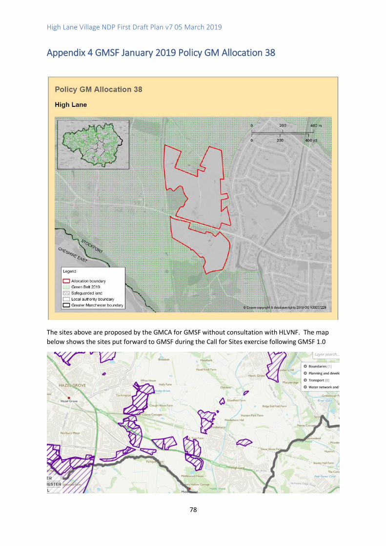
High Lane Village NDP First Draft Plan v7 05 March 2019
78
Appendix 4 GMSF January 2019 Policy GM Allocation 38
The sites above are proposed by the GMCA for GMSF without consultation with HLVNF. The map
below shows the sites put forward to GMSF during the Call for Sites exercise following GMSF 1.0

High Lane Village NDP First Draft Plan v7 05 March 2019
79
The housing steering group believe further consultation with High Lane residents is needed to
understand which of these sites are preferred and the number of homes acceptable is needed. We
propose a survey is undertaken via FB and Website before the ending of this phase of GMSF
consultation and feed into this draft plan.

High Lane Village NDP First Draft Plan v7 05 March 2019
80
Appendix 5 Affordable Housing (NPPF Annex 2: Glossary)
Affordable housing: housing for sale or rent, for those whose needs are not met by the market (including housing that provides a subsidised route to home ownership and/or is for essential local workers); and which complies with one or more of the following definitions: a) Affordable housing for rent: meets all of the following conditions: (a) the rent is set in accordance with the Government’s rent policy for Social Rent or Affordable Rent, or is at least 20% below local market rents (including service charges where applicable); (b) the landlord is a registered provider, except where it is included as part of a Build to Rent scheme (in which case the landlord need not be a registered provider); and (c) it includes provisions to remain at an affordable price for future eligible households, or for the subsidy to be recycled for alternative affordable housing provision. For Build to Rent schemes affordable housing for rent is expected to be the normal form of affordable housing provision (and, in this context, is known as Affordable Private Rent).
b) Starter homes: is as specified in Sections 2 and 3 of the Housing and Planning Act 2016 and any secondary legislation made under these sections. The definition of a starter home should reflect the meaning set out in statute and any such secondary legislation at the time of plan-preparation or decision-making. Where secondary legislation has the effect of limiting a household’s eligibility to purchase a starter home to those with a particular maximum level of household income, those restrictions should be used.
c) Discounted market sales housing: is that sold at a discount of at least 20% below local market value. Eligibility is determined with regard to local incomes and local house prices. Provisions should be in place to ensure housing remains at a discount for future eligible households.
d) Other affordable routes to home ownership: is housing provided for sale that provides a route to ownership for those who could not achieve home ownership through the market. It includes shared ownership, relevant equity loans, other low cost homes for sale (at a price equivalent to at least 20% below local market value) and rent to buy (which includes a period of intermediate rent). Where public grant funding is provided, there should be provisions for the homes to remain at an affordable price for future eligible households, or for any receipts to be recycled for alternative affordable housing provision, or refunded to Government or the relevant authority specified in the funding agreement.

High Lane Village NDP First Draft Plan v7 05 March 2019
81
Appendix 6 Informal Public Consultation on Housing Issues using
Facebook, Summer 2018
Questions
1. How many new homes does High Lane need over the next 20 years to grow as a sustainable
village?
2. Please rank in order of importance the types of homes the village should see built with any
development?
3. Do you feel that High Lane needs more Council/Housing Association/Shared ownership type
homes?
4. Would you prefer land currently used for recreation, such as golf, be used for housing
development before any green belt is removed?
5. If you are aware of land, which may be used for small developments, up to 10 homes, please
advise the location.
Responses
The responses gained from 35 respondents mirror much of the knowledge gained from the
initial open day, with 27 (77.14%) answering less than 500 homes to question one.
Question two provided more detail than the initial questionnaire:
Question three on whether the village needs social/council homes showed 42% for in favour
and 42% against with 16% unsure.
As the initial FB survey response advised the group to show where new homes should be built
the last two questions focused on this. Question four asked whether homes should be built on
green belt land or recreational land such as Golf courses, with 45% stating Yes, 42% No and 13%
unsure. However, the group are advised that the two golf courses within the boundaries of High
Lane are in fact on green belt land.
The issue the housing group face in providing options as to “where to build” is that 100% of the
land surrounding High Lane is designated as green belt, as such to grow the Village will have to
encroach on some of this precious commodity. Question five asked residents to advise where
new build could be built. The responses were as follows:
➢ Behind the shopping arcade on the A6 (Buxton Rd) that borders the Canal.

High Lane Village NDP First Draft Plan v7 05 March 2019
82
➢ Land behind High Lane cricket pitch where motor engineers have a large plot
➢ Behind and to the side of the Royal Oak.
➢ Opposite the Royal Oak, on the other side of the A6.
➢ Adjacent to Brookside farm (High Lane side of the railway line.)
➢ Behind Brookside Tennis Club.
➢ Behind the Water Treatment Plant adjacent to Wybersley Farm.
➢ Land around Batesons Trailers.
High Lane Village NDP First Draft Plan v7 05 March 2019
83
Appendix 7 Informal Consultations on Recreational Activity in High Lane
Community Survey Questionnaires 2018 and Facebook Surveys 2018
From the 165 responses received from the younger generation of High Lane there were 114
journeys by car across all ages to access sporting activities in other areas. Of these 24 were
for ages 11-18 and totalled 88.8% of the total responses received for this age group.
Local sport clubs indicate that they are all well used. Both the tennis club and the cricket
club are seeking expansion of their facilities but are currently limited by financial restraints
and other suitable users with whom they could share facilities. Since existing clubs cannot
expand at the moment, though they would if they could, this supports an argument for extra
facilities for High Lane. The Forum approached the Tennis Club, Cricket Club, Allotment
Club and the Bowling Club all of which have recreational premises in High Lane and
consulted with them about their needs and future plans.
Responses:
The Tennis Club has the capacity to increase their membership. They are seeking to raise funds
for extensive improvement to both the clubhouse and courts in order to expand their facilities
and attract younger members to the sport. The local Bridge Club shares its facility. The club lies
adjacent to greenbelt. It has no excess land.
The Cricket Club advised they have the capability to increase their membership and expand
their facilities, but due to field usage constraints together with the issue of field water
retention they are limited in terms of users with whom they can share grounds with. They
struggle attracting young people to the sport, as there are no secondary schools in the area.
They have no excess land.
The Bowling Club has a large membership of predominantly older members. An
independent club is sited behind the Conservative Club. They have one bowling green. The
club has the capacity to expand its membership and would like to attract younger members.
They have no other land available.
The Allotment Group advised they have 44 plots and are at membership capacity with a
waiting list. As plots become available they are bound by plot allocation constraints in line
with council policy, which means they are allocated from the Stockport waiting list. The
allotments were expanded in recent years to include land available and adjacent to the
current site. They have no other land available.
The Junior Football Club is run by volunteers. The club would like to expand its membership
but has no premises. They train in the summer at High Lane Cricket Club. Matches are played
in Disley East Cheshire due to the only available pitch at High Lane Park recreation ground
being unfit for purpose. The pitch there has poor drainage with holes present, presenting
as a safety risk. Additionally, there are no available changing facilities.
Local Primary Schools and Youth Survey, 2018

High Lane Village NDP First Draft Plan v7 05 March 2019
84
We have undertaken school projects involving the two local primary schools.
Questionnaires were aimed at those aged 7-11 years asking
• Which parks they use and which equipment/activity they enjoy there?
• What activities they enjoy doing in open green space?
• If they belong to any clubs in or out of High Lane?
• What they like about living in the area?
We achieved a 43% response rate from Brookside School whose pupils completed
questionnaires at home and a 100% in school completion response rate from High Lane Primary.
The responses from the younger generation demonstrates support for both local parks as
highly used community assets as well as retention of the countryside surrounding High Lane
for family activities such as cycling and walking. Issues were raised concerning:
The need to improve facilities and football pitches at both parks; and
The children were also concerned about the environment in the parks, particularly the issues
of dog fouling and need for improved lighting at High Lane Park.
Of the 74 responses received from Brookside 44 children travelled weekly in cars outside of
High Lane to access sporting activities. Of the 64 responses from children attending High Lane
School 55 journeys were made.
As High Lane has no secondary school. In order to gauge the opinions of those aged 11 -18
years a small-scale study was undertaken using questionnaires completed by High Lane
Scouts, together with a scheme using peer mentors to facilitate reaching a wider audience.
Questionnaires asked this group about:
• Their use of local parks and if so, what their opinions were of the facilities there?
• Do they attend local activities/travel to other areas for recreational activities? Or
access pursuits in green open space?
• We also asked the question if they felt there are enough activities for their age
group in the area as this topic was a particular issued raised at both the forums
earlier consultations.
The total of completed questionnaires were 27.
Facebook Survey - Middlewood Way
Issues raised in our surveys by those respondents who use this route are:
• Inconsiderate use of this route by cyclists who ride too fast putting walkers at ris k
• Accessible points onto this route in High Lane are poor particularly for the disabled and for the residents of High Lane with young families.
• The main access points are on the busy A6 and Torkington Lane, both of which are not wheelchair friendly and cannot accommodate horses.
• Other access routes exist on Windlehurst Road (some involve navigating stiles and crossing open fields).
• Mog Lane is the only access point with no stiles which leads on to 202M pathway and provides access for walkers only.

High Lane Village NDP First Draft Plan v7 05 March 2019
85
• Access to the pathway is difficult to navigate as the path is often unpassable due to the boggy surface.
• Signage to Middlewood Way and other off road paths throughout High Lane are predominantly of the old wooden variety with little information available, or non-existent.
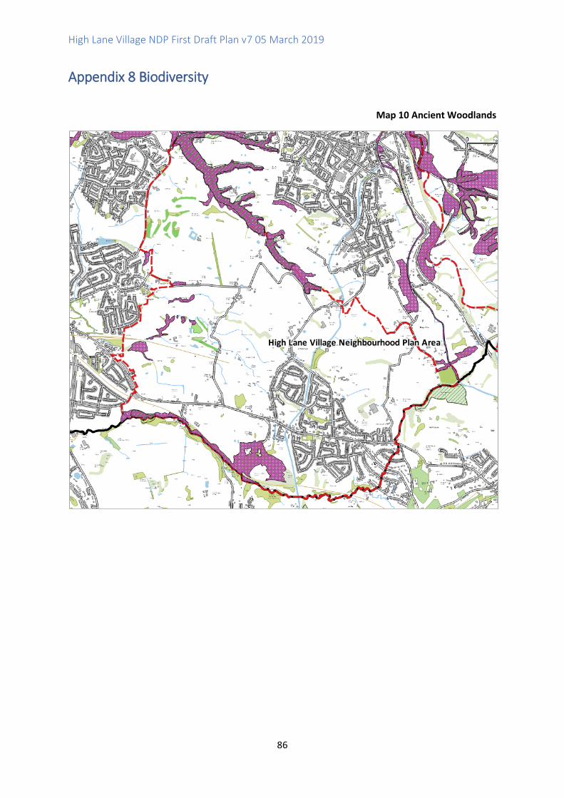
High Lane Village NDP First Draft Plan v7 05 March 2019
86
Appendix 8 Biodiversity
Map 10 Ancient Woodlands
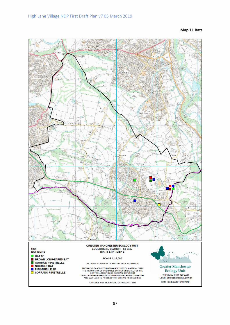
High Lane Village NDP First Draft Plan v7 05 March 2019
87
Map 11 Bats
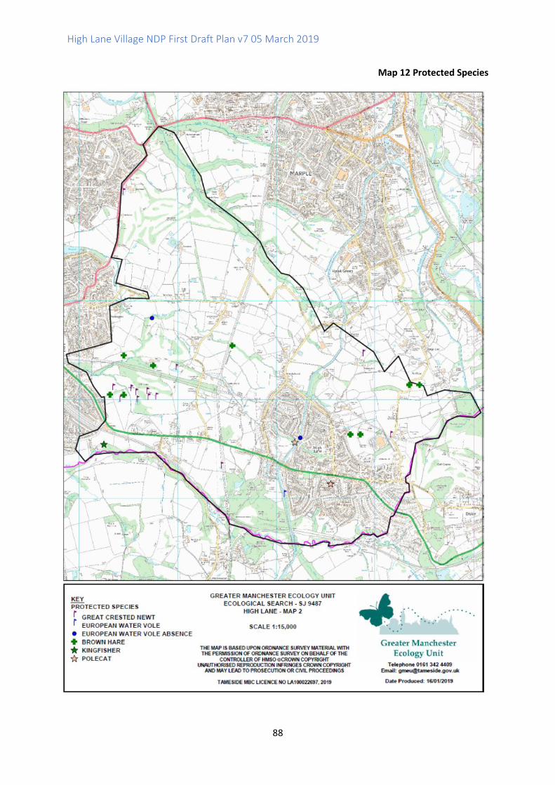
High Lane Village NDP First Draft Plan v7 05 March 2019
88
Map 12 Protected Species
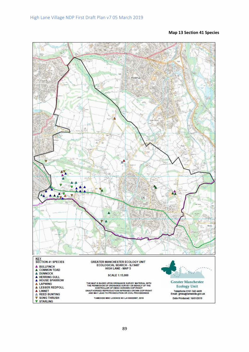
High Lane Village NDP First Draft Plan v7 05 March 2019
89
Map 13 Section 41 Species
High Lane Village NDP First Draft Plan v7 05 March 2019
90
Appendix 9 Listed Buildings
Historic England List of Statutory Listed Buildings (Designated Heritage Assets)
(reference: https://historicengland.org.uk/listing/the-list/)
Macclesfield Canal Bridges:
NUMBER 6 (BROADHURST'S BRIDGE) ON MACCLESFIELD CANAL Designation Type: Listing Grade: II
NUMBER 7 (HYDE ROAD FOOTBRIDGE) ON MACCLESFIELD CANAL Designation Type: Listing Grade: II
NUMBER 8 (BANCROFT'S BRIDGE) ON MACCLESFIELD CANAL Designation Type: Listing Grade: II
NUMBER 9 (WINDLEHURST BRIDGE) ON MACCLESFIELD CANAL Designation Type: Listing Grade: II
NUMBER 10 (BROADHURST'S BRIDGE) ON MACCLESFIELD CANAL Designation Type: Listing Grade: II
BRIDGE NUMBER 11 ON MACCLESFIELD CANAL Designation Type: Listing Grade: II
BRIDGE NUMBER 12 OVER HIGH LANE ARM AT SJ 9502 8519 ON MACCLESFIELD CANAL Designation
Type: Listing Grade: II
Church of St Thomas and Lychgate Designation Type: Listing Grade: II
High Lane War Memorial Designation Type: Listing Grade: II
LOMBER HEY HOUSE Designation Type: Listing Grade: II
MARSDEN HOUSE Designation Type: Listing Grade: II
MILE POST AT JUNCTION WITH MIDDLEWOOD ROAD Designation Type: Listing Grade: II
THE OLD COURT HOUSE Designation Type: Listing Grade: II
OUTBUILDING TO NORTH OF WYBERSLEY HALL Designation Type: Listing Grade: II
WYBERSLEY HALL Designation Type: Listing Grade: II
MILESTONE ADJACENT TO BRIDGE NUMBER 10 ON MACCLESFIELD CANAL Designation Type: Listing
Grade: II
Moated site north-west of Broadoak Farm Designation Type: Scheduling Grade: Not Applicable to
this List Entry
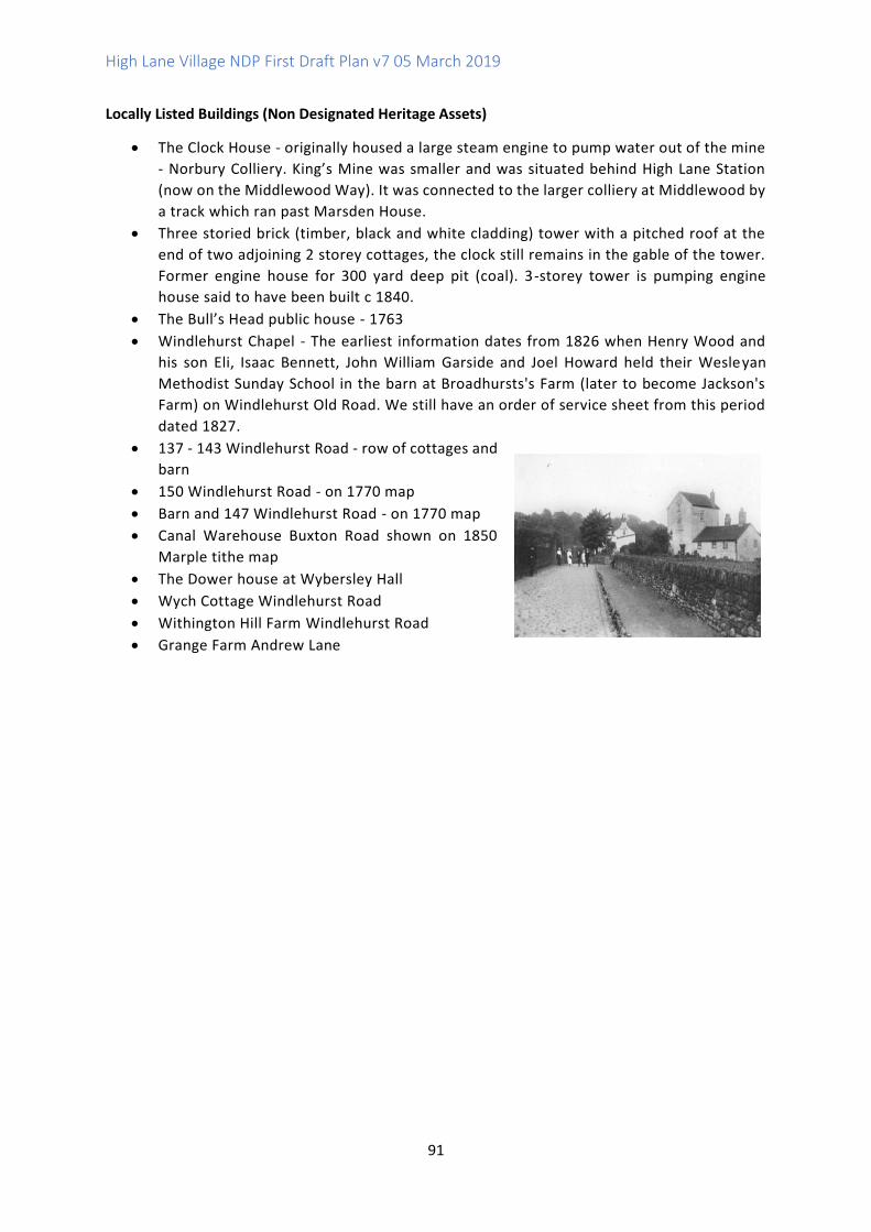
High Lane Village NDP First Draft Plan v7 05 March 2019
91
Locally Listed Buildings (Non Designated Heritage Assets)
• The Clock House - originally housed a large steam engine to pump water out of the mine
- Norbury Colliery. King’s Mine was smaller and was situated behind High Lane Station
(now on the Middlewood Way). It was connected to the larger colliery at Middlewood by
a track which ran past Marsden House.
• Three storied brick (timber, black and white cladding) tower with a pitched roof at the
end of two adjoining 2 storey cottages, the clock still remains in the gable of the tower.
Former engine house for 300 yard deep pit (coal). 3-storey tower is pumping engine
house said to have been built c 1840.
• The Bull’s Head public house - 1763
• Windlehurst Chapel - The earliest information dates from 1826 when Henry Wood and
his son Eli, Isaac Bennett, John William Garside and Joel Howard held their Wesleyan
Methodist Sunday School in the barn at Broadhursts's Farm (later to become Jackson's
Farm) on Windlehurst Old Road. We still have an order of service sheet from this period
dated 1827.
• 137 - 143 Windlehurst Road - row of cottages and
barn
• 150 Windlehurst Road - on 1770 map
• Barn and 147 Windlehurst Road - on 1770 map
• Canal Warehouse Buxton Road shown on 1850
Marple tithe map
• The Dower house at Wybersley Hall
• Wych Cottage Windlehurst Road
• Withington Hill Farm Windlehurst Road
• Grange Farm Andrew Lane
High Lane Village NDP First Draft Plan v7 05 March 2019
92
Prepared by High Lane Village Neighbourhood Forum Steering Group
March 2019