Embed Size (px)
Citation preview
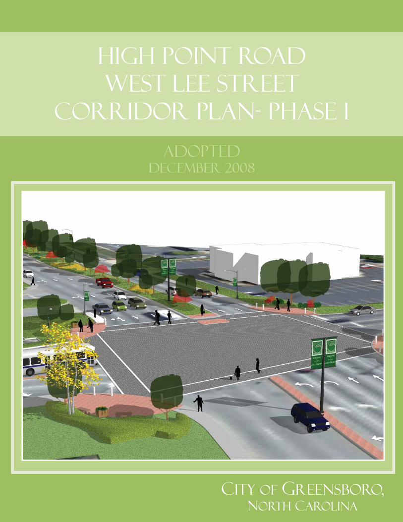
High Point RoadWest Lee Street
Corridor Plan- PHASE I
City of Greensboro,NORTH CAROLINA
ADOPTED DECEMBER 2008

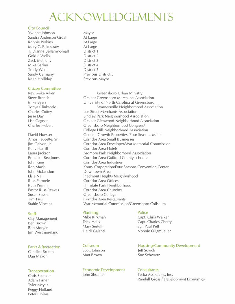
City CouncilYvonne Johnson MayorSandra Anderson Groat At LargeRobbie Perkins At LargeMary C. Rakestraw At LargeT. Dianne Bellamy-Small District 1Goldie Wells District 2Zack Methany District 3Mike Barber District 4Trudy Wade District 5Sandy Carmany Previous District 5Keith Holliday Previous Mayor
Citizen Committee Rev. Mike Aiken Greensboro Urban Ministry Steve Branch Greater Greensboro Merchants Association Mike Byers University of North Carolina at Greensboro Tonya Clinkscale Warnersville Neighborhood Association Charles Coffey Lee Street Merchants Association Jesse Day Lindley Park Neighborhood Association Lisa Gagnon Greater Glenwood Neighborhood Association Charles Hebert Greensboro Neighborhood Congress/ College Hill Neighborhood Association David Huesser General Growth Properties (Four Seasons Mall) Amos Faucette, Sr. Corridor Area Small Businesses Jim Galyon, Jr. Corridor Area Developer/War Memorial Commission Kelly Harrill Corridor Area Hotels Laura Jackson Ardmore Park Neighborhood Association Principal Bea Jones Corridor Area Guilford County schools John King Corridor Area Industries Ron Mack Koury Corporation/Four Seasons Convention Center John McLendon Downtown Area Elsie Nall Piedmont Heights Neighborhood Russ Parmele Corridor Area Offi ces Ruth Primm Hillsdale Park Neighborhood Pastor Russ Reaves Corridor Area Churches Susan Sessler Greensboro College Tim Tsujii Corridor Area Restaurants Stahle Vincent War Memorial Commission/Greensboro Coliseum
Staff City ManagementBen Brown Bob MorganJim Westmoreland
Parks & RecreationCandice Bruton Dan Maxon
TransportationChris Spencer Adam FisherTyler MeyerPeggy HollandPeter Ohlms
AC
KN
OW
LE
DG
EM
EN
TS
ACKNOWLEDGEMENTS
PlanningMike KirkmanDick HailsMary SertellHeidi Galanti
Police Capt. Chris Walker Capt. Charles CherrySgt. Paul PellNonnie Oligmueller
ColiseumScott Johnson Matt Brown
Housing/Community DevelopmentJeff SovichSue Schwartz
Economic DevelopmentJohn Shoffner
Consultants:Teska Associates, Inc.Randall Gross / Development Economics
Executive summaryThe High Point Road/West Lee Street Corridor Plan is the result of the combined efforts of community members, City staff, and consultants to prepare a guide for future development and redevelopment of a key reinvestment corridor identifi ed in the City of Greensboro’s Connections 2025 Comprehensive Plan. Beginning in January 2007, and concluding with offi cial adoption in December 2008, the preparation of the Plan was guided by a 24 member citizen committee representing the interests of residents, property-owners, neighborhood associations, business operators, corridor users, and major facilities including UNCG, the Coliseum Complex, the Koury Convention Center/Four Seasons Mall, and hotels. The High Point Road/West Lee Street Corridor extends from South Eugene Street on the east to the western city limit, just past Groometown Road and Hilltop Road on the west. For planning purposes, the corridor has been subdivided into two phases: Phase I, from South Eugene Street on the east to the Koury Convention Center on the west, is addressed in this document. A subsequent planning process and a Phase II document are planned.
Reinvestment and land use in the High Point Road/West Lee Street corridor will be focused around a series of “villages” linked to key drivers of activity. The three villages are:
These villages are further defi ned with specifi c recommendations for future development within 14 identifi ed opportunity sites located throughout the corridor.
The Corridor Plan presents a coherent strategy to coordinate signifi cant public and private investment to overcome an existing decline in character, property values, business district strength, and neighborhood vitality. Like any planning document, it will only have value if the plan is adopted, embraced and made fundamental to the decision-making of corridor area property owners, developers, and the commissions and agencies that govern the corridor. To ensure effective implementation, the Corridor Plan includes an Action Plan which identifi es short, medium and long term actions necessary to achieve the plan’s stated goals and objectives. Recommended actions include:
University/Mixed Use Village (related to UNCG, Greensboro College and to a lesser degree
NC A&T, Bennett College and Elon Law School);
Sports, Recreation and Fitness Village (related primarily to the Coliseum and UNCG); and
Hospitality Village (related to Koury Convention Center, Four Seasons Mall, Meadowview
Offi ce Park and signifi cant concentration of hotels around I-40).
1.
2.
3.
Corridor appearance improvements, based on a Conceptual Streetscape Plan;
Reconfi gured roadway to improve corridor safety and encourage new patterns of
investment;
Removal of barriers and impediments to pedestrians, bicyclists and transit riders to provide
safe and attractive access to corridor area destinations (i.e. UNCG, Coliseum, Convention
Center/Mall, greenways, offi ce park, etc.);
1.
2.
3.
The High Point Road/West Lee Street Corridor Plan incorporates recommendations from other previously adopted plans (Glenwood Neighborhood Plan, UNCG Master Plan) for this area and will serve as the guiding document for future public and private investment along High Point Road and West Lee Street. This Plan will also be used as a guide for future reinvestment corridor plans outlined in the Connections 2025 Comprehensive Plan, including Phase 2 of High Point Road that will address areas between I-40 and Groometown/Hilltop Roads.
Enhancing and leveraging existing corridor assets including expansion of the University
of North Carolina Greensboro campus onto the corridor, additional facilities related to the
Coliseum Complex, and the promotion of expanded hospitality services and facilities to
support the Coliseum and Convention Center/Mall;
Adaptive reuse of existing sound and historic/unique properties;
Encouraging mixed use buildings and mixed use sites for greater economic diversity and
more “eyes on the street”;
Corridor zoning overlay districts to encourage higher densities and mixture of land uses
with more specifi c site and building design standards to promote sustainable development
and allow expanded transportation options;
Enhanced crime prevention through education, physical improvements and expanded/
targeted resources;
Creating a transit focused corridor with enhanced density supporting future transit
development/expansion;
Creation of a formal citizen group (Corridor Development Board) to oversee Plan
implementation and facilitate development partnerships
Development and implementation of a comprehensive corridor marketing strategy
Increasing direct access to the UNCG campus from the corridor, including new
pedestrian/bicyclist underpass
4.
5.
6.
7.
8.
9.
10.
11.
12.

Page Intentionally Left Blank
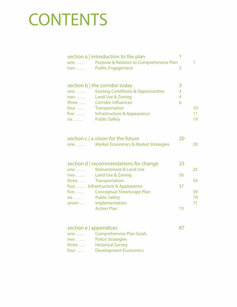
section a | introduction to the plan 1 one . . . . . Purpose & Relation to Comprehensive Plan 1
two . . . . . Public Engagement 2
section b | the corridor today 3one . . . . . Existing Conditions & Opportunities 3
two . . . . . Land Use & Zoning 4
three . . . . Corridor Infl uences 6
four . . . . Transportation 10
fi ve . . . . . Infrastructure & Appearance 11
six . . . . . Public Safety 19
section c | a vision for the future 20 one . . . . . Market Economics & Market Strategies 20
section d | recommendations for change 25one . . . . . Reinvestment & Land Use 25
two . . . . . Land Use & Zoning 50
three . . . . Transportation 54
four . . . . . Infrastructure & Appearance 57
fi ve . . . . . Conceptual Streetscape Plan 59
six . . . . . Public Safety 70
seven . . . . Implementation 71
Action Plan 73
section e | appendices 87one . . . . . Comprehensive Plan Goals
two . . . . . Police Strategies
three . . . . Historical Survey
four . . . . Development Economics
CONTENTS

Page Intentionally Left Blank
High Point Road/West Lee Street Corridor Plan PHASE I SECTION
PAGE
1A1) Purpose and Relation to Comprehensive Plan
The City of Greensboro’s Connections 2025 Comprehensive Plan (adopted May 2003) identifi ed a number of reinvestment corridors, including High Point Road and West Lee Street, throughout the city. These reinvestment corridors are “older commercial corridors that would benefi t from signifi cant public and private investment to enhance their economic viability and strengthen adjacent neighborhoods.” The High Point Road and West Lee Street corridor was also designated as a visual enhancement corridor as a “thoroughfare that carries large amounts of traffi c and would benefi t from public physical improvements to address visual character. These improvements could include public/private partnerships.”
As initially designated in the Comprehensive Plan, the High Point Road/West Lee Street reinvestment corridor stretches from South Eugene Street at the edge of downtown to just west of Groometown/Hilltop Roads, at the city limits. Given its signifi cant length, it was determined that plans for the High Point Road/West Lee Street corridor should be addressed in two phases. Phase 1 of the corridor, the subject of this Plan, extends from South Eugene Street to Interstate 40. This section connects a number of signifi cant areas of activity for Greensboro including the downtown area, portions of the UNCG and Greensboro College campuses, the Greensboro Coliseum complex and the Koury Convention Center and Four Seasons Mall. Additional areas west of I-40 are also included for some planning and coordination purposes as a result of the public process that developed this Plan.
As a recommended implementation step of the adopted Comprehensive Plan, this Plan for the High Point Road/ West Lee Street corridor addresses a number of written goals and policies of the adopted Comprehensive Plan including promoting compatible infi ll and reinvestment, preserving and enhancing the City’s built environment and adjacent neighborhoods and creating opportunities for businesses, residents and visitors to use a variety of transportation options for corridor and citywide destinations.
The High Point Road/West Lee Street Corridor Plan identifi es strategies to encourage signifi cant new public and private investment, including mixed and higher intensity uses where appropriate; encourage the incorporation of multiple transportation options throughout the corridor while maintaining existing and predicted auto capacity; improve the overall appearance, safety and function of the corridor; enhance adjacent neighborhoods; and connect and enhance key public and private assets already located in this area.
SECTION A: Introduction to the Plan
INT
RO
DU
CT
ION
TO
TH
E P
LA
N
A1
High Point Road/West Lee Street Corridor Plan PHASE I
PAGE
SECTION
2A2) Public Engagement
As active public participation is vital to the success of any plan, the City of Greensboro Planning Department worked diligently to engage a variety of potential stakeholders throughout the Plan’s development. A series of stakeholder meetings including property owners, business groups, adjacent neighborhoods and economic development interests were held prior to and just following the project kickoff to identify major points of concern and potential opportunities. Staff continued these stakeholder conversations (25 meetings) throughout the planning process. The kickoff meeting in January 2007, attended by over 70 people, engaged citizens in identifying major strengths, weaknesses, opportunities and threats for the corridor to provide initial priorities for the Plan to address. Staff also established a project website around this time and contact lists to provide periodic updates and major project milestones on the Plan process and encourage feedback on various pieces of information.
Composed in part of volunteers at the project kickoff meeting, a 24 member citizen committee (see Acknowledgements), representing a variety of corridor and citywide interests, was convened to guide the Plan’s development. This committee met on an as needed basis (a total of 8 times) to assist staff and project consultants in setting Plan priorities and evaluating proposed recommendations and strategies included with this Plan.
Another large community meeting held in November 2007 outlined major issues and concepts, as determined by staff, citizens and the design and marketing consultants hired to assist with this Plan. Additional time was requested by the public for adequate review and input of these concepts. Major components of the Corridor Plan were reviewed by the Citizen Committee throughout 2008, and presented in brief to the City Council. A fi nal community meeting was held in October 2008 to review the full draft Corridor Plan, with public hearings before the Planning Board in November 2008 and City Council in December 2008, after which the Plan was offi cially adopted.
INT
RO
DU
CT
ION
TO
TH
E P
LA
N
A2
High Point Road/West Lee Street Corridor Plan PHASE I SECTION
PAGE
3B1) Existing Conditions and Opportunities
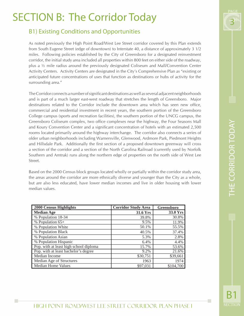
As noted previously the High Point Road/West Lee Street corridor covered by this Plan extends from South Eugene Street (edge of downtown) to Interstate 40, a distance of approximately 3 1/2 miles. Following policies established by the City of Greensboro for a designated reinvestment corridor, the initial study area included all properties within 800 feet on either side of the roadway, plus a ½ mile radius around the previously designated Coliseum and Mall/Convention Center Activity Centers. Activity Centers are designated in the City’s Comprehensive Plan as “existing or anticipated future concentrations of uses that function as destinations or hubs of activity for the surrounding area.”
The Corridor connects a number of signifi cant destinations as well as several adjacent neighborhoods and is part of a much larger east-west roadway that stretches the length of Greensboro. Major destinations related to the Corridor include the downtown area which has seen new offi ce, commercial and residential investment in recent years, the southern portion of the Greensboro College campus (sports and recreation facilities), the southern portion of the UNCG campus, the Greensboro Coliseum complex, two offi ce complexes near the highway, the Four Seasons Mall and Koury Convention Center and a signifi cant concentration of hotels with an estimated 2,500 rooms located primarily around the highway interchange. The corridor also connects a series of older urban neighborhoods including Warnersville, Glenwood, Ardmore Park, Piedmont Heights and Hillsdale Park. Additionally the fi rst section of a proposed downtown greenway will cross a section of the corridor and a section of the North Carolina Railroad (currently used by Norfolk Southern and Amtrak) runs along the northern edge of properties on the north side of West Lee Street.
Based on the 2000 Census block groups located wholly or partially within the corridor study area, the areas around the corridor are more ethnically diverse and younger than the City as a whole, but are also less educated, have lower median incomes and live in older housing with lower median values.
SECTION B: The Corridor Today
TH
E C
OR
RID
OR
TO
DA
Y
B1
2000 Census Highlights Corridor Study Area GreensboroMedian Age 31.6 Yrs 33.0 Yrs% Population 18-34% Population 65+% Population White% Population Black% Population Asian% Population HispanicPop. with at least high school diplomaPop. with at least bachelor’s degreeMedian IncomeMedian Age of StructuresMedian Home Values
39.8%9.5%
50.1%40.5%5.3%6.4%
15.7%9.2%
$30,7511963
$97,031
30.8%11.9%55.5%37.4%2.8%4.4%
53.6%21.6%
$39,6611974
$104,700
High Point Road/West Lee Street Corridor Plan PHASE I
PAGE
SECTION
4B2) Land Use and Zoning
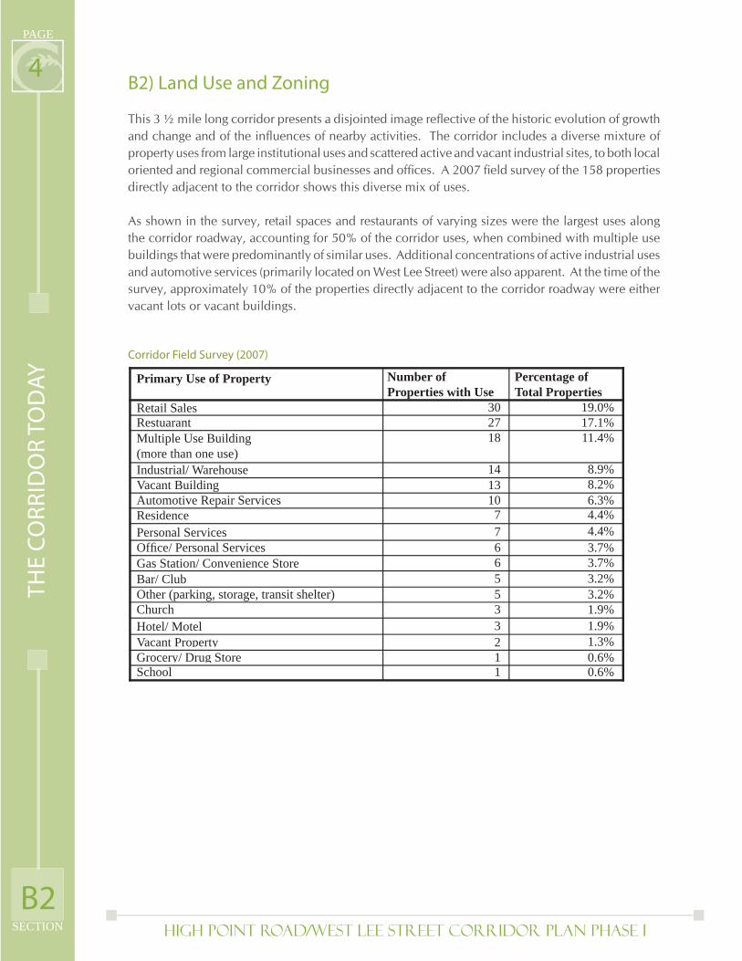
This 3 ½ mile long corridor presents a disjointed image refl ective of the historic evolution of growth and change and of the infl uences of nearby activities. The corridor includes a diverse mixture of property uses from large institutional uses and scattered active and vacant industrial sites, to both local oriented and regional commercial businesses and offi ces. A 2007 fi eld survey of the 158 properties directly adjacent to the corridor shows this diverse mix of uses.
As shown in the survey, retail spaces and restaurants of varying sizes were the largest uses along the corridor roadway, accounting for 50% of the corridor uses, when combined with multiple use buildings that were predominantly of similar uses. Additional concentrations of active industrial uses and automotive services (primarily located on West Lee Street) were also apparent. At the time of the survey, approximately 10% of the properties directly adjacent to the corridor roadway were either vacant lots or vacant buildings.
Corridor Field Survey (2007)
TH
E C
OR
RID
OR
TO
DA
Y
B2
Primary Use of Property Number ofProperties with Use
Percentage ofTotal Properties
Retail SalesRestuarantMultiple Use Building(more than one use)Industrial/ WarehouseVacant BuildingAutomotive Repair ServicesResidencePersonal ServicesOffi ce/ Personal ServicesGas Station/ Convenience StoreBar/ ClubOther (parking, storage, transit shelter)ChurchHotel/ MotelVacant PropertyGrocery/ Drug StoreSchool
302718
14131077665533211
19.0%17.1%11.4%
8.9%8.2%6.3%4.4%4.4%3.7%3.7%3.2%3.2%1.9%1.9%1.3%0.6%0.6%
High Point Road/West Lee Street Corridor Plan PHASE I SECTION
PAGE
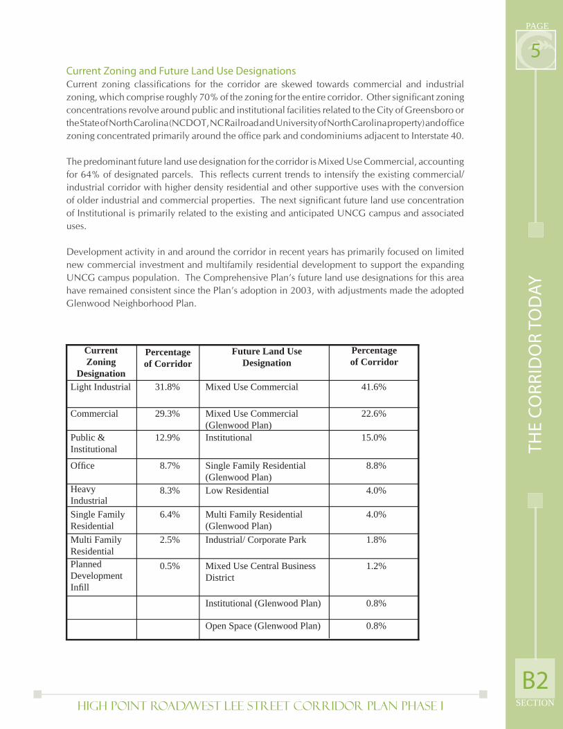
5Current Zoning and Future Land Use DesignationsCurrent zoning classifi cations for the corridor are skewed towards commercial and industrial zoning, which comprise roughly 70% of the zoning for the entire corridor. Other signifi cant zoning concentrations revolve around public and institutional facilities related to the City of Greensboro or the State of North Carolina (NCDOT, NC Railroad and University of North Carolina property) and offi ce zoning concentrated primarily around the offi ce park and condominiums adjacent to Interstate 40.
The predominant future land use designation for the corridor is Mixed Use Commercial, accounting for 64% of designated parcels. This refl ects current trends to intensify the existing commercial/industrial corridor with higher density residential and other supportive uses with the conversion of older industrial and commercial properties. The next signifi cant future land use concentration of Institutional is primarily related to the existing and anticipated UNCG campus and associated uses. Development activity in and around the corridor in recent years has primarily focused on limited new commercial investment and multifamily residential development to support the expanding UNCG campus population. The Comprehensive Plan’s future land use designations for this area have remained consistent since the Plan’s adoption in 2003, with adjustments made the adopted Glenwood Neighborhood Plan.
TH
E C
OR
RID
OR
TO
DA
Y
B2
Current Zoning
DesignationLight Industrial
Commercial
Public &Institutional
Offi ce
Heavy IndustrialSingle FamilyResidentialMulti FamilyResidentialPlannedDevelopmentInfi ll
Percentageof Corridor
Future Land UseDesignation
Percentageof Corridor
31.8%
29.3%
12.9%
8.7%
8.3%
6.4%
2.5%
0.5%
Mixed Use Commercial
Mixed Use Commercial(Glenwood Plan)Institutional
Single Family Residential(Glenwood Plan)Low Residential
Multi Family Residential(Glenwood Plan)Industrial/ Corporate Park
Mixed Use Central BusinessDistrict
Institutional (Glenwood Plan)
Open Space (Glenwood Plan)
41.6%
22.6%
15.0%
8.8%
4.0%
4.0%
1.8%
1.2%
0.8%
0.8%
High Point Road/West Lee Street Corridor Plan PHASE I
PAGE
SECTION
6B3) Corridor Infl uences
The corridor is heavily infl uenced by several key activity centers described, east to west, as downtown Greensboro and Greensboro College; the UNCG campus; the Coliseum Complex; and Interstate 40/Koury Convention Center Mall. These major infl uences affect both historic and predicted patterns of development in the corridor and are linked to a series of 14 opportunity sites that have been identifi ed as areas where opportunities exist for signifi cant new investment.
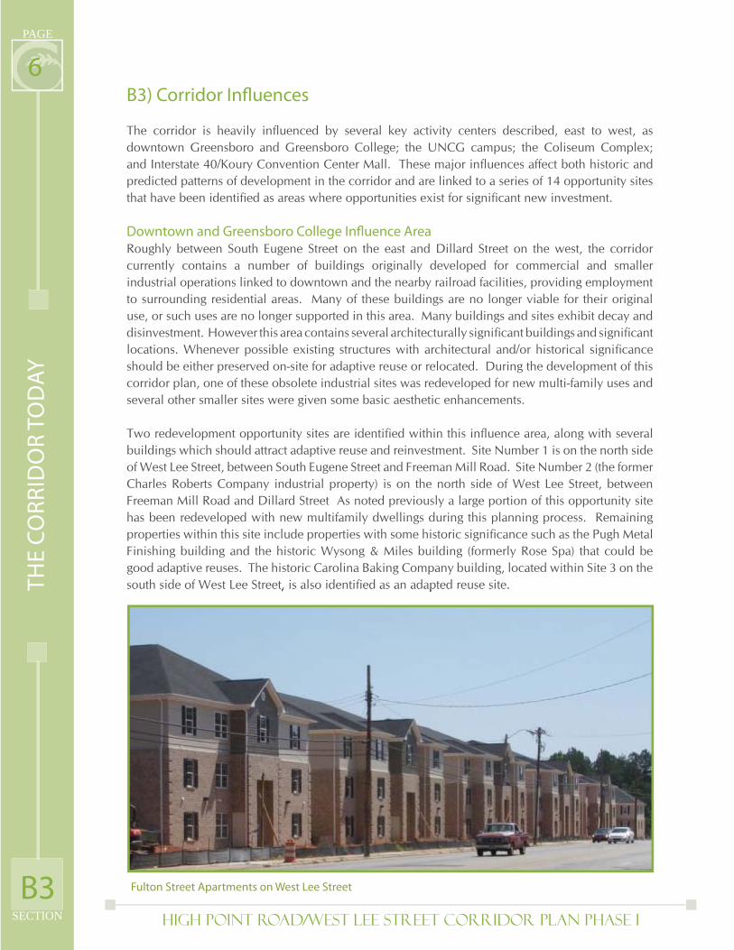
Downtown and Greensboro College Infl uence AreaRoughly between South Eugene Street on the east and Dillard Street on the west, the corridor currently contains a number of buildings originally developed for commercial and smaller industrial operations linked to downtown and the nearby railroad facilities, providing employment to surrounding residential areas. Many of these buildings are no longer viable for their original use, or such uses are no longer supported in this area. Many buildings and sites exhibit decay and disinvestment. However this area contains several architecturally signifi cant buildings and signifi cant locations. Whenever possible existing structures with architectural and/or historical signifi cance should be either preserved on-site for adaptive reuse or relocated. During the development of this corridor plan, one of these obsolete industrial sites was redeveloped for new multi-family uses and several other smaller sites were given some basic aesthetic enhancements.
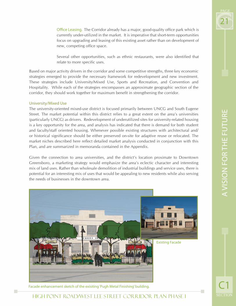
Two redevelopment opportunity sites are identifi ed within this infl uence area, along with several buildings which should attract adaptive reuse and reinvestment. Site Number 1 is on the north side of West Lee Street, between South Eugene Street and Freeman Mill Road. Site Number 2 (the former Charles Roberts Company industrial property) is on the north side of West Lee Street, between Freeman Mill Road and Dillard Street As noted previously a large portion of this opportunity site has been redeveloped with new multifamily dwellings during this planning process. Remaining properties within this site include properties with some historic signifi cance such as the Pugh Metal Finishing building and the historic Wysong & Miles building (formerly Rose Spa) that could be good adaptive reuses. The historic Carolina Baking Company building, located within Site 3 on the south side of West Lee Street, is also identifi ed as an adapted reuse site.
Fulton Street Apartments on West Lee StreetB3
TH
E C
OR
RID
OR
TO
DA
Y
High Point Road/West Lee Street Corridor Plan PHASE I SECTION
PAGE
7UNCG Infl uence AreaThe University of North Carolina-Greensboro campus lies north of the corridor and the largely parallel North Carolina Railroad. Though the University has acquired several parcels lying between West Lee Street and the Railroad, their current use has been for vehicular parking. Aside from the University Logo on the City’s elevated water tank at South Aycock Street, and the view of some of the newer, taller university structures on campus, there is limited visible evidence of the University on the corridor at this time. The physical condition and character of West Lee Street, including the limited number (and unattractive condition) of grade-separated rail crossings has generally kept campus development north of the NCRR right-of-way. However, the latest UNCG Master Plan, adopted at the end of 2007, notes much of the north side of West Lee Street for potential future campus expansion. Additionally, predicted student growth in coming years has created expanded opportunities for university oriented private development, such as the new Fulton Street Apartments on West Lee Street.
This segment of the corridor is currently a mix of non-retail businesses and industries in older buildings along with retail uses in buildings appearing to date from the 1930s through the 1970s. Many of the businesses, either used car dealers, auto repair businesses or business-to-business services, use considerable portions of their sites for parking and traffi c circulation. In this area lot depths vary but are generally too shallow for many contemporary commercial activities; squeezed on the north by the railroad right-of-way and on the south by homes and buildings in the Glenwood Neighborhood.
Several opportunities exist for infi ll, redevelopment or adaptive reuse. On the north side of West Lee Street, between Tate Street and Highland Avenue, the building which dominates the block and the corridor, used most recently by Industries of the Blind, is likely to be vacant and presents either an adaptive reuse or redevelopment opportunity. Site 4, the uninterrupted north side of West Lee Street between Highland Avenue and South Aycock Street, is directly to the south and across the NCRR R.O.W. from the UNCG campus. This site presents a considerable opportunity for the establishment of a UNCG “face” on West Lee Street. Site 5, between Lexington Avenue on the east and McCormick Street on the west currently supports several existing auto-oriented businesses with little buffering to separate it from the Glenwood Neighborhood. This site is perceived to offer an opportunity for redevelopment that presents a welcome gateway into the Glenwood Neighborhood.
Coliseum Complex Infl uence AreaThe Coliseum Complex accommodates events which have local, regional and national attraction and generate signifi cant infl uences (traffi c impacts, off-site hospitality and entertainment expenditures) well beyond the boundaries of the complex itself. It is the hinge of the corridor, where West Lee Street becomes High Point Road. Areas infl uenced by the Coliseum complex, from South Aycock Street on the east to West Florida Street on the southwest, encompass as much as 40 percent of the corridor roadway frontage. On site, the complex of large scale buildings clustered at the north end of the site with large scale surface parking lots dominating the south and east sides of the site presents a challenging scale with only walls, service areas, parking areas and landscape buffers addressed to the street.
B3
TH
E C
OR
RID
OR
TO
DA
Y
High Point Road/West Lee Street Corridor Plan PHASE I
PAGE
SECTION
8With the exception of parking facilities shared with UNCG, there is little directly related to the Coliseum facility beyond the main complex and parking lots. To the east of the Coliseum, West Lee Street presents a series of deteriorating single-story industrial and commercial buildings that support small scale retail operations and many auto-related uses with accompanying on-site vehicle storage. Most of the sites between Warren Street and Coliseum Boulevard, on the south side of West Lee Street, are currently used for the storage of trailers. With the exception of a patch of landscaping in front of a sporting goods/outdoor recreation retailer, these sites present little but buildings and paving from one end to the other, contributing to a bleak image. This segment is one of the only areas along the corridor in which uses fronting the corridor extend more than a block deep into the adjacent neighborhood. The north side of West Lee Street presents three distinct “blocks”: a relatively new restaurant and fuel/convenience store at the north west corner of Aycock and West Lee Street; the mixed and adaptively reused industrial complex in the center (major uses include self storage and a bar/night club); and the UNCG/Coliseum parking lot from Warren Street to Chapman Street
The Coliseum is at the confl uence of several signifi cant roads, each accommodating a portion of traffi c fl owing to and from the facility, and each presenting a different image/character. In addition to the transition between West Lee Street and High Point Road, this confl uence also includes Patterson Street from the west (linked to I-40) and Coliseum Boulevard from the south (linked to US 220 and the Greensboro Urban Loop). Coliseum Boulevard is (with the exception of the nights/weekends of events at the Coliseum) a relatively quiet collector street running through adjacent neighborhoods. In contrast, Patterson Street is an industrial and warehouse corridor nestled between the Ardmore Park and Lindley Park neighborhoods and the NCRR right-of-way.
High Point Road serves a series of independent businesses in buildings, often ringed by parking lots, that evidence a more recent period of development in which automobile access was the dominant site design characteristic. One or more separate curb-cut access points to High Point Road, independent of the access, circulation and parking on the adjoining site is a common theme of this portion of the corridor. The most visible deviation from this pattern is the former Canada Dry bottling and distribution facility adjacent to the Coliseum Complex, between Patterson Road and Ellington Street This building, with an attractive architectural façade on High Point Road has been the subject of both public speculation and interest by the Coliseum operators as a potential public adaptive reuse. The planning process identifi ed several opportunity sites within the Coliseum Infl uence Area. Beginning on the east, Site 6 lies on the south side of West Lee Street, between Fuller Street and Coliseum Boulevard This may constitute several independent redevelopment efforts which collectively can connect the UNCG and Coliseum areas. Site 7, on the north side of West Lee Street is the UNCG/Coliseum parking lot which, perceived by the public as an underutilization of the site, presents opportunities for infi ll development and an additional University “face” on the corridor.
The Coliseum Complex itself, Site 8, presents multiple sub-areas in which the conversion of surface parking to structured parking could free up areas for additional event/exhibit and recreation/entertainment facilities, as well as other supportive uses. Site 9, between Patterson Ct. and Patterson Street, on the west side of High Point Road includes a vacant lot and an aging warehouse complex. Site 10, between Patterson Street and Ellington Street is a series of independent auto-service and auto-oriented businesses in disconnected single-story buildings evidencing physical decay and obsolescence.B3
TH
E C
OR
RID
OR
TO
DA
Y
High Point Road/West Lee Street Corridor Plan PHASE I SECTION
PAGE
9Interstate/Convention Center Infl uence AreaThe interchange of High Point Road and Interstate 40 combines high regional accessibility with the capacity and visibility of the Koury Convention Center, Four Seasons Town Center shopping mall and a signifi cant concentration of hotels. Given the relative proximity to the nearby Coliseum complex, this area presents ideal conditions for greater development of hospitality and entertainment businesses.
The cemetery located on the east side of High Point Road, between Vanstory Street and Grimsley Street presents the only break in the continuous frontage of restaurants, hotels, and retail buildings between Florida Street and Interstate 40. Site conditions improve and the age of buildings decreases moving east to west as contemporary businesses compete for proximity and visibility from Interstate 40.
Opportunity sites closest to West Florida Street are on properties fronting High Point Road, while opportunities closest to the Interstate are deeper, more complex and more likely to be infi ll and expansion of existing offi ce and hospitality uses. Opportunity Site 11 encompasses vacant property in Ardmore Park, between Immanuel Road and Williams Street; that while not directly related to hospitality uses, appears appropriate for residential infi ll that could strengthen the associated Ardmore Park neighborhood and redevelopment opportunities along High Point Road. Opportunity Site 12 around the intersection of West Florida Street and High Point Road includes properties of relatively signifi cant depth, contains existing aging single-story retail structures and site improvements tending toward obsolescence. These properties lack adequate buffer to adjacent residential uses, and will require more sensitivity to adjacent uses. Site 13, on the west side of High Point Road, between Dexter Avenue and West Meadowview Road, is an existing underutilized retail center with signifi cant setbacks which afford the opportunity for infi ll and greater intensity. Site 14 on the east side of High Point Road, between Vanstory Street and the Interstate is a relatively contemporary development of mixed uses including offi ce, hotel, and restaurant uses which can accommodate additional infi ll in support of a critical mass of hospitality uses. Additional reinvestment and introduction of greater diversity is anticipated within the existing and attractive Meadowview Business Park to the northwest of High Point Road along Meadowview Road. There are also opportunities for residential development complementary to the adjacent Hillsdale Park neighborhood.
B3
TH
E C
OR
RID
OR
TO
DA
Y
High Point Road/West Lee Street Corridor Plan PHASE I
PAGE
SECTION
10B4) Transportation The High Point Road/West Lee Street corridor is one of the most heavily traveled corridors within the City of Greensboro, averaging 24,000 trips a day on the eastern end to 32,000 trips a day on the western end. Major Coliseum events can typically add an additional 7,000 trips to these totals. The Corridor is currently served by two bus routes. Bus route 11 (which also provides connections to the GTCC campus in Jamestown) travels the entire length of the corridor and a portion of Bus Route 2 serves portions of the corridor from Glenwood Avenue to Tate Street along West Lee Street and from Pinecroft Road to Meadowview Road along High Point Road. Additionally one HEAT route (focused on serving universities and students) runs along West Lee Street from Fulton Street to Tate Street. There are approximately 31 bus stops throughout the corridor. However the facilities for these bus stops vary greatly from dedicated bus shelters with route information and seating, to simple route signs affi xed to utility poles. Easy access to these bus stops also varies somewhat depending on their location and the layout of adjacent development.
Pedestrian use of the corridor is limited due to a lack of safe and easily navigable crossing points and lack of destinations easily accessible by foot. Sidewalks are present on both sides of the roadway along the vast majority of the corridor. However, existing sidewalks in many places are in need of repair, are not up to current city standards (5 ft minimum width with planter strip or 6 ft. minimum width without planter strip) or are limited in potential use due to a variety of obstacles including overhead utility poles, fi re hydrants, utility boxes and other public and private fi xtures. Additionally, while most of High Point Road and West Lee Street have existing sidewalks, there are gaps between this network and destinations in close proximity to the corridor.
While High Point Road and West Lee Street are used to some degree by bicyclists there are no dedicated bicycle facilities along the roadway, with bicycles sharing outside lanes with auto traffi c, which are wider in some areas than others. The City has two existing dedicated bicycle lanes along Spring Garden Street, just north of the corridor, and along West Florida Street, signed Route 12, which directly intersects High Point Road. Signed ‘Bicycle Route 9’ is on Chapman Street and Coliseum Boulevard.
There is an existing North Carolina Railroad line (currently in use by Amtrak and Norfolk Southern) that runs north of the corridor. This has been designated a high-speed rail corridor by the Federal Rail Administration. While some passenger rail service currently uses this line (primarily the Carolinian that runs from Charlotte to Raleigh and the Crescent that runs from New York to New Orleans) this route is also being evaluated for future regional rail service connecting the majority of the Triad. These initial assessments include the potential for future rail stops around UNCG and the Coliseum for commuters and special events. Areas on the north side of the railroad tracks are connected to the High Point Road/West Lee Street corridor by four underpasses at Chapman Street, South Aycock Street, Tate Street and Fulton Street. As a result of poor appearance, lack of adequate lighting and poorly maintained sidewalks and landscaping these underpasses are perceived to be unsafe or undesirable by pedestrians and bicyclists, and have provided limited access to the UNCG campus and other destinations north of the corridor.
B4
TH
E C
OR
RID
OR
TO
DA
Y
High Point Road/West Lee Street Corridor Plan PHASE I SECTION
PAGE
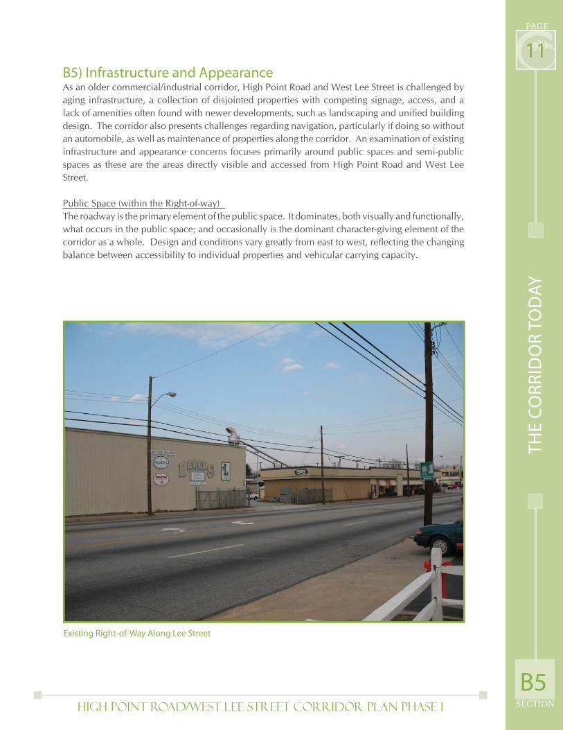
11B5) Infrastructure and AppearanceAs an older commercial/industrial corridor, High Point Road and West Lee Street is challenged by aging infrastructure, a collection of disjointed properties with competing signage, access, and a lack of amenities often found with newer developments, such as landscaping and unifi ed building design. The corridor also presents challenges regarding navigation, particularly if doing so without an automobile, as well as maintenance of properties along the corridor. An examination of existing infrastructure and appearance concerns focuses primarily around public spaces and semi-public spaces as these are the areas directly visible and accessed from High Point Road and West Lee Street.
Public Space (within the Right-of-way) The roadway is the primary element of the public space. It dominates, both visually and functionally, what occurs in the public space; and occasionally is the dominant character-giving element of the corridor as a whole. Design and conditions vary greatly from east to west, refl ecting the changing balance between accessibility to individual properties and vehicular carrying capacity.
B5
TH
E C
OR
RID
OR
TO
DA
Y
Existing Right-of-Way Along Lee Street
High Point Road/West Lee Street Corridor Plan PHASE I
PAGE
SECTION
12
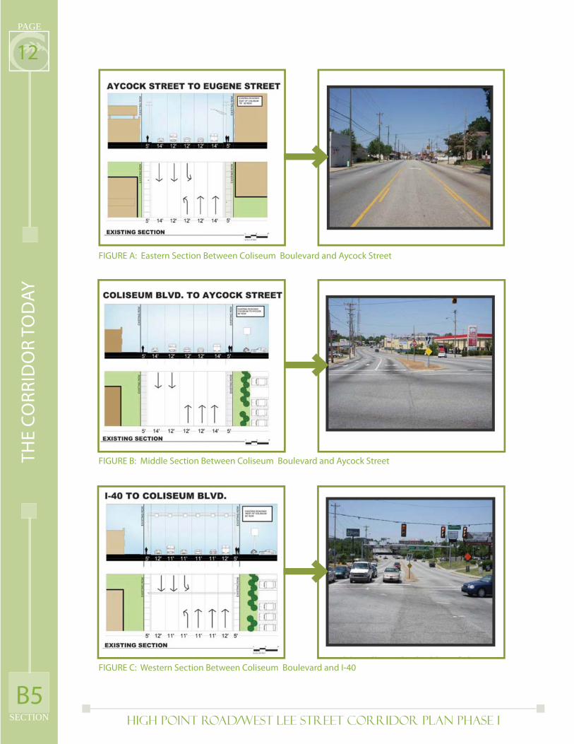
FIGURE A: Eastern Section Between Coliseum Boulevard and Aycock Street
FIGURE B: Middle Section Between Coliseum Boulevard and Aycock Street
FIGURE C: Western Section Between Coliseum Boulevard and I-40
B5
TH
E C
OR
RID
OR
TO
DA
Y
High Point Road/West Lee Street Corridor Plan PHASE I SECTION
PAGE
13In the eastern section, between Aycock Street and Eugene Street, the roadway is commonly fi ve lanes wide with two travel lanes in each direction and a center turn lane (which in some cases is protected by a center median, and in others is merely a striped center lane). (See Figure A) In the middle section, between Coliseum Boulevard and Aycock Street, the roadway is commonly fi ve or six lanes wide, with three through lanes in the westbound direction, two lanes in the eastbound direction, and a center turn lane for a portion of the corridor. In this middle section and the western section, additional turning lanes are added at major intersections to signifi cantly widen the roadway. (See Figure B)
The western section, between Coliseum Boulevard and Interstate 40 is the widest of the corridor, typically six lanes wide, with one subsection seven lanes wide. The normal traffi c pattern in this six-lane section is three westbound lanes, two eastbound lanes and a center turn lane. During peak periods, such as events at the Coliseum, the center lanes are designed to be “reversible” utilizing overhead electronic lane use signage to change the traffi c pattern to three eastbound lanes, two westbound lanes plus a center turn lane. (See Figure C)
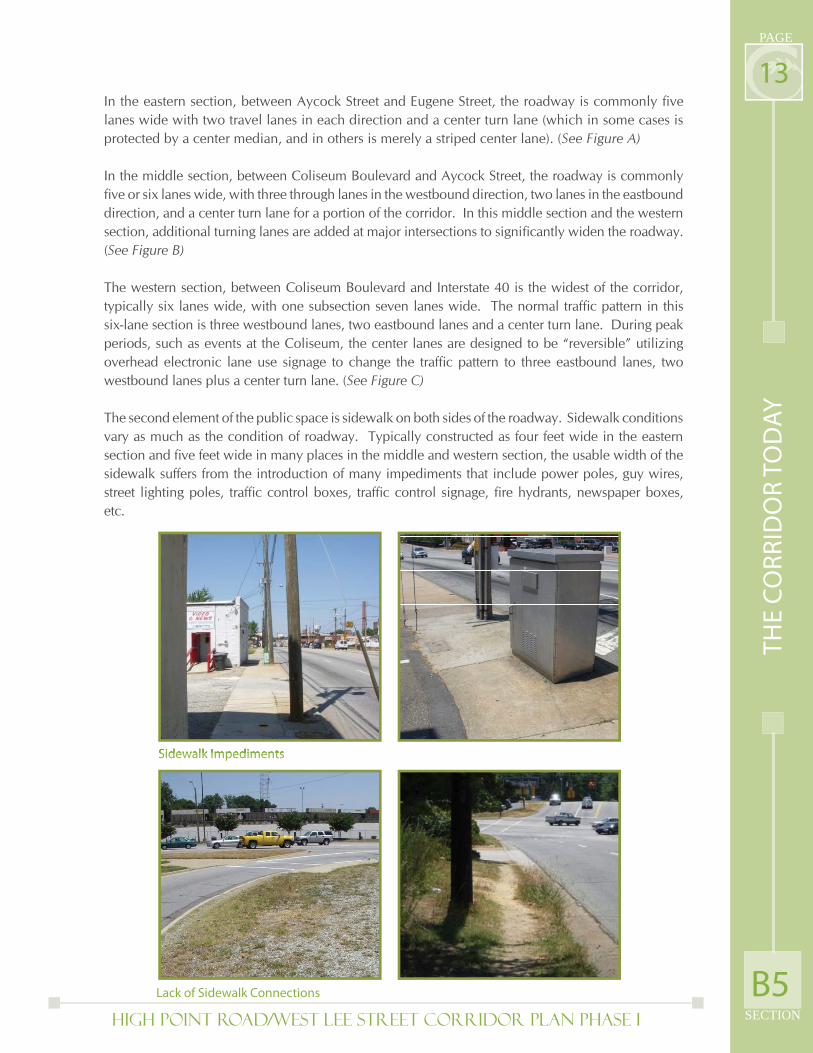
The second element of the public space is sidewalk on both sides of the roadway. Sidewalk conditions vary as much as the condition of roadway. Typically constructed as four feet wide in the eastern section and fi ve feet wide in many places in the middle and western section, the usable width of the sidewalk suffers from the introduction of many impediments that include power poles, guy wires, street lighting poles, traffi c control boxes, traffi c control signage, fi re hydrants, newspaper boxes, etc.
Sidewalk Impediments
Lack of Sidewalk Connections B5
TH
E C
OR
RID
OR
TO
DA
Y
High Point Road/West Lee Street Corridor Plan PHASE I
PAGE
SECTION
14Though the sidewalk may be continuous from one end of the corridor to the other, the connections to sidewalks from intersecting streets are not. A considerable number of neighborhood streets do not have sidewalks on one side or both sides, making it more diffi cult to walk, push a stroller or wheelchair or otherwise use the High Point Road/ West Lee Street sidewalks.
Narrow sidewalks, with no separation from adjacent high vehicle traffi c volumes (including trucks, busses, cars) or adjacent buildings, parking lots and driveways makes for an unattractive and diffi cult pedestrian environment. Further aggravating these conditions are direct confl icts between pedestrians and vehicles. Particularly within the eastern and middle sections, the frequency of curb cuts for vehicle access into sites crossing the sidewalk, often obscured by buildings on the sidewalk edge, makes for hazardous conditions for pedestrians and frustrates traffi c fl ow on the street and private property. Other confl icts between pedestrians and vehicles occur at intersections where numerous traffi c lanes with limited signage, signals and space make it extremely diffi cult to cross in a safe manner.
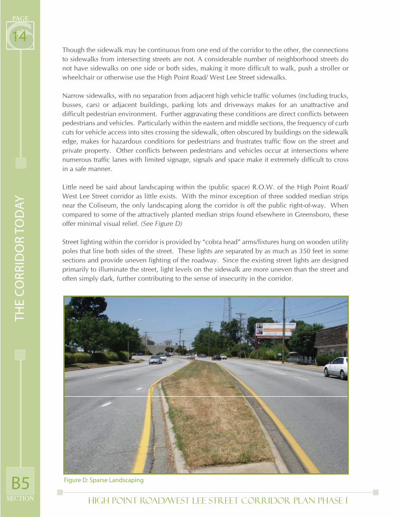
Little need be said about landscaping within the (public space) R.O.W. of the High Point Road/ West Lee Street corridor as little exists. With the minor exception of three sodded median strips near the Coliseum, the only landscaping along the corridor is off the public right-of-way. When compared to some of the attractively planted median strips found elsewhere in Greensboro, these offer minimal visual relief. (See Figure D)
Street lighting within the corridor is provided by “cobra head” arms/fi xtures hung on wooden utility poles that line both sides of the street. These lights are separated by as much as 350 feet in some sections and provide uneven lighting of the roadway. Since the existing street lights are designed primarily to illuminate the street, light levels on the sidewalk are more uneven than the street and often simply dark, further contributing to the sense of insecurity in the corridor.
Figure D: Sparse LandscapingB5
TH
E C
OR
RID
OR
TO
DA
Y
High Point Road/West Lee Street Corridor Plan PHASE I SECTION
PAGE
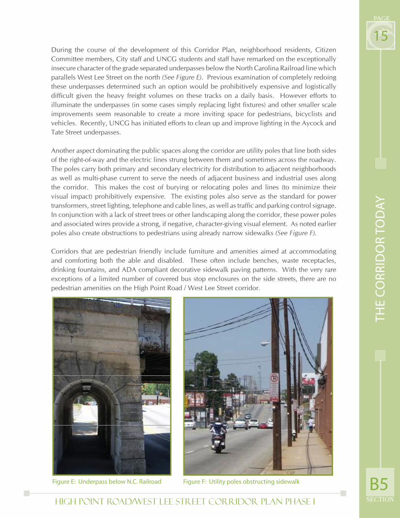
15During the course of the development of this Corridor Plan, neighborhood residents, Citizen Committee members, City staff and UNCG students and staff have remarked on the exceptionally insecure character of the grade separated underpasses below the North Carolina Railroad line which parallels West Lee Street on the north (See Figure E). Previous examination of completely redoing these underpasses determined such an option would be prohibitively expensive and logistically diffi cult given the heavy freight volumes on these tracks on a daily basis. However efforts to illuminate the underpasses (in some cases simply replacing light fi xtures) and other smaller scale improvements seem reasonable to create a more inviting space for pedestrians, bicyclists and vehicles. Recently, UNCG has initiated efforts to clean up and improve lighting in the Aycock and Tate Street underpasses.
Another aspect dominating the public spaces along the corridor are utility poles that line both sides of the right-of-way and the electric lines strung between them and sometimes across the roadway. The poles carry both primary and secondary electricity for distribution to adjacent neighborhoods as well as multi-phase current to serve the needs of adjacent business and industrial uses along the corridor. This makes the cost of burying or relocating poles and lines (to minimize their visual impact) prohibitively expensive. The existing poles also serve as the standard for power transformers, street lighting, telephone and cable lines, as well as traffi c and parking control signage. In conjunction with a lack of street trees or other landscaping along the corridor, these power poles and associated wires provide a strong, if negative, character-giving visual element. As noted earlier poles also create obstructions to pedestrians using already narrow sidewalks (See Figure F).
Corridors that are pedestrian friendly include furniture and amenities aimed at accommodating and comforting both the able and disabled. These often include benches, waste receptacles, drinking fountains, and ADA compliant decorative sidewalk paving patterns. With the very rare exceptions of a limited number of covered bus stop enclosures on the side streets, there are no pedestrian amenities on the High Point Road / West Lee Street corridor.
Figure E: Underpass below N.C. Railroad Figure F: Utility poles obstructing sidewalk B5
TH
E C
OR
RID
OR
TO
DA
Y
High Point Road/West Lee Street Corridor Plan PHASE I
PAGE
SECTION
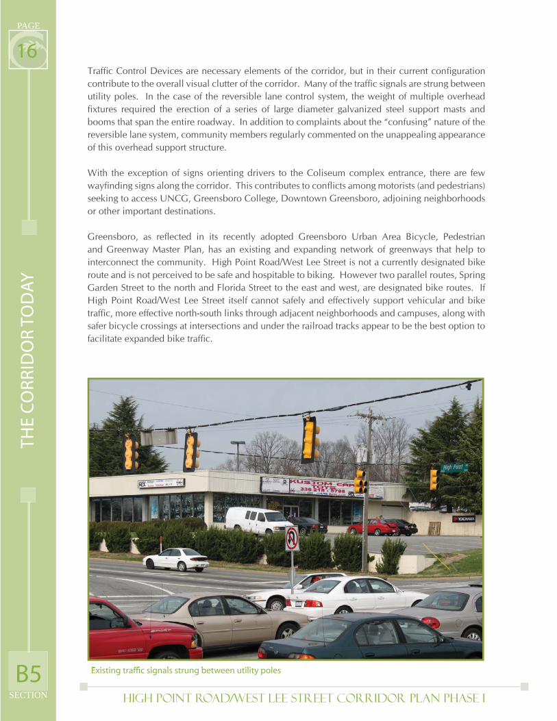
16Traffi c Control Devices are necessary elements of the corridor, but in their current confi guration contribute to the overall visual clutter of the corridor. Many of the traffi c signals are strung between utility poles. In the case of the reversible lane control system, the weight of multiple overhead fi xtures required the erection of a series of large diameter galvanized steel support masts and booms that span the entire roadway. In addition to complaints about the “confusing” nature of the reversible lane system, community members regularly commented on the unappealing appearance of this overhead support structure.
With the exception of signs orienting drivers to the Coliseum complex entrance, there are few wayfi nding signs along the corridor. This contributes to confl icts among motorists (and pedestrians) seeking to access UNCG, Greensboro College, Downtown Greensboro, adjoining neighborhoods or other important destinations.
Greensboro, as refl ected in its recently adopted Greensboro Urban Area Bicycle, Pedestrian and Greenway Master Plan, has an existing and expanding network of greenways that help to interconnect the community. High Point Road/West Lee Street is not a currently designated bike route and is not perceived to be safe and hospitable to biking. However two parallel routes, Spring Garden Street to the north and Florida Street to the east and west, are designated bike routes. If High Point Road/West Lee Street itself cannot safely and effectively support vehicular and bike traffi c, more effective north-south links through adjacent neighborhoods and campuses, along with safer bicycle crossings at intersections and under the railroad tracks appear to be the best option to facilitate expanded bike traffi c.
Existing traffi c signals strung between utility poles B5
TH
E C
OR
RID
OR
TO
DA
Y
High Point Road/West Lee Street Corridor Plan PHASE I SECTION
PAGE
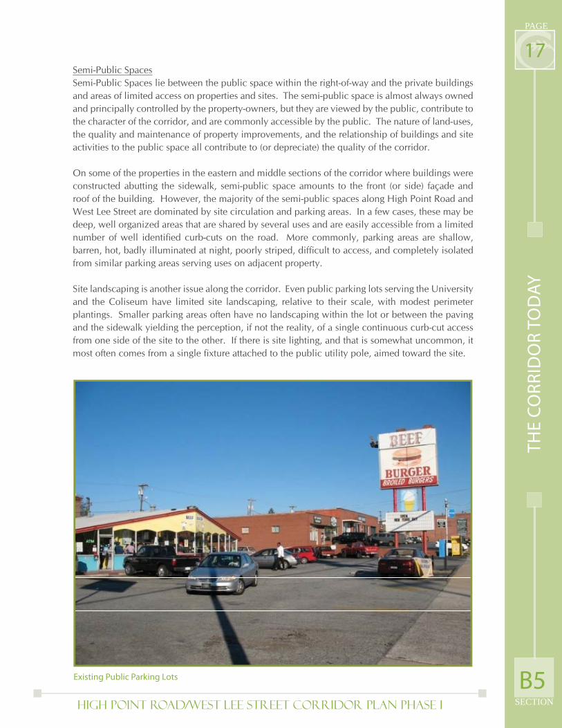
17Semi-Public Spaces Semi-Public Spaces lie between the public space within the right-of-way and the private buildings and areas of limited access on properties and sites. The semi-public space is almost always owned and principally controlled by the property-owners, but they are viewed by the public, contribute to the character of the corridor, and are commonly accessible by the public. The nature of land-uses, the quality and maintenance of property improvements, and the relationship of buildings and site activities to the public space all contribute to (or depreciate) the quality of the corridor.
On some of the properties in the eastern and middle sections of the corridor where buildings were constructed abutting the sidewalk, semi-public space amounts to the front (or side) façade and roof of the building. However, the majority of the semi-public spaces along High Point Road and West Lee Street are dominated by site circulation and parking areas. In a few cases, these may be deep, well organized areas that are shared by several uses and are easily accessible from a limited number of well identifi ed curb-cuts on the road. More commonly, parking areas are shallow, barren, hot, badly illuminated at night, poorly striped, diffi cult to access, and completely isolated from similar parking areas serving uses on adjacent property.
Site landscaping is another issue along the corridor. Even public parking lots serving the University and the Coliseum have limited site landscaping, relative to their scale, with modest perimeter plantings. Smaller parking areas often have no landscaping within the lot or between the paving and the sidewalk yielding the perception, if not the reality, of a single continuous curb-cut access from one side of the site to the other. If there is site lighting, and that is somewhat uncommon, it most often comes from a single fi xture attached to the public utility pole, aimed toward the site.
Existing Public Parking Lots
Existing Public Parking Lots B5
TH
E C
OR
RID
OR
TO
DA
Y
High Point Road/West Lee Street Corridor Plan PHASE I
PAGE
SECTION
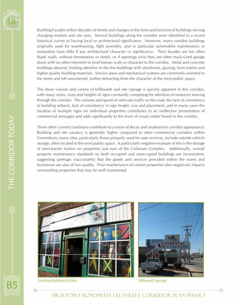
18Building Facades refl ect decades of trends and changes in the form and function of buildings serving changing markets and site uses. Several buildings along the corridor were identifi ed in a recent historical survey as having local or architectural signifi cance. However, many corridor buildings originally used for warehousing, light assembly, and in particular automobile maintenance or restoration have little if any architectural character or signifi cance. Their facades are too often blank walls, without fenestration or detail, or if openings exist they are often truck-sized garage doors with no other elements to lend human scale or character to the corridor. Metal and concrete buildings abound, lending attention to the few buildings with storefronts, glazing, front entries and higher quality building materials. Service areas and mechanical systems are commonly oriented to the street and left unscreened, further detracting from the character of the semi-public space.
The shear volume and variety of billboards and site signage is quickly apparent in this corridor, with many styles, sizes and heights of signs constantly competing for attention of motorists moving through the corridor. The volume and speed of vehicular traffi c on the road, the lack of consistency in building setback, lack of consistency in sign height, size and placement, and in many cases the location of multiple signs on individual properties contributes to an ineffective presentation of commercial messages and adds signifi cantly to the level of visual clutter found in the corridor.
Three other current conditions contribute to a sense of decay and unattractive corridor appearance: Building and site vacancy is generally higher compared to other commercial corridors within Greensboro; many sites, particularly those primarily used for auto services, include outside vehicle storage, often located in the semi-public space. A particularly negative example of this is the storage of semi-tractor trailers on properties just east of the Coliseum Complex. Additionally, overall property maintenance standards on both occupied and unoccupied buildings are inconsistent, suggesting (perhaps inaccurately) that the goods and services provided within the stores and businesses are also of low quality. Poor maintenance of certain properties also negatively impacts surrounding properties that may be well maintained.
Existing Building Facade Billboard Signage
B5
TH
E C
OR
RID
OR
TO
DA
Y
High Point Road/West Lee Street Corridor Plan PHASE I SECTION
PAGE
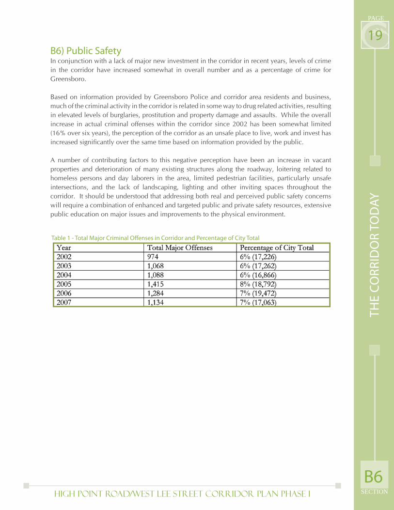
19B6) Public SafetyIn conjunction with a lack of major new investment in the corridor in recent years, levels of crime in the corridor have increased somewhat in overall number and as a percentage of crime for Greensboro.
Based on information provided by Greensboro Police and corridor area residents and business, much of the criminal activity in the corridor is related in some way to drug related activities, resulting in elevated levels of burglaries, prostitution and property damage and assaults. While the overall increase in actual criminal offenses within the corridor since 2002 has been somewhat limited (16% over six years), the perception of the corridor as an unsafe place to live, work and invest has increased signifi cantly over the same time based on information provided by the public.
A number of contributing factors to this negative perception have been an increase in vacant properties and deterioration of many existing structures along the roadway, loitering related to homeless persons and day laborers in the area, limited pedestrian facilities, particularly unsafe intersections, and the lack of landscaping, lighting and other inviting spaces throughout the corridor. It should be understood that addressing both real and perceived public safety concerns will require a combination of enhanced and targeted public and private safety resources, extensive public education on major issues and improvements to the physical environment.
Table 1 - Total Major Criminal Off enses in Corridor and Percentage of City Total
B6
TH
E C
OR
RID
OR
TO
DA
Y
High Point Road/West Lee Street Corridor Plan PHASE I
PAGE
SECTION
20C1) Market Economics and Market Strategies
To ensure that the recommendations of this Corridor Plan are reasonable and will effectively address identifi ed issues, a market and economic analysis was conducted to determine major opportunities for new corridor investment and barriers that may be need to be eliminated or lessened to facilitate this development.
Several key opportunities were identifi ed from initial assessment of potential land uses that were appropriate to the corridor, based on existing and forecasted economic trends:
SECTION C: A Vision for the Future
University-Related Housing. The Corridor’s proximity to fi ve universities and colleges provides a strategic advantage as a location for university-related housing uses. In addition to student housing, there are also opportunities for development of new housing and mixed-use products targeted to serve the needs of people who work for these institutions. Major improvements to the physical environment, in concert with the development of high-quality housing products and amenities, would greatly increase the Corridor’s attractiveness for college and other downtown-area workers.
Nursing & Other Senior Housing Facilities. As the region’s senior population continues to expand, there will be increasing opportunities for centrally-located senior housing within reach of health care facilities, amenities, and families. University-related programs and continuing education are increasingly integrated into senior housing amenity packages.
Destination Sports-Oriented Retail & Entertainment. Because of the Corridor’s central location, proximity to major venues (Coliseum), universities, convention center/hotels, and downtown, there are opportunities for destination-oriented commercial uses that draw thematically on the city’s role as a host for major sporting events, (in addition to concerts, tradeshows, conventions, fl ea markets, etc). There are already certain destination retail uses in the Corridor that contribute greatly to this marketing concept. There may be opportunities for additional audience support facilities (e.g., museums, auditoriums, other regional facilities, etc) that could be explored at a later time.
Catering, Craft, and Contracting. There are a number of logistics, light industrial, catering, craft shops, and contracting businesses for which the Corridor has always been and continues to be competitive. Logistics companies and typical light industrial uses like food distribution companies require good, functional space closer to the interstate. But certain downtown-oriented craft and contracting businesses are well-suited to the West Lee Street portion of the Corridor. These types of businesses can add to the diversity of the overall mix of uses in the area.
Lodging Upgrading. Long-term opportunities exist for additional lodging in the Corridor, particularly as additional university, recreation and event facilities are developed. However, in the short-term opportunities should focus primarily on the upgrading and improvement of existing facilities.
A V
ISIO
N F
OR
TH
E F
UT
UR
E
C1
High Point Road/West Lee Street Corridor Plan PHASE I SECTION
PAGE
21
Based on major activity drivers in the corridor and some competitive strengths, three key economic strategies emerged to provide the necessary framework for redevelopment and new investment. These strategies include University/Mixed Use, Sports and Recreation, and Convention and Hospitality. While each of the strategies encompasses an approximate geographic section of the corridor, they should work together for maximum benefi t in strengthening the corridor.
University/Mixed Use
The university-oriented mixed-use district is focused primarily between UNCG and South Eugene Street. The market potential within this district relies to a great extent on the area’s universities (particularly UNCG) as drivers. Redevelopment of underutilized sites for university-related housing is a key opportunity for the area, and analysis has indicated that there is demand for both student and faculty/staff oriented housing. Whenever possible existing structures with architectural and/or historical signifi cance should be either preserved on-site for adaptive reuse or relocated. The market niches described here refl ect detailed market analysis conducted in conjunction with this Plan, and are summarized in memoranda contained in the Appendix.
Given the connection to area universities, and the district’s location proximate to Downtown Greensboro, a marketing strategy would emphasize the area’s eclectic character and interesting mix of land uses. Rather than wholesale demolition of industrial buildings and service uses, there is potential for an interesting mix of uses that would be appealing to new residents while also serving the needs of businesses in the downtown area.
Offi ce Leasing. The Corridor already has a major, good-quality offi ce park which is currently under-utilized in the market. It is imperative that short-term opportunities focus on upgrading and leasing of this existing asset rather than on development of new, competing offi ce space.
Several other opportunities, such as ethnic restaurants, were also identifi ed that relate to more specifi c uses.
Facade enhancement sketch of the exisiting ‘Pugh Metal Finishing’ building.
Existing Facade
A V
ISIO
N F
OR
TH
E F
UT
UR
E
C1
High Point Road/West Lee Street Corridor Plan PHASE I
PAGE
SECTION
22
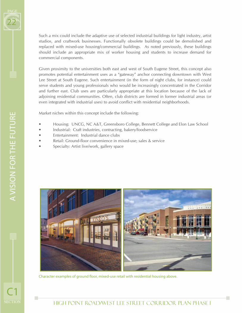
Such a mix could include the adaptive use of selected industrial buildings for light industry, artist studios, and craftwork businesses. Functionally obsolete buildings could be demolished and replaced with mixed-use housing/commercial buildings. As noted previously, these buildings should include an appropriate mix of worker housing and students to increase demand for commercial components.
Given proximity to the universities both east and west of South Eugene Street, this concept also promotes potential entertainment uses as a “gateway” anchor connecting downtown with West Lee Street at South Eugene. Such entertainment (in the form of night clubs, for instance) could serve students and young professionals who would be increasingly concentrated in the Corridor and further east. Club uses are particularly appropriate at this location because of the lack of adjoining residential communities. Often, club districts are formed in former industrial areas (or even integrated with industrial uses) to avoid confl ict with residential neighborhoods.
Market niches within this concept include the following:
• Housing: UNCG, NC A&T, Greensboro College, Bennett College and Elon Law School • Industrial: Craft industries, contracting, bakery/foodservice• Entertainment: Industrial dance clubs• Retail: Ground-fl oor convenience in mixed-use; sales & service• Specialty: Artist live/work, gallery space
Character examples of ground fl oor, mixed-use retail with residential housing above.
A V
ISIO
N F
OR
TH
E F
UT
UR
E
C1
High Point Road/West Lee Street Corridor Plan PHASE I SECTION
PAGE
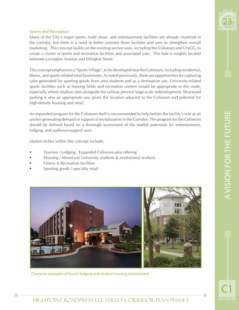
23Sports and Recreation
Many of the City’s major sports, trade show, and entertainment facilities are already clustered in the corridor, but there is a need to better connect these facilities and uses to strengthen overall marketing. This concept builds on the existing anchor uses, including the Coliseum and UNCG, to create a cluster of sports and recreation facilities and associated uses. This hub is roughly located between Lexington Avenue and Ellington Street.
This concept emphasizes a “Sports Village”, to be developed near the Coliseum, including residential, fi tness, and sports-related retail businesses. As noted previously, there are opportunities for capturing sales generated for sporting goods from area students and as a destination use. University-related sports facilities such as training fi elds and recreation centers would be appropriate in this node, especially where shallow sites alongside the railway prevent large-scale redevelopment. Structured parking is also an appropriate use, given the location adjacent to the Coliseum and potential for high-density housing and retail.
An expanded program for the Coliseum itself is recommended to help bolster the facility’s role as an anchor generating demand in support of revitalization in the Corridor. The program for the Coliseum should be defi ned based on a thorough assessment of the market potentials for entertainment, lodging, and audience-support uses.
Market niches within this concept include:
• Tourism / Lodging: Expanded Coliseum-area offering• Housing / Mixed-use University students & institutional workers• Fitness & Recreation facilities• Sporting goods / specialty retail
Character examples of tourist lodging and student housing environment.
A V
ISIO
N F
OR
TH
E F
UT
UR
E
C1
High Point Road/West Lee Street Corridor Plan PHASE I
PAGE
SECTION
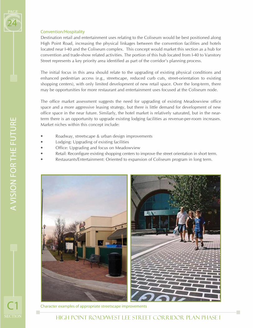
24Convention/Hospitality
Destination retail and entertainment uses relating to the Coliseum would be best positioned along High Point Road, increasing the physical linkages between the convention facilities and hotels located near I-40 and the Coliseum complex. This concept would market this section as a hub for convention and trade-show related activities. The portion of this hub located from I-40 to Vanstory Street represents a key priority area identifi ed as part of the corridor’s planning process.
The initial focus in this area should relate to the upgrading of existing physical conditions and enhanced pedestrian access (e.g., streetscape, reduced curb cuts, street-orientation to existing shopping centers), with only limited development of new retail space. Over the long-term, there may be opportunities for more restaurant and entertainment uses focused at the Coliseum node.
The offi ce market assessment suggests the need for upgrading of existing Meadowview offi ce space and a more aggressive leasing strategy, but there is little demand for development of new offi ce space in the near future. Similarly, the hotel market is relatively saturated, but in the near-term there is an opportunity to upgrade existing lodging facilities as revenue-per-room increases. Market niches within this concept include:
• Roadway, streetscape & urban design improvements• Lodging: Upgrading of existing facilities• Offi ce: Upgrading and focus on Meadowview• Retail: Reconfi gure existing shopping centers to improve the street orientation in short term. • Restaurants/Entertainment: Oriented to expansion of Coliseum program in long term.
Character examples of appropriate streetscape improvements
A V
ISIO
N F
OR
TH
E F
UT
UR
E
C1
High Point Road/West Lee Street Corridor Plan PHASE I SECTION
PAGE
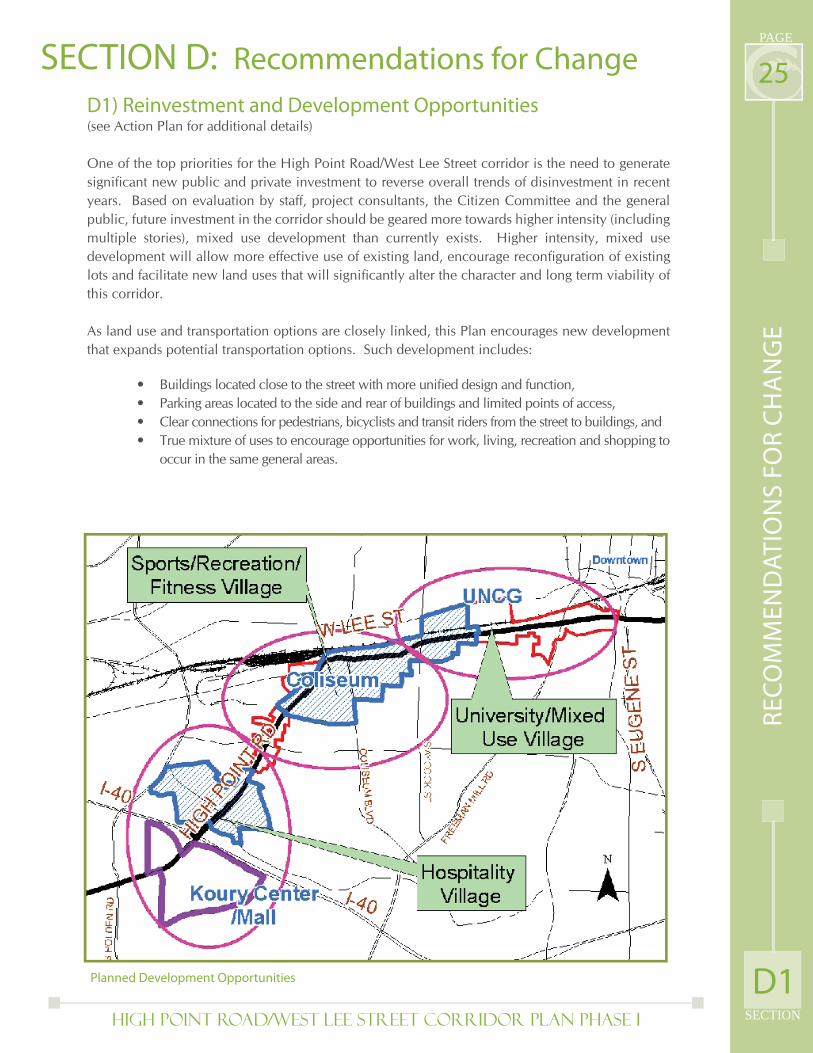
25D1) Reinvestment and Development Opportunities (see Action Plan for additional details)
One of the top priorities for the High Point Road/West Lee Street corridor is the need to generate signifi cant new public and private investment to reverse overall trends of disinvestment in recent years. Based on evaluation by staff, project consultants, the Citizen Committee and the general public, future investment in the corridor should be geared more towards higher intensity (including multiple stories), mixed use development than currently exists. Higher intensity, mixed use development will allow more effective use of existing land, encourage reconfi guration of existing lots and facilitate new land uses that will signifi cantly alter the character and long term viability of this corridor.
As land use and transportation options are closely linked, this Plan encourages new development that expands potential transportation options. Such development includes:
SECTION D: Recommendations for Change
Buildings located close to the street with more unifi ed design and function, Parking areas located to the side and rear of buildings and limited points of access,Clear connections for pedestrians, bicyclists and transit riders from the street to buildings, andTrue mixture of uses to encourage opportunities for work, living, recreation and shopping to occur in the same general areas.
••••
Planned Development Opportunities
RE
CO
MM
EN
DA
TIO
NS
FO
R C
HA
NG
E
D1
High Point Road/West Lee Street Corridor Plan PHASE I
PAGE
SECTION
26Though higher intensity, pedestrian friendly mixed use development is a goal for new development throughout the corridor, this Plan recommends the most intense developments (in terms of density and potential impacts from uses) be focused in revised Activity Centers linking the corridor’s major drivers of activity. These Activity Centers (shown in blue) will enable stronger connections between UNCG, the Coliseum and the Convention Center/Mall while relieving potentially incompatible development pressures on surrounding residential neighborhoods. Activity Centers are designated in the City’s Comprehensive Plan as “existing or anticipated future concentrations of uses that function as destinations or hubs of activity for the surrounding area.” The revised Activity Centers in this Corridor Plan are based on the original Coliseum and Mall/Convention Center Activity Center designations.
Reinvestment and land use in the High Point Road/West Lee Street corridor will also be focused around a series of “villages” linked to key drivers of activity with specifi c themes to guide new investment. The three villages are:
The 14 opportunity sites previously identifi ed for new development and redevelopment contain specifi c land use recommendations that also fi t with the overall theme of a related village concept. It should be noted that the uses recommended for these opportunity sites have been developed with a twenty year time horizon in mind and will come into play when opportunities arise to redevelop these sites. Additionally given the potentially long time frame for recommended uses it is assumed other similar opportunities may arise that could be located at these sites or in other areas of the corridor.
It should also be noted that all recommendations incorporate some common themes regarding placement of structures and parking, encouragement of multiple and better integrated uses on individual properties and increased density and intensity of uses, while respecting surrounding neighborhoods and development. An overview of the recommendations for the 14 sites, linked to the three village concepts, is presented below.
University Mixed Use VillageThe University of North Carolina-Greensboro continues to be a vibrant institution which benefi ts both its students and the Greensboro community. The university has seen steady growth on the existing campus located north of the North Carolina Railroad right-of-way and anticipates much greater development pressures in the future to accommodate anticipated student enrollment growth. The corridor can benefi t from the extension of the university’s good image onto West Lee Street, both as a contributor to the character of the roadway and as an economic engine. Other colleges and universities in Greensboro are also continuing to generate demand for housing, services, retail goods and social activities. The University Mixed-Use District is a means for connecting these related uses. The land use recommendations for related opportunity sites within this village (Sites 1-5) will attract new and expanded private and public investment which capitalizes on the proximity of UNCG and Greensboro College, and to a lesser extent NC A&T, Bennett College and Elon Law School.
University/Mixed Use Village (related to UNCG, Greensboro College and to a lesser
degree NC A&T, Bennett College and Elon Law School),
Sports, Recreation and Fitness Village (related primarily to the Coliseum and UNCG)
Hospitality Village (related to Koury Convention Center, Four Seasons Mall, Meadowview
Offi ce Park and signifi cant concentration of hotels around I-40).
1.
2.
3.
RE
CO
MM
EN
DA
TIO
NS
FO
R C
HA
NG
E
D1
High Point Road/West Lee Street Corridor Plan PHASE I SECTION
PAGE
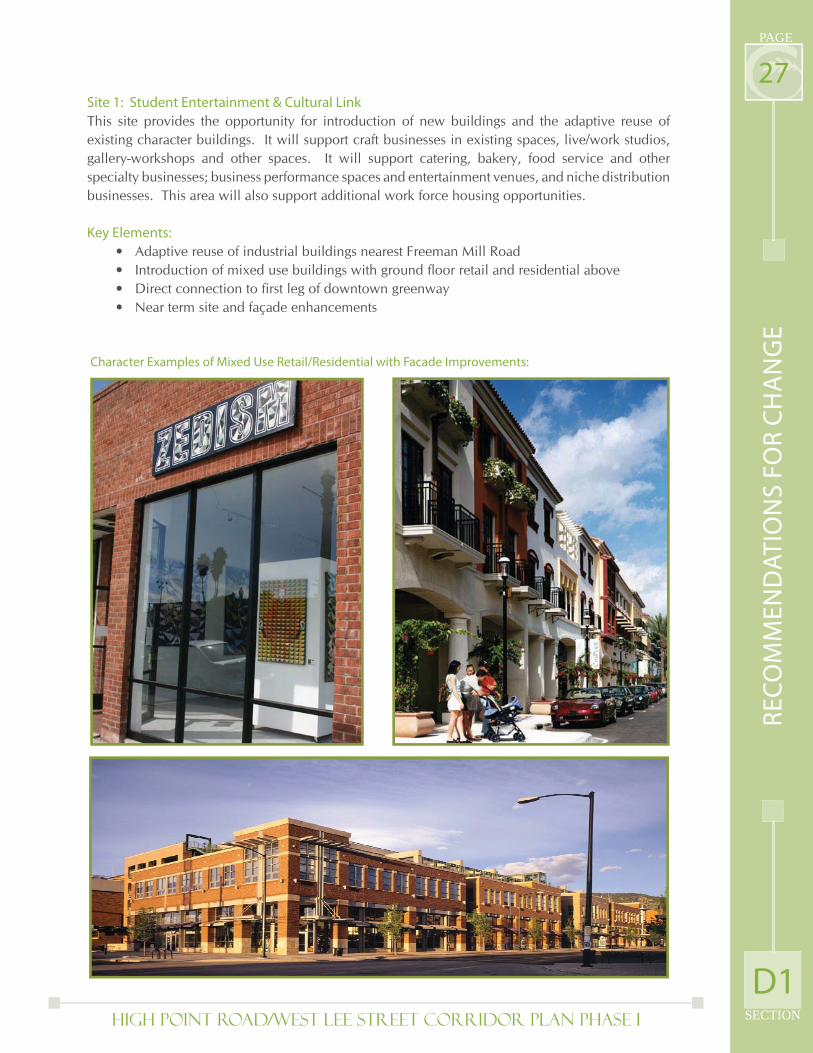
27Site 1: Student Entertainment & Cultural Link
This site provides the opportunity for introduction of new buildings and the adaptive reuse of existing character buildings. It will support craft businesses in existing spaces, live/work studios, gallery-workshops and other spaces. It will support catering, bakery, food service and other specialty businesses; business performance spaces and entertainment venues, and niche distribution businesses. This area will also support additional work force housing opportunities.
Key Elements:
Adaptive reuse of industrial buildings nearest Freeman Mill Road Introduction of mixed use buildings with ground fl oor retail and residential above Direct connection to fi rst leg of downtown greenway Near term site and façade enhancements
Character Examples of Mixed Use Retail/Residential with Facade Improvements:
••••
RE
CO
MM
EN
DA
TIO
NS
FO
R C
HA
NG
E
D1
High Point Road/West Lee Street Corridor Plan PHASE I
PAGE
SECTION
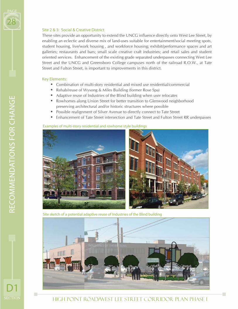
28Site 2 & 3: Social & Creative District
These sites provide an opportunity to extend the UNCG infl uence directly onto West Lee Street, by enabling an eclectic and diverse mix of land-uses suitable for entertainment/social meeting spots, student housing, live/work housing , and workforce housing; exhibit/performance spaces and art galleries; restaurants and bars; small scale creative craft industries; and retail sales and student oriented services. Enhancement of the existing grade separated underpasses connecting West Lee Street and the UNCG and Greensboro College campuses north of the railroad R.O.W., at Tate Street and Fulton Street, is important to improvements in this district.
Key Elements:
Combination of multi-story residential and mixed use residential/commercial Rehab/reuse of Wysong & Miles Building (former Rose Spa) Adaptive reuse of Industries of the Blind building when user relocates Rowhomes along Union Street for better transition to Glenwood neighborhood preserving architectural and/or historic structures where possible Possible realignment of Silver Avenue to directly connect to Tate Street Enhancement of Tate Street intersection and Tate Street and Fulton Street RR underpasses
Site sketch of a potential adaptive reuse of Industries of the Blind building
Examples of multi-story residential and rowhome style buildings
••••
••
D1
RE
CO
MM
EN
DA
TIO
NS
FO
R C
HA
NG
E
High Point Road/West Lee Street Corridor Plan PHASE I SECTION
PAGE
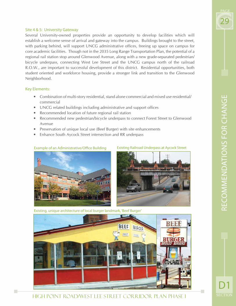
29Site 4 & 5: University Gateway
Several University-owned properties provide an opportunity to develop facilities which will establish a welcome sense of arrival and gateway into the campus. Buildings brought to the street, with parking behind, will support UNCG administrative offi ces, freeing up space on campus for core academic facilities. Though not in the 2035 Long Range Transportation Plan, the potential of a regional rail station stop around Glenwood Avenue, along with a new grade-separated pedestrian/bicycle underpass, connecting West Lee Street and the UNCG campus north of the railroad R.O.W., are important to successful development of this district. Residential opportunities, both student oriented and workforce housing, provide a stronger link and transition to the Glenwood Neighborhood.
Key Elements:
Combination of multi-story residential, stand alone commercial and mixed use residential/commercial UNCG related buildings including administrative and support offi cesRecommended location of future regional rail stationRecommended new pedestrian/bicycle underpass to connect Forest Street to Glenwood AvenuePreservation of unique local use (Beef Burger) with site enhancementsEnhance South Aycock Street intersection and RR underpass
•
•••
••
Example of an Administrative/Offi ce Building Existing Railroad Underpass at Aycock Street
Existing, unique architecture of local burger landmark, ‘Beef Burger’
D1
RE
CO
MM
EN
DA
TIO
NS
FO
R C
HA
NG
E
High Point Road/West Lee Street Corridor Plan PHASE I
PAGE
SECTION
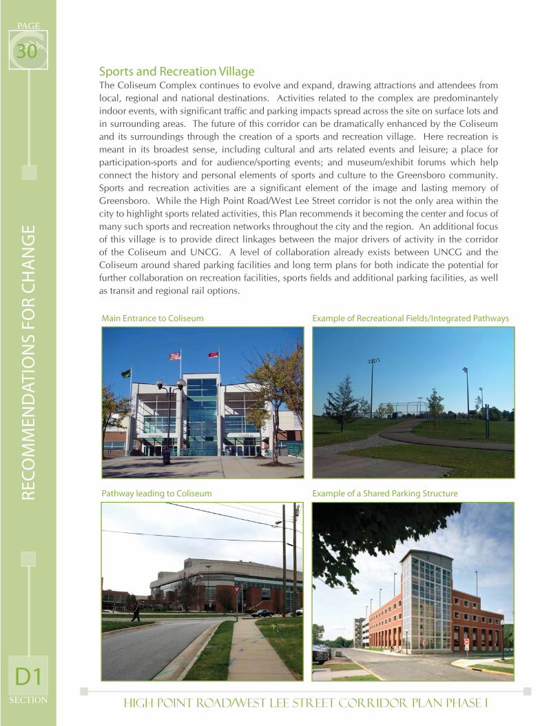
30Sports and Recreation VillageThe Coliseum Complex continues to evolve and expand, drawing attractions and attendees from local, regional and national destinations. Activities related to the complex are predominantely indoor events, with signifi cant traffi c and parking impacts spread across the site on surface lots and in surrounding areas. The future of this corridor can be dramatically enhanced by the Coliseum and its surroundings through the creation of a sports and recreation village. Here recreation is meant in its broadest sense, including cultural and arts related events and leisure; a place for participation-sports and for audience/sporting events; and museum/exhibit forums which help connect the history and personal elements of sports and culture to the Greensboro community. Sports and recreation activities are a signifi cant element of the image and lasting memory of Greensboro. While the High Point Road/West Lee Street corridor is not the only area within the city to highlight sports related activities, this Plan recommends it becoming the center and focus of many such sports and recreation networks throughout the city and the region. An additional focus of this village is to provide direct linkages between the major drivers of activity in the corridor of the Coliseum and UNCG. A level of collaboration already exists between UNCG and the Coliseum around shared parking facilities and long term plans for both indicate the potential for further collaboration on recreation facilities, sports fi elds and additional parking facilities, as well as transit and regional rail options.
Main Entrance to Coliseum
Pathway leading to Coliseum
Example of Recreational Fields/Integrated Pathways
Example of a Shared Parking Structure
D1
RE
CO
MM
EN
DA
TIO
NS
FO
R C
HA
NG
E
High Point Road/West Lee Street Corridor Plan PHASE I SECTION
PAGE
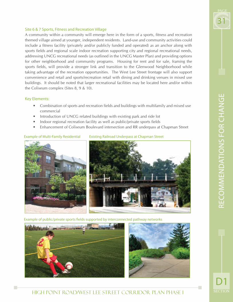
31Site 6 & 7 Sports, Fitness and Recreation Village
A community within a community will emerge here in the form of a sports, fi tness and recreation themed village aimed at younger, independent residents. Land-use and community activities could include a fi tness facility (privately and/or publicly funded and operated) as an anchor along with sports fi elds and regional scale indoor recreation supporting city and regional recreational needs, addressing UNCG recreational needs (as outlined in the UNCG Master Plan) and providing options for other neighborhood and community programs. Housing for rent and for sale, framing the sports fi elds, will provide a stronger link and transition to the Glenwood Neighborhood while taking advantage of the recreation opportunities. The West Lee Street frontage will also support convenience and retail and sports/recreation retail with dining and drinking venues in mixed use buildings. It should be noted that larger recreational facilities may be located here and/or within the Coliseum complex (Sites 8, 9 & 10).
Key Elements:
Combination of sports and recreation fi elds and buildings with multifamily and mixed use commercialIntroduction of UNCG related buildings with existing park and ride lotIndoor regional recreation facility as well as public/private sports fi eldsEnhancement of Coliseum Boulevard intersection and RR underpass at Chapman Street
•
•••
Example of Multi-Family Residential Existing Railroad Underpass at Chapman Street
Example of public/private sports fi elds supported by interconnected pathway networks
D1
RE
CO
MM
EN
DA
TIO
NS
FO
R C
HA
NG
E
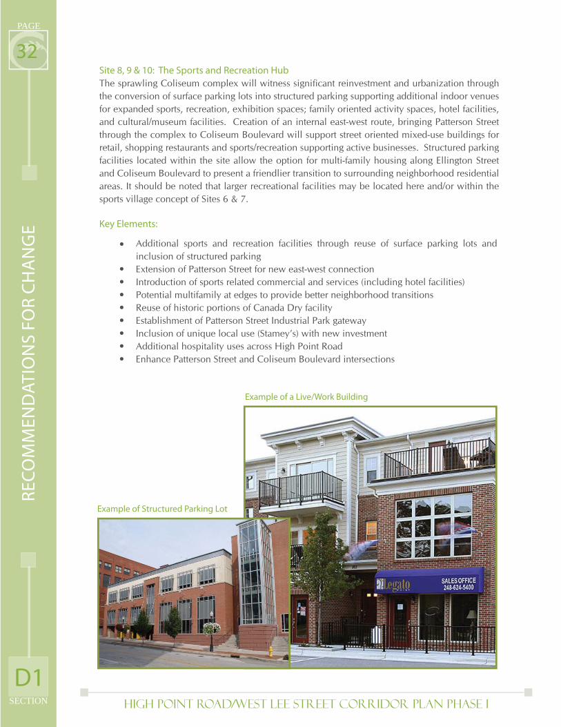
High Point Road/West Lee Street Corridor Plan PHASE I
PAGE
SECTION
32Site 8, 9 & 10: The Sports and Recreation Hub
The sprawling Coliseum complex will witness signifi cant reinvestment and urbanization through the conversion of surface parking lots into structured parking supporting additional indoor venues for expanded sports, recreation, exhibition spaces; family oriented activity spaces, hotel facilities, and cultural/museum facilities. Creation of an internal east-west route, bringing Patterson Street through the complex to Coliseum Boulevard will support street oriented mixed-use buildings for retail, shopping restaurants and sports/recreation supporting active businesses. Structured parking facilities located within the site allow the option for multi-family housing along Ellington Street and Coliseum Boulevard to present a friendlier transition to surrounding neighborhood residential areas. It should be noted that larger recreational facilities may be located here and/or within the sports village concept of Sites 6 & 7.
Key Elements:
•
•••••
Additional sports and recreation facilities through reuse of surface parking lots and inclusion of structured parkingExtension of Patterson Street for new east-west connectionIntroduction of sports related commercial and services (including hotel facilities)Potential multifamily at edges to provide better neighborhood transitionsReuse of historic portions of Canada Dry facility Establishment of Patterson Street Industrial Park gatewayInclusion of unique local use (Stamey’s) with new investmentAdditional hospitality uses across High Point RoadEnhance Patterson Street and Coliseum Boulevard intersections
•••
Example of Structured Parking Lot
Example of a Live/Work Building
RE
CO
MM
EN
DA
TIO
NS
FO
R C
HA
NG
E
D1
High Point Road/West Lee Street Corridor Plan PHASE I SECTION
PAGE
33Hospitality VillageThe Corridor’s accessibility to a regional scale market (via interstate access) and the existence of regional activity centers in the Koury Conference facility, Four Seasons Town Center mall, the Coliseum, University and Colleges, and the Central Business District, creates demand for continued and expanded hospitality services in close proximity. Hospitality, in the form of restaurants, hotels, conferencing/meeting spaces and recreation outlets, has historically been drawn to the corridor to support these activity centers. What will distinguish the High Point Road/West Lee Street corridor in the future will be the greater physical and thematic links between these major facilities and overall themes of sports, recreation, universities, entertainment and hospitality.
Sites 11 & 12: Neighborhood Support & Convenience District
These sites fall between the Coliseum Sports and Recreation Hub and the primary hub of hospitality uses located closer to the interstate. Redevelopment opportunities here are focused more on supporting adjoining residential neighborhoods through grocery and neighborhood retail services, restaurants and additional residential infi ll that fi ts within the context of the neighborhood.
Key Elements:
New neighborhood oriented commercial and supportive services New residential development to improve Ardmore Park neighborhood Enhance West Florida Street intersection
Example of Neighborhood Retail-Commercial
Example of Single-Family Attached
Residential
•••
RE
CO
MM
EN
DA
TIO
NS
FO
R C
HA
NG
E
D1
High Point Road/West Lee Street Corridor Plan PHASE I
PAGE
SECTION
34Sites 13 & 14: National Retail and Highway Interchange Infl uence—Hospitality Hub
These sites, larger and deeper than anywhere else on the corridor (other than the Coliseum complex), can support highway oriented/national chain retailers and restaurants, but should focus more effort on supporting the campus of hotels and supporting offi ce/meeting spaces that will emerge with redevelopment and revitalization. Care must be taken to assure good land-use and visible transitions between active uses for visitors and the neighborhoods which surround these business/hospitality zones. Shuttle buses and off-road bicycle and pedestrian routes are options to link these areas to the coliseum, convention center, greenway and downtown, without increasing the burden of traffi c on the High Point Road/West Lee Street roadway.
Key Elements: Expanded use of existing commercial center Consolidation/improvement of existing hotel cluster Potential reuse of Park Lane Hotel for senior living or condos New multifamily development for better transition to Hillsdale Park Neighborhood Link Hillsdale Park greenway to hotels and offi ces on Meadowview Road Enhance Meadowview Road intersection and support future offi ce park improvements
•••••
Example of Neighborhood Offi ce
Example of Commercial Retail CenterRE
CO
MM
EN
DA
TIO
NS
FO
R C
HA
NG
E
D1
•

Page Intentionally Left Blank
High Point Road/West Lee Street Corridor Plan PHASE I
PAGE
SECTION
36SITE 1:
Infl uenced by proximity to downtown and surrounding college campus
activity, including:
* Adaptive Reuse of existing character buildings
* Artist Live/Craft Businesses
* Performance/Entertainment
* Catering, Bakery, Food and Drink
* Gallery Workshop
* Work Force Housing
* Niche Distribution
Site 1: Brooks Lumber & General Contractors Building
SITE DATA: Total Acreage: 13.5 acExisting Land Uses: Retail/Multiple Uses/Personal Services/Industrial
RETAIL DATA:Building Area: 69,000 sfSurface Parking: 404 Cars (5.8/1,000 sf)
RESIDENTIAL DATA:Residential Units: 115 du @1,200 - 1,500 sfSurface Parking: 196 Cars (1.7/du)
BUILDING COLOR CODE:
STUDENT ENTERTAINMENT & CULTURAL LINK
End Cap Buildings - Located at the ends of blocks, signifi cant architectural treatments where facades front onto the street(s), signifi cant corner treatments.
Plaza Buildings - Located at roadway intersections, building corners are stepped inward to embrace pedestrian plaza spaces, arranged in pairs to encourage plazas and pedestrian activity on both sides of the street, signifi cant architectural treatments where facades front onto the street(s), signifi cant corner treatments.
Mid-Block Buildings - Located in the middle of end caps and plazas, intended to support a continuous facade along the length of the development site with signifi cant architectural treatments fronting onto the corridor.
Adaptive Reuse/Existing Building
Iconic Buildings - Signifi cant feature buildings located at key points along the corridor to generate visual interest and appeal along the length of the corridor, iconic features may include additional building height, towers, accentuated roofl ines, or other building features.
AND OTHER INDUSTRIAL/COMMERCIAL USES
RE
CO
MM
EN
DA
TIO
NS
FO
R C
HA
NG
E
D1
High Point Road/West Lee Street Corridor Plan PHASE I SECTION
PAGE
37
SITE 1: STUDENT ENTERTAINMENT & CULTURAL LINK
Building Details
A) Adaptive Reuse/Craft Manufacturing/Retail/Studio/Workshops
B) Mixed-Use/Retail/Residential - 3 bldgsGround Floor Retail/Restaurant: 29,000 sf152 Cars (5/1,000 sf)2nd-4th Floor Residential: 44du @ 1,500 sf66 Cars (1.5/du)
C) Near Term Site & Facade EnhancementsLong Term Mixed-Use Retail/Residential, 3 bldgsGround Floor Retail/Restaurant: 26,000 sf158 Cars (6/1,000 sf)2nd-4th Floor Residential: 46 du @ 1,200 sf92 Cars (2/du)
RE
CO
MM
EN
DA
TIO
NS
FO
R C
HA
NG
E
D1
High Point Road/West Lee Street Corridor Plan PHASE I
PAGE
SECTION
38SITES 2 & 3: SOCIAL & CREATIVE DISTRICT
An eclectic and diverse mix of land uses suitable for:
* Entertainment/Social Meeting Spot
* Student Housing & Live/Work Housing
* Exhibits & Art Galleries
* Restaurants & Bars
* Creative Industrial Fabrication (arts, music, pottery, workshops, etc.)
* Retail Sales
Site 2: Former Charles Roberts Company
SITE DATA: Total Acreage: 11.75 acExisting Land Uses: Industrial/Warehouse/Residential/Personal Services/Multiple Uses
RETAIL DATA:Building Area: 26,400 sf(Does not include existing neighborhood commercial center or Industries of the Blind)Surface Parking: 132 Cars (5/1,000 sf)
RESIDENTIAL DATA:Residential Units: 168 du @1,500 - 1,600 sfSurface Parking: 250 Cars (1.5/du)
Site 3: Industrial between West Lee Street and Union Street
SITE DATA: Total Acreage: 9 acExisting Land Uses: Auto Repair/ Industrial/Warehouse/Residential/Services/Retail/Parking/Vacant Lot
RETAIL DATA:Building Area: 48,500 sfSurface Parking: 225 Cars (4.6/1,000 sf)
RESIDENTIAL DATA:Residential Units: 36 Condo Units @1,800 sf31 Rowhomes @ 2,250 sf
Surface Parking: 55 Cars designated for condo units (1.5/du)
Garage Parking:62 Cars designated for rowhomes (2.0/du)
RE
CO
MM
EN
DA
TIO
NS
FO
R C
HA
NG
E
D1
High Point Road/West Lee Street Corridor Plan PHASE I SECTION
PAGE
39
SITES 2 & 3: SOCIAL & CREATIVE DISTRICT
Building Details
A) Multi-Family Housing, 2 Bldgs, 3 StyRelocate (3) existing single family homes to Glenwood neighborhood or other suitable neighborhod environments.48 du @1,500 sf ea75 cars (1.5/du)Alternate concept to reuse Pugh Metal Finishing Building
B) Multi-Family Housing, 2 Bldgs, 3 Sty48 du @ 1,500 sf ea75 cars (1.5/du)
C) Mixed Use Retail/Residential, 3 Bldgs, 3 StyPartial Ground Floor Retail: 26,400 sf132 cars (5/1,000 sf)1st-3rd Floor Residential: 32 du @ 2,000 sf ea40 cars (1.5 cars/du)
D) Historic Wysong & Miles Company Offi ce BuildingsPotential offi ce/residential mixed use, 3 Sty7,500 sf30 cars (4/1,000 sf)Possible building relocation forward to Lee Street
E) Historic Old Carolina Baking Co. BuildingAdaptive Reuse for Residential, 3 Sty40 du @ 1,600 sf ea60 cars (1.5 cars/du)
F) RowhomesRelocate existing single family homes on north side of Union Street and west side of Silver Avenue within Glenwood neighborhood or other suitable neighborhod environments.20 du @ 2,250 sf ea
G) Mixed Use Retail/Residential, 2 Bldgs, 3 StyGround Floor Retail (east bldg only): 8.5K sf42 cars (5/1000 sf)1st (west bldg), 2nd - 3rd Floor Residential:14 du @ 1,800 sf ea22 cars (1.5/du)
H) Mixed Use Retail/Residential, 4 Bldgs, 2 StyGround Floor Retail: 40,000 sf183 cars (4.6/1,000 sf)2nd Floor Residential: 22 du @ 1,800 sf ea33 cars (1.5 cars/du)
I) Reconfi gure Silver Avenue to align with Tate Streetto create new plaza area
J) Neighborhood Supporting Commercial
K) Industries Of The Blind Building; Adaptive Reuse for craft industries; potential University related use (long range potential for mid-rise student oriented housing)
RE
CO
MM
EN
DA
TIO
NS
FO
R C
HA
NG
E
D1
High Point Road/West Lee Street Corridor Plan PHASE I
PAGE
SECTION
40SITES 4 & 5: UNIVERSITY GATEWAY
University of North Carolina Greensboro (UNCG) infl uenced uses, including:
* UNCG Administrative Support Offi ces
* Possible Light Rail Station Stop to Glenwood
* Integrated neighborhood residential
* Proposed new pedestrian/bicycle underpass into the UNCG campus @ the extension
of Glenwood Avenue
Site 4: Shops/Industry North of West Lee Street
SITE DATA: Total Acreage: 11.75 acExisting Land Uses: Retail/Auto-Repair/Warehouse/Restaurant/Vacant Lot/Multiple Uses/School/Parking Lot
UNIVERSITY ADMIN/OFFICE DATA:Building Area: 64,000 sfSurface Parking: 110 carsStructured Parking: 200 carsTotal Parking: 310 cars (4.8/1,000)
RETAIL DATA:Building Area: 50,000 sfSurface Parking: 254 cars (5.0/1,000)
RESIDENTIAL DATA:Residential Units: 60 duSurface Parking: 95 cars (1.5/du)
RESTAURANT DATA:Building Area: 12,000 sfSurface Parking: 72 cars (6/1,000)
Site 5 Aycock Street & West Lee Street Commercial
SITE DATA: Total Acreage: 2.8 acExisting Land Uses: Abandoned/ Multipled Uses/Personal Services
RETAIL/OFFICE DATA:Building Area: 23,500 sfSurface Parking: 140 Cars (6/1,000 sf)
RESIDENTIAL DATA:Residential Units: 315 duSurface Parking: 250 cars (1.3/1,000)
RE
CO
MM
EN
DA
TIO
NS
FO
R C
HA
NG
E
D1
High Point Road/West Lee Street Corridor Plan PHASE I SECTION
PAGE
41
SITES 4 & 5: UNIVERSITY GATEWAY
Building Details
A) Mixed Use Retail/Residential, 2 Bldgs, 3-7 StyGround Floor Retail: 16,500 sf82 cars (5 cars/1,000 sf)2nd - 3rd Floor Residential: 22 du38 Cars (1.5 cars/du)
B) Mixed Use Retail/University Support/Residential, 2 Bldgs, 3-7 StyGround Floor Retail/Offi ce: 18,000 sf90 Cars (5 cars/1,000 sf)2nd - 3rd Floor Residential: 24 du @ 1,500 sf36 cars (1.5 cars/du)
C) University Related, 2 Bldgs, 4 Sty1st - 2nd Floor Offi ce: 64,000 sf3rd - 4th Floor Parking: 200 carsSurface Parking: 110 CarsTotal Parking: 310 cars (4.8/1,000 sf)
D) Beef Burger (Recommended Site Enhancements)
E) Mixed Use Retail Residential, 2 Bldgs, 3 StyGround Floor Retail: 11,000 sf64 Cars (5.8 cars/1,000 sf)2nd - 3rd Floor Residential: 14 du @ 1,500 sf21 Cars
F) Existing Brick Building to be Reused as Offi ce, 3 Sty4,500 sf18 Cars (4 cars/1,000 sf)
G) Plaza and pedestrian connection to possible future light rail station,UNCG Parking Structure and campus towards the north
H) Residential, 5 Bldgs, 3 Sty125 du @1,100 sf85 Cars (1.5 cars/du)
I) Residential, 5 Bldgs, 3 Sty150 du @ 1,100 sf105 Cars (1.4 cars/du)
J) Restaurant, 1 Sty12,000 sf72 Cars (6 cars/1,000 sf)
K) Mixed Use Retail/Service/Residential, 3 Bldgs, 3 StyGround Floor Retail/Offi ce: 23,500 sf140 Cars (6 cars/1,000 sf)2nd - 3rd Floor Residential: 40 du @ 1,200 sf60 Cars (1.5 cars/du)
RE
CO
MM
EN
DA
TIO
NS
FO
R C
HA
NG
E
D1
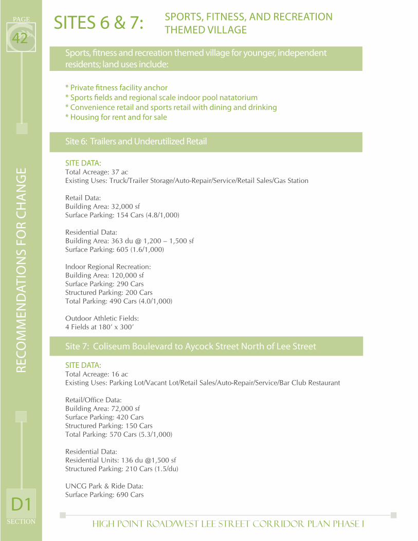
High Point Road/West Lee Street Corridor Plan PHASE I
PAGE
SECTION
42SITES 6 & 7:
Sports, fi tness and recreation themed village for younger, independent
residents; land uses include:
* Private fi tness facility anchor
* Sports fi elds and regional scale indoor pool natatorium
* Convenience retail and sports retail with dining and drinking
* Housing for rent and for sale
Site 6: Trailers and Underutilized Retail
SITE DATA: Total Acreage: 37 acExisting Uses: Truck/Trailer Storage/Auto-Repair/Service/Retail Sales/Gas Station
Retail Data:Building Area: 32,000 sfSurface Parking: 154 Cars (4.8/1,000)
Residential Data:Building Area: 363 du @ 1,200 – 1,500 sfSurface Parking: 605 (1.6/1,000)
Indoor Regional Recreation:Building Area: 120,000 sfSurface Parking: 290 CarsStructured Parking: 200 CarsTotal Parking: 490 Cars (4.0/1,000)
Outdoor Athletic Fields:4 Fields at 180’ x 300’
Site 7: Coliseum Boulevard to Aycock Street North of Lee Street
SITE DATA: Total Acreage: 16 acExisting Uses: Parking Lot/Vacant Lot/Retail Sales/Auto-Repair/Service/Bar Club Restaurant
Retail/Offi ce Data:Building Area: 72,000 sfSurface Parking: 420 CarsStructured Parking: 150 CarsTotal Parking: 570 Cars (5.3/1,000)
Residential Data:Residential Units: 136 du @1,500 sfStructured Parking: 210 Cars (1.5/du)
UNCG Park & Ride Data:Surface Parking: 690 Cars
SPORTS, FITNESS, AND RECREATION
THEMED VILLAGER
EC
OM
ME
ND
AT
ION
S F
OR
CH
AN
GE
D1
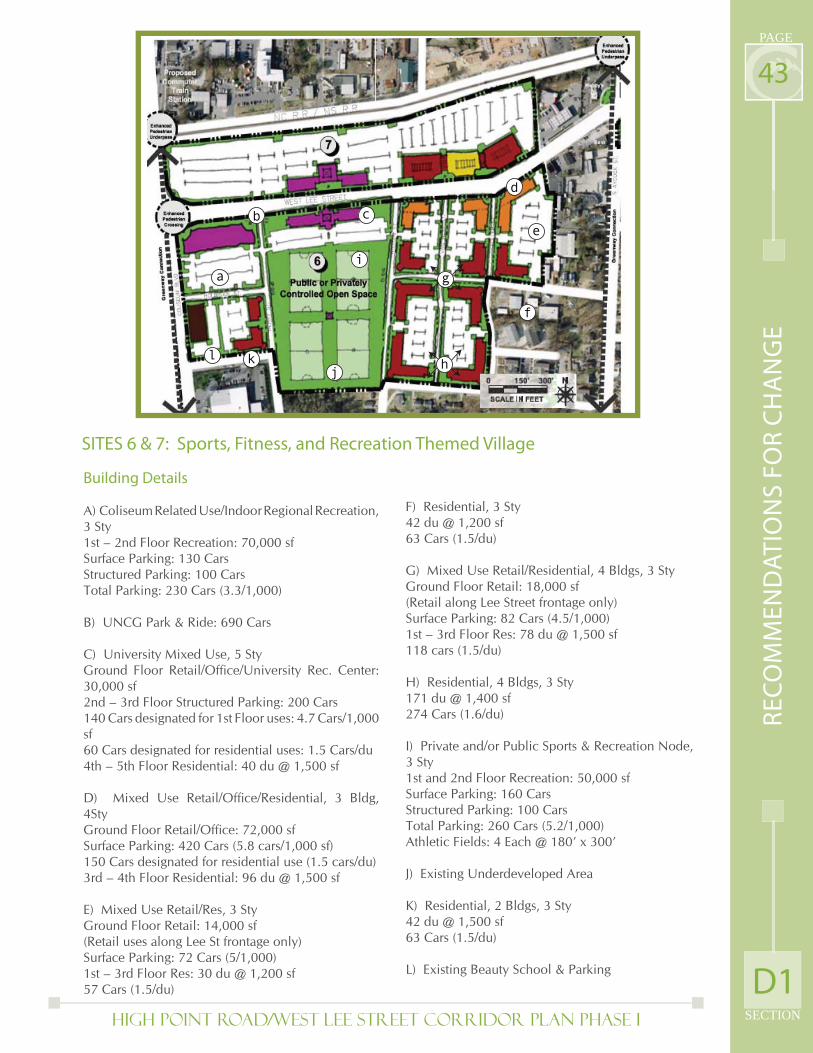
High Point Road/West Lee Street Corridor Plan PHASE I SECTION
PAGE
43
d
e
f
j
a
b c
h
i
k
g
l
SITES 6 & 7: Sports, Fitness, and Recreation Themed Village
Building Details
A) Coliseum Related Use/Indoor Regional Recreation, 3 Sty1st – 2nd Floor Recreation: 70,000 sfSurface Parking: 130 CarsStructured Parking: 100 CarsTotal Parking: 230 Cars (3.3/1,000)
B) UNCG Park & Ride: 690 Cars
C) University Mixed Use, 5 StyGround Floor Retail/Offi ce/University Rec. Center: 30,000 sf2nd – 3rd Floor Structured Parking: 200 Cars140 Cars designated for 1st Floor uses: 4.7 Cars/1,000 sf60 Cars designated for residential uses: 1.5 Cars/du4th – 5th Floor Residential: 40 du @ 1,500 sf
D) Mixed Use Retail/Offi ce/Residential, 3 Bldg, 4StyGround Floor Retail/Offi ce: 72,000 sfSurface Parking: 420 Cars (5.8 cars/1,000 sf)150 Cars designated for residential use (1.5 cars/du)3rd – 4th Floor Residential: 96 du @ 1,500 sf
E) Mixed Use Retail/Res, 3 StyGround Floor Retail: 14,000 sf(Retail uses along Lee St frontage only)Surface Parking: 72 Cars (5/1,000)1st – 3rd Floor Res: 30 du @ 1,200 sf57 Cars (1.5/du)
F) Residential, 3 Sty42 du @ 1,200 sf63 Cars (1.5/du)
G) Mixed Use Retail/Residential, 4 Bldgs, 3 StyGround Floor Retail: 18,000 sf(Retail along Lee Street frontage only)Surface Parking: 82 Cars (4.5/1,000)1st – 3rd Floor Res: 78 du @ 1,500 sf118 cars (1.5/du)
H) Residential, 4 Bldgs, 3 Sty171 du @ 1,400 sf274 Cars (1.6/du)
I) Private and/or Public Sports & Recreation Node, 3 Sty1st and 2nd Floor Recreation: 50,000 sfSurface Parking: 160 CarsStructured Parking: 100 CarsTotal Parking: 260 Cars (5.2/1,000)Athletic Fields: 4 Each @ 180’ x 300’
J) Existing Underdeveloped Area
K) Residential, 2 Bldgs, 3 Sty42 du @ 1,500 sf63 Cars (1.5/du)
L) Existing Beauty School & Parking
RE
CO
MM
EN
DA
TIO
NS
FO
R C
HA
NG
E
D1
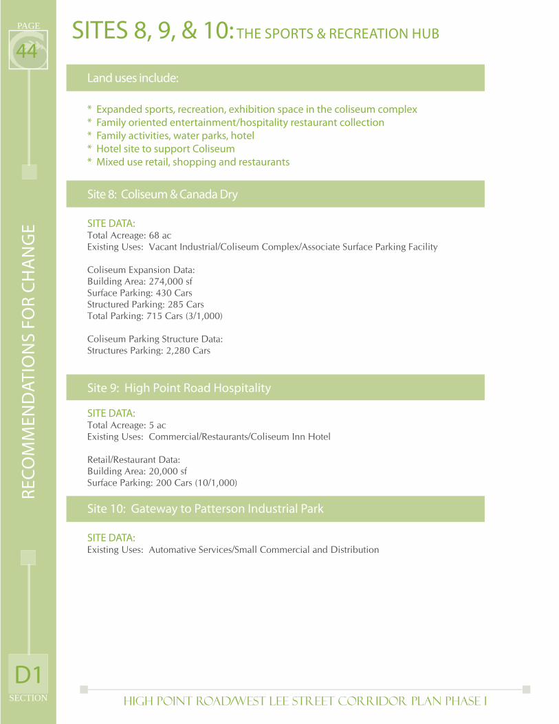
High Point Road/West Lee Street Corridor Plan PHASE I
PAGE
SECTION
44SITES 8, 9, & 10: THE SPORTS & RECREATION HUB
Land uses include:
* Expanded sports, recreation, exhibition space in the coliseum complex
* Family oriented entertainment/hospitality restaurant collection
* Family activities, water parks, hotel
* Hotel site to support Coliseum
* Mixed use retail, shopping and restaurants
Site 8: Coliseum & Canada Dry
SITE DATA: Total Acreage: 68 acExisting Uses: Vacant Industrial/Coliseum Complex/Associate Surface Parking Facility
Coliseum Expansion Data:Building Area: 274,000 sfSurface Parking: 430 CarsStructured Parking: 285 CarsTotal Parking: 715 Cars (3/1,000)
Coliseum Parking Structure Data:Structures Parking: 2,280 Cars
Site 9: High Point Road Hospitality
SITE DATA: Total Acreage: 5 acExisting Uses: Commercial/Restaurants/Coliseum Inn Hotel
Retail/Restaurant Data:Building Area: 20,000 sfSurface Parking: 200 Cars (10/1,000)
Site 10: Gateway to Patterson Industrial Park
SITE DATA: Existing Uses: Automative Services/Small Commercial and Distribution
RE
CO
MM
EN
DA
TIO
NS
FO
R C
HA
NG
E
D1
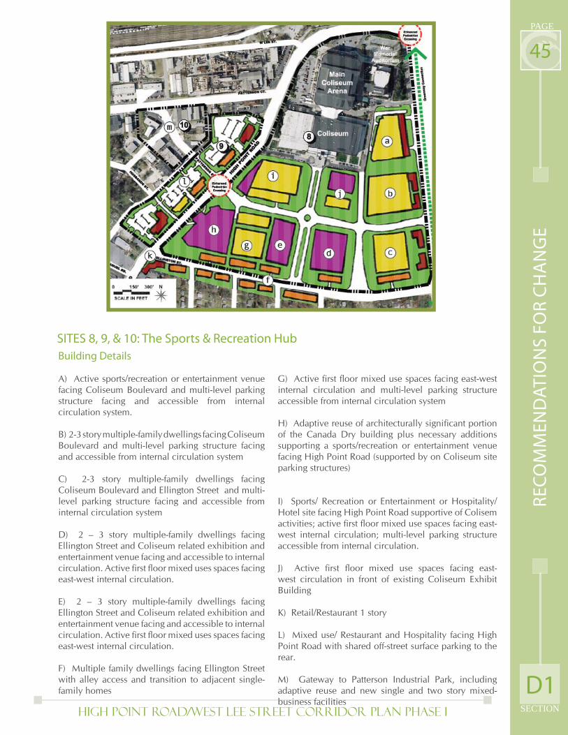
High Point Road/West Lee Street Corridor Plan PHASE I SECTION
PAGE
45
SITES 8, 9, & 10: The Sports & Recreation Hub
Building Details
A) Active sports/recreation or entertainment venue facing Coliseum Boulevard and multi-level parking structure facing and accessible from internal circulation system.
B) 2-3 story multiple-family dwellings facing Coliseum Boulevard and multi-level parking structure facing and accessible from internal circulation system
C) 2-3 story multiple-family dwellings facing Coliseum Boulevard and Ellington Street and multi-level parking structure facing and accessible from internal circulation system
D) 2 – 3 story multiple-family dwellings facing Ellington Street and Coliseum related exhibition and entertainment venue facing and accessible to internal circulation. Active fi rst fl oor mixed uses spaces facing east-west internal circulation.
E) 2 – 3 story multiple-family dwellings facing Ellington Street and Coliseum related exhibition and entertainment venue facing and accessible to internal circulation. Active fi rst fl oor mixed uses spaces facing east-west internal circulation.
F) Multiple family dwellings facing Ellington Street with alley access and transition to adjacent single-family homes
G) Active fi rst fl oor mixed use spaces facing east-west internal circulation and multi-level parking structure accessible from internal circulation system
H) Adaptive reuse of architecturally signifi cant portion of the Canada Dry building plus necessary additions supporting a sports/recreation or entertainment venue facing High Point Road (supported by on Coliseum site parking structures)
I) Sports/ Recreation or Entertainment or Hospitality/Hotel site facing High Point Road supportive of Colisem activities; active fi rst fl oor mixed use spaces facing east-west internal circulation; multi-level parking structure accessible from internal circulation.
J) Active fi rst fl oor mixed use spaces facing east-west circulation in front of existing Coliseum Exhibit Building
K) Retail/Restaurant 1 story
L) Mixed use/ Restaurant and Hospitality facing High Point Road with shared off-street surface parking to the rear.
M) Gateway to Patterson Industrial Park, including adaptive reuse and new single and two story mixed-business facilities
RE
CO
MM
EN
DA
TIO
NS
FO
R C
HA
NG
E
D1
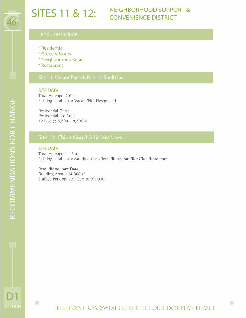
High Point Road/West Lee Street Corridor Plan PHASE I
PAGE
SECTION
46SITES 11 & 12:
Land uses include:
* Residential
* Grocery Stores
* Neighborhood Retail
* Restaurant
Site 11 Vacant Parcels Behind Shell Gas
SITE DATA: Total Acreage: 2.6 acExisting Land Uses: Vacant/Not Designated
Residential Data:Residential Lot Area: 12 Lots @ 5,500 – 9,500 sf
Site 12: China King & Adjacent Uses
SITE DATA: Total Acreage: 11.5 asExisting Land Uses: Multiple Uses/Retail/Restaurant/Bar Club Restaurant
Retail/Restaurant Data:Building Area: 104,800 sfSurface Parking: 729 Cars (6.9/1,000)
Site 10: Gateway to Ptterson Business Park
NEIGHBORHOOD SUPPORT &
CONVENIENCE DISTRICTR
EC
OM
ME
ND
AT
ION
S F
OR
CH
AN
GE
D1
High Point Road/West Lee Street Corridor Plan PHASE I SECTION
PAGE
47
SITES 11 & 12: Neighborhood Support & Convenience District
Building Details
Building DetailsA) Affordable Single Family Detached or Attached Homes12 Lots5,500 – 9,500 sf
B) Restaurant/Retail, 1 Sty15,000 sf124 Cars (8.2/1,000)
C) Restaurant, 1 Sty13,500 sf130 Cars (9.3/1,000)
D) Neighborhood Oriented Retail, 4 Bldgs, 1 Sty76,300 sf475 Cars (6.2/1,000)
Site 11
Site 12
RE
CO
MM
EN
DA
TIO
NS
FO
R C
HA
NG
E
D1
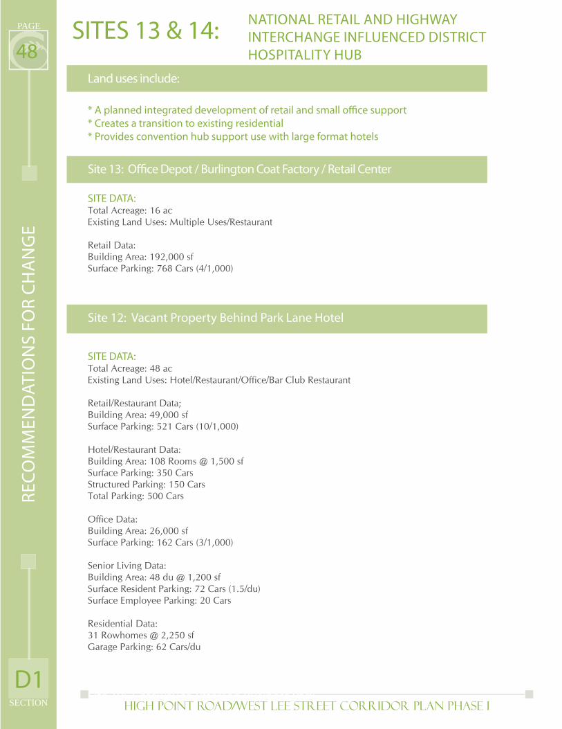
High Point Road/West Lee Street Corridor Plan PHASE I
PAGE
SECTION
48SITES 13 & 14:
Land uses include:
* A planned integrated development of retail and small offi ce support
* Creates a transition to existing residential
* Provides convention hub support use with large format hotels
Site 13: Offi ce Depot / Burlington Coat Factory / Retail Center
SITE DATA: Total Acreage: 16 acExisting Land Uses: Multiple Uses/Restaurant
Retail Data:Building Area: 192,000 sfSurface Parking: 768 Cars (4/1,000)
Site 12: Vacant Property Behind Park Lane Hotel
SITE DATA: Total Acreage: 48 acExisting Land Uses: Hotel/Restaurant/Offi ce/Bar Club Restaurant
Retail/Restaurant Data;Building Area: 49,000 sfSurface Parking: 521 Cars (10/1,000)
Hotel/Restaurant Data:Building Area: 108 Rooms @ 1,500 sfSurface Parking: 350 CarsStructured Parking: 150 CarsTotal Parking: 500 Cars
Offi ce Data:Building Area: 26,000 sfSurface Parking: 162 Cars (3/1,000)
Senior Living Data:Building Area: 48 du @ 1,200 sfSurface Resident Parking: 72 Cars (1.5/du)Surface Employee Parking: 20 Cars
Residential Data:31 Rowhomes @ 2,250 sfGarage Parking: 62 Cars/du
Site 10: Gateway to Ptterson Business Park
NATIONAL RETAIL AND HIGHWAY
INTERCHANGE INFLUENCED DISTRICT
HOSPITALITY HUB
RE
CO
MM
EN
DA
TIO
NS
FO
R C
HA
NG
E
D1
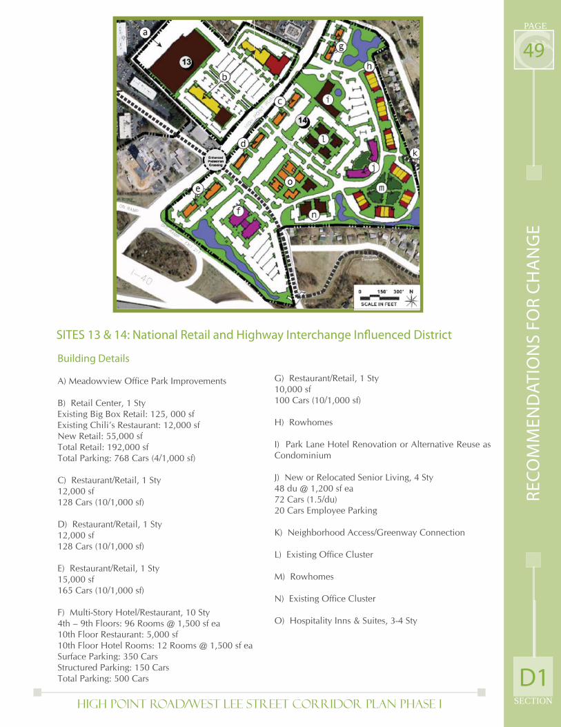
High Point Road/West Lee Street Corridor Plan PHASE I SECTION
PAGE
49
SITES 13 & 14: National Retail and Highway Interchange Infl uenced District
Building Details
A) Meadowview Offi ce Park Improvements
B) Retail Center, 1 StyExisting Big Box Retail: 125, 000 sfExisting Chili’s Restaurant: 12,000 sfNew Retail: 55,000 sfTotal Retail: 192,000 sfTotal Parking: 768 Cars (4/1,000 sf)
C) Restaurant/Retail, 1 Sty12,000 sf128 Cars (10/1,000 sf)
D) Restaurant/Retail, 1 Sty12,000 sf128 Cars (10/1,000 sf)
E) Restaurant/Retail, 1 Sty15,000 sf165 Cars (10/1,000 sf)
F) Multi-Story Hotel/Restaurant, 10 Sty4th – 9th Floors: 96 Rooms @ 1,500 sf ea10th Floor Restaurant: 5,000 sf10th Floor Hotel Rooms: 12 Rooms @ 1,500 sf eaSurface Parking: 350 CarsStructured Parking: 150 CarsTotal Parking: 500 Cars
G) Restaurant/Retail, 1 Sty10,000 sf100 Cars (10/1,000 sf)
H) Rowhomes
I) Park Lane Hotel Renovation or Alternative Reuse as Condominium
J) New or Relocated Senior Living, 4 Sty48 du @ 1,200 sf ea72 Cars (1.5/du)20 Cars Employee Parking
K) Neighborhood Access/Greenway Connection
L) Existing Offi ce Cluster
M) Rowhomes
N) Existing Offi ce Cluster
O) Hospitality Inns & Suites, 3-4 Sty
RE
CO
MM
EN
DA
TIO
NS
FO
R C
HA
NG
E
D1
High Point Road/West Lee Street Corridor Plan PHASE I
PAGE
SECTION
50D2) Land Use and Zoning
The majority of the High Point Road/West Lee Street corridor is designated Mixed Use Commercial in the Connections 2025 Comprehensive Plan and Glenwood Neighborhood Plan, with smaller concentrations of Institutional and various Residential designations. To facilitate the greater intensity and mixture of pedestrian oriented uses in the corridor and establish appropriate transitions between residential and non-residential/mixed use areas, a corridor Future Land Use Map is included with this Plan. The defi nitions for these future land use designations are the same as those in the City’s adopted Comprehensive Plan. The Future Land Use Map, shown on Page 53, notes the following:
Areas along West Lee Street between Freeman Mill Road and South Aycock Street are designated Mixed Use Commercial and Mixed Use Residential. This a refl ection of the anticipated mixed development patterns linked to UNCG (and to a lesser degree other local colleges and universities) and the Glenwood neighborhood
An additional area is designated Mixed Use Residential one block in from the intersection of Coliseum Boulevard and West Lee Street. This serves the dual function of supporting the sports village concept that includes a signifi cant new residential component and provides clearer boundaries between activities related to the Coliseum area and the Glenwood neighborhood.
Areas between residences in the Hillsdale Park neighborhood and the restaurants, hotels and offi ces located on the east of High Point Road, north of I-40, are designated Mixed Use Residential, refl ecting proposed future residential uses as part of larger redevelopment efforts in that area.
The Mixed Use Commercial designation along High Point Road is limited to properties directly adjacent to High Point Road to establish clearer boundaries between commercial and other non-residential uses along High Point Road and adjacent low density residential neighborhoods of Ardmore Park, Hillsdale Park and Piedmont Heights.
More defi nite boundaries for the Patterson Street industrial area and commercial related uses west of the Coliseum are also identifi ed.
All remaining areas will maintain the Mixed Use Commercial designation; or Low Residential designation for the potential residential site in the Ardmore Park neighborhood. It should be noted that while areas around UNCG and the Coliseum are shown as Mixed Use Commercial in the corridor future land use plan, it is understood that these large institutions will signifi cantly infl uence future development in these areas.
•
•
•
•
•
•
Consistent with the Comprehensive Plan, almost seventy-fi ve percent of the High Point Road/West Lee Street corridor is currently zoned for commercial or industrial uses. As the future land use map encourages more intense and mixed land uses, this Plan recommends some adjustments to existing zoning as property is redeveloped:
RE
CO
MM
EN
DA
TIO
NS
FO
R C
HA
NG
E
D2
High Point Road/West Lee Street Corridor Plan PHASE I SECTION
PAGE
51
•
Remove all Heavy Industrial zoning outside of the stable Patterson Street industrial area to facilitate new commercial, light industrial, offi ce and residential uses.
The use of the Planned Development Infi ll zoning district is encouraged as it provides more development fl exibility and should encourage development that is more unifi ed and pedestrian scaled in design and can more easily facilitate mixed use development that is compatible with surrounding areas, particularly adjacent lower intensity residential uses.
Other zoning districts such as General Business, General Offi ce Moderate Intensity and General Offi ce-High Intensity could be appropriate to replace industrial zoning in areas where mixed development is encouraged. Additionally lower intensity commercial and offi ce zoning such as Limited Business, Neighborhood Business and Limited Offi ce are encouraged for areas that are more logically oriented towards local services and are less connected to the nearby highway.
•
•
RE
CO
MM
EN
DA
TIO
NS
FO
R C
HA
NG
E
D2

Page Intentionally Left Blank
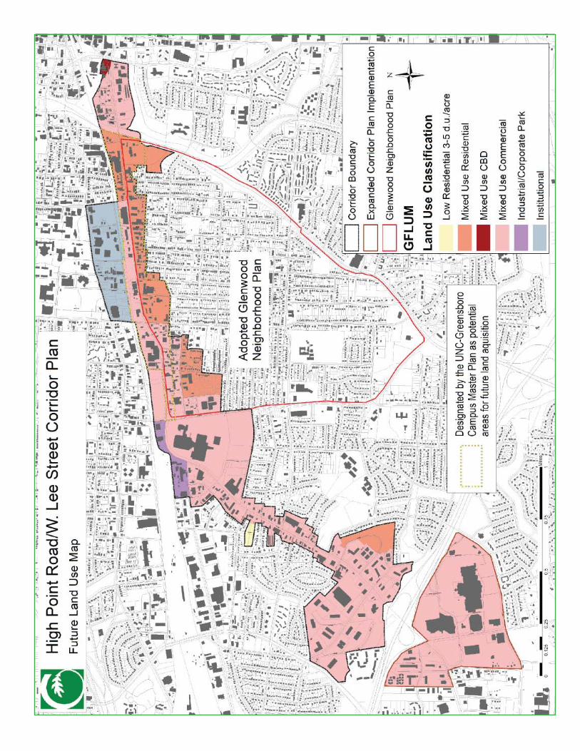
High Point Road/West Lee Street Corridor Plan PHASE I
PAGE
SECTION
54D3) Transportation(see Action Plan for additional details)
Much of the transportation focus in the High Point Road/West Lee Street corridor has been on moving large volumes of auto and truck traffi c through the corridor, and to and from Coliseum events; encouraging auto oriented land development patterns that have limited opportunities for pedestrians, bicyclists and transit riders. While this Plan acknowledges the need to preserve existing auto traffi c capacity, expanding opportunities for pedestrians, bicyclists and transit riders will be crucial to the overall success of corridor redevelopment. To that end this Plan focuses on enhancing existing transportation options and routes and creating safe and more effi cient routes between major corridor destinations and new land uses.
Given the corridor’s location and connections to numerous major destinations, its potential as one of the highest intensity corridors with signifi cant transportation options is apparent. Such varied transportation options are needed to support the types of development recommended under the Reinvestment and Land Use section.
Pedestrian
Major priorities to enhance pedestrian use of the corridor focus around improvements at key intersections, enhancing the existing sidewalk network for the corridor (and related areas), providing links to existing and planned greenways and the inclusion of pedestrian amenities with new investment. Recommended enhancements include:
Increase and enhance pedestrian signage, primarily at intersection crossings
Install or upgrade pedestrian countdown signals at key intersections
High visibility crosswalks at intersections to make them more visible to motorists
Install pedestrian refuge islands or bulb-outs at intersections to reduce pedestrian crossing distances
Bring existing corridor sidewalks up to City standards (at minimum), and increase sidewalk widths throughout corridor through public improvements or through property redevelopment
Identify gaps in sidewalk network (and connections between major destinations) and fi ll in as part of public improvements or through property redevelopment
Link sidewalks to existing or proposed greenways to expand pedestrian options. Priorities include proposed Downtown Greenway (fi rst leg crosses corridor) and linkages to existing Hillsdale Park greenway
Include pedestrian amenities (eg. pedestrian scaled entrances, clear access from public rights-of-way, inclusion of active street level uses) with new investment
Enhance railroad underpasses at Chapman Street, South Aycock Street, Tate Street and Fulton Street and longer term create new pedestrian/bicycle underpass at Forest Street/Glenwood Avenue
••
•
•
•
•
•
•
•
•
RE
CO
MM
EN
DA
TIO
NS
FO
R C
HA
NG
E
D3
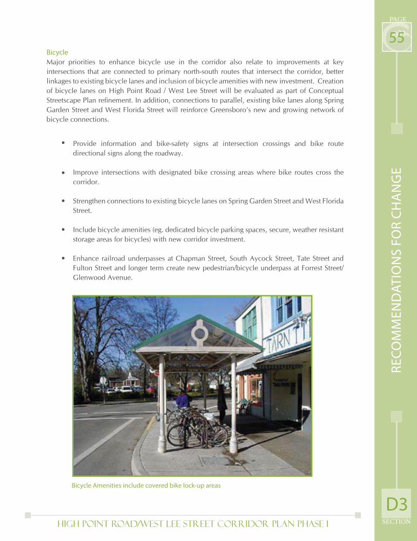
High Point Road/West Lee Street Corridor Plan PHASE I SECTION
PAGE
55Bicycle
Major priorities to enhance bicycle use in the corridor also relate to improvements at key intersections that are connected to primary north-south routes that intersect the corridor, better linkages to existing bicycle lanes and inclusion of bicycle amenities with new investment. Creation of bicycle lanes on High Point Road / West Lee Street will be evaluated as part of Conceptual Streetscape Plan refi nement. In addition, connections to parallel, existing bike lanes along Spring Garden Street and West Florida Street will reinforce Greensboro’s new and growing network of bicycle connections.
Provide information and bike-safety signs at intersection crossings and bike route directional signs along the roadway.
Improve intersections with designated bike crossing areas where bike routes cross the corridor.
Strengthen connections to existing bicycle lanes on Spring Garden Street and West Florida Street.
Include bicycle amenities (eg. dedicated bicycle parking spaces, secure, weather resistant storage areas for bicycles) with new corridor investment.
Enhance railroad underpasses at Chapman Street, South Aycock Street, Tate Street and Fulton Street and longer term create new pedestrian/bicycle underpass at Forrest Street/Glenwood Avenue.
•
•
•
•
•
Bicycle Amenities include covered bike lock-up areas
RE
CO
MM
EN
DA
TIO
NS
FO
R C
HA
NG
E
D3
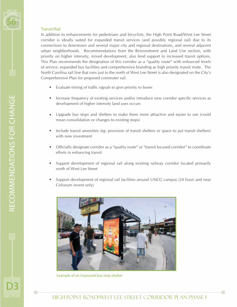
High Point Road/West Lee Street Corridor Plan PHASE I
PAGE
SECTION
56Transit/Rail
In addition to enhancements for pedestrians and bicyclists, the High Point Road/West Lee Street corridor is ideally suited for expanded transit services (and possibly regional rail) due to its connections to downtown and several major city and regional destinations, and several adjacent urban neighborhoods. Recommendations from the Reinvestment and Land Use section, with priority on higher intensity, mixed development, also lend support to increased transit options. This Plan recommends the designation of this corridor as a “quality route” with enhanced levels of service, expanded bus facilities and comprehensive branding as high priority transit route. The North Carolina rail line that runs just to the north of West Lee Street is also designated on the City’s Comprehensive Plan for proposed commuter rail.
Evaluate timing of traffi c signals to give priority to buses
Increase frequency of existing services and/or introduce new corridor specifi c services as development of higher intensity land uses occurs
Upgrade bus stops and shelters to make them more attractive and easier to use (could mean consolidation or changes to existing stops)
Include transit amenities (eg. provision of transit shelters or space to put transit shelters) with new investment
Offi cially designate corridor as a “quality route” or “transit focused corridor” to coordinate efforts in enhancing transit
Support development of regional rail along existing railway corridor located primarily north of West Lee Street
Support development of regional rail facilities around UNCG campus (24 hour) and near Coliseum (event only)
•
•
•
•
•
•
•
Example of an improved bus stop shelter
RE
CO
MM
EN
DA
TIO
NS
FO
R C
HA
NG
E
D3
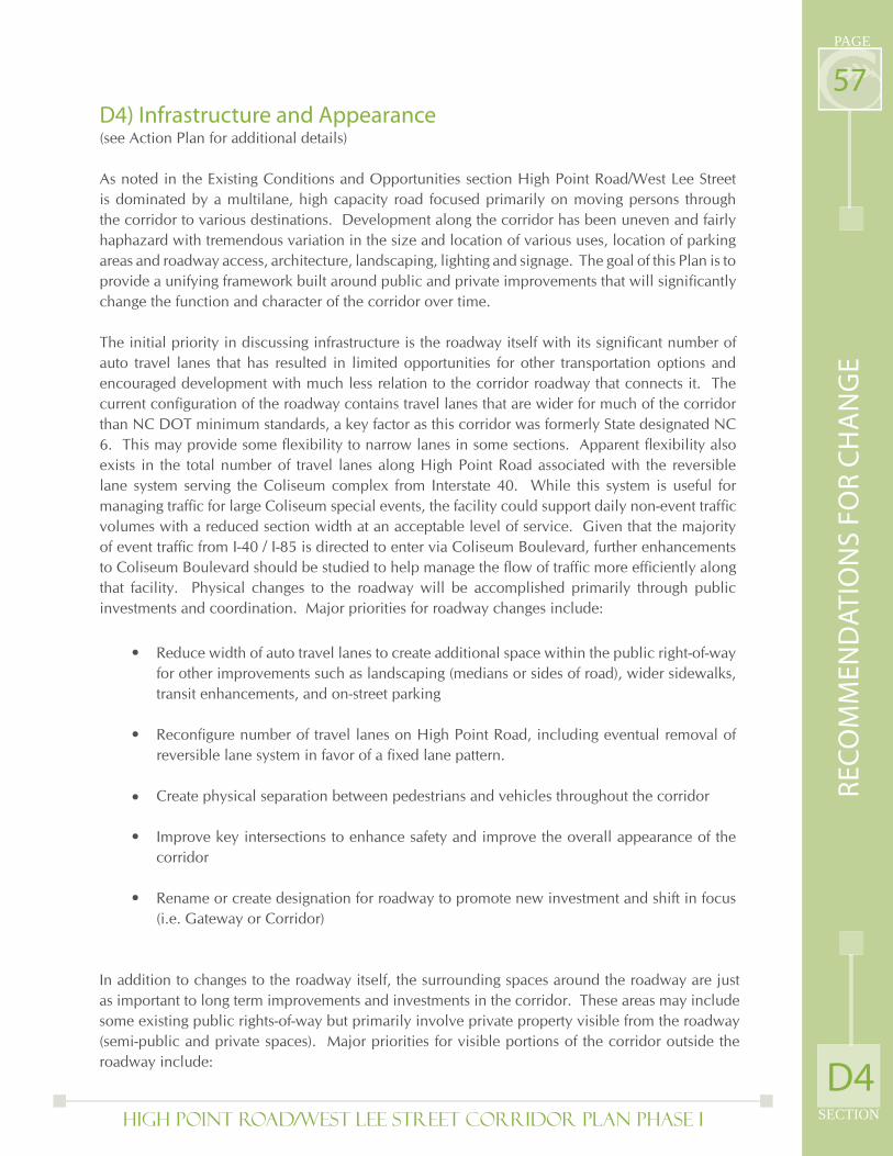
High Point Road/West Lee Street Corridor Plan PHASE I SECTION
PAGE
57D4) Infrastructure and Appearance(see Action Plan for additional details)
As noted in the Existing Conditions and Opportunities section High Point Road/West Lee Street is dominated by a multilane, high capacity road focused primarily on moving persons through the corridor to various destinations. Development along the corridor has been uneven and fairly haphazard with tremendous variation in the size and location of various uses, location of parking areas and roadway access, architecture, landscaping, lighting and signage. The goal of this Plan is to provide a unifying framework built around public and private improvements that will signifi cantly change the function and character of the corridor over time.
The initial priority in discussing infrastructure is the roadway itself with its signifi cant number of auto travel lanes that has resulted in limited opportunities for other transportation options and encouraged development with much less relation to the corridor roadway that connects it. The current confi guration of the roadway contains travel lanes that are wider for much of the corridor than NC DOT minimum standards, a key factor as this corridor was formerly State designated NC 6. This may provide some fl exibility to narrow lanes in some sections. Apparent fl exibility also exists in the total number of travel lanes along High Point Road associated with the reversible lane system serving the Coliseum complex from Interstate 40. While this system is useful for managing traffi c for large Coliseum special events, the facility could support daily non-event traffi c volumes with a reduced section width at an acceptable level of service. Given that the majority of event traffi c from I-40 / I-85 is directed to enter via Coliseum Boulevard, further enhancements to Coliseum Boulevard should be studied to help manage the fl ow of traffi c more effi ciently along that facility. Physical changes to the roadway will be accomplished primarily through public investments and coordination. Major priorities for roadway changes include:
Reduce width of auto travel lanes to create additional space within the public right-of-way for other improvements such as landscaping (medians or sides of road), wider sidewalks, transit enhancements, and on-street parking
Reconfi gure number of travel lanes on High Point Road, including eventual removal of reversible lane system in favor of a fi xed lane pattern.
Create physical separation between pedestrians and vehicles throughout the corridor
Improve key intersections to enhance safety and improve the overall appearance of the corridor
Rename or create designation for roadway to promote new investment and shift in focus (i.e. Gateway or Corridor)
•
•
•
•
•
In addition to changes to the roadway itself, the surrounding spaces around the roadway are just as important to long term improvements and investments in the corridor. These areas may include some existing public rights-of-way but primarily involve private property visible from the roadway (semi-public and private spaces). Major priorities for visible portions of the corridor outside the roadway include:
D4
RE
CO
MM
EN
DA
TIO
NS
FO
R C
HA
NG
E
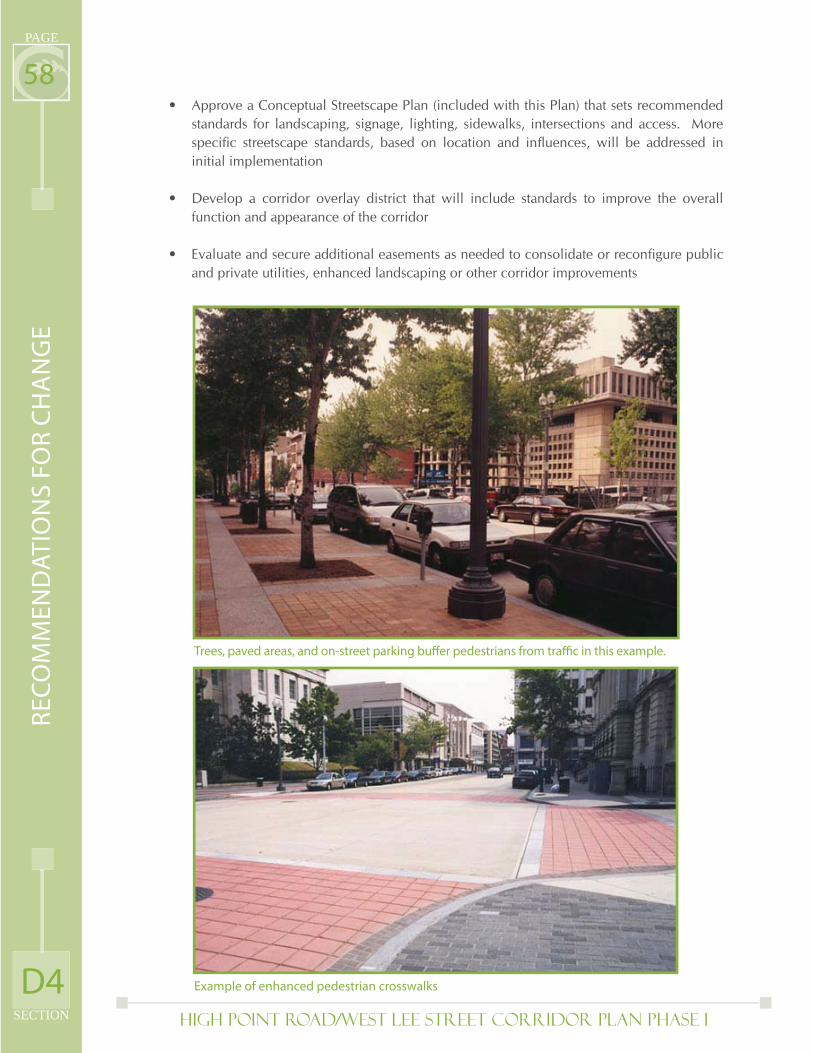
High Point Road/West Lee Street Corridor Plan PHASE I
PAGE
SECTION
58Approve a Conceptual Streetscape Plan (included with this Plan) that sets recommended standards for landscaping, signage, lighting, sidewalks, intersections and access. More specifi c streetscape standards, based on location and infl uences, will be addressed in initial implementation
Develop a corridor overlay district that will include standards to improve the overall function and appearance of the corridor
Evaluate and secure additional easements as needed to consolidate or reconfi gure public and private utilities, enhanced landscaping or other corridor improvements
•
•
•
Example of enhanced pedestrian crosswalks
Trees, paved areas, and on-street parking buff er pedestrians from traffi c in this example.
D4
RE
CO
MM
EN
DA
TIO
NS
FO
R C
HA
NG
E
High Point Road/West Lee Street Corridor Plan PHASE I SECTION
PAGE
59D5) Conceptual Streetscape Plan
Paths and Nodes
Signifi cant public discussion regarding the desirability of the High Point Road / West Lee Street Corridor focused on the character and safety within the public controlled right-of-way…the “streetscape.” The analysis, public input, and recommendations key on these fundamentals:
High Point Road and West Lee Streets are not consistent rights-of-ways. Across the 3 ½ mile corridor, there are many different lane widths and confi gurations, varying sidewalk widths and conditions, differences in traffi c volumes, different forms and qualities of street lighting and differences in site accessibility. Right-of-way widths vary, adjacent land-uses vary, truck/auto/pedestrian/bicycle mode volumes vary. Each of these conditions lead to the strong conclusion that one streetscape system cannot be successfully applied to the entire corridor. As such, this plan recommends improvements at intersection nodes, and the vehicular and pedestrian paths between these intersection nodes which refl ect the adjacent and surrounding conditions. Nodes fall into three categories:
Increase pedestrian comfort and safety, particularly at intersections and road crossings
Reduce visual clutter
Manage congestion and confl icts between accessibility and roadway capacity
Create a consistent image, from gateway through destination across the entire corridor, without sacrifi cing differences between unique areas to uniformity.
•
•
•
•
Gateway Nodes – Primary entries into the corridor which provide great opportunities to introduce the corridor, set the corridor theme, and welcome travelers. Meadowview Road, Patterson Street and South Eugene Street are designated as gateway nodes.
High Image Nodes – Places where large numbers of pedestrians and vehicles come together require special treatment to present a positive image and to accommodate safe interaction. South Aycock Street and Coliseum Boulevard are designated as high image nodes.
Safe Crossing Nodes – Clear crosswalk designations, traffi c signal/pedestrian signal systems, and higher street lighting levels will accommodate and encourage pedestrian (and bicyclist) traffi c supporting businesses and residential development in the corridor. Freeman Mill Road, Tate Street/Silver Street, Glenwood Avenue and West Florida Street are designated as Safe Crossing nodes.
1.
2.
3.
D5
RE
CO
MM
EN
DA
TIO
NS
FO
R C
HA
NG
E
High Point Road/West Lee Street Corridor Plan PHASE I
PAGE
SECTION
60Two general forms of path are indicated, though dozens of variations on these two categories will evolve based on the specifi c physical limitations of right-of-way and refl ective of the land-uses which abut these paths:
Urban Corridor – Where the tightest rights-of-way widths constrain public improvements, most commonly in the older developed areas of West Lee Street, attractive and safe improvements can make the paths more comfortable, usable and attractive to both vehicular and pedestrian users. The Urban Corridor extends from South Eugene Street on the East to Coliseum Boulevard on the West.
Suburban Corridor -- Wider rights-of-way, auto-oriented development, larger frontages, and deeper building setbacks allow streetscape improvements to accommodate more landscaping, wider sidewalks, and may allow for reduced visibility of overhead utilities. The Suburban Corridor extends from Coliseum Boulevard on the East to Interstate 40 on the West.
•
•
D5
RE
CO
MM
EN
DA
TIO
NS
FO
R C
HA
NG
E

Page Intentionally Left Blank
High Point Road/West Lee Street Corridor Plan PHASE I
PAGE
SECTION
62
WFL
OR
IDA
ST
WA
LKE
RA
VE
SP
RIN
GG
AR
DE
NS
T
BU
S40
E
BU
S40
W
OA
KS
T
DENRD
FREEMANMILLRD
HARDIEST
S EUGENE ST
COLISEUM BLVD
OA
KLA
ND
AV
E
PATT
ER
SON
ST
AS
HE
ST
GR
OV
ES
T
WTE
RR
ELL
ST
IMM
AN
UE
LR
D
KERSEYST
GLENWOODAVE
MU
RR
AYH
ILL
RD
MCCORMICKST
WM
EADOW
VIEW
RD
WM
CG
EE
ST
NEALST
WR
IGH
TA
VE
SELM-EUGENEST
PARK TER
BR
ICE
ST
LOVETTST
VANSTORY ST
EXIT21
7
LEXINGTONAVE
GA
RR
ETT
ST
VANWERTST
HAY
WO
OD
ST
RANDLEMANRD
S LINDELL RD
SILVERAVE
OPA
LD
R
SCOTTAVE
KO
UR
YB
LVD
WARRENST
HIGHLANDAVE
SELMST
ER
WIN
ST
SCHAPMANST
CR
AIG
ST
BILBROST
MOBILEST
BRANDTST
DO
AK
ST
RO
BB
INS
ST
VICTORY ST
ASH
LAN
DD
R
OGDEN ST
NORTHRIDGEST
DILLARDST
FLOYDST
WWENDOVERAVE
GREGORYST
SELAMAVE
DORSEYST
MA
YW
OO
DS
T
ORCHARDST
TOWNST
WW
HIT
TIN
GTO
NS
T
WILLOMOREST
SO
UTH
ST
MEMPHISST
MA
SON
ICD
R
RAY
ST
LAW
RE
NC
ES
T
JA
VE
ELLI
NG
TON
ST
TRO
GD
ON
ST
FULTONST
HO
LBR
OO
KS
T
ON
TAR
IOS
T
MA
RSH
ST
SOABARST
DICKST
KIR
KM
AN
ST
S TATE ST
EMERYWOODRD
ATLANTAST
BELMARST
ELW
OO
DA
VE
OC
ON
NO
RS
T
UN
ION
ST
RAINBOW DR
SA
VAN
NA
HS
T
ISLE
RS
T
SW
AN
ST
OLDCHAPMANST
PORTLANDST
CA
RR
ST
HIG
HPO
INT
RD
WILDWOODDR
LONGVIEWST
CO
LLIE
RD
R
KE
RST
IRE
LAN
DS
T
SMENDENHALLST
ALLENST
COLLEGEAVE
CA
RP
EN
TER
ST
BERTIEST
ROWE ST
HY
DE
DR
CE
NTE
RS
T
PERRY ST
GRANITEST
SU
SS
MA
NS
ST
WIL
LORA
ST
PINECROFT RD
DEXT
ERA
KENILWORTHST
NOR
THD
R
FLAGST
SPR
ING
WO
OD
DR
HANNERST
WESTBROOKST
NEWORLEANSST
EM
ER
ALD
DR
FULLERST
GR
IMSL
EYST
DA
NA
PL
SCEDARST
WESTDR
COLUMBUS ST
WILLOWBROOK DR
DEV
ON
DR
MAYFLOWERDR
CO
NC
OR
DS
T
WW
AS
HIN
GTO
NS
T
CURTIS ST
EDGARST
BINFORDST
STIRLINGST
TODDST
MA
RIO
NS
T
LYN
ETT
ED
RM
INO
RS
T
HIA
TTS
T
ENGLEWOODST
SERVICEDR
SSPRINGST
UR
BA
ND
R
FEDERALPL
LAM
AS
T
SGREENEST
EUGENECT
BITTINGST
GLE
NH
AV
EN
DR
RH
EIM
SD
R
BRUCEST
UNIVERSITYDR
CO
BB
ST
HUSBANDSST
HOWARDST
BAKE
RD
R
RO
CK
ETT
ST
HOMEST
PATT
ER
SO
NC
T
CLEMMONSST
BULLAST
DUMONT
DR
LUR
AY
DR
LANGLEYST
BE
EC
HW
OO
DS
T
VEASLEYST
SEASONSW
AY
FORESTST
HU
DG
INS
DR
CA
MB
OR
NE
ST
HALLST
MA
PLE
WO
OD
LN
PIN
EB
LUFF
ST
SILERST
FAWNST
RE
XC
T
JOYNER ST
EULAST
VIL
LAG
EG
RE
EN
DR
ALBATROSSST
PASCHALST
WO
OD
BE
RR
YD
R
RUTH'S LN
CLEGGST
EU
CLI
DS
T
HUBERTST
SAYCOCKST
MCMANUSST
SHORTST
EDGECOMBEST
MILTONST
FAR
GIS
ST
WES
TC
OU
RT
ST
BA
RR
ING
ER
ST
RATHST
LIN
WO
OD
ST
PH
OE
BE
DR
CRESTRIDGE RD
HAY
DEN
SP
AR
TA
DR
OD
ELL
PL
PEEBLES DR
BA
ILIF
FS
T
CENTERVIEWDR
WATTSST
SP
RIN
GH
ILL
RD
PA
RK
WO
OD
DR
SH
ER
WO
OD
ST
WIL
LIA
MS
ST
LILL
YA
VE
STREMONTDR
MCIVERSTEXT
FOURSEASONSBLVD
FAIR
BA
NK
SS
T
REYNOLDSPL
CAMEODR
POEST
MIL
BU
RN
ST
COLLEGEPL
CHAPMANCT
WB
RA
GG
ST
SH
AYD
EN
ST
KENSINGTONRD
BUNDY DR
MID
WA
YS
T
SHERRILLST
POTO
MA
CD
R
BERWICKST
ODDST
CR
YS
TAL
LN
ISLE
RC
T
MIAMIST
RICHARDSONST
STMARKRD
WE
STH
AVEN
DR
NH
AY
DE
NS
T
WESTDALEPL
BEAGLEST
HE
RTF
OR
DS
T
FRONTST
MO
RTO
NS
T
HOLLIDAYDR
SE
AW
ELL
RD
TONPL
FOR
ES
TB
RO
OK
DR
SPRINGDALECT
BO
YD
EN
ST
WY
PR
IVA
TED
R
MICHELLE LN
THE
TAS
T
WACHOVIADR
MAYBANKDR
HUNTLEYCT
MARTLET
ST
ATHENACT
TERRAC
EW
AY
BLANDWOODAVE
JACKSON ST
FR
EE
MA
SO
NS
DR
AD
MIN
ISTR
ATI
ON
DR
LINDALN
GRAYDREXT
AMESBURY RD
CLIFFSIDETER
WLEW
ISS
T
GRAYDR
HO
US
TON
ST
WAFC
OL
N
WESTGRENWAYDRS
MO
RE
HE
AD
AV
E
SW
AIN
ST
DR
SEDGEWORTHST
BA
INS
T
COVENANTLN
JEFF
ER
SON
ST
ETTACT
MARSHCT
FORESTSTEXT
HIC
KS
CT
PO
MR
OY
ST
BR
YEC
T
MCIVERST
WM
EA
DO
W
VIEWCT
CA
RP
ENTE
RC
T
BA
RN
HA
RD
TS
T
BIRC
HCRE
STDR
KE
RS
EY
CT
SAVANNAHCT
TIPT
ON
CT
PLACIDLN
YORK
RIT
HA
RD
IEC
T
REVELLE LN
HENLEY CT
AUSTIN CT
WOODCRESTST
HAY
WO
OD
ST
LYN
ETT
ED
R
OA
KLA
ND
AV
E
WILLOWBROOK DR
GREGORYST
OA
KLA
ND
AV
E
PORTLANDST
S SPRING STW
ALK
ER
AV
E
SERVICEDR
HIA
TTS
T
GLENWOODAVE
WA
LKE
RA
VE
MID
WA
YS
T
MO
RE
HE
AD
AV
ES
ER
VIC
ED
R
STIRLINGST
WIL
LORAST
HOWARDST
ON
TAR
IOS
T
HIGHPOINT
MCCORMICK ST
CLEMMONSST
GRANITEST
WA
LKE
RA
VE
WATTS ST
LURAYDR
HE
RTF
OR
DS
T
FOUR SEASONS BLVD
SERVICEDR
SPRING
WO
OD
DR
SEDGEWORTHST
JACKSONST
SH
ER
WO
OD
ST
VEASLEYST
SEDGEWORTHST
CA
MB
OR
NE
ST
SH
ER
WO
OD
ST
PR
IVA
TE
DR
CR
AIG
ST
HAY
DE
NS
T
HIGHLANDAVE
RIC
HA
RD
SO
NS
T
MUR
RAYH
ILL
RD
HIGHLAND AVE
BLANDWOODAVE
RIC
HA
RD
SO
NS
T
SP
RIN
GW
OO
DD
R
OC
ON
NO
RS
T
WFL
OR
IDA
ST
WR
IGH
TA
VE
VANWERT
CRESTRIDGERD
EXIT 217
RAY
ST
CO
NC
OR
DS
TCORMICKST
BA
ILIF
FS
T
GR
IMSL
EY
ST
MAYFLOWERDR
CHAPMANCT
WARRENST
KIR
KM
AN
ST
PINECROFT RD
HIA
TTS
T
MA
RIO
NS
T
BA
ILIF
FS
T
AVE
WILLOMORE ST
SERVICEDR
UN
ION
ST
SP
RIN
GW
OO
DD
R
WO
OD
BE
RR
YD
R
WM
EA
DO
WV
IEW
RD
HAY
DE
NS
T
RIC
HA
RD
SO
NS
T
¯K
eyIn
ters
ectio
n
Hig
h P
oin
t R
oad
/Wes
t Le
e St
reet
Co
rrid
or
POOIINNT
CCCOOORRR
TTT
HIGH
POINTROAD
I-40
Flo
rid
aSt
.
Aycock St.
S. Eugene St.
Freeman Mill Rd.
Silver St.
Glenwood Ave.
Coliseum Blvd.
W. M
eadow
view
Rd
Patt
erso
n
Tate St.
Sp
ring
Gar
den
G
G
S
GS
SS
H
H
HIG
H P
OIN
T RO
AD
/WES
T LE
E ST
REET
CO
RRID
OR
PLA
N
A -
Stud
ent E
nter
tain
men
t & C
ultu
ral L
ink
(U
RBA
N)
B - S
ocia
l & C
rea
ve D
istr
ict
(URB
AN
)
C - U
nive
rsit
y G
atew
ay
(URB
AN
)
D -
Spor
ts, F
itne
ss &
Rec
rea
on T
hem
ed V
illag
e (U
RBA
N)
E - D
esna
on E
nter
tain
men
t Dis
tric
t (S
UBU
RBA
N)
G -
Nei
ghbo
rhoo
d Su
ppor
t & C
onve
nien
ce D
istr
ict
(SU
BURB
AN
)
H -
Na
onal
Ret
ail &
Hig
hway
Inte
rcha
nge
Inue
nced
Dis
tric
t (S
UBU
RBA
N)
STRE
ETSC
APE
TYP
OLO
GY
DIA
GRA
M
Gat
eway
Hig
h Im
age
INTE
RSEC
TIO
NS
G H
Safe
Cro
ssin
gsS
Streetscape Typology Map
D5
RE
CO
MM
EN
DA
TIO
NS
FO
R C
HA
NG
E
High Point Road/West Lee Street Corridor Plan PHASE I SECTION
PAGE
63Node Matrix (Please refer to Streetscape Typology Map)
D5
RE
CO
MM
EN
DA
TIO
NS
FO
R C
HA
NG
E
Nod
e /Pa
thPr
imar
y In
fluen
ceSt
reet
scap
e Fo
rmPe
dest
rian
/ V
ehic
ular
Nee
ds; P
ublic
Impr
ovem
ents
(Thr
ough
out t
he C
orri
dor)
Cons
iste
nt s
tree
t lig
htin
g, r
eloc
ated
out
of t
he s
idew
alk
S.Eu
gene
/W.Lee
St.Intersection
Dow
ntow
n Re
late
d Ve
hicu
lar
Traf
ficG
atew
ay In
ters
ectio
nPe
dest
rian
act
uate
d cr
ossi
ng li
ghts
; ref
uge
isla
nds;
wel
com
e ba
nner
s
Eugene
toFreeman
MillRd
.St
uden
t/en
tert
ainm
ent &
cul
tura
l act
iviti
esU
rban
cor
rido
rSi
dew
alk
impe
dim
ent r
emov
al, P
edes
tria
n Sc
ale
light
ing;
dri
vew
ay c
onso
lidat
ion;
pa
ralle
l par
king
alo
ng r
etai
l bus
ines
ses
Freeman
MillRd
./W.Lee
St.O
verpass;
Dow
ntow
nGreen
way
Crossing
Dow
ntow
n G
reen
way
Cro
ssin
gSa
fe C
ross
ing
Path
way
cro
ssin
g w
ith b
icyc
le a
cces
sibl
e lig
ht a
ctiv
atio
n; s
afe
bicy
cles
t act
ivat
ed
cros
sing
at g
reen
way
Freeman
MillRd
.toTate
St./Silver
St.
Soci
al a
nd C
reat
ive
Dis
tric
tU
rban
cor
rido
rSi
dew
alk
impe
dim
ent r
emov
al, P
edes
tria
n Sc
ale
light
ing;
acc
omod
atio
ns a
t hi
stor
ic/a
dapt
ive
site
s p
aral
lel p
arki
ng a
long
ret
ail b
usin
esse
s
Tate
St.Silver
St./
W.Lee
St.Intersections
Stud
ent/
facu
lty p
edes
tria
n en
viro
nmen
tSa
fe C
ross
ing
Inte
rsec
tion
alig
nmen
t, u
nifie
d pe
dest
rian
cro
ssw
alk
light
ing,
ped
estr
ian
refu
ge is
land
s
Tate
St.Silver
St.toGlenw
oodAve.
Uni
vers
ity G
atew
ayU
rban
cor
rido
rSi
dew
alk
impe
dim
ent r
emov
al, P
edes
tria
n Sc
ale
light
ing;
dri
vew
ay c
onso
lidat
ion;
pa
ralle
l par
king
alo
ng r
etai
l bus
ines
ses
Glenw
oodAve./W.Lee
St.Intersection
Uni
vers
ity G
atew
aySa
fe C
ross
ing
Gra
de s
epar
ated
ped
estr
ian
/bic
ycle
con
nect
ion
to U
NCG
cam
pus;
Ped
estr
ian
actu
ated
cr
ossi
ng li
ghts
; ref
uge
isla
nds;
Glenw
oodAve.toAycockSt.
Uni
vers
ity G
atew
aySa
fe C
ross
ing
Pede
stri
an s
cale
ligh
ting,
dri
vew
ay c
onso
lidat
ion,
buf
fers
to o
ffst
reet
par
king
are
as
AycockSt./
W.Lee
St.Intersection
Shar
ed p
edes
tria
n /
vehi
cula
r vo
lum
eH
igh
Imag
e Cr
ossi
ng
Nar
row
ed c
ross
ing,
hig
hly
visi
ble
cros
swal
ks, e
nhan
ced
stre
et li
ghtin
g an
d am
eniti
es to
hi
ghte
n dr
iver
, ped
estr
ian
and
bicy
clis
t aw
aren
ess;
UN
CG id
entit
y/w
ayfin
ding
im
prov
emen
ts.
AycockSt.To
Coliseum
Blvd.
Spor
ts, f
itnes
s &
rec
reat
ion
them
ed v
illag
eU
rban
cor
rido
r/bo
ulev
ard
Side
wal
k im
pedi
men
t rem
oval
, add
ition
al s
idew
alk
wid
th, P
edes
tria
n Sc
ale
light
ing;
dr
ivew
ay c
onso
lidat
ion,
buf
fers
to o
ffst
reet
par
king
are
as
Coliseu
mBlvd.Intersection
Even
t tra
ffic
; Sha
red
pede
stri
an /
veh
icul
ar
volu
me
Hig
h Im
age
Cros
sing
Pede
stri
an r
efug
e is
land
s, h
ighl
y vi
sibl
e cr
ossw
alks
, enh
ance
d st
reet
ligh
ting
and
amen
ities
to h
ight
en d
rive
r, p
edes
tria
n an
d bi
cycl
ist a
war
enes
s; C
olis
eum
id
entit
y/w
ayfin
ding
impr
ovem
ents
.
Coliseum
Blvd.toPa
ttersonSt.
Even
t tra
ffic
, Ind
ustr
ial v
iew
sSu
burb
an C
orri
dor
Boul
evar
d la
ndsc
apin
g, s
cree
ning
of i
ndus
tria
l vie
ws,
sid
ewal
k re
loca
tion,
sid
ewal
k im
pedi
men
t rem
oval
, ped
estr
ian
scal
e lig
htin
g; d
rive
way
con
solid
atio
n; b
uffe
rs to
off
-st
reet
par
king
are
as; r
emov
al o
f rev
ersi
ble
lane
sys
tem
and
ove
rhea
d co
ntro
ls
PattersonSt./HighPo
intR
d.Intersection
Empl
oym
ent P
ark
Gat
eway
; Eve
nt T
raff
icG
atew
ay In
ters
ectio
nPe
dest
rian
act
uate
d cr
ossi
ng li
ghts
; ref
uge
isla
nds;
wel
com
e ba
nner
s
PattersonSt.toFloridaSt.
Ente
rtai
nmen
t Dis
tric
t; N
eigh
borh
ood
supp
ort a
nd c
onve
nien
ce r
etai
ling
Subu
rban
Cor
rido
r
Boul
evar
d la
ndsc
apin
g, s
idew
alk
relo
catio
n, s
idew
alk
impe
dim
ent r
emov
al, p
edes
tria
n sc
ale
light
ing;
dri
vew
ay c
onso
lidat
ion;
buf
fers
to o
ff-s
tree
t par
king
are
as; r
emov
al o
f re
vers
ible
lane
sys
tem
and
ove
rhea
d co
ntro
ls
FloridaSt./HighPo
intR
d.Intersection
Even
t Tra
ffic
, Nei
ghbo
rhoo
d su
ppor
t and
re
taili
ngSa
fe C
ross
ing
Rem
oval
of s
idew
alk
impe
dim
ents
, bi
cycl
est a
ctiv
ated
cro
ssin
g at
gre
enw
ay /
pede
stri
an
cros
sing
FloridaSt.toMeado
wview
Rd.
Hos
pita
lity
dist
rict
Subu
rban
Cor
rido
rSi
dew
alk
impe
dim
ent r
emov
al, a
dditi
onal
sid
ewal
k w
idth
, Ped
estr
ian
Scal
e lig
htin
g;
Rem
oval
of r
ever
sibl
e la
ne s
yste
m a
nd o
verh
ead
cont
rols
Meado
wview
Rd./
HighPo
intR
d.Intersection
Busi
ness
Par
k an
d H
ospi
talit
y D
istr
ict T
raff
ic;
Corr
idor
Gat
eway
Gat
eway
Inte
rsec
tion
Pede
stri
an a
ctua
ted
cros
sing
ligh
ts; r
efug
e is
land
s; w
elco
me
bann
ers
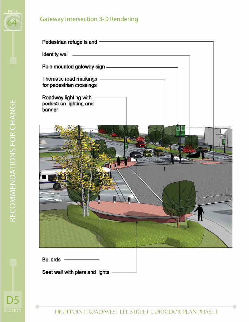
High Point Road/West Lee Street Corridor Plan PHASE I
PAGE
SECTION
64Gateway Intersection 3-D Rendering
D5
RE
CO
MM
EN
DA
TIO
NS
FO
R C
HA
NG
E
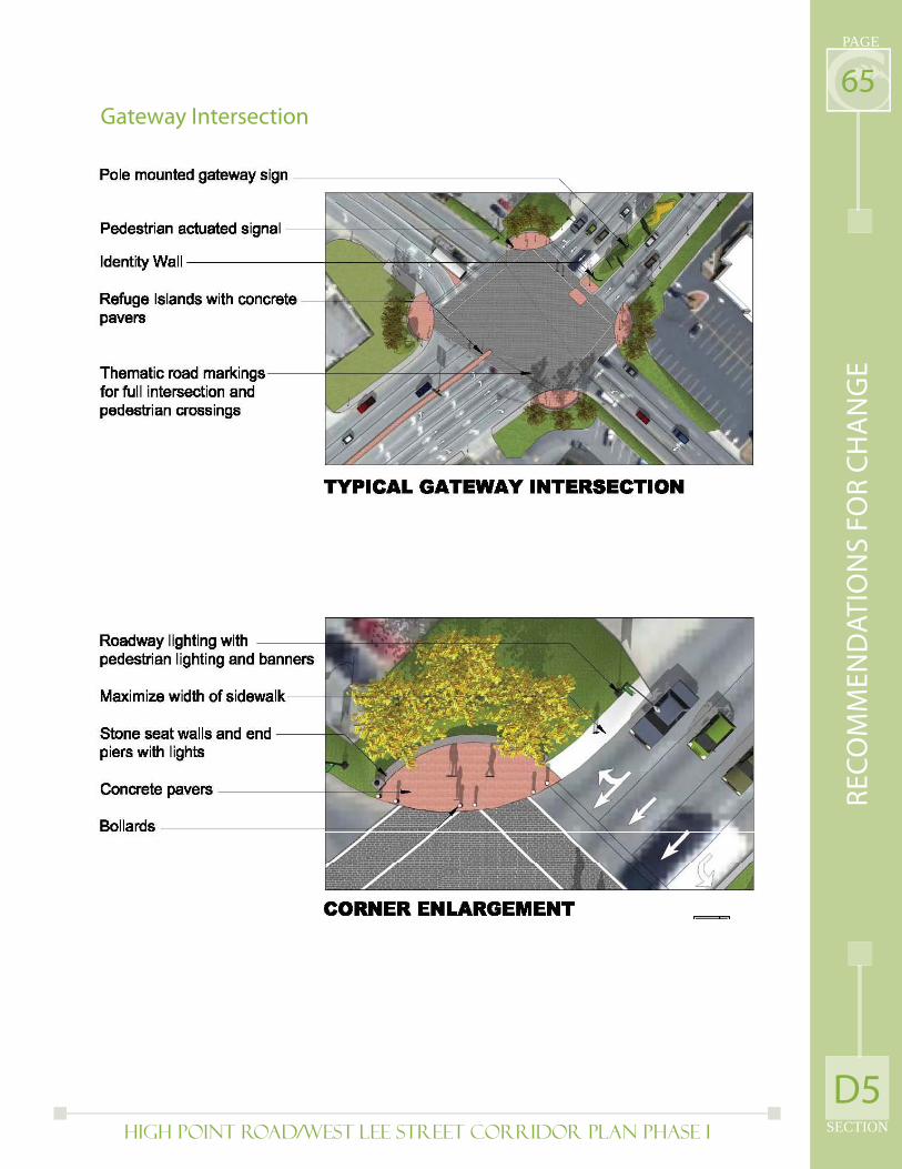
High Point Road/West Lee Street Corridor Plan PHASE I SECTION
PAGE
65Gateway Intersection
D5
RE
CO
MM
EN
DA
TIO
NS
FO
R C
HA
NG
E
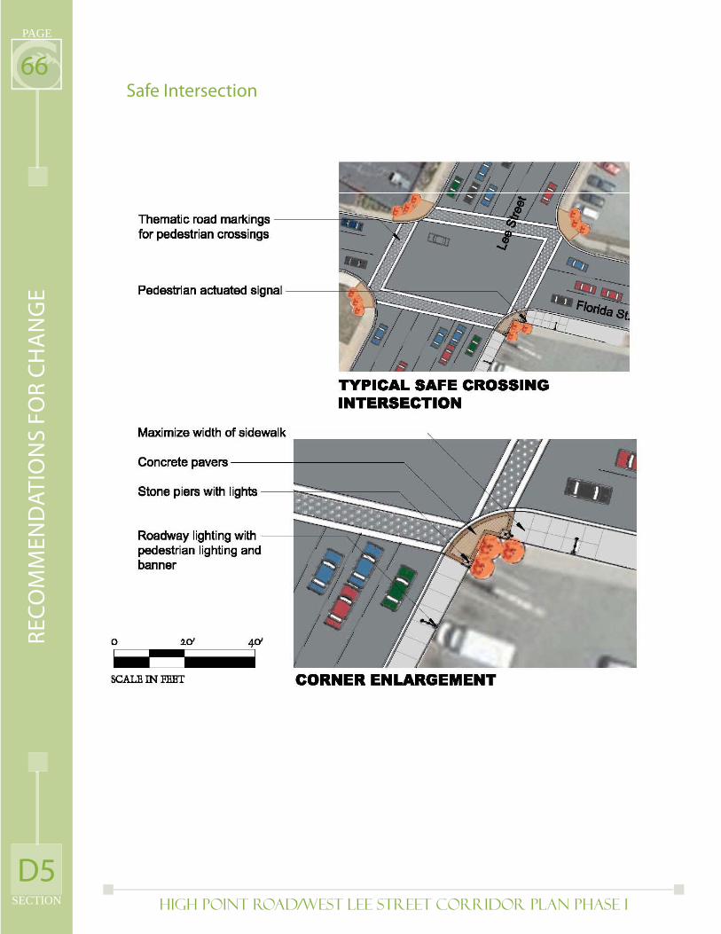
High Point Road/West Lee Street Corridor Plan PHASE I
PAGE
SECTION
66Safe Intersection
D5
RE
CO
MM
EN
DA
TIO
NS
FO
R C
HA
NG
E
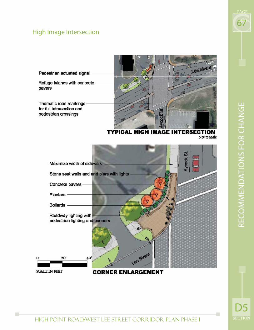
High Point Road/West Lee Street Corridor Plan PHASE I SECTION
PAGE
67High Image Intersection
D5
RE
CO
MM
EN
DA
TIO
NS
FO
R C
HA
NG
E
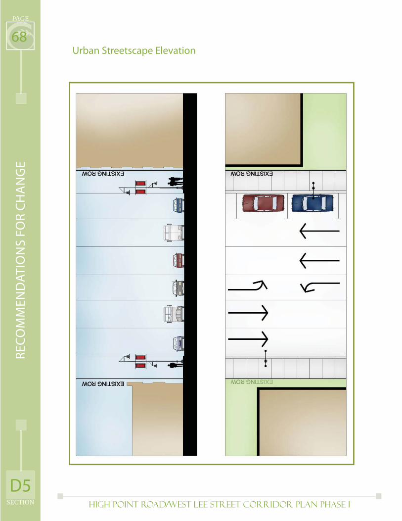
High Point Road/West Lee Street Corridor Plan PHASE I
PAGE
SECTION
68Urban Streetscape Elevation
D5
RE
CO
MM
EN
DA
TIO
NS
FO
R C
HA
NG
E
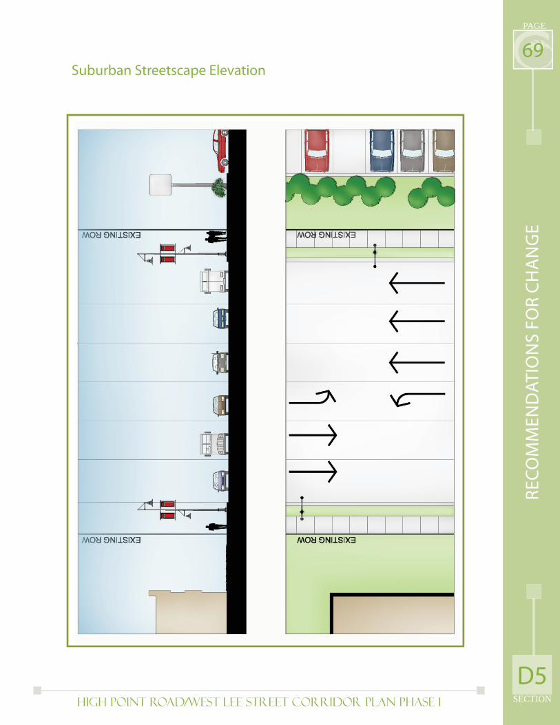
High Point Road/West Lee Street Corridor Plan PHASE I SECTION
PAGE
69Suburban Streetscape Elevation
D5
RE
CO
MM
EN
DA
TIO
NS
FO
R C
HA
NG
E

High Point Road/West Lee Street Corridor Plan PHASE I
PAGE
SECTION
70D6) Public Safety(see Action Plan for additional details)
The overall level of public safety, and the negative aspects on the corridor relative to investment and use, was identifi ed early in the process as a major priority for this Plan. As noted in the Existing Conditions section the overall level of major crimes in the corridor increased slightly between 2002 and 2007 in terms of real numbers and as a percentage of the city’s overall crime rates. However the perception of the corridor as an unsafe place to be has increased more signifi cantly based on information provided by corridor stakeholders and the general public. Reasons for this increase in negative perception relate to an increasing number of vacant or poorly maintained properties, particularly older commercial and industrial properties, deterioration of existing infrastructure, and lack of safe routes for pedestrians, bicyclists and transit users to easily navigate the corridor. An additional issue noted with this negative perception is a signifi cant presence of homeless individuals and loiterers. This is due in part to a concentration of social service facilities along West Lee Street, including the City’s primary homeless shelter operated by Greensboro Urban Ministries, and to scattered locations frequented by day laborers.
Major priorities for addressing public safety in the High Point Road/West Lee Street corridor include:
Increase participation in community and business watch groups throughout the corridor
Provide comprehensive education to property owners, businesses, residents and visitors on steps to reduce crime
Comprehensively evaluate and track crime data in the corridor to identify problem issues and properties, in order to more effectively target resources
Coordinate public and private security resources to ensure adequate crime control and public safety during large events and to more effectively address day to day issues
Implement physical improvements such as lighting and landscaping to deter criminal activity while making spaces more inviting to pedestrians
Identify additional public and private resources to enhance security throughout the corridor
Improve key intersections and stretches of roadway to improve safety for pedestrians and bicyclists.
Promote positive aspects of corridor, including new public and private investments
Support creation of a full service day center for homeless individuals and evaluate consolidation of known day labor sites to a single drop off and pick up point, possibly in the Patterson Street Industrial area
•
•
•
•
•
•
•
•
•
D6
RE
CO
MM
EN
DA
TIO
NS
FO
R C
HA
NG
E
High Point Road/West Lee Street Corridor Plan PHASE I SECTION
PAGE
71D7) Implementation(see Action Plan for additional details)
As with any planning document, the ability to effectively implement the High Point Road/West Lee Street Corridor Plan is crucial to its success in addressing previously outlined recommendations. Towards this end, this Plan includes a more detailed Action Plan of short (1-2 years), medium (3-5 years) and long (5+ years) term action steps. This Action Plan identifi es both specifi c actions to undertake in the appropriate timeframes as well as additional studies and analysis needed following the adoption of the Corridor Plan.
Effective implementation of this Corridor Plan will require signifi cant public input and direction after Plan adoption, the identifi cation and use of varied public and private resources, coordinated marketing and promotion strategies, active public and private partnerships and use of specifi c benchmarks to evaluate the Plan’s success. It should be noted for that purposes of implementation areas located directly to the west of Interstate 40 are included with recommendations for this Corridor Plan. These areas include numerous hotels, the Koury Convention Center and Four Seasons Mall, and make sense for inclusion due to the signifi cant physical and economic connections to areas on the east side of Business 40. Inclusion of these additional areas also supports the hospitality village land use concept and will enable more effective conversations on connecting major corridor destinations and identifying additional resources for corridor improvements.
Major priorities for implementation of the High Point Road/West Lee Street Corridor Plan include:
Creation of a formal citizen group with representation from both corridor and citywide interests to oversee and advocate for Plan implementation. The eventual incorporation of this group is recommended to formalize the makeup and responsibilities of this group (Downtown Greensboro Inc. is a potential model)
Identifi cation and use of varied resources for corridor improvements and to encourage signifi cant new investment, including public bond funds, potential Business Improvement District, self fi nancing bonds, NC Urban Progress Zone Designation, and other public and private resources
Implement a comprehensive marketing strategy to promote the corridor, built around the key economic themes (and identifi ed village concepts) of university/mixed use, sports, recreation and fi tness, and hospitality.
Coordinate recommendations of this Corridor Plan with other previously adopted plans (i.e. Glenwood Neighborhood Plan, UNCG Master Plan, 2035 Long Range Transportation Plan)
Strengthen partnerships between major activity centers on key issues such as transportation, recreational facilities and university related housing
•
•
•
•
•
D7
RE
CO
MM
EN
DA
TIO
NS
FO
R C
HA
NG
E

Page Intentionally Left Blank
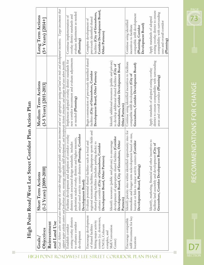
High Point Road/West Lee Street Corridor Plan PHASE I SECTION
PAGE
73
D7
RE
CO
MM
EN
DA
TIO
NS
FO
R C
HA
NG
E
Hig
h P
oin
t R
oad
/W
est
Lee
Str
eet
Cor
rid
or P
lan
Act
ion
Pla
n
Goa
ls/
Ob
ject
ives
Shor
t T
erm
Act
ion
s(1
-2 Y
ears
) [2
009-
2010
] M
ediu
m T
erm
Act
ion
s (3
-5 Y
ears
) [2
011-
2013
] L
ong
Ter
m A
ctio
ns
(5+
Yea
rs)
[201
4+]
Rei
nve
stm
ent
and
Lan
d U
se
Goa
l: A
chiev
e acti
ve m
ixed
uses
thro
ugho
ut th
e cor
ridor
thro
ugh
signi
fican
t pub
lic a
nd p
rivat
e inv
estme
nt a
nd u
se of
appr
opria
te zo
ning
and
land
use
tools
and
deve
lopme
nt in
centiv
es. T
arget
inve
stmen
ts th
at
supp
ort m
ajor a
ctivit
y cen
ters a
nd p
edest
rian
area
s, en
coura
ge com
patib
le in
fill d
evelo
pmen
t, an
d in
corpo
rate
histo
ric st
ructu
res a
nd u
niqu
e loca
l uses
whe
re po
ssible
.E
stab
lish
corr
idor
zo
ning
ove
rlay
dist
ricts
to
enh
ance
cor
ridor
de
velo
pmen
t
Faci
litat
e de
velo
pmen
t and
ado
ptio
n of
cor
ridor
ove
rlay
dist
ricts
with
ass
ocia
ted
desig
n st
anda
rds;
incl
udes
pe
dest
rian
scal
ed o
verla
y di
stric
ts a
nd h
ighe
r int
ensit
y,
mix
ed u
sed
activ
ity c
ente
r dist
ricts
(Pla
nn
ing,
Cor
rid
or
Dev
elop
men
t B
oard
)
Impl
emen
t ado
pted
ove
rlay
dist
rict s
tand
ards
for
new
cor
ridor
inve
stm
ent a
nd e
valu
ate
adju
stm
ents
as
nee
ded
(Pla
nn
ing)
Cont
inue
impl
emen
tatio
n of
ov
erla
y di
stric
t sta
ndar
ds a
nd
eval
uate
adj
ustm
ents
as n
eede
d (P
lan
nin
g)
Enc
oura
ge d
evel
opm
ent
of sh
ared
faci
litie
s lin
king
majo
r act
ivity
ce
nter
s (i.e
. dow
ntow
n,
UN
CG, C
olise
um
com
plex
, and
M
all/C
onve
ntio
n Ce
nter
)
Eva
luat
e po
tent
ial s
hare
d fa
cilit
ies s
uch
as lo
cal a
nd
regi
onal
recr
eatio
n fa
cilit
ies,
mul
tipur
pose
spor
ts fi
elds
and
sh
ared
par
king
faci
litie
s (in
clud
es p
arki
ng d
ecks
) to
enha
nce
corr
idor
(Cit
y of
Gre
ensb
oro,
Cor
rid
or
Dev
elop
men
t B
oard
, Oth
er P
artn
ers)
Iden
tify
reso
urce
s (pu
blic
and
priv
ate)
to e
ncou
rage
de
velo
pmen
t of a
ppro
priat
e sh
ared
faci
litie
s (C
orri
dor
Dev
elop
men
t B
oard
, Cit
y of
Gre
ensb
oro,
Oth
er
Par
tner
s)
Begi
n co
nstru
ctio
n of
pre
viou
sly id
entif
ied
shar
ed
faci
litie
s(C
ity
of G
reen
sbor
o, C
orri
dor
D
evel
opm
ent
Boa
rd, O
ther
Par
tner
s)
Iden
tify
addi
tiona
l res
ourc
es (p
ublic
and
priv
ate)
to
dev
elop
add
ition
al sh
ared
faci
litie
s (C
ity
of
Gre
ensb
oro,
Cor
rid
or D
evel
opm
ent
Boa
rd,
Oth
er P
artn
ers)
Com
plet
e de
velo
pmen
t of
prev
ious
ly id
entif
ied
shar
ed
faci
litie
s(C
ity
of G
reen
sbor
o,
Cor
rid
or D
evel
opm
ent
Boa
rd,
Oth
er P
artn
ers)
Enc
oura
ge c
ompa
tible
in
fill i
nves
tmen
t for
key
lo
catio
ns
Iden
tify
prio
rity
sites
with
in id
entif
ied
oppo
rtuni
ty si
tes f
or
imm
ediat
e an
d lo
nger
term
rede
velo
pmen
t bas
ed o
n siz
e,
loca
tion
or li
nks t
o m
ajor a
ctiv
ity c
ente
rs (C
orri
dor
Dev
elop
men
t B
oard
, Pla
nn
ing)
Iden
tify,
mar
ketin
g, fi
nanc
ial a
nd o
ther
ince
ntiv
es to
fa
cilit
ate
land
ass
embl
y an
d de
velo
pmen
t (C
ity
of
Gre
ensb
oro,
Cor
rid
or D
evel
opm
ent
Boa
rd)
Cont
inue
usin
g id
entif
ied
ince
ntiv
es to
faci
litat
e co
mpa
tible
infil
l dev
elop
men
t (C
ity
of
Gre
ensb
oro,
Cor
rid
or D
evel
opm
ent
Boa
rd)
App
ly st
anda
rds o
f ado
pted
zon
ing
over
lay
dist
rict t
o en
sure
com
patib
ility
with
surr
ound
ing
area
s and
ove
rall
corr
idor
(Pla
nn
ing)
Cont
inue
usin
g id
entif
ied
ince
ntiv
es to
faci
litat
e co
mpa
tible
infil
l dev
elop
men
t (P
lan
nin
g, C
orri
dor
D
evel
opm
ent
Boa
rd)
App
ly st
anda
rds o
f ado
pted
zo
ning
ove
rlay
dist
rict t
o en
sure
co
mpa
tibili
ty w
ith su
rrou
ndin
g us
es a
nd o
vera
ll co
rrid
or
(Pla
nn
ing)
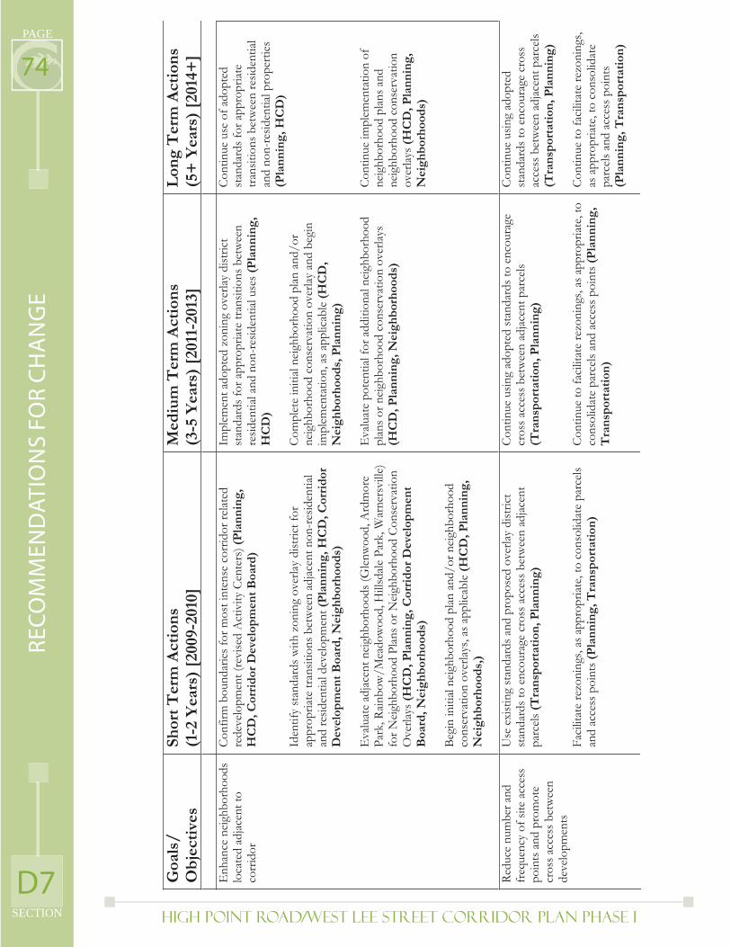
High Point Road/West Lee Street Corridor Plan PHASE I
PAGE
SECTION
74
D7
RE
CO
MM
EN
DA
TIO
NS
FO
R C
HA
NG
E
Goa
ls/
Ob
ject
ives
Shor
t T
erm
Act
ion
s(1
-2 Y
ears
) [2
009-
2010
] M
ediu
m T
erm
Act
ion
s (3
-5 Y
ears
) [2
011-
2013
] L
ong
Ter
m A
ctio
ns
(5+
Yea
rs)
[201
4+]
Enh
ance
nei
ghbo
rhoo
ds
loca
ted
adja
cent
to
corr
idor
Conf
irm b
ound
arie
s for
mos
t int
ense
cor
ridor
relat
ed
rede
velo
pmen
t (re
vise
d A
ctiv
ity C
ente
rs) (
Pla
nn
ing,
H
CD
, Cor
rid
or D
evel
opm
ent
Boa
rd)
Iden
tify
stan
dard
s with
zon
ing
over
lay d
istric
t for
ap
prop
riate
tran
sitio
ns b
etw
een
adjac
ent n
on-r
esid
entia
l an
d re
siden
tial d
evel
opm
ent (
Pla
nn
ing,
HC
D, C
orri
dor
D
evel
opm
ent
Boa
rd, N
eigh
bor
hoo
ds)
Eva
luat
e ad
jacen
t nei
ghbo
rhoo
ds (G
lenw
ood,
Ard
mor
e Pa
rk, R
ainb
ow/M
eado
woo
d, H
illsd
ale P
ark,
War
ners
ville
) fo
r Nei
ghbo
rhoo
d Pl
ans o
r Nei
ghbo
rhoo
d Co
nser
vatio
n O
verla
ys(H
CD
, Pla
nn
ing,
Cor
rid
or D
evel
opm
ent
Boa
rd, N
eigh
bor
hoo
ds)
Begi
n in
itial
neig
hbor
hood
plan
and
/or n
eigh
borh
ood
cons
erva
tion
over
lays,
as a
pplic
able
(HC
D, P
lan
nin
g,
Nei
ghb
orh
ood
s,)
Impl
emen
t ado
pted
zon
ing
over
lay d
istric
t st
anda
rds f
or a
ppro
priat
e tra
nsiti
ons b
etw
een
resid
entia
l and
non
-res
iden
tial u
ses (
Pla
nn
ing,
H
CD
)
Com
plet
e in
itial
neig
hbor
hood
plan
and
/or
neig
hbor
hood
con
serv
atio
n ov
erlay
and
beg
in
impl
emen
tatio
n, a
s app
licab
le (H
CD
,N
eigh
bor
hoo
ds,
Pla
nn
ing)
Eva
luat
e po
tent
ial fo
r add
ition
al ne
ighb
orho
od
plan
s or n
eigh
borh
ood
cons
erva
tion
over
lays
(H
CD
, Pla
nn
ing,
Nei
ghb
orh
ood
s)
Con
tinue
use
of a
dopt
ed
stan
dard
s for
app
ropr
iate
trans
ition
s bet
wee
n re
siden
tial
and
non-
resid
entia
l pro
perti
es
(Pla
nn
ing,
HC
D)
Cont
inue
impl
emen
tatio
n of
ne
ighb
orho
od p
lans a
nd
neig
hbor
hood
con
serv
atio
n ov
erlay
s(H
CD
, Pla
nn
ing,
N
eigh
bor
hoo
ds)
Redu
ce n
umbe
r and
fr
eque
ncy
of si
te a
cces
s po
ints
and
pro
mot
e cr
oss a
cces
s bet
wee
n de
velo
pmen
ts
Use
exi
stin
g st
anda
rds a
nd p
ropo
sed
over
lay
dist
rict
stan
dard
s to
enco
urag
e cr
oss a
cces
s bet
wee
n ad
jace
nt
parc
els(
Tra
nsp
orta
tion
, Pla
nn
ing)
Faci
litat
e re
zoni
ngs,
as a
ppro
priat
e, to
con
solid
ate
parc
els
and
acce
ss p
oint
s (P
lan
nin
g, T
ran
spor
tati
on)
Cont
inue
usin
g ad
opte
d st
anda
rds t
o en
cour
age
cros
s acc
ess b
etw
een
adja
cent
par
cels
(Tra
nsp
orta
tion
, Pla
nn
ing)
Cont
inue
to fa
cilit
ate
rezo
ning
s, as
app
ropr
iate
, to
cons
olid
ate
parc
els a
nd a
cces
s poi
nts (
Pla
nn
ing,
Tra
nsp
orta
tion
)
Cont
inue
usin
g ad
opte
d st
anda
rds t
o en
cour
age
cros
s ac
cess
bet
wee
n ad
jace
nt p
arce
ls (T
ran
spor
tati
on, P
lan
nin
g)
Cont
inue
to fa
cilit
ate
rezo
ning
s, as
app
ropr
iate
, to
cons
olid
ate
parc
els a
nd a
cces
s poi
nts
(Pla
nn
ing,
Tra
nsp
orta
tion
)
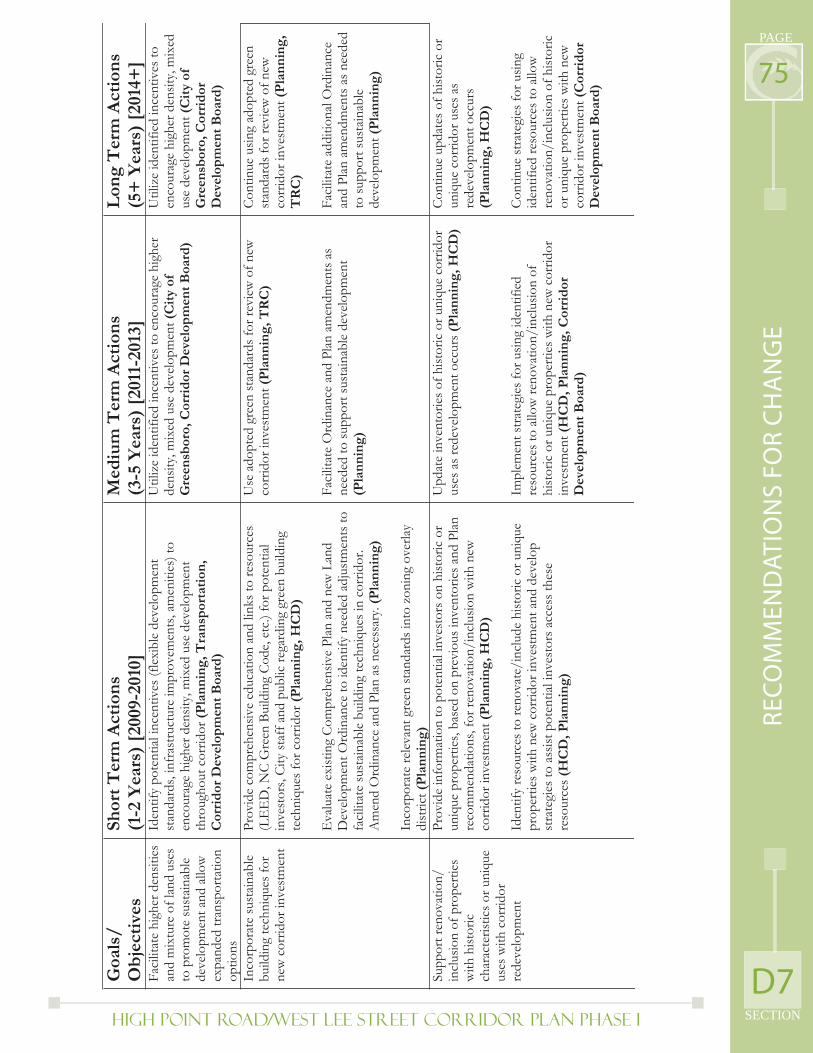
High Point Road/West Lee Street Corridor Plan PHASE I SECTION
PAGE
75
D7
RE
CO
MM
EN
DA
TIO
NS
FO
R C
HA
NG
E
Goa
ls/
Ob
ject
ives
Shor
t T
erm
Act
ion
s(1
-2 Y
ears
) [2
009-
2010
] M
ediu
m T
erm
Act
ion
s (3
-5 Y
ears
) [2
011-
2013
] L
ong
Ter
m A
ctio
ns
(5+
Yea
rs)
[201
4+]
Faci
litat
e hi
gher
den
sitie
s an
d m
ixtu
re o
f lan
d us
es
to p
rom
ote
sust
ainab
le
deve
lopm
ent a
nd a
llow
ex
pand
ed tr
ansp
orta
tion
optio
ns
Iden
tify
pote
ntia
l inc
entiv
es (f
lexi
ble
deve
lopm
ent
stan
dard
s, in
fras
truct
ure
impr
ovem
ents
, am
eniti
es) t
o en
cour
age
high
er d
ensit
y, m
ixed
use
dev
elop
men
t th
roug
hout
cor
ridor
(Pla
nn
ing,
Tra
nsp
orta
tion
, C
orri
dor
Dev
elop
men
t B
oard
)
Util
ize
iden
tifie
d in
cent
ives
to e
ncou
rage
hig
her
dens
ity, m
ixed
use
dev
elop
men
t (C
ity
of
Gre
ensb
oro,
Cor
rid
or D
evel
opm
ent
Boa
rd)
Util
ize
iden
tifie
d in
cent
ives
to
enco
urag
e hi
gher
den
sity,
mix
ed
use
deve
lopm
ent (
Cit
y of
G
reen
sbor
o, C
orri
dor
D
evel
opm
ent
Boa
rd)
Inco
rpor
ate
sust
ainab
le
build
ing
tech
niqu
es fo
r ne
w c
orrid
or in
vest
men
t
Prov
ide
com
preh
ensiv
e ed
ucat
ion
and
links
to re
sour
ces
(LE
ED
, NC
Gre
en B
uild
ing
Code
, etc
.) fo
r pot
entia
l in
vest
ors,
City
staf
f and
pub
lic re
gard
ing
gree
n bu
ildin
g te
chni
ques
for c
orrid
or (P
lan
nin
g, H
CD
)
Eva
luat
e ex
istin
g C
ompr
ehen
sive
Plan
and
new
Lan
d D
evel
opm
ent O
rdin
ance
to id
entif
y ne
eded
adj
ustm
ents
to
faci
litat
e su
stain
able
bui
ldin
g te
chni
ques
in c
orrid
or.
Am
end
Ord
inan
ce a
nd P
lan
as n
eces
sary
. (P
lan
nin
g)
Inco
rpor
ate
rele
vant
gre
en st
anda
rds i
nto
zoni
ng o
verla
y di
stric
t(P
lan
nin
g)
Use
ado
pted
gre
en st
anda
rds f
or re
view
of n
ew
corr
idor
inve
stm
ent (
Pla
nn
ing,
TR
C)
Faci
litat
e O
rdin
ance
and
Pla
n am
endm
ents
as
need
ed to
supp
ort s
usta
inab
le d
evel
opm
ent
(Pla
nn
ing)
Cont
inue
usin
g ad
opte
d gr
een
stan
dard
s for
revi
ew o
f new
co
rrid
or in
vest
men
t (P
lan
nin
g,
TR
C)
Faci
litat
e ad
ditio
nal O
rdin
ance
an
d Pl
an a
men
dmen
ts a
s nee
ded
to su
ppor
t sus
tain
able
de
velo
pmen
t(P
lan
nin
g)
Supp
ort r
enov
atio
n/
incl
usio
n of
pro
perti
es
with
hist
oric
ch
arac
teris
tics o
r uni
que
uses
with
cor
ridor
re
deve
lopm
ent
Prov
ide
info
rmat
ion
to p
oten
tial i
nves
tors
on
hist
oric
or
uniq
ue p
rope
rties
, bas
ed o
n pr
evio
us in
vent
orie
s and
Plan
re
com
men
datio
ns, f
or re
nova
tion/
incl
usio
n w
ith n
ew
corr
idor
inve
stm
ent (
Pla
nn
ing,
HC
D)
Iden
tify
reso
urce
s to
reno
vate
/inc
lude
hist
oric
or u
niqu
e pr
oper
ties w
ith n
ew c
orrid
or in
vest
men
t and
dev
elop
st
rate
gies
to a
ssist
pot
entia
l inv
esto
rs a
cces
s the
se
reso
urce
s(H
CD
, Pla
nn
ing)
Upd
ate
inve
ntor
ies o
f hist
oric
or u
niqu
e co
rrid
or
uses
as r
edev
elop
men
t occ
urs (
Pla
nn
ing,
HC
D)
Impl
emen
t stra
tegi
es fo
r usin
g id
entif
ied
reso
urce
s to
allow
reno
vatio
n/in
clus
ion
of
hist
oric
or u
niqu
e pr
oper
ties w
ith n
ew c
orrid
or
inve
stm
ent(
HC
D, P
lan
nin
g, C
orri
dor
D
evel
opm
ent
Boa
rd)
Cont
inue
upd
ates
of h
istor
ic o
r un
ique
cor
ridor
use
s as
rede
velo
pmen
t occ
urs
(Pla
nn
ing,
HC
D)
Cont
inue
stra
tegi
es fo
r usin
g id
entif
ied
reso
urce
s to
allo
w
reno
vatio
n/in
clus
ion
of h
istor
ic
or u
niqu
e pr
oper
ties w
ith n
ew
corr
idor
inve
stm
ent (
Cor
rid
orD
evel
opm
ent
Boa
rd)
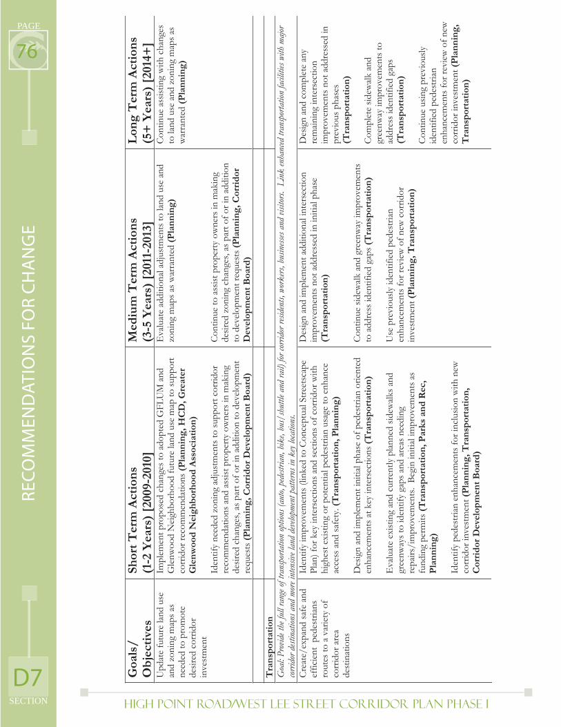
High Point Road/West Lee Street Corridor Plan PHASE I
PAGE
SECTION
76
D7
RE
CO
MM
EN
DA
TIO
NS
FO
R C
HA
NG
E
Goa
ls/
Ob
ject
ives
Shor
t T
erm
Act
ion
s(1
-2 Y
ears
) [2
009-
2010
] M
ediu
m T
erm
Act
ion
s (3
-5 Y
ears
) [2
011-
2013
] L
ong
Ter
m A
ctio
ns
(5+
Yea
rs)
[201
4+]
Upd
ate
futu
re la
nd u
se
and
zoni
ng m
aps a
s ne
eded
to p
rom
ote
desir
ed c
orrid
or
inve
stm
ent
Impl
emen
t pro
pose
d ch
ange
s to
adop
ted
GFL
UM
and
G
lenw
ood
Nei
ghbo
rhoo
d fu
ture
land
use
map
to su
ppor
t co
rrid
or re
com
men
datio
ns (P
lan
nin
g, H
CD
, Gre
ater
G
len
woo
d N
eigh
bor
hoo
d A
ssoc
iati
on)
Iden
tify
need
ed z
onin
g ad
just
men
ts to
supp
ort c
orrid
or
reco
mm
enda
tions
and
ass
ist p
rope
rty o
wne
rs in
mak
ing
desir
ed c
hang
es, a
s par
t of o
r in
addi
tion
to d
evel
opm
ent
requ
ests
(Pla
nn
ing,
Cor
rid
or D
evel
opm
ent
Boa
rd)
Eva
luat
e ad
ditio
nal a
djus
tmen
ts to
land
use
and
zo
ning
map
s as w
arra
nted
(Pla
nn
ing)
Con
tinue
to a
ssist
pro
perty
ow
ners
in m
akin
g de
sired
zon
ing
chan
ges,
as p
art o
f or i
n ad
ditio
n to
dev
elop
men
t req
uest
s (P
lan
nin
g, C
orri
dor
D
evel
opm
ent
Boa
rd)
Con
tinue
ass
istin
g w
ith c
hang
es
to la
nd u
se a
nd z
onin
g m
aps a
s w
arra
nted
(P
lan
nin
g)
T
ran
spor
tati
on
G
oal:
Prov
ide th
e ful
l ran
ge of
trans
porta
tion
optio
ns (a
uto,
pede
strian
, bik
e, bu
s/sh
uttle
and
rail)
for c
orrid
or re
siden
ts, w
orke
rs, b
usin
esses
and
visito
rs. L
ink
enha
nced
tran
spor
tatio
n fac
ilitie
s with
majo
r cor
ridor
dest
inat
ions a
nd m
ore i
nten
sive l
and
deve
lopme
nt p
atter
ns in
key
locat
ions.
C
reat
e/ex
pand
safe
and
ef
ficie
nt p
edes
trian
s ro
utes
to a
var
iety
of
corr
idor
are
a de
stin
atio
ns
Iden
tify
impr
ovem
ents
(lin
ked
to C
once
ptua
l Stre
etsc
ape
Plan
) for
key
inte
rsec
tions
and
sect
ions
of c
orrid
or w
ith
high
est e
xist
ing
or p
oten
tial p
edes
trian
usa
ge to
enh
ance
ac
cess
and
safe
ty. (
Tra
nsp
orta
tion
, Pla
nn
ing)
Des
ign
and
impl
emen
t ini
tial p
hase
of p
edes
trian
orie
nted
en
hanc
emen
ts a
t key
inte
rsec
tions
(Tra
nsp
orta
tion
)
Eva
luat
e ex
istin
g an
d cu
rren
tly p
lann
ed si
dew
alks
and
gr
eenw
ays t
o id
entif
y ga
ps a
nd a
reas
nee
ding
re
pairs
/im
prov
emen
ts.
Begi
n in
itial
impr
ovem
ents
as
fund
ing
perm
its (T
ran
spor
tati
on, P
arks
an
d R
ec,
Pla
nn
ing)
Iden
tify
pede
stria
n en
hanc
emen
ts fo
r inc
lusio
n w
ith n
ew
corr
idor
inve
stm
ent (
Pla
nn
ing,
Tra
nsp
orta
tion
, C
orri
dor
Dev
elop
men
t B
oard
)
Des
ign
and
impl
emen
t add
ition
al in
ters
ectio
n im
prov
emen
ts n
ot a
ddre
ssed
in in
itial
phas
e (T
ran
spor
tati
on)
Con
tinue
side
wal
k an
d gr
eenw
ay im
prov
emen
ts
to a
ddre
ss id
entif
ied
gaps
(Tra
nsp
orta
tion
)
Use
pre
viou
sly id
entif
ied
pede
stria
n en
hanc
emen
ts fo
r rev
iew
of n
ew c
orrid
or
inve
stm
ent(
Pla
nn
ing,
Tra
nsp
orta
tion
)
Des
ign
and
com
plet
e an
y re
main
ing
inte
rsec
tion
impr
ovem
ents
not
add
ress
ed in
pr
evio
us p
hase
s (T
ran
spor
tati
on)
Com
plet
e sid
ewal
k an
d gr
eenw
ay im
prov
emen
ts to
ad
dres
s ide
ntifi
ed g
aps
(Tra
nsp
orta
tion
)
Cont
inue
usin
g pr
evio
usly
id
entif
ied
pede
stria
n en
hanc
emen
ts fo
r rev
iew
of n
ew
corr
idor
inve
stm
ent (
Pla
nn
ing,
T
ran
spor
tati
on)
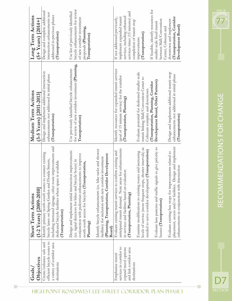
High Point Road/West Lee Street Corridor Plan PHASE I SECTION
PAGE
77
D7
RE
CO
MM
EN
DA
TIO
NS
FO
R C
HA
NG
E
Goa
ls/
Ob
ject
ives
Shor
t T
erm
Act
ion
s(1
-2 Y
ears
) [2
009-
2010
] M
ediu
m T
erm
Act
ion
s (3
-5 Y
ears
) [2
011-
2013
] L
ong
Ter
m A
ctio
ns
(5+
Yea
rs)
[201
4+]
Crea
te/e
nhan
ce sa
fe a
nd
effic
ient
bic
ycle
rout
es to
a
varie
ty o
f cor
ridor
are
a de
stin
atio
ns
Iden
tify
prim
ary
north
-sou
th ro
utes
to c
onne
ct e
xist
ing
bicy
cle
lanes
on
Sprin
g G
arde
n an
d Fl
orid
a St
reet
s, in
clud
ing
incr
ease
d sig
nage
, oth
er ro
ute
impr
ovem
ents
and
de
dica
ted
bicy
cle
faci
litie
s whe
re sp
ace
is av
aila
ble
(Tra
nsp
orta
tion
)
Des
ign
and
impl
emen
t ini
tial i
nter
sect
ion
impr
ovem
ents
(e
x. si
gnal
dete
ctor
s for
bik
es a
nd b
icyc
le b
oxes
) in
conj
unct
ion
with
ped
estri
an e
nhan
cem
ents
to im
prov
e no
rth-s
outh
acc
ess f
or b
icyc
les (
Tra
nsp
orta
tion
, P
lan
nin
g)
Iden
tify
bicy
cle
enha
ncem
ents
(ex.
bik
e ra
cks a
nd sh
ower
fa
cilit
ies)
for i
nclu
sion
with
new
cor
ridor
inve
stm
ent
(Pla
nn
ing,
Tra
nsp
orta
tion
, Cor
rid
or D
evel
opm
ent
Boa
rd)
Des
ign
and
impl
emen
t add
ition
al in
ters
ectio
n en
hanc
emen
ts n
ot a
ddre
ssed
in in
itial
phas
e (T
ran
spor
tati
on)
Use
pre
viou
sly id
entif
ied
bicy
cle
enha
ncem
ents
fo
r rev
iew
of n
ew c
orrid
or in
vest
men
t (P
lan
nin
g,
Tra
nsp
orta
tion
)
Des
ign
and
com
plet
e ad
ditio
nal
inte
rsec
tion
enha
ncem
ents
not
ad
dres
sed
in p
revi
ous p
hase
s (T
ran
spor
tati
on)
Use
list
of p
revi
ously
iden
tifie
d bi
cycl
e en
hanc
emen
ts fo
r rev
iew
of
new
cor
ridor
inve
stm
ent
prop
osals
(Pla
nn
ing,
Tra
nsp
orta
tion
)
Em
phas
ize
trans
it se
rvic
es in
cor
ridor
to
expa
nd tr
avel
opt
ions
an
d lin
k co
rrid
or a
rea
dest
inat
ions
Eva
luat
e ex
istin
g tra
nsit
serv
ices
to c
onfir
m e
xist
ing
and
antic
ipat
ed tr
ansit
dem
and.
Not
e ar
eas f
or e
nhan
cem
ents
in
serv
ices
and
faci
litie
s bas
ed o
n ev
alua
tion
(Tra
nsp
orta
tion
, Pla
nn
ing)
Exa
min
e m
odifi
catio
ns to
exi
stin
g ro
utes
and
incr
easin
g le
vels
of se
rvic
e (m
ore
freq
uent
stop
s, sh
orte
r int
erva
ls) a
s ne
eded
to se
rve
corr
idor
dev
elop
men
t (T
ran
spor
tati
on)
Eva
luat
e la
ne p
atte
rns a
nd tr
affic
sign
als t
o gi
ve p
riorit
y to
bu
sses
(Tra
nsp
orta
tion
)
Eva
luat
e ex
istin
g bu
s sto
ps fo
r im
prov
emen
ts re
lated
to
plac
emen
t, ac
cess
and
/or f
acili
ties.
Des
ign
and
impl
emen
t en
hanc
emen
ts in
con
junc
tion
with
inte
rsec
tion
Iden
tify
reso
urce
s for
exp
ande
d tra
nsit
serv
ices
(g
oal o
f 15
min
ute
serv
ice)
for t
he c
orrid
or
(Tra
nsp
orta
tion
, Pla
nn
ing)
Eva
luat
e po
tent
ial f
or d
edic
ated
smal
ler s
cale
tra
nsit
linki
ng M
all/C
onve
ntio
n Ce
nter
to
Colis
eum
com
plex
and
dow
ntow
n (T
ran
spor
tati
on, P
lan
nin
g, C
orri
dor
D
evel
opm
ent
Boa
rd, O
ther
Par
tner
s)
Des
ign
and
impl
emen
t add
ition
al tr
ansit
stop
en
hanc
emen
ts n
ot a
ddre
ssed
in in
itial
phas
e (T
ran
spor
tati
on)
If n
ot a
ddre
ssed
pre
viou
sly,
impl
emen
t exp
ande
d tra
nsit
serv
ices
, inc
ludi
ng e
nhan
ced
serv
ices
tim
es (1
5 m
inut
es) a
nd
com
plet
ion
of tr
ansit
stop
im
prov
emen
ts(T
ran
spor
tati
on)
If fe
asib
le, i
dent
ify re
sour
ces f
or
small
er sc
ale fi
xed
trans
it be
twee
n M
all/C
onve
ntio
n Ce
nter
, Col
iseum
and
do
wnt
own
and
impl
emen
t (T
ran
spor
tati
on, C
orri
dor
D
evel
opm
ent
Boa
rd)
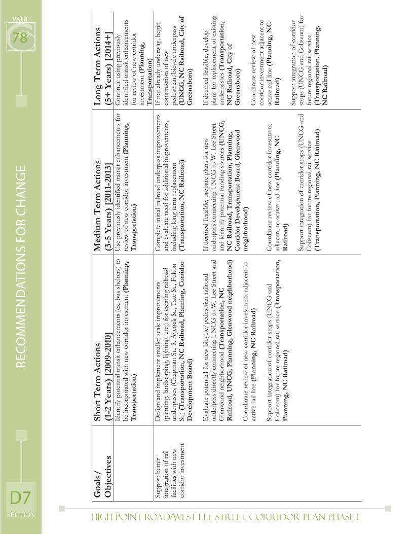
High Point Road/West Lee Street Corridor Plan PHASE I
PAGE
SECTION
78
D7
RE
CO
MM
EN
DA
TIO
NS
FO
R C
HA
NG
E
Goa
ls/
Ob
ject
ives
Shor
t T
erm
Act
ion
s(1
-2 Y
ears
) [2
009-
2010
] M
ediu
m T
erm
Act
ion
s (3
-5 Y
ears
) [2
011-
2013
] L
ong
Ter
m A
ctio
ns
(5+
Yea
rs)
[201
4+]
Iden
tify
pote
ntia
l tra
nsit
enha
ncem
ents
(ex.
bus
shel
ters
) to
be in
corp
orat
ed w
ith n
ew c
orrid
or in
vest
men
t (P
lan
nin
g,T
ran
spor
tati
on)
Use
pre
viou
sly id
entif
ied
trans
it en
hanc
emen
ts fo
r re
view
of n
ew c
orrid
or in
vest
men
t (P
lan
nin
g,
Tra
nsp
orta
tion
)
Cont
inue
usin
g pr
evio
usly
id
entif
ied
trans
it en
hanc
emen
ts
for r
evie
w o
f new
cor
ridor
in
vest
men
t(P
lan
nin
g,
Tra
nsp
orta
tion
) Su
ppor
t bet
ter
inte
grat
ion
of ra
il fa
cilit
ies w
ith n
ew
corr
idor
inve
stm
ent
Des
ign
and
impl
emen
t sm
alle
r sca
le im
prov
emen
ts
(pain
ting,
land
scap
ing,
ligh
ting,
etc
.) fo
r exi
stin
g ra
ilroa
d un
derp
asse
s (Ch
apm
an S
t., S
. Ayc
ock
St.,
Tate
St.,
Ful
ton
St.)
(Tra
nsp
orta
tion
, NC
Rai
lroa
d, P
lan
nin
g, C
orri
dor
D
evel
opm
ent
Boa
rd)
Eva
luat
e po
tent
ial f
or n
ew b
icyc
le/p
edes
trian
railr
oad
unde
rpas
s dire
ctly
con
nect
ing
UN
CG
to W
. Lee
Stre
et a
nd
Gle
nwoo
d ne
ighb
orho
od (T
ran
spor
tati
on, N
C
Rai
lroa
d, U
NC
G, P
lan
nin
g, G
len
woo
d n
eigh
bor
hoo
d)
Coor
dina
te re
view
of n
ew c
orrid
or in
vest
men
t adj
acen
t to
activ
e ra
il lin
e (P
lan
nin
g, N
C R
ailr
oad
)
Supp
ort i
nteg
ratio
n of
cor
ridor
stop
s (U
NCG
and
Co
liseu
m) f
or fu
ture
regi
onal
rail
serv
ice
(Tra
nsp
orta
tion
, P
lan
nin
g, N
C R
ailr
oad
)
Com
plet
e in
itial
railr
oad
unde
rpas
s im
prov
emen
ts
and
eval
uate
nee
d fo
r add
ition
al im
prov
emen
ts,
incl
udin
g lo
ng te
rm re
plac
emen
t (T
ran
spor
tati
on, N
C R
ailr
oad
)
If d
eem
ed fe
asib
le, p
repa
re p
lans f
or n
ew
unde
rpas
s con
nect
ing
UN
CG
to W
. Lee
Stre
et
and
iden
tify
pote
ntia
l fun
ding
sour
ces (
UN
CG
,N
C R
ailr
oad
, Tra
nsp
orta
tion
, Pla
nn
ing,
C
orri
dor
Dev
elop
men
t B
oard
, Gle
nw
ood
n
eigh
bor
hoo
d)
Coor
dina
te re
view
of n
ew c
orrid
or in
vest
men
t ad
jace
nt to
act
ive
rail
line
(Pla
nn
ing,
NC
R
ailr
oad
)
Supp
ort i
nteg
ratio
n of
cor
ridor
stop
s (U
NCG
and
Co
liseu
m) f
or fu
ture
regi
onal
rail
serv
ice
(Tra
nsp
orta
tion
, Pla
nn
ing,
NC
Rai
lroa
d)
If n
ot a
lread
y un
derw
ay, b
egin
co
nstru
ctio
n of
new
pe
dest
rian/
bicy
cle
unde
rpas
s (U
NC
G, N
C R
ailr
oad
, Cit
y of
G
reen
sbor
o)
If d
eem
ed fe
asib
le, d
evel
op
plan
s for
repl
acem
ent o
f exi
stin
g un
derp
asse
s(T
ran
spor
tati
on,
NC
Rai
lroa
d, C
ity
of
Gre
ensb
oro)
Coo
rdin
ate
revi
ew o
f new
co
rrid
or in
vest
men
t adj
acen
t to
activ
e ra
il lin
e (P
lan
nin
g, N
C
Rai
lroa
d)
Supp
ort i
nteg
ratio
n of
cor
ridor
st
ops (
UN
CG a
nd C
olise
um) f
or
futu
re re
gion
al ra
il se
rvic
e (T
ran
spor
tati
on, P
lan
nin
g,
NC
Rai
lroa
d)
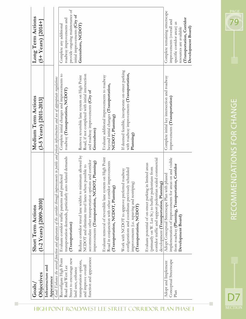
High Point Road/West Lee Street Corridor Plan PHASE I SECTION
PAGE
79
D7
RE
CO
MM
EN
DA
TIO
NS
FO
R C
HA
NG
E
Goa
ls/
Ob
ject
ives
Shor
t T
erm
Act
ion
s(1
-2 Y
ears
) [2
009-
2010
] M
ediu
m T
erm
Act
ion
s (3
-5 Y
ears
) [2
011-
2013
] L
ong
Ter
m A
ctio
ns
(5+
Yea
rs)
[201
4+]
Infr
astr
uct
ure
an
d
Ap
pea
ran
ce
Goa
l: E
nhan
ce th
e ove
rall
func
tion
and
appe
aran
ce of
the c
orrid
or th
roug
h im
prov
emen
ts to
publi
c and
priv
ate i
nfra
struc
ture
and
use o
f app
ropr
iate
regul
ation
s Re
conf
igur
e H
igh
Poin
t Ro
ad a
nd W
est L
ee
Stre
et to
enc
oura
ge n
ew
land
use
s, en
hanc
e tra
nspo
rtatio
n op
tions
, an
d im
prov
e ov
eral
l fu
nctio
n an
d ap
pear
ance
Eva
luat
e co
rrid
or tr
affic
pat
tern
s and
pre
dict
ed
trans
porta
tion
dem
ands
, par
ticul
arly
aut
o re
late
d de
man
ds
(Tra
nsp
orta
tion
)
Redu
ce c
orrid
or tr
avel
lane
wid
ths t
o m
inim
um a
llow
ed b
y N
CD
OT
and
elim
inat
e tra
vel l
anes
whe
re p
ossib
le to
ac
com
mod
ate
othe
r tra
nspo
rtatio
n op
tions
and
cor
ridor
im
prov
emen
ts(T
ran
spor
tati
on, N
CD
OT
, Pla
nn
ing)
Eva
luat
e re
mov
al of
reve
rsib
le la
ne sy
stem
on
Hig
h Po
int
Road
in c
onju
nctio
n w
ith o
ther
cor
ridor
impr
ovem
ents
(T
ran
spor
tati
on, N
CD
OT
, Pla
nn
ing)
Wor
k w
ith N
CD
OT
to a
ppro
ve p
refe
rred
road
way
co
nfig
urat
ions
and
coo
rdin
ate
prev
ious
ly sc
hedu
led
impr
ovem
ents
(i.e
. rep
avin
g an
d re
strip
ing)
(T
ran
spor
tati
on, N
CD
OT
)
Eva
luat
e po
tent
ial o
f on-
stre
et p
arki
ng in
lim
ited
area
s (p
rimar
ily o
n W
. Lee
St.)
to b
uffe
r ped
estri
ans f
rom
co
rrid
or tr
affic
and
supp
ort p
edes
trian
scale
d co
mm
erci
al de
velo
pmen
t(T
ran
spor
tati
on, P
lan
nin
g)
Com
plet
e in
itial
chan
ges a
nd im
prov
emen
ts to
ro
adw
ay(T
ran
spor
tati
on, N
CD
OT
)
Rem
ove
reve
rsib
le la
ne sy
stem
on
Hig
h Po
int
Road
, if n
ot c
ompl
eted
with
initi
al in
ters
ectio
n an
d ro
adw
ay im
prov
emen
ts (C
ity
of
Gre
ensb
oro)
Eva
luat
e ad
ditio
nal i
mpr
ovem
ents
to ro
adw
ay
beyo
nd in
itial
chan
ges (
Tra
nsp
orta
tion
, N
CD
OT
, Pla
nn
ing)
If d
eem
ed fe
asib
le, i
ncor
pora
te o
n-st
reet
par
king
w
ith ro
adw
ay im
prov
emen
ts (T
ran
spor
tati
on,
Pla
nn
ing)
Com
plet
e an
y ad
ditio
nal
road
way
impr
ovem
ents
and
pr
ovid
e on
goin
g m
ainte
nanc
e of
in
itial
impr
ovem
ents
(Cit
y of
G
reen
sbor
o, N
CD
OT
)
Ado
pt a
nd Im
plem
ent
Con
cept
ual S
treet
scap
e Pl
an
Ado
pt C
once
ptua
l Stre
etsc
ape
Plan
with
pha
sed
impl
emen
tatio
n of
impr
ovem
ents
for a
reas
on
and
visib
le
from
road
way
(Pla
nn
ing,
Tra
nsp
orta
tion
, Cor
rid
or
Dev
elop
men
t B
oard
)
Com
plet
e in
itial
key
inte
rsec
tion
and
road
way
im
prov
emen
ts(T
ran
spor
tati
on)
Com
plet
e re
main
ing
stre
etsc
ape
impr
ovem
ents
(ove
rall
and
spec
ific
corr
idor
are
as) a
s re
sour
ces a
re a
vaila
ble
(Tra
nsp
orta
tion
, Cor
rid
or
Dev
elo p
men
t B
oard
)
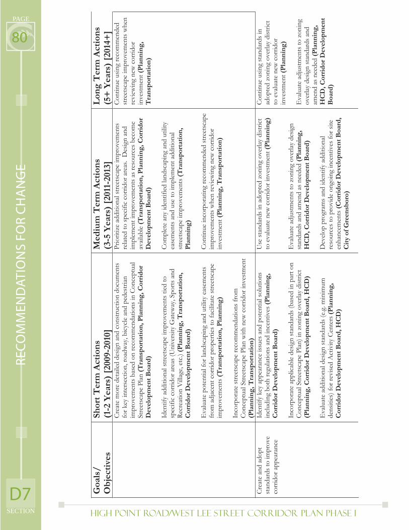
High Point Road/West Lee Street Corridor Plan PHASE I
PAGE
SECTION
80
D7
RE
CO
MM
EN
DA
TIO
NS
FO
R C
HA
NG
E
Goa
ls/
Ob
ject
ives
Shor
t T
erm
Act
ion
s(1
-2 Y
ears
) [2
009-
2010
] M
ediu
m T
erm
Act
ion
s (3
-5 Y
ears
) [2
011-
2013
] L
ong
Ter
m A
ctio
ns
(5+
Yea
rs)
[201
4+]
Cre
ate
mor
e de
taile
d de
sign
and
cons
truct
ion
docu
men
ts
for k
ey in
ters
ectio
n, ro
adw
ay, b
icyc
le a
nd p
edes
trian
im
prov
emen
ts b
ased
on
reco
mm
enda
tions
in C
once
ptua
l St
reet
scap
e Pl
an (T
ran
spor
tati
on, P
lan
nin
g, C
orri
dor
D
evel
opm
ent
Boa
rd)
Iden
tify
addi
tiona
l stre
etsc
ape
impr
ovem
ents
tied
to
spec
ific
corr
idor
are
as (U
nive
rsity
Gat
eway
, Spo
rts a
nd
Recr
eatio
n V
illag
e, e
tc.)
(Pla
nn
ing,
Tra
nsp
orta
tion
, C
orri
dor
Dev
elop
men
t B
oard
)
Eva
luat
e po
tent
ial fo
r lan
dsca
ping
and
util
ity e
asem
ents
fr
om a
djac
ent c
orrid
or p
rope
rties
to fa
cilit
ate
stre
etsc
ape
impr
ovem
ents
(Tra
nsp
orta
tion
, Pla
nn
ing)
Inco
rpor
ate
stre
etsc
ape
reco
mm
enda
tions
from
C
once
ptua
l Stre
etsc
ape
Plan
with
new
cor
ridor
inve
stm
ent
(Pla
nn
ing,
Tra
nsp
orta
tion
)
Prio
ritiz
e ad
ditio
nal s
treet
scap
e im
prov
emen
ts
rela
ted
to sp
ecifi
c co
rrid
or a
reas
. D
esig
n an
d im
plem
enti
mpr
ovem
ents
as r
esou
rces
bec
ome
avail
able
(T
ran
spor
tati
on, P
lan
nin
g, C
orri
dor
D
evel
opm
ent
Boa
rd)
Com
plet
e an
y id
entif
ied
lands
capi
ng a
nd u
tility
ea
sem
ents
and
use
to im
plem
ent a
dditi
onal
st
reet
scap
e im
prov
emen
ts (T
ran
spor
tati
on,
Pla
nn
ing)
Cont
inue
inco
rpor
atin
g re
com
men
ded
stre
etsc
ape
impr
ovem
ents
whe
n re
view
ing
new
cor
ridor
in
vest
men
t(P
lan
nin
g, T
ran
spor
tati
on)
Cont
inue
usin
g re
com
men
ded
stre
etsc
ape
impr
ovem
ents
whe
n re
view
ing
new
cor
ridor
in
vest
men
t(P
lan
nin
g,
Tra
nsp
orta
tion
)
Cre
ate
and
adop
t st
anda
rds t
o im
prov
e co
rrid
or a
ppea
ranc
e
Iden
tify
key
appe
aran
ce is
sues
and
pot
entia
l sol
utio
ns
incl
udin
g bo
th re
gula
tions
and
ince
ntiv
es (P
lan
nin
g,
Cor
rid
or D
evel
opm
ent
Boa
rd)
Inco
rpor
ate
appl
icab
le d
esig
n st
anda
rds (
base
d in
par
t on
Con
cept
ual S
treet
scap
e Pl
an) i
n zo
ning
ove
rlay
dist
rict
(Pla
nn
ing,
Cor
rid
or D
evel
opm
ent
Boa
rd, H
CD
)
Eva
luat
e ad
ditio
nal d
esig
n st
anda
rds (
e.g.
min
imum
de
nsiti
es) f
or re
vise
d A
ctiv
ity C
ente
rs (P
lan
nin
g,C
orri
dor
Dev
elop
men
t B
oard
, HC
D)
Use
stan
dard
s in
adop
ted
zoni
ng o
verla
y di
stric
t to
eva
luat
e ne
w c
orrid
or in
vest
men
t (P
lan
nin
g)
Eva
luat
e ad
just
men
ts to
zon
ing
over
lay
desig
n st
anda
rds a
nd a
men
d as
nee
ded
(Pla
nn
ing,
HC
D, C
orri
dor
Dev
elop
men
t B
oard
)
Dev
elop
pro
gram
s and
iden
tify
addi
tiona
l re
sour
ces t
o pr
ovid
e on
goin
g in
cent
ives
for s
ite
enha
ncem
ents
(Cor
rid
or D
evel
opm
ent
Boa
rd,
Cit
y of
Gre
ensb
oro)
Cont
inue
usin
g st
anda
rds i
n ad
opte
d zo
ning
ove
rlay
dist
rict
to e
valu
ate
new
cor
ridor
in
vest
men
t(P
lan
nin
g)
Eva
luat
e ad
just
men
ts to
zon
ing
over
lay
desig
n st
anda
rds a
nd
amen
d as
nee
ded
(Pla
nn
ing,
HC
D, C
orri
dor
Dev
elop
men
t B
oard
)
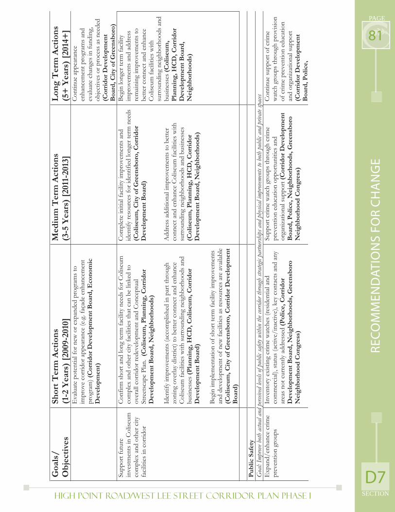
High Point Road/West Lee Street Corridor Plan PHASE I SECTION
PAGE
81
D7
RE
CO
MM
EN
DA
TIO
NS
FO
R C
HA
NG
E
Goa
ls/
Ob
ject
ives
Shor
t T
erm
Act
ion
s(1
-2 Y
ears
) [2
009-
2010
] M
ediu
m T
erm
Act
ion
s (3
-5 Y
ears
) [2
011-
2013
] L
ong
Ter
m A
ctio
ns
(5+
Yea
rs)
[201
4+]
Eva
luat
e po
tent
ial fo
r new
or e
xpan
ded
prog
ram
s to
impr
ove
corr
idor
app
eara
nce
(e.g
. faç
ade
enha
ncem
ent
prog
ram
) (C
orri
dor
Dev
elop
men
t B
oard
, Eco
nom
ic
Dev
elop
men
t)
Cont
inue
app
eara
nce
enha
ncem
ent p
rogr
ams a
nd
evalu
ate
chan
ges i
n fu
ndin
g,
obje
ctiv
es o
r pro
cess
as n
eede
d (C
orri
dor
Dev
elop
men
t B
oard
, Cit
y of
Gre
ensb
oro)
Su
ppor
t fut
ure
inve
stm
ents
in C
olise
um
com
plex
and
oth
er c
ity
faci
litie
s in
corr
idor
Conf
irm sh
ort a
nd lo
ng te
rm fa
cilit
y ne
eds f
or C
olise
um
com
plex
and
oth
er c
ity fa
cilit
ies t
hat c
an b
e lin
ked
to
over
all c
orrid
or re
deve
lopm
ent a
nd C
once
ptua
l St
reet
scap
e Pl
an.
(Col
iseu
m, P
lan
nin
g, C
orri
dor
D
evel
opm
ent
Boa
rd, N
eigh
bor
hoo
ds)
Iden
tify
impr
ovem
ents
(acc
ompl
ished
in p
art t
hrou
gh
zoni
ng o
verla
y di
stric
t) to
bet
ter c
onne
ct a
nd e
nhan
ce
Col
iseum
faci
litie
s with
surr
ound
ing
neig
hbor
hood
s and
bu
sines
ses(
Pla
nn
ing,
HC
D, C
olis
eum
, Cor
rid
or
Dev
elop
men
t B
oard
)
Begi
n im
plem
enta
tion
of sh
ort t
erm
faci
lity
impr
ovem
ents
an
d de
velo
pmen
t of n
ew fa
cilit
ies a
s res
ourc
es a
re a
vaila
ble
(Col
iseu
m, C
ity
of G
reen
sbor
o, C
orri
dor
Dev
elop
men
t B
oard
)
Com
plet
e in
itial
faci
lity
impr
ovem
ents
and
id
entif
y re
sour
ces f
or id
entif
ied
long
er te
rm n
eeds
(C
olis
eum
, Cit
y of
Gre
ensb
oro,
Cor
rid
or
Dev
elop
men
t B
oard
)
Add
ress
add
ition
al im
prov
emen
ts to
bet
ter
conn
ect a
nd e
nhan
ce C
olise
um fa
cilit
ies w
ith
surr
ound
ing
neig
hbor
hood
s and
bus
ines
ses
(Col
iseu
m, P
lan
nin
g, H
CD
, Cor
rid
or
Dev
elop
men
t B
oard
, Nei
ghb
orh
ood
s)
Begi
n lo
nger
term
faci
lity
impr
ovem
ents
and
add
ress
re
main
ing
impr
ovem
ents
to
bette
r con
nect
and
enh
ance
Co
liseu
m fa
cilit
ies w
ith
surr
ound
ing
neig
hbor
hood
s and
bu
sines
ses(
Col
iseu
m,
Pla
nn
ing,
HC
D, C
orri
dor
D
evel
opm
ent
Boa
rd,
Nei
ghb
orh
ood
s)
P
ub
lic S
afet
y
Goa
l: Im
prov
e both
actu
al an
d pe
rceive
d lev
els of
pub
lic sa
fety w
ithin
the c
orrid
or th
roug
h str
ategi
c par
tners
hips
and
phy
sical
impr
ovem
ents
to bo
th p
ublic
and
priv
ate s
paces
E
xpan
d/en
hanc
e cr
ime
prev
entio
n gr
oups
In
vent
ory
exist
ing
crim
e w
atch
es (r
esid
entia
l and
co
mm
erci
al),
stat
us (a
ctiv
e/in
activ
e), k
ey c
onta
cts a
nd a
ny
area
s not
cur
rent
ly a
ddre
ssed
(Pol
ice,
Cor
rid
or
Dev
elop
men
t B
oard
, Nei
ghb
orh
ood
s, G
reen
sbor
o N
eigh
bor
hoo
d C
ongr
ess)
Supp
ort c
rime
wat
ch g
roup
s thr
ough
crim
e pr
even
tion
educ
atio
n op
portu
nitie
s and
or
gani
zatio
nal s
uppo
rt (C
orri
dor
Dev
elop
men
t B
oard
, Pol
ice,
Nei
ghb
orh
ood
s, G
reen
sbor
o N
eigh
bor
hoo
d C
ongr
ess)
Cont
inue
supp
ort o
f crim
e w
atch
gro
ups t
hrou
gh p
rovi
sion
of c
rime
prev
entio
n ed
ucat
ion
and
orga
niza
tiona
l sup
port
(Cor
rid
or D
evel
opm
ent
Boa
rd, P
olic
e,
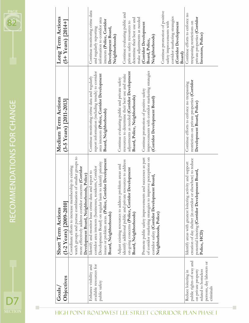
High Point Road/West Lee Street Corridor Plan PHASE I
PAGE
SECTION
82
D7
RE
CO
MM
EN
DA
TIO
NS
FO
R C
HA
NG
E
Goa
ls/
Ob
ject
ives
Shor
t T
erm
Act
ion
s(1
-2 Y
ears
) [2
009-
2010
] M
ediu
m T
erm
Act
ion
s (3
-5 Y
ears
) [2
011-
2013
] L
ong
Ter
m A
ctio
ns
(5+
Yea
rs)
[201
4+]
Coor
dina
te e
ffor
ts to
incr
ease
mem
bers
hip
in e
xist
ing
wat
ch g
roup
s and
pur
sue
com
bina
tion
of sm
aller
gro
ups t
o m
ore
effe
ctiv
ely
addr
ess c
orrid
or c
once
rns (
Cor
rid
orD
evel
opm
ent
Boa
rd, N
eigh
bor
hoo
ds,
Pol
ice)
E
nhan
ce v
isibi
lity
and
avail
able
reso
urce
s for
pu
blic
safe
ty
Iden
tify
and
mon
itor b
ase
crim
e da
ta a
nd re
port
to
corr
idor
are
a in
tere
sts (
busin
esse
s, re
siden
ts, C
orrid
or
Dev
elop
men
t Boa
rd) o
n re
gular
bas
is to
iden
tify
prio
rity
issue
s or p
robl
em a
reas
. (P
olic
e, C
orri
dor
Dev
elop
men
t B
oard
, Nei
ghb
orh
ood
s)
Adj
ust e
xist
ing
reso
urce
s to
addr
ess p
robl
em a
reas
and
id
entif
y ad
ditio
nal p
ublic
and
priv
ate
reso
urce
s to
addr
ess
on-g
oing
con
cern
s (P
olic
e, C
orri
dor
Dev
elop
men
t B
oard
, Nei
ghb
orh
ood
s)
Prom
ote
publ
ic sa
fety
impr
ovem
ents
and
succ
esse
s as p
art
of c
orrid
or m
arke
ting
stra
tegi
es to
impr
ove
perc
eptio
ns o
n co
rrid
or sa
fety
(Cor
rid
or D
evel
opm
ent
Boa
rd,
Nei
ghb
orh
ood
s, P
olic
e)
Con
tinue
mon
itorin
g cr
ime
data
and
regu
larly
re
port
info
rmat
ion
(incl
udin
g tre
nds)
to c
orrid
or
area
inte
rest
s (P
olic
e, C
orri
dor
Dev
elop
men
t B
oard
, Nei
ghb
orh
ood
s)
Cont
inue
eva
luat
ing
publ
ic a
nd p
rivat
e sa
fety
re
sour
ces t
o de
term
ine
thei
r bes
t use
and
mak
e ad
just
men
ts a
s nee
ded
(Cor
rid
or D
evel
opm
ent
Boa
rd, P
olic
e, N
eigh
bor
hoo
ds)
Cont
inue
pro
mot
ion
of p
ositi
ve sa
fety
im
prov
emen
ts w
ith c
orrid
or m
arke
ting
stra
tegi
es
(Cor
rid
or D
evel
opm
ent
Boa
rd)
Con
tinue
mon
itorin
g cr
ime
data
an
d re
gular
ly re
porti
ng
info
rmat
ion
to c
orrid
or a
rea
inte
rest
s(P
olic
e, C
orri
dor
D
evel
opm
ent
Boa
rd,
Nei
ghb
orh
ood
s)
Con
tinue
eva
luat
ing
publ
ic a
nd
priv
ate
safe
ty re
sour
ces t
o de
term
ine
thei
r bes
t use
and
m
ake
adju
stm
ents
as n
eede
d (C
orri
dor
Dev
elop
men
t B
oard
, Pol
ice,
N
eigh
bor
hoo
ds)
Cont
inue
pro
mot
ion
of p
ositi
ve
safe
ty im
prov
emen
ts w
ith
corr
idor
mar
ketin
g st
rate
gies
(C
orri
dor
Dev
elop
men
t B
oard
)Re
duce
loite
ring
in
publ
ic ri
ghts
-of-
way
and
on
priv
ate
prop
erty
re
late
d to
hom
eles
s pe
rson
s, da
y lab
orer
s or
crim
inals
Iden
tify
area
s with
gre
ates
t loi
terin
g ac
tivity
and
supp
ort
crea
tion
of d
ay sh
elte
r (in
cor
ridor
or e
lsew
here
) to
redu
ce
pote
ntial
loite
ring
(Cor
rid
or D
evel
opm
ent
Boa
rd,
Pol
ice,
HC
D)
Con
tinue
eff
orts
to e
nfor
ce n
o tre
spas
sing
rest
rictio
ns o
n pr
ivat
e pr
oper
ties (
Cor
rid
orD
evel
opm
ent
Boa
rd, P
olic
e)
Con
tinue
eff
orts
to e
nfor
ce n
o tre
spas
sing
rest
rictio
ns o
n pr
ivat
e pr
oper
ties (
Cor
rid
orIn
vest
ors,
Pol
ice)
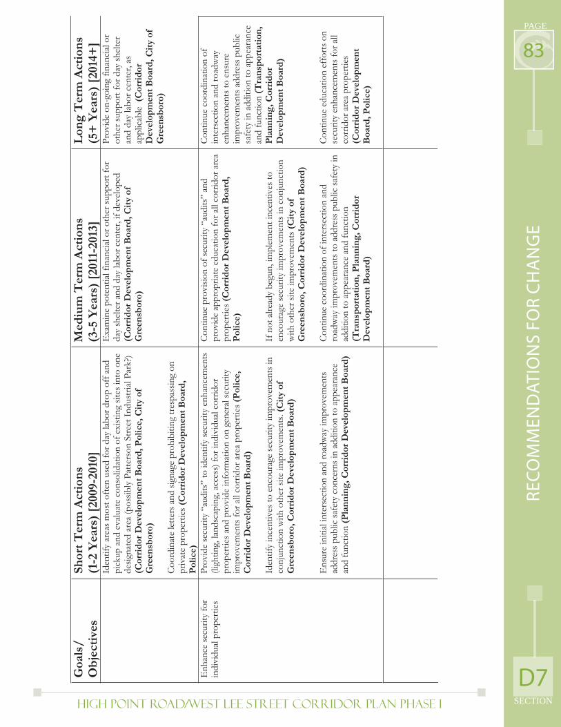
High Point Road/West Lee Street Corridor Plan PHASE I SECTION
PAGE
83
D7
RE
CO
MM
EN
DA
TIO
NS
FO
R C
HA
NG
E
Goa
ls/
Ob
ject
ives
Shor
t T
erm
Act
ion
s(1
-2 Y
ears
) [2
009-
2010
] M
ediu
m T
erm
Act
ion
s (3
-5 Y
ears
) [2
011-
2013
] L
ong
Ter
m A
ctio
ns
(5+
Yea
rs)
[201
4+]
Iden
tify
area
s mos
t ofte
n us
ed fo
r day
labo
r dro
p of
f and
pi
ckup
and
eva
luat
e co
nsol
idat
ion
of e
xist
ing
sites
into
one
de
signa
ted
area
(pos
sibly
Pat
ters
on S
treet
Indu
stria
l Par
k?)
(Cor
rid
or D
evel
opm
ent
Boa
rd, P
olic
e, C
ity
of
Gre
ensb
oro)
Coor
dina
te le
tters
and
sign
age
proh
ibiti
ng tr
espa
ssin
g on
pr
ivat
e pr
oper
ties (
Cor
rid
or D
evel
opm
ent
Boa
rd,
Pol
ice)
Exa
min
e po
tent
ial fi
nanc
ial o
r oth
er su
ppor
t for
da
y sh
elte
r and
day
labo
r cen
ter,
if de
velo
ped
(Cor
rid
or D
evel
opm
ent
Boa
rd, C
ity
of
Gre
ensb
oro)
Prov
ide
on-g
oing
fina
ncial
or
othe
r sup
port
for d
ay sh
elte
r an
d da
y la
bor c
ente
r, as
ap
plic
able
(Cor
rid
orD
evel
opm
ent
Boa
rd, C
ity
of
Gre
ensb
oro)
Enh
ance
secu
rity
for
indi
vidu
al pr
oper
ties
Prov
ide
secu
rity
“aud
its”
to id
entif
y se
curit
y en
hanc
emen
ts
(ligh
ting,
land
scap
ing,
acc
ess)
for i
ndiv
idua
l cor
ridor
pr
oper
ties a
nd p
rovi
de in
form
atio
n on
gen
eral
secu
rity
impr
ovem
ents
for a
ll co
rrid
or a
rea
prop
ertie
s (P
olic
e,C
orri
dor
Dev
elop
men
t B
oard
)
Iden
tify
ince
ntiv
es to
enc
oura
ge se
curit
y im
prov
emen
ts in
co
njun
ctio
n w
ith o
ther
site
impr
ovem
ents
. (C
ity
of
Gre
ensb
oro,
Cor
rid
or D
evel
opm
ent
Boa
rd)
Ens
ure
initi
al in
ters
ectio
n an
d ro
adw
ay im
prov
emen
ts
addr
ess p
ublic
safe
ty c
once
rns i
n ad
ditio
n to
app
eara
nce
and
func
tion
(Pla
nn
ing,
Cor
rid
or D
evel
opm
ent
Boa
rd)
Cont
inue
pro
visio
n of
secu
rity
“aud
its”
and
prov
ide
appr
opria
te e
duca
tion
for a
ll co
rrid
or a
rea
prop
ertie
s (C
orri
dor
Dev
elop
men
t B
oard
, P
olic
e)
If n
ot a
lread
y be
gun,
impl
emen
t inc
entiv
es to
en
cour
age
secu
rity
impr
ovem
ents
in c
onju
nctio
n w
ith o
ther
site
impr
ovem
ents
(Cit
y of
G
reen
sbor
o, C
orri
dor
Dev
elop
men
t B
oard
)
Cont
inue
coo
rdin
atio
n of
inte
rsec
tion
and
road
way
impr
ovem
ents
to a
ddre
ss p
ublic
safe
ty in
ad
ditio
n to
app
eara
nce
and
func
tion
(Tra
nsp
orta
tion
, Pla
nn
ing,
Cor
rid
or
Dev
elop
men
t B
oard
)
Cont
inue
coo
rdin
atio
n of
in
ters
ectio
n an
d ro
adw
ay
enha
ncem
ents
to e
nsur
e im
prov
emen
ts a
ddre
ss p
ublic
sa
fety
in a
dditi
on to
app
eara
nce
and
func
tion
(Tra
nsp
orta
tion
, P
lan
nin
g, C
orri
dor
D
evel
opm
ent
Boa
rd)
Cont
inue
edu
catio
n ef
forts
on
secu
rity
enha
ncem
ents
for a
ll co
rrid
or a
rea
prop
ertie
s (C
orri
dor
Dev
elop
men
t B
oard
, Pol
ice)
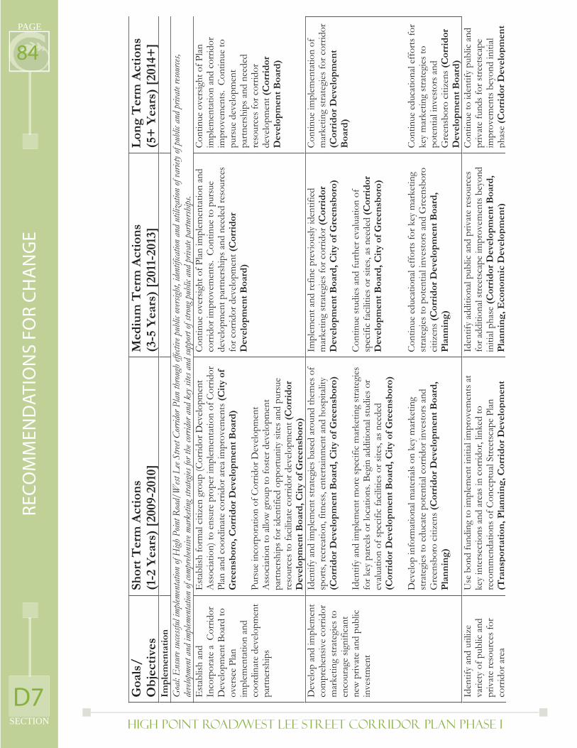
High Point Road/West Lee Street Corridor Plan PHASE I
PAGE
SECTION
84
D7
RE
CO
MM
EN
DA
TIO
NS
FO
R C
HA
NG
E
Goa
ls/
Ob
ject
ives
Shor
t T
erm
Act
ion
s(1
-2 Y
ears
) [2
009-
2010
] M
ediu
m T
erm
Act
ion
s (3
-5 Y
ears
) [2
011-
2013
] L
ong
Ter
m A
ctio
ns
(5+
Yea
rs)
[201
4+]
Imp
lem
enta
tion
Goa
l: E
nsur
e suc
cessfu
l imp
lemen
tatio
n of
High
Poin
t Roa
d/W
est L
ee St
reet C
orrid
or P
lan th
roug
h eff
ective
pub
lic ov
ersigh
t, id
entif
icatio
n an
d ut
iliza
tion
of va
riety
of pu
blic a
nd p
rivat
e reso
urces
, de
velop
ment
and
imple
ment
ation
of co
mpreh
ensiv
e mar
ketin
g stra
tegies
for t
he co
rrido
r and
key
sites
and
supp
ort o
f stro
ng p
ublic
and
priv
ate p
artn
ershi
ps.
Est
ablis
h an
d In
corp
orat
e a
Cor
ridor
D
evel
opm
ent B
oard
to
over
see
Plan
im
plem
enta
tion
and
coor
dina
te d
evel
opm
ent
partn
ersh
ips
Est
ablis
h fo
rmal
citiz
en g
roup
(Cor
ridor
Dev
elop
men
t A
ssoc
iatio
n) to
ens
ure
prop
er im
plem
enta
tion
of C
orrid
or
Plan
and
coo
rdin
ate
corr
idor
are
a im
prov
emen
ts (C
ity
of
Gre
ensb
oro,
Cor
rid
or D
evel
opm
ent
Boa
rd)
Purs
ue in
corp
orat
ion
of C
orrid
or D
evel
opm
ent
Ass
ociat
ion
to a
llow
gro
up to
fost
er d
evel
opm
ent
partn
ersh
ips f
or id
entif
ied
oppo
rtuni
ty si
tes a
nd p
ursu
e re
sour
ces t
o fa
cilit
ate
corr
idor
dev
elop
men
t (C
orri
dor
Dev
elop
men
t B
oard
, Cit
y of
Gre
ensb
oro)
Con
tinue
ove
rsig
ht o
f Pla
n im
plem
enta
tion
and
corr
idor
impr
ovem
ents
. Co
ntin
ue to
pur
sue
deve
lopm
ent p
artn
ersh
ips a
nd n
eede
d re
sour
ces
for c
orrid
or d
evel
opm
ent (
Cor
rid
orD
evel
opm
ent
Boa
rd)
Cont
inue
ove
rsig
ht o
f Pla
n im
plem
enta
tion
and
corr
idor
im
prov
emen
ts.
Con
tinue
to
purs
ue d
evel
opm
ent
partn
ersh
ips a
nd n
eede
d re
sour
ces f
or c
orrid
or
deve
lopm
ent(
Cor
rid
orD
evel
opm
ent
Boa
rd)
Dev
elop
and
impl
emen
t co
mpr
ehen
sive
corr
idor
m
arke
ting
stra
tegi
es to
en
cour
age
signi
fican
t ne
w p
rivat
e an
d pu
blic
in
vest
men
t
Iden
tify
and
impl
emen
t stra
tegi
es b
ased
aro
und
them
es o
f sp
orts
, rec
reat
ion,
fitn
ess,
ente
rtain
men
t and
hos
pita
lity
(Cor
rid
or D
evel
opm
ent
Boa
rd, C
ity
of G
reen
sbor
o)
Iden
tify
and
impl
emen
t mor
e sp
ecifi
c m
arke
ting
stra
tegi
es
for k
ey p
arce
ls or
loca
tions
. Beg
in a
dditi
onal
stud
ies o
r ev
aluat
ion
of sp
ecifi
c fa
cilit
ies o
r site
s, as
nee
ded
(Cor
rid
or D
evel
opm
ent
Boa
rd, C
ity
of G
reen
sbor
o)
Dev
elop
info
rmat
iona
l mat
erial
s on
key
mar
ketin
g st
rate
gies
to e
duca
te p
oten
tial c
orrid
or in
vest
ors a
nd
Gre
ensb
oro
citiz
ens (
Cor
rid
or D
evel
opm
ent
Boa
rd,
Pla
nn
ing)
Impl
emen
t and
refin
e pr
evio
usly
iden
tifie
d m
arke
ting
stra
tegi
es fo
r cor
ridor
(Cor
rid
orD
evel
opm
ent
Boa
rd, C
ity
of G
reen
sbor
o)
Cont
inue
stud
ies a
nd fu
rther
eva
luat
ion
of
spec
ific
faci
litie
s or s
ites,
as n
eede
d (C
orri
dor
Dev
elop
men
t B
oard
, Cit
y of
Gre
ensb
oro)
Cont
inue
edu
catio
nal e
ffor
ts fo
r key
mar
ketin
g st
rate
gies
to p
oten
tial i
nves
tors
and
Gre
ensb
oro
citiz
ens(
Cor
rid
or D
evel
opm
ent
Boa
rd,
Pla
nn
ing)
Cont
inue
impl
emen
tatio
n of
m
arke
ting
stra
tegi
es fo
r cor
ridor
(C
orri
dor
Dev
elop
men
t B
oard
)
Cont
inue
edu
catio
nal e
ffor
ts fo
r ke
y m
arke
ting
stra
tegi
es to
po
tent
ial in
vest
ors a
nd
Gre
ensb
oro
citiz
ens (
Cor
rid
orD
evel
opm
ent
Boa
rd)
Iden
tify
and
utili
ze
varie
ty o
f pub
lic a
nd
priv
ate
reso
urce
s for
co
rrid
or a
rea
Use
bon
d fu
ndin
g to
impl
emen
t ini
tial i
mpr
ovem
ents
at
key
inte
rsec
tions
and
are
as in
cor
ridor
, lin
ked
to
reco
mm
enda
tions
of C
once
ptua
l Stre
etsc
ape
Plan
(T
ran
spor
tati
on, P
lan
nin
g, C
orri
dor
Dev
elop
men
t
Iden
tify
addi
tiona
l pub
lic a
nd p
rivat
e re
sour
ces
for a
dditi
onal
stre
etsc
ape
impr
ovem
ents
bey
ond
initi
al ph
ase
(Cor
rid
or D
evel
opm
ent
Boa
rd,
Pla
nn
ing,
Eco
nom
ic D
evel
opm
ent)
Con
tinue
to id
entif
y pu
blic
and
pr
ivat
e fu
nds f
or st
reet
scap
e im
prov
emen
ts b
eyon
d in
itial
phas
e(C
orri
dor
Dev
elop
men
t
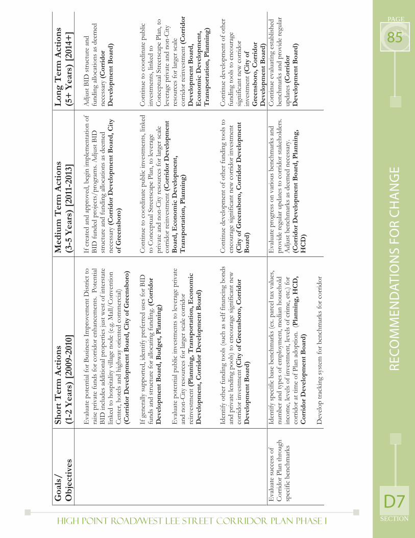
High Point Road/West Lee Street Corridor Plan PHASE I SECTION
PAGE
85
D7
RE
CO
MM
EN
DA
TIO
NS
FO
R C
HA
NG
E
Goa
ls/
Ob
ject
ives
Shor
t T
erm
Act
ion
s(1
-2 Y
ears
) [2
009-
2010
] M
ediu
m T
erm
Act
ion
s (3
-5 Y
ears
) [2
011-
2013
] L
ong
Ter
m A
ctio
ns
(5+
Yea
rs)
[201
4+]
Eva
luat
e po
tent
ial f
or B
usin
ess I
mpr
ovem
ent D
istric
t to
raise
priv
ate
fund
s for
cor
ridor
enh
ance
men
ts.
Pote
ntial
BI
D in
clud
es a
dditi
onal
pro
perti
es ju
st w
est o
f int
erst
ate
linke
d to
hos
pita
lity
villa
ge n
ode
(e.g
. Mall
/Con
vent
ion
Cent
er, h
otel
s and
hig
hway
orie
nted
com
mer
cial)
(C
orri
dor
Dev
elop
men
t B
oard
, Cit
y of
Gre
ensb
oro)
If g
ener
ally
supp
orte
d, id
entif
y pr
efer
red
uses
for B
ID
fund
s and
stru
ctur
e fo
r allo
catin
g fu
ndin
g. (C
orri
dor
D
evel
opm
ent
Boa
rd, B
ud
get,
Pla
nn
ing)
Eva
luat
e po
tent
ial p
ublic
inve
stm
ents
to le
vera
ge p
rivat
e an
d no
n-Ci
ty re
sour
ces f
or la
rger
scale
cor
ridor
re
inve
stm
ent(
Pla
nn
ing,
Tra
nsp
orta
tion
, Eco
nom
ic
Dev
elop
men
t, C
orri
dor
Dev
elop
men
t B
oard
)
Iden
tify
othe
r fun
ding
tool
s (su
ch a
s sel
f fin
anci
ng b
onds
an
d pr
ivat
e le
ndin
g po
ols)
to e
ncou
rage
sign
ifica
nt n
ew
corr
idor
inve
stm
ent (
Cit
y of
Gre
ensb
oro,
Cor
rid
or
Dev
elop
men
t B
oard
)
If c
reat
ed a
nd a
ppro
ved,
beg
in im
plem
enta
tion
of
BID
fund
ed p
roje
cts/
prog
ram
s. A
djus
t BID
st
ruct
ure
and
fund
ing
allo
catio
ns a
s dee
med
ne
cess
ary
(Cor
rid
or D
evel
opm
ent
Boa
rd, C
ity
of G
reen
sbor
o)
Con
tinue
to c
oord
inat
e pu
blic
inve
stm
ents
, lin
ked
to C
once
ptua
l Stre
etsc
ape
Plan
, to
leve
rage
pr
ivat
e an
d no
n-Ci
ty re
sour
ces f
or la
rger
scale
co
rrid
or re
inve
stm
ent (
Cor
rid
or D
evel
opm
ent
Boa
rd, E
con
omic
Dev
elop
men
t,
Tra
nsp
orta
tion
, Pla
nn
ing)
Cont
inue
dev
elop
men
t of o
ther
fund
ing
tool
s to
enco
urag
e sig
nific
ant n
ew c
orrid
or in
vest
men
t (C
ity
of G
reen
sbor
o, C
orri
dor
Dev
elop
men
t B
oard
)
Adj
ust B
ID st
ruct
ure
and
fund
ing
alloc
atio
ns a
s dee
med
ne
cess
ary
(Cor
rid
or
Dev
elop
men
t B
oard
)
Con
tinue
to c
oord
inat
e pu
blic
in
vest
men
ts, l
inke
d to
Co
ncep
tual
Stre
etsc
ape
Plan
, to
leve
rage
priv
ate
and
non-
City
re
sour
ces f
or la
rger
scale
co
rrid
or re
inve
stm
ent (
Cor
rid
orD
evel
opm
ent
Boa
rd,
Eco
nom
ic D
evel
opm
ent,
T
ran
spor
tati
on, P
lan
nin
g)
Cont
inue
dev
elop
men
t of o
ther
fu
ndin
g to
ols t
o en
cour
age
signi
fican
t new
cor
ridor
in
vest
men
t (C
ity
of
Gre
ensb
oro,
Cor
rid
or
Dev
elop
men
t B
oard
) E
valu
ate
succ
ess o
f Co
rrid
or P
lan th
roug
h sp
ecifi
c be
nchm
arks
Iden
tify
spec
ific
base
ben
chm
arks
(ex.
par
cel t
ax v
alue
s, nu
mbe
r and
type
s of e
mpl
oym
ent,
med
ian h
ouse
hold
in
com
e, le
vels
of in
vest
men
t, le
vels
of c
rime,
etc
.) fo
r co
rrid
or a
t tim
e of
Plan
ado
ptio
n. (
Pla
nn
ing,
HC
D,
Cor
rid
or D
evel
opm
ent
Boa
rd)
Dev
elop
trac
king
syst
em fo
r ben
chm
arks
for c
orrid
or
Eva
luat
e pr
ogre
ss o
n va
rious
ben
chm
arks
and
pr
ovid
e re
gula
r upd
ates
to c
orrid
or st
akeh
olde
rs.
Adj
ust b
ench
mar
ks a
s dee
med
nec
essa
ry.
(Cor
rid
or D
evel
opm
ent
Boa
rd, P
lan
nin
g,
HC
D)
Con
tinue
eva
luat
ing
esta
blish
ed
benc
hmar
ks a
nd p
rovi
de re
gular
up
date
s(C
orri
dor
D
evel
opm
ent
Boa
rd)
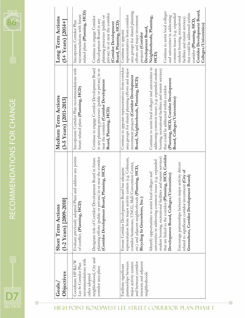
High Point Road/West Lee Street Corridor Plan PHASE I
PAGE
SECTION
86
D7
RE
CO
MM
EN
DA
TIO
NS
FO
R C
HA
NG
E
Goa
ls/
Ob
ject
ives
Shor
t T
erm
Act
ion
s(1
-2 Y
ears
) [2
009-
2010
] M
ediu
m T
erm
Act
ion
s (3
-5 Y
ears
) [2
011-
2013
] L
ong
Ter
m A
ctio
ns
(5+
Yea
rs)
[201
4+]
Coo
rdin
ate
HP
Rd/W
Le
e St
Cor
ridor
Plan
re
com
men
datio
ns w
ith
othe
r ado
pted
ne
ighb
orho
od, C
ity a
nd
corr
idor
are
a pl
ans
Eva
luat
e pr
evio
usly
ado
pted
Plan
s and
add
ress
any
poi
nts
of c
onfli
ct. (
Pla
nn
ing,
HC
D)
Des
igna
te ro
le o
f Cor
ridor
Dev
elop
men
t Boa
rd in
futu
re
plan
ning
eff
orts
(pub
lic o
r priv
ate)
in o
r nea
r the
cor
ridor
(C
orri
dor
Dev
elop
men
t B
oard
, Pla
nn
ing,
HC
D)
Inco
rpor
ate
Corr
idor
Pla
n re
com
men
datio
ns w
ith
futu
re re
lated
plan
s (P
lan
nin
g, H
CD
)
Cont
inue
to e
ngag
e Co
rrid
or D
evel
opm
ent B
oard
in
any
plan
ning
pro
cess
es (p
ublic
or p
rivat
e) in
or
near
the
corr
idor
(Cor
rid
or D
evel
opm
ent
Boa
rd, P
lan
nin
g, H
CD
)
Inco
rpor
ate
Corr
idor
Pla
n re
com
men
datio
ns w
ith fu
ture
re
late
d pl
ans (
Pla
nn
ing,
HC
D)
Con
tinue
to e
ngag
e C
orrid
or
Dev
elop
men
t Boa
rd in
any
pl
anni
ng p
roce
sses
(pub
lic o
r pr
ivat
e) in
or n
ear t
he c
orrid
or
(Cor
rid
or D
evel
opm
ent
Boa
rd, P
lan
nin
g, H
CD
)Fa
cilit
ate
signi
fican
t pa
rtner
ship
s bet
wee
n m
ajor a
ctiv
ity c
ente
rs
and
betw
een
corr
idor
in
tere
sts a
nd a
djac
ent
neig
hbor
hood
s
Ens
ure
Corr
idor
Dev
elop
men
t Boa
rd h
as a
dequ
ate
repr
esen
tatio
n fr
om m
ajor a
ctiv
ity c
ente
rs (e
.g. C
olise
um,
corr
idor
bus
ines
ses,
UN
CG, M
all/C
onve
ntio
n Ce
nter
, et
c.) a
nd a
djac
ent n
eigh
borh
oods
(Pla
nn
ing,
HC
D,
Bic
yclin
g In
Gre
ensb
oro,
In
c.)
Iden
tify
oppo
rtuni
ties t
o as
sist l
ocal
col
lege
s and
un
iver
sitie
s in
addr
essin
g co
mm
on is
sues
(e.g
. exp
ande
d st
uden
t hou
sing,
recr
eatio
nal f
acili
ties a
nd tr
ansit
serv
ices
) th
at a
re li
nked
to th
e co
rrid
or (P
lan
nin
g, H
CD
, Cor
rid
or
Dev
elop
men
t B
oard
, Col
lege
s/U
niv
ersi
ties
)
Enc
oura
ge p
artn
ersh
ips b
etw
een
majo
r act
ivity
driv
ers
rela
ted
to si
gnifi
cant
cor
ridor
inve
stm
ent (
Cit
y of
G
reen
sbor
o, C
orri
dor
Dev
elop
men
t B
oard
)
Cont
inue
to a
ppoi
nt re
pres
enta
tives
from
cor
ridor
ar
ea g
roup
s for
shar
ed p
lanni
ng e
ffor
ts a
nd m
ajor
inve
stm
ent p
roje
cts (
Cor
rid
or D
evel
opm
ent
Boa
rd, N
eigh
bor
hoo
ds,
Pla
nn
ing,
HC
D)
Con
tinue
to a
ssist
loca
l col
lege
s and
uni
vers
ities
in
addr
essin
g co
mm
on is
sues
(e.g
. exp
ande
d st
uden
t ho
usin
g, re
crea
tiona
l fac
ilitie
s and
tran
sit se
rvic
es)
that
cou
ld b
e ad
dres
sed
with
in c
orrid
or
(Pla
nn
ing,
HC
D, C
orri
dor
Dev
elop
men
t B
oard
, Col
lege
s/U
niv
ersi
ties
)
Cont
inue
to a
ppoi
nt
repr
esen
tativ
es fr
om c
orrid
or
area
gro
ups f
or sh
ared
plan
ning
ef
forts
and
majo
r inv
estm
ent
proj
ects
(Cor
rid
or
Dev
elop
men
t B
oard
, N
eigh
bor
hoo
ds,
Pla
nn
ing,
H
CD
)
Con
tinue
to a
ssist
loca
l col
lege
s an
d un
iver
sitie
s in
addr
essin
g co
mm
on is
sues
(e.g
. exp
ande
d st
uden
t hou
sing,
recr
eatio
nal
faci
litie
s and
tran
sit se
rvic
es)
that
cou
ld b
e ad
dres
sed
with
in
corr
idor
(Pla
nn
ing,
HC
D,
Cor
rid
or D
evel
opm
ent
Boa
rd,
Col
lege
s/U
niv
ersi
ties
)
High Point Road/West Lee Street Corridor Plan PHASE I SECTION
PAGE
87
SECTION E: Appendix
E1
AP
PE
ND
IX
High Point Road/West Lee Street Corridor Plan PHASE I
PAGE
SECTION
88E1) Comprehensive Plan Goals: Relevant Comprehensive Plan Goals
and Policies to High Point Road-West Lee Street Corridor
WRITTEN POLICIES
Reinvestment/Infi ll Goal: Promote sound investment in Greensboro’s urban areas, including Center City, commercial and industrial areas, and neighborhoods.
POLICY 4B: Target capital investments to leverage private investment in urban areas
POLICY 4C: Promote new patterns and intensities of use to increase economic competitiveness and enhance quality of life in urban areas.
POLICY 4D.4: Encourage use of fi nancial incentives for reinvestment in historic and/or abandoned properties
Man-made Environment Goal: Preserve and enhance the character and visual quality of Greensboro’s built environment, including historic resources, private developments, and public landscapes.
POLICY 5E.1: Identify funding sources and develop phased capital program to implement visual improvements (e.g. landscaping, streetscape, public art and signage) to gateway entrances, landmarks, and major corridors
POLICY 5F.2: Improve design standards for new development to enhance community appearance and sense of place (visual impacts on adjacent neighborhoods).
Housing and Neighborhoods Goal: Meet the needs of present and future Greensboro citizens for a choice of decent, affordable housing in stable, livable neighborhoods that offer security, quality of life, and the necessary array of services and facilities.
POLICY 6A.2: Promote mixed-income neighborhoods.
POLICY 6A.4: Implement measures to protect neighborhoods from potential negative impacts of development, redevelopment, and/or public projects that are inconsistent with the neighborhood’s livability, architectural or historical character, and reinvestment potential. Including protection against incompatible commercial encroachments into residential neighborhoods
POLICY 6C: Promote the diversifi cation of new housing stock to meet the needs of all citizens for suitable, affordable housing.
Economic Development Goal: Promote a healthy, diversifi ed economy with a strong tax base and opportunities for employment, entrepreneurship and for-profi t and non-profi t economic development for all segments of the community, including under-served areas such as East Greensboro.
POLICY 7A.2: Encourage “home-grown” and community-based businesses and entrepreneurs with special emphasis on increasing the number of minority-owned businesses in traditionally underserved parts of the community.
E1
AP
PE
ND
IXSECTION E: Appendix
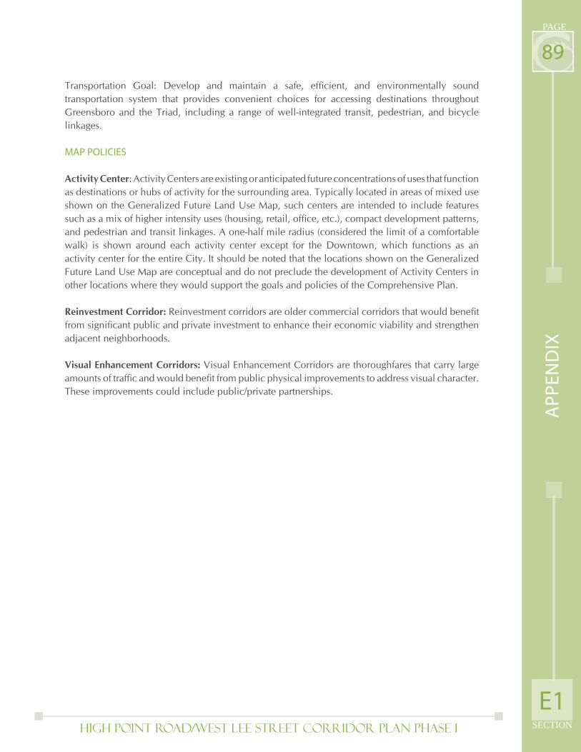
High Point Road/West Lee Street Corridor Plan PHASE I SECTION
PAGE
89
Transportation Goal: Develop and maintain a safe, effi cient, and environmentally sound transportation system that provides convenient choices for accessing destinations throughout Greensboro and the Triad, including a range of well-integrated transit, pedestrian, and bicycle linkages.
MAP POLICIES
Activity Center: Activity Centers are existing or anticipated future concentrations of uses that function as destinations or hubs of activity for the surrounding area. Typically located in areas of mixed use shown on the Generalized Future Land Use Map, such centers are intended to include features such as a mix of higher intensity uses (housing, retail, offi ce, etc.), compact development patterns, and pedestrian and transit linkages. A one-half mile radius (considered the limit of a comfortable walk) is shown around each activity center except for the Downtown, which functions as an activity center for the entire City. It should be noted that the locations shown on the Generalized Future Land Use Map are conceptual and do not preclude the development of Activity Centers in other locations where they would support the goals and policies of the Comprehensive Plan.
Reinvestment Corridor: Reinvestment corridors are older commercial corridors that would benefi t from signifi cant public and private investment to enhance their economic viability and strengthen adjacent neighborhoods.
Visual Enhancement Corridors: Visual Enhancement Corridors are thoroughfares that carry large amounts of traffi c and would benefi t from public physical improvements to address visual character. These improvements could include public/private partnerships.
E1
AP
PE
ND
IX
E2) Police Strategies

Page Intentionally Left Blank
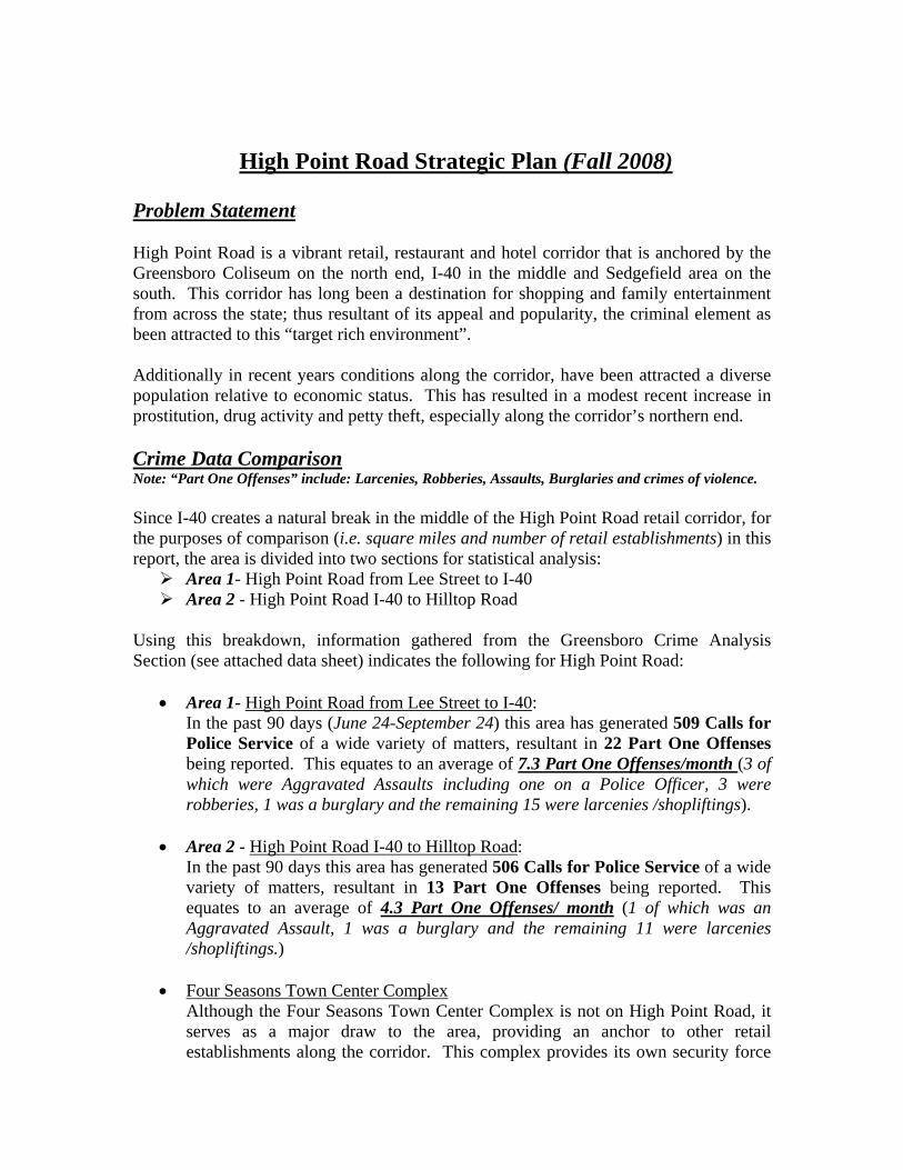
High Point Road Strategic Plan (Fall 2008) Problem Statement High Point Road is a vibrant retail, restaurant and hotel corridor that is anchored by the Greensboro Coliseum on the north end, I-40 in the middle and Sedgefield area on the south. This corridor has long been a destination for shopping and family entertainment from across the state; thus resultant of its appeal and popularity, the criminal element as been attracted to this “target rich environment”. Additionally in recent years conditions along the corridor, have been attracted a diverse population relative to economic status. This has resulted in a modest recent increase in prostitution, drug activity and petty theft, especially along the corridor’s northern end. Crime Data Comparison Note: “Part One Offenses” include: Larcenies, Robberies, Assaults, Burglaries and crimes of violence. Since I-40 creates a natural break in the middle of the High Point Road retail corridor, for the purposes of comparison (i.e. square miles and number of retail establishments) in this report, the area is divided into two sections for statistical analysis:
Area 1- High Point Road from Lee Street to I-40 Area 2 - High Point Road I-40 to Hilltop Road
Using this breakdown, information gathered from the Greensboro Crime Analysis Section (see attached data sheet) indicates the following for High Point Road:
• Area 1- High Point Road from Lee Street to I-40: In the past 90 days (June 24-September 24) this area has generated 509 Calls for Police Service of a wide variety of matters, resultant in 22 Part One Offenses being reported. This equates to an average of 7.3 Part One Offenses/month (3 of which were Aggravated Assaults including one on a Police Officer, 3 were robberies, 1 was a burglary and the remaining 15 were larcenies /shopliftings).
• Area 2 - High Point Road I-40 to Hilltop Road:
In the past 90 days this area has generated 506 Calls for Police Service of a wide variety of matters, resultant in 13 Part One Offenses being reported. This equates to an average of 4.3 Part One Offenses/ month (1 of which was an Aggravated Assault, 1 was a burglary and the remaining 11 were larcenies /shopliftings.)
• Four Seasons Town Center Complex Although the Four Seasons Town Center Complex is not on High Point Road, it serves as a major draw to the area, providing an anchor to other retail establishments along the corridor. This complex provides its own security force
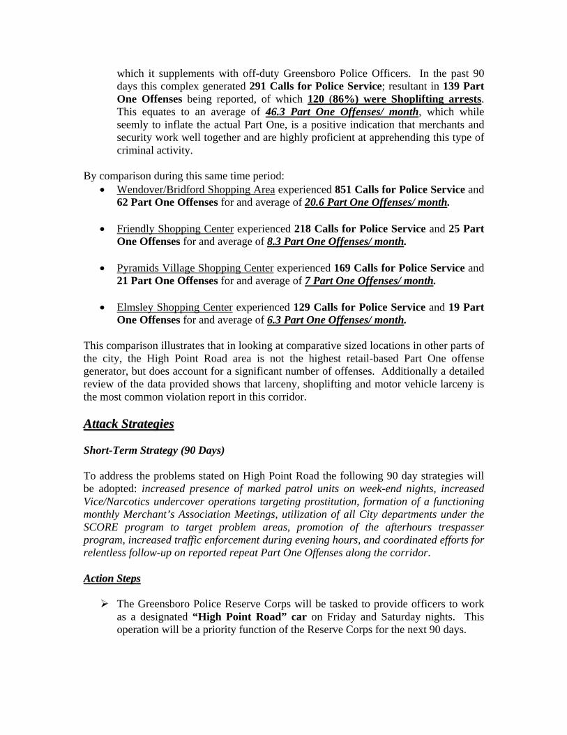
which it supplements with off-duty Greensboro Police Officers. In the past 90 days this complex generated 291 Calls for Police Service; resultant in 139 Part One Offenses being reported, of which 120 (86%) were Shoplifting arrests. This equates to an average of 46.3 Part One Offenses/ month, which while seemly to inflate the actual Part One, is a positive indication that merchants and security work well together and are highly proficient at apprehending this type of criminal activity.
By comparison during this same time period: • Wendover/Bridford Shopping Area experienced 851 Calls for Police Service and
62 Part One Offenses for and average of 20.6 Part One Offenses/ month.
• Friendly Shopping Center experienced 218 Calls for Police Service and 25 Part One Offenses for and average of 8.3 Part One Offenses/ month.
• Pyramids Village Shopping Center experienced 169 Calls for Police Service and
21 Part One Offenses for and average of 7 Part One Offenses/ month.
• Elmsley Shopping Center experienced 129 Calls for Police Service and 19 Part One Offenses for and average of 6.3 Part One Offenses/ month.
This comparison illustrates that in looking at comparative sized locations in other parts of the city, the High Point Road area is not the highest retail-based Part One offense generator, but does account for a significant number of offenses. Additionally a detailed review of the data provided shows that larceny, shoplifting and motor vehicle larceny is the most common violation report in this corridor. AAttttaacckk SSttrraatteeggiieess Short-Term Strategy (90 Days) To address the problems stated on High Point Road the following 90 day strategies will be adopted: increased presence of marked patrol units on week-end nights, increased Vice/Narcotics undercover operations targeting prostitution, formation of a functioning monthly Merchant’s Association Meetings, utilization of all City departments under the SCORE program to target problem areas, promotion of the afterhours trespasser program, increased traffic enforcement during evening hours, and coordinated efforts for relentless follow-up on reported repeat Part One Offenses along the corridor. AAccttiioonn SStteeppss
The Greensboro Police Reserve Corps will be tasked to provide officers to work as a designated “High Point Road” car on Friday and Saturday nights. This operation will be a priority function of the Reserve Corps for the next 90 days.
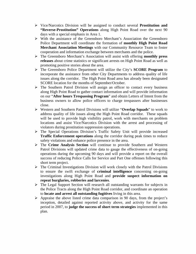
Vice/Narcotics Division will be assigned to conduct several Prostitution and “Reverse-Prostitution” Operations along High Point Road over the next 90 days with a special emphasis in Area 1.
With the assistance of the Greensboro Merchant’s Association the Greensboro Police Department will coordinate the formation of monthly High Point Road Merchant Association Meetings with our Community Resource Team to foster cooperation and information exchange between merchants and the police.
The Greensboro Merchant’s Association will assist with offering monthly press releases about crime statistics or significant arrests on High Point Road as well as promoting positive stories about the area.
The Greensboro Police Department will utilize the City’s SCORE Program to incorporate the assistance from other City Departments to address quality of life issues along the corridor. The High Point Road area has already been designated SCORE location for the months of September/October.
The Southern Patrol Division will assign an officer to contact every business along High Point Road to gather contact information and will provide information on our “After hours Trespassing Program” and obtain Letters of Intent from the business owners to allow police officers to charge trespassers after businesses close.
Western and Southern Patrol Divisions will utilize “Overlap Squads” to work to address quality of life issues along the High Point Road corridor. These squads will be used to provide high visibility patrol, work with merchants on problem locations and assist Vice/Narcotics Division with the arrest and processing of violators during prostitution suppression operations.
The Special Operations Division’s Traffic Safety Unit will provide increased Traffic Enforcement operations along the corridor during peak times to reduce safety violations and enhance police presence in the area.
The Crime Analysis Section will continue to provide Southern and Western Patrol Divisions will updated crime data to gauge the effectiveness of on-going operations during the upcoming 90 days and will provide a report on the overall success of reducing Police Calls for Service and Part One offenses following this short term project.
The Criminal Investigations Division will work closely with the Patrol Divisions to ensure the swift exchange of criminal intelligence concerning on-going investigations along High Point Road and provide suspect information on repeat burglaries, robberies and larcenies.
The Legal Support Section will research all outstanding warrants for subjects in the Police Tracts along the High Point Road corridor, and coordinate an operation to locate and arrest all outstanding fugitives living in this area.
Appraise the above listed crime data comparison in 90 days, from the project’s inception, detailed against reported activity above, and activity for the same period in 2007, to judge the success of short term strategies implemented in this plan.
Long-Term Strategy (more than 90 Days) To address the problems stated on High Point Road the following long strategies will be implemented: continued coordination of short term strategies, enhanced surveillance hardware along the corridor, staffing enhancement study, coordination with local Outreach programs, legal enhancements to aid in enforcement. AAccttiioonn SStteeppss
Continue to maintain and monitor effective 90 day short term strategies as stated above that reduce crime, and address perception of safety in the area.
Explore the possibility of requesting funding for enhanced digital surveillance cameras placed along High Point Road.
Present to Council a future Police Staffing Study (5th District Plan) to better address calls for service and response times in such locations across the City.
Continue to offer information for monthly press releases by GMA about crime statistics or significant arrests on High Point Road.
Work with outside partners to create a “Prostitution Outreach Project” in hope of decreasing repeat offenders.
Continue to work with area merchants to sustain the monthly High Point Merchant’s Association meetings.
Continue to identify and address the underlying causes of crime along the corridor.
Work with local Hotel/Motel owners to address quality of life issues at these locations, to include a study by the City Legal Department on a Motel ordinance limiting the number of days a person may rent a room at one location.
Explore new technology and tactics for improvements to monitoring criminal activity on High Point Road.
Study the feasibility of the eventual placement of a Police Substation along the corridor, to further enhance the police presence along High Point Road.
By working together on the action steps outlined in this plan, we can establish a framework for addressing criminal perception, and activity along this vibrant entertainment and shopping destination. With the assistance of other City departments, local merchants, governmental leaders, and the citizens of this community, we can have a long lasting impact on the safety of the many employees, residents, and visitors who live, work, and play along the High Point Road area. Chief of Police Tim Bellamy September 30, 2008 TRB/cnw
E3) Historical Survey

Page Intentionally Left Blank
West Lee Street Historic Structure Survey
Address Former use of
Building Type of Building
Year Built
Comments Photo
625 Fulton St. Wysong and Miles Co. Offices
Commercial 1910 Brick Italianate Revival‐style office building, adorned at the second story by arches worked in raised rows of brick Listed in Greensboro: An Architectural Record by Marvin Brown Page 194
719 W. Lee St. Old Carolina
Baking Company
Commercial 1926 GF 4803 ‐ This massive, two‐story, stuccoed building is likely constructed of poured concrete. The building displays a variety of Spanish Mission influenced details such as the parapeted corner towers with diamond‐shaped tiles and red tile roof with projecting rafter tails. Over the corner entry is an arched pent roof shelter. The building also retains its metal casement windows with cast stone stills. This building is significant for its display of style on a commercial/industrial structure. It is one of the more distinguished buildings surveyed in the Lee Street corridor, but more research is needed to make a fair comparison with similar building types and designs in other parts of Greensboro. This building retains very good overall physical integrity. Depending on the historical uses of the property, it may be individually eligible for the National Register. It may be a good candidate for historic preservation tax credits. One of the few Spanish Colonial Revival‐style commercial buildings in GSO. Features a red‐tiled roof canted between two scalloped corner towers. Listed in Greensboro: An Architectural Record by Marvin Brown Page 187. My research shows it was built in 1926 (Appraisal card shows year built as 1924). Newspaper article ‐Greensboro Daily News , May 9, 1926. Opened for business May, 1926.
724 W. Lee St. House House 1915 GF 4802 ‐ This two‐story frame dwelling has a hipped roof with central dormer, exposed rafter tails and 8/1 window sash. The entry door has been replaced. The hipped‐roof porch is supported by paneled posts on brick piers. The square posts near the entry are a later addition. The last of the early twentieth century residences that lined Lee St. Would make a good infill house on vacant lot in Glenwood.
726 W. Lee St. House House 1900 GF 4801 ‐ Frame pyramidal cottage with shingled front gable. Unique two‐part paneled posts support the hipped‐roof porch. The balustrade has been replaced. The last of the early twentieth century residences that lined Lee St. Would make a good infill house on vacant lot in Glenwood.
802/804 W. Lee St. House House 1912 Built between 1900 & 1905 (The appraisal card shows year
built as 1912) for George Newman who opened Newman Machinery. Features‐ Cutaway front bay topped by scrolled brackets, shingled gable, lattice bargeboard. Listed in Greensboro: An Architectural Record by Marvin Brown Page 187.
812 W. Lee St. House House 1910 GF 4798 ‐ One‐story, frame, triple‐A form house with
weatherboard siding and irregular shingles in the front gable. The house retains its original window sash and turned posts and sawn brackets on the porch. The last of the early twentieth century residences that lined Lee St. Could be moved and would make a good infill house on vacant lot in Glenwood
816 W. Lee St. House House 1912 GF 4797 ‐ This two‐story, L‐plan folk Victorian house has a
wrap‐around porch, vinyl siding, and replacement windows.The last of the early twentieth century residences that lined Lee St. Could be moved and would make a good infill house on vacant lot in Glenwood
834 W. Lee St. Spear's
Doughnut Shop Old Poindexter's Drug Store
Commercial 1927 GF 4796 ‐ A one‐story, brick commercial building with double storefronts, stepped parapets, and corner pilasters that project above the roofline. Above each storefront is a decorative diamond shaped tile. Typical of small commercial buildings that once were part of a twentieth century residential neighborhood /unique architecture
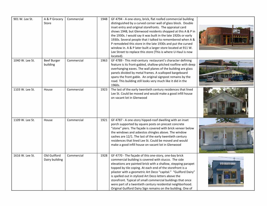
901 W. Lee St. A & P Grocery
Store Commercial 1948 GF 4794 ‐ A one‐story, brick, flat roofed commercial building
distinguished by a curved corner wall of glass block. Double inset entry and original storefronts. The appraisal card shows 1948, but Glenwood residents shopped at this A & P in the 1930s. I would say it was built in the late 1920s or early 1930s. Several people that I talked to remembered when A & P remodeled this store in the late 1930s and put the curved window in. A & P later built a larger store located at 911 W. Lee Street to replace this store (This is where U‐Haul is now located).
1040 W. Lee St. Beef Burger building
Commercial 1963 GF 4789 ‐ This mid‐century restaurant’s character defining feature is its front‐gabled, shallow‐pitched roofline with deep overhanging eaves. The wall planes of the building are glass panels divided by metal frames. A scalloped bargeboard spans the front gable. An original signpost remains by the road. This building still looks very much like it did in the 1960s.
1103 W. Lee St. House Commercial 1923 The last of the early twentieth century residences that lined Lee St. Could be moved and would make a good infill house on vacant lot in Glenwood
1109 W. Lee St. House Commercial 1921 GF 4787 ‐ A one‐story hipped‐roof dwelling with an inset
porch supported by square posts on precast concrete “stone” piers. The façade is covered with brick veneer below the windows and asbestos shingles above. The window sashes are 12/1. The last of the early twentieth century residences that lined Lee St. Could be moved and would make a good infill house on vacant lot in Glenwood
1616 W. Lee St. Old Guilford
Dairy building Commercial 1928 GF 4770 ‐ The façade of this one‐story, one‐bay brick
commercial building is covered with stucco. The side elevations are painted brick with a shallow, stepping parapet topped by tile coping. At each end of the storefront is a pilaster with a geometric Art Deco “capital.” “Guilford Dairy” is spelled out in stylized Art Deco letters above the storefront. Typical of small commercial buildings that once were part of a twentieth century residential neighborhood. Original Guilford Dairy Sign remains on the building. One of
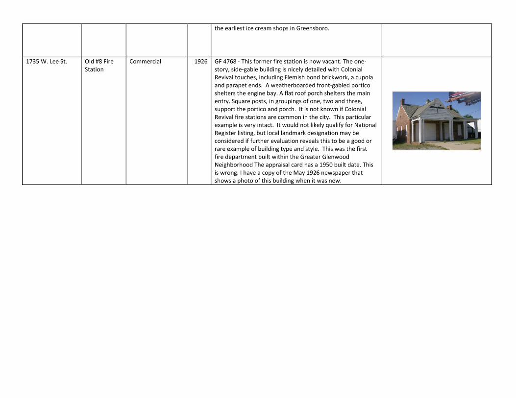
the earliest ice cream shops in Greensboro.
1735 W. Lee St. Old #8 Fire Station
Commercial 1926 GF 4768 ‐ This former fire station is now vacant. The one‐story, side‐gable building is nicely detailed with Colonial Revival touches, including Flemish bond brickwork, a cupola and parapet ends. A weatherboarded front‐gabled portico shelters the engine bay. A flat roof porch shelters the main entry. Square posts, in groupings of one, two and three, support the portico and porch. It is not known if Colonial Revival fire stations are common in the city. This particular example is very intact. It would not likely qualify for National Register listing, but local landmark designation may be considered if further evaluation reveals this to be a good or rare example of building type and style. This was the first fire department built within the Greater Glenwood Neighborhood The appraisal card has a 1950 built date. This is wrong. I have a copy of the May 1926 newspaper that shows a photo of this building when it was new.
Lee-Patterson Corridor GF 4768 1737 Lee Street Fire Station This former fire station is now vacant. The one-story, side-gable building is nicely detailed with Colonial Revival touches, including Flemish bond brickwork, a cupola and parapet ends. A weatherboarded front-gabled portico shelters the engine bay. A flat roof porch shelters the main entry. Square posts, in groupings of one, two and three, support the portico and porch. It is not known if Colonial Revival fire stations are common in the city. This particular example is very intact. It would not likely qualify for National Register listing, but local landmark designation may be considered if further evaluation reveals this to be a good or rare example of building type and style. GF 4769 1600 Lee Street Industrial Building Electric Motor Sales and Repair This one-story brick industrial building has a barrel-vaulted roof and stepped parapet ends capped with tile coping. The original multi-light metal casement windows remain. GF 4770 1616 Lee Street Former Guilford Dairy The façade of this one-story, one-bay brick commercial building is covered with stucco. The side elevations are painted brick with a shallow, stepping parapet topped by tile coping. At each end of the storefront is a pilaster with a geometric Art Deco “capital.” “Guilford Dairy” is spelled out in stylized Art Deco letters above the storefront. GF 4771 1600 Lee Street Industrial Complex A multi-part brick industrial complex spanning one-half of a city block. The building is currently occupied by several businesses. The western section (Gate City Auto Body) is a two-story brick building with a stepped parapet roofline and multi-light casement windows. Two brick, gabled buildings attach to the rear elevation. JABS bar occupies the central section. This one-story, flat-roofed section has had corrugated metal sheets applied over the window bays. The eastern section of the complex houses University Mini Storage. The windows of this two-story brick building have been infilled. The only detailing on this brick box is the stepped parapet of the roofline and the brick knuckle joints at the corners. A one-story brick loading dock is the eastern-most section of tbe complex. GF 4772 1551 Lee Street Former Mill This brick textile mill building was built in 1926. The three-part façade has a stepped parapet roofline with central two-story tower. The tower is embellished with simple corner pilasters and an arched projecting entry bay. The one-story, gabled building on the east side of the mill was the former mill cafeteria. GF 4773 1601 Lee Street Service Station Typical 1960s era flat-roofed service station constructed of brick covered with square enamel-coated tiles. GF 4774 1503 Lee Street Restaurant 1960s concrete block restaurant with a “boomerang” roofline. Full view glass panes span the front elevation. The original signage posts remain in a planting median, although the original signage has been replaced. GF 4775 1501 Lee Street Service Station A one-story brick service station. The garage bays have been infilled with vinyl siding and converted to offices. Running bond brick with soldier courses above the garage bay and below the cornice. Brick pilasters demarcate the entry bay. The building has been extended on a side elevation. GF 4776 410 Lee Street Industrial Building This one-story, brick, barrel vaulted industrial building has a non-historic porch addition across the front elevation. A flat roof hyphen connects the main block with a second barrel vaulted structure placed
perpendicular to the first. The current windows are one-over-one vinyl replacement sash and are not original to the building. GF 4777 1409 Lee Street Commercial Building A one-story brick industrial building with a stepped parapet façade topped with tile coping. The original entry doors have been replaced and vinyl siding covers the storefront windows and side elevations. A monitor tops the barrel-vaulted roof. GF 4778 1400 Lee Street Service Station This 1960s service station remains very intact. A full view glass storefront is sandwiched between a thick poured concrete foundation and flat roof plane with deep eaves. Concrete gas pump pads remain. Behind the service station is a frame, shed-roofed garage covered with corrugated metal. GF 4779 1401 Lee Street Commercial Building This building is an excellent and intact example of mid-century commercial architecture. The building is boat-shaped with the straight elevation facing the street and the “bow” at the east side. At the west end of the façade is an intact double door entry comprised of glass panes and metal mullions suggestive of sidelights and a transom. The original door handles remain. The entry is sheltered by a flat-roofed entry pavilion on a base of earth colored Roman bricks. The “storefront” consists of a curving glass wall that wraps from the front to the rear elevation. A flat roofed painted brick wing projects from the rear elevation. All in all a very intact building and one of the more stylized buildings surveyed in the corridor. Notable use of materials common at the time, such as glass, metal, and Roman brick. GF 4880 1317-1319 Lee Street Commercial/Industrial Building This former bakery building has been heavily altered. It is a two-story brick building, although the façade has been obscured with vinyl siding and wood shakes applied to the pilasters. The doors and windows are incompatible replacements. At the building’s west corner is a 1950s flat-roofed office bay. This small section is intact and conveys a mid-century design aesthetic. GF 4781 1310-1313 West Lee Street Commercial Buildings These disparate brick commercial buildings share a side elevation. 1310 consists of a large garage bay and a replacement entry. Above the doors are raised brick lozenges, a sign panel offset by a header course, and sawtooth cornice. 1311 has a much plainer façade of painted running brick. On each side of the recessed central entry are four boarded up window openings. GF 4782 1300-1302 West Lee Street Commercial/Industrial Building One-story brick, flat-roofed buildings with plain cast stone coping and disparate patterned brickwork of running bond, ridged bond, header courses and simple corbelling. GF 4783 1301 West Lee Street Commercial Building This one-story Colonial Revival brick building was a bank at one time. The façade (facing West Lee Street) has a central double door entry set in a Federal surround complete with a fanlight of leaded glass. Above the entry is a heavy, applied wooden cornice that runs around the building’s four elevations. On the east elevation is a large, single-shouldered, exterior chimney with paved shoulders and a corbelled cap. On the west elevation is a second, well detailed, double door entry with a flared copper awning. Flanking the doors are sets of fixed doors comprised of single light widows over panels. Each of the entry bays is topped by a transom. All of the windows are replacement vinyl sashes with a 6/1 configuration. GF 4784 1225-1231 West Lee Street Commercial Buildings One-story brick commercial building with five altered storefronts. Original detail is limited to tile coping on roof parapet. At the rear of the lot is a concrete block warehouse with a stepped parapet roofline. GF 4785 1201 West Lee Street Service Station One-story enamel paneled service station. There are two garage bays and the storefront has a clipped corner.
GF 4786 1111 West Lee Street Commercial Building A one-story, double storefront building with a stone façade. The side elevations are stuccoed brick. Stone pilasters separate the storefronts. The center pilaster has a stone engraved with “C. Eways.” Storefront doors and windows have been replaced. Green tile covers the roof. The current occupant stated this building was a bar at one time. GF 4787 1109 West Lee Street House A one-story hipped-roof dwelling with an inset porch supported by square posts on precast concrete “stone” piers. The façade is covered with brick veneer below the windows and asbestos shingles above. The window sashes are 12/1. GF 4788 1116 West Lee Street Commercial Building This two-story, rectangular, flat-roofed frame commercial building, although heavily altered, is the only frame commercial building surveyed on West Lee Street, perhaps making it one of the oldest. It is covered with deteriorating asbestos shingles on the W. Lee Street façade and corrugated metal on the sides. Near the façade roofline the shingles are missing revealing a metal cornice. Six single pane replacement windows pierce the façade. GF 4789 1040 West Lee Street/Beef Burger Restaurant This mid-century restaurant’s character defining feature is its front-gabled, shallow-pitched roofline with deep overhanging eaves. The wall planes of the building are glass panels divided by metal frames. A scalloped bargeboard spans the front gable. An original signpost remains by the road. GF 4790 1000-1004 West Lee Street Commercial Buildings This two-story brick commercial building has three storefronts, each with a central entry flanked by display windows. The window openings of the second story have been infilled with brick, although the header course sills and brick jack arches remain. Above the windows and below the parapet’s concrete coping are decorative soldier courses. GF 4791 1001 West Lee Street Commercial Building A one-story, flat-roofed, concrete block commercial building. The façade is brick with large fixed pane windows, metal casements and a later garage bay. GF 4792 919-923 W. Lee Street Hodgin Supply Company Built in 1946, the Hodgin Supply Company has been this building’s only occupant. The front part of the building contains the offices and is a one-story, flat -roofed structure. The façade is veneered with narrow bricks. Four recessed storefronts of equal size are crafted of brick and permastone. Above each storefront are three narrow transoms. The rear of the building is concrete block and contains warehouse space. A second detached unpainted concrete block warehouse with tile coping is also on the parcel. The low horizontal lines of the building are typical of mid-century recessed commercial buildings. This building is intact on both the interior and exterior, and is a good example of its kind on the Lee Street corridor. GF 4793 911 W. Lee Street Moving Supplies A one-story painted brick commercial building with a gabled, or perhaps barrel vaulted, roof hidden by a flat parapet on the front elevation and a stepped parapet on the rear elevation. A flat awning, which shelters the recessed entry and the angled fixed pane display windows, spans the façade. GF 4794 901 W. Lee Street A one-story, brick, flat roofed commercial building distinguished by a curved corner wall of glass block. Double inset entry and original storefronts. GF 4795 903 W. Lee Street
A one-story, flat roofed, commercial store with two garage bays. The building is veneered with a narrow, light–colored stone. The office bay is enclosed by angled, fixed pane windows. GF 4796 836 W. Lee Street A one-story, brick commercial building with double storefronts, stepped parapets, and corner pilasters that project above the roofline. Above each storefront is a decorative diamond shaped tile. GF 4797 816 W. Lee Street House This two-story, L-plan folk Victorian house has a wrap-around porch, vinyl siding, and replacement windows. GF 4798 812 Lee Street House One-story, frame, triple-A form house with weatherboard siding and irregular shingles in the front gable. The house retains its original window sash and turned posts and sawn brackets on the porch. GF 4799 802 W. Lee Street Pugh Metal Finishing Substantial brick commercial/industrial building. Center block is two stories with a stepped parapet flanked by one-story garage bays. Original multi-light metal window sashes remain on the façade. GF 4800 800 W. Lee Street House This one-story, side-gable house has slightly projecting eaves. The hipped-roof porch is supported by heavy battered posts on brick piers. The house is sheathed in original weatherboards and retains its 6/6 sash. GF 4801 726 W. Lee Street House Frame pyramidal cottage with shingled front gable. Unique two-part paneled posts support the hipped-roof porch. The balustrade has been replaced. GF 4802 724 W. Lee Street House This two-story frame dwelling has a hipped roof with central dormer, exposed rafter tails and 8/1 window sash. The entry door has been replaced. The hipped-roof porch is supported by paneled posts on brick piers. The square posts near the entry are a later addition. GF 4803 719 W. Lee Street Parker Metal Finishing This massive, two-story, stuccoed building is likely constructed of poured concrete. The building displays a variety of Spanish Mission influenced details such as the parapeted corner towers with diamond-shaped tiles and red tile roof with projecting rafter tails. Over the corner entry is an arched pent roof shelter. The building also retains its metal casement windows with cast stone stills. This building is significant for its display of style on a commercial/industrial structure. It is one of the more distinguished buildings surveyed in the Lee Street corridor, but more research is needed to make a fair comparison with similar building types and designs in other parts of Greensboro. This building retains very good overall physical integrity. Depending on the historical uses of the property, it may be individually eligible for the National Register. It may be a good candidate for historic preservation tax credits. GF 4804 300 W. Lee Street Service Station One-story, flat-roofed brick service station with a glazed office and two garage bays. GF 4805 300 W. Lee Street Brooks Lumber Company Complex Expansive complex of offices, warehouses, sheds, fenced yards and processing machinery. These structures date from the first half of the twentieth century to the present. Facing Eugene Street is a rectangular, brick, flat-roofed windowless structure with a flat, cabled awning over the entry. Fronting W. Lee Street is a flat roofed structure, approximately one-half block in length, that appears to have been constructed within the last twenty five years, or is very heavily altered. The yards and sheds are arranged behind these two buildings. GF 4806 2411 High Point Road Canada Dry Building
This two-story brick building displays design motifs of the Art Deco style. The flat roofed structure has cast stone coping and a wave-patterned frieze. Below the frieze, and separated from it by brick courses, is second band of cast stone; this one in a more geometric sawtooth pattern. The window bays of the building’s central block are demarcated by fluted pilasters topped with peaked “capitals” and decorated with waves and shells. Flat cast stone panels connect the original metal multi-light windows on the second story with the fixed, single pane windows of the first story. At the west end of the façade is a recessed entry, with glazed doors, surrounded by cast stone panels. This is the corridor’s second well-executed commercial/industrial building (the other being 719 W. Lee Street). This level of detail was not noted on other buildings surveyed with in the corridor. It retains very good overall physical integrity. It merits additional study and appears to be individually eligible for the National Register. It may be a good candidate for historic preservation tax credits. GF 4807 2416 High Point Road Commercial Building This one-story commercial building has a central block flanked by shorter bays. A flat awning covers the storefront windows of the main block. The building’s enamel panels have been painted gray. GF 4808 2424 High Point Road Coliseum Inn This motel appears to date from the 1960s. It comprises a main office and two buildings of guest rooms arranged around a parking lot. The office is a one-story box enclosed by fixed pane windows with pebble dash aprons. An oval sign on two posts is in front of the office. The guest rooms are contained within a two-story painted brick building surmounted by a flat roof with projecting eaves. The rooms are accessed by an exterior balcony with a metal balustrade of rectangular patterns. The second building is at the rear of the parking lot and appears of later construction. GF 4809 2432 High Point Road Immanuel Baptist Church Brick Colonial Revival church surmounted by a steeple. The massive columned portico shelters three entries, each with a classical surround. The c. 1960, two-story, flat-roofed community building is built of brick. The original metal windows have pebble dash aprons. GF 4810 2501 High Point Road Restaurant An A-frame restaurant with a red-shingled roof. GF 4811 2600 High Point Road Restaurant This brick hipped-roof building may have been a service station at one time. This building is heavily altered. GF 4812 2702 High Point Road Commercial Building with Diner This one-story brick commercial building has been heavily altered with stone veneer, an altered roofline and reconfigured store front. On the west side of the building is classic 1930s-era, streamlined metal clad diner. GF 4813 2704 High Point Road Arby’s sign Hat-shaped Arby’s restaurant sign. The design dates from the mid-1960s, although the age of this particular sign is not known. GF 4814 2900 High Point Road Commercial Building One-story, flat-roofed office building of light-colored brick. The deeply overhanging eaves are banded by a metal fascia. The banded window frieze has been painted over. West of the entry is a privacy wall constructed of pierced concrete blocks..
E4) Development Economics

Page Intentionally Left Blank
Randall Gross / Development Economics
Summary of Preliminary Findings HOUSING & INDUSTRIAL MARKET ANALYSES High Point Road – West Lee Street Corridor Greensboro, N.C. November 7, 2007 Prepared for the City of Greensboro Department of Planning Randall Gross / Development Economics
USA: 2311 Connecticut Ave Ste 206 Washington DC 20008. Tel 202-332-7430. Fax 332-1853. [email protected] AFRICA: African Development Economic Consultants (ADEC). 27-11-728-1965. Fax 728-8371. [email protected]
1
Randall Gross / Development Economics
Part 1. RESIDENTIAL MARKET FINDINGS A market potentials analysis was conducted for residential uses in the High Point Road – West Lee Street Corridor. This analysis focused on key niche markets, many of which were identified based on an Opportunities Assessment completed previously. This document provides a summary of preliminary findings with respect to the scale of development potential within target market niches within their respective distinct market base. Indications of the primary product types, marketing concepts, tenure, and location within the corridor are also discussed. The full market report will provide more refined detail on the marketing concepts, pricing, phasing, and other factors.
Key Target Market Niches The market for housing within the High Point Road / West Lee Street Corridor is driven by demographic growth and consumer behavior within specific market niches. Among these target markets are singles, households with two (dual) incomes but no children (“DINKS”), university students, employees at area institutions, artisans, and individuals with special needs (e.g., nursing care). There are also opportunities to attract starter families, particularly immigrants and in-migrants, to exiting homes in the neighborhoods adjoining the Corridor. Clearly, in the short-term, the institutional anchors located in or near the Corridor are primary generators of new residential demand. These institutions include the University of North Carolina-Greensboro (UNCG), North Carolina Agricultural Technological State University (A&T), Greensboro College, and Bennett College, among others. These universities not only generate demand for housing their off-campus students, but also for affordable units to house institutional employees. While A&T and Bennett College are located outside of the Corridor, they are part of the primary market for housing in the Corridor.
Corridor Potentials Preliminary market findings forecast short-term demand for 135 to 240 additional housing units within the Corridor. The “short term” is defined here as a three to five-year period required from 2007 to develop new housing in order to meet demand in the market. These numbers do not include already existing, planned or proposed units within the Corridor or institutional housing on campus. Demand within the Corridor was determined based on market conditions and demographic forecasts within each target niche, coupled with an assessment of the competitive framework. These findings are summarized in the following table, below.
USA: 2311 Connecticut Ave Ste 206 Washington DC 20008. Tel 202-332-7430. Fax 332-1853. [email protected] AFRICA: African Development Economic Consultants (ADEC). 27-11-728-1965. Fax 728-8371. [email protected]
2
Randall Gross / Development Economics
Table 1. SUMMARY RESIDENTIAL MARKET POTENTIALS, HIGH POINT ROAD / W LEE ST CORRIDOR, 2012 Market Target 2012 Corridor Potentials Table. Base Market/Yr Low High Dual Income-No Kids Greensboro 243 23 39 Singles Urban Core 346 23 50 Artists/Craftpersons Guilford 5 2 6 Univ. Students UNCG, A&T 163 71 116 Institutional Staff UNCG, A&T 42 14 20 Imm/Starter Families Guilford 587 3 7 Nursing Care Guilford TBD TBD TBD TOTAL 1,385 137 239 Source: Randall Gross / Development Economics.
Demand by Target Niche
The market base or market area for housing within the Corridor differs, depending on the targeted niche. Furthermore, demand ranges depending on the level to which conditions (or expectations) in the Corridor change within the three to five-year period. Such changes must relate first to perceptions of safety and security in the Corridor and the security amenities in new housing developments themselves. Additional changes relate to the physical environment in the Corridor, and particularly along High Point Road between the Coliseum and Downtown Greensboro.
The lower end of the demand range is based on the assumption that the
plan and commitments made by public and private entities will spur a positive change in perceptions regarding the safety, security, environment, and marketability of the Corridor. The higher end of the range assumes that visible progress is made with respect to the safety of the area and physical improvements. Certain additional changes could further spur housing demand, such as the development of anchor projects, transit, or new retail that enhances the overall amenity value and livability of the area. For the purposes of this analysis, it is assumed that the latter changes would only occur concurrently with or after completion of residential projects during the short-term. Demand within key market niches is discussed below.
Singles. Singles working in Downtown Greensboro or nearby areas represent an important target market for housing that surrounds Greensboro’s central core. Single workers without the resources or interest for purchasing
USA: 2311 Connecticut Ave Ste 206 Washington DC 20008. Tel 202-332-7430. Fax 332-1853. [email protected] AFRICA: African Development Economic Consultants (ADEC). 27-11-728-1965. Fax 728-8371. [email protected]
3
Randall Gross / Development Economics
housing are a particularly important market because of the relatively limited supply of affordable rental housing.
Demographic growth will generate annual demand for 330 to 360 rental or condominium housing units within Greensboro’s urban core (defined roughly as the area covered by zip codes 27403, 27408, and 27401) and the Corridor can capture a portion of this market. Given the competitive rental supply, it is possible for the Corridor to capture demand for 20 to 50 units generated by this market segment in the short term.
DINKS. In addition to singles, there are married couples and dual-income
non-family households without children (“DINKS”) that form another important part of the potential market in the Corridor. This market would be attracted from a broader geographic area including other portions of the city of Greensboro and neighboring areas. Again, at least one member of these households would be working within Downtown Greensboro or nearby areas of the city. Demand for up to 40 units would be generated from growth and move-ups within this demographic cohort in the short term. Students. There is significant enrollment growth anticipated at UNCG as well as at A&T and other area colleges and universities. In fact, enrollment at the state universities in Greensboro has surpassed projections by almost 4% per year. UNCG graduate students and some commuting undergraduate students represent a prime market for housing in the Corridor. However, the rapidly expanding gap between supply and demand for A&T student housing also feeds potentials within the High Point Road Corridor. Growth in the number of off-campus students living within two miles of campus is expected to generate demand for up to 160 units per year for the next several years in Greensboro.
There has been (and still is) a significant level of rental housing construction near UNCG targeted to the student market. However, the Corridor could still expect to capture a total of about 70 to 120 units of student housing in the short term, depending on a number of factors discussed later in this section. Institutional Staff. Employment growth at the universities and other nearby institutions will also generate demand for more housing that could be captured in or near the Corridor. While university faculty are less likely to move into this portion of Greensboro, there are other university staff with more limited incomes that represent a prime target market for new and existing housing in the Corridor under certain conditions. This employment growth will generate demand for up to about 40 units per year, with the Corridor capturing a total of up to 20 units over the near term. Artists. While the opportunity assessment identified artists and craftspeople as a niche market for the Corridor, subsequent research determined that the scale of this market is very limited in Greensboro, at least in the near
USA: 2311 Connecticut Ave Ste 206 Washington DC 20008. Tel 202-332-7430. Fax 332-1853. [email protected] AFRICA: African Development Economic Consultants (ADEC). 27-11-728-1965. Fax 728-8371. [email protected]
4
Randall Gross / Development Economics
term. Artists and crafts workers are often attracted to former industrial, often less-desirable, areas of cities where there is relatively affordable housing combined with work space. Sculptors, stone masons, and other heavy material crafts workers are often attracted to older industrial spaces that offer weight-bearing floors, truck bays, and storage, plus various amenities (such as loft space and views). The overall numbers of artists are small in Greensboro, but there may be opportunities to use Corridor buildings and spaces to pro-actively attract new arts spaces and uses to the city. Care-Dependent. Demand for senior housing, and assisted living facilities in particular, is expected to increase in the region. The Corridor can potentially offer opportunities for nursing and assisted-care facilities. Initial market findings suggest that current supply, including several newer facilities, may be sufficient to meet short-term needs with the exception of special care units (e.g. alzheimers). This market is being tested further. Starter Immigrant Families. Young families with children have not been attracted in great numbers to the neighborhoods surrounding the Corridor, due to quality of life factors as well as the age, condition, and marketability of the existing housing stock. The quality of urban schools, coupled with perceptions of crime, has effectively reduced the Corridor’s short-term potentials for capturing a share of the region’s family housing market. There are niches within this market, especially new Latino and other immigrant families, who are attracted by the relative affordability of single-family homes in the area. Nevertheless, the overall capture will remain low until certain quality and service issues are improved.
Development Concepts and Locations Based on the preliminary market findings, several concepts have been created for development of new housing as well as rehabilitation of existing units within the Corridor. These concepts will be further refined as part of the community participation process and integrated with the planning consultant’s inputs. Strategic recommendations will be developed relating to the implementation of these projects and an overall marketing, development, and financing framework.
• Four-University Housing & Nightlife District. Because of the presence of four substantial institutions of higher education straddling Downtown Greensboro and linked by Lee Street, there is an untapped opportunity to realize this corridor as a university-related residential and entertainment district. Student housing already represents the highest and best development opportunity in Corridor, as well as the most immediate. Further, the development of student housing in the Corridor would anchor revitalization and help change the investment climate in support of further redevelopment. Major components of this concept are detailed below.
USA: 2311 Connecticut Ave Ste 206 Washington DC 20008. Tel 202-332-7430. Fax 332-1853. [email protected] AFRICA: African Development Economic Consultants (ADEC). 27-11-728-1965. Fax 728-8371. [email protected]
5
Randall Gross / Development Economics
o Student mixed-use and mid-rise rental housing developed east and west of the UNCG campus along West Lee Street. While such projects may not be institution-driven, there is the possibility of soft participation by the universities. Housing would benefit not only from proximity to the campus but also adjacency to new UNCG parking facilities. The mixed-use buildings would incorporate retail businesses, creating a new urban context for Greensboro and helping to change perceptions of the area. Approximately 70-120 units would be developed in the short-term 1st and 2nd phases.
o Integration of student housing east and west of S. Eugene – creating a university-oriented housing & nightlife district that links the four colleges. A&T is an important source of potential housing demand. There is an opportunity for better physical and economic integration between these institutions along the Lee Street Corridor.
o Day labor activities should be relocated to an employment node (e.g., Lowe’s worker center). A Downtown Gateway should be established at S. Eugene and Lee Street with a commercial/entertainment node as nexus of this student- and singles-oriented district.
• Sports Village. There is also the opportunity to develop non-student
mixed-use projects to capture housing demand generated by the institutional staff, singles, and young couples who work in the area. Given the Corridor’s existing strength as the home of a major sporting event facility, there are opportunities to build thematically on this strength to supplant negative perceptions with a new image for the area. One possible project would include fitness or other recreation facilities as an amenity associated with multi-family rental housing. This combination of uses would be attractive for young singles and couples who might work nearby at UNCG or Downtown.
Ideally, this project might be located on one of the under-developed properties between UNCG and the Coliseum. An initial phase might include 20 to 50 units in several buildings integrated with the fitness or other recreation center. Marketing of this project would probably require that the student housing be completed or under-development prior to the Sports Village apartments.
• Housing Improvement Plan (HIP). A HIP is recommended that focuses on the commercial “impact” area along the south side of West Lee Street. The HIP would include a marketing strategy for young (immigrant) families and DINKs. This strategy will be refined, re-structured, or further developed as part of the Glenwood housing analysis now underway.
• Industrial Arts Live-Work Project. Adaptive use of an older industrial or
commercial structure within the West Lee Street Corridor is recommended
USA: 2311 Connecticut Ave Ste 206 Washington DC 20008. Tel 202-332-7430. Fax 332-1853. [email protected] AFRICA: African Development Economic Consultants (ADEC). 27-11-728-1965. Fax 728-8371. [email protected]
6
Randall Gross / Development Economics
to attract artists and craftspeople who would utilize it for studio live-work space in the Corridor. Even a small group of seven artists can make a significant impact in the Corridor as part of a core, integrated-use project that includes live and work space, as well as possible gallery or other public venue. Preferably, this project would be located in a high-profile location within the Lee Street Corridor between S Eugene and the UNCG campus.
USA: 2311 Connecticut Ave Ste 206 Washington DC 20008. Tel 202-332-7430. Fax 332-1853. [email protected] AFRICA: African Development Economic Consultants (ADEC). 27-11-728-1965. Fax 728-8371. [email protected]
7
Randall Gross / Development Economics
PART 2. INDUSTRIAL MARKET FINDINGS An industrial market analysis was conducted to determine the potential for reuse of industrial buildings and new construction. The analysis examined overall demand in the market and focused on the competitive positioning of the Corridor for certain industrial uses within the regional framework. The analysis also forecasted market area demand based in part on employment factors. The Opportunities Assessment completed previously determined that the Corridor is relatively competitive for certain industrial uses, which would be accommodated through an appropriate marketing strategy. Key preliminary findings from this analysis are provided below along with several concepts for redevelopment and marketing.
Summary of Findings The market analysis found long-term negative absorption patterns and outflow from throughout the Southwest Industrial Sub-Market of which the study area is a part. The industrial market has shifted most recently toward high-box and distribution uses accommodated along interstate highways and near major multi-modal transportation nodes such as the airport. The Corridor originally attracted industry based on competitive advantages such as bulk rail access that are no longer applicable to most industrial users operating in the current market. Nevertheless, the Corridor retains certain advantages, as mentioned in the Opportunities Assessment report that include a central location within the city, and access to major institutional and downtown employers. The Corridor also provides direct access onto Interstate 40, with links to I-85 and other major national and regional distribution routes. Within the context of manufacturing decline and shifting economic realities, the competitiveness of the Corridor was considered within the regional framework. In that comparative matrix, the study area fares at least as well as other comparable urban corridors in the Triad with the exception of safety, image, and appropriate building stock. A significant number of the area’s industrial buildings are functionally obsolescent. Adaptive Reuse At the same time, some of the Corridor’s existing available building space can be adaptively reused for certain types of businesses that prefer to be in older but functional spaces that are located close to Downtown and the universities.
USA: 2311 Connecticut Ave Ste 206 Washington DC 20008. Tel 202-332-7430. Fax 332-1853. [email protected] AFRICA: African Development Economic Consultants (ADEC). 27-11-728-1965. Fax 728-8371. [email protected]
8
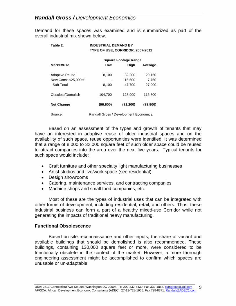
Randall Gross / Development Economics
Demand for these spaces was examined and is summarized as part of the overall industrial mix shown below.
Table 2. INDUSTRIAL DEMAND BY TYPE OF USE, CORRIDOR, 2007-2012 Square Footage Range Market/Use Low High Average Adaptive Reuse 8,100 32,200 20,150 New Const-<25,000sf - 15,500 7,750 Sub-Total 8,100 47,700 27,900 Obsolete/Demolish 104,700 128,900 116,800 Net Change (96,600) (81,200) (88,900) Source: Randall Gross / Development Economics.
Based on an assessment of the types and growth of tenants that may have an interested in adaptive reuse of older industrial spaces and on the availability of such space, reuse opportunities were identified. It was determined that a range of 8,000 to 32,000 square feet of such older space could be reused to attract companies into the area over the next five years. Typical tenants for such space would include:
• Craft furniture and other specialty light manufacturing businesses • Artist studios and live/work space (see residential) • Design showrooms • Catering, maintenance services, and contracting companies • Machine shops and small food companies, etc.
Most of these are the types of industrial uses that can be integrated with
other forms of development, including residential, retail, and others. Thus, these industrial business can form a part of a healthy mixed-use Corridor while not generating the impacts of traditional heavy manufacturing. Functional Obsolescence Based on site reconnaissance and other inputs, the share of vacant and available buildings that should be demolished is also recommended. These buildings, containing 130,000 square feet or more, were considered to be functionally obsolete in the context of the market. However, a more thorough engineering assessment might be accomplished to confirm which spaces are unusable or un-adaptable.
USA: 2311 Connecticut Ave Ste 206 Washington DC 20008. Tel 202-332-7430. Fax 332-1853. [email protected] AFRICA: African Development Economic Consultants (ADEC). 27-11-728-1965. Fax 728-8371. [email protected]
9
Randall Gross / Development Economics
New Construction Demand for net new construction of industrial buildings was determined based on the broader market considerations and competitive advantages of this Corridor. Again, overall trends have seen consistent negative absorption and outflow of industrial businesses from this sub-market. On the other hand, much of that outflow has been concentrated in older, less-competitive buildings. There has been some new construction of multi-tenant flex buildings that has fared much better in the market, although there has still not been positive absorption. Assuming that conditions were to remain the same in the Corridor, there is likely to be continued outflow of industrial uses to more competitive locations even though rents are low relative to other sub-markets. However, strengthening of the Corridor and in particular, better definition and marketing of the Patterson Street area as an industrial park, can help to reverse some of the downward trend. The location is still comparatively good from a local and regional distribution perspective, given Patterson Street’s location near I-40. Based on the assumption that the area is marketed and enhanced as an industrial park with affordable prices, there is a strong possibility for reversing the outflow from flex and small warehouse buildings and attracting demand for buildings under 25,000 square feet in the next five years. A conservative estimate of demand for up to 15,000 square feet is projected based on this assumption. Net Demand If accounting for the need to demolish functionally obsolete buildings, there is an over-supply of 81,000 to 97,000 square feet of industrial space in the Corridor carrying through into the near term. However, assuming demolition of those buildings, there would be net demand for an estimated 28,000 square feet (8,000 to 50,000 square feet) of industrial use (of existing and new buildings) assuming a marketing strategy addresses the need for adaptive reuse in certain areas and for better definition of industrial park in the Patterson Street area.
Preliminary Concepts As noted previously, there are three basic strategies relating to industrial use within the Corridor.
• Demolish Functionally-Obsolete Buildings. First, there is a need for assessment and (as appropriate) demolition of functionally obsolete industrial buildings that are impacting on the image of High Point Road and draining the economic viability of the Corridor.
USA: 2311 Connecticut Ave Ste 206 Washington DC 20008. Tel 202-332-7430. Fax 332-1853. [email protected] AFRICA: African Development Economic Consultants (ADEC). 27-11-728-1965. Fax 728-8371. [email protected]
10
Randall Gross / Development Economics
• Incentives for Adaptive Reuse. Where there are buildings appropriate for adaptive reuse, even if located adjacent to existing or planned residential development, there is a need for incentives to encourage the reuse of such buildings for economically-viable uses. Such incentives will be explored as part of the strategic planning component of this project. Again, it should be emphasized that many industrial uses can be effectively and successfully integrated with residential and other land uses, and this should be encouraged particularly as part of the University Student Residential and Entertainment Corridor Concept. Such industrial uses as crafts manufacturing can add to the vibrancy and urban context of this concept.
• Patterson Street Industrial Park. The Patterson Street area can be
more competitive for attracting and retaining light industrial uses such as logistics and delivery companies, plus light manufacturing, that depend on a central location and access to I-40. A strategy will be developed for creating better definition and marketing of Patterson Street as an industrial park.
USA: 2311 Connecticut Ave Ste 206 Washington DC 20008. Tel 202-332-7430. Fax 332-1853. [email protected] AFRICA: African Development Economic Consultants (ADEC). 27-11-728-1965. Fax 728-8371. [email protected]
11
Randall Gross / Development Economics
MEMORANDUM July 2, 2008 TO: Mike Kirkman Greensboro Planning Department FROM: Randy Gross SUBJECT: Housing Update & Next Steps This memorandum provides a “bulleted” summary of findings from the housing survey, revised market analysis, and resulting changes to the housing development recommendations. In addition, suggestions are also offered on a way forward for refinement of the sports & recreation hub concept.
Housing Market Revisions A survey was distributed to a statistically random sample of 1,344 faculty and staff of the University of North Carolina-Greensboro (UNCG), to collect information on employee demographics, existing housing situation, and housing preferences. Almost 240 responses were received. The survey also tested the concepts for revitalization of W. Lee Street in order to determine whether changes in the urban environment would actually attract downtown and UNCG employees to live in the area.
Results of the survey were useful in refining the market data that was produced through a market analysis earlier this year. The findings also provide more detailed input on consumer preferences with respect to the type, pricing, and tenure of housing that would appeal to employees in the area. Key findings and revisions to the housing recommendations are provided below. Key Findings
• Surprisingly, more than 50% of university faculty and staff would consider living in the W. Lee Street Corridor or Glenwood, having responded positively to the following question (#10):
If a new, safe, and pleasant environment with amenities (such as health club, shopping) were created in the W. Lee Street Corridor near UNCG, could you be attracted to live there?
• Almost 40% of university faculty and staff noted that they would be interested in living closer to their work. A share of those (15%) said that
2311 Connecticut Avenue Suite 206 Washington DC 20008. Tel 202-332-7430. Fax 332-7433. [email protected] AFRICA: African Development Economic Consultants (ADEC). 27-11-728-1965. Fax 728-82371. [email protected]
1
Randall Gross / Development Economics
they want to be closer to “city life and amenities” including art, culture, and neighborhoods.
• Overall, the input from the survey has resulted in a shift upwards in the
housing demand projections, mainly due to an adjusted capture rate specifically for university employees. In other words, the survey helped to refine the Corridor’s potential capture of the university and other employee markets. The change in overall potentials is summarized below:
o Former 2012 Projection: 137-239 units o Revised 2012 Projection: 158-268 units
• About 22% of employees currently rent their housing, but only 5% would move to West Lee Street to rent an apartment. Most of the renters would prefer to move up and purchase housing. Among employees who would consider moving to housing in the W Lee Street, somewhat more are likely to choose to live in a single-family house than in multi-family buildings. The most popular form of housing desired would be a rehabilitated house in Glenwood. However, of new housing types, the most popular format would be mixed-use buildings, particularly if such development includes a health club.
o New Rental Apartment 5% o New Condominium 21% o New Single-Family Home 29% o New Mixed-Use/Health Club 32% o Rehab Glenwood Home 35%
• Employees are currently paying an average rent of $672 per month or they have an average monthly mortgage payment of $1,121. Based on these amounts, comparable for-sale housing would be priced in the range of about $85,000 to $160,000. Demographically, about one-third of UNCG employee households have incomes above $100,000 and more than 60% of those employees have a graduate, professional, or doctorate degree. Prices for existing homes were averaging about $73,300 in the Study Area in 2007.
• Housing sales would be difficult in the current market climate, not so much
because of a lack of demand but because of a downturn in housing prices (which reduces the ability of current homeowners to sell and move-up) and because of a scarcity of “easy” financing for first-time buyers relating to the so-called “credit crunch.”
• Many of the employees responded favorably to the concept of the City
offering financial incentives. The assistance most requested from the City is a lower mortgage interest rate. Almost 60% of those who would
2311 Connecticut Avenue Suite 206 Washington DC 20008. Tel 202-332-7430. Fax 332-7433. [email protected] AFRICA: African Development Economic Consultants (ADEC). 27-11-728-1965. Fax 728-82371. [email protected]
2
Randall Gross / Development Economics
consider purchasing housing in the W. Lee Street or Glenwood areas would appreciate some assistance in writing down the interest costs of their mortgage. Also important to the employees is some sort of down-payment assistance. Less appealing were rent-to-own options and other incentives, such as property tax abatements, although some residents suggested that they would appreciate assistance with selling existing homes in order to move to the area.
• In terms of retail amenities desired by the UNCG employees, sit-down
restaurants have the broadest appeal, followed by groceries, fast food take-outs, and clothing & shoe stores. If a transit service (e.g., shuttle bus) were offered between the university and businesses along W. Lee Street, then 60% of those surveyed said that they would take advantage of that service. Only 27% of the UNCG households have children under the age of 18, and the average age of the head of household is 46, suggesting that schools and youth services are not a priority for the majority of employees.
Key Recommendations
• The “Sports Village” residential/retail/health club mixed-use marketing concept proposed between UNCG and the coliseum (at Site #4) is popular among the institutional employees as well as among students. However, the tenure will be different for students, verses workers, with most students renting units while staff would more likely purchase. The current planning concept at this site currently has 46 DUs in two mixed-use buildings on the north side and 40 DUs on the south side of W Lee Street, just off of Aycock. In all likelihood, the financial requirements of a single, mixed-use project with a health club will require a higher density of housing, perhaps in the range of 80 to 100 units. Based on the overall market findings, the mix is likely to be 36% for-sale and 64% rental. Preferably, the project would be developed with separate wings or buildings for rental versus for-sale. This project would ideally begin development within the five-year market forecast horizon (2012/3) as a “first-phase” anchor for the area, and would act as a catalyst for further redevelopment. Several additional residential / mixed-use projects having 50 to 80 student-oriented rental units would be developed in successive phases, clustered near the health club facilities and retail amenities.
• Other residential demand supported in the existing and near-term market
would include rehabilitation of 20 to 35+ existing homes in Glenwood as well as some limited (10 unit) artist housing and live-work space integrated into a mixed industrial service/craft/entertainment environment for Site #1. The housing survey seems to confirm that there is also some demand for new, single-family housing (perhaps 15 to 25 townhouses) targeted to UNCG employees and other DINK households that should be
2311 Connecticut Avenue Suite 206 Washington DC 20008. Tel 202-332-7430. Fax 332-7433. [email protected] AFRICA: African Development Economic Consultants (ADEC). 27-11-728-1965. Fax 728-82371. [email protected]
3
Randall Gross / Development Economics
accommodated near the university or in a proximate location within the Study Area.
• Remaining housing that has been shown in the physical plan is conceptual
in nature and more likely to build-out over the long term (beyond the 5-10 year horizon of the market study). Again, there is a concern for the marketability of housing projects that have been shown on the physical plan in the Site #1 area, since there is remaining demand for downtown-oriented industrial uses (e.g., bakeries, machine shops), opportunities for specialty craft (e.g., stained glass), and potential for urban entertainment uses (e.g., nightclubs) near downtown that can access the student market in this east-west university corridor. The marketing concept for this area tries to draw upon these diverse uses to create a more unique and exciting multi-use urban district that promotes adaptive use and infill rather than wholesale redevelopment.
• Given the near-term housing market and financing considerations, it would
be recommended that the City pursue a special district mortgage and/or down-payment assistance program for the area. There are various ways in which the City could help in “writing down” the interest rates on mortgages, but it would seem that in this climate the City’s most powerful tool may be some type of loan guarantee that would help alleviate pressure on lenders. The consultant can examine this programmatic concept further in discussion with mortgage companies that are active in the area.
“Sports & Recreation Hub Concept” Next Steps
The concept of a “Sports & Recreation Hub” developed out of the market analysis and findings related to the existing institutional and facility asset base, activities at the Coliseum, potential for certain destination retail businesses, and the likely demographic market niches for housing in this corridor. This concept was discussed in greater detail as part of the strategic planning recommendations, and the Action Plan identified specific actions that should be taken in order to encourage the development of this concept further. The community appears to have expressed an interest in this concept, and the housing survey conducted of UNCG faculty and staff seems to indicate further market support for the integration of mixed-use housing and recreation facilities. Among the first steps recommended in the Action Plan were for the City to appoint a working partnership between the Coliseum, private investors/property owners, and the university community to explore this concept as a broader marketing tool for the city of Greensboro. But in addition, there is the need to examine the economic potentials for various elements of the concept in greater detail so that specific plans can be set into place for anchor facilities
2311 Connecticut Avenue Suite 206 Washington DC 20008. Tel 202-332-7430. Fax 332-7433. [email protected] AFRICA: African Development Economic Consultants (ADEC). 27-11-728-1965. Fax 728-82371. [email protected]
4
Randall Gross / Development Economics
and programs as the centerpiece for marketing. Among the specific questions relating to facilities include the following:
• Swimming Center or Natatorium. The community has apparently considered the development of a swimming center for some time and that the need for this center may have been examined in some way. In the least, a full Needs Assessment should be conducted to determine the future need for such a facility not only to serve the local constituency base but also as a competitive regional or national facility that could bring cache to Greensboro and the Corridor. At the least, there should be a review of any needs assessments that have already been conducted to determine whether further work is required and whether the Sports & Recreation Hub is an appropriate location for this type of facility. Further assessment would also determine the regional or national competitive framework for such facilities, and potential within this framework. Finally, such assessment should determine the potential public returns and economic development impacts of such a facility, in terms of the exposure and economic and fiscal spin-off it might bring to Greensboro.
• “All Sports Facility.” There is also the opportunity to look at the future
potential for an all-sports facility that would prospectively accommodate regional high school, intra-mural, civic or corporate league, and university sporting competitions that cannot otherwise be accommodated on campuses in the Triad. Similar economic spin-offs should be examined.
• Coliseum & Affiliated Attractions. As discussed several times
throughout this planning process and in the Strategic Plan, it is strongly recommended that the economic potentials for the Coliseum be examined with respect to future growth and expansion of program, venues, and facilities. The potential for expanding the convention and trade show component of the Coliseum program needs to be examined further, and some of this question may relate specifically to the sports & recreation niche within that market. Other, affiliated attractions (e.g., museum) have been proposed by the Coliseum, but these have not been tested in the market and there is a need to understand the realistic opportunities and economic viability of such concepts.
• Hospitality. Demand for related tourism and hospitality support facilities
(e.g., hotels, attractions, restaurants, entertainment) could be better determined if the future of key “drivers” (i.e., Coliseum, sports facilities, etc) are better understood. Those major facilities help to drive demand for retail and other secondary uses.
• Sports Village Complex. The mixed-use Sports Village concept has been
proposed based on the overall market analysis for the Study Area. However, further more detailed assessment would normally be required to
2311 Connecticut Avenue Suite 206 Washington DC 20008. Tel 202-332-7430. Fax 332-7433. [email protected] AFRICA: African Development Economic Consultants (ADEC). 27-11-728-1965. Fax 728-82371. [email protected]
5
Randall Gross / Development Economics
determine whether the project itself is economically viable and financially feasible. Importantly, it would also be useful do conduct outreach to potential local, regional, and national developers and tenants to test the concept and the specific findings, and to determine the requirements that a developer would have to help encourage such development. Since the concept is proposed as an anchor project, and because of the timing during the down cycle in the housing market, it will be important to understand the structural incentives that may be necessary to leverage development.
• Linkages. The plan is already accounting for such considerations as
greenways, etc that might provide pedestrian and bicycle linkages, but these should also respond to the need for linking facilities in the sports & recreation hub.
• Retail. The market analysis has examined overall demand in the corridor
and, as part of that assessment, identified existing assets and opportunities for sporting goods, dining, and related retail uses. This could be explored in more detail in order to build on this concept. Again, both the hospitality and retail components would be influenced in large measure by key drivers such as the coliseum, natatorium, all-sports facility, and other anchors.
• Other City & University Recreation Facilities. There should be strategic
coordination with the City’s and universities’ recreation divisions with respect to overall facility planning and an understanding of need and market opportunity that may relate back to this hub.
Reference should be made to the Action Plan prepared by RGDE as part
of the strategic planning recommendations. The Action Plan references specific tasks toward implementation, although the aforementioned assessments would help inform strategic planning up-front.
2311 Connecticut Avenue Suite 206 Washington DC 20008. Tel 202-332-7430. Fax 332-7433. [email protected] AFRICA: African Development Economic Consultants (ADEC). 27-11-728-1965. Fax 728-82371. [email protected]
6
Randall Gross / Development Economics
RETAIL MARKET TESTING This report provides findings from an assessment of the retail & commercial use proposed as part of the physical development concepts envisioned in the Corridor. The concepts were tested against the existing market conditions and marketing requirements. The retail opportunities are also identified in the context of several marketing concepts proposed for the Corridor.
Opportunities Assessment Review A review of existing retail market conditions was conducted and opportunities identified as part of an overall Opportunities Assessment for the Corridor. Site analysis determined that the Corridor has a total inventory of 850,013 square feet of retail building space, of which about 9.7% (82,500sf) is vacant. It should be noted that some retail commercial spaces are actually occupied by offices (such as for labor or financial service entities). Existing retail uses along West Lee Street are characterized as generally low-end local-serving retail/service; while those in the High Point Road area are more typically oriented to the national brands, including small and big-box chain stores and restaurants that benefit from access to Interstate 40 and shopping mall traffic. Strengths
The Corridor’s strengths include its position within a relatively healthy regional (Triad) market, and its access and exposure afforded by I-40. Existing retail serves an affordable niche in the market, which performs well during times like these of rising gas prices and uncertain economic conditions. Anchors like the Coliseum and UNCG provide potential for further development of the area’s capture in the destination market. Constraints
As noted in the Opportunities Assessment, the area’s constraints include overall competitive framework and the limited income base to support convenience purchases within the primary trade area adjacent to the Corridor. More importantly, perceptions of crime and poor physical conditions serve to hamper inflow to the Corridor from neighborhoods outside of the adjacent communities (and from more affluent areas to the north).
USA: 2311 Connecticut Ave Ste 206 Washington DC 20008. Tel 202-332-7430. Fax 332-1853. [email protected] AFRICA: African Development Economic Consultants (ADEC). 27-11-728-1965. Fax 728-8371. [email protected]
1
Randall Gross / Development Economics
Opportunities (Tenant Mix)
Opportunities identified in the initial assessment included destination restaurants and entertainment that might be driven by the Corridor’s anchors and its location near downtown. There is also an opportunity for discount merchandise, home and contracting supply, due to accessibility and the relatively low land prices in the Corridor as compared with more competitive locations in affluent neighborhoods. There is also the opportunity for attracting certain types of specialty good niches that would appeal to the university-driven markets, such as sporting goods and recreation equipment, but only if a critical mass of these businesses could be attracted in order to generate destination appeal.
Physical Concept Plan
The physical concept plan integrates retail uses into practically all sections of the Corridor. Much of this retail is envisioned as part of mixed-use (residential/commercial) buildings located from the eastern edge of the Corridor west towards the Coliseum. Along High Point Road, the Concept plan envisions retail in mixed-use buildings but reverts to the existing pad retail at sites closer to I-40. The Concept plan envisions a total of 701,700 square feet of retail/commercial space at the sites, but would also leave 144,585 square feet of existing retail uses outside of those concept sites. Thus, there would be a total 846,285 square feet of retail/commercial envisioned in the Corridor. This represents a net increase of 102,000 square feet over existing retail use. The Appendix of this report summarizes the retail/commercial use as delineated in the Concept Plan. Market Testing of Concept Plan Commercial Use Basic market inputs were examined within a primary trade area comprised of neighborhoods surrounding the Corridor, as well as in a larger secondary trade area in south-west Greensboro. The retail market is driven by changes in the household base and in disposable incomes within the trade area. Both households and incomes have been declining within the primary and secondary trade areas.
The primary trade area household base has fallen at a rate of 0.4% per year since 2000. Households in the primary trade area drive demand for convenience goods in particular. Income levels among these households have fallen at rate of 2.3% per year in real terms since 2000. While incomes had begun to stabilize since the recession of 2002-3, recent economic instability is likely to have had a negative impact on the fragile employment base and incomes among trade-area residents.
USA: 2311 Connecticut Ave Ste 206 Washington DC 20008. Tel 202-332-7430. Fax 332-1853. [email protected] AFRICA: African Development Economic Consultants (ADEC). 27-11-728-1965. Fax 728-8371. [email protected]
2
Randall Gross / Development Economics
Using a standard retail model (without completing a full market analysis), it can be assumed that retail expenditure potential within the two trade areas would total an estimated $340.6 million in 2012/3. Using various capture assumptions, this potential would logically translate into demand for about 706,500 square feet of retail space in the Corridor within five to ten years. Given that there is an existing retail base of 744,300 square feet, then it can be said that there is likely to be a slight over-supply (in other words, existing retailers will under-perform based on expected retail sales standards) within five to ten years. The redevelopment concepts proposed in the plan calls for approximately 846,000 square feet (including new and existing space). Thus, the addition of about 100,000 square feet of net new space will increase the over-supply in the market through the foreseeable future (to a total overhang of about 140,000 square feet). However, since the concept plan calls for mixed-use with up to 915 units of housing, there is the opportunity to generate retail demand from the new housing that is envisioned in the plan.
The additional retail envisioned in the plan would (based on median household incomes and a high capture rate) require the addition of at least 600 housing units. If the housing is to accommodate graduate students however, then up to 1,180 new units would be required to support the additional retail space envisioned in the plan.
Units required to support Concept Plan commercial within 5-10 years:
Households at median area income: 600+ Households at graduate student income: 1,180+
Units included in Concept Plan: 915 More student units would be required because students have less
disposable income for the purchase of retail goods and services. Thus, the housing conceptualized in the plan would need to accommodate a mix of working households and students, preferably weighted more to the workers. Whether or not the Corridor’s housing can attract up to 600 working households within the near future is being tested further through a housing survey of area employees. Another option for ameliorating the housing requirement is to focus on destination marketing strategies for the retail to increase the inflow to the Corridor from communities outside of the primary and secondary trade areas. Without completing a full retail market analysis, it is impossible to determine the potential for destination retail & entertainment in this market context. But, the Corridor does have significant assets that can leverage greater demand from the regional market base. A possible mix of net new retail & entertainment uses that might be accommodated in the Corridor would logically include the following:
Destination entertainment & restaurants 50,000 SF Corridor serving and discount retail 35,000 – 70,000 SF
USA: 2311 Connecticut Ave Ste 206 Washington DC 20008. Tel 202-332-7430. Fax 332-1853. [email protected] AFRICA: African Development Economic Consultants (ADEC). 27-11-728-1965. Fax 728-8371. [email protected]
3
Randall Gross / Development Economics
Specialty (e.g., sporting goods) 30,000 – 50,000 SF
A total prospective mix of 115,000 to 170,00 square feet of new retail use might be accommodated in the Corridor if an appropriate mix of worker vs student housing is developed, and if marketing concepts generate destination demand.
Marketing Concepts
Several marketing concepts were developed that build on this strategy for generating destination retail demand within separate sections of the Corridor. These concepts would include a university-oriented mixed-use district (from UNCG to South Eugene), a sports & recreation hub from UNCG to the Coliseum, and a convention district along High Point Road from the Coliseum to Interstate 40. (A separate Patterson Street industrial district marketing concept has also been developed, but the focus would have only limited impact on retail/commercial uses). University-Oriented Mixed-Use District A marketing concept has been developed that is consistent with the physical concepts for a university-oriented mixed-use district between UNCG and South Eugene. The market potential within this district relies to a great extent on the area’s universities (particularly UNCG) as drivers. Redevelopment of underutilized sites for university-related housing is a key opportunity for the area, and the housing market analysis has indicated that there is demand within certain niches. The survey now underway is testing this concept in particular among university faculty and staff, a key market niche for housing and retail in this area. At the same time, the industrial market assessment indicates that there is limited potential for new industrial development, but that there are opportunities for industrial service businesses that need a central location and serve the downtown market base. Given the likely reliance on university demand drivers, and on the district’s location proximate to Downtown Greensboro, a marketing concept is put forward that would emphasize the area’s eclectic character and interesting mix of land uses. Rather than wholesale demolition of industrial buildings and service uses, the marketing concept would build on a potentially interesting mix of uses that would be appealing to new residents while also serving the needs of businesses in the downtown area. Such a mix would include the adaptive use of selected industrial buildings for light industry, artist studios, and craftwork businesses. Functionally obsolete buildings would be demolished and replaced with mixed-use housing/commercial buildings as envisioned in the Concept Plan. As noted previously, these buildings
USA: 2311 Connecticut Ave Ste 206 Washington DC 20008. Tel 202-332-7430. Fax 332-1853. [email protected] AFRICA: African Development Economic Consultants (ADEC). 27-11-728-1965. Fax 728-8371. [email protected]
4
Randall Gross / Development Economics
would need to include an appropriate mix of worker housing and students to help increase demand for the commercial component.
Given proximity to the universities both east and west of South Eugene, the concept would promote a portion of the entertainment use as a “gateway” anchor connecting downtown with West Lee Street at South Eugene. Such entertainment (in the form of night clubs, for instance) would serve students and young professionals who would be increasingly concentrated in the Corridor and further east. Club uses are particularly appropriate at this location because of the lack of adjoining residential communities. Often, club districts are formed in former industrial areas (or even integrated with industrial uses) to avoid conflict with residential neighborhoods.
The particular niches within this concept’s eclectic mix of uses would include the following for each land use:
• Housing: UNCG, NC A&T, G’boro College, Bennett • Industrial: Craft industries, contracting, bakery/foodservice • Entertainment: Industrial dance clubs • Retail: Ground-floor convenience in mixed-use; sales & service • Specialty: Artist live/work, gallery space • Relocation of day labor to contractor hub
The retail uses would include site-serving convenience retail & service
establishments in mixed-use buildings, as well as sales & service businesses oriented to central city contracts. Such uses would be interspersed with light industrial businesses including craft industries (e.g., makers of fine handmade woodcraft furniture or stained glass), building contractors (e.g., security, HVAC, elevator repair), and bakeries & foodservice businesses including those that supply downtown businesses and universities. This mix is supportable given existing and likely conditions with respect to both retail and industrial markets.
Note that the marketing concept recommends relocation of the day labor site to a more formalized contractor hub, where construction companies and contractors will have more formal access to day workers. The concept for the hub will be developed further as part of the strategic recommendations, but it may also be oriented to include training, entrepreneurial, and business partnership programs. Greensboro Sports & Recreation Hub The City’s sports, trade show, and entertainment functions are already clustered in the Corridor, but there is no agglomeration of uses to strengthen marketing. This concept builds on the existing anchor uses, including the Coliseum and UNCG, to create a cluster of sports & recreation facilities and associated uses.
USA: 2311 Connecticut Ave Ste 206 Washington DC 20008. Tel 202-332-7430. Fax 332-1853. [email protected] AFRICA: African Development Economic Consultants (ADEC). 27-11-728-1965. Fax 728-8371. [email protected]
5
Randall Gross / Development Economics
A mixed-use project would be developed near the Coliseum as a “Sports Village” concept, to including residential, fitness, and sports-related retail businesses. As noted in previously in this report, there are opportunities for capturing sales generated for sporting goods from area students and as a destination use. University-related sports facilities such as training fields and recreation centres would be appropriate in this node, especially where shallow sites alongside the railway prevent large-scale redevelopment. Structured parking is also an appropriate use, given the location adjacent to the Coliseum and high-density housing and retail. A housing improvement plan (HIP) will be proposed for adjoining neighborhoods such as Glenwood as part of the strategic recommendations. An expanded program for the Coliseum itself is recommended to help bolster the facility’s role as an anchor generating demand in support of revitalization in the Corridor. The program for the Coliseum should be defined based on a thorough assessment of the market potentials for entertainment, lodging, and audience-support uses. The market niches for each use in this area are explored below based on the market review and assessments.
• Tourism / Lodging: Expanded Coliseum-area offering • Housing / Mixed-use University students & institutional workers • Fitness & Recreation facilities • Sporting goods / specialty retail
Convention Hub
Destination retail and entertainment uses relating to the Coliseum would be best positioned at the High Point Road portion of this node, thereby increasing the physical linkages with the convention facilities and hotels located near I-40. High Point Road, between the Coliseum and Interstate 40, would be marketed partly as a hub for convention and trade-show related activities.
The initial focus in this area should relate to the upgrading of existing
physical conditions and enhanced pedestrian access (e.g., streetscape, reduced curb cuts, street-orientation to existing shopping centers), with only limited development of new retail space. Over the long-term, there may be opportunities for more restaurant and entertainment uses focused at the Coliseum node.
The office market assessment suggests the need for upgrading of existing
Meadowview office space and a more aggressive leasing strategy, but there is little demand for development of new office space in the near future. Similarly, the hotel market is relatively saturated, but in the near-term there is an opportunity to upgrade existing lodging facilities as revenue-per-room increases. Key components of this concept by use, include:
USA: 2311 Connecticut Ave Ste 206 Washington DC 20008. Tel 202-332-7430. Fax 332-1853. [email protected] AFRICA: African Development Economic Consultants (ADEC). 27-11-728-1965. Fax 728-8371. [email protected]
6
Randall Gross / Development Economics
• Roadway, streetscape & urban design improvements • Lodging: Upgrading of existing facilities • Office: Upgrading and focus on Meadowview • Retail: Reconfigure existing shopping centers to improve the
street orientation in short term. • Restaurants/Entertainment: Oriented to expansion of Coliseum
program in long term.
Summary In general, the physical development concepts envisioned for the Corridor are consistent with market considerations. The plans call for about 100,000 square feet of retail commercial use above and beyond that which can be supported under existing market conditions. However, the development of at least 600 housing units (or 1,200 student units) would help to generate additional retail demand in support of retail development. In addition, there are opportunities for destination retail that would attract inflow to the Corridor particularly if the Coliseum program and audience support facilities were expanded in the future.
USA: 2311 Connecticut Ave Ste 206 Washington DC 20008. Tel 202-332-7430. Fax 332-1853. [email protected] AFRICA: African Development Economic Consultants (ADEC). 27-11-728-1965. Fax 728-8371. [email protected]
7
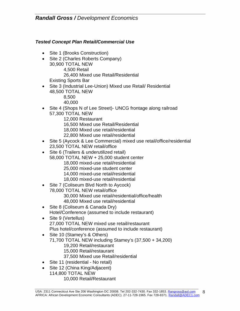
Randall Gross / Development Economics
Tested Concept Plan Retail/Commercial Use
• Site 1 (Brooks Construction) • Site 2 (Charles Roberts Company)
30,900 TOTAL NEW 4,500 Retail 26,400 Mixed use Retail/Residential Existing Sports Bar
• Site 3 (Industrial Lee-Union) Mixed use Retail/ Residential 48,500 TOTAL NEW
8,500 40,000
• Site 4 (Shops N of Lee Street)- UNCG frontage along railroad 57,300 TOTAL NEW 12,000 Restaurant 16,500 Mixed use Retail/Residential 18,000 Mixed use retail/residential 22,800 Mixed use retail/residential
• Site 5 (Aycock & Lee Commercial) mixed use retail/office/residential 23,500 TOTAL NEW retail/office
• Site 6 (Trailers & underutilized retail) 58,000 TOTAL NEW + 25,000 student center 18,000 mixed-use retail/residential 25,000 mixed-use student center 14,000 mixed-use retail/residential 18,000 mixed-use retail/residential
• Site 7 (Coliseum Blvd North to Aycock) 78,000 TOTAL NEW retail/office 30,000 Mixed use retail/residential/office/health 48,000 Mixed use retail/residential
• Site 8 (Coliseum & Canada Dry) Hotel/Conference (assumed to include restaurant)
• Site 9 (Vertellus) 27,000 TOTAL NEW mixed use retail/restaurant Plus hotel/conference (assumed to include restaurant)
• Site 10 (Stamey’s & Others) 71,700 TOTAL NEW including Stamey’s (37,500 + 34,200) 19,200 Retail/restaurant 15,000 Retail/restaurant 37,500 Mixed use Retail/residential
• Site 11 (residential - No retail) • Site 12 (China King/Adjacent)
114,800 TOTAL NEW 10,000 Retail/Restaurant
USA: 2311 Connecticut Ave Ste 206 Washington DC 20008. Tel 202-332-7430. Fax 332-1853. [email protected] AFRICA: African Development Economic Consultants (ADEC). 27-11-728-1965. Fax 728-8371. [email protected]
8
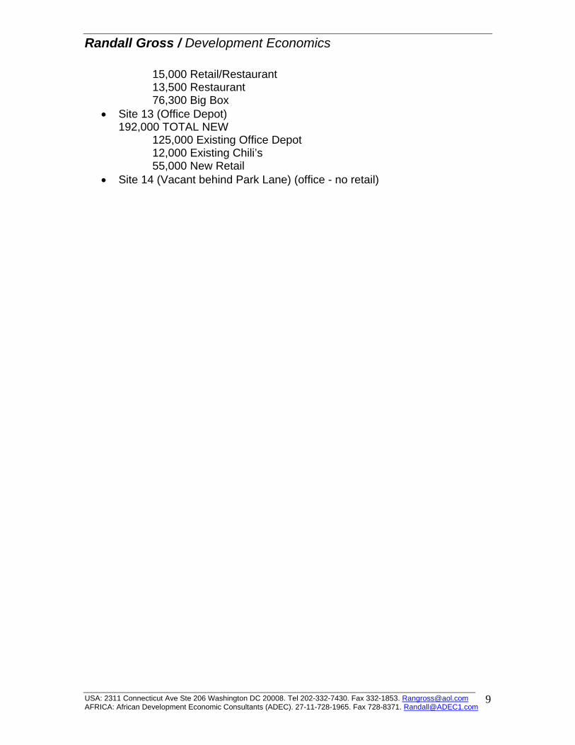
Randall Gross / Development Economics
15,000 Retail/Restaurant 13,500 Restaurant 76,300 Big Box
• Site 13 (Office Depot) 192,000 TOTAL NEW 125,000 Existing Office Depot 12,000 Existing Chili’s 55,000 New Retail
• Site 14 (Vacant behind Park Lane) (office - no retail)
USA: 2311 Connecticut Ave Ste 206 Washington DC 20008. Tel 202-332-7430. Fax 332-1853. [email protected] AFRICA: African Development Economic Consultants (ADEC). 27-11-728-1965. Fax 728-8371. [email protected]
9