Embed Size (px)
Citation preview
Historic FarmsteadsPreliminary CharacterStatement:East of England Region

The text of this document was prepared by Jeremy Lakeand Bob Edwards with contributions to the regional andnational sections from Susanna Wade Martins andadditional assistance by Peter Gaskell and Julie Ryan. Itwas designed by Steve Dent and edited by NickiMarshall of BiscuitBox Ltd.The research project wascommissioned by English Heritage and the CountrysideAgency and managed by Peter Gaskell of the Universityof Gloucestershire.The assistance of the following peopleis gratefully acknowledged: Steve Podd, Freya Edwardsand the many farmers and owners of buildings who gavetheir time to discuss their farm buildings and allowedaccess for photography.
This document is one of eight Preliminary CharacterStatements, which provide information on thecharacteristics of traditional farm buildings in eachRegion.They can be viewed and downloaded atwww.helm.org.uk/ruraldevelopment and atwww.ahds.ac.uk.
English Heritage is the Government's adviser on thehistoric environment. Central to the role of EnglishHeritage is the advice it gives to local planningauthorities, government departments and others on theconservation of historic buildings, sites and areas,archaeology on land and underwater, designedlandscapes and the historic aspects of the landscape as awhole. English Heritage also has a duty to enhancepeople's understanding and enjoyment of their heritageand, as part of this, it manages an estate of over 400historic properties open to the public.
The Countryside Agency is the statutory body workingto conserve and enhance England's countryside.The aimof the Countryside Agency's Landscape, Access andRecreation division is to help everyone respect, protectand enjoy the countryside, protect natural landscapes,and encourage access to, enjoyment of and sustainablemanagement and use of the countryside.
In accordance with the Natural Environment and RuralCommunities Act 2006, English Nature, the RuralDevelopment Service and the Countryside Agency'sLandscape, Access and Recreation division are workingtowards integration as a single body: Natural England. Itwill work for people, places and nature withresponsibility for enhancing biodiversity, landscapes andwildlife in rural, urban, coastal and marine areas,promoting access, recreation and public well-being, andcontributing to the way natural resources are managedso that they can be enjoyed now and for futuregenerations.
The document should be cited as:Historic Farmsteads. Preliminary Character Statement:East of England Region.
Published in August 2006 by the University ofGloucestershire in association with English Heritage andthe Countryside Agency.
Copyright 2006 Authors, University of Gloucestershire,English Heritage and the Countryside Agency
The text in this document may be reproduced free ofcharge in any format or medium without specificpermission, subject to the material not being used in aderogatory way.The copyright holders must beacknowledged, and the title of the publication must beincluded in any published reference.
All photographs and illustrations are individually credited.
Countryside and Community Research UnitDunholme VillaThe ParkCheltenhamGloucestershireGL50 2RF
Acknowledgements
2
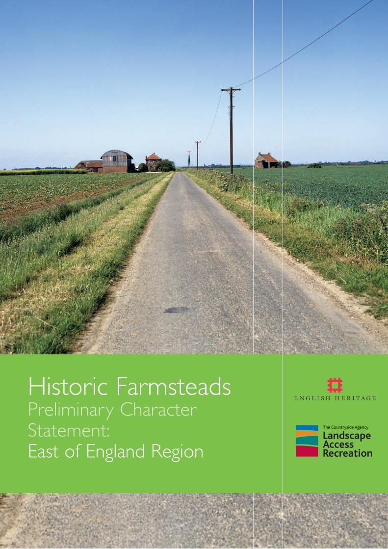
Cover image:The Fens – the characteristic flat landscape crossed by straight roads and drains with isolated farmsteads either sitting alongside the road or setback from the road and accessed by tracks. Large-scale reclamation of parts of the Fens was carried out from the 17th century, mainly to produce grazing lands.Improved drainage systems introduced in the 19th century allowed the rich peat soils to be extensively used for arable and led to the construction of many newfarmsteads. Shrinkage of the peat often resulted in structural problems so few of the early farm buildings survive. © Countryside Agency / David Burton
SUMMARY 6
1.0 INTRODUCTION 10
2.0 UNDERSTANDING CONTEXT ANDCHARACTER 12
2.1 LANDSCAPE CHARACTER ANDCHARACTERISATION 12
2.2 THE CHARACTER OF THE EAST OFENGLAND REGION:AN INTRODUCTION
122.3 THE CHARACTER OF RURAL SETTLEMENT
132.3.1 National Framework 132.3.2 Rural Settlement in the East of England 16
3.0 BUILDING MATERIALS 173.1 NATIONAL OVERVIEW 173.1.1 Walling 183.1.1.1 Temporary structures 183.1.1.2 Mass walling 183.1.1.3 Timber frame 183.1.1.4 Timber cladding 193.1.1.5 Corrugated iron 193.1.2 Roofing 193.1.2.1 Thatch 193.1.2.2 Plain clay tiles and stone slates 193.1.2.3 Corrugated iron and other prefabricated
modern materials 193.2 BUILDING MATERIALS IN THE EAST OF
ENGLAND 203.2.1 Walling 203.2.1.1 Stone 203.2.1.2 Earth 203.2.1.3 Timber 203.2.1.4 Brick 203.2.2 Roofing 223.2.2.1 Thatch 223.2.2.2 Slate 223.2.2.3 Tiles 23
4.0 AGRICULTURAL HISTORY AND FARM BUILDINGS 24
4.1 AN INTRODUCTION TO ENGLISHAGRICULTURAL HISTORY AND FARMBUILDINGS:THEIR DEVELOPMENT,SURVIVAL AND SIGNIFICANCE 24
4.1.1 Up to 1550 244.1.1.1 Survival and value 244.1.2 1550 to 1750 244.1.2.1 Survival and value 254.1.3 1750 to 1880 254.1.3.1 Survival and value 26
4.1.4 1880 to 1940 274.1.4.1 Survival and value 274.1.5 1940 to the present 284.2 FARMING IN THE EAST OF ENGLAND 294.2.1 North West Norfolk and North Norfolk
Coast 304.2.2 Breckland 304.2.3 Suffolk Coasts and Heaths 304.2.4 Central North Norfolk 314.2.5 The Flegg and The Broads 314.2.6 Mid Norfolk 314.2.7 South Norfolk and High Suffolk Claylands 314.2.8 South Suffolk and North Essex Claylands 324.2.9 The Chilterns and East Anglian Chalk 344.2.10 The Fens 354.2.11 Bedfordshire and Cambridgeshire Claylands and
the Bedfordshire Greensand Ridge 364.2.12 Greater Thames Estuary 364.2.13 Northern Thames Basin 36
5.0 FARMSTEAD TYPES 385.1 NATIONAL OVERVIEW 385.1.1 Linear plans 405.1.2 Parallel plans and L-shaped plans 405.1.3 Dispersed plans 405.1.4 Loose courtyard plans 405.1.5 Regular courtyard plans 415.2 FACTORS INFLUENCING FARMSTEAD
CHARACTER 415.2.1 Farm size 415.2.2 Estate policy 425.2.3 Local variation of farming systems 425.2.4 Internal workings of the farmyard 425.2.5 Development of farming systems 425.3 FARMSTEAD PLANS IN THE EAST OF
ENGLAND 435.3.1 Early loose courtyard and dispersed layouts 435.3.2 Regular courtyard layouts 435.3.3 L- and U-shaped courtyard layouts 44
6.0 KEY BUILDING TYPES: CROPSTORAGE AND PROCESSING 45
6.1 BARNS 456.1.1 National Overview 456.1.1.1 Plan form 456.1.1.2 Size 466.1.1.3 Combination barns 476.1.1.4 Evidence for mechanisation 476.1.1.5 Evidence for reuse and adaptation 476.1.2 Barns in the East of England 476.1.2.1 Threshing Barns and Aisled barns 476.1.2.2 Combination barns 48
Contents
3
6.1.2.3 Mechanisation 496.2 GRANARIES 506.2.1 National Overview 506.2.2 Granaries in the East of England 526.3 CART SHEDS AND IMPLEMENT SHEDS 526.3.1 National Overview 526.3.2 Cart sheds in the East of England 526.4 HAY BARNS AND OTHER CROP-RELATED
BUILDINGS 526.4.1 National Overview 526.4.2 Hay barns and other crop-related buildings
in the East of England 546.4.2.1 Hay barns 546.4.2.2 Farm Maltings 556.4.2.3 Onion Houses 55
7.0 KEY BUILDING TYPES:ANIMALS ANDANIMAL PRODUCTS 56
7.1 CATTLE HOUSING 567.1.1 National Overview 567.1.1.1 Longhouses 567.1.1.2 Ox houses 567.1.1.3 Combination barns 567.1.1.4 Open-fronted sheds 567.1.1.5 Lean-tos (outshots) 577.1.1.6 Free-standing cow houses 577.1.1.7 Looseboxes for fatstock 587.1.1.8 Covered yards 587.1.2 Cattle housing in the East of England 587.1.2.1 Pre-1750 587.1.2.2 Post 1750 587.2 DAIRIES 607.2.1 National Overview 607.2.2 Dairies in the East of England 617.3 STABLES 617.3.1 National Overview 61
7.3.2 Stables in the East of England 627.4 PIG HOUSING 637.4.1 National Overview 637.4.2 Pig housing in the East of England 647.5 SHEEP HOUSING 647.5.1 National Overview 647.5.2 Sheep housing in the East of England 647.6 DOVES AND POULTRY 647.6.1 National Overview 647.6.2 Doves and poultry in the East of England 677.6.2.1 Doves 677.6.2.2 Poultry 67
8.0 KEY BUILDING TYPES:OTHER FARMSTEAD BUILDINGS 68
8.1 OUTFARMS AND FIELD BARNS 688.1.1 National Overview 688.1.2 Outfarms and field barns in the East of England
688.2 MINOR AND MISCELLANEOUS BUILDINGS
688.2.1 National Overview 688.2.2 Minor and miscellaneous buildings in the East of
England 69
9.0 GLOSSARY 70
10.0 SOURCES 7410.1 GENERAL SOURCES 7410.2 NATIONAL BIBLIOGRAPHY 7510.3 REGIONAL BIBLIOGRAPHY 79
11.0 JOINT CHARACTER AREADESCRIPTIONS: URLS FOR PDFDOCUMENTS 81
4
Figure 1 Geology and Landscape Character in the Eastof England Region 13–14
Figure 2 Rural settlement in the East of England Region15
Figure 3 Distribution of cruck-framed and aisled barns17
Figure 4 Cruck and aisled barns 18Figure 5 Distribution of listed earth-built agricultural
buildings in England 18Figure 6 Distribution of listed timber-framed barns in
England 19Figure 7 Distribution of listed thatched agricultural
buildings in England 20Figure 8 Examples of walling materials in the East of
England Region 21–22Figure 9 Examples of roofing materials in the East of
England Region 23Figure 10 Distributions of listed farmhouses in England
pre-1550 and 1550–1750 26Figure 11 Distributions of listed barns in England
pre-1550 and 1550–1750 28Figure 12 Farmsteads in the landscape: All Saints South
Elmham, Suffolk 32Figure 13 Farmsteads in the landscape: Felsted, Essex 33Figure 14 Farmsteads in the landscape:West Wratting,
Cambridgeshire 34Figure 15 Farmsteads in the landscape: Doddington,
Cambridgeshire 35
Figure 16 Farmstead plan types 39Figure 17 Distribution of listed longhouses
in England 41Figure 18 Isometric view of a large, regular courtyard
farmstead in Northumberland 42Figure 19 Power in barns 46Figure 20 Barns in the East of England Region 48–9Figure 21 Interior of a granary showing grain bins and
louvered window 50Figure 22 Isometric drawings of a freestanding granary
on staddle stones and a granary at first floorlevel as part of a range of buildings 51
Figure 23 Granaries & cart sheds in the East of England Region 53
Figure 24 Hay barns and other crop related buildings inEast of England 54
Figure 25 Principal forms of cattle housing – some national examples 57
Figure 26 Cattle housing in the East of England Region 59
Figure 27 Interior of a stable 61Figure 28 Stables in the East of England Region 62Figure 29 Pigsties in England 63Figure 30 Distribution of listed dovecotes in England 65Figure 31 Dovecotes and buildings for poultry
in England 65Figure 32 Outfarms and field barns in the East of
England Region 69
5
Illustrations

1 LANDSCAPE AND AGRICULTURALCONTEXT
NATIONAL FRAMEWORK Patterns of land use were very varied, reflecting culturalfactors as well as climatic conditions and the physicalstructure of the landscape.The distribution of farmsteads,their dates of foundation and their relationship to thefarming landscape are intimately linked to historicalpatterns of fields and settlement in the landscape. Areasof nucleated settlement, concentrated in a central bandrunning from Northumberland into Somerset andDorset, are associated with villages whose communallyfarmed townfields were subject – at varying rates – toamalgamation and enclosure by tenants and landlordsfrom the 14th century.This process was often associatedwith the creation of new holdings and farmsteads withinthe new enclosures. Areas of dispersed settlement,where farmsteads are either isolated or grouped inhamlets and surrounded by originally smaller townfieldsand more ancient patterns of enclosure, are moststrongly characteristic of western and parts of easternand south-eastern England. Between the two extremesare areas that contain both nucleated and dispersedsettlement to varying degrees.
Agricultural development in England can be divided intothe following major periods:
• Up to 1750 Economic boom in the 12th and 13thcenturies, which included the development of largefarms on monastic and secular estates, was followedby contraction of settlement and the leasing out ofestates after the famines and plagues of the 14thcentury.The period from the 15th century wascharacterised by a general increase in agriculturalincomes and productivity and the emergence –particularly from 1660 – of increasingly market-basedand specialised regional economies. Substantiallycomplete farm buildings of this period are rare, andprovide the first evidence for the development andstrengthening of regional traditions and building types.Many surviving farmsteads in upland areas, with farmbuildings attached to their farmhouse, survive from thelater 17th and 18th centuries. It is otherwise very rarefor farmsteads to have more than a house and barndating from this period.
• 1750 – 1880 This is the most important period offarm building development, the production offarmyard manure by cattle playing a major role inincreasing agricultural productivity.The increasedoutput of this period was encouraged by rising grain
prices and the demands of an increasingly urbanpopulation, and was enabled by the expansion of thecultivated area (especially from the 1790s to 1815),the continued reorganisation and enlargement ofholdings and the final phase of the enclosure of openfields – concentrated in the Midland counties.Substantial improvements in animal husbandry weremade with the development of improved breeds anda greater awareness of the importance of the needfor housing, particularly for cattle, which hastenedfattening and meant that manure could be collectedand stored better.The high-input/high-output systemsof the ‘High Farming’ years of the 1840s to 1870swere based on the availability of imported artificialfertilisers, manures and feeds.
• 1880 – 1940 There was little fresh investment due tothe long farming depression in this period, notableexceptions being some estates and continuingdevelopments in dairying areas. Hygiene regulations inthe inter-war period resulted in intense forms ofhousing for pigs and poultry, and the replacement ofearlier forms of housing for dairy cattle by new formsof cow house with concrete floors and stalls, andmetal roofs and fittings.
• 1940 to present The 1937 Agriculture Act anticipatedthe need to increase self-sufficiency, and the SecondWorld War witnessed a 60% rise in productivity.Thiswas the result of the growth in livestock numbers,increasing scientific and government control andguidance, more specialised systems of managementand the conversion to arable of permanent pasture.The Agriculture Act of 1947 heralded theintensification and increased specialisation of farming in the post-war period, accompanied by thedevelopment of government and industry researchand guidance.The Government provided grants tocover the capital cost of new building under the FarmImprovement Scheme (introduced 1957).Theintroduction of wide-span multi-purpose sheds inconcrete, steel and asbestos met increasingrequirements for machinery and for the environmentalcontrol of livestock and on-farm production,particularly of milk.
REGIONAL PATTERNSIn most of the Region, settlement is a mixture of villages,hamlets and dispersed farmsteads; many of the latter areoften clustered around commons and greens. Across thefenland, much of which – particularly to the south – was unsuited to settlement until extensive drainageoperations reclaimed large tracts of land, the density of
Summary: East of England Region
6
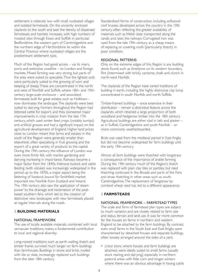
settlement is relatively low with small, nucleated villagesand isolated farmsteads. On the anciently enclosedclaylands to the south and east the density of dispersedfarmsteads and hamlets increases, with high numbers ofmoated sites through Essex and Suffolk in particular.Bedfordshire, the western part of Cambridgeshire andthe northern edge of Hertfordshire lie within theCentral Province where nucleated villages are thepredominant settlement type.
Much of the Region had good access – via its rivers,ports and extensive coastline – to London and foreignmarkets. Mixed farming was very strong, but parts of the area were suited to specialise.Thus the lightest soilswere particularly suited to the growing of corn andkeeping of sheep.These are concentrated in the northand west of Norfolk and Suffolk, where 18th- and 19th-century large-scale enclosure – and associatedfarmsteads built for great estates such as Holkham –now dominates the landscape.The claylands were bestsuited to dairying. Farmers throughout the Region hadfattened cattle for export, and they pioneered majorimprovements in crop rotation from the late 17thcentury, which used winter feed crops (notably turnips)and artificial grasses and had a significant impact on theagricultural development of England. Higher land pricesclose to London meant that farms and estates in thesouth of the Region were generally smaller thanelsewhere, often specialising in fruit growing and theexport of a great variety of products to the capital.During the 19th century the influence of London waseven more firmly felt, with market gardening and dairying increasing in importance. Railways became amajor factor from the 1840s. Intensive bullock and cattlefeeding (with oilcake) was increasingly widespread in theperiod up to the 1870s, a major aspect being thefattening of livestock bound for Smithfield marketimported into Norfolk from Scotland and Ireland.The 19th century also saw the application of steampower to the drainage and reclamation of the peat-based southern fens, which led to the creation ofdistinctive new landscapes with new farmsteads placedat regular intervals along the roads.
2 BUILDING MATERIALS
NATIONAL FRAMEWORKThe use of locally available materials, combined with localvernacular traditions, makes a fundamental contributionto local and regional diversity.
Long-rooted traditions such as earth walling, thatch andtimber frame, survived much longer on farm buildingsthan farmhouses. Buildings in stone and brick, roofedwith tile or slate, increasingly replaced such buildingsfrom the later 18th century.
Standardised forms of construction, including softwoodroof trusses, developed across the country in the 19thcentury, often reflecting the greater availability ofmaterials such as Welsh slate transported along thecanals and, later, the railways. Corrugated iron was used from the late 19th century as a cheap means of replacing or covering roofs (particularly thatch) inpoor condition.
REGIONAL PATTERNSOnly on the extreme edges of this Region is any buildingstone found, such as limestone on its western boundary,flint (intermixed with brick), carstone, chalk and clunch innorth-west Norfolk.
The claylands of the Region have varied traditions ofbuilding in earth, including the highly distinctive clay lumpconcentrated in south Norfolk and north Suffolk.
Timber-framed buildings – once extensive in theirdistribution – remain a distinctive feature across theclaylands, which retained a large proportion of bothwoodland and hedgerow timber into the 18th century.Agricultural buildings are either clad in lath and plaster –as in Suffolk, Cambridgeshire and south Norfolk – ormore commonly weatherboarded.
Brick was used from the medieval period in East Angliabut did not become widespread for farm buildings untilthe early 19th century.
Almost all farm buildings were thatched with longstraw,a consequence of the importance of arable farming.During the 19th century much of the Region’s thatchwas replaced with plain clay tiles or pantiles, but reedthatching continued in the Broads and parts of the Fensand straw thatching in other areas such as southCambridgeshire.The replacement of longstraw bycombed wheat reed has led to a different appearance.
3 FARMSTEADS
NATIONAL FRAMEWORK – FARMSTEAD TYPESThe scale and form of farmstead plan types are subjectto much variation and are closely related to farm sizeand status, terrain and land use. It was far more commonfor the houses on farms in northern and westernEngland to be attached to the farm buildings. By contrast,even small farms in the South East and East Anglia werecharacterised by detached houses and separate buildings,often loosely arranged around the sides of a yard.
• Linear plans, where houses and farm buildings areattached, were ideally suited to small farms (usuallystock rearing and dairying), especially in northernpastoral areas with little corn and longer winterswhere there was an obvious advantage in having cattle
7
and their fodder (primarily hay) in one enclosedbuilding.They now display a wide range in scale, fromlarge steadings of independent Pennine yeoman-farmers to the smallholdings of miner-farmers.
• Dispersed plans, comprising clusters and unplannedgroupings of separate buildings, were morewidespread.They now range from those of hamlets,where the buildings of different owners were oftenintermixed, to large-scale individual steadings, some ofwhich were of high status.
• Loose courtyard plans became most strongly associatedwith large and/or arable farms.The buildings are builtaround a yard with or without scatters of other farmbuildings close by.
• Regular courtyard plans, where the various functionswere carefully placed in relation to one another inorder to minimise the waste of labour, and where themanure could be conserved, were built – at first onlarge estates – from the later 18th century.
REGIONAL PATTERNS – FARMSTEAD TYPESIn common with the South East, the Region has somevery early surviving entire complexes of loose courtyardsteadings dating from the 17th century, oftendistinguished by groups of two or more barns, granariesand stabling. Many of these loose courtyards are found inthe claylands, where dispersed plans are common also.Regular courtyard farms are documented in the Regionfrom the mid-18th century, although no surviving groupscan be dated before the 1780s.They are concentrated in areas of post-1750 enclosure, and are stronglyassociated with the activities of estates. Some of thelargest examples of mid-19th century steam-poweredindustrial farms are found on the Duke of Bedfordestates. On smaller dairy farms such re-planning was lesslikely and a scattered group of buildings around a yardremained typical.
NATIONAL FRAMEWORK – BUILDING TYPESThe functions of crop processing and storage and theaccommodation of animals and birds determine thevariety of building types, which could house one or acombination of functions.The principal types are listedbelow.
Barns are generally the largest farm buildings to befound on farms.They were either designed solely forstoring and processing the corn crop, these being mostcommon in areas of arable production, or ascombination barns to incorporate many functions.Threshing machines, usually powered by horsesaccommodated in a projecting wheel house, wereintroduced from the later 18th century. Split-level mixing barns developed in many regions from the later18th century as a result of the widespread introductionof machinery for processing corn and fodder.Theintroduction of the portable steam engine and threshing
machine in the 1850s heralded the end of the traditionalbarn as a building for storage and processing.
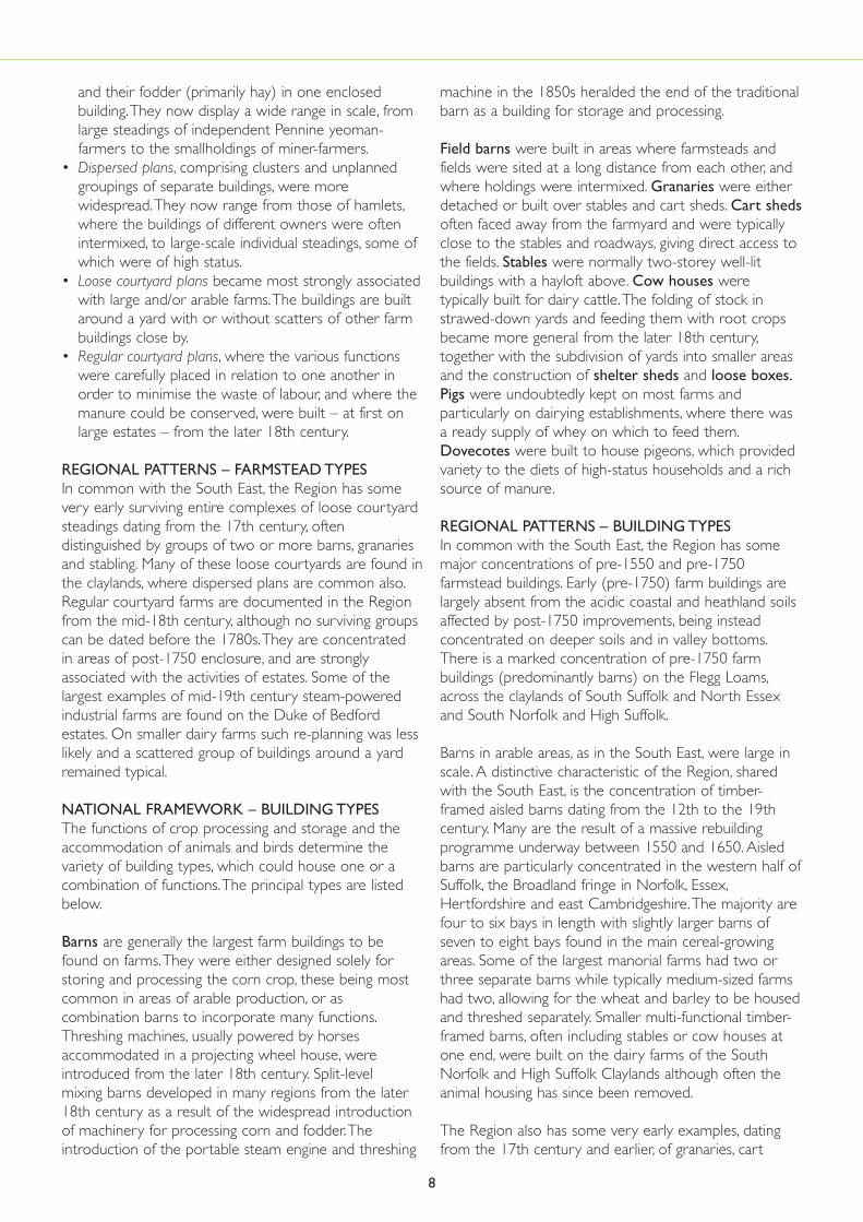
Field barns were built in areas where farmsteads andfields were sited at a long distance from each other, andwhere holdings were intermixed. Granaries were eitherdetached or built over stables and cart sheds. Cart shedsoften faced away from the farmyard and were typicallyclose to the stables and roadways, giving direct access tothe fields. Stables were normally two-storey well-litbuildings with a hayloft above. Cow houses weretypically built for dairy cattle.The folding of stock instrawed-down yards and feeding them with root cropsbecame more general from the later 18th century,together with the subdivision of yards into smaller areasand the construction of shelter sheds and loose boxes.Pigs were undoubtedly kept on most farms andparticularly on dairying establishments, where there wasa ready supply of whey on which to feed them.Dovecotes were built to house pigeons, which providedvariety to the diets of high-status households and a richsource of manure.
REGIONAL PATTERNS – BUILDING TYPESIn common with the South East, the Region has somemajor concentrations of pre-1550 and pre-1750farmstead buildings. Early (pre-1750) farm buildings arelargely absent from the acidic coastal and heathland soilsaffected by post-1750 improvements, being insteadconcentrated on deeper soils and in valley bottoms.There is a marked concentration of pre-1750 farmbuildings (predominantly barns) on the Flegg Loams,across the claylands of South Suffolk and North Essexand South Norfolk and High Suffolk.
Barns in arable areas, as in the South East, were large inscale. A distinctive characteristic of the Region, sharedwith the South East, is the concentration of timber-framed aisled barns dating from the 12th to the 19thcentury. Many are the result of a massive rebuildingprogramme underway between 1550 and 1650. Aisledbarns are particularly concentrated in the western half ofSuffolk, the Broadland fringe in Norfolk, Essex,Hertfordshire and east Cambridgeshire.The majority arefour to six bays in length with slightly larger barns ofseven to eight bays found in the main cereal-growingareas. Some of the largest manorial farms had two orthree separate barns while typically medium-sized farmshad two, allowing for the wheat and barley to be housedand threshed separately. Smaller multi-functional timber-framed barns, often including stables or cow houses atone end, were built on the dairy farms of the SouthNorfolk and High Suffolk Claylands although often theanimal housing has since been removed.
The Region also has some very early examples, datingfrom the 17th century and earlier, of granaries, cart
8

sheds and stables. Associated with the dairy industry ofthe High Suffolk clays are so-called neathouses formilking and feeding, identifiable by their lack of lofts,internal subdivision and window openings. Some ofthese, and subdivisions in multi-functional barns, are theearliest evidence for cattle housing in the country. Cattlehouses located on the edge of the grazing marshes ofthe Norfolk Broads are highly specialised in their form, inwhich cattle were housed down side aisles facing into acentral nave where root crops were stored. Increases inthe price of fatstock from 1840 encouraged moreintensive fattening systems such as loose boxes beingwidely introduced. Shelter sheds around straw yardswere also increasingly common from the mid-19th
century, particularly on estate farms such as those ofnorth Norfolk.
In this predominately arable Region it is not surprisingthat hay barns are rare. Malting barley (for export toLondon and abroad) was a significant crop in Norfolkand Hertfordshire and both were important maltingcounties. A few farms retain maltings but by the 19thcentury the industry was concentrated in towns wherelarge industrial maltings were built. A type of buildingassociated specifically with the traditional market-gardening economy of the gravel soils of Bedfordshire isthe onion shed.
9

Historic farmsteads and their buildings make afundamental contribution to the richly varied characterof our countryside, and illustrate the long history offarming and settlement in the English landscape. Englanddisplays a huge diversity in geology, with a greater varietyin small areas than anywhere else in Europe, whichcombined with varied farming practices has resulted in agreat diversity of materials and types of farmstead.
It is clear, however, that we know far more about thenature and processes of change affecting land cover andfield pattern than we do about agriculture’s builtenvironment and its contribution to countrysidecharacter and local distinctiveness. Furthermore, weknow far less about the working than the domesticbuildings of the farmstead. Recent research has madeinitial efforts to address this issue, and has made it clearhow the domestic and working buildings of thefarmstead are subject to very different processes ofchange (Gaskell & Owen, 2005).
English Heritage is now undertaking to develop thisknowledge base in order to inform diverse futureoutcomes, such as the targeting of grant aid and thedevelopment of character-based policies for thesustainable reuse of farm buildings.This document is oneof eight regional preliminary character statements that aimto promote better and more accessible understanding ofthe character of farm buildings. It is important, as a firststep in this process, to present an information base for abroad diversity of users with an interest in researching,
understanding and managing historic farmsteads. It hastherefore been written as a sourced synthesis ofinformation, drawing together information that willenable the farmsteads of each Region to be betterunderstood within the national context of farmstead and agricultural development, and their surrounding fields and settlements. As this is a preliminary statement,it and future work will benefit greatly from informationand comments.These will be gratefully received at thefollowing e-mail address:[email protected].
The objectives of this document are:
• To provide an information base and introduction tothe subject.
• To place the development of the farmsteads and farmbuildings of the East of England Region within theirnational context.
• To demonstrate, with examples, how the present stockof farmsteads and their buildings reflects the diversityof farming, settlement and landscape character in theEast of England Region.
• To provide broad guidance on the value and survivalby period and functional type.
An accompanying policy booklet has also been prepared,which makes the case for urgent action and considers
IntroductionIf the land is best suited for tillage, then the outhouses must be adapted to thepurposes of keeping cattle for plowing; of holding and thrashing corn; and ofpreserving straw, &c. for winter food. In the counties where oxen plow, ox-housesmust exceed the quantity of stabling: if where horses only are used, stables alonewill be sufficient. If the land seems to promise fairest for pasturage, then cowhouses, suckling-houses, sheepcots, dairies, and fattening houses must predominate;and if for grass, much barn-room seems unnecessary.The Complete English Farmer, 1771, quoted in Wiliam 1986, p.67
Farm buildings are the leitmotif of the countryside. It seems appropriate to describethem with a musical term for they are thematic, and the resonance of their forms,colours and textures within the scenery is that of sound, overall and orchestrated.Here and there is the solo instrument, spectacular in its own right, but much moreimportant is the orchestral effect.Darley, Gillian (1981) The National Trust Book of the Farm,The National Trust, London, p.7
10
1.0
the importance of historic farm buildings, their value andtheir future. See Living buildings in a living landscape:finding a future for traditional farm buildings, atwww.helm.org.uk/ruraldevelopment.
In each of the following sections, the national overview ispresented immediately before the regional statement.For example, on the topic of barns, the nationaloverview describes the development, variety and uses ofbarns nationally while the regional statement describesthe variety that can be seen in the barns of the Region.
Section 2 provides an introduction to characterisationand briefly describes the landscape character of theRegion, examining the pattern of rural settlement acrossthe Region.
Section 3 describes the predominant building materialsused for farm buildings nationally and in the Region.
Section 4 provides a brief introduction to the agriculturalhistory of England with particular reference to thedevelopment of farmsteads and farm buildings dividedinto the major periods, supported by statements relatingto the survival and significance of farm buildings fromeach period.This is followed by a summary of the
agricultural history of the Region.
Section 5 provides a national and regional background oftypes of farmsteads and farm buildings.
Sections 6, 7 and 8 provide a national and regionaloverview of key building types.
Section 9 provides a Glossary of terms both familiar andunfamiliar to the reader (e.g. dairy, linhay, enclosure).
Section 10 provides a list of national and regionalsources for further reference.
It is also important at this stage to outline a distinction interminology. ‘Traditional’ is a term often used to describefarm buildings pre-dating 1940, after which modernbuilding materials (concrete, steel, asbestos sheet) andrevolutions in farming technology and farmstead planningmarked a sharp divide with previous practice. ‘Historic’ ismore encompassing, as it includes farmsteads of all dates,irrespective of changes in form and material; it has beenused in this document in order that the reader can viewthe history of farm buildings, and their change andadaptation over the centuries, within their broadhistorical context.
11

2.1 LANDSCAPE CHARACTER ANDCHARACTERISATIONLandscape character is defined as a distinct andrecognisable pattern of elements that occur consistentlyin a particular type of landscape. Particular combinationsof geology (Figure 1A), landform, soils, vegetation, landuse, field patterns and human settlement create character.Character makes each part of the landscape distinct, andgives each its particular sense of place. Landscape-scaletechniques for understanding and guiding future change,now brigaded under the heading of characterisation, havedeveloped since the 1990s.These have developed asmulti-disciplinary and holistic tools for understanding thewhole rural environment, its capacity to absorb changeand its links to community values and needs.
During the 1990s the Countryside Commission workedwith English Nature and English Heritage to identify Joint Character Areas (159 in total) for the whole ofEngland, each of these resulting from a combination offactors such as land cover, geology, soils, topography,and settlement and enclosure patterns.These are nowbeing used as the framework for the delivery of adviceand the targeting of resources for many aspects of therural environment, most recently to farmers under theHigher Level Stewardship Agri-Environment schemes,and local authorities have taken forward thismethodology for Landscape Character Assessments on afiner scale.These are also being used as the spatialframework for reporting change in the countryside, inthe Countryside Quality Counts project (seewww.cqc.org.uk).
The East of England Region extends over the JointCharacter Areas listed in Figure 1B.Whenever the textcross-refers to the Joint Character Areas, they will belisted by their number (i.e. JCA 152).The keycharacteristics and a detailed description and map foreach Character Area are available from the CountrysideAgency’s website (www.countryside.gov.uk/lar/landscape).The web addresses for each JCA aredetailed in Section 11.
Human impact has been central to the development andpresent character of landscape. Historic LandscapeCharacterisation (HLC), which is being developed byEnglish Heritage with its county and local partners, isusing GIS mapping techniques to deepen ourunderstanding and perception of the long historicaldevelopment of our landscapes.The practical applicationsof HLC now include development plans, a broad rangeof conservation and enhancement strategies, strategicland-use planning and similar initiatives, and research and
academic implications (Clark, Darlington & Fairclough,2004; Rippon, 2005, 100–142).
Pilot work is now indicating that the density and time-depth of farmsteads, and the rates of survival of differenttypes of steading and building, are closely related topatterns of historically conditioned landscape characterand type (Lake & Edwards 2006).This work represents ashift in focus away from individual buildings to a morequestion-based and holistic approach, one that useslandscape to both reflect and inform the patterning ofthe built environment. Recording and understanding at alocal scale can both test and refine these broad-based,contextualised statements and contribute towards amore integrated understanding of both buildings andlandscapes.
For characterisation see:www.english-heritage.org.uk/characterisation
2.2 THE CHARACTER OF THE EAST OFENGLAND REGION:AN INTRODUCTIONThe East of England Region comprises the six counties ofNorfolk, Suffolk, Cambridgeshire, Bedfordshire,Hertfordshire and Essex. It contains a variety oflandscapes from flat fens, broads and coastal marshes, todunes and beaches and the rolling landscapes of village,woodland and hedgerow.
Geologically the underlying rocks are sandstone in theeast with chalk and limestone in the central areas, butmuch of the Region is covered by deep glacial soils,which can vary greatly within individual farm holdings.
Whilst the Region does not have the strongly contrastingupland–lowland landscapes of some of other Regions,there is considerable variety in the character of thelandscapes across the area (Figure 1B). In the north-westof the Region is the open, flat, large-scale arablelandscape of the Fens. Although the fenland and theNorfolk Broads in north-east Norfolk are probably thebest-known landscapes in the Region, across much ofNorfolk there are the higher, rolling landscapes of NorthWest Norfolk and Mid and Central North Norfolk,where areas of heathland are found along Cromer Ridgeand the greensand ridge bordering the fens. However,arable farming dominates the landscape of these areas,much of it associated with large estates.
At the heart of the Region is Breckland, a uniquelandscape of large-scale arable, open heathland and vastconifer plantations. South of Breckland is the East AnglianChalk, an open, rolling downland landscape forming a
2.0 Understanding Context and Character
12

continuation of the Chilterns. North-west of the chalk isthe Bedfordshire and Cambridgeshire Clayland, whichforms a predominantly open, gently undulating arablelandscape divided by the flood plains of the Great Ouse and Ivel.To the south-east of Breckland and the East Anglian Chalk are the South Suffolk and North Essex Claylands and the South Norfolk and High Suffolk Claylands, which have more hedgerow trees and stretches of woodland with a winding network of roads and lanes, contrasting with the longstraight roads found across much of the western andnorthern parts of the Region. Along the south-easternedge of Essex are the more heavily wooded, sandy EssexWooded Hills and Ridges, and the lower-lying EssexHeaths, both of which form part of the North ThamesBasin character area.
The coastal fringes of the Region, represented by the North Norfolk Coast, North East Norfolk and the Suffolk Coast and Heath are characterised byestuaries, salt marshes, grazing marshes, mudflats andsand dunes.
The Region’s greatest economic asset is its intensivelycropped high-quality agricultural land, 58% of which isGrade 1 and 2.The main area of Grade 1 land is in the fens where the soils are based on marine sands ordeep peat. Only 10% falls into the lower-quality Grades 4 and 5, mostly in the Brecklands.The agriculturalpotential of the Region is further enhanced by itsproximity to continental Europe resulting in warmsummers and mild winters giving a long growing season.The Region receives only two-thirds of the nationalaverage of rainfall with higher areas such as the Chilternsreceiving most rain (ERDP 2000).
2.3 THE CHARACTER OF RURALSETTLEMENT
2.3.1 NATIONAL FRAMEWORKFarmland has historically been divided into arable forgrowing corn and other crops, and meadow for hay andgrass. In the past, farmers also had access to fallow land,land laid open after the harvest and areas of roughercommon ground for grazing livestock. Patterns of
100 km0
60 miles0 a a aKEY
Mainly Clay
Chalk
Upper & Lower Greensand
Jurassic Limestone
Soft Sandstones
Sandstone & Millstone Grit
Magnesian Limestone
Carboniferous Limestone
Old Red Sandstone
Silurian & Ordovician
Igneous
Wealden Sandstone & Clays
13
1AEngland displays a huge diversityin geology, with a greater varietyin small areas than anywhere elsein Europe.This variety providedthe different building materialsused in vernacular buildings thatcontribute so much to localdistinctiveness.The East ofEngland Region has few areaswith good building stone –timber-framing was thepredominant building techniqueacross much of the Region’s claylands whilst flint from the chalkwas often combined with brickalong the chalk belt.The clayswere used for earth-walledbuildings and for bricks of a wide,and often distinctive, range ofcolours. Based upon ‘Solid Geology’Source Defra/BGS, NERC: bypermission of the British GeologicalSurvey IPR/52-65C. ©NERC/Crowncopyright. OS Licence no.100042054

settlement in the countryside varied from large,nucleated villages to dispersed settlement areas withscattered, isolated hamlets and farmsteads, both being closely related to the patterns of fields and theirassociated boundaries in the surrounding landscape.There were many variations between the two extremesof communal open fields with their scattered holdings,which typically developed around larger nucleatedsettlements, and the anciently enclosed fields of isolatedfarmsteads and hamlets.
Re-arranging previously communal fields or commonpasture land into self-contained private land unitsenabled the rationalisation of formerly scatteredholdings, allowing better management of livestock androtation of crops.This process of enclosure – evidentfrom the 14th century and even earlier – resulted in the immediate or gradual establishment of new isolated farmsteads out in the fields. It could beundertaken on a piecemeal basis, or in one single phase, the latter form of enclosure being typically
14
1B This map shows the Character Areas relating to this Region.These are known as Countryside Character Areas or mostcommonly now as Joint Character Areas, this reflecting theirdevelopment as multi-disciplinary means of mapping, definingand describing the character of distinct areas.Based upon Joint Character Areas. Source: Defra/EnglishNature/Countryside Agency. © Crown copyright OS Licence no.100042054
JCA JCA name number
45 Northern Lincolnshire Edge with Coversands75 Kesteven Uplands76 North West Norfolk78 Central North Norfolk79 North East Norfolk and Flegg80 The Broads81 Greater Thames Estuary82 Suffolk Coast and Heaths83 South Norfolk and High Suffolk Claylands84 Mid Norfolk85 Breckland86 South Suffolk and North Essex Clayland87 East Anglian Chalk88 Bedfordshire and Cambridgeshire Claylands89 Northamptonshire Vales90 Bedfordshire Greensand Ridge91 Yardley-Whittlewood Ridge92 Rockingham Forest110 Chilterns111 Northern Thames Basin
15
2
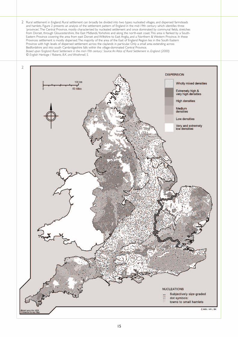
2 Rural settlement in England. Rural settlement can broadly be divided into two types: nucleated villages, and dispersed farmsteadsand hamlets. Figure 2 presents an analysis of the settlement pattern of England in the mid-19th century which identifies three‘provinces’.The Central Province, mostly characterised by nucleated settlement and once dominated by communal fields, stretchesfrom Dorset, through Gloucestershire, the East Midlands,Yorkshire and along the north-east coast.This area is flanked by a South-Eastern Province covering the area from east Dorset and Wiltshire to East Anglia, and a Northern & Western Province. In theseProvinces settlement is mostly dispersed.The majority of the area of the East of England Region lies in the South EasternProvince with high levels of dispersed settlement across the claylands in particular. Only a small area extending acrossBedfordshire and into south Cambridgeshire falls within the village-dominated Central Province.Based upon ‘England: Rural Settlement in the mid-19th century’. Source: An Atlas of Rural Settlement in. England (2000) © English Heritage / Roberts, B.K. and Wrathmell, S.

more regular in its appearance. Enclosure byparliamentary act, some of which formalised earlieragreements, often resulted in new designed landscapes.Parliamentary enclosure was concentrated in the period1750 to 1880.
English Heritage has commissioned work on mappingthese patterns of settlement in the English countryside,now published as An Atlas of Rural Settlement in England(Roberts & Wrathmell 2000) and Region and Place, AStudy of English Rural Settlement (Roberts & Wrathmell2002). In summary, it has been demonstrated that aCentral Province mostly characterised by nucleatedsettlement and, by the 14th century, communal fieldswhich occupied the great majority of the land area, isflanked by a South-Eastern Province and both aNorthern and Western Province where settlement ismostly dispersed (Figure 2).
In areas of nucleated settlement in the medieval periodand later, the majority of farmsteads were sited in villagesand the surrounding land dominated by communallymanaged open fields, where the holdings of individualfarmers were inter-mixed and farmed in rotation asmeadow or arable land. Many open field systems werecreated during the period from the 9th to the 12thcenturies, replacing earlier dispersed patterns ofsettlement with nucleated villages with communallymanaged fields, many of which were clearly planned byestates.
Farmsteads in areas of dispersed settlement arecommonly isolated or clustered in hamlets.They arecommonly medieval in origin (pre-14th centurygenerally) and often surrounded by ancient and irregularpatterns of field boundaries, including the reclamation ofwoodland or waste.Typically smaller and more numerousthan the open fields of Midlands villages, these fieldswere either farmed from the outset as compact farmingunits or contained the scattered holdings or strips ofindividual farmers that were farmed on a communalbasis. Areas of pasture and rough grazing were typicallyfar greater in extent than in areas of nucleatedsettlement, and have again been subject to varying ratesof enclosure from the 14th century.
Between the extremes of nucleation and dispersion are
the areas that to some degree included both villagesand scattered farmsteads and hamlets. In these areas,nucleated villages again originated from developmentsbetween the 9th and 12th centuries, but were oftenintermixed with isolated farmsteads that date from both the medieval period or earlier and from the later enclosure of open fields and common meadowand pasture.
In some areas, the remains of earlier, including pre-Roman, farmsteads are visible as crop-marks orearthworks close to existing farmsteads or villages (seeRoberts 1976 and Taylor 1983 for a usefulintroduction). While research is demonstrating thatexisting parish and field boundaries possibly originatefrom very early, even pre-Roman, field and estateboundaries, it is exceptionally rare for present farmsteadsites – as in Cornwall’s West Penwith – to display suchcontinuity.
2.3.2 RURAL SETTLEMENT IN THE EAST OFENGLAND REGIONBedfordshire, the western part of Cambridgeshire andthe northern edge of Hertfordshire lie within theCentral Province where nucleated villages are thepredominant settlement type.With the exception of thiswestern fringe, most of the Region falls within Robertsand Wrathmell’s South-Eastern Province wheresettlement is a mixture of villages, hamlets and dispersedfarmsteads; many of the latter clustered aroundcommons and greens. Across the fenland, much of whichwas unsuited to settlement until extensive drainageoperations reclaimed large tracts of land, the density ofsettlement is relatively low with small, nucleated villagesand isolated farmsteads. On the claylands to the southand east the density of dispersed farmsteads andhamlets increases, with high numbers of moated sitesthrough Essex and Suffolk in particular. However, thedistribution of moated sites continues west intoBedfordshire where high numbers of moats are alsofound, making this one of the few areas of the CentralProvince where higher levels of dispersed settlementdensity are recorded (Roberts & Wrathmell 2000). Asthe regional summary below makes clear (see 4.2), therewas from the medieval period a strong degree of localvariation in the distribution of enclosed and communallyregulated fields.
16

3.1 NATIONAL OVERVIEWFarm buildings were frequently altered and re-roofed,and survivals can display evidence for successive phasesof rebuilding, marked by straight joints in masonry orindications of mortise holes and joints in timberwork.
The present stock of farm buildings displays strong localand regional variation.This is the result of a range offactors, particularly England’s huge diversity in geology,the status of the owner, availability of resources managedin the local landscape and the cost of manufacturedmaterials (Rackham 1972; Moir 1997). Long-rootedtraditions such as earth walling and thatch in Cornwalland timber frame in Norfolk, survived much longer onfarm buildings than farmhouses, and were not overtakenby increasingly fashionable and robust forms ofconstruction (such as stone in parts of Cornwall, brick inNorfolk) until the early to mid-19th century (Potts 1974;Lucas 1997).The coastal shipping trade had for manycenturies allowed the transport of building materials, butthe arrival firstly of canals and then railways allowed the
easier transportation of building materials into inlandareas. Buildings in stone and brick, and roofed with tile orslate, increasingly replaced buildings in clay, timber andthatch from the later 18th century. Mass-walled buildingscomprise the majority of listed agricultural buildings(67%), with timber framing accounting for just over onequarter of entries.
There are strong regional and local differences in roofconstruction and carpentry, as is still demonstrated by thedistribution of aisled and cruck buildings (Figures 4 and 5).From the medieval period, the unit of reference intimber-framed and mass-walled buildings became the bay,the distance between principal roof trusses.These bayscould also mark out different areas of storage withinbarns and other buildings (see 3.1.1.3). Iron bolts, strapsand tension bars became increasingly common, often incombination with imported softwood, in the 19thcentury.Textbooks such as Waistell’s Designs for AgriculturalBuildings (1827) and Stephens’s Book of the Farm (1844)helped to promote more standardised forms of
3.0 Building Materials
17
3A 3B
3 The distribution of listed aisled (left) and cruck (right) barns in England Aisled construction, used for domestic buildings from the 12th century at the highest level in society, was suited to the storage and constructionalrequirements of large barns.The weighting of the distribution is southern English, outliers being generally of a high status and dating from before 1550; anotable concentration in northern England is in the Halifax–-Huddersfield area, where the wealth derived from a combination of farming and the clothindustry in the 15th and 16th centuries led to the construction of a notable group of aisled houses and barns. Aisled construction continued to beemployed in southern England into the 19th century.Crucks in domestic buildings have a date range from the mid-13th to the mid-17th centuries, examples in the north of England being generally later indate, whereas in agricultural buildings the earliest survivals are 15th century and the latest (in the southern Pennines) early 18th century.There is a widevariety of forms in cruck construction.© Crown copyright. All rights reserved. English Heritage 100019088. 2005

construction. Metal roofs were used from the 1850s forcovered yards and other buildings on expensive plannedfarmsteads, but did not come into general use – mainlyfor covered yards – until the end of the 19th century.Pre-fabricated buildings in iron were manufactured andexported from the 1840s, the most well known on thefarmstead being the Dutch barn (see 6.4.1), popular fromthe 1880s. Factory-made prefabricated buildings, built tostandard widths applicable to a wide variety of uses, havesince the 1950s been the standard building type used onfarms.The principal materials are summarised below.
3.1.1 WALLING
3.1.1.1 Temporary structuresAs could be expected, the most fragile structures aredocumented from excavation or archives (for examplethe Wiltshire vicarage stable ‘enclosed with hurdle work’in Hobbs [ed] 2000, xvi and p.438) but have notsurvived. A long-standing building tradition, where postswere set directly in the ground with no definable baystructure, is documented from excavation and hassurvived in use for single-storey structures (including18th-century cart sheds and 20th-century tractor sheds)to the present day (Lake 1989, p.43).
3.1.1.2 Mass walling Mass-walled buildings now dominate the traditional farmbuilding stock, almost exclusively so in the threenorthern regions. Stone and brick display a wide varietyof treatment, their use reflecting not only the availabilityof materials but also the status of the farm and itsowner. Large parts of England – particularly in the South East, South West, East of England, the EastMidlands and the North West – display differenttraditions of walling in earth, dating from the 14thcentury (Figure 5). Concrete was used from the 1860s
on some farms, for example for silage clamps, but didnot achieve general use until after the 1950s.
3.1.1.3 Timber frameTimber-framed buildings are concentrated in the East ofEngland, the South East and the West Midlands.The basicvocabulary of construction had been developed by the13th century – notably the use of sophisticated jointingtechniques, particularly at the junction of the main postsand roof trusses (the so-called bay divisions), and timbersills raised off the ground on dwarf walls. Climate andpatterns of land use and ownership have affected the
18
4AAisled barn, Cressing Temple, Essex. One of theearliest surviving barns in England on an estateof the Knights Hospitaller erected with timberfelled between 1259 and 1280. (South Suffolkand North Essex Claylands) © English Heritage / Michael Williams;
4B Barn at Cross Farm, Burgh-by-Sands, Cumbria,showing the full crucks to the interior of a late17th-century clay-walled barn.This is one of agroup of such barns on the Solway Plain, datingfrom between the 14th and 17th centuries.(Solway Basin) © Jen Deadman
5 Listed earth-built agricultural buildings inEngland. Survival is much more extensive thanthis map indictes. In the East of England claylump buildings form the majority of thebuildings shown in the two main clusters. Earthwalling is also found in the clayland areas ofsouth Norfolk and Suffolk and on the chalkbelt running into south Cambridgeshire. ©Crown copyright. All rights reserved. EnglishHeritage 100019088. 2005
4B
5
4A
availability of timber and, together with cultural factors,have influenced the distribution, appearance of distincttraditions in timber framing and the framing of rooftrusses for mass-walled buildings (Smith 1965; Stenning &Andrews 1988; and Figures 3 and 6).The infill betweenthe timber frames would either be wattle and daub (aclay and straw mix), brick (often a later addition) orsimply left as a wattle framework.Timber planks, eitherrebated or slotted like wattle, were also used but nowonly survive in very rare instances. External walling andrender can also disguise evidence of earlier timberframing, including cruck and aisled construction.
3.1.1.4 Timber claddingIn parts of the country – particularly in the South East,East of England and the western part of the WestMidlands – timber frames were often clad in horizontallyfixed weatherboarding. Hand-sawn hardwood boarding isnow rarely found, as machine-sawn softwood wasincreasingly used from the late 18th century.Weatherboarding is either applied to a whole building(most commonly in regions in the South East and thesouthern part of the East of England) or to the upperportions of sidewalls (a common use in the WestMidlands).Vertical boarding is mainly found in the SouthEast.This had cover strips to prevent the ingress of rain;surviving examples date from the late 19th century. Hit-and-miss timber boarding, sometimes known as Yorkshireboarding, has been widely in use as cladding since the1970s, since it provides good ventilation and meetsmodern animal welfare requirements.
3.1.1.5 Corrugated ironSee 3.1.2.3.
3.1.2 ROOFING
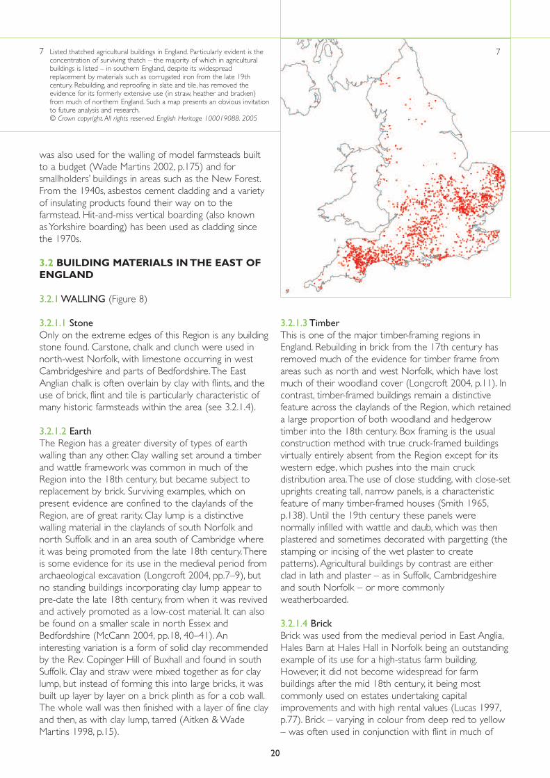
3.1.2.1 ThatchThatch was common in large parts of the country, andfarmers used a wide range of locally available materials:heather, bracken, reeds, rushes, grass, turf, and straw fromoats, barley, wheat and rye.Thatch, predominantly madeof wheat straw or water reed, is now mainly confined tosouthern England and East Anglia (Figure 7). Heather andbracken was, until the 19th century, used in upland areasof moorland and heath, such as Dartmoor, the Pennines,
the North York Moors and the Cheviots. Solid thatch,where the whole of the roof space was filled withmaterials such as heather or gorse with a straw or reedtopcoat, was formerly widespread but is now very rare(Moir & Letts 1999, pp.103–4).
3.1.2.2 Plain clay tiles and stone slatesThese materials were used at a high social level from themedieval period and are found in many parts of thecountry.Their use became increasingly widespread afterthe later 18th century, along with stone and brick walling,supplanting smaller farm buildings built of timber, earthand thatch in many parts of the country.The coastaltrade and improved communications also enabled thewidespread introduction of pantiles – instantlyrecognisable with their distinctive curved profile – intoparts of the South West and across large areas of theeastern counties from north Essex to Northumberland,and of Welsh slate into many inland areas.
3.1.2.3 Corrugated iron and other prefabricatedmodern materialsCorrugated iron was used in England from the 1820s,initially for industrial buildings. Although severalpioneering firms were producing portable corrugated-iron-clad buildings by the 1850s, it did not come intogeneral use for new farm buildings (particularly on so-called Dutch Barns for protecting harvested hay andcorn crops, see 6.4.1) until the farming depression of the1880s made cheaper materials desirable. By the FirstWorld War, corrugated iron was in general use for therepair of roofs on farm buildings, particularly thatch. It
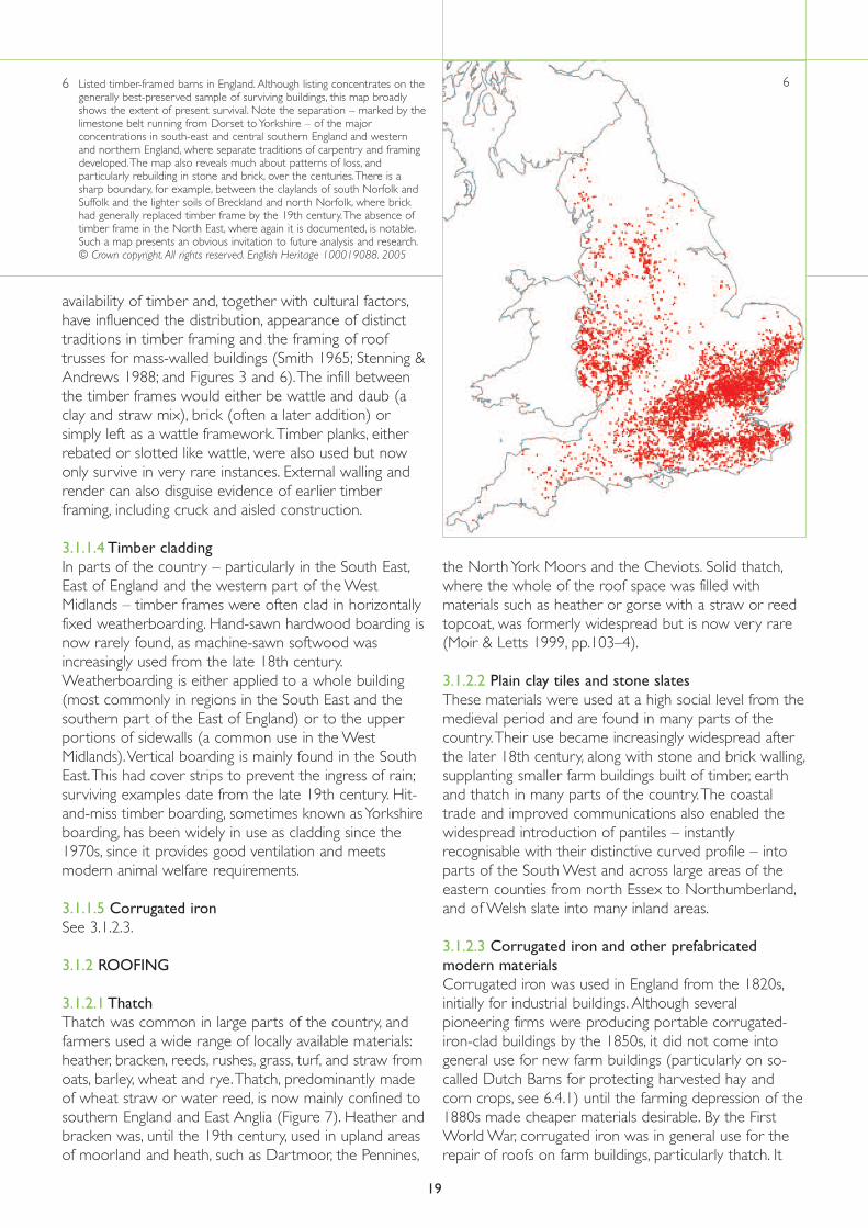
6 Listed timber-framed barns in England. Although listing concentrates on thegenerally best-preserved sample of surviving buildings, this map broadlyshows the extent of present survival. Note the separation – marked by thelimestone belt running from Dorset to Yorkshire – of the majorconcentrations in south-east and central southern England and westernand northern England, where separate traditions of carpentry and framingdeveloped.The map also reveals much about patterns of loss, andparticularly rebuilding in stone and brick, over the centuries.There is asharp boundary, for example, between the claylands of south Norfolk andSuffolk and the lighter soils of Breckland and north Norfolk, where brickhad generally replaced timber frame by the 19th century.The absence oftimber frame in the North East, where again it is documented, is notable.Such a map presents an obvious invitation to future analysis and research.© Crown copyright. All rights reserved. English Heritage 100019088. 2005
19
6
was also used for the walling of model farmsteads builtto a budget (Wade Martins 2002, p.175) and forsmallholders’ buildings in areas such as the New Forest.From the 1940s, asbestos cement cladding and a varietyof insulating products found their way on to thefarmstead. Hit-and-miss vertical boarding (also known as Yorkshire boarding) has been used as cladding sincethe 1970s.
3.2 BUILDING MATERIALS IN THE EAST OFENGLAND
3.2.1 WALLING (Figure 8)
3.2.1.1 Stone Only on the extreme edges of this Region is any buildingstone found. Carstone, chalk and clunch were used innorth-west Norfolk, with limestone occurring in westCambridgeshire and parts of Bedfordshire.The EastAnglian chalk is often overlain by clay with flints, and theuse of brick, flint and tile is particularly characteristic ofmany historic farmsteads within the area (see 3.2.1.4).
3.2.1.2 EarthThe Region has a greater diversity of types of earthwalling than any other. Clay walling set around a timberand wattle framework was common in much of theRegion into the 18th century, but became subject toreplacement by brick. Surviving examples, which onpresent evidence are confined to the claylands of theRegion, are of great rarity. Clay lump is a distinctivewalling material in the claylands of south Norfolk andnorth Suffolk and in an area south of Cambridge whereit was being promoted from the late 18th century.Thereis some evidence for its use in the medieval period fromarchaeological excavation (Longcroft 2004, pp.7–9), butno standing buildings incorporating clay lump appear topre-date the late 18th century, from when it was revivedand actively promoted as a low-cost material. It can alsobe found on a smaller scale in north Essex andBedfordshire (McCann 2004, pp.18, 40–41). Aninteresting variation is a form of solid clay recommendedby the Rev. Copinger Hill of Buxhall and found in southSuffolk. Clay and straw were mixed together as for claylump, but instead of forming this into large bricks, it wasbuilt up layer by layer on a brick plinth as for a cob wall.The whole wall was then finished with a layer of fine clayand then, as with clay lump, tarred (Aitken & WadeMartins 1998, p.15).
3.2.1.3 TimberThis is one of the major timber-framing regions inEngland. Rebuilding in brick from the 17th century hasremoved much of the evidence for timber frame fromareas such as north and west Norfolk, which have lostmuch of their woodland cover (Longcroft 2004, p.11). Incontrast, timber-framed buildings remain a distinctivefeature across the claylands of the Region, which retaineda large proportion of both woodland and hedgerowtimber into the 18th century. Box framing is the usualconstruction method with true cruck-framed buildingsvirtually entirely absent from the Region except for itswestern edge, which pushes into the main cruckdistribution area.The use of close studding, with close-setuprights creating tall, narrow panels, is a characteristicfeature of many timber-framed houses (Smith 1965,p.138). Until the 19th century these panels werenormally infilled with wattle and daub, which was thenplastered and sometimes decorated with pargetting (thestamping or incising of the wet plaster to createpatterns). Agricultural buildings by contrast are eitherclad in lath and plaster – as in Suffolk, Cambridgeshireand south Norfolk – or more commonlyweatherboarded.
3.2.1.4 BrickBrick was used from the medieval period in East Anglia,Hales Barn at Hales Hall in Norfolk being an outstandingexample of its use for a high-status farm building.However, it did not become widespread for farmbuildings after the mid 18th century, it being mostcommonly used on estates undertaking capitalimprovements and with high rental values (Lucas 1997,p.77). Brick – varying in colour from deep red to yellow– was often used in conjunction with flint in much of
20
7 Listed thatched agricultural buildings in England. Particularly evident is theconcentration of surviving thatch – the majority of which in agriculturalbuildings is listed – in southern England, despite its widespreadreplacement by materials such as corrugated iron from the late 19thcentury. Rebuilding, and reproofing in slate and tile, has removed theevidence for its formerly extensive use (in straw, heather and bracken)from much of northern England. Such a map presents an obvious invitationto future analysis and research.© Crown copyright. All rights reserved. English Heritage 100019088. 2005
7

21
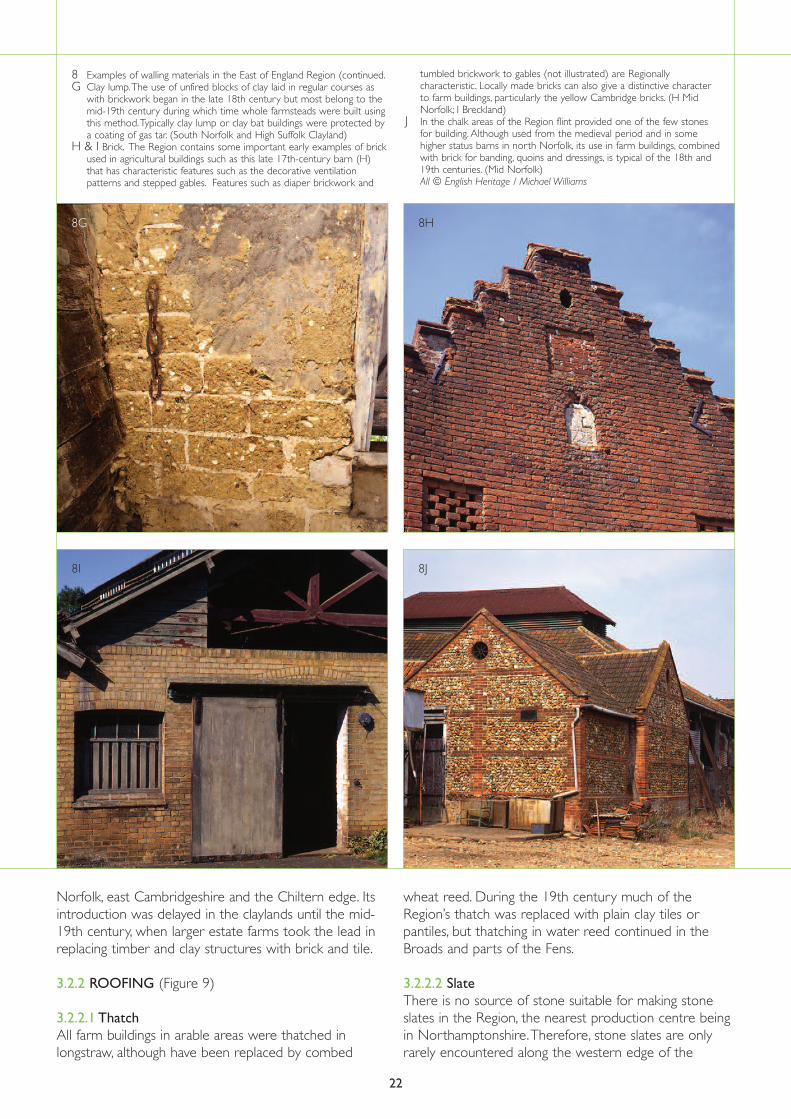
8 Examples of walling materials in the East of England RegionA Exposed timber frame with brick infill. (South Suffolk and North Essex
Claylands)B Weatherboarding over timber frame.The typical wall covering for
timber-framed agricultural buildings across the Region is horizontalweatherboarding. (East Anglian Chalk)
C Timber-framing panels could also be infilled with wattle and daub.Thisexample has been tarred – a characteristic treatment seen on manyfarm buildings in the Region. (South Suffolk and North Essex Claylands)
D Clay applied to laths. (South Norfolk and High Suffolk Claylands)
E Pargetting.Where plastered panels, or in some cases the whole of theelevation of a building was plastered, the wet plaster could bedecorated. Such treatment is normally found on farmhouses but may beseen on some farm buildings such as stables. (South Suffolk and NorthEssex Claylands)
F Rammed earth. Solid earth walling is seen in parts of the Region,especially in the chalk areas. (South Suffolk and North Essex Clayland)All photographs © English Heritage/Michael Williams except B © BobEdwards; F © Susanna Wade Martins (continued overleaf)
8E 8F
8C 8D
8A 8B
Norfolk, east Cambridgeshire and the Chiltern edge. Itsintroduction was delayed in the claylands until the mid-19th century, when larger estate farms took the lead inreplacing timber and clay structures with brick and tile.
3.2.2 ROOFING (Figure 9)
3.2.2.1 ThatchAll farm buildings in arable areas were thatched inlongstraw, although have been replaced by combed
wheat reed. During the 19th century much of theRegion’s thatch was replaced with plain clay tiles orpantiles, but thatching in water reed continued in theBroads and parts of the Fens.
3.2.2.2 SlateThere is no source of stone suitable for making stoneslates in the Region, the nearest production centre beingin Northamptonshire.Therefore, stone slates are onlyrarely encountered along the western edge of the
22
8 Examples of walling materials in the East of England Region (continued.G Clay lump.The use of unfired blocks of clay laid in regular courses as
with brickwork began in the late 18th century but most belong to themid-19th century during which time whole farmsteads were built usingthis method.Typically clay lump or clay bat buildings were protected bya coating of gas tar. (South Norfolk and High Suffolk Clayland)
H & I Brick. The Region contains some important early examples of brickused in agricultural buildings such as this late 17th-century barn (H)that has characteristic features such as the decorative ventilationpatterns and stepped gables. Features such as diaper brickwork and
tumbled brickwork to gables (not illustrated) are Regionallycharacteristic. Locally made bricks can also give a distinctive characterto farm buildings, particularly the yellow Cambridge bricks. (H MidNorfolk; I Breckland)
J In the chalk areas of the Region flint provided one of the few stonesfor building. Although used from the medieval period and in somehigher status barns in north Norfolk, its use in farm buildings, combinedwith brick for banding, quoins and dressings, is typical of the 18th and19th centuries. (Mid Norfolk)All © English Heritage / Michael Williams
8I 8J
8G 8H

23
9 Examples of roofing materials in the East of England RegionA Thatch.Water reed from the managed reed beds of the Norfolk Broads
was used in the north-east part of the Region. In many other parts ofthe region straw from arable farming was available and widely used forfarm buildings. (The Broads)
B Clay tiles. Clay for brick and tile making was available in many parts ofthe Region and was exploited from the medieval period. (South Suffolkand North Essex Claylands)
C Pantiles. Profiled roofing tiles are a characteristic feature of the roofs ofthe East of England. (East Anglian Chalk)
D Welsh slate. Across most of the Region the use of Welsh slate increasedas the railways made transportation easier and cheaper. Slate allowed alower roof pitch to be used, characterising many farm buildings of theperiod from earlier thatched or tiled buildings. (Breckland) A 227169 Taken as part of the Images of England project © Mr E.MTrendell; B & D © English Heritage / Michael Williams; C © Bob Edwards
9A 9B
9C
9D
Region.Welsh slate was imported through the Region’s coastal ports and from the late 18th century by canal.
3.2.2.3 TilesThe north of the Region is strongly associated withpantiles, which in an area stretching up the Scottish
border were increasingly used at a vernacular level fromthe early 18th century and in some cases earlier. It hadalso spread across the northern half of Suffolk andBedfordshire by the 18th century. Plain tile is moretypically found in the southern half of the Region,spreading into mid Norfolk (Brunskill 1987, p.170; Moir &Letts 1999, pp.18–19).