Embed Size (px)
Citation preview
Historic Roseland Neighborhood Plan Existing Conditions
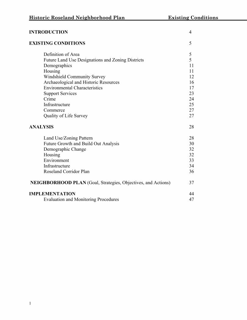
INTRODUCTION 4 EXISTING CONDITIONS 5 Definition of Area 5 Future Land Use Designations and Zoning Districts 5 Demographics 11 Housing 11 Windshield Community Survey 12 Archaeological and Historic Resources 16 Environmental Characteristics 17
Support Services 23 Crime 24 Infrastructure 25 Commerce 27 Quality of Life Survey 27 ANALYSIS 28 Land Use/Zoning Pattern 28 Future Growth and Build Out Analysis 30 Demographic Change 32 Housing 32 Environment 33 Infrastructure 34 Roseland Corridor Plan 36 NEIGHBORHOOD PLAN (Goal, Strategies, Objectives, and Actions) 37 IMPLEMENTATION 44 Evaluation and Monitoring Procedures 47
1
Historic Roseland Neighborhood Plan Existing Conditions
List of Tables
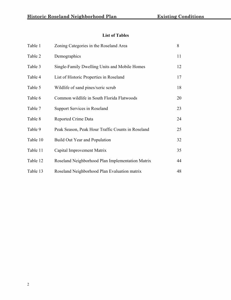
Table 1 Zoning Categories in the Roseland Area 8 Table 2 Demographics 11 Table 3 Single-Family Dwelling Units and Mobile Homes 12 Table 4 List of Historic Properties in Roseland 17 Table 5 Wildlife of sand pines/xeric scrub 18 Table 6 Common wildlife in South Florida Flatwoods 20 Table 7 Support Services in Roseland 23 Table 8 Reported Crime Data 24 Table 9 Peak Season, Peak Hour Traffic Counts in Roseland 25 Table 10 Build Out Year and Population 32 Table 11 Capital Improvement Matrix 35 Table 12 Roseland Neighborhood Plan Implementation Matrix 44 Table 13 Roseland Neighborhood Plan Evaluation matrix 48
2
Historic Roseland Neighborhood Plan Existing Conditions
List of Figures
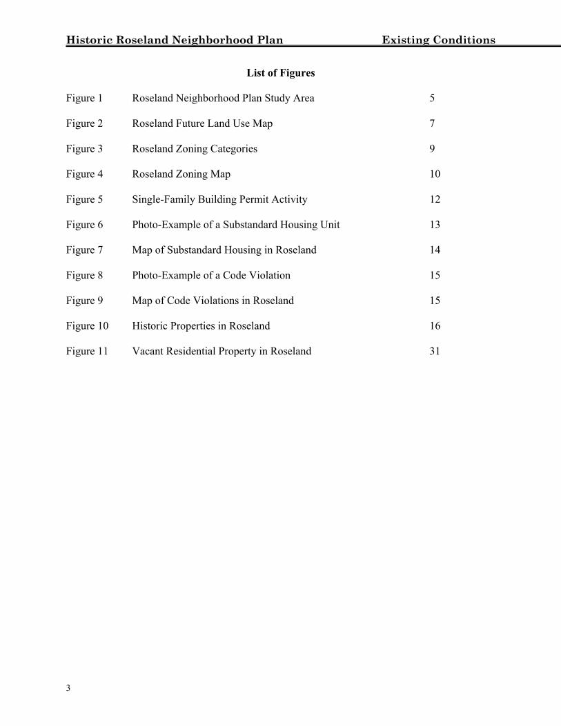
Figure 1 Roseland Neighborhood Plan Study Area 5 Figure 2 Roseland Future Land Use Map 7 Figure 3 Roseland Zoning Categories 9 Figure 4 Roseland Zoning Map 10 Figure 5 Single-Family Building Permit Activity 12 Figure 6 Photo-Example of a Substandard Housing Unit 13 Figure 7 Map of Substandard Housing in Roseland 14 Figure 8 Photo-Example of a Code Violation 15 Figure 9 Map of Code Violations in Roseland 15 Figure 10 Historic Properties in Roseland 16 Figure 11 Vacant Residential Property in Roseland 31
3
Historic Roseland Neighborhood Plan Existing Conditions
INTRODUCTION The Roseland Neighborhood Plan is the culmination of a joint effort between the Roseland Neighborhood Task Force and Indian River County staff. Through considerable interaction with the residents of Roseland, the County has prepared this neighborhood plan. In February 2001, the Roseland Property Owners Association wrote to the Board of County Commissioners, requesting that the board appoint a task force to review the Land Development Regulations and Comprehensive Plan as they relate to Roseland. In March 2001, the Board of County Commissioners approved the creation of a Roseland Neighborhood Plan Task Force. Subsequently, the Board appointed the members of the task force. Included in the Roseland Neighborhood Plan are an existing conditions section, an analysis section, a plan section, and a recommended implementation section. The existing conditions section of the plan presents the most up to date data on land uses, zoning, infrastructure, and commerce for the Roseland neighborhood. Based on the existing conditions of the neighborhood, the analysis section identifies issues, problems, opportunities and constraints that exist in Roseland. From the analysis of the data, a plan section identifies the plan goal, objectives, and policies. Finally, a recommended implementation section presents the framework for how physical improvements can be made and how the character of Roseland as a community can be maintained. While the plan focuses on one neighborhood within the county, the strategies and actions of this plan are consistent with the policies and objectives of the county’s Comprehensive Plan.
4
Historic Roseland Neighborhood Plan Existing Conditions
EXISTING CONDITIONS Definition of Area Located in the unincorporated portion of Indian River County, the Roseland Neighborhood area encompasses approximately 1,574 acres or about 2.46 square miles. Specifically, the geographical boundaries of the plan area comprise that portion of unincorporated Indian River County north and west of the City of Sebastian. To the northeast lies the Indian River, to the west and northwest, the Sebastian River.
F
5
TCpasa
uture Land Use Designations and Zoning Districts
he future land use map and the zoning map are two of the primary tools by which Indian River ounty regulates development within the unincorporated area. As part of the comprehensive lan, the future land use map depicts the broad land use designations, or categories, that are pplied to properties in the unincorporated area of the county. Future land use designations pecify and control zoning districts and zoning densities and intensities that may be permitted on specific piece of property.
Historic Roseland Neighborhood Plan Existing Conditions Future Land Use Designations
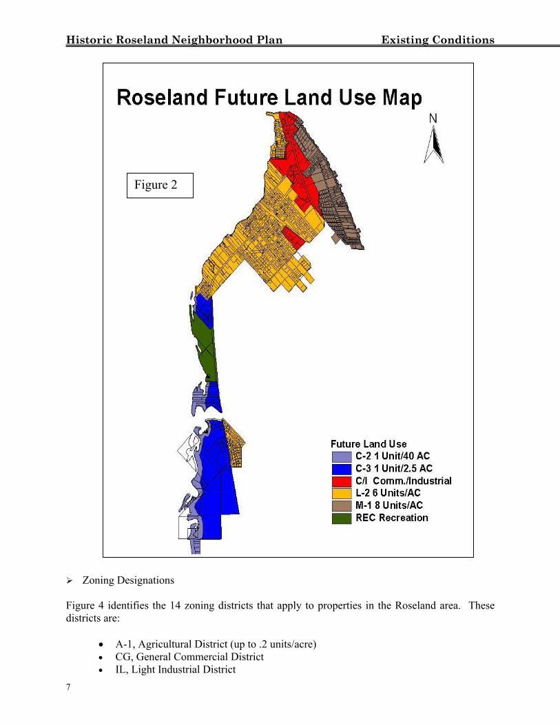
Figure 2 identifies the future land use designations applicable to the Roseland area. Those designations are:
• C/I, Commercial/Industrial • C-2, Privately Owned or Controlled Conservation (up to 1 unit/40 acres) • C-3, Privately Owned or Controlled Conservation (up to 1 unit/2.5 acres) • L-2, Low Density Residential-2 (up to 6 units/acre) • M-1, Medium Density Residential-1 (up to 8 units/acre) • REC, Recreation
Approximately 73% of the land in the study area is designated for residential development. Most residentially designated land (74%) is designated as L-2 (Low Density Residential of up to 6 dwelling units per acre). The rest of the residentially designated land in Roseland is designated as M-1, which allows up to 8 units/acre. There are two commercial/industrial nodes in the Roseland area. Comprising 139 acres, one of these nodes, the US1 node, consists primarily of retail, professional, and medical uses that service the residents of Roseland and the surrounding area. The other node, the Gibson Street node, comprises 20.6 acres of land zoned light industrial. As adopted, the County’s Future Land Use map designates the area east of St. Sebastian river as C-2, Conservation-2 (Privately owned estuarine wetland and undeveloped lagoon island conservation areas, up to 1 unit per 40 acres), and C-3, Conservation-3 (privately owned xeric scrub conservation areas, up to 1 unit per 2.5 acres). C-2 and C-3 designated areas are generally depicted on the future land use map; specific boundaries are established on a parcel by parcel basis by environmental survey at the time of development review. With one exception, any area which is depicted as a C-2 (wetlands) area or C-3 (upland xeric scrub) area on the Future Land Use Map, but which is determined by environmental survey not to be wetlands (as defined in the Conservation Element) or xeric uplands, will have the same land use designation as the contiguous adjacent property. The exception applies to land located east of the St. Sebastian River and depicted as C-3 on the future land use map. If determined by environmental survey not to be xeric uplands, then that land shall be designated R, Rural Residential (up to 1 unit/acre). Residential development in C-2 designated areas and in C-3 designated areas shall be limited to approved Planned Developments (PDs). The county shall require cluster development and density transfers to limit the impact of development on conservation lands. There are approximately 84 acres of land designated for recreational purposes by the Future Land Use Map. Land designated for recreation is applied to land used for active and passive public parks and recreation facilities.
6
Historic Roseland Neighborhood Plan Existing Conditions Zonin
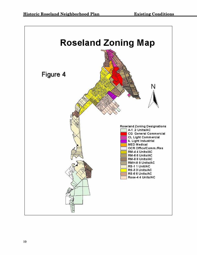
Figure 4districts
•• •
7
g Designations
Figure 2
identifies the 14 zoning districts that apply to properties in the Roseland area. These are:
A-1, Agricultural District (up to .2 units/acre) CG, General Commercial District IL, Light Industrial District
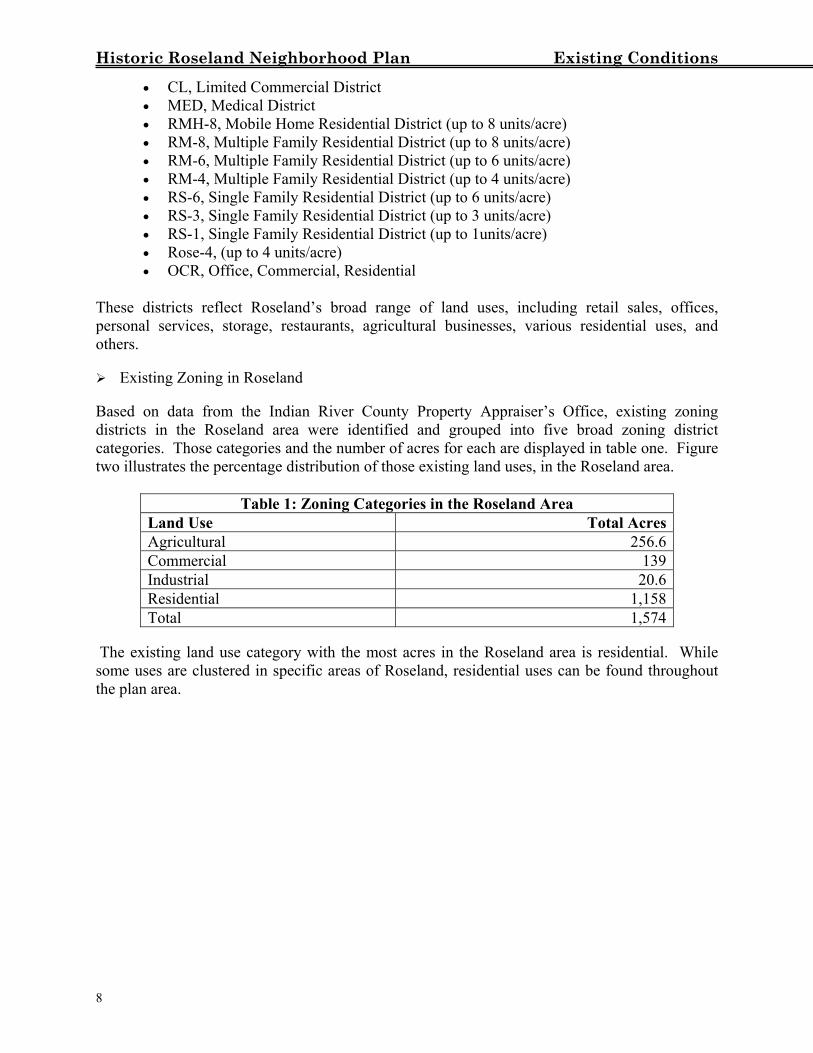
Historic Roseland Neighborhood Plan Existing Conditions • CL, Limited Commercial District • MED, Medical District • RMH-8, Mobile Home Residential District (up to 8 units/acre) • RM-8, Multiple Family Residential District (up to 8 units/acre) • RM-6, Multiple Family Residential District (up to 6 units/acre) • RM-4, Multiple Family Residential District (up to 4 units/acre) • RS-6, Single Family Residential District (up to 6 units/acre) • RS-3, Single Family Residential District (up to 3 units/acre) • RS-1, Single Family Residential District (up to 1units/acre) • Rose-4, (up to 4 units/acre) • OCR, Office, Commercial, Residential
These districts reflect Roseland’s broad range of land uses, including retail sales, offices, personal services, storage, restaurants, agricultural businesses, various residential uses, and others. Existing Zoning in Roseland
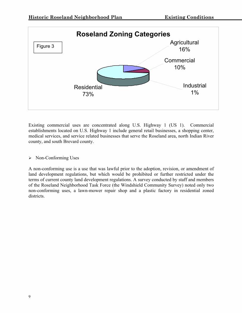
Based on data from the Indian River County Property Appraiser’s Office, existing zoning districts in the Roseland area were identified and grouped into five broad zoning district categories. Those categories and the number of acres for each are displayed in table one. Figure two illustrates the percentage distribution of those existing land uses, in the Roseland area.
Table 1: Zoning Categories in the Roseland Area Land Use Total AcresAgricultural 256.6Commercial 139Industrial 20.6Residential 1,158Total 1,574
The existing land use category with the most acres in the Roseland area is residential. While some uses are clustered in specific areas of Roseland, residential uses can be found throughout the plan area.
8
Historic Roseland Neighborhood Plan Existing Conditions
Roseland Zoning Categories
Residential73%
Industrial1%
Commercial10%
Agricultural16%Figure 3
Existing commercial uses are concentrated along U.S. Highway 1 (US 1). Commercial establishments located on U.S. Highway 1 include general retail businesses, a shopping center, medical services, and service related businesses that serve the Roseland area, north Indian River county, and south Brevard county. Non-Conforming Uses
A non-conforming use is a use that was lawful prior to the adoption, revision, or amendment of land development regulations, but which would be prohibited or further restricted under the terms of current county land development regulations. A survey conducted by staff and members of the Roseland Neighborhood Task Force (the Windshield Community Survey) noted only two non-conforming uses, a lawn-mower repair shop and a plastic factory in residential zoned districts.
9
Historic Roseland Neighborhood Plan Existing Conditions Historic Roseland Neighborhood Plan Existing Conditions
1
1
0 0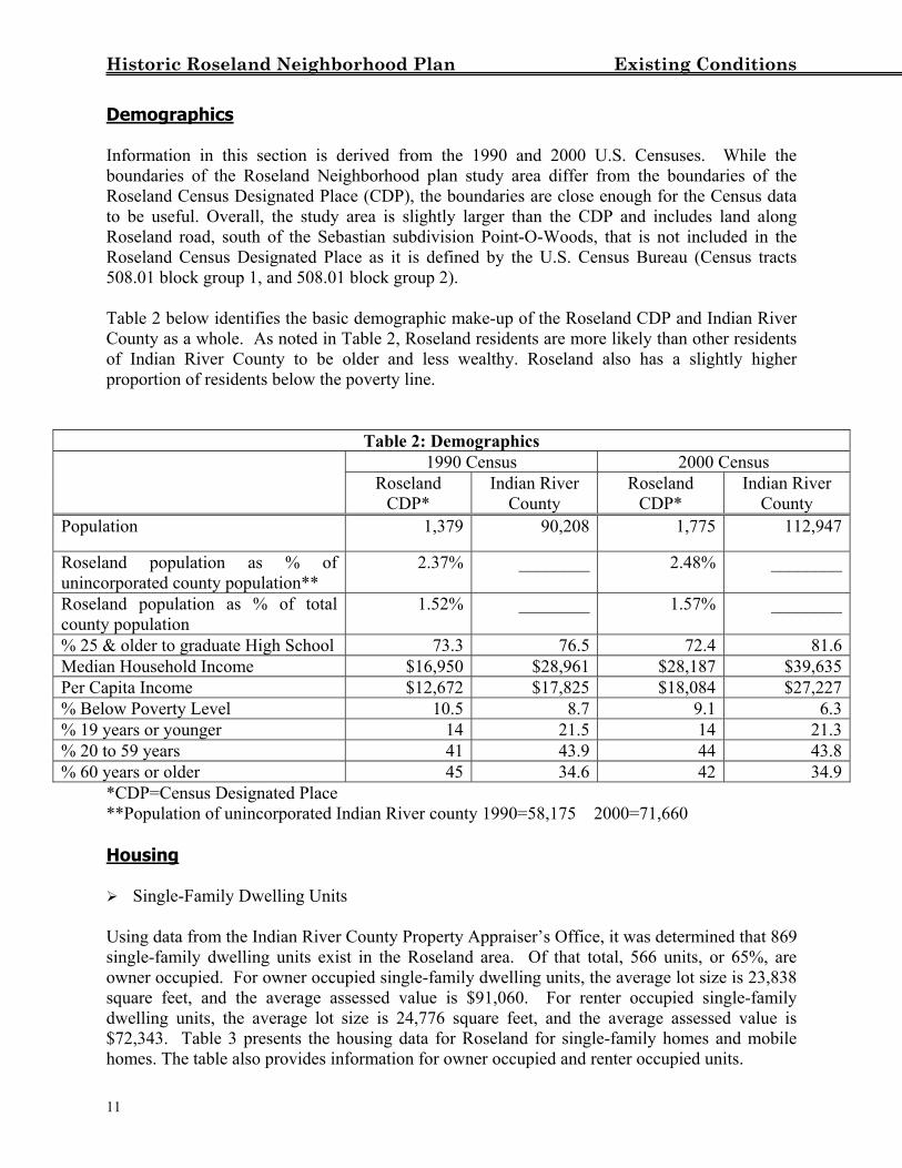
Historic Roseland Neighborhood Plan Existing Conditions Demographics Information in this section is derived from the 1990 and 2000 U.S. Censuses. While the boundaries of the Roseland Neighborhood plan study area differ from the boundaries of the Roseland Census Designated Place (CDP), the boundaries are close enough for the Census data to be useful. Overall, the study area is slightly larger than the CDP and includes land along Roseland road, south of the Sebastian subdivision Point-O-Woods, that is not included in the Roseland Census Designated Place as it is defined by the U.S. Census Bureau (Census tracts 508.01 block group 1, and 508.01 block group 2). Table 2 below identifies the basic demographic make-up of the Roseland CDP and Indian River County as a whole. As noted in Table 2, Roseland residents are more likely than other residents of Indian River County to be older and less wealthy. Roseland also has a slightly higher proportion of residents below the poverty line.
Table 2: Demographics 1990 Census 2000 Census
Roseland CDP*
Indian River County
Roseland CDP*
Indian River County
Population 1,379 90,208 1,775 112,947
Roseland population as % of unincorporated county population**
2.37% ________ 2.48% ________
Roseland population as % of total county population
1.52% ________ 1.57% ________
% 25 & older to graduate High School 73.3 76.5 72.4 81.6Median Household Income $16,950 $28,961 $28,187 $39,635Per Capita Income $12,672 $17,825 $18,084 $27,227% Below Poverty Level 10.5 8.7 9.1 6.3% 19 years or younger 14 21.5 14 21.3% 20 to 59 years 41 43.9 44 43.8% 60 years or older 45 34.6 42 34.9
*CDP=Census Designated Place **Population of unincorporated Indian River county 1990=58,175 2000=71,660 Housing Single-Family Dwelling Units
Using data from the Indian River County Property Appraiser’s Office, it was determined that 869 single-family dwelling units exist in the Roseland area. Of that total, 566 units, or 65%, are owner occupied. For owner occupied single-family dwelling units, the average lot size is 23,838 square feet, and the average assessed value is $91,060. For renter occupied single-family dwelling units, the average lot size is 24,776 square feet, and the average assessed value is $72,343. Table 3 presents the housing data for Roseland for single-family homes and mobile homes. The table also provides information for owner occupied and renter occupied units.
11
Historic Roseland Neighborhood Plan Existing Conditions
Table 3: Single-Family Dwelling Units and Mobile Homes Owner Occupied Renter Occupied
Housing Type # of
Units Avg. Lot
Size Avg. Assessed Value # of Units Avg. Lot
Size Avg. Assessed
Value Single Family home
440 25,273 $109,006 163 29,762 $102,701
Mobile Home 135 19,161 $32,566 116 17,701 $29,423Total 575 23,838 $91,060 279 24,766 $72,343
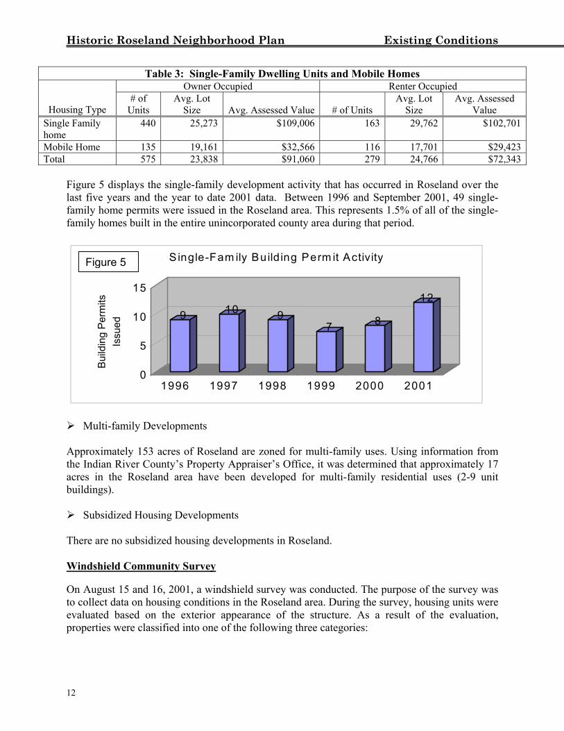
Figure 5 displays the single-family development activity that has occurred in Roseland over the last five years and the year to date 2001 data. Between 1996 and September 2001, 49 single-family home permits were issued in the Roseland area. This represents 1.5% of all of the single-family homes built in the entire unincorporated county area during that period.
Single-Fam ily Build ing Perm it Activity
Aptheacrbui
The Wi Onto cevapro 12
Figure 5
9 10 97 8
12
0
5
10
15
Build
ing
Perm
its
Issu
ed
1996 1997 1998 1999 2000 2001
Multi-family Developments
proximately 153 acres of Roseland are zoned for multi-family uses. Using information from Indian River County’s Property Appraiser’s Office, it was determined that approximately 17 es in the Roseland area have been developed for multi-family residential uses (2-9 unit ldings).
Subsidized Housing Developments
re are no subsidized housing developments in Roseland.
ndshield Community Survey
August 15 and 16, 2001, a windshield survey was conducted. The purpose of the survey was ollect data on housing conditions in the Roseland area. During the survey, housing units were luated based on the exterior appearance of the structure. As a result of the evaluation, perties were classified into one of the following three categories:
Historic Roseland Neighborhood Plan Existing Conditions
1.) Standard Housing Category; Buildings that appeared to be in good condition, without any apparent damage to
the roof, foundation, or siding. 2.) Sub-Standard Housing Category;
Buildings that appeared in need of substantial repair to the roof, foundation, or siding.
Buildings with boarded up or damaged windows and doors.
3.) Dilapidated Housing Category; or Buildings that appeared to be in such disrepair that rehabilitation might be more
costly and time-consuming than building a new structure.
In addition to the Housing classification, properties were also evaluated as to whether they fit in the:
County Code Violation Category. Properties with debris that was visible from the street. Debris includes items such as old and dilapidated automobiles, household
appliances, scrap building material, or any junk item as defined in the county’s land development regulations.
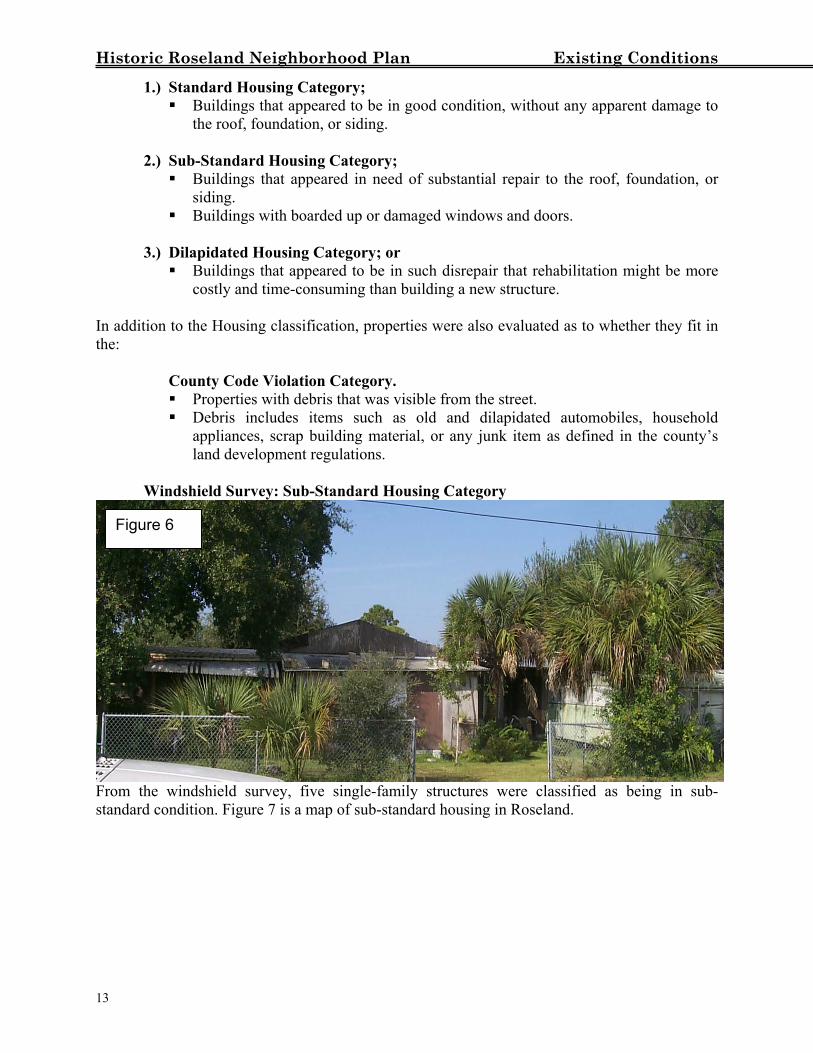
Windshield Survey: Sub-Standard Housing Category
Figure 6
From the windshield survey, five single-family structures were classified as being in sub-standard condition. Figure 7 is a map of sub-standard housing in Roseland.
13
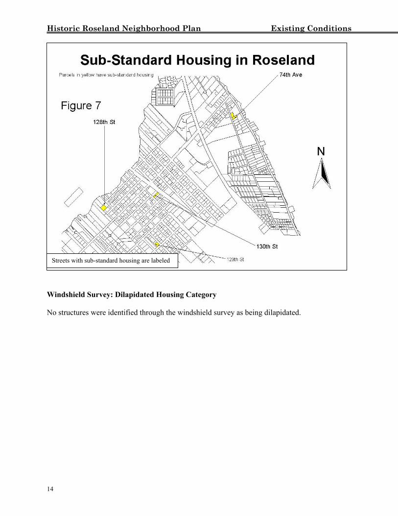
Historic Roseland Neighborhood Plan Existing Conditions W N
1
Streets with sub-standard housing are labeled
indshield Survey: Dilapidated Housing Category
o structures were identified through the windshield survey as being dilapidated.
4
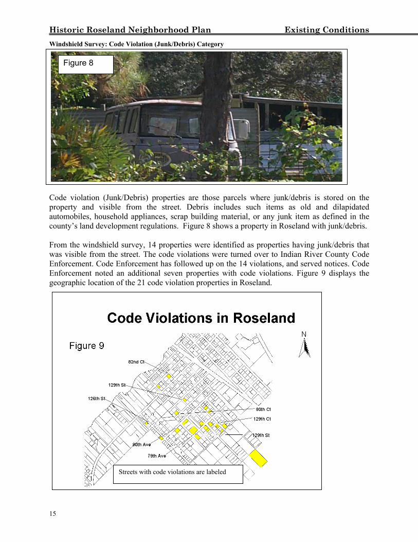
Historic Roseland Neighborhood Plan Existing Conditions Windshield Survey: Code Violation (Junk/Debris) Category
Figure 8
Code violation (Junk/Debris) properties are those parcels where junk/debris is stored on the property and visible from the street. Debris includes such items as old and dilapidated automobiles, household appliances, scrap building material, or any junk item as defined in the county’s land development regulations. Figure 8 shows a property in Roseland with junk/debris. From the windshield survey, 14 properties were identified as properties having junk/debris that was visible from the street. The code violations were turned over to Indian River County Code Enforcement. Code Enforcement has followed up on the 14 violations, and served notices. Code Enforcement noted an additional seven properties with code violations. Figure 9 displays the geographic location of the 21 code violation properties in Roseland. 1
Streets with code violations are labeled
5
Historic Roseland Neighborhood Plan Existing Conditions
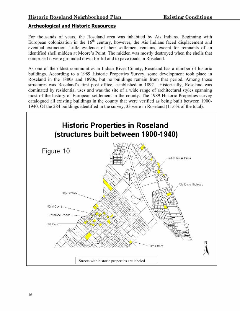
Archeological and Historic Resources For thousands of years, the Roseland area was inhabited by Ais Indians. Beginning with European colonization in the 16th century, however, the Ais Indians faced displacement and eventual extinction. Little evidence of their settlement remains, except for remnants of an identified shell midden at Moore’s Point. The midden was mostly destroyed when the shells that comprised it were grounded down for fill and to pave roads in Roseland. As one of the oldest communities in Indian River County, Roseland has a number of historic buildings. According to a 1989 Historic Properties Survey, some development took place in Roseland in the 1880s and 1890s, but no buildings remain from that period. Among those structures was Roseland’s first post office, established in 1892. Historically, Roseland was dominated by residential uses and was the site of a wide range of architectural styles spanning most of the history of European settlement in the county. The 1989 Historic Properties survey catalogued all existing buildings in the county that were verified as being built between 1900-1940. Of the 284 buildings identified in the survey, 33 were in Roseland (11.6% of the total).
d
16
Streets with historic properties are labele
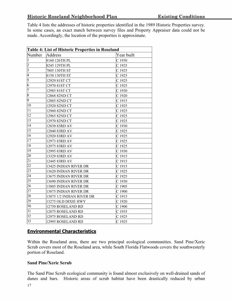
Historic Roseland Neighborhood Plan Existing Conditions Table 4 lists the addresses of historic properties identified in the 1989 Historic Properties survey. In some cases, an exact match between survey files and Property Appraiser data could not be made. Accordingly, the location of the properties is approximate. Table 4: List of Historic Properties in Roseland Number Address Year built 1 8160 126TH PL C 1930 2 8245 129TH PL C 1925 3 7805 130TH ST C 1925 4 8150 130TH ST C 1925 5 12929 81ST CT C 1925 6 12970 81ST CT C 1925 7 12985 81ST CT C 1930 8 12868 82ND CT C 1920 9 12885 82ND CT C 1915 10 12920 82ND CT C 1925 11 12960 82ND CT C 1925 12 12965 82ND CT C 1925 13 12970 82ND CT C 1925 14 12830 83RD AV C 1930 15 12840 83RD AV C 1925 16 12920 83RD AV C 1925 17 12973 83RD AV C 1925 18 12975 83RD AV C 1925 19 12995 83RD AV C 1930 20 13329 83RD AV C 1915 21 12445 83RD AV C 1915 22 13425 INDIAN RIVER DR C 1915 23 13620 INDIAN RIVER DR C 1925 24 13675 INDIAN RIVER DR C 1925 25 13690 INDIAN RIVER DR C 1930 26 13805 INDIAN RIVER DR C 1905 27 13875 INDIAN RIVER DR C 1900 28 13875 1/2 INDIAN RIVER DR C 1915 29 13275 OLD DIXIE HWY C 1920 30 12750 ROSELAND RD C 1900 31 12875 ROSELAND RD C 1935 32 12975 ROSELAND RD C 1925 33 12995 ROSELAND RD C 1925 Environmental Characteristics
Within the Roseland area, there are two principal ecological communities. Sand Pine/Xeric Scrub covers most of the Roseland area, while South Florida Flatwoods covers the southwesterly portion of Roseland. Sand Pine/Xeric Scrub The Sand Pine Scrub ecological community is found almost exclusively on well-drained sands of dunes and bars. Historic areas of scrub habitat have been drastically reduced by urban
17
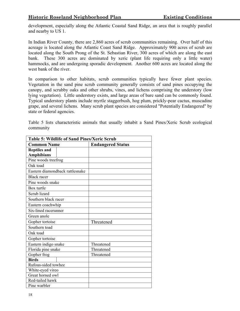
Historic Roseland Neighborhood Plan Existing Conditions development, especially along the Atlantic Coastal Sand Ridge, an area that is roughly parallel and nearby to US 1. In Indian River County, there are 2,860 acres of scrub communities remaining. Over half of this acreage is located along the Atlantic Coast Sand Ridge. Approximately 900 acres of scrub are located along the South Prong of the St. Sebastian River, 300 acres of which are along the east bank. These 300 acres are dominated by xeric (plant life requiring only a little water) hammocks, and are undergoing sporadic development. Another 600 acres are located along the west bank of the river. In comparison to other habitats, scrub communities typically have fewer plant species. Vegetation in the sand pine scrub community generally consists of sand pines occupying the canopy, and scrubby oaks and other shrubs, vines, and lichens comprising the understory (low lying vegetation). Little understory exists, and large areas of bare sand can be commonly found. Typical understory plants include myrtle staggerbush, hog plum, prickly-pear cactus, muscadine grape, and several lichens. Many scrub plant species are considered "Potentially Endangered" by state or federal agencies. Table 5 lists characteristic animals that usually inhabit a Sand Pines/Xeric Scrub ecological community Table 5: Wildlife of Sand Pines/Xeric Scrub Common Name Endangered Status Reptiles and Amphibians
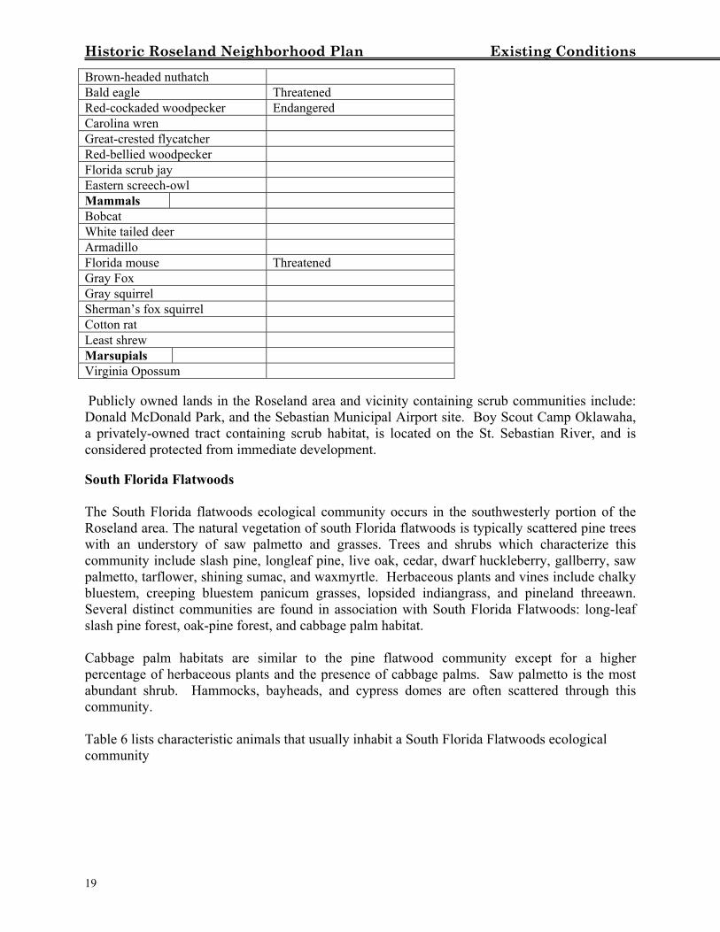
Pine woods treefrog Oak toad Eastern diamondback rattlesnake Black racer Pine woods snake Box turtle Scrub lizard Southern black racer Eastern coachwhip Six-lined racerunner Green anole Gopher tortoise Threatened Southern toad Oak toad Gopher tortoise Eastern indigo snake Threatened Florida pine snake Threatened Gopher frog Threatened Birds Rufous-sided towhee White-eyed vireo Great horned owl Red-tailed hawk Pine warbler
18
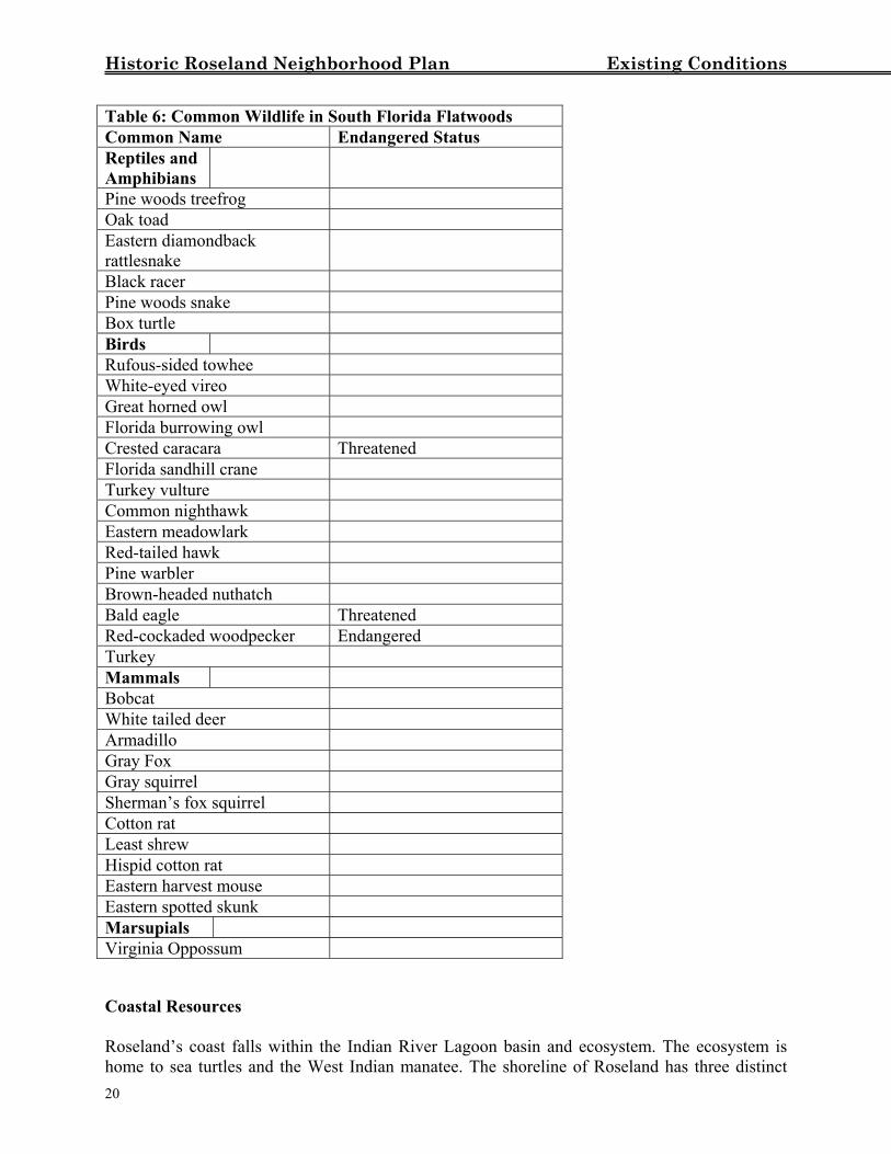
Historic Roseland Neighborhood Plan Existing Conditions Brown-headed nuthatch Bald eagle Threatened Red-cockaded woodpecker Endangered Carolina wren Great-crested flycatcher Red-bellied woodpecker Florida scrub jay Eastern screech-owl Mammals Bobcat White tailed deer Armadillo Florida mouse Threatened Gray Fox Gray squirrel Sherman’s fox squirrel Cotton rat Least shrew Marsupials Virginia Opossum Publicly owned lands in the Roseland area and vicinity containing scrub communities include: Donald McDonald Park, and the Sebastian Municipal Airport site. Boy Scout Camp Oklawaha, a privately-owned tract containing scrub habitat, is located on the St. Sebastian River, and is considered protected from immediate development. South Florida Flatwoods The South Florida flatwoods ecological community occurs in the southwesterly portion of the Roseland area. The natural vegetation of south Florida flatwoods is typically scattered pine trees with an understory of saw palmetto and grasses. Trees and shrubs which characterize this community include slash pine, longleaf pine, live oak, cedar, dwarf huckleberry, gallberry, saw palmetto, tarflower, shining sumac, and waxmyrtle. Herbaceous plants and vines include chalky bluestem, creeping bluestem panicum grasses, lopsided indiangrass, and pineland threeawn. Several distinct communities are found in association with South Florida Flatwoods: long-leaf slash pine forest, oak-pine forest, and cabbage palm habitat. Cabbage palm habitats are similar to the pine flatwood community except for a higher percentage of herbaceous plants and the presence of cabbage palms. Saw palmetto is the most abundant shrub. Hammocks, bayheads, and cypress domes are often scattered through this community. Table 6 lists characteristic animals that usually inhabit a South Florida Flatwoods ecological community
19
Historic Roseland Neighborhood Plan Existing Conditions Table 6: Common Wildlife in South Florida Flatwoods Common Name Endangered Status Reptiles and Amphibians
Pine woods treefrog Oak toad Eastern diamondback rattlesnake
Black racer Pine woods snake Box turtle Birds Rufous-sided towhee White-eyed vireo Great horned owl Florida burrowing owl Crested caracara Threatened Florida sandhill crane Turkey vulture Common nighthawk Eastern meadowlark Red-tailed hawk Pine warbler Brown-headed nuthatch Bald eagle Threatened Red-cockaded woodpecker Endangered Turkey Mammals Bobcat White tailed deer Armadillo Gray Fox Gray squirrel Sherman’s fox squirrel Cotton rat Least shrew Hispid cotton rat Eastern harvest mouse Eastern spotted skunk Marsupials Virginia Oppossum Coastal Resources Roseland’s coast falls within the Indian River Lagoon basin and ecosystem. The ecosystem is home to sea turtles and the West Indian manatee. The shoreline of Roseland has three distinct
20
Historic Roseland Neighborhood Plan Existing Conditions sub-areas (estuarine, transitional, riverine) with each sub-area associated with a particular portion of the adjacent waterbody. Estuarine From the Highway U.S. 1 bridge south, along the Indian River Lagoon, the shoreline is characterized by a high bluff descending toward a narrow estuarine wetland area. Towards the south of this area, the bluff elevation falls and becomes less than three (3) feet above the mean high water line (MHWL). Generally, the undisturbed areas of estuarine wetlands consist of smooth cord grass, rushes, and scattered mangroves (red, white, and black). The submerged bottom is characterized by large expanses of seagrass, and other submerged aquatic vegetation (SAV), which exist due to the shallow and relatively clear water. Due to the shallow nature of the Indian River Lagoon in this area, the seagrasses extend well offshore, in some areas up to 400 feet waterward of the MHWL. Transitional from estuarine to riverine From the Highway U.S. 1 bridge west and south to the confluence of the South Prong of the St. Sebastian River and the C-54 Canal, the shoreline is represented by a wide range of elevations. These elevations range from nearly the elevation of the MHWL to as much as 20 feet above the MHWL. In this area, the wetland areas associated with the St. Sebastian River are a mix of estuarine and riverine, as this area represents a mixing zone where estuarine or riverine conditions exist depending on such factors as wind speed and direction, rainfall, tides, and controlled discharges from the C-54 Canal. Shoreline vegetation in this area consists of smooth cord grass and rushes; however, there are pockets of dense concentration of mangroves, particularly red mangroves. The submerged bottom in this area does support a small nearshore area of seagrass; however, most of the submerged bottom is muck with no overlaying SAV. Riverine From the confluence of the South Prong of the St. Sebastian River to the southern terminus of the study area, the shoreline consists of nearly level and somewhat elevated land. The wetland areas associated with the South Prong of the St. Sebastian River are less disturbed than those in the other two areas and tend to be more extensive. In some areas, the mangrove forest can be over a hundred feet wide. There are also areas of forested wetlands consisting of leather fern, swamp fern, and royal fern as understory with red maple and dahoon holly as canopy. The submerged bottom is generally devoid of any SAV. Groundwater Resources In Indian River County there are two horizontally layered aquifers. One is the surficial aquifer, while the other is the Floridian aquifer. Those are the two primary sources of potable water in the Roseland area. The surficial aquifer is a source of freshwater extending from the top of the water table (about 6-10 feet below the surface in Roseland) to about 200 feet below the surface. The Floridan aquifer, at a depth of 250 to 2,700 feet below the surface, is an important source of potable water for much of the state. Saltwater has encroached into the surficial aquifer in the Roseland area, due to the high level of development in the area and due to the soil characteristics of the area, which are excessively drained. The North Sebastian area is a primary recharge area for the groundwater ‘aquifer,’ a zone of water immediately below the surface.
21
Historic Roseland Neighborhood Plan Existing Conditions
Wetlands Within the Roseland area, there are several areas of jurisdictional wetlands. There are isolated freshwater wetlands in the upland areas consisting mainly of depressional wetlands and wetland areas associated with natural creeks or stormwater drainage systems. Other freshwater wetlands are associated with the South Fork of the Saint Sebastian River. There are also estuarine wetlands, consisting of mangroves and Brazilian Pepper, associated with the upper portion of the South Fork of the Saint Sebastian River as well as the main thread of the St. Sebastian River. Conservation Areas Roseland abuts two areas that are protected under the County Environmental Lands Program: the Fischer-Sebastian River Tract and the North Sebastian Conservation Area. The Fischer-Sebastian Tract, adjacent to the St. Sebastian River Buffer Preserve, comprises 95 acres of forested wetlands and hardwood hammock bordering the south prong of the St. Sebastian River. The tract helps buffer the St. Sebastian River from residential development, protects water quality, and preserves the river’s scenic corridor. A public canoe launch on this tract was completed in Fall 2001. The St. Sebastian River Buffer Preserve, on the west side of the St. Sebastian River and extending past I-95, comprises thousands of acres of conservation land. This land is owned and managed by various state agencies for conservation and recreation purposes. The North Sebastian Conservation Area contains 407 acres of xeric scrub, pine flatwoods, and savanna wetlands. The area contains important habitat for the Florida scrub-jay, the gopher tortoise, the eastern indigo snake, and other rare species native to coastal scrub. Bald eagles and sandhill cranes are also known to use the site. Public access improvements are planned in 2002. As a part of the county’s resource management plan for the site, the North Sebastian Conservation Area has been timbered and is scheduled to undergo prescribed burns in the near future. These activities benefit scrub-jays and other species endemic to scrub, which is a fire-adaptive natural system. Improvement of scrub-jay habitat at the North Sebastian Conservation Area is a key component of the Sebastian Area-Wide Scrub-Jay Habitat Conservation Plan (HCP) adopted by the County in March 2000 and subsequently approved by the U.S. Fish and Wildlife Service. As a part of the HCP, the County has begun the process of abandoning the undeveloped Gibson Street (130th Street) right-of-way in the Conservation Area.
22
Historic Roseland Neighborhood Plan Existing Conditions
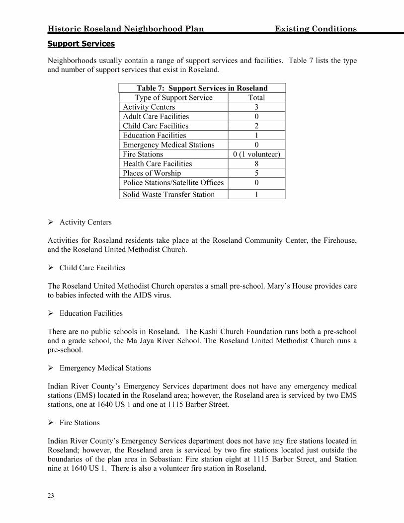
Support Services Neighborhoods usually contain a range of support services and facilities. Table 7 lists the type and number of support services that exist in Roseland.
Table 7: Support Services in Roseland Type of Support Service Total
Activity Centers 3 Adult Care Facilities 0 Child Care Facilities 2 Education Facilities 1 Emergency Medical Stations 0 Fire Stations 0 (1 volunteer) Health Care Facilities 8 Places of Worship 5 Police Stations/Satellite Offices 0 Solid Waste Transfer Station 1
Activity Centers
Activities for Roseland residents take place at the Roseland Community Center, the Firehouse, and the Roseland United Methodist Church. Child Care Facilities
The Roseland United Methodist Church operates a small pre-school. Mary’s House provides care to babies infected with the AIDS virus. Education Facilities
There are no public schools in Roseland. The Kashi Church Foundation runs both a pre-school and a grade school, the Ma Jaya River School. The Roseland United Methodist Church runs a pre-school. Emergency Medical Stations
Indian River County’s Emergency Services department does not have any emergency medical stations (EMS) located in the Roseland area; however, the Roseland area is serviced by two EMS stations, one at 1640 US 1 and one at 1115 Barber Street. Fire Stations
Indian River County’s Emergency Services department does not have any fire stations located in Roseland; however, the Roseland area is serviced by two fire stations located just outside the boundaries of the plan area in Sebastian: Fire station eight at 1115 Barber Street, and Station nine at 1640 US 1. There is also a volunteer fire station in Roseland.
23
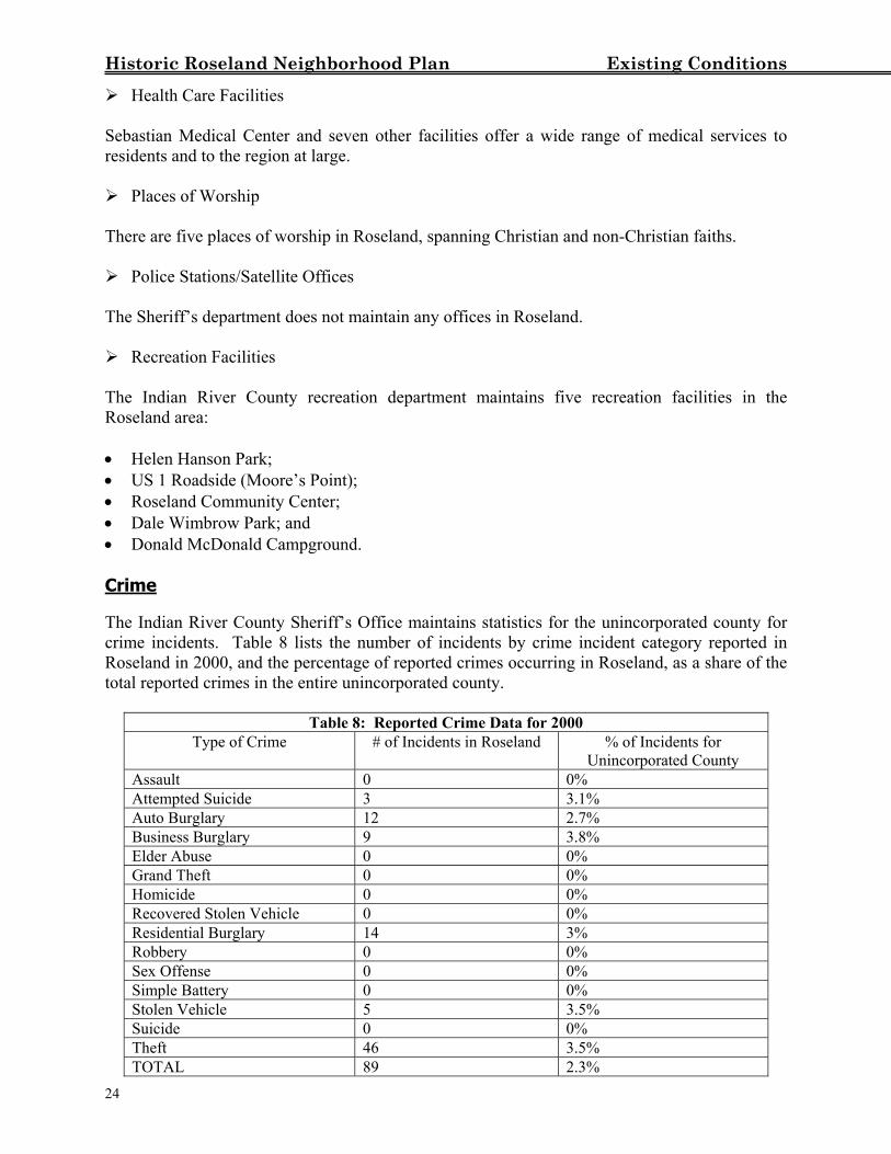
Historic Roseland Neighborhood Plan Existing Conditions Health Care Facilities
Sebastian Medical Center and seven other facilities offer a wide range of medical services to residents and to the region at large. Places of Worship
There are five places of worship in Roseland, spanning Christian and non-Christian faiths. Police Stations/Satellite Offices
The Sheriff’s department does not maintain any offices in Roseland. Recreation Facilities
The Indian River County recreation department maintains five recreation facilities in the Roseland area: • Helen Hanson Park; • US 1 Roadside (Moore’s Point); • Roseland Community Center; • Dale Wimbrow Park; and • Donald McDonald Campground. Crime The Indian River County Sheriff’s Office maintains statistics for the unincorporated county for crime incidents. Table 8 lists the number of incidents by crime incident category reported in Roseland in 2000, and the percentage of reported crimes occurring in Roseland, as a share of the total reported crimes in the entire unincorporated county.
Table 8: Reported Crime Data for 2000 Type of Crime # of Incidents in Roseland % of Incidents for
Unincorporated County Assault 0 0% Attempted Suicide 3 3.1% Auto Burglary 12 2.7% Business Burglary 9 3.8% Elder Abuse 0 0% Grand Theft 0 0% Homicide 0 0% Recovered Stolen Vehicle 0 0% Residential Burglary 14 3% Robbery 0 0% Sex Offense 0 0% Simple Battery 0 0% Stolen Vehicle 5 3.5% Suicide 0 0% Theft 46 3.5% TOTAL 89 2.3% 24
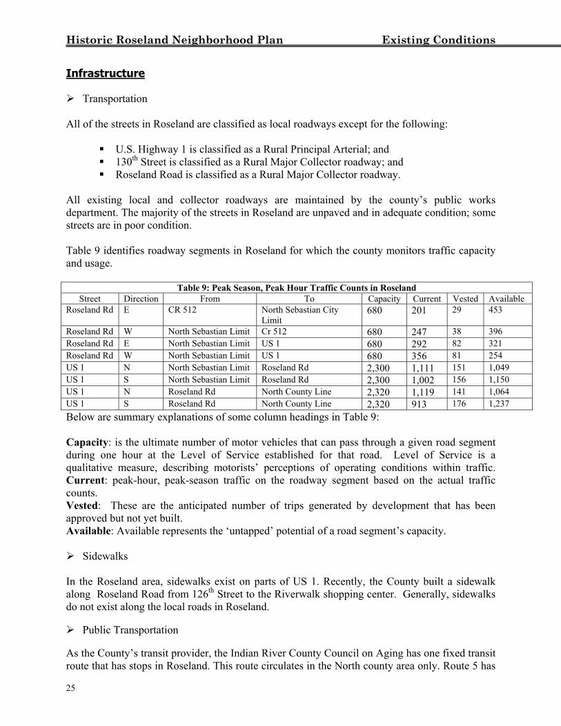
Historic Roseland Neighborhood Plan Existing Conditions Infrastructure Transportation
All of the streets in Roseland are classified as local roadways except for the following:
U.S. Highway 1 is classified as a Rural Principal Arterial; and 130th Street is classified as a Rural Major Collector roadway; and Roseland Road is classified as a Rural Major Collector roadway.
All existing local and collector roadways are maintained by the county’s public works department. The majority of the streets in Roseland are unpaved and in adequate condition; some streets are in poor condition. Table 9 identifies roadway segments in Roseland for which the county monitors traffic capacity and usage.
Table 9: Peak Season, Peak Hour Traffic Counts in Roseland Street Direction From To Capacity Current Vested Available
Roseland Rd E CR 512 North Sebastian City Limit
680 201 29 453
Roseland Rd W North Sebastian Limit Cr 512 680 247 38 396 Roseland Rd E North Sebastian Limit US 1 680 292 82 321 Roseland Rd W North Sebastian Limit US 1 680 356 81 254 US 1 N North Sebastian Limit Roseland Rd 2,300 1,111 151 1,049 US 1 S North Sebastian Limit Roseland Rd 2,300 1,002 156 1,150 US 1 N Roseland Rd North County Line 2,320 1,119 141 1,064 US 1 S Roseland Rd North County Line 2,320 913 176 1,237 Below are summary explanations of some column headings in Table 9: Capacity: is the ultimate number of motor vehicles that can pass through a given road segment during one hour at the Level of Service established for that road. Level of Service is a qualitative measure, describing motorists’ perceptions of operating conditions within traffic. Current: peak-hour, peak-season traffic on the roadway segment based on the actual traffic counts. Vested: These are the anticipated number of trips generated by development that has been approved but not yet built. Available: Available represents the ‘untapped’ potential of a road segment’s capacity. Sidewalks
In the Roseland area, sidewalks exist on parts of US 1. Recently, the County built a sidewalk along Roseland Road from 126th Street to the Riverwalk shopping center. Generally, sidewalks do not exist along the local roads in Roseland. Public Transportation
As the County’s transit provider, the Indian River County Council on Aging has one fixed transit route that has stops in Roseland. This route circulates in the North county area only. Route 5 has
25
Historic Roseland Neighborhood Plan Existing Conditions three stops in Roseland. Ridership on Route 5 from the 3rd quarter of 2000 to the 2nd quarter of 2001 was 4,937 passengers. In the second quarter (April-June 2001), there were 1,492 passengers on Route 5, making it one of the least utilized routes on IRT (where the average ridership was 4,997 for the second quarter). Major stops include Kash & Karry, Sebastian Medical Center, Riverwalk Publix, and Wal-Mart. In conjunction with the fixed route service, the Council on Aging offers a dial-a-ride service for patrons who live more than a quarter-mile from either side of its fixed routes. This service will pick up patrons at their door and drop them off at the closest designated fixed route stop, which then allows those patrons to utilize the fixed route service. The Indian River County School District also provides public transportation which picks-up and drops-off school children. Potable Water Service
Operated by the Indian River County Utilities Department, the county water system extends into the Roseland area. Generally, the North County Water Treatment Plant serves the Roseland area. Installed along major transportation corridors, main water transmission lines ranging in diameter from 1 inches to 20 inches allow the water to flow from the treatment plant. From those main lines, smaller lines branch out into residential neighborhoods and commercial/industrial nodes to provide residents and businesses with potable water. In the Roseland area, water mainlines have been installed along Roseland Road, US 1, and 130th Street. 139 lots (about 16%) in Roseland are connected to county water. Sanitary Sewer Service
The Indian River County Utilities Department operates five wastewater treatment plants, each serving a defined area of the county. While the North Regional Wastewater Treatment Plant usually serves the Roseland area, it is currently out of service. In the meantime, the Central Region Wastewater Treatment Plant serves the Roseland area. Wastewater generated by residences, businesses and other uses is conveyed to the wastewater treatment plant by a network of collection pipes. The existing sewage collection system consists of force mains along parts of Roseland road, parts of North Indian River drive and 130th street. Gravity sewers run along North Indian River Drive. In Roseland, only 57 residences (7%) are connected to the county sanitary sewer system. Most residences use an onsite septic tank system for sewerage. Stormwater Management
Roseland is part of both the Indian River Lagoon basin and the Saint Sebastian River basin. The Saint Sebastian basin is further divided into sub-basins, one of which is the Roseland sub-basin. The Roseland sub-basin contains three small sub-areas (less than 300 acres) that include: Frog Leg Creek (west Roseland), 128th Street (Central Roseland), and Gibson Street (130th Street). Stormwater runoff is collected from the area south of Roseland road and conveyed north via swales and culverts beneath Roseland Road to the South Prong of the Saint Sebastian River.
26
Historic Roseland Neighborhood Plan Existing Conditions
Commerce Roseland has two Commercial/Industrial nodes, comprising approximately 159 acres of land. Most of this land, overwhelmingly commercial in character, is concentrated along US 1. About 50 acres of the commercial/industrial zoned land is vacant commercial. The Sebastian River Medical Center and the other medical facilities occupy 18 acres. Shopping centers comprise about 12 acres, and banks and professional services about 9 acres. The balance consists of a wide range of retail operations, as well as auto service and sales uses. Sebastian River Medical Center is the largest employer in the Roseland area, with 390 employees. Of those, 275 are full time, and 115 are part time (in 2000). Quality of Life Survey In January, 2002, a Quality of Life Survey was delivered to 1,169 residences in Roseland. The survey was sent to all owner occupants, owners of rental/second home properties, and their occupants. The Quality of Life Survey asked respondents a range of questions pertaining to County provided services and amenities, respondents’ interest in property maintenance, volunteer services, regulations governing new development in the area, and annexation to the City of Sebastian. In addition, space was provided for comments and suggestions. The Survey results are useful for determining public interest in assessments for utilities, sidewalks, road improvements, needed recreational facilities, and support for regulations governing new development in Roseland.
27

Historic Roseland Neighborhood Plan Analysis
ANALYSIS Using the data from the Existing Conditions section, this Analysis identifies the issues, opportunities, and constraints that exist in Roseland. Land Use/Zoning Pattern Like many of the older, more established communities in the county, Roseland has a mix of residential, commercial and industrial land uses. Such a mix can be good or bad. If incompatible uses are scattered throughout an area, they may have an adverse impact on the residential character of the community, such as channeling commercial traffic through residential areas. Commercial traffic in residential areas can be noisy, and can pose risks to pedestrians. Similarly, incompatible uses scattered throughout a neighborhood can produce nuisance impacts such as high luminosity lights, noises, and smells from commercial/industrial uses. Generally, the land use pattern in Roseland is appropriate, and consistent with the pattern of land use throughout the county. In Roseland, higher land use designation density residential areas are generally adjacent to major traffic corridors (US 1) and near the Indian River lagoon, while lower land use designation density residential areas are situated along Roseland Road (a collector road) and residential subdivision roads, and further away from commercial/industrial uses. Usually, single-family residences are not appropriate along major roadway corridors, such as US 1. However, multi-family development, which has more design flexibility and buffering opportunity, is appropriate along major roadways. In Roseland, there are two commercial/industrial nodes, one located along US 1 and the other located along Gibson Street. The US 1 node is situated along a high volume, multi-lane roadway, while the Gibson Street node is located along the Florida East Coast railroad track. These C/I node configurations are consistent with County Comprehensive Plan objectives to concentrate commercial and industrial development in compact areas along major roadways, railroad tracks, and, to the extent feasible, not to mix residential, commercial and industrial uses. For an area the size of Roseland, planning standards indicate that about 30 acres of neighborhood-type commercial land are needed for uses to support residents. Roseland’s two C/I nodes comprise about 159 acres of both commercial and industrial land uses. In Roseland, this commercial/industrial land serves not only the Roseland area, but the City of Sebastian and southern Brevard county as well, making the US 1 node a regional commercial, medical and service center. These commercial and industrial land uses in the Roseland area provide opportunities for Roseland residents to work, shop and utilize services near their neighborhood, while the proximity of retail uses and service uses provides convenience, shorter trips and helps residents save time and money. Within Roseland, as well as other areas of the unincorporated county, all land is assigned a zoning designation. These zoning designations identify allowable uses, indicate maximum allowed densities, and provide specific size and dimensional criteria such as setbacks, lot size, and height. Zoning designations also separate different uses and housing types. One exception in Roseland is the Rose-4 zoning designation. This designation, which exists only in Roseland,
28
Historic Roseland Neighborhood Plan Analysis allows single-family residences and mobile homes in the same district. Typically, these uses are kept separate. In 1985, the area southeast of Roseland Road was zoned RMH-8 (Mobile Homes up to 8 dwelling units/acre), and existing single-family residences were then considered to be legal non-conforming uses. Because that created a problem for then existing single-family residences (there are restrictions on repairs and expansions for legal non-conforming uses), a new zoning designation, Rose-4, was created to accommodate both single-family residences and mobile homes in the same district. In Roseland, some existing uses are not consistent with uses that are allowed under the area’s current zoning designation. Some of these uses are illegal, and the Code Enforcement division is engaged in an effort to remove these illegal uses. There are also legal non-conforming uses in Roseland. Legal non-conforming uses are uses that were permitted under a previous zoning designation, but are no longer allowed under the current zoning designation. Among these uses are two industrial enterprises in residential areas, noted in the Windshield Survey. When the industrial uses on these properties cease for at least one year, the land can be re-developed only as residential in the future. Surrounding Land Uses Roseland lies along the northern and western border of the City of Sebastian. Since Roseland and Sebastian are neighbors, activities of one jurisdiction have a direct impact upon the other. These activities can produce positive or negative impacts. One action with positive consequences for both Sebastian and Roseland is the county’s purchase of environmentally sensitive land within Sebastian for conservation. Sometimes, however, a positive consequence for one community may have mixed results for the other. For example, most of Sebastian’s land bordering Roseland along Roseland Road is zoned for industrial uses. While industrial activities may provide jobs to residents of both Sebastian and Roseland and increase Sebastian’s tax base, industrial development may produce adverse impacts to residential areas in Roseland, including airport and industrial noise, high-luminosity lighting, and non-residential traffic. These adverse impacts can be at least partly mitigated through site planning. Because residents of Roseland cannot vote in Sebastian elections, Roseland residents do not have an effective mechanism to influence the City of Sebastian. Since most Roseland residents (93%, according to the Roseland Quality of Life Survey) are not interested in annexation to the City, Roseland residents will be able to address city issues only through informal communication with the city. Summary
In the future, Roseland will continue to be a mostly residential community. There is sufficient commercial/industrial land to support Roseland residents and to provide good opportunities for work, shopping and access to other services. Similarly, Roseland’s neighbor, the city of
29
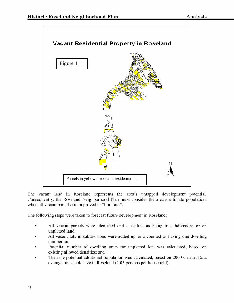
Historic Roseland Neighborhood Plan Analysis Sebastian, presents both employment opportunities in the abutting industrial area along Roseland road, and potential adverse impacts from industrial development on neighboring residential uses. Future Growth and Build Out Analysis As time goes by, development will continue to occur in Roseland. One way to project how much development can occur in the future is to do a build-out analysis. A build-out analysis is a forecast of the maximum number of dwelling units and population in an area, when all vacant residential land is developed consistent with the properties’ allowed land use density. According to data from the Property Appraiser’s office, there are 317 parcels of vacant residential land, comprising 287.8 acres in Roseland (18% of the total acreage for all land uses in Roseland). Over time, this vacant residential land will be developed into new housing. To better understand Roseland’s long-term future conditions, it is useful to project what the area’s ultimate development will be in terms of new dwelling units and added population when all vacant parcels are improved or built out. For Roseland, a build-out analysis was done on all vacant parcels, based on their respective land use designations and corresponding densities. For properties that are not in subdivisions (unplatted land), the maximum number of new dwelling units that could be built was calculated, given the highest allowed densities for the vacant lands’ land use designation. Also, it was assumed that parcels that are in existing subdivisions will be built out in a manner consistent with previously existing development in the subdivision. Figure 11 is a map of vacant residential property in Roseland.
30
Historic Roseland Neighborhood Plan Analysis The vacConsequewhen all The follo
C
C
C
C
31
Figure 11
Parcels in yellow are vacant residential land
ant land in Roseland represents the area’s untapped development potential. ntly, the Roseland Neighborhood Plan must consider the area’s ultimate population,
vacant parcels are improved or “built out”.
wing steps were taken to forecast future development in Roseland:
All vacant parcels were identified and classified as being in subdivisions or on unplatted land; All vacant lots in subdivisions were added up, and counted as having one dwelling unit per lot; Potential number of dwelling units for unplatted lots was calculated, based on existing allowed densities; and Then the potential additional population was calculated, based on 2000 Census Data average household size in Roseland (2.05 persons per household).
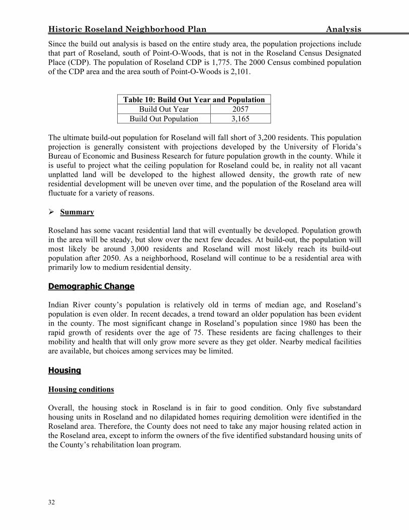
Historic Roseland Neighborhood Plan Analysis Since the build out analysis is based on the entire study area, the population projections include that part of Roseland, south of Point-O-Woods, that is not in the Roseland Census Designated Place (CDP). The population of Roseland CDP is 1,775. The 2000 Census combined population of the CDP area and the area south of Point-O-Woods is 2,101.
Table 10: Build Out Year and Population Build Out Year 2057
Build Out Population 3,165 The ultimate build-out population for Roseland will fall short of 3,200 residents. This population projection is generally consistent with projections developed by the University of Florida’s Bureau of Economic and Business Research for future population growth in the county. While it is useful to project what the ceiling population for Roseland could be, in reality not all vacant unplatted land will be developed to the highest allowed density, the growth rate of new residential development will be uneven over time, and the population of the Roseland area will fluctuate for a variety of reasons. Summary
Roseland has some vacant residential land that will eventually be developed. Population growth in the area will be steady, but slow over the next few decades. At build-out, the population will most likely be around 3,000 residents and Roseland will most likely reach its build-out population after 2050. As a neighborhood, Roseland will continue to be a residential area with primarily low to medium residential density. Demographic Change Indian River county’s population is relatively old in terms of median age, and Roseland’s population is even older. In recent decades, a trend toward an older population has been evident in the county. The most significant change in Roseland’s population since 1980 has been the rapid growth of residents over the age of 75. These residents are facing challenges to their mobility and health that will only grow more severe as they get older. Nearby medical facilities are available, but choices among services may be limited. Housing Housing conditions Overall, the housing stock in Roseland is in fair to good condition. Only five substandard housing units in Roseland and no dilapidated homes requiring demolition were identified in the Roseland area. Therefore, the County does not need to take any major housing related action in the Roseland area, except to inform the owners of the five identified substandard housing units of the County’s rehabilitation loan program.
32
Historic Roseland Neighborhood Plan Analysis
Code Violations and Housing Conditions The Windshield Survey identified 21 properties with code violations in Roseland, 18 of which are concentrated south of Roseland Road in the original Townsite of Roseland area. Most of these violations are due to the presence of junk or trash in the yards of homes. The Code Enforcement division has investigated these violations and has followed up with citations. Most of the violations have been resolved in accordance with county regulations. There were also five substandard housing units noted in the Windshield survey. Two of the five substandard housing units are also located in the same area south of Roseland Road. It is possible that the presence of junk, and other violations are complementary to poor property maintenance. Code Enforcement may be enhanced through the involvement of Roseland residents and better coordination with the County Code Enforcement division. Historic Resources Roseland, as one of Indian River county’s oldest communities, has a very high proportion of historic properties (11.6% of the unincorporated county’s total) relative to its share of the unincorporated county’s population (2.48%). While the share of homes built before 1940 (the ‘historic’ threshold used by the 1989 survey) is a mere 5.5% of the total of Roseland’s single-family housing stock, the distribution of historic properties is concentrated, a feature that reinforces the historic character of Roseland as a neighborhood. Eight of these historic properties are along Bay Street, seven properties are along 82nd Court, and five are along Roseland Road. These 20 properties all fall within the original Townsite of Roseland area. Since thirteen years have elapsed since the Historic Properties Survey was conducted, and there are now more homes that are more than 50 years old, community efforts to identify additional historic properties and to preserve them will serve to enhance the quality of life in Roseland. Environment Overall, environmentally sensitive and important lands in Roseland and the vicinity are mostly protected. Surrounding Roseland are hundreds of acres of conservation land that will never be developed. Within Roseland, the area east of the St. Sebastian river is designated as conservation lands with a maximum density of either one unit per 40 acres or one unit per 2.5 acres. Any residential development in those areas designated as conservation-2 or conservation-3 is subject to environmental review, prior to development. Overall density may not exceed 1 dwelling unit per acre on any land determined not to be environmentally sensitive. Furthermore, development must occur as Planned Developments (PDs), which will require clustering of residential development and will require maintaining the remaining land for open space and passive recreation. The PD and clustering requirements do not apply to single-family lots along the east side of the St. Sebastian River that were legally created prior to February 13, 1990.
33
Historic Roseland Neighborhood Plan Analysis Roseland abuts two areas that are protected under the County Environmental Lands Program: the Fischer-Sebastian River Tract and the North Sebastian Conservation Area. Both areas are important to conservation efforts. Similarly, scrub land, mangroves and wetlands are protected from development. Low-density land use designations and the purchase of environmentally sensitive land ensure the protection of environmentally sensitive land and wildlife in Roseland and surrounding areas. The requirement to conduct environmental surveys to delineate environmentally sensitive areas prior to development of any land designated on the Future Land Use map as conservation (C-2, C-3), the PD requirements, very low density on lands designated as environmentally sensitive, and County purchase of environmentally sensitive land around Roseland, contribute to environmental protection and are consistent with the objectives of the County’s Comprehensive Plan. The County will take all appropriate steps to protect environmentally sensitive and important lands. Infrastructure Park Space There are 84 acres of park area in the Roseland area. While the parks in Roseland serve the north county area in general, the location of the parks ensure that Roseland area residents will be the principal beneficiaries of local park space. Level of Service standards set forth in the Comprehensive Plan establish a ratio of four acres of park space for every 1,000 residents. With a population of 2,101 residents, the 84 acres of park space yield a ratio of 39.98 acres for every 1,000 residents, nearly ten times the county’s established Level of Service standard for park space. At the maximum possible build-out population, 3,165, there will still be more than adequate supply of park space for Roseland residents (27 acres for every thousand residents). Traffic, Roadways and Sidewalks Most local roads in Roseland are not paved, and only Roseland Road, from 126th street to Riverwalk Shopping Center, and US 1 have sidewalks. At this time, the unpaved roads in Roseland do not need to be paved because of the low traffic volume and slow growth in the area. Also many residents do not want their roads paved. However, if residents of an area want their local road paved, they can apply for petition paving. If a majority of residents agree, the County will pay for 25% of the paving costs, and the rest of the cost will be assessed to the residents. As with most roads in older subdivisions in the county, most of the subdivision roads in Roseland do not have a sidewalk. To make a community walkable, sidewalks are important. Capital Improvements The County has programmed some capital improvements that will affect the Roseland area. Following are current capital improvement projects in the Roseland area: Public Canoe Launch, completed in Fall, 2001;
34
Historic Roseland Neighborhood Plan Analysis Sidewalk along Roseland Road from 126th Street to Riverwalk Shopping Center, completed
in early 2002; CR 512 Widening from Roseland Road to I-95 to increase capacity to accommodate demand; Barber Street widening; Work on intersection (straighten left turn lane and improve drainage) of Roseland Rd and
US1; Storm Water Improvement to address drainage problems in Roseland area, swale
betterment/detention; Potable Water, service Roseland with 12” mainline loop along Old Dixie; and North Sebastian Conservation Area Access.
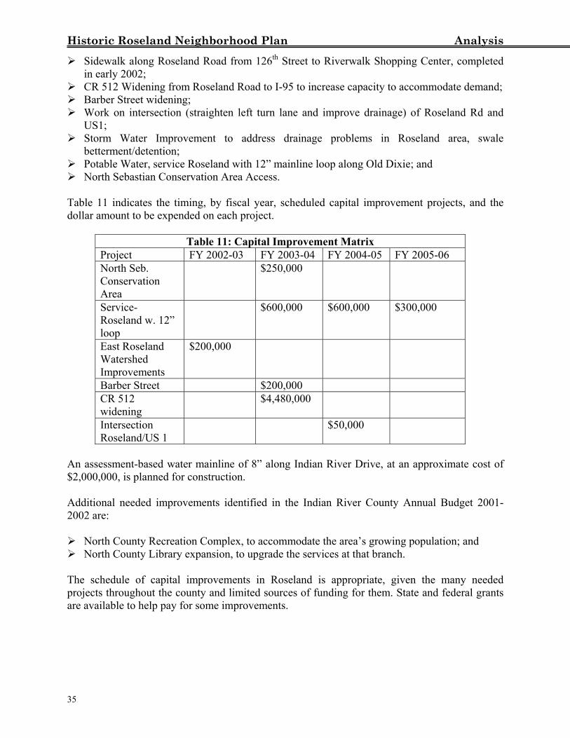
Table 11 indicates the timing, by fiscal year, scheduled capital improvement projects, and the dollar amount to be expended on each project.
Table 11: Capital Improvement Matrix Project FY 2002-03 FY 2003-04 FY 2004-05 FY 2005-06 North Seb. Conservation Area
$250,000
Service-Roseland w. 12” loop
$600,000 $600,000 $300,000
East Roseland Watershed Improvements
$200,000
Barber Street $200,000 CR 512 widening
$4,480,000
Intersection Roseland/US 1
$50,000
An assessment-based water mainline of 8” along Indian River Drive, at an approximate cost of $2,000,000, is planned for construction. Additional needed improvements identified in the Indian River County Annual Budget 2001-2002 are: North County Recreation Complex, to accommodate the area’s growing population; and North County Library expansion, to upgrade the services at that branch.
The schedule of capital improvements in Roseland is appropriate, given the many needed projects throughout the county and limited sources of funding for them. State and federal grants are available to help pay for some improvements.
35
Historic Roseland Neighborhood Plan Analysis
Summary Most roads in Roseland are not paved, and sidewalks are rare. Currently, the capital improvements schedule for Roseland is appropriate given the many other areas of the county that require improvements. Grants may enable the county to pay for capital improvements ahead of schedule, or add improvements not currently programmed. Roseland Corridor Plan In Roseland, the majority of commercial establishments are located along US 1. The segment of US 1 in Roseland is similar to US 1 in much of the county. Like other parts of US 1, Roseland’s segment of US 1 is characterized by extensive signage, unimaginative architecture, vast parking lots for large commercial uses, and minimal landscaping. These characteristics affect the aesthetic potential of the roadway. In the past, the County has implemented successful corridor plans in commercial areas in Wabasso and along State Route 60. Those corridor plans affect primarily commercial and industrial development and serve to enhance the appearance of those corridors. A corridor plan may be a useful tool to enhance the Roseland area. Since the Wabasso and State Route 60 corridor plan regulations pertain to commercial development, a corridor plan for the Roseland area should also regulate commercial development along US 1. Such a corridor plan, if adopted, would include both sides of US 1 north of the City of Sebastian city limits, and continue north along both sides of US 1 to the north county limit, and would also contain that portion of Roseland Road that is currently designated as commercial/industrial on the Future Land Use Map. The Roseland Corridor regulations would govern new commercial, institutional, and industrial developments inside the corridor boundaries and would include regulations pertaining to signage design, roofing, color, buffers, architectural design, and landscaping. These regulations will enhance the look and feel of the corridor. The corridor regulations would also apply to all new institutional use developments (such as churches) throughout the Roseland area. Preliminary results from the Roseland Quality of Life survey indicate that there is widespread support for corridor regulations for new multi-family, commercial and industrial development, but not for new single-family subdivisions. Summary
Development and implementation of a Roseland Corridor plan will enhance the appearance of Roseland’s streetscape and will make development more compatible with the historic character of the area.
36
Historic Roseland Neighborhood Plan Plan
NEIGHBORHOOD PLAN
The neighborhood plan component of the Roseland Neighborhood Plan identifies the Plan Goal, strategies to achieve the goal, and actions to be taken to implement the plan. As structured, the plan is results oriented, with specific actions programmed for implementation.
ROSELAND NEIGHBORHOOD PLAN GOAL The goal of the Roseland Neighborhood Plan is to maintain the quality of life in the Roseland area, preserve natural and historic resources, ensure compatibility of land uses, preserve the neighborhood as a safe community with well-maintained housing, and to ensure provision of adequate physical infrastructure. Roseland Neighborhood Plan Strategies For each major issue identified in the Analysis Section of this plan, an overall strategy has been developed. Each strategy provides an overall blueprint for addressing the issue and solving attendant problems. Associated with each strategy are objectives and actions. Roseland Plan Objectives and Actions While the strategies establish the general framework for addressing each issue, objectives associated with each strategy set reasonable accomplishments to be met by specified times. Related to each objective are actions to be undertaken by appropriate parties. These actions, when undertaken, should lead to the accomplishment of the objectives. Because the Roseland Neighborhood Plan is a coordinated effort among a number of groups, there are several governmental agencies/community organizations with responsibility for taking actions identified in the plan. These agencies/organizations will play a critical role throughout the implementation of the plan. Only through the coordinated efforts of these governmental agencies/community organizations can the plan’s objectives be met.
LAND USE AND ZONING
Land Use and zoning designations within Roseland are generally appropriate; therefore, these designations should be maintained. Because there is a sufficient amount of commercial/industrial land in Roseland, there is a need to ensure that the amount of commercial/industrial land in Roseland does not increase. That will be done through a county initiated comprehensive plan amendment limiting commercial/industrial land to those areas currently designated C/I. In order to enhance the appearance of commercial and industrial development in Roseland, the County will adopt a corridor plan that will provide design criteria for new commercial and industrial development along streets containing any commercial or industrial uses. Such streets include Gibson Street and US 1 in the Roseland area. These
37
Historic Roseland Neighborhood Plan Plan
criteria will address signage, roof material, color schemes, buffers, architectural design, building height, and landscaping. Objective 1: Land Use Amendments By 2005, the Future Land Use Map will depict an appropriate land use pattern for the Roseland area. Action 1.1: In January 2004, The County will initiate a Future Land Use Element amendment to “cap” the commercial/industrial boundaries in Roseland at their existing configurations, as depicted on Figure 2 of the Neighborhood Plan. Objective 2: Roseland Corridor Plan By 2010, streets adjacent to commercial and industrial lands in the Roseland area will have an improved appearance. Action 2.1: The County will amend its Land Development Regulations to adopt the Roseland Corridor Plan. Action 2.2: The County will appoint a Historic Roseland Architectural Review Committee to review proposed commercial and industrial projects in the corridor.
SURROUNDING LAND USES While Roseland is mostly surrounded by waterways or conservation land, there are publicly and privately owned properties abutting Roseland to the south where potentially incompatible land uses could develop. Of particular concern are industrial uses which could locate on airport land or adjacent privately owned industrial sites. Development of these industrial sites will affect the Roseland area. The major effects of this industrial development will be appearance, lighting, noise, and traffic. Most of these potential incompatibility problems can be addressed through site design, use restrictions, buffering, and landscaping. To address these issues, the County will coordinate with the City of Sebastian and work with the City to resolve compatibility issues along the Roseland/Sebastian interface. Objective 3: Compatibility/Buffering By 2010, there will be no land use incompatibilities between the City of Sebastian and Roseland. Action 3.1: The County will work cooperatively with the City of Sebastian to establish intergovernmental coordination procedures for the review and comment on rezonings, development projects, and land development regulation amendments in each jurisdiction. Action 3.2: County staff will meet with City of Sebastian staff to address potential development along the Roseland/Sebastian interface, identify expected impacts on each jurisdiction, and develop measures to mitigate those impacts.
38
Historic Roseland Neighborhood Plan Plan Action 3.3: The County will request that the City of Sebastian establish design, buffering, and landscaping criteria, using ‘cutting-edge’ design techniques, for airport industrial sites along Roseland Road to reduce impacts on surrounding residential areas. Action 3.4: County staff will meet with City of Sebastian staff to gather information about the city’s plans for possible future annexations and to establish a procedure for notification and review of annexation requests prior to final action by the City. Action 3.5: Notification of annexations given to the county by the City of Sebastian will be forwarded to the Friends of Historic Roseland and Friends of the St. Sebastian River.
ENVIRONMENT The County has implemented regulations that protect privately held environmentally sensitive lands, and has purchased several thousand acres of environmentally significant lands for conservation purposes. The County will continue to enforce its environmental regulations, and will continue to actively manage the conservation properties it has purchased. As part of its management activities, the County will improve public access to its conservation lands, while protecting the resource values of these properties. Objective 4: Access to Conservation Lands By 2005, the North Sebastian Conservation Area (NSCA) will be accessible to the general public. Action 4.1: The County will build parking areas and pedestrian walkways from Main Street to provide public access to the North Sebastian Conservation Area. Action 4.2: The County will implement its management plan for the North Sebastian Conservation Area. Action 4.3: The County will provide pedestrian access to the North Sebastian Conservation Area through Gibson Street. Action 4.4: The County will coordinate with City of Sebastian staff with regard to the management of conservation lands. The County, in conjunction with the City of Sebastian, will improve the NSCA for passive recreational use and maintain the conservation area, while the City of Sebastian will provide public safety services to the conservation area. Action 4.5: The County’s improvements to the parks in the Roseland area will ‘blend-in’ with the surrounding environment and will be compatible with the historical character of the area. Action 4.6: The County will, through incentives, encourage the use of native plants in landscaping for new development in the Roseland Corridor Plan.
39
Historic Roseland Neighborhood Plan Plan
HOUSING
A windshield survey and subsequent investigations by County Code Enforcement staff found that there are relatively few code violations in the Roseland area. To address those code violations, that do exist, County Code Enforcement staff, the Friends of Historic Roseland, and Roseland residents will need to work together.
Based on the windshield survey, there are only five substandard housing units in the Roseland area. To address substandard housing, the county will notify the owners of these units that resources are available through the County to rehabilitate these units. In this effort, the County’s role will be to provide funds for housing rehabilitation. Community groups, particularly the Friends of Historic Roseland, have a vital role. The community groups must work with the County to identify code violations, and work with residents to resolve these violations, inform Roseland residents of the county’s housing rehabilitation (SHIP) program, and encourage residents to participate in this program. Objective 5. Resolution of Code Violations By 2007, the percentage of residential properties in the Roseland area with code violations will be less than 1% of the total housing stock in Roseland. Action 5.1: County Code Enforcement Section staff will meet with the Friends of Historic Roseland association and area residents to disseminate information about property maintenance. Action 5.2: The Friends of Historic Roseland will promote property maintenance and neighborhood cooperation. Action 5.3: The County will consider adding additional Code Enforcement officers. Action 5.4: The County will increase its proactive (non-complaint initiated) code enforcement activities, especially in the north county area. Objective 6. Housing Rehabilitation By 2005, there will be no substandard residential units in Roseland. Action 6.1: The County will prepare an informational package about the County’s affordable housing program with respect to rehabilitation assistance. Copies of the package will be mailed to the homeowners of substandard residential units. Action 6.2: The Friends of Historic Roseland will distribute information about the County’s affordable housing rehabilitation program to Roseland residents at public meetings, churches, and civic events.
40
Historic Roseland Neighborhood Plan Plan
INFRASTRUCTURE Adequate infrastructure is important in every community. In the Roseland area, most streets are unpaved, and most residents do not have County centralized potable water nor sewer services. Currently, Roseland’s unpaved roads do not need to be paved because of the low traffic volume and slow growth in the area. According to the Roseland Quality of Life survey, most residents are not interested in paying for road paving or water/sewer connections. Nevertheless, the County public works department has programmed some infrastructural improvements in the Roseland area. Objective 7: Stormwater Management and Drainage By 2005, there will not be any significant flooding problems in the Roseland area for 10 year/24 hour storm events. Action 7.1: The County will undertake drainage improvements at the intersection of Roseland Road and US 1. Action 7.2: The County will undertake drainage improvements on Bay Street. Action 7.3: The County will improve drainage along 79th Avenue between 126th Street and 130th Street and will maintain the publicly owned portion of the Roseland Lake. Action 7.4: The County will maintain drainage at 129th Place and Roseland Road. Objective 8: Roadway and Sidewalk Improvements By 2010, there will be additional sidewalks and improved roadways in the Roseland area. Action 8.1: The Public Works Department will widen CR 512 from Roseland Road to I-95 to accommodate increased traffic. Action 8.2: The County will add a left turn lane from Roseland Road onto US 1. Action 8.3: The County will construct a sidewalk along Indian River Drive from the north City of Sebastian city limits to Roseland Road. Action 8.4: The County will investigate the possibility of providing a narrow sidewalk along Gibson Street between Roseland Road and the North Sebastian Conservation Area. Action 8.5: The County will construct a sidewalk along Roseland Road from US 1, east to Indian River Drive. Action 8.6: The County will construct a sidewalk along Roseland Road to County Road 512. Action 8.7: The County will investigate the availability of grants, apply for appropriate grants, and if awarded, will construct a ‘walkway’ along Bay Street to Moore’s Point.
41
Historic Roseland Neighborhood Plan Plan Objective 9: Provision of potable water. By 2010, County potable water service will be available east of U.S.1 in Roseland. Action 9.1: The County will extend a 12-inch diameter water mainline loop along Old Dixie. Action 9.2: The County will extend an 8-inch diameter water mainline along Indian River Drive. Objective 10: Solid Waste Disposal By 2010, the County transfer station at Gibson Street will be improved. Action 10.1: The County Solid Waste Disposal District will provide a landscape buffer using plants endemic to the Roseland area, with a six-foot opaque feature, for the Roseland transfer station at Gibson Street. Action 10.2: The Solid Waste Disposal District shall ensure that trash and debris will be managed at, and transferred from the transfer station in a way that does not create a hazard or litter the surrounding area. Action 10.3: The Friends of Historic Roseland, through neighborhood patrols, will identify vehicles conveying trash to the transfer station in a manner that allows trash to fall off and litter the surrounding area, and will report license plate numbers of those vehicles to the sheriff’s department.
Quality of Life
While Roseland residents currently enjoy a high quality of life, that quality of life can be further enhanced through various projects and programs to beautify Roseland and preserve its historic integrity.
Objective 11: Quality of Life By 2010, the Quality of Life in Roseland will have improved through a partnership between the Friends of Historic Roseland and the County. Action 11.1: The Friends of Historic Roseland will coordinate with the County’s Public Works department to restore the original street names in the Berry and Bay Street areas. When original concrete posts can be preserved, the street names will be displayed on these posts. Action 11.2: The Friends of Historic Roseland will coordinate with the appropriate federal, state, and local agencies to restore the original concrete posts along streets in Roseland. Action 11.3: The County will install benches along sidewalks when funding is available.
42
Historic Roseland Neighborhood Plan Plan Action 11.4: The County Parks Department will work cooperatively with The Friends of Historic Roseland to plant and maintain native vegetation in the vicinity of the Community Center and create a safe park area around the Community Center area. Action 11.5: The County and the Friends of Historic Roseland will cooperate to obtain grants to place historic markers in Roseland area parks in order to commemorate the presence of the Ais Indians in the Roseland area. Action 11.6: The County will allow historic identification signs in the Roseland area. Action 11.7: The Friends of Historic Roseland will work with the County Sheriff’s office to create a neighborhood crime watch program.
43
Historic Roseland Neighborhood Plan Plan
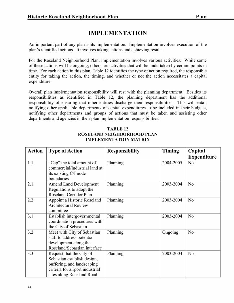
IMPLEMENTATION
An important part of any plan is its implementation. Implementation involves execution of the plan’s identified actions. It involves taking actions and achieving results. For the Roseland Neighborhood Plan, implementation involves various activities. While some of these actions will be ongoing, others are activities that will be undertaken by certain points in time. For each action in this plan, Table 12 identifies the type of action required, the responsible entity for taking the action, the timing, and whether or not the action necessitates a capital expenditure. Overall plan implementation responsibility will rest with the planning department. Besides its responsibilities as identified in Table 12, the planning department has the additional responsibility of ensuring that other entities discharge their responsibilities. This will entail notifying other applicable departments of capital expenditures to be included in their budgets, notifying other departments and groups of actions that must be taken and assisting other departments and agencies in their plan implementation responsibilities.
TABLE 12 ROSELAND NEIGHBORHOOD PLAN
IMPLEMENTATION MATRIX Action Type of Action Responsibility Timing Capital
Expenditure 1.1 “Cap” the total amount of
commercial/industrial land at its existing C/I node boundaries
Planning 2004-2005 No
2.1 Amend Land Development Regulations to adopt the Roseland Corridor Plan
Planning 2003-2004 No
2.2 Appoint a Historic Roseland Architectural Review committee
Planning 2003-2004 No
3.1 Establish intergovernmental coordination procedures with the City of Sebastian
Planning 2003-2004 No
3.2 Meet with City of Sebastian staff to address potential development along the Roseland/Sebastian interface
Planning Ongoing No
3.3 Request that the City of Sebastian establish design, buffering, and landscaping criteria for airport industrial sites along Roseland Road
Planning 2003-2004 No
44
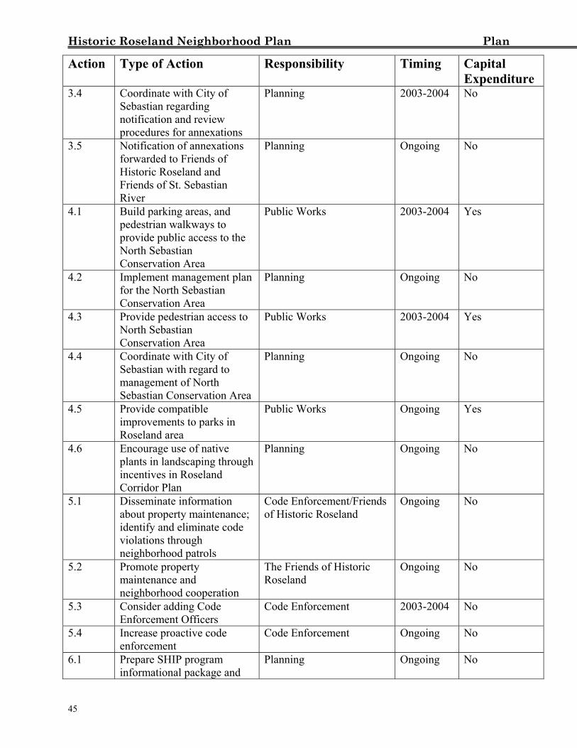
Historic Roseland Neighborhood Plan Plan
Action Type of Action Responsibility Timing Capital Expenditure
3.4 Coordinate with City of Sebastian regarding notification and review procedures for annexations
Planning 2003-2004 No
3.5 Notification of annexations forwarded to Friends of Historic Roseland and Friends of St. Sebastian River
Planning Ongoing No
4.1 Build parking areas, and pedestrian walkways to provide public access to the North Sebastian Conservation Area
Public Works 2003-2004 Yes
4.2 Implement management plan for the North Sebastian Conservation Area
Planning Ongoing No
4.3 Provide pedestrian access to North Sebastian Conservation Area
Public Works 2003-2004 Yes
4.4 Coordinate with City of Sebastian with regard to management of North Sebastian Conservation Area
Planning Ongoing No
4.5 Provide compatible improvements to parks in Roseland area
Public Works Ongoing Yes
4.6 Encourage use of native plants in landscaping through incentives in Roseland Corridor Plan
Planning Ongoing No
5.1 Disseminate information about property maintenance; identify and eliminate code violations through neighborhood patrols
Code Enforcement/Friends of Historic Roseland
Ongoing No
5.2 Promote property maintenance and neighborhood cooperation
The Friends of Historic Roseland
Ongoing No
5.3 Consider adding Code Enforcement Officers
Code Enforcement 2003-2004 No
5.4 Increase proactive code enforcement
Code Enforcement Ongoing No
6.1 Prepare SHIP program informational package and
Planning Ongoing No
45
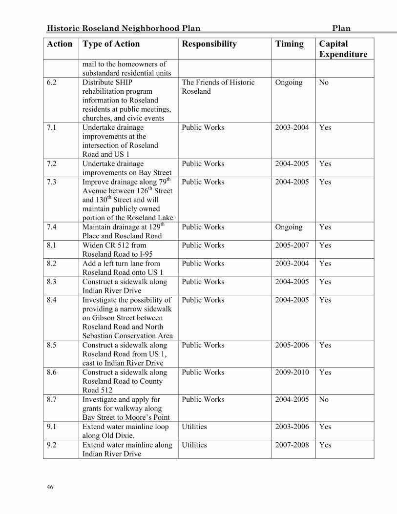
Historic Roseland Neighborhood Plan Plan
Action Type of Action Responsibility Timing Capital Expenditure
mail to the homeowners of substandard residential units
6.2 Distribute SHIP rehabilitation program information to Roseland residents at public meetings, churches, and civic events
The Friends of Historic Roseland
Ongoing No
7.1 Undertake drainage improvements at the intersection of Roseland Road and US 1
Public Works 2003-2004 Yes
7.2 Undertake drainage improvements on Bay Street
Public Works 2004-2005 Yes
7.3 Improve drainage along 79th Avenue between 126th Street and 130th Street and will maintain publicly owned portion of the Roseland Lake
Public Works 2004-2005 Yes
7.4 Maintain drainage at 129th Place and Roseland Road
Public Works Ongoing Yes
8.1 Widen CR 512 from Roseland Road to I-95
Public Works 2005-2007 Yes
8.2 Add a left turn lane from Roseland Road onto US 1
Public Works 2003-2004 Yes
8.3 Construct a sidewalk along Indian River Drive
Public Works 2004-2005 Yes
8.4 Investigate the possibility of providing a narrow sidewalk on Gibson Street between Roseland Road and North Sebastian Conservation Area
Public Works 2004-2005 Yes
8.5 Construct a sidewalk along Roseland Road from US 1, east to Indian River Drive
Public Works 2005-2006 Yes
8.6 Construct a sidewalk along Roseland Road to County Road 512
Public Works 2009-2010 Yes
8.7 Investigate and apply for grants for walkway along Bay Street to Moore’s Point
Public Works 2004-2005 No
9.1 Extend water mainline loop along Old Dixie.
Utilities 2003-2006 Yes
9.2 Extend water mainline along Indian River Drive
Utilities 2007-2008 Yes
46
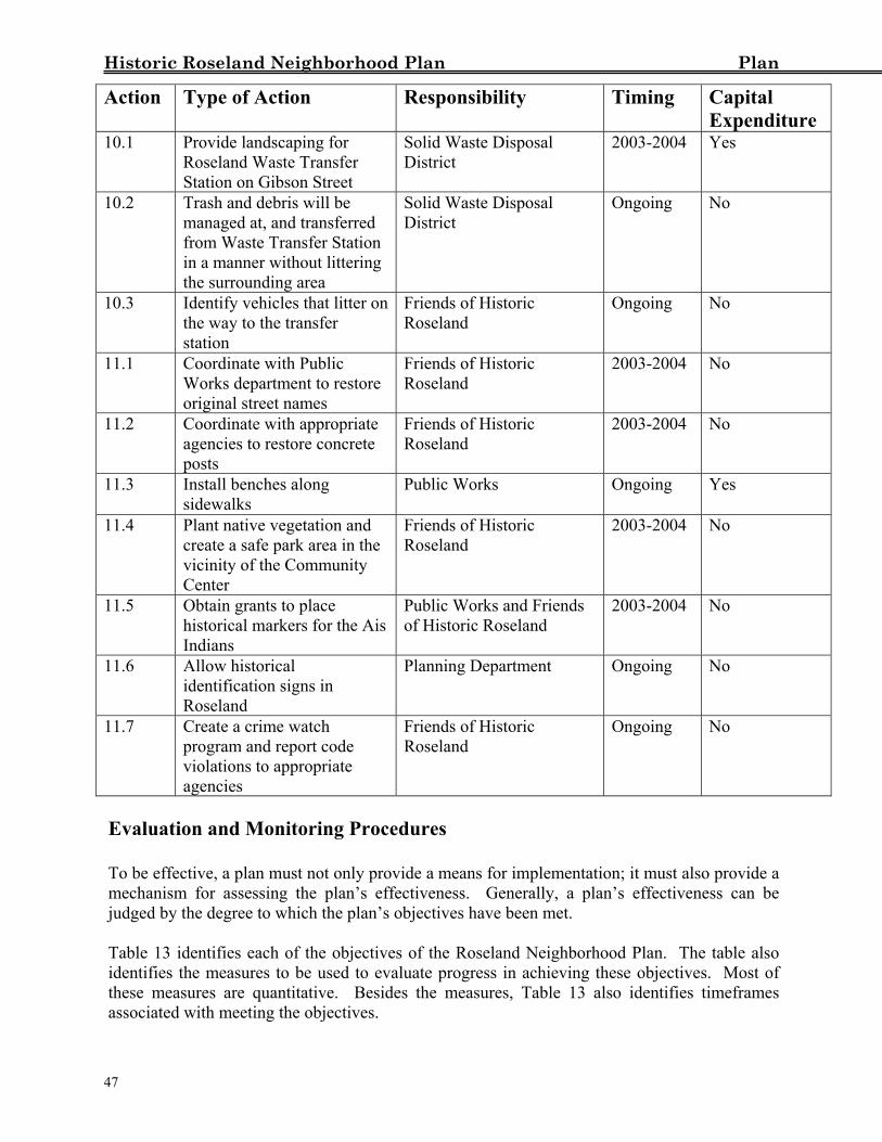
Historic Roseland Neighborhood Plan Plan
Action Type of Action Responsibility Timing Capital Expenditure
10.1 Provide landscaping for Roseland Waste Transfer Station on Gibson Street
Solid Waste Disposal District
2003-2004 Yes
10.2 Trash and debris will be managed at, and transferred from Waste Transfer Station in a manner without littering the surrounding area
Solid Waste Disposal District
Ongoing No
10.3 Identify vehicles that litter on the way to the transfer station
Friends of Historic Roseland
Ongoing No
11.1 Coordinate with Public Works department to restore original street names
Friends of Historic Roseland
2003-2004 No
11.2 Coordinate with appropriate agencies to restore concrete posts
Friends of Historic Roseland
2003-2004 No
11.3 Install benches along sidewalks
Public Works Ongoing Yes
11.4 Plant native vegetation and create a safe park area in the vicinity of the Community Center
Friends of Historic Roseland
2003-2004 No
11.5 Obtain grants to place historical markers for the Ais Indians
Public Works and Friends of Historic Roseland
2003-2004 No
11.6 Allow historical identification signs in Roseland
Planning Department Ongoing No
11.7 Create a crime watch program and report code violations to appropriate agencies
Friends of Historic Roseland
Ongoing No
Evaluation and Monitoring Procedures To be effective, a plan must not only provide a means for implementation; it must also provide a mechanism for assessing the plan’s effectiveness. Generally, a plan’s effectiveness can be judged by the degree to which the plan’s objectives have been met. Table 13 identifies each of the objectives of the Roseland Neighborhood Plan. The table also identifies the measures to be used to evaluate progress in achieving these objectives. Most of these measures are quantitative. Besides the measures, Table 13 also identifies timeframes associated with meeting the objectives.
47
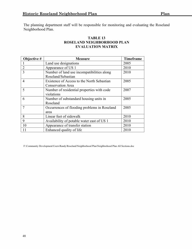
Historic Roseland Neighborhood Plan Plan
48
The planning department staff will be responsible for monitoring and evaluating the Roseland Neighborhood Plan.
TABLE 13
ROSELAND NEIGHBORHOOD PLAN EVALUATION MATRIX
Objective # Measure Timeframe 1 Land use designations 2005 2 Appearance of US 1 2010 3 Number of land use incompatibilities along
Roseland/Sebastian 2010
4 Existence of Access to the North Sebastian Conservation Area
2005
5 Number of residential properties with code violations
2007
6 Number of substandard housing units in Roseland
2005
7 Occurrences of flooding problems in Roseland area
2005
8 Linear feet of sidewalk 2010 9 Availability of potable water east of US 1 2010 10 Appearance of transfer station 2010 11 Enhanced quality of life 2010
F:\Community Development\Users\Randy\Roseland\Neighborhood Plan\Neighborhood Plan All Sections.doc


![[10 on Tuesday] How to Save Your Historic Neighborhood School](https://img.pdfslide.net/doc/110x75/55a4102d1a28ab343d8b4821/10-on-tuesday-how-to-save-your-historic-neighborhood-school.jpg)

