Embed Size (px)
Citation preview

Historical Analysis of Montañita, Ecuador for April 6-14 and March 16-24
Prepared for the ISA by Mark Willis and the Surfline Forecast and Science Teams
Figure 1. Perfect Right-‐hander at Montañita, Ecuador on February 23, 2012. Photo: Jon Steele.
FINAL CONCLUSION: We recommend March 16-‐24 over April 6-‐14.
Detailed Analysis and Supportive Evidence For Our Recommendation
1. Introduction Montañita is a very popular surfing destination on the Pacific Coast of Ecuador highlighted by a consistent right point break that produces rideable surf almost year round. The consistency is due to its wide exposure to storms in both the South and North Pacific.

The International Surfing Association (ISA) requested Surfline to perform a historical analysis of swell, wind, and weather conditions at Montañita to determine if the dates of April 6-14 or March 16-24 would be better to hold the 2013 ISA World Masters Surfing Championships. To determine the better of these two time frames, Surfline used our archived LOLA Wavewatch III wave model data with a data point located just off the coast of Montañita at 2.0 South latitude, 81.0 West longitude. In addition, Surfline also utilized the NOAA NCEP/NCAR Reanalysis dataset that allowed us to further analyze the climatology of wind and weather patterns from 1981-2010 (Kalnay and coauthors, 1996).
Figure 2. Map showing Montañita and LOLA Data Point used for this study.
2. Seasonal Swell, Wind, and Weather Overview
Swell. The approximate swell window for Montañita is between 215 and 330 degrees. Swell directions south of 215 begin to get shadowed by the point near Salinas, west of La Libertad. Longer period swells with more south in the direction will likely refract in, but with less energy. Swells with directions north of 330 are shadowed by Isla Salango and Isla La Plata to the north. Longer period swells from more northerly directions are unlikely due to the absence of significant storm activity in the tropical east Pacific this

time of year. In addition, directions between 270-280 degrees are mostly shadowed by the Galapagos Islands to the west. We filtered these directions in our internal climate system to optimize the results for this study. In addition, we also filtered out swells with heights less than 3ft and periods less than 13 seconds to identify the times with the best potential for good surf. On a seasonal scale, our results revealed that the most consistent time to receive swells that satisfy the criteria specified above is December through March, with February being the most consistent month during that time frame. The consistency probabilities for swells during the months of March and April that meet or exceed these criteria are 57 and 47 percent, respectively.
Figure 3. Monthly swell height consistency probabilities for periods greater than 12s, heights greater than 2ft, and directions between 210 and 330 degrees.
In addition, we notice that the average swell direction gradually gains more of a southerly component during the February through May timeframe. This is to be expected as we transition out of the boreal (Northern Hemisphere) winter months, when North Pacific storm activity is at its peak, and into the boreal summer months when swells with a predominant southerly direction begins to take over, thanks to the active South Pacific storm track during this time. Specifically, the average swell directions for the months of March and April are 229 and 219 degrees, respectively.
Figure 4. Average swell directions by month for waves with periods greater than 12s, heights greater than 2ft, and directions between 210 and 330 degrees.

Wind. Like most surf breaks, Montañita prefers either light winds (less than 6kts) or offshore winds. Straight offshore winds are out of the NE to ENE. However, the exact offshore direction varies depending where you are located along the point and how the wave refracts into the beach, which depends on swell direction and period. Regardless, for the purpose of this study, we assume that either light winds or winds that contain an east component are favorable, except directions south of 130 degrees. This portion of the tropical East Pacific is often dominated by a relatively weak surface pressure pattern during most months since it is located so close to the Equator. The general climatological weather pattern that leads to this is high pressure just west of Chile, low pressure around the Intertropical Convergence Zone (ITCZ) to the north, and a semi-persistent trough of low pressure that extends NW to SE off the coast of Ecuador and Peru. This typically leads to light winds that have a southerly direction. Winds are often influenced by the temperature difference between the land and sea that leads to periods of light and variable to light offshore winds in the mornings, and light onshore winds in the afternoon and evening hours.
Figure 5. Average wind directions and speeds in the Eastern Pacific. Rough
positions of high and low-‐pressure systems are labeled. Black star is Montañita.
However, we have identified some important details in the seasonal wind patterns that influence the surf. One thing of significance that stood out to us was that the average
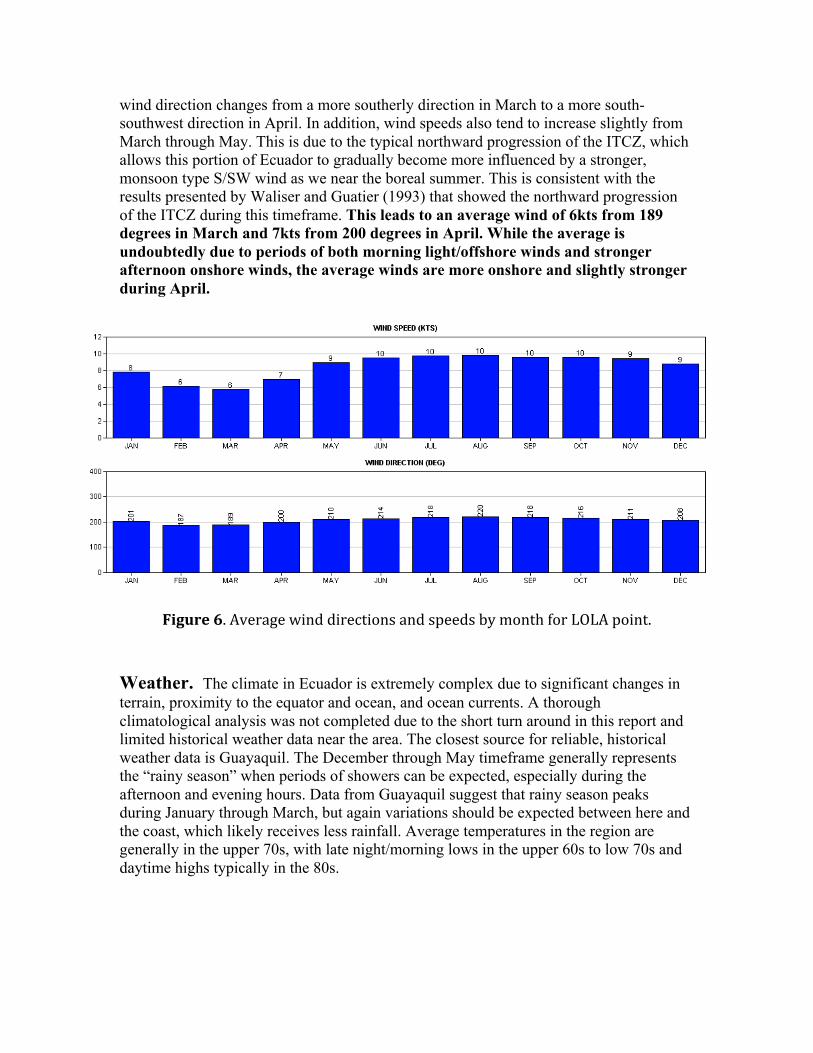
wind direction changes from a more southerly direction in March to a more south-southwest direction in April. In addition, wind speeds also tend to increase slightly from March through May. This is due to the typical northward progression of the ITCZ, which allows this portion of Ecuador to gradually become more influenced by a stronger, monsoon type S/SW wind as we near the boreal summer. This is consistent with the results presented by Waliser and Guatier (1993) that showed the northward progression of the ITCZ during this timeframe. This leads to an average wind of 6kts from 189 degrees in March and 7kts from 200 degrees in April. While the average is undoubtedly due to periods of both morning light/offshore winds and stronger afternoon onshore winds, the average winds are more onshore and slightly stronger during April.
Figure 6. Average wind directions and speeds by month for LOLA point. Weather. The climate in Ecuador is extremely complex due to significant changes in terrain, proximity to the equator and ocean, and ocean currents. A thorough climatological analysis was not completed due to the short turn around in this report and limited historical weather data near the area. The closest source for reliable, historical weather data is Guayaquil. The December through May timeframe generally represents the “rainy season” when periods of showers can be expected, especially during the afternoon and evening hours. Data from Guayaquil suggest that rainy season peaks during January through March, but again variations should be expected between here and the coast, which likely receives less rainfall. Average temperatures in the region are generally in the upper 70s, with late night/morning lows in the upper 60s to low 70s and daytime highs typically in the 80s.

Figure 7. Average precipitation by month for Guayaquil.
3. Daily Swell and Wind Analysis April 6-14. The consistency for meeting the same criteria discussed in section 2 (directions between 210 and 330 degrees, wave heights greater than 2ft, and periods greater than 12s) ranges from a low on April 12 of 29% to a high of 64% percent on April 6, 7, 8, and 10. The average daily consistency for these criteria being met throughout the period is 52%. That means that the average daily chance of getting appreciable surf during this period of shoulder high or greater is roughly 52%. The average dominant wave direction during this time is 219 degrees. The average wave height at the LOLA point during this time is 5.55 ft. The average wind direction is 195 degrees at 6.7kts.
Figure 8. Percentage of time the wave criteria discussed in the text is met or exceeded by day. Daily average for April dates is 52%.
March 16-24. The consistency for meeting the above wave criteria for this period ranges from a low on March 20 of 57% and a high on March 17, 18, and 23 of 86%. The average daily consistency for these criteria being met is 75%. That means that the
0
5
10
15
J F M A M J J A S O N D
Average Precipitation at Guayaquil (Inches)

average daily chance of getting appreciable surf during this period of shoulder high or greater is roughly 75%. The average dominant wave direction during this time is 222 degrees. The average wave height at the LOLA point during this time is roughly 5ft. The average wind direction is 185 degrees at 7.4kts.
Figure 9. Same as in Figure 8. Daily average for March dates is 75%. 4. Conclusions While the dates in this study are fairly close, there is enough evidence that supports us recommending March 16-24 over April 6-14. The consistency probabilities for appreciable surf during the March dates are significantly higher, the average wave direction has more west in it which is better for Montañita, and the average wind direction is more southerly suggesting more time with light and variable winds or offshore flow especially in the mornings. The only negative factors we found were that the average offshore wave heights were slightly higher during April and the average precipitation in April appears to be lower. However, we do not think these reasons are significant enough to sway the decision. In addition, the seasonal evidence from a longer-term climate perspective (as presented in section 2) also overwhelmingly supports a March contest over an April contest. 5. References
1. Kalnay, E. and Coauthors, 1996: The NCEP/NCAR Reanalysis 40-year Project. Bull. Amer. Meteor. Soc., 77, 437-471.
2. Waliser, D. and Guatier, C, 1993: A Satellite-derived Climatology of the ITCZ. Journal of Climate, 6, 2162-2174.