Embed Size (px)
Citation preview

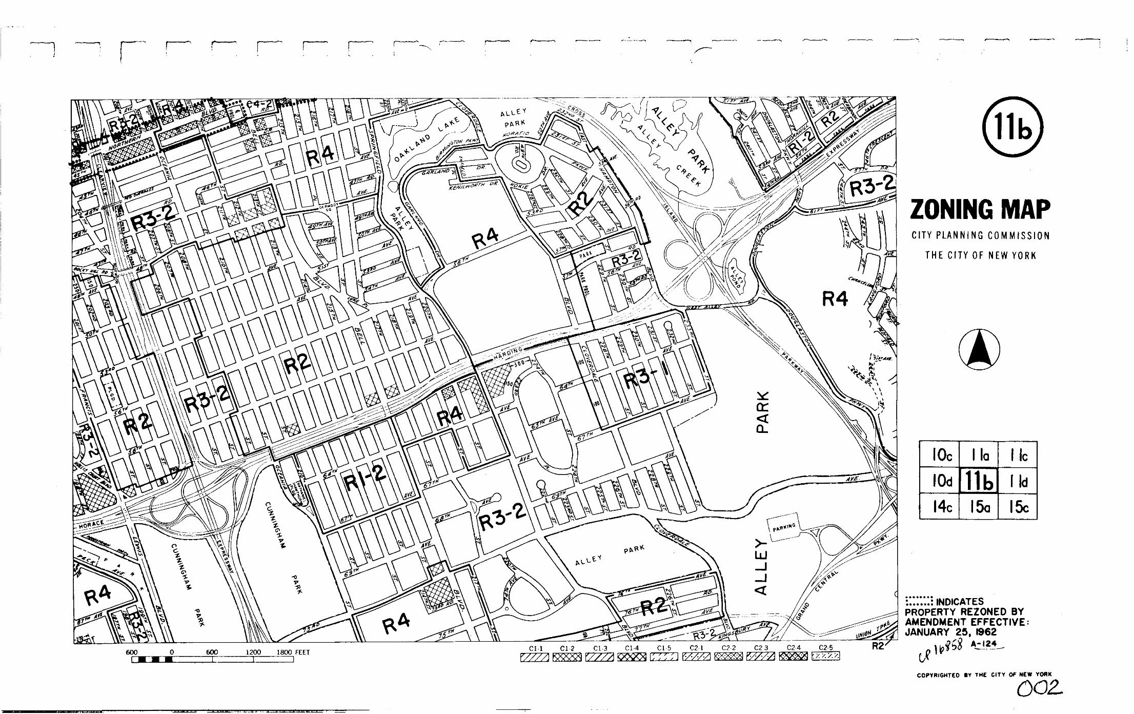

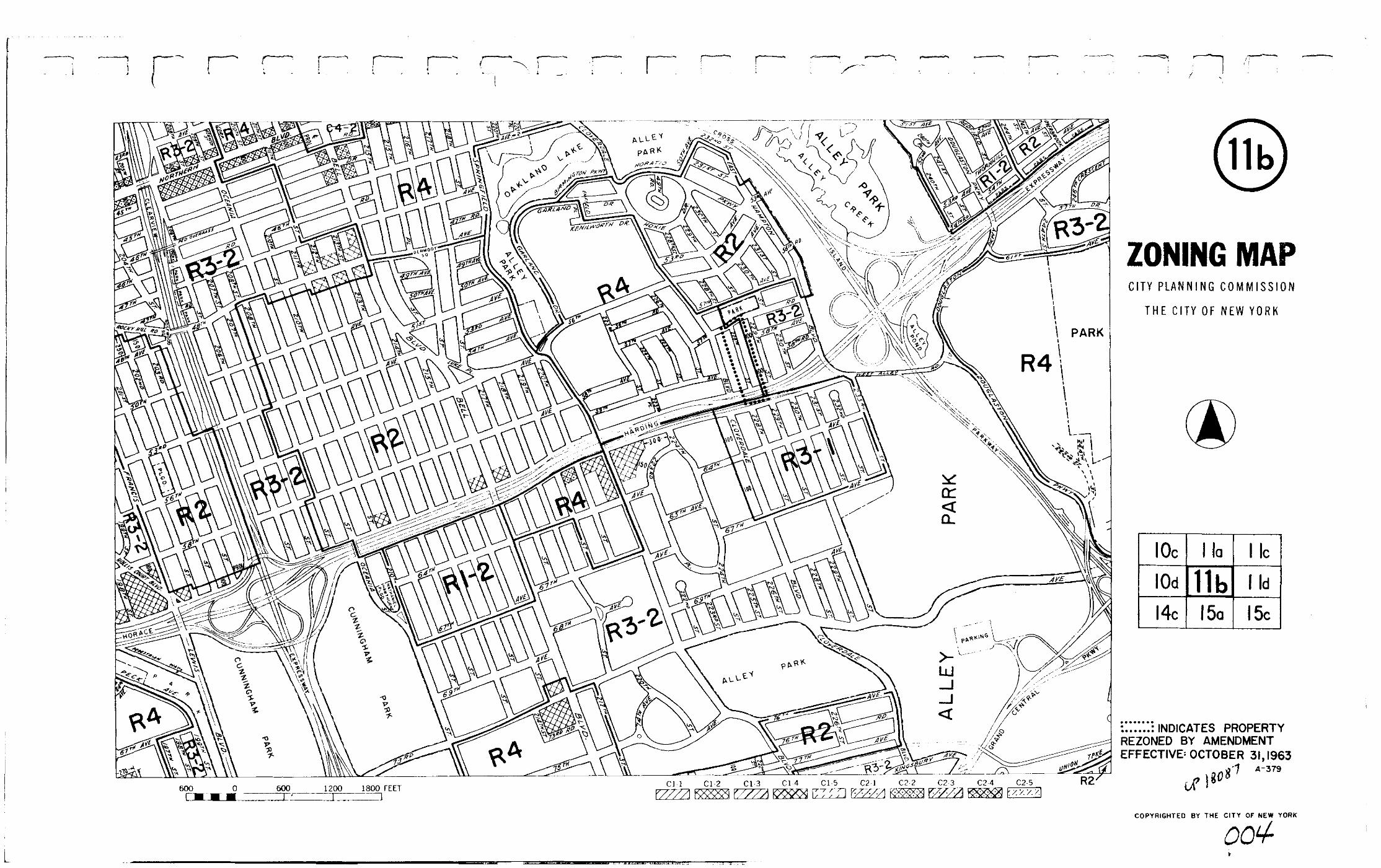

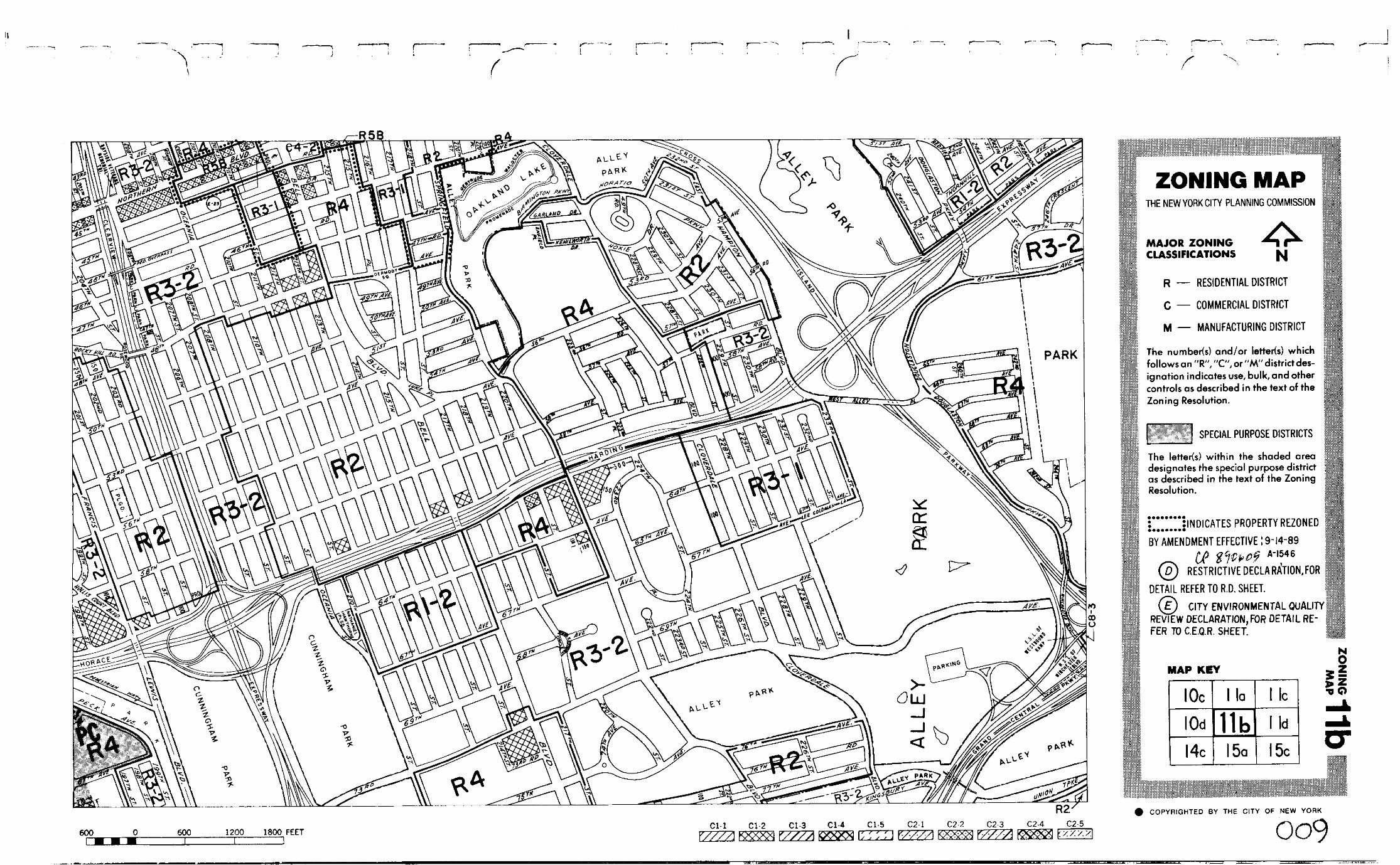


11b
10c 11a 11c
11d
15c15a14c
10d
11bZ
ON
ING
MA
P
MAP KEY
Copyrighted by the City of New Yorkc
ZONING MAPTHE NEW YORK CITY PLANNING COMMISSION
D
E
R, C M
NOTE: Zoning information as shown on this map is subject tochange. For the most up-to-date zoning information for this mapcheck the Department of City Planning website:http://www.nyc.gov/html/dcp/html/subcats/zoning.htmlor contact the Zoning Information Desk at (212) 720-3291.NOTE: Where no dimensions for zoning district boundaries appear on the zoning maps, such dimensions are determined
600 0 600 1200 1800 FEET C1-1 C1-2 C1-3 C1-4 C1-5 C2-1 C2-2 C2-3 C2-4 C2-5
R2A
R3-1R4
R2A
R4B
R2A
ST.
ST.
ST.
100
ROSEWOOD
ROCKY HILL RD.
100
100
100
100
AVE.
ST. R3-1R3AO
CEANIA
100100
R3-2
R3X
205 TH
R3-1
SQ.
SPRINGFIELDCL
CL
CL
CL
70
100
350
100
100

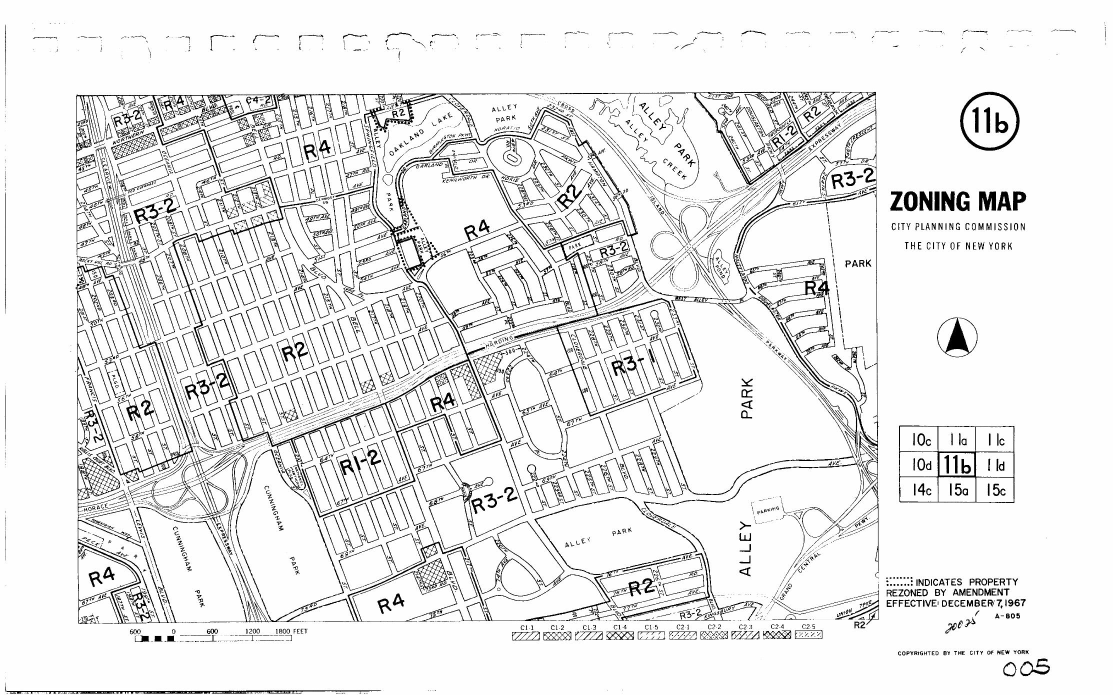
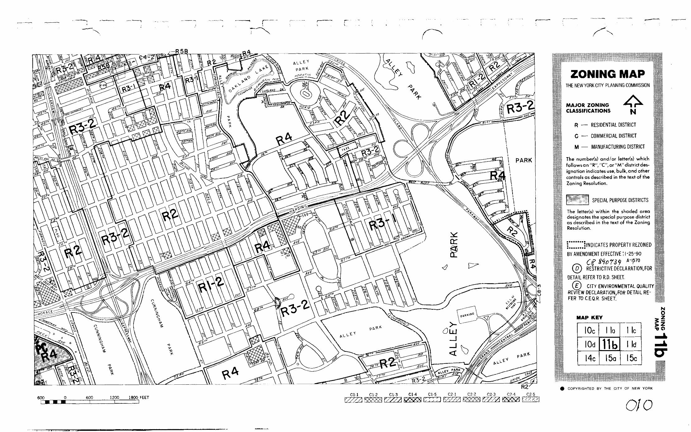
11b
10c 11a 11c
11d
15c15a14c
10d
11bZ
ON
ING
MA
P
MAP KEY
Copyrighted by the City of New Yorkc
ZONING MAPTHE NEW YORK CITY PLANNING COMMISSION
D
E
R, C M
NOTE: Zoning information as shown on this map is subject tochange. For the most up-to-date zoning information for this mapcheck the Department of City Planning website:http://www.nyc.gov/html/dcp/html/subcats/zoning.htmlor contact the Zoning Information Desk at (212) 720-3291.NOTE: Where no dimensions for zoning district boundaries appear on the zoning maps, such dimensions are determined
in Article VII, Chapter 6 (Location of District Boundaries) of the Zoning Resolution.
600 0 600 1200 1800 FEET C1-1 C1-2 C1-3 C1-4 C1-5 C2-1 C2-2 C2-3 C2-4 C2-5
R2A
R3-1R4
R2A
R4B
R2A
ST.
ST.
ST.
100
ROSEWOOD
ROCKY HILL RD.
100
100
100
100
AVE.
ST. R3-1R3AO
CEANIA
100100
R3-2
R3X
205 TH
R3-1
SQ.
SPRINGFIELDCL
CL
CL
CL
70
100
350
100
100
DR.
10054090
PROL.
R2A
R3X
ST.
R3-2
248 TH
OVERBROOK
ST.
57TH
244 TH
ST.
245 TH
ST.
R2A
R2

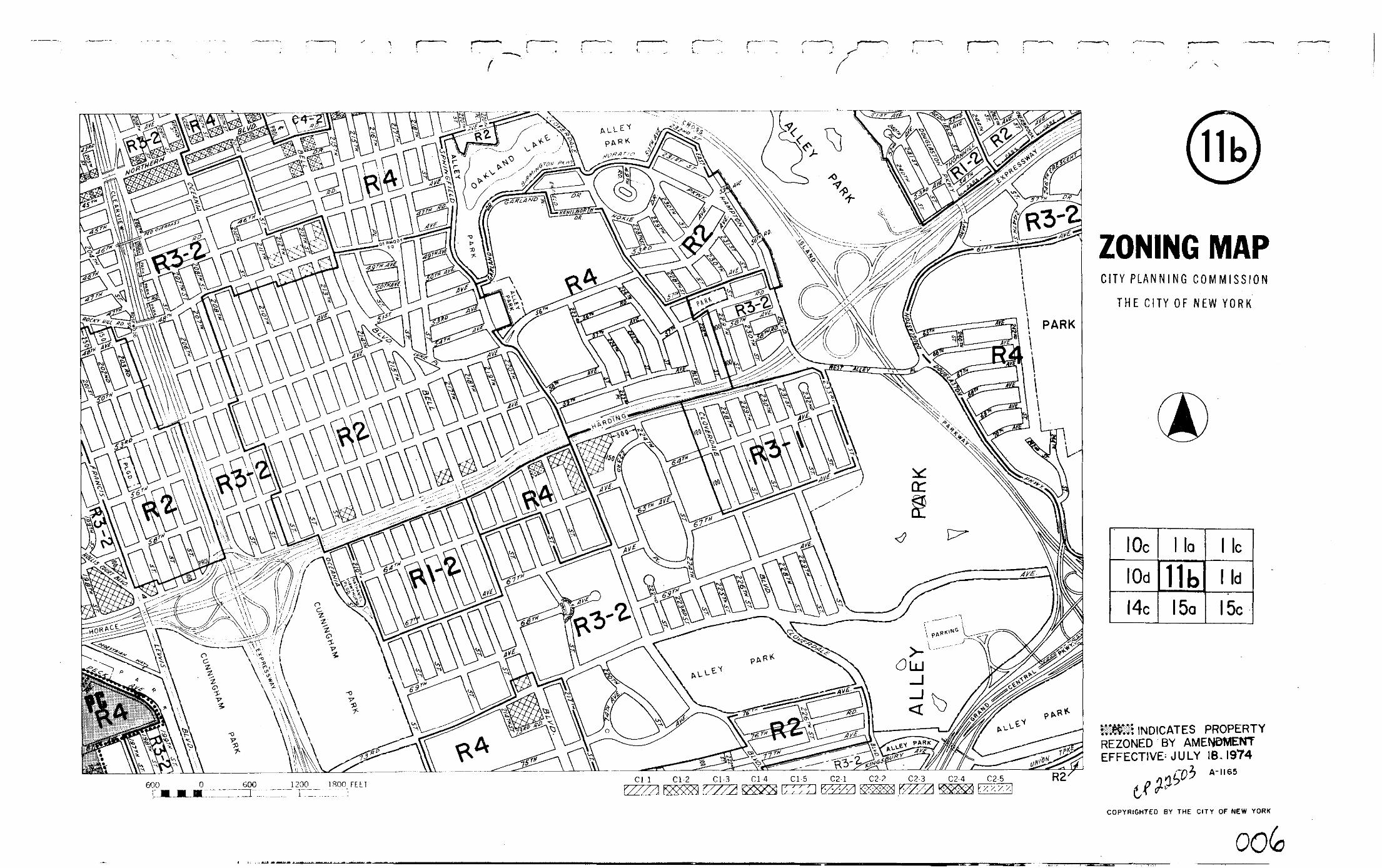
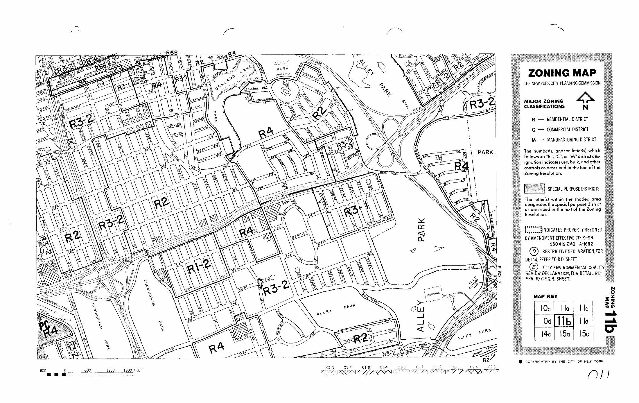
11b
10c 11a 11c
11d
15c15a14c
10d
11bZ
ON
ING
MA
P
MAP KEY
Copyrighted by the City of New Yorkc
R2A
R3-1 R4
R2A
R4B
R2A
ST.
ST.
ST.
100
ROSEWOOD
ROCKY HILL RD.
100
100
100
100
AVE.
ST. R3-1R3AO
CEANIA
100100
R3-2
R3X
205TH
R3-1
SQ.
SPRINGFIELDCL
CL
70
100
350
100
100
DR.
10054090
PROL.
R2A
R3X
ST.
R3-2
248 TH
OVERBROOK
ST.
57TH
244 TH
ST.
245 TH
ST.
R2A
R2
NOTE: Zoning information as shown on this map is subject tochange. For the most up-to-date zoning information for this map,visit the Zoning section of the Department of City Planning website:www.nyc.gov/planning or contact the Zoning Information Desk at(212) 720-3291.NOTE: Where no dimensions for zoning district boundaries appear on the zoning maps, such dimensions are determined
in Article VII, Chapter 6 (Location of District Boundaries) of the Zoning Resolution.
600 0 600 1200 1800 FEET C1-1 C1-2 C1-3 C1-4 C1-5 C2-1 C2-2 C2-3 C2-4 C2-5
R2A
R3X
R4-1
R3-1
R1-2A
R5
100
100100
175
120
R3-2
R4-1
CL
CL
R3XAVE.
100
100
150
CL
CLR3-1
R2A
100
150
100
R3-1140
CL
100
100
ST.
198 TH
100BLVD.
PROL.
CL
CL
CL
CL
470
CL
CL
100
R3X
R4
48TH
69TH
AVE.
120
HOLLIS COURT
203 RD
ST.
ZONING MAPTHE NEW YORK CITY PLANNING COMMISSION
R
C
M
R, C M
ST.
BLVD.

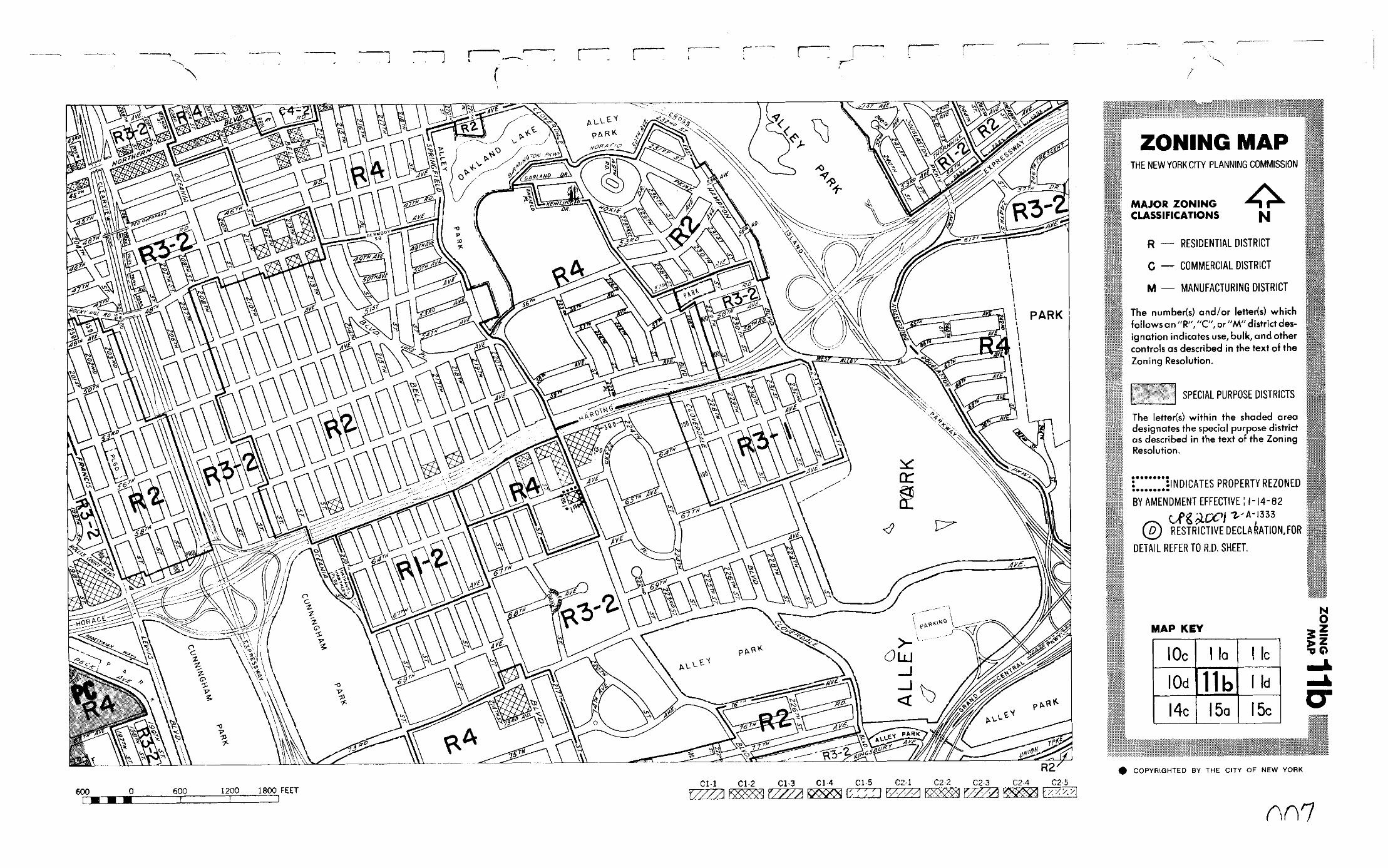
PC 11b
10c 11a 11c
11d
15c15a14c
10d
11bZ
ON
ING
MA
P
MAP KEY
N
Copyrighted by the City of New Yorkc
R2A
R3-1 R4
R2A
R4B
R2A
ST.
ST.
ST.
100
ROSEWOOD
ROCKY HILL RD.
100
100
100
100
AVE.
ST. R3-1R3AO
CEAN
IA
100100
R3-2
R3X
205 TH
R3-1
SQ.
SPRINGFIELDCL
CL
70
100
350
100
100
DR.
10054090
PROL.
R2A
R3X
ST.
R3-2
248 TH
OVERBROOK
ST.
57TH
244 TH
ST.
245 TH
ST.
R2A
R2
NOTE: Zoning information as shown on this map is subject tochange. For the most up-to-date zoning information for this map,visit the Zoning section of the Department of City Planning website:www.nyc.gov/planning or contact the Zoning Information Desk at(212) 720-3291.NOTE: Where no dimensions for zoning district boundaries appear on the zoning maps, such dimensions are determined
in Article VII, Chapter 6 (Location of District Boundaries) of the Zoning Resolution.
600 0 600 1200 1800 FEET C1-1 C1-2 C1-3 C1-4 C1-5 C2-1 C2-2 C2-3 C2-4 C2-5
R2A
R3X
R4-1
R3-1
R1-2A
R5
100
100100
175
120
R3-2
R4-1
CL
CL
R3XAVE.
100
100
150
CL
CLR3-1
R2A
100
150
100
R3-1140
CL
100
100
ST.
198 TH
100BLVD.
PROL.
CL
CL
CL
CL
470
CL
CL
100
R3X
R4
48TH
69TH
AVE.
120
HOLLIS COURT
203 RD
ST.
ZONING MAPTHE NEW YORK CITY PLANNING COMMISSION
Major Zoning Classifications:The number(s) and/or letter(s) that follows
use, bulk and other controls as describedin the text of the Zoning Resolution.
- RESIDENTIAL DISTRICT
- COMMERCIAL DISTRICT
- MANUFACTURING DISTRICT
AREA(S) REZONED
R
C
M
an or District designation indicatesR, C M
{\C256;For Inclusionary Housing designated areas on this map, see APPENDIX F.\~\fCalibri|b0|i0|c0|p34;\C167;\c8210719;\~ }{\C256;For a list of lots subject to "D" restrictive declarations, see APPENDIX D.}{\C256;For a list of lots subject to CEQR environmental requirements, see APPENDIX C.}
{\Fromans|c0;06-24-2013 C 130188 ZMQ}
Special Requirements:
Effective Date(s) of Rezoning:
SPECIAL PURPOSE DISTRICTThe letter(s) within the shadedarea designates the special purposedistrict as described in the textof the Zoning Resolution.
ST.
BLVD.
R2A

PC 11b
10c 11a 11c
11d
15c15a14c
10d
11bZ
ON
ING
MA
P
MAP KEY
N
Copyrighted by the City of New Yorkc
R2A
R3-1 R4
R2A
R4B
R2A
ST.
ST.
ST.
100
ROSEWOOD
ROCKY HILL RD.
100
100
100
100
AVE.
ST. R3-1R3AO
CEAN
IA
100100
R3-2
R3X
205TH
R3-1
SQ.
SPRINGFIELDCL
CL
70
100
350
100
100
DR.
10054090
PROL.
R2A
R3X
ST.
R3-2
248 TH
OVERBROOK
ST.
57TH
244 TH
ST.
245 TH
ST.
R2A
R2
NOTE: Zoning information as shown on this map is subject tochange. For the most up-to-date zoning information for this map,visit the Zoning section of the Department of City Planning website:www.nyc.gov/planning or contact the Zoning Information Desk at(212) 720-3291.NOTE: Where no dimensions for zoning district boundaries appear on the zoning maps, such dimensions are determined
in Article VII, Chapter 6 (Location of District Boundaries) of the Zoning Resolution.
600 0 600 1200 1800 FEET C1-1 C1-2 C1-3 C1-4 C1-5 C2-1 C2-2 C2-3 C2-4 C2-5
R2A
R3X
R4-1
R3-1
R1-2A
R5
100
100100
175
120
R3-2
R4-1
CL
CL
R3XAVE.
100
100
150
CL
CL R3-1
R2A
100
150
100
R3-1140
CL
100
100
ST.
198 TH
100BLVD.
PROL.
CL
CL
CL
CL
470
CL
CL
100
R3X
R4
48TH
69TH
AVE.
120
HOLLIS COURT
203 RD
ST.
ZONING MAPTHE NEW YORK CITY PLANNING COMMISSION
Major Zoning Classifications:The number(s) and/or letter(s) that follows
use, bulk and other controls as describedin the text of the Zoning Resolution.
- RESIDENTIAL DISTRICT
- COMMERCIAL DISTRICT
- MANUFACTURING DISTRICT
AREA(S) REZONED
R
C
M
an or District designation indicatesR, C M
{\C256;For Inclusionary Housing designated areas on this map, see APPENDIX F.\~\fCalibri|b0|i0|c0|p34;\C167;\c8210719;\~ }{\C256;For a list of lots subject to "D" restrictive declarations, see APPENDIX D.}{\C256;For a list of lots subject to CEQR environmental requirements, see APPENDIX C.}
{\Fromans|c0;08-22-2013 C 130170 ZMQ}
Special Requirements:
Effective Date(s) of Rezoning:
SPECIAL PURPOSE DISTRICTThe letter(s) within the shadedarea designates the special purposedistrict as described in the textof the Zoning Resolution.
ST.
BLVD.
R2A
R4R3-2
LPROL.C
R4
{\Fromans|c0;06-24-2013 C 130188 ZMQ}

Metadata for Historical Zoning Maps:
Source:These PDF maps were created from the set of past versions of each of the 126 zoning maps in the Technical Review Division’s archive. This set includes map versions for each zoning map beginning with the original 1961 issue of the Zoning Resolution and ending with the current zoning map as posted in the Zoning section of the Department of City Planning website: www.nyc.gov/planning. Scanning and Creation of Adobe PDF copies:Maps in this archive from 1961 through Update #2 of the Zoning Resolution in 2003 are scans of actual printed zoning map. From Update #3 (2005) onwards, maps are direct PDF copies of the map revisions as printed in updates to the Zoning Resolution.
Notes on conversion of Amendment Numbers to CP (City Planning) or ULURP numbers:On earlier zoning maps, an Amendment Number (e.g. A-629) is used to identify the area that has been rezoned. Commission reports and sketch maps for rezonings are referenced solely by CP or ULURP numbers. In order to request copies of reports or sketch maps it is necessary to know the CP or ULURP number. A conversion table (ANumber-CPNumberConversion.pdf) is available to translate the “A” numbers listed on the actual zoning maps to their corresponding CP or ULURP numbers. Use of the Amendment Number to identify zoning map changes has been discontinued.
Copyright:These maps are copyrighted by the City of New York. This is indicated in the space below the map legend on each map.
Contact Info:NYC Department of City Planning22 Reade Street, RM 3NNew York, NY 10007212.720.3505 [email protected]
revised 02/11/11