Embed Size (px)
Citation preview


Home > Aquatic Ecosystem Health
Are Our Aquatic Ecosystems Healthy?
California has many types of aquatic habitats. Follow the links below to learn more….
ESTUARIESEstuaries are unique habitats found where rivers and the ocean mix. They feature a diverse array of plants and animals that are adapted to life along this mixing zone. More >>
LAKES California lakes, supporting deep water, wetlands, riparian woodlands, offer a quiet refuge for plants, animals and humans alike. More >>
STREAMSCalifornia's streams and rivers flow through diverse habitats, from mountain canyons, valleys, deserts, estuaries and urban areas. Riparian woodlands develop along stream banks and floodplains, linking forest, chaparral, scrubland, grassland, and wetlands. More>>
OCEANCalifornia has 1,100 miles of shoreline and 220,000 square miles of state and federal oceanic habitat, featuring one of the world's most diverse marine ecosystems. More>>
WETLANDSWetlands form along the shallow margins of deepwater ecosystems such as lakes, estuaries, and rivers. They also form in upland settings where groundwater or runoff makes the ground too wet for upland vegetation.More>>
Eating Fish and Shellfish
Aquatic Ecosystem Health
Estuaries I Lakes l Streams and Rivers l Ocean l Wetlands
Aquatic Health Links
→Stressors
→Laws, Regulations, Standards, and Guidelines
→Regulatory Activities
→Enforcement Actions
→Research
→Monitoring Programs, Data Sources and Reports

This is your portal to the wonderful world of California wetlands. The purpose of the Wetland Tracker is to provide the pubic information on the quantity and quality of California wetlands.
Welcome to the California’s Wetland Tracker!Pick a Region to Enter the Wetland Tracker
Answers to Questions on the Locations, Quantity and Quality of Wetlands
Basic Background Information on California Wetlands
California Rapid Assessment Method (CRAM) for Wetlands
Download Wetland Maps
About Wetland Tracker
Select a region on the map to view interactive maps and monitoring information related to wetlands and projects.
Click on questions below to view summary information on the wetlands, based on available monitoring information:
NEWS
Fact sheet on status of perennial estuarine wetlands in California (7/30)
More>>>>
Explore your wetlands
Where are our wetlands? Is there a wetland near me?
How much habitat do we have?
How much habitat have we lost?
How healthy are our wetlands?
What is being done to improve California’s wetlands?
Questions Answered
North Coast
Central Valley
Lahontan
Colorado
San Francisco
Central Coast
Los Angeles
San Diego
Santa Ana
Click on the map or select a region from the menu below

Assessment Questions Related Pages

Where are California’s Wetlands? Is There a Wetland Near Me?
Wetlands of many types can be found in all regions of California.
To see maps showing where are the wetlands near you:
Click on a Regional Board on the map
Type in an address (Example, 123 Main Street, Sacramento, CA)
Is your location of interest not showing any wetlands? Not all of California’s wetlands have been mapped (see Status of Wetland Mapping>>>).
Pick a Region to Enter the Wetland Tracker
Answers to Questions on the Locations, Quantity and Quality of Wetlands
Basic Background Information on California Wetlands
California Rapid Assessment Method (CRAM) for Wetlands
Download Wetland Maps
About Wetland Tracker
North Coast
Central Valley
Lahontan
Colorado
San Francisco
Central Coast
Los Angeles
San Diego
Santa Ana
Click on the map or select a region from the menu below
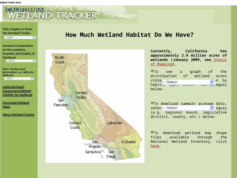
How Much Wetland Habitat Do We Have?
Currently, California has approximately 2.9 million acres of wetlands (January 2009, see Status of Mapping).
To see a graph of the distribution of wetland acres statewide or in each region by habitat type, select the category below:
To download summary acreage data, select the reporting category (e.g. regional board, legislative district, county, etc.) below:
To download wetland map shape files available through the National Wetland Inventory, click here.
North Coast
Central Valley
Lahontan
Colorado
San Francisco
Central Coast
Los Angeles
San Diego
Santa Ana
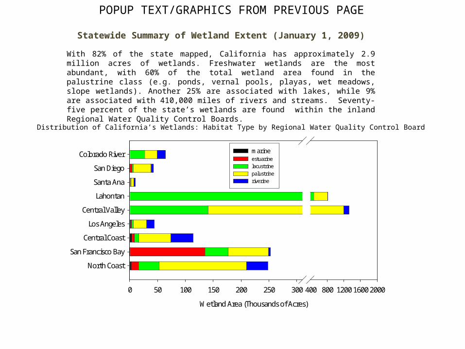
Statewide Summary of Wetland Extent (January 1, 2009)
With 82% of the state mapped, California has approximately 2.9 million acres of wetlands. Freshwater wetlands are the most abundant, with 60% of the total wetland area found in the palustrine class (e.g. ponds, vernal pools, playas, wet meadows, slope wetlands). Another 25% are associated with lakes, while 9% are associated with 410,000 miles of rivers and streams. Seventy-five percent of the state’s wetlands are found within the inland Regional Water Quality Control Boards.
Distribution of California’s Wetlands: Habitat Type by Regional Water Quality Control Board
Wetland Area (Thousands of Acres)
0 50 100 150 200 250 300 400 800 1200 1600 2000
North Coast
San Francisco Bay
Central Coast
Los Angeles
Central Valley
Lahontan
Santa Ana
San Diego
Colorado River marine estuarine lacustrine palustrine riverine
POPUP TEXT/GRAPHICS FROM PREVIOUS PAGE

Summary of Wetland Extent: North Coast Regional Water Quality Control Board (RWQCB) January 1, 2009
With 51% of it’s geographic area mapped, the North Coast RWQCB has approximately 247 thousand acres of wetlands. Sixty three percent of the total wetland area found in the palustrine class (e.g. ponds, vernal pools, playas, wet meadows, slope wetlands). Approximately 15% is found in the riverine class, while 15% is associated with lakes and reservoirs. The remaining 7% are associated with estuarine and marine wetlands.
Distribution of Wetland Type in the North Coast RWQCB
Thousands of Acres
0 20 40 60 80 100 120 140 160 180
Wel
and
Hab
itat
Typ
e
Marine
Estuarine
Lacustrine
Palustrine
Riverine
POPUP TEXT/GRAPHICS FROM INTERACTIVE MAP

Summary of Wetland Extent: San Francisco Bay Regional Water Quality Control Board (RWQCB) January 1, 2009
With 95% of it’s geographic area mapped, the San Francisco RWQCB has approximately 252 thousand acres of wetlands. Fifty three percent of the total wetland area found in the estuarine class. Approximately 29% is found in the palustrine class (e.g. ponds, vernal pools, playas, wet meadows, slope wetlands). Another 16% are associated with lakes and reservoirs. Less than 1% are marine wetlands.
Distribution of Wetland Type in the San Francisco Bay RWQCB
Thousands of Acres
0 20 40 60 80 100 120 140 160
Wel
and
Ha
bita
t T
ype
Marine
Estuarine
Lacustrine
Palustrine
Riverine

Summary of Wetland Extent: Central Coast Regional Water Quality Control Board (RWQCB) January 1, 2009
With 76% of it’s geographic area mapped, the Central Coast RWQCB has approximately 114 thousand acres of wetlands. Fifty one percent of the total wetland area found in the palustrine class (e.g. ponds, vernal pools, playas, wet meadows, slope wetlands). Approximately 35% is found in the riverine class, while 7% is associated with lakes and reservoirs. The remaining 7% are associated with estuarine and marine wetlands.
Distribution of Wetland Type in the Central Coast RWQCB
Thousands of Acres
0 10 20 30 40 50 60 70
We
lan
d H
ab
itat
Typ
e
Marine
Estuarine
Lacustrine
Palustrine
Riverine

Summary of Wetland Extent: Los Angeles Regional Water Quality Control Board (RWQCB) January 1, 2009
With 84% of it’s geographic area mapped, the Los Angeles RWQCB has approximately 44 thousand acres of wetlands. Fifty four percent of the total wetland area found in the palustrine class (e.g. ponds, vernal pools, playas, wet meadows, slope wetlands). Approximately 31% is found in the riverine class, while 7% is associated with lakes and reservoirs. The remaining 8% are associated with estuarine and marine wetlands.
Distribution of Wetland Type in the Los Angeles RWQCB
Thousands of Acres
0 5 10 15 20 25
Wel
and
Hab
itat
Typ
e
Marine
Estuarine
Lacustrine
Palustrine
Riverine
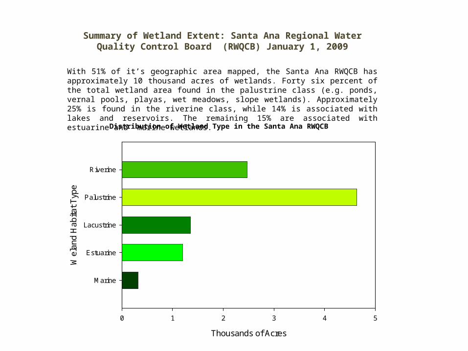
Summary of Wetland Extent: Santa Ana Regional Water Quality Control Board (RWQCB) January 1, 2009
With 51% of it’s geographic area mapped, the Santa Ana RWQCB has approximately 10 thousand acres of wetlands. Forty six percent of the total wetland area found in the palustrine class (e.g. ponds, vernal pools, playas, wet meadows, slope wetlands). Approximately 25% is found in the riverine class, while 14% is associated with lakes and reservoirs. The remaining 15% are associated with estuarine and marine wetlands.
Distribution of Wetland Type in the Santa Ana RWQCB
Thousands of Acres
0 1 2 3 4 5
Wel
and
Ha
bita
t T
ype
Marine
Estuarine
Lacustrine
Palustrine
Riverine

Summary of Wetland Extent: San Diego Regional Water Quality Control Board (RWQCB) January 1, 2009
With 91% of it’s geographic area mapped, the San Diego RWQCB has approximately 43 thousand acres of wetlands. Seventy four percent of the total wetland area found in the palustrine class (e.g. ponds, vernal pools, playas, wet meadows, slope wetlands). Approximately 10% is found in the riverine class, while 5% is associated with lakes and reservoirs. The remaining 11% are associated with estuarine and marine wetlands.
Distribution of Wetland Type in the San Diego RWQCB
Thousands of Acres
0 1 2 3 4 5
Wel
and
Hab
itat
Typ
e
Marine
Estuarine
Lacustrine
Palustrine
Riverine

Summary of Wetland Extent: Central Valley Regional Water Quality Control Board (RWQCB) January 1, 2009
With 86% of it’s geographic area mapped, the Central Valley RWQCB has approximately 1,320 thousand acres of wetlands. Eighty percent of the total wetland area found in the palustrine class (e.g. ponds, vernal pools, playas, wet meadows, slope wetlands). Approximately 9% is found in the riverine class, while 11% is associated with lakes and reservoirs.
Distribution of Wetland Type in the Central Valley RWQCB
Thousands of Acres
0 200 400 600 800 1000 1200
Wel
and
Hab
itat
Typ
e
Marine
Estuarine
Lacustrine
Palustrine
Riverine
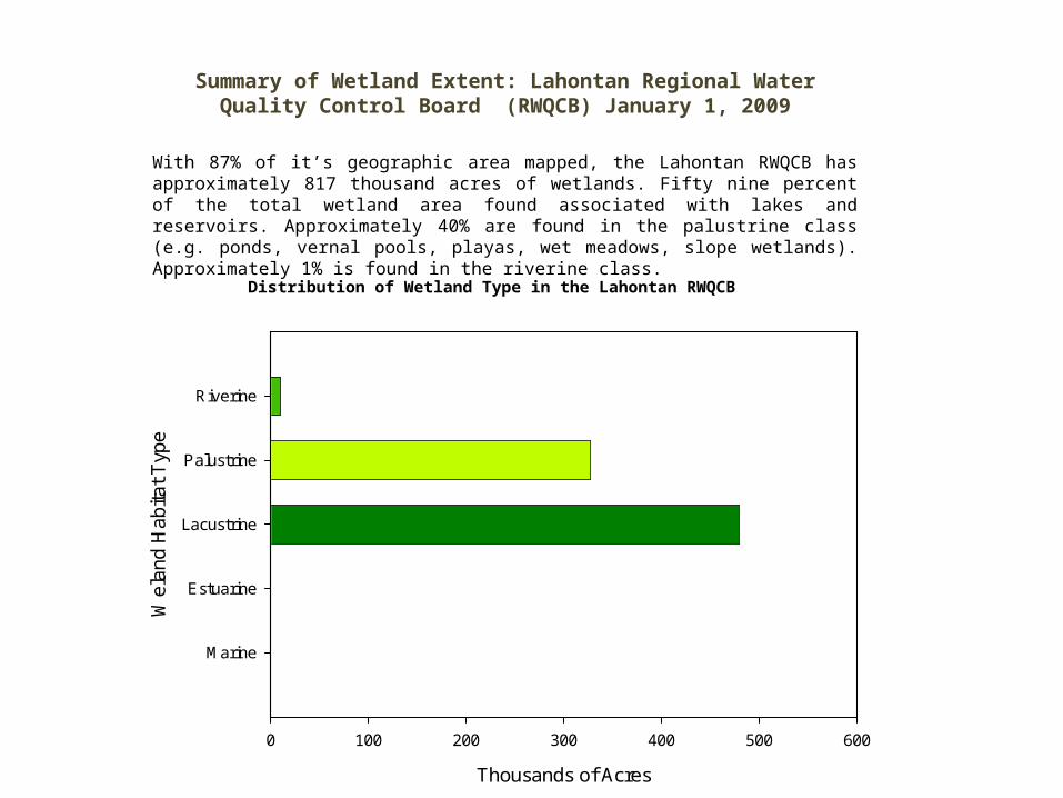
Summary of Wetland Extent: Lahontan Regional Water Quality Control Board (RWQCB) January 1, 2009
With 87% of it’s geographic area mapped, the Lahontan RWQCB has approximately 817 thousand acres of wetlands. Fifty nine percent of the total wetland area found associated with lakes and reservoirs. Approximately 40% are found in the palustrine class (e.g. ponds, vernal pools, playas, wet meadows, slope wetlands). Approximately 1% is found in the riverine class.
Distribution of Wetland Type in the Lahontan RWQCB
Thousands of Acres
0 100 200 300 400 500 600
Wel
and
Hab
itat
Typ
e
Marine
Estuarine
Lacustrine
Palustrine
Riverine

Summary of Wetland Extent: Colorado River Basin Regional Water Quality Control Board (RWQCB) January 1, 2009
With 58% of it’s geographic area mapped, the Colorado River Basin RWQCB has approximately 64 thousand acres of wetlands. Forty two percent of the total wetland area found is associated with lakes and reservoirs. Approximately 34% are found in the palustrine class (e.g. ponds, vernal pools, playas, wet meadows, slope wetlands). Approximately 23% is found in the riverine class.
Distribution of Wetland Type in the Colorado River Basin RWQCB
Thousands of Acres
0 5 10 15 20 25 30
Wel
and
Ha
bita
t T
ype
Marine
Estuarine
Lacustrine
Palustrine
Riverine

One of the standardized tools is the California Rapid Assessment Method (CRAM). CRAM measures wetland health in terms of four attributes of condition: Buffer and Landscape Context, Hydrology, Biological Structure, and Physical Structure.
Click on the link below to access an interactive display of scores where at sites where CRAM has been conducted throughout the State.
Go to the CRAMwetlands.org website
How Healthy Are California Wetlands?Simply defined, “health” is the sum of the biological, chemical and physical integrity (a.k.a. ecological integrity) of wetland and associated habitats. Read more>>>.
CRAM is being utilized in a series of wetland assessment studies. Select from the list of available guidance documents, factsheets and published survey reports utilizing CRAM.
A large quantity of data have been collected on the ecological integrity of California’s wetlands. These data have been collected with a variety of methods, making statewide reporting very difficult. A toolkit of standardized assessment methods have been developed to address this issue.
CRAM was used to conduct a rapid assessment of the Health of the State’s Estuarine Wetlands>>>

The Health of California ‘s Estuarine Wetlands: A Statewide SurveyRapid assessments can provide a snapshot of the ecological condition of a wetland, similar to a yearly checkup at the physician. The California Rapid Assessment Method (CRAM) for Wetlands, measures the health of a wetland with respect to its Buffer and Landscape Context, Hydrology, Biological Structure, and Physical Structure.
In 2007, a rapid assessment was conducted on a probability-based sample of the State’s approximately 44,456 acres of perennially tidal salt marshes. Following are a few of the important findings of this study:
85% of the State’s salt marshes were in good to very good health; 35% of salt marsh acreage had scores reflecting very good hydrology and marsh plant community structure; 65% was found to have large, intact buffers.
50 % of acreage scored in the fair to poor category with respect to their physical structure.
Salt marsh health generally declined from Northern to southern California, consistent with a trend in increasing urbanization from north to south.
Dikes and levees were among the most frequent and most severe physical stressors identified statewide.
Percent of Salt Marsh Acreage Within Each Health CategoryStatewide and By Region
Statewide or Region
Statewide North Coast SF Estuary Central Coast South Coast
Perc
ent o
f sal
t mar
sh a
crea
ge
0
20
40
60
80
100
Poor HealthFair HealthGood HealthVery Good Health
To download a summary factsheet or full text report of the assessment, click here.

What Was the Historic Extent of Wetlands in California?
Changes can be expected to occur with continued land use development and climate change. The State has been working to minimize loss from ongoing development (see Wetland Protection) and has stepped up efforts to conserve and restore existing wetlands. (see Efforts to Improve Wetlands)
Regional historical ecology investigations provide detailed insight on how wetland quantity and quality has changed over the past 200 years. It provides valuable insights to guide restoration efforts.
Find out what historical ecology studies have been conducted on wetlands in your region:
It is estimated that California has approx.90% of the wetlands present prior to European settlement (Dahl 1990). This wetland loss has occurred as land was converted from open space to urban and agricultural land uses.
Maps of past and present wetland extent in San Francisco Bay
Moro Joo
To find out more about the regional partnerships that have been working to conserve and restore wetlands in your region, click on a region on the map.
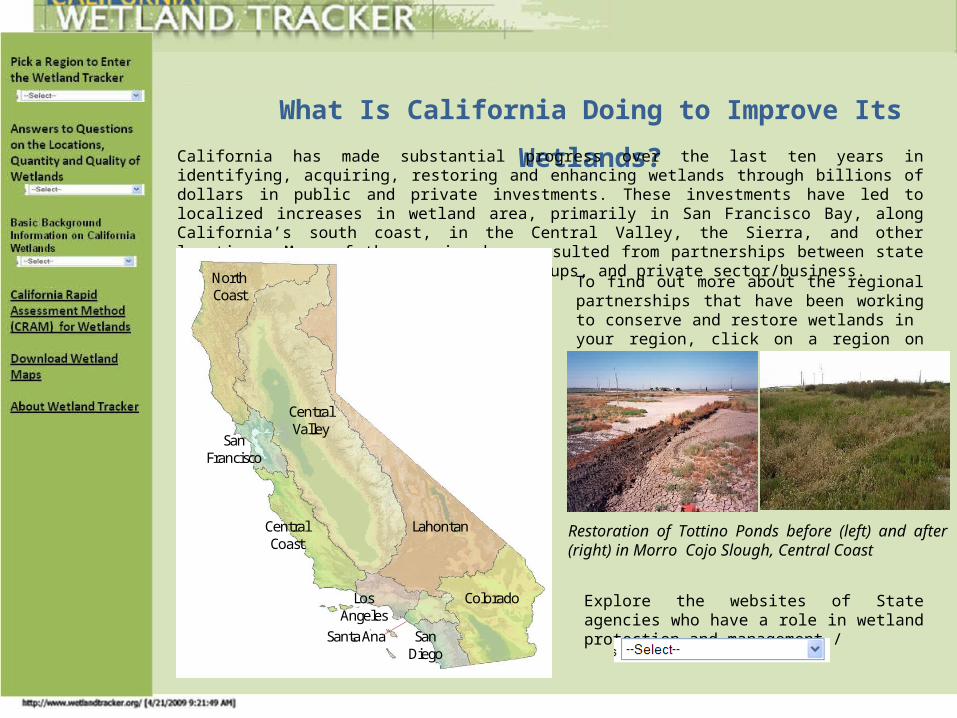
What Is California Doing to Improve Its Wetlands?
California has made substantial progress over the last ten years in identifying, acquiring, restoring and enhancing wetlands through billions of dollars in public and private investments. These investments have led to localized increases in wetland area, primarily in San Francisco Bay, along California’s south coast, in the Central Valley, the Sierra, and other locations. Many of these gains have resulted from partnerships between state and federal agencies, local citizen groups, and private sector/business.
North Coast
Central Valley
Lahontan
Colorado
San Francisco
Central Coast
Los Angeles
San Diego
Santa Ana
Explore the websites of State agencies who have a role in wetland protection and management./
Restoration of Tottino Ponds before (left) and after (right) in Morro Cojo Slough, Central Coast

Background Questions and Related Pages

The State is developing an official wetland definition as part of the new Wetland and Riparian Area Protection Policy. The draft definition states “an area is wetland if, under normal circumstances, it is saturated by groundwater or inundated by shallow surface water for a duration sufficient to cause anaerobic conditions within the upper substrate; exhibit anaerobic conditions indicative of such hydrology; and either lack vegetation or the vegetation is dominated by hydrophytes”.
What Are Wetlands?
As the name suggests, wetlands have aquatic and terrestrial characteristics. They form wherever the land gets too wet for upland vegetation and standing water is not too deep for wetland vegetation. They form along the shallow margins of lakes, estuaries, and rivers, and in upland areas with high groundwater or shallow surface water, such as springs, seeps, wet meadows, and ponds.
Insert Pic
pic of lacustrine wetlands
Wetlands are found in every region of California. They vary widely in form, function and human services (more>>) because of regional and local differences in soils, topography, climate, hydrology, geology and other factors, including human disturbance. More on the diversity of California wetlands>>.
San
hill
Cra
nes
at
Mod
oc
NW
R
(???
???)
Hu
mb
old
t B
ay,
N
ort
h
Coast
(A
. E
ich
er,
UC
E
xten
sion
, )
Tri
nit
y R
iver
(J.
Collin
s,
SF
EI)
Tri
nit
y R
iver
(J.
Collin
s,
SF
EI)

Wetlands are protected by law. The following laws apply to projects affecting wetlands in California.
Clean Water Act – Section 404. The US Army Corps of Engineers (USACE) is responsible for issuing permits for discharge of dredged or fill materials into the waters of the United States. Wetlands are considered to be waters of the United States. Section 404 permits are required for actions affecting more that 1/3 of an acre of wetland. Permits can be general for minimal projects (issued on nationwide, regional, or local basis) or individual permits for projects with potentially significant impacts.
State 401 Certification. Section 401 of the Clean Water Act allows states to Certify that Federal 404 permits do not violate State water Quality Standards. In California, those certifications are are typically issued by the Regional Water Quality Control Boards. (some certifications pertaining to water rights and multiregional projects are administered by the State Water Board). These certifications also serve as Waste Discharge Requirements (WDRs) under the State’s Porter-Cologne Water Quality Control Act.
Clean Water Act - National Pollutant Discharge Elimination System Under the auspices of the U.S. Environmental Protection Agency, the State Board and nine Regional Boards also have the responsibility of granting permits, commonly known as NPDES permits, for certain point-source discharges. The permits can stipulate
Rivers and Harbors Act- Section 10 Section 10 requires a permit from the USACE for the construction of structures in, under, or over navigable waters and for all work affecting the course, location, condition, or capacity of navigable waters (e.g. piers, boat dock, boat ramps, wharfs, dolphins, weirs, booms, breakwaters, bulkheads, and jetties.)
Executive Order 11990 Wetland Protection Executive Order 11990 requires Federal agencies and responsible entities to avoid an undertaking or providing financial assistance for new construction located within wetlands, unless a finding is made that there is no practicable alternative to such construction.
Porter-Cologne Water Quality Control Act.Water quality in California is governed by the Porter-Cologne Water Quality Control Act. This law assigns overall responsibility for water rights and water quality protection to the State Water Resource Control Board and directs the nine statewide Regional Water Quality Control Boards to develop and enforce water quality standards within their boundaries. The standards are based on formally recognized beneficial uses for water bodies, many of which pertain to wetlands and are used to protect them. (http://www.blm.gov/nstc/WaterLaws/california2.html).
In addition to laws protecting wetlands, there are many ways in which wetlands are protected by elective land conservation and stewardship plans, including the following:
Conservation Easements http://ceres.ca.gov/wetlands/introduction/conservation_easements.html
Remainder Interests http://ceres.ca.gov/wetlands/introduction/remainder_interests.html
Management Agreements http://ceres.ca.gov/wetlands/introduction/management_agreements.html
Limited Development Strategies http://ceres.ca.gov/wetlands/introduction/limited_development.html
Leases http://ceres.ca.gov/wetlands/introduction/leases.html
Transfer of Full Title http://ceres.ca.gov/wetlands/introduction/transfer.htmll
How Are Wetlands Protected?Pick a Region to Enter
the Wetland Tracker
Basic Background Information on California Wetlands
California Rapid Assessment Method (CRAM) for Wetlands
Download Wetland Maps
About Wetland Tracker

Have My Wetlands Been Mapped? Status of Wetland Mapping in California
To see if your wetlands have been mapped, the vintage of the map, and whether there is a current update:
Click on the region in the drop down menu to navigate to the are a of interest
Type in an address (Example, 123 Main Street, Sacramento, CA)
Pick a Region to Enter the Wetland Tracker
Answers to Questions on the Locations, Quantity and Quality of Wetlands
Basic Background Information on California Wetlands
California Rapid Assessment Method (CRAM) for Wetlands
Download Wetland Maps
About Wetland Tracker
North Coast
Central Valley
Lahontan
Colorado
San Francisco
Central Coast
Los Angeles
San Diego
Santa Ana
In 2002, the State of California began developing a complete map of wetlands through a partnership bewteen the California Resources Agency and the U.S. Fish and Wildlife Service National Wetland Inventory (NWI). Currently, 76% of the state has been mapped. Many of these digital maps date from the 1980s and are not sufficiently detailed to assess trends. Areas of the state which are still significantly unmapped (<75%) include the North Coast, Colorado, and Santa Ana RWQCBs.
The State is working to continuously update these maps and develop methods to more quickly evaluate the trends in wetland acreage. Maps are currently being updated in several areas of the State, including large projects in South Coast and San Francisco Bay.
Percent of State mapped by Regional Board. Green fills represent percent of each region mapped. South Coast and San Francisco Bay mapping updates will result in 100 % mapped in those areas.

Why Are Wetlands Important? Wetlands are important because of what they do. They provide important services to society. They help control global warming by trapping carbon dioxide, improve flood control by storing flood waters, maintain water supplies by replenishing aquifers, protect water quality by filtering runoff, and provide essential habitat for fish and wildlife including threatened and endangered species as well as commercially important species. Wetlands are also attractive. They are an important component of the landscape aesthetic.
Different kinds of wetlands provide different kinds of service. The location, size, and ecological characteristics of a wetland help determine the kinds and levels of service it can provide.
PICS OF WETLANDS FUNCTIONS
PICS OF WETLANDS FUNCTIONS
Modoc NWR(USFWS, Modoc NWR Staff) Storm after fire in Ventura County (SCCWRP)

Wetland Processes, Functions, Services, and Beneficial UsesThe work that wetlands do is so important that wetland scientists and managers have a special language for talking about it.
Scientists analyze the work of wetlands as physical, chemical, biological, and ecological processes. For example, photosynthesis is a process by which wetland plants transform carbon dioxide and water into plant tissue and oxygen. Decomposition is a process by which wetlands transform plant tissue and other organic matter into carbon dioxide, water, and many organic compounds including nutrients.
Every wetland process has one or more functions. They are consequences of the processes. For example, one function of photosynthesis is to trap carbon. Another is to feed herbivores. One function of decomposition is to replenish soil nutrients. Photosynthesis and decomposition, plus many other processes, have a combined function of supporting waterfowl and other wetland wildlife.
Wetland managers recognize that wetland functions provide service in the context of human culture or society. For example, the wetland function called waterfowl support provides a service called hunting.
California law recognizes the services of wetlands and other aquatic areas as beneficial uses. These are the wetland services that are highly valued by the people of California.
Wetlands undoubtedly have processes and functions yet to be discovered. And, not all the services or beneficial uses of known functions have been indentified. What is known for sure is that wetlands provide many services that people value highly.

California’s Wetland Assessment ToolkitThe State’s Wetland Assessment Toolkit consists of standardized mapping and assessment methods that provide a comprehensive assessment of wetland extent and ecological integrity. Assessments are conducted at three levels:
•Landscape Assessment (Level 1) uses remote sensing data and field surveys to inventory the wetlands and riparian habitats. The California Wetland Inventory and the national Wetlands Inventory are examples of Level 1 assessments.
•Rapid Assessment (Level 2) uses visible field diagnostics and existing data to assess conditions at wetland and riparian sites. CRAM is an example of a Level 2 assessment method.
•Intensive Site Assessment (Level 3) provides quantitative field data to give more precise answers to management questions. Level 3 methods can also be used to calibrate and validate Level 1 and level 2 methods, and to test hypotheses about the causes of habitat conditions.
What are the tools in California’s Wetland Toolkit?
•Standard methods to map wetlands and riparian areas (www.wrmp.org, www.socalwetlands.org)•Methods to rapidly assess wetland condition and stressors (www.cramwetlands.org)•Methods to assess the condition of benthic macroinvertebrates in streams (link) and estuaries (link)•A web-based portal for the public to access information on wetlands and methods to track the effect of projects permitted by regulatory agencies on wetland acreage and health (www.wetlandtracker.org )
Warn
er
Valley
wild
life
Are
a,
Plu
mas
Cou
nty
(?
????
?)

The natural diversity of California wetlands is unsurpassed by any region in the world. This includes, but is not limited to, wet meadows in the mountains and foothills, playas in the deserts, verdant floodplains along the rivers, ancient vernal pools on some alluvial plains, lakes and ponds throughout the State, and tidal flats and marshes along the coast.
The State is developing a standard list of wetland types and guidelines for identifying them, called the California Wetland Classification System. The system is hierarchical, meaning that some types have sub-types. The names can change and new types can be added. Wetland types are mostly distinguished by their different sources of water or formative processes.
Click on the link to get more information about the major types of wetlands within California:
Diversity of California’s Wetlands
• Estuarine Wetlands
• Riverine Wetlands
• Lake Wetlands
• Depressional Wetlands
• Playa wetlands
• Seep, Spring and Slope Wetlands
• Vernal Pool Wetlands
• Marine Wetlands
Pick a Region to Enter the Wetland Tracker
Basic Background Information on California Wetlands
California Rapid Assessment Method (CRAM) for Wetlands
Download Wetland Maps
About Wetland Tracker
La Jolla Creek Pond, Los Angeles County, (M. Sutula, SCCWRP)
Widgeon Pond, Modoc NWR(USFWS, Modoc NWR Staff

ESTUARINE WETLANDS
An estuary is an area where runoff flowing downstream through a river or stream is influenced by ocean water moving upstream through a tidal inlet or the river mouth during a rising tide. Estuaries include entire lengths of rivers that are tidally influenced. Estuarine wetlands exist along the shores of estuaries and are directly and regularly affected by estuarine tides.
Text for each wetland type
San Elijo Lagoon, San Diego County (M. Sutula, SCCWRP)
Morro Bay, San Luis Obispo County (R. Clark , Coastal Commission)
Text for each wetland type
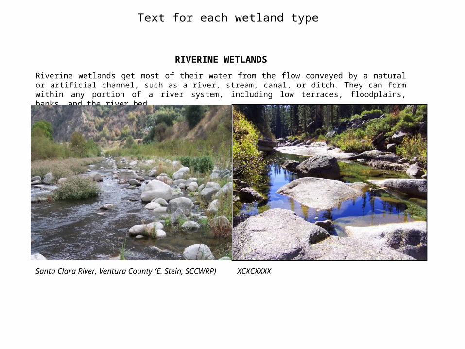
RIVERINE WETLANDS
Riverine wetlands get most of their water from the flow conveyed by a natural or artificial channel, such as a river, stream, canal, or ditch. They can form within any portion of a river system, including low terraces, floodplains, banks, and the river bed.
XCXCXXXXSanta Clara River, Ventura County (E. Stein, SCCWRP)

DEPRESSIONAL WETLANDS
These wetlands are associated with natural topographic basins or artificial impoundments that are too small or shallow to be lakes or reservoirs, lack the water chemistry of playas, and lack the indicative flora of vernal pools. It takes longer than a day for water to enter and pass through a depressional wetland. Most depressional wetlands in California are seasonal. They often depend on multiple water sources, including local runoff, groundwater, and direct precipitation.
Text for each wetland type
Tuolumne Meadows, Yosemite National P ark (M. Sutula, SCCWRP)
Modoc NWR (USFWS, Modoc NWR Staff)

Text for each wetland type
MARINE WETLANDS
Marine wetlands occur along the immediate ocean shore where they are directly influenced by the ocean tides and waves. They often form on natural berms built by storm waves inland from beaches.
Sonoma State Beach, North Coast (M. Sutula, SCCWRP)Mussel Bed, South Coast (SCCWRP)

SEEP, SPRING AND SLOPE WETLANDS
These wetlands depend almost entirely on groundwater. Seeps and springs form where groundwater emerges as surface runoff without a defined channel. Slope wetlands form where the groundwater rises into the root zone but does not emerge as surface runoff.
Text for each wetland type
Seep along the East Fork of the San Gabriel River (C. Solek, SCCWRP)
Summit Lake Fen, Tahoe National Forest (USFS)

Text for each wetland type
PLAYA WETLANDS
A playa is the nearly flat bottom area of an undrained basin within which water variously accumulates and evaporates, leaving salty deposits along the playa margins. Playas are shallower than lakes and their chemistry distinguishes them from vernal pools and other depressional wetlands. Playa wetlands form along the shores of playas and depend on them for water.
Carrizo Plain (C. Vouchilas, Department of Fish and Game)
Alkali Lake, Surprise Valley, Modoc County (A. Uchida, BLM )

LAKE WETLANDS
Lakes, including reservoirs, are surface water storage areas at least 20 acres large and at least 6 feet deep on average during the dry season. It takes longer than a day for water to enter and pass through a lake. Lake wetlands form along lakeshores and get most of their water from their adjacent lakes.
Text for each wetland type
Emerald Lake, Mono County (M. Sutula,, SCCWRP ) Heenan Lake, Alpine County (???)

Text for each wetland type
VERNAL POOLS WETLANDS
Vernal pools are ephemeral wetlands that form in shallow depressions closely underlain by bedrock or another impervious stratum. They typically support a minimum of 30% cover of indicative, native plant species.
Vernal Pool at Mather Field, Sacramento County(David Rosen , Wildside Photography)
Vernal Pool at Mather Field, Sacramento County (Eva Butler, SacramentoSplash)

Human activities that result in a reduction in wetland quantity or quality are called wetland stressors. Most wetlands are subject to multiple stressors that exacerbate their negative effects. All stressors are ultimately due to land use practices and can be sorted into five basic groups.
)
All stressors are ultimately due to land use practices and can be sorted into five basic groups. Click on the link to get more information about each groups:
What Factors Affect Wetland Health?
• Habitat Alteration
• Hydrological Modification
• Biological Invasion
• Pollution
• Overharvesting
• Climate Change
Insert two pics here
Pick a Region to Enter the Wetland Tracker
Basic Background Information on California Wetlands
California Rapid Assessment Method (CRAM) for Wetlands
Download Wetland Maps
About Wetland Tracker
Jetty Road in Moss Landing, Monterey County (S. Ryan, CCWG)
Hummer in damaged slope wetland (USFS)

HABITAT CONVERSION
People can change wetlands from one type to another, or change them into non-wetland areas. Wetlands tend to form on flat landscapes, such as floodplains and valley floors, favored for many land uses, such as housing and farming that can easily displace or destroy wetlands. Except for laws protecting them, most wetlands can be easily drained or filled. Such habitat conversion has been the leading cause for declines in the distribution and abundance of every kind of wetland in California. There has been a greater than 75% reduction in wetland acreage in California since the gold rush of 1849.
Text for Stressor Descriptions
NEED PICS AND LINKS– PLEASE DONATE
Cargill Salt Ponds type-converted from San Francisco Bay,lands, South San Francisco Bay (NASA photo obtained from K. Bane, State Coastal Conservancy)

Text for Stressor Descriptions
HYDROLOGICAL MODIFICATION
Unnatural changes in the timing and duration of flooding in a wetland (a.k.a. hydroperiod) of a wetland can affect its functions and services. The hydroperiod of a wetland is easily modified by upstream impoundments, diversions, or additions of surface water. Levees, riverbank revetments, spring boxes, dams, and every other unnatural structure directly affect wetlands. Seasonal wetlands are the most vulnerable to changes in water supplies. They tend to be shallow and subject to high rates of evaporation. Slight changes in hydrology can affect large changes in seasonal wetlands.
NEED PICS AND LINKS– PLEASE DONATE
XXXXBorrego Canyon Wash, Orange County (E. Stein, SCCWRP)

BIOLOGICAL INVASION
Non-native species that are inadvertently or intentionally introduced by people into a wetland can proliferate, displacing native species and altering wetland functions and services. Bullfrogs, the Louisiana red crayfish, Brazilian milfoil, bluegill sunfish, and many other alien plants and animals are changing the essential functions of California wetlands.
Text for each wetland type
Pampas Grass in Ballona Wetlands (M. Mattson, USACE)
Hemlock, Mustard and Curly Dock in the Tembladero Wetland, Monterey County (C. Clark, MLML)

Text for each wetland type
POLLUTION
The accumulation of anything in a wetland that causes an unacceptable decline in its services can be called pollution. It isn’t always a manufactured chemical that is dumped, spilled, leaked, or otherwise released by people into the environment. An overabundance of nutrients, sediment, native vegetation, or even water can pollute a wetland. Management of wetlands for purposes of vector control can result in pollution. Many wetlands function as natural filters and tend to have higher concentrations of pollutants than other habitat types.
Stormwater Runoff in Southern California (SCCWRP)Photo credit, K Rey, MLML
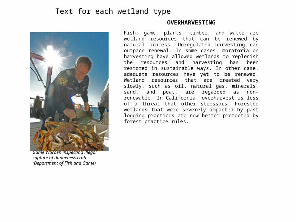
OVERHARVESTING
Fish, game, plants, timber, and water are wetland resources that can be renewed by natural process. Unregulated harvesting can outpace renewal. In some cases, moratoria on harvesting have allowed wetlands to replenish the resources and harvesting has been restored in sustainable ways. In other case, adequate resources have yet to be renewed. Wetland resources that are created very slowly, such as oil, natural gas, minerals, sand, and peat, are regarded as non-renewable. In California, overharvest is less of a threat that other stressors. Forested wetlands that were severely impacted by past logging practices are now better protected by forest practice rules.
Text for each wetland type
Game Warden inspecting illegal capture of dungeness crab (Department of Fish and Game)

Text for each wetland type
CLIMATE CHANGE
The world is entering a period of rapid climate change. While there is uncertainty about the future rates of change and how long they will last, California is already experiencing greater year-to-year variability in rainfall and air temperature, higher average temperatures, and less snow pack. To the extent that climate change is caused by people, it could be considered a stressor. Regardless of its causes, climate change will likely impact all wetlands in California.
South Bay Shoreline Areas Vulnerable to Sea Level Rise, T. Doherty (Bay Conservation and Development Commission)