Embed Size (px)
Citation preview

HOMOGENEOUS PHOTOGRAPHIC TEXTURE: AN INSTRUMENT TO
IDENTIFY DIFFERENT URBAN POPULATION SEGMENTS
ABSTRACT
Maria de Lourdes Neves de Oliveira Kurkdjian Instituto de Pesquisas Espaciais - INPE Ministerio da Ciencia e Tecnologia - MCT Av. dos Astronautas, 1758 - Caixa Postal 515 CEP 12201 - Sao Jose dos Campos, SP, Brazil
This paper presents a summary of the main results from a study to define a geographical reference system to be used for city planners in urban analysis. A method to delimitate homogeneous residential sectors in a city, using visual interpretation of aerial photographs, is presented. The city of Sao Jose dos Campos, SP. State~ Brazil was used as a test-site. The survey data obtained were evalUated using variance and cluster analysis techniques. These data showed that the discrimination of texture by photographic interpretation can be used as a reliable criterion to dif£erentiate urban population segments according to its socioeconomic status. Some homogeneous textures are sensitive to family and migration status factors too.
1. INTRODUCTION
The basic proposal of this paper,that can be found with more ~eta~l ~n Oliveira (~986h), and which the preliminary results were presented ln Ollve1ra (1986a), 1S that the analysis of urban residential areas and its resident population should be done through visual interpretation of panchromatic aerial photographs at a large scale.
Thorugh these photographs the reading of the residential spaces turns into the interpretation of the meaning of those elements percei~able through the aerial view of the city_
The discrimination of the different photograph textures, present in the intricated urban mosaic, delineates the residential sectors of homogeneous textures of the city that turn into analysis units of the more general residential space.
This being so, based upon the delimitation and the analysis of the different parts that make up the residential space, the photointerpretation may be used as an appropriate identification and analysis technique of the different segments of the urban population, the contrasts of which, at the level of socioeconomic variables, are reflected in the physical and urbanistic variables of the areas they live in.
The hypothesis that guides the present paper is that, through photointerpretation, different homogeneous residential sectors of an urban area may be identified, and that people, that
324

cluster in that space, are somehow coherent from social and/or economical viewpoint.
2. PROPOSED METHOD
The residential use of the urban soil does not constitute one single homogeneous class, but on the contrary, proves to be subdivided into subclasses, composing an intrincated urban mosaic.
Everyone of these parts this mosaic is composed of is assumingly homogeneous. Not only does the identification of these parts imply the delimitation of resident environments, but also of groups of residents homogeneous from the viewpoint of their socioeconomic characteristics. With regard to the aerial view of the city, made possible by the aerophotographs, it can be held that the res~dential urban area is made up of homogeneously textured subunits. In this context the concept of homogeneity can be understood better, based upon the premise that homogeneity is a result of the repetition of a certain number of forms, of a set of arrangements that reproduce themselves on a surface in a similar, but not perfectly identical way.
The method presented in this paper proposes that the delimitation of homogeneous residential urban areas should be effectuated by means of the visual discrimination of different textures on vertical panchromatic aerophotographs on a scale of roughly 1:10.000.
According to Haralick (1979), referring to orbital images, a texture is not figurative or cellular, but actually a phenomenon of area organization having two basic dimensions:
a) one with respect to the primary elements that compose it;
b) one with respect to the dependency and interaction between primary elements, i.e., to the spatial organization of these components. Thus the texture of a image is described by the number of types of their primary elements and by the spatial organization of these primitives.
The urban residential areas on the 1:10.000 scale aerophotographs show a large variation of primary elements. These areas are composed of small heterogeneous elements that constitute a complex assembly. That is the reason why photographic textures are to be adopted as basic elements for delineating the different residential sectors of a city.
Primary components, different as to type and dimension, define different textures and so do the number of their elements and their spatial arrangements.
In the residential areas this means, for instance, that areas having large residences show a texture different from areas having small residences: or that there are differences between:
325

a) areas having one-storey houses and areas having apartments;
b) dense and less dense areas;
c) arborized and nonarborized areas;
d) the single-use residential and mixed-use areas.
Basically the process of delineating homogeneous sectors consistis of the following:
a) visual discrimination of the areas having different textures, through the global perception of the assembly of small details;
b) identification, within these areas, of the primary components of the texture, as well as their spatial organization;
c) determination of whether there is differentiation between textures, perceived spontaneously and visually in item (a), based upon information collected from item (b);
d) outlining of the limits of homogeneously textured sectors.
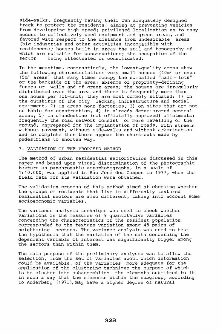
For instance, Figure 2.1 shows an aerophotographwhere some homogeneously textured sectors were delineated according to the above-mentioned process.
This aerophotograph clearly shows the differences between the textures 1,2, 3 and 4, definig four residential sectors.
Texture 1 is coarser than the other areas, i.e., its primary elements are larger. It is defined by larger houses and lots, some of which still unoccupied, spatially organized along the streets that make up the road network of the sector. This is regular, with parallel lines, ending up in "dead-ends".
Texture 2 has a more heterogeneous composition as far as its primary elements are concerned. It is an urban renewal area in which res~dential apartment buildings can be seen, together with one-storey houses~ Such elements are distributed according to a spatial organization pattern that gives the area an overall homogeneous visual appearance. Although the composition is heterogeneous, it ~s not possible to define, within the sector, more homogeneous subareas. As a whole, it is characterized as such.
Texture 3 is slimmer than the two preceding ones. It contains one-family houses of smaller size than the two already described textures. The occupation is dense, not only because of the relationship between constructed and unoccupied areas, but also because there are hardly any empty lots.
326

Figure 2.1 - Homogeneous residential sectors. Sao Jose dos Campos, SP, Brazil, 1977.
Texture 4 is defined by slightly larger houses than the ones described in texture 3. Furthermore, the presence of a great many unoccupied lots, as well as the arborization, causes its appearance to be different from the precedent textures.
Generally speaking, in Brazilian cities high-quality sectors show: large one-family residences in spacious areas, sometimes comprising several lots: well-dimensioned recoils turning into yards and gardens; exclusively residential use of the soil, the use for commercial or public-service purposes within its limits being forbidden by law; adequately dimensioned road network with asphaltcovered or paved streets, arborized
327
side-walks, frequently having their own adequately designed track to protect the residents, aiming at preventing vehicles from developping high speed; privileged localization as to easy access to collectively used equipment and green areas, and favored with respect to the distance from undesirable areas (big industries and other activities incompatible with residences); houses built in areas the soil and topography of which are suitable for constructions; the occupation of the sector being effectuated or consolidated.
In the meantime, contrastingly, the lowest-quality areas show the following characteristics: very small houses (40m2 or even 1 5m 2 areas) that many time s occupy the so-called II hal f - lots" or the backside of the area; absence of propriety-defining fences or walls and of green areas; the houses are irregularly distributed over the area and there is frequently more than one house per lot-unit; they are most commoly situated: 1) in the outskirts of the city lacking infrastructure and social equipment, 2) in areas near factories, 3) on sites that are not suitable for construction, 4) in already deteriorated central areas, 5) in clandestine (not officially approved) allotments; frequently the road network consist of mere levelling of the ground, unprepared for the implantation of roads, with streets without pavement, without side-walks and without arborization and to complete then there appear the short-cuts made by pedestrians to shorten way.
3. VALIDATION OF THE PROPOSED METHOD
The method of urban residential sectorization discussed in this paper and based upon visual discrimination of the photographiC texture on panchromatic aerophotographs, in a scale of 1:10.000, was applied in Sao Jose dos Campos in 1977, when the field data for its validation were obtained.
The validation process of this method aimed at checking whether the groups of residents that live in differently textured residential sectors are also different, taking into account some socioeconomic variables.
The variance analysis technique was used to check whether variations in the measures of 9 quantitative variables concerning the characteristics of the resident population corresponded to the texture variation among 48 pairs of neighboring sectors. The variance analYSis was used to test the hypothesis that the variation of the data concerning the dependent variable of interest was significantly bigger among the sectors than within them.
The main purpose of the preliminary analyses was to allow the selection, from the set of variables about which information could be available, of the variables more adequate for the application of the clustering technique the purpose of which is to cluster into subassemblies the elements submitted to it in such a way that the elements within the subgroup, according to Anderberg (1 973), may have a higher degree of natural
328

association among them, while the subgroups are relatively distinct one from another. Using the K MEANS algor~thm (Hartigan, 1975), the residences situated in the pairs of sectors, defined by the aerophotographs used in the validation process, were reassembled into two sets, according to the field data.
With the results of theK MEANS algorithm the absolute value and the proportion of the residences of each sector, defined by the aerophotographs, classified in each of the two conglomerates determined by the field data, were determined.
Based upon these data, a statistical test was introduced to. verify whether there was an expressive difference between the proportion of elements of each of the sectors classified in the conglomerates, which would mean that the population of the two differently textured sectors were also d~fferent as far as the socioeconomic variables of interested were concerned.
The above-described technique was applied to the following set of variables:
1 - family chief's revenue 2 - family chief's educational level 3 - residence pattern
4 - number of people at home 5 family chief's age 6 - number of children under 12
7 - family chief's birthplace (state of federation)
8 - family chief's birthplace (rural or urban)
9 - period of residence in SJC
(
indicating the family's
. "social status"
r indicating the "family status"
l
1 indicating the resident's "migratory character U
In this validation process of the method two sets of pairs of homogeneously textured sectors were used:
1 - The first one contained eight pairs of sectors, not necessarily neighboring, of textures outstandingly differentiated one from another. In this case the purpose was to validate the differentiation between the textures as a pattern for the differentiation of residential population segments.
2 - The second one contained pairs of neighboring sectors, the main purpose being the validation of the very delimitation process of these geographic units. In this case 48 pairs of sectors were analysed.
4. RESULTS AND CONCLUSIONS
The application of the cluster analysis to field data related
329

to the social status of the residents implied the separation of the families living in each of the sectors into two groups, the first of which being made up of lower social status families, while the second was made up of higher social status families.
The total results of the artalysis indicated that at significance level 0,80, 29 pairs of neighboring sectors out of 48 showed a statistically significant difference as to their composition, with respect to the proportion of higher (and lower) level status of their residents. At significance level 0,70, in turn, this was true for 33 pairs, while at level 0,60 it occurred in 35 of the total number of the examined pairs.
Through a new check of the aerial photographs it was observed that those pairs of sectors where this difference was not expressive generally corresponded to those, the visual texture discrimination of which was less evident.
With respect to the 8 pairs of sectors of outstandingly differentiated textures, selected on purpose for this statistical test, it was observed that all of the pairs of sectors indicated a statistically significant difference, at a significance level of 0,99, between the proportions of their elements classified in the two conglomerates, defined by the K MEANS algorithm.
These results confirm that the differentiation of the residential areas according to their photographic textures is an adequate standard for the discrimination of the different urban populational segments. according to their socioeconomic status.
With regard to the analysis carried out with the field data referring to the "family status" of the habitants, it was observed that, even at a significance level of 0,70, only 16 out of 48 pairs of sectors defined by means of the photointerpretation showed a significant differrence between the proportions of the classified elements in one of the clusters defined by the cluster technique.
With regard to this same factor, the results obtained with the sectors of strongly differentiated textures indicate that, in this case, 3 out of 8 pairs of sectors showed a significant difference in their composition at a significance level of 0,99. On the other hand, at a 0,80 significance leveli 5 out of 8 pairs of sectors showed this difference. For a = 0,30 this fact was observed in 6 out of 8 pairs of sectors.
As a whole, these results seem to show that there are types of textures identifying homogeneous clusters as far as this factor is concerned, although there is no constant relation between the differentiation of the photographic texture among the residential sectors and the differentiation of their residents according to their Ufamily status".
As to the two clusters found by the K MEANS algorithm, based upon theHmigratory factor"of the resident, the generally formation observed was a cluster predominantly composed of
330

elements born in the State of Sao Paulo, in the urban area, and having lived in Sao Jose dos Campos for many years, and a cluster predominantly formed by people born in other States, in the rural area, and having lived in Sao Jose dos Campos fewer years. This, in spite of the variations being found in their composition when the results obtained for the different pairs of sectors were compared.
As far as the resident's migratory character was concerned, the tests of the difference of elemen~s proportions in each of the t~o sectors (defined by the aerophotographs) classified in the two sets (defined by the cluster analysis) indicated that only 17 out of 48 pairs of neighboring sectors stud~ed were differentiated at a 0,70 significance level.
With regard to the sectors of strongly differentiated texture, it was observed that 4 out of 8 pairs of these sectors have a statistically significant difference at a 0,96 level. At a 0,70 level 6 out of 8 pairs of sectors can be considered differentiated as to the factor in question.
As occurred with the factor "family status U of the residents, in this case, too, the resul ts indicated that t/here was no constant relation between the differentiation of the photographic texture of residential sectors and the differentiation between their residents, as to their migratory character. The results also indicated that there seem to exist some textures sensitive to the ident~fication of homogeneous groups, as to this factor.
An overall analysis of the collected results brought about the conclusion as to the convenience of homogeneous photographic textures being used as a standard for the division of the city into residential sectors.
The relationship observed between photographic texture and ~ocial status~of the population underlines the usefulness of aerophotographs for urban analysis.
Furthermore, the results obtained with regard to the factors "family status'" and "migratory characterfi of the residents allow some reflections.
In these cases only a set of sectors of strongly differentiated textures were more positive, in the sense that it indicated a relationship between the textures and the factors in question. This brought about the conclusion that, although not every difference in texture implies difference in population as to the factors, some sectors of more characteristics texture are populated by groups of residents, also characteristics with regards to the reffered factors.
The results obtained in Sao Jose dos Campos may lead to the conclusion that the residential differentiation in the city is strongly dictated by the socioeconomic status of the resident population, that neutraliz.es the influence of the other
1

factors. This, by the way, is also bound to happen in the remaining Brazilian cities.
5. REFERENCES
ANDERBERG, M.R. Cluster analysis for applications. New York, N.Y., Academic Press, 1973.
HARTIGAN, J.A. Clustering algorithms. New York, N.Y. Wiley, 1975.
HARALICK, R.M. Statistical and structural approaches to texture. Proceedings of the I.E.E.E. 67(5): 786-804, 1979.
OLIVEIRA, M.L.N. Visual aerial photograph texture discrimination for delineating homogeneous residencial sectors. An instrument for urban planners. In: SYMPOSIUM ON REMOTE SENSING FOR RESOURCES DEVELOPMENT AND ENVIRONMENT MANAGEMENT. Enschede. August, 1986a. p.809-812.
OLIVEIRA KURKDJIAN, M.L.N. Um metodo para a identificacaoe an~lise de setores residenciais urbanos homoa~neos, atraves de dados de sensoriamento remoto, com vistas ao planejamento urbano. Sao Paulo, 1986b. 158. Tese Doutorado. FAU-USP.
332


![CHAPTER 6 An Algorithm of Rotation Invariant Texture Classification … · An Algorithm of Rotation Invariant Texture Classification 6.1. Introduction ... Quivy’s method [Quivy98]](https://img.pdfslide.net/doc/110x75/5c00fed809d3f20f068bff2f/chapter-6-an-algorithm-of-rotation-invariant-texture-classification-an-algorithm.jpg)