Embed Size (px)
Citation preview

MEMBER REPORT
ESCAP/WMO Typhoon Committee
43rd
Session
25 – 30 January 2011
Jeju
(Hong Kong, China)
“Annual activities covering the period from
1 January 2010 to 31 December 2010”

2
CONTENTS
Page
I. Overview of tropical cyclones which have affected/impacted 3-9
Member’s area since the last Typhoon Committee Session
II. Summary of progress in Key Result Areas 10-28
1. Progress on Key Result Area 1
Reduced Loss of Life from Typhoon-related Disasters
2. Progress on Key Result Area 2
Minimized Typhoon-related Social and Economic Impacts
3. Progress on Key Result Area 3
Enhanced Beneficial Typhoon-related Effects for the
Betterment of Quality of life
4. Progress on Key Result Area 4
Improved Typhoon-related Disaster Risk Management in
Various Sectors.
5. Progress on Key Result Area 5
Strengthened Resilience of Communities to Typhoon-related
Disasters
6. Progress on Key Result Area 6
Improved Capacity to Generate and Provide Accurate, Timely,
and understandable Information on Typhoon-related Threats
7. Progress on Key Result Area 7
Enhanced Typhoon Committee‟s Effectiveness and
International Collaboration.
III. Resource Mobilization Activities 29
IV. Update of Members’ Working Groups representatives 29

3
I. Overview of tropical cyclones which have affected/impacted Member’s
area in 2010
1. Meteorological Assessment (highlighting forecasting issues/impacts)
Five tropical cyclones affected Hong Kong from 1 January to 31
December 2010. They were:
(a) Typhoon Conson (1002)
(b) Typhoon Chanthu (1003)
(c) Severe Tropical Storm Lionrock (1006)
(d) Severe Typhoon Fanapi (1011)
(e) Super Typhoon Megi (1013)
Conson and Lionrock necessitated the issuance of the Standby Signal
No. 1 in Hong Kong, while Chanthu, Fanapi and Megi necessitated the
issuance of the Strong Wind Signal No. 3 in Hong Kong. Details are given in
the following paragraphs. Figure 1 shows the tracks of these tropical cyclones.
Figure 1 Hong Kong Observatory best tracks of tropical cyclones that
affected Hong Kong, China from 1 January to 31 December 2010.
Typhoon Conson (1002)
Conson formed as a tropical depression over the western North Pacific
about 1 200 km east of Manila early on 12 July. Figure 2 shows the track of
Conson. Conson crossed the southern part of Luzon during the night of 13
July and entered the South China Sea the following morning. It moved across

4
the South China Sea from 14 to 16 July and intensified into a typhoon on 16
July, reaching its peak intensity with estimated maximum winds of 120 km/h
near its centre. Conson skirted the coast of southwest Hainan that night and
crossed Beibu Wan on 17 July. It made landfall over the coast of northern
Vietnam that evening and dissipated inland the next day.
In Hong Kong, winds were moderate easterlies on the evening of 15
July, becoming fresh offshore and strong on high ground that night. Conson
was closest to Hong Kong at around 8 p.m. that evening when it was about
630 km to the south. Local winds became moderate to fresh east to
southeasterlies on 16 July and were strong on high ground. Winds moderated
in the evening as Conson gradually moved away from Hong Kong.
The weather in Hong Kong was cloudy with sunny intervals on 15 July,
but there were also a few showers and isolated thunderstorms. Under the
influence of the outer rainbands of Conson, squally showers and
thunderstorms affected Hong Kong on 16 July.
Figure 2 Track of Conson (1002) on 12 – 18 July 2010.
Typhoon Chanthu (1003)
Chanthu formed over the central part of the South China Sea about 900
km south-southeast of Hong Kong on 19 July and moved generally
northwestwards. Figure 3 shows the track of Chanthu. Chanthu intensified
into a typhoon to the east of Hainan Island in the early hours of 22 July,
reaching its peak intensity with estimated maximum sustained winds of 120
km/h near its centre. It made landfall near Zhanjiang that afternoon and
moved across Guangxi on 23 July. Chanthu eventually dissipated inland that
night.

5
In Hong Kong, winds were moderate easterlies on the afternoon of 20
July, occasionally strong on high ground that night. As Chanthu moved closer
and intensified, winds freshened from the east on 21 July and became strong
on high grounds. Chanthu was closest to Hong Kong at about 5 a.m. on 22
July passing about 330 km to the southwest. Local winds were strong
offshore and on high ground in the morning on 22 July and turned to
southeasterlies during the day. As Chanthu moved gradually away from Hong
Kong, local winds subsided further that afternoon.
Affected by the subsidence zone ahead of Chanthu, the weather in Hong
Kong was fine and very hot on 20 July. Under the influence of the outer
rainbands of Chanthu, there were squally showers and thunderstorms in the
following two days.
Figure 3 Track of Chanthu (1003) on 19 – 23 July 2010.
Severe Tropical Storm Lionrock (1006)
Lionrock formed as a tropical depression over the northern part of the
South China Sea about 600 km south-southeast of Hong Kong on 28 August
and moved northwestwards. Figure 4 shows the track of Lionrock. It took a
north to northeasterly track the next day and drifted east to east-southeastwards
on 30 August. It intensified into a severe tropical storm that evening, reaching
its peak intensity with estimated maximum sustained winds of 90 km/h near its
centre. On 31 August, Lionrock speeded up and gradually changed its course to
the north-northeast. It adopted a northwesterly course the following day and
traversed the northeastern part of the South China Sea. After making landfall
over the coast of southern Fujian on 2 September morning, Lionrock weakened

6
into a tropical storm. It then moved generally westwards and subsequently
dissipated over Guangdong on 3 September afternoon.
In Hong Kong, winds were moderate northerlies on 29 August and
became occasionally strong on high ground the next day. Light to moderate
northerlies generally prevailed for 31 August – 1 September. The winds turned
to moderate westerlies on 2 September. Lionrock edged closer to Hong Kong
once more on 2 September and local winds turned to the south on 3 September
and were occasionally fresh offshore. Lionrock was closest to Hong Kong at
about 2:00 p.m. on 3 September passing about 150 km to the north-northwest.
Under the influence of the outer rainbands of Lionrock, there were isolated
squally thunderstorms on 29 August and 30 August. Under the subsidence
ahead of Lionrock, it was very hot with sunny periods in the following two
days. The weather turned cloudy with a few showers on 2 September. Rain
became heavy at times with a few squally thunderstorms the following day.
Figure 4 Track of Lionrock (1006) on 28 August – 3 September 2010.
Severe Typhoon Fanapi (1011)
Fanapi formed as a tropical depression over the western North Pacific
about 750 km south of Okinawa on 15 September and moved northwestwards.
Fig. 5 shows the track of Fanapi. Fanapi moved northeastwards slowly on 16
September and resumed a northwesterly track on 17 September and intensified
into a typhoon over the western North Pacific to the east of Taiwan. Fanapi
intensified further into a severe typhoon on 18 September, reaching its peak
intensity with estimated maximum sustained winds of 165 km/h near its centre
and turning to move generally westwards. It crossed Taiwan on 19 September
and weakened into a typhoon. Fanapi crossed the Taiwan Strait that night. It
made landfall over the coastal areas of southern Fujian on 20 September and

7
weakened into a severe tropical storm. Fanapi then tracked westwards across
Guangdong and dissipated near Guangzhou on the morning of 21 September.
In Hong Kong, winds were moderate westerlies on 19 September and
freshened on 20 September with occasionally strong winds on high ground.
Local winds turned to the southwest and strengthened further that night to
become strong over offshore waters, occasionally reaching gale force on high
ground. Fanapi was closest to Hong Kong between 1 and 2 a.m. on 21
September passing about 150 km to the north of the Hong Kong
Observatory‟s Headquarters. As Fanapi weakened overland, local winds
moderated that morning
Under the influence of the subsiding air ahead of Fanapi, the weather was
generally fine and very hot on 19 September. The rainbands of Fanapi started
to affect Hong Kong during the afternoon of 20 September and there were
heavy rain with squally thunderstorms. Heavy rain with a few squally
thunderstorms continued to affect Hong Kong on 21 September.
Figure 5 Track of Fanapi (1011) on 15 -21 September 2010.
Super Typhoon Megi (1013)
Megi was the first super typhoon over the western North Pacific in
2010. It was also one of the most intense tropical cyclones over the western
North Pacific since 1980s.
Megi formed as a tropical depression over the western North Pacific
about 450 km west-southwest of Guam on 13 October and moved west-
northwest to northwestwards. Figure 6 shows the track of Megi. On 15
October, Megi gradually intensified into a typhoon over the Pacific to the east
of the Philippines. It turned to move west-southwestwards and became a

8
super typhoon on 17 October, reaching its peak intensity with maximum
sustained winds of about 270 km/h near its centre. Megi crossed Luzon on 18
October and weakened into a severe typhoon. It slowed down and moved
generally westwards on 19 October, but turned to move generally northwards
the next day. Megi weakened into typhoon over the northeastern part of the
South China Sea on 22 October. It made landfall over the coast of Zhangpu,
Fujian on 23 October and dissipated over Fujian on the morning of 24 October.
In Hong Kong, winds were fresh north to northeasterlies, occasionally
strong over offshore waters and on high ground on 20 October. With Megi
edging closer to the south China coast and under the combined effect of Megi
and the northeast monsoon, winds strengthened to become fresh northerlies,
strong offshore and occasionally reaching gale force on high ground on 21
October. Megi came as close as 430 km to the east-southeast at about 2 a.m.
on 22 October. It weakened into a typhoon towards the evening and local
winds also decreased gradually.
Under the combined influence of the northeast monsoon and Megi, it
was mainly cloudy and dry in Hong Kong on 20 October. There were a few
showers on 21 and 22 October under the influence of the outer rainbands of
Megi.
Figure 6 Track of Megi (1013) on 13 -24 October 2010.
2. Hydrological Assessment (highlighting water-related issues/impact)
During the passage of Conson, over 20 millimetres of rainfall were
recorded in most parts of Hong Kong, locally up to 60 millimetres of rainfall
were recorded in the western part of Hong Kong Island.

9
During the passage of Chanthu, heavy rain affected Hong Kong in the
afternoon on 22 July and the first Black Rainstorm Warning Signal this year
was issued. The Special Announcement on Flooding in the northern New
Territories and the Landslip Warning were also issued. Over 100 millimetres
of rainfall were recorded generally in Hong Kong with over 250 millimetres
of rainfall recorded in parts of the New Territories.
During the passage of Lionrock, 50-100 millimetres of rainfall were
recorded in most parts of Hong Kong. Locally, over 200 millimetres of
rainfall were recorded in southern part of Lantau Island.
During the passage of Fanapi, over 150 millimetres of rainfall were
recorded in most parts of Hong Kong. Locally, more than 300 millimetres of
rainfall were recorded in parts of Hong Kong Island. The Amber Rainstorm
Warning was issued for about 2 hours in the evening on 20 September. Heavy
rain with a few squally thunderstorms continued to affect Hong Kong with the
Amber and Red Rainstorm Warnings in force in the early hours of 21
September.
During the passage of Megi, only around 10 millimetres were recorded
over the northeastern part of Hong Kong.
3. Socio-Economic Assessment (highlighting socio-economic and DPP
issues/impacts)
During the passage of Conson, apart from the windscreen of a van being
damaged by a fallen tree trunk in the New Territories, there was no significant
damage in Hong Kong.
During the passage of Chanthu, the heavy rain during the afternoon on
22 July resulted in at least 42 reports of flooding and seven reports of
landslips. There were widespread flooding in Hong Kong and the flooding
was most severe in the northern part of the New Territories. Four people were
killed by the flood waters in the New Territories and tens of people were
injured. At the Hong Kong International Airport, two flights were diverted
due to adverse weather. A passer-by was injured by fallen objects blown off
by winds in Kowloon, Hong Kong. A section of a 20-metre tall tree fell in
Tsuen Wan on 21 July, fortunately no one was injured.
No significant damage was reported in Hong Kong during the passage
of Lionrock.
Affected by the rainbands associated with Fanapi, there were three
reports of flooding in Hong Kong on the morning of 21 September. In one
case on Hong Kong Island, villagers were trapped by flood waters and had to
be rescued by firemen. There were 47 reports of fallen trees, damaging a few
vehicles, but fortunately no one was injured.

10
There were at least 10 reports of fallen trees in Hong Kong during the
approach of Megi, affecting the traffic in various parts of the territory. A 50-
metre crane on a construction site in Tsing Yi collapsed, fortunately with no
one injured.
4. Regional Cooperation Assessment (highlighting regional cooperation
successes and challenges) Nil.
II. Summary of progress in Key Result Areas (For achievements/results which
apply to more than one Key Result Area, please describe them under the most applicable
Key Result Area. Then, at the end of the description, place in parentheses ( ) the other
applicable Key Result Areas)
1. Progress on Key Result Area 1: Reduced Loss of Life from Typhoon-
related Disasters. (List progress on the Strategic Goals and Associated Activities in the
Strategic Plan and progress on the 2008 Typhoon Committee Annual Operating Plan goals)
a. Meteorological Achievements/Results
The Tropical Cyclone Information Display and Processing System (TIPS),
the major system for TC forecast operations, was enhanced with incorporation
of the Observatory‟s mesoscale non-hydrostatic model (meso-NHM), the
ensemble mean track of China Meteorological Administration, UK Met.
Office and Korea Meteorological Administration based on data available from
the THORPEX GIFS-TIGGE project, and the overlay of tropical cyclone
strike probability information derived from the CMA EPS, in addition to
ECMWF EPS and JMA One-week EPS, to facilitate the formulation of the
subjective warning track.
The new generation numerical weather prediction (NWP) system of the
Observatory has been put into operation since June 2010. The system, named
as the Atmospheric Integrated Rapid cycle (AIR) forecast model, was
developed with the kind support of JMA based on their Non-hydrostatic
Model (NHM). It provides 72 hours and 15 hours of forecasts at horizontal
resolution of 10 km and 2 km respectively. With the improved model physics
and higher horizontal resolution comparing to the previous NWP system, AIR
forecast model shows improvement in the weather forecasts on both surface
and upper levels. To support the prediction of high-impact weather due to
tropical cyclones, new products like distribution of surface wind and gusts
have been developed for reference by forecasters to assess the change of wind
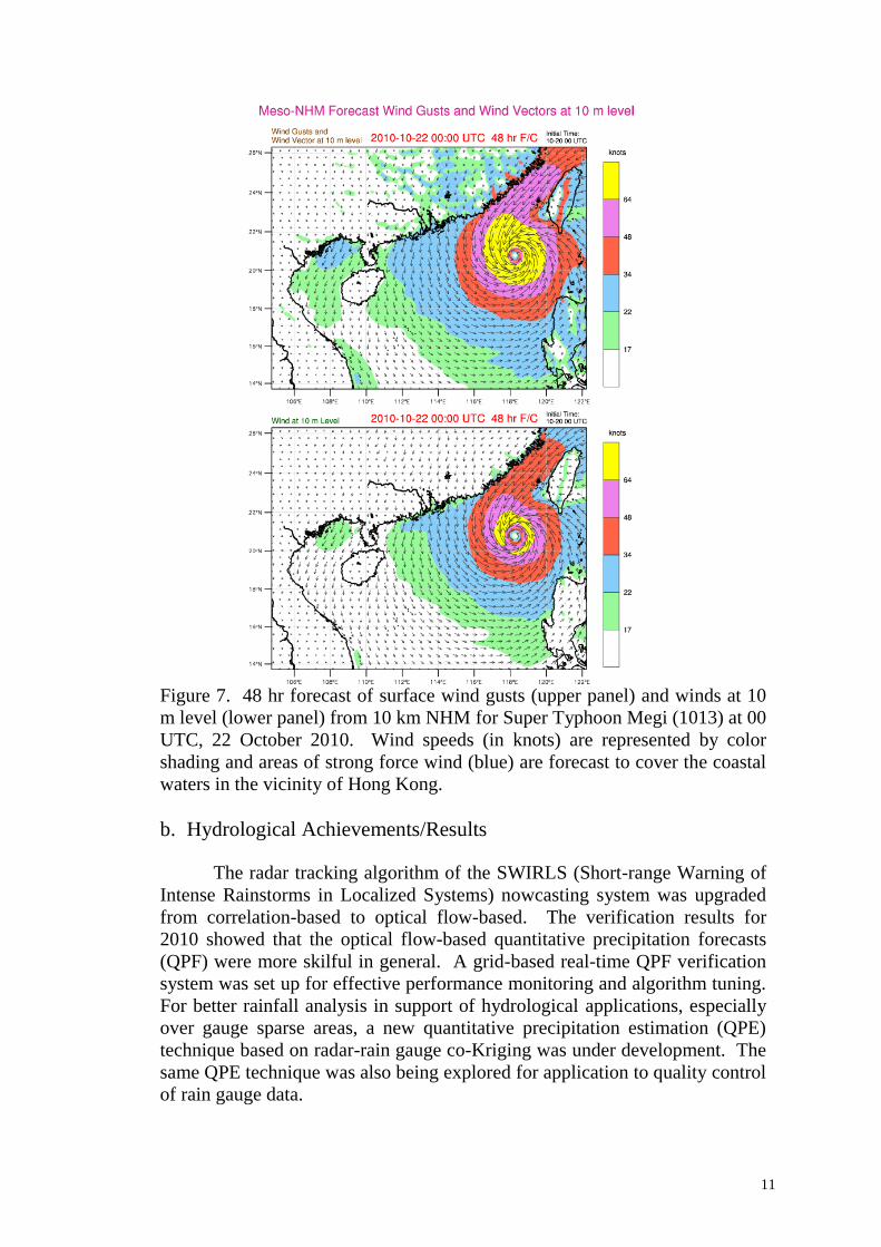
intensity over coastal areas of southern China (Figure 7).
11
Figure 7. 48 hr forecast of surface wind gusts (upper panel) and winds at 10
m level (lower panel) from 10 km NHM for Super Typhoon Megi (1013) at 00
UTC, 22 October 2010. Wind speeds (in knots) are represented by color
shading and areas of strong force wind (blue) are forecast to cover the coastal
waters in the vicinity of Hong Kong.
b. Hydrological Achievements/Results
The radar tracking algorithm of the SWIRLS (Short-range Warning of
Intense Rainstorms in Localized Systems) nowcasting system was upgraded
from correlation-based to optical flow-based. The verification results for
2010 showed that the optical flow-based quantitative precipitation forecasts
(QPF) were more skilful in general. A grid-based real-time QPF verification
system was set up for effective performance monitoring and algorithm tuning.
For better rainfall analysis in support of hydrological applications, especially
over gauge sparse areas, a new quantitative precipitation estimation (QPE)
technique based on radar-rain gauge co-Kriging was under development. The
same QPE technique was also being explored for application to quality control
of rain gauge data.

12
The Observatory provided support to the Drainage Service Department
in their review of the Drainage Master Plans in Yuen Long & North Districts
and feasibility study of applying integrated water resources management
system in real-time flood forecasting. Results showed that direct output from
SWIRLS nowcasting system agreed reasonably well with the measurement at
the nearest rain gauge but did not serve as a good predictor of flooding over a
small catchment due to spatial variation and time fluctuation. Further studies
would be conducted where opportunities arise.
The Observatory provided the Drainage Service Department with a
forecast guidance on the likelihood of having rainstorms (widespread and
persistent heavy rain with hourly rainfall at 30 mm or higher) in Hong Kong
in the next couple of hours to facilitate their flood control operations. It was
presented in iconic form, with intuitive graphical content flipping between
two possible states: “(80%” or “<80%” (meaning high chance or not). The
probability guidance was based on the rainfall forecasts generated by the
SWIRLS (Short-range Warning of Intense Rainstorms in Localized Systems)
nowcasting system and historical rainstorm data.
c. Disaster Prevention and Preparedness Achievements/Results
In order to facilitate the flood related operations of relevant government
departments, Short Message Service (SMS) was arranged to alert key
operational personnel upon the real-time regional rainfall exceeding the
thresholds of 50 mm/hr and 70 mm/hr.
With the successful implementation of a localized alert system on storm
surge flooding for a small rural village community in 2009, similar early alert
system was implemented for five more vulnerable areas in Hong Kong in 2010.
Early alerts would be communicated to key operational personnel using the
Short Message Service (SMS). Super Typhoon Megi (1013) posed severe
threats to countries along its path in October 2010. In Hong Kong, localized
storm surge alerts were activated during the approach of Megi. Necessary
precautions were taken in time for preventing flooding caused by possible
storm surge (Figure 8).

13
Figure 8. Precautions taken at one of the flood-prone locations
during the passage of Severe Typhoon Megi
d. Research, Training, and Other Achievements/Results
An Observatory‟s officer lectured on tropical cyclone wind and rainfall
forecasting in a training workshop at Shanghai organized under the WMO
Typhoon Landfall Forecast Demonstration Project. The objective of the
workshop is to enhance the ability of weather forecasters in tropical cyclone
forecasting, especially the provision of better forecast services for the World
Expo 2010.
A training course on "Automated Weather Station Network" was
provided to 11 meteorologists from 11 WMO Members by the Observatory
from 29 November to 3 December 2010. It covered, amongst other topics,
applications of automated weather station network in monitoring weather
situation during the passage of tropical cyclones. Data on wind, rain, water
levels, etc. gathered from local automatic weather stations is made available in
real-time on the Internet, providing detailed and timely weather information to
government personnel and the public for mitigation of damage and casualties
caused by tropical cyclones.
e. Regional Cooperation Achievements/Results
Please refer to Key Result Area 2(e).
f. Identified Opportunities/Challenges for Future Achievements/Results
Nil.

14
2. Progress on Key Result Area 2: Minimized Typhoon-related Social and
Economic Impacts. (List progress on the Strategic Goals and Associated Activities in
the Strategic Plan and progress on the 2008 Typhoon Committee Annual Operating Plan goals)
a. Meteorological Achievements/Results
Please refer to Key Result Area 1(a).
b. Hydrological Achievements/Results
The Drainage Service Department liaised closely with other relevant
Government departments and persons in charge of construction sites to avoid
flooding due to blockage of roadside gullies, drains or watercourses by garbage
or construction waste. Television announcements were broadcast from time to
time soliciting the support of the public to keep the drainage system from
blockage.
The Drainage Service Department provided a 24-hour hotline to
facilitate reception of flooding complaints and to mobilize their labour force
and contractors. Complaints received by the department were recorded by a
computerized Drainage Complaints Information System so that data could be
retrieved and analyzed later. When the situation warranted, an Emergency
Control Centre under the charge of senior professionals would be activated.
Please also refer to Key Result Area 5(b).
c. Disaster Prevention and Preparedness Achievements/Results
Typhoon related information on Hagupit (2008) and Koppu (2009) were
prepared and provided to NIDP, Republic of Korea for the production of
brochures. The information highlights the impact of the storm surge during
the passage of Hagupit and the new alerting system on storm surge during the
passage of Koppu.
Damage figures brought about by tropical cyclones and rainstorms were
collected from selected Government departments and public utility companies
for the compilation of damage statistics. The results were provided in the
annual tropical cyclone publication of the Observatory.
d. Research, Training, and Other Achievements/Results Nil.
e. Regional Cooperation Achievements/Results

15
As one of the contributions to the WMO Typhoon Landfall Forecast
Demonstration Project in assessing the social and economic impacts of an
improved tropical cyclone forecast service, the Observatory shared the
experience of conducting public and customer opinion surveys with the
Shanghai Typhoon Institute.
f. Identified Opportunities/Challenges for Future Achievements/Results Nil.
3. Progress on Key Result Area 3: Enhanced Beneficial Typhoon-related
Effects for the Betterment of Quality of life. (List progress on the Strategic Goals
and Associated Activities in the Strategic Plan and progress on the 2008 Typhoon Committee
Annual Operating Plan goals)
a. Meteorological Achievements/Results Nil.
b. Hydrological Achievements/Results Nil.
c. Disaster Prevention and Preparedness Achievements/Results Nil.
d. Research, Training, and Other Achievements/Results Nil.
A paper on the benefits of typhoons from the Hong Kong perspective was
presented in the 5th ESCAP/WMO Typhoon Committee‟s Integrated
Workshop “Urban Flood Risk Management in a Changing Climate: Sustainable
and Adaptation Challenges” held in September 2010. The study revealed that
the rainfall associated with tropical cyclones accounted for a significant portion
of Hong Kong‟s annual total rainfall and would help alleviate the prevailing
drought. Furthermore, based on data in 2007-2009, tropical cyclones provided
a net cooling effect in Hong Kong. Tropical cyclones could also enhance
potential wind energy in Hong Kong.
e. Regional Cooperation Achievements/Results
Nil.
f. Identified Opportunities/Challenges for Future Achievements/Results Nil.
4. Progress on Key Result Area 4: Improved Typhoon-related Disaster
Risk Management in Various Sectors. (List progress on the Strategic Goals and
Associated Activities in the Strategic Plan and progress on the 2008 Typhoon Committee
Annual Operating Plan goals)

16
a. Meteorological Achievements/Results
The convective weather associated with a tropical cyclone may have
adverse effects on flight operations, with implications on both aviation safety
and efficiency. In support of air traffic management (ATM), an Aviation
Thunderstorm Nowcasting System (ATNS) was developed and put into trial
operation since May 2010 to forecast the location of thunderstorms in the next
60 minutes by extrapolation based on artificial intelligence technique. ATNS
automatically determines the movement of thunderstorms from the radar image
sequence every 6 minutes and forecasts their future locations at 6-minute time
steps. It is found to be useful in forecasting the thunderstorms in the outer rain
bands of tropical cyclones. Alerts on severity of thunderstorms affecting the
vicinity of HKIA (Figure 9) are generated for reference by aviation weather
forecasters and air traffic controllers. Based on 5 tropical cyclone cases in
2010, ATNS demonstrates a 30-minute nowcasting skill with probability of
detection (POD) larger than 70% and false alarm rate (FAR) under 30%.
Figure 9. A web-based interface showing the forecast locations of thunderstorms
around HKIA (right panel with different colors indicating the intensity of forecast
radar reflectivity) and the corresponding alerts at selected locations (left panel) for the
case of Severe Typhoon Fanapi (1011) at 12:00 UTC on 20 September 2010.
High crosswind may have adverse impact on flight operations. To
support the forecasting of high crosswinds, objective probabilistic wind speed
and crosswind forecasts for the Hong Kong International Airport (HKIA)
were generated based on ECMWF EPS outputs for reference by aviation users
HKIA

17
and forecasters on a trial basis. Figure 10 shows the probabilistic products
during the passage of Severe Typhoon Megi in October 2010. To facilitate
near real-time verification, 10-minute mean wind observations ending on the
hour from the anemometers on the runways of HKIA are overlaid and denoted
by vertical black segments spanning the range of wind speed observations
from various anemometers. The wind observation in METAR report is
marked with a cross in the figure. New products of probabilistic forecast of
tropical cyclone distance from HKIA and probability map of tropical cyclone
positions would also be generated and put on trial in 2011 with a view to
facilitating users‟ understanding of the spread in the probabilistic wind
forecasts.
(a)
(b)
Figure 10 Objective probabilistic forecast of (a) wind speed; (b) crosswind
for HKIA during the passage of Severe Typhoon Megi in October 2010.
b. Hydrological Achievements/Results
Dynamic hydrological and hydraulic computer models for the drainage
systems in Hong Kong managed by the Drainage Service Department were
developed to provide quantitative information on the risk of flooding, impacts
of development and the performance of various flood loss mitigation options.
In particular, all the trunk and major branch river channels in the most flood-
prone river basins in the northern part of Hong Kong had been digitized into
the computational hydraulic model which was used for the review of the
hydrological criteria for the release of basin-wide flood warning in the region.
A computerized stormwater drainage asset inventory and maintenance system

18
had been developed. In the past year, the Drainage Service Department had
completed several research studies including a review on the triggering criteria
for the Special Announcement on Flooding in the northern New Territories, a
sensitivity analysis of the hydraulic effect of mangrove growth in river estuary,
an analysis of effects of climate change on stormwater drainage system, the use
of local rainfall forecasts to mobilize maintenance staff to deal with flooding,
and a study to identify the critical input parameters of the MIKE11 model and
to quantify their uncertainties and sensitivities on the flood risk assessment.
A study to estimate extreme rainfall intensities for various locations
over the whole territory using a regional frequency analysis approach was
being carried out and would be completed in early 2012.
c. Disaster Prevention and Preparedness Achievements/Results Nil.
d. Research, Training, and Other Achievements/Results
An Observatory‟s officer attended the Workshop on “Space Application
to Reduce Water-related Disaster Risk in Asia” organized by ESCAP and
supported by WMO Typhoon Committee and Japan Space Exploration (JAXA)
in Bangkok from 7 to 9 December 2010.
Please also refer to Key Result Area 2 (d).
e. Regional Cooperation Achievements/Results
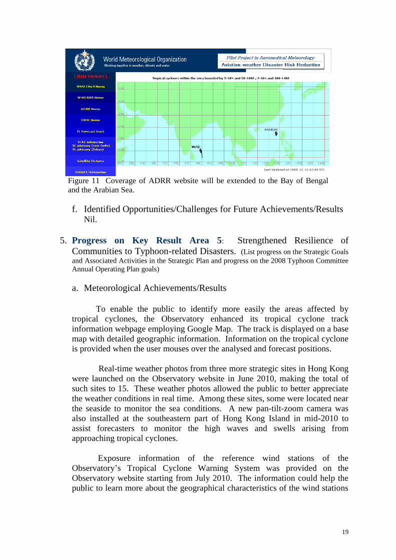
A pilot project on "Aviation Weather Disaster Risk Reduction" (ADRR)
in RA II was established in the WMO Commission for Aeronautical
Meteorology session in 2006 with a focus on tropical cyclone hazards.
Under the project, dedicated website (http://adrr.weather.gov.hk) for the
pilot project developed by the Observatory was being extended to cover the
Bay of Bengal and the Arabian Sea (see Figure 11) with the official tropical
cyclone forecasts, advisories (TCAC New Delhi), numerical weather prediction
products and satellite imageries of that area provided by India Meteorological
Department.
Noting the success of the pilot project, it is planned that the ADRR
website would become operational in early 2011. Training will also be
organized for sharing best practice with Members.
19
Figure 11 Coverage of ADRR website will be extended to the Bay of Bengal
and the Arabian Sea.
f. Identified Opportunities/Challenges for Future Achievements/Results Nil.
5. Progress on Key Result Area 5: Strengthened Resilience of
Communities to Typhoon-related Disasters. (List progress on the Strategic Goals
and Associated Activities in the Strategic Plan and progress on the 2008 Typhoon Committee
Annual Operating Plan goals)
a. Meteorological Achievements/Results
To enable the public to identify more easily the areas affected by
tropical cyclones, the Observatory enhanced its tropical cyclone track
information webpage employing Google Map. The track is displayed on a base
map with detailed geographic information. Information on the tropical cyclone
is provided when the user mouses over the analysed and forecast positions.
Real-time weather photos from three more strategic sites in Hong Kong
were launched on the Observatory website in June 2010, making the total of
such sites to 15. These weather photos allowed the public to better appreciate
the weather conditions in real time. Among these sites, some were located near
the seaside to monitor the sea conditions. A new pan-tilt-zoom camera was
also installed at the southeastern part of Hong Kong Island in mid-2010 to
assist forecasters to monitor the high waves and swells arising from
approaching tropical cyclones.
Exposure information of the reference wind stations of the
Observatory‟s Tropical Cyclone Warning System was provided on the
Observatory website starting from July 2010. The information could help the
public to learn more about the geographical characteristics of the wind stations

20
so that they could make sensible interpretation of the wind information at these
sites.
Two new products were launched on the Observatory‟s web page based
on the outputs of the new suite of high-resolution NWP models that came into
operation in mid-2010. The new products are, namely, “Computer Forecast
Weather Map” and “Wind Forecast for Water Sport Activities”. The former
provides prediction up to three days ahead of the evolution of weather patterns
over East Asia and the western North Pacific; and the latter provides detailed
site- and time-specific forecasts for a number of water sport hotspots in Hong
Kong. The new products will enable the public to gain more insight into the
possible development of hazardous weather such as tropical cyclones affecting
Hong Kong and the driving mechanisms behind them.
To publicize the Observatory's warning systems, a video series
introducing the severe weather warnings (including tropical cyclone) in Hong
Kong, was launched on YouTube
( http://www.youtube.com/watch?v=5ZO2wTTS6Po ) from May to July in
2010. Apart from providing the definitions and factors affecting the issuance
of our warnings, the videos also demonstrate the possible disasters brought by
severe weather. Members of the public are reminded on the suitable
precautions to take to minimize damage when severe weather warnings are in
force.
With the rapid increasing popularity of smartphones in the market, the
Observatory developed an iPhone application (named as MyObservatory,
Figure 12) in 2010 to provide individuals with a comprehensive and
personalized weather service any time and anywhere. MyObservatory
automatically provides the latest location-specific information, e.g. temperature,
wind and weather photos from the weather stations closest to the user. In
addition, the application also provides the latest tropical cyclone warnings as
well as the forecast track, which is implemented on Google map with rich
geographical information. “MyObservatory” has been well received by the
public, and its visit figures exceeded 100 million in three months. Plans are
underway for this popular application to be extended to other mobile platforms.

21
Fig. 12 Sample displays of “MyObservatory” showing the current
weather, 7-day forecasts and tropical cyclone forecast track.
To reach out to the younger generation, the Observatory started
experimenting with the use of social networking services for the dissemination
of weather warnings and information. The Hong Kong Observatory Twitter
service was launched in September 2010. Tropical cyclone warnings, in a form
of „tweets‟, are published on the Observatory‟s Twitter profile
“HKObservatory” and distributed to all „followers‟, viz. users subscribing to
the tweets of HKObservatory. The advantages of using these popular social
networking platforms include its cost-effectiveness for implementation and
maintenance as well as the ability to reach out to international travelers to
Hong Kong.
b. Hydrological Achievements/Results
Since 1997, about HK$8 billion worth of major river-training works and
flood-control projects had been completed in the New Territories over the
northern part of Hong Kong. As a result, the flooding in the New Territories
had reduced.
To alleviate flooding in low-lying villages, the Government completed 27
village flood pumping stations to protect 35 villages where river-training works
could not be effectively undertaken due to topography.
For the rural areas, the construction of 25 km of drainage channels and 3
km of stormwater drains were in progress. For the urban area, the

22
construction of 32 km of stormwater drains and 14 km of drainage tunnels were
underway.
Data from rain gauges operated by the Drainage Service Department and
Geotechnical Engineering Office were relayed to the Observatory to support
the operation of the Rainstorm Warning System, the Special Announcement on
Flooding in the northern New Territories and the Landslip Warning System.
Savings in operational cost were achieved by using the government data
network instead of commercial leased lines. General Packet Radio Services
(GPRS) mobile networks and solar panels were used for data acquisition in
some out-stations where land-based telemetry and electricity supply were
unreliable. Over 80 automated gauging stations were installed at major river
channels in the territory to provide round-the-clock real-time monitoring of
water depth, rainfall and video surveillance.
Over 1600 km of drains and watercourses were inspected and about $109
million was spent on such maintenance works in 2008-2009. At locations
where flooding might cause high risks to local residents, local flood warning
systems were installed to monitor the flooding situations and to alert them
about the arrival of floodwater. A list of flooding blackspots was also
compiled to facilitate the deployment of resources to carry out immediate relief
measures during adverse weather situations. Also refer to Key Result Areas
2(b) and 4(b)
Staff of the Drainage Service Department attended various training
classes, workshops and conferences (both local and overseas) to acquire the
latest knowledge on advanced technology relating to flood prevention,
including flooding caused by tropical cyclones. Overseas experts were also
invited to Hong Kong to provide in-house training to staff of the department on
advanced hydraulic modelling techniques for the drainage systems.
c. Disaster Prevention and Preparedness Achievements/Results
Seminars to promote public understanding of severe weather warnings and
proper response actions were conducted by the Hong Kong Observatory for
government bureaux/departments as well as the education, transport and other
sectors.
The "Safer Slopes Safer Living Fiesta 2010" was jointly organized by the
Civil Engineering and Development Department, Hong Kong Observatory,
Hong Kong Red Cross and the Hong Kong Association of Property
Management Companies (Figure 13). It was the first carnival event in Hong
Kong featuring slope safety and reducing natural disasters. It aimed to enhance
public knowledge and awareness on slope safety and disaster. Apart from
quizzes, booth games, performances and exhibitions, a „Disaster Adventure
Pavilion‟ was set up for people to experience the power of various natural

23
disasters such as landslides and typhoons. The Fiesta attracted more than 5,000
people.
Figure 13 Honourable guests officiating the opening ceremony of the Fiesta
To enhance public awareness of mountaineering safety, the Civil Aid
Service joined hands with 16 government departments and non-governmental
organizations to hold the "Mountaineering Safety Promotion Day" on 31
October 2010. As in the past years, the Observatory rendered full support to
the activity by setting up booth and delivering talks to introduce weather
phenomena including tropical cyclones which would affect mountaineering and
hiking. Precautions under various severe weather conditions were also
highlighted.
The “Hong Kong Community Weather Information Network” started in
2007 in collaboration with the Hong Kong Polytechnic University and the
Hong Kong Joint-school Meteorological Association saw further expansion in
the number of community weather stations to a total of 92, with relevant
weather data made available to the public via the Internet. Weather data
obtained through the Network was applied by school children in various
educational projects and studies. The network also helped raise awareness of
severe weather, including tropical cyclones.
To celebrate the World Meteorological Day on March 23, the Hong
Kong Observatory was open to the public on 27 and 28 March, 2010. Around
10,000 people of all ages visited the Observatory headquarters. The theme of
the Open Day was "Braving the storm together for over a hundred years".
Through words, pictures and various exhibits, it introduced how the
Observatory had evolved to cope with societal changes, protect the safety of
the public with science and technology, and contribute towards the well-being

24
of Hong Kong, its neighbouring areas and the international community.
d. Research, Training, and Other Achievements/Results
A series of public talks on "Weather and Everyday Life" was held at
various districts in Hong Kong in April 2010. The talks elaborated on weather
phenomena affecting daily life and the precautionary measures to be taken
during tropical cyclones and severe weather situations. Similar talks on
different topics were held in April, May and August 2010 to cater for the needs
of specific clients. Please also refer to Key Result Areas 4(d)
e. Regional Cooperation Achievements/Results
Nil.
f. Identified Opportunities/Challenges for Future Achievements/Results Nil.
6. Progress on Key Result Area 6: Improved Capacity to Generate and
Provide Accurate, Timely, and understandable Information on Typhoon-
related Threats. (List progress on the Strategic Goals and Associated Activities in the
Strategic Plan and progress on the 2008 Typhoon Committee Annual Operating Plan goals)
a. Meteorological Achievements/Results
Tropical cyclone predictions encoded in CXML format made available
under the THORPEX/TIGGE project were routinely acquired and processed.
Maps of the ensemble tracks (Figure 14) and strike probability derived from
such data were generated in real time for reference of the forecasters.

25
Figure 14. EPS predictions from various centres generated from CXML
data during Severe Tropical Storm Lionrock (1006).
The satellite-based tropical cyclone rainfall forecast tool combining the
QMORPH precipitation analysis from the Climate Prediction Center of NOAA
and subjective tropical cyclone forecast track was enhanced prior to the start of
the typhoon season in 2010. Perturbed tropical cyclone tracks output from the
EPS of ECMWF were employed to generate probabilistic rainfall predictions
with respect to various rainfall thresholds using the same technique. Figure 15
shows a sample of the new product during the passage of Severe Typhoon
Fanapi in September 2010.

26
Figure 15 Predictions of rainfall associated with Severe Typhoon
Fanapi (1011).
b. Hydrological Achievements/Results
Nil.
c. Disaster Prevention and Preparedness Achievements/Results
Nil.
d. Research, Training, and Other Achievements/Results
Verification of the track predictions from the multi-model ensemble
(MMC) and each of the member models, namely ECMWF, JMA, UKMO and
NCEP, was conducted using all cases of tropical cyclones at or above tropical
depression strength within the western North Pacific during 2008-2009. The
results showed that ECMWF outperformed all other members from 24-hour
forecasts to 120-hour forecasts with a wide margin (at 0.05 level of
significance and serial correlation removed). The ECMWF track position
errors were even smaller than those of MMC for 72-hour forecasts, 96-hour
forecasts and 120 hour forecasts. However, the differences were not
statistically significant.
A method using principal components of dynamical climate model data
as predictors to forecast the monthly/seasonal number of tropical cyclones
coming within a certain range of a city has been developed. A keynote lecture
on the subject was given by a member staff of the Observatory at the 5th
ESCAP/WMO Typhoon Committee Integrated Workshop “Urban Flood Risk
Management in a Changing Climate: Sustainable and Adaptation Challenges”.
An officer of the Observatory attended the 10th Training attachment to
RSMC Tokyo Typhoon Centre in Japan from 21 to 30 July 2010 under one of
the capacity building initiatives of the 33rd Session of ESCAP/WMO Typhoon
Committee.

27
Three officers of the Observatory separately attended (1) the
International Training Course on “Multi-hazard Early Warning” at WMO
Regional Training Centre at Nanjing, China from 10 to 28 May 2010; (2) the
International Training Course on “Satellite Meteorology” at WMO Regional
Training Centre at Beijing, China from 22 June to 2 July 2010; (3) the
International Training Course on “Numerical Weather Prediction” at WMO
Regional Training Centre at Nanjing, China from 13 to 24 Sep 2010.
e. Regional Cooperation Achievements/Results
An officer of the Observatory served as a member in the Typhoon
Committee‟s Expert Team on the Assessment of Change of Frequency and
Intensity of Tropical Cyclones in the Typhoon Committee Region.
Observatory‟s input of providing reference material and assessments had been
communicated to the focal point of the Expert Team.
f. Identified Opportunities/Challenges for Future Achievements/Results
Nil.
7. Progress on Key Result Area 7: Enhanced Typhoon Committee‟s
Effectiveness and International Collaboration. (List progress on the Strategic
Goals and Associated Activities in the Strategic Plan and progress on the 2008 Typhoon
Committee Annual Operating Plan goals)
a. Meteorological Achievements/Results Please refer to Key Result Area 2(e).
b. Hydrological Achievements/Results Nil.
c. Disaster Prevention and Preparedness Achievements/Results Nil.
d. Research, Training, and Other Achievements/Results
An Observatory staff served as a resource person and delivered lectures
on tropical cyclone genesis and seasonal tropical cyclone forecasting in the
Typhoon Committee Roving Seminar in 2010.
Please also refer to Key Result Area 4 (d).
e. Regional Cooperation Achievements/Results
28
As part of the Observatory‟s contribution to the WMO Landfall
Typhoon Forecast Demonstration Project (WMO-LTFDP), the in-house
developed satellite-based tropical cyclone rainfall forecast tool was adapted to
the eastern China region and being supplied in real-time to the Shanghai
Typhoon Institute for evaluation since September 2010.
A forecaster from the National Meteorological Centre of CMA attached
to the Observatory under the Typhoon Committee Research Fellowship 2010
for 2 months starting from late October 2010. The research topic was, “Can
the extreme rainfall associated with Typhoon Morakot (0908) happen in Hong
Kong?‟. The study involved the conduct of numerical experiments by
transplanting the storm vortex of Morakot and the associated environmental
conditions to the South China Sea in order to estimate the amount of rainfall
that would thus fall in Hong Kong.
The Severe Weather Information Centre (SWIC) website, operated by
Hong Kong, China for WMO, continues to serve as a popular channel for
dissemination of real-time official tropical cyclone warnings and information
worldwide. To facilitate the dissemination of severe weather warnings within
the local community and to enhance their availability to interested parties
anywhere on the globe, the ESCAP/Typhoon Committee recommended in 2009
a feasibility study of employing an Internet web based platform for real-time
transmission of severe weather warnings. Hong Kong, China coordinated the
project and undertook necessary software development. In June 2010, a new
service known as SWIdget was successfully launched by the
Observatory. With this SWIdget service, local as well as international users
can obtain severe weather warnings issued by participating official weather
services in near realtime in SWIC platform. Up to October 2010, warnings of
the three participating weather services, namely, Hong Kong, China; Macao,
China; and Guam, the USA, are available. Development was underway to
disseminate warnings from two Typhoon Committee members, viz Singapore
and Republic of Korea with target completion date in Jan 2011. Plans are in
hand to invite more official weather services to participate.
The WMO RA II Pilot Project on the Provision of City-Specific
Numerical Weather Prediction (NWP) Products to Developing Countries was
making steady progress. Up to October 2010, 19 RA II Members, 8 of which
were Typhoon Committee Members, participated in the project. In addition to
the forecast time series for the existing 160 cities, arrangement is being made to
generate forecast products to Pakistan and Thailand.
f. Identified Opportunities/Challenges for Future Achievements/Results
Two meteorologists from the Observatory attended the Seventh WMO
International Workshop on Tropical Cyclones (IWTC-VII) held in La Reunion,
France from 15-20 November 2010 and presented a rapporteur report on

29
“Operational Warning Strategies”. Apart from presenting a review of the
latest developments on the topic, a number of recommendations had been put
forward for discussion at the workshop.
III. Resource Mobilization Activities Nil.
IV. Update of Members’ Working Groups representatives
1. Working Group on Meteorology –
Mr. C.M. Shun – email: [email protected]
Facsimile: 852 23119448
Telephone: 852 29268232
2. Working Group on Hydrology –
Mr. H.Y. Mok – email: [email protected]
Facsimile: 852 23119448
Telephone: 852 29268451
3. Working Group on Disaster Prevention and Preparedness –
Ms. Hilda Lam - email: [email protected]
Facsimile: 852 23119448
Telephone: 852 29268222
4. Training and Research Coordinating Group –
Mr. Edwin S.T. Lai - email: [email protected]
Facsimile: 852 23119448
Telephone: 852 29268371
5. Resource Mobilization Group
Nil.