Embed Size (px)
Citation preview

Horse Creek Dam Removal ProjectSalmonid Habitat Survey
September 15, 2005
Prepared by:Matt W. Stoecker
P.O. Box 2062Santa Barbara, Ca. 93120
Prepared for:Community Environmental Council
930 Miramonte DriveSanta Barbara 93109
Contact: Mauricio Gomez
Funded by:American Rivers-NOAA Fisheries
Community-Based Restoration Program Partnership

2
Table of Contents
Title Page 1
Table of Contents 2
Background 3
Scope of Work 4
Survey Results 4
Horse Creek Drainage Map 5
Mainstem of Horse Creek 6
East Fork Horse Creek 11
Middle Fork Horse Creek 13
Salmonid Habitat and Population Recovery Conclusions 14
References 16
3
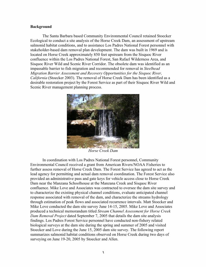
Background
The Santa Barbara based Community Environmental Council retained StoeckerEcological to conduct a site analysis of the Horse Creek Dam, an assessment of upstreamsalmonid habitat conditions, and to assistance Los Padres National Forest personnel withstakeholder-based dam removal plan development. The dam was built in 1969 and islocated on Horse Creek approximately 850 feet upstream from the Sisquoc Riverconfluence within the Los Padres National Forest, San Rafael Wilderness Area, andSisquoc River Wild and Scenic River Corridor. The obsolete dam was identified as animpassable barrier to fish migration and recommended for removal in SteelheadMigration Barrier Assessment and Recovery Opportunities for the Sisquoc River,California (Stoecker 2003). The removal of Horse Creek Dam has been identified as adesirable restoration project by the Forest Service as part of their Sisquoc River Wild andScenic River management planning process.
Horse Creek Dam
In coordination with Los Padres National Forest personnel, CommunityEnvironmental Council received a grant from American Rivers/NOAA Fisheries tofurther assess removal of Horse Creek Dam. The Forest Service has agreed to act as thelead agency for permitting and actual dam removal coordination. The Forest Service alsoprovided an administrative pass and gate keys for vehicle access close to Horse CreekDam near the Manzana Schoolhouse at the Manzana Creek and Sisquoc Riverconfluence. Mike Love and Associates was contracted to oversee the dam site survey andto characterize the existing physical channel conditions, evaluate anticipated channelresponse associated with removal of the dam, and characterize the streams hydrologythrough estimation of peak flows and associated recurrence intervals. Matt Stoecker andMike Love conducted the dam site survey June 14-15, 2005. Mike Love and Associatesproduced a technical memorandum titled Stream Channel Assessment for Horse CreekDam Removal Project dated September 7, 2005 that details the dam site analysisfindings. Los Padres Forest Service personnel have conducted non-fishery relatedbiological surveys at the dam site during the spring and summer of 2005 and visitedStoecker and Love during the June 15, 2005 dam site survey. The following reportsummarizes salmonid habitat conditions observed on Horse Creek during two days ofsurveying on June 19-20, 2005 by Stoecker and Allen.

4
Scope of Work
The objectives of the survey were to identify the natural limits to upstreamsteelhead migration that would be encountered with the removal of the Horse Creek Dam,to assess basic salmonid habitat conditions, and to document any fish species observed.The habitat survey extended from the Horse Creek confluence at the Sisquoc Riverupstream and included the upper mainstem of Horse Creek and both the Middle and EastForks of Horse Creek.
Survey Results
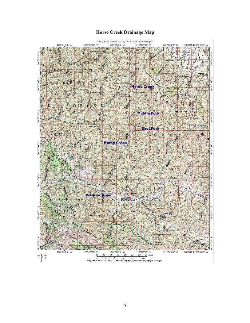
Survey results are summarized below for the mainstem of Horse Creek, the EastFork Horse Creek, and the Middle Fork Horse Creek. Within these reaches the habitatdescription and photographs are organized in the order they were observed from thedownstream end of the reach to the upstream survey limit. For the purposes of this report,the mainstem of Horse Creek extends from the Sisquoc River upstream along “HorseCanyon” as defined on USGS 7.5 minute quad maps. The East Fork Horse Creekconfluence with the mainstem occurs approximately 6.1 miles upstream of the SisquocRiver. The Middle Fork Horse Creek confluence with the mainstem occurs approximately7.15 miles upstream of the Sisquoc River. Both East and Middle Forks are unnamedtributaries on the USGS 7.5 minute quad maps. The mainstem of Horse Creek wassurveyed for approximately 8.7 miles upstream of the Sisquoc River. The East Fork ofHorse Creek was surveyed for 1.1 miles upstream of Horse Creek. The Middle Fork ofHorse Creek was surveyed for 1.0 mile upstream of Horse Creek. A total of 10.8 miles ofstream were ground surveyed within the Horse Creek drainage.
5
Horse Creek Drainage Map
6
Mainstem of Horse Creek
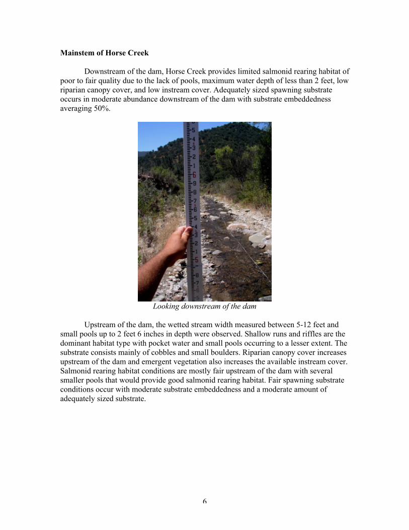
Downstream of the dam, Horse Creek provides limited salmonid rearing habitat ofpoor to fair quality due to the lack of pools, maximum water depth of less than 2 feet, lowriparian canopy cover, and low instream cover. Adequately sized spawning substrateoccurs in moderate abundance downstream of the dam with substrate embeddednessaveraging 50%.
Looking downstream of the dam
Upstream of the dam, the wetted stream width measured between 5-12 feet andsmall pools up to 2 feet 6 inches in depth were observed. Shallow runs and riffles are thedominant habitat type with pocket water and small pools occurring to a lesser extent. Thesubstrate consists mainly of cobbles and small boulders. Riparian canopy cover increasesupstream of the dam and emergent vegetation also increases the available instream cover.Salmonid rearing habitat conditions are mostly fair upstream of the dam with severalsmaller pools that would provide good salmonid rearing habitat. Fair spawning substrateconditions occur with moderate substrate embeddedness and a moderate amount ofadequately sized substrate.
7
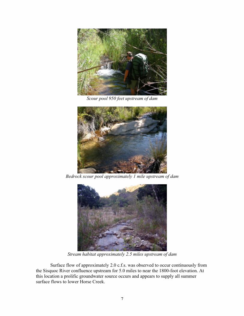
Scour pool 950 feet upstream of dam
Bedrock scour pool approximately 1 mile upstream of dam
Stream habitat approximately 2.5 miles upstream of dam
Surface flow of approximately 2.0 c.f.s. was observed to occur continuously fromthe Sisquoc River confluence upstream for 5.0 miles to near the 1800-foot elevation. Atthis location a prolific groundwater source occurs and appears to supply all summersurface flows to lower Horse Creek.

8
Groundwater resurfacing and dry channel upstream
Upstream of the groundwater source, Horse Creek was observed to be dry for 1.1miles to 100 feet upstream of the East Fork Horse Creek confluence. Approximately 100feet upstream of the East Fork Horse Creek confluence, a short reach of Horse Creek wasobserved to have trickling flows mixed with short dry reaches and several small pools.This wetted reach extended for only 0.05 miles and contained one bedrock scour poolmeasuring 2 feet 6 inches deep. Water temperature measured 67 degrees Fahrenheit. Thepool and adjacent wetted reaches would provide adequate, but limited summer rearinghabitat for salmonids.
Habitat approximately 250 feet upstream of the East Fork
The Horse Creek channel remained dry for 0.9 miles upstream to 250 feetdownstream of the Middle Fork where surface flows of 1 c.f.s were observed upstream tothe Middle Fork. The Middle Fork supplied all surface flows into this portion of HorseCreek. Water temperature was measured at 65 degrees Fahrenheit and fair spawning andrearing habitat was observed. Beginning immediately upstream of the Middle Fork, themainstem of Horse Creek was dry for 1.15 miles upstream to near the 2400-footelevation.
9
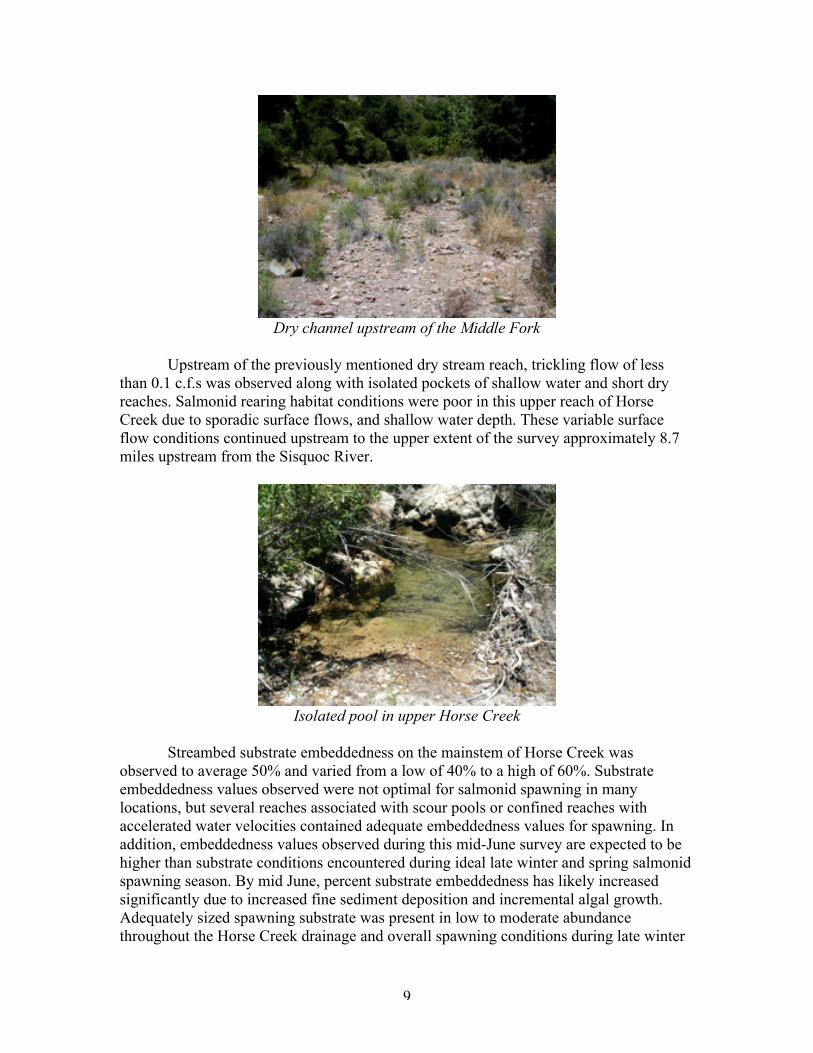
Dry channel upstream of the Middle Fork
Upstream of the previously mentioned dry stream reach, trickling flow of lessthan 0.1 c.f.s was observed along with isolated pockets of shallow water and short dryreaches. Salmonid rearing habitat conditions were poor in this upper reach of HorseCreek due to sporadic surface flows, and shallow water depth. These variable surfaceflow conditions continued upstream to the upper extent of the survey approximately 8.7miles upstream from the Sisquoc River.
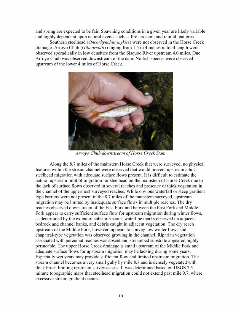
Isolated pool in upper Horse Creek
Streambed substrate embeddedness on the mainstem of Horse Creek wasobserved to average 50% and varied from a low of 40% to a high of 60%. Substrateembeddedness values observed were not optimal for salmonid spawning in manylocations, but several reaches associated with scour pools or confined reaches withaccelerated water velocities contained adequate embeddedness values for spawning. Inaddition, embeddedness values observed during this mid-June survey are expected to behigher than substrate conditions encountered during ideal late winter and spring salmonidspawning season. By mid June, percent substrate embeddedness has likely increasedsignificantly due to increased fine sediment deposition and incremental algal growth.Adequately sized spawning substrate was present in low to moderate abundancethroughout the Horse Creek drainage and overall spawning conditions during late winter
10
and spring are expected to be fair. Spawning conditions in a given year are likely variableand highly dependant upon natural events such as fire, erosion, and rainfall patterns.
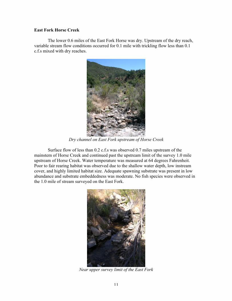
Southern steelhead (Oncorhynchus mykiss) were not observed in the Horse Creekdrainage. Arroyo Chub (Gila orcutti) ranging from 1.5 to 4 inches in total length wereobserved sporadically in low densities from the Sisquoc River upstream 4.0 miles. OneArroyo Chub was observed downstream of the dam. No fish species were observedupstream of the lower 4 miles of Horse Creek.
Arroyo Chub downstream of Horse Creek Dam
Along the 8.7 miles of the mainstem Horse Creek that were surveyed, no physicalfeatures within the stream channel were observed that would prevent upstream adultsteelhead migration with adequate surface flows present. It is difficult to estimate thenatural upstream limit of migration for steelhead on the mainstem of Horse Creek due tothe lack of surface flows observed in several reaches and presence of thick vegetation inthe channel of the uppermost surveyed reaches. While obvious waterfall or steep gradienttype barriers were not present in the 8.7 miles of the mainstem surveyed, upstreammigration may be limited by inadequate surface flows in multiple reaches. The dryreaches observed downstream of the East Fork and between the East Fork and MiddleFork appear to carry sufficient surface flow for upstream migration during winter flows,as determined by the extent of substrate scour, waterline marks observed on adjacentbedrock and channel banks, and debris caught in adjacent vegetation. The dry reachupstream of the Middle Fork, however, appears to convey low winter flows andchaparral-type vegetation was observed growing in the channel. Riparian vegetationassociated with perennial reaches was absent and streambed substrate appeared highlypermeable. The upper Horse Creek drainage is small upstream of the Middle Fork andadequate surface flows for upstream migration may be lacking during some years.Especially wet years may provide sufficient flow and limited upstream migration. Thestream channel becomes a very small gully by mile 8.7 and is densely vegetated withthick brush limiting upstream survey access. It was determined based on USGS 7.5minute topographic maps that steelhead migration could not extend past mile 9.7, whereexcessive stream gradient occurs.
11
East Fork Horse Creek
The lower 0.6 miles of the East Fork Horse was dry. Upstream of the dry reach,variable stream flow conditions occurred for 0.1 mile with trickling flow less than 0.1c.f.s mixed with dry reaches.
Dry channel on East Fork upstream of Horse Creek
Surface flow of less than 0.2 c.f.s was observed 0.7 miles upstream of themainstem of Horse Creek and continued past the upstream limit of the survey 1.0 mileupstream of Horse Creek. Water temperature was measured at 64 degrees Fahrenheit.Poor to fair rearing habitat was observed due to the shallow water depth, low instreamcover, and highly limited habitat size. Adequate spawning substrate was present in lowabundance and substrate embeddedness was moderate. No fish species were observed inthe 1.0 mile of stream surveyed on the East Fork.
Near upper survey limit of the East Fork
12
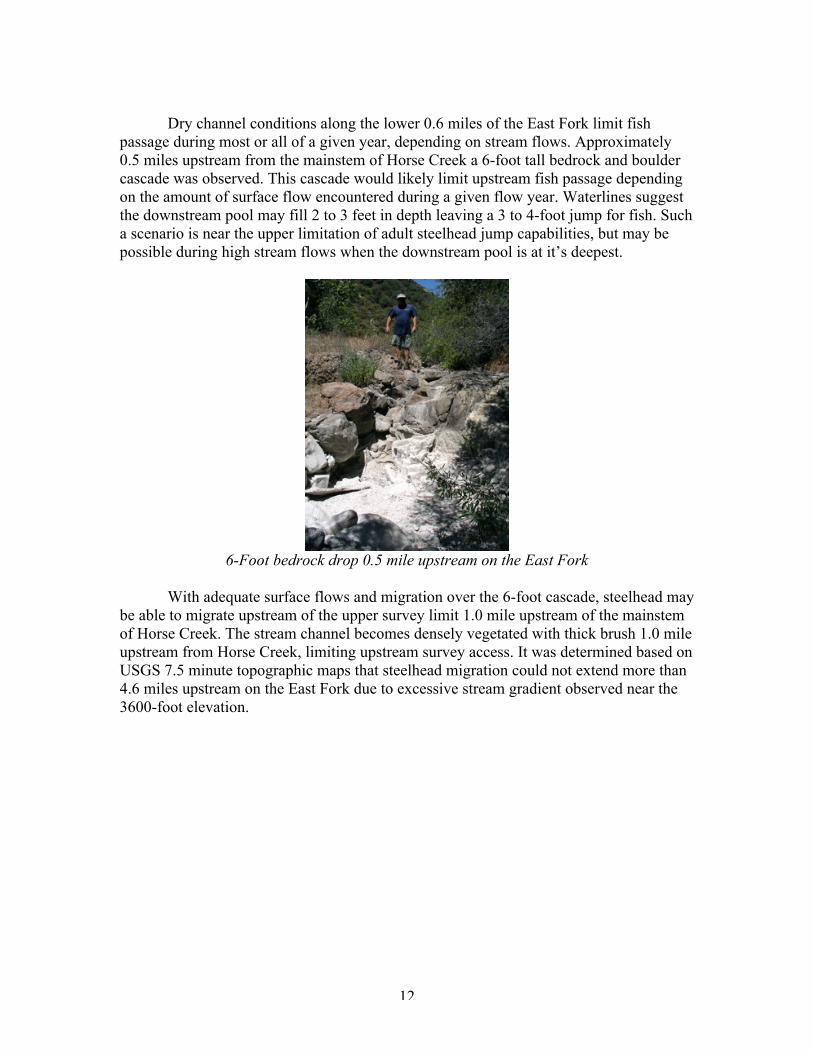
Dry channel conditions along the lower 0.6 miles of the East Fork limit fishpassage during most or all of a given year, depending on stream flows. Approximately0.5 miles upstream from the mainstem of Horse Creek a 6-foot tall bedrock and bouldercascade was observed. This cascade would likely limit upstream fish passage dependingon the amount of surface flow encountered during a given flow year. Waterlines suggestthe downstream pool may fill 2 to 3 feet in depth leaving a 3 to 4-foot jump for fish. Sucha scenario is near the upper limitation of adult steelhead jump capabilities, but may bepossible during high stream flows when the downstream pool is at it’s deepest.
6-Foot bedrock drop 0.5 mile upstream on the East Fork
With adequate surface flows and migration over the 6-foot cascade, steelhead maybe able to migrate upstream of the upper survey limit 1.0 mile upstream of the mainstemof Horse Creek. The stream channel becomes densely vegetated with thick brush 1.0 mileupstream from Horse Creek, limiting upstream survey access. It was determined based onUSGS 7.5 minute topographic maps that steelhead migration could not extend more than4.6 miles upstream on the East Fork due to excessive stream gradient observed near the3600-foot elevation.
13
Middle Fork Horse Creek
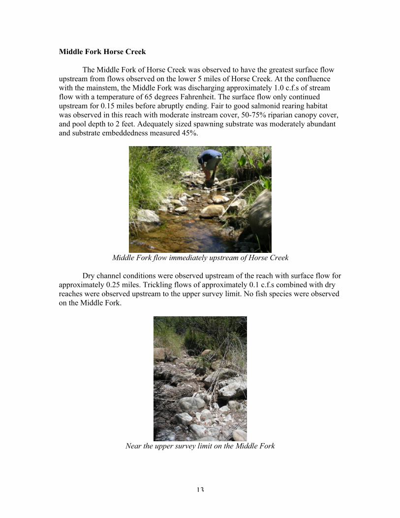
The Middle Fork of Horse Creek was observed to have the greatest surface flowupstream from flows observed on the lower 5 miles of Horse Creek. At the confluencewith the mainstem, the Middle Fork was discharging approximately 1.0 c.f.s of streamflow with a temperature of 65 degrees Fahrenheit. The surface flow only continuedupstream for 0.15 miles before abruptly ending. Fair to good salmonid rearing habitatwas observed in this reach with moderate instream cover, 50-75% riparian canopy cover,and pool depth to 2 feet. Adequately sized spawning substrate was moderately abundantand substrate embeddedness measured 45%.
Middle Fork flow immediately upstream of Horse Creek
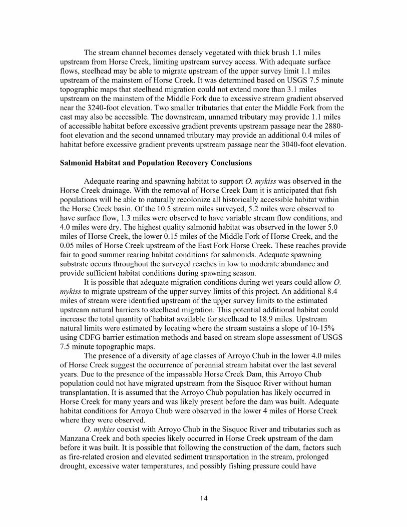
Dry channel conditions were observed upstream of the reach with surface flow forapproximately 0.25 miles. Trickling flows of approximately 0.1 c.f.s combined with dryreaches were observed upstream to the upper survey limit. No fish species were observedon the Middle Fork.
Near the upper survey limit on the Middle Fork
14
The stream channel becomes densely vegetated with thick brush 1.1 milesupstream from Horse Creek, limiting upstream survey access. With adequate surfaceflows, steelhead may be able to migrate upstream of the upper survey limit 1.1 milesupstream of the mainstem of Horse Creek. It was determined based on USGS 7.5 minutetopographic maps that steelhead migration could not extend more than 3.1 milesupstream on the mainstem of the Middle Fork due to excessive stream gradient observednear the 3240-foot elevation. Two smaller tributaries that enter the Middle Fork from theeast may also be accessible. The downstream, unnamed tributary may provide 1.1 milesof accessible habitat before excessive gradient prevents upstream passage near the 2880-foot elevation and the second unnamed tributary may provide an additional 0.4 miles ofhabitat before excessive gradient prevents upstream passage near the 3040-foot elevation.
Salmonid Habitat and Population Recovery Conclusions
Adequate rearing and spawning habitat to support O. mykiss was observed in theHorse Creek drainage. With the removal of Horse Creek Dam it is anticipated that fishpopulations will be able to naturally recolonize all historically accessible habitat withinthe Horse Creek basin. Of the 10.5 stream miles surveyed, 5.2 miles were observed tohave surface flow, 1.3 miles were observed to have variable stream flow conditions, and4.0 miles were dry. The highest quality salmonid habitat was observed in the lower 5.0miles of Horse Creek, the lower 0.15 miles of the Middle Fork of Horse Creek, and the0.05 miles of Horse Creek upstream of the East Fork Horse Creek. These reaches providefair to good summer rearing habitat conditions for salmonids. Adequate spawningsubstrate occurs throughout the surveyed reaches in low to moderate abundance andprovide sufficient habitat conditions during spawning season.
It is possible that adequate migration conditions during wet years could allow O.mykiss to migrate upstream of the upper survey limits of this project. An additional 8.4miles of stream were identified upstream of the upper survey limits to the estimatedupstream natural barriers to steelhead migration. This potential additional habitat couldincrease the total quantity of habitat available for steelhead to 18.9 miles. Upstreamnatural limits were estimated by locating where the stream sustains a slope of 10-15%using CDFG barrier estimation methods and based on stream slope assessment of USGS7.5 minute topographic maps.
The presence of a diversity of age classes of Arroyo Chub in the lower 4.0 milesof Horse Creek suggest the occurrence of perennial stream habitat over the last severalyears. Due to the presence of the impassable Horse Creek Dam, this Arroyo Chubpopulation could not have migrated upstream from the Sisquoc River without humantransplantation. It is assumed that the Arroyo Chub population has likely occurred inHorse Creek for many years and was likely present before the dam was built. Adequatehabitat conditions for Arroyo Chub were observed in the lower 4 miles of Horse Creekwhere they were observed.
O. mykiss coexist with Arroyo Chub in the Sisquoc River and tributaries such asManzana Creek and both species likely occurred in Horse Creek upstream of the dambefore it was built. It is possible that following the construction of the dam, factors suchas fire-related erosion and elevated sediment transportation in the stream, prolongeddrought, excessive water temperatures, and possibly fishing pressure could have
15
eliminated the O. mykiss population. With the impassable dam near the mouth of thecreek, O. mykiss have likely not been able to recolonize the drainage since that time. It isexpected that following the removal of Horse Creek Dam, O. mykiss and other aquaticspecies prevented from upstream migration, will naturally recolonize this drainage. Itshould be noted that natural events such as fires and prolonged droughts may havehistorical eliminated fish populations from all or parts of Horse Creek in the past andsimilar conditions will surely occur in the future. However, with the removal of HorseCreek Dam, unrestricted migration from the Sisquoc River to the natural upstream limitsof Horse Creek will allow fish populations to naturally recolonize the tributary whenconditions are adequate.
Successful steelhead recovery to Horse Creek, the Sisquoc River, and the SantaMaria River watershed is highly dependant on improving steelhead migration conditionson the Santa Maria River downstream. Unfavorable flow releases from Twitchell Dam onthe Cuyama River, increased groundwater pumping near Santa Maria, and gravelextraction operations in the river channel have all negatively impacted the nowendangered Santa Maria/Sisquoc River steelhead population (Stoecker 2003). Improvedstream flow conditions for steelhead migration between the ocean and the Sisquoc Riverare needed to ensure successful steelhead recovery to Horse Creek, the Sisquoc River,and Santa Maria River watershed.
16
References
California Department of Fish and Game 2002. California Salmonid Stream HabitatRestoration Manual. State of California Resources Agency Department of Fish and GameThird Edition Volume II February 2002.
Love, Michael, Llanos, Antonio 2005. Stream Channel Assessment for Horse Creek DamRemoval Project. Prepared for Stoecker Ecological. September 7, 2005
Stoecker, Matt W., J. Stoecker 2003. Steelhead Migration Barrier Assessment andRecovery Opportunities for the Sisquoc River, California. Submitted to and funded by theCoastal Conservancy. January 2003.


![[W f stoecker]_refrigeration_and_a_ir_conditioning_(book_zz.org)](https://img.pdfslide.net/doc/110x75/58a81cc11a28ab4d148b58b3/w-f-stoeckerrefrigerationandairconditioningbookzzorg.jpg)


![Stoecker & Jones - Refrigeration & Air Conditioning 2nd Ed [McGraw Hill]](https://img.pdfslide.net/doc/110x75/55cf9a75550346d033a1d676/stoecker-jones-refrigeration-air-conditioning-2nd-ed-mcgraw-hill.jpg)