Embed Size (px)
Citation preview
Hospital heliport flight path protection
Guidance note for Design and Development Overlays

Hospital heliport flight path protection: Guidance note for design and development overlays Page 3
Hospital heliport flight path protection
Guidance note for Design and Development Overlays
Page 4 Hospital heliport flight path protection: Guidance note for design and development overlays
To receive this publication in an accessible format phone (03) 9096 2119, using the
National Relay Service 13 36 77 if required, or email [email protected].
Authorised and published by the Victorian Government, 1 Treasury Place, Melbourne.
© State of Victoria, Department of Health and Human Services November 2017.
ISBN 978-0-7311-7077-7 (pdf/online)
Available at www.capital.health.vic.gov.au.
Hospital heliport flight path protection: Guidance note for design and development overlays Page 5
Contents
Introduction ................................................................................................................................................. 7
Part 1: Protecting hospital heliport flight paths ...................................................................................... 9
Why heliport flight paths need to be protected ............................................................................................. 9
Purpose of applying an overlay .................................................................................................................... 9
How overlays are applied to hospital heliports ............................................................................................. 9
Incorporated documents ............................................................................................................................. 12
Part 2: Planning permission and exemptions ....................................................................................... 14
When planning controls apply .................................................................................................................... 14
Exemptions ................................................................................................................................................. 14
Determining whether a development triggers the planning control and therefore whether a
planning permit is required ......................................................................................................................... 15
Part 3: Making and assessing applications ........................................................................................... 16
Documentation to support a planning permit application ........................................................................... 16
Pre-application meetings ............................................................................................................................ 16
Notification .................................................................................................................................................. 16
Referral of the application ........................................................................................................................... 16
Assessment of the application .................................................................................................................... 17
Permit conditions ........................................................................................................................................ 17
Application costs ......................................................................................................................................... 17
Review rights .............................................................................................................................................. 17
Part 4: Further information ...................................................................................................................... 18
Appendix 1: Incorporated document ...................................................................................................... 19
Hospital Emergency Medical Services - Helicopter Flight Path Protection Areas Incorporated
Document, June 2017 ................................................................................................................................ 19
Appendix 2: Plumes ................................................................................................................................. 22
Background ................................................................................................................................................. 22
Definition ..................................................................................................................................................... 22
Sources of plumes ...................................................................................................................................... 22
How plumes affect aircraft operations ........................................................................................................ 22
Factors that influence the impact of a plume on aircraft operations ........................................................... 22
Assessing critical plume velocity ................................................................................................................ 23
Mitigating the impact of a plume on helicopter operations ......................................................................... 23
Responsibility for costs associated with plume assessment ...................................................................... 23
Controlling plumes in hospital heliport flight paths ..................................................................................... 23
More information ......................................................................................................................................... 23
Appendix 3: Flow diagram to determine if a planning permit is required .......................................... 24
Appendix 4: Example referral responses ............................................................................................... 25
No comment ............................................................................................................................................... 25
Page 6 Hospital heliport flight path protection: Guidance note for design and development overlays
Objection to development ........................................................................................................................... 25
Development supported with conditions ..................................................................................................... 25
Hospital heliport flight path protection: Guidance note for design and development overlays Page 7
Introduction
This guidance note has been prepared by the Department of Health and Human Services (the
department) to assist councils, planning permit applicants, interested parties and the general public with
the interpretation and implementation of Design and Development Overlay (overlay) planning controls
protecting the flight paths of emergency medical services helicopter landing sites at public hospitals in
Victoria.
The guidance note provides information on:
• protecting emergency medical services helicopter landing site flight paths
• how overlays and the associated incorporated document are applied to hospital heliports
• determining when a development will trigger the need for approval under the overlay
• applying for a planning permit where a proposed development triggers this overlay, and assessing a
planning permit application for an affected property
• sources of further information.
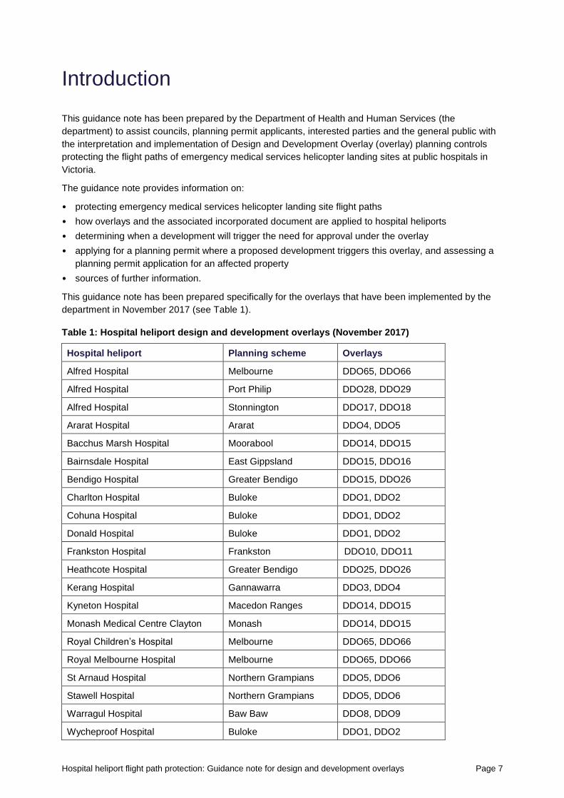
This guidance note has been prepared specifically for the overlays that have been implemented by the
department in November 2017 (see Table 1).
Table 1: Hospital heliport design and development overlays (November 2017)
Hospital heliport Planning scheme Overlays
Alfred Hospital Melbourne DDO65, DDO66
Alfred Hospital Port Philip DDO28, DDO29
Alfred Hospital Stonnington DDO17, DDO18
Ararat Hospital Ararat DDO4, DDO5
Bacchus Marsh Hospital Moorabool DDO14, DDO15
Bairnsdale Hospital East Gippsland DDO15, DDO16
Bendigo Hospital Greater Bendigo DDO15, DDO26
Charlton Hospital Buloke DDO1, DDO2
Cohuna Hospital Buloke DDO1, DDO2
Donald Hospital Buloke DDO1, DDO2
Frankston Hospital Frankston DDO10, DDO11
Heathcote Hospital Greater Bendigo DDO25, DDO26
Kerang Hospital Gannawarra DDO3, DDO4
Kyneton Hospital Macedon Ranges DDO14, DDO15
Monash Medical Centre Clayton Monash DDO14, DDO15
Royal Children’s Hospital Melbourne DDO65, DDO66
Royal Melbourne Hospital Melbourne DDO65, DDO66
St Arnaud Hospital Northern Grampians DDO5, DDO6
Stawell Hospital Northern Grampians DDO5, DDO6
Warragul Hospital Baw Baw DDO8, DDO9
Wycheproof Hospital Buloke DDO1, DDO2
Page 8 Hospital heliport flight path protection: Guidance note for design and development overlays
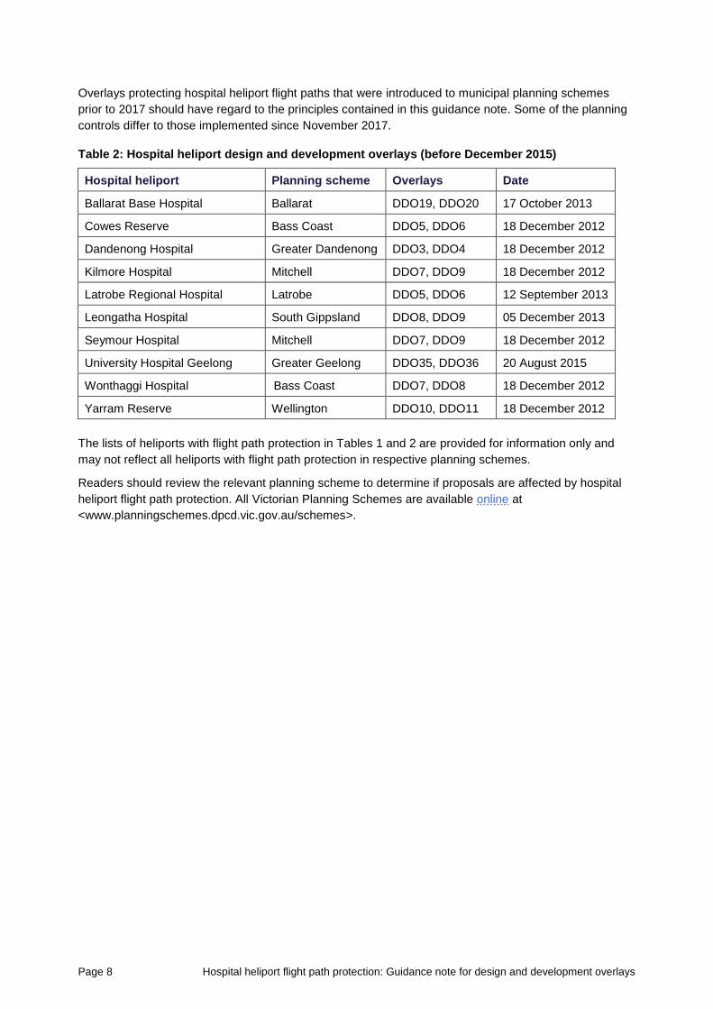
Overlays protecting hospital heliport flight paths that were introduced to municipal planning schemes
prior to 2017 should have regard to the principles contained in this guidance note. Some of the planning
controls differ to those implemented since November 2017.
Table 2: Hospital heliport design and development overlays (before December 2015)
Hospital heliport Planning scheme Overlays Date
Ballarat Base Hospital Ballarat DDO19, DDO20 17 October 2013
Cowes Reserve Bass Coast DDO5, DDO6 18 December 2012
Dandenong Hospital Greater Dandenong DDO3, DDO4 18 December 2012
Kilmore Hospital Mitchell DDO7, DDO9 18 December 2012
Latrobe Regional Hospital Latrobe DDO5, DDO6 12 September 2013
Leongatha Hospital South Gippsland DDO8, DDO9 05 December 2013
Seymour Hospital Mitchell DDO7, DDO9 18 December 2012
University Hospital Geelong Greater Geelong DDO35, DDO36 20 August 2015
Wonthaggi Hospital Bass Coast DDO7, DDO8 18 December 2012
Yarram Reserve Wellington DDO10, DDO11 18 December 2012
The lists of heliports with flight path protection in Tables 1 and 2 are provided for information only and
may not reflect all heliports with flight path protection in respective planning schemes.
Readers should review the relevant planning scheme to determine if proposals are affected by hospital
heliport flight path protection. All Victorian Planning Schemes are available online at
<www.planningschemes.dpcd.vic.gov.au/schemes>.
Hospital heliport flight path protection: Guidance note for design and development overlays Page 9
Part 1: Protecting hospital heliport flight paths
Why heliport flight paths need to be protected
Helicopter-based emergency medical services play a key role in providing medical and trauma care to
patients who are critically ill or who may have been involved in serious accidents.
Hospital heliports typically have more than one flight path to ensure that the helipad is available for use in
a range of weather conditions and in the event that one of the flight paths is temporarily unavailable for
helicopter movements.
The protection of hospital heliport flight paths is required to ensure the efficient and effective transfer of
critically ill patients to designated landing sites at public hospitals. Time is critical to the survival of a
trauma patient, and helicopter transport is frequently the quickest way to deliver trauma patients to a
major trauma service. Safeguarding flight paths protects an integral part of the Victorian health system
and ensure ongoing service for future generations.
Purpose of applying an overlay
The purpose of applying an overlay is to protect helicopter flight paths from the encroachment of
obstacles by requiring a planning permit for development that may affect emergency medical services
helicopter operations.
An overlay is a common tool used in planning schemes to identify areas affected by specific
requirements relating to the design and built form of new development. It is a planning control designed
to achieve desired or specified built form outcomes. A schedule accompanies the overlay, containing a
statement of the design objectives to be achieved for the area affected and outlining the requirements of
the control.
The main advantages of using an overlay are that it provides an accepted and transparent planning
mechanism for the protection of heliport operations, and for these flight paths to be considered in the
decision-making process when assessing planning permits for a proposed development.
The overlays do not introduce a mandatory height limit. Instead, they trigger a requirement for a planning
permit for certain buildings and works to be obtained from the responsible authority, usually the local
council.
In the case of the overlays implemented in November 2017 there is reference to an incorporated
document for specific buildings and works which cannot be protected solely through an overlay. This is
explained further below.
All planning permit applications will be referred to the department, which will assess each referral on its
merit. Where the proposed development will not affect heliport operations, the development is likely to be
supported, or supported with conditions. Where it would affect heliport operations, the proposal may be
rejected.
How overlays are applied to hospital heliports
The protection of hospital heliport flight paths is based on the department’s Planning and development
guidelines: guidelines for helicopter medical transport landing sites.1 These guidelines are based on the
current and proposed regulatory framework for helicopter medical transport flights as well as relevant
international standards and recommended practices.
1 Guidelines for helicopter medical transport landing sites
<www.capital.health.vic.gov.au/Asset_property_management_and_operations/Helicopter_landing_site_guidelines_2015/>.
Page 10 Hospital heliport flight path protection: Guidance note for design and development overlays
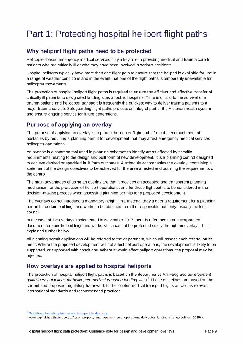
The flight paths ensure that helicopters can operate in Performance Class 1 at existing hospital heliports.
Performance Class 1 is a flight condition with one engine inoperative on the approach and departure up
to 1,130 metres from the hospital helipad.
In accordance with the department’s guidelines, the area protected by the overlay is the obstacle
limitation surface for the flight path of a Performance Class 1 flight. The obstacle limitation surface
defines the desirable limits to which objects may project into airspace so that aircraft operations may be
conducted safely.
The obstacle limitation surface commences at the edge of the helipad (called the safety area) and
extends horizontally along a flat plane equivalent to the height of the helipad for 240 metres. From this
point, the obstacle limitation surface gradually rises at an angle of 4.5 per cent. By protecting the
helipad’s obstacle limitation surface, helicopter operations can be safely maintained in accordance with
applicable guidelines and international standards.
The overlays apply to the first 1,130 metres of the flight path. At this point, the helicopter would be
approximately 40 metres above the elevation of the helipad. The obstacle limitation surface for a
helicopter flight path continues until the helicopter is 150 metres above the hospital helipad, which is a
lateral distance of 3,386 metres from the helipad.
Protection of the flight path between 1,130 metres and 3,386 metres is not required at this point in time. If
the Civil Aviation Safety Authority adopts the Notice of proposed rulemaking (NPRM 1304OS): regulation
of aeroplane and helicopter ‘ambulance function’ flights as AIR Transport operations, then the
department will reconsider the need to apply an overlay to protect flight paths beyond 1,130 metres.
Figure 1 below provides a simplified depiction of the obstacle limitation surface and overlays relative to
the helipad.
Figure 1: Heights of obstacle limitation surface and Overlay relative to helipad (simplified)
As shown above, an inner and an outer overlay is applied to each hospital heliport. This approach
minimises the overall number of developments that may trigger a planning permit.
The inner overlay ensures that any structures plumes that are of the same height or higher than the
hospital helipad and within 240 metres of the helipad or 460 metres along the flight path are referred to
the department for an assessment of the impacts to the flight path.
The outer overlay ensures that any structures that are more than 10 metres above the hospital helipad
and between 460 metres and 1,130 metres laterally from the helipad along the flight path are referred to
the department for an assessment of the impacts to the flight path.
Hospital heliport flight path protection: Guidance note for design and development overlays Page 11
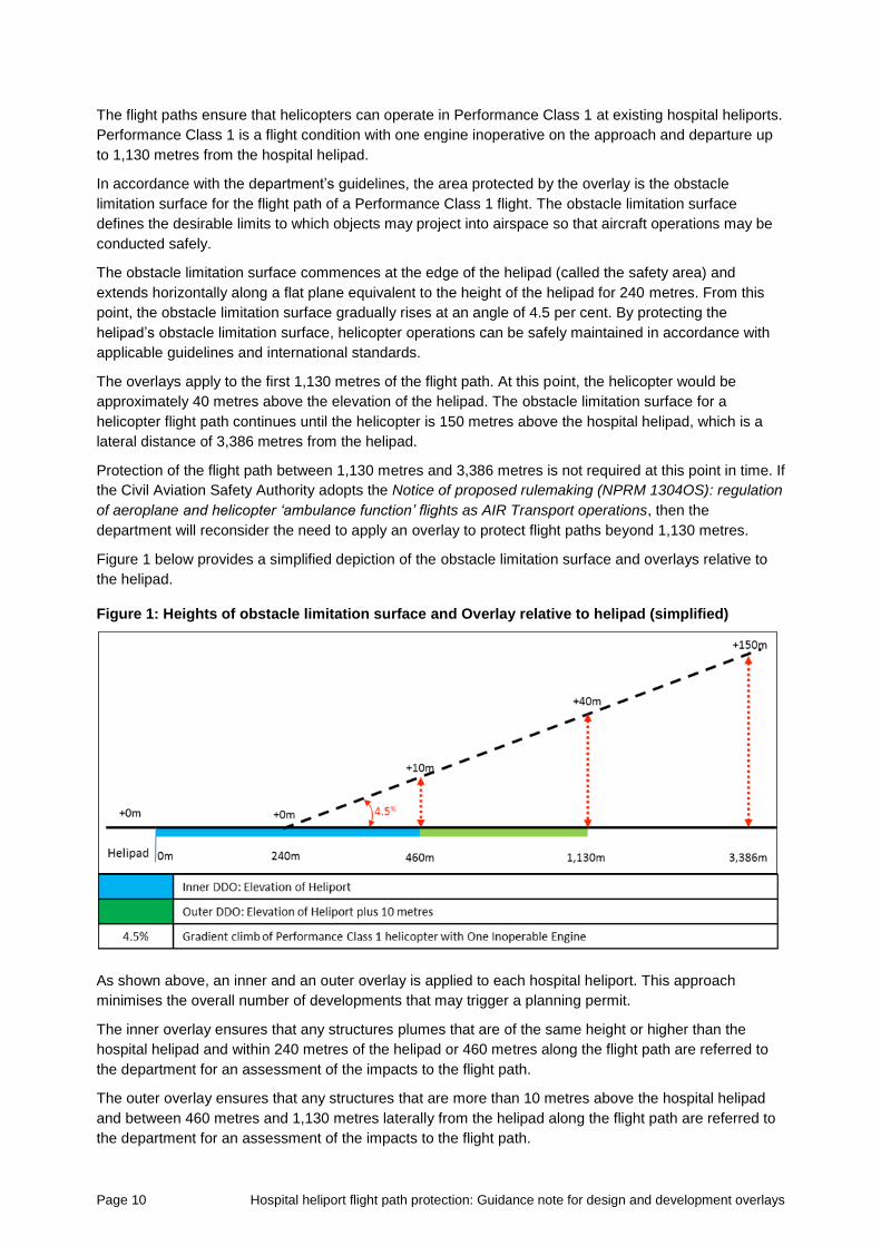
The overlays have two different shapes. The first shape is a ‘corridor’ containing a 150-metre wide flight
path to allow for crosswinds where there is a defined flight path. Flight paths are usually defined for
helipads which are either elevated and/or those which are used regularly. Where appropriate, a 70-metre
wide buffer area either side of the flight path is included, which represents the potential reach of a
construction crane.
The second shape is a ‘sector’ of varying widths where a hospital does not have a defined flight path.
The sector has been mapped based on site conditions and discussions with Air Ambulance Victoria,
Victoria Police Air Wing and chief pilots from the operator of Air Ambulance helicopters in Victoria.
Figure 2: Widths of obstacle limitation surface and overlay relative to helipad (simplified)
In-situ cranes can affect the flight path of helicopters and temporarily close a flight path. Where there is
no notification of a planned development that penetrates a hospital helipad flight path, the department
and the relevant hospital and Air Ambulance Victoria are unable to facilitate flight path alternatives. In the
event that a helicopter approaches a hospital helipad and discovers an uncharted obstacle in the flight
path, then it is at the discretion of the pilot in command to use the hospital helipad. This could mean that
critical patients are either sent to another hospital, or to an alternative location for transfer to the hospital
by road ambulance. This could potentially affect the timing and hence capacity to save lives and/or
achieve the optimal recovery of patients.
In regional Victoria, the 70-metre buffer for cranes is only applied in rural cities, such as Bendigo, where
there is a higher likelihood that future developments may use construction cranes that could interfere
with flight paths.
The protection of the flight path of helicopters from cranes is managed through an incorporated
document.
Page 12 Hospital heliport flight path protection: Guidance note for design and development overlays
Incorporated documents
The Planning and Environment Act 1987 allows certain documents to be incorporated in a planning
scheme by reference, rather than by including them in the scheme itself. Incorporated documents are
included in the list in the Schedule to Clause 81.01 (local) of the planning scheme.
Generally, where reference to a document is specifically required because the document affects the
operation of the planning scheme, the document, or relevant part of the document, is incorporated and
read as part of the scheme.
Each of the planning schemes with an overlay for Hospital Emergency Medical Services - Helicopter
Flight Path Protection Areas implemented in November 2017 has an incorporated document for
managing the impact of certain buildings and works within the protected areas. For ease of reference the
incorporated document as of November 2017 is included in Appendix 1 and covers the construction, or
carrying out, of buildings and works for:
• a temporary structure for construction purposes, including a crane or other construction equipment
that is fixed to the ground
• a stack, vent, chimney, cooling tower or the like that produces an exhaust plume which has an
upward vertical velocity of 4.3 metres or more per second at the point of emission/exit
• a telecommunications facility, including radio masts and antenna
• a flagpole.
The incorporated document is provided in this guideline for information only and may not reflect the
actual incorporated document in respective planning schemes.
Types and impact of cranes
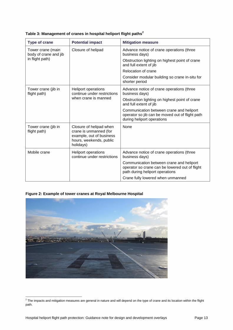
The most common temporary structure for construction purposes likely to affect helicopter operations are
cranes. There are two main forms of cranes used for construction purposes: in-situ (fixed) and mobile.
An in-situ or tower crane is a fixed structure generally used in the construction of skyscrapers and similar
large-scale developments. They are usually in place from a number of months to a year, and are mainly
used in metropolitan Melbourne and large regional cities.
Mobile, telescope or truck-mounted cranes are fixed to a mobile platform. They are usually mounted to
the back of a truck and are used during short-term construction projects. These include the construction
of pre-fabricated and concrete panel buildings, and lifting plant equipment to the roof of commercial and
residential buildings. They may be on site for short periods, or for multiple days at a time. Whereas
mobile cranes are exempt from the incorporated document, they can still affect helicopter operations and
proactive engagement with hospitals can avoid any adverse impact on helicopter operations.
The potential impacts of cranes and mitigation measures are outlined in Table 3.
Exhaust plumes
An exhaust plume is gas, steam, water or similar that rises into the air in a tall, thin shape, usually
emanating from a stack, vent, chimney, cooling tower or the like.
An exhaust plume which has an upward vertical velocity of 4.3 metres or more per second at the point of
emission/exit can affect the operations of helicopters. Further guidance on plumes is provided in
Appendix 2.
Other structures
Other structures such as a telecommunications facility, including radio masts and antenna, and flagpoles
that penetrate the obstacle limitation surface can affect the operations of helicopters.
Hospital heliport flight path protection: Guidance note for design and development overlays Page 13
Table 3: Management of cranes in hospital heliport flight paths2
Type of crane Potential impact Mitigation measure
Tower crane (main body of crane and jib in flight path)
Closure of helipad Advance notice of crane operations (three business days)
Obstruction lighting on highest point of crane and full extent of jib
Relocation of crane
Consider modular building so crane in-situ for shorter period
Tower crane (jib in flight path)
Heliport operations continue under restrictions when crane is manned
Advance notice of crane operations (three business days)
Obstruction lighting on highest point of crane and full extent of jib
Communication between crane and heliport operator so jib can be moved out of flight path during heliport operations
Tower crane (jib in flight path)
Closure of helipad when crane is unmanned (for example, out of business hours, weekends, public holidays)
None
Mobile crane Heliport operations continue under restrictions
Advance notice of crane operations (three business days)
Communication between crane and heliport operator so crane can be lowered out of flight path during heliport operations
Crane fully lowered when unmanned
Figure 2: Example of tower cranes at Royal Melbourne Hospital
2 The impacts and mitigation measures are general in nature and will depend on the type of crane and its location within the flight
path.
Page 14 Hospital heliport flight path protection: Guidance note for design and development overlays
Part 2: Planning permission and exemptions
When planning controls apply
Where a proposed structure, or building works exceeds the height specified in the relevant overlay
schedule and/or incorporated document then a planning permit application is required.
Where a stack, vent, chimney, cooling tower or the like that produces an exhaust plume which has an
upward vertical velocity of 4.3 metres or more per second at the point of emission/exit that exceeds the
height specified in the relevant overlay schedule and/or incorporated document then a planning permit
application is required.
If the proposal does not exceed the height specified in the overlay schedule, then a planning permit
application is not required.
That is, a planning permit will be triggered for specified buildings, works or plumes that exceed the
specified heights in either:
• the inner overlay, and/or
• the outer overlay, and/or
• the incorporated document.
The control applies to:
• permanent structures within the protected flight path, including radio masts, antennae,
telecommunications towers and flagpoles
• temporary structures within the protected flight path, including cranes and construction equipment
associated with buildings and works
• a stack, vent, chimney, cooling tower or the like, of any height, that may produce an exhaust plume
which has an upward vertical velocity of 4.3 metres or more per second at the point of emission/exit.
Some buildings and works are unlikely to affect helicopter operations. To reduce the requirement for a
planning permit, the overlay includes a number of exemptions. These are explained further below.
Exemptions
Permit applicants should contact their local council to discuss their proposed development. Council will
be able to confirm whether a development is exempt from needing a planning permit under the overlay
and/or incorporated document.
A planning permit will not be required under the overlay and/or incorporated document for:
• additions and alterations to an existing dwelling or outbuildings that exceed the overlay height,
provided:
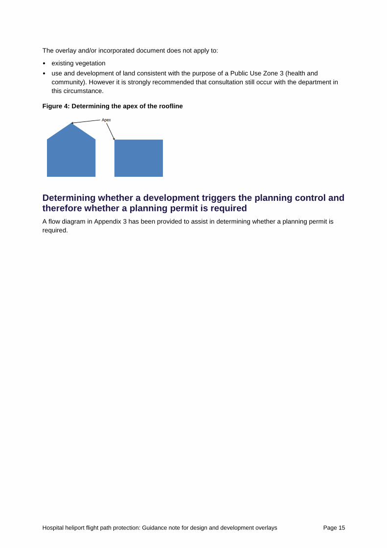
– the additions and alterations do not exceed the existing height of the building (measured at the
apex of the roofline – see Figure 4), and
– the lot does not immediately adjoin the hospital land
• constructing a fence, pergola, and ancillary structures for an existing dwelling, provided:
– the structure does not exceed the height of the existing dwelling (measured at the apex of the
roofline), and
– the lot does not immediately adjoin the hospital land
• subdividing land.
Hospital heliport flight path protection: Guidance note for design and development overlays Page 15
The overlay and/or incorporated document does not apply to:
• existing vegetation
• use and development of land consistent with the purpose of a Public Use Zone 3 (health and
community). However it is strongly recommended that consultation still occur with the department in
this circumstance.
Figure 4: Determining the apex of the roofline
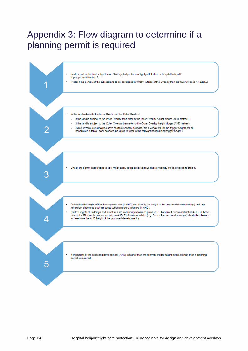
Determining whether a development triggers the planning control and therefore whether a planning permit is required
A flow diagram in Appendix 3 has been provided to assist in determining whether a planning permit is
required.
Page 16 Hospital heliport flight path protection: Guidance note for design and development overlays
Part 3: Making and assessing applications
Documentation to support a planning permit application
A planning permit application must include the following information:
• the location and topography of the subject land in relation to the helicopter landing site
• the location and height of the main features on the subject land, including existing buildings,
structures, trees or any other tall features
• the proposed buildings and works on the land including details of the maximum height of the
proposed buildings, works and construction equipment measured relative to the height of the helipad.
All heights shown on plans and elevations and referred to in text must be in Australian Height Datum and
all drawings must be to scale.
Check with your local council to confirm any other documentation you need to submit to the council and
other referral authorities.
Depending on the context of the application, you should also include information about the surrounding
area, in particular any existing uses and buildings between the helipad and the proposed development
on the subject land, and the heights of those structures.
In all cases the department will be a determining authority for planning permit applications triggered by
an overlay that protects hospital heliport flight paths. This is a requirement of s. 55 of the Planning and
Environment Act 1987. In summary, this means that the department will direct the council’s decision,
determining whether the proposal can be supported and under what conditions, or whether it must be
refused.
Pre-application meetings
For complex planning permit applications, councils may consider inviting the department to participate in
pre-application meetings with a permit applicant. The department will consider the merit of meeting with
an applicant to discuss their finalised plans on a case-by-case basis.
Notification
A planning permit application triggered by an overlay for the protection of a hospital helipad is exempt
from the notice requirements of ss. 52(1) (a), (b) and (d) of the Planning and Environment Act 1987.
Please note other notice requirements may still apply.
Referral of the application
The relevant local council will refer the application to the department for assessment. The department
may:
• request further information if the application material lacks appropriate information
• consent to the application with or without conditions
• direct that an application be refused.
The department has 21 days from receiving the application from council to request further information,
and must respond to a referral within 28 days of receiving the application, or within 28 days of receiving
any further information submitted.
Hospital heliport flight path protection: Guidance note for design and development overlays Page 17
Assessment of the application
When considering an application the department and responsible authority (the local council) will have
regard to:
• the objectives of planning in Victoria
• the planning scheme, in particular the provisions that relate to the referral.
The department will assess the impact of the proposed development on the ongoing use of the helipad
and will take into account:
• whether the proposal will impact on the ongoing availability and viability of the heliport
• the physical requirements for heliports and associated airspace for Performance Class 1
• the department’s Planning and development guidelines for helicopter medical transport landing sites
(January 2015)
• the Civil Aviation Advisory Publication (CAAP) 92-2(2) Guidelines for the establishment and operation
of onshore helicopter landing sites (February 2014)
• the Civil Aviation Advisory Circular AC 139-5(1) Plume rise assessments (November 2012)
• the respective hospital helipad operations manual (where available).
Permit conditions
Conditions may be placed on a planning permit application. These may address:
• the maximum allowable height of the proposed structure(s)
• modifications to the proposed structure(s) to make them more visible to helicopter pilots, such as
obstruction lights
• relocation of the proposed structure(s) to avoid an obstruction along a flight path
• modification to an exhaust vent to redirect an exhaust plume.
Cranes are generally managed through a condition on the permit requiring the department to be an
approver of a flight path construction management plan.
Example conditions the department may impose are contained in Appendix 4.
Application costs
The applicant will be subject to the usual statutory costs associated with making a planning application to
council or seeking to modify an existing approval. More information on these costs can be obtained from
your local council.
Once the department receives a referral, it will cover its costs to assess the implications of the proposed
development on the hospital heliport flight path.
Review rights
An applicant can seek a review of the decision of council to approve (with or without conditions), or
refuse an application under the overlay at the Victorian Civil and Administrative Tribunal following
conventional planning processes.
As an application under the overlay is exempt from the third party review rights of s. 82(1) of the Planning
and Environment Act 1987, an objector does not have this right of review.
Page 18 Hospital heliport flight path protection: Guidance note for design and development overlays
Part 4: Further information
For more information see:
• general information regarding the Victorian planning system <www.delwp.vic.gov.au/planning>,
including information regarding the operation of planning controls and referral provisions
• detailed information regarding hospital heliport flight path protection
<www.capital.health.vic.gov.au/Asset_property_management_and_operations/
Flight_path_protection/>, including technical reports and shape files for each of the protected
heliports.
Alternatively, please contact your local Council Statutory Planning Department or the Department of
Health and Human Services at:
Manager Property
Victorian Health and Human Services Building Authority
Department of Health and Human Services
GPO Box 4541
MELBOURNE VIC 3001
(03) 9096 2119
Formal referrals from Council to the Department are to be e-mailed to [email protected].
Hospital heliport flight path protection: Guidance note for design and development overlays Page 19
Appendix 1: Incorporated document
Hospital Emergency Medical Services - Helicopter Flight Path Protection Areas Incorporated Document, June 2017
1. Introduction
This document is an incorporated document in the Ararat, Baw Baw, Buloke, East Gippsland, Frankston,
Gannawarra, Greater Bendigo, Macedon Ranges, Melbourne, Monash, Moorabool, Northern Grampians,
Port Phillip and Stonnington Planning Schemes (the Planning Schemes) pursuant to section 6(2)(j) of the
Planning and Environment Act 1987 (the Act).
2. Purpose
The purpose of this control is to protect Helicopter Emergency Medical Services flight paths from
encroachment by development that could prejudice the safety or efficiency of the helipad at the relevant
public hospitals.
3. Land
The control in clause 4 applies to land affected by:
• Schedules 4 and 5 to Clause 43.02 (Design and Development Overlay) of the Ararat Planning
Scheme
• Schedules 8 and 9 to Clause 43.02 (Design and Development Overlay) of the Baw Baw Planning
Scheme
• Schedules 1 and 2 to Clause 43.02 (Design and Development Overlay) of the Buloke Planning
Scheme
• Schedules 15 and 16 to Clause 43.02 (Design and Development Overlay) of the East Gippsland
Planning Scheme
• Schedules 10 and 11 to Clause 43.02 (Design and Development Overlay) of the Frankston Planning
Scheme
• Schedules 3 and 4 to Clause 43.02 (Design and Development Overlay) of the Gannawarra Planning
Scheme
• Schedules 25 and 26 to Clause 43.02 (Design and Development Overlay) of the Greater Bendigo
Planning Scheme
• Schedules 14 and 15 to Clause 43.02 (Design and Development Overlay) of the Macedon Ranges
Planning Scheme
• Schedules 65 and 66 to Clause 43.02 (Design and Development Overlay) of the Melbourne Planning
Scheme
• Schedules 14 and 15 to Clause 43.02 (Design and Development Overlay) of the Monash Planning
Scheme
• Schedules 14 and 15 to Clause 43.02 (Design and Development Overlay) of the Moorabool Planning
Scheme
• Schedules 5 and 6 to Clause 43.02 (Design and Development Overlay) of the Northern Grampians
Planning Scheme
• Schedules 28 and 29 to Clause 43.02 (Design and Development Overlay) of the Port Phillip Planning
Scheme
• Schedules 17 and 18 to Clause 43.02 (Design and Development Overlay) of the Stonnington
Planning Scheme.
Page 20 Hospital heliport flight path protection: Guidance note for design and development overlays
4. Control
4.1 Design objectives
• To ensure that the height of development and associated construction-related structures does not
encroach on the flight path areas associated with the hospital helicopter landing sites.
• To ensure that the height of development and associated construction-related structures avoids
creating a hazard to aircraft using the hospital helicopter landing sites.
4.2 Permit requirement
Despite the exemptions from permit requirements in clause 62.02-1 and 62.02-2 of the Planning
Schemes, a permit is required:
• To construct a new building or to construct or carry out works with a height greater than the referral
height specified in clause 2 of the Schedules to the Design and Development Overlays listed in
clause 3 of this Incorporated Document.
• Construct or carry out buildings and works for a temporary structure for construction purposes,
including a crane or other construction equipment that is fixed to the ground, with a height greater
than the referral height specified in clause 2 of the Schedules to the Design and Development
Overlays listed in clause 3 of this Incorporated Document.
• Construct or carry out buildings and works for a stack, vent, chimney, cooling tower or the like that
produces an exhaust plume which has an upward vertical velocity of 4.3 metres or more per second
at the point of emission/exit.
• Construct or carry out buildings and works for a telecommunications facility, including radio masts and
antenna, with a height greater than the referral height specified in clause 2 of the Schedules to the
Design and Development Overlays listed in clause 3 of this Incorporated Document.
• Construct or carry out buildings and works for a flagpole with a height greater than the referral height
specified in clause 2 of the Schedules to the Design and Development Overlays listed in clause 3 of
this Incorporated Document.
4.3 Application requirements
An application must be accompanied by the following information (prepared by a suitably qualified
person):
• The location and topography of the subject land in relation to the helicopter landing site.
• The location and height of the main features on the subject land, including existing buildings,
structures, trees or any other tall features.
• The proposed buildings and works on the land including details of the maximum height of the
proposed buildings, works and construction equipment measured relative to the height of the helipad
(AHD).
Note: AHD means Australian Height Datum.
4.4 Referral of applications
An application must be referred under section 55 of the Act to the person or body specified as the referral
authority in the Schedule to Clause 66.04 to the Planning Schemes.
4.5 Exemption from notice and review
An application is exempt from the notice requirements of section 52(1)(a), (b) and (d), the decision
requirements of section 64(1), (2) and (3) and the review rights of section 82(1) of the Act.
Hospital heliport flight path protection: Guidance note for design and development overlays Page 21
4.6 Decision guidelines
Before deciding on an application, the responsible authority must consider, as appropriate:
• Whether the height and design of any proposed buildings or works will have an impact on the flight
paths associated with the relevant helicopter landing site.
• The views of the relevant referral authority.
• Any technical guidelines prepared by the relevant referral authority.
• The design objectives at clause 4.1.
Page 22 Hospital heliport flight path protection: Guidance note for design and development overlays
Appendix 2: Plumes
Background
The guidance below identifies the common sources of plumes and provides an explanation of the plume
assessment process and measures that can be taken to mitigate the potential impact of plumes on safe
helicopter operations.
In the event that a proposed plume triggers the need for a permit through an overlay, the impact of the
plume on safe helicopter operations requires formal assessment by the department. There are a number
of variables and considerations that are taken into account in performing this assessment and the
assessment process can be complex.
The majority of this guidance is sourced from the Civil Aviation Advisory Circular 139-5(1) Plume rise
assessments (November 2012).
Definition
A plume is a long cloud of smoke or vapour resembling a feather as it spreads from its point of origin. In
the context of this document, likely sources could be an exhaust plume of gas, steam, water or similar
that rises into the air in a tall, thin shape, usually emanating from a stack, vent, chimney, cooling tower or
the like.
Sources of plumes
Exhaust plumes can originate from any number of sources including:
• industrial facilities release process emissions through stacks or vents
• industrial flares create an instantaneous release of hot gases during the depressurisation of gas
systems
• cooling towers produce large volumes of buoyant gases that can rise a significant distance into the
atmosphere
• exhaust gases from power generation facilities can produce plumes of varying velocities during
different operating scenarios.
How plumes affect aircraft operations
Aircraft operations in various stages of flight may be affected by an exhaust plume of significant vertical
velocity (that is, a plume rise). A light aircraft in approach configuration is more likely to be affected by a
plume rise than a heavy aircraft cruising at altitude. In addition, helicopters and light recreational aircraft
may be severely affected by a high temperature plume and the altered air mixture above an exhaust
plume, and should therefore avoid low flight over such facilities.
Factors that influence the impact of a plume on aircraft operations
The following factors will influence the impact of a plume assessment:
• critical plume velocity (CPV) – the height up to which the plume of critical velocity may impact the
handling characteristics of an aircraft in flight such that there may be a momentary loss of control
• critical plume height (CPH) – the velocity at which the vertical plume rise may affect the handling
characteristics of an aircraft in flight such that there may be a momentary loss of control
• location of the plume relative to the aircraft flight path(s) – as a general rule, the area covered by the
overlay is greater than that of the designated flight path to and from the helipad. Any proposed
Hospital heliport flight path protection: Guidance note for design and development overlays Page 23
development that triggers the overlay will require formal assessment of the plume location relative to
the actual helicopter flight paths.
Assessing critical plume velocity
Typically assessment of a critical plume velocity will need to include the following considerations:
• phase of flight affected
• size of aircraft affected
• geographical factors such as high terrain
• proximity to designated flight paths (including proximity to the landing site)
• navigation method in use (visual versus instrument)
• human factors considerations.
Mitigating the impact of a plume on helicopter operations
There are a number of measures that can be taken to mitigate the impact of plumes on helicopter
operations. In approximate order of preference these might include:
• restricting the development – this may include removing or relocating the plume such that it is clear of
the affected helicopter flight path(s) or further away from the helicopter landing site
• reducing the plume upward velocity – a high-velocity plume inside a helicopter flight path can affect
aircraft performance as well as patient safety and comfort. Decreasing the vertical velocity can be
achieved by:
– reducing the output
– increasing the discharge orifice diameter
– re-directing the plume sideways.
• restricting plume operating times – limiting plume operating times to times when the heliport is less
likely to be used may be an acceptable mitigation method depending on the location and usage of the
heliport. Alternatively, if the plume discharge can be suspended upon notification of a pending
helicopter arrival, this may also be an acceptable method of mitigation. Implementation of any such
mitigation measures requires prior approval from the department.
Responsibility for costs associated with plume assessment
All costs associated with the assessment process and associated mitigation measure implementation are
the responsibility of the applicant for the proposed development.
Controlling plumes in hospital heliport flight paths
Where the department considers that a proposed activity within the overlay may result in a plume having
a critical plume velocity of 4.3 metres per second (or greater), it will require a condition on the permit (see
Appendix 3).
More information
The following documents provide further information of plumes:
• Civil Aviation Advisory Circular 139-5(1) Plume rise assessments (November 2012)
• United States Department of Transport, Federal Aviation Regulation Part 139.
Page 24 Hospital heliport flight path protection: Guidance note for design and development overlays
Appendix 3: Flow diagram to determine if a planning permit is required
Hospital heliport flight path protection: Guidance note for design and development overlays Page 25
Appendix 4: Example referral responses
No comment
1. The Department of Health and Human Services has no comment on the proposed development.
Objection to development
2. The Department of Health and Human Services objects to the proposed development for the
following reasons [project specific].
Building or structure height
2(a) The maximum height of the proposed development at [x metres] Australian Height Datum would
encroach on a flight path area associated with the [hospital name] helicopter landing site and
create an unacceptable risk of hazard to aircraft using the landing site.
Exhaust plume
2(b) The proposed development includes the construction of [a stack / vent / chimney / cooling tower]
that could produce an exhaust plume with an upward vertical velocity of 4.3 metres or more per
second at the point of emission or exit. This would encroach on a flight path area associated with
the [hospital name] helicopter landing site and create an unacceptable risk of hazard to aircraft
using the landing site.
Development supported with conditions
3. The Department of Health and Human Services does not object to the proposed development
provided the permit is subject to the following conditions [choose as relevant].
Reduction in building or structure height
3(a) The overall height of the building be reduced so that no part of the building (including but not
limited to roof top plant, antennae, flagpoles, telecommunications equipment or structures erected
on the building) is greater than [x metres] Australian Height Datum.
Lighting on highest point of building or structure
3(b) Before the development starts or by such time as agreed by the Responsible Authority and
Department of Health and Human Services in writing, an obstacle lighting plan in accordance with
Chapter 9.4 of the Civil Aviation Safety Authority Manual of Standards Part 139 must be submitted
to the Responsible Authority and be approved in writing by the Department of Health and Human
Services.
3(c) Obstacle lighting must be installed and operated on the highest point of any building or structure
on the site in accordance with the approved obstacle lighting plan to ensure the satisfaction of the
Department of Health and Human Services.
Page 26 Hospital heliport flight path protection: Guidance note for design and development overlays
Flight path construction management plan
3(d) Prior to the commencement of any development (including any demolition or excavation) or by
such time as agreed by the Responsible Authority and Department of Health and Human Services
in writing, a flight path construction management plan must be prepared to the satisfaction of the
Department of Health and Human Services and be approved by the responsible authority. The
flight path construction management plan must include measures to minimise the impact of the
construction of the building on the safe and unfettered operation of the Hospital helipad. The
management measures incorporated within the plan must be implemented during the construction
of the building to the satisfaction of the Department of Health and Human Services and the
responsible authority.
The flight path construction management plan must identify the location and height of any
construction equipment, including cranes.
Location and height of cranes
3(e) The location and height of any cranes and associated construction equipment must not exceed a
height of [x metres] Australian Height Datum, unless otherwise agreed in writing by the
Department of Health and Human Services.
3(f) Before the development starts, a communication protocol must be prepared to the satisfaction of
the Responsible Authority and the Department of Health and Human Services and implemented
between the crane operator(s) and Air Ambulance Victoria and/or helicopter pilots.
Lighting on cranes
3(g) Cranes and other associated construction equipment must be fitted with continuously operated low
intensity steady red obstruction lighting in accordance with Chapter 9.4 of the Civil Aviation Safety
Authority Manual of Standards Part 139 at their highest point(s) to ensure that they can be seen
within the helicopter flight paths.
Limitation on vegetation height
3(h) The height of any vegetation must be no greater than [x metres] Australian Height Datum when
planted and the vegetation must be managed so as to remain at or below that height.
Location and velocity of exhaust plumes
3(i) The location and velocity of any exhaust plumes must be notated on the plans to be endorsed and
which will then form part of this permit. Before the plans are endorsed, the location and velocity of
the plumes must be approved in writing by the Department of Health and Human Services.
3(j) Any exhaust plumes from the permitted development must not exceed an upward velocity of 4.3
metres per second.