Embed Size (px)
Citation preview

energy arriving from the Sun
energy leaving Earth
wind
ice
water
clouds
precipitation
interactionsbetween
air and ice
interactionsbetween
water and ice
interactionsbetweenwaterand air
interactionsbetween
land and air
gases and ash fromerupting volcanoes
snow and ice
water runoff
ocean currents
humanactivities
HOW DO WE
DESCRIBE CLIMATE?To describe climate, geographers start by gathering data about weather. Meteorologists, the scientists who study weather, supply the data by measuring weather conditions like those in the table below:
Temperature Precipitation Wind Conditions
• maximum (highest) daily temperature
• minimum (lowest) daily temperature
• amount of moisture in the air (relative humidity)
• amount of precipitation
• type of precipitation
• cloud cover (amount and type of clouds)
• wind speed
• wind direction
The climate on Earth works as a system. The global climate system, shown in Figure 2.8, is made up of five parts: Earth’s surface, the atmosphere, all the water on Earth, all the ice on Earth, and all life on Earth. With energy from the Sun, these parts interact in several ways to produce the climates of different places. Geographers group together places with similar climates into climate regions.
climate regions areas of Earth identified as having similar climate characteristics
FIGURE 2.8 This diagram shows the global climate system. The Sun’s energy powers the climate on Earth.
54 UNIT 1: Physical Patterns in a Changing World NEL
02_geo7_ch2.indd 54 2014-10-29 11:52 AM

CLIMATE GRAPHSClimate graphs combine bar and line graphs
to show both average monthly temperatures
and average monthly precipitation amounts
for a place. Geographers use climate graphs
to show and analyze climate data. When you
read a climate graph, you analyze the data.
Look at the climate graph in Figure 2.9. The
average monthly temperature is shown by the
line graph. The average monthly precipitation
is shown by the bar graph.
READING
Climate Data for Brisbane, Australia
Jan Feb Mar Apr May Jun Jul Aug Sept Oct Nov Dec
Average monthly temperature (°C) 25.1 25.0 23.9 21.7 18.8 16.1 15.0 16.0 18.3 20.7 22.7 24.3
Average monthly precipitation (mm) 169 148 140 104 97 74 68 46 33 105 110 132
FIGURE 2.10 Climate data for Brisbane, Australia
White box in bottom layer.
C02-F21-G07SB
Crowle Art Group
3rd pass
Geography 7 SB
0-17-659048-X
FN
CO
Pass
Approved
Not Approved
Precip
itation (m
m)
400
350
300
250
200
150
100
50
0
Month
temperature precipitation
J F M A M J J A S O N D
Tem
per
atur
e (°
C)
30
20
10
0
–10
–20
–30
–40
–50
Brisbane, Australia
FIGURE 2.9 Climate graph for Brisbane, Australia
STEP 1
STEP 3
STEP 2
STEP 4
Determine the average annual temperature. Using the data in Figure 2.10, add up the monthly temperatures. Divide by 12.
Determine the total annual precipitation. This is calculated by adding up the monthly precipitation totals.
Determine the temperature range. This is the number of degrees from the highest monthly temperature to the lowest. Subtract the lowest monthly temperature from the highest monthly temperature.Determine the precipitation pattern by looking
at when most of the city’s precipitation occurs. Most places in the world match one of these three patterns:• winter maximum—most precipitation occurs in
the coldest months of the year• summer maximum—most precipitation occurs in
the warmest months of the year• evenly distributed—each month has about the
same amount of precipitation
As you can see, you need to look at both temperature and precipitation to figure out the precipitation pattern.
HOW TO READ A CLIMATE GRAPH
CHAPTER 2: Changing Patterns of Climate 55NEL
02_geo7_ch2.indd 55 2014-10-29 11:52 AM

C02-F04A-G07SB
Crowle Art Group
4th pass
Geography 7 SB
0-17-659048-X
FN
CO
Pass
Approved
Not Approved
Lhasa (29.65°N, 91.10°E)
Dubai (25.20°N, 55.30°E)
Yakutsk (62.03°N, 129.73°E)Iqaluit (63.75°N, 68.52°W)
Winnipeg (49.90°N, 97.14°W)
Belém (1.45°S, 48.50°W)
Münster (51.96°N, 7.63°E)
Mashhad (36.30°N, 59.60°E)
Lusaka (15.41°S, 28.28°E)
P A C I F I C
O C E A N
P A C I F I C
O C E A N
A R C T I C O C E A N
A T L A N T I C
O C E A N
P A C I F I C
O C E A N
I N D I A N
O C E A N
A T L A N T I C
O C E A N
Equator
Arctic Circle
Antarctic Circle
Tropic of Cancer
Tropic of Capricorn
N
1000 km0
White box in bottom layer.
C02-F04G-G07SB
Crowle Art Group
3rd pass
Geography 7 SB
0-17-659048-X
FN
CO
Pass
Approved
Not Approved
Winnipeg, Canada
J F M A M J J A S O N D
400
350
300
250
200
150
100
50
0
30
20
10
0
–10
–20
–30
–40
–50
Month
Precip
itation (m
m)Te
mp
erat
ure
(°C
)
C02-F04C-G07SB
Crowle Art Group
3rd pass
Geography 7 SB
0-17-659048-X
FN
CO
Pass
Approved
Not Approved
J F M A M J J A S O N D
Precip
itation (m
m)
400
350
300
250
200
150
100
50
0
Lusaka, Zambia
Tem
per
atur
e (°
C)
30
20
10
0
–10
–20
–30
–40
–50
Month
White box in bottom layer.
C02-F04D-G07SB
Crowle Art Group
3rd pass
Geography 7 SB
0-17-659048-X
FN
CO
Pass
Approved
Not Approved
Dubai, United Arab Emirates
–40J F M A M J J A S O N D
400
350
300
250
200
Shifted Temperature values down 10° to accomodate+30° temperatures.
White box in bottom layer.
150
100
50
0
30
40
20
10
0
–10
–20
–30
Month
Precip
itation (m
m)Te
mp
erat
ure
(°C
)
C02-F04B-G07SB
Crowle Art Group
4th pass
Geography 7 SB
0-17-659048-X
FN
CO
Pass
Approved
Not Approved
J F M A M J J A S O N D
450
400
350
300
250
200
150
100
50
0
Belém, Brazil40
30
20
10
0
–10
–20
–30
–40
–50
Precip
itation (m
m)Te
mp
erat
ure
(°C
)
Month
White box in bottom layer.
C02-F04I-G07SB
Crowle Art Group
4th pass
Geography 7 SB
0-17-659048-X
FN
CO
Pass
Approved
Not Approved
Iqaluit, Canada
J F M A M J J A S O N D
400
350
300
250
200
150
100
50
0
30
20
10
0
–10
–20
–30
–40
–50
Month
Precip
itation (m
m)Te
mp
erat
ure
(°C
)
GLOBAL CLIMATE PATTERNSClimate regions are found in different parts of the world. Geographers group them into nine overall climate regions as seen here in Figure 2.11.
FIGURE 2.11 This map shows climate regions around the world and climate graphs for each region. Which climate region is the least like the climate from where you live? Why do you think it is so different?
temperature
precipitation
Climate Graphs
World Climate Regions
tropical(hot with rain all year)
savannah(hot with dry season)
steppe(warm and dry)
desert(hot and very dry)
mild(warm and wet)
continental(dry with cold winter)
subarctic(very cold winter)
polar(very cold and dry)
mountainous(altitude affects climate)
C02-F04A-G07SB (legend)
Crowle Art Group
3rd pass
Geography 7 SB
0-17-659048-X
FN
CO
Pass
Approved
Not Approved
56 UNIT 1: Physical Patterns in a Changing World NEL
02_geo7_ch2.indd 56 2014-10-29 11:52 AM

C02-F04A-G07SB
Crowle Art Group
4th pass
Geography 7 SB
0-17-659048-X
FN
CO
Pass
Approved
Not Approved
Lhasa (29.65°N, 91.10°E)
Dubai (25.20°N, 55.30°E)
Yakutsk (62.03°N, 129.73°E)Iqaluit (63.75°N, 68.52°W)
Winnipeg (49.90°N, 97.14°W)
Belém (1.45°S, 48.50°W)
Münster (51.96°N, 7.63°E)
Mashhad (36.30°N, 59.60°E)
Lusaka (15.41°S, 28.28°E)
P A C I F I C
O C E A N
P A C I F I C
O C E A N
A R C T I C O C E A N
A T L A N T I C
O C E A N
P A C I F I C
O C E A N
I N D I A N
O C E A N
A T L A N T I C
O C E A N
Equator
Arctic Circle
Antarctic Circle
Tropic of Cancer
Tropic of Capricorn
N
1000 km0
White box in bottom layer.
C02-F04E-G07SB
Crowle Art Group
3rd pass
Geography 7 SB
0-17-659048-X
FN
CO
Pass
Approved
Not Approved
Mashhad, Iran
J F M A M J J A S O N D
400
350
300
250
200
150
100
50
30
20
10
0
–10
–20
–30
–40
–50
Month
Precip
itation (m
m)Te
mp
erat
ure
(°C
)
0
White box in bottom layer.
C02-F04J-G07SB
Crowle Art Group
3rd pass
Geography 7 SB
0-17-659048-X
FN
CO
Pass
Approved
Not Approved
Lhasa, China
J F M A M J J A S O N D
400
350
300
250
200
150
100
50
0
30
20
10
0
–10
–20
–30
–40
–50
Month
Precip
itation (m
m)Te
mp
erat
ure
(°C
)
White box in bottom layer.
C02-F04F-G07SB
Crowle Art Group
3rd pass
Geography 7 SB
0-17-659048-X
FN
CO
Pass
Approved
Not Approved
Münster, Germany
J F M A M J J A S O N D
400
350
300
250
200
150
100
50
0
30
20
10
0
–10
–20
–30
–40
–50
Month
Precip
itation (m
m)Te
mp
erat
ure
(°C
)
White box in bottom layer.
C02-F04H-G07SB
Crowle Art Group
3rd pass
Geography 7 SB
0-17-659048-X
FN
CO
Pass
Approved
Not Approved
Yakutsk, Russia
J F M A M J J A S O N D
400
350
300
250
200
150
100
50
0
30
20
10
0
–10
–20
–30
–40
–50
Month
Precip
itation (m
m)Te
mp
erat
ure
(°C
)
CHAPTER 2: Changing Patterns of Climate 57NEL
02_geo7_ch2.indd 57 2014-10-29 11:52 AM

You already know how to read a climate graph. In this activity, you will
learn how to make one.
MAKING
STEP 1
STEP 5
STEP 4
STEP 3
STEP 6
Draw the x axis for the climate graph on graph paper. Label 12 spaces along the x axis (horizontal) with the initials of the months of the year.
Make a bar graph to show precipitation. • Find the precipitation amount for each month
from the data table for Beijing. Draw a bar for each month using the right y axis.
• Colour the bars blue.
Make a line graph to show temperature. • Find the temperature for each month from the
data table for Beijing (Figure 2.12). Put a red dot in the middle of each column for each month using the left y axis.
• Once you have plotted all 12 points, join the dots with a red line.
Now draw the right y axis for precipitation.• Label the lines with 0 mm on the bottom line
and intervals of 50 mm to the top. Precipitation labels can also be adjusted, but 0 mm must always be on the bottom line.
• Label this axis “Precipitation.”
Add a title above your climate graph, giving the name of the place.
HOW TO MAKE A CLIMATE GRAPH
CLIMATE GRAPHS
Climate Data for Beijing, China
Jan Feb Mar Apr May Jun Jul Aug Sept Oct Nov Dec
Average monthly temperature (°C) –4.3 –1.9 5.1 13.6 20.0 24.2 25.9 24.6 19.6 12.7 4.3 –2.2
Average monthly precipitation (mm) 3 5 8 21 34 78 185 160 45 22 7 3
FIGURE 2.12 Climate data for Beijing, China. How might you draw a graph using two sets of numbers and keep them separate on the graph?
STEP 2
Your graph needs two y axes (vertical). Draw the left axis for temperature first. • Label the lines from –50 °C to 30 °C. The
temperature labels can be adjusted depending on the highest and lowest temperatures of the place you are graphing. For example, you might start at –20 °C if there are no very low temperatures for the place.
• Label this axis “Temperature.”
58 UNIT 1: Physical Patterns in a Changing World NEL
02_geo7_ch2.indd 58 2014-10-29 11:52 AM
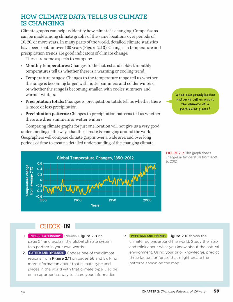
HOW CLIMATE DATA TELLS US CLIMATE IS CHANGINGClimate graphs can help us identify how climate is changing. Comparisons can be made among climate graphs of the same locations over periods of 10, 20, or more years. In many parts of the world, detailed climate statistics have been kept for over 100 years (Figure 2.13). Changes in temperature and precipitation trends are good indicators of climate change.
These are some aspects to compare:• Monthly temperatures: Changes to the hottest and coldest monthly
temperatures tell us whether there is a warming or cooling trend.• Temperature ranges: Changes to the temperature range tell us whether
the range is becoming larger, with hotter summers and colder winters, or whether the range is becoming smaller, with cooler summers and warmer winters.
• Precipitation totals: Changes to precipitation totals tell us whether there is more or less precipitation.
• Precipitation patterns: Changes to precipitation patterns tell us whether there are drier summers or wetter winters.Comparing climate graphs for just one location will not give us a very good
understanding of the ways that the climate is changing around the world. Geographers will compare climate graphs over a wide area and over long periods of time to create a detailed understanding of the changing climate.
1. INTERRELATIONSHIPS Review Figure 2.8 on
page 54 and explain the global climate system
to a partner in your own words.
2. GATHER AND ORGANIZE Choose one of the climate
regions from Figure 2.11 on pages 56 and 57. Find
more information about that climate type and
places in the world with that climate type. Decide
on an appropriate way to share your information.
3. PATTERNS AND TRENDS Figure 2.11 shows the
climate regions around the world. Study the map
and think about what you know about the natural
environment. Using your prior knowledge, predict
three factors or forces that might create the
patterns shown on the map.
CHECK-IN
Global Temperature Changes, 1850–2012
–0.6
–0.4
–0.2
0
0.2
0.4
0.6
Tem
per
atur
e ch
ang
efr
om
ave
rag
e ( °
C)
Years
C02-F24-G07SB
Crowle Art Group
3rd pass
Geography 7 SB
0-17-659048-X
FN
CO
Pass
Approved
Not Approved
1850 1900 1950 2000
FIGURE 2.13 This graph shows changes in temperature from 1850 to 2012.
What can precipitation patterns tell us about
the climate of a particular place?
CHAPTER 2: Changing Patterns of Climate 59NEL
02_geo7_ch2.indd 59 2014-10-29 11:52 AM


![Learning Interactions and Relationships Between …openaccess.thecvf.com/content_CVPR_2020/papers/Kukleva...interactions, Alonso et al. [36] predict interactions between two people](https://img.pdfslide.net/doc/110x75/5f489a10659cd849c66af5a8/learning-interactions-and-relationships-between-interactions-alonso-et-al.jpg)