Embed Size (px)
Citation preview

7/30/2019 How to handle Geological hazard
http://slidepdf.com/reader/full/how-to-handle-geological-hazard 1/23
Mining and Energy Services
West Nusa Tenggara Province Jl. Majapahit No 40 Phone. 0370-621536 fax. 0370-625766
2012

7/30/2019 How to handle Geological hazard
http://slidepdf.com/reader/full/how-to-handle-geological-hazard 2/23
Existing condition in Mining and
Energy Services

7/30/2019 How to handle Geological hazard
http://slidepdf.com/reader/full/how-to-handle-geological-hazard 3/23
Mapsa. Maps from outer
1. Rupa Bumi Indonesia Maps scale 1: 25.000 from
Bakosurtanal in digital form and hardcopy form2. Maps from Badan Geologi ( Landslide Susceptibility
Maps, Volcanic Hazard Maps of Rinjani, Tamboraand Sangeangapi, landslides susceptibility maps, etc
)3. Forest Zone Maps NTB from ministry of forester. etc

7/30/2019 How to handle Geological hazard
http://slidepdf.com/reader/full/how-to-handle-geological-hazard 4/23
b. Self Maps Produce1. Overwhelming Tsunami Maps
2. Tsunami and Volcano Evacuation Routes Map.
3. Landslide susceptibility maps for big scale4. Landslide events maps
5. Groundwater basin Maps of NTB
6. Mineral Potential Maps NTB.

7/30/2019 How to handle Geological hazard
http://slidepdf.com/reader/full/how-to-handle-geological-hazard 5/23
5 m
10 m
15 m
20 m
Overwhelming Tsunami Map of Lombok Island

7/30/2019 How to handle Geological hazard
http://slidepdf.com/reader/full/how-to-handle-geological-hazard 6/23
Susceptibility overwhelming tsunami map of KuteLombok
7/30/2019 How to handle Geological hazard
http://slidepdf.com/reader/full/how-to-handle-geological-hazard 7/23
×
å
å ñ
!,
j
!,
!,
f c
!,
å
å!,
!,
å
!,
ÆJ
ÆJ
$Z
$Z
$Z
$Z
$Z
$Z
$Z
$Z
$Z
$Z
$Z
$Z
S A M U D E R A H I N D I A
Ds. Kute(Arealterbuka Gn Baturiti)
DsKute(Lapangan Dusun Ketapang)
Ds. Kute(Arealterbuka Gn Sekar Kuning)
Dusun Samak Dui(Arealterbuka)
Ds. Kute(Arealterbuka Gn Benjon)
Dusun Embonuh(Arealterbuka Gn Koleh)
Dusun Kubur Tikus(Arealterbuka)
Dusun Tekok(Arealterbuka)
Dusun PantaiAan(Arealterbuka Gn BatikBantar)
Dusun Baturingas(Lapangan SepakBola)
Dusun Keliu(Arealterbuka )
Dusun Ebuak(Arealterbuka Gn Ebuak)
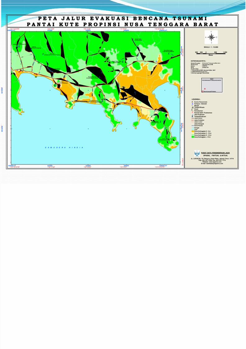
P E T A J A L U R E V A K U A S I B E N C A N A T S U N A M IP E T A J A L U R E V A K U A S I B E N C A N A T S U N A M I
P A N T A I K U T E P R O P I N S I N U S A T E N G G A R A B A R A TP A N T A I K U T E P R O P I N S I N U S A T E N G G A R A B A R A T
500 0 500 1,000250
Meter
SKALA : 1 : 15.000
JL. LAPAN No. 70, Pekayon, Pasar Rebo, Jakarta Timur, 13710Telp. (021) 871 0786 Fax. (021) 871 7715
Website : www.lapanrs.comE-mail : [email protected]
SPASIAL, FAKTUAL & AKTUAL
PUSAT DATA PENGINDERAAN JAUH
INSETPROPINSI NUSA TENGGARA BARAT
Daerah yang di Petakan
422000
424000
424000
426000
426000
9 0 1 4
0 0 0
9 0 1 6 0 0 0
9 0 1 6 0 0 0
116°16'26" BT420000 mT
116°17'28"422000
116°18'30" 116°19'32" 116°20'34" BT428000 mT
9018000mU
8°53'0"LS
8°54'2"
8°55'4"
8°56'6"LS
901400
0mU
428000 mT116°20'34" BT116°19'32"116°18'30"116°17'28"116°16'26" BT
420000 mT
KETERANGAN PETA :
Sistem ProyeksiSistem GridDatumZonaSumber Data1. Citra ALOS-AVNIR, Akuisisi 26 Mei 20072. DEM SRTM Resolusi 30 m3. Survey Lapangan Tahun 2008
: Universal Transverse Mercator: Geografi dan UTM: WGS 84: Selatan 50:
LEGENDA :
Rumah Sakit / Puskesmas×
$Z Tempat Evakuasi
Pemakamanf cPasar j
Kantor Pemerintahñ
Masjid!,Kampus / Sekolahå
Sungai
LautZona Ketinggian 0 - 5 m
Zona Ketinggian 5 - 10 m
Zona Ketinggian 0 - 15 m
Zona Ketinggian > 15 m
Jalur Evakuasi<
Tempat WisataÆJ
Jalan Kolektor
Jalan Lokal
Jalan Setapak
Garis Pantai
Jalan Arteri

7/30/2019 How to handle Geological hazard
http://slidepdf.com/reader/full/how-to-handle-geological-hazard 8/23

7/30/2019 How to handle Geological hazard
http://slidepdf.com/reader/full/how-to-handle-geological-hazard 9/23
Landslide susceptibility Maps of NorthwesthLombok

7/30/2019 How to handle Geological hazard
http://slidepdf.com/reader/full/how-to-handle-geological-hazard 10/23
Reports Annual report of earthquake from accumulation of
data BMKG
Annual report of volcano from accumulation of data VSI.
Geological Hazard survey
Emergency response of geological hazard

7/30/2019 How to handle Geological hazard
http://slidepdf.com/reader/full/how-to-handle-geological-hazard 11/23
Recommendations
Recommendation for hazard prone areas of spatialplanning and anticipation of the events of a disaster.
For the areas event of a disasters how to step to
handling a disasters and efforts to minimize casualtiesin case of another similar disaster from the aspect of geology

7/30/2019 How to handle Geological hazard
http://slidepdf.com/reader/full/how-to-handle-geological-hazard 12/23
TOOLSIn Main Office :
2 GPS Navigation type Garmin 76CSX
3 Camera, 1 good and 2 not working. 1 compass geology
In Geology and Mineral resources Division:
3 Computer, 1 good and 2 not working.
2 Laptop, it’s held by head and sub-head.

7/30/2019 How to handle Geological hazard
http://slidepdf.com/reader/full/how-to-handle-geological-hazard 13/23
Province Regulation Perda No.3 year 2010 about spatial planning
Perda No. 5 year 2010 about ground water treatment

7/30/2019 How to handle Geological hazard
http://slidepdf.com/reader/full/how-to-handle-geological-hazard 14/23
Geohazards condition in West Nusa Tenggara
Province especially Lombok Island West Nusa Tenggara are composed two major islands,
Lombok and Sumbawa Islands.
Located at subduction zone between Indo-australianplate and Eurasian Plate.
So has the potential geological hazard in the form of earthquake, tsunami, volcano and landslides.

7/30/2019 How to handle Geological hazard
http://slidepdf.com/reader/full/how-to-handle-geological-hazard 15/23
Local Regulation on spatial planning in West NusaTenggara (NTB) has to accommodate the geologicalcondition of NTB by entering hazards parameter inthe spatial planning of NTB

7/30/2019 How to handle Geological hazard
http://slidepdf.com/reader/full/how-to-handle-geological-hazard 16/23
Potential Hazard Map in Perda No. 3 year 2010.

7/30/2019 How to handle Geological hazard
http://slidepdf.com/reader/full/how-to-handle-geological-hazard 17/23

7/30/2019 How to handle Geological hazard
http://slidepdf.com/reader/full/how-to-handle-geological-hazard 18/23
LANDSLIDE OF PUSUK SEMBALUN, LOMBOK TIMUR
7/30/2019 How to handle Geological hazard
http://slidepdf.com/reader/full/how-to-handle-geological-hazard 19/23
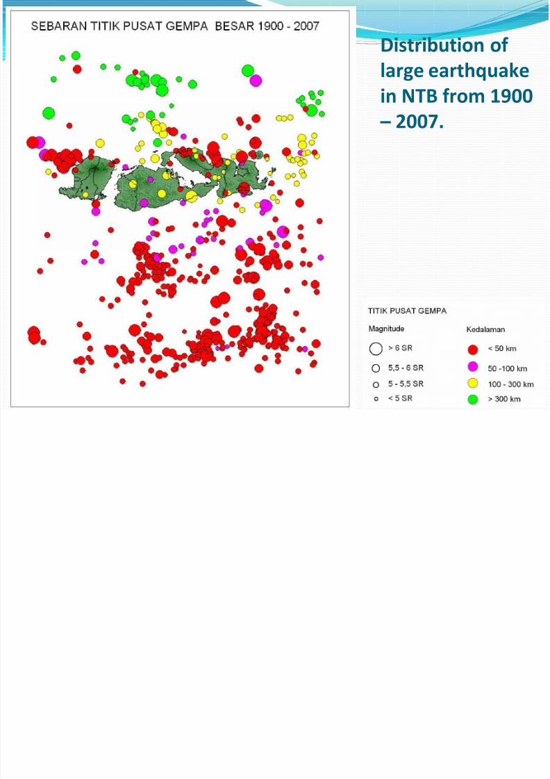
Distribution of
large earthquake
in NTB from 1900 – 2007.

7/30/2019 How to handle Geological hazard
http://slidepdf.com/reader/full/how-to-handle-geological-hazard 20/23
EARTHQUAKE DAMAGE DISTRIBUTION IN WEST NUSA TENGGARASource : Pusat Vulkanologi dan Mitigasi Bencana Geologi, Dept. ESDM 2006 dan Dinas Pertambangan dan Provinsi NTB 31 Desember 2009

7/30/2019 How to handle Geological hazard
http://slidepdf.com/reader/full/how-to-handle-geological-hazard 21/23
JALUR GEMPA DAN GUNUNGAPI AKTIF DI INDONESIA
3 (Three) Active Volcano in NTB
2851 m
TAMBORA
1849 mSANGEANG API
RINJANI
3726 m

7/30/2019 How to handle Geological hazard
http://slidepdf.com/reader/full/how-to-handle-geological-hazard 22/23
Expectation from Georisk Project
and Badan Geologi Given the limitations of existing equipment in the
Mining and Energy Services we expect aid tofulfillment of equipment that can support to our work.
Capacity building for personnel of Mining and Energy Services with training and working together.
Especially in Lombok Island we expect to provide the
output of good data to support spatial planningmodels,

7/30/2019 How to handle Geological hazard
http://slidepdf.com/reader/full/how-to-handle-geological-hazard 23/23
TERIMA KASIH/ THANKS