Embed Size (px)
Citation preview

How To Make Menlo Park More Bike-Friendly
Don’t Sacrifice Cyclist and Pedestrian Safety The City of Menlo Park is currently evaluating three alternative ways to reconfigure El Camino Real (ECR). Alternative 1 would provide three vehicle lanes on its entire length by adding a lane north of Ravenswood Avenue. Alternative 2 would provide two vehicle lanes on its entire length by eliminating one lane south of Ravenswood AND adding bike lanes. Alternative 3 would be similar to Alternative 2 except physically separate bike paths would be provided. This analysis includes my evaluation of the three alternatives and one that has not been presented in either the El Camino Real Corridor Study workshops or online surveys. I also include my recommendations.
Dana Hendrickson Re-Imagine Menlo Park
www.reimaginemenlopark.com
Published: February 23, 2015 Updated: March 8, 2015
Re-Imagine Menlo Park 2
My Recommendations:
• No bike facilities should be added to El Camino Real as cyclists of all levels would be much safer in bike lanes on convenient and mostly residential streets.
• Two considerably safer north-south alternative bike facilities can be provided on the east side of El Camino Real between Encinal Avenue and Sand Hill Road.
- Laurel Street, Burgess Drive and Alma Street (existing) - Alma Street, Greenheart connector, and Garwood Street (proposed)
• Two considerably safer north-south alternative bike facilities can be provided on
the west side of El Camino Real between Middle Avenue and Valparaiso. - University, Live Oak and Crane; (existing) riders uncomfortable with sharing
University with vehicles could be encouraged to use the sidewalks - Fremont Avenue (proposed)
• Menlo Park should require Greenheart to provide a temporary bike route across
its property until a permanent connector is built and Stanford to provide a temporary north-south bike route across its property until a Middle Avenue-Alma connector is built under the train tracks. An alternative to the temporary route might be a dual use sidewalk built on the east side of ECR between Cambridge and Ravenswood.
Rationale The best street-sharing designs optimally weigh the safety and convenience of pedestrians, drivers and cyclists, and safety always trumps convenience, e.g., 10% more safety outweighs 10% more convenience. El Camino Real is a busy state highway with between 34000 and 46000 average daily vehicle trips along its length and there are a large number of dangerous locations where drivers could cross the paths of cyclists regardless of the type of bike facilities. There are 13 intersections on the southbound side and 5 on the northbound side plus SIXTY mid-block access points where vehicles can enter and exit commercial properties. Bike lanes are better suited to residential where there are controlled intersections and less dangerous residential driveways. While experienced and alert cyclists could ride in bike lanes on El Camino Real – and some would – most would prefer a convenient and safer alternative. Inexperienced and less cautious cyclists should NOT be encouraged to ride in such bike lanes as they endanger pedestrians, drivers and themselves at busy intersections. It is noteworthy that Palo Alto has a very comprehensive bike network that does NOT include bike facilities on El Camino Real, and this is consistent with other mid-peninsula communities that share El Camino Real. Palo Alto updated its bike plan in 2012.

Re-Imagine Menlo Park 3
Note: I am a 30-year Menlo Park resident, experienced cyclist and frequent local driver who rides in busy urban settings and on highways ONLY when it’s unavoidable. Background During the Specific Planning process Menlo Park studied ways to improve its bike network in and around El Camino Real and our central downtown business districts, and this work benefited from significant resident input. Now the City is currently conducting an El Camino Real Corridor Study that appears to be totally out of synch with general – not bike enthusiast – resident expectations. The transportation department is asking residents for feedback on three changes to El Camino Real that would impact both bike and vehicle traffic. An obvious additional option is leave the existing lane configurations alone. This post focuses on the need to provide safe and convenient options for not only inexperienced and experienced cyclists but also pedestrians. Read my post The Future Of El Camino Real on the RE-Imagine Menlo Park website/blog to understand my perspectives on this study. Option 1 – Build A Bike Lane or Separate Path on El Camino Real El Camino Real is a state highway with heavy vehicle traffic crossing or turning at intersections where there would be either bike paths or lanes.
• Southbound : Thirteen intersections including three arteries and three collectors.
• Northbound: Eight intersections including two arteries and three collectors.
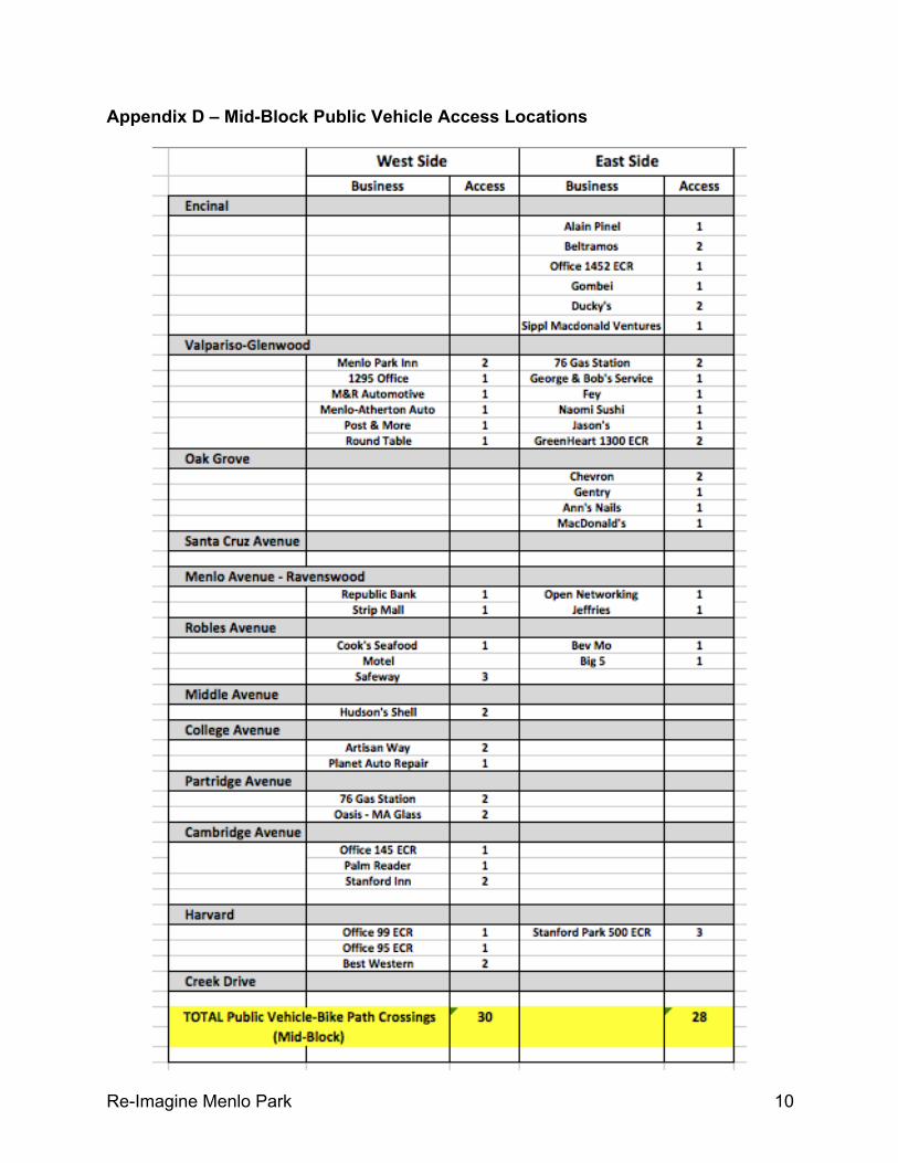
• On each side of ECR there are about thirty mid-block locations where vehicles would cross bike paths to enter and exit ECR via public access points
Option 2 – Keep Cyclists In Bike Lanes that are largely on Residential Streets An alternative bike route that used Alma, Greenheart, and Garwood Street would cross fewer vehicle lanes of all kinds.
• Southbound and northbound: Ten intersections including one vehicle artery and four collectors
• Southbound: Vehicles DO NOT cross bike route at four intersections (Willow,
Sherwood, Waverly and Burgess)
• On non-ECR there are few mid-block locations where vehicles cross bike lanes to enter and exit the street via public access points.
Re-Imagine Menlo Park 4
Important Details See Appendices for a closer look at each option and additional info. Considerations
• Menlo Park already has an extensive bike network, and cyclists can conveniently and safely ride in existing bike lanes parallel to El Camino Real a short distance away using Alma. Add a bike lane on Alma between Ravenswood and Oak Grove, a connector through the Greenheart property, and bike lanes on Garwood Riders and there would be continuous bike lanes from East Creek to Encinal Avenue. Cyclists can also ride a parallel route in existing bike Lanes on Laurel Street from Burgess Drive to Encinal Avenue. Convenient existing bike lanes also enable cyclists to travel east and west and cross El Camino Real at Ravenswood, Glenwood and Encinal.
• A bike network should be viewed as a system for safely routing cyclists with
sensitivity to convenience. Evaluating individual segments in isolation is misleading.
• Experienced cyclists will always pick safety over convenience when selecting a
bike route and inexperienced cyclists should never be trusted to make the correct decision.
• Most bike-car collisions occur either at busy intersections – regardless of signaling – and mid-block where vehicles cross paths with cyclists when either entering or exiting public areas, e.g., parking lots, gas stations, retail malls.
• Mixing bikes and pedestrians at busy intersections endangers both.
• In many situations either walking or riding a bike for a SHORT distance on a sidewalk is safer than riding on a busy street, and it’s not significantly less convenient. Likely adds only 3-5 minutes.
• Riding on residential neighborhood streets is generally safer that riding on
highways and urban streets as the latter has busy intersections, mid-block side “pull-ins and pull-outs”, cars either entering or leaving parking spaces and
UNEXPECTEDLY opening car doors into bike paths. • I believe projections for vehicle and bike traffic volumes and circulation paths are
extremely unreliable. Both expected and ranges of possible outcomes must be carefully considered when potential outcomes are significantly negative.
• Palo Alto is one of the most progressive and renowned bike communities in the country and it has chosen NOT to build either bike paths or lanes on El Camino Real. This city has more experience with biking issues and a much better understanding of bike circulation challenges and solutions than Menlo Park.

Re-Imagine Menlo Park 5
A case study for the Palo Alto Bryant Street Boulevard is available at http://www.pedbikesafe.org/BIKESAFE/case_studies/casestudy.cfm?CS_NUM=502
Cyclist Bike Route Preferences Cyclists view bike routes as unsafe where…
• A lot of nearby vehicle traffic is going too fast and at a close distance on shared roads, even when in bike lanes, i.e., no time to escape driver or cyclist mistakes.
• Vehicles can unexpectedly (a) either cross or turn into bike paths at intersections and “mid-block, (b) pull out from the side of the road, and (c) open doors.
• Vehicles and bikes share roads NOT separated by adequate space and clear markings.
Additional Information Menlo Park Comprehensive Bike Development Plan (2005) http://www.menlopark.org/DocumentCenter/Home/View/372 Palo Alto Bicycle Transportation Plan (2003) http://www.cityofpaloalto.org/civicax/filebank/documents/25489/ (Palo Alto) Bryant Street Bicycle Boulevard http://www.pedbikesafe.org/BIKESAFE/case_studies/casestudy.cfm?CS_NUM=502 NACTO Urban Bikeway Design Guide http://nacto.org/cities-for-cycling/design-guide/
Re-Imagine Menlo Park 6
Appendix Appendix A – El Camino Real Vehicle Arteries And Collectors Appendix B – Menlo Park Specific Plan Bike Network Appendix C – Intersections Where Cyclists Riding On ECR Encounter Vehicle Appendix D – Mid-Block Public Vehicle Access Locations Appendix E – Intersections Where Cyclists Riding On non-ECR Route Encounter Vehicle Appendix F – Arguments Made For Adding Bike Lanes/Paths To El Camino Real Appendix G – Six Most Frequent Sources of Cyclists Injuries Appendix H – Palo Alto Bike Network

Re-Imagine Menlo Park 7
Appendix A – El Camino Real Vehicle Arteries And Collectors

Re-Imagine Menlo Park 8
Appendix B – Menlo Park Bike Network (Specific Plan)

Re-Imagine Menlo Park 9
Appendix C – Intersections Where Cyclists Riding On ECR Encounter Vehicle (Note: Refers to the number of vehicle lanes in each direction)
Re-Imagine Menlo Park 10
Appendix D – Mid-Block Public Vehicle Access Locations

Re-Imagine Menlo Park 11
Appendix E – Intersections On non-ECR Route Where Vehicles & Bikes Cross Paths (Note: Refers to the number of vehicle lanes in each direction)

Re-Imagine Menlo Park 12
Appendix F – Arguments For/Against Adding Bike Capacity To El Camino Real CLAIM #1 More bike riders would use El Camino IF it were safer. My Assessment: Bike-vehicle collisions occur most often when the two objects cross paths even when suitable signaling is provided, and adding pedestrian to the mix increases the risk to all parties. Busy intersections are particularly dangerous especially whenever EITHER cyclists, pedestrians or drivers are distracted, misjudge either their own capabilities or the actions of others, daydream or simply act impatiently. Mid-block points where vehicles enter or exit the highway are also dangerous. Inexperienced cyclists are the most vulnerable as they can easily be distracted, misjudge situations and feel safer than they really are. Unfortunately, bike lanes and paths reinforce this illusion. Bike lanes and paths on mostly residential streets offer the greatest opportunity to create safe environments for cyclists, vehicles and pedestrians.
El Camino is a MAIN artery with three minor arterial connections, three collectors, and five additional intersections. Plus, about sixty mid-block vehicle driveways serve local businesses. Together these represent about seventy potential collision points.
In contrast, the bike lane that already exists on Alma between Creek Drive and Ravenswood Avenue could be (a) extended to Oak Grove, (b) connected to Glenwood via a connector on the Greenheart property and (c) lengthened by adding bike lanes on Garwood. This route would cross one minor artery, two connectors and less than ten business “driveways”, and none involve a MAIN artery (El Camino Real).
I personally would not recommend that friends or family members of any age or experience bike on El Camino regardless of the bike facilities.
CLAIM #2: El Camino is more convenient than either existing or planned biking alternatives. My Assessment: I believe this statement is NOT meaningful. Whether one bike option is more convenient than another depends many factors, e.g., the distance between a rider’s points of origin and destination, the abilities of the rider, the number of required or potential stopping points, and the number and length of time delays at stopping points. The existing Menlo Park bike network includes many popular north-south and east-west bike lanes and routes, and the City plans on adding more facilities when the Greenheart and Stanford projects are built. Adding a bike lane on University between Middle and at least Robles Avenue IS worth exploring as is the alternative of creating bike lanes on Fremont between Middle Avenue and Santa Cruz Avenue. Cyclist should never expect to ride safely on ALL available streets nor always the entire distance between their origins and destinations. For example, it is safer and not inconvenient to walk a bike a short distance on an El Camino sidewalk from a side street to reach a store on this highway.

Re-Imagine Menlo Park 13
Appendix G – The Six Most Common Frequent Sources Of Cyclist Injuries 2012 National Survey of Bicyclist and Pedestrian Attitudes and Behavior (http://www.nhtsa.gov/nti/811841)