Embed Size (px)
Citation preview

http://www.fao.org/geonetwork
Cover
Environment and Natural Resources ServiceSustainable Development Department
Food and Agriculture Organization of the United Nations
www.fao.org/geonetwork
GEONETWORK
TRAINING COURSE
http://www.fao.org/geonetwork

http://www.fao.org/geonetwork
UNIT 1: An introduction to GeoNetwork
UNIT 2: GeoNetwork’s management services for your metadata
UNIT 1: An introduction to GeoNetwork

http://www.fao.org/geonetwork
What Can GeoNetwork Do?
GeoNetwork allows individuals and organizations to work interactively and visually with FAO’s vast wealth of map and related information, making the earth’s geography a stting point for finding, retrieving and using information. This includes:
Population density
Infrastructure
Administrative boundaries
Land cover/use
Soils
Crop zones
Water
Fisheries and forest resources
Livestock distribution
Nutrition profiles
Early warning information

http://www.fao.org/geonetwork
UNIT 1: Introduction
TOPIC 1.1: GeoNetwork: a common spatial data repository and metadata catalog system
UNIT 1: AN INTRODUCTION TO GEONETWORK
GeoNetwork uses the standards and guidelines for metadata and data as agreed by the United Nations Information Working Group (UNGIWG):
ISO/DIS 19115; OpenGIS;
http://www.ungiwg.org

http://www.fao.org/geonetwork
UNIT 1: Introduction
TOPIC 1.1: GeoNetwork: a common spatial data repository and metadata catalog system
UNIT 1: AN INTRODUCTION TO GEONETWORK
GeoNetwork’s compliance to UNGIWG
ISO/DIS 19115
This new international standard defines the schema required for describing geographic information and services. It provides information about:
identification; extent; quality; spatial; temporal schema; spatial reference; distribution …of digital geographic data.

http://www.fao.org/geonetwork
UNIT 1: Introduction
TOPIC 1.1: GeoNetwork: a common spatial data repository and metadata catalog system
UNIT 1: AN INTRODUCTION TO GEONETWORK
GeoNetwork’s compliance to UNGIWG
OpenGIS
GeoNetwork uses Open GIS Consortium (OGC) compliant map services for dynamic mapping. The OGC is a not-for-profit organization dedicated to open systems geoprocessing.
http://www.opengis.org

http://www.fao.org/geonetwork
UNIT 1: Introduction
TOPIC 1.1: GeoNetwork: a common spatial data repository and metadata catalog system
UNIT 1: AN INTRODUCTION TO GEONETWORK
The ideal world: Interoperable portals
How?
By implementing common standards.
Standards for:
Describing data; Finding data; Combining data

http://www.fao.org/geonetwork
UNIT 1: Introduction
TOPIC 1.1: GeoNetwork: a common spatial data repository and metadata catalog system
UNIT 1: AN INTRODUCTION TO GEONETWORK
Implementing common standards for describing data
A metadata standard
Geographic Information - MetadataISO/DIS 19115

http://www.fao.org/geonetwork
UNIT 1: Introduction
TOPIC 1.1: GeoNetwork: a common spatial data repository and metadata catalog system
UNIT 1: AN INTRODUCTION TO GEONETWORK
All of the new standards have one thing in common:
A universal format for documents, for data and for communication between applications:
XML

http://www.fao.org/geonetwork
UNIT 1: Introduction
TOPIC 1.1: GeoNetwork: a common spatial data repository and metadata catalog system
UNIT 1: AN INTRODUCTION TO GEONETWORK
The eXtensible Mark-up Language (XML)
XML as the basic data format
GeoNetwork makes extensive use of the eXtendible Mark-up Language (XML) data format. XML is a self-describing format. XML can be used to store data, but can also be used to give instructions to software programs.

http://www.fao.org/geonetwork
UNIT 1: Introduction
TOPIC 1.1: GeoNetwork: a common spatial data repository and metadata catalog system
UNIT 1: AN INTRODUCTION TO GEONETWORK
The eXtensible Mark-up Language (XML)
Web Services
GeoNetwork is fully based on Web Services. Web services are small applications that can receive instructions formatted in XML, and respond in XML format. Web services are therefore very easy to use by many different types of applications. XML responses from the GeoNetwork application are transformed into HTML using XSL style-sheets.
GeoNetwork
Web Services
HTML
XML
XML
XSL

http://www.fao.org/geonetwork
UNIT 2: GeoNetwork’s management services for your metadata
LESSON 2.1: Metadata preparation and management through GeoNetwork’s Internet interface

http://www.fao.org/geonetwork
STEP 2.1.1: Introduction
LESSON 2.1: Metadata preparation and management through GeoNetwork’s Internet interface
UNIT 3: GeoNetwork’s management services for your metadata
GeoNetwork’s management services are accessible only through a user account that regulates access and assures metadata quality control.
To Insert new metadata select “Administration” from the toolbar, then select the relevant divisional or departmental group that the metadata belongs to. The resulting form contains the fields required to insert metadata into GeoNetwork.
Username
Password
Approved and Authenticated users can:
Insert; Edit; Delete
… metadata records directly into/from GeoNetwork’s catalogue system.
TOOLBAR:

http://www.fao.org/geonetwork
STEP 2.1.1: Introduction
LESSON 2.1: Metadata preparation and management through GeoNetwork’s Internet interface
UNIT 3: GeoNetwork’s management services for your metadata
GeoNetwork’s metadata fields are grouped in the following sections:
! A dataset becomes increasingly useful with more thorough metadata. Complete as many of the Optional fields as possible so that users will be able to better locate, access, evaluate and eventually utilize the
dataset.
1. Metadata information;2. Dataset identification
information;3. Spatial representation
information;4. Reference system information;
5. Constraint information;6. Data quality information;7. Maintenance information;8. Distribution information.
All of GeoNetwork’s metadata fields are ISO compliant and each is listed as:
Mandatory [M]; Conditional [C]; Optional [O].

http://www.fao.org/geonetwork
STEP 2.1.1: Introduction
LESSON 2.1: Metadata preparation and management through GeoNetwork’s Internet interface
UNIT 3: GeoNetwork’s management services for your metadata
To edit a metadata record that has been previously inserted:
1. [SEARCH] for the metadata record by entering keywords, a title or a previously assigned identification number if known;
2. Select [DESCRIPTION] of the interested record from the search results page;
3. Select [EDIT] at the end of the metadata display form;
4. After changes select [SAVE AND CLOSE] and review the content on the metadata display form;
5. Select [EDIT] again for further changes or [SEARCH] to return to the home page.
Select [DELETE] to remove a metadata record.
http://www.fao.org/geonetwork
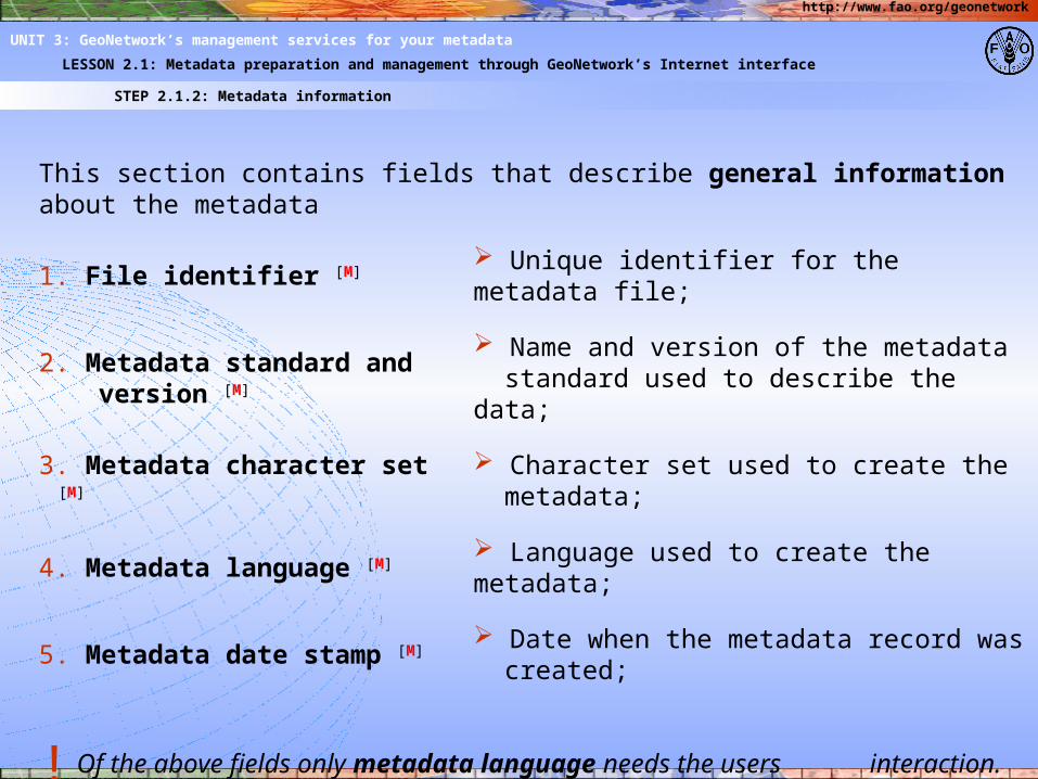
STEP 2.1.2: Metadata information
LESSON 2.1: Metadata preparation and management through GeoNetwork’s Internet interface
UNIT 3: GeoNetwork’s management services for your metadata
This section contains fields that describe general information about the metadata
1. File identifier [M] Unique identifier for the metadata file;
2. Metadata standard and version [M]
Name and version of the metadata standard used to describe the data;
3. Metadata character set [M] Character set used to create the metadata;
4. Metadata language [M] Language used to create the metadata;
5. Metadata date stamp [M] Date when the metadata record was created;
! Of the above fields only metadata language needs the users interaction. The other fields are populated with default information.

http://www.fao.org/geonetwork
STEP 2.1.2: Metadata information
LESSON 2.1: Metadata preparation and management through GeoNetwork’s Internet interface
UNIT 3: GeoNetwork’s management services for your metadata
Metadata information continued…
6. Metadata author [M]
The person who is associated with the metadata and who is the point of contact for data information.
!Before selecting the [ADD] link to insert any new fields into the Metadata form, [SAVE] must be selected first to save all text that has been entered since the last [SAVE].
!Many fields contain a drop-down list of options to complete the field. These make entering data quicker and easier.
Role

http://www.fao.org/geonetwork
STEP 2.1.3: Dataset identification information
LESSON 2.1: Metadata preparation and management through GeoNetwork’s Internet interface
UNIT 3: GeoNetwork’s management services for your metadata
This section contains fields to uniquely identify the dataset:
1. Title [M] Name by which the data is known;
2. Dataset edition Version of the data (i.e. first, second, etc.);
3. Dataset reference date [M]
Date on which the data was published, created or revised;
4. Dataset reference date type [M]
Type of date entered in the “Dataset reference date” field;
5. Presentation format Presentation format for the data (document, map, table, etc.);
6. Dataset language [M] Language of any text in the data.
http://www.fao.org/geonetwork
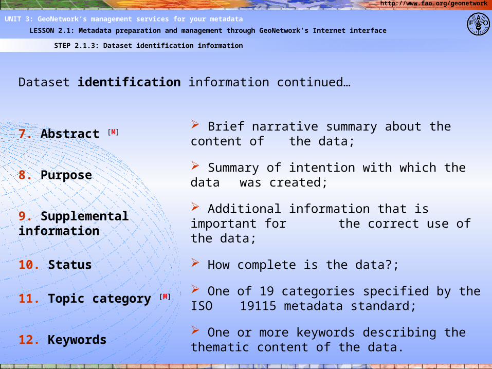
STEP 2.1.3: Dataset identification information
LESSON 2.1: Metadata preparation and management through GeoNetwork’s Internet interface
UNIT 3: GeoNetwork’s management services for your metadata
Dataset identification information continued…
7. Abstract [M] Brief narrative summary about the content of
the data;
8. Purpose Summary of intention with which the data was created;
9. Supplemental information
Additional information that is important for the correct use of the data;
10. Status How complete is the data?;
11. Topic category [M] One of 19 categories specified by the ISO 19115 metadata standard;
12. Keywords One or more keywords describing the thematic content of the data.

http://www.fao.org/geonetwork
STEP 2.1.3: Dataset identification information
LESSON 2.1: Metadata preparation and management through GeoNetwork’s Internet interface
UNIT 3: GeoNetwork’s management services for your metadata
Dataset identification information continued…
13. Place Keywords [M] Keyword that describes the geographical
extent of the data;
14. Scale Scale of the map from which the data was
derived;
15. Graphic overview name
Name of the file that contains a graphic illustration of the data;
16. Graphic overview description
Text description (i.e. Title) of the illustration;
17. Graphic overview type
Format in which the illustration is encoded;
18. Resource provider [M]
Person or organization that provides the data and that may be contacted for
acquiring knowledge about the data

http://www.fao.org/geonetwork
STEP 2.1.4: Spatial representation information
LESSON 2.1: Metadata preparation and management through GeoNetwork’s Internet interface
UNIT 3: GeoNetwork’s management services for your metadata
This section contains fields that describe the mechanisms used to represent spatial information in a dataset:
1. Spatial representation type
Digital mechanism used to represent spatial data (i.e. text table, vector, grid);
2. Geographic bounding box [M]
Coordinates that define the extent of the data.
Vector spatial representation information:
3. Topology level Code which identifies the degree of complexities of the
spatial relationships;
4. Geometric object type
Name of point and vector objects used to locate zero-, one-, two-dimensional spatial locations in the data (ex.
point, curve, surface, composite);
5. Geometric object count
Total number of point and vector object type occurring in the data

http://www.fao.org/geonetwork
STEP 2.1.4: Spatial representation information
LESSON 2.1: Metadata preparation and management through GeoNetwork’s Internet interface
UNIT 3: GeoNetwork’s management services for your metadata
Grid spatial representation information:
6. Number of dimension [M]
Number of independent spatial-temporal axes;
7. Dimension name [M] Name of the axis;
8. Dimension size [M] Number of elements along the axis;
9. Cell geometry [M] Identification of grid data as point or cell;
10. Resolution value Degree of detail in the grid data;
11. Transformation parameters availability [M]
Indication of whether or not parameters for transformation exists.

http://www.fao.org/geonetwork
STEP 2.1.5: Reference system information
LESSON 2.1: Metadata preparation and management through GeoNetwork’s Internet interface
UNIT 3: GeoNetwork’s management services for your metadata
This section contains the description of the spatial reference system(s) used in a dataset:
1. Name [M] Name of the reference systems used;
2. Projection Identity of the projection used;
3. Ellipsoid Identity of the ellipsoid used;
4. Datum Identity of the datum used.

http://www.fao.org/geonetwork
STEP 2.1.5: Reference system information
LESSON 2.1: Metadata preparation and management through GeoNetwork’s Internet interface
UNIT 3: GeoNetwork’s management services for your metadata
Projection Parameters:
5. Zone Unique identifier for 100,000 meter grid zone;
6. Standard parallel Line of constant latitude at which the
surface of the Earth and the plane or developable surface intersect;
Ellipsoid parameters
7. Semi mayor axis
Identity of the ellipsoid used;
8. Axis units Identity of the datum used

http://www.fao.org/geonetwork
STEP 2.1.6: Constraints information
LESSON 2.1: Metadata preparation and management through GeoNetwork’s Internet interface
UNIT 3: GeoNetwork’s management services for your metadata
The constrains information defines the metadata required for managing rights to information including restrictions on access and use.
1. Data access restrictions
Access constraints applied to assure the protection of privacy or intellectual property, and any special restrictions or limitations on
obtaining the resource
2. Data use restrictions
Constraints applied to assure the protection of privacy or intellectual property, and any special
restrictions or limitations or warnings on using the resource;
http://www.fao.org/geonetwork
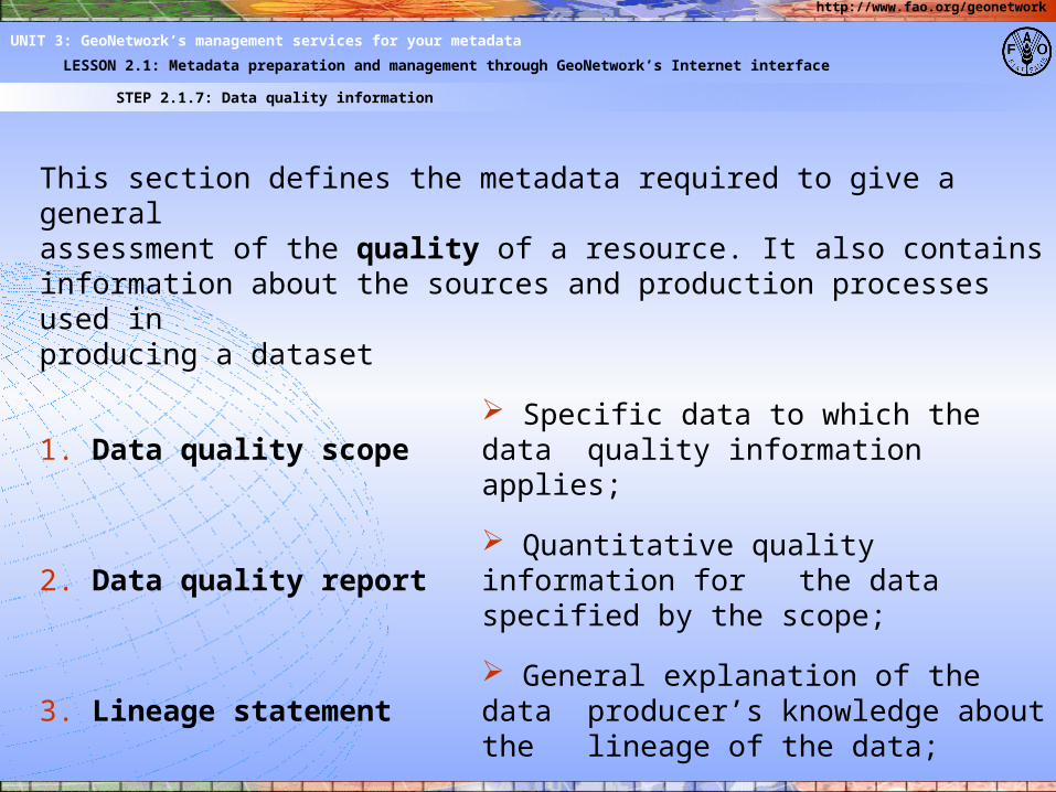
STEP 2.1.7: Data quality information
LESSON 2.1: Metadata preparation and management through GeoNetwork’s Internet interface
UNIT 3: GeoNetwork’s management services for your metadata
This section defines the metadata required to give a generalassessment of the quality of a resource. It also containsinformation about the sources and production processes used inproducing a dataset
1. Data quality scope Specific data to which the data quality information applies;
2. Data quality report Quantitative quality information for
the data specified by the scope;
3. Lineage statement General explanation of the data producer’s knowledge about the lineage of the data;
4. Data source Information about the source data
used in creating the data specified by the scope

http://www.fao.org/geonetwork
STEP 3.1.8: Maintenance information
LESSON 3.1: Metadata preparation and management through GeoNetwork’s Internet interface
UNIT 3: GeoNetwork’s management services for your metadata
This section provides information about the frequency of metadata updates, and specific requirements for maintaining the dataset:
1. Maintenance frequency
Frequency with which changes and additions are made to the resource after the initial resource is
completed;
2. Date of next update Scheduled revision date for the data;
3. Maintenance note Information on regarding specific
requirement for maintaining the dataset;
http://www.fao.org/geonetwork
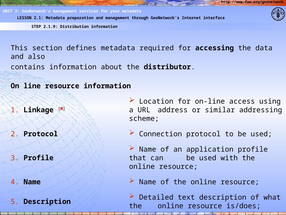
STEP 2.1.9: Distribution information
LESSON 2.1: Metadata preparation and management through GeoNetwork’s Internet interface
UNIT 3: GeoNetwork’s management services for your metadata
This section defines metadata required for accessing the data and alsocontains information about the distributor.
On line resource information
1. Linkage [M] Location for on-line access using a URL
address or similar addressing scheme;
2. Protocol Connection protocol to be used;
3. Profile Name of an application profile that can
be used with the online resource;
4. Name Name of the online resource;
5. Description Detailed text description of what the online resource is/does;
5. Function Code for function performed by the online resource
http://www.fao.org/geonetwork
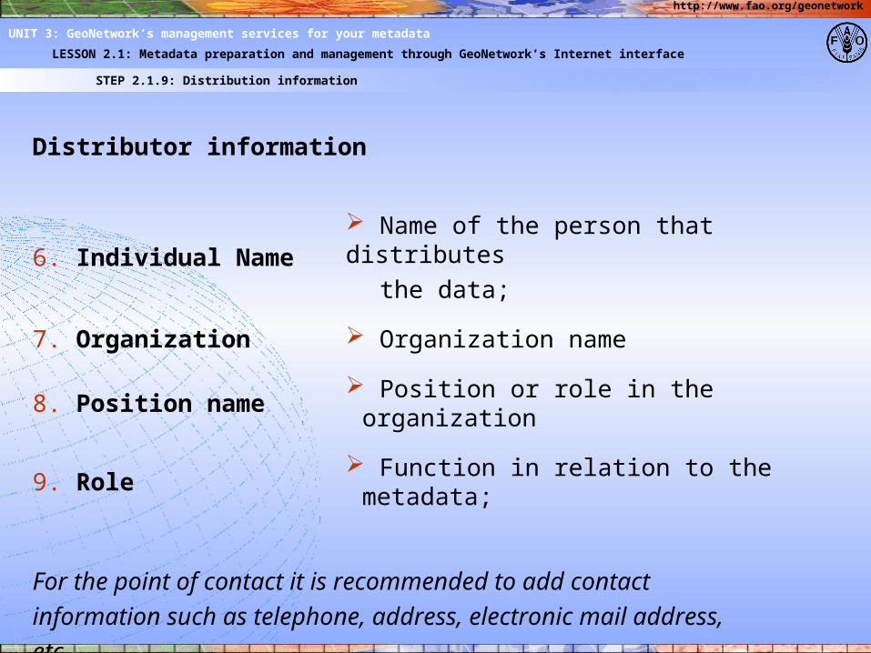
STEP 2.1.9: Distribution information
LESSON 2.1: Metadata preparation and management through GeoNetwork’s Internet interface
UNIT 3: GeoNetwork’s management services for your metadata
Distributor information
6. Individual Name Name of the person that distributes
the data;
7. Organization Organization name
8. Position name Position or role in the organization
9. Role Function in relation to the metadata;
For the point of contact it is recommended to add contactinformation such as telephone, address, electronic mail address,etc..

http://www.fao.org/geonetwork
STEP 2.1.10: Maintenance information
LESSON 2.1: Metadata preparation and management through GeoNetwork’s Internet interface
UNIT 3: GeoNetwork’s management services for your metadata
When the Metadata form has been completed click [SAVE AND CLOSE]. This will create a new metadata record and a default unique identifier will be generated automatically for this record.
Finally select [PRIVILEGES] to set which divisional and departmental groups have authorization to access and manipulate your dataset. It is also possible to select if the dataset can be accessible externally from FAO.
Within the available services the options are:
• View;• Download;• Edit;• Delete;• Administration;• Dynamic View;• Z3590.
Clicking [UPDATE] will save any changes that you have made to the Privileges form.