Embed Size (px)
Citation preview

Humisphere
SOIL RECONNAISSANCE MISSION TO 3 ESTATES IN TANZANIA
Ir. J.H.M. (Hans) Scholten
September 2012

2
CONTENT
1. INTRODUCTION …………………………………………………………………………………………… 3
2. SOIL INFORMATION OBTAINED …………………………………………………………………… 3
3. SOILS OF KWAMDULU ESTATE ……………………………………………………………………. 4
3.1 Soils ……………………………………………………………………………………………………….. 4
3.2 Soil suitability …………………………………………………………………………………………. 4
3.3 Soil fertility management recommendations ……………………………………….. 5
4. SOILS OF KWARUGURU ESTATE …………………………………………………………………... 6
4.1 Soils ………………………………………………………………………………………………………. 6
4.2 Soil suitability .……………………………………………………………………………………….. 7
4.3 Soil fertility management recommendations ………………………………………… 8
5. SOILS OF KILIMANGWIDO ESTATE ………………………………………………………………. 8
5.1 Soils ………………………………………………………………………………………………………. 8
5.2 Soil suitability ………………………………………………………………………………………… 9
5.3 Soil fertility management recommendations ………………………………………. 10
ANNEX
Augerhole observations…………………………………………………………………………………… 11

3
1. INTRODUCTION
By order of FORM International, Hattem, The Netherlands, a mission to Tanzania was carried out in
order to investigate the soil suitability for growing teak in 3 estates in Tanzania where at present
sisal is grown. It concerns Kwamdulu and Kwaruguru estates near Korogwe and Kilimangwido estate
near Pangani. The mission was carried out together with Paul Hol and Mans Vroom of FORM
International, from 9 to 15 September 2012.
2. SOIL INFORMATION OBTAINED
The following reports were obtained from the International Soil Reference and Information Centre
(ISRIC);
- Soils of Kwamdulu Estate and their potential for hybrid sisal cultivation. National Soil Service
Mlingano, Tanzania (1988).
- Soils of Mwera Estate and their potential for hybrid sisal cultivation. National Soil Service,
Mlingano, Tanzania (1988).
- The potential for hybrid sisal cultivation of four Amboni estates in Tanga region. National
Soil Service, Mlingano, Tanzania (1988).
- Hartemink, Alfred E, (1995). Soil fertility decline under sisal cultivation in Tanzania. ISRIC
Technical paper no 28.
- Soil map of Korogwe district
- Soil map of Handeni district
From the reports of Kwamdulu and Mwera estates the soil map 1:20.000 were missing. The soil map
of Kwamdulu was however found in the office of the estate. A copy of the soil map of Mwera estate
was obtained from Mlingano Institute.
During the mission Mr. Joseph Mbogoni and Mr. Godson Urassa from the Mlingano Institute have
been consulted. According Mr. Mbogoni Kwamdulu and Kwaruguru estates are part of the same soil
unit of the recently updated soil map of East Tanzania which is part of the project to produce a map
with agro-ecological zones of Tanzania. Mr Mbogoni supplied additional information about this soil
unit.
A paper copy of the soil map of Mwera estate and digital copies of some district soil maps were
supplied by Mlingano Institute.

4
3. SOILS OF KWAMDULU ESTATE
3.1 Soils
The upland soils of Kwamdulu estate are very deep (rootable depth more than 150 cm, usually
more than 200 cm), well drained, red ferralitic clays derived from gneiss rock. In the valleys soils are
imperfectly and poorly drained alluvial and colluvial sandy clays.
During the field inspection no shallow soils have been observed in Kwamdulu, neither spots with
iron/manganese nodules. However the soil report mentions that on some of the steep slopes (slopes
over 10%) the soils have locally ironstone close to the surface. Ironstones have a gravelly character.
The red upland soils have favourable physical properties, but a very low fertility status. Their pH is
usually 5 -6 at the surface and 4,5 – 5 in the subsoil. Plant nutrients like phosphate and calcium are
very low; potassium is extremely low.
Soils of hill crests
The soils on the hill crests (map unit C1/W) are very strongly acid (pH 4,5 – 5,0), have a very low
effective capacity to retain nutrients and are extremely low in calcium, potassium, phosphate and
other nutrients. These soils have high (toxic) aluminum saturation values and are in the suitability
rating classified as unsuitable for sisal, covering 19% of the area. In spite of that it has been observed
in the field that are planted with sisal. It is unknown whether lime has been applied on these
hillcrests.
During the survey in 1988 12 sites in this unit have been sampled and analyzed for toxic aluminum. In
8 out of 12 sites the aluminum saturation rates turned out to be too high in the subsoil (30 – 50 cm
depth). The present suitability for sisal is supposed to be better; probably moderately suitable.
3.2 Soil suitability
Soil suitability for sisal
According the Kwamdulu soil report 53% of the area is suitable for sisal, 4% is moderately suitable,
7% marginally suitable and 36% unsuitable. As unsuitable are classified the soils in the imperfectly
and poorly drained valley bottoms and the soils of the hill crests. The latter make out 19% of the total
area, but at least parts of this unit will be suitable, making the total suitable area for sisal about 66%.
Soil suitability for teak
Both sisal and teak require well drained, deep soils. Roughly suitability criteria are similar. It is still in
discussion what the effect of the very low pH will have on the growth of teak, and whether teak can
stand toxic aluminum. However in Kwamdulu estate and in Ghana reasonable growth rates have
been observed on similar soils.

5
In general it is assumed that teak will grow on a wide range of soil pH’s (pH water), pH 5,0 to pH 8,0 ,
with an optimum range between pH 6,5 and pH 7,5
Soil suitability for sisal and teak in Kwamdulu estate
Suitability soils % of area
suitable Red soils on slopes Red soils on crests (partly)
57
7
Total suitable 64
unsuitable Red soils on crests with toxic aluminum Soils with impeded drainage
12
24
Total unsuitable 36
3.3 Soil fertility management recommendations
The mineral parts of the upland soils of Kwamdulu are extremely poor and acidic, and have a
very low capacity to retain nutrients. The organic matter in the soils has a high capacity to retain
moisture and nutrients. Good management of organic matter is therefore of utmost importance to
maintain fertility and moisture holding capacity and to prevent erosion! Burning should be avoided
and all organic sisal waste should be returned to the field and incorporated in the soil.
Potassium and phosphate levels in the soil are extremely low. When fertilizer is applied these two
elements should be applied first of all. Nitrogen fertilizer will only be effective if levels of potassium
and phosphate are satisfactory. When one or more nutrients are missing plants will have troubles
with the uptake of other nutrients.
Source: FAO Fertilizer Programme (1978). Fertilizers and
their use.

6
4. SOILS OF KWARUGURU ESTATE
4.1 Soils
A field inspection of Kwaruguru estate has been carried out. It confirmed the statement of Mr.
Mbogoni that Kwamdulu and Kwaruguru estates are situated within the same soil- and physiographic
unit.
Deep red soils have been observed in road cuttings and in auger hole observations. These soils are
similar to those of Kwamdulu estate.
Deep red soils in Kwaruguru estate.
In Kwaruguru estate a pilot teak plantation is situated on a slope of 7 to 8%. Here two soil augerings
have been made, one just above the plantation (augering 1) and one just down slope the plantation
(augering 2). Both augerings showed uniform deep red soils more than 150 cm deep, without any
obstruction to roots, which are representative for the suitable areas of the estate. The teak
plantation showed a reasonable growth of the trees: the growth of teak is 15 m³/ha year (source:
FORM International) .

7
Teak plantation in Kwaruguru estate.
A salinity measurement was made in water from a borehole (about 10m depth). The water turned
out to be very highly saline (EC 2,7 mS/cm), and cannot be used for irrigation. The origin of the
salinity is not known. At present the water from the borehole is used for the sisal factory (Corona). It
is recommended to investigate the impact of the saline water on the environment.
4.2 Soil suitability for teak and sisal
Because no soil survey has been carried out in Kwaruguru estate, detailed suitability data are
not available. But because soils and landscape of Kwaruguru belong to the same soil unit as
Kwamdulu estate, it is a fair assumption that the percentage of suitable area for sisal and teak will be
almost similar to that of Kwamdulu estate.
Assumed soil suitability for sisal and teak in Kwaruguru estate
Suitability soils % of area
suitable Red soils on slopes Red soils on crests (partly)
57
7
Total suitable 64
unsuitable Red soils on crests with toxic aluminum Soils with impeded drainage
12
24
Total unsuitable 36

8
According the farm manager the sisal production of this estate is higher than in Kwamdulu. It is
unknown whether soil/climate factors attribute to the higher production or management practices.
4.3 Soil fertility management recommendations
As the soils in Kwaruguru are similar to those of Kwamdulu, the same recommendations
apply to Kwaruguru. Please see section 3.3.
5. SOILS OF KILIMANGWIDO ESTATE
5.1 Soils
In Kilimangwido estate a soil survey has never been carried out. However, in the neighbouring
Mwera estate, which has a similar position near the coastline, a detailed soil survey has been carried
out in 1988. From the survey report of that estate valuable data could be obtained.
During the field visit a quick reconnaissance has been carried out and 5 augerhole observations were
made in order to identify the soil types.
Three different units of the Mwera soil map have been identified:
Map unit Rvd/W : Well drained red sandy clay loams with more than 200 cm effective soil depth.
Map unit Rd/W : Well drained red sandy clay loams with 50 to 200 cm effective soil depth.
Map unit Bs/W : Well drained dark grayish brown calcareous sandy clay with an effective soil depth
of 80 to 100 cm and a pH of 7,2 to 7,8 over soft powdery lime.
As no estate soil map is available, it is difficult to judge percentage of the area of each map unit; it is
assumed that the soil pattern is almost similar to that of Mwera estate. During the reconnaissance
visit the emphasis was on well drained soil as imperfectly and poorly drained soils are not suitable for
teak.
In general the soils of Kilimangwido are less acid and have a much better soil fertility status than the
soils of Kwamdulu and Kwaruguru; the organic matter content and base saturation are higher and
toxic aluminum is not reported. However, Kilimangwido soils are also very low in phosphate and
potassium.
Some soils are developed in old uplifted coral reefs, resulting in presence of limestone, high pH, and
high levels of calcium. Limestone from coral reef is still visible in a quarry where material for road
construction has been taken out.

9
5.2 Soil suitability for sisal and teak
Regarding soil suitability it is a fair assumption that the soil pattern is almost similar to that of
Mwera estate. Based on this assumption the following estimate of the suitable area for sisal can be
made.
Estimated soil suitability for sisal in Kilimangwido estate
Suitability soils % of area
suitable Well drained red and black soils on slopes and crests
66
Total suitable 66
unsuitable Soils with impeded drainage shallow soils
29 5
Total unsuitable 34
The soil suitability for teak might slightly differ from the suitability for sisal. Regarding the suitability
for sisal in Mwera estate an area of 10% of the total surface with somewhat excessively drained,
shallow black soil is included which is only moderately suitable for sisal; this area will be unsuitable
for teak. This results in the following estimated soil suitability for teak.
Estimated soil suitability for teak in Kilimangwido estate
Suitability soils % of area
suitable Well drained red and black soils on slopes and crests
56
Total suitable 56
unsuitable Soils with impeded drainage shallow soils
29 15
Total unsuitable 44
Please note that the above mentioned figures are estimates, and that the real suitable area can
only be calculated from a soil map of Kilimangwido estate; such a soil map has still to be made!
Rainfall data of Kilimangwido estate show that rainfall is higher than in Kwamdulu and Kwaruguru
estates.

10
5.3 Soil fertility management recommendations
Especially in the red soils maintenance of a good level of organic matter is very important.
Burning should be avoided and organic waste from sisal should be returned to the field before
planting.
Present levels of potassium are low to very low; phosphate levels are low. All soils are expected to
respond to nitrogen fertilizers. However, nitrogen should not be applied without additional potash
and phosphate fertilizers (see also 3.3).

11
ANNEX AUGER HOLE OBSERVATIONS
Augering Nr. 1 location: S 5° 28.696 E 38° 31.796
Kwaruguru estate, upper slope of teak plantation.
Date: 11-09-2012
Author: J.H.M. Scholten
0 – 30 cm dark reddish brown (2,5YR 3/3) clay loam
30 – 160 cm dark red (10R 3/6) clay
Remarks: slope: 8% to the South
Augering Nr. 2 location: S 5° 28.803 E 38° 31.747
Kwaruguru estate, down slope of teak plantation
Date: 11-09-2012
Author: J.H.M. Scholten
0 – 20 cm dark reddish brown (2,5YR 3/3) clay loam
20 - 30 cm very dark reddish brown (2,5YR 2/4) clay loam
30 – 120+ dark reddish brown (2,5YR 3/6) clay
Remarks: slope 7% to the South
Augering Nr. 3 location: S 5° 27.049 E 38° 56.125
Kilimangwido estate, Block nr. 23A
Date: 12-09-2012
Author: J.H.M. Scholten
0 – 20 cm dark reddish brown (5YR 3/3) clay loam
20 - 30 cm very dark reddish brown (5YR 2/4) clay loam
30 – 50 cm reddish brown (5YR 4/6) clay
50 – 120 cm reddish brown (2,5YR 4/6) clay
12
Remarks: slope 7% to SE; Mwera soil map unit Rvd/W
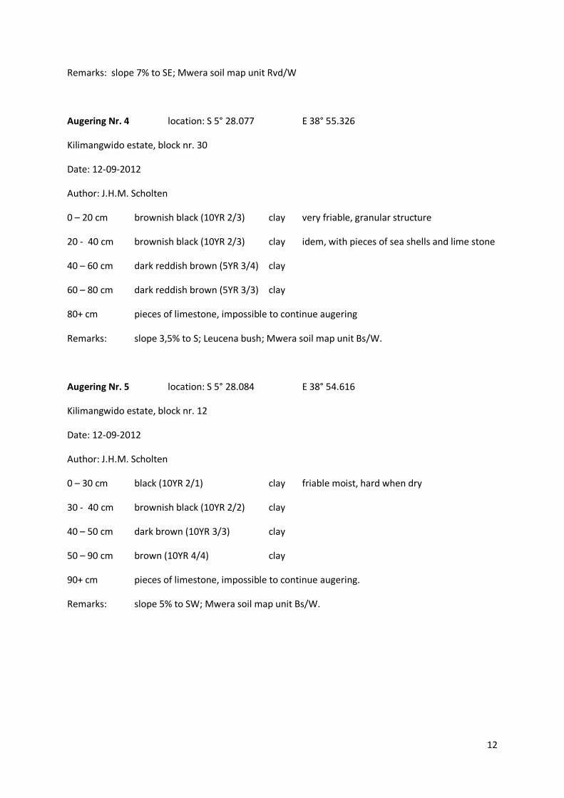
Augering Nr. 4 location: S 5° 28.077 E 38° 55.326
Kilimangwido estate, block nr. 30
Date: 12-09-2012
Author: J.H.M. Scholten
0 – 20 cm brownish black (10YR 2/3) clay very friable, granular structure
20 - 40 cm brownish black (10YR 2/3) clay idem, with pieces of sea shells and lime stone
40 – 60 cm dark reddish brown (5YR 3/4) clay
60 – 80 cm dark reddish brown (5YR 3/3) clay
80+ cm pieces of limestone, impossible to continue augering
Remarks: slope 3,5% to S; Leucena bush; Mwera soil map unit Bs/W.
Augering Nr. 5 location: S 5° 28.084 E 38° 54.616
Kilimangwido estate, block nr. 12
Date: 12-09-2012
Author: J.H.M. Scholten
0 – 30 cm black (10YR 2/1) clay friable moist, hard when dry
30 - 40 cm brownish black (10YR 2/2) clay
40 – 50 cm dark brown (10YR 3/3) clay
50 – 90 cm brown (10YR 4/4) clay
90+ cm pieces of limestone, impossible to continue augering.
Remarks: slope 5% to SW; Mwera soil map unit Bs/W.

13
Augering Nr. 6 location: S 5° 27.541 E 38° 54.501
Kilimangwido estate, block nr. 14
Date: 12-09-2012
Author: J.H.M. Scholten
0 – 20 cm very dark reddish brown (5YR 2/3) clay loam
20 - 30 cm very dark reddish brown (5YR 2/4) clay
30 – 40 cm dark reddish brown (2,5YR 3/4) clay
40 – 110+ cm very dark reddish brown (2,5YR 2/4) clay firm
Remarks: on nearly flat hill crest; dwellings, bananas, maize.
Augering Nr. 7 location: S 5° 28.610 E 38° 52.571
Kilimangwido estate, block nr. 4
Date: 12-09-2012
Author: J.H.M. Scholten
0 – 20 cm brownish black (10YR 2/2) clay
20 - 30 cm dark brown (10YR 3/4) clay
30 – 80+ dark reddish brown (5YR 3/4) clay
Remarks: slope 1% to S; scattered trees, grazing, Masai people; surface looks like black clay
soil, but is a deep red soil; Mwera soil map unit Rd/W.