Embed Size (px)
Citation preview
DPS 5D
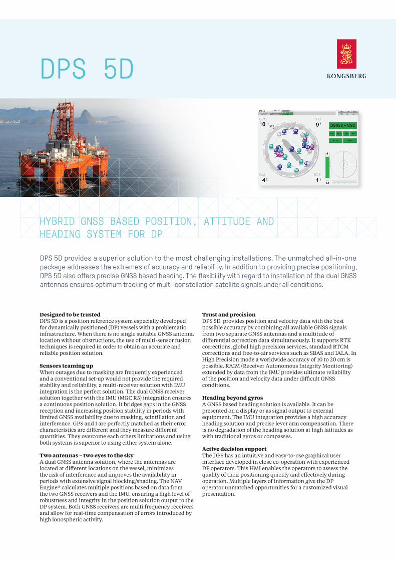
Designed to be trustedDPS 5D is a position reference system especially developed for dynamically positioned (DP) vessels with a problematic infrastructure. When there is no single suitable GNSS antenna location without obstructions, the use of multi-sensor fusion techniques is required in order to obtain an accurate and reliable position solution.
Sensors teaming upWhen outages due to masking are frequently experienced and a conventional set-up would not provide the required stability and reliability, a multi-receiver solution with IMU integration is the perfect solution. The dual GNSS receiver solution together with the IMU (MGC R3) integration ensures a continuous position solution. It bridges gaps in the GNSS reception and increasing position stability in periods with limited GNSS availability due to masking, scintillation and interference. GPS and I are perfectly matched as their error characteristics are different and they measure different quantities. They overcome each others limitations and using both systems is superior to using either system alone.
Two antennas – two eyes to the skyA dual GNSS antenna solution, where the antennas are located at different locations on the vessel, minimizes the risk of interference and improves the availability in periods with extensive signal blocking/shading. The NAV Engine® calculates multiple positions based on data from the two GNSS receivers and the IMU, ensuring a high level of robustness and integrity in the position solution output to the DP system. Both GNSS receivers are multi frequency receivers and allow for real-time compensation of errors introduced by high ionospheric activity.
Trust and precisionDPS 5D provides position and velocity data with the best possible accuracy by combining all available GNSS signals from two separate GNSS antennas and a multitude of differential correction data simultaneously. It supports RTK corrections, global high precision services, standard RTCM corrections and free-to-air services such as SBAS and IALA. In High Precision mode a worldwide accuracy of 10 to 20 cm is possible. RAIM (Receiver Autonomous Integrity Monitoring) extended by data from the IMU provides ultimate reliability of the position and velocity data under difficult GNSS conditions.
Heading beyond gyrosA GNSS based heading solution is available. It can be presented on a display or as signal output to external equipment. The IMU integration provides a high accuracy heading solution and precise lever arm compensation. There is no degradation of the heading solution at high latitudes as with traditional gyros or compasses.
Active decision supportThe DPS has an intuitive and easy-to-use graphical user interface developed in close co-operation with experienced DP operators. This HMI enables the operators to assess the quality of their positioning quickly and effectively during operation. Multiple layers of information give the DP operator unmatched opportunities for a customized visual presentation.
HYBRID GNSS BASED POSITION, ATTITUDE AND HEADING SYSTEM FOR DP
DPS 5D provides a superior solution to the most challenging installations. The unmatched all-in-one package addresses the extremes of accuracy and reliability. In addition to providing precise positioning, DPS 5D also offers precise GNSS based heading. The flexibility with regard to installation of the dual GNSS antennas ensures optimum tracking of multi-constellation satellite signals under all conditions.
TECHNICAL SPECIFICATIONS DPS 5D
PERFORMANCERTK 1 cm + 1.6 ppm RMSHigh precision accuracy 10 cm, 95 % CEPDGNSS < 1 m, 95 % CEPSBAS accuracy < 1 m, 95 % CEPVelocity accuracy < 0.01 m/s, 95 % CEP Accuracy roll, pitch (for ±5° amplitude) 0.01° RMS Update frequency rate 1 to 20 HzLatency < 1 ms
All accuracy specifications are based on real-life tests conducted in the North Sea under various conditions. Operation in other locations under different conditions may produce different results.
INTERFACESSerial ports 8 isolated ports, 6 configurable between RS-232 and RS-422IMU RS-422Ethernet/LAN 4 USB 3 DATA OUTPUTSMessage formats NMEA 0183 v. 3.0, ProprietaryMessage types ABBDP, ARABB, DPGGA, DTM, GBS, GGA, GLL, GNS, GRS, GSA, GST, GSV, RMC, VBW, VTG, ZDA
DATA INPUTSDGNSS corrections RTCM-SC104 v.2.2, 2.3, 3.0 and 3.1, Seastar XP/XP2/G2/G2+RTK corrections RTCM-SC104 v. 2.3, 3.0, 3.1 and CMRGyro compass NMEA 0183 HEHDT, HEHRC, HETHS and Robertson LR22 BCD format
IMU SENSORSupported IMU MGC R3, MRU 5+ (See dedicated datasheets for technical information)
WEIGHTS AND DIMENSIONSDPS 5D Processing Unit 5.4 kg, 89 x 485 x 357 mm DPS 5D HMI Unit 3.8 kg, 44 x 485 x 330 mmGNSS antennas 0.5 kg, 69 mm x 185 mmIALA beacon antenna 1 kg, 1000 mm
POWER SPECIFICATIONSDPS 5D Processing Unit 100 - 240 V AC, 50/60 Hz, max 75 WDPS 5D HMI Unit 100 - 240 V AC, 50/60 Hz, max 40 W GNSS antennas 5 V DC from Processing Unit IALA beacon antenna 10.2 V DC from Processing Unit
ENVIRONMENTAL SPECIFICATIONSOperating temperature rangeDPS 5D Processing Unit -15 to +55 ºC (*)DPS 5D HMI Unit -15 to +55 ºC (*) GNSS antennas -40 to +85 ºCIALA beacon antenna -55 to +55 ºC(*) Recommended +5 to +40 ºC
HumidityDPS 5D Processing Unit Max 95 % non-condensing DPS 5D HMI Unit Max 95 % non-condensing GNSS antennas IP66 IALA beacon antenna IP66
MechanicalVibration IEC 60945/EN 60945
Electromagnetic compatibilityCompliance to EMCD, immunity/emission IEC 60945/EN 60945
Product safety Compliance to LVD, standard used IEC 60950-1/EN 60950-1
PRODUCT STANDARDSIMO regulations MSC.112(73) MSC.113(73) MSC.114(73) MSC.115(73)IEC standards IEC 61108-1 IEC 61162-1 IEC 60945UKOOA compliant
Specifications subject to change without any further notice.
KONGSBERG SEATEX
Switchboard: +47 73 54 55 00Global support 24/7: +47 33 03 24 07E-mail sales: [email protected] E-mail support: [email protected]
kongsberg.com/maritime
Sept
embe
r 201
9
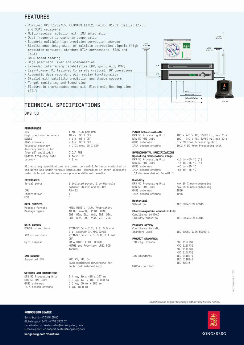
FEATURES• Combined GPS L1/L2/L5, GLONASS L1/L2, Beidou B1/B2, Galileo E1/E5 and SBAS receivers
• Multi-receiver solution with IMU integration• Dual frequency ionospheric compensation• Supports multiple high precision correction sources• Simultaneous integration of multiple correction signals (high precision services, standard RTCM corrections, SBAS and IALA)• GNSS based heading• High precision lever arm compensation• Extended interfacing capabilities (DP, gyro, AIS, ROV)• Easy-to-use HMI tailored to safety critical DP operations• Automatic data recording with replay functionality• Skyplot with satellite prediction and shadow sectors• Target monitoring and Speed view• Electronic chart/seabed maps with Electronic Bearing Line (EBL)