Embed Size (px)
Citation preview
1ESTUARY SAN FRANCISCO
W A T E R
E N V I R O N M E N T
C L I M A T E
E Q U I T Y
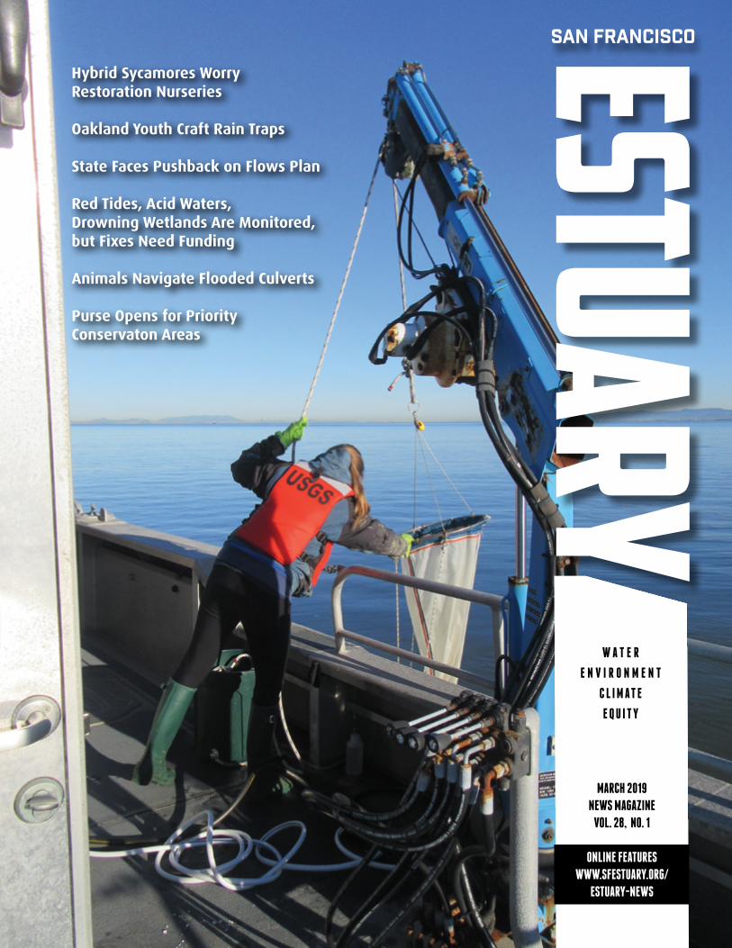
Hybrid Sycamores Worry Restoration Nurseries
Oakland Youth Craft Rain Traps
State Faces Pushback on Flows Plan
Red Tides, Acid Waters, Drowning Wetlands Are Monitored, but Fixes Need Funding
Animals Navigate Flooded Culverts
Purse Opens for Priority Conservaton Areas
MARCH 2019
NEWS MAGAZINE
VOL. 28, NO. 1
ONLINE FEATURES
WWW.SFESTUARY.ORG/
ESTUARY-NEWS
MARCH 2019ESTUARY2
Getting a Bead on Table SaltJOE EATON, REPORTER
When microplastics — fragments of containers, fibers from textiles, microbeads from personal care products — hit the water, they don’t all migrate to the Great Pacific Garbage Patch. Some, as documented in a San Francisco Estuary Institute study led by Rebecca Sutton (“ Unhealthy Fiber in Bay Diet,” Estuary News, December 2015), spend time in San Francisco Bay, with higher concentrations than Chesapeake Bay or the Great Lakes. A recent report by Ji-Su Kim and other South Korean researchers, published last fall in Environmental Science & Technology, has also found these pervasive and persistent contaminants in samples of table salt produced on six continents. Although the highest levels were
detected in salt from South and East Asia (peaking at 13,629 particles per kilogram in an Indonesian sample), almost all of the 39 samples, including one from Puget Sound, had measurable levels of microplastics, representing 14 different synthetic polymers. Salt produced by Cargill in the South Bay was not analyzed. “Food safety is a top priority for Cargill” says corporate spokesperson Justin Barber. “While research is still determining the impact of microplastics on all sea salt supplies, regulatory agencies have ensured our high-quality, naturally produced product is safe for consumption.”
Sutton, who is still research-ing microplastics in the Bay, says there’s “a lot of uncertainty about potential impacts to people and wildlife. It’s a diverse and variable contaminant, challenging to analyze and interpret.” What we know is sufficient cause for concern: apart from their physical impacts, plas-tics can absorb other pollutants and some plastic ingredients are known
endocrine disruptors. “In Bay water samples, it’s hard to know what the original source might be,” she adds. “It could be litter from creeks and streams or objects lost from boats, getting broken down into smaller and smaller particles,” in addition to the microbeads in face washes and toothpaste that start small. “Existing wastewater treatment technologies don’t degrade the plastic. It ends up in biosolids, and that’s not neces-sarily a solution.” In terms of source reduction, Sutton explains that a California ban on microbeads in per-sonal care products was superseded by less restrictive federal regulations which only address rinse-off prod-ucts. Meanwhile, the European Union is considering treating microplastics as a nonthreshold contaminant, for which any release to the environ-ment would pose a risk.
CONTACT [email protected]; [email protected]
HEALTHWATCH
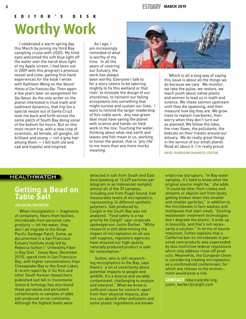
I celebrated a warm spring day this March by joining my third Bay sampling cruise with USGS. My tired eyes welcomed the soft blue light off the water over the harsh blue light of my Apple screen. I had been out in 2009 with this program’s previous vessel and crew, gaining first hand experiences for the book I wrote with Kathleen Wong on the Natural History of San Francisco Bay. Then again a few years later on assignment for Bay Nature. As the only writer on the planet interested in mud math and sediment dynamics, that trip (on a special vessel out of Santa Cruz) took me back and forth across the same patch of South Bay doing sonar of the bottom for hours. But on this most recent trip, with a new crop of scientists, all female, all gungho, all brilliant and young — not a grey hair among them — I felt both old and sad and hopeful and inspired.
As I age, I am increasingly reminded of what is worthy of my time. In all the years of covering our Estuary, the work has always been worthy. Everyone I talk to for a story seems to be laboring mightly to fix this wetland or that river, to innovate the design of our shorelines, to reinvent our failing ecosystems into something that might survive and sustain our lives. I want to remind the larger readership of this noble work. Any new green deal must have saving the planet with science and hands-on field work in the mix. Touching the water, thinking about what real earth and leaves and fish mean to us, working to honor the planet, that is “pro-life” to me more than any more murky meaning.
Which is all a long way of saying this issue is about all the things we do because we care. We monitor, we take the pulse, we restore, we teach youth about native plants and women to lead us in math and science. We chase salmon upstream until they die spawning, and then measure how big they are. We grow trees to replant riverbanks, then worry when they don’t turn out as planned. We follow the tides, the river flows, the pollutants, the bobcats on their travels around our estuary. We do really great things in the service of our small planet. Read all about it. I’m really proud.
ARIEL RUBISSOW OKAMOTO, EDITOR
E D I T O R ’ S D E S K
Worthy Work
3
LISA OWENS VIANI, REPORTER
This spring, as willows, alders, big-leaf maples, and other riparian species begin to leaf out on rivers and streams throughout the Estuary watershed, one native tree—the western sycamore—may be less conspicuous. The flashy flow regimes that encourage the tree to reproduce happen less frequently due to dams, levees, and other flood-control infrastructure on the state’s rivers and streams. In addition, the recent discovery that many of the trees grown for restoration projects are in fact hybrids has led to concerns about planting more sycamores.
In 2016, restoration managers with The Nature Conservancy discovered that the western sycamores they had planted along the Sacramento River had hybridized with the non-native London plane tree. London plane trees are popular street trees in cities and suburbs: they are tall and stately, provide excellent shade, and are resistant to pollution and disease. So if hybrids are planted in restoration projects, what harm has been done? The problem has to do with habitat values, says Ryan Luster, a project director with The Nature Conservancy.
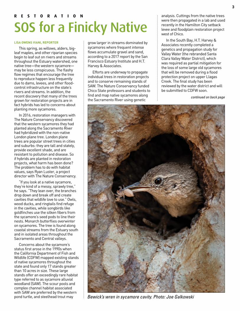
“If you look at a native sycamore, they’re kind of a messy, sprawly tree,” he says. “They lean over, the branches drop down and break off and create cavities that wildlife love to use.” Owls, wood ducks, and ringtails find refuge in the cavities, while songbirds like goldfinches use the silken fibers from the sycamore’s seed pods to line their nests. Monarch butterflies overwinter on sycamores. The tree is found along coastal streams from the Estuary south and in isolated areas throughout the Sacramento and Central valleys.
Concerns about the sycamore’s status first arose in the 1990s when the California Department of Fish and Wildlife (CDFW) mapped existing stands of native sycamores throughout the state and found only 17 stands greater than 10 acres in size. These large stands offer an exceedingly rare habitat type referred to as sycamore alluvial woodland (SAW). The scour pools and complex channel habitat associated with SAW are preferred by the western pond turtle, and steelhead trout may
grow larger in streams dominated by sycamores where frequent intense flows accumulate gravel and sand, according to a 2017 report by the San Francisco Estuary Institute and H.T. Harvey & Associates.
Efforts are underway to propagate individual trees in restoration projects and to conserve remaining stands of SAW. The Nature Conservancy funded Chico State professors and students to find and map native sycamores along the Sacramento River using genetic
analysis. Cuttings from the native trees were then propagated in a lab and used recently in the Hamilton City setback levee and floodplain restoration project west of Chico.
In the South Bay, H.T. Harvey & Associates recently completed a genetics and propagation study for Valley Water (the rebranded Santa Clara Valley Water District), which was required as partial mitigation for the loss of some large old sycamores that will be removed during a flood protection project on upper Llagas Creek. The final study has been reviewed by the water district and will be submitted to CDFW soon.
R E S T O R A T I O N
SOS for a Finicky Native
Bewick’s wren in sycamore cavity. Photo: Joe Galkowski
continued on back page
MARCH 2019ESTUARY4
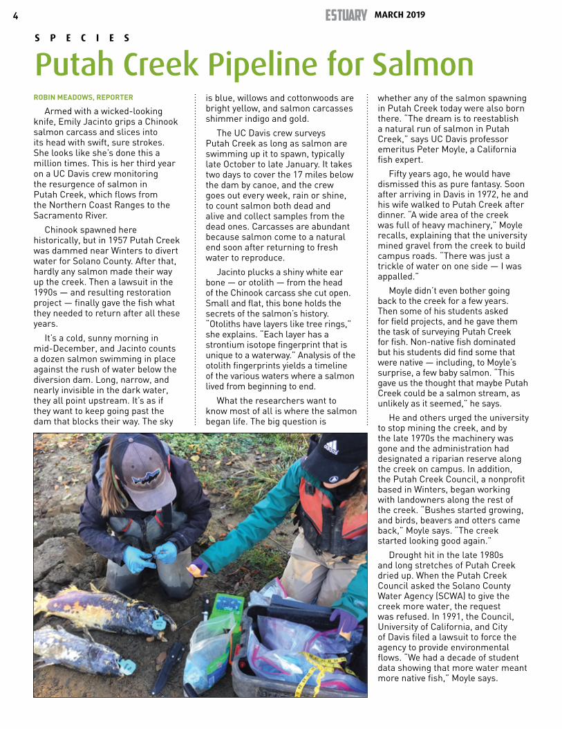
ROBIN MEADOWS, REPORTER
Armed with a wicked-looking knife, Emily Jacinto grips a Chinook salmon carcass and slices into its head with swift, sure strokes. She looks like she’s done this a million times. This is her third year on a UC Davis crew monitoring the resurgence of salmon in Putah Creek, which flows from the Northern Coast Ranges to the Sacramento River.
Chinook spawned here historically, but in 1957 Putah Creek was dammed near Winters to divert water for Solano County. After that, hardly any salmon made their way up the creek. Then a lawsuit in the 1990s — and resulting restoration project — finally gave the fish what they needed to return after all these years.
It’s a cold, sunny morning in mid-December, and Jacinto counts a dozen salmon swimming in place against the rush of water below the diversion dam. Long, narrow, and nearly invisible in the dark water, they all point upstream. It’s as if they want to keep going past the dam that blocks their way. The sky
is blue, willows and cottonwoods are bright yellow, and salmon carcasses shimmer indigo and gold.
The UC Davis crew surveys Putah Creek as long as salmon are swimming up it to spawn, typically late October to late January. It takes two days to cover the 17 miles below the dam by canoe, and the crew goes out every week, rain or shine, to count salmon both dead and alive and collect samples from the dead ones. Carcasses are abundant because salmon come to a natural end soon after returning to fresh water to reproduce.
Jacinto plucks a shiny white ear bone — or otolith — from the head of the Chinook carcass she cut open. Small and flat, this bone holds the secrets of the salmon’s history. “Otoliths have layers like tree rings,” she explains. “Each layer has a strontium isotope fingerprint that is unique to a waterway.” Analysis of the otolith fingerprints yields a timeline of the various waters where a salmon lived from beginning to end.
What the researchers want to know most of all is where the salmon began life. The big question is
whether any of the salmon spawning in Putah Creek today were also born there. “The dream is to reestablish a natural run of salmon in Putah Creek,” says UC Davis professor emeritus Peter Moyle, a California fish expert.
Fifty years ago, he would have dismissed this as pure fantasy. Soon after arriving in Davis in 1972, he and his wife walked to Putah Creek after dinner. “A wide area of the creek was full of heavy machinery,” Moyle recalls, explaining that the university mined gravel from the creek to build campus roads. “There was just a trickle of water on one side — I was appalled.”
Moyle didn’t even bother going back to the creek for a few years. Then some of his students asked for field projects, and he gave them the task of surveying Putah Creek for fish. Non-native fish dominated but his students did find some that were native — including, to Moyle’s surprise, a few baby salmon. “This gave us the thought that maybe Putah Creek could be a salmon stream, as unlikely as it seemed,” he says.
He and others urged the university to stop mining the creek, and by the late 1970s the machinery was gone and the administration had designated a riparian reserve along the creek on campus. In addition, the Putah Creek Council, a nonprofit based in Winters, began working with landowners along the rest of the creek. “Bushes started growing, and birds, beavers and otters came back,” Moyle says. “The creek started looking good again.”
Drought hit in the late 1980s and long stretches of Putah Creek dried up. When the Putah Creek Council asked the Solano County Water Agency (SCWA) to give the creek more water, the request was refused. In 1991, the Council, University of California, and City of Davis filed a lawsuit to force the agency to provide environmental flows. “We had a decade of student data showing that more water meant more native fish,” Moyle says.
S P E C I E S
Putah Creek Pipeline for Salmon

5
The case hinged on a law that had been on the books for 100 years but had not been enforced. “Fish and Game code section 5937 said all fish must be in good condition below a dam,” Moyle says, adding that he got to define what ‘good condition’ meant, and that his definition ultimately became the basis for future lawsuits to restore environmental flows, including in the San Joaquin River. “Because of the Putah Creek lawsuit, other dams in the state now meet this requirement,” he continues.
After a decade of fighting in court, the SCWA settled the lawsuit in 2000. In a complete turnaround, agency officials embraced their new role as environmental stewards of Putah Creek. “They’ve become the good guys now,” Moyle says.
As part of the settlement agreement, the water agency created the new position of Streamkeeper to lead the creek’s restoration, and the job went to Rich Marovich, who had once been a farmer. “That turned out to be a brilliant move,” Moyle says. Most of the landowners along Putah Creek are farmers, and at first many were leery of the restoration. “Rich understood and worked really well with them,” Moyle says.
Marovich’s ambitious restoration includes replanting riparian forests as well as bringing back some of the creek’s natural twists and turns. But he credits the salmon’s comeback primarily to two other factors. First, at the onset of spawning season, the SCWA releases a week-long pulse of water from the diversion dam. This alerts salmon that they can swim up Putah Creek.
“There’s been an incredible increase in salmon,” Marovich says, adding that adult counts for recent years have hovered between 500 and 1,000. “That’s in the range where they could be self-sustaining.” While the numbers for this year are still being crunched, initial estimates put the adult population at 400 to 500.
The other key factor is that Putah Creek now offers good spots for spawning. Salmon build their nests in loose gravel, but the bottom of the creek had essentially been one big solid ever since the diversion dam went in. “Without scouring flows, fine sediment settled and cemented the gravel together like asphalt,” Ma-
rovich says. “It formed a crust about eight inches thick.”
In 2013, the state gave Marovich permission to try something that had not yet been tested — and that they didn’t think was feasible: breaking up the creek bottom to free the gravel just below the dam. “It was wildly successful,” he says. “That reach was the only place salmon spawned that year.”
Last spring, more than 30,000 young salmon swam down Putah Creek towards the Sacramento River, and Marovich says the capacity is even higher. The creek has five deep pools — former gravel mining pits — that are each about a mile long. “Salmon need shallow water with riffles,” Marovich says. “This is not spawning habitat.” But it could be.
He’s already restored one such pool in Winters and hopes to transform the rest as well.
Putah Creek’s spectacular success gives hope for restoring salmon in other degraded waterways. “Putah Creek was a heavily modified ditch,” Moyle says. “This shows we can bring salmon back to places that haven’t had regular runs for a long time.” And, he adds on a personal note, “Putah Creek is now one of the great benefits of living in Davis.”
CONTACT [email protected]; [email protected]; [email protected]: Robin Meadows
MARCH 2019ESTUARY6
CARIAD HAYES THRONSON, REPORTER
While this wet winter’s storms have been filling California’s reservoirs, building an impressive snowpack and turning creeks into torrents, several streams of activity around the future of Delta flows were bubbling along and spilling into the fraught relationship between the state and the Trump administration.
The winter kicked off with the State Water Resources Control Board’s December vote to adopt increased flow objectives for the southern Delta, lower San Joaquin River and its tributaries as part of the Board’s long-awaited update to the Bay-Delta Water Quality Control Plan. The plan calls for instream flows of 30 to 50 percent of unimpaired flows on the Stanislaus, Tuolumne and Merced rivers to restore endangered fish populations. “The Board did what it hasn’t done in decades,” says San Francisco Baykeeper’s Jon Rosenfield. “It adopted new standards that it developed on its own, rather than something that came out of a negotiation.” The vote follows the Board’s summer 2018 release of a framework for a similar plan for the
Sacramento River and flows into and through the Delta.
The December vote provoked an immediate volley of lawsuits, both from water users, and from environmental organizations. The water users—including a number of irrigation districts, the San Francisco Public Utilities Commission and Valley Water (the rebranded Santa Clara Valley Water District)—oppose the plan. They claim, among other things, that the Board violated the California Environmental Quality Act by incorrectly analyzing the plan’s impacts and that the required flows would be an unconstitutional waste and unreasonable use of water. On the other hand, environmental groups argue that the plan doesn’t go far enough to restore endangered fish populations as legally required. “We are glad they did their job” by establishing the standards, says Rosenfield, “but their plan won’t achieve what’s required.” More suits are likely as the Plan goes through various administrative processes, including water rights proceedings to determine who will need to give up how much water to meet the Plan’s requirements.
In hopes of reaching a resolution before the lawsuits work their way through the courts—which would almost certainly take years—the Board left the door open for “volun-tary settlement agreements” that might permit lower instream flows in exchange for “non-flow” measures to improve conditions for fish and wildlife. “We believe the State Water Board’s flow-only approach is not the best solution for the environment,” says Valley Water in a statement. “A more holistic approach is needed; one that incorporates non-flow mea-sures like providing greater access to floodplains, removing barriers to migration, improving spawning and rearing habitat, and controlling predation.”
Negotiations over agreements have been ongoing for more than five years, and are widely seen as setting the stage for a “grand bargain” on Delta flows. Indeed, on the same day that the Board voted to adopt the lower San Joaquin flow requirements, the direc-tors of California’s Departments of Water Resources and Fish and Wildlife presented the Board with the outline of an agreement covering the Tuolumne, American, Sacramento, Feather and
P O L I C Y
Choppy Waters for Flow Rules
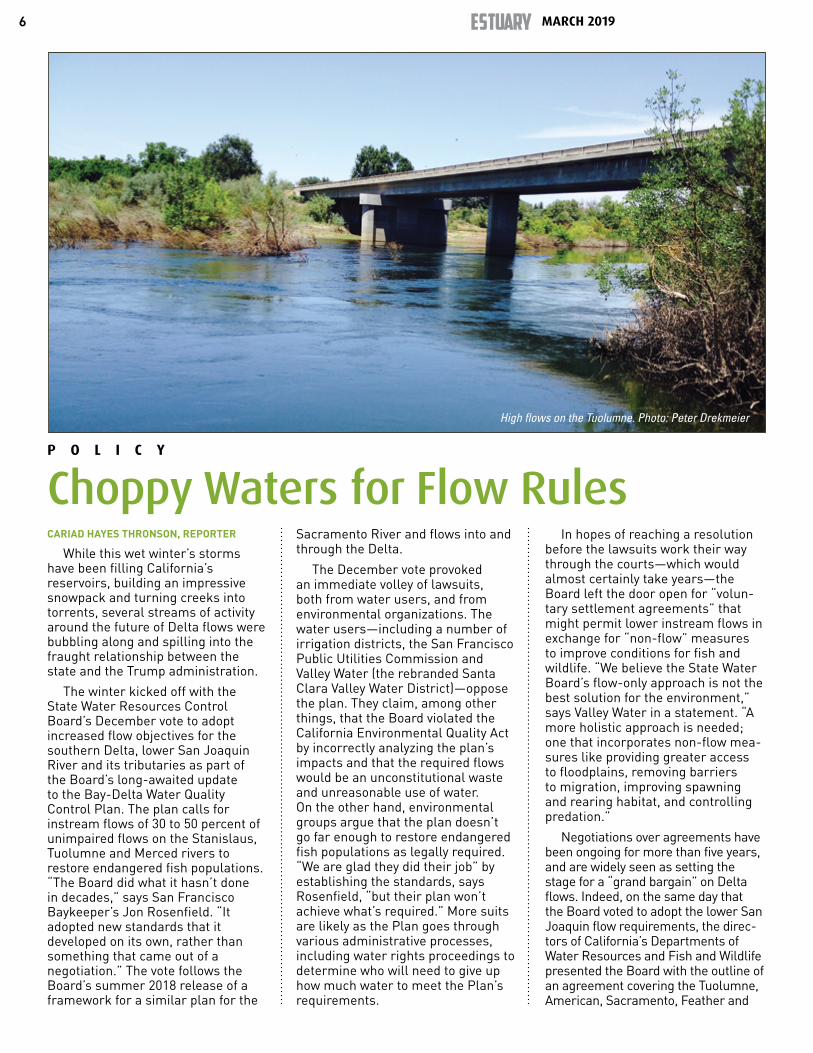
High flows on the Tuolumne. Photo: Peter Drekmeier

7
Yuba rivers and the Delta. At the Board’s direction, this month DWR and DFW submitted a more detailed description of the proposed settle-ment. The Board will now evaluate the proposed agreement to determine if it might serve as an alternative to its own flow plans.
Although new Governor Gavin Newsom’s administration brought the environmental community back into talks in January, “we are still evaluating what has really been put on the table,” says Defenders of Wildlife’s Kim Delfino. Up to this point, negotiations over the settlement had been conducted “without meaningful participation from conservation groups,” says the Natural Resources Defense Council’s Doug Obegi. Delfino confirms: “What was submitted to the Board is not the product of extensive NGO engagement, it’s the beginning of the NGO reengagement.”
Advocates for the environment say the proposal leaves some critical questions unanswered. “The plan is still not adequately described, and what is described reinforces that the voluntary agreements are not adequate to meet the objectives of the Water Quality Control Plan,” says Rosenfield. The proposal leaves unresolved the question of how flows are measured. It refers to “new water” for the environment, but “there is still a lack of clarity about what the baseline is,” says Delfino. “From our perspective, ‘existing conditions’ mean the combined flows under Decision 1641, current endangered species requirements, and other flows that occur incidentally that provide ecological benefits. I don’t know that we have a meeting of the minds on that among all the parties.”
Overshadowing discussions, and potentially influencing the defini-tion of the baseline, are the vigorous efforts by the US Interior Depart-ment — under acting Secretary of the Interior and former Westlands Water District lobbyist David Bernhardt — to rollback protections for endangered Delta fish. During the Obama admin-istration, when it had become clear that the existing biological opinions for Delta smelt and Chinook salmon were insufficiently protective and that fish populations were continuing to nosedive, the DWR and the Bureau of Reclamation reinitiated consultation
on a new, more protective biological opinion governing the joint opera-tions of the State Water Project and the Central Valley Project. (These two projects do the majority of the exporting. But they do not export the majority of the total available water and they do not represent the major-ity of all diversions — in basin + out of basin. In February, however, under the Trump administration, Reclama-tion issued a Biological Assessment (the basis for new biological opin-ions) that calls for temperature and
entrainment management, as well as habitat and salinity measures, rather than flows. “By expanding our toolkit with the best science and using what we know today, new biological opin-ions will allow us to maximize water and power benefits while support-ing endangered fish populations,” Mid-Pacific Regional Director Ernest Conant said in a statement.
All the more reason to make sure that the baseline for flows in any agreement reflects existing conditions, says Rachel Zwillinger of Defenders of Wildlife. “If the baseline is set properly, the agreements can make sure that the Estuary receives enough water no matter what the Trump administration does with ESA protections.”
California has some options for protecting its endangered fish, even if federal protections are rolled back. “Currently, the SWP and CVP achieve California Endangered Species Act compliance for Delta smelt and two salmon species under a consistency determination”— a determination by the state that the biological opinions meet CESA requirements, says DFW’s Carl Wilcox. “Going forward, we would expect that the state will issue its own permits for the SWP.” Whether the federal CVP would also have to obtain a permit is likely to be a contentious question. The CVP is required to comply with state law under the 1992 Central Valley Improvement Act, says Obegi, “but they have never in the past obtained a permit under CESA. We’ve never really had a large difference between the federal standards and state standards, where state standards were stronger than fed standards, which is why it’s never come to a head before now.”
“Governor Newsom has staked out turf against the Trump Administration, and water management and endangered species are going to be the first real test of that,” says Rosenfield. “These rivers and the Delta are all contained within California, there is no federal aspect to them. Will the Newsom administration stand up and defend California’s natural resources from Trump?”
CONTACT [email protected]; [email protected] Top: Sierra snowmelt above the dam on the
Tuolumne River. Photo (and sign): Carson Jeffres Bottom: Low flows hamper kayakers below Tuolumne dams. Photo Peter Drekmeier
MARCH 2019ESTUARY8
AUDREY MEI YI BROWN, REPORTER
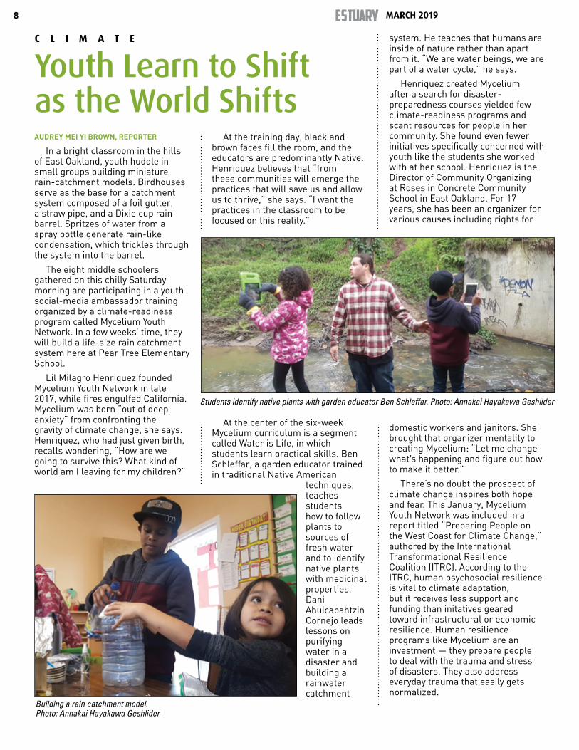
In a bright classroom in the hills of East Oakland, youth huddle in small groups building miniature rain-catchment models. Birdhouses serve as the base for a catchment system composed of a foil gutter, a straw pipe, and a Dixie cup rain barrel. Spritzes of water from a spray bottle generate rain-like condensation, which trickles through the system into the barrel.
The eight middle schoolers gathered on this chilly Saturday morning are participating in a youth social-media ambassador training organized by a climate-readiness program called Mycelium Youth Network. In a few weeks’ time, they will build a life-size rain catchment system here at Pear Tree Elementary School.
Lil Milagro Henriquez founded Mycelium Youth Network in late 2017, while fires engulfed California. Mycelium was born “out of deep anxiety” from confronting the gravity of climate change, she says. Henriquez, who had just given birth, recalls wondering, “How are we going to survive this? What kind of world am I leaving for my children?”
At the training day, black and brown faces fill the room, and the educators are predominantly Native. Henriquez believes that “from these communities will emerge the practices that will save us and allow us to thrive,” she says. “I want the practices in the classroom to be focused on this reality.”
At the center of the six-week Mycelium curriculum is a segment called Water is Life, in which students learn practical skills. Ben Schleffar, a garden educator trained in traditional Native American
techniques, teaches students how to follow plants to sources of fresh water and to identify native plants with medicinal properties. Dani Ahuicapahtzin Cornejo leads lessons on purifying water in a disaster and building a rainwater catchment
system. He teaches that humans are inside of nature rather than apart from it. “We are water beings, we are part of a water cycle,” he says.
Henriquez created Mycelium after a search for disaster-preparedness courses yielded few climate-readiness programs and scant resources for people in her community. She found even fewer initiatives specifically concerned with youth like the students she worked with at her school. Henriquez is the Director of Community Organizing at Roses in Concrete Community School in East Oakland. For 17 years, she has been an organizer for various causes including rights for
domestic workers and janitors. She brought that organizer mentality to creating Mycelium: “Let me change what’s happening and figure out how to make it better.”
There’s no doubt the prospect of climate change inspires both hope and fear. This January, Mycelium Youth Network was included in a report titled “Preparing People on the West Coast for Climate Change,” authored by the International Transformational Resilience Coalition (ITRC). According to the ITRC, human psychosocial resilience is vital to climate adaptation, but it receives less support and funding than initatives geared toward infrastructural or economic resilience. Human resilience programs like Mycelium are an investment — they prepare people to deal with the trauma and stress of disasters. They also address everyday trauma that easily gets normalized.
C L I M A T E
Youth Learn to Shift as the World Shifts
Students identify native plants with garden educator Ben Schleffar. Photo: Annakai Hayakawa Geshlider
Building a rain catchment model. Photo: Annakai Hayakawa Geshlider
9
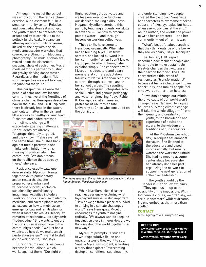
Although the rest of the school was empty during the rain catchment exercise, our classroom felt like a small community center. Relatives and guest educators sat amongst the youth to listen to presentations, or stopped by to contribute to the potluck lunch. Ayako Nagano, an attorney and community organizer, kicked off the day with a social-media ambassador workshop that covered everything from blogging to photography. The middle schoolers moved about the classroom, snapping shots of each other. Mosiah modeled for his partner by busting out gravity-defying dance moves. Regardless of the medium, “It’s your perspective we want to know,” Nagano told the youth.
This perspective is aware that people of color and low-income communities live at the frontlines of climate change. Henriquez describes how in their Oakland 94601 zip code, there is already lead in the water, particulate matter in the air, and little access to healthy organic food. Disasters and added stresses from climate change will exacerbate existing challenges. Her students are already “disproportionately targeted, and they know it,” she says. At the same time, she pushes back against media portrayals she thinks only highlight what is missing or problematic in her community. “We don’t focus on the resilience that’s already there,” she says.
Resilience usually calls upon diverse skills. Mycelium brings together youth participatory action research, disaster preparedness, urban and wilderness survival, ecological sustainability, and visionary imaginings. Activities include a “walk your block” exercise to identify medicinal and sacred plants as well as lessons on how to mobilize an emergency bag and family plan for when disaster strikes. As Henriquez remarks affectionately, it’s a dynamic “hodgepodge.” She wants to ensure the curriculum is responsive to the community’s needs. “We just had a wildfire, so how do we make an air purification system? I want it to shift as the world shifts,” she says.
During trauma and crisis people become individualistic, which works against them. “Our fight or
flight reaction gets activated and we lose our executive functions, our decision-making skills,” says Nagano. Mycelium combats this panic by teaching students key skills in advance — like how to procure potable water — and through lessons on working collectively.
Those skills have come to Henriquez organically. When she began building Mycelium from scratch, she looked outward into her community. “When I don’t know, I go to people who do know,” she explains simply. She connected with Mycelium’s educators and board members at climate adaptation forums, at Native American resource centers, through relatives, and in her school garden. The resulting Mycelium program “integrates eco-social justice, indigenous pedagogy, and water engineering,” says Pablo K. Cornejo, a civil engineering professor at California State University at Chico who consulted on the curriculum.
While Mycelium takes disaster-readiness seriously, exploring what lays beyond survival is also important. “How do we go from a place of survival to thriving in a climate challenged world?” says Henriquez. Mycelium encourages the youth to imagine radically. “We always want to keep the imagination piece in there: How are we thinking about the world together in a new way?”
Mycelium prompts its students to write speculative fiction and envision a world they want to see. Sana, a Mycelium student, is writing a story that explores “overcoming dystopian conditions, sustainability,
and understanding how people created the dystopia.” Sana wills her characters to overcome stacked odds; she “likes dystopias but hates when everybody dies at the end.” As the author, she wields the power to write her characters — and her community — out of harm’s way.
“What’s beautiful about youth is that they think outside of the box — they are visionary,” says Henriquez.
The January ITRC report described how resilient people are better able to make sustainable lifestyle changes that will lessen their carbon footprint. The ITRC characterizes this brand of resilience as “transformational” because it turns a challenge into an opportunity, and makes people feel empowered rather than helpless.
“If we don’t change our minds, the physicality of our world won’t change,” says Nagano. Henriquez believes surviving climate change will take the whole village — “from the ingenuity and creativity of
youth, to the knowledge and experience of adults and elders, to the wisdom and traditions of our ancestors.”
At the Mycelium workshop day, Henriquez sat amongst the youth. She listened to the educators and piped in occasionally, but mostly watched the workshop unfold. She had no need to assume center stage because she had already done her part: organizing the network to support the next generation of collective leadership.
“The youth should be the leaders!” Henriquez exclaims. “They open us all up to the
possibility of the impossible. Within Indigenous circles, we often say, we are our ancestors’ wildest dreams. No one embodies that more than youth.”
CONTACT [email protected]
DEEPER DIVE www.sfestuary.org/estuary-news-mycelliium-youth-shifting-world
www.myceliumyouthnetwork.org
Henriquez speaks at the social-media ambassador training. Photo: Annakai Hayakawa Geshlider
MARCH 2019ESTUARY10
ASHLEIGH PAPP, REPORTER
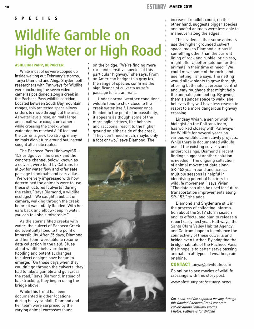
While most of us were cooped up inside waiting out February’s storms, Tanya Diamond and Ahíga Snyder, both researchers with Pathways for Wildlife, were anchoring the seven video cameras positioned along a creek in the Pacheco Pass wildlife corridor. Located between South Bay mountain ranges, this protected space allows critters to move throughout the area. As water levels rose, animals large and small were caught on camera while crossing the creek; when water depths reached 6-10 feet and the currents grew too strong, many animals didn’t turn around but instead sought alternate routes.
The Pacheco Pass Highway/SR-152 bridge over the creek and the concrete channel below, known as a culvert, were built by Caltrans to allow for water flow and offer safe passage to animals and cars alike. “We were very impressed with how determined the animals were to use these structures [culverts] during the rains,” says Diamond, a wildlife ecologist. “We caught a bobcat on camera, walking through the creek before it was totally flooded. With her ears back and elbow-deep in water, you can tell she’s miserable.”
As the storms filled creeks with water, the culvert of Pacheco Creek did eventually flood to the point of impassibility. After 25 days, Diamond and her team were able to resume data collection in the field. Clues about wildlife behavior during flooding and potential changes to culvert designs have begun to emerge. “On those days when they couldn’t go through the culverts, they had to take a gamble and go across the road,” says Diamond. Instead of backtracking, they began using the bridge above.
While this trend has been documented in other locations during heavy rainfall, Diamond and her team were surprised by the varying animal carcasses found
on the bridge. “We’re finding more rare and sensitive species at this particular highway,” she says. From an American badger to a gray fox, the range of species confirms the significance of culverts as safe passage for all animals.
Under normal weather conditions, wildlife tend to stick close to the creek water itself. However once flooded to the point of impassibility, it appears as though some of the more agile critters, like bobcats and raccoons, resort to the higher ground on either side of the creek. “They don’t need much, maybe only a foot or two,” says Diamond. The
increased roadkill count, on the other hand, suggests bigger species and hoofed animals were less able to maneuver along the edges.
This evidence, that some animals use the higher grounded culvert space, makes Diamond curious if something other than the current lining of rock and rubble, or rip rap, might offer a better solution for the animals in their time of need. “We could move some of the rocks and use netting,” she says. The netting would allow plants to grow through, offering both natural erosion control and leafy roughage that might help the animals gain footing. By giving them a slender space to walk, she believes they will have less reason to resort to a more dangerous highway crossing.
Lindsay Vivian, a senior wildlife biologist on the Caltrans team, has worked closely with Pathways for Wildlife for several years on various wildlife connectivity projects. While there is documented wildlife use of the existing culverts and undercrossings, Diamond’s recent findings suggest another solution is needed. “The ongoing collection of animal movement data along SR-152 year-round and across multiple seasons is helpful in identifying potential barriers to wildlife movement,” says Vivian. “The data can also be used for future transportation improvements along SR-152,” she adds.
Diamond and Snyder are still in the process of collecting informa-tion about the 2019 storm season and its effects, and plan to release a report early next year. Pathways, the Santa Clara Valley Habitat Agency, and Caltrans hope to to enhance the connectivity of these culverts and bridge even further. By adapting the bridge habitats of the Pacheco Pass, their hope is to better serve passing animals in all types of weather, rain or shine.
CONTACT [email protected]
Go online to see movies of wildlife crossings with this story post.
www.sfestuary.org/estuary-news
Cat, coon, and fox captured moving through this flooded Pacheco Creek concrete culvert during February storms. Photos: Pathways for Wildlife
S P E C I E S
Wildlife Gamble on High Water or High Road
CARIAD HAYES THRONSON, REPORTER
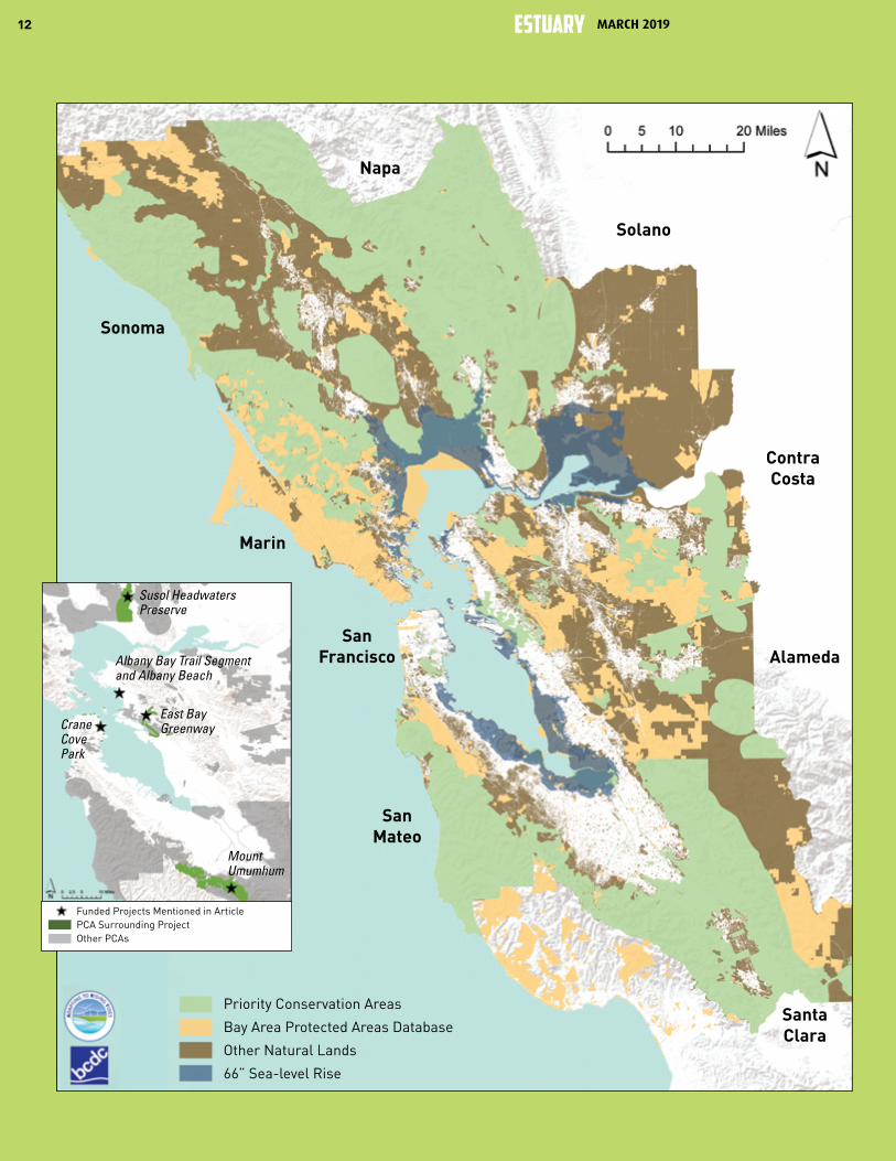
Marsh restoration, Bay and Ridge Trail extensions, and urban park up-grades are among the types of projects eligible to receive funding through the 2019 Bay Area Priority Conservation Area (PCA) One Bay Area Grant Pro-gram. By March, aided by new map-ping tools that can pinpoint regional landscape characteristics and needs, more than 36 cities, counties, agencies and non-profits had submitted letters of interest to the program, outlining a variety of projects that benefit one or more of the Bay Area’s 165 PCAs (see map p. 12). Altogether, the grant re-quests totaled more than $19 million.
Some of these projects may help vulnerable shoreline areas defend against sea-level rise; others may make urban hardscapes more porous under atmospheric river downpours; still others may connect vital migratory corridors for urban wildlife through the skyscrapers, industry, and neighborhoods of the metropolitan Bay Area.
“With this new stream of funding, you could say we have a goal of both growing and conserving the region at the same time,” says Matt Gerhart of the State Coastal Conservancy (SCC), which is managing the grants.
Important elements of the Plan Bay Area 2040, the current integrated long-range transportation and land-use plan for the region, PCAs are intended to complement areas designated for high-density growth, or Priority Development Areas. “Compared to other Bay Area natural lands, parks and preserves, the PCA network contributes a disproportionately high number of some ecosystem services,” says Heather Dennis of the SF Bay Conservation and Development Commission’s Adapting to Rising Tides (ART) project.
PCAs, which are nominated by local governments, agencies or non-profits, fall into four categories: natural landscapes, agricultural land, regional recreation and urban greening. Some PCAs fit more than one category, such as agricultural land that also provides recreational opportunities.
The first list of PCAs was assembled in 2008, when ABAG asked local interests and agencies around the Bay to suggest unprotected places where pastures, forests, vacant lots, creeks, and shorelines should be identified as a conservation priority. “Cities pushed back on that approach, because anyone was allowed to submit an idea, and they felt there was not enough consideration of existing municipal plans and priorities,” says Laura Thompson, Assistant Planning Director for the Association of Bay Area Governments (ABAG/MTC).
In the second round, cities were placed in the drivers seat—as primary nominators of PCAs—and they were also required to notify property owners of designations. A new category for PCAs of “urban greening” was also added. “The urban greening category is important, because it creates opportunities for multi-benefit stormwater management practices, like rain gardens, and active transportation improvements, such as bike and pedestrian trails along greenway corridors,” says the San Francisco Estuary Partnership’s John Bradt. “These projects promote public awareness of resource protection, and public access to nature within the built environment.”
In terms of the money to support these PCAs, the first round of PCA grants funded 23 projects around the Bay in 2013, ranging from recreational improvements to Mill Valley’s Bayfront Park to the purchase of 174 acres adjacent to San Mateo County’s Memorial Park for open space and recreation. Funds awarded totaled $12 million. In the second round, now underway, the Metropolitan Transportation Commission (MTC) and the Coastal Conservancy have set aside $10 million for projects in the Peninsula, Southern and East Bay counties (the North Bay program is managed separately by local transportation agencies; in the second round of those grants, 11 projects were awarded a total of $8.2 million).
continued on page 14
L A N D S C A P E S
Purse Opens for PCA Projects
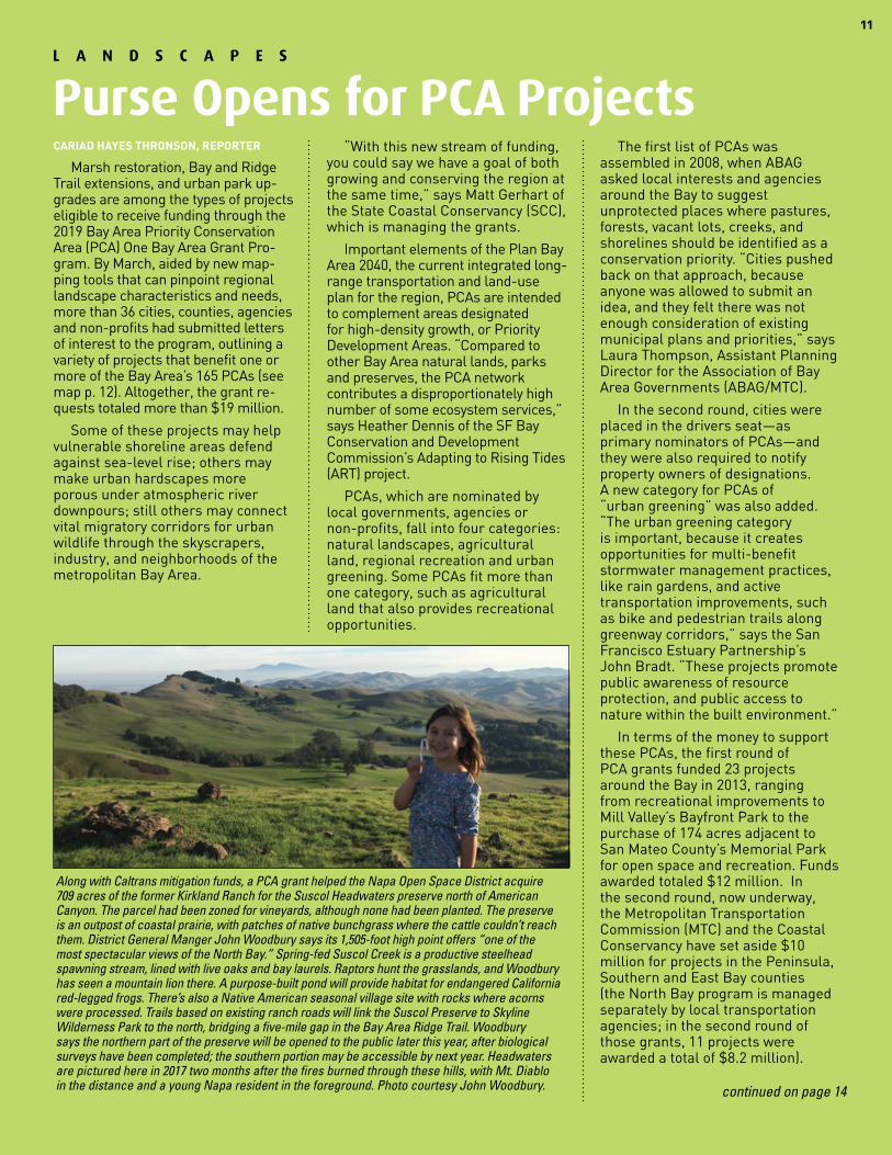
Along with Caltrans mitigation funds, a PCA grant helped the Napa Open Space District acquire 709 acres of the former Kirkland Ranch for the Suscol Headwaters preserve north of American Canyon. The parcel had been zoned for vineyards, although none had been planted. The preserve is an outpost of coastal prairie, with patches of native bunchgrass where the cattle couldn’t reach them. District General Manger John Woodbury says its 1,505-foot high point offers “one of the most spectacular views of the North Bay.” Spring-fed Suscol Creek is a productive steelhead spawning stream, lined with live oaks and bay laurels. Raptors hunt the grasslands, and Woodbury has seen a mountain lion there. A purpose-built pond will provide habitat for endangered California red-legged frogs. There’s also a Native American seasonal village site with rocks where acorns were processed. Trails based on existing ranch roads will link the Suscol Preserve to Skyline Wilderness Park to the north, bridging a five-mile gap in the Bay Area Ridge Trail. Woodbury says the northern part of the preserve will be opened to the public later this year, after biological surveys have been completed; the southern portion may be accessible by next year. Headwaters are pictured here in 2017 two months after the fires burned through these hills, with Mt. Diablo in the distance and a young Napa resident in the foreground. Photo courtesy John Woodbury.
11
12 MARCH 2019ESTUARY
Priority Conservation Areas
Bay Area Protected Areas Database
Other Natural Lands
66” Sea-level Rise
SanMateo
SanFrancisco
Marin
Sonoma
Napa
Solano
ContraCosta
SantaClara
Alameda
Funded Projects Mentioned in ArticlePCA Surrounding ProjectOther PCAs
Crane Cove Park
East Bay Greenway
Mount Umumhum
Susol Headwaters Preserve
Albany Bay Trail Segment and Albany Beach
Here and There Locals Point to Valuable Open-Space Pockets, Gaps, and Buffers in the Urban Landscape
continued on next page
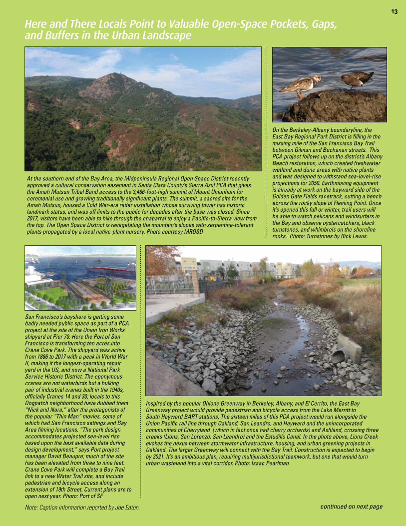
At the southern end of the Bay Area, the Midpeninsula Regional Open Space District recently approved a cultural conservation easement in Santa Clara County’s Sierra Azul PCA that gives the Amah Mutsun Tribal Band access to the 3,486-foot-high summit of Mount Umunhum for ceremonial use and growing traditionally significant plants. The summit, a sacred site for the Amah Mutsun, housed a Cold War-era radar installation whose surviving tower has historic landmark status, and was off limits to the public for decades after the base was closed. Since 2017, visitors have been able to hike through the chaparral to enjoy a Pacific-to-Sierra view from the top. The Open Space District is revegetating the mountain’s slopes with serpentine-tolerant plants propagated by a local native-plant nursery. Photo courtesy MROSD
San Francisco’s bayshore is getting some badly needed public space as part of a PCA project at the site of the Union Iron Works shipyard at Pier 70. Here the Port of San Francisco is transforming ten acres into Crane Cove Park. The shipyard was active from 1886 to 2017 with a peak in World War II, making it the longest-operating repair yard in the US, and now a National Park Service Historic District. The eponymous cranes are not waterbirds but a hulking pair of industrial cranes built in the 1940s, officially Cranes 14 and 30; locals to this Dogpatch neighborhood have dubbed them “Nick and Nora,” after the protagonists of the popular “Thin Man” movies, some of which had San Francisco settings and Bay Area filming locations. “The park design accommodates projected sea-level rise based upon the best available data during design development,” says Port project manager David Beaupre; much of the site has been elevated from three to nine feet. Crane Cove Park will complete a Bay Trail link to a new Water Trail site, and include pedestrian and bicycle access along an extension of 19th Street. Current plans are to open next year. Photo: Port of SF
On the Berkeley-Albany boundaryline, the East Bay Regional Park District is filling in the missing mile of the San Francisco Bay Trail between Gilman and Buchanan streets. This PCA project follows up on the district’s Albany Beach restoration, which created freshwater wetland and dune areas with native plants and was designed to withstand sea-level-rise projections for 2050. Earthmoving equipment is already at work on the bayward side of the Golden Gate Fields racetrack, cutting a bench across the rocky slope of Fleming Point. Once it’s opened this fall or winter, trail users will be able to watch pelicans and windsurfers in the Bay and observe oystercatchers, black turnstones, and whimbrels on the shoreline rocks. Photo: Turnstones by Rick Lewis.
Note: Caption information reported by Joe Eaton.
Inspired by the popular Ohlone Greenway in Berkeley, Albany, and El Cerrito, the East Bay Greenway project would provide pedestrian and bicycle access from the Lake Merritt to South Hayward BART stations. The sixteen miles of this PCA project would run alongside the Union Pacific rail line through Oakland, San Leandro, and Hayward and the unincorporated communities of Cherryland (which in fact once had cherry orchards) and Ashland, crossing three creeks (Lions, San Lorenzo, San Leandro) and the Estudillo Canal. In the photo above, Lions Creek evokes the nexus between stormwater infrastructure, housing, and urban greening projects in Oakland. The larger Greenway will connect with the Bay Trail. Construction is expected to begin by 2021. It’s an ambitious plan, requiring multijurisdictional teamwork, but one that would turn urban wasteland into a vital corridor. Photo: Isaac Pearlman
13
14
Projects eligible for funding during the current grant round must consist of at least one of five activities, within or adjacent to, a PCA: protection or enhancement of nature resources, open space or agricultural lands; pedestrian and bicycle facilities, urban greening; planning activities; and visual enhancements (see pp.12-13 for examples]. After reviewing the letters of interest, regional agencies will invite selected projects to submit a full proposal by July.
As part of the application process, PCA grant applicants must submit a project report through Bay Area Greenprint. This mapping and data tool was developed by the Greenbelt Alliance, the Nature Conservancy, the Bay Area Open Space Council, the American Farmland Trust and the Green Info Network. A Greenprint report identifies, maps and measures ecosystem values, and allows users to visually display and share a range of data about their project location—everything from its status as habitat for protected species to agricultural and recreational uses to carbon sequestering potential.
“The Greenprint allows you to see where within a PCA are the conservation priorities,” says Adam Garcia of Greenbelt Alliance, who gave a quick onscreen lesson in how to navigate the tool’s colorful and attractive menus at several recent workshops for grant applicants. “It can offer a snapshot of what’s in your project area right now and a way to assess multiple benefits, but it’s not a scenario planning tool.”
“The Greenprint helps us identify the highest priorities for conservation, based on values that we have all agreed on,” says Tom Robinson of the Bay Area Open Space Council. “No matter who is evaluating the projects, [we now have] a standard way to view them.”
Given the investment in PCA projects, figuring out how to protect them from the effects of climate change, and leverage them to protect other assets, is a priority. With funding from MTC, BCDC’s ART Bay Area program conducted vulnerability assessments of 19 PCAs around the Bay in 2018. Among the findings was that more than 50 percent of the recreation that the PCA network provides, and all of the PCAs that
are critical for coastal protection, are vulnerable to sea-level rise and flooding. Findings also compared ecosystem services provided by PCAs across the region using ecosystem valuation models developed by the Natural Capital Project, a collabora-tion between Stanford University, University of Minnesota, the World Wildlife Fund, and the Nature Conser-vancy (see map).
“We are hoping that this analysis will help guide where future PCAs make sense, and also how projects within existing PCAs might speak to the vulnerabilities that we’ve iden-tified,” says BCDC’s Dennis. For example, the PCA around Oakland’s Damon Slough has wetlands that may provide flood protection to the Coliseum area PDA, as well as nearby transportation infrastructure. Next, ART will examine issues such as what adaptation strategies might make PCAs more resilient, and whether rising sea-levels warrant changes in how PCAs are designated and funded.
“The ART analysis isn’t intended to dictate how the PCA program operates, or whether there should be a change in our regional ap-proach to natural lands,“ says the ART program’s new director Dana Brechwald. “That’s a bigger conver-sation. This analysis could help us think about a regional approach in new ways.”
The PCA program has evolved to more effectively balance Bay Area-wide priorities, says The Nature Conservancy’s Liz O’Donoghue. “There will always be tension between locally identified, locally driven priorities, which is really how on-the-ground conservation is most successful, and the need for local conservation pri-orities and projects to support and be driven by regional priorities, so you can get to landscape-scale conservation.”
“We’re not there yet, in terms of adding another layer of regional anal-ysis to the locally-driven PCA desig-nation process, but we will be taking a new look at the PCA-PDA balance next year through MTC’s Horizons and scenario development program. Staff are still discussing all this internally, but given all the pressures in the region for growth, climate adaptation, and ecosystem services, being more strategic could pay off,” says ABAG/MTC’s Thompson.
Whether and where additional PCAs will be designated are questions to be answered in Plan Bay Area 2050, which is slated to be released in 2021. “In the months ahead we will be working to update our growth framework, which might include an opportunity for new PCAs to be submitted and considered,” says MTC’s Dave Vautin. “We’ve been working closely with the ART Bay Area team over the last year as we start preparing for PBA2050,” he says.
The Nature Conservancy’s O’Donoghue is bullish on the future of the PCA program. “It supports the Bay Area’s vision for growth and reflects the importance of conserva-tion in the area, as well as MTC’s and SCC’s innovation in figuring out how the local and regional connect and support each other. I think its just getting better and better.”
CONTACT [email protected]; [email protected]; [email protected]; [email protected]
DEEPER DIVE www.sfestuary.org/estuary-news-purse-priority-conservation
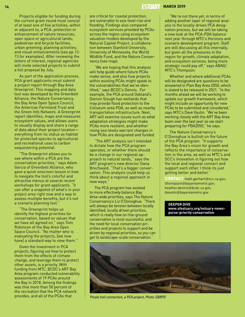
Pinole trail connection, a PCA project. Photo: EBRPD
MARCH 2019ESTUARY

15
ARIEL RUBISSOW OKAMOTO, REPORTER
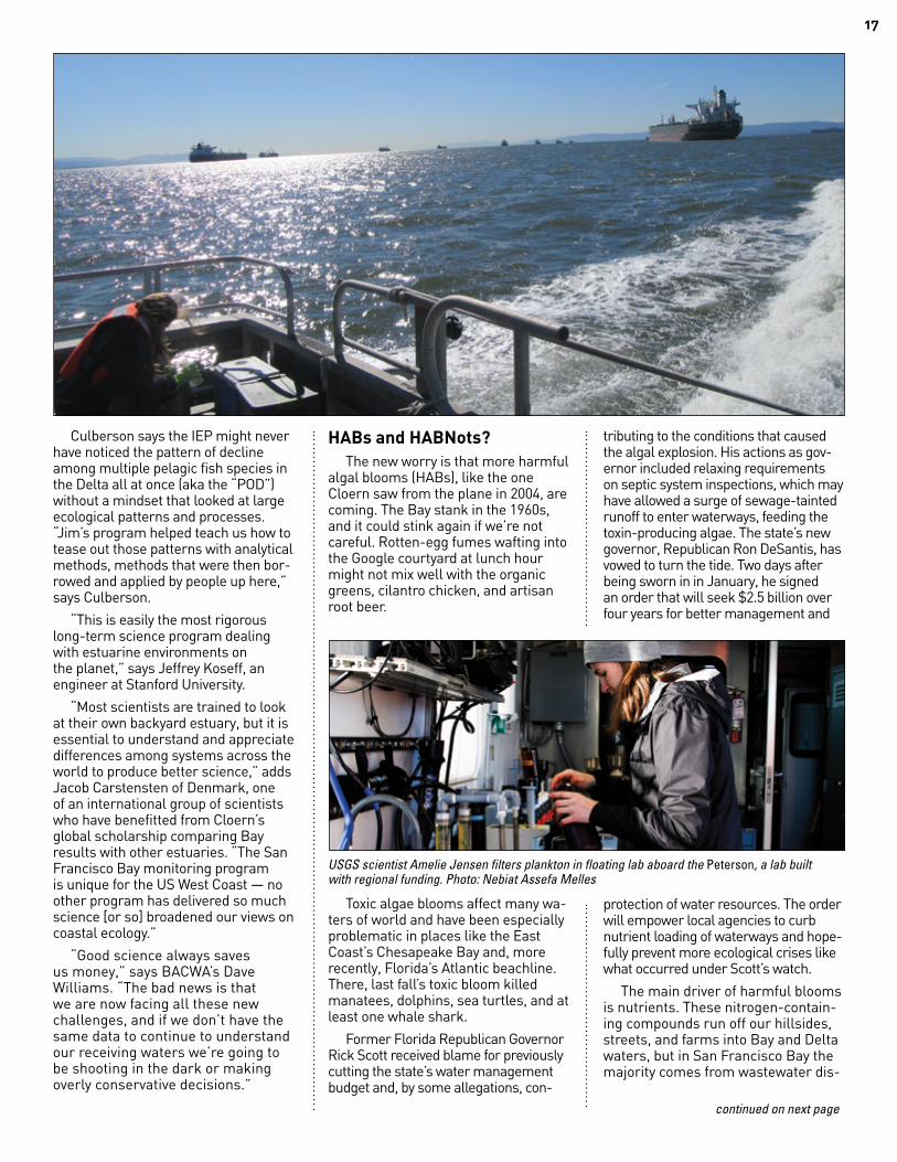
Jim Cloern looked out of the airplane window and saw red streaks in the water; crimson patches darkening the grey-green shallows that are San Francisco’s South Bay. A superscientist for USGS, he knew something big was happening.
As soon as the plane landed he called his crew. “You will not believe the explosion we’re seeing on the surface,” he heard back from his crew leader, Tara Schraga. A quality-control freak who sticks to the gold letter that is attached to everything labeled “USGS science,” Schraga had spent the morning on their research vessel lowering sensors down into the shallows and then pulling them out again to log the levels of salt, nutrients, sediment, and phytoplankton between the surface and the bottom oozes. It turns out that the tiny drifting plankton visible from Cloern’s window on that day in 2004 were blooming on the Bay’s surface in record amounts. The color indicated a red tide, a harmful algal bloom, like those that closed Florida’s white beaches and made Miamians cough during the 2018 elections.
I asked Cloern, a humble guy with a big brain who just retired after 43 years as a scientist specializing in the San Francisco Bay, if he ever gets tired of plankton? “That would be like asking John Muir if he ever got tired of trees,” he says.
Spring 2019 finds USGS — the non-partisan, top-of-the-line federal science service paid for by our tax dollars — in the midst of a restructuring that includes not hiring someone new to fill Cloern’s supersize shoes. Word is the agency is thinking of shifting its water division into National Weather Service-style monitoring mode, and cutting coastal research programs like Cloern’s that make up less than five percent of the national budget.
The thing is, it’s a really bad time for the San Francisco Bay research community to be in limbo, not knowing if it will be able to replace this brainpower or sustain USGS’s 50-year-old, boat-based water-quality sampling program. As conditions change, more red tides may be on the way: bad news for shoreline communities, Bay health, the local
economy, and wastewater treatment plants that might be forced to make significant and costly upgrades to prevent them.
“Regulators have some big decisions pending, such as are we going to mandate that 37 sewage plants invest in expensive upgrades to treat and remove nutrients before they enter the Bay?” says Cloern.“Without ongoing science, those decisions could be costly, ineffective, inefficient, or just plain wrong.”
According to Cloern’s longtime USGS colleague Jan Thompson, an expert in the clams down in the mud that eat plankton, the system most likely “to catch us with our mouth open” by changing dramatically lies south of the San Mateo Bridge. “We still don’t know exactly why the South Bay isn’t pea soup eutrophic today. If it’s something good we should market it and sell it, but it could be something bad like a contaminant holding blooms in check,” says Thompson, who is
now in phased retirement. Putting all the pieces together — conditions plus climate plus clams plus contaminants, among other estuarine complexities — is the kind of thing this program has always done best.
“Having the research capacity to receive early indications of change before it happens is priceless,” says Tom Mumley, the assistant executive officer of the San Francisco Bay Regional Water Quality Control Board, who has relied on USGS science to make sound regulatory decisions for decades. “Absent that think tank, I’m concerned.”
Decisions at the national levels of the USGS water division suggest
the program and its lead scientist position could sunset as early as August 2019 or not at all; the uncertainty is crippling. USGS’s local and state partners in science are now scrambling to see if they can pick up the slack. The slack isn’t a surprise, since funding for federal science has flatlined for decades. USGS’s national budget for research has declined in real dollars from around $700 million in 1996 to $650 million in 2017. Cloern’s
coastal research and Bay monitoring program is down to a mere $760,000 per year in cost today. It’s all scraps compared to a $5 billion border fence or a $13 billion space force. Yet this
S C I E N C E
Feds Coastal Research Crew Bucks Headwinds
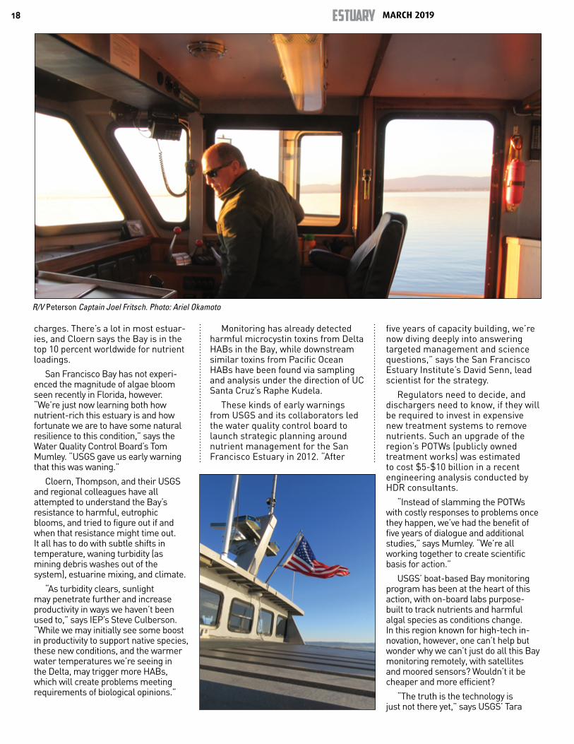
USGS research vessel R/V Peterson. Photo: Joel Fritsch
continued on next page
Superscientist Jim Cloern, who retired this February after 43 years of studying San Francisco Bay.

MARCH 2019ESTUARY16
USGS science serves Americans every day — tracking storms, measuring snowpack, steering airplanes, saving salmon, monitoring water quality, modeling the cascade of effects that occur with climate change, namely interpreting our changing world — as the USGS slogan goes.
“If resource agencies cannot rely on long-term funding, they cannot implement long-term monitoring programs, which means we cannot track long-term trends. And if we cannot track trends we won’t know if our ecosystems are changing — and that seems to be the intent of the federal bureaucracy these days,” says Ian Wren, a staff scientist with the nonprofit San Francisco Baykeeper. “The administration has pushed for cuts to USGS, NOAA and EPA in an attempt to shield themselves from unfavorable science outcomes. In the Bay Area, we’ve always welcomed scientific insight into our planning and business conversations, and been willing to pay for it.”
It’s important to remember how much this legacy of water-quality monitoring has paid off economically and for the health of the Bay Area and the nation. What ends up in the Bay comes from a vast watershed and an equally vast Pacific Ocean, not just one small region. “USGS is gathering data coming from more than 40 percent of the land mass of California through a major river system and estuary, with essentially a statewide effect, not to mention a nationwide effect on the agricultural economy. That’s why the Bay Area shouldn’t be paying for it all,” says Dave Williams, executive director of the Bay Area Clean Water Agencies, an association
of publicly-owned wastewater treatment plants that serve more than seven million residents of the Bay Area.
But the Bay Area has already started paying. When earlier shortfalls threatened the USGS program, the Regional Moni-toring Program and those managing the water board’s Nutri-ent Management Strategy stepped up. Together, they man-aged to bankroll the
conversion of a gunmetal-grey former cop boat into a floating science lab called the R/V Peterson when the aging converted pleasure yacht Polaris, which had hosted Bay sampling cruises for decades, had to be replaced. They also funded essential crew positions.
“We had to,” says San Francisco Estuary Institute senior scientist David Senn. “The community has relied on this information for a long time.”
Three-Legged ChairDespite the steady chipping away at
this San Francisco Bay USGS coastal research and monitoring program over the years, the program remains a solid fourth leg of dozens of chairs at the head table. The fifty years of Bay monitoring data and observations, interpreted by Cloern and his team for decision-makers and regulators, have become an integral part of the regional science enterprise. Removing that fourth leg from each of those chairs for less than a million bucks could topple dozens of ongoing programs that underpin management of California’s water supply, economy, endangered species, fires, floods, wastewater treat-ment services, and more.
Take for example the Interagency Ecological Program (IEP) for the Delta, which relies on USGS to cover the lower watershed. “Our authorities here in the Delta may be circumscribed, but as scientists we know we can’t really limit ourselves to one area of a very large watershed,” says Steve Culber-son, lead scientist for the IEP. “It’s all connected.”
Water and nutrient samples from a March 2019 cruise. Photo: Ariel Okamoto
SFEI’s Erika King prepares the Niskin bottle to collect a water sample from near Angel Island. Sensor-loaded CTD at right. Photo: Nebiat Assefa Melles
17
Culberson says the IEP might never have noticed the pattern of decline among multiple pelagic fish species in the Delta all at once (aka the “POD”) without a mindset that looked at large ecological patterns and processes. “Jim’s program helped teach us how to tease out those patterns with analytical methods, methods that were then bor-rowed and applied by people up here,” says Culberson.
“This is easily the most rigorous long-term science program dealing with estuarine environments on the planet,” says Jeffrey Koseff, an engineer at Stanford University.
“Most scientists are trained to look at their own backyard estuary, but it is essential to understand and appreciate differences among systems across the world to produce better science,” adds Jacob Carstensten of Denmark, one of an international group of scientists who have benefitted from Cloern’s global scholarship comparing Bay results with other estuaries. “The San Francisco Bay monitoring program is unique for the US West Coast — no other program has delivered so much science [or so] broadened our views on coastal ecology.”
“Good science always saves us money,” says BACWA’s Dave Williams. “The bad news is that we are now facing all these new challenges, and if we don’t have the same data to continue to understand our receiving waters we’re going to be shooting in the dark or making overly conservative decisions.”
HABs and HABNots? The new worry is that more harmful
algal blooms (HABs), like the one Cloern saw from the plane in 2004, are coming. The Bay stank in the 1960s, and it could stink again if we’re not careful. Rotten-egg fumes wafting into the Google courtyard at lunch hour might not mix well with the organic greens, cilantro chicken, and artisan root beer.
Toxic algae blooms affect many wa-ters of world and have been especially problematic in places like the East Coast’s Chesapeake Bay and, more recently, Florida’s Atlantic beachline. There, last fall’s toxic bloom killed manatees, dolphins, sea turtles, and at least one whale shark.
Former Florida Republican Governor Rick Scott received blame for previously cutting the state’s water management budget and, by some allegations, con-
tributing to the conditions that caused the algal explosion. His actions as gov-ernor included relaxing requirements on septic system inspections, which may have allowed a surge of sewage-tainted runoff to enter waterways, feeding the toxin-producing algae. The state’s new governor, Republican Ron DeSantis, has vowed to turn the tide. Two days after being sworn in in January, he signed an order that will seek $2.5 billion over four years for better management and
protection of water resources. The order will empower local agencies to curb nutrient loading of waterways and hope-fully prevent more ecological crises like what occurred under Scott’s watch.
The main driver of harmful blooms is nutrients. These nitrogen-contain-ing compounds run off our hillsides, streets, and farms into Bay and Delta waters, but in San Francisco Bay the majority comes from wastewater dis-
continued on next page
USGS scientist Amelie Jensen filters plankton in floating lab aboard the Peterson, a lab built with regional funding. Photo: Nebiat Assefa Melles
MARCH 2019ESTUARY18
charges. There’s a lot in most estuar-ies, and Cloern says the Bay is in the top 10 percent worldwide for nutrient loadings.
San Francisco Bay has not experi-enced the magnitude of algae bloom seen recently in Florida, however. “We’re just now learning both how nutrient-rich this estuary is and how fortunate we are to have some natural resilience to this condition,” says the Water Quality Control Board’s Tom Mumley. “USGS gave us early warning that this was waning.”
Cloern, Thompson, and their USGS and regional colleagues have all attempted to understand the Bay’s resistance to harmful, eutrophic blooms, and tried to figure out if and when that resistance might time out. It all has to do with subtle shifts in temperature, waning turbidity (as mining debris washes out of the system), estuarine mixing, and climate.
“As turbidity clears, sunlight may penetrate further and increase productivity in ways we haven’t been used to,” says IEP’s Steve Culberson. “While we may initially see some boost in productivity to support native species, these new conditions, and the warmer water temperatures we’re seeing in the Delta, may trigger more HABs, which will create problems meeting requirements of biological opinions.”
Monitoring has already detected harmful microcystin toxins from Delta HABs in the Bay, while downstream similar toxins from Pacific Ocean HABs have been found via sampling and analysis under the direction of UC Santa Cruz’s Raphe Kudela.
These kinds of early warnings from USGS and its collaborators led the water quality control board to launch strategic planning around nutrient management for the San Francisco Estuary in 2012. “After
five years of capacity building, we’re now diving deeply into answering targeted management and science questions,” says the San Francisco Estuary Institute’s David Senn, lead scientist for the strategy.
Regulators need to decide, and dischargers need to know, if they will be required to invest in expensive new treatment systems to remove nutrients. Such an upgrade of the region’s POTWs (publicly owned treatment works) was estimated to cost $5-$10 billion in a recent engineering analysis conducted by HDR consultants.
“Instead of slamming the POTWs with costly responses to problems once they happen, we’ve had the benefit of five years of dialogue and additional studies,” says Mumley. “We’re all working together to create scientific basis for action.”
USGS’ boat-based Bay monitoring program has been at the heart of this action, with on-board labs purpose-built to track nutrients and harmful algal species as conditions change. In this region known for high-tech in-novation, however, one can’t help but wonder why we can’t just do all this Bay monitoring remotely, with satellites and moored sensors? Wouldn’t it be cheaper and more efficient?
“The truth is the technology is just not there yet,” says USGS’ Tara
R/V Peterson Captain Joel Fritsch. Photo: Ariel Okamoto
19
Schraga, whose crew regularly test-runs the latest sensors on the Petersen against the quality of the data coming out of the Bay. “It’s tough to use satellites to see San Francisco Bay year-round because of the fog and the turbidity — you can’t see the telltale pigments in the plankton that help us identify the size and species,” she says.
One boat and a crew covering a big estuary once a month can also cost a lot less than installing stationary sensors where there are no pilings, adding them to buoys, or fixing them onto bridge stanchions. Once installed, these stationary sensors invite all manner of Bay life to colonize them. “Left unattended, things grow on the instrument housings and sensors themselves, and fine particles clog various parts needed to take measurements,” says Senn. A number of stationary sensors are already deployed around the Bay (see online story).
The best future program, all seem to agree, is some combination of stationary sensors, a boat and crew, and a lead scientist or two with the chops to turn concentration levels into management information.
“Without someone interpreting the data it’s not useful,” says Schraga, a part-timer and Cloern’s only remain-ing permanent staff.
Shooting in the DarkSo just imagine taking a jog with
your dog on that new stretch of Bay Trail you like — the one with the pretty purple flowers dancing in the breeze and the steps leading down to the beach. It’s high tide. Your dog chases a ball in and out of the water, upchucks in the back seat of your car on the way home, and dies that night for no apparent reason. Sound alarmist?
Bay Area residents have come to expect a beautiful bayshore and safe, non-sticky, non-stinky water for their pets and children to play in. That cleanliness is a point of pride, another couple of zeroes on your property value. The science and long-term monitoring that contributed to it is an international, not local resource.
Indeed Bay conditions from year-to-year, as posted and made available to all via the USGS Bay monitoring web site, serve a much broader audience than just local residents. In 2019, the web site with its downloadable data was getting more than 2,000 visits a day, with users from 90 different countries, ranging from Andorra to Zimbabwe at last look. Could this invaluable online resource get lost in future shutdowns or be parked on some obscure federal server due to budget cuts?
Looking ahead, there’s little doubt the USGS coastal research program could help us confront new challenges to our quality of life, including major changes to the Bay’s tidal prism from sea-level rise — which is slated for 3 to 5 feet over current levels by 2100.
“Change in overall depth is going to be a big one, given that it is a major parameter in phytoplankton growth,” says Thompson. The advancing ocean will also submerge Bay mudflats and lessen turbidity, another limit on bloom rates. More and bigger sea walls, built to protect major shoreline infrastructure, will exacerbate circulation problems, she says. “The Bay will be more like a big bath tub, not a good result if you’re worried about HABs.”
Worry about losing the Bay’s USGS coastal research and monitoring program, meanwhile, seems ubiquitous. As Tom Mumley says: “Having this research program has helped us adapt, helped us create a healthy bay and healthy economy. What could be a better use of public resources?”
CONTACT [email protected]; [email protected]
DEEPER DIVE
(with on-the-boat video)
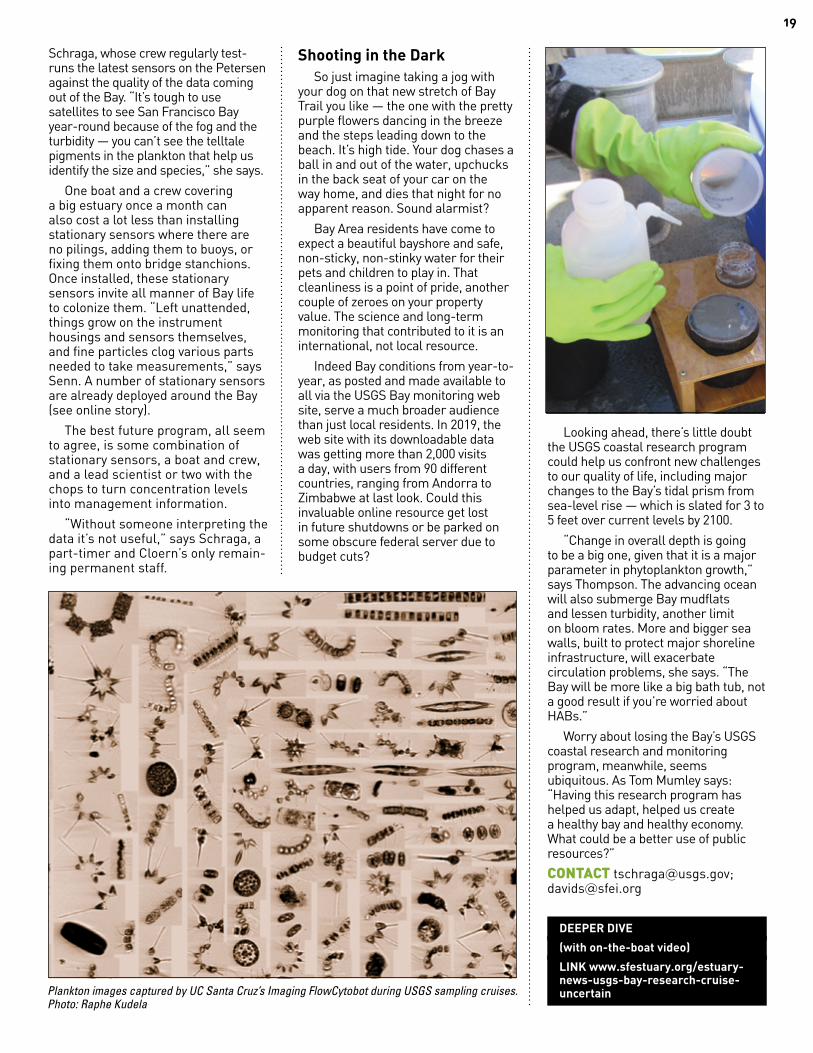
LINK www.sfestuary.org/estuary-news-usgs-bay-research-cruise-uncertainPlankton images captured by UC Santa Cruz’s Imaging FlowCytobot during USGS sampling cruises.
Photo: Raphe Kudela

MARCH 2019ESTUARY20
JACOBA CHARLES, REPORTER
From the crest of Bullet Hill in China Camp State Park, an historic remnant of marsh is stunningly on view. An ancient, sinuous water channel winds through the pickleweed, straightening as it nears the open water. A flock of egrets rises, then settles again nearby to hunt and feed. This is one of the most-studied wetlands in the San Francisco Bay Area; as part of the San Francisco Bay National Estuarine Research Reserve (NERR), the site has more than a decade’s worth of annual vegetation sampling and water-quality data available.
Not all wetlands are so comprehensively studied, but the new Wetland Regional Monitoring Program (WRMP), funded through an EPA Region 9 Wetlands Program Development Grant and managed by the San Francisco Estuary Partnership, aims to change that. The goal of the program, which is currently in the development phase, is to revolutionize the way that data is collected and shared about one of the Bay Area’s most fragile ecosystem types.
“Every project can learn from other projects — so work won’t be done in a silo,” says Aimee Good, Wetland Science Coordinator of NERR. “We need to regionalize the way we gather data.”
Right now the Bay Area is home to an astounding 30,000 acres of wetland restoration projects, of all
sizes, ages, and methods, says Mike Vasey, director of the reserve. A ream of monitoring data is gathered for each project site, but there has until now been no coordinated system for organizing how it is collected or accessed.
“For years, we have been basing our monitoring on what is needed for permitting—the reports go in to the [regulatory] agencies, but they rarely come out,” Vasey noted. As a result, this cumulative wealth of information remains essentially untouched.
“Monitoring data sits on shelves when there is an incredible opportunity
to use it to inform critical management questions for the region,” say Heidi Nutters of the Estuary Partnership, manager of the new program.
Another impetus for the program is the large number of new wetland projects now coming online due to Measure AA regional parcel-tax funding under the San Francisco Bay Restoration Authority. “We need to increase
monitoring efficiency and consistency and reduce costs for wetland managers,” says Nutters.
For example, one of the research projects conducted at China Camp requires extremely accurate measurements of sedimentation accrual—the vital process that allows wetlands to keep up with sea-level rise rather than “drowning,” or converting to open water. These measurements are based off a precisely calibrated fixed point called a benchmark—one that requires periodic and expensive recalibration.
“We want precision,” Vasey says. “We want to get down to millimeters, not centimeters. We hope that under [the new program], this would be one of several sentinel sites funded around the Bay—and that we wouldn’t have to
shoulder the whole cost of maintaining the network on our own.”
Such a network would also help detect regional patterns in wetland conditions in light of climate change and sea-level rise. Ideally, by monitoring on a regional rather than a project- or site-based scale, scientists will better understand how our wetlands function, perform, and adapt within the estuary as a whole.
“We are trying to understand patterns in advance,” Nutters says. “Where do tidal wetlands have space to migrate upward as sea-level rises? Where are vegetation communities downshifting, drowning, or progressing? What are the indicators that drowning is about to happen?”
The program follows in the footsteps of an already successful collaboration of dischargers, regulators, and scientists that monitors Bay water quality (RMP). Efforts to establish a regional wetland monitoring program go back at least to the early 1990s. “The logic has never been disputed but it never reached critical mass,” Vasey says.
The new program has moved forward not only because of growing public investment in marsh restoration but also because of the vulnerability of these habitats and buffers to sea-level rise. There’s a need to establish a “control” system to evaluate long-term drivers of marsh loss such as reduced sediment supply or land subsidence in the tectonically active Bay region.
“We are developing collaborative leading management questions that we can then answer with monitoring data — and that has never happened before for our wetlands,” says Nutters. Questions are being hashed out in an ongoing series of stakeholder workshops, attended by up to 80 people.
A plan for a small-scale pilot program will be in place by the end of the year, says Nutters. If that goes well, it will be expanded in future years.
“We’re not being naïve, that it’s just going to move forward like someone sprinkled fairy dust on it,” Vasey says. “If—no, when—we pull this off it’s going to be one of the first wetlands monitoring programs that is coordinated on a regional scale.”
CONTACT [email protected]; [email protected]
W E T L A N D S
Attention to Outcomes
Alex Wick, former SF Bay NERR technician working with USGS staff to install a Surface Elevation Table, a portable mechanical leveling device for measuring the relative elevation change of wetland sediments. Photo: Mike Vasey
21
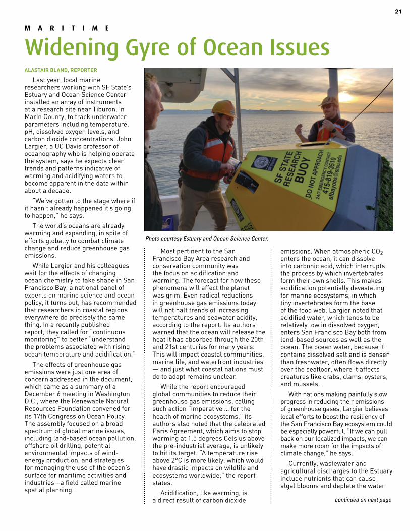
ALASTAIR BLAND, REPORTER
Last year, local marine researchers working with SF State’s Estuary and Ocean Science Center installed an array of instruments at a research site near Tiburon, in Marin County, to track underwater parameters including temperature, pH, dissolved oxygen levels, and carbon dioxide concentrations. John Largier, a UC Davis professor of oceanography who is helping operate the system, says he expects clear trends and patterns indicative of warming and acidifying waters to become apparent in the data within about a decade.
“We’ve gotten to the stage where if it hasn’t already happened it’s going to happen,” he says.
The world’s oceans are already warming and expanding, in spite of efforts globally to combat climate change and reduce greenhouse gas emissions.
While Largier and his colleagues wait for the effects of changing ocean chemistry to take shape in San Francisco Bay, a national panel of experts on marine science and ocean policy, it turns out, has recommended that researchers in coastal regions everywhere do precisely the same thing. In a recently published report, they called for “continuous monitoring” to better “understand the problems associated with rising ocean temperature and acidification.”
The effects of greenhouse gas emissions were just one area of concern addressed in the document, which came as a summary of a December 6 meeting in Washington D.C., where the Renewable Natural Resources Foundation convened for its 17th Congress on Ocean Policy. The assembly focused on a broad spectrum of global marine issues, including land-based ocean pollution, offshore oil drilling, potential environmental impacts of wind-energy production, and strategies for managing the use of the ocean’s surface for maritime activities and industries—a field called marine spatial planning.
Most pertinent to the San Francisco Bay Area research and conservation community was the focus on acidification and warming. The forecast for how these phenomena will affect the planet was grim. Even radical reductions in greenhouse gas emissions today will not halt trends of increasing temperatures and seawater acidity, according to the report. Its authors warned that the ocean will release the heat it has absorbed through the 20th and 21st centuries for many years. This will impact coastal communities, marine life, and waterfront industries — and just what coastal nations must do to adapt remains unclear.
While the report encouraged global communities to reduce their greenhouse gas emissions, calling such action “imperative … for the health of marine ecosystems,” its authors also noted that the celebrated Paris Agreement, which aims to stop warming at 1.5 degrees Celsius above the pre-industrial average, is unlikely to hit its target. “A temperature rise above 2°C is more likely, which would have drastic impacts on wildlife and ecosystems worldwide,” the report states.
Acidification, like warming, is a direct result of carbon dioxide
emissions. When atmospheric CO2 enters the ocean, it can dissolve into carbonic acid, which interrupts the process by which invertebrates form their own shells. This makes acidification potentially devastating for marine ecosystems, in which tiny invertebrates form the base of the food web. Largier noted that acidified water, which tends to be relatively low in dissolved oxygen, enters San Francisco Bay both from land-based sources as well as the ocean. The ocean water, because it contains dissolved salt and is denser than freshwater, often flows directly over the seafloor, where it affects creatures like crabs, clams, oysters, and mussels.
With nations making painfully slow progress in reducing their emissions of greenhouse gases, Largier believes local efforts to boost the resiliency of the San Francisco Bay ecosystem could be especially powerful. “If we can pull back on our localized impacts, we can make more room for the impacts of climate change,” he says.
Currently, wastewater and agricultural discharges to the Estuary include nutrients that can cause algal blooms and deplete the water
M A R I T I M E
Widening Gyre of Ocean Issues
Photo courtesy Estuary and Ocean Science Center.
continued on next page
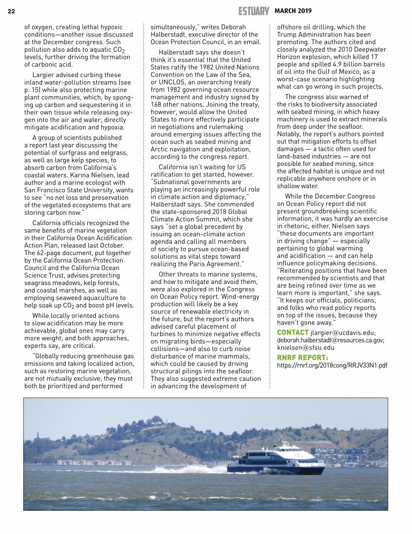
MARCH 2019ESTUARY22
of oxygen, creating lethal hypoxic conditions—another issue discussed at the December congress. Such pollution also adds to aquatic CO2 levels, further driving the formation of carbonic acid.
Largier advised curbing these inland water-pollution streams (see p. 15) while also protecting marine plant communities, which, by spong-ing up carbon and sequestering it in their own tissue while releasing oxy-gen into the air and water, directly mitigate acidification and hypoxia.
A group of scientists published a report last year discussing the potential of surfgrass and eelgrass, as well as large kelp species, to absorb carbon from California’s coastal waters. Karina Nielsen, lead author and a marine ecologist with San Francisco State University, wants to see “no net loss and preservation of the vegetated ecosystems that are storing carbon now.”
California officials recognized the same benefits of marine vegetation in their California Ocean Acidification Action Plan, released last October. The 62-page document, put together by the California Ocean Protection Council and the California Ocean Science Trust, advises protecting seagrass meadows, kelp forests, and coastal marshes, as well as employing seaweed aquaculture to help soak up CO2 and boost pH levels.
While locally oriented actions to slow acidification may be more achievable, global ones may carry more weight, and both approaches, experts say, are critical.
“Globally reducing greenhouse gas emissions and taking localized action, such as restoring marine vegetation, are not mutually exclusive; they must both be prioritized and performed
simultaneously,” writes Deborah Halberstadt, executive director of the Ocean Protection Council, in an email.
Halberstadt says she doesn’t think it’s essential that the United States ratify the 1982 United Nations Convention on the Law of the Sea, or UNCLOS, an overarching treaty from 1982 governing ocean resource management and industry signed by 168 other nations. Joining the treaty, however, would allow the United States to more effectively participate in negotiations and rulemaking around emerging issues affecting the ocean such as seabed mining and Arctic navigation and exploitation, according to the congress report.
California isn’t waiting for US ratification to get started, however. “Subnational governments are playing an increasingly powerful role in climate action and diplomacy,” Halberstadt says. She commended the state-sponsored 2018 Global Climate Action Summit, which she says “set a global precedent by issuing an ocean-climate action agenda and calling all members of society to pursue ocean-based solutions as vital steps toward realizing the Paris Agreement.”
Other threats to marine systems, and how to mitigate and avoid them, were also explored in the Congress on Ocean Policy report. Wind-energy production will likely be a key source of renewable electricity in the future, but the report’s authors advised careful placement of turbines to minimize negative effects on migrating birds—especially collisions—and also to curb noise disturbance of marine mammals, which could be caused by driving structural pilings into the seafloor. They also suggested extreme caution in advancing the development of
offshore oil drilling, which the Trump Administration has been promoting. The authors cited and closely analyzed the 2010 Deepwater Horizon explosion, which killed 17 people and spilled 4.9 billion barrels of oil into the Gulf of Mexico, as a worst-case scenario highlighting what can go wrong in such projects.
The congress also warned of the risks to biodiversity associated with seabed mining, in which heavy machinery is used to extract minerals from deep under the seafloor. Notably, the report’s authors pointed out that mitigation efforts to offset damages — a tactic often used for land-based industries — are not possible for seabed mining, since the affected habitat is unique and not replicable anywhere onshore or in shallow water.
While the December Congress on Ocean Policy report did not present groundbreaking scientific information, it was hardly an exercise in rhetoric, either. Nielsen says “these documents are important in driving change” — especially pertaining to global warming and acidification — and can help influence policymaking decisions. “Reiterating positions that have been recommended by scientists and that are being refined over time as we learn more is important,” she says. “It keeps our officials, politicians, and folks who read policy reports on top of the issues, because they haven’t gone away.”
CONTACT [email protected]; [email protected]; [email protected]
RNRF REPORT: https://rnrf.org/2018cong/RRJV33N1.pdf
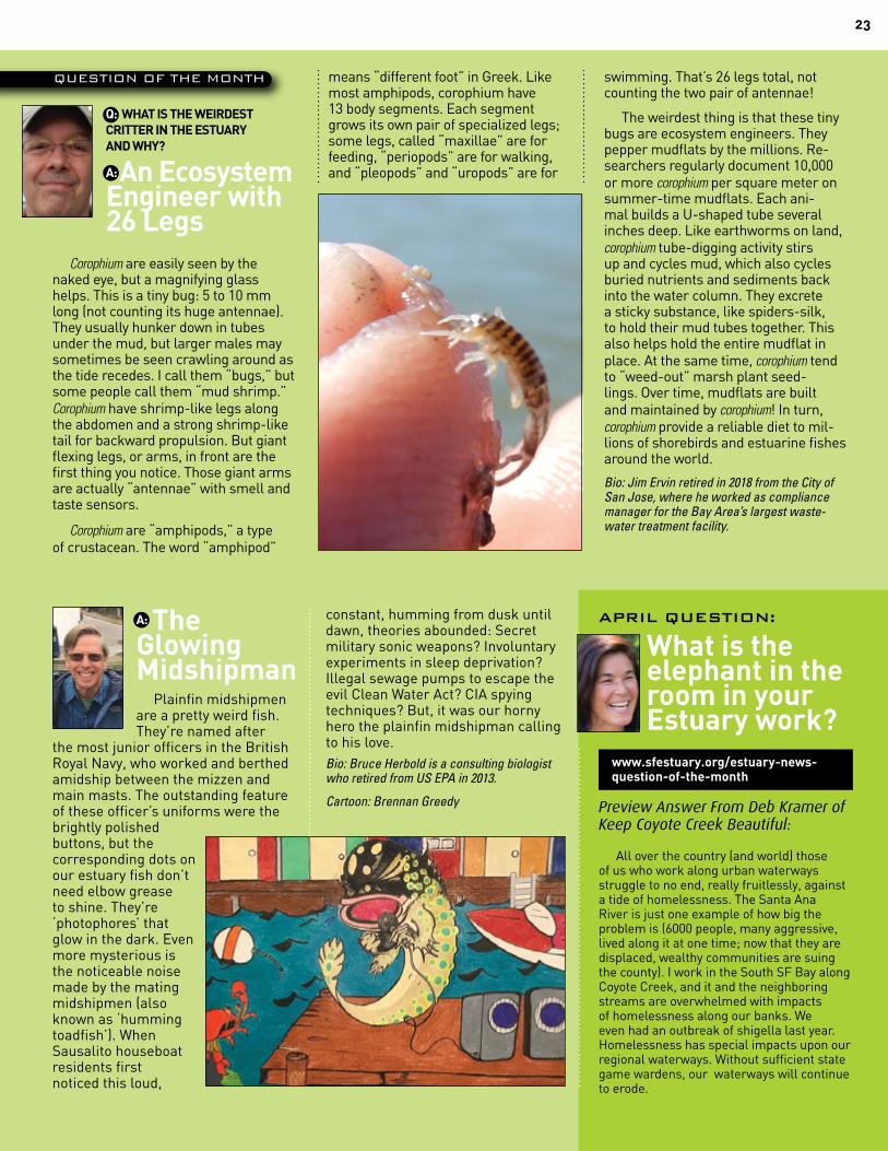
23
Q: WHAT IS THE WEIRDEST CRITTER IN THE ESTUARY AND WHY?
A: An Ecosystem Engineer with 26 Legs
Corophium are easily seen by the naked eye, but a magnifying glass helps. This is a tiny bug: 5 to 10 mm long (not counting its huge antennae). They usually hunker down in tubes under the mud, but larger males may sometimes be seen crawling around as the tide recedes. I call them “bugs,” but some people call them “mud shrimp.” Corophium have shrimp-like legs along the abdomen and a strong shrimp-like tail for backward propulsion. But giant flexing legs, or arms, in front are the first thing you notice. Those giant arms are actually “antennae” with smell and taste sensors.
Corophium are “amphipods,” a type of crustacean. The word “amphipod”
means “different foot” in Greek. Like most amphipods, corophium have 13 body segments. Each segment grows its own pair of specialized legs; some legs, called “maxillae” are for feeding, “periopods” are for walking, and “pleopods” and “uropods” are for
swimming. That’s 26 legs total, not counting the two pair of antennae!
The weirdest thing is that these tiny bugs are ecosystem engineers. They pepper mudflats by the millions. Re-searchers regularly document 10,000 or more corophium per square meter on summer-time mudflats. Each ani-mal builds a U-shaped tube several inches deep. Like earthworms on land, corophium tube-digging activity stirs up and cycles mud, which also cycles buried nutrients and sediments back into the water column. They excrete a sticky substance, like spiders-silk, to hold their mud tubes together. This also helps hold the entire mudflat in place. At the same time, corophium tend to “weed-out” marsh plant seed-lings. Over time, mudflats are built and maintained by corophium! In turn, corophium provide a reliable diet to mil-lions of shorebirds and estuarine fishes around the world.
Bio: Jim Ervin retired in 2018 from the City of San Jose, where he worked as compliance manager for the Bay Area’s largest waste-water treatment facility.
QUESTION OF THE MONTH
APRIL QUESTION:
What is the elephant in the room in your Estuary work?
www.sfestuary.org/estuary-news-question-of-the-month
Preview Answer From Deb Kramer of Keep Coyote Creek Beautiful:
All over the country (and world) those of us who work along urban waterways struggle to no end, really fruitlessly, against a tide of homelessness. The Santa Ana River is just one example of how big the problem is (6000 people, many aggressive, lived along it at one time; now that they are displaced, wealthy communities are suing the county). I work in the South SF Bay along Coyote Creek, and it and the neighboring streams are overwhelmed with impacts of homelessness along our banks. We even had an outbreak of shigella last year. Homelessness has special impacts upon our regional waterways. Without sufficient state game wardens, our waterways will continue to erode.
constant, humming from dusk until dawn, theories abounded: Secret military sonic weapons? Involuntary experiments in sleep deprivation? Illegal sewage pumps to escape the evil Clean Water Act? CIA spying techniques? But, it was our horny hero the plainfin midshipman calling to his love. Bio: Bruce Herbold is a consulting biologist who retired from US EPA in 2013.
Cartoon: Brennan Greedy
A: The Glowing Midshipman
Plainfin midshipmen are a pretty weird fish. They’re named after
the most junior officers in the British Royal Navy, who worked and berthed amidship between the mizzen and main masts. The outstanding feature of these officer’s uniforms were the brightly polished buttons, but the corresponding dots on our estuary fish don’t need elbow grease to shine. They’re ‘photophores’ that glow in the dark. Even more mysterious is the noticeable noise made by the mating midshipmen (also known as ‘humming toadfish’). When Sausalito houseboat residents first noticed this loud,
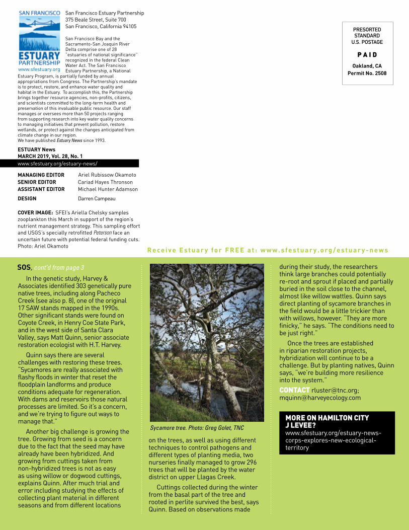
In the genetic study, Harvey & Associates identified 303 genetically pure native trees, including along Pacheco Creek (see also p. 8), one of the original 17 SAW stands mapped in the 1990s. Other significant stands were found on Coyote Creek, in Henry Coe State Park, and in the west side of Santa Clara Valley, says Matt Quinn, senior associate restoration ecologist with H.T. Harvey.
Quinn says there are several challenges with restoring these trees. “Sycamores are really associated with flashy floods in winter that reset the floodplain landforms and produce conditions adequate for regeneration. With dams and reservoirs those natural processes are limited. So it’s a concern, and we’re trying to figure out ways to manage that.”
Another big challenge is growing the tree. Growing from seed is a concern due to the fact that the seed may have already have been hybridized. And growing from cuttings taken from non-hybridized trees is not as easy as using willow or dogwood cuttings, explains Quinn. After much trial and error including studying the effects of collecting plant material in different seasons and from different locations
on the trees, as well as using different techniques to control pathogens and different types of planting media, two nurseries finally managed to grow 296 trees that will be planted by the water district on upper Llagas Creek.
Cuttings collected during the winter from the basal part of the tree and rooted in perlite survived the best, says Quinn. Based on observations made
during their study, the researchers think large branches could potentially re-root and sprout if placed and partially buried in the soil close to the channel, almost like willow wattles. Quinn says direct planting of sycamore branches in the field would be a little trickier than with willows, however. “They are more finicky,” he says. “The conditions need to be just right.”
Once the trees are established in riparian restoration projects, hybridization will continue to be a challenge. But by planting natives, Quinn says, “we’re building more resilience into the system.”
CONTACT [email protected]; [email protected]
MORE ON HAMILTON CITY J LEVEE? www.sfestuary.org/estuary-news-corps-explores-new-ecological-territory
San Francisco Estuary Partnership 375 Beale Street, Suite 700 San Francisco, California 94105
San Francisco Bay and the Sacramento-San Joaquin River Delta comprise one of 28 “estuaries of national significance” recognized in the federal Clean Water Act. The San Francisco Estuary Partnership, a National
Estuary Program, is partially funded by annual appropriations from Congress. The Partnership’s mandate is to protect, restore, and enhance water quality and habitat in the Estuary. To accomplish this, the Partnership brings together resource agencies, non-profits, citizens, and scientists committed to the long-term health and preservation of this invaluable public resource. Our staff manages or oversees more than 50 projects ranging from supporting research into key water quality concerns to managing initiatives that prevent pollution, restore wetlands, or protect against the changes anticipated from climate change in our region. We have published Estuary News since 1993.
ESTUARY News MARCH 2019, Vol. 28, No. 1 www.sfestuary.org/estuary-news/
MANAGING EDITOR SENIOR EDITOR Cariad Hayes Thronson ASSISTANT EDITOR Michael Hunter Adamson DESIGN Darren Campeau
COVER IMAGE: SFEI’s Ariella Chelsky samples zooplankton this March in support of the region’s nutrient management strategy. This sampling effort and USGS’s specially retrofitted Peterson face an uncertain future with potential federal funding cuts. Photo: Ariel Okamoto
www.sfestuary.org
PRESORTEDSTANDARD
U.S. POSTAGE
P A I D
Oakland, CA Permit No. 2508
R e ce i v e E s t u a r y fo r F R E E a t : w w w . s fe s t u a r y . o rg / e s t u a r y - n e w s
SOS, cont’d from page 3
Ariel Rubissow Okamoto
Sycamore tree. Photo: Greg Golet, TNC


![Alders, Hanny - El Señor De Los Cataros [Novela Historica].pdf](https://img.pdfslide.net/doc/110x75/55cf9da0550346d033ae7554/alders-hanny-el-senor-de-los-cataros-novela-historicapdf.jpg)