Embed Size (px)
Citation preview

Hydrogeology of EthiopiaFrom EarthwiseJump to navigation Jump to search
Africa Groundwater Atlas >> Hydrogeology by country >> Hydrogeology of Ethiopia
This work islicensedunder aCreativeCommonsAttribution-ShareAlike3.0 UnportedLicense
Ethiopia is one of the oldest countries in the world, having existed within similar borders to today forover 2000 years. For most of its long history its governmental system was an independent monarchy,which was overthrown in 1974. The communist military Derg government that followed was itselfoverthrown in 1991, since when a shaky democracy has seen several contested elections. TheAfrican Union is headquartered in Addis Ababa, Ethiopia’s capital.
Ethiopia’s economy grew rapidly between 2005 and 2010. Agriculture is a major contributor toexport income and most of the population is engaged in agriculture. Most agricultural production isby small-scale farmers, but the cash-crop sector accounts for a large proportion of agriculturalexports, with the most important being coffee: Ethiopia is the largest coffee exporter globally. Thecountry also has large mineral resources, with gold a major export commodity, but they have notseen much development to date; nor has the investigation of oil potential.
Groundwater provides more than 90% of the water used for domestic and industrial supply inEthiopia, but a very small proportion of water used for irrigation, which mostly comes from surfacewater. Ethiopia has vast surface water resources in lakes and rivers, which supply most of thecountry’s electricity through hydropower. Further expansion of hydropower capacity is planned,including the ‘Grand Ethiopian Renaissance Dam’, which is intended to become the largesthydroelectric power plant in Africa. However, the country has also suffered recurring devastatingdroughts, with severe impacts including famine, increased poverty and civil unrest.
Contents
1 Authors2 Terms and conditions3 Geographical Setting
3.1 General3.2 Climate

3.3 Surface water3.4 Soil3.5 Land cover3.6 Water statistics
4 Geology5 Hydrogeology
5.1 Unconsolidated5.2 Igneous - Volcanic5.3 Mesozoic Consolidated Sedimentary Aquifers with Fracture and Intergranular Flow5.4 Precambrian Basement5.5 Recharge5.6 Groundwater Quality5.7 Groundwater Status
6 Groundwater use and management6.1 Groundwater use6.2 Groundwater management6.3 Transboundary aquifers
7 Groundwater Projects8 References and further information
8.1 Maps8.2 Geology: key references8.3 Hydrogeology: key references
AuthorsDr Seifu Kebede, Addis Ababa University, Ethiopia
Addis Hailu, University of Gondor, Ethiopia
Emily Crane & Brighid Ó Dochartaigh, British Geological Survey, UK
Dr Imogen Bellwood-Howard, Institute of Development Studies, UK
Please cite this page as: Kebede, Hailu, Crane, Ó Dochartaigh and Bellwood-Howard, 2018.
Bibliographic reference: Kebede, S., Hailu, A., Crane, E., Ó Dochartaigh, B.É and Bellwood-Howard,I. 2018. Africa Groundwater Atlas: Hydrogeology of Ethiopia. British Geological Survey. Accessed[date you accessed the information]. http://earthwise.bgs.ac.uk/index.php/Hydrogeology_of_Ethiopia
Terms and conditionsThe Africa Groundwater Atlas is hosted by the British Geological Survey (BGS) and includesinformation from third party sources. Your use of information provided by this website is at your ownrisk. If reproducing diagrams that include third party information, please cite both the AfricaGroundwater Atlas and the third party sources. Please see the Terms of use for more information.
Geographical Setting
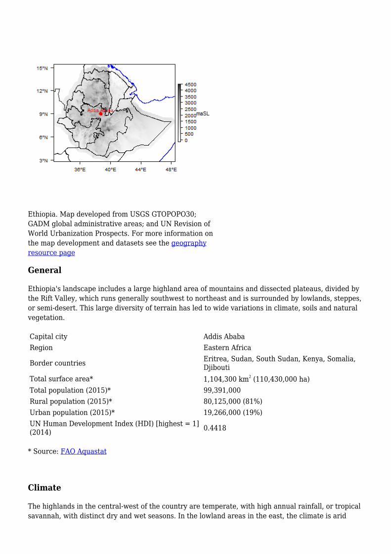
Ethiopia. Map developed from USGS GTOPOPO30;GADM global administrative areas; and UN Revision ofWorld Urbanization Prospects. For more information onthe map development and datasets see the geographyresource page
General
Ethiopia's landscape includes a large highland area of mountains and dissected plateaus, divided bythe Rift Valley, which runs generally southwest to northeast and is surrounded by lowlands, steppes,or semi-desert. This large diversity of terrain has led to wide variations in climate, soils and naturalvegetation.
Capital city Addis AbabaRegion Eastern Africa
Border countries Eritrea, Sudan, South Sudan, Kenya, Somalia,Djibouti
Total surface area* 1,104,300 km2 (110,430,000 ha)Total population (2015)* 99,391,000Rural population (2015)* 80,125,000 (81%)Urban population (2015)* 19,266,000 (19%)UN Human Development Index (HDI) [highest = 1](2014) 0.4418
* Source: FAO Aquastat
Climate
The highlands in the central-west of the country are temperate, with high annual rainfall, or tropicalsavannah, with distinct dry and wet seasons. In the lowland areas in the east, the climate is arid

steppe or arid desert, and is significantly hotter and drier.
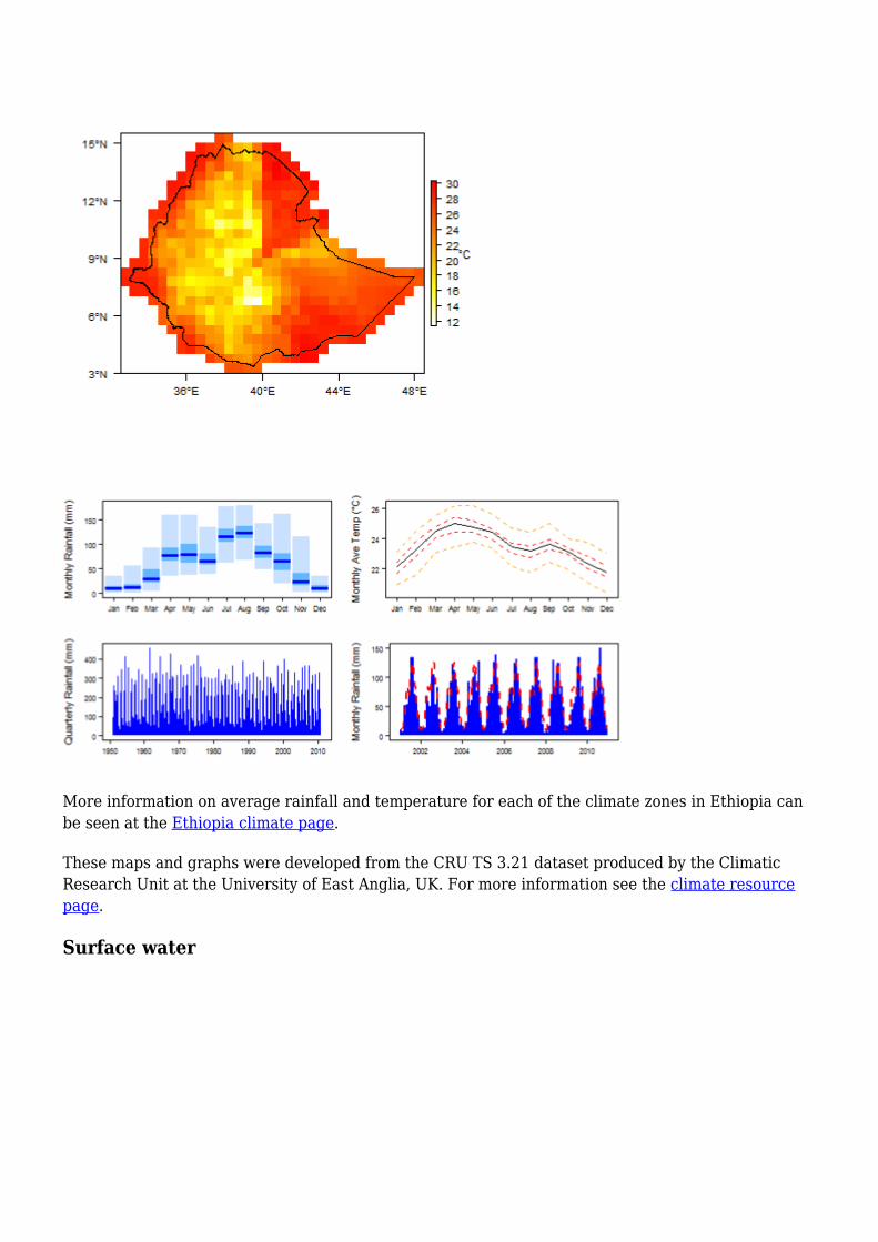
More information on average rainfall and temperature for each of the climate zones in Ethiopia canbe seen at the Ethiopia climate page.
These maps and graphs were developed from the CRU TS 3.21 dataset produced by the ClimaticResearch Unit at the University of East Anglia, UK. For more information see the climate resourcepage.
Surface water

The highlands of Ethiopia arethe source of major perennialrivers, and Ethiopia also has anumber of large lakes. LakeTana, in the north, is thesource of the Blue Nile, andthere are a number of othermajor rivers. However, apartfrom these major surfacewater features, there arehardly any perennial surfacewater flows in areas below1,500 m.The Hydrology Directorate ofthe Ethiopian Ministry ofWater Irrigation and Energy isthe responsible body forinstallation and maintainenceof river gauges. They alsomanage and disseminate theresulting river discharge data.Most hydrological recordsstarted in the 1960s followingthe initiation of the Blue NileBasin Master Plan study bythe USBR (United StatesBureau of Reclamation). Thereare currently 489 operationalriver gauging stations inEthiopia.
Major surface water features of Ethiopia. Map developed fromWorld Wildlife Fund HydroSHEDS; Digital Chart of the Worlddrainage; and FAO Inland Water Bodies. For more information onthe map development and datasets see the surface water resourcepage
Soil
Soil Map of Ethiopia, from the European Commission Joint Research Centre: European Soil Portal.For more information on the map see the soil resource page

Land cover
Ethiopia is an ecologically diverse country, including deserts along the eastern border; tropicalforests in the south; and extensive mountains in the north and southwest.
Land cover map of Ethiopia, from the European Space Agency GlobCover 2.3, 2009. For moreinformation on the map see the land cover resource page
Water statistics
2001 2005 2012 2014 2015 2016Rural population with access to safe drinkingwater (%) 48.6
Urban population with access to safe drinkingwater (%) 93.1
Population affected by water related disease No data Nodata
Nodata No data No data No
dataTotal internal renewable water resources (cubicmetres/inhabitant/year) 1,227
Total exploitable water resources (Million cubicmetres/year) 53,000
Freshwater withdrawal as % of total renewablewater resourcesTotal renewable groundwater (Million cubicmetres/year) 20,000
Exploitable: Regular renewable groundwater(Million cubic metres/year) 2,600
Groundwater produced internally (Million cubicmetres/year) 20,000
Fresh groundwater withdrawal (primary andsecondary) (Million cubic metres/year) No data No
dataNodata No data No data No
dataGroundwater: entering the country (total) (Millioncubic metres/year)

Groundwater: leaving the country to othercountries (total) (Million cubic metres/year) No data No
dataNodata No data No data No
dataIndustrial water withdrawal (all water sources)(Million cubic metres/year) 51.1
Municipal water withdrawal (all water sources)(Million cubic metres/year) 810
Agricultural water withdrawal (all water sources)(Million cubic metres/year) 9,687
Irrigation water withdrawal (all water sources)(Million cubic metres/year) 9,000
Irrigation water requirement (all water sources)(Million cubic metres/year) 1,475
Area of permanent crops (ha) 1,140,000Cultivated land (arable and permanent crops) (ha) 16259Total area of country cultivated (%) 14.72Area equipped for irrigation by groundwater (ha) 2,611Area equipped for irrigation by mixed surfacewater and groundwater (ha) No data No
dataNodata No data No data No
data
Source and more statistics at: FAO Aquastat.
GeologyThe following section provides a summary of the geology of Ethiopia. More detailed information canbe found in the key references listed below: many of these are available through the AfricaGroundwater Literature Archive.
The geology map on this page shows a simplified version of the geology of Ethiopia at a nationalscale (see the geology resource page for more details).
Download a GIS shapefile of the Ethiopia geology and hydrogeology map.
The Geological Survey of Ethiopia is the main source of detailed geological information. The GISPortal for Ethiopian Geology provides online access to view digital geological maps.
More detailed geological maps for selected smaller areas in Ethiopia, developed for a UNICEFEthiopia project can be viewed and downloaded from the GW4E viewer (UNICEF Ethiopia, 2020).

Geology of Ethiopia at 1:5 million scale. Developed from USGS map(Persits et al. 2002). For more information on the map development anddatasets see the geology resource page. Download a GIS shapefile of theEthiopia geology and hydrogeology map.
Geological Environments
Key Formations Period LithologyThickness andimportant structuralfeatures
Igneous - volcanic
Rift volcanics QuaternaryRift related, unwelded and weldedpyroclastics and basalts. Composed ofash, pumice, ignimbrites andpyroclastics.
Thickness reaches500 metres; multiplesets of faults,fractures andvolcanic landforms,isolated volcanoesand cones, calderasand craters

Quaternary plateaubasalts Quaternary
Scoraceous basalts, mostly vesicularand scoraceous. Have a limited lateralextent.
Associated withcentral eruptionsfrom volcaniccentres on theplateau; mainlyassociated withshields.
Shield volcanics Miocene(Tertiary)
Basalts intercalated with minor acidvolcanic rocks (eg rhyolites) andtrachytes. The basal diameters of theshields range from 50 to 100 km. Theyradiate from a peak, and dip at anangle of 5°.
500 metres; broadbased (up to 100km) shields dottingthe Ethiopianplateau
Aiba, Alaji andTermaberformations (UpperBasalts)
Oligo-Miocene(Tertiary)
Basalts with intercalations of rhyolitesand ignimbrites towards the top part.Can be associated with shieldvolcanics. Mostly massive basalt, butcolumnar jointed layers are common.Layers of acidic rocks, rhyolites andtuffs are also common. Paleosol layersmay be visible between the contact ofthis unit with the the underlyingAshangie Formation.
Thickness 1000metres. Typicallyforms flat topped,uniform plateauareas, with cliffs atplateau edges.
Ashangie Formation(Lower Basalts)
Oligocene(Tertiary) Deeply weathered, brecciated basalts 500 metres, forms
rugged terrainSedimentary - Miocene (Tertiary) to Recent
Alwero Formation(largelyconsolidated) andassociatedunconsolidatedsediments
Miocene(Tertiary) toRecent
1. Holocene alluvial sedimentsAlluvial sediments composed ofdiatomites, red beds, fluvial materialsand paleosols. These were probablydeveloped during the Holoceneclimate fluctuations. Up to 400 metresthick.2. Quaternary alluvio-lacustrinesedimentsQuaternary to recent alluvialsediments, lacustrine sediments, riverterraces, volcanoclastics, colluvial andtalus slopes, fluviatile and deltaicsediments, elluvials and soils. Theselocalised deposits are present incentral Ethiopia, southern and northwestern Ethiopia. Up to 500 metresthick.3. Pliocene (Tertiary) AlweroFormationSandstones
1 km?. The Basinforms part of theBlue Nile rift inSouth Sudan andextends toward thewest
Sedimentary - EoceneAuradu and Talehformations -carbonate andevaporite rocks
Eocene(Tertiary)
Interbedded limestone, evaporite(anhydrite, gypsum) and shale
500 metres; karstfeatures observed
Sedimentary - Upper Cretaceous
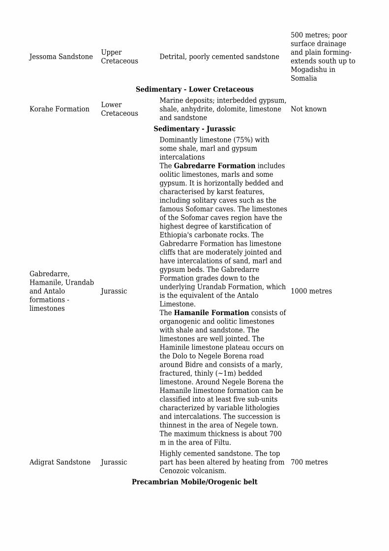
Jessoma Sandstone UpperCretaceous Detrital, poorly cemented sandstone
500 metres; poorsurface drainageand plain forming-extends south up toMogadishu inSomalia
Sedimentary - Lower Cretaceous
Korahe Formation LowerCretaceous
Marine deposits; interbedded gypsum,shale, anhydrite, dolomite, limestoneand sandstone
Not known
Sedimentary - Jurassic
Gabredarre,Hamanile, Urandaband Antaloformations -limestones
Jurassic
Dominantly limestone (75%) withsome shale, marl and gypsumintercalationsThe Gabredarre Formation includesoolitic limestones, marls and somegypsum. It is horizontally bedded andcharacterised by karst features,including solitary caves such as thefamous Sofomar caves. The limestonesof the Sofomar caves region have thehighest degree of karstification ofEthiopia's carbonate rocks. TheGabredarre Formation has limestonecliffs that are moderately jointed andhave intercalations of sand, marl andgypsum beds. The GabredarreFormation grades down to theunderlying Urandab Formation, whichis the equivalent of the AntaloLimestone.The Hamanile Formation consists oforganogenic and oolitic limestoneswith shale and sandstone. Thelimestones are well jointed. TheHaminile limestone plateau occurs onthe Dolo to Negele Borena roadaround Bidre and consists of a marly,fractured, thinly (~1m) beddedlimestone. Around Negele Borena theHamanile limestone formation can beclassified into at least five sub-unitscharacterized by variable lithologiesand intercalations. The succession isthinnest in the area of Negele town.The maximum thickness is about 700m in the area of Filtu.
1000 metres
Adigrat Sandstone JurassicHighly cemented sandstone. The toppart has been altered by heating fromCenozoic volcanism.
700 metres
Precambrian Mobile/Orogenic belt
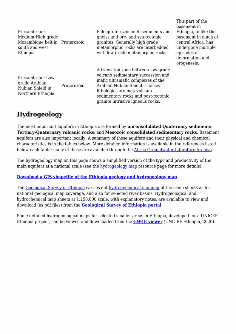
Precambrian:Medium-High gradeMozambique belt insouth and westEthiopia
Proterozoic
Paleoproterozoic metasediments andgneiss and pre- and syn-tectonicgranites. Generally high grademetamorphic rocks are interbeddedwith low grade metamorphic rocks
This part of thebasement inEthiopia, unlike thebasement in much ofcentral Africa, hasundergone multipleepisodes ofdeformation andorogenesis.
Precambrian: Lowgrade ArabianNubian Shield inNorthern Ethiopia
Proterozoic
A transition zone between low gradevolcano sedimentary succession andmafic ultramafic complexes of theArabian Nubian Shield. The keylithologies are metavolcanosedimentary rocks and post-tectonicgranite intrusive igneous rocks.
HydrogeologyThe most important aquifers in Ethiopia are formed by unconsolidated Quaternary sediments;Tertiary-Quaternary volcanic rocks; and Mesozoic consolidated sedimentary rocks. Basementaquifers are also important locally. A summary of these aquifers and their physical and chemicalcharacteristics is in the tables below. More detailed information is available in the references listedbelow each table: many of these are available through the Africa Groundwater Literature Archive.
The hydrogeology map on this page shows a simplified version of the type and productivity of themain aquifers at a national scale (see the hydrogeology map resource page for more details).
Download a GIS shapefile of the Ethiopia geology and hydrogeology map.
The Geological Survey of Ethiopia carries out hydrogeological mapping of the same sheets as fornational geological map coverage, and also for selected river basins. Hydrogeological andhydrochemical map sheets at 1:250,000 scale, with explanatory notes, are available to view anddownload (as pdf files) from the Geological Survey of Ethiopia portal.
Some detailed hydrogeological maps for selected smaller areas in Ethiopia, developed for a UNICEFEthiopia project, can be viewed and downloaded from the GW4E viewer (UNICEF Ethiopia, 2020).

Hydrogeology of Ethiopia at 1:5 million scale. For more information onhow the map was developed see the hydrogeology map resource page.Download a GIS shapefile of the Ethiopia geology and hydrogeology map.
Unconsolidated
Named Aquifers AquiferProductivity General Description Water
quality
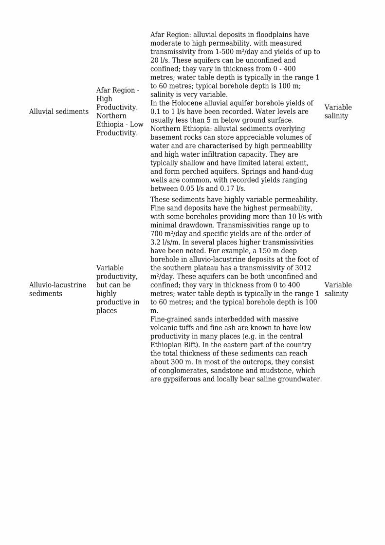
Alluvial sediments
Afar Region -HighProductivity.NorthernEthiopia - LowProductivity.
Afar Region: alluvial deposits in floodplains havemoderate to high permeability, with measuredtransmissivity from 1-500 m²/day and yields of up to20 l/s. These aquifers can be unconfined andconfined; they vary in thickness from 0 - 400metres; water table depth is typically in the range 1to 60 metres; typical borehole depth is 100 m;salinity is very variable.In the Holocene alluvial aquifer borehole yields of0.1 to 1 l/s have been recorded. Water levels areusually less than 5 m below ground surface.Northern Ethiopia: alluvial sediments overlyingbasement rocks can store appreciable volumes ofwater and are characterised by high permeabilityand high water infiltration capacity. They aretypically shallow and have limited lateral extent,and form perched aquifers. Springs and hand-dugwells are common, with recorded yields rangingbetween 0.05 l/s and 0.17 l/s.
Variablesalinity
Alluvio-lacustrinesediments
Variableproductivity,but can behighlyproductive inplaces
These sediments have highly variable permeability.Fine sand deposits have the highest permeability,with some boreholes providing more than 10 l/s withminimal drawdown. Transmissivities range up to700 m²/day and specific yields are of the order of3.2 l/s/m. In several places higher transmissivitieshave been noted. For example, a 150 m deepborehole in alluvio-lacustrine deposits at the foot ofthe southern plateau has a transmissivity of 3012m²/day. These aquifers can be both unconfined andconfined; they vary in thickness from 0 to 400metres; water table depth is typically in the range 1to 60 metres; and the typical borehole depth is 100m.Fine-grained sands interbedded with massivevolcanic tuffs and fine ash are known to have lowproductivity in many places (e.g. in the centralEthiopian Rift). In the eastern part of the countrythe total thickness of these sediments can reachabout 300 m. In most of the outcrops, they consistof conglomerates, sandstone and mudstone, whichare gypsiferous and locally bear saline groundwater.
Variablesalinity
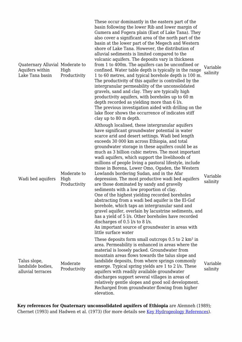
Quaternary AlluvialAquifers withinLake Tana basin
Moderate toHighProductivity
These occur dominantly in the eastern part of thebasin following the lower Rib and lower margin ofGumera and Fogera plain (East of Lake Tana). Theyalso cover a significant area of the north part of thebasin at the lower part of the Megech and Westernshore of Lake Tana. However, the distribution ofalluvial sediments is limited compared to thevolcanic aquifers. The deposits vary in thicknessfrom 1 to 400m. The aquifers can be unconfined orconfined. Water table depth is typically in the range1 to 60 metres, and typical borehole depth is 100 m.The productivity of this aquifer is controlled by theintergranular permeability of the unconsolidatedgravels, sand and clay. They are typically highproductivity aquifers, with boreholes up to 60 mdepth recorded as yielding more than 6 l/s.The previous investigation aided with drilling on thelake floor shows the occurrence of indicates stiffclay up to 80 m depth.
Variablesalinity
Wadi bed aquifersModerate toHighProductivity
Although localised, these intergranular aquifershave significant groundwater potential in waterscarce arid and desert settings. Wadi bed lengthexceeds 30 000 km across Ethiopia, and totalgroundwater storage in these aquifers could be asmuch as 3 billion cubic metres. The most importantwadi aquifers, which support the livelihoods ofmillions of people living a pastoral lifestyle, includethose in Borena, Lower Omo, Ogaden, the WesternLowlands bordering Sudan, and in the Afardepression. The most productive wadi bed aquifersare those dominated by sandy and gravellysediments with a low proportion of clay.One of the highest yielding recorded boreholesabstracting from a wadi bed aquifer is the El-Gofborehole, which taps an intergranular sand andgravel aquifer, overlain by lacustrine sediments, andhas a yield of 5 l/s. Other boreholes have recordeddischarges of 0.5 l/s to 8 l/s.An important source of groundwater in areas withlittle surface water
Variablesalinity
Talus slope,landslide bodies,alluvial terraces
ModerateProductivity
These deposits form small outcrops 0.5 to 2 km² inarea. Permeability is enhanced in areas where thematerial is loosely packed. Groundwater frommountain areas flows towards the talus slope andlandslide deposits, from where springs commonlyemerge. Typical spring yields are 1 to 2 l/s. Theseaquifers with readily available groundwaterdischarges support several villages in areas ofrelatively gentle slopes and good soil development.Recharged from groundwater flowing from higherelevation.
Variablesalinity
Key references for Quaternary unconsolidated aquifers of Ethiopia are Alemneh (1989);Chernet (1993) and Hadwen et al. (1973) (for more details see Key Hydrogeology References).
Igneous - Volcanic
NamedAquifers
AquiferProductivity General Description Water quality
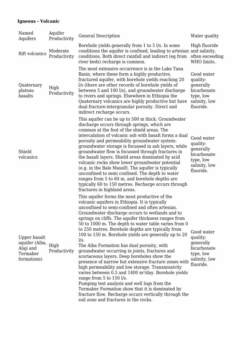
Rift volcanics ModerateProductivity
Borehole yields generally from 1 to 5 l/s. In someconditions the aquifer is confined, leading to artesianconditions. Both direct rainfall and indirect (eg fromriver beds) recharge is common.
High fluorideand salinity,often exceedingWHO limits.
Quaternaryplateaubasalts
HighProductivity
The most extensive occurrence is in the Lake TanaBasin, where these form a highly productive,fractured aquifer, with borehole yields reaching 20l/s (there are other records of borehole yields ofbetween 5 and 100 l/s), and groundwater dischargeto rivers and springs. Elsewhere in Ethiopia theQuaternary volcanics are highly productive but havedual fracture-intergranular porosity. Direct andindirect recharge occurs.
Good waterquality:generallybicarbonatetype, lowsalinity, lowfluoride.
Shieldvolcanics
This aquifer can be up to 500 m thick. Groundwaterdischarge occurs through springs, which arecommon at the foot of the shield areas. Theintercalation of volcanic ash with basalt forms a dualporosity and permeability groundwater system:groundwater storage is focussed in ash layers, whilegroundwater flow is focussed through fractures inthe basalt layers. Shield areas dominated by acidvolcanic rocks show lower groundwater potential(e.g. in the Bale Massif). The aquifer is typicallyunconfined to semi confined. The depth to waterranges from 5 to 60 m, and borehole depths aretypically 60 to 150 metres. Recharge occurs throughfractures in highland areas.
Good waterquality:generallybicarbonatetype, lowsalinity, lowfluoride.
Upper basaltaquifer (Aiba,Alaji andTermaberformations)
HighProductivity
This aquifer forms the most productive of thevolcanic aquifers in Ethiopia. It is typicallyunconfined to semi-confined and often artesian.Groundwater discharge occurs to wetlands and tosprings on cliffs. The aquifer thickness ranges from50 to 1000 m. The depth to water table varies from 0to 250 metres. Borehole depths are typically from100 to 150 m. Borehole yields are generally up to 20l/s.The Aiba Formation has dual porosity, withgroundwater occurring in joints, fractures andscoriaceous layers. Deep boreholes show thepresence of narrow but extensive fracture zones withhigh permeability and low storage. Transmissivityvaries between 0.5 and 1400 m²/day. Borehole yieldsrange from 5 to 150 l/s.Pumping test analysis and well logs from theTermaber Formation show that it is dominated byfracture flow. Recharge occurs vertically through thesoil zone and fractures in the rocks.
Good waterquality:generallybicarbonatetype, lowsalinity, lowfluoride.

Lower basaltaquifer(AshangieFormation)
Low to HighProductivity
These rocks are characterised by rugged topographywith dissected and irregular morphology. The rocksare deformed, and in their northern section dip at upto 40°. They are thinly bedded, and in several areasare brecciated. Field evidence shows that thebrecciated parts are characterized by lowerpermeability. The rocks are typically deeplyweathered, when they are reddish in colour, butgenerally have low permeability. Both primary(vesicle) porosity and secondary (fracture) porosityhave been modified and reduced by secondarymineralisation (e.g. by calcite, zeolite and silica).In more detail, the Ashangie Formation can bedivided into three zones:1) an upper layer, with gentle topographic slopes.Mostly scoriaceous, with several thin beds of claysoils. Recharge occurs vertically through this layer tothe underlying layers. Springs are rare, and mostgroundwater discharge occurs as diffuse seepage onslopes, often contributing to landslides.2) a thinner middle, more resistant layer, which oftenforms cliffs. When exposed at the ground surface byerosion, this can form locally extensive plateauareas, such as around the Upper Tekeze plains,Lalibela and the Belesa plain. Typically has highergroundwater productivity.3) a lower layer, also with gentle slope. Mostlyscoriaceous, with several thin beds of clay soils.Often contains cross-cutting dykes which areconduits for groundwater convergence anddischarge.The aquifer thickness varies up to 500 m. The ruggedtopography means that the aquifer is not laterallyextensive. Depressions in the rugged terrain areareas of groundwater discharge.The aquifer is usually unconfined to semi-confined.Typical borehole yields are between 0.5 and 20 l/s.Transmissivity ranges between 0.5 and 85 m²/day.The water table depth is typically between 100 and200 m, and borehole depths are typically 150 to 200m.The contact between this unit and the upper basaltabove is characterised by spring discharge.
Good waterquality:generallybicarbonatetype, lowsalinity, lowfluoride.
Key references for volcanic aquifers of Ethiopia are Kebede (2013) and Ayenew et al. (for moredetails see Key Hydrogeology References).
Mesozoic Consolidated Sedimentary Aquifers with Fracture and Intergranular Flow
Notable hydrogeologic and geologic features of Mesozoic sedimentary rocks of Ethiopia are:
- Uplifting and formation of tabular plateaus;
- deep incision by river gorges;
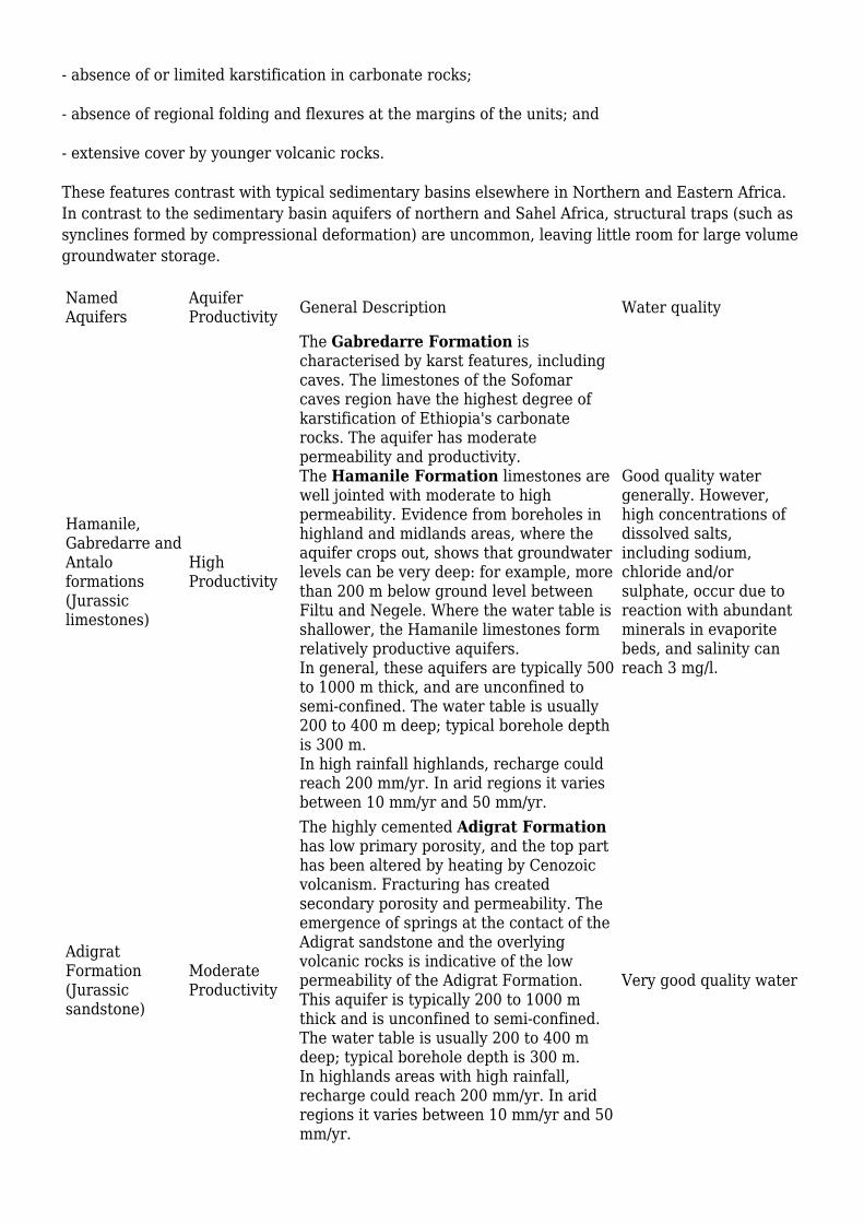
- absence of or limited karstification in carbonate rocks;
- absence of regional folding and flexures at the margins of the units; and
- extensive cover by younger volcanic rocks.
These features contrast with typical sedimentary basins elsewhere in Northern and Eastern Africa.In contrast to the sedimentary basin aquifers of northern and Sahel Africa, structural traps (such assynclines formed by compressional deformation) are uncommon, leaving little room for large volumegroundwater storage.
NamedAquifers
AquiferProductivity General Description Water quality
Hamanile,Gabredarre andAntaloformations(Jurassiclimestones)
HighProductivity
The Gabredarre Formation ischaracterised by karst features, includingcaves. The limestones of the Sofomarcaves region have the highest degree ofkarstification of Ethiopia's carbonaterocks. The aquifer has moderatepermeability and productivity.The Hamanile Formation limestones arewell jointed with moderate to highpermeability. Evidence from boreholes inhighland and midlands areas, where theaquifer crops out, shows that groundwaterlevels can be very deep: for example, morethan 200 m below ground level betweenFiltu and Negele. Where the water table isshallower, the Hamanile limestones formrelatively productive aquifers.In general, these aquifers are typically 500to 1000 m thick, and are unconfined tosemi-confined. The water table is usually200 to 400 m deep; typical borehole depthis 300 m.In high rainfall highlands, recharge couldreach 200 mm/yr. In arid regions it variesbetween 10 mm/yr and 50 mm/yr.
Good quality watergenerally. However,high concentrations ofdissolved salts,including sodium,chloride and/orsulphate, occur due toreaction with abundantminerals in evaporitebeds, and salinity canreach 3 mg/l.
AdigratFormation(Jurassicsandstone)
ModerateProductivity
The highly cemented Adigrat Formationhas low primary porosity, and the top parthas been altered by heating by Cenozoicvolcanism. Fracturing has createdsecondary porosity and permeability. Theemergence of springs at the contact of theAdigrat sandstone and the overlyingvolcanic rocks is indicative of the lowpermeability of the Adigrat Formation.This aquifer is typically 200 to 1000 mthick and is unconfined to semi-confined.The water table is usually 200 to 400 mdeep; typical borehole depth is 300 m.In highlands areas with high rainfall,recharge could reach 200 mm/yr. In aridregions it varies between 10 mm/yr and 50mm/yr.
Very good quality water

Key references for Mesozoic sedimentary aquifers of Ethiopia are BSEE (1973), Chernet(1993), Hadwen et al. (1973), Haile et al (1996) and Kebede (2013) (for more details see KeyHydrogeology References).
Precambrian Basement
Named Aquifers AquiferProductivity General Description Water
quality

Precambrianbasement aquifers ofSouthern Ethiopiaand NorthernEthiopia; CrystallineBasement aquifers ofWestern Ethiopia
Very Low toLowProductivity.
Basement aquifers in generalThe productivity of basement aquifers in Ethiopialargely depends of the development of regolith(weathered rock) amd the density of fractures. Inturn, these are partly controlled by the type orgrade of metamorphic rock that forms thebasement. Less important controls on groundwateroccurrence are the sustainability of recharge; andtopography. Groundwater in the basement aquifersoccurs in shallow regolith (weathered rock) basins.Borehole yields from the most productive boreholesin basement aquifers are generally less than 0.1 l/s.Spring discharges in the basement complex are ofthe order of 1 l/s. Generally, basement aquifers inwestern and south-central parts of Ethiopia areproductive, and the lowest productivity basementaquifers are located in northern Ethiopia and theBorena lowlands (near the southern border).The basement aquifers are unconfined. Aquifer(regolith) thickness varies from 0 to 60 m (thinnerin northern Ethiopia and thicker in westernEthiopia - see below). The deepest known boreholestruck water at 100 m. The water table is typically2 to 60 m deep. Boreholes tend to be 60 to 120 mdeep.Regional detailsNorthern Ethiopia: the basement rocks ofNorthern Ethiopia have low groundwater potential.Groundwater occurs generally in fractures in theupper few metres of the unweathered rocks; in verythin regolith layers; and in patches of overlyingalluvial sediments in river valleys (see theUnconsolidated section for further information).Southern Ethiopia: groundwater in the basementrocks is stored in, and transmitted through, bothregolith layers and fractures. There is variablefracturing and regolith development. Boreholeyields range from 0.13 to 0.33 l/s.Western Ethiopia: the crystalline basementaquifers of Western Ethiopia have bettergroundwater storage than in other areas. Thishigher groundwater potential is related to highrainfall that supports high recharge; to a relativelythick regolith which favours groundwater storage;and to rugged undulating topography whichfavours accumulation of weathering products indepressions and flat plains allowing groundwaterstorage and circulation. The average borehole yieldis 5 l/s (Bako & Abakoran). The hydraulicconductivity of this aquifer varies from 0.12 m/dayto 2.3 m/day.Recharge varies from 10 to 250 mm/yr dependingon rainfall regime
Goodquality
The key reference for basement aquifers of Ethiopia is Kebede (2013) (for more details see KeyHydrogeology References).
Recharge
Recharge over Ethiopia is extremely variable. It varies from nearly 0 to 300 mm/yr. Nearly 60% ofaquifers receive indirect recharge from floods, mountain runoff, as well as fast recharge from highrainfall events. Diffuse recharge is limited to the plateau region which accounts for around 30% ofthe country.
The geological uplift in the Cenozoic which led to erosion and dissection of the aquifers into smallersize units, has resulted in generally low storage compared to large sedimentary basins elsewhere inAfrica. The storage to recharge ratio is around 28 years (Kebede, 2013).
Groundwater Quality
Groundwater quality is highly variable across Ethiopia, from fresh waters in many of the springsflowing from basement aquifers, to more saline waters in volcanic aquifers in parts of the Rift Valleyand sedimentary aquifers of the plains.
The key natural groundwater quality issues are:
Fluoride.
Fluoride has long been a recognised health concern in Ethiopia. Concentrations of fluoride ingroundwater that are higher than the WHO guideline value of 1.5 mg/l have been found acrossEthiopia, but are concentrated in the Rift Valley, linked to the volcanic geology. Groundwaterfluoride values of greater than 10 mg/l have been found in some areas (Smedley 2001). As a result ofthe long-term use of high-fluoride drinking water, both dental and skeletal fluorosis are known tooccur in populations from the Rift Valley. However, more research is needed on the links betweengeology, hydrogeology, fluoride concentrations and fluorosis in order to target interventions.
Salinity.
High values of total dissolved salts in volcanic aquifers in the Rift Valley are linked to the influenceof geothermal waters. Increased salinity in many groundwaters in sedimentary aquifers in the south,southeast and northeast of the country, is linked to the dissolution of evaporite minerals.
Key references for more information on groundwater quality in Ethiopia are:
British Geological Survey/WaterAid. 2001. Groundwater Quality: Ethiopia. Leaflet.
Groundwater Status
Groundwater quantity
Annual renewable groundwater resources are estimated at around 36,000 million cubic metres (36billion cubic metres) , with estimates of total groundwater storage varying from 1,000 to 10,000billion m³.
Groundwater quality

An estimated 30% of groundwater storage is not available for direct use because of high salinityand/or high fluoride.
Groundwater-Surface Water Interaction
- There are a number of groundwater dependent surface waters, including wetlands and lakes. -Wetlands are increasingly threatened by deepening, widening and propagating gullies as well as byinfestation by invasive weeds
Groundwater Dependent Ecosystems
There is low recognition at government level of the fact that wetlands are groundwater dependent.
Groundwater use and management
Groundwater use
Some 80% of the total national water supply comes from groundwater.
Kebede (2013) gives national estimates of groundwater abstraction volumes. Groundwater providesmost of the water for domestic supply (90%) and industrial use (95%).
To date only a very small proportion of irrigation demand (<1%) comes from groundwater, includingsmall well irrigation by smallholder farmers, but some larger commercial irrigation schemes arepioneering the use of groundwater. Groundwater use for livestock watering is unknown. Morehydrogeological research may help increase the use of groundwater for irrigation, for example inproving the existence of a large enough resource that can be sustainably abstracted.
Groundwater sources in Ethiopia consist of:
BoreholesHand dug wellsImproved cold springsRiver bed excavations/pitsHaffirsTraditional Ella wells (very large diameter wells)Bircados
Groundwater management
There are currently no regional or national groundwater level or quality monitoring programmes,and relatively little formal registration of boreholes and other water abstraction points.
The key groundwater institutions, and their roles, are:
Ministry of Water Irrigation and Energy- Regulatory, policy, financing, planning, maintenanceof information base
Geological Survey of Ethiopia- Exploration and Mapping
Ministry of Forestry and Environment: Reviewing possible impacts of national investments ongroundwater quality and quantity; Selected strategic environmental assessments – linked to

groundwater management plans
Agricultural Transformation Agency- Shallow groundwater mapping and management policy
Regional Water Bureaus- Regulatory, policy, financing and planning
Water Works Enterprises- Study, Design, Supervision and Development
Regional Ministry of Forestry and Environment: Licensing and Impact assessment ofinvestment on groundwater
River Basin Organizations: Allocation and supplies
Water User Associations: Local regulation and allocation; formal and informal
Drillers' Association
Technical and vocational Schools (TVETs): training human power in groundwater development, low skill
There is a limited legal framework for groundwater management, but the regulations are notsystematically implemented. No regulatory provision exists to protect vulnerable areas. The report“Groundwater Management framework document (MWR, 2010)” includes the following regulatoryprovisions:
No person shall be engaged in the drilling or rehabilitating of water wells without a permitduly issued by the Ministry or his designee.Any person who wants to have water well drilled shall first acquire a permit to do so from theMinistry or his designee before entering a contract for this purpose with a water well drillingor rehabilitating contractor. Applications made to have a water well drilling or rehabilitatingcontractor. Applications made to have water well drilled must be accompanied with the designand specifications of such well.All water well drillers and rehabilitators shall, before entering in to a contract to drill waterwell, first ensure that the Ministry or his designee has approved that such well be drilled.All persons who want to have a water well drilled or rehabilitated shall, before entering in to acontract to have such water well drilled or rehabilitated, first ensure that the driller orrehabilitator has a permit to undertake the drilling or rehabilitating or water wells.A well driller or rehabilitator shall, within three months of completing a well drilling orrehabilitation, submit to the Ministry or his designee a technical report – that includesinformation about the drilling, construction and rehabilitation process, the geological andelectrical log, yield tests, laboratory tests, problems encountered during drilling, constructionand rehabilitation, pump installed.
Informal local water user organisations exist for most small-scale traditional water schemes,including groundwater, that operate on more than an individual/household level, and typically do nothave legal recognition or support. For formal and most modern schemes, there is usually a formalstatutory water user association or irrigation cooperative.
Transboundary aquifers
The major transboundary aquifers in Ethiopia are:
The unconsolidated sedimentary aquifers of Gambella (Upper Blue Nile) and AlweroSandstone: Ethiopia and South SudanThe Bulal Basalt aquifer: Ethiopia and Kenya

The Hanle Graben aquifer: Djibouti and EthiopiaThe Sedimentary Basin of Ogaden: Ethiopia and Somalia
No management system exists specifically pertaining to transboundary aquifers. Conflict over watersources in general is common among pastoralists in the border region of Ethiopia and Kenya.
Groundwater ProjectsInformation on particular groundwater projects in Ethiopia, including links to project results andoutputs, can be found on the Ethiopia groundwater projects page.
References and further informationMany of the documents below, and others relating to the hydrogeology of Ethiopia, can be accessedthrough the Africa Groundwater Literature Archive.
Maps
As well as the Atlas overview Ethiopia geology and hydrogeology map available to download as aGIS file from this page, other geological and hydrogeological maps are available:
Hydrogeological and hydrochemical maps at 1:250,000 scale, with explanatory notes, are availableto view and download (as pdf files) from the Geological Survey of Ethiopia portal. The GeologicalSurvey of Ethiopia website gives background information on hydrogeological mapping .
Maps, data and reports from the project Groundwater mapping for climate resilient WASH inarid and semi-arid areas of Ethiopia (2018-2020) can be visualized and downloaded from a publicwebservice system, the GW4E viewer. This includes harmonized geological maps, groundwatersuitability maps and socio-economic maps on a scale of 1:250,000 for eight clusters in Ethiopia, and1:50,000 hydrogeological maps and 1:10,000 drilling maps for target kebeles.
Geology: key references
Beyth M. 1972. The Geology of Central Western Tigre, Ethiopia. University of Bonn, p. 155.
EGS. 1996. Geological map of Ethiopia at 1:2000000 scale. Ethiopian Geological Survey, AddisAbaba, Ethiopia
Davidson A. 1983. The Omo River Project. Reconnaissance geology and geochemistry of parts ofIllubabor, Kefa, Gemu Gofa and Sidamo, Ethiopia. Ethiopian Institute of Geological Surveys Bull 2,89 pp.
Kazmin V, Shiferaw A and Balcha T. 1978. The Ethiopian basement: stratigraphy and possiblemanner of evolution. GeologischeRundschau 67, 531–548.
Kieffer B, Arndt N, Lapierre H et al. 2004. Flood and Shield Basalts from Ethiopia: Magmas from theAfrican Superswell. J of Petrology 45:793-834
Le Turdu C, Tiercelin JJ, Gibert E et al. 1999. The Ziway–Shala lake basin system, Main EthiopianRift: influence of volcanism, tectonics, and climatic forcing on basin formation and sedimentation.

Palaeogeography, Palaeclimatology and Palaeoecology 150: 135–177.
Mohr P. 1973. Crustal deformation rate and the evolution of the Ethiopian rift. In: Tarling DH,Runcorn SK (eds) Implications of continental drift to the earth sciences. Academic Press, London, pp767–776
Mohr P. 1983. Ethiopian Flood Basalt Province. Nature 303:577- 584.
Mohr P and Zanettin B. 1988. The Ethiopian flood basalt province. In: Macdougall, J. D. (ed.)Continental Flood Basalts. Dordrecht: Kluwer Academic, pp. 63---110.
Rochette P, Tamrat E, Feraud G et al. 1998. Magnetostratigraphy and timing of the OligoceneEthiopian Traps. Earth and Planet.Sci. Lett, 164: 497-510.
Taddesse T, Hoshino M, Sawada Y. 1999. Geochemistry of low-grade metavolcanic rocks from thePan-African of the Axum area, northern Ethiopia. Precambrian Research 99: 101–124
USBR. 1964. Land and water resources of the Blue Nile basin, Ethiopia. United States Bureau ofReclamation, Main report, Washington.
WoldeGabriel G, Walter RC, Aronson JL. 1992. Geochronology and distribution of silicic volcanicrocks of Plio-Pleistocene age from the central sector of the Main Ethiopian Rift. Quat. Int. 13–14,69–76.
Zanettin B, Justin-Visentin E. 1974. The volcanic succession in central Ethiopia, the volcanics of thewestern Afar and Ethiopian Rift margins. Univ. Padova Inst. Geol. Mineral. Mem. 31, 1–19.
Hydrogeology: key references
Alemneh S. 1989. Hydrogeology of Yabello sheet (NB37-14). Ethiopian Geological Survey reportnumber 307. Addis Ababa, 40pp.
Awulachew S. 2010. Irrigation potential in Ethiopia: Constraints and opportunities for enhancing thesystem. IWMI.
Ayenew T, Demli M and Wohnlich S. DATE. Occurrence of groundwater in Ethiopian volcanicterrain. Journal of Africa Earth Sciences, 52 (3), 97–113.
BCEOM. 1999. Abay River Basin integrated master plan, main report, Ministry of Water Resources,Addis Ababa.
Belete Y, Alemirew D, Mekonen A et al. 2004. Explanatory notes to the hydrogeological andhydrochemical maps of the Asosa-Kurmuk Area (NC36-7 West of Assosa and NC36-8 Assosa sheets).Geological Survey of Ethiopia, Addis Ababa, 120 pp.
BSEE. 1973. The caves of Ethiopia, The 1972 British SpeleologiclaExpediation to Ethiopia.Transaction Cave Research Group of Great Britain, 15:107-168
Chernet T. 1982. Hydrogeologic map of the lakes region (with memo) Ethiopian Institute ofGeological Survey (now Ethiopian Geological Survey), Addis Ababa Ethiopia.
Chernet T. 1993. Hydrogeology of Ethiopia and water resources development Ethiopian Institute ofGeological Surveys, Addis Ababa, 222pp.
Federal Democratic Republic of Ethiopia Ministry of Water Resources and GW-MATE. 2011.Ethiopia: Strategic Framework for Managed Groundwater Development.
Gasse F. 1977. Evolution of Lake Abhe (Ethiopia and TFAI), from 70,000 BP. Nature (London) 265(5589), 42– 45.
Gasse F and Street FA. 1978. Late Quaternary lake level fluctuations and environments of thenorthern Rift Valley and Afar region (Ethiopia and Djibouti). Paleogeogr. Paleoclimatol. Paeoecolo.24, 279-221
Gebru TA and Tesfahunegn GB. 2019. Chloride mass balance for estimation of groundwaterrecharge in a semi-arid catchment of northern Ethiopia. Hydrogeology Journal 27 (1), 363–378. doi:10.1007/s10040-018-1845-8.
Hadwen P. 1975. Boreholes in Ethiopia. Geological Survey of Ethiopia, Unpublished report number29, Hydrogeology Division, Technical Memorandum 9, Addis Ababa, 22pp.
Hadwen P, Aytenfisu M and Mengesha G. 1973. Groundwater in the Ogaden. Geological Survey ofEthiopia, report number 880-551-14. 59pp.
Haile A, Kebede G and Lemessa G. 1996. Reconnaissance Hydrogeological and EngineeringGeological Survey of Bikilal, Achebo and Dilbi Areas. Ethiopian Institute of Geological Survey,Report Number 880-351-06., Addis Ababa, 9pp.
Hailemeskel M. 1987. Hydrogeology of South Afar and Adjacent areas, Ethiopia. Supported byinterpretation of LANDSAT imagery. Unpublished MSc thesis. International Institute for Aerialsurvey and Earth Sciences (ITC), Enschede, the Netherlands.
Halcrow. 2008. Rift Valley Lakes Basin Integrated Resources Development Master Plan StudyProject. Main Report. Halcrow Group Limited and Generation Integrated Rural Development (GIRD)Consultants, Ministry of Water and Energy, Addis Ababa
Kebede S, Travi Y, Alemayehu T and Ayenew T. 2005. Groundwater Recharge, Circulation andGeochemical Evolution in the Source Region of the Blue Nile River, Ethiopia. Appl. Geochem. 20,1658
Kebede S. 2013. Groundwater in Ethiopia: Features, vital numbers and opportunities. Springer,Berlin. ISBN 978 3 642 30390 6. Available to purchase athttp://www.springer.com/gp/book/9783642303906
Ministry of Water and Energy. 2013. Supplement to Task Force Report on Aquifer Management forAddis Abeba and Vicinity. Ethiopia: Practical Framework for Managed Groundwater Development inthe Greater Addis Ababa Area
MWR. 2007. Evaluation of water resources of the Ada’a and Becho plains groundwater basin forirrigation development project, Volume III: Groundwater Evaluation Report, Water Works Designand Supervision Enterprise, Addis Ababa, 188pp.
MWR. 2010. Ethiopia: Strategic Framework for Managed Groundwater Development, Reportprepared by World bank - GWMate project, 77pp, Addis Ababa
Ralph M Parsons Company. 1968. Groundwater condition at Dallol, Ethiopia, Geological Survey ofEthiopia report number 880-201-01, Addis Ababa, 29pp.
Sima J. 1987. Hydrogeology and Hydrochemistry of the Bako and Ist’IfanosHayk’ areas (NB 37-9 andNB37-13), Provision Military Government of Socialist Ethiopia, Ministry of Mines and Engergy,Ethiopian Institute of Geological Surveys. Note Number 271, Addis Ababa, 65pp.
Sima J. 2009. Water Resources Management and Environmental Protection Studies of the JemmaRiver Basin for Improved Food Security. AQUATEST ,Geologicka Prague, Czech Republic, 220 pp.
Smedley P. 2001. Groundwater quality: Ethiopia. British Geological Survey.
Spate Irrigation Network Foundation. 2015. Status and potential of groundwater use in Ethiopianfloodplains. Practical Note Spate Irrigation 17.
Tadesse K. 1980. Hydrogeology of Borkena River Basin, Wollo Ethiopia. Unpublished MSC thesis,Addis Ababa University, 129pp.
UNICEF Ethiopia. 2020. Groundwater mapping for climate resilient WASH in arid and semi-aridareas of Ethiopia. Project (2018-2020). Project outputs at: GW4E online viewer.
USBR. 1964. Land and water resources of the Blue Nile basin, Ethiopia. United States Bureau ofReclamation, Main report, Washington.
WAPCOS. 1990. Preliminary Water Resources Development Master Plan for Ethiopia, Ministry ofWater Resoruces, Addis Ababa.
WWDSE. 2009. Groundwater Resources of the Upper Tekeze Basin: Resource Description,Assessment and Model, Interim Report. Water Works Design and Supervision Enterprise, AddisAbaba, 74pp.
Zerai H and Sima J. 1986. Hydrogeology and hydrochemistry of the Dire Dawa area (Sheet NC 3712). Provisional Military Government of Ethiopia, Ethiopian Institute of Geological Survey, Notenumber 276, Addis Ababa, 82pp.
Return to the index pages: Africa Groundwater Atlas >> Hydrogeology by country
Retrieved from ‘http://earthwise.bgs.ac.uk/index.php?title=Hydrogeology_of_Ethiopia&oldid=54710’Categories:
Hydrogeology by countryAfrica Groundwater Atlas
Navigation menu
Personal tools
Not logged inTalkContributionsLog inRequest account

Namespaces
PageDiscussion
Variants
Views
ReadEditView historyPDF Export
More
Search
Search Go
Navigation
Main pageRecent changesRandom pageHelp about MediaWiki
Tools
What links hereRelated changesSpecial pagesPermanent linkPage informationCite this pageBrowse properties
This page was last modified on 15 November 2021, at 13:36.
Privacy policyAbout EarthwiseDisclaimers