Embed Size (px)
Citation preview

Hydrologic Engineering Center
Projects and Initiatives at the Hydrologic Engineering Center (HEC)
Presented By: Christopher N. Dunn, P.E., Director Hydrologic Engineering CenterInstitute for Water Resources
For: Northern California AWRA, Sacramento CA10 March 2009

USACECEIWR-HEC
LEGEND: Division HQ location District HQ location Division boundary District boundary State boundary
LEGEND: Division HQ location District HQ location Division boundary District boundary State boundary
Pacific Pacific Ocean Ocean DivisionDivision
SouthwesternSouthwesternDivisionDivision
South South AtlanticAtlantic DivisionDivision
South South PacificPacificDivisionDivision
MississippiMississippiValley Valley
DivisionDivision
NorthNorthAtlanticAtlanticDivisionDivision
Great Lakes Great Lakes & Ohio River& Ohio RiverDivisionDivision
NorthwesternNorthwesternDivisionDivision
Alaska Seattle
WallaWallaPortland
SanFrancisco
Los Angeles
Honolulu
Albuquerque
Omaha
Kansas City
Tulsa
Ft. Worth
Galveston
Little Rock
St.Louis
RockIsland
St. Paul
Vicks-burg
New Orleans
MobileJacksonville
Savannah
Charleston
Wilmington
Norfolk
Philadelphia
New York
NewEngland
DetroitBuffalo
Balti-morePitts-
burghChicago
Memphis
Nashville
Louisville
Hunting- ton
Sacramento
Cincinnati
Dallas
Atlanta
Corps Water Resources Divisions & DistrictsCorps Water Resources Divisions & Districts

USACECEIWR-HEC
U.S. Army Corps of Engineers Key Mission Areas
Water ResourcesR & D
• Watershed Hydrology • Riverine Hydraulics• Estuary-Coastal Hydraulics• Socio-Economic• Geospatial• Environment
Inte
rag
ency
Su
pp
ort
• DOD, Federal• State & Local• International
Civ
il W
ork
s
• Primary Water Resources Missions - Navigation, Flood Damage Reduction & Shore Protection, and Environmental Restoration
• Allied Water Resources Purposes – Recreation, Water Supply, F&W, Hydropower
• Disaster Response• Regulatory

USACECEIWR-HEC
Mississippi Valley
Division
Great Lakesand
Ohio River Division
NorthAtlanticDivision
NorthwesternDivision
SouthPacific
Division
Pacific Ocean
Division
SouthAtlanticDivision
SouthwesternDivision
Buffalo
Chicago
Detroit
Huntington
Louisville
Nashville
Pittsburgh
Vicksburg
Memphis
New Orleans
St Paul
Rock Island
St Louis
Kansas City
Omaha
Portland
Seattle
Charleston
Jacksonville
Mobile
Savannah
Wilmington
Albuquerque
Sacramento
Los Angeles
San Francisco
Fort Worth
Galveston
Little Rock
Tulsa
MarineDesign
Center (FOA)
Finance Center (FOA)
249thPrime Power
Battalion
TransAtlanticPrograms
Center
HuntsvilleEngineeringand Support
Center
HQUSACE
Corps of Engineers Organization
Alaska
Honolulu
Far East
Japan
Walla Walla
Baltimore
New England
New York
Norfolk
Philadelphia
Europe
GulfRegionDivision
CentralBaghdad
NorthMosul
SouthBasrah
AfghanistanEngineerDistrict
Major Subordinate Commands Or
Divisions
Civil Works District Offices Humphreys Engineer
Center Support Activity(FOA)
Institutefor Water
Resources(FOA)
EngineerResearch andDevelopment
Center - 7 Labs MilitaryDistricts

USACECEIWR-HEC
Center of expertise in hydrologic engineering and planning analysisexecuting a balanced program of technical assistance, research, software development, training and special studies. Located in Davis, California.
Organization within the Institute for Water Resources.
Institute for Water Resources – Hydrologic Engineering Center
Trainingand
SoftwareSupport
TechnicalAssistance Research
SoftwareDevelopment

USACECEIWR-HEC
Hydrologic Engineering Center
Support office within USACE Institute for Water Resources.
USACE Center of Expertise for Hydrologic Engineering and Planning Assistance.
33 full-time professionals; hydraulic engineers, a few computer specialists, mostly MS degrees, a few Ph.Ds.
15 additional staff; IWR employees, UCD students, admin staff.
Primarily support USACE; some other Federal agencies; occasional international assistance; increasing number of MoU’s; visiting scholars – U.S. and international.

USACECEIWR-HEC
Brief History, Origin HEC
Created by HQUSACE initiative in 1964. Principals: HQUSACE H&H, SPK Engineering Division. Imminent retirements of WWII veterans. Institutionalize ‘hydrologic engineering’ – critical skill.
1964 – Branch within SPK Engineering Division.
1965 – Division within SPK (under Commander).
1971 – Organization assigned to SPD Commander.
1978 – Briefly FOA reporting to Director of Civil Works, then assigned to the Water Resources Support Center, a new FOA reporting to Director of Civil Works (CECW).
2000 – Assigned to Institute for Water Resources, an FOA/support office reporting to CECW.

USACECEIWR-HEC
HEC Basic Precepts‘HEC Business Model’
HEC exists to help the Corps perform it’s CW mission in a world-class manner.
The work of the Corps is performed at the field office level.
HEC products and services are for field use and application.
HEC is a wholly owned (by CECW) small business with primary customer base being the field offices; to lesser extent, HQUSACE, Labs, other Corps and Army elements, and other agencies/partners.

USACECEIWR-HEC
HEC Divisions/Responsibilities
Water Management
Systems
Water Resource Systems
H&HTechnology
HEC IT Mgmt./Web
Real-time Data
CWMS System
H&H Forecasting
Reservoir Regulation
Software Engr.
Training Admin.
Reservoir Systems
System Optimization
Flood Damage Anal.
Risk Analysis.
Env./Watershed St.
Research Admin.
Surface & GW Hyd.
River Hydraulics
Erosion/Sed. Trans.
Hydrologic Statistics
Drought/low Flow
(Chief: Tom Evans) (Chief: Jeff Harris)(Chief: Mike Deering)

USACECEIWR-HEC
Typical Products/Projects
H&H and planning analysis software: new models/GIS utilities versions; new software.
Real-time water control: Modernized Corps Water Management System: Corps-wide deployment completed; now supporting and improving.
Studies/support: Katrina Support; Ft. Worth Flood Warning model; Great Lakes Study; NWS Forecasting Model for Joint Operations; Bill Williams River Restoration; Sac/SJ Comp Study; Sac River Risk Analysis; Tooele & Ft. Huachuca groundwater; Ohio River WSP modeling; Sonoma County Water Agency; ACT-ACF, FEMA Map Modernization, Iraq water management, Afghanistan, South Florida Water Management District; Tampa Bay Water; LCRA; Bulletin 17B; Levee Certification; Dam Safety.
Training: Average – 10 courses, 6 workshops; publications, video tapes, software support, Web dissemination.

USACECEIWR-HEC
HEC Software Activities
Complete product line for hydrologic engineering in HEC library.
Solve problems in a general manner for use everywhere.
Hydrologic Statistics with SSP Watershed hydrology with HMS &
GeoHMS. River hydraulics with RAS & GeoRAS. Reservoir Analysis with ResSim. Flood damage analysis with FDA and
FIA. Software Integration with CWMS,
DSSVue. Ecosystem Functions with EFM Watershed Analysis with WAT

USACECEIWR-HEC
Hydrologic Statistical Software Package HEC-SSP Version 1.0
Develop statistical analysis software that supports hydrologic studies. This software will perform frequency analysis, regional regression, coincident frequency analysis, duration analysis, etc….

USACECEIWR-HEC
Hydrologic Modeling System, HEC-HMS, Version 3.3 Computes streamflow throughout a
river basin given precipitation and watershed characteristics.
Event and continuous simulation, multiple routing/ runoff methods, grid precip., losses & runoff, snowmelt, coeff. estimation, dam break, powerful GUI.
GeoHMS GIS utility for watersheds/sub-watersheds, runoff parameters. ArcGIS 8.X version underway.

USACECEIWR-HEC
Surface Water Enhancements HEC-HMS - Version 3.3
• Sediment Washoff (lumped area & gridded washoff)• Water quality simulation thru NSM
Surface Washoff Total Nitrogen Total Phosphorous Fecal Coliform
• Reservoir Features Spillway Options Dam Face Seepage Specified Release Evaporation
USACECEIWR-HEC
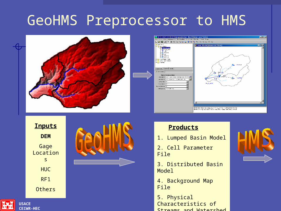
GeoHMS Preprocessor to HMS
Inputs
DEM
Gage Locations
HUC
RF1
Others
Products
1. Lumped Basin Model
2. Cell Parameter File
3. Distributed Basin Model
4. Background Map File
5. Physical Characteristics of Streams and Watershed Tables

USACECEIWR-HEC
HEC-RAS, River AnalysisVersion 4.0
1-Dimensional hydraulics program
Computes river velocities, stages, profiles, and inundated areas (with GeoRAS) given streamflow and geometry.
Steady and Unsteady Flow
Water depth?
Flow

USACECEIWR-HEC
River Analysis EnhancementsHEC-RAS -Version 4.0Software to analyze steady and unsteady flow, sediment transport & WQ
• 1D sediment transport (movable bed calculations through scour and deposition).
• Pump Stations
• Compute Ungaged Flow from Gaged Data
• Interfacing RAS with 2D ADH
• Automating Manning’s n value for calibration
• Water temperature modeling to HEC-RAS
• Water quality constituents to the HEC-RAS analysis process by incorporating the water quality computations of QUAL-RIV1

USACECEIWR-HEC
HEC-GeoRAS
Pre-processor for generating geometric data for HEC-RAS
Post-processor for mapping and displaying results from hydraulic simulations

USACECEIWR-HEC
Groundwater/Surface Water Interaction for HEC-RAS
Develop a coupled model that will support improved representation of water exchange where groundwater interaction is a significant component of channel flow, and provide a more complete accounting of water storage in groundwater and channels.
1. Evaluation of OpenMI non-proprietary software used for coupling models at the time-step level.2. Algorithm for computing water exchange between HEC-RAS and MODFLOW.3. Mapping of stream on groundwater model grid. 4. Temporal issues.5. Spatial issues. 6. User Interface.

USACECEIWR-HEC
Reservoir System Analysis HEC-ResSimVersion 3.0
Simulates reservoir operations for flood management, low flow augmentation and water supply for planning studies, detailed reservoir regulation plan investigations, and real-time decision support
New features include pump-back storage, multi-reservoir system operation to meet power generation goals and capability to utilize Ensemble Streamflow Predictions from the NWS.

USACECEIWR-HEC
Reservoir Water Quality EnhancementsHEC-ResSim & CE-QUAL-W2
• Demand for water quality and temperature modeling for real-time and planning analyses
• Looking to link both models thru OpenMI (Open Model Interface) rather than fund a major development effort
• Will provide in and downstream of the reservoir Temperatures Dissolved Oxygen Other conservative constituents Variable gate settings

USACECEIWR-HEC
Flood Risk Management ToolsHEC-FDA Version 1.2.4/HEC-FIA
Develop software to perform flood risk management analyses; project benefit analysis including loss-of-life consequences; evaluate flood risk management measures using risk and uncertainty and including systems approach and GIS capability. Improve planning capability by: enabling multi-purpose formulation, tradeoff analysis, promoting Collaborative Planning and NED/NER formulation.

USACECEIWR-HEC
Flood Damage Reduction Analysis HEC-FDA,Version 1.2.4
Plan Evaluation and Plan Formulation Tool
Helps answer the question "Which proposed flood damage reduction plan is the best from an economic standpoint?"
evaluate the existing condition analyze alternative damage reduction plans
Compare plans using Expected Annual Damage and damage reduction benefits
Since 1996, use risk analysis procedures
USACECEIWR-HEC
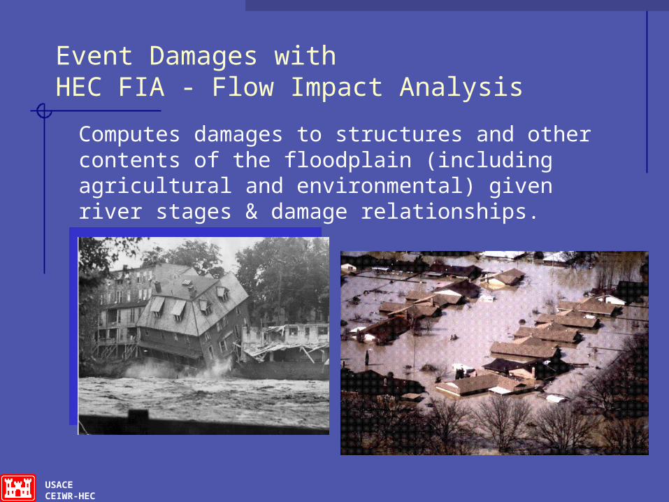
Event Damages with HEC FIA - Flow Impact Analysis
Computes damages to structures and other contents of the floodplain (including agricultural and environmental) given river stages & damage relationships.

USACECEIWR-HEC
Goals for HEC-FRM (Flood Risk Management)
Systems approach for assessing risks in complex, interdependent systems
Incorporation of social and environmental consequences
Tools for levee assessment and certification Effective risk communication New computational methodology

USACECEIWR-HEC
HEC-EFM Ecosystems Functions Model – Version 1.0 Planning tool for flow regime change. Reservoir/regulation change,
diversions, remove/set back levee, reconfigure channel.
Impact on terrestrial and aquatic habitat. Change direction/magnitude - biologic
impact. Team use: biologists, geomorphologists,
hydraulic engineers, environmental managers.
Premise: hydrologic/hydraulic data can help predict biologic response.
Spawning Habitat
Cottonwood Recruitment

USACECEIWR-HEC
With Project• Increased flow
and stage
Without Project• Flow is 14,800-cfs• Stage is 15.67-ft
Floodplain Spawning Habitat -
With Project

USACECEIWR-HEC
Corps Water Management System
CWMS is the data acquisition, management, modeling and decision support system that supports the Corps in its water management mission of regulating more than 700 dam and reservoir projects.CWMS is a nationwide integrated system of hardware, software, and other resources that acquires, analyzes, and stores data; develops decision support information; and allows user access to any data and information on the system.

USACECEIWR-HEC
Corps Water Management System(CWMS)
Improved Real-Time Water Management Decision Support for over 700 Multipurpose Reservoirs, Control Structures and Thousands of miles of Levees.
An integrated suite of real-time water resources software
Standard Corporate Centrally Supported Hardware/Software.
From 40 Existing Unique Systems to one CWMS.
Weather Radars
Streamgages
Operational decisions Inundation Forecasts
Fully Integrated Hydrologic ModelsReal-Time

USACECEIWR-HEC
CWMS Watershed Modeling
Modeling
Hydrology(HEC-HMS)
Storage(HEC-ResSim)
Hydraulics(HEC-RAS)
Damages(HEC-FIA)

USACECEIWR-HEC
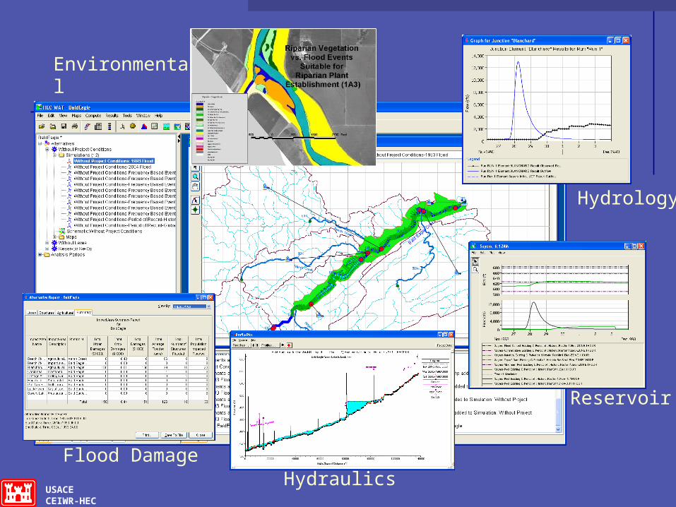
Watershed Analysis Tool (HEC-WAT)
Create a product that will improve the coordination, communication, and productivity of a Project Delivery Team throughout a project study by involving modelers early in the study process, allowing data and results to be shared across models, and visualizing model parameters and results, all using a shared and intuitive interface.
USACECEIWR-HEC
Hydrology
Reservoir
Hydraulics
Environmental
Flood Damage

USACECEIWR-HEC
HEC-WAT Model Integration
Integrate model and tools used during the analytical process
• Hydrology - HEC-HMS & GeoHMS - Done• Reservoir Operations - HEC-ResSim - Done• Hydraulics - HEC-RAS & GeoRAS - Done• Economics - HEC-FIA - Done• Statistical – HEC-SSP – Done• Data – HEC-DSSVue – Done• Environmental - HEC-EFM – Done• Future Additions – HEC-FDA, RiverWare …

USACECEIWR-HEC
Result Comparison in the WAT

USACECEIWR-HEC
Typical Project Work:Sacramento and San Joaquin Comprehensive Study
Hydrologic Modeling Watershed Impact Analysis HEC-FDA Technical Assistance HEC-FIA Model Development Risk Communication and Mapping Conjunctive Use Ecosystem Functions Model (EFM)

Hydrologic Engineering Center
Hydrologic Modeling
Sacramento Basin 27,000 Sq. Mi.
San Joaquin River & Tulare Lake Bed Basins 32,000 Sq. Mi.
33 HEC-HMS models
Sacramento Sacramento River BasinRiver Basin
San Joaquin San Joaquin River/Tulare River/Tulare Lake Bed Lake Bed BasinsBasins

USACECEIWR-HEC
Conjunctive Use for Flood Benefits
Determine if flood benefits from employing Conjunctive Use practices outweigh the costs
Increase system storage capacity by including depleted groundwater aquifers
Shift existing water supply to aquifers in order to increase flood storage reservation in surface reservoirs
USACECEIWR-HEC
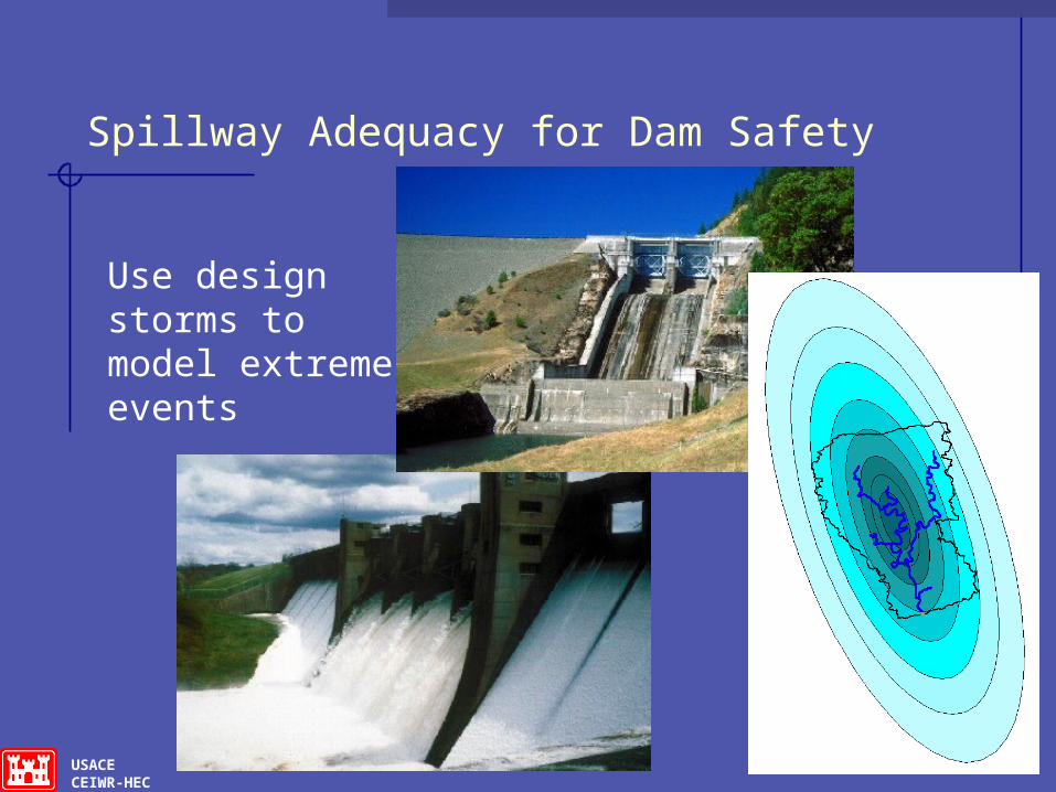
Spillway Adequacy for Dam Safety
Use design storms to model extreme events

USACECEIWR-HEC
Assistance to Iraq Ministry of Water Resources (MoWR)
Training and collaborative water management system model creation.
Model expansion and refinement. Baseline flow data preparation and coding.
Unimpaired, current, and a projected future. Gauging technology advice and demo. On-site training – model, water management,
gauging system restoration.

USACECEIWR-HEC

USACECEIWR-HEC
The Helmand Valley - Afghanistan
Drainage area 160,000 km2 31% of country
Helmand River AY~14 Billion m3
Kajakai Reservoir

USACECEIWR-HEC
Flood Warning and Response System
Provide a Flood Warning and Response System to communities along river systems
Provide accurate and timely warnings Maximize response time (County Emergency
Management Agencies and Floodplain Residents) Use stage/elevation-based flood inundation mapping Evacuation & flood warning plan formulation tool Damage estimates (expedite disaster assistance) Educate the public on flood hazard Two Major Applications
Susquehanna River and San Antonio River

USACECEIWR-HEC
Risk Analysis/Impact Analyses of Proposed Modifications to the Sacramento River Flood Control Project Levees
To Define a Risk Analysis Methodology Identify if system-wide hydraulic impacts
resulting from alterations and modifications to the SRFCP can be determined with Risk Analysis
Compare Risk Methodology to Traditional Deterministic Methodology
NOT comparing results…Only the Process

USACECEIWR-HEC
SRFCP
1300 miles of levees
Protects 800k Acres
Significant Upstream Storage Reservoirs
Downstream channel capacity must be maintained
USACECEIWR-HEC
t
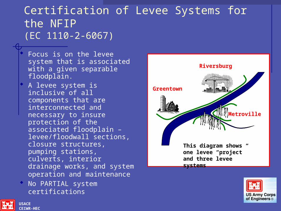
Certification of Levee Systems for the NFIP (EC 1110-2-6067)
Focus is on the levee system that is associated with a given separable floodplain.
A levee system is inclusive of all components that are interconnected and necessary to insure protection of the associated floodplain – levee/floodwall sections, closure structures, pumping stations, culverts, interior drainage works, and system operation and maintenance
No PARTIAL system certifications
Riversburg
Greentown
Metroville
This diagram shows one levee “project” and three levee systems

USACECEIWR-HEC
HEC Training Classes FY09
Nonstructural Measures for Flood Risk Management Mar 30 - Apr 03
Hydrologic Analysis for Ecosystem Restoration Apr 06-10 Advanced Steady Flow Analysis with HEC-RAS May 04-08 Risk Analysis For Flood Damage Reduction Projects Jun 15-
19 Statistical Methods in Hydrology Jul 13-17, 09 Sediment Transport Analysis With HEC-RAS Aug 17-21 Advanced Reservoir Modeling with HEC-ResSim Sep 14-18
USACECEIWR-HEC
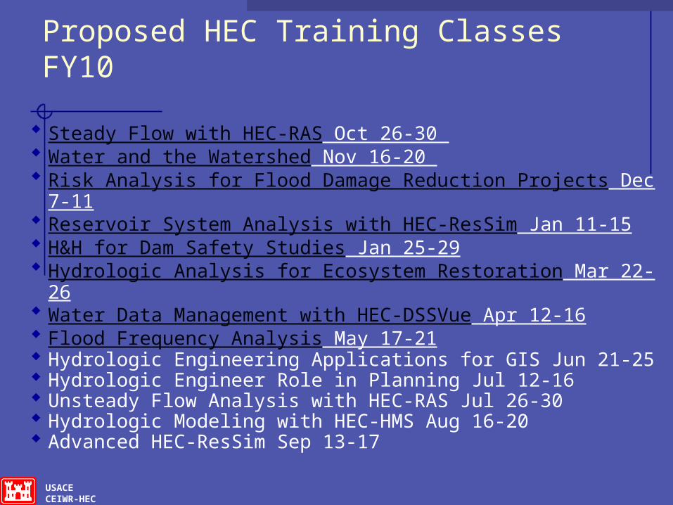
Proposed HEC Training Classes FY10
Steady Flow with HEC-RAS Oct 26-30 Water and the Watershed Nov 16-20 Risk Analysis for Flood Damage Reduction Projects Dec
7-11 Reservoir System Analysis with HEC-ResSim Jan 11-15 H&H for Dam Safety Studies Jan 25-29 Hydrologic Analysis for Ecosystem Restoration Mar 22-
26 Water Data Management with HEC-DSSVue Apr 12-16 Flood Frequency Analysis May 17-21 Hydrologic Engineering Applications for GIS Jun 21-25 Hydrologic Engineer Role in Planning Jul 12-16 Unsteady Flow Analysis with HEC-RAS Jul 26-30 Hydrologic Modeling with HEC-HMS Aug 16-20 Advanced HEC-ResSim Sep 13-17

USACECEIWR-HEC
HEC Senior Staff, Contact Information
Chris Dunn, P.E., Director Jeff Harris, Hydrology & Hydraulics Technology Div. Mike Deering, P.E., Water Resources Systems Div. Tom Evans, Ph.D., Water Management Systems Div. Gary Brunner, P.E., Senior Technical Specialist, River
Hydraulics Bill Charley, P.E., Senior Technical Specialist, Water Control
HEC Web site: http://www.hec.usace.army.mil
Contact for publications, software:Hydrologic Engineering Center609 Second StreetDavis, CA 95616Ph 530/756-1104