Embed Size (px)
Citation preview

QdroDQdfoDQdroQdfoSunMax
globalQsi CalcHr
calcsuntrheaupppt
QsiQsoQnQlnSunActform_data
hru_thru_rhhru_eahru_uhru_phru_rainhru_snowhru_SunActhru_tmaxhru_tminhru_tmeanhru_eameanhru_umeanhru_rhmeanhru_newsnow
obsnet_rainnet_snowintcp_evap
intcpnetcum_net
netallRnQgQs
net_rnhru_evaptransp_on
evapSWE
pbsmalbedomeltflag
albedosnowmeltD
ebsmsnowinfilrunoff
crackinfil
srunoffsoil_to_gw_Dsoil_to_ssr_D
smbalinflowoutflowbasinflowcumbasinflowbasingwcumbasingw
route
P
P
C:\Program Files\CRHM\Examples\badlakeflow7475jp.prj
Hydrology of Prairie Droughts
John Pomeroy, Kevin Shook, Robert Armstrong, Xing FangCentre for Hydrology
University of SaskatchewanSaskatoon, Sask
www.usask.ca/hydrology
Non-Contributing Areas to Streamflow a Prairie Characteristic

Prairie Runoff GenerationSnow Redistribution to Channels
Spring melt and runoff
Water Storage in Wetlands
Dry non-contributing areas to runoff
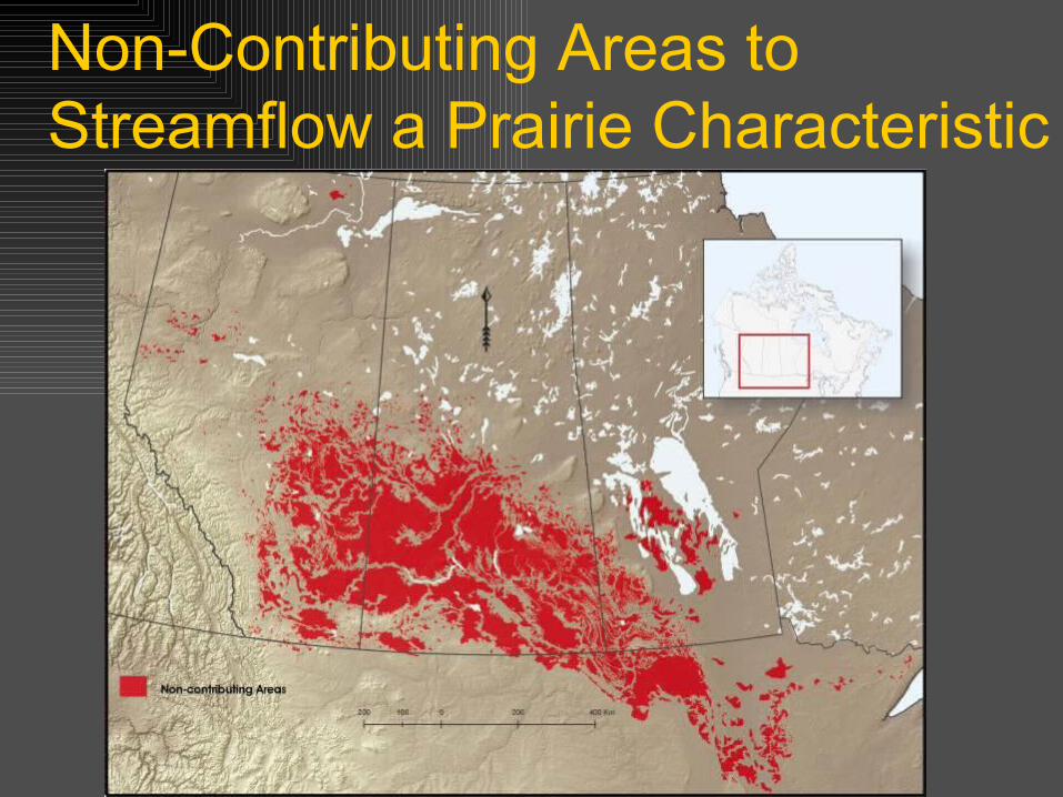
Prairie Hydrology – don’t blink
0
5
10
15
20
25
01-Jan
31-Jan
02-Mar
01-Apr
01-May
31-May
30-Jun
30-Jul
29-Aug
28-Sep
28-Oct
27-Nov
27-Dec
Str
eam
flow
m3
per
seco
nd
Average 1975-2006
1995 High Year
2000 Low Year
Smith Creek, Saskatchewan
Drainage area ~ 450 km2
No baseflow from groundwater
Hydrological drought can be viewed as the absence of prairie runoff……
How to Characterise Hydrological Drought for the Prairies?
River flows well gauged, but subject to abstraction, storage and do not reflect Prairie hydrological conditions.
Streamflow network is more representative but is sparse, and subject to changes in land cover, drainage, abstraction, storage.
Possibility to model prairie runoff generation and related hydrological processes to create a hydrological drought “surface” for the Prairies using atmospheric driving data and standardised representation of prairie snow redistribution, melt, runoff generation, infiltration and evaporation.

Modelling Objectives
To Demonstrate the: differences between drought and non-drought
hydrological cycling at the surface, evolution of hydrological drought over time and
space Calculated Variables as ratios to non-drought
conditions (~Hydrological Drought Indices~) Snow Accumulation peak SWE, duration Spring Freshet total, duration Actual ET/PET growing season Soil Moisture spring, summer, fall

Cold Regions Hydrological Model (CRHM) Drought Hydrology Simulation Model the effects of local drought meteorology on the
hydrology of ”representative”, first-order prairie basins Create “virtual” basin models, which can be applied to
gridded datasets Allows comparison of basin response to drought
conditions and to normal variability Requires high resolution driving data over entire Prairies
for normal (1961-1990), non-drought (1962-1987) and drought periods (1999-2004) Snowfall, rainfall Incoming shortwave radiation, cloudiness or sunshine hours Temperature Humidity Wind speed
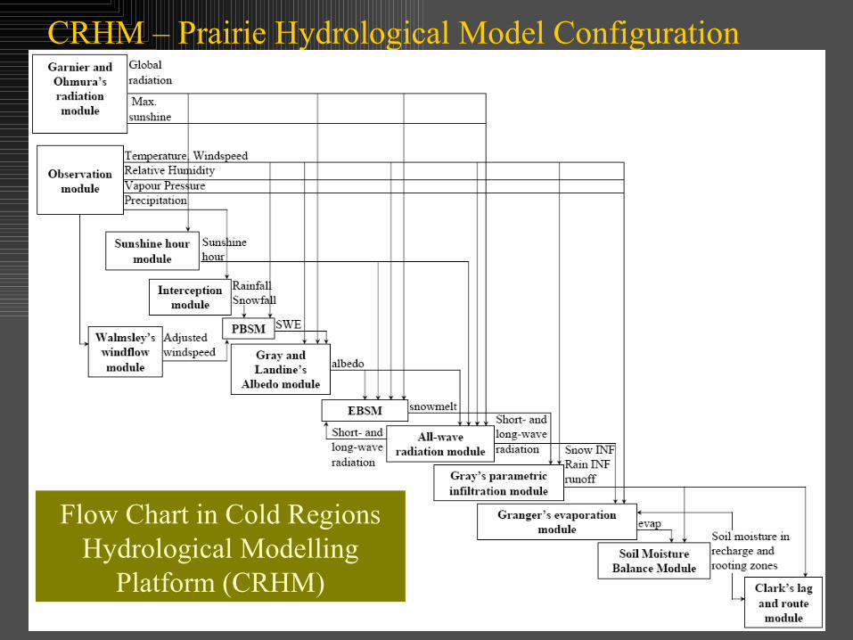
CRHM – Prairie Hydrological Model Configuration
Flow Chart in Cold Regions Hydrological Modelling
Platform (CRHM)

CRHM Tests Creighton
Tributary of Bad Lake-well drained semi-arid
St. Denis National Wildlife Area-internally drained sub-humid
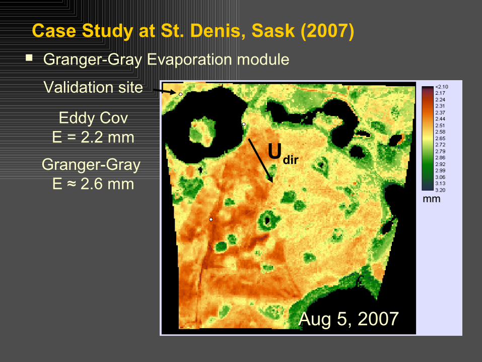
Case Study at St. Denis, Sask (2007) Granger-Gray Evaporation module
Validation site
Eddy CovE = 2.2 mm
Granger-Gray E ≈ 2.6 mm
Aug 5, 2007Aug 5, 2007
Udir
mmmm

CRHM Hydrological Response Unit (HRU) Configurations
Fallow Stubble
Grass Coulee
Stream
Creighton Tributary, Bad Lake
Cultivated
Wooded Wetland
Pond
Wetland 109, St Denis
Well Drained Poorly Drained
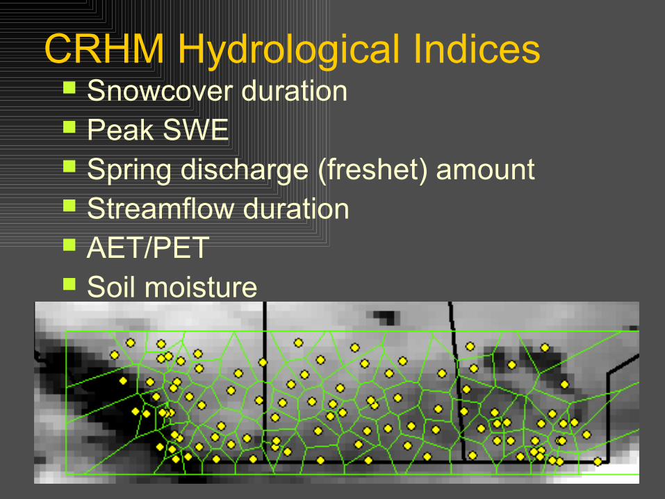
CRHM Hydrological Indices Snowcover duration Peak SWE Spring discharge (freshet) amount Streamflow duration AET/PET Soil moisture
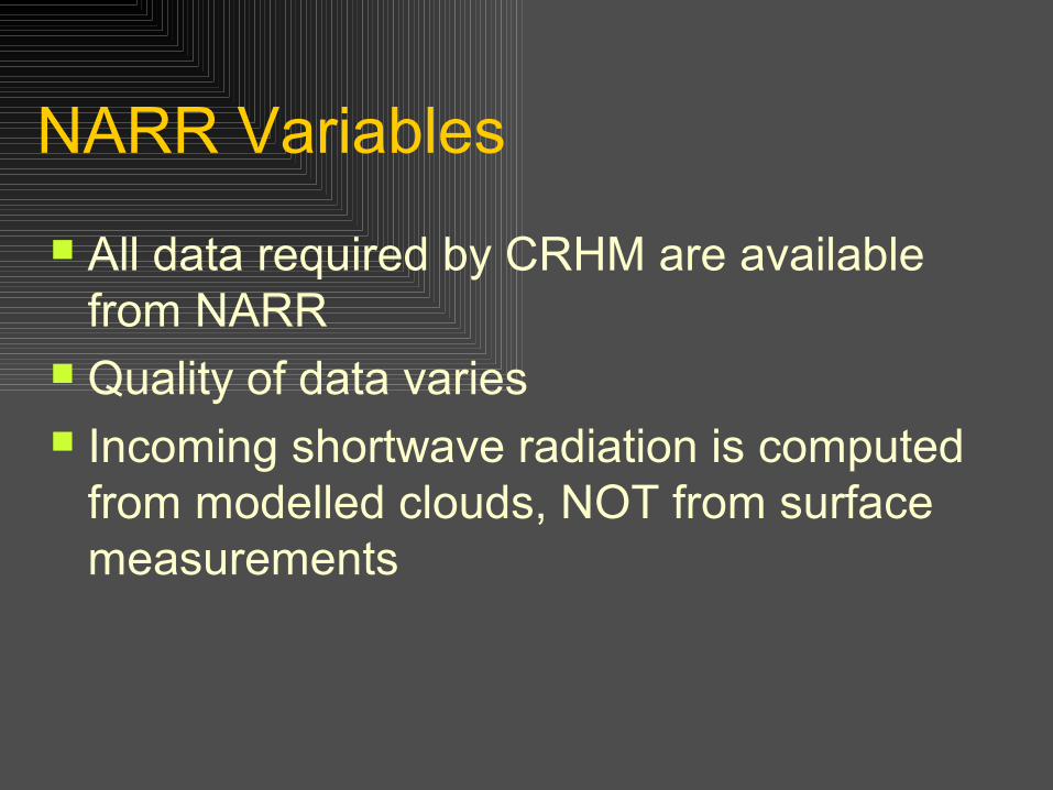
NARR Variables
All data required by CRHM are available from NARR
Quality of data varies Incoming shortwave radiation is computed
from modelled clouds, NOT from surface measurements

Edmonton 1979-2000
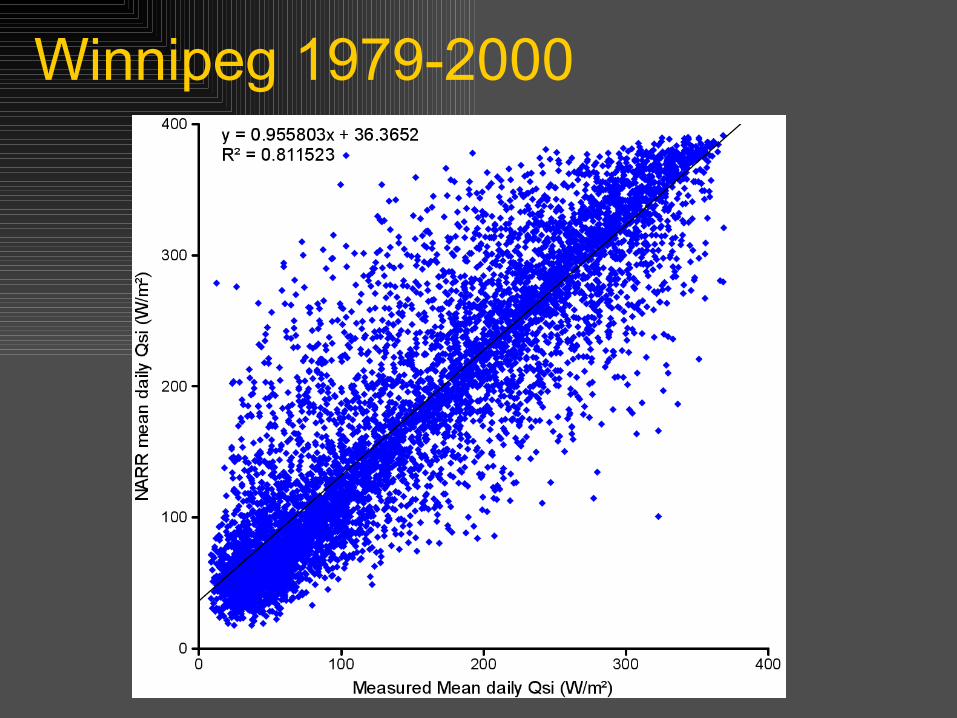
Winnipeg 1979-2000

Why not use all NARR data?Winnipeg daily Tmin & Tmax, 1979-2000
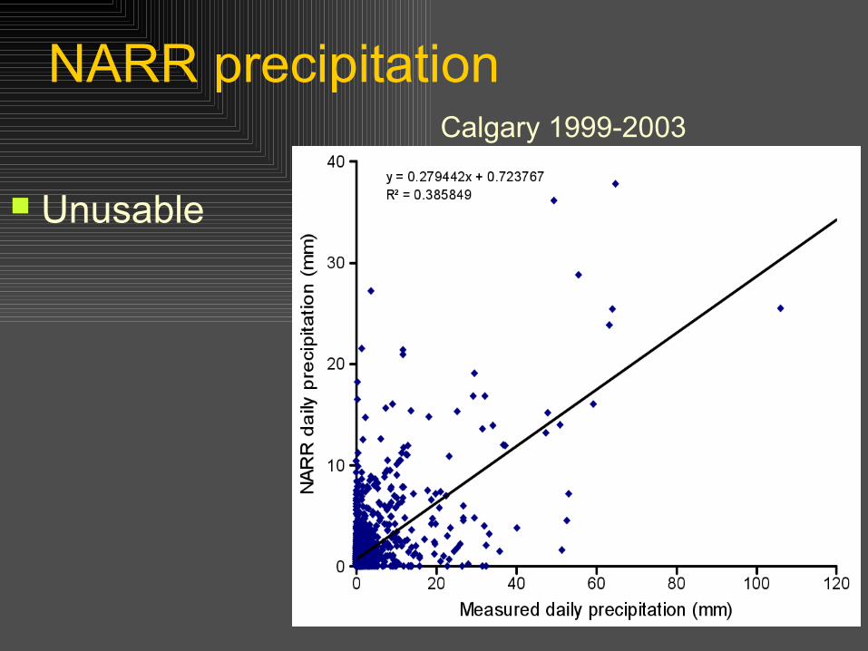
NARR precipitation
Unusable
Calgary 1999-2003

CRHM Simulations
Winnipeg and Calgary to date HRUs grass, cropped Evaluation of changes to drought
hydrology
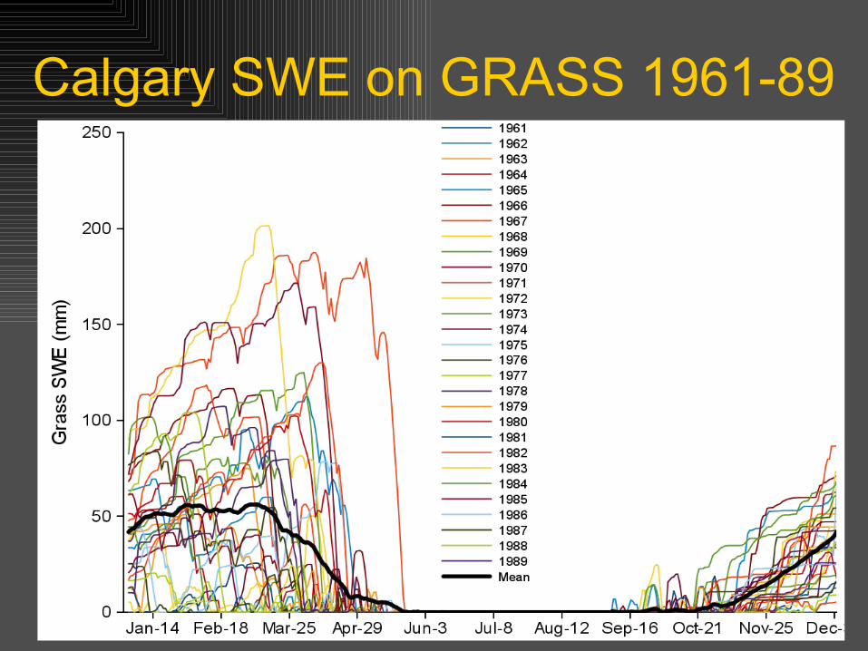
Calgary SWE on GRASS 1961-89
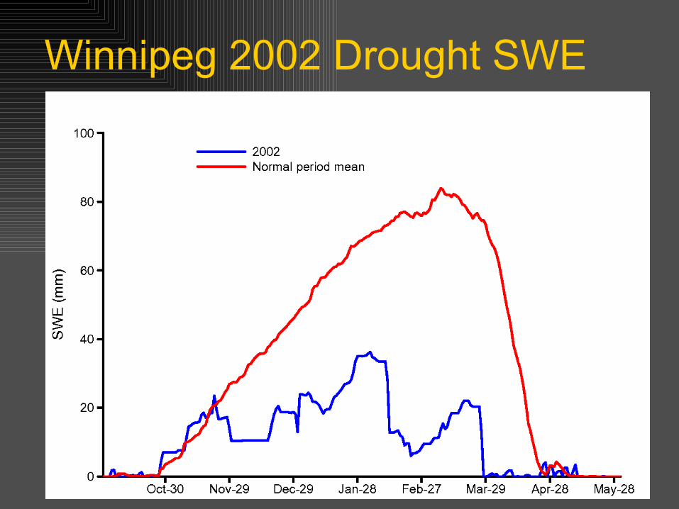
Winnipeg 2002 Drought SWE

Winnipeg Maximum SWE

Winnipeg Spring Freshet

CRHM Gridded First Order Hydrology
Runs to be completed for all Prairies this winter, then mapped
Will provide first physically based, comprehensive estimation of runoff generation from first order basins in Prairies
Useful information for DEWS (soil moisture, SWE, peak flow, duration of flow, wetland level, actual evaporation)
Actual evapotranspiration maps using remote sensing, splined observations, reanalysis
Provides a hydrological modelling tool for general prairie application
Advises application of VIC and MESH to Prairie environment