Embed Size (px)
Citation preview

April – June, 2011. Volume: IV
HYDROLOGY PROJECT-II
A S S I S T E D B Y T H E W O R L D B A N K
NEWSLETTER
What is inside? • Impact of Major Surface Water Projects
on Ground Water: A Case Study of Srisailam Right Branch Canal (SRBC) in Andhra Pradesh
• Farmers 'harvest' crop water budgeting• Orissa (SW): Implementation of Purpose
Driven Study (PDS) on Water Quality Monitoring & Modelling in Taladanda Canal
• Ground water Management: A future perspective
• Lobbying with Polity at Grassroots levelMaharashtra-SW Aims High and Gets it Right
• On a Campaign Mode: Visit of School Children to Masoli FCS
• International Training (January to June 2011)
• Real Time Data Acquisition System (RTDAS) and Flood Management
• Water and Sanitation Service Delivery PDS adds Value in the High Hills of Shimla
• Leadership Training in Gujarat receives a ‘Thumbs Up’
• Children’s Contributions• Future of Hydrology
tyWater/keZ & deZ & tylgstks & ty
gj iy
ty
tyWater/keZ & deZ & tylgstks & ty
gj iy
ty

HYDROLOGY PROJECT-II
Message from the Project Coordinator
Dear friends and colleagues,
Greetings to all of you from the Project Coordination
Secretariat. I have taken over the responsibilities as
Project Coordinator with effect from May 23, 2011. I
am imbibing the unique Hydrology Project culture which
displays a high degree of scientific temperament. With a
multitude of agencies involved, it is hard to ignore the
existence of plurality of work culture that underlines the
project. Despite this divergence of work culture across
agencies, I have noticed that a perfect blend has emerged and
all are contributing their best to achieve project milestones. I
give full credit to all of you for this, especially to the members
of the PCS and TAMC team.
The countdown has now begun. From now on, we have less
than one year time window, and the final goal post is still far
away. A number of things are yet to be achieved. For
example, while data collection, data processing and data
storage have matched up to expectations, a lot of ground
needs to be covered under data dissemination. As reported
in the inside pages of this Newsletter, some agencies have
made good strides in data dissemination. They have gone on
a campaign mode and lobbied well with potential users of
data both at the decision making level and at the grassroots
level. To reflect the true spirit of the project, all agencies need
to leap frog in this area and ensure that there is adequate
demand for HIS data and it is used by a cross spectrum of
users, ultimately resulting in improved water resources
planning and management.
I acknowledge that launching of the newly designed
Hydrology Project website, with a public interface window is
a right step in this direction of connecting with users. I have
also noted that Surface Water agencies of Karnataka and
Andhra Pradesh have already hosted their new website
with public interface widows. Their effort needs to be
applauded. We have made a reference to these sites in the
Newsletter. I urge all other agencies to follow the path laid
by these two agencies and eventually outshine them in a
healthy competitive spirit.
As I take charge of my new responsibilities, I assure you of
my full support and also from all of my team members.
Narendra KumarProject Coordinator, HP-II & Commissioner (B&B),
MoWR
Andhra Pradesh is the hub of many major irrigation projects. Srisailam is one such major project. The Ground water department of Andhra Pradesh government conducted a study in Srisailam Right Branch Canal (SRBC) to assess the impact of major surface water irrigation projects on ground water. The study provides evidence to the positive impact of surface water irrigation releases on ground water levels. The ground water levels have improved so much that some of the villages identified as 'overexploited' turned safe. The study was conducted in two blocks (Block I and IV) and the hydrographs presented below stand as strong evidence to the change.
The Ground Water Estimation for Andhra Pradesh records that the stage of ground water development in command areas is lower (21%) as compared to non-command areas (57%). This is because command areas get recharge from canals and applied irrigation.
Impact of Major Surface Water Projects on Ground water: A Case Study of Srisailam
Right Branch Canal (SRBC) in Andhra Pradesh
Sustainability of Ground water in Andhra PradeshGround water development in the state has increased manifold since 1970. The area irrigated by ground water surpassed that of the surface water in 2007. Therefore, ground water management becomes crucial. Interventions like introducing micro irrigation and encouraging ID crops need to be considered.

HYDROLOGY PROJECT-II
Farmers 'harvest' crop water budgeting
On the map of Andhra Pradesh, Krishnapuram looks like a small dot. Administratively, it falls under the jurisdiction of Marripadu Mandal, located at a distance of 120km from Nellore District headquarters. The village has a population of less than 2000. Rain fed agriculture is the main source of livelihood. Unlike many other coastal villages, Krishnapuram is devoid of irrigation canals. The village is dependent on a single village tank known as Krishnapuram village tank, 20 open wells and 3 bore wells for their water supply.
Krishnapuram village tank became a part of the Andhra Pradesh Community Based Tank Management Project (APCBTMP), a major tank rejuvenation initiative across the state. The Ground Water Department selected this village for participatory Ground Water Management and identified 150 hectares under tank influence zone. A total of 3 bore wells were fitted with Participatory Hydrological Monitoring (PHM) equipment and one Rain Gauge station was established. Thirty eight Ground Water users were identified and formed into five groups. Awareness programs, trainings and monthly meetings are being conducted on water resource information i.e. estimation, utilization and availability for crop water budgeting.
Participatory meetings were the preferred
methods of interaction with farmers under the project. Therefore, a series of meetings were arranged with village farmers at Rachabanda (village meeting hub). During the meeting the concept of crop water budget was introduced. For ease of understanding technical jargons were avoided. Instead, the discussion initially steered around the subjects the farmers easily related with such as money, banks, how money is credited and debited by the bank. Following a couple of initial 'warm up' meetings, farmers were imparted with
3
the skills of preparing water budgets. The water resources were estimated based on the rainfall received in the tank influence zone, water available in the tank, crop water requirement and infiltration factor. Through the method of crop water budgeting on the availability side, farmers estimated that the village holds a total of forty seven ha.m. of water resources, including surface and ground water for one year (June 2010 to May 2011). On the demand side, they estimated that 63 ha.m. was required for irrigation of paddy,
Conjunctive Use
Surface water and ground water specialists
need to have holistic approach to consider
integrated water resource development.
Additional responsibilities are placed now
on irrigation engineers as many major
projects are underway and there is scope for
conjunctive use and also to devise
innovative approaches to bring additional
area under irrigation. Large areas still to be
brought under irrigation. Further tapping
of surplus surface water is no longer
possible without adopting innovative
approaches of using both surface and
ground water judiciously. The aim of all
players in the field should be to irrigate
maximum area per unit of water and to
realize the vision of 'more crop per drop'. n
Warm Welcome
We extend a hearty welcome to Shree Narendra Kumar, who has taken
over as the Project Coordinator HP-II & Commissioner (B &B), MoWR
on May 23, 2011. With over 25 years of diversified experience in executing
water resource projects, Shree Narendra Kumar brings in 'hands on' water
resource management skills to the Project Coordination Secretariat. His
experience will be valuable in connecting HIS with a range of users. We
look forward to his guidance and support in the coming years of the
project implementation.

HYDROLOGY PROJECT-II
4
sugarcane and irrigated dry crops on 67 hectares of land.
This discussion on demand supply equation generated keen interest amongst farmers. It was pointed out that at an individual level, this reality may not make much difference, but when one looks at it from the community perspective, it is a huge
challenge. Some HIS data in simple forms were also presented to explain the problem. It took several rounds of discussion for the famers to do some introspection. Following many sittings and prolonged discussions, farmers realised that there is a huge demand-supply gap. After displaying several permutations and combinations, farmers recognized that if the current
choice of cropping pattern continues, wells are likely to go dry by irrigating just about 22 acres of land and there will be a shortage of 16 ha.m. of ground water.
Alarmed by the situation, farmers started thinking deeply on the issue. Since it is an issue of extreme importance to villagers, they passed a resolution and unanimously decided to reduce the paddy area and promote irrigated dry crops. They also showed interest to know more about modern techniques of paddy cultivation. Thus this exercise by the ground water department, supported by simple HIS data, helped in creating awareness among farmers. The village farmers also came forward to implement the AP WALTA (Water Land and Tree Act) by consulting the ground water department for construction of wells n
Orissa (SW): Implementation of Purpose Driven Study (PDS) on Water Quality Monitoring & Modelling in Taladanda Canal
Purpose Driven Studies under the Hydrology Project II relate to specific issues concerning water management for which solutions have not been identified so far or they have been poorly understood. The studies are intended to provide feasible and cost effective replication of the proposed methodology in other similar areas.
The present study in Taladanda canal system has been undertaken (i) to review the commonly used river water quality models and their applicability, (ii) to develop most suitable model considering the effect of point and non-point load and (iii) to generate different scenarios for water quality management and best use of canal water for various purposes. Taladanda canal is contaminated by different polluting sources at its off-take. It is important to undertake rigorous approach using a large
number of physical parameters and input data for accurate simulation of water quality variables in the Taladanda canal system. Water quality and flow data of different locations would be used for the review and development of water quality models.
The technical assistance for this study comes from the National Institute of Technology, Rourkela. The inception workshop for the above study was
conducted on May 4, 2011 at Bhubaneswar involving participation of senior level officers of Water Resources Department.
The consultants will prepare and produce a manual containing step-by-step description of the recommended methodology and the mathematical model to be developed. A core group has been constituted to monitor the implementation of the study. n
“Water is fluid, soft, and yielding.
But water will wear away rock,
which is rigid and cannot yield. As
a rule, whatever is fluid, soft, and
yielding will overcome whatever is
rigid and hard. This is another
paradox: what is soft is strong”
Lao-tzu

HYDROLOGY PROJECT-II
5
Ground Water Management in Kerala: A future perspective
Ground water management is becoming increasingly complex, especially in a state like Kerala, where the well density beats the national average. Kerala is blessed with an average annual rainfall of 3000mm. Due to its peculiar geomorphologic features, the precipitation drains into the sea within a short time. The State is highly dependent on ground water resources for its domestic and irrigation needs. The dependence of the State on groundwater resources can be gauged from the fact that the state has a high well population and well density.
Based on the physiographic and hydro geologic conditions the ground water regime can be broadly divided into two – areas forming part of the larger peninsular shield of India and sedimentary formations having primary porosity in coastal plains. About 88% area of the state belongs to the first category. This area is underlain by hard crystalline metamorphic rocks formations, which have secondary porosity, induced by fractures and fissures, and in the weathered portions and valley fills. Ground water occurs in these areas under unconfined, semi-confined and confined conditions. Sedimentary formations having primary porosity comprise alluvial deposits forming multi aquifer systems. The two coastal districts namely, Alappuzha and Kollam have been subjected to extensive development mainly for drinking water supply in urban and rural areas.
Dynamic Ground Water Resources The utilizable of ground water resources in the active recharge zone of Kerala is estimated to be 6.3 BCM. The stage of development is 47% and it is spatially uneven, with 101 blocks categorized as safe, 30 semi-critical, 15 critical and five over-exploited.
Ground Water Development Ground water Resource Potential of Kerala State (in MCM) as on March 2004:
Category State Aggregate
Recharge from rainfall during monsoon season
Recharge from other sources during monsoon season
Recharge from rainfall during non- monsoon season
Recharge from other sources during non- monsoon season
Total Annual Ground Water recharge
Natural discharge during non- monsoon season
3788.88
14.86
1928.08
1109.53
6841.35
611.75
Net Annual Ground Water availability 6229.60
The exercise for computing the latest resource position is currently underway and nearing completion. It is expected that the stage of development would have substantially escalated since the last
estimation. The in-storage ground water resources in the deep-seated confined aquifers – static ground water resources – have been assessed to be 11BCM in Kerala.
Ground Water Abstraction StructuresThe major ground water withdrawal in the state is through open dug wells; the estimated number of wells in the state varying from 4.5 to 6.9 million. The number of irrigation wells in Kerala is about 16, 000. Evidently a large number of them are used both for domestic and irrigation purpose.
Quality of Ground WaterThe chemical quality of ground water in Kerala is exceptionally good. Some areas having geogenic contamination have also been noted e.g. fluoride contamination in Alappuzha and in parts of Palakkad, iron in excess of permissible limits in some pockets, coastal salinity. The major quality issue facing ground water resources in Kerala is e-coli contamination. This is confirmed by the open dug well samples under the Purpose Driven Study. The State is densely populated with contiguous rural and urban spatial stretches. The coliform contamination of wells is attributed to the high population density, unscientific fecal waste disposal, improper construction of septic tanks and soak pits.
Ground Water Management Issues and Management Strategy The ground water management issues in Kerala are multi-fold, including i) increased dependency across the state, with regional variation ii) prevalence of pathogenic contamination of well water, especially in the shallow phreatic aquifers iii) occurrence of geo-genic contamination (fluoride, iron, saline ingress etc), although confined to limited pockets and iv) industrial use – the proliferation of water intensive units is a recent trend in the water sector in the state. This has resulted in conflicts arising out of competing sectoral demands, and accompanied social issues.
In view of the developing scenario, future ground water development needs effective management strategies on both the dimensions i.e. supply side and demand side.
Supply side measures: i) Promote the use of ground water in a sustainable manner. ii) Introduce artificial recharge measures and rain water harvesting in feasible, site-specific locations and iii) Promote stakeholders engagement in corrective recourses.
Demand side measures: Sustainability of the ground water resources can be assured only if measures to control, protect and conserve the resources are also adopted simultaneously with supply side measures. The demand side measures include i) legislative instruments ii) sectoral allocations through policy intervention and iii) stakeholders involvement in the resources development.
Regulation of Ground Water DevelopmentGround Water Control and Regulation Act is in force in the State. Ground water use is primarily in the hands of the private sector and intervention will have to be made with stakeholders' participation and consensus to arrive at decisions.n
HYDROLOGY PROJECT-II
6
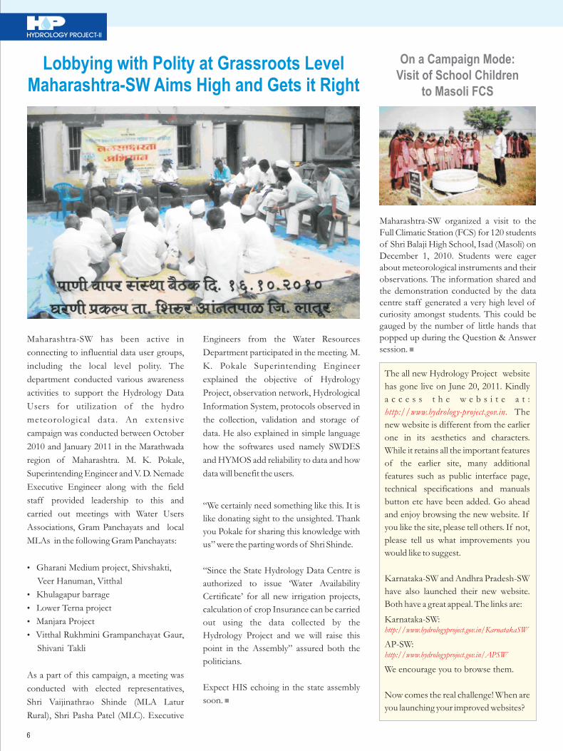
Lobbying with Polity at Grassroots LevelMaharashtra-SW Aims High and Gets it Right
Maharashtra-SW has been active in
connecting to influential data user groups,
including the local level polity. The
department conducted various awareness
activities to support the Hydrology Data
Users for utilization of the hydro
meteorological data. An extensive
campaign was conducted between October
2010 and January 2011 in the Marathwada
region of Maharashtra. M. K. Pokale,
Superintending Engineer and V. D. Nemade
Executive Engineer along with the field
staff provided leadership to this and
carried out meetings with Water Users
Associations, Gram Panchayats and local
MLAs in the following Gram Panchayats:
• Gharani Medium project, Shivshakti,
Veer Hanuman, Vitthal
• Khulagapur barrage
• Lower Terna project
• Manjara Project
• Vitthal Rukhmini Grampanchayat Gaur,
Shivani Takli
As a part of this campaign, a meeting was
conducted with elected representatives,
Shri Vaijinathrao Shinde (MLA Latur
Rural), Shri Pasha Patel (MLC). Executive
Engineers from the Water Resources
Department participated in the meeting. M.
K. Pokale Superintending Engineer
explained the objective of Hydrology
Project, observation network, Hydrological
Information System, protocols observed in
the collection, validation and storage of
data. He also explained in simple language
how the softwares used namely SWDES
and HYMOS add reliability to data and how
data will benefit the users.
“We certainly need something like this. It is
like donating sight to the unsighted. Thank
you Pokale for sharing this knowledge with
us” were the parting words of Shri Shinde.
“Since the State Hydrology Data Centre is
authorized to issue ‘Water Availability
Certificate’ for all new irrigation projects,
calculation of crop Insurance can be carried
out using the data collected by the
Hydrology Project and we will raise this
point in the Assembly” assured both the
politicians.
Expect HIS echoing in the state assembly
soon. n
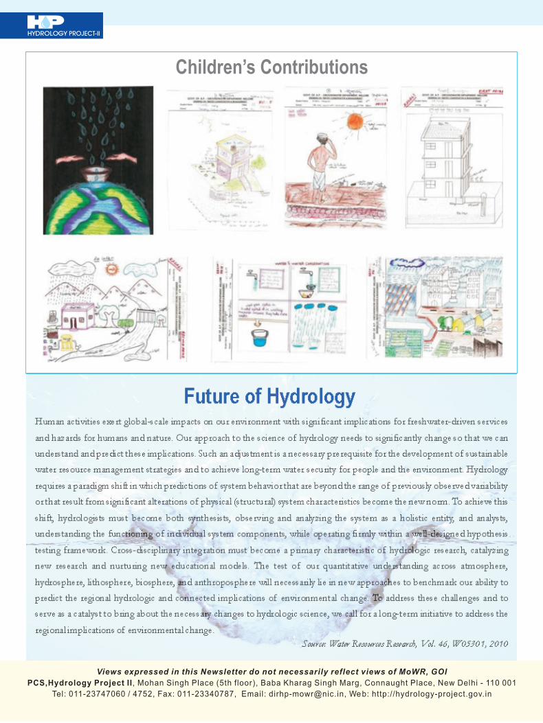
On a Campaign Mode: Visit of School Children
to Masoli FCS
Maharashtra-SW organized a visit to the Full Climatic Station (FCS) for 120 students of Shri Balaji High School, Isad (Masoli) on December 1, 2010. Students were eager about meteorological instruments and their observations. The information shared and the demonstration conducted by the data centre staff generated a very high level of curiosity amongst students. This could be gauged by the number of little hands that popped up during the Question & Answer session. n
The all new Hydrology Project website
has gone live on June 20, 2011. Kindly
a c c e s s t h e w e b s i t e a t :
The
new website is different from the earlier
one in its aesthetics and characters.
While it retains all the important features
of the earlier site, many additional
features such as public interface page,
technical specifications and manuals
button etc have been added. Go ahead
and enjoy browsing the new website. If
you like the site, please tell others. If not,
please tell us what improvements you
would like to suggest.
Karnataka-SW and Andhra Pradesh-SW
have also launched their new website.
Both have a great appeal. The links are:
Karnataka-SW:
AP-SW:
We encourage you to browse them.
Now comes the real challenge! When are
you launching your improved websites?
http://www.hydrology-project.gov.in.
http://www.hydrologyproject.gov.in/KarnatakaSW
http://www.hydrologyproject.gov.in/APSW

7
HYDROLOGY PROJECT-II
International Training (January to June 2011)
The following participants attended ten different international training programs that have been conducted between January and June 2011. 1. Water Quality Assessment held at UNESCO-IHE,
th thNetherlands from 7 Feb to 25 Feb 2011 (Duration:19 days).
Learning objectives
The objective of this course was to acquaint participants with the
principles, techniques and management issues used in water quality
description, monitoring and assessment. This course covered the
subject matters such as Water quality and monitoring, Data analysis
and presentation, Aquatic ecotoxicology, Water quality modeling,
Fieldwork water quality monitoring and Excursion in the field of
water quality monitoring and/or modeling.
2. Environmental Monitoring and modeling held at th thUNESCO-IHE, Netherlands from 28 March to 15
Apr-11 (Duration: 19 days).Learning objectives
The objective of this course was to acquaint participants with the
principles, techniques and management issues used in environmental
monitoring and assessment. This course covered the subject matters
such as Water and groundwater quality monitoring, Air quality
monitoring, Water quality modeling, Environmental Information
Management using eg GIS and DSS and Excursion in the field of
water quality monitoring and/or modelling.
Sr. No. Name Designation &
Department
1 Sh. Rajesh Chandra Sc-C, CGWB
2 Sh. Sushil Kumar Director, NWA, CWC
3. Financial Management of Water Organization held at th thUNESCO-IHE, Netherlands from 28 March to 15 Apr
11 (Duration :19 days) Learning objectives
The objective of this course was to prepare participants for positions
of leadership in water sector and utility management. This course
covered the topics as need for commercial accounting and the
components of standard financial statements in irrigation, water and
sanitation entities, to assess the financial position of a water
organisation through an analysis of financial statements.
4. Hydrological Data Collection and Processing held at th thUNESCO-IHE, Netherlands from 28 March to 15
April 2011 (Duration:19 days)
This course addressed aspects of data collection, data processing,
data archiving as well as issues related to providing hydrological
services from an operational point of view.
Sr. No. Name Designation &
Department
Central IAs
1 Sh. Asit Chaturvedi Dy.Comm.(BM),
MoWR, New Delhi
2 Sh. K. V. Prasad EE, Snow hydrology
Divn. Shimla, CWC
3 Sh. G. Rambabu EE, UGD, CWC,
Hyderabad
State IAs
1 Sh. Sanjeev Kaul Executive Engineer,
Shimla, HP
2 Sh. R.B. Ghanti Executive Engineer
Works Division III Water
Resources Department
Ponda-Goa
5. Water and Environmental Law and Institutions held at th thUNESCO-IHE, Netherlands from 26 Apr to 13 May
11 (Duration :18 days)
This short course introduced the participants to theoretical and
practical aspects of water and environmental resources management
from a legal and policy perspective. Course also focused on multi-
level governance from global through to local levels and teaches
skills needed in order to improve the institutions needed for water
and environmental management.
6. Introduction to River Flood Modelling held at UNESCO-th thIHE, Netherlands from 26 Apr to 13 May 11
(Duration:18days) This course introduced the participants to the state-of-the-art concepts and practices of flood modelling for management. It also covered the modelling used for planning and design as well as for forecasting floods so that mitigating measures can be taken in time.
Sr. No. Name Designation &
Department
1 Sh. Rajeev Kumar Director (GW),
MoWR, New Delhi
2 Sh. S. K. Swaroop Scientist 'B', CGWB
Sr. No. Name Designation & Department
1 Sh. N. Mukherjee SJC, MoWR, New Delhi
Sr. No. Name Designation &
Department
1 Dr. P.K. Mehrotra Director (Estt.),
MoWR. New Delhi
2 Sh. O.R.K. Reddy Executive Engineer,
LKD,Central Water
Commission, MoWR
3 Dr. M.K. Sharma Sc-C, NIH, Roorkee

HYDROLOGY PROJECT-II
8
Sr. No. Name Designation &
Department
Central IAs
1 Sh. Avanish Kant Sr. Hydrogeologist,
MoWR
2 Dr. M. S. Rao Scientist C, NIH,
Roorkee
3 Sh. Sunil Kumar Suptd. Hg, CGWB
4 Sh. S.K.Sinha Sc'D', CGWB
5 Sh. Pratul Saxena Sc-C, CGWB
State IAs
1 Sh. Kishor N. Deshmukh Assistant Geologist,
GSDA. Thane, Mah
(GW)
2 Sh. Sanjeev Soni Assistant Engineer,
Santokgarh, HP
3 Sh. Pradeep Mishra Geological Assistant, MP
Sr. No. Name Designation & Department
Central IAs1 Dr. P. K. Bhunya Scientist E-1, NIH Roorkee2 Sh. Anupam Prasad Director, Dte., CWC3 Sh. Vijay Saran Director BCD (E&NE),
New Delhi CWCState IAs1 Sh. Anil Mehta Executive Engineer, Shimla,
HP2 Sh. Shailesh K. Naik Technical Assistant Works
Division III Water Resources Department
7. Short Course on Regulation : London School of
Economics (LSE) Executive Training Programme held at thLondon School of Economics, United Kingdom from 25
thApr to 29 April, 2011 (Duration: 5days )
This course offered the introduction to the full range of economic,
legal and political issues in regulation. It also provided the strategies
to lower costs and to design efficient regulatory systems and
responses.
Sr. No. Name Designation & Department
Central IAs1 Sh. D. K. Jena DC (NE), B&B
Wing, MoWR, New Delhi2 Sh. S. Kunar Member (SAM), CGWBState IAs1 Sh. Ratnakar Jha Project Administrator, WB
Projects, MP
8. Flood risk management held at UNESCO-IHE, th stNetherlands from 14 June to 01 July 2011
(Duration :18days) This course introduced the participants to the state-of-the-art concepts and practices of flood risk management. It covered the experience in managing floods and stresses in the use of the latest tools in flood risk management such as flood inundation modelling, flood risk mapping, flood hazard mapping and decision and evacuation support systems.
Sr. No. Name Designation & Department
Central IAs1 Sh. Narendra Kumar Commissioner, B&B
Wing, MoWR2 Sh. Pankaj Kumar Sharma Dy. Director, RD Dte.,
CWC3 Sh. Jaiveer Tyagi Scientist E- 2, NIH,
RoorkeeState IAs1 Sh. Hemant Puri Assistant Engineer,
Shimla, HP2 Sh. D. A. Bagade Executive Engineer,
Basin Simulation Division, Pune Maharashtra.
9. Managing Water Organisations held at UNESCO-th stIHE, Netherlands from 14 June to 01 July 2011
(Duration:18 days)
This course introduced the participants for leadership in water sector
and utility management, the essential elements within the field of
organisational and change management and covered the topics such
as: Organisational perspectives; organisations and institutions,
institutional analysis; organisational behaviour, organisational
structure, the behaviour of people in organisations and the
behaviour of organisation.
Sr. No. Name Designation &
Department
Central IAs
1 Sh. Bhupinder Singh Sr.Jt. Commissioner
(BM), MoWR
2 Sh. Sudhir Garg JS (Admn.), MoWR
3 Dr. Rakesh Kumar Scientist F, NIH,
Roorkee
State IAs
1 Sh. R.K. Rajak Assisstant
GeoHydrogeologist, M.P.
10. Applied Groundwater Modelling held at UNESCO-IHE, th stNetherlands from 14 June to 01 July 2011 (Duration
:18days) This course introduced the participants with principles and procedures of groundwater modelling and the use of computer models for groundwater resources management and protection. Also the course taught the participants how to construct a groundwater model and use the model to simulate groundwater flow, contaminant transport and salt water intrusion.
“When the well is dry, we know the worth of water”
Benjamin Franklin, (1706-1790).
Poor Richard's Almanac, 1746

HYDROLOGY PROJECT-II
Real Time Data Acquisition System (RTDAS) and Flood Management
9
Floods are most common and wide spread of all natural disasters. It is an endemic problem most frequently encountered in our country. Out of the total geographical area of 329 MHa, around 40 MHa is flood prone. This figure has been revised to 33.5 MHa in a recent publication of the Ministry of Water Resources. On an average, 7.5 MHa area is affected by floods in any one year, in some or other part of the country. The traditional f lood management measures in practice focus only on reducing flooding and susceptibility to flood damage. In most of the cases, such measures are problem driven and carried out in isolation. But the need of the time is to opt for an integrated flood management system including both structural and non-structural measures, thereby promoting an in t eg r a t ed approach ( r a the r than fragmented) for development and management of both land and water resources in a river basin. The ultimate objective should be maximizing the net benefit from the flood plains and minimizing the loss to life and property from flooding.
The structural measures involve physical works for modifying flood magnitude with a view to keep the flood away from people, whereas the non-structural measures are planned activities to modify susceptibility to flood damage and are meant to keep people away from floods.
The s t r uctura l measures inc lude construction of dams and reservoirs, flood protection embankments and levees, channel improvement to increase flood carrying capacity, detention basins for retarding and absorbing flood water, improvement in the existing drainage system, inter-basin transfer depending on feasibility and many more.
Similarly, the non-structural measures include flood forecasting and warning, flood plain zoning, immediate flood fighting measures, flood insurance to cover damage and health impacts, and relief and rehabilitation work.
Keeping in view the advantages and disadvantages of both the measures, the Engineers and Technocrats have most often opined for an appropriate and judicious mix
of these measures to secure optimum results in saving the lives and properties prone to flood. The structural measures by themselves are dependent on and guided by the prevailing laws related to rehabilitation and resettlement. It also involves laws of the land concerning forestry and land use. This is the reason why, in spite of the requirement, the authorities are unable to adopt these measures. In comparison the nonstructural measures are easier to follow and dependable at par. Most of such measures are common events during each flooding. While relief and rehabilitation works are almost administrative in nature, the other measures described under the head are technical. As the structural measures alone cannot completely overcome the hazards of flood, no matter how high the design standards are, there is always the risk of higher floods exceeding the standard. Flood forecasting and early warning is the most effective non-structural measure to reduce the loss of life and properties in vulnerable areas.
A reliable early warning system can reduce the loss of life and properties to a considerable extent by shifting the people to safe and secured place and evacuating the area likely to be inundated.
Concept of Data Acquisition SystemThe data acquisition system (DAS) comprises two segments, the data collection segment and the data communication segment. Different equipments are used for data collection in respect of water level data and rainfall data. The data acquisition segment comprises a sensor, data acquisition controller/ data logger and an integrated power controller. Data communication segment comprises the data communication equipment at site, all intermediate components and the net work controller/web server at Data Processing Centre (DPC).
Sensor- Sensors can be of different types depending on the site conditions. Different types of sensors available include vented gauge pressure sensor, float operated shaft encoder type, bubblers, Ultra sonic and radar gauge. Out of these sensors, the last two are non-contact type sensors.
Data Logger- The data logger acts as the
system controller for power to the sensors, acquires the sensor signals and prepares the telemetry message for transmission. The other task of the data logger is to record all acquired data for later retrieval.
Server- A server is placed in the Data Processing Centre and connected to PC for retrieval and processing of data.
Data Communication System The telemetry message prepared by the data logger is communicated to PC through the server. This communication can be satellite linked, radio operated or cellular transmission based on GPRS. The cellular communication is similar to the cell phone system. Transmission is made through the existing telecom network designed for voice and message communication using SIM card. A dedicated modem is used to capture the data from the data logger and power it to a particular IP address or web server placed at DPC. The battery gets charged through a solar panel attached to the device to supply an uninterrupted power. The acquired data is transmitted to PC through the server for processing and validation. The advantages with the system include low investment and maintenance cost, low profile and non-d i r e c t i o n a l a n t e n n a , t w o w a y communication facil ity and event notification through SMS.
The Real Time Data Acquisition System (RTDAS) will be consisting of Dedicated Data Logger, GPRS Modem, Sensors, Battery, Solar Panel, Enclosure and a standard stand. The required data will be sensed by sensor and logged in to Data Logger at certain interval specified by the user. The same data is transmitted through GPRS Modem at a defined interval to a dedicated web server. The GPRS service can be availed through service providers operating in the region. The reports can be generated as per user requirement in excel format and graphically.
Pressure SensorPressure sensors are submerged at a fixed level under the water surface. The pressure sensor measures the equivalent hydrostatic pressure of the water above the sensor diaphragm. It is like weighing the water.

HYDROLOGY PROJECT-II
10
Encoder/Floats:Encoders, potentiometers, linear variable differential transformers, and synchros are float-operated sensors using a float and counter weight attached to a cable or lines that is placed around the float-operated sensor's pulley. Advantages of Float-operated sensors for water level measurements are:
· Since many older sites were designed for mechanical f loat operated measurement, encoders are easily adapted to existing float gear and gauging system.
· Float-operated systems are easy to understand and troubleshoot.
· Most encoders offer good temperature stability.
· Various electronic technologies can be used including digital incremental and digital absolute (encoders); analog absolute (potentiometers and Linear variable differential transformers); or digital absolute (synchros).
· Float is protected in a stilling well and sensor is not in direct contact with the water. Therefore, the risk of damage is low from debris flow or fouling.
· Highly accurate with large sized floats.
BubblersBubblers are absolute sensors similar to pressure sensors, and are either digital or analog. A bubbler's enclosures typically include an air compressor, pressurized air tank, pressure sensor and air flow regulator. Air from the compressor or air tank is forced through the plastic bubble tube resulting in bubblers coming out of the tubes orifice. This action will cause the pressure in the tube to be equivalent to the depth of water located above the tube's orifice. The changing head above the bubble orifice causes a corresponding pressure change which is reflected back through the system to provide a water level measurement by a precision pressure transducer, located at the other end of the tube in the bubbler's enclosure.
UltrasonicBoth ultrasonic and sonic level instruments operate on the basic principle of using sound waves to determine fluid level. The frequency range for ultrasonic methods is ~20~200kHz, and sonic types use a frequency of 10 kHz. The transducer directs sound waves downward in bursts onto the surface of the water. Echoes of these waves return to the transducer, which performs calculation to convert the
distance of wave travel into a measure of level/ head. Radar GaugeRadar sensor is a high accuracy-measuring instrument for measuring the surface water level without direct contact. It is insensitive to mudding, drifting material, weeding and aggressive media as sewage and brackish water etc. The few construction works like mounting at a bridge jib does not result in narrowing measuring cross-section and eventually does not disturb the channel hydraulics.
There is no influence to the measurement accuracy due to air humidity (fog) or air temperature fluctuations within the measuring range. Further advantages offer the low energy consumption, the short measuring cycle, no dead angle and the short mounting distance.
The measuring principle, the so-called pulse procedure, sends a short microwave impulse. Then the transmitter has a short rest. Within this time it receives the response signals reflecting from the water and transmits them to the integrated
evaluation system. The run time of the impulses corresponds directly to the distance to the actual water level.
Conclusion Manual observation and transmission of hydro-meteorological data involves the risk of delay and accuracy. The magnitude of flood and computation of lead time based on such information may lead to incorrect prediction. As most of the river gauging sites is located at remote places, the reporter may show reluctance in collecting higher frequency data, thereby skipping the peak on different occasions. Such risks can be avoided through automation of gauging stations and real time transmission. The reservoir level and the trend of rise/ fall can also be monitored directly from Data Processing Centre (DPC) with the help of such real time data. After receipt of hydro-meteorological data, the same is processed and validated by the engineers stationed in DPC through dedicated software to prevent chances of error. The error free data is utilized for forecasting the flood volume as well as the travel time at identified reaches of the stream using suitable models. n
Water and Sanitation Service Delivery PDS adds Value in the High Hills of Shimla
Under Hydrology Project-II several “value added” Purpose Driven Studies (PDS) have been taken up to study water quality problems of the concerned area. For Himachal Pradesh, a PDS was conceived on an important water quality problem of the capital city of Shimla. The study is related to contamination of drinking water source by sewage. The sewage contaminated water had caused Hepatitis A outbreak in the city some time in 2007.
Hepatitis A is an enterically transmitted viral disease. The infection occurs primarily due to ingestion of contaminated food and water and person-to-person contacts. Common source outbreaks occur due to faecal contaminated food and water. The average incubation period is 25-30 days. In order to understand the main cause for such contamination and suggest remedial measures a study has been initiated by Irrigation and Public Health (I&PH) Department, Himachal Pradesh. I & PH Department is the implementing agency for Hydrology Project in Himachal Pradesh. The study is being carried out with
help of National Institute of Hydrology (NIH) , Roorkee , because I&PH Department has not yet established laboratory and other infrastructure required for the study. The study was conceived with following objectives:
· To study water quality and basin
characteristics;
· To understand performance of Sewage
Treatment Plants;
· To identify contamination source
identification;
· To suggest possible remedies;
· To disseminate knowledge to decision
makers and others
Drinking Water SupplyDrinking water is supplied through five water supply systems namely Seog, Cherot and Jagroti Nallh, Chair Nallh, Nauti Khud and Ashwani Khud to Shimla. Jaundice cases were noted mainly from the localities receiving water from Ashwani Khud water supply system. This system was installed in

HYDROLOGY PROJECT-II
11
1992. Water is sourced from Ashwani khud, a natural stream, chlorinated, pumped to Kawalag storage plant and then to Kusumpti tank where it is chlorinated again before distribution. For the past one year treated sewage water from Malayana sewage treatment plant was let in to the Ashwani Khud water stream, four kilometers upstream of the collection point. Two months before the 2007 outbreak, chlorination was replaced with silver ionization at Kusumpti storage tank. However, chlorination was reintroduced on February 28, 2007 and since then the water is continued to be treated with chlorine.
Sewage ManagementShimla Municipal Area has a well-laid underground sewerage system and is maintained by I&PH Department. The first sewerage network was laid in the year 1880 to serve the then population of 18,000. In year 2005, under the assistance from OPEC and state funding, a new sewerage network for Shimla was designed and implemented. This is expected to cater to the projected demand of 2031. The network of new sewerage system in Shimla is about 179 km and diameter of sewer pipes ranges from 150 mm to 800 mm. The network covers 90% of municipal area serving up to 80% of the population. Special areas, which are now merged in Shimla Municipal Corporation remain un-served.
There are six Sewage Treatment Plants (STPs) in Shimal with total capacity of 35.63 MLD. I&PH Department is undertaking the operation & maintenance
of these STPs on a management contract basis. The treatment plants are working below their capacity due to non-existence of sewerage connectivity to entire Shimla area. Although the sewerage network is covering 90% of the city, people have not taken connections. For example, Shimla has about 22,000 water connections, but has only about 12,000 sewerage connections. This clearly indicates that a large population of the city is yet to be connected to sewerage systems. The reason for this unwillingness of people to obtain sewage connection is unknown. This has resulted in large part of the sewage not being transported to the sewage treatment plants for treatment and raw sewage often gets into Ashwani Khad.
So far the study results have established that the treatment plant is not working to its optimum capacity and needs proper operation and maintenance and further up-gradation. There are also high likelihood of contamination of drinking water in the water supply network as evident from some of the results. This needs further study. It was also revealed that the treatment plant needs to be operated based on regular monitoring of the operation parameters to get optimum performance. Since the water supply is intermittent, chances of contaminated water being sucked through the leakages are also high. Detailed study is required in the affected areas.
The study suggested the following measures for immediate remediation:
· Connect 100% of the houses and establishments to the sewer system, particularly in the catchments of Ashwani Khad.
· Rehabilitate the sewerage network
including main line in order to prevent
leakages and to provide linkages to the
new network and main transmission
line leading to STPs
· Augment sewerage network for areas
of Dhalli, Tutu, New Shimla and
Special Areas of Ghanahatti, Kufri and
Shoghi and provide new sewage
ne twork . T h i s sha l l i n c l ude
construction of 7 STPs to serve the
proposed sewerage network.
· Enforce tariff notification on sewerage
to ensure effective operation and
maintenance of STPs and sewerage
system.
As the study progresses further, we expect
to gain new insights. This is a classic
example of how HIS can add value to water
and sanitation service delivery system. n
Training on ‘Leadership’ in Gujarat receives a 'Thumbs Up’
National Water Academy (NWA) Pune, in collaboration with TAMC conducted a two day in-house training program on June 1, and 2, 2011 for senior officers of the Water Resources Department in their State Data Centre at Gandhi Nagar. The title of the program was “Leadership Effectiveness, Managerial Skills and Influencing Change” and 27 participants participated. The training program was the outcome of a dialogue between the State Water Resources Department and NWA. The need for such a training was raised by WALMI staff sometime in March 2011 and WAMI and NWA engaged in discussions on the modalities with TAMC providing back stopping support.
The workshop covered leadership skills, effectiveness of departmental heads, and importance of influencing change, staff development and personal effectiveness. The program content was a blend of concept clarity and skill development, with a number of exercises and experiential games thrown in.
An open feedback session was held at the end of Day 2 and the participants gave the program ‘Thumbs Up’. The department requested NWA to conduct a skill development program for junior level staff.
If any of IAs are interested in similar program, please pick up your phone and give a tinkle to Mr. Narayan Bhat, Change Management Specialist, TAMC at 011-43724385. n
HYDROLOGY PROJECT-II
PCS,Hydrology Project II, Mohan Singh Place (5th floor), Baba Kharag Singh Marg, Connaught Place, New Delhi - 110 001
Tel: 011-23747060 / 4752, Fax: 011-23340787, Email: [email protected], Web: http://hydrology-project.gov.in
Views expressed in this Newsletter do not necessarily reflect views of MoWR, GOI
Children’s Contributions
Future of HydrologyHuman activities exert global-scale impacts on our environment with significant implications for freshwater-driven services
and hazards for humans and nature. Our approach to the science of hydrology needs to significantly change so that we can
understand and predict these implications. Such an adjustment is a necessary prerequisite for the development of sustainable
water resource management strategies and to achieve long-term water security for people and the environment. Hydrology
requires a paradigm shift in which predictions of system behavior that are beyond the range of previously observed variability
or that result from significant alterations of physical (structural) system characteristics become the new norm. To achieve this
shift, hydrologists must become both synthesists, observing and analyzing the system as a holistic entity, and analysts,
understanding the functioning of individual system components, while operating firmly within a well-designed hypothesis
testing framework. Cross-disciplinary integration must become a primary characteristic of hydrologic research, catalyzing
new research and nurturing new educational models. The test of our quantitative understanding across atmosphere,
hydrosphere, lithosphere, biosphere, and anthroposphere will necessarily lie in new approaches to benchmark our ability to
predict the regional hydrologic and connected implications of environmental change. To address these challenges and to
serve as a catalyst to bring about the necessary changes to hydrologic science, we call for a long-term initiative to address the
regional implications of environmental change.
Source: Water Resources Research, Vol. 46, W05301, 2010


![[hydrology] groundwater hydrology - david k. todd (2005).pdf](https://img.pdfslide.net/doc/110x75/577c77961a28abe0548cb0b1/hydrology-groundwater-hydrology-david-k-todd-2005pdf.jpg)


![[Hydrology] Groundwater Hydrology - David K. Todd (2005)](https://img.pdfslide.net/doc/110x75/548ce7beb47959e2288b45f9/hydrology-groundwater-hydrology-david-k-todd-2005.jpg)