Embed Size (px)
Citation preview

I-680 Investment Options AnalysisI-680 Investment Options Analysis
Prepared for
Contra Costa Transportation Authority
Prepared by
DKS Associates
May 19, 2003
in association with
CH2M Hill
Final Report

1956 Webster Street Suite 300 Oakland, CA 94612
(510) 763-2061 (510) 268-1739 fax www.dksassociates.com
May 19, 2003 Hisham Noemi Contra Costa Transportation Authority Hookston Square 3478 Buskirk Ave., Suite 100 Pleasant Hill, CA 94523 Subject: I-680 Investment Options Analysis – Final Report P/A#: 02214-000x004 Dear Hisham: DKS Associates is pleased to present the Final Report for the I-680 Investment Options Analysis study conducted for the CCTA. Enclosed are thirty (30) bound copies and one (1) unbound copy of this report. Electronic copies of this report, in both WORD and pdf formats, will follow shortly along with a copy of the Technical Work Products document. Thank you for the opportunity to assist you with this challenging project. We look forward to working with you in the future. Sincerely, DKS Associates A California Corporation Terry Klim Senior Project Manager
P:\P\02\02214\docs\Task 4 - Report\Final\transmit letter.doc

I-680 Investment Options Analysis Final Report
Prepared for Contra Costa Transportation Authority
Prepared by
DKS Associates 1956 Webster Street, Suite 300 Oakland, CA 94612 (510) 763-2061
In association with:
CH2M HILL
May 19, 2003

DKS Associates
I-680 Investment Options Analysis i May 19, 2003 Final Report
TABLE OF CONTENTS
EXECUTIVE SUMMARY.........................................................................................................1 1.0 INTRODUCTION ..........................................................................................................5 2.0 CORRIDOR TRANSPORTATION CHARACTERISTICS..........................................9
2.1 Roadway Network...................................................................................................9 2.2 Transit Service ......................................................................................................12 2.3 Travel Characteristics ...........................................................................................13 2.4 Right-of-Way Analysis .........................................................................................17
3.0 INITIAL INVESTMENT OPTIONS............................................................................18 3.1 Terminology..........................................................................................................18 3.2 Initial Option Packages .........................................................................................18
4.0 SCREENING OF INITIAL INVESTMENT OPTIONS ..............................................22 4.1 Screening Process .................................................................................................22 4.2 Screening Results ..................................................................................................23
5.0 OPTION PACKAGES DESIGNATED FOR FURTHER EVALUATION.................26 5.1 Option Package A: BART.....................................................................................26 5.2 Option Package B: Light Rail Transit (LRT) (I-680) ...........................................26 5.3 Option Package C: Light Rail Transit (I-680/Dougherty Valley).........................29 5.4 Option Package D: HOV Facilities/Express Bus Package....................................29 5.5 Option Package E: HOV to HOT Lane Conversion .............................................32
6.0 DETAILED EVALUATION OF FIVE OPTION PACKAGES ..................................34 6.1 Evaluation Criteria ................................................................................................34 6.2 Evaluation Results.................................................................................................35 6.3 Other Observations ...............................................................................................37
7.0 RECOMMENDATION FOR PREFERRED INVESTMENT OPTION......................38 8.0 NEXT STEPS ...............................................................................................................40
8.1 Measure C Reauthorization...................................................................................40 8.2 Project Implementation .........................................................................................40
APPENDICES Appendix A Technical Memorandum #1 – Needs Analysis Appendix B Technical Memorandum #2 – Investment Options Appendix C Technical Memorandum #3 – Screening of Investment Options Appendix D Technical Memorandum #4 – Evaluation of Preferred Option Packages Appendix E Option Summary Sheets

DKS Associates
I-680 Investment Options Analysis ii May 19, 2003 Final Report
LIST OF FIGURES
Figure 1-1 Study Area.................................................................................................................6 Figure 2-1 Roadway Network and Freeway Volumes (2000) ..................................................10 Figure 2-2 Major Trip Generators............................................................................................14 Figure 2-3 Screenline Trip Distribution (AM Peak) ................................................................16 Figure 5-1 Option Package A: BART Rail ..............................................................................27 Figure 5-2 Option Package B: Light Rail Transit (I-680)........................................................28 Figure 5-3 Option Package C: Light Rail Transit (I-680/Dougherty Valley)..........................30 Figure 5-4 Option Package D: HOV Facilities/Express Bus Package.....................................31 Figure 5-5 Option Package E: HOV to HOT Lane Conversion ..............................................33
LIST OF TABLES
Table ES-1 Recommended Investment Option – Improvement Elements ................................4 Table 2-1 Existing Express Bus Service in the I-680 Corridor................................................12 Table 4-1 Initial Investment Option Screening Results ...........................................................24 Table 6-1 Summary of Comparative Evaluation Results.........................................................35 Table 7-1 Priorities Within the Preferred Investment Option D: HOV Facilities/Express Bus
Package ..............................................................................................................................39
P:\P\02\02214\docs\Task 4 - Report\Final\I-680 Report - final.doc

DKS Associates
I-680 Investment Options Analysis 1 May 19, 2003 Final Report
EXECUTIVE SUMMARY In recent years, the I-680 corridor between Walnut Creek and Dublin has experienced significant growth in terms of both development and traffic volumes. Between 1990 and 2000, the number of households within the Contra Costa portion of the Tri-Valley area grew by almost 30 percent. Over this same time, employment grew by nearly 35 percent, notably with the development of Bishop Ranch and the addition of major employers such as Chevron, Pacific Bell/SBC Communications and PG&E. This development growth has led to significant growth in travel both within the corridor, as well as between the corridor and points outside. Furthermore, growth throughout the San Francisco Bay Area, including the development of major employment centers in Pleasanton and the Silicon Valley, has lead to significant increases in the number of trips traveling through the corridor.
As a result, congestion has increased, and recent studies show significant worsening for the future. While operational improvements, such as new auxiliary lanes, and express bus improvements are expected to provide some benefits, they will by no means fully address the congestion forecast for I-680. Thus, the I-680 Investment Options Analysis Study was initiated to examine long range, major capital investment opportunities for the corridor.
The I-680 Investment Options Analysis Study, as a planning-oriented effort, involved the qualitative analysis of a number of potential investment options. A full range of multi-modal options was considered. In response to community concerns, however, these options excluded the addition of mixed-flow lanes on I-680 and the construction of at- or above-grade facilities along the Iron Horse Trial. The Iron Horse Trail runs north-south along the I-680 corridor. It is an abandoned rail right-of-way which has been transformed into a multi-purpose bicycle/pedestrian trail.
A consultant team lead by DKS Associates was selected to perform the study. Technical guidance and review was provided through the involvement of a Technical Advisory Committee (TAC) comprised of staff members of local jurisdictions, the County, CCTA, and transit agencies. Staff to local elected officials and representatives of Alameda County also participated. Policy guidance and input at key decision points was provided by a Policy Advisory Committee (PAC) comprised of local elected officials.
The first step in this study was the identification of a range of investment options. A workshop attended by a wide range of stakeholders was conducted to help identify these options. From this workshop and the work of the DKS Team, 14 initial options were identified. These options included:
• BART Underground • BART I-680 Median • BART -- Parallel Corridor - Above Ground • BART DMU -- I-680 Median • Light Rail in the I-680 Median • Light Rail West of I-680 • Light Rail East of I-680 • Phased Busway to Light Rail • Busway in I-680 Median

DKS Associates
I-680 Investment Options Analysis 2 May 19, 2003 Final Report
• I-680 Bus Lane on Shoulder • Express Bus Focus Package • HOV Focus Package • HOT Median Lanes • HOV to HOT Lane Conversion
Due to similarities in service characteristics and alignment considerations, the light rail transit (LRT) technology was defined at this time to include not only “traditional” LRT, but a variety of new rail technologies such as maglev or monorail, with the concept being that if LRT was determined to be the preferred option, then the specific technology would be defined at a later stage. Although diesel multiple unit (DMU) rail could have also been incorporated into this category as well, it was kept separate at this point because this specific technology is being considered as part of separate BART extension studies.
The initial options were then screened to identify a subset of alternatives for further analysis. The initial screening was conducted by the DKS Team. Following review of the screening results by the TAC and PAC, the following five options were selected for further study.
Option A. BART – from Walnut Creek BART station to the proposed West Dublin BART station;
Option B. Light Rail Transit (I-680) – from Walnut Creek BART station to the proposed West Dublin BART station primarily within the I-680 Median;
Option C. Light Rail Transit (I-680/Dougherty Valley) – from Walnut Creek BART station to the Dublin/Pleasanton BART station following the I-680 Median and Bollinger Canyon Road;
Option D. HOV Facilities/Express Bus Package – HOV lane and ramp improvements plus additional express bus service; and
Option E. HOV to HOT Lane Conversion – conversion of existing HOV lane to HOT lane.
Summaries of each of these options are also provided in Appendix E.
A qualitative evaluation was then conducted on these investment options. This evaluation examined estimated cost, travel time impacts, potential mode shift, markets served, connectivity, construction impacts, potential environmental impacts, conflicts with other traffic, and constructability issues. In addition to these evaluation criteria, observations were noted during the course of the study related to community acceptability and funding sources.
As a result of this evaluation, Option D: HOV Facility/Express Bus Package was selected as the preferred option to be pursued further as part of the Measure C Reauthorization. Some of the major benefits of this package are:
• It is consistent with existing plans, • It provides additional mobility to transit and HOV users, and • It falls within a range of costs that are reasonably encompassed within the Measure C
Reauthorization.

DKS Associates
I-680 Investment Options Analysis 3 May 19, 2003 Final Report
Options A through C were found to be too expensive to construct, even with the passage of the Measure C renewal. Option E, although the lowest cost option, was found to have limited effectiveness on congestion relief.
The recommended investment option consists of several major elements that may potentially be implemented independently. A description of these elements, along with an estimated cost range for each, is provided in Table ES-1.
Through this study, a recommended direction for transportation system investment in the I-680 corridor has been identified. However, several steps remain before this investment can be realized. The remaining steps to get this package included in the Measure C Reauthorization are:
• Present study results to SWAT and TRANSPAC for consideration;
• Request that SWAT and TRANSPAC forward recommended investment option to CCTA for consideration in the new measure; and
• Develop financial plan for the project and conduct more analysis/design of the different components of the package.
With respect to the individual improvement elements, future steps generally include conducting more detailed assessment, securing the necessary funding, and completing the detailed designs.

DKS Associates
I-680 Investment Options Analysis 4 May 19, 2003 Final Report
Table ES-1 Recommended Investment Option – Improvement Elements
Priority Improvement Element Estimated Capital Cost (1)
1
New Express Bus Service – Additional service between the study area and Martinez, East County, and Fremont/San Jose consistent with the Enhanced Scenario recommendations from the Express Bus Study; eight new buses in this service area; and expansion of the existing CCCTA maintenance facility to accommodate additional buses. (2)
$ 6.2 M (3)
2
Norris Canyon HOV Direct Ramps – Includes reconstruction of overcrossing, widening of median, construction of new HOV-only on- and off-ramps in both the northbound and southbound directions, and modifications to the local street network. The ramps would be HOV only for the same hours of operation as the HOV lanes.
$ 44.1 M
3 San Ramon Transit Center Enhancements – Includes expanded parking to be achieved through lease agreements with adjacent properties.
(4)
4
Southbound HOV Lane Extension – North (North Main to Livorna) – Through the SR 24 junction, this element includes conversion of one lane through the interchange from mixed-flow to HOV use. Three remaining mixed-flow lanes are consistent with the three southbound mixed-flow lanes at Livorna.
$ 11.6 M
5
HOV Lane Extension – South (Alcosta to south of the I-580 Junction) – Includes restriping the median and widening the outside shoulder to create the width necessary to extend the HOV lanes through the interchange. May require design exemption to accommodate additional lane.
$ 6.3 M (5)
6 Northbound HOV Lane Extension – North (Livorna to North Main) – Through the SR 24 junction, this element includes a new HOV flyover structure.
$ 115.6 M
7 Sycamore Valley HOV Direct Ramps – Includes reconstruction of interchange, widening of median, and construction of new HOV-only on- and off-ramps in both the northbound and southbound directions.
$ 66.2 M
NOTES: (1) All costs are in 2002 $s.
(2) The additional express bus service would not replace or compete with existing bus service. Specifically, the Bishop Ranch (Sunset Development) express bus service.
(3) Includes $3.0 M for expansion of the existing CCCTA maintenance facility, and $3.2 M for purchase of eight buses. This element also includes an estimated $1.6 million increase in annual bus transit operating costs. This value represents the estimated operating cost for the portion of each new service within the study area. Additional costs would be associated with the portion of each route outside the study area.
(4) Cost for this element was not estimated because of the uncertainty of future lease arrangements.
(5) Most of this cost is for improvements in Alameda County
Source: DKS Associates; CH2M HILL, 2003

DKS Associates
I-680 Investment Options Analysis 5 May 19, 2003 Final Report
1.0 INTRODUCTION This report presents the process and results of the I-680 Investment Options Analysis. The primary purpose of the I-680 Investment Options Analysis was to define and evaluate potential transportation investment options that address the needs of the I-680 corridor between central Contra Costa and the Dublin/Pleasanton area in Alameda County. The study area is illustrated in Figure 1-1. The ultimate goal was to identify specific projects that may be considered for inclusion in the Measure C Reauthorization Expenditure Plan.
The study area has grown considerably over the past thirty years in terms of both employment and resident population. In that time, a number of large employers, such as Chevron, Pacific Bell/SBC Communications and PG&E, have located in the study, especially in the San Ramon/Bishop Ranch vicinity. Between 1990 and 2000 alone, employment within the Contra Costa portion of the Tri-Valley area grew by nearly 35 percent, while the number of households grew by almost 30 percent. Forecasts indicate that similar growth rates are expected to continue until at least 2020.
This development growth has lead to significant growth in travel both within the study area, as well between study area and points outside. Furthermore, growth throughout the Bay Area, including the development of major employment centers in Pleasanton and the South Bay, has lead to significant increases in the number of trips traveling through the study area. This increase in travel has placed considerable pressure on the area’s roadway system and lead to significant congestion on I-680 in both directions during the peak periods. Analysis conducted as part of the Central, East, Southwest Arterial and Freeway Ramp Metering Study indicated that with continued growth, congestion within the study area is expected to worsen considerably in terms of both intensity and duration. Though this study was determined that ramp metering alone would be unable to address these problems and that additional improvements would be necessary.
The study corridor has been subject to various studies and improvements over the past two decades. In the mid-1980s, the San Ramon Branchline/I-680 Corridor Transportation Study was undertaken. This study was very similar to the current I-680 Investment Options Analysis. It looked at potential transit improvements for the corridor with an eye toward utilization of the abandoned San Ramon Branchline rail right-of-way (this is now the Iron Horse Trail). The goal of the study was not to identify a single preferred system, but rather to define a shortlist of the most promising alternatives to be analyzed and evaluated in more detail in subsequent studies. The study recommended that the more detailed studies focus on light rail transit (LRT) and busway alternatives, and that the focus should be on the exclusive use of the abandoned rail right-of-way.
More recently, a Project Study Report (PSR) was completed that examined the addition of auxiliary lanes between several interchanges along I-680. These auxiliary lanes are intended to help relieve congestion due to merging at on-ramps and weaving between the on- and off-ramps of adjacent interchanges. The auxiliary lanes recommended in this study include those between Diablo Road and Sycamore Valley Road, Sycamore Valley Road and Crow Canyon Road, and Crow Canyon Road and Bollinger Canyon Road. Except for the one between Sycamore Valley Road and Crow Canyon Road these auxiliary lanes are scheduled for construction beginning late 2005.

I-680 Investment Options AnalysisFinal Report
May 19, 2003
DKS Associates
Figure 1-1Study Area
Study Area
Stalen
y
D e H l R .e r i l d
itM . DBa lo b l.
Danville
Alamo
SanRamon
Dublin
Walnut CreekLafayette
Dublin/Pleasanton BART Sta.
West DublinBART Sta. (Future)
580
Con raa o
t Cos Ctnu ty
lamAeda o nt
C u y
o eVa
St nlley R .d
hBlack awk R .d
Rn
mV
R
Sa
a
on
alle
y d.
n R
Sa
am
on
V alle
y Rd.
rI on
irT a
l
Horse
Do
ghe
yur
td
R.
Da
lli e l.
nv
B
mi
ssaa r
Cano Ta
ja
n o
Crow Cay n
Rd.
d.R
o
Canyn
oCany n
Nor ir s
ol
r
Bl inge
dR
.
Sycamore
Cam
ino Ra
onm
olc
A
sta
Bl.
Dvona D
r
a
.
Sunset D
r.
Twin
eC
reks D
r.
inC
am
oR
mno
a
Diablo
El
Pin
atd
oR
d.
Rd
.
l e orE C r Bl.
L
na
aGo
d
Rd.nai orL v
Va
Rd
lley
.
Pe
inV
la ley Rd.
Me
ontiv deo
rD .
mor
all
Ada
V
yeRd.
Dublin Bl.
680
680
24
Rd
GO
ak
vor
e .
Wal un tA .ve
Rd.
eiV
e
Rle
z all
y
pn
hgi l
d.
Sri
l R
Geary Rd.
aM
in S
t. S.
aw
Bro
day
aD
nville B.l
Rd.
Hli l
Pl
aa
te
sn
Oak Park Bl.
Sunnyvale
Coggins Dr.
Jones
Walden Rd.
gRud earR .d
Nel
wel
Bl.Olyicmp
vi
Ci
cD
r.
San Luis Rd.
Rd.
ain
M S
t..
Oak
Rd.
rT eta
Va ell y
gY
o
naci
R.d
B .l
DKS Associates
P0
22
14
6

DKS Associates
I-680 Investment Options Analysis 7 May 19, 2003 Final Report
Another relevant study is the Contra Costa Express Bus Study that was completed in December 2001. This study recommended a number of express bus service enhancements that would benefit the study corridor including new services from Fairfield to Dublin-Pleasanton BART, Martinez to San Ramon, and Martinez to Dublin-Pleasanton BART, as well the expansion of existing services. The goal of these enhancements is to improve conditions along I-680 by reducing the reliance on automobile travel.
A third relevant project is the reconstruction of the Alcosta Boulevard interchange. This project involves reconfiguration of the southbound ramps to eliminate a signalized intersection thereby improving safety and traffic flow in this area. Construction of this project is expected to begin in September 2003.
While operational improvements such as new auxiliary lane and express bus improvements are expected to provide some benefits, they will by no means fully address the congestion forecast for I-680 within the study area. Thus, the I-680 Investment Options Analysis study was initiated to examine long-range, major capital investment opportunities for the corridor.
This study began in July 2002 on an accelerated schedule in order to meet the programming requirements of the Measure C Reauthorization Expenditure Plan. Consistent with the study’s goals and schedule, the I-680 Investment Options Analysis was a planning-oriented study that involved the qualitative analysis of a number of potential investment options. A full range of multi-modal options was considered. In response to community concerns, however, these options excluded the addition of mixed-flow lanes on I-680 and the construction of at- or above-grade facilities along the Iron Horse Trial. The Iron Horse Trail runs north-south along the I-680 corridor. It is an abandoned rail right-of-way which has been transformed into a multi-purpose bicycle/pedestrian trail.
It should be noted that BART is leading a concurrent examination of transit options for this corridor. The I-580 study focuses on potential rail service between Pleasanton and Tracy, but was recently expanded to include the possible extension of this rail service northward up the I-680 corridor to Walnut Creek. For the I-680 corridor, three rail options, two of which involve at-grade service along the southern portion of the Iron Horse Trail, plus a bus transit option similar to the recommended investment package identified in this report were examined. New transportation technology, such as Diesel Multiple Units (DMU) are being considered. Results of the study, including feasible alternatives and costs, will be available in July 2003. It is uncertain whether any service in the I-680 corridor will be included as part of the final I-580 Corridor plan, due in part to the limited funding availability. Thus, recommended improvements from the I-580 study may be viewed as longer term at best, and are not expected to conflict with those recommended as part of this study.
The remainder of this report summarizes the key results and findings from each step of the I-680 Investment Options Analysis. Chapter 2 of this report contains a description of the transportation system within the corridor, including the roadway network, transit service, and travel characteristics. Chapter 3 contains a description of fourteen initial investment options, while Chapter 4 contains the screening of these initial investment options. These fourteen options were consolidated into five preferred option packages for further analysis. The five preferred option packages are presented in Chapter 5, and evaluated in Chapter 6. Chapter 7 contains a description of the recommended option packages, while Chapter 8 lists the next steps now that this study is complete.

DKS Associates
I-680 Investment Options Analysis 8 May 19, 2003 Final Report
This report also contains a number of appendices. The first four of these contain copies of the technical memoranda prepared in the conduct of this study. It is important to recognize that these memoranda were intended as intermediate working materials to facilitate discussions by both the study’s Technical Advisory Committee (TAC) and Policy Advisory Committee (PAC). As such, aside from correcting a few errors, these memoranda were not updated based on comments from these groups, rather, these refinements and modifications were simply incorporated in to subsequent activities and work products. Appendix E contains a set of Option Summary Sheets that describe each of the five investment options that were subject to more detailed assessment as part of this study.
Included under separate cover is a series of technical work products prepared in support of this study. These products include an analysis of available right-of-way along I-680, estimated travel time analysis, cost estimate details, and conceptual drawings of HOV facility improvements through the I-680/SR 24 junction.

DKS Associates
I-680 Investment Options Analysis 9 May 19, 2003 Final Report
2.0 CORRIDOR TRANSPORTATION CHARACTERISTICS An overview of the geographic constraints of the San Ramon Valley is helpful to the discussion of the transportation system between Central Contra Costa and the Dublin/Pleasanton area in Alameda County. The developed area between Walnut Creek and Dublin/Pleasanton has evolved linearly, with large mountains on either side of a valley that begins in the Alamo area and widens at the Alameda County line. The San Ramon Valley can be generally described as about two to three miles wide. One effect of the constrained geography is that east-west corridors connecting to the rest of the Bay Area do not exist. As a result the primary transportation routes are north-south.
The primary growth in this area has been post 1970. During the past twenty years, a considerable number of new employers have also located in this area, especially in the San Ramon/Bishop Ranch vicinity. Major employers in this area include Chevron, SBC/Pacific Bell and PG&E. The suburban character of the study area, coupled with good freeway access and very little transit service, resulted in most persons choosing to drive, whether the trip begins or ends in the San Ramon Valley, or just travels through the corridor.
The following sections provide an overview of the study area’s transportation system and travel characteristics. A more detailed discussion of these characteristics is provided in Appendix A, Technical Memorandum #1 – Transportation Needs Analysis.
2.1 Roadway Network The roadway network in this area consists of one major freeway (I-680) and many arterials, both large and small. The key roadway facilities are illustrated in Figure 2-1.
I-680 Freeway The corridor’s main transportation feature is Interstate 680 (I-680) which runs north-south through the study area and is the major freeway connection between Contra Costa County and Santa Clara County. The segment between SR 24 and I-580 generally has four lanes in each direction with an auxiliary lane between Diablo Road and El Cerro Boulevard.
During peak periods, I-680 is designated as three lanes for all vehicles and one for high-occupancy vehicles (HOVs). The current HOV lanes extend between Newell Avenue in Walnut Creek and Alcosta Boulevard in San Ramon (the Alameda County/Contra Costa County border), and are placed next to the roadway median. The hours of operation are 6 AM to 9 AM, and from 3 PM to 6 PM in both directions. There are no direct access ramps to or from the HOV lanes; all HOV lane traffic must enter from a mixed-flow lane.
Interchanges on this roadway segment are generally spaced at one to two mile intervals. Interchanges are found at Alcosta Boulevard, Bollinger Canyon Road, Crow Canyon Road, Sycamore Valley Road, Camino Tassajara, Diablo Road, El Cerro Boulevard, El Pintado Road, Stone Valley Road and Livorna Road. All roadways have full access available to and from northbound and southbound I-680 traffic, except for El Pintado Road (which taken with nearby El Cerro Boulevard offers full access to I-680).

I-680 Investment Options AnalysisFinal Report
May 19, 2003
DKS Associates
aStlen
y
eDH l R .
e r i l d
itM . D a o bl B .l
Danville
Alamo
SanRamon
Dublin
Walnut CreekLafayette
Dublin/Pleasanton BART Sta.
West DublinBART Sta. (Future)
580
Contra Cos Co
a tun yt
lA ma eda Co t un y
o
VSt ne a l y
l eR .d
hBlack awk Rd.
nR
mV
R
Sa
a
on
alle
y .
d
Sa
Rn
am
on V
alle
y Rd.
Iron
irT a
l
Horse
Dougheryt
d
R.
Da
ille l.
nv
B
mi
ssaa r
Cano Ta
ja
n o
Crow Cay n
Rd.
Rd.
yan
o
C
n
oCany n
Nor ir s
ol
r
Bl inge
Rd.
Sycamore
Cam
ion R
aon
m
oAlc
sta
Bl.
Dvona D
r
a
.
Sunset D
r.
Twin
eC
reks D
r.
io
Cam
n
Rm
noa
Diablo
El
Pin
atd
oR
d.
Rd
.
l e roE C r Bl.
L
na
aGo
d
Rd.ornLiv
a
Va
dRlle
y .
Pe
inVall ye Rd.
Me
ontide
vo
r.D
mor
all
Ada
Vey Rd.
Dublin Bl.
680
680
24
Rd
OakG
ovr
e .
WalnutA .ve
Rd.
eiV
e
Rel
z all
y
pnghi l
.d
Sri
l R
Geary Rd.
Main
St. S
.a
w
Bro
day
Da
lnvi le B
l.
Rd.
Hli l
Pl
aa
te
sn
Oak Park Bl.
Sunnyvale
Coggins Dr.
Jon
se
Walden Rd.
gRud earRd.
Neel
wl
lB.
Olym cpi
vi
Ci
cD
r.
San Luis Rd.
Rd.
ai
Mn
t.
S.
Oak
. R
d
rT eat
Va ell y
gY
o
naci
Rd.
B .l
DKS Associates
P0
22
14
Figure 2-1Roadway Network and Freeway Volumes (2000)
BART Station
BART Line
21,500
(24,800)
[90,800]16,9
(16,000)
[80,500]
00
19,400
(28,200)
[87,900]
22,1
(15,500)
[68,800]
00
18,600
(22,700)
[75,700]
19,4
(20,500)
[74,500]
00
15,800
(19,800)
[64,900]17,0
(16,200)
[62,800]
00
XXX
(XXX)
[XXX]
AM (3-hr period)PM Daily
(3-hr period)
10

DKS Associates
I-680 Investment Options Analysis 11 May 19, 2003 Final Report
Arterial Roadways The major arterial routes that run north-south (parallel to I-680) in the study area include:
Danville Boulevard/Hartz Avenue/San Ramon Boulevard – runs parallel to I-680 on the west side throughout the length of the study segment. It is four lanes wide through San Ramon, but only two lanes wide through most of Danville.
Alcosta Boulevard – crosses I-680 at the south end of the study corridor, but then runs northward and parallels I-680 through San Ramon. The roadway is a divided arterial roadway with two lanes in each direction.
Camino Ramon – a local collector roadway that parallels I-680 on the east side. It connects with Sycamore Valley Road and Fostoria Way.
Dougherty Road – currently a rural roadway, but is designed to serve a developing area of San Ramon. It currently carries two lanes of traffic in each direction, with additional lane width available.
Starting in the south, major cross-streets in the study area include:
Bollinger Canyon Road – runs between Crow Canyon Road and Alcosta Boulevard in San Ramon. Generally two lanes in each direction, although the central segment between San Ramon Valley Boulevard and Alcosta Boulevard has three lanes in each direction.
Crow Canyon Road – connects northern San Ramon and southern Danville (Blackhawk area) to I-580 in Castro Valley. Generally two lanes in each direction west of Bollinger Canyon Road, where it widens to six or eight lanes until it reaches Alcosta Boulevard, and narrows again to four lanes.
Sycamore Valley Road – connects Camino Tassajara/Tassajara Road with San Ramon Valley Boulevard. This roadway is a four-lane divided arterial roadway.
Camino Tassajara – a four-lane facility that connects Danville with the Dougherty Valley. The roadway is four lanes total east of Sycamore Valley Road, and two lanes between Sycamore Valley Road and Diablo Road.
Diablo Road – a two-lane local Danville roadway the runs from Hartz Avenue to Stone Valley Road.
El Cerro Boulevard – a local Danville roadway that connects with Danville Boulevard and Diablo Road.
El Pintado Road – a local Danville roadway that connects with El Cerro Boulevard and La Gonda Way.
Stone Valley Road – a two lane roadway that runs between Danville Boulevard and Diablo Road.

DKS Associates
I-680 Investment Options Analysis 12 May 19, 2003 Final Report
2.2 Transit Service The main transit service through the corridor is provided by County Connection. Routes connect Dublin/Pleasanton with downtown Pleasant Hill, as well as many points in between. In addition to County Connection, some of the large employers in the region provide shuttle services for their employees to/from BART, including both Chevron/Texaco and Pacific Bell. Existing express bus services are described in Table 2-1. Table 2-1 Existing Express Bus Service in the I-680 Corridor
Routes Service Type Major Stops (1)
CC Route 960B Peak Period Freeway Express
Mitchell Drive Park-and-Ride, Walnut Creek BART, Danville Park-and-Ride, Bishop Ranch (south)
CC Route 960C Peak Period Freeway Express
Mitchell Drive Park-and-Ride, Walnut Creek BART, Danville Park-and-Ride, Bishop Ranch (north)
CC Route 970B All Day Freeway Express Bishop Ranch (south), Dublin/Pleasanton BART CC Route 970C All Day Freeway Express Bishop Ranch (north), Dublin/Pleasanton BART CC Route 121 All Day Local Arterial Walnut Creek BART, Danville Park-and-Ride,
San Ramon Transit Center, Dublin/Pleasanton BART
CC Route 920 (SRTC)
Peak Period Freeway Express
Mitchell Drive Park-and-Ride, Danville Park-and-Ride, Bishop Ranch, Pleasanton ACE
CC Route 259 All Day Employer Shuttle Bishop Ranch, Dublin/Pleasanton BART Wheels Route 70 Peak Period Freeway
Express Mitchell Drive Park-and-Ride, Pleasant Hill BART, Walnut Creek BART, Dublin/Pleasanton BART, Hacienda Business Park
Note: (1) Includes start and end points for each route.
Source: www.ccta.org/Country Connection.html; www.lavta.org

DKS Associates
I-680 Investment Options Analysis 13 May 19, 2003 Final Report
At either end of the corridor, BART stations function as regional, multi-modal transit facilities. Within the corridor, the major transit facilities consist of the Danville Park-and-Ride Lot, the San Ramon Transit Center, and the Bollinger Canyon Park-and-Ride Lot. The Danville Park-and-Ride Lot is located on Sycamore Valley Road near I-680. It contains 244 spaces and is generally underutilized. The San Ramon Transit Center is located at Bishop Ranch on Camino Ramon. This center has parking for 55 vehicles, with lighting and bicycle parking. The Bollinger Canyon Park-and-Ride Lot is located on Bollinger Canyon Road near I-680 and has 108 spaces. The nearest transit route to the Bollinger Canyon Park-and-Ride lot is Route 121, although this is a long block away.
2.3 Travel Characteristics To define effective transportation investment options, it is important to understand travel patterns within the corridor. Information used in this analysis included socio-economic characteristics, travel pattern forecasts and analysis of origins and destinations estimated at different locations along I-680. This information was derived from census data, as well as the county and regional travel models. An illustration of major activity centers in the region is illustrated in Figure 2-2. More detailed information is available in Appendix A.

I-680 Investment Options AnalysisFinal Report
May 19, 2003
DKS Associates
Stalen
y
D e H l R .re
i l d
iMt. Do Babl l.
Danville
Alamo
SanRamon
Dublin
Walnut CreekLafayette
Dublin/Pleasanton BART Sta.
West DublinBART Sta. (Future)
580
Con a Co
trosa Ct
unty
lAam eda untyCo
St
aoneV
l ey lRd.
hlB ack awk R . d
Rn
Vm
R
Sa
a
on
al
y le
.d
San R
am
on V
alle
y Rd.
Ior n
ri
Ta
l
Horse
oD
gu
he
yrt
d R
.
Da
ille l.
nv
B
mi
ssaa r
Cano Ta
ja
n o
Crow Cay n
Rd.
R.d
Canyon
oCany n
Nor ir s
lo
r
Bl inge
Rd.
Sycamore
aC
mi
on Ra
onm
oAlc
ts a
Bl.
Dvo
an Dr
a
.
Sunset D
r.
Twin
eC
reks D
r.
inC
am
oR
mno
a
Diablo
El
Pni
atdo
Rd.
Rd.
l e roE C r Bl.
L
na
aGo
d
Rd.i o a
L rnv
Va
Rd
lley
.
Pe
inV
la ley dR.
Me
ont video
D .r
mor
all
Aad
V
yeRd.
Dublin Bl.
680
680
24
Rd
OakG
vor
e .
WalnutA .ve
Rd.
eiV
e
Rle
z all
y
png
ihl
.d
Sri
Rl
Geary Rd.
Main
t
S. S
. a
w
Bro
day
Da
villn
e Bl.
Rd.
Hli l
Pa
al
te
sn
Oak Park Bl.
Sunnyvale
Coggins Dr.
Jones
Walden Rd.
gRud earRd.
Nell
we
Bl.Oly picm
vi
Ci
cD
r.
San Luis Rd.
Rd.
Main
St
..
Oak
R.
d
rT eat
aVell y
Yg
o
naci
.R
d
B .l
DKS Associates
P0
22
14
Activity Centers
Figure 2-2Major Trip Generators
Employment (500+ employees)
Medical Center
Shopping
College/University
14

DKS Associates
I-680 Investment Options Analysis 15 May 19, 2003 Final Report
The I-680 corridor between Walnut Creek and Dublin experiences congestion throughout much of the day. As more people are expected to move into the area in the future, congestion will likely worsen and continue to be the number one cited problem for residents of the Bay Area1. Based on an analysis of the travel patterns of the users of I-680, a list of key points regarding the needs of I-680 users has been developed. These key points are listed below:
• Current freeway congestion affects all corridor users. The corridor is heavily congested in both the A.M and P.M. peaks, in both the northbound and southbound directions. Typical southbound bottleneck locations include Livorna Road, Sycamore Valley Road, and I-580; typical northbound bottleneck locations are Crow Canyon Road, Sycamore Valley Road and El Pintado Road. In addition, the peak is spreading, and now includes a four hour time frame in the mornings (6 A.M. to 10 A.M.)
• Freeway congestion affects most residents and workers. Most residents work out of the study area. Of the study area residents, 30 percent work within the corridor, 37 percent work toward the north and 34 percent work toward the south. Of those who work in the study area, approximately 45 percent live in the study area, 32 percent live toward the north of the study area, and 22 percent live toward the south. These relative travel statistics for workers and residents should not change substantially through the year 2020.
• About half of those entering the study area are traveling non-stop through the study area. A select link analysis on either end of the corridor suggests that about 52 percent of southbound trips and 49 percent of northbound trips are through trips in the A.M. peak hour. In the P.M., about 41 percent of southbound trips and 56 percent of northbound trips are through trips. The trip distribution is illustrated in Figure 2-3.
• A notable number of residents use transit, and these mostly use BART. A connection to the regional transit system (BART) is available at either end of the corridor, although parking is severely restricted at both ends. For a suburban area, a high number of corridor residents use transit to commute to work (5%), with nearly all of these trips occurring on BART (92%). This is likely attributable to the effectiveness of BART in serving the long commute of some local residents.
• With additional growth, congestion in the corridor will get worse. Although there are no major roadway expansions planned in the corridor, 2020 population is forecasted to grow by 50 percent and employment by about 75 percent. This will cause traffic to be even worse than today resulting in slower speeds, longer queues, a spreading of the peak, and thus, more frustrated drivers. On the current 2+ HOV network, additional users will cause these lanes to approach capacity during both the A.M. and P.M. peak periods. For bus transit operators, congestion will impact both the efficiency and effectiveness of their operations as it will be difficult to enter, exit and use this portion of the I-680 corridor.
1 “Traffic top Bay Area problem for 7th year, poll says”, Contra Costa Times, December 10, 2002

I-680 Investment Options AnalysisFinal Report
May 19 2003
DKS Associates
Satelny
eDH l R .
e r i l d
iMt. D ba lo Bl.
Figure 2-3Screenline Trip Distribution (AM Peak)
48% to points within Study Area
52% to points outside Study Area
51% to points within Study Area
49% to points outside Study Area
Danville
Alamo
SanRamon
Dublin
Walnut CreekLafayette
Dublin/Pleasanton BART Sta.
West DublinBART Sta. (Future)
580
oC n ra Cost
a Cotun yt
l mAa eda Cy
ount
S oneV
ta ll y e
Rd.
hBlack aw
.k Rd
nR
mV
R
Sa
a
on
al
yle
.
d
San R
am
on V
alle
y Rd.
Iron
ri
Ta
l
Horse
oD
ug
ey
hrt
d
R.
Da
li le l.
nv
B
mi
ssaa r
Cano Ta
ja
n o
Crow Cay n
Rd.
d.R
Canyon
oCany n
Nor ir s
ol
r
Bl i gn
e
dR
.
Sycamore
Cam
in R
oa
onm
oAlc
sta
Bl.
Dvona D
r
a
.
Suns
et D
r.
Twin
eC
reks D
r.
ia
no
Cm
Rm
ona
Diablo
lE
Pin
tad
oR
d.
Rd
.
l e roE C r Bl.
L
na
aGo
d
Rd.Livorna
Va
Rd
lley
.
Pe
inV
la ley Rd.
Me
ontde
vio
Dr.
mor
all
Ada
Vey Rd.
Dublin Bl.
680
680
24
Rd
OakG
rove .
alW nutA .ve
Rd.
eiV
e
Rle
z all
y
png
ihl
d.
Sri
Rl
Geary Rd.
aM
in
tS
.
S
.a
w
Bro
day
Da
ln
i lev
Bl.
Rd.
Hli l
Pt
aa
les
n
Oak Park Bl.
Sunnyvale
Coggins Dr.
Jones
Walden Rd.
guR d dearR .
Newell
lB.
Olympic
vi
Ci
cD
r.
San Luis Rd.
Rd.
aM
inS
t..
Oak
Rd.
rT eta
Va ell y
Yg
o
naci
Rd.
B .l
DKS Associates
P0
22
14
16

DKS Associates
I-680 Investment Options Analysis 17 May 19, 2003 Final Report
2.4 Right-of-Way Analysis As part of this study, a comprehensive analysis of available right-of-way (ROW) along I-680 and the Iron Horse Trail was conducted. The purpose of this analysis was to help assess the feasibility and cost of potential investment options. In other words, this analysis was used to determine whether sufficient existing ROW was available to accommodate a particular option or, if not, how much additional ROW would be required.
In the case of I-680, the available ROW was determined by subtracting the currently utilized ROW (e.g. existing travel lanes, shoulders, structures, etc.) from the total distance between ROW lines. Where applicable, currently programmed improvements (e.g. addition of auxiliary lanes) were included in the measure of currently utilized ROW. For the Iron Horse Trail, the available ROW reflects the full width of the trail.
The detailed results of the ROW analysis are presented in the separate technical work product document. In summary, the available ROW along I-680 was found to vary considerably, with over 30 meters available in some areas and less than 5 meters in others. The most constrained area was determined to be between Diablo Road and Greenbrook Drive through the Town of Danville. In this segment there were many sections where the available ROW was less than 10 meters, and thus insufficient to accommodate new transportation facilities. However, north and south of this segment, the available ROW generally exceeds 20 meters.
Along the Iron Horse Trail, the available ROW varied from less than 10 meters to over 40 meters. North of Stone Valley Road, the trail is generally greater than 30 meters wide, although it does narrow to between 10 and 20 meters in some places. South of Stone Valley Road to Diablo Road, the trail is only 10 to 20 meters wide. From Diablo Road to Crow Canyon Road the trail varies from as little as 10 meters to wide as 40 meters, but is typically between 20 and 30 meters. Starting just south of Crow Canyon Road, Iron Horse Trail widens to between 30 and 40 meters until just north of Alcosta Boulevard where it becomes greater than 40 meters.

DKS Associates
I-680 Investment Options Analysis 18 May 19, 2003 Final Report
3.0 INITIAL INVESTMENT OPTIONS The corridor’s transportation-related characteristics and needs served as the basis for identifying potential transportation improvement options. The chapter describes a set of fourteen option packages that were developed to meet these needs.
The following section defines two key terms used in this study: improvement elements and option packages. The next section provides a summary of each investment option package that was evaluated in the initial phase of this study. More detailed information on these topics, including a description of each of the improvement elements that was considered, can be found in Appendix B, Technical Memorandum #2 – Investment Options.
3.1 Terminology To assist in the process of defining investment options, it was important that consistent terminology be established. For this study, two key concepts or terms were identified, both of which are defined below:
• Improvement Element – An individual strategy or type of improvement; and • Investment Option Package – A grouping of elements (primary & supporting) to form
a complete investment option.
Examples of improvement elements include different types of rail technology, HOV and transit facilities, and service and support strategies. It was recognized that a meaningful investment option could not typically consist of a single improvement element, but rather some combination of elements and strategies that work together as a system. Thus, the first step taken was to identify the range of improvement elements that may be implemented in the study corridor. The second step was then to identify packages or groupings of improvement elements to form logical and distinct investment option packages. Improvement elements are described in detail in Appendix B, while the initial option packages are discussed in the following section.
3.2 Initial Option Packages Once the full range of improvement elements was identified, the next step was to identify packages or groupings of improvement elements to form logical and distinct investment option packages. This step began with a “brainstorming” workshop coordinated by the Consultant Team and attended by a number of elected officials and staff from the affected local jurisdictions, transit agencies, CCTA, and Caltrans. Input from the workshop was used by the Consultant Team to develop a set of investment packages that were then refined through meetings with the TAC and with representatives from individual jurisdictions.
A total of fourteen (14) initial option packages were identified through this process. The investment option packages are primarily defined by the key technology (e.g. BART, LRT, HOV facility, etc.) and alignment (e.g. within I-680 ROW, below or above ground, etc.). In developing the set of initial investment option packages, a number of key considerations were taken into account:

DKS Associates
I-680 Investment Options Analysis 19 May 19, 2003 Final Report
• At the outset, the set of potential options was defined to exclude the addition of mixed-flow lanes on I-680 and the construction of at- or above-grade facilities on the Iron Horse Trial (abandoned rail right-of-way).
• The preference was to keep the initial option packages as straightforward or simple as possible. As a result, each of the initial option packages focus on a single “technology” for the entire corridor, rather than some combination (e.g. technology “A” for the north portion of the corridor, and technology “B” for the southern portion).
• Due to similarities in service characteristics and alignment considerations, the light rail transit (LRT) technology was defined at this time to include not only “traditional” LRT, but a variety of new rail technologies such as maglev or monorail, with the concept being that if LRT was determined to be the preferred option then the specific technology would be defined at a later stage. Although diesel multiple unit (DMU) rail could have also been incorporated into this category as well, it was kept separate at this point because this specific technology is being considered as part of separate BART extension studies.
A summary description of each initial option package is presented below. More detailed descriptions are provided as part of Technical Memorandum #2 – Investment Options in Appendix B.
1. BART Underground This option involves the construction of an underground BART line that would provide a direct connection between the Pleasant Hill BART Station and the proposed West Dublin BART station. The alignment would generally follow underneath the Iron Horse Trail, with new stations in Downtown Walnut Creek, Downtown Danville and two stations in San Ramon.
2. BART I-680 Median This option involves the construction of a BART line with an alignment along the I-680 freeway median. Portions of the route would be underground, at-grade and elevated, and the line would stub at both the Walnut Creek BART Station and the proposed West Dublin BART station. A new transit station would be built in both Danville and San Ramon.
3. BART – Parallel Corridor - Above Ground This option involves the construction of an above ground BART line with an alignment on arterial streets parallel to the I-680. Between Walnut Creek and Danville, the route would generally be under Danville Boulevard (which changes its name to San Ramon Valley Boulevard). The line would stub at both the Walnut Creek BART Station and the proposed West Dublin BART station. A new transit station would be built in both Danville and San Ramon.
4. BART DMU – I-680 Median This option involves the construction of an above ground Diesel Multiple Units (DMU) line that would use diesel trains to follow the same route as Option Package 2. A new transit station would be built in Alamo, Danville, and San Ramon.

DKS Associates
I-680 Investment Options Analysis 20 May 19, 2003 Final Report
5. Light Rail in the I-680 Median This option involves the construction of a light rail line in the median of I-680. It would use the same alignment as Option Package 2, although more stops would be provided. The line would stub at both the Walnut Creek BART Station and the proposed West Dublin BART station. The alignment for this route would follow Oakland Boulevard from the Walnut Creek BART station to I-680. From there, the route would follow the center median of the I-680 and stub at the proposed West Dublin BART station.
6. Light Rail West of I-680 This option involves the construction of a light rail line on surface streets to the west of I-680. This option would have the same alignment as Option Package 3, although more stops would be provided. The line would stub at both the Walnut Creek BART Station and the proposed West Dublin BART station. The alignment for this light rail route would go from the Walnut Creek BART station to Main Street. The route would then continue south on the center median of Main Street as the roadway changes name from Danville Boulevard to Hartz Avenue to San Ramon Valley Boulevard.
7. Light Rail East of I-680 This option involves the construction of a light rail line on surface streets to the east of I-680. Because appropriate light-rail right-of-way is not available on the east side of I-680 throughout the entire corridor, it would travel to the west of I-680 for at least part of the route. This light rail would stub at both the Walnut Creek BART station and the Dublin/Pleasanton BART station. The alignment for this light rail route would go from the Walnut Creek BART station to Main Street. The route would then continue south on the center median of Main Street as the roadway changes its name to Danville Boulevard. The route would then go east of I-680 at Sycamore Valley Road, where it would continue South on Camino Ramon. The route would cut further east at Bollinger Canyon. At Dougherty, the route would head south to the proposed West Dublin BART station.
8. Phased Busway to Light Rail This option involves a two-phased construction plan. First a busway would be constructed in the I-680 median. Eventually, this busway would be converted to a light rail line. The Busway configuration would be similar to Option Package #9, except there would be no direct ramps along the freeway. This route would travel in the I-680 median for most of the distance. Southbound the route would follow the Iron Horse trail from the Pleasant Hill BART Station to the Main Street. Once on Main Street, the route would continue south to I-680. At I-680, the route would transition into the freeway median. The busway (and eventually light rail route) would end with off/on-ramps at Dublin Boulevard. The light rail line would stub at both the Pleasant Hill BART Station and the Proposed Dublin BART station.
9. Busway in I-680 Median This option package involves adding an exclusive bus-only lane to the median of I-680. The overall package would include adding bus-only direct access ramps in order to facilitate bus operations on the freeway. The busway would connect the Walnut Creek BART station with the proposed West Dublin BART station. This route would travel in the I-680 median for most of the distance. Southbound the route would

DKS Associates
I-680 Investment Options Analysis 21 May 19, 2003 Final Report
follow the Iron Horse trail from the Pleasant Hill BART Station to the Main Street. Once on Main Street, the route would continue until I-680. At I-680, the route would continue in the freeway median. The busway would end with on/off-ramps at Dublin Boulevard.
10. I-680 Bus Lane on Shoulder This option package involves adding a dedicated bus-only lane on the outside shoulder of I-680. The overall package would need to include special treatment of bus lanes near existing on and off-ramps. The route would connect the Walnut Creek BART station with the proposed West Dublin BART station. The northern boundary of the bus lane would be at Main Street while the southern boundary would be at the Dublin Boulevard.
11. Express Bus Focus Package This option package includes implementing a variety of measures that were recommended in the Express Bus Study. The measures include closing HOV gaps, extending HOV facilities, adding new intermodal stations, and implementing TDM and ITS strategies to increase transit ridership. There would be new HOV lanes from central Contra Costa County to Livorna in the north and from Contra Costa county line to Sunol Grade in the south. New HOV ramps would be built at Sycamore Valley Road, Crow Canyon Road, Bollinger Canyon Road and Dublin Boulevard.
12. HOV Focus Package This option package includes implementing a variety of measures that would improve the HOV system throughout the I-680 corridor. The measures include closing HOV gaps, extending HOV facilities, adding HOV ramps and connectors, adding/enhancing park-and-ride lots, as well as implementing TDM and ITS strategies to increase transit ridership. There would be new HOV lanes from central Contra Costa County to Livorna in the north and from Contra Costa county line to Sunol Grade in the south. A new HOV connector would be built at the I-580 interchange. New HOV ramps would be built at Main Street, El Cerro, Sycamore Valley Road, Crow Canyon Road, and Bollinger Canyon Road.
13. HOT Median Lanes This option package includes design and implementation of a high occupancy toll (HOT) lane parallel to I-680 between Walnut Creek and Dublin. Where space is available, the HOT lane would be in the median of I-680, otherwise, the HOT lane would be built as an aerial structure.
14. HOV to HOT Lane Conversion This option package includes converting the existing HOV lane on I-680 to a HOT lane between Walnut Creek and Dublin. The HOT lane would run from Near Main Street in Walnut Creek to Dublin Boulevard in Dublin. Entrance/Exit ramps would be located south of Main Street, at Norris Canyon Road and north of Dublin Boulevard.

DKS Associates
I-680 Investment Options Analysis 22 May 19, 2003 Final Report
4.0 SCREENING OF INITIAL INVESTMENT OPTIONS The first step in the analysis was a screening-level evaluation of the initial investment options described in the previous chapter. Provided below is a description of the screening process and a summary of the screening results. More detailed information on this analysis step is provided in Appendix C, Technical Memorandum #3 – Screening of Investment Options.
4.1 Screening Process The initial investment options were screened to identify those that best fit within the objectives and constraints of this study.
Each of the investment options was evaluated based on the screening criteria described below. The criteria were defined such that a high rating corresponds with a favorable outcome, while a low rating corresponds with less favorable impacts. The final two criteria do not follow the same rating system, but were deemed useful to the screening process. The screening criteria were:
• Increase Person Throughput – number of travelers that can be accommodated in the corridor. A greater number of travelers across all modes would receive a higher score.
• Attractiveness to New Riders – how attractive the strategy package is to new riders. An ability to attract a greater number of new riders, as opposed to easing the travel for existing riders, would receive a higher score.
• Enhance Connectivity – ability to integrate with existing systems, ease of transfer. Direct connections to existing, regional transit systems would receive a higher score.
• Impact on Traffic Operations – potential impact on freeway and surface street traffic operations, including delay, weaving, and level of service. An improvement in traffic operations would receive a higher score.
• Minimize Right-of-Way Requirements – amount of ROW required and potential availability of that ROW. No need for additional ROW would receive the highest score.
• Community Acceptability – public and political support for project. The greater anticipated support for the project would result in a higher score.
• Policy Consistency – consistency with current local and regional plans and policies. Strategy packages that are identified in existing plans would receive the highest score.
• Minimize Construction Impacts – potential impact that construction of the strategy package would have on the surrounding roadways and neighbors. Those strategies with the fewest direct impacts from construction would receive the highest score.
• Minimize Environmental Impacts – potential impact on natural and built environment, including visual and noise impacts. Those strategy packages with the least negative environmental impact would receive the highest score.

DKS Associates
I-680 Investment Options Analysis 23 May 19, 2003 Final Report
• Cost – order-of-magnitude cost, including both capital and operating costs. A greater number of dollar signs indicate a higher cost.
• Markets Served – lists the travel markets that the option would potentially serve, e.g., local vs. through trips; trips with an origin or destination in the corridor; peak vs. off-peak trips; commute vs. non-commute trips.
4.2 Screening Results For each of the 14 option packages, the DKS Team applied the screening criteria, and developed a relative “score” for each of the criteria. The initial screening results were presented to the TAC for review and comment. The final results of the investment option screening activity incorporated the TAC comments, and are presented in Table 4-1. For most of the criteria, circles are used to indicate positive to negative screening results. The more favorable an option is found to be, the more completely the circle is filled in. The less favorable, the less the circle is filled in. The scale used for each criterion is based on the range assessed for the options examined. Thus, the introduction of a completely new option could shift the relative scale. Relative costs are indicated by number of dollar signs, although the number of dollar signs is not proportional (that is two “$” signs is not twice as much as one “$” sign). Because “markets served” is not inherently positive or negative, this information is provided as a purely qualitative listing.
Some general observations made during the application of the screening criteria are summarized below. It should be noted that some of the issues raised during the screening were taken into account in developing the option packages for further evaluation.
• The greatest person throughput resulted from the BART option packages and the HOT Median Lane, which is the addition of a freeway lane.
• The BART option packages and the Light Rail West of I-680 were assessed to be the most attractive to new users.
• Because of the direct linkage to the regional BART system, without a transfer, the BART option packages had the highest rating for enhancing connectivity.
• The only strategy that showed a negative impact on traffic operations was the Light Rail West of I-680, due to the assumption that the light rail would run at-grade in the arterial roadway, thereby interrupting traffic flow.
• Those strategies that require the least construction, also result in the least construction impacts and environmental impacts.
• While not based on a development of cost estimates, it is expected that the BART option packages would be the most expensive, followed by the Light Rail option packages.
No attempt was made to define an overall score by summing the individual ratings. This was because weighting between the criteria was not established (and is not part of the screening approach), and the relative scale between criteria varies.

Tabl
e 4-
1 In
itial
Inve
stm
ent O
ptio
n Sc
reen
ing
Res
ults
Stra
tegy
Pac
kage
s
Increase Person Throughput
Attractiveness to New Users
Enhance Connectivity
Impact on Traffic Operations Minimize Right-of-way Requirements
Community Acceptability
Policy Consistency
Minimize Construction Impacts Minimize Environmental Impacts
Cost
Mar
kets
Ser
ved
1BA
RT
Und
ergr
ound
●
●
●
●
●
◕
◑
◑
◑
$$
$$
• Th
roug
h tri
ps
• To
/from
cor
ridor
•
Peak
and
off-
peak
•
Com
mut
e an
d no
n-co
mm
ute
2BA
RT
I-680
– M
edia
n Al
ignm
ent
●
◕
●
●
◕
◑
◑
◔
◔
$$$$
• Th
roug
h tri
ps
• To
/from
cor
ridor
•
Peak
and
off-
peak
•
Com
mut
e an
d no
n-co
mm
ute
3BA
RT
Para
llel
Cor
ridor
– A
bove
G
roun
d ●
●
●
●
○
◔
◑
○
○
$$
$$$
• Th
roug
h tri
ps
• To
/from
cor
ridor
•
Peak
and
off-
peak
•
Com
mut
e an
d no
n-co
mm
ute
4BA
RT
DM
U in
I-68
0 M
edia
n ◕
◕
◕
●
◑
◑
◑
◔
◔
$$
$$
• Th
roug
h tri
ps
• To
/from
cor
ridor
•
Peak
and
off-
peak
•
Com
mut
e an
d no
n-co
mm
ute
5Li
ght R
ail i
n I-6
80
Med
ian
◕
◑
◑
◕
◕
◑
◑
◑
◑
$$$
• Lo
cal t
rips
• To
/from
cor
ridor
•
Peak
and
off-
peak
•
Com
mut
e an
d no
n-co
mm
ute
6Li
ght R
ail W
est o
f I-6
80
◑
◕
◑
◔
○
◔
◑
○
◔
$$$
• Lo
cal t
rips
• To
/from
cor
ridor
•
Peak
and
off-
peak
•
Com
mut
e an
d no
n-co
mm
ute
• Lo
cal B
usin
esse
s
7Li
ght R
ail E
ast o
f
I-680
◑
◑
◑
◑
◔
◑
◕
◑
◔
$$
$
• Lo
cal t
rips
• To
/from
cor
ridor
•
Peak
and
off-
peak
•
Com
mut
e an
d no
n-co
mm
ute
• Lo
cal B
usin
esse
s
I-680 Investment Options Analysis 24 May 19, 2003 Draft Report
DKS Associates

Tabl
e 4-
1 (c
ont.)
In
itial
Inve
stm
ent O
ptio
n Sc
reen
ing
Res
ults
St
rate
gy P
acka
ges
Increase Person Throughput
Attractiveness to New Users
Enhance Connectivity
Impact on Traffic Operations Minimize Right-of-way Requirements
Community Acceptability
Policy Consistency
Minimize Construction Impacts Minimize Environmental Impacts
Cost
Mar
kets
Ser
ved
8Ph
ased
Bus
way
to
Ligh
t Rai
l ◑
◑
◑
◕
◑
◑
◑
◑
◑
$$
$
• Th
roug
h tri
ps
• To
/from
cor
ridor
•
Peak
and
off-
peak
•
Com
mut
e an
d no
n-co
mm
ute
9Bu
sway
in I-
680
Med
ian
◑
◑
◔
◕
◑
◕
◑
◑
◑
$$$
• Th
roug
h tri
ps
• To
/from
cor
ridor
•
Peak
and
off-
peak
•
Com
mut
e
10I-6
80 B
us L
ane
on
Shou
lder
◔
○
◔
◑
◕
◑
◕
◕
◕
$
• Th
roug
h tri
ps
• To
/from
cor
ridor
•
Peak
•
Com
mut
e
11Ex
pres
s Bu
s Fo
cus
Pack
age
◔
◔
◔
◕
◕
◕
●
◕
◕
$$
• Th
roug
h tri
ps
• To
/from
cor
ridor
•
Peak
•
Com
mut
e
12H
OV
Focu
s Pa
ckag
e ◔
◔
◔
◕
◑
◕
●
◕
◕
$$
$
• Th
roug
h tri
ps
• To
/from
cor
ridor
•
Peak
•
Com
mut
e an
d no
n-co
mm
ute
13H
OT
Med
ian
Lane
◕
◑
○
●
◑
◔
◑
◑
◑
$$
• Th
roug
h tri
ps
• To
/from
cor
ridor
•
Peak
•
Com
mut
e
14H
OV
to H
OT
Lane
C
onve
rsio
n ○
◔
◔
◑
●
◔
◑
●
●
$ •
Thro
ugh
trips
•
To/fr
om c
orrid
or
• Pe
ak
• C
omm
ute
Lege
nd:
● M
ost F
avor
able
○
Leas
t Fav
orab
le
I-680 Investment Options Analysis 25 May 19, 2003 Draft Report
Sour
ce: D
KS
Ass
ocia
tes,
2003
DKS Associates

DKS Associates
I-680 Investment Options Analysis 26 May 19, 2003 Final Report
5.0 OPTION PACKAGES DESIGNATED FOR FURTHER EVALUATION
Following a discussion of the screening results with the Technical Advisory Committee (TAC), five option packages were identified for refinement and more detailed study. Subsequently, discussions were held with representatives from the cities of Walnut Creek, Danville and San Ramon to further refine the alignments and other design details within each of these jurisdictions. The five refined option packages were then endorsed by the TAC and the Policy Advisory Committee (PAC). Additional descriptions of these options are provided in Appendix D, Technical Memorandum #4 – Evaluation of Preferred Options, and Appendix E, Refined Option Fact Sheets. The five investment option packages identified by the PAC for further analysis are described below.
5.1 Option Package A: BART This option consists of an underground BART line with an alignment that generally follows the Iron Horse Trail between the Walnut Creek BART Station and the proposed West Dublin BART station. At both termini, the BART line could tie into and continue on the existing network. At the Walnut Creek BART Station, the line could continue north (towards Bay Point). At the proposed West Dublin BART station the route could continue west towards Castro Valley.
The alignment would run under California Blvd from the Walnut Creek BART station to I-680. From there, the BART route would tunnel deep below the Iron Horse Trail to the proposed West Dublin BART station. Intermediate stations would be located in downtown Walnut Creek, at Sycamore Valley Road in Danville (near the existing Danville Park-and-Ride lot), and at the San Ramon Transit Center. At all locations, underground station facilities would be required, with structure or above ground parking at the latter two locations.
This option package is illustrated in Figure 5-1.
5.2 Option Package B: Light Rail Transit (LRT) (I-680) This option consists of a light rail line in the I-680 right-of-way. This route would use a combination of underground, at-grade and elevated facilities as appropriate throughout the corridor. The line would stub at both the Walnut Creek BART station and the proposed West Dublin BART station.
The alignment would be at-grade along California Blvd from the Walnut Creek BART station to I-680. From there, the route would be underground to Fostoria Way in San Ramon. From San Ramon to the proposed West Dublin BART station, the route would generally be at-grade, although it could be elevated depending on right-of-way availability.
Stations or stops along this LRT line would include: Walnut Creek BART, downtown Walnut Creek, South Main at Newell Avenue, Danville Park-and-Ride, I-680 just north of Norris Canyon, I-680 just south of Bollinger Canyon, I-680 at Alcosta, and West Dublin BART. The station facility and parking requirements vary by location.
This option package is illustrated in Figure 5-2.

I-680 Investment Options AnalysisFinal Report
May 19, 2003
DKS Associates
64
108
240
55 55
Figure 5-1Option Package ‘A’BART Rail
Existing Facilities
0000 BART Station Parking Spaces
BART Station
Transit Center(with number of spaces)
Park-N-Ride Lot(with number of spaces)
Iron Horse Trail
00
00
BART Line
0000 BART Station Parking Spaces
BART Station
Transit Center(with number of spaces)
Park-N-Ride Lot(with number of spaces)
Iron Horse Trail
00
00
BART LineBART Line
Staelny
eDH l R .
e r i l d
iMt. D ba lo Bl.
Danville
Alamo
SanRamon
Dublin
Walnut CreekLafayette
Dublin/Pleasanton BART Sta.
West DublinBART Sta. (Future)
1521
2612
3450
580
Con ra Cosa o
tCt
un yt
lAam eda Cy
ount
on
SteVa lley Rd.
hBlack aw
.k Rd
nR
mV
R
Sa
a
on
al
yle
.
d
San R
am
on
V alle
y Rd.
Iron
ri
Ta
l
Horse
Do
ge
uh
rytd
R.
Da
ille l.
nv
B
mi
ssaa r
Cano Ta
ja
n o
Crow Cay n
Rd.
Rd.
Canyon
oC nya n
Norris
ol
r
Bl inge
Rd.
Sycamore
Cam
in R
oa
onm
oAlc
ts a
Bl.
Dvona D
r
a
.
Suns
et D
r.
Twin
eC
reks D
r.
ia
oC
mn
Rm
ona
Diablo
lE
Pin
tad
oR
d.
Rd
.
l e roE C r Bl.
L
na
aGo
d
Rd.Livorna
Va
Rd
lley
.
Pe
inV
la le y Rd.
Me
ontdeiv
o
rD .
mor
all
Ada
Vey Rd.
Dublin Bl.
680
680
24
Rd
OakG
rove .
alW nutA .ve
Rd.
eiV
e
Rle
z all
y
pnghi l
d.
Sri
l R
Geary Rd.
Main
t
S.
S
.a
w
Bro
day
Da
ln
levi
Bl.
Rd.
Hli l
Pt
aa
les
n
Oak Park Bl.
Sunnyvale
Coggins Dr.
Jones
Walden Rd.
guR d darRe .
Newlel
lB.
Olymp ci
vi
Ci
cD
r.
San Luis Rd.
Rd.
aM
in S
t..
Oak
Rd.
rT eat
aVell y
Yg
o
naci
Rd.
.Bl
DKS Associates
P0
22
14
Underground
Stations
Proposed Facilities
1
2
3
4
5
Walnut Creek BART (modify/expand existing station)
Downtown Walnut Creek
At Sycamore Valley Road in Danville
At the San Ramon Transit Center in San Ramon
West Dublin BART (integrate into proposed station)
1
2
3
4
5
27
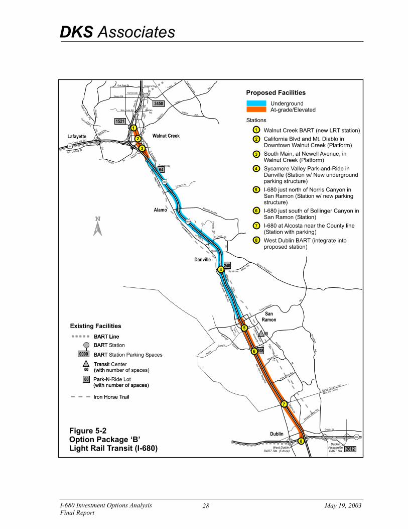
I-680 Investment Options AnalysisFinal Report
May 19, 2003
DKS Associates
64
108
240
55
Figure 5-2Option Package ‘B’Light Rail Transit (I-680)
Existing Facilities
0000 BART Station Parking Spaces
BART Station
Transit Center(with number of spaces)
Park-N-Ride Lot(with number of spaces)
Iron Horse Trail
00
00
BART Line
0000 BART Station Parking Spaces
BART Station
Transit Center(with number of spaces)
Park-N-Ride Lot(with number of spaces)
Iron Horse Trail
00
00
BART LineBART Line
Staelny
eDH l R .
e r i l d
iMt. D ablo Bl.
Danville
Alamo
SanRamon
Dublin
Walnut CreekLafayette
Dublin/Pleasanton BART Sta.
West DublinBART Sta. (Future)
1521
2612
3450
580
oC n ra Cosa o
tCt
un yt
lAam eda Cy
ount
on
SteVa lley Rd.
hBlack aw
.k Rd
nR
mV
R
Sa
a
on
al
yle
.
d
San R
am
on V
alle
y Rd.
Iron
ri
Ta
l
Horse
oD
ug
ey
hrt
d
R.
Da
li le l.
nv
B
mi
ssaa r
Cano Ta
ja
n o
Crow Cay n
Rd.
dR.
Canyon
oC yan n
Norris
ol
r
Bl i gn
e
Rd.
Sycamore
Cam
in R
oa
onm
oAlc
ts a
Bl.
Dvona D
r
a
.
Sunset D
r.
Twin
eC
reks D
r.
ia
oC
nm
Rm
ona
Diablo
lE
Pin
tad
oR
d.
Rd
.
l e roE C r Bl.
L
na
aGo
d
Rd.Livonr a
Va
Rd
lley
.
Pe
inV
la ley Rd.
Me
ontde
vio
r.D
mor
all
Ada
Vey Rd.
Dublin Bl.
680
680
24
Rd
aO
kGr
vo e .
alW nutA .ve
Rd.
eiV
e
Rle
z all
y
pnghi l
.d
Sri
Rl
Geary Rd.
Main
t
S. S
. a
w
Bro
day
Da
lln
ie
v B
l.
Rd.
Hli l
Pa
tl
ae
sn
Oak Park Bl.
Sunnyvale
Coggins Dr.
Jones
Walden Rd.
gRud arRde .
Newell
Bl.Olympic
vi
Ci
cD
r.
San Luis Rd.
Rd.
aM
in S
t..
Oak
Rd.
rT eat
aVell y
Yg
o
naci
Rd.
.Bl
DKS Associates
P0
22
14
UndergroundAt-grade/Elevated
Stations
Proposed Facilities
1
2
3
4
Walnut Creek BART (new LRT station)
California Blvd and Mt. Diablo in Downtown Walnut Creek (Platform)
South Main, at Newell Avenue, in Walnut Creek (Platform)
Sycamore Valley Park-and-Ride in Danville (Station w/ New underground parking structure)
I-680 just north of Norris Canyon in San Ramon (Station w/ new parking structure)
I-680 just south of Bollinger Canyon in San Ramon (Station)
I-680 at Alcosta near the County line (Station with parking)
West Dublin BART (integrate into proposed station)
1
2
3
4
5
6
7
8
5
6
7
8
28

DKS Associates
I-680 Investment Options Analysis 29 May 19, 2003 Final Report
5.3 Option Package C: Light Rail Transit (I-680/Dougherty Valley) This option consists of a light rail line in the I-680 median through much of Alamo and Danville, moving to the east of I-680 in South Danville through San Ramon and Dublin. This route would use a combination of underground, at-grade and elevated facilities as appropriate throughout the corridor. This light rail line would stub at both the Walnut Creek BART Station and the Dublin/Pleasanton BART station.
The alignment would be at-grade along California Blvd from the Walnut Creek BART station to I-680. From there, the light rail line would be underground in the I-680 right-of-way until Sycamore Valley Road. At Sycamore Valley Road, the route would continue underground along the Iron Horse Trail until Fostoria Blvd where it would curve toward Camino Ramon. Once in San Ramon, the route would be at-grade or aerial along Camino Ramon. The route would head further east on Bollinger Canyon Road and then south through Dougherty Valley to the Dublin/Pleasanton BART station.
Stations or stops along this LRT line would include: Walnut Creek BART, downtown Walnut Creek, South Main at Newell Avenue, Danville Park-and-Ride, Camino Ramon at Norris Canyon Road, Camino Ramon at the Civic Center, Bollinger Canyon Road at Dougherty Road, Bollinger Canyon Road at Dougherty Village Center, Dougherty Road at Amador Valley Road, Dougherty Road at Dublin Boulevard, and Dublin/Pleasanton BART. The station facility and parking requirements vary by location.
This option package is illustrated in Figure 5-3.
5.4 Option Package D: HOV Facilities/Express Bus Package This option includes implementing a variety of measures to expand HOV facilities within the study area, and enhance express bus service. HOV facility improvements include extending the HOV lanes northward from Livorna Road to North Main Street in Walnut Creek2 and southward from Alcosta Boulevard to just south of the I-580 junction in Alameda County, and the construction of new HOV-only ramps at Sycamore Valley Road in Danville and at Norris Canyon road in San Ramon. Express bus enhancements represent those that were identified for this area as part of the Enhanced Scenario within the Contra Costa Express Bus Study (DKS Associates - 2001). These include additional service between the Martinez and Dublin/Pleasanton BART, extension of service from East County through Walnut Creek and down the I-680 corridor, and new service between the study area and Fremont/San Jose. This package also includes new buses and expansion of the existing CCCTA maintenance facility to accommodate additional buses.
This option package is illustrated in Figure 5-4.
2 The gap closure for the northbound HOV lane between North Main Street and SR 242 is being analyzed separately.

I-680 Investment Options AnalysisFinal Report
May 19, 2003
DKS Associates
64
108
240
55
Figure 5-3Option Package ‘C’Light Rail Transit (I-680/Dougherty Valley)
Existing Facilities
0000 BART Station Parking Spaces
BART Station
Transit Center(with number of spaces)
Park-N-Ride Lot(with number of spaces)
Iron Horse Trail
00
00
BART Line
0000 BART Station Parking Spaces
BART Station
Transit Center(with number of spaces)
Park-N-Ride Lot(with number of spaces)
Iron Horse Trail
00
00
BART LineBART Line
Satelny
eDH l R .
e r i l d
iMt. D ablo Bl.
Danville
Alamo
SanRamon
Dublin
Walnut CreekLafayette
Dublin/Pleasanton BART Sta.
West DublinBART Sta. (Future)
1521
2612
3450
580
Con ros
a Ca Co
tt
un yt
l mAa eda Cy
ount
S ont
eVa ll ye Rd.
hBlack aw .
k Rd
nR
mV
R
Sa
a
on
al
yle
.
d
San R
am
on V
alle
y Rd.
Iron
ri
Ta
l
Horse
oD
ughe
yrtd
R.
Da
ille l.
nv
B
mi
ssaa r
Cano Ta
ja
n o
Crow Cay n
Rd.
d.R
Canyon
oCany n
Norris
ol
r
Bl inge
Rd.
Sycamore
Cam
Rino
aon
m
oAlc
sta
Bl.
Dvona D
r
a
.
Sunse
t Dr.
Twin
eC
reks D
r.
ia
no
Cm
Rm
ona
Diablo
lE
Pin
tad
oR
d.
Rd
.
l e roE C r Bl.
L
na
aGo
d
Rd.Livorna
Va
Rd
lley
.
Pe
inV
la le y Rd.
Me
ontdeiv
o
rD .
mor
all
Aad
Vey Rd.
Dublin Bl.
680
680
24
Rd
OakG
rove .
alW nutA .ve
Rd.
eiV
e
Rle
z all
y
pnghi l
.d
Sri
Rl
Geary Rd.
Main
t
S. S
. a
w
Bro
day
Dan
llevi
Bl.
Rd.
Hli l
Pa
tl
ae
sn
Oak Park Bl.
Sunnyvale
Coggins Dr.
Jones
Walden Rd.
guR d darRe .
Newell
Bl.Olympic
vi
Ci
cD
r.
San Luis Rd.
Rd.
aM
inS
.
t.
Oak
Rd.
rT eat
aVell y
Yg
o
naci
Rd.
.Bl
DKS Associates
P0
22
14
1
2
3
UndergroundAt-grade/Elevated
Stations
Proposed Facilities
1
2
3
4
Walnut Creek BART (new LRT station)
California Blvd and Mt. Diablo in Downtown Walnut Creek (Platform)
South Main, at Newell Avenue, in Walnut Creek (Platform)
Sycamore Valley at I-680 (Station)
Camino Ramon at Norris Canyon Road (Platform with Parking)
Camino Ramon at the Civic Center in San Ramon (Platform)
Bollinger Canyon Road at Dougherty Road (Platform with Parking)
Bollinger Canyon Road at Dougherty Village Center (Platform with parking)
Dougherty Road at Amador Valley Road (Platform)
Dougherty Road at Dublin Boulevard (Platform)
Dublin/Pleasanton BART (new LRT station)
5
6
7
8
4
5
6
7
8
9
10
11
9
10
11
30

I-680 Investment Options AnalysisFinal Report
May 19, 2003
DKS Associates
DKS Associates
P0
22
14
Figure 5-4Option Package ‘D’HOV Facilities/Express Bus Package
Option Package also includes:
1. New Express Bus Service
Existing HOV Lanes
64
108
244
55
Existing Facilities
0000 BART Station Parking Spaces
BART Station
Transit Center(with number of spaces)
Park-N-Ride Lot(with number of spaces)
Iron Horse Trail
00
00
BART Line
0000 BART Station Parking Spaces
BART Station
Transit Center(with number of spaces)
Park-N-Ride Lot(with number of spaces)
Iron Horse Trail
00
00
BART LineBART Line
Stanley
Deer Hill Rd.
Mt. Diablo Bl.
Danville
Alamo
SanRamon
Dublin
Walnut CreekLafayette
Dublin/PleasantonBART Sta.
West DublinBART Sta. (Future)
1521
2612
3450
580
Contra Costa County
Alameda County
Stone Valley Rd.
Blackhawk Rd.
San
Ram
on
Valle
yR
d.
San
Ram
on
Valle
yR
d.
Iron
Trail
Horse
Dougherty
Rd.
Danville
Bl.
Camino Tassajara
Crow Canyon
Rd.
Rd.
Canyon
Canyon
Norris
Bollinger
Rd.
Sycamore
Cam
ino
Ram
on
Alcosta
Bl.
Davo
na
Dr.
Sunse
tD
r.
Tw
in
Cre
eks
Dr.
Cam
ino
Ram
on
Diablo
El
Pin
tad
oR
d.
Rd
.El Cerro Bl.
LaGonda
Rd.Livorna
Valley
Rd.
Pine Valley Rd.
Montevideo
Dr.
Amador Valle
y Rd.
Dublin Bl.
680
680
24
Oak
Grove
Rd.
WalnutAve.
Rd.
Relie
zValle
y
Springhill Rd.
Geary Rd.
Main
St. S
.B
roadw
ay
Danville
Bl.
Rd.
Hill
Ple
asant
Oak Park Bl.
Sunnyvale
Coggins Dr.
Jones
WaldenRd.
Rudgear Rd.
Newell
Bl.Olympic
Civ
icD
r.
San Luis Rd.
Rd.
Main
St..
Oak
Rd.
Treat
Valley
Ygn
acio
Rd.
Bl.
DKS Associates
P02214
Forecasted HOV Lanes(expected as part of other projects)
HOV Ramps
On-ramps & off-ramps at SycamoreValley Road in Danville
On-ramps & off-ramps at NorrisCanyon Road in San Ramon
1
1
2
Proposed Extension
2
Proposed Facilities
HOV Lanes
Park-and-Ride Lot
Expand the number of parkingspaces at the San Ramon TransitCenter to 500 spaces through leasearrangement
31

DKS Associates
I-680 Investment Options Analysis 32 May 19, 2003 Final Report
5.5 Option Package E: HOV to HOT Lane Conversion This option consists of converting the existing HOV lane on I-680 between Livorna Road and Alcosta Blvd to a high-occupancy toll (HOT) lane. As with existing HOV lanes, the HOT lane would be available to high occupancy vehicles during the peak periods. In addition, single-occupant vehicles are permitted to use the remaining lane capacity for a fee (toll). This option package includes a non-separated lane with electronic monitoring/enforcement. For the purposes of this evaluation, it is assumed that a non-separated HOT lane could be enforced using a to-be-specified technology that would be developed in the future. These HOT lanes would operate only during the peak periods
The assumed maximum volume allowed (using the monitoring mentioned above) on the HOT lane would be 1,600 vehicles per hour. At volumes in excess of 1,600 vehicles per hour the speed of the HOT lane would begin to decrease and no new HOT users would be allowed to use the facility. If there were 1,600 HOV vehicles per hour, then HOT users would be prohibited from entering the facility.
The HOT lane would run from Livorna Road in Walnut Creek to Alcosta Boulevard in San Ramon/Dublin (includes approximately 11.1 miles of converted HOT lane facilities).
This option package is illustrated in Figure 5-5.

I-680 Investment Options AnalysisFinal Report
May 19, 2003
DKS Associates
64
108
240
55
Figure 5-5Option Package ‘E’HOV to HOT Lanes Conversion
Proposed HOV to HOT laneConversion
Existing Facilities
0000 BART Station Parking Spaces
BART Station
Transit Center(with number of spaces)
Park-N-Ride Lot(with number of spaces)
Iron Horse Trail
00
00
BART Line
0000 BART Station Parking Spaces
BART Station
Transit Center(with number of spaces)
Park-N-Ride Lot(with number of spaces)
Iron Horse Trail
00
00
BART LineBART Line
Satelny
eDH l R .
e r i l d
iMt. D ablo Bl.
Danville
Alamo
SanRamon
Dublin
Walnut CreekLafayette
Dublin/Pleasanton BART Sta.
West DublinBART Sta. (Future)
1521
2612
3450
580
Con ros
a Ca Co
tt
un yt
l mAa eda Cy
ount
S ont
eVa ll ye Rd.
hBlack aw .
k Rd
nR
mV
R
Sa
a
on
al
yle
.
d
San R
am
on V
alle
y Rd.
Iron
ri
Ta
l
Horse
oD
ughe
yrtd
R.
Da
ille l.
nv
B
mi
ssaa r
Cano Ta
ja
n o
Crow Cay n
Rd.
d.R
Canyon
oCany n
Norris
ol
r
Bl inge
Rd.
Sycamore
Cam
Rino
aon
m
oAlc
sta
Bl.
Dvona D
r
a
.
Sunse
t Dr.
Twin
eC
reks D
r.
ia
no
Cm
Rm
ona
Diablo
lE
Pin
tad
oR
d.
Rd
.
l e roE C r Bl.
L
na
aGo
d
Rd.Livorna
Va
Rd
lley
.
Pe
inV
la le y Rd.
Me
ontdeiv
o
rD .
mor
all
Aad
Vey Rd.
Dublin Bl.
680
680
24
Rd
OakG
rove .
alW nutA .ve
Rd.
eiV
e
Rle
z all
y
pnghi l
.d
Sri
Rl
Geary Rd.
Main
t
S. S
. a
w
Bro
day
Dan
llevi
Bl.
Rd.
Hli l
Pa
tl
ae
sn
Oak Park Bl.
Sunnyvale
Coggins Dr.
Jones
Walden Rd.
guR d darRe .
Newell
Bl.Olympic
vi
Ci
cD
r.
San Luis Rd.
Rd.
aM
inS
.
t.
Oak
Rd.
rT eat
aVell y
Yg
o
naci
Rd.
.Bl
DKS Associates
P0
22
14
33

DKS Associates
I-680 Investment Options Analysis 34 May 19, 2003 Final Report
6.0 DETAILED EVALUATION OF FIVE OPTION PACKAGES As described in the previous section, five investment options were identified for further evaluation based on feedback from the TAC and PAC. This section describes the evaluation criteria that were used in the analysis of these five investment options, as well as the evaluation results. More detail on many of the elements of this section is provided in Appendix D, Technical Memorandum #4 – Evaluation of Preferred Options.
6.1 Evaluation Criteria Each of the investment options was evaluated based on the criteria described below. The first two criteria are quantitative in nature, while the remainders are largely qualitative.
• Estimated Cost - preliminary estimate for capital and operating costs (capital costs include right-of-way).
• Travel Time Impacts – estimated change in transit and HOV travel times for selected O/D pairs.
• Potential Mode Shift – potential shift in travel mode based on investment option characteristics and travel time changes.
• Markets Served – types of travel market served that investment option is intended to serve, e.g., local vs. through trips; trips with an origin or destination in the corridor; peak vs. off-peak trips; commute vs. non-commute trips.
• Connectivity – ability to integrate with existing or planned regional systems; ease or convenience of transfer.
• Construction Impacts – potential impacts to the surrounding roadways and neighbors associated with construction.
• Potential Environmental Impacts – potential impact on natural and built environment, including visual and noise impacts, of an investment option when completed. Traffic and construction impacts are not included, as they are separate criteria.
• Conflicts with other Traffic – potential increase or decrease in conflicts between vehicles of an investment option when completed.
• Constructability Issues – uncertainties or expected difficulties in constructing physical improvements.
In addition to these evaluation criteria, observations were noted during the course of the study related to community acceptability and funding sources. A summary of these observations was also provided as part of the evaluation.

DKS Associates
I-680 Investment Options Analysis 35 May 19, 2003 Final Report
6.2 Evaluation Results Each of the five option packages were evaluated against the criteria described above. The results of this evaluation are presented for each criterion in the sections below, followed by a summary of the comparative results. More extensive discussion of evaluation results is provided in the following sections.
A comparative summary of the evaluation results is presented in Table 6-1 below. Because many of the criteria are qualitative in nature, the evaluation results are not easily summarized. Therefore, a relative rating system has been used for the comparative summary.
Table 6-1 Summary of Comparative Evaluation Results
Option Package
Criteria
A. BART B. Light Rail (I-680
Median)
C. Light Rail (I-680/
Dougherty Valley)
D. HOV Facilities/
Express Bus Package
E. HOV to HOT Lane
Conversion
Estimated Capital Cost
$4.0 to $5.3 billion
$3.8 to $4.5 billion
$3.5 to $4.2 billion
$240 to $300 million
$2 to $4 million
Travel Time Impacts ++ + + + 0
Mode Shift ++ + + + -
Markets Served ++ ++ ++ + 0
Connectivity ++ + + ++ 0
Construction Impacts -- -- -- - 0
Environmental Impacts -- - -- 0 0
Traffic Conflicts 0 - -- + 0
Constructability Issues -- -- -- - -
Legend:
“++” very positive impact on criteria
“+” positive impact on criteria
“0” neutral impact on criteria
“-” negative impact on criteria
“--” very negative impact on criteria
Source: DKS Associates, 2003

DKS Associates
I-680 Investment Options Analysis 36 May 19, 2003 Final Report
The estimated costs for the different options vary considerably, from a high of $5.3 billion for Option A – BART, to a low of $2 million for Option E – HOV to HOT Lane Conversion. It should be noted that Options A, B, and C include significant lengths of underground rail facilities. For these cost estimates, the higher end of the range typically reflects the use of tunneling construction methods to minimize surface construction impacts, while the low end reflects cut-and-cover. As indicated by the cost estimate ranges, the use of the tunneling method adds significantly to the cost of these options. The cost estimate for Option E – HOV to HOT Lane Conversion does not include the software or other unique technology costs for the as-yet unspecified enforcement technology.
Option A – BART is expected to have the most significant impact on transit travel times in the corridor (as much as 35 minutes for a trip from Bay Point to San Ramon) and would be expected to produce the greatest increase in transit ridership by residents and employees. With more stops and slower operating speeds, the two LRT options (Option B and Option C), are expected to produce lesser transit travel time savings and increases in transit ridership lower than the BART option. Through the addition of new HOV facilities, and enhanced service levels, Option D would produce significant transit travel time savings and increases in transit ridership and HOV use by residents and employees, but not as much as the BART option and in the peak periods only. Option E is expected to produce travel time savings only for SOV users in the HOT lane; thus it is not expected to encourage shift to transit or HOV travel, and may likely have the opposite effect.
The three rail options may be expected to serve most travel markets, with BART better serving through trips and the LRT options better serving local trips. Options D and E focus primarily on peak period, commute trips.
In terms of connectivity, Option A provides the best connection to the regional transit network, while Option D fills gaps in the regional HOV lane network. Options B and C also connect to the regional transit network, but would require modal transfers at each end of the system. Option E does not enhance connectivity of regional networks, and creates an isolated HOT lane.
Due to the amount of new infrastructure required, the three rail options are expected to have the most significant construction and environmental impacts, and pose the most significant construction issues. These can be mitigated, in part, by the specific design and construction methods. Option D does require some significant new construction, but it largely limited with existing roadway rights-of-way. The most notable construction issue for this option relates to the extension of the HOV lanes through the I-680/I-24 interchange. The HOV to HOT lane conversion option may be expected to have very little or no construction or environmental impact; a potential construction issue is the identification of a suitable technology for enforcement.
By being fully grade-separated, Option A would not create any additional traffic conflicts. Option B includes short at-grade segments at the northern and southern end thus resulting in a modest increase in potential traffic conflicts. Because Option C includes s significant segment of at-grade operation through the southern portion of the corridor, this option is expected to produce the highest increase in traffic conflicts. With the construction of HOV direct ramps, Option D may be expected to produce a decrease in traffic conflicts by eliminating the need for HOVs to weave through mixed flow lanes. Option E is expected to generate little or no change in the traffic conflict level.

DKS Associates
I-680 Investment Options Analysis 37 May 19, 2003 Final Report
6.3 Other Observations An important factor for the potential implementation of an investment option is the level of acceptability among policymakers and the general public that lives in cities within the corridor. In defining and screening investment options, numerous issues were identified as potentially influencing community acceptability. Included were issues such as noise and visual impacts, and impacts to the Iron Horse Trail. To a significant extent, these issues and concerns were incorporated into the design of the investment options. For example, the underground design for all or parts of Options A, B and C was intended to address potential concerns regarding visual and noise impacts. Anticipated community acceptability levels and issues include:
• Option A: BART – Viewed by many as a missing link in the regional transit network, but unlikely to rate highly with respect to BART System Expansion criteria.
• Options B & C: LRT (I-680) & LRT (I-680/Dougherty Valley) – In light of community concerns, it was considered infeasible to locate all stations/platforms immediately adjacent to activity centers. As a result, walking accessibility to the LRT was somewhat compromised. Above-ground alignment through San Ramon was accepted as part of a previous planning effort. For Option C, the Dougherty Valley Specific Plan includes preservation of right-of-way for light-rail line and stations.
• Option D: HOV Facilities/Express Bus – Consistent with Contra Costa Express Bus plan and Bay Area HOV Master Plan. A portion of the HOV lane in the southbound direction between North Main Street and Livorna Road would require the conversion of a mixed-flow lane to HOV.
• Option E: HOV TO HOT Lane Conversion - HOT lanes are controversial from an equity perspective; efforts to encourage HOV and transit use could be hampered if congestion levels increase due to presence of HOT vehicles in HOV lane.
The potential for funding from sources other than Measure C is critical to the implementation for a number of the options being studied. There are a large number of funding programs that exist. However, most of these programs have limitations regarding the type of improvements or expenditures that are eligible for funding, and the amount of funding that may be available. With respect to operating costs, most funding from current sources is already dedicated to existing transit operations and thus new sources would need to be found to support operations of any new services. Listings of the major potential funding sources for capital improvements and for operational expenditures are provided in Appendix D.

DKS Associates
I-680 Investment Options Analysis 38 May 19, 2003 Final Report
7.0 RECOMMENDATION FOR PREFERRED INVESTMENT OPTION
Based on the evaluation results, it was recommended that the HOV Facility/Express Bus package (Option Package D) be pursued further as a potential candidate for Measure C Reauthorization. It should be noted that specific design details still need to be resolved.
Some of the major benefits of this package are:
• It is consistent with existing plans, including the Contra Costa Express Bus Study, the Bay Area HOV Master Plan, and BART’s Service Expansion Policy.
• It provides additional mobility to both transit and HOV users by enhancing express bus service and adding new HOV facilities, and
• At an estimated cost of $250 million for capital expenditures, this option package falls within a range of costs that could be encompassed within the Measure C Reauthorization and other revenues reasonably expected to be available over 20 years.
• If funds are limited, this package could be developed in phases. Selected elements within Option D could be incrementally constructed, with each element offering tangible benefits.
As the study progressed and the preferred option emerged, Option D was modified and refined. The recommended investment option consists of several major elements that potentially could be implemented independently. These elements are identified and described in Table 7-1. A cost estimate is provided for each element, which are listed in order of priority. These priorities were set by the Policy Advisory Committee to support the possibility of phased implementation. The following considerations, not listed in a particular order, were taken into account in establishing these priorities.
• Implementation of Express Bus Study recommendations.
• Early implementation should focus on Bishop Ranch as a key trip generator in the study area.
• Relative costs and benefits were qualitatively assessed.
• The gap in HOV lane connectivity on northbound I-680 between North Main Street and SR 242.
• Connectivity for express buses to rest of county.

DKS Associates
I-680 Investment Options Analysis 39 May 19, 2003 Final Report
Table 7-1 Priorities Within the Preferred Investment Option D: HOV Facilities/Express Bus Package
Priority Improvement Element Estimated Capital Cost (1)
1
New Express Bus Service – Includes additional service between the study area and Martinez, East County, and Fremont/San Jose consistent with the Enhanced Scenario recommendations from the Express Bus Study; eight new buses; and expansion of the existing CCCTA maintenance facility to accommodate additional buses. (2)
$ 6.2 M (3)
2
Norris Canyon HOV Direct Ramps – Includes reconstruction of overcrossing, widening of median, construction of new HOV-only on- and off-ramps in both the northbound and southbound directions, and modifications to the local street network. The ramps would be HOV only for the same hours of operation as the HOV lanes.
$ 44.1 M
3 San Ramon Transit Center Enhancements – Includes expanded parking to be achieved through lease agreements with adjacent properties.
(4)
4
Southbound HOV Lane Extension – North (North Main to Livorna) – Through the SR 24 junction, this element includes conversion of one lane through the interchange from mixed-flow to HOV use. Three remaining mixed-flow lanes are consistent with the three southbound mixed-flow lanes at Livorna.
$ 11.6 M
5
HOV Lane Extension – South (Alcosta to south of the I-580 Junction) – Includes restriping the median and widening the outside shoulder to create the width necessary to extend the HOV lanes through the interchange. May require design exemption to accommodate additional lane.
$ 6.3 M (5)
6 Northbound HOV Lane Extension – North (Livorna to North Main) – Through the SR 24 junction, this element includes a new HOV flyover structure.
$ 115.6 M
7 Sycamore Valley HOV Direct Ramps – Includes reconstruction of interchange, widening of median, and construction of new HOV-only on- and off-ramps in both the northbound and southbound directions.
$ 66.2 M
NOTES: (1) All costs are in 2002 $s.
(2) The additional express bus service would not replace or compete with existing bus service. Specifically, the Bishop Ranch (Sunset Development) express bus service.
(3) Includes $3.0 M for expansion of the existing CCCTA maintenance facility, and $3.2 M for purchase of eight buses. This element also includes an estimated $1.6 million increase in annual bus transit operating costs. This value represents the estimated operating cost for the portion of each new service within the study area. Additional costs would be associated with the portion of each route outside the study area.
(4) Cost for this element was not estimated because of the uncertainty of future lease arrangements.
(5) Most of this cost is for improvements in Alameda County.
Source: DKS Associates; CH2M HILL, 2003

DKS Associates
I-680 Investment Options Analysis 40 May 19, 2003 Final Report
8.0 NEXT STEPS This study recommends a preferred investment option for the I-680 corridor. However, before this investment can be made, a more detailed evaluation of the preferred option package should be conducted, ridership should be estimated, environmental assessments should be completed, and the final design should be completed. The steps that need to be undertaken in each of these areas are discussed more fully below.
8.1 Measure C Reauthorization The objective of this study was to identify a project or set of projects for inclusion in Measure C Reauthorization. Having identified the HOV Facilities/Express Bus Package as the preferred option, the remaining steps to ensure that the proposal is considered in the Measure C Reauthorization are:
• Present study results to SWAT and TRANSPAC for consideration;
• Request that SWAT and TRANSPAC include the preferred option in their investment priorities for CCTA to consider in the reauthorization; and
• Assuming that the proposal is included as a candidate project for the reauthorization, develop a financial plan for the project and conduct more detailed analysis/design of the different components of the package.
8.2 Project Implementation The recommended investment option package includes a combination of capital and operational improvements. The steps needed to realize implementation of these improvements vary somewhat as a function of the type of improvement, location, and affected jurisdictions, although in all cases a critical step will be that of securing the necessary funding. It should be noted that travel demand and ridership forecasts were not developed as part of this study. As part of the more detailed analysis and design of this investment package, such forecasts should be developed to determine if they affect implementation priorities.
For capital improvements to the freeway, additional steps will likely include:
• coordination with Caltrans; • inclusion in Caltrans’ I-680 Transportation Corridor Concept Report; • preparation of a Project Study Report (PSR); • complete a Project Report (PR); • environmental assessment; • detailed design; and • in some cases, the acquisition of right-of-way.

DKS Associates
I-680 Investment Options Analysis 41 May 19, 2003 Final Report
In the execution of these steps, specific implementation issues may be identified and need to be resolved. One issue that will need to be addressed is that the conversion of an existing mixed-flow lane to an HOV lane, as proposed for the southbound extension of the HOV lane from North Main to Livorna, conflicts with current Caltrans policy.
For new express bus service, steps may include defining specific service requirements, purchasing vehicles, and modifying maintenance facilities as needed. Implementation steps for enhancements to the San Ramon Transit Center include determining specific parking addition requirements, negotiating lease agreements with affected parties, and coordination with County Connection.
Coordination with other active transportation planning studies, specifically the BART I-580 Corridor Study and the Dougherty Valley Transit Feasibility Study will be necessary. The I-580 study focuses on potential rail service between Pleasanton and Tracy, but was recently expanded to include the possible extension of this rail service northward up the I-680 corridor to Walnut Creek. For the I-680 corridor, three rail options, two of which involve at-grade service along the southern portion of the Iron Horse Trail, plus a bus transit option similar to the recommended investment package identified in this report were examined. New transportation technology, such as Diesel Multiple Units (DMU) are being considered. Results of the study, including feasible alternatives and costs, will be available in July 2003. It is uncertain whether any service in the I-680 corridor will be included as part of the final I-580 Corridor plan, due in part to the limited funding availability. Thus, recommended improvements from the I-580 study may be viewed as longer term at best, and are not expected to conflict with those recommended as part of this study.
The Dougherty Valley study is just getting underway and will examine transit options to serve the growing development in the Dougherty Valley. A key element of this study will be providing connections from the Dougherty Valley to San Ramon/Bishop Ranch and to the Dublin/Pleasanton area.
P:\P\02\02214\docs\Task 4 - Report\Final\I-680 Report - final.doc


![Citizenship Investment Options (EN) [5.7MB]](https://img.pdfslide.net/doc/110x75/5873aa071a28aba3548b5b25/citizenship-investment-options-en-57mb.jpg)