Embed Size (px)
Citation preview

COBLDR18.1_Addendum_2016-04-01.docx i Anderson Consulting Engineers, Inc.
TABLE OF CONTENTS
I. INTRODUCTION ................................................................................................................................ 1
II. FLOOD HAZARD PROTECTION PADS AND REPRESENTATIVE CROSS SECTIONS ............................... 1
III. FLOOD HAZARD GRADIENT MAPPING ............................................................................................. 1
IV. WEST BOOKEND FLOOD MITIGATION EVALUATION ....................................................................... 2
LIST OF TABLES
Table 1. Comparison of 100-Year Water Surface Elevations .................................................................. 3
LIST OF APPENDICES
Appendix A: Flood Protection Elevation Figures and Representative Cross Sections
Appendix B: Flood Hazard Gradient Mapping
Appendix C: Alternative Grading and Flood Hazard Mapping for the West Bookend
COBLDR18.1_Addendum_2016-04-01.docx 1 Anderson Consulting Engineers, Inc.
I. INTRODUCTION
Anderson Consulting Engineers, Inc. (ACE) in conjunction with JVA Engineering, Inc. were contracted by the City of Boulder to conduct additional analysis and produce informational graphics as an addendum to the “Boulder Civic Area Floodplain and Engineering Opportunities and Constraints Report” (ACE & JVA, December 2015).
II. FLOOD HAZARD PROTECTION PADS AND REPRESENTATIVE CROSS SECTIONS
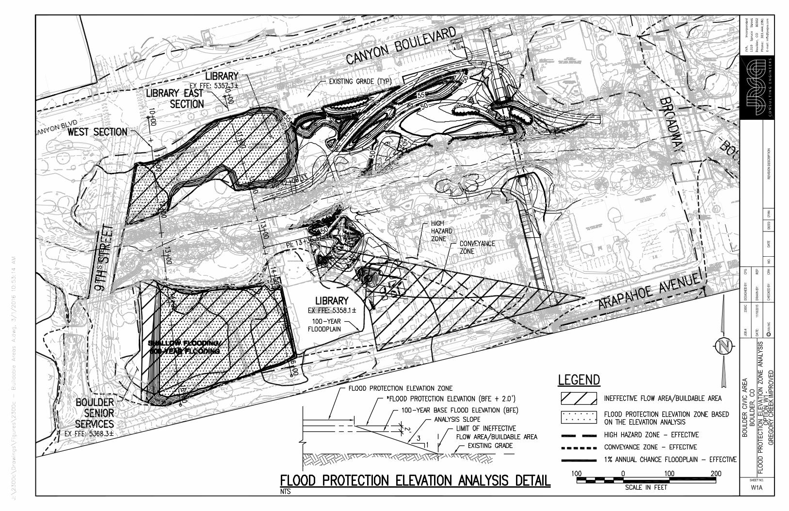
The existing condition Boulder Creek hydraulic (HEC-RAS) model was modified by ACE to reflect the removal of the North Library Wing, the Library Bridge Wing and the Senior Center. Based on the resulting hydraulic conditions and a request from City staff to show a single flood protection pad in the West Bookend Area south of Boulder Creek, JVA produced a revised figure illustrating the potential buildable areas for the West Bookend (see Sheet A1 in Appendix A).
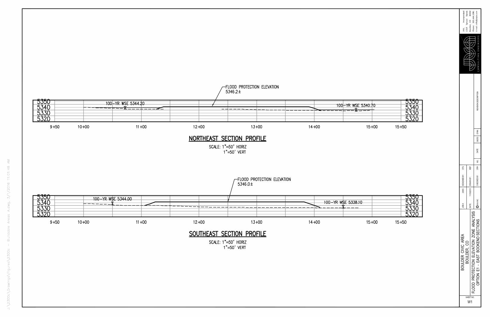
The effective Gregory Canyon Creek 100-year floodplain, conveyance zone and high hazard zone (HHZ) both along the creek corridor and along Arapahoe Avenue east of 9th Street dictated the flood protection elevation pads for the West Bookend area south of Boulder Creek presented in the December 2015 report, with the pad elevations determined based on Gregory Canyon Creek/Arapahoe Avenue 100-year water surface elevations. For the current analysis, it was assumed that flood mitigation improvements would be implemented for Gregory Canyon Creek, such that the creek’s 100-year flow would be contained within a proposed drainage corridor adjacent to the east side of 9th Street. For this analysis, it was assumed that this drainage corridor would need to be 100 feet wide, thereby defining the west edge of the new flood protection elevation pad. Due to the assumption that these improvements would remove the Gregory Canyon Creek flood hazards from Arapahoe Avenue, the revised flood protection elevation of the potentially buildable pad immediately west of the South Library Wing is based on the 100-year water surface elevation of Boulder Creek.
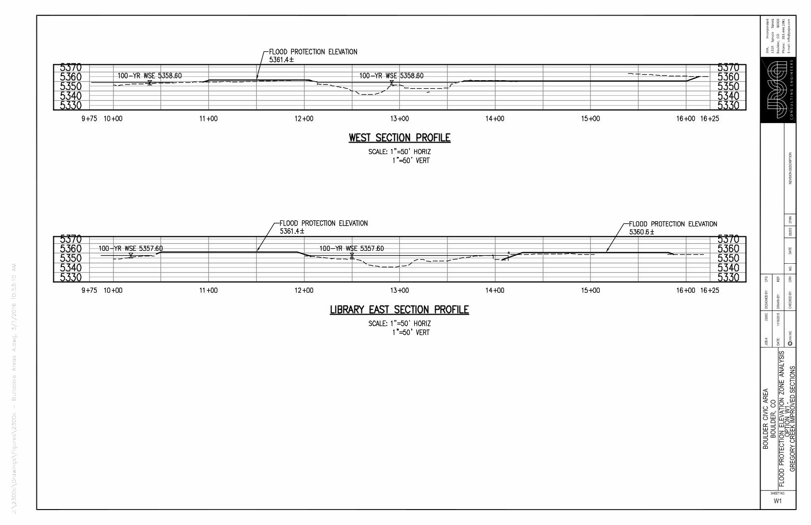
In an effort to demonstrate how these potential building pads would appear from ground level, JVA prepared two cross sections each for the West and East Bookends that reflect the grading shown on the flood protection pad plan view sheets (included in Appendix A as Sheets A1 and A2). Sheets A3 and A4 illustrate the four cross sections. These cross sections were also provided to City staff in electronic format to be rendered for display purposes.
III. FLOOD HAZARD GRADIENT MAPPING
Flood hazard gradient mapping (flow depth X velocity) was produced for Boulder Creek and Gregory Canyon Creek, through the Boulder Civic Area (BCA) from 9th Street east to just east of 14th Street. The data for the flood hazard gradient mapping are based on the effective 100-year Gregory Canyon Creek hydraulic model and the 100-year Boulder Creek floodplain model with the North Library
COBLDR18.1_Addendum_2016-04-01.docx 2 Anderson Consulting Engineers, Inc.
Wing, the Library Bridge Wing and the Senior Center removed. For Gregory Canyon Creek, the hydraulic model was georeferenced and modifications made to ensure cross section and reach lengths were compatible with the georeferencing effort.
The flood hazard gradients through the BCA were created by first utilizing HEC-GeoRAS to build surfaces based on hydraulic modeling results. In order to define the velocity and depth distributions using GeoRAS, the Boulder Creek and Gregory Canyon Creek models were rerun with the flow distribution function enabled. The flow distribution function in HEC-RAS allows for a total of 45 flow distribution subsections for each cross section. For this analysis, the subsections were distributed with 18 across each overbank and 9 within the channel, commensurate with the subsections used for the Boulder Creek high hazard zone analysis (ACE, 2013). Utilizing the results of the 100-year flow distribution analysis, the data were exported and Geo-RAS created surfaces based on the velocity distributions and flow depth at each cross section. These two surfaces were then combined to create initial flood hazard mapping. Since GeoRAS only utilizes cross section data to create surfaces, gaps were encountered in vicinity of areas modeled in HEC-RAS using junctions. To fill these gaps at the junctions, separate surfaces were created which span each junction using data from adjacent cross sections. These secondary surfaces were meshed with the GeoRAS surfaces to create a single continuous surface. A similar method was used to bridge the gaps the Boulder Creek and Gregory Canyon Creek flood hazard data. The resulting flood hazard gradient map through the BCA is included in Appendix B.
IV. WEST BOOKEND FLOOD MITIGATION EVALUATION
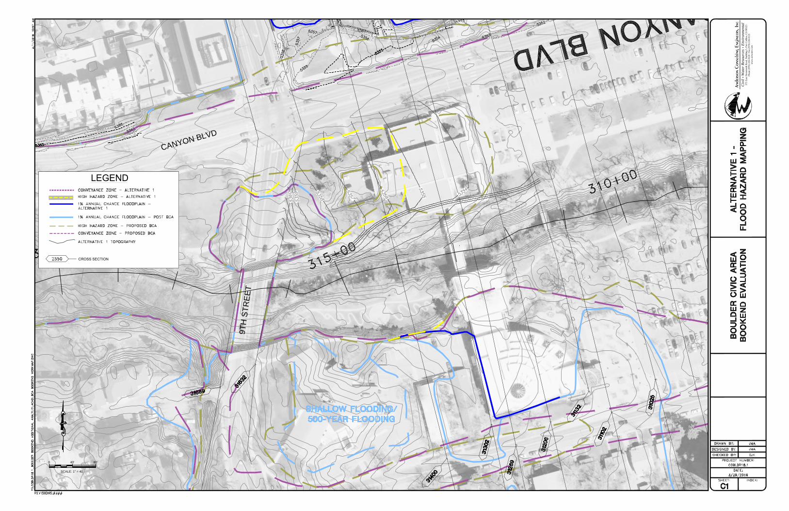
In an effort to provide flood mitigation for the West Bookend Area, two alternative grading plans were formulated and analyzed with the specific intention of attempting to remove the South Library Wing from the current HHZ. ACE and JVA collaborated to formulate two grading configurations for the West Bookend area north of Boulder Creek. Both grading plans assume that the North Library Wing and the Library Wing Bridge are removed. In addition, the grading plans were roughly tied to the proposed BCA grading east of the library. The proposed condition HEC-RAS model for Boulder Creek, which was created by ACE to analyze the proposed grading for the BCA east of the library, was utilized as the base model for this analysis.
The first grading configuration, Alternative 1, was designed to have a lower terrace along the creek with a secondary bench placed 3 feet higher than the terrace, approximately 80 feet north of the creek. The purpose of this configuration is to increase flood flow conveyance adjacent to the channel, in an effort to lower 100-year water surface elevations and reduce the HHZ footprint. For this alternative, it is anticipated that the Boulder Creek Trail would be relocated to the higher bench in order to reduce the potential for frequent flooding of the trail. Due to the proposed grading and removal of both the North Library and Bridge Wings, 100-year water surface elevations would be reduced by up to 2.5 feet relative to the baseline condition. Changes in 100-year water surface elevations at all cross sections in the vicinity of the West Bookend are summarized in Table 1. It is noted that the small rise in the 100-year WSEL at Cross Section 31269 can likely be mitigated by reformulating the tie-in between the
COBLDR18.1_Addendum_2016-04-01.docx 3 Anderson Consulting Engineers, Inc.
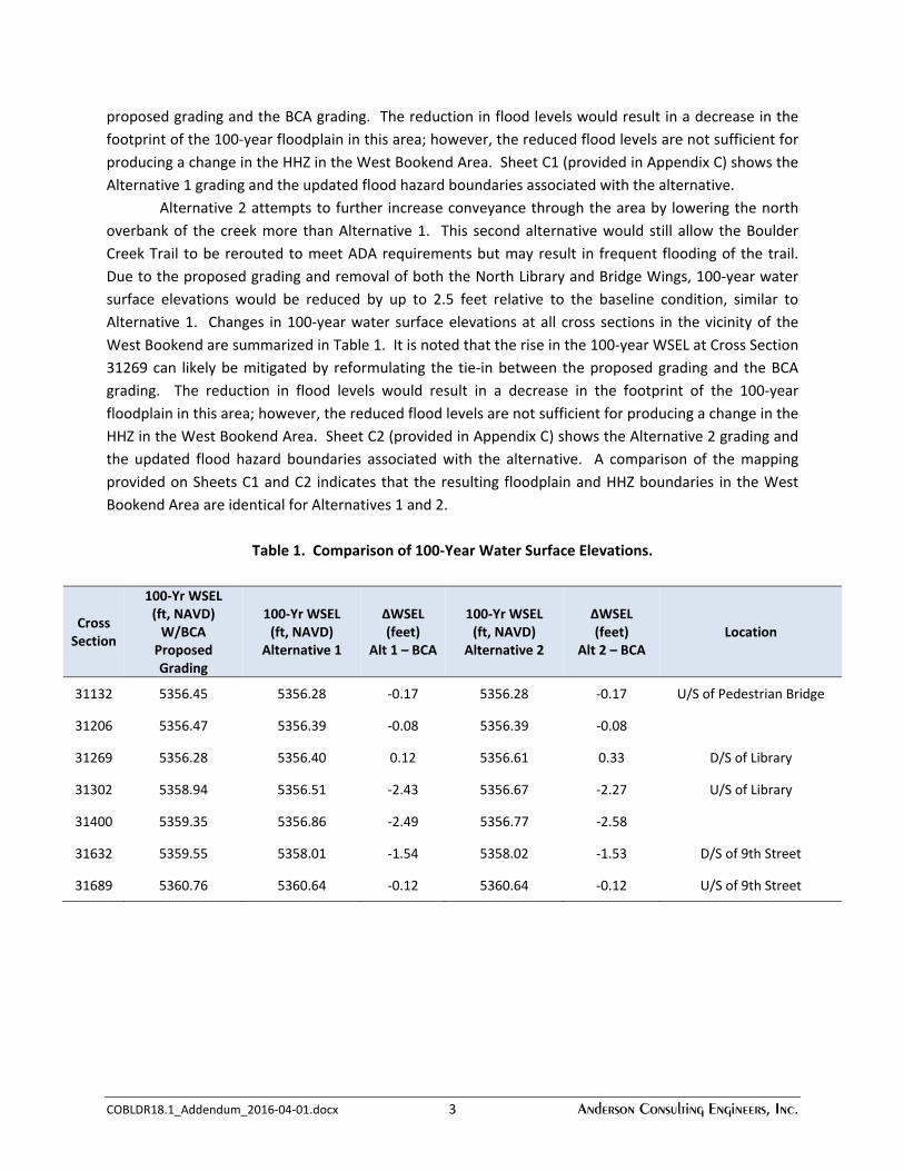
proposed grading and the BCA grading. The reduction in flood levels would result in a decrease in the footprint of the 100-year floodplain in this area; however, the reduced flood levels are not sufficient for producing a change in the HHZ in the West Bookend Area. Sheet C1 (provided in Appendix C) shows the Alternative 1 grading and the updated flood hazard boundaries associated with the alternative.
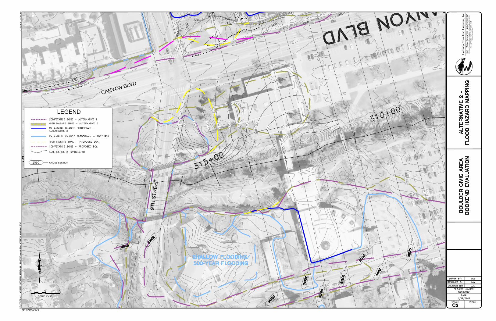
Alternative 2 attempts to further increase conveyance through the area by lowering the north overbank of the creek more than Alternative 1. This second alternative would still allow the Boulder Creek Trail to be rerouted to meet ADA requirements but may result in frequent flooding of the trail. Due to the proposed grading and removal of both the North Library and Bridge Wings, 100-year water surface elevations would be reduced by up to 2.5 feet relative to the baseline condition, similar to Alternative 1. Changes in 100-year water surface elevations at all cross sections in the vicinity of the West Bookend are summarized in Table 1. It is noted that the rise in the 100-year WSEL at Cross Section 31269 can likely be mitigated by reformulating the tie-in between the proposed grading and the BCA grading. The reduction in flood levels would result in a decrease in the footprint of the 100-year floodplain in this area; however, the reduced flood levels are not sufficient for producing a change in the HHZ in the West Bookend Area. Sheet C2 (provided in Appendix C) shows the Alternative 2 grading and the updated flood hazard boundaries associated with the alternative. A comparison of the mapping provided on Sheets C1 and C2 indicates that the resulting floodplain and HHZ boundaries in the West Bookend Area are identical for Alternatives 1 and 2.
Table 1. Comparison of 100-Year Water Surface Elevations.
Cross Section
100-Yr WSEL (ft, NAVD)
W/BCA Proposed Grading
100-Yr WSEL (ft, NAVD)
Alternative 1
∆WSEL (feet)
Alt 1 – BCA
100-Yr WSEL (ft, NAVD)
Alternative 2
∆WSEL (feet)
Alt 2 – BCA Location
31132 5356.45 5356.28 -0.17 5356.28 -0.17 U/S of Pedestrian Bridge
31206 5356.47 5356.39 -0.08 5356.39 -0.08
31269 5356.28 5356.40 0.12 5356.61 0.33 D/S of Library
31302 5358.94 5356.51 -2.43 5356.67 -2.27 U/S of Library
31400 5359.35 5356.86 -2.49 5356.77 -2.58
31632 5359.55 5358.01 -1.54 5358.02 -1.53 D/S of 9th Street
31689 5360.76 5360.64 -0.12 5360.64 -0.12 U/S of 9th Street
APPENDIX A
FLOOD PROTECTION ELEVATION FIGURES
AND REPRESENTATIVE CROSS SECTIONS

APPENDIX B
FLOOD HAZARD GRADIENT MAPPING

9th
Stre
et
9th Street
Broadw
ay
Arapahoe Avenue11th Street
Walnut Street
Canyon Boulevard
Gregory Canyon Creek
13th Street
14th Street
Broadw
ay
Boulder Creek
Flood Hazard Gradient Mapping For The Boulder Civic Area
0 400200
Feet
Legend
D * Vel =
0 - 4
4 - 8
8 - 14
14 - 18
18 - 24
24 - 48
48 - 72
> 72 ±

APPENDIX C
ALTERNATIVE GRADING AND
FLOOD HAZARD MAPPING FOR THE WEST BOOKEND
C
A
N
Y
O
N
B
L
V
D
9T
H
S
TR
E
E
T
SCALE: 1" = 40'
80'40'0
Civ
il ▪ W
ater
Res
ourc
es ▪
Envi
ronm
enta
l37
5 Ea
st H
orse
toot
h R
oad,
Bui
ldin
g 5,
For
t Col
lins,
CO
805
25Ph
one
(970
) 226
-012
0 / F
ax (9
70) 2
26-0
121
ww
w.a
cew
ater
.com
C
A
N
Y
O
N
B
L
V
D
9T
H
S
TR
E
E
T
SCALE: 1" = 40'
80'40'0
Civ
il ▪ W
ater
Res
ourc
es ▪
Envi
ronm
enta
l37
5 Ea
st H
orse
toot
h R
oad,
Bui
ldin
g 5,
For
t Col
lins,
CO
805
25Ph
one
(970
) 226
-012
0 / F
ax (9
70) 2
26-0
121
ww
w.a
cew
ater
.com