Embed Size (px)
Citation preview
UNlTED THc lNTERfOR (Doc. 19681
\ C ~ ~ > N T Y - NATIONAL HlSTORlC Loudoun
fNYENTORY - NOMlNATlON FORM NPS ONLY
- r c 7 m Y entries complotc applicnblc sccrficms) -- _l_l
11. I 'I - C CmMON
IJaterford Hiatmrie A N n j C R H l S T n R I C .
Route miles o f Leesburg ] C L T Y TOWN:
(Check QlraJ OWNFRSHIP
e
D ls t r rc t yl Bvi I ~ v b i r c I
1 Acquls~r ion: 0 cc oisd El' Ye*:
SE1e IIYCN~~ n \.?i*#e ( I n P r m e s . l)nocc~pi.d ~1 ~ * s ~ ~ i c f 0 ~ \ : I \
PREaaN r USE (Check Ons e n Appronr1nte) .- [I n Prrnrportat~on n C a r n n m ; + T
Industrial r) Privntc kcnidcnce T S P a c i l v l 1
Educational Milttary C Rcl ig iou~ vFl1ap;e U Scicntifir Enfsr+u~nmenr rl - - i
.. - -.--- .-- 2 -
1 ~ + R T E
Wat crfosd $-- - - - - --A
5 , LOCATION DESCRIPTIOU L- T.L-... -. -. -- ..----- - -" - -+.
I C O U R T P O U S E R C G I T T R Y C I B nEEOS.
i Loudaun Clerk 's - -- - - - lsTPEE r A M 0 N1JMULF..
<IT" T O W N
O A T F S U R V E Y : 1937 --
~ * d * c - l f i sfof* c-n*~ K? .--[ 1 kl G E P O S I T Q R Y FOE S U R V E Y I=- kibrary
R F E T A h 0 NLl . IHEF(
I >--a
1 D i s t r - k c t af Colunb-i,?
Form 10-300 STATES DEPARTMENT OF NATIONAL PARK SERVICE
REGISTER OF PLACES F O R
USE
(Type all -NAME . ,
'
District
Waterford
f 665, 7 Northwest -----IO R
CATEGORY
I
Public u I
or More .- I Government Park
Other I I
Museum
OWNER OF PROPERTY I I
and private
4.
.-<-
I Virginia. .
OF LEGAL ..... , . E T C
County O f f ice
O H
V i r g i n i a
Historic American Buildings Survey O F -.-
: o f Congress--
RECORDS.
I S I
S T A T E - C O O P
Washington
[TI I I
S i t u a t e d i n t h e Loudoun Valley sevrn mi les northwest of Leesburg, t h e m i l l town of Waterford remains v i r t u a l l y unchanged from i t s e igh teen th and n ine teen th century appearance. Waterford i s no tab le f o r t h e g r e a t v a r i e t y of bu i ld ing m a t e r i a l s used, inc luding b r i c k , s tone , log and frame, as wel l as f o r t h e v a r i e t y of a r c h i t e c t u r a l s t y l e s . E s p e c i a l l y i n t e r e s t i n g a r e t h e b r i c k m i l l (c.1750); t h e Arch House Row of s t o n e , b r i c k and wood (c.1750); t h e Camelot School, a two-story log bu i ld ing (c.1800); t h e neo-c l a s s i c B a p t i s t Church of 1850; and t h e romantic Vic to r i an P resby te r i an Church of 1882, A major f a c t o r i n w a t e r f o r d ' s c h a r a c t e r i s t h e unspoi led open r o l l i n g landscape which surrounds t h e v i l l a g e and enhances i t s i n t e g r i t y .
DESCRIPTION - CONDITION
I N T E G R I T Y
-- - (Check on.,,
Excal lant j 3 Goad a Fanr O Ostorlorated n R u l n 3 unexposed 0 - . -- (Check One) (Check One)
Altered Unal te red @ Ornglnal S I * ~ lip
D E S C R I B E THE PRESENT AND ORIGINAL P H Y S I C A L A P P E A R & N C E
. SIGNIFfCANCE PERlOD (check one .,,More e a Appro~rIutoJ i
I Pre-Columbion 16th Cantury 1;-I i81h Cantvry B t h Century I;/ 15th Century U 17th Century [:I 19th Century I --
S P E C 1 F I C D A T E I S 1 (If Applfeabfa end Known)
A ~ E A S O F S ~ G N I F I C A N C E (Check Ono or More n a ~ p p ~ o p ~ i ~ r t a )
Abor iginol Educotibn 111 Political u Urbdn Planning 111 Prehistoric E g i i 1-1 Raligion/Phi- Other (Specify1
, , kl
~ i ~ t ~ ~ i ~ , n industry 17 ~~~~~h~ ee A ~ ~ ~ ~ ~ I ~ ~ ~ ~ ' u ~~~~~~i~~ n science n w, : A,t a Landscope Sculptvts 0 Commerce Architacturc U Social/Humon.
Communications Litcroturs 0 i torion
Conssrvation i-J Mil i tary c.1 Thsoter
MUSIC n T r m n ~ ~ o r t o t i o n u 5 7 A T E M E N T O F 5 1 C N I F I C A N C E ( I n ~ l ~ d b P e r ~ ~ n e & ? s a , Dates. E m n l ~ . E t c . )
The o l d e s t s e t t l emen t i n Loudoun County,' Waterford began as a small Quaker v i l l a g e about 1730. The f i r s t house b u i l t w i th in the town l i m i t s , t h a t of Asa Moore (c.1733), i s s t i l l s tanding. Or ig ina l ly c a l l e d Milltown because o f t h e small i n d u s t r i e s t h e r e , t h e name was soon changed t o Waterford i n honor of Waterford, I r e l and . The town was incorpora ted i n 1810, and by 1834 i t was a f l o u r i s h i n g v i l l a g e of four hundred persons wi th some seventy houses, a tannery , a chair-maker, and a boot and shoe manufacturer. A t one time t h e r e was a l s o a woolen f a c t o r y a s wel l a s seve ra l s t o r e s , a bank and tavern. Through c a r e f u l p r i v a t e p rese rva t ion e f f o r t s , most of Waterford remains a s it was i n the n ine teen th century .
-- 9. MAJOR BIBLIOGRAPHICAL REFERENCES - --
Head, James W . , H i s t o r y of Loudoun County, V i r g i n i a . Park Vlew P r e s s : 1908. V i r g i n i a : A Guide t o t h e Old Dominion. American Guidc S e r i e s . New York: Oxford U n i v e r s i t y P r e s s (1940) . "Wate r fo rd , Loudoun County, V i r g i n i a , " pamphlet p r i n t e d by The Waterford Foundat i o n , 1958. O 'Nea l , N i l l i a m B . , A r c h i t e c t u r e & V i r g i n i a . Ncw York: Walker 6,
Company, I n c . (1968). S a l e , Mar ian Marsh, "Old W a t e r f o r d ," V i r g i n i a Cava lcade , ~ d l . X V I I I , No. 4 ( S p r i n g , 1969) .
I I S T A T E :
z V)
I I . FORM PREPAReD BY
( N A M E A N D r \ r L t
V)
rn rn
-
I__. 10. GEOGRAPHICAL . . ~ ~ DATA
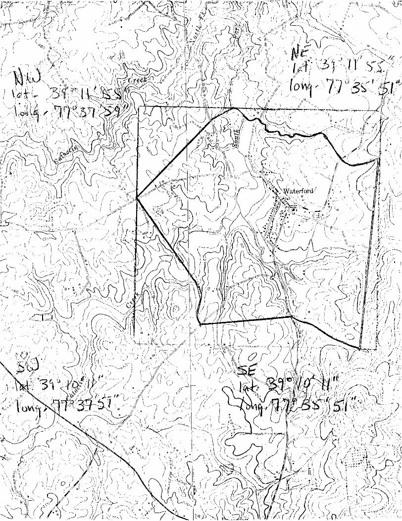
L l t T l T U D E & N O L O N C l T U D E C O O R O N A T F S O O E F t N I N G THE C E N T E R . P p I N T O F i\ P R O P E R T Y ' OF L E S S T H t N ON? & C R F
Landmarks Commission, James W. Moody, Jr. , D i r e c t o r . 0
O R G A N 8 L A T I O N DI\ T E --I V i r g i n i a H i s t o r i c Landmarks Commission May 23, 1969 -
L O N G l T U D E L A T i T U D E
"1.. Seconds
7 7 " 3 5 ' 5 1 "
1116 Nin th S t r e e t S t a t e O f f i c e B u i l d i n g C I T Y O i l T O W N :
V)
Richmond
-- L O N G l T V U E
, . Degteer Minujes Sarond.
0
I I .. I - . . . .- - - . .- ... - . - .. . - - - .. - -. - -. -- 12. STATE LIAISON OFFICER CERTIF ICAI ION - - NATIONAL REGISTER VERIFICATION
I I
A s thc desl~naled Statc 1,inison Officer far the Na-
tional H i x t o r ~ c Preservation Act o f 1966 (Publ ic Law
80.665). 1 h e r e b y nominate th i s property far inc lus ion
in t h e N;ltional R c ~ i s t c r and certify that it h a s hren
evaluated t~rcording t o the criteria and procedures set forth b y the National Park Service , T h e recommended
l e v e l of s i g n ~ f i c a n c e of th i s nomination i s :
National 3 State Local 0
O R C O U N T Y B O U N D A R I E S
' J '4 D r . Edward P. Alexander , Chairman
C O D E C O U N T Y - CODE C O U N T Y : -
I herebv certify that th i s property is included in the
National Register.
C O D E - C O O S -
Chief, Office of Archeology endHistoric Preservatrar
Date
ATTEST:
I Title V i r g i n i a H i s t o r i c Landmarks Corn. II I I II Keeper of The National Register I
Date May 2 3 , 1969 -- Date I
Form 10.3000 UNITED STATES DEPARTMFNT OF THE INTERIOR (Doc. 1968) NATIONAL PARK S E R V I C C --l I
I -- -
NATIONAL R E G I S T E R OF HISTORIC P L A C E S C O L J N T Y i INVENTORY - NOMINATION FORM -- ~-
FOR NPS USE ONLY 1
(Continuation Sh~ ,e t ) ~~ ~~
~ - -- (Number al l enlrlss) -
i 6. H l s t o r i c American B u i l d i n g s Survey I n v e n t o r y
1959 Fe 'dera l L i b r a r y o f Congress Washington, D. C . Code: 08
V i r g i n i a H i s t o r i c Landmarks Commission Repor t 1153-108 1969 S t a t e V i r g i n i a H i s t o r i c Landmarks Commission Nin th S t r e e t S t a t e O f f i c e B u i l d i n g Richmond, V i r g i n i a 23219 Code: 45
' ~ ~ ~ r n 10-301 UNITED STATES D E P A R l M r N T O F THE INTERIOR ( o e c . 1968) NATIONAL P A R K SCRVICF: Virgin ia
~
NATIONAL REGISTER OF HISTORIC PLACES C O i i N T Y
Idoucloun PROPERTY MAP FORM ~~ .
FOR NPS USF ONLY ~.~~ - ..
( T y p e a l l en t r ies - i i f tnch to or anc.losc, w i t h map) .~ EI.ZTHY ~ I I J M ~ ~ F ~
1. NAME - - ~ ~
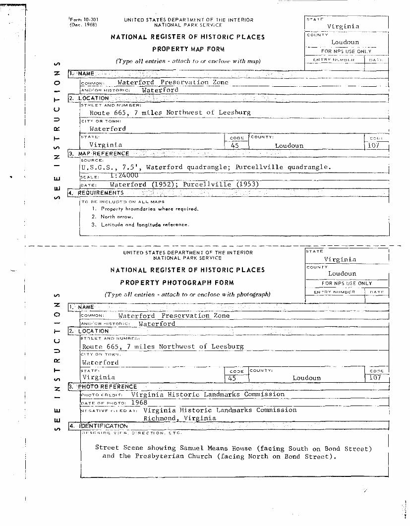
COMMON: Waterford Prescrvatj .on Zone ~
. % ~ ~ i o n H l s r o n t c : Waterford
12. L O C A T I O N S I P L E T A N D NUMBER:
Route 665. 7 mi l e s Northwest of Leesburg
Waterford S T A I F C O U N T Y
V i r g i n i a 45 Loudoun 3. MCRE_F_CRENCE . -
< n , , m < ! =
/;:B.G.S., 7.5 ' , Waterford quadrangle; P u r c e l l v i l l e quadrangle. L:24UUU
- -- , [&<--warer£ord (1952); h r e e l l v i l l e (1953)
4. R E Q U I R E M E N T S
T O R E i N C L U D F D O N A L L M A P S
1 . Property braundories where required.
2 . North orrow.
3 . Lati tude and longitude reference.
---------- UNITED STATES DEPARTMENT OF THE INTERIOR 1
NATIONAL PARK SERVICE Virgin ia 1 NATIONAL REGISTER OF HISTORIC P L A C E S C O U N T Y
Loudoun
P R O P E R T Y PHOTOGRAPH FORM F O R ~ - U S E 1 ( T y p e al l en t r ies - a t t a c h t o or enclosc with photograph) E N T R Y N U M L I C R
- I . U A M E -- -- -
2 --
COMMON Waterford P rese rva t ion Zone
7 mi l e s Northwest of Leesburg . - - .-
Waterford -- -- S T A T E : C O " F
V i r g i n i a Loudoun 107 b.' P H O T O REFERENCE --o C R E D I T : Virg in ia H i s t o r i c Landmarks Commission -
D A T E .. O F P H O T O : . 1968- ~.
A L : V i r g i n i a H i s t o r i c Landmarks Commission ,,, , - Richmond2 Vi rg in ia
V) 4 I D E N T I F I C A T I O h
D F S C R I B E V l F W D I R E C T I O N E T C
I S t r e e t Scene showing Samuel Means House ( f ac ing South on Bond S t r e e t ) and t h e P resby te r i an Church ( f ac ing North on Bond S t r e e t ) .