Embed Size (px)
Citation preview
GCE-LTER ANNUAL REPORT OF ACTIVITIES,
Year Six (2005-2006) Award NSF OCE 99-82133
I. Project Management Project Administration James Hollibaugh, Dept. of Marine Sciences, UGA; Steven C. Pennings, Univ. of Houston
Administrative responsibilities have included organizing the GCE annual meeting, participating in LTER network coordinating committee meetings, and dealing with accounting, reporting and supplementary and continuation funding paperwork. Hollibaugh and Pennings split Coordinating Committee responsibilities with Pennings attending the spring meeting in Santa Barbara, CA and Hollibaugh attending the summer meeting in Fairbanks, AK. Science oversight responsibilities involved coordinating the efforts of scientists in different aspects of the study, and negotiating agreements with different agencies to supplement monitoring efforts.
Our sixth year of Schoolyard LTER support provided an opportunity for teachers to participate in field research at the GCE-LTER site during the summer of 2005. Immediate supervision of the Schoolyard LTER is currently being provided by J.T. Hollibaugh, with the actual teacher training effort led by Dr. Trisha Hembree. Dr. Hembree has been successful in augmenting the Schoolyard with funds from the Eisenhower Foundation.
Web Site, Database, and Information Management Activities Wade Sheldon, Dept. of Marine Sciences, UGA Overview
Information management activities this year focused on 1) assisting GCE investigators with data integration, analysis and synthesis projects in preparation for the 2006 renewal proposal, 2) enhancing web and MATLAB client tools for discovering and accessing data (both accessioned data sets and near-real-time monitoring data), and 3) building a searchable archive of electronic reprints from GCE-funded journal articles and theses to enhance communication of research findings within the project.
Near-real-time Climate and Hydrographic Data
The fully automated climate data harvesting system, developed in November 2002 with supplemental NSF funding for ClimDB/HydroDB participants, continues to provide GCE participants with near-real-time data and plots from two climate stations (Marsh Landing on Sapelo Island and Hudson Creek/Meridian Landing) and one USGS streamflow gage (Altamaha River at Doctortown), updated hourly. Real-time data are finalized monthly, re-sampled to daily values and submitted to the LTER climate and hydrological databases (ClimDB and HydroDB), along with data from the manually operated NWS climate station on Sapelo Island. In addition, near-real-time and historic data and plots from these and other relevant climate stations are also now publicly accessible on the GCE Data Portal web site (see below).
Salinity, temperature and pressure data from moored hydrographic data loggers are downloaded and processed on a bimonthly to quarterly basis. Provisional data and plots are provided to GCE investigators on the project web site within two days of acquisition, and finalized, quality-controlled data are added to the GCE Data Catalog at the end of each year to provide public access.
The GCE project also continues to host the USGS Data Harvesting Service for HydroDB (see http://gce-lter.marsci.uga.edu/lter/research/tools/usgs_harvester.htm). Data from 52 USGS streamflow gauging stations are automatically harvested on a weekly basis for 10 LTER sites (AND, BES, FCE, GCE, KBS, KNZ, LUQ, NTL, PIE, SBC) and one USFS site. Recent provisional and finalized data are automatically acquired, standardized, quality-checked, formatted, and uploaded to HydroDB to
2
provide the LTER community with the best available stream flow and precipitation data for synthetic research at no cost to individual site research programs.
Software Development
We have continued to enhance the GCE Data Toolbox for MATLAB software and offer a compiled version of this toolbox for public download on our web site (see http://gce-lter.marsci.uga.edu/lter/research/tools/data_toolbox.htm). This software can be used to search and download data from the GCE Data Catalog and GCE Data Portal as well as import local data, and then perform metadata-based analysis, transformation, integration and visualization. Significant improvements were made in the data integration functions this year, allowing multiple related data sets stored in any number of directories to be merged or joined to create composite data sets, complete with detailed metadata and QA/QC flags. We also enhanced functions for retrieving data and metadata from any USGS streamflow station using direct HTTP requests, and added new functions for retrieving data from any station in the LTER ClimDB/HydroDB database. Toolbox users can now retrieve data from both USGS and ClimDB/HydroDB for analysis and display, using either command-line functions or graphical dialogs, and then integrate these data with GCE data sets or their own data in real time. Nearly 700 web visitors downloaded the toolbox package in 2005 (see download statistics below). Support for EML Metadata
We comprehensively support the XML-based EML 2.0 metadata standard adopted by LTER in all GCE databases, allowing us to dynamically generate EML for all data sets in our catalog, as well as species lists, personnel entries and bibliographic citations. GCE was the first LTER site to fully support EML 2, and our rapid implementation has facilitated adoption of this standard across LTER and aided in development of EML-based applications at LNO, NCEAS and NBII. Our EML implementation is among the most comprehensive in LTER, supporting metadata-mediated data access and integration (Level 5 in the EML Best Practices guidelines, a document created by a working group chaired by W. Sheldon in 2004).
We also continue to collaborate with LNO and NCEAS on development and testing of specifications for automatically harvesting EML documents from LTER sites for inclusion in the LNO Metacat repository (and therefore the distributed Metacat and Ecogrid networks). GCE EML documents are automatically added or updated in the LNO Metacat server on a weekly basis, and then synchronized to other Metacat servers across the world. GCE EML is also harvested weekly for inclusion in the NBII metadata clearinghouse. As a result, GCE metadata can be searched using the NCEAS Morpho application, the LNO Data Catalog (http://metacat.lternet.edu/query/), the NBII Mercury search engine (http://mercury.ornl.gov/nbii/), and the Ecogrid network being developed by the SEEK project. Corresponding data tables can also be automatically retrieved by these external systems using connection information in the metadata, with data access logged by the GCE database. In addition, the comprehensive EML implementation and support for automated data streaming developed at GCE continues to enable NCEAS and the SEEK project to prototype, test and demonstrate EML-based data analysis and workflow tools, such as Kepler (http://seek.ecoinformatics.org), using realistic ecological data sets, significantly aiding their development work.
Data Catalog Additions
Data submissions from both monitoring and directed study programs were similar to those in year 5, with 101 data sets added to the catalog or in the final stages of documentation for inclusion since February 2005. GCE investigators have contributed a total of 334 documented data sets to date, 269 of which are currently accessible to the LTER and broader scientific community through our web-accessible public data catalog as well as through catalogs hosted at LNO, NCEAS and NBII (see above). Detailed public data download statistics are provided below in the Web Site and Data Access Statistics section. Web Site Additions
In February 2005 we began providing public access to the GCE Data Portal (http://gce-lter.marsci.uga.edu/portal/), a web site we established in April 2003 to distribute ancillary data sets, maps, photos and other relevant information acquired by the GCE project, but not produced exclusively with GCE funding. Over 150 fully-
3
documented data sets accompanied by various standardized plots are currently available on the Data Portal, including near-real-time climate and hydrographic data updated hourly as well as historic observations dating back to 1895. All standard GCE data and metadata distribution formats and tools are supported, and data can be retrieved using the Data Portal web pages as well as GCE Data Toolbox search tools. Data use is tracked by routing download requests to the same data distribution web application used for the GCE Data Catalog. We have also recently added an archive of printable tide tables to this site to aid researchers in field planning.
We also significantly improved the options available for searching the GCE Data Catalog (http://gce-lter.marsci.uga.edu/lter/asp/db/data_catalog.asp), our catalog of accessioned core data sets. Visitors can now search for data based on LTER core area, study date range, and metadata content in addition to GCE theme, study site, and investigator. Data sets can also be sorted by study duration to highlight long term studies. These new search options also made it possible to add specific data search queries to various web pages, including detail pages for species entries in the GCE taxonomic database (http://gce-lter.marsci.uga.edu/lter/asp/db/all_species_lists.asp).
Other significant web additions were an automated reprint request service for the GCE bibliographic database (http://gce-lter.marsci.uga.edu/lter/asp/db/biblio_query.asp) and a searchable archive of reprints for journal articles, conference publications and theses on the private GCE project web site.
Web Site and Data Access Statistics
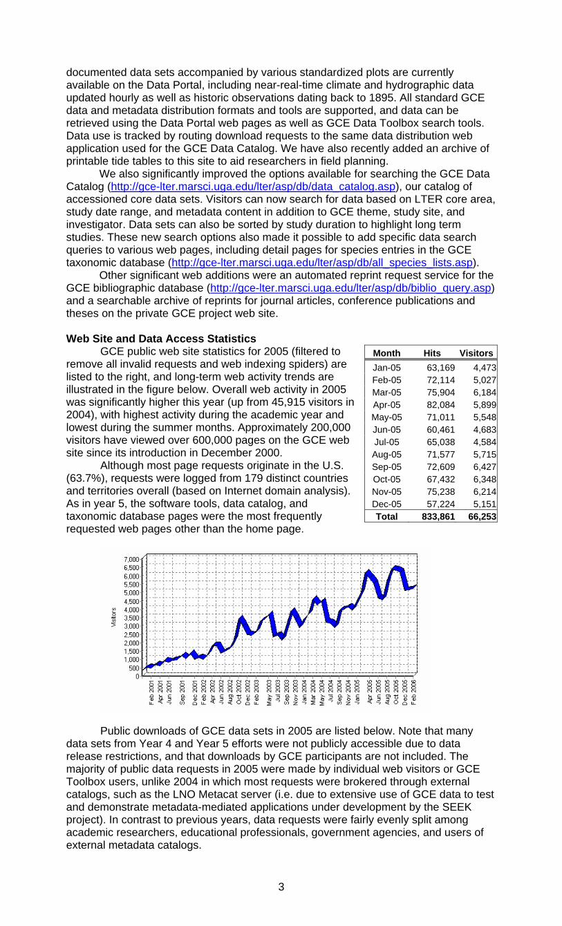
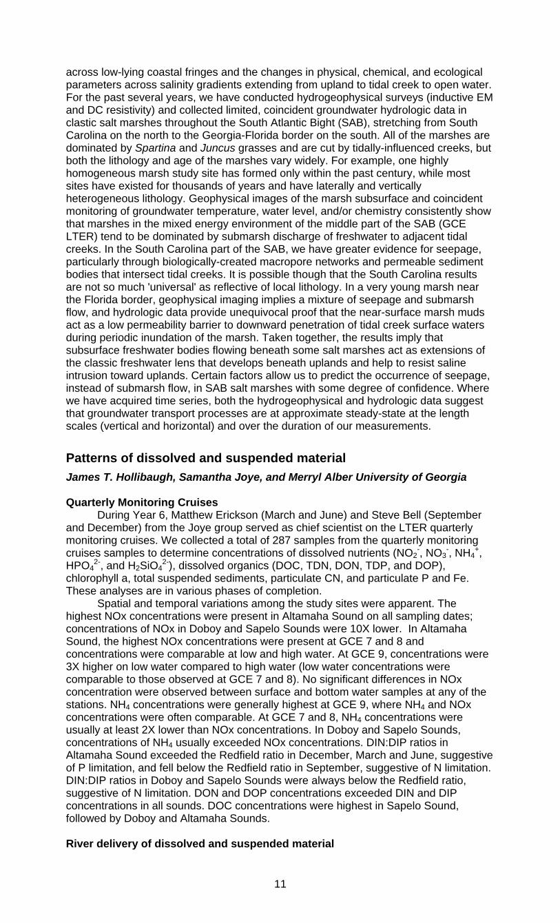
GCE public web site statistics for 2005 (filtered to remove all invalid requests and web indexing spiders) are listed to the right, and long-term web activity trends are illustrated in the figure below. Overall web activity in 2005 was significantly higher this year (up from 45,915 visitors in 2004), with highest activity during the academic year and lowest during the summer months. Approximately 200,000 visitors have viewed over 600,000 pages on the GCE web site since its introduction in December 2000.
Although most page requests originate in the U.S. (63.7%), requests were logged from 179 distinct countries and territories overall (based on Internet domain analysis). As in year 5, the software tools, data catalog, and taxonomic database pages were the most frequently requested web pages other than the home page.
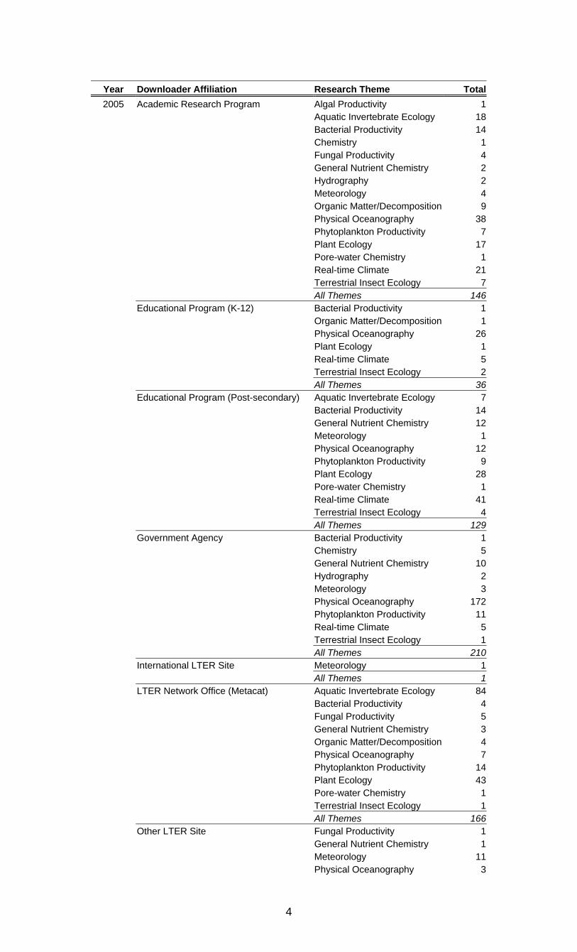
Public downloads of GCE data sets in 2005 are listed below. Note that many data sets from Year 4 and Year 5 efforts were not publicly accessible due to data release restrictions, and that downloads by GCE participants are not included. The majority of public data requests in 2005 were made by individual web visitors or GCE Toolbox users, unlike 2004 in which most requests were brokered through external catalogs, such as the LNO Metacat server (i.e. due to extensive use of GCE data to test and demonstrate metadata-mediated applications under development by the SEEK project). In contrast to previous years, data requests were fairly evenly split among academic researchers, educational professionals, government agencies, and users of external metadata catalogs.
Month Hits VisitorsJan-05 63,169 4,473Feb-05 72,114 5,027Mar-05 75,904 6,184Apr-05 82,084 5,899May-05 71,011 5,548Jun-05 60,461 4,683Jul-05 65,038 4,584Aug-05 71,577 5,715Sep-05 72,609 6,427Oct-05 67,432 6,348Nov-05 75,238 6,214Dec-05 57,224 5,151Total 833,861 66,253
4
Year Downloader Affiliation Research Theme Total2005 Academic Research Program Algal Productivity 1
Aquatic Invertebrate Ecology 18 Bacterial Productivity 14 Chemistry 1 Fungal Productivity 4 General Nutrient Chemistry 2 Hydrography 2 Meteorology 4 Organic Matter/Decomposition 9 Physical Oceanography 38 Phytoplankton Productivity 7 Plant Ecology 17 Pore-water Chemistry 1 Real-time Climate 21 Terrestrial Insect Ecology 7 All Themes 146 Educational Program (K-12) Bacterial Productivity 1 Organic Matter/Decomposition 1 Physical Oceanography 26 Plant Ecology 1 Real-time Climate 5 Terrestrial Insect Ecology 2 All Themes 36 Educational Program (Post-secondary) Aquatic Invertebrate Ecology 7 Bacterial Productivity 14 General Nutrient Chemistry 12 Meteorology 1 Physical Oceanography 12 Phytoplankton Productivity 9 Plant Ecology 28 Pore-water Chemistry 1 Real-time Climate 41 Terrestrial Insect Ecology 4 All Themes 129 Government Agency Bacterial Productivity 1 Chemistry 5 General Nutrient Chemistry 10 Hydrography 2 Meteorology 3 Physical Oceanography 172 Phytoplankton Productivity 11 Real-time Climate 5 Terrestrial Insect Ecology 1 All Themes 210 International LTER Site Meteorology 1 All Themes 1 LTER Network Office (Metacat) Aquatic Invertebrate Ecology 84 Bacterial Productivity 4 Fungal Productivity 5 General Nutrient Chemistry 3 Organic Matter/Decomposition 4 Physical Oceanography 7 Phytoplankton Productivity 14 Plant Ecology 43 Pore-water Chemistry 1 Terrestrial Insect Ecology 1 All Themes 166 Other LTER Site Fungal Productivity 1 General Nutrient Chemistry 1 Meteorology 11 Physical Oceanography 3
5
Plant Ecology 6 Pore-water Chemistry 3 Real-time Climate 3 Various (custom file) 1 All Themes 29 Other/Unspecified Aquatic Invertebrate Ecology 1 Bacterial Productivity 2 Fungal Productivity 3 General Nutrient Chemistry 3 Meteorology 2 Organic Matter/Decomposition 3 Physical Oceanography 54 Phytoplankton Productivity 1 Plant Ecology 2 Pore-water Chemistry 2 Real-time Climate 3 All Themes 76
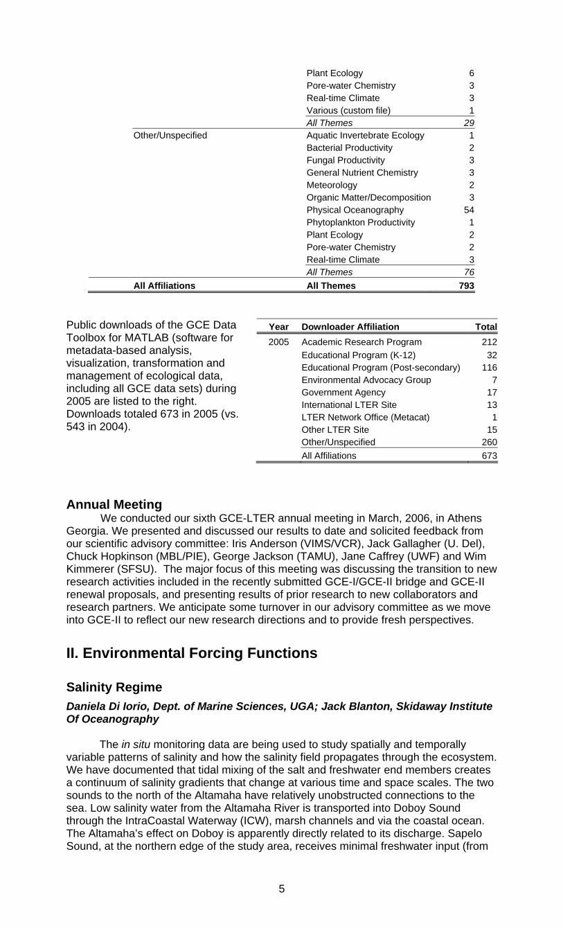
All Affiliations All Themes 793
Public downloads of the GCE Data Toolbox for MATLAB (software for metadata-based analysis, visualization, transformation and management of ecological data, including all GCE data sets) during 2005 are listed to the right. Downloads totaled 673 in 2005 (vs. 543 in 2004).
Annual Meeting
We conducted our sixth GCE-LTER annual meeting in March, 2006, in Athens Georgia. We presented and discussed our results to date and solicited feedback from our scientific advisory committee: Iris Anderson (VIMS/VCR), Jack Gallagher (U. Del), Chuck Hopkinson (MBL/PIE), George Jackson (TAMU), Jane Caffrey (UWF) and Wim Kimmerer (SFSU). The major focus of this meeting was discussing the transition to new research activities included in the recently submitted GCE-I/GCE-II bridge and GCE-II renewal proposals, and presenting results of prior research to new collaborators and research partners. We anticipate some turnover in our advisory committee as we move into GCE-II to reflect our new research directions and to provide fresh perspectives.
II. Environmental Forcing Functions
Salinity Regime Daniela Di Iorio, Dept. of Marine Sciences, UGA; Jack Blanton, Skidaway Institute Of Oceanography
The in situ monitoring data are being used to study spatially and temporally variable patterns of salinity and how the salinity field propagates through the ecosystem. We have documented that tidal mixing of the salt and freshwater end members creates a continuum of salinity gradients that change at various time and space scales. The two sounds to the north of the Altamaha have relatively unobstructed connections to the sea. Low salinity water from the Altamaha River is transported into Doboy Sound through the IntraCoastal Waterway (ICW), marsh channels and via the coastal ocean. The Altamaha’s effect on Doboy is apparently directly related to its discharge. Sapelo Sound, at the northern edge of the study area, receives minimal freshwater input (from
Year Downloader Affiliation Total2005 Academic Research Program 212
Educational Program (K-12) 32 Educational Program (Post-secondary) 116 Environmental Advocacy Group 7 Government Agency 17 International LTER Site 13 LTER Network Office (Metacat) 1 Other LTER Site 15 Other/Unspecified 260 All Affiliations 673
6
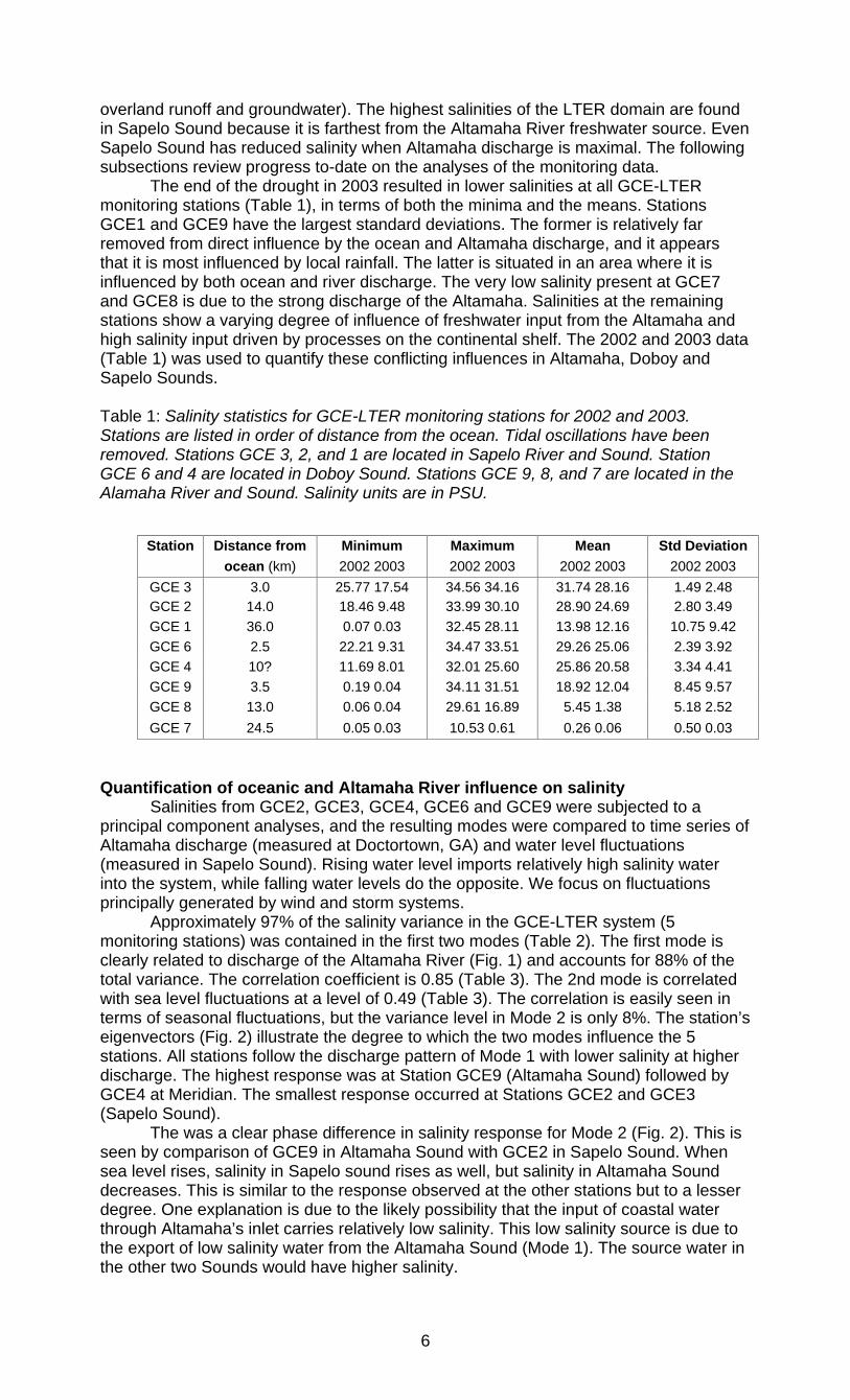
overland runoff and groundwater). The highest salinities of the LTER domain are found in Sapelo Sound because it is farthest from the Altamaha River freshwater source. Even Sapelo Sound has reduced salinity when Altamaha discharge is maximal. The following subsections review progress to-date on the analyses of the monitoring data. The end of the drought in 2003 resulted in lower salinities at all GCE-LTER monitoring stations (Table 1), in terms of both the minima and the means. Stations GCE1 and GCE9 have the largest standard deviations. The former is relatively far removed from direct influence by the ocean and Altamaha discharge, and it appears that it is most influenced by local rainfall. The latter is situated in an area where it is influenced by both ocean and river discharge. The very low salinity present at GCE7 and GCE8 is due to the strong discharge of the Altamaha. Salinities at the remaining stations show a varying degree of influence of freshwater input from the Altamaha and high salinity input driven by processes on the continental shelf. The 2002 and 2003 data (Table 1) was used to quantify these conflicting influences in Altamaha, Doboy and Sapelo Sounds. Table 1: Salinity statistics for GCE-LTER monitoring stations for 2002 and 2003. Stations are listed in order of distance from the ocean. Tidal oscillations have been removed. Stations GCE 3, 2, and 1 are located in Sapelo River and Sound. Station GCE 6 and 4 are located in Doboy Sound. Stations GCE 9, 8, and 7 are located in the Alamaha River and Sound. Salinity units are in PSU.
Quantification of oceanic and Altamaha River influence on salinity
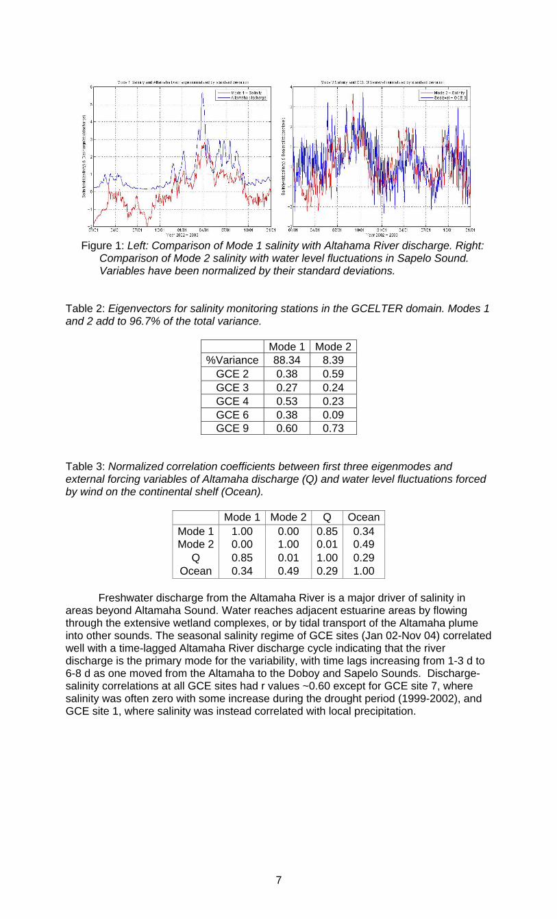
Salinities from GCE2, GCE3, GCE4, GCE6 and GCE9 were subjected to a principal component analyses, and the resulting modes were compared to time series of Altamaha discharge (measured at Doctortown, GA) and water level fluctuations (measured in Sapelo Sound). Rising water level imports relatively high salinity water into the system, while falling water levels do the opposite. We focus on fluctuations principally generated by wind and storm systems.
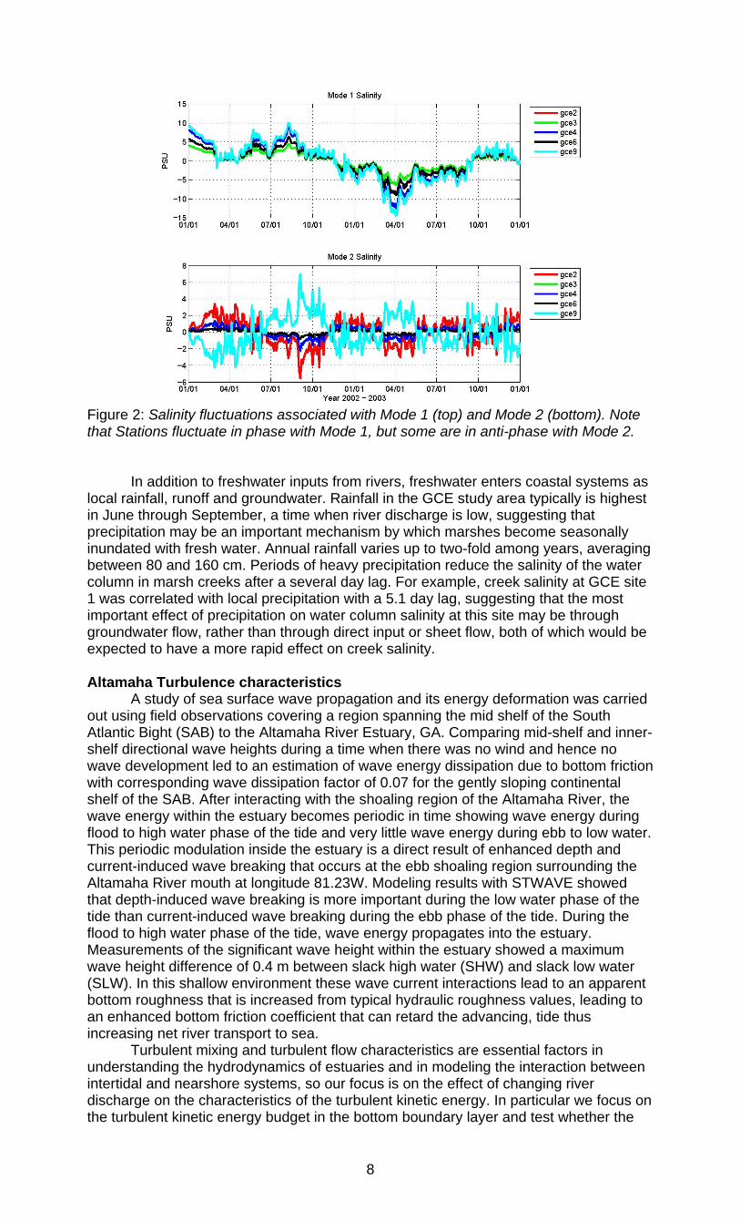
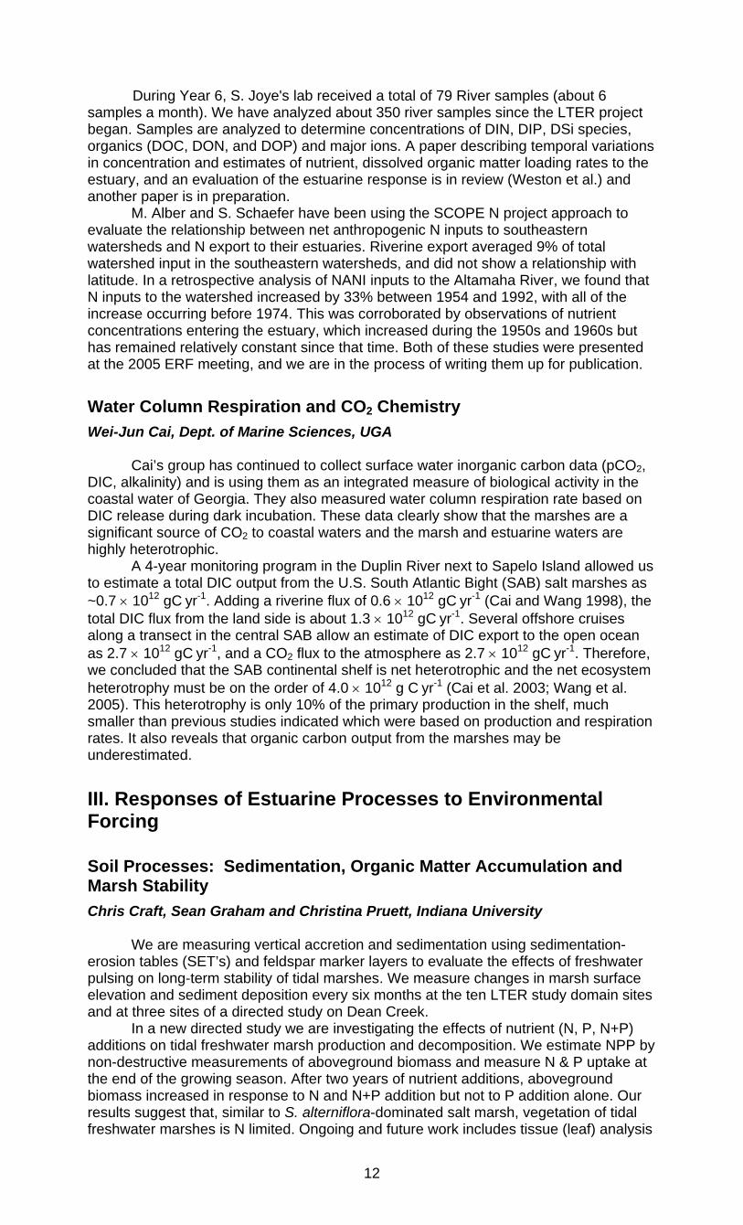
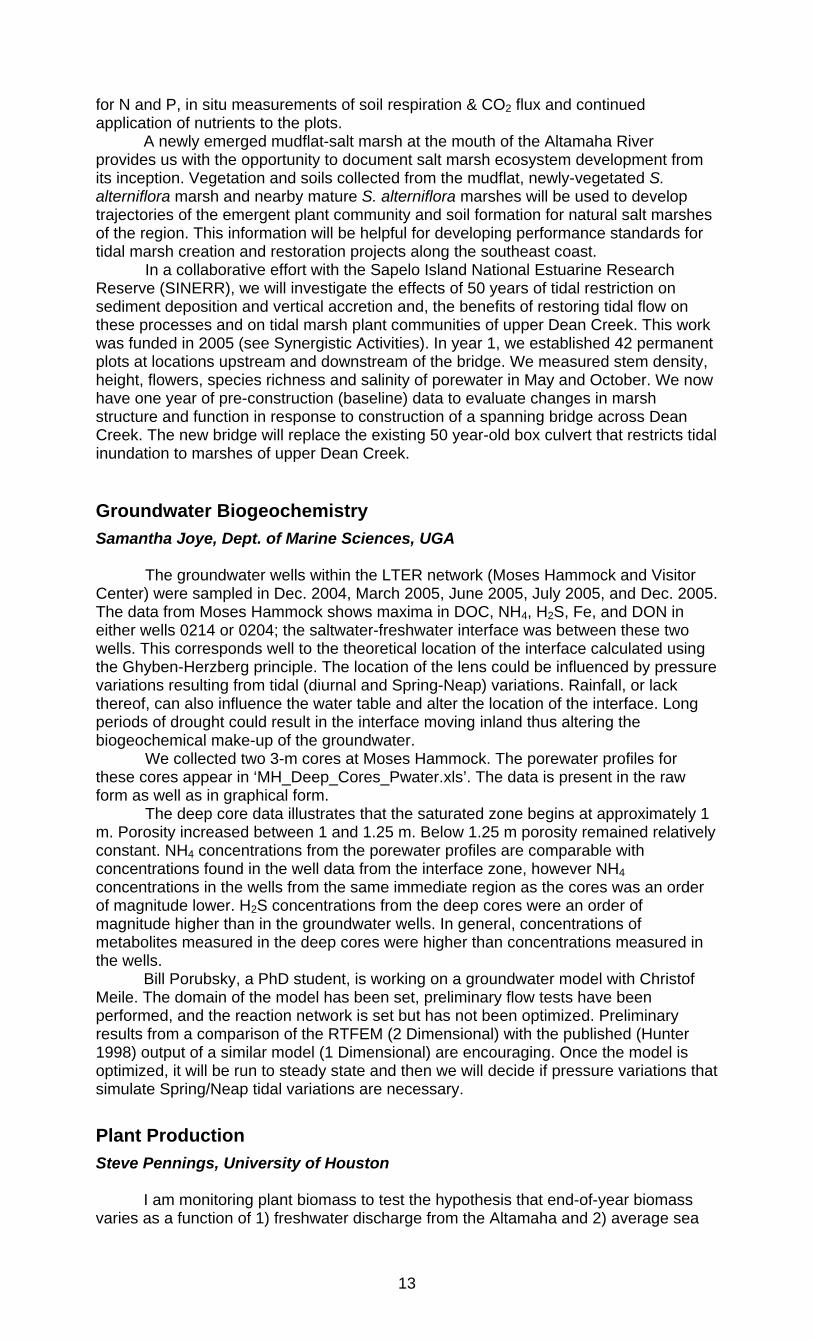
Approximately 97% of the salinity variance in the GCE-LTER system (5 monitoring stations) was contained in the first two modes (Table 2). The first mode is clearly related to discharge of the Altamaha River (Fig. 1) and accounts for 88% of the total variance. The correlation coefficient is 0.85 (Table 3). The 2nd mode is correlated with sea level fluctuations at a level of 0.49 (Table 3). The correlation is easily seen in terms of seasonal fluctuations, but the variance level in Mode 2 is only 8%. The station’s eigenvectors (Fig. 2) illustrate the degree to which the two modes influence the 5 stations. All stations follow the discharge pattern of Mode 1 with lower salinity at higher discharge. The highest response was at Station GCE9 (Altamaha Sound) followed by GCE4 at Meridian. The smallest response occurred at Stations GCE2 and GCE3 (Sapelo Sound).
The was a clear phase difference in salinity response for Mode 2 (Fig. 2). This is seen by comparison of GCE9 in Altamaha Sound with GCE2 in Sapelo Sound. When sea level rises, salinity in Sapelo sound rises as well, but salinity in Altamaha Sound decreases. This is similar to the response observed at the other stations but to a lesser degree. One explanation is due to the likely possibility that the input of coastal water through Altamaha’s inlet carries relatively low salinity. This low salinity source is due to the export of low salinity water from the Altamaha Sound (Mode 1). The source water in the other two Sounds would have higher salinity.
Station Distance from Minimum Maximum Mean Std Deviation ocean (km) 2002 2003 2002 2003 2002 2003 2002 2003
GCE 3 3.0 25.77 17.54 34.56 34.16 31.74 28.16 1.49 2.48 GCE 2 14.0 18.46 9.48 33.99 30.10 28.90 24.69 2.80 3.49 GCE 1 36.0 0.07 0.03 32.45 28.11 13.98 12.16 10.75 9.42 GCE 6 2.5 22.21 9.31 34.47 33.51 29.26 25.06 2.39 3.92 GCE 4 10? 11.69 8.01 32.01 25.60 25.86 20.58 3.34 4.41 GCE 9 3.5 0.19 0.04 34.11 31.51 18.92 12.04 8.45 9.57 GCE 8 13.0 0.06 0.04 29.61 16.89 5.45 1.38 5.18 2.52 GCE 7 24.5 0.05 0.03 10.53 0.61 0.26 0.06 0.50 0.03
7
Figure 1: Left: Comparison of Mode 1 salinity with Altahama River discharge. Right:
Comparison of Mode 2 salinity with water level fluctuations in Sapelo Sound. Variables have been normalized by their standard deviations.
Table 2: Eigenvectors for salinity monitoring stations in the GCELTER domain. Modes 1 and 2 add to 96.7% of the total variance.
Mode 1 Mode 2%Variance 88.34 8.39
GCE 2 0.38 0.59 GCE 3 0.27 0.24 GCE 4 0.53 0.23 GCE 6 0.38 0.09 GCE 9 0.60 0.73
Table 3: Normalized correlation coefficients between first three eigenmodes and external forcing variables of Altamaha discharge (Q) and water level fluctuations forced by wind on the continental shelf (Ocean).
Mode 1 Mode 2 Q OceanMode 1 1.00 0.00 0.85 0.34 Mode 2 0.00 1.00 0.01 0.49
Q 0.85 0.01 1.00 0.29 Ocean 0.34 0.49 0.29 1.00
Freshwater discharge from the Altamaha River is a major driver of salinity in areas beyond Altamaha Sound. Water reaches adjacent estuarine areas by flowing through the extensive wetland complexes, or by tidal transport of the Altamaha plume into other sounds. The seasonal salinity regime of GCE sites (Jan 02-Nov 04) correlated well with a time-lagged Altamaha River discharge cycle indicating that the river discharge is the primary mode for the variability, with time lags increasing from 1-3 d to 6-8 d as one moved from the Altamaha to the Doboy and Sapelo Sounds. Discharge-salinity correlations at all GCE sites had r values ~0.60 except for GCE site 7, where salinity was often zero with some increase during the drought period (1999-2002), and GCE site 1, where salinity was instead correlated with local precipitation.
8
Figure 2: Salinity fluctuations associated with Mode 1 (top) and Mode 2 (bottom). Note that Stations fluctuate in phase with Mode 1, but some are in anti-phase with Mode 2. In addition to freshwater inputs from rivers, freshwater enters coastal systems as local rainfall, runoff and groundwater. Rainfall in the GCE study area typically is highest in June through September, a time when river discharge is low, suggesting that precipitation may be an important mechanism by which marshes become seasonally inundated with fresh water. Annual rainfall varies up to two-fold among years, averaging between 80 and 160 cm. Periods of heavy precipitation reduce the salinity of the water column in marsh creeks after a several day lag. For example, creek salinity at GCE site 1 was correlated with local precipitation with a 5.1 day lag, suggesting that the most important effect of precipitation on water column salinity at this site may be through groundwater flow, rather than through direct input or sheet flow, both of which would be expected to have a more rapid effect on creek salinity. Altamaha Turbulence characteristics A study of sea surface wave propagation and its energy deformation was carried out using field observations covering a region spanning the mid shelf of the South Atlantic Bight (SAB) to the Altamaha River Estuary, GA. Comparing mid-shelf and inner-shelf directional wave heights during a time when there was no wind and hence no wave development led to an estimation of wave energy dissipation due to bottom friction with corresponding wave dissipation factor of 0.07 for the gently sloping continental shelf of the SAB. After interacting with the shoaling region of the Altamaha River, the wave energy within the estuary becomes periodic in time showing wave energy during flood to high water phase of the tide and very little wave energy during ebb to low water. This periodic modulation inside the estuary is a direct result of enhanced depth and current-induced wave breaking that occurs at the ebb shoaling region surrounding the Altamaha River mouth at longitude 81.23W. Modeling results with STWAVE showed that depth-induced wave breaking is more important during the low water phase of the tide than current-induced wave breaking during the ebb phase of the tide. During the flood to high water phase of the tide, wave energy propagates into the estuary. Measurements of the significant wave height within the estuary showed a maximum wave height difference of 0.4 m between slack high water (SHW) and slack low water (SLW). In this shallow environment these wave current interactions lead to an apparent bottom roughness that is increased from typical hydraulic roughness values, leading to an enhanced bottom friction coefficient that can retard the advancing, tide thus increasing net river transport to sea. Turbulent mixing and turbulent flow characteristics are essential factors in understanding the hydrodynamics of estuaries and in modeling the interaction between intertidal and nearshore systems, so our focus is on the effect of changing river discharge on the characteristics of the turbulent kinetic energy. In particular we focus on the turbulent kinetic energy budget in the bottom boundary layer and test whether the
9
effects of stabilizing and destabilizing buoyancy effects are important contributors since horizontal density gradients are large in the Altamaha River system. An examination of turbulent flow characteristics in a highly compressed estuary had not been carried out prior to our study, even though turbulence in estuarine and coastal regions is a key component to understanding many physical, biological and biogeochemical processes and for the development of circulation models. Estimates of the Reynolds stress, shear production (P), dissipation rate (�) and buoyancy flux (B) were derived and compared for two contrasting river conditions which essentially characterized the estuary as well mixed during low discharge and partially mixed during high discharge. Flood/ebb asymmetries in the buoyancy flux, calculated by the dynamic approach in which the flux is estimated as a residual after other terms in the simplified density conservation equation are measured, showed that during ebb the buoyancy flux was a large sink and during flood it was a weak source. A balance of production and dissipation of energy gave a factor of 2 difference, implying that turbulent transport of TKE is an important mechanism.
Residence Times in the Altamaha River Estuary Merryl Alber and Joan Sheldon, Dept. of Marine Sciences, University of Georgia
We (Joan Sheldon and Merryl Alber) continue to work with our desktop modeling application, SqueezeBox, as a way to estimate transport times and interpret patterns in estuaries. We completed an analysis in which chlorophyll a concentrations measured along the Altamaha River estuary during 10 sampling periods were compared to transit times through the entire estuary as well as through the tidal freshwater, oligohaline, mesohaline, and polyhaline zones. Overall, total transit time is a good predictor of average estuary chlorophyll concentration, location of the chlorophyll peak, and salinity at the peak location. With increasing transit time, chlorophyll concentrations increase and the peak moves upstream and occurs at lower salinities. However, zone transit times can be better predictors of zone chlorophyll concentrations. At high flows, the tidal freshwater zone is long (>35 km) but transit time through it is very short (<1 d), and chlorophyll concentrations are nearly zero except in the lower estuary. As flows decrease, most of the extra transit time is spent in higher-salinity zones, and chlorophyll increases in these zones. Chlorophyll in tidal freshwater remains minimal until the freshwater zone transit time surpasses 1.3 d, then rises rapidly, suggesting that net phytoplankton production has overcome flushing. This work was presented at the 2005 Estuarine Research Federation as part of a special session that we organized on “Utility of Residence Time and Related Concepts in Estuarine Studies.” Our paper on the relationship between freshwater fraction and tidal prism methods was also accepted for publication (Sheldon and Alber 2006).
We also used SqueezeBox to perform a detailed comparison of transit times over the range of historic flows in both the Altamaha and Ogeechee River estuaries. Although the two estuaries have similar lengths, we found that the slower-flowing Ogeechee grades from a zone of tidal freshwater (except at very low flows) through oligo-mesohaline zones to a polyhaline zone inside the mouth whereas the Altamaha always has a fairly long (>25 km) extent of tidal freshwater but only a short (or non-existent) polyhaline zone. Transit times through the whole Ogeechee estuary are 3.3 to 4.7 times longer than those in the Altamaha, but the lengths of time water spends in the tidal freshwater reaches of the estuaries are comparable whereas there are large differences in the times spent in oligo-mesohaline and polyhaline reaches. This work was presented at the 2005 Georgia Water Resources Conference (Sheldon and Alber 2005).
Circulation and Biogeochemical Fluxes in the Duplin River Jack Blanton, Skidaway Institute of Oceanography; Daniela Di Iorio, Dept. of Marine Sciences, UGA
Exchange processes between intertidal areas and tidal creeks The Duplin River, at the geographic center of the GCE domain, is the site of an ongoing directed study of the exchange processes between subtidal and intertidal areas. It has a large intertidal drainage area with a hard land periphery on the east side
10
and large salt marshes and hammocks situated on the west side. We have used a 3 element approach to address the complexity of the large intertidal areas surrounding the main channel of the Duplin River. First, DUPLEX 1 brought together GCE LTER investigators for a coordinated field effort in the Duplin. Secondly, a series of aerial images are currently being used to determine water area as a function of water level for 12 of the larger tributary creeks. Special emphasis has been placed on 4 sub areas containing hammocks on the west side. The third element is the TELEMAC hydrodynamic model of the Duplin River system. The previous annual report covers the DUPLEX studies and full details are described in Blanton et al. (2005). Transport mechanisms Although salt balance techniques from moored measurements are often used to characterize material transport in estuaries, this approach suffers from limitations in areas of low to no longitudinal salinity gradient or where the salinity is not in steady state. We are currently in the process of decomposing salinity and flow into advective and tidal components along with time-varying depth. We expect that cross-sectional shear transport will be negligible as the cross sectional salinity gradient is small (or non existent) for the Duplin River. The advective transport of salt is for the most part export directed. The dispersive tidal transport was decomposed into tidal pumping transport mechanisms, which was much less than the advective term, suggesting a non steady state. In fact, salinities in the Duplin were increasing during the summer 2003 observation period. Initial measurements of diffusive/dispersive processes using non steady salt flux relations in the lower reaches of the Duplin River have given values on average of 250 m/s. These estimates will be refined by considering vertical shear transport mechanisms since surface and bottom salinities and flow were also measured. We have also begun using drifters to allow transport measurements to be validated and extended into areas where they could not previously be made due to a lack of tracers. Previous work with drifters in shallow coastal waters has been limited by the high cost of commercially available drifters and the large size of drifters designed for open ocean use. Earlier attempts to develop small and inexpensive drifters have resulted in instruments which are either visually tracked and internally logging and thus subject to loss or are limited by battery life and radio range. However the recent introduction of inexpensive commercially available GPS receiver/General Mobile Radio Spectrum (GMRS) radio transmitter units with PC connections, such as the Garmin Rino 130, and the easing of FCC rules to allow high powered data transmissions on GMRS frequencies makes it possible to develop small and inexpensive drifters capable both of internally logging their position and transmitting it back at regular intervals to a remote base station for real time tracking and data processing. A set of six such small, low cost, GPS-tracked Lagrangian drifters were designed, built and tested in the upper and lower Duplin during Summer and Fall of 2005. Four trials have been run in the lower Duplin, two looking at dispersion/ diffusion wholly within the main channel and two looking at export into Doboy sound. These measurements will be compared to long term simultaneous and previously mooring measurements of flow and salinity within the Duplin River. A heat balance has been constructed for the lower Duplin showing that heating and cooling in this area is predominantly tidal as water is advected in from and carried out to Doboy Sound. This is in contrast to the upper reaches where the along-channel temperature gradient is near zero and heating and cooling are diurnal in nature and coincide with the solar heating cycle. There exists a middle region where temperature appears to be dependent on both solar and tidal influences. Heating and cooling of waters overlying the salt marsh on flood, particularly when high tide coincides with midday or midnight, is hypothesized to be a source of excess heating and cooling in the main channel as a result of advection on the following ebb.
Groundwater Hydrology Carolyn Ruppel, Georgia Tech Salt marsh systems play a critical role in buffering upland coastal areas from the influence of open saltwater bodies and in filtering contaminants that originate offshore or are flushed from uplands. For these reasons, it is important to understand the salt marsh hydrologic cycle, especially the interaction of groundwater and surface water
11
across low-lying coastal fringes and the changes in physical, chemical, and ecological parameters across salinity gradients extending from upland to tidal creek to open water. For the past several years, we have conducted hydrogeophysical surveys (inductive EM and DC resistivity) and collected limited, coincident groundwater hydrologic data in clastic salt marshes throughout the South Atlantic Bight (SAB), stretching from South Carolina on the north to the Georgia-Florida border on the south. All of the marshes are dominated by Spartina and Juncus grasses and are cut by tidally-influenced creeks, but both the lithology and age of the marshes vary widely. For example, one highly homogeneous marsh study site has formed only within the past century, while most sites have existed for thousands of years and have laterally and vertically heterogeneous lithology. Geophysical images of the marsh subsurface and coincident monitoring of groundwater temperature, water level, and/or chemistry consistently show that marshes in the mixed energy environment of the middle part of the SAB (GCE LTER) tend to be dominated by submarsh discharge of freshwater to adjacent tidal creeks. In the South Carolina part of the SAB, we have greater evidence for seepage, particularly through biologically-created macropore networks and permeable sediment bodies that intersect tidal creeks. It is possible though that the South Carolina results are not so much 'universal' as reflective of local lithology. In a very young marsh near the Florida border, geophysical imaging implies a mixture of seepage and submarsh flow, and hydrologic data provide unequivocal proof that the near-surface marsh muds act as a low permeability barrier to downward penetration of tidal creek surface waters during periodic inundation of the marsh. Taken together, the results imply that subsurface freshwater bodies flowing beneath some salt marshes act as extensions of the classic freshwater lens that develops beneath uplands and help to resist saline intrusion toward uplands. Certain factors allow us to predict the occurrence of seepage, instead of submarsh flow, in SAB salt marshes with some degree of confidence. Where we have acquired time series, both the hydrogeophysical and hydrologic data suggest that groundwater transport processes are at approximate steady-state at the length scales (vertical and horizontal) and over the duration of our measurements.
Patterns of dissolved and suspended material James T. Hollibaugh, Samantha Joye, and Merryl Alber University of Georgia Quarterly Monitoring Cruises
During Year 6, Matthew Erickson (March and June) and Steve Bell (September and December) from the Joye group served as chief scientist on the LTER quarterly monitoring cruises. We collected a total of 287 samples from the quarterly monitoring cruises samples to determine concentrations of dissolved nutrients (NO2
-, NO3-, NH4
+, HPO4
2-, and H2SiO42-), dissolved organics (DOC, TDN, DON, TDP, and DOP),
chlorophyll a, total suspended sediments, particulate CN, and particulate P and Fe. These analyses are in various phases of completion.
Spatial and temporal variations among the study sites were apparent. The highest NOx concentrations were present in Altamaha Sound on all sampling dates; concentrations of NOx in Doboy and Sapelo Sounds were 10X lower. In Altamaha Sound, the highest NOx concentrations were present at GCE 7 and 8 and concentrations were comparable at low and high water. At GCE 9, concentrations were 3X higher on low water compared to high water (low water concentrations were comparable to those observed at GCE 7 and 8). No significant differences in NOx concentration were observed between surface and bottom water samples at any of the stations. NH4 concentrations were generally highest at GCE 9, where NH4 and NOx concentrations were often comparable. At GCE 7 and 8, NH4 concentrations were usually at least 2X lower than NOx concentrations. In Doboy and Sapelo Sounds, concentrations of NH4 usually exceeded NOx concentrations. DIN:DIP ratios in Altamaha Sound exceeded the Redfield ratio in December, March and June, suggestive of P limitation, and fell below the Redfield ratio in September, suggestive of N limitation. DIN:DIP ratios in Doboy and Sapelo Sounds were always below the Redfield ratio, suggestive of N limitation. DON and DOP concentrations exceeded DIN and DIP concentrations in all sounds. DOC concentrations were highest in Sapelo Sound, followed by Doboy and Altamaha Sounds. River delivery of dissolved and suspended material
12
During Year 6, S. Joye's lab received a total of 79 River samples (about 6 samples a month). We have analyzed about 350 river samples since the LTER project began. Samples are analyzed to determine concentrations of DIN, DIP, DSi species, organics (DOC, DON, and DOP) and major ions. A paper describing temporal variations in concentration and estimates of nutrient, dissolved organic matter loading rates to the estuary, and an evaluation of the estuarine response is in review (Weston et al.) and another paper is in preparation. M. Alber and S. Schaefer have been using the SCOPE N project approach to evaluate the relationship between net anthropogenic N inputs to southeastern watersheds and N export to their estuaries. Riverine export averaged 9% of total watershed input in the southeastern watersheds, and did not show a relationship with latitude. In a retrospective analysis of NANI inputs to the Altamaha River, we found that N inputs to the watershed increased by 33% between 1954 and 1992, with all of the increase occurring before 1974. This was corroborated by observations of nutrient concentrations entering the estuary, which increased during the 1950s and 1960s but has remained relatively constant since that time. Both of these studies were presented at the 2005 ERF meeting, and we are in the process of writing them up for publication.
Water Column Respiration and CO2 Chemistry Wei-Jun Cai, Dept. of Marine Sciences, UGA
Cai’s group has continued to collect surface water inorganic carbon data (pCO2, DIC, alkalinity) and is using them as an integrated measure of biological activity in the coastal water of Georgia. They also measured water column respiration rate based on DIC release during dark incubation. These data clearly show that the marshes are a significant source of CO2 to coastal waters and the marsh and estuarine waters are highly heterotrophic. A 4-year monitoring program in the Duplin River next to Sapelo Island allowed us to estimate a total DIC output from the U.S. South Atlantic Bight (SAB) salt marshes as ~0.7 × 10¹² gC yr-1. Adding a riverine flux of 0.6 × 10¹² gC yr-1 (Cai and Wang 1998), the total DIC flux from the land side is about 1.3 × 10¹² gC yr-1. Several offshore cruises along a transect in the central SAB allow an estimate of DIC export to the open ocean as 2.7 × 10¹² gC yr-1, and a CO2 flux to the atmosphere as 2.7 × 10¹² gC yr-1. Therefore, we concluded that the SAB continental shelf is net heterotrophic and the net ecosystem heterotrophy must be on the order of 4.0 × 10¹² g C yr-1 (Cai et al. 2003; Wang et al. 2005). This heterotrophy is only 10% of the primary production in the shelf, much smaller than previous studies indicated which were based on production and respiration rates. It also reveals that organic carbon output from the marshes may be underestimated.
III. Responses of Estuarine Processes to Environmental Forcing
Soil Processes: Sedimentation, Organic Matter Accumulation and Marsh Stability Chris Craft, Sean Graham and Christina Pruett, Indiana University
We are measuring vertical accretion and sedimentation using sedimentation- erosion tables (SET’s) and feldspar marker layers to evaluate the effects of freshwater pulsing on long-term stability of tidal marshes. We measure changes in marsh surface elevation and sediment deposition every six months at the ten LTER study domain sites and at three sites of a directed study on Dean Creek. In a new directed study we are investigating the effects of nutrient (N, P, N+P) additions on tidal freshwater marsh production and decomposition. We estimate NPP by non-destructive measurements of aboveground biomass and measure N & P uptake at the end of the growing season. After two years of nutrient additions, aboveground biomass increased in response to N and N+P addition but not to P addition alone. Our results suggest that, similar to S. alterniflora-dominated salt marsh, vegetation of tidal freshwater marshes is N limited. Ongoing and future work includes tissue (leaf) analysis
13
for N and P, in situ measurements of soil respiration & CO2 flux and continued application of nutrients to the plots. A newly emerged mudflat-salt marsh at the mouth of the Altamaha River provides us with the opportunity to document salt marsh ecosystem development from its inception. Vegetation and soils collected from the mudflat, newly-vegetated S. alterniflora marsh and nearby mature S. alterniflora marshes will be used to develop trajectories of the emergent plant community and soil formation for natural salt marshes of the region. This information will be helpful for developing performance standards for tidal marsh creation and restoration projects along the southeast coast.
In a collaborative effort with the Sapelo Island National Estuarine Research Reserve (SINERR), we will investigate the effects of 50 years of tidal restriction on sediment deposition and vertical accretion and, the benefits of restoring tidal flow on these processes and on tidal marsh plant communities of upper Dean Creek. This work was funded in 2005 (see Synergistic Activities). In year 1, we established 42 permanent plots at locations upstream and downstream of the bridge. We measured stem density, height, flowers, species richness and salinity of porewater in May and October. We now have one year of pre-construction (baseline) data to evaluate changes in marsh structure and function in response to construction of a spanning bridge across Dean Creek. The new bridge will replace the existing 50 year-old box culvert that restricts tidal inundation to marshes of upper Dean Creek.
Groundwater Biogeochemistry Samantha Joye, Dept. of Marine Sciences, UGA
The groundwater wells within the LTER network (Moses Hammock and Visitor Center) were sampled in Dec. 2004, March 2005, June 2005, July 2005, and Dec. 2005. The data from Moses Hammock shows maxima in DOC, NH4, H2S, Fe, and DON in either wells 0214 or 0204; the saltwater-freshwater interface was between these two wells. This corresponds well to the theoretical location of the interface calculated using the Ghyben-Herzberg principle. The location of the lens could be influenced by pressure variations resulting from tidal (diurnal and Spring-Neap) variations. Rainfall, or lack thereof, can also influence the water table and alter the location of the interface. Long periods of drought could result in the interface moving inland thus altering the biogeochemical make-up of the groundwater.
We collected two 3-m cores at Moses Hammock. The porewater profiles for these cores appear in ‘MH_Deep_Cores_Pwater.xls’. The data is present in the raw form as well as in graphical form.
The deep core data illustrates that the saturated zone begins at approximately 1 m. Porosity increased between 1 and 1.25 m. Below 1.25 m porosity remained relatively constant. NH4 concentrations from the porewater profiles are comparable with concentrations found in the well data from the interface zone, however NH4 concentrations in the wells from the same immediate region as the cores was an order of magnitude lower. H2S concentrations from the deep cores were an order of magnitude higher than in the groundwater wells. In general, concentrations of metabolites measured in the deep cores were higher than concentrations measured in the wells.
Bill Porubsky, a PhD student, is working on a groundwater model with Christof Meile. The domain of the model has been set, preliminary flow tests have been performed, and the reaction network is set but has not been optimized. Preliminary results from a comparison of the RTFEM (2 Dimensional) with the published (Hunter 1998) output of a similar model (1 Dimensional) are encouraging. Once the model is optimized, it will be run to steady state and then we will decide if pressure variations that simulate Spring/Neap tidal variations are necessary.
Plant Production Steve Pennings, University of Houston I am monitoring plant biomass to test the hypothesis that end-of-year biomass varies as a function of 1) freshwater discharge from the Altamaha and 2) average sea
14
level. In 2000 we set up permanent plots at all 10 LTER monitoring sites. Plots were established at creek-bank and mid-marsh zones (8 plots/zone/site). An additional zone (high marsh Juncus) was established at site 10 in 2005 to increase replication of sites with Juncus. Plants were non-destructively monitored (stem counts, heights, flowering status) in October 2000, 2001, 2002, 2003, 2004 and 2005. Soil organic content was measured by ashing cores collected adjacent to each plot in October 2000. Stem samples were taken adjacent to plots in 2002, measured, dried and weighed, in order to generate regression relationships between height and mass. Results to-date suggest that productivity of creekbank plots increases during years with high Altamaha discharge during the summer months. Plots are also proving useful in documenting spatial and temporal variation in disturbance from physical (wrack) and biotic (grazing) sources.
Measurements of plant photosynthesis at high and low tides indicated that photosynthesis of high-marsh plants was more strongly affected by the spring-neap tidal cycle than by the daily tidal cycle. A manuscript based on this work has been submitted.
Plant Litter Decomposition Malte Mews, Ph.D. Student, Univ. of Kiel, Germany and Martin Zimmer, Univ. of Kiel, Germany We are testing whether decomposition rates of salt marsh plant litter (Spartina alterniflora, Juncus roemerianus, Quercus virginiana) are affected by the presence of different litter species and by the diversity of invertebrate detritivores (Littoraria irrorata, Melampus bidentatus, Armases cinereum). We set up enclosures in the low and high intertidal zone, respectively, with either one or two of three species (both for litter and detritivores), and sampled and analyzed the remaining plant litter after three months (July-October 2005). Preliminary results indicate that plant litter diversity does not influence the mass loss of the tested litter. Detritivores did not significantly accelerate litter mass loss within/after three months (compared to animal-free controls), nor did their diversity affect mass loss rates.
Plant Community Ecology Steven Pennings, Univ. of Houston Responses to eutrophication. In collaboration with Caroline McFarlin (M.S. student), I examined spatial variation in nutrient effects on marsh community structure. The border between two dominant marsh plants, Spartina alterniflora and Juncus roemerianus, was fertilized at 19 sites within the LTER domain for two years. Across all sites there was a strong increase in biomass of live and dead S. alterniflora and a decrease in biomass of live and dead J. roemerianus in fertilized plots. Decomposer fungi on dead S. alterniflora leaves did not increase per unit of dead leaf, but did increase on a per-plot basis. Herbivorous grasshoppers increased in abundance, but detritivorous snails did not. All responses varied among sites. We are exploring correlations between edaphic variables and responses to fertilization to see if we can explain any of the site to site variation. We expect to submit a manuscript based on this work during the summer. Plant zonation In collaboration with Mary-Bestor Grant and Mark Bertness, I examined the factors mediating zonation between Juncus roemerianus and Spartina alterniflora at Sapelo Island. Juncus was precluded from moving to low elevations by a combination of salinity, flooding, and competition. Spartina was precluded from moving to higher elevations by competition. These results differ from those of previous zonation studies in New England in that salinity stress played a greater role in Georgia. A manuscript based on this work recently appeared in the Journal of Ecology. Annual variation in vegetation borders
15
I am testing the hypothesis that annual variation in marsh plant species composition is driven by variation in rainfall. Salt marsh vegetation often consists of discrete stands with abrupt borders between different species or associations. I have monitored mid-summer plant composition at permanent plots located on 3 types of vegetation borders (Spartina alterniflora-Juncus roemerianus, S. alterniflora-meadow, meadow-Juncus roemerianus), at two sites each, since 1996. Vegetation composition in these plots is dynamic, and appears to be related to variation in rainfall, although more years of data will be needed to rigorously test this hypothesis. Secondary succession of marsh vegetation in GA and AL I am conducting parallel experiments in GA and AL to examine 1) how rapidly marsh vegetation can recover from disturbance, and 2) the role of competition in secondary succession. In 3 vegetation zones (Spartina alterniflora-meadow border, meadow-Juncus roemerianus border, J. roemerianus zone) at each of 2 marshes in each state, I cleared replicate 3 x 3 m plots using herbicide and clipping and maintained plots free of vegetation for 2 years. Control plots were marked but unmanipulated. In 2000 individual plots were divided into two or four quadrants, depending on the diversity of the vegetation in each zone, with one quadrant allowed to recover without further manipulation and the other quadrant(s) treated by periodically removing 1 or 2 dominant plant species occurring in each zone. To date, succession has been fastest in plots on the Spartina alterniflora-meadow border, which have already converged on control plot values, and slowest in the J. roemerianus plots, which are still early in the successional trajectory. Removal treatments indicate that competition plays a strong role in mediating the composition of the vegetation in each zone.
Phenotypic and Genetic Variation in Salt Marsh Plant Species Lisa Donovan, Dept. of Plant Biology, UGA Our directed study under the GC-LTER consisted of 4 studies, which formed the core of Christina Richards’ dissertation in 2004. We had previously presented results from three studies investigating plant strategies that may have evolved in response to the heterogeneity of the marsh environment. The first study showed that 12 plant species express a broad range of phenotypes correlated to environmental factors in Sapelo Island salt marshes. This study was presented as a poster in 2000 at the ESA annual meeting, in 2001 at the GC-LTER annual meeting and at the 2002 National Estuarine Research Reserve (NERR) annual meeting. A manuscript on this work was published in Plant Ecology in 2005. The second study, done in the controlled environment of a greenhouse, suggests some traits in Borrichia frutescens are differentiating in response to salt while others are plastic. These results were formally presented at the 2001 ESA annual meeting. A manuscript summarizing this work is in preparation for submission to Journal of Evolutionary Biology. The third study, based on allozyme markers, revealed that clone size in Borrichia frutescens and Spartina alterniflora are not as large as we anticipated and genetic structure is not significantly explained by the environmental gradients in the marsh. The results for B. frutescens were presented at 5 national meetings in the summer of 2003: SSE (oral), ESA (oral), ERF (poster), LTER (poster) and NERR (poster). The manuscript reports the data for both species and was published in Ecology Letters in 2004. In the fourth study, we used two large field experiments to further investigate how natural selection acts in populations of the C3 composite Borrichia frutescens. Spartina alterniflora was eliminated from these studies due to the magnitude of the design necessary to closely examine patterns of natural selection in the field. The results were published in Christina Richards’ dissertation in May 2004 and presented at the ERF annual meeting in Norfolk, VA this fall. The final manuscript is in preparation for submission to Evolution.
16
Benthic Invertebrates Dale Bishop and Merryl Alber, UGA Dept of Marine Sciences
We (Bishop and Alber) continue the routine monitoring of marsh macrofauna. We have found no significant difference in population size estimates made in the spring or fall for most of the common species. Therefore, all ten permanent monitoring sites will continue to be sampled annually in the fall to coincide with the plant monitoring program. All epifaunal and infaunal mollusc data sets from the monitoring program will be accessible on the project website by early spring 2006.
Oyster reef crab population monitoring (begun in 2002) is ongoing. This project was designed to determine the long-term effects of the invasive green porcelain crab, Petrolisthes armatus, on native mud crab populations. From 2003 to 2004, the number of P. armatus as a proportion of the three most common reef crabs increased from 6% to 60%. Over the same period, the percentage of flat-backed mud crabs (Eurypanopeus depressus) decreased from 77% to 18%. This shift may have resulted from competition for space as both are crabs are found in the upper interstices of oyster reefs.
Our project to assess the occurrence of the invasive green mussel, Perna viridis, in Georgia estuaries (in conjunction with SINERR and UGA Marine Extension) was concluded in 2005. No significant populations were found at the sample sites monitored in the Savannah, Altamaha or Satilla Rivers. Although established populations continue to be found in the near shore region, significant invasion of the estuaries has not occurred.
Our efforts to evaluate the effects of restored tidal flow on the invertebrate communities at Dean Creek (Sapelo Island) have continued. Due to delays in bridge construction, we were able to collect a second year of pre-construction population abundance and distribution data. GCE-LTER population monitoring protocols are being used for the work at Dean Creek, allowing direct comparisons with data from the GCE monitoring program (especially site #6). Bishop, Di Iorio, Craft and Hurley have submitted a Coastal Incentive Grant proposal to fund the after construction phase of this research. In addition to the invertebrate data, this proposal seeks funding for work on hydrodynamic and sedimentation processes and plant population studies. The goal of this project is to provide information for best management practices related to roadway construction over marsh creeks.
Blue crab recruitment studies initiated during the Duplex I effort (August 2003) have been expanded spatially and temporally. During the summer and fall of 2005, larval collectors were deployed in the Duplin, North, and Altamaha Rivers within the GCE domain. Sites were selected according to salinity differences and distance from ocean inlets. Collectors were processed every two to three days for blue crab megalopae and early crab stages. This resulted in over 700 individual samples, which are still being processed. Early indications are that recruitment follows patterns known from other South and Mid-Atlantic estuaries: larvae settle in pulses, preferably near the bottom, and in lower salinity areas. This work represents a collaboration between GCE-LTER, SINERR, UGA Marine extension and the UGA Department of Marine Sciences personnel, and has led to a subsequent project by Bishop and Dr. Charles Tilburg (UGA Marine Sciences) designed to assess the abundance and distribution of earlier larval stages of the blue crab in the Satilla River. Biological and physical oceanography data will be combined in a modeling effort aimed at predicting blue crab settlement patterns and locations.
Plant-Herbivore Interactions Steven Pennings, University of Houston
Feeding preference experiments indicate that most marsh plants are more palatable at high latitudes (New England) than at low latitudes (e.g., GA). This variation is correlated with latitudinal differences in toughness, nitrogen content and chemistry, and is constitutive rather than induced. We are testing the hypothesis that herbivore pressure is greater at low latitudes, and thus that this could be one selective pressure on plant palatability.
Our grasshopper monitoring data allows us to determine whether their abundance varies among sites and years as a function of site characteristics and
17
angiosperm production. Grasshoppers (which are dominated by two common taxa) have been visually counted on transects (mid-marsh, 8-10/site) at the 10 LTER monitoring sites every August since 2000. Densities differed more than ten-fold among sites. The rank-order of sites was similar among years, suggesting that some sites consistently supported high grasshopper populations and other sites consistently supported low populations. Expanded monitoring at 30 sites in 2003 indicated that grasshoppers were common at sites with extensive adjacent upland, but were absent at mid-estuary sites that had extensive Spartina zones but lacked upland habitats. We have begun to make collections at multiple sites along the Atlantic Coast of the US from FL to ME to examine latitudinal variation in salt marsh grasshopper species composition and body size.
Microbial Food Webs in Salt Marsh Sediments Matthew First, Ph.D. Student, Dept. of Marine Sciences, UGA; James T. Hollibaugh, Dept. of Marine Sciences, UGA
Benthic ecosystems are locations of high microbial concentration and activity. The high bacterial concentrations in sediment (generally several orders of magnitude greater than water column bacteria) harbor extensive metabolic diversity, allowing bacterial communities to adapt to shifting conditions in temperature, salinity, insolation and oxygen availability. Although bacteria, microalgae and meiofauna are considered important food sources for higher trophic levels (e.g. Uca pugnax, Littoraria irrorata.), the role of protist bacterivores remains unclear. For example, how does the biomass of sediment heterotrophic protists vary over changing conditions and how does this relate to bacterial biomass? Are abiotic factors (e.g. temperature, sediment grain size) more important in regulating benthic protists than prey availability or predator control? Reports of high bacterial production and stable standing biomass argue that bacterial grazing plays an important role in carbon flow to higher trophic levels. The following studies are geared towards addressing these issues:
1. A year long survey of benthic microbes was completed in 2005 with monthly sampling and experiments at locations with varying conditions. Sub-tidal sediment samples were collected from a sandy beach (Nanny Goat Beach), a tidal creek (Dean Creek) and a Spartina alterniflora marsh (Marsh Landing). These samples were used to determine both bacterial and microfaunal community structures (concentration, biomass, ribotype distribution). Grazing on bacteria was measured by enumerating fluorescently labeled cells in protist food vacuoles.
2. A short term (24 hour) survey was conducted in July 2005 at Dean Creek to observe changes in sediment photopigments, bacteria, protist concentration and activity. In order to track small scale migrations of benthic protists, fluorescently stained cells were enumerated in epoxy-embedded cores to follow the relative positions of protists in the sediment over large fluctuations in temperature, salinity, water cover and insolation.
3. Because sediments have high concentrations of detrital carbon, the direct uptake of high molecular weight organic molecules by ciliates is under investigation. Although osmotrophy is common in enteric ciliates and direct uptake of dissolved organic matter has been noted for water column flagellates, the role of direct organic matter uptake by benthic ciliates is unclear. This work will report on the prevalence of fluorescein-labeled dextran in ciliate food vacuoles as well as the potential role of this organic carbon in supplementing carbon requirements. Initial surveys indicate that direct uptake of dissolved organic matter is common among benthic ciliates.
4. The process of selective feeding by sediment bacterivores will be investigated in a series of lab-based experiments. Primarily, these experiments will test whether bacterial size (manipulated by impeding cell division) affects uptake rate. Also, several common bacterial species of similar size ranges will be used to determine if selection may be a function of some other phenotypic trait.
5. A spatial survey of sediment microfauna and meiofauna was conducted in October of 2005. This survey compared creek bank communities to mid-marsh communities at several GCE-LTER sites. With information on invertebrate
18
populations gathered by Dale Bishop, this study will provide a comprehensive survey of benthic biota at GCE-LTER locations.
While the vast majority of field sampling and experiments has been completed, analysis of the samples is still underway. The results of the short term survey will be presented at the ASLO conference in June of 2006. The two surveys are expected to generate three manuscripts which should be submitted by Summer of 2006. The experimental chapters will be completed by Fall of 2006. Additionally, the survey of microbial communities at the LTER sites will likely be completed by the Fall of 2006 with a manuscript forthcoming in 2007.
Molecular Comparison of Ascomycete Fungal Communities on Spartina Species Justine Lyons, Ph.D. Student, Dept. of Marine Sciences, UGA; James T. Hollibaugh, Dept. of Marine Sciences, UGA
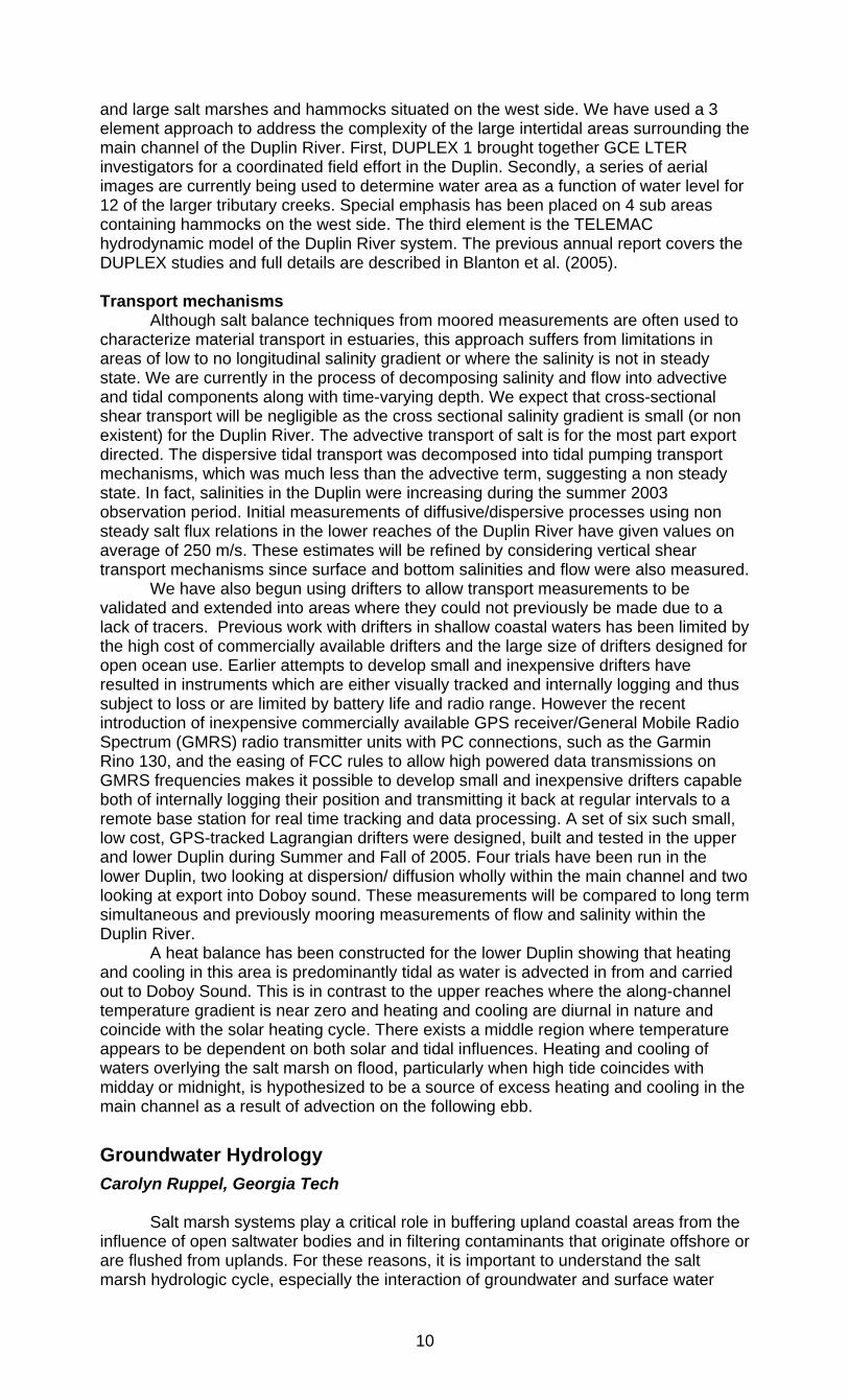
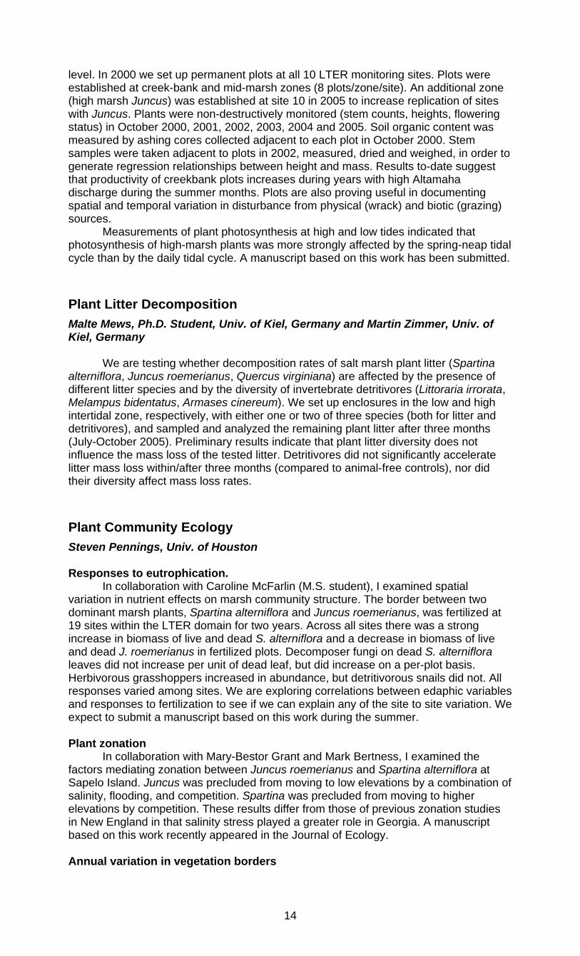
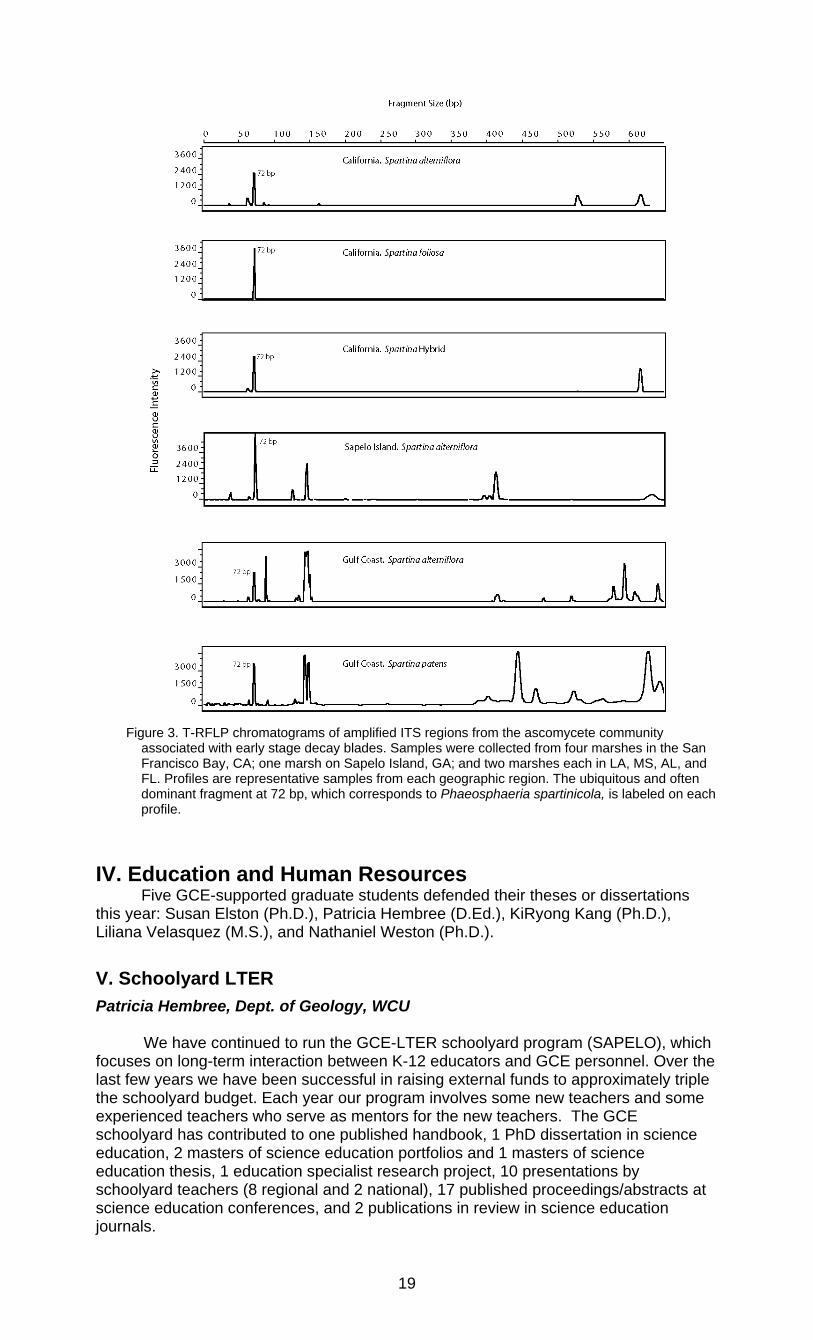
Fungi, particularly ascomycetes, are recognized as important in the decomposition of salt marsh producers. Although previous research has described the ascomycete community associated with Spartina alterniflora on Sapelo Island, GA (Buchan et al., 2002), little work has been done to compare fungal species diversity within and among Spartina species or across geographic locations. To this end, this study is using a molecular approach to compare the composition of the ascomycete fungal communities on several Spartina species (S. alterniflora, S. patens, S. densiflora, S. foliosa, and a California Spartina hybrid) collected from salt marshes along the east, Gulf, and west coasts. Blades of the various species of Spartina in early-decay stage have been collected from several coastal sites: two marshes in New York, one in Georgia, two in each Gulf Coast state (Florida, Alabama, Mississippi, and Louisiana), and four in California. Terminal restriction length polymorphism (T-RFLP) analysis of 18S-to-28S internal transcribed spacer (ITS) regions was used to produce fingerprint profiles of the ascomycete communities. Collection and analysis of west and east coast samples are not yet complete, but preliminary results suggest that the ascomycete communities found on Spartina species found along the west coast are significantly different from those found along the Gulf and east coasts (p< .05) when percentages of total chromatograph peak area covered by individual T-RFs are compared. A previously described species, Phaeosphaeria spartinicola, was often dominant and was found on all Spartina species examined along all three coasts. Fungal species diversity (as indicated by number of T-RFs) was greater on gulf coast Spartina (<14) than on west coast species (<8). On the west coast, fungal communities on S. alterniflora, S. foliosa, and the hybrid thereof were indistinguishable (Fig. 3), whereas S. densiflora hosted at least two unique species. When complete, this study will provide a comprehensive molecular comparison of the ascomycete communities associated with Spartina species in different geographic regions.
19
Figure 3. T-RFLP chromatograms of amplified ITS regions from the ascomycete community
associated with early stage decay blades. Samples were collected from four marshes in the San Francisco Bay, CA; one marsh on Sapelo Island, GA; and two marshes each in LA, MS, AL, and FL. Profiles are representative samples from each geographic region. The ubiquitous and often dominant fragment at 72 bp, which corresponds to Phaeosphaeria spartinicola, is labeled on each profile.
IV. Education and Human Resources Five GCE-supported graduate students defended their theses or dissertations
this year: Susan Elston (Ph.D.), Patricia Hembree (D.Ed.), KiRyong Kang (Ph.D.), Liliana Velasquez (M.S.), and Nathaniel Weston (Ph.D.).
V. Schoolyard LTER Patricia Hembree, Dept. of Geology, WCU We have continued to run the GCE-LTER schoolyard program (SAPELO), which focuses on long-term interaction between K-12 educators and GCE personnel. Over the last few years we have been successful in raising external funds to approximately triple the schoolyard budget. Each year our program involves some new teachers and some experienced teachers who serve as mentors for the new teachers. The GCE schoolyard has contributed to one published handbook, 1 PhD dissertation in science education, 2 masters of science education portfolios and 1 masters of science education thesis, 1 education specialist research project, 10 presentations by schoolyard teachers (8 regional and 2 national), 17 published proceedings/abstracts at science education conferences, and 2 publications in review in science education journals.

20
S.A.P.E.L.O. Project participation and Funding
Year Returning teachers
New teachers
Teacher slots
Students Impacted
NSF Funding
External Funding
2000-1 Not applicable 6 6 620 $15,000 2001-2 5 5 10 982 $15,000 2002-3 9 8 17 1732 $15,000 $28,607 2003-4 8 14 22 2021 $15,000 $48,035 2004-5 13 4 17 1361 $15,000 $44,038 2005-6 14 3 17 1304 $15,000 $45,605 Totals 49 40 89 8020 $90,000 $166,285
Combined total: $256,285
The S.A.P.E.L.O. Schoolyard LTER workshops capitalize on the way field
science activities differ from the traditional school-based or laboratory-based science—a view that teachers rarely get to see, much less come to understand as something to be included in a typical curriculum. Because the program establishes a long-term partnership, the teachers develop a confidence not seen in a typical science class. This support may very well be the reason why 95% of the teachers have remained invested, purposefully working to put GCE science concepts into the routine of the class and their schools. Additionally, this long-term relationship has provided for extensive evaluation and feedback. Indeed, the results of my research on the Schoolyard program showed that the teachers’ epistemology of science—the way they think science knowledge is constructed—was challenged and revised to include a more sophisticated, constructivist view of science as active, temporary, and local. This revision caused teachers to change their self-view to include personal and professional empowerment and a new sense of comfort in their practice. These results form a solid basis for future professional development designs and opportunities for teachers.
The GCE Schoolyard coordinator (Hembree) is exploring collaborations with faculty at Western Carolina University and with the Program for the Study of Developed Shorelines to further enhance the schoolyard program.
VI. Personnel supported by the GCE-LTER:
Dale Bishop, Post-doctoral associate, UGA Vladimir Samarkin, Post-doctoral associate, UGA Wade Sheldon, Scientific Computing Professional, UGA Julie Amft, Research Coordinator, SkIO Matthew Erickson, Research Coordinator, UGA Steven Bell, Research Coordinator, UGA Ken Helm, Field technician, UGAMI Sean Graham, Research Technician, IU Trent Moore, Research Coordinator, SkIO Joan Sheldon, Research Professional III, UGA Rachel Gisewhite, Ph.D. student, UGA Chuan-Kai Ho, Ph.D. student, UH KiRyong Kang, Ph.D. student, UGA Liqing Jiang, Ph.D. student, UGA Justine Lyons, Ph.D. student, UGA Caroline McFarlin, Ph.D. student, UGA Paul McKay, Ph.D. student, UGA Bill Porubsky, Ph.D. student, UGA Nathaniel Weston, Ph.D. student, UGA Trisha Hembree, D. Ed. student, UGA Justin Hartman, M.S. student, UGA Josh Hall, M.S. student, IU
21
Amy Kunza, M.S. student, UH Tymeri Schleicher, M.S. student, IU Liliana Velasquez, M.S. student, UGA Rochelle Randall, Savannah State University (Student: Savannah State REU) Rudy Rivas, Undergraduate Student, UGA Daniel Sattelmeyer, Undergraduate Student, UGA Elizabeth Wason, Undergraduate Student, UH
VII. Broader Impacts
PI Outreach J.Blanton:
• Lectured at the Univ. of Georgia Dept. of Marine Sciences and Univ. of the Algarve (Portugal) on the physical oceanography of coastal environments using data from the GCE-LTER monitoring program to illustrate the changing character of the tide as well as how the tide affected the salinity environment in the LTER domain. These lectures were part of graduate level courses and programs.
D. Bishop: • D. Bishop continued his participation with the GCE-LTER Schoolyard program.
Teachers were included in many of the field and laboratory activities associated with the Dean Creek, invasive crab, and blue crab recruitment projects detailed above.
• During the past year, the invertebrate database web pages have continued to be a source of contact between Bishop and the public. Questions regarding the biology and taxonomy of estuarine invertebrates listed on the website have come from students, consulting firms, and international scientists.
C. Craft: • GCE LTER Schoolyard (July 16-18 2005). Instructed teachers in field sampling
and measurement of porewater salinity, measurement of emergent vegetation (stem height, density, species identification) in permanent plots, measurement of SET’s and accretion in feldspar plots.
W. Sheldon: • Served on the LTER Information Management Executive committee • Elected to serve on the LTER Network Information System Advisory Committee • Served on two NSF LTER site review panels • Chaired a molecular database design group at the International Census of
Marine Microbes informatics workshop • Participated in the LTER Trends Project editorial meeting at the SEV LTER site
Synthetic Activities M. Alber:
• I was the GCE representative at both the LTER Human Dimensions Working Group and the Social Sciences Workshop this year. Both of these efforts have stimulated us to examine the interrelationships between humans and ecosystems at our site and provide input to planning grant activities.
S. Pennings: • I am a member of LTER cross-site synthesis group examining whether the traits
of plant species can predict different responses by different taxa across multiple fertilization experiments. This work will enhance our ability to predict the impacts of anthropogenic inputs of nitrogen into natural systems.
W. Sheldon: • The comprehensive EML implementation and support for EML-based automated
data streaming developed at GCE continues to allow NCEAS and the SEEK
22
projects to prototype, test and demonstrate EML-based data analysis and workflow tools (e.g. Kepler, http://seek.ecoinformatics.org) using realistic ecological data sets, significantly aiding these projects.
• Developed support for the automatically retrieving data from any station in the LTER ClimDB/HydroDB and USGS streamflow databases using MATLAB, allowing investigators to easily identify, integrate, synthesize climate data for comparison with their studies.
The Georgia Coastal Research Council Merryl Alber, Dept. of Marine Sciences, UGA
We continue to provide outreach to managers, scientists, and the general public
through the Georgia Coastal Research Council. The GCRC, which is headed by Alber, has 86 affiliated scientists, with representatives from 9 Universities, 6 Federal agencies, and 4 State and regional agencies. The GCRC hosts workshops, assists management agencies with scientific assessments, and distributes information on coastal issues. The GCRC web site (http://www.marsci.uga.edu/coastalcouncil), which is linked to the GCE-LTER web site, logged 2671 page views by 1261 visitors from 38 nations in 2005. This past year we compiled literature syntheses and technical reports on Best Management Practices for Marinas; Vegetative Buffers in the Coastal Zone; Environmental Effects of Docks; and Herbicide Use in Coastal Marshland in response to specific requests form Georgia DNR. We also completed two watershed assessments for the National Park Service, one for Cumberland Island National Seashore and the second for Fort Pulaski National Monument. The GCRC continues to investigate and monitor marsh dieback (a paper by Ogburn and Alber summarizing transplant experiments in dieback areas is currently in press), and we have also received continued media attention (see list below). We have given 6 presentations on the GCRC over the past year, ranging from invited briefings to the Georgia legislature and the Georgia DNR Emerging Leaders Program to more traditional venues such as the Ecological Society of America and the Coastal States Organization. Other presentations have been geared towards the general public, with audiences such as the Georgia River Network and the Georgia DNR Community Docks & Marinas Stakeholder Group. Media Coverage: 12/05 “Snail blamed for key role in destruction of state’s marshes” Atlanta Journal
Constitution. Alber interviewed for response to Science article on salt marsh dieback.
12/05 “Snails to blame for marsh dieback, study says” Savannah Morning News. Alber interviewed for response to Science article on salt marsh dieback.
10/05 “Revival of the marshes” The Brunswick News. Alber interviewed for update on marsh dieback recovery.
4/05 “For every action there is a reaction—Focus on Estuarine Science” Passport to the See v. 2, issue 1, Spring 2005. Profile of Alber’s work in estuaries. http://www.scseagrant.org/se-cosee/newsletter/passport_current.htm
VIII. Additional Funding Merryl Alber:
• Environmental Protection Agency - Climate-linked alteration of ecosystem services in tidal salt marshes of Georgia and Louisiana (with M. Hester, I. Mendelssohn, and S. Joye), $94,364 (October 2004 – September 2007)
• Georgia Coastal Resources Division - Georgia Coastal Research Council: Development of a Watershed-compatible nitrogen model for the Altamaha River Estuary, $245,794 (October 2004 – September 2007)
• Georgia Sea Grant - Georgia Coastal Research Council, $106,900 (March 2004 - February 2006)
• Georgia Sea Grant - Georgia Coastal Research Council, $104,434 (March 2006 - February 2008)
23
T. Dale Bishop: • Sapelo Island NERR - Sapelo Island National Estuarine Research Reserve non-
indigenous species monitoring, $5,000 (June 2004 – December 2005) • Sapelo Island NERR - Monitoring the invasion of the green mussel, Perna viridis,
into the Sapelo Island National Estaurine Research Reserve (with R. Walker, A. Power), $15,000 (March 2004 – March 2005)
• Georgia Sea Grant – A spatial distribution of blue crab larvae in a Georgia estuary (C. Tilburg, PI), $10,000 (March 2005 – December 2005)
Jackson Blanton, Daniela Di Iorio:
• NOAA – Coastal Zone Management Grant, $240,000 (Oct 2001-March 2005) • NOAA – Land User Coastal Ecosystem Study, $502,000 (July 1999-June 2005) • NMS/NOAA – National Marine Sanctuaries, $20,000 (May 2004-April 2005)
Christopher Craft, Indiana University:
• U.S. EPA STAR grant program - Effects of sea level rise and climate variability on ecosystem services of tidal marshes, South Atlantic coast, $749,974 (began January 1 2005).
• NOAA National Estuarine Research Reserve. “Dean Creek Monitoring Project: Assessing the biological and physiological effects of long-term hydrological alteration on a tidal salt marsh”. Co-PI with Dorset Hurley (SINERR). May 1 2005-April 30 2007, $32,995
Daniela Di Iiorio:
• NOAA – Georgia Sea Grant Patricia Hembree, University of Georgia (SLTER Coordinator)
• Eisenhower Teacher Quality Program grant to support 17 teachers, $45,605
Samantha Joye, University of Georgia: • U.S. EPA STAR grant program - Effects of sea level rise and climate variability
on ecosystem services of tidal marshes, South Atlantic coast, (with C. Craft, S. Pennings, D. Park, J. Ehman) $217,556 (began January 1 2005).
• U.S. EPA STAR grant program - Climate-linked alteration of ecosystem services in tidal salt marshes of Georgia and Louisiana (with M. Hester, I. Mendelssohn, and M. Alber), $227,855 (October 2004 – September 2007).
Steve Pennings, University of Houston:
• Environmental Institute of Houston - Diversity patterns in Texas salt marsh plant communities, S. Pennings (PI), $14,880 (January 2005-Auguest 2005). This project is comparing plant diversity patterns in Texas salt marshes with those in GA salt marshes, with the goal of understanding controls on diversity. GA study sites are within the GCE-LTER domain, and the result will provide information on how plant diversity patterns within GA marshes compare to those in other geographic regions.
• USEPA - Effects of sea level rise and climate variability on ecosystem services of tidal marshes, south Atlantic Coast, Craft, C. (PI), Joye, S. (Co-PI), Pennings, S. C. (Co-PI), Park, D. (Co-PI) and Ehman, J. (Co-PI), $749,974 total. This project is comparing the ecosystem services of tidal fresh, brackish and salt marshes. A number of the study sites are within the GCE domain, and the results will greatly enhance our understanding of the ecology of marshes across the estuarine gradient
Wei-Jun Cai, UGA:
• NSF - Marsh-Dominated Ocean Margins as a Source of CO2 to the Atmosphere and Open Oceans: A Field Study in the U.S. Southeastern Continental Shelf. Wei-Jun Cai (sole PI), $453,573 (NSF-OCE-0425153, 8/04 to 8/08).
• National Oceanic and Atmospheric Administration (NOAA), Office of Global Programs —Coastal CO2 Measurements and Databases for the North American Carbon Program. Group proposal, lead PI, R. Feely, NOAA-PMEL (Pacific Lab). (07/05-07/08).
24
IX. Publications
Peer-reviewed Journal Articles Published and Accepted Franks, S.J., Richards, C.L., Gonzales, E., Cousins, J.C. and Hamrick, J.L., 2004. Multi-
Scale Genetic Analysis of Uniola Paniculata (Poaceae): A Coastal Species with a Linear, Fragmented Distribution. American Journal of Botany, 91: 1345-1351.
Kang, K. and Di Iorio, D., 2005. Depth- and current-induced effects on wave propagation into the Altamaha River Estuary, Georgia. Estuarine, Coastal and Shelf Science, 66: 395-408.
Moore, W.S. et al., 2002. Thermal evidence of water exchange through a coastal aquifer: implications for nutrient fluxes. Geophysical Research Letters, 10: 1029/2002GL014923.
Ogburn, M.B. and Alber, M., 2006. An Investigation of Salt Marsh Dieback in Georgia using Field Transplants. Estuaries and Coasts, 29: 54-62.
Pennings, S.C. et al., 2005. Do individual plant species show predictable responses to nitrogen addition across multiple experiments? Oikos, 110: 547-555.
Schaefer, S.C. and Alber, M., 2005. Trends in agricultural sources of nitrogen in the Altamaha River watershed. In: K.J. Hatcher (Editor), Proceedings of the 2005 Georgia Waters Resources Conference. Institute of Ecology, University of Georgia, Athens, Georgia.
Sheldon, J.E. and Alber, M., 2005. Comparing Transport Times Through Salinity Zones in the Ogeechee and Altamaha River Estuaries Using SqueezeBox. In: K.J. Hatcher (Editor), Proceedings of the 2005 Georgia Water Resources Conference. Institute of Ecology, University of Georgia, Athens, Georgia.
Sheldon, J.E. and Alber, M., 2006. The calculation of estuarine turnover times using freshwater fraction and tidal prism models: a critical evaluation. Estuaries and Coasts, 29: 145-159.
Suding, K.N. et al., 2005. Functional- and abundance-based mechanisms explain diversity loss due to N fertilization. Proceedings of the National Academy of Sciences, U.S.A., 102: 4387-4392.
Wang, Z., Cai, W.-J., Wang, Y. and Ji, H., 2005. The southeastern continental shelf of the United States as an atmospheric CO2 source and an exporter of inorganic carbon to the ocean. Continental Shelf Research, 25: 1917-1941.
Weston, N.B., Dixon, R.E. and Joye, S.B., 2006. Ramifications of increased salinity in tidal freshwater sediments: Geochemistry and microbial pathways of organic matter mineralization. Journal of Geophysical Research, 111(G01009): doi:10.1029/2005JG000071.
Weston, N.B. and Joye, S.B., 2005. Temperature-driven decoupling of key phases of organic matter degradation in marine sediments. Proceedings of the National Academy of Sciences (USA), 102(47): 17036-17040.
Weston, N.B. et al., 2006. Pore water stoichiometry of terminal metabolic products, sulfate, and dissolved organic carbon and nitrogen in intertidal creek-bank sediments. Biogeochemistry, 77: 375-408.
Submitted
25
Alber, M., Ogburn, M.B., Bishop, T.D. and Hollibaugh, J.T., Comment on “Drought, snails, and large-scale die-off of southern U.S. salt marshes.” Estuaries and Coasts.
Craft, C.B., Freshwater input structures soil properties, vertical accretion and nutrient accumulation of Georgia and United States (U.S.) tidal marshes. Limnology & Oceanography, (in review).
Kang, K. and Di Iorio, D., Variations of turbulent flow with river discharge in the Altamaha River Estuary, Georgia. Journal of Geophysical Research, (in revision).
Lasher, C. et al., The diverse bacterial community in intertidal, anaerobic sediments at Sapelo Island, Georgia. Environmental Microbiology, (in review).
Pennings, S.C., Local and geographic variation in Spartina-herbivore interactions. Proceedings of the Third International Conference on Invasive Spartina.
Pennings, S.C. and Moore, D.J., Variation in salt marsh primary production on multiple temporal scales.
Porubsky, W.P., Weston, N.B. and Joye, S.B., Benthic metabolism and the relative importance of three dissimilatory nitrate sinks in intertidal sediments. Estuaries, (in review).
Thoresen, M. and Alber, M., Contribution of benthic diatoms to the diets of suspension-feeding bivalves (eastern oyster, Crassostrea virginica). Marine Ecology Progress Series, (in review).
Verity, P.G., Alber, M. and Bricker, S.B., Development of hypoxia in well-mixed estuaries. Estuaries, (in review).
Books and Book Sections Bestelmeyer, S. et al., 2005. Handbook for LTER Education, First Edition. Long Term
Ecological Research Network, Albuquerque, NM, 61pp.
Joye, S.B., Bronk, D.A., Koopmans, D. and Moore, W.S., 2006. Potential for groundwater-derived carbon, nitrogen and phosphorus inputs to coastal ecosystems in South Carolina and Georgia. In: G.S. Kleppel, M.R. DeVoe and M. Rawson (Editors), Implications of Land Use Change to Coastal Ecosystems. Springer-Verlag.
Queiroga, H. and Blanton, J.O., 2005. Interactions between behaviour and physical forcing in the control of horizontal transport of decapod larvae. In: A. Southward, P. Tyler, C. Young and L. Fuiman (Editors), Advances in Marine Biology. Elsevier Science, Ltd., San Diego, CA, pp. 107-214.
Sharitz, R.R. and Pennings, S.C., Development of wetland plant communities. In: D. Batzer and R.R. Sharitz (Editors), Ecology of freshwater and estuarine wetlands. University of California Press, Berkeley, California. (in review)
Theses and Dissertations Elston, S.A., 2005. Secondary Circulation in a Sinuous Coastal Plain Estuary. Ph.D.
Dissertation Thesis, Georgia Institute of Technology, Atlanta, Georgia.
Hembree, P.A., 2005. Defining science/defining stories: Teachers’ constructions of science knowledge through collaborations in field-based scientific research. Ph.D. Dissertation Thesis, University of Georgia, Athens, Georgia.
Kang, K.R., 2005. Waves, Turbulence, and Circulation in the Altamaha River Estuary, Georgia. Ph.D. Dissertation Thesis, University of Georgia, Athens, Georgia, 161 pp pp.
Velasquez, L., 2005. The importance of benthic primary production in salt marsh carbon cycles. M.S. Thesis Thesis, University of Georgia, Athens, Georgia, 90 pp pp.
26
Weston, N., 2005. Biogeochemistry in the coastal zone: changing land use, salinity intrusion, porewater stoichiometry and the mineralization of organic matter in estuarine sediments. Ph.D. Dissertation Thesis, University of Georgia, Athens, Georgia, 188 pp pp.
Wrona, A.B., 2004. Determining movement patterns and habitat use of blue crabs (Callinectes sapidus rathbun) in a Georgia saltmarsh estuary with the use of ultrasonic telemetry and a geographic information system (GIS). Ph.D. Dissertation Thesis, University of Georgia, Athens, Georgia, 178 pp pp.
Posters and Presentations Alber, M., 2005. Effects of Surface Water Management on Estuarine Resources,
Society for Wetland Scientists Meeting, Charleston, South Carolina.
Alber, M., Pomeroy, L.R., Sheldon, J.E. and Schaefer, S.C., 2005. Forty years of watershed nitrogen inputs and estuarine response in the Altamaha River estuary (Georgia, USA), 2005 Estuarine Research Federation Meeting. Symposium on “Examining nutrient enrichment effects on coastal ecosystems through comparative ecological approaches and perspectives”, Norfolk, Virginia.
Bowen, G.M. and Hembree, P.A., 2005. Participating in inquiry with field scientists: The development of discursive claim construction by practicing teachers, National Association for Research in Science Teaching, Dallas, TX.
Bowen, G.M. and Hembree, P.A., 2005. Understanding the development of competency with inscriptions by science teachers: Conducting inquiry with field biologists, American Educational Research Association.
Clark, C. et al., 2005. Predicting the loss of biodiversity with nitrogen addition across North American herbaceous communities: abiotic vs. biotic drivers, Ecological Society of America 2005 Meeting - Ecology at multiple scales. Ecological Society of America, Montreal, Canada.
Craft, C.B., 2005. Freshwater input affects vertical accretion and nutrient accumulation of tidal marshes, Sapelo Island Georgia (USA), Estuarine Research Federation biennial meeting, Norfolk, Virginia.
Elston, S.E., Seim, H.E. and Blanton, J.O., 2005. Adjusting discrete spatial ADCP data to MLLW over complex bathymetry, Gordon Research Conference on Coastal Ocean Circulation, New London, NH.
Fargione, J. et al., 2005. A negative relationship between species richness and productivity response to N addition in a synthesis of N fertilization studies, Ecological Society of America 2005 Meeting - Ecology at multiple scales. Ecological Society of America, Montreal, Canada.
Hembree, P.A., 2004. Defining Science/Defining Stories: Teachers' Constructions of Science Knowledge through Collaborations in Field-Based Scientific Research, National Association of Research in Science Teaching, Vancouver, British Columbia.
Hembree, P.A., 2004. Sustainment: Teachers' experiences in long-term, collaborative, field-based research, Southeastern Association for the Education of Teachers in Science, Gainesville, Florida.
Hembree, P.A. and Bowen, G.M., 2005. Talking about research: Developing competency in the discursive practices of science through participating in inquiry with field biologists, Canadian Society for the Study of Education, London, Ontario.
Ho, C.-K. and Pennings, S.C., 2005. Consequences of omnivory, The 18th Biennial Conference of the Estuarine Research Federation. Estuarine Research Federation, Norfolk, Virginia.
27
Ho, C.-K. and Pennings, S.C., 2005. Consequences of Omnivory for Trophic Interactions: A Case from Salt Marshes, Ecological Society of America 2005 Meeting - Ecology at multiple scales. Ecological Society of America, Montreal, Canada.
Kunza, A.L. and Pennings, S.C., 2005. Plant diversity of Texas and Georgia salt marshes, Ecological Society of America 2005 Meeting - Ecology at multiple scales. Ecological Society of America, Montreal, Canada.
Pennings, S.C., 2005. Physical forcing and variation in salt marsh plant productivity at multiple time scales, Ecological Society of America 2005 Meeting - Ecology at multiple scales. Ecological Society of America, Montreal, Canada.
Richards, C.L., Donovan, L.A. and Mauricio, R., 2005. Selection, but no local adaptation of plant physiological traits in contrasting salt marsh environments, ERF 2005 - The 18th Biennial Conference of the Estuarine Research Federation. Estuarine Research Federation, Norfolk, Virginia.
Schaefer, S.C. and Alber, M., 2005. Comparison of net anthropogenic nitrogen inputs and riverine export in estuarine watersheds of the Southeast, 2005 Estuarine Research Federation Meeting, Norfolk, Virginia.
Sheldon, J.E. and Alber, M., 2005. Beyond whole-estuary flushing times: Using transport times through salinity zones to explain chlorophyll patterns in the Altamaha River estuary (Georgia, USA), 2005 Estuarine Research Federation Meeting. Estuarine Interactions: biological-physical feedbacks and adaptations. Estuarine Research Federation, Norfolk, Virginia.
Sheldon, J.E. and Alber, M., 2005. New and improved: Modeling mixing time scales in the Altamaha River estuary, GCE-LTER 2005 Annual Meeting. GCE-LTER, Athens, Georgia.
Verity, P.G., Alber, M. and Bricker, S.B., 2005. Long term declines in dissolved oxygen in well-mixed estuaries in the southeast USA, ASLO Summer Meeting, Santiago de Compostela, Spain.
White, S.N. and Alber, M., 2005. The reponse of Spartina species to prolonged drought in the Altamaha River Estuary, Georgia, 2005 Estuarine Research Federation Meeting, Norfolk, Virginia.