Embed Size (px)
Citation preview
30 July 2019
Recommendation on
ULURP Applications C190357PQM and N190356ZRM
East Side Coastal Resiliency (ESCR) Project by Applicants:
New York City Department of Transportation (DOT)
New York City Department of Citywide Administrative Services (DCAS)
New York City Department of Environmental Protection (DEP)
New York City Department of Small Business Services (SBS)
I. PROPOSED ACTIONS
The New York City Departments of Transportation (DOT), Citywide Administrative Services (DCAS),
Environmental Protection (DEP), and Small Business Services (SBS) (collectively the “Applicants” or the
“City”) are seeking two Uniform Land Use Review Procedure (ULURP) approvals for (1) eight
acquisitions of easements on non-City owned property and (2) a text amendment to the New York City
Zoning Resolution (ZR) § 62-50 (“General Requirements for Visual Corridors and Waterfront Public
Access Areas”) and § 62-60 (“Design Requirements for Waterfront Public Access Areas”) to facilitate the
East Side Coastal Resiliency (ESCR) Project (the Proposed Project) in Manhattan Community Board 3
and 6 (CB3 and CB6). The Proposed Project is bounded by Montgomery Street on the south and
continues north along parcels of Montgomery and South Streets, Avenue C, East 23rd
Street, and the
Franklin Delano Roosevelt East River Drive (the FDR Drive) right-of-way. In total, the Proposed Project
extends through the Lower East Side, East Village, Alphabet City, Stuyvesant Town, Peter Cooper
Village, and Kips Bay neighborhoods.
The Proposed Project aims to address coastal flooding vulnerability in lower Manhattan by implementing
a system that includes floodwalls, underground sewer upgrades, an improved shared use path
(bikeway/walkway), a new flyover bridge, open space improvements at nearby parks, and the raising of
the John V. Lindsay East River Park (East River Park) out of the 100-year floodplain between
Montgomery Street to approximately East 13th Street. The systematic and architectural elements coupled
with the related park improvements do not require any ULURP approvals.
In addition to the floodwalls located along and under the elevated FDR Drive, the flood protection system
includes closure structures (i.e. roller gates and swing gates) which would be recessed except under storm
conditions when they are deployed to provide flood protection. The flood protection system also includes
drainage system modifications through the installation of an underground parallel conveyance system that
would prevent tidal flooding and minimize inland flooding associated with simultaneous tide and rain
events. These measures consist of flood proofing regulators and manholes, installing parallel conveyance
pipes and interceptors that reroute storm drainage and combined sewer outfalls, and placing an isolation
gate valve in the regulator below Asser Levy Playground.
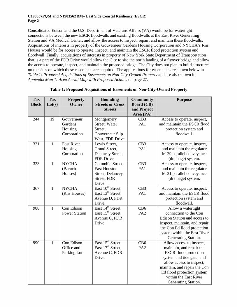
Action 1: Proposed Acquisitions of Easements on Non-City-Owned Property (C190357PQM)
According to the Department of Design and Construction (NYC DDC), these flood protection measures
would require acquisition of easements by the City on eight parcels of non-City owned properties which
constitute the first ULURP action. Acquisitions of interests in property of the New York City Housing
Authority’s (NYCHA) Baruch Houses and the East River Housing Corporation would be for the access to
and maintenance of parallel conveyance drainage systems. Acquisitions of interests in property of
C190357PQM and N190356ZRM– East Side Coastal Resiliency (ESCR)
Page 2
Consolidated Edison and the U.S. Department of Veterans Affairs (VA) would be for watertight
connections between the new ESCR floodwalls and existing floodwalls at the East River Generating
Station and VA Medical Center, and allow the access to inspect, repair, and maintain these floodwalls.
Acquisitions of interests in property of the Gouverneur Gardens Housing Corporation and NYCHA’s Riis
Houses would be for access to operate, inspect, and maintain the ESCR flood protection system and
floodwall. Finally, acquisitions of interests in property of New York State Department of Transportation
that is a part of the FDR Drive would allow the City to site the north landing of a flyover bridge and allow
the access to operate, inspect, and maintain the proposed bridge. The City does not plan to build structures
on the sites on which these easements are acquired. The applications for easements are shown below in
Table 1: Proposed Acquisitions of Easements on Non-City-Owned Property and are also shown in
Appendix Map 1: Area Aerial Map with Proposed Actions on page 27.
Table 1: Proposed Acquisitions of Easements on Non-City-Owned Property
Tax
Block
Tax
Lot(s)
Property
Owner
Bounding
Streets or Cross
Streets
Community
Board (CB)
and Project
Area (PA)
Purpose
244 19 Gouverneur
Gardens
Housing
Corporation
Montgomery
Street, Water
Street,
Gouverneur Slip
West, FDR Drive
CB3
PA1
Access to operate, inspect,
and maintain the ESCR flood
protection system and
floodwall.
321 1 East River
Housing
Corporation
Lewis Street,
Grand Street,
Delancey Street,
FDR Drive
CB3
PA1
Access to operate, inspect,
and maintain the regulator
M-29 parallel conveyance
(drainage) system.
323 1 NYCHA
(Baruch
Houses)
Columbia Street,
East Houston
Street, Delancey
Street, FDR
Drive
CB3
PA1
Access to operate, inspect,
and maintain the regulator
M-31 parallel conveyance
(drainage) system.
367 1 NYCHA
(Riis Houses)
East 10th Street,
East 13th Street,
Avenue D, FDR
Drive
CB3
PA1
Access to operate, inspect,
and maintain the ESCR flood
protection system and
floodwall.
988 1 Con Edison
Power Station
East 14th Street,
East 15th Street,
Avenue C, FDR
Drive
CB6
PA2
Allow a watertight
connection to the Con
Edison Station and access to
inspect, maintain, and repair
the Con Ed flood protection
system within the East River
Generating Station.
990 1 Con Edison
Office and
Parking Lot
East 15th Street,
East 17th Street,
Avenue C, FDR
Drive
CB6
PA2
Allow access to inspect,
maintain, and repair the
ESCR flood protection
system and tide gate, and
allow access to inspect,
maintain, and repair the Con
Ed flood protection system
within the East River
Generating Station.
C190357PQM and N190356ZRM– East Side Coastal Resiliency (ESCR)
Page 3
955 5 U.S.
Department of
Veterans
Affairs
East 23rd
Street,
East 25th Street,
1st Avenue, Asser
Levy Place
CB6
PA2
Allow a watertight
connection to the VA
Medical Center’s existing
floodwall and the access to
inspect, maintain, and repair
the ESCR flood protection
system.
FDR
Drive
New York State
Department of
Transportation
Part of FDR
Drive right-of-
way from East
15th Street to
Avenue C
CB6
PA2
Allow the City to site the
north landing for the
proposed flyover bridge and
allow the access to operate,
inspect, and maintain the
proposed bridge.
Action 2: Text Amendment to the Zoning Resolution (N190356ZRM)
The second ULURP action necessary for the project is a text amendment to the City's ZR outlined in
Article VI, Chapter 2 (“Special Regulations Applying in Waterfront Areas”). These regulations encourage
active water dependent uses and ensure physical and visual access to the City’s waterfront. Stuyvesant
Cove Park is subject to these regulations and the proposed flood protection design elements slated for the
park such as the floodwalls, the raising of the interior grade of the park and public paths do not comply
with these regulations. Therefore, the regulations would be amended to deem these elements to be
compliant with zoning.
Specifically, the Applicants seek a zoning text amendment to § 62-50 (“General Requirements for Visual
Corridors and Waterfront Public Access Areas” and § 62-60 (“Design Requirements for Waterfront
Public Access Areas”) on a segment of Stuyvesant Cove Park mapped as a “Marginal Street, Wharf, or
Place”) that is under the jurisdiction of SBS and managed by the New York City Economic Development
Corporation (NYCEDC). The segment is bounded by the FDR Drive, the East River, East 23rd
Street, and
Captain Patrick J. Brown Walk (see Appendix Figure 9: Photographs of Stuyvesant Cove Park (Mapped
“Marginal Street, Wharf, or Place” on page 39). The proposed zoning text amendment allows for the
regulations detailed in § 62-50 and § 62-60 to be considered satisfied as long as: (1) the park remains
open and accessible to the public at a minimum from dawn to dusk, and (2) the maintenance and
operation of the park is conducted by a City or State entity or its designee.
These elements that are currently not compliant with zoning are shown below and at Appendix Map 4:
Proposed Waterfront Access Connections on page 30:
ZR § 62-511 (“Location of Visual Corridors”): requiring that upland streets that terminate at a
waterfront block shall be prolonged as visual corridors to the water if the prolonged street
intersects the shoreline at an angle of 45 degrees or more and there are no existing obstructions
blocking 50% or more of the width of the visual corridor.
o The street grid along this waterfront segment is unusual with three wide mapped and built
streets upland of the subject property that if prolonged would intersect the waterfront
from different and less than right angles, where these upland streets include: Avenue C
on the south (approximately 120 feet wide), East 20th Street (approximately 135 feet
wide), and East 23rd
Street (approximately 130 feet wide);
ZR § 62-512 (“Dimensions of Visual Corridors”): requiring that visual corridors be no less than
50 feet in width:
o Where the distance between Avenue C and East 20th Street is approximately 575 feet and
the distance from East 20th to East 23
rd Street is 850 feet;
ZR § 62-53 (“Requirements for Shore Public Walkways”): requiring that waterfront walkways
have a minimum width of 30 feet:
o Where the paved walkway along the water’s edge at Stuyvesant Cove Park averages a
width of 30 feet but is proposed to be narrowed due to the grading on the waterside of the
C190357PQM and N190356ZRM– East Side Coastal Resiliency (ESCR)
Page 4
proposed flood protection system which will also include a raised landscape with a public
path;
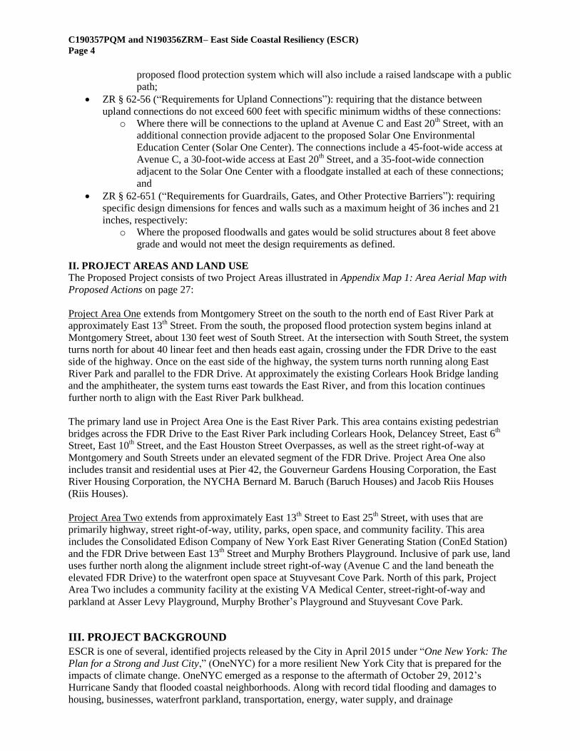
ZR § 62-56 (“Requirements for Upland Connections”): requiring that the distance between
upland connections do not exceed 600 feet with specific minimum widths of these connections:
o Where there will be connections to the upland at Avenue C and East 20th Street, with an
additional connection provide adjacent to the proposed Solar One Environmental
Education Center (Solar One Center). The connections include a 45-foot-wide access at
Avenue C, a 30-foot-wide access at East 20th Street, and a 35-foot-wide connection
adjacent to the Solar One Center with a floodgate installed at each of these connections;
and
ZR § 62-651 (“Requirements for Guardrails, Gates, and Other Protective Barriers”): requiring
specific design dimensions for fences and walls such as a maximum height of 36 inches and 21
inches, respectively:
o Where the proposed floodwalls and gates would be solid structures about 8 feet above
grade and would not meet the design requirements as defined.
II. PROJECT AREAS AND LAND USE The Proposed Project consists of two Project Areas illustrated in Appendix Map 1: Area Aerial Map with
Proposed Actions on page 27:
Project Area One extends from Montgomery Street on the south to the north end of East River Park at
approximately East 13th Street. From the south, the proposed flood protection system begins inland at
Montgomery Street, about 130 feet west of South Street. At the intersection with South Street, the system
turns north for about 40 linear feet and then heads east again, crossing under the FDR Drive to the east
side of the highway. Once on the east side of the highway, the system turns north running along East
River Park and parallel to the FDR Drive. At approximately the existing Corlears Hook Bridge landing
and the amphitheater, the system turns east towards the East River, and from this location continues
further north to align with the East River Park bulkhead.
The primary land use in Project Area One is the East River Park. This area contains existing pedestrian
bridges across the FDR Drive to the East River Park including Corlears Hook, Delancey Street, East 6th
Street, East 10th Street, and the East Houston Street Overpasses, as well as the street right-of-way at
Montgomery and South Streets under an elevated segment of the FDR Drive. Project Area One also
includes transit and residential uses at Pier 42, the Gouverneur Gardens Housing Corporation, the East
River Housing Corporation, the NYCHA Bernard M. Baruch (Baruch Houses) and Jacob Riis Houses
(Riis Houses).
Project Area Two extends from approximately East 13th Street to East 25
th Street, with uses that are
primarily highway, street right-of-way, utility, parks, open space, and community facility. This area
includes the Consolidated Edison Company of New York East River Generating Station (ConEd Station)
and the FDR Drive between East 13th Street and Murphy Brothers Playground. Inclusive of park use, land
uses further north along the alignment include street right-of-way (Avenue C and the land beneath the
elevated FDR Drive) to the waterfront open space at Stuyvesant Cove Park. North of this park, Project
Area Two includes a community facility at the existing VA Medical Center, street-right-of-way and
parkland at Asser Levy Playground, Murphy Brother’s Playground and Stuyvesant Cove Park.
III. PROJECT BACKGROUND
ESCR is one of several, identified projects released by the City in April 2015 under “One New York: The
Plan for a Strong and Just City,” (OneNYC) for a more resilient New York City that is prepared for the
impacts of climate change. OneNYC emerged as a response to the aftermath of October 29, 2012’s
Hurricane Sandy that flooded coastal neighborhoods. Along with record tidal flooding and damages to
housing, businesses, waterfront parkland, transportation, energy, water supply, and drainage
C190357PQM and N190356ZRM– East Side Coastal Resiliency (ESCR)
Page 5
infrastructure, the storm also caused multiple deaths and underscored the need for the City to design and
implement coastal flood protection measures. The neighborhoods within the Proposed Project area have
one of the largest concentrations of low- and moderate-income households in the City, with over 12,707
NYCHA housing units.
After Hurricane Sandy, the City formed the Special Initiative for Rebuilding and Resiliency team to
examine the hurricane’s impact on the City’s buildings, infrastructure, and people, assess climate change
risks in the near term (2020s) and long term (2050s), and outline strategies for increasing resiliency
citywide. The report that was generated from this initiative, PlaNYC – A Stronger, More Resilient New
York (June 2013), contains Community Rebuilding and Resiliency Plans (CRRP) for five particularly
vulnerable neighborhoods throughout the city. The CRRP recommendations considered various coastal
hazards and their likelihood of occurrence, their potential impacts on the built environment and critical
infrastructure, and proposed protection measures to address coastal storm impacts. The CRRP
recommendations were greatly influenced by the Department of City Planning’s (DCP) Urban Waterfront
Adaptive Strategies study from June 2013 which examined the underlying geomorphology of various
stretches of the city’s shoreline, categorized each coastal reach by geomorphic type, and provided an
evaluation of coastal resiliency measures that would be appropriate for each reach. These reach areas of
the Proposed Project are listed in Appendix Map 2: Potential Night Work Construction Areas on page 28.
In June 2013, the United States Department of Housing and Urban Development (HUD), in conjunction
with the Rockefeller Foundation and other supporting organizations, launched the Rebuild by Design
(RBD) global competition with the objective of developing more efficient and effective coastal flood
protections in the New York City region. This competition solicited proposals from around the world with
innovative coastal flood protection solutions that would respond to devastations equal to that of Hurricane
Sandy through proposed mitigation measures for urban and coastal resiliency. In June 2014, HUD
announced six winning RBD projects located in Long Island, New Jersey, the Bronx, Staten Island, and
Manhattan. The winning proposal in Manhattan was the “BIG U,” a flood protection system extending
from Battery Place on the south to East 23rd
Street on the north, and divided into three sub-areas or
“compartments.” HUD then allocated Community Development Block Grant-Damage Recovery (CDBG-
DR) funds to advance the preliminary and final design and construction of Compartment 1 of the “BIG
U,” an area that covers the ESCR project area from Montgomery Street to East 23rd
Street. As design for
this compartment advanced, the project area was extended north to East 25th Street to include the historic
Asser Levy Recreational Center, concluding to an approximately 2.2 mile stretch of area. This area
corresponds to the Federal Emergency Management Agency’s (FEMA) 100-year Special Flood Hazard
Area (SFHA) floodplain and includes areas projected to be within the 100-year SFHA floodplain in the
2050s, taking into account the 90th percentile projection for sea level rise. In addition, the area houses
critical city infrastructure such as the ConEd Station, subway stations, the Manhattan Pump Station
(sewage pump station), and a stretch of the FDR Drive (a major regional arterial highway).
In late 2014, the City entered a grant agreement with HUD to disburse $338 million of CDBG-DR funds
through the New York City Office of Management and Budget (OMB) for the design and construction of
a coastal flood protection system. Since January 5, 2015, the City regularly engaged both CB3 and CB6
on multiple proposals for ESCR. The formal public review process for the proposed project was initiated
with the release of the Draft Scope of Work (DSOW) on October 30, 2015, a public scoping meeting that
was held on December 3, 2015 and its comment period that remained open until December 21, 2015. At
the closure of the comment period, NYC Parks and OMB reviewed and considered the comments
received and prepared the Final Scope of Work (FSOW). During this early engagement process, the City
put forth a design proposal identified as “Design Alternative 3” which was brought to CB3 and a CB6 for
ULURP approval. On March 27, 2018, CB3’s Full Board voted to disapprove with revisions the Design
Alternative 3 proposal. Likewise, on April 11, 2018, CB6’s Full Board voted to disapprove with revisions
the Design Alternative 3 proposal.
C190357PQM and N190356ZRM– East Side Coastal Resiliency (ESCR)
Page 6
In October 2018, the City unveiled a significantly redesigned proposal for ESCR, the Proposed Project,
which is identified in its Draft Environmental Impact Statement (DEIS) released on April 5, 2019 as the
“Design Alternative 4” or the “Preferred Alternative”. According to the City, a major reason for
abandoning the original plan was that the Proposed Project’s construction would not have to be staged,
thus reducing the construction schedule from 5 to 3.5 years. During this time, the City and its federal
partners committed approximately $1.45 billion in funding for the implementation of the Proposed
Project which includes the original $338 million CDBG-DR grant.
The principal objectives of the Proposed Project are as follows:
Provide a reliable coastal flood protection system against a storm event for the protected area;
Improve access to and enhance open space resources along the waterfront;
Respond quickly to the urgent need for increased flood protection and resiliency, particularly for
communities that have a large concentration of residents in affordable and public housing units
along the proposed project area; and
Achieve implementation milestones and comply with the conditions attached to funding
allocations as established by HUD, including scheduling milestones.
Additionally, design considerations for the proposed project include:
Installing a reliable coastal flood protection system;
Ensuring urban design compatibility, enhancements, constructability, operational needs, and
maintenance needs;
Improving the ecology and long-term resiliency of the East River Park;
Minimizing environmental effects, including construction-related effects, disruptions to public
right-of-way, and the use of pre-storm event deployable structures;
Ensuring FEMA accreditation; and
Scheduling that meets HUD milestones and maximizes cost effectiveness.
IV. PROPOSED DEVELOPMENT
The Proposed Project includes a number of design elements such as floodwalls, levees, 18 closure
structures (i.e. swing gates and roller gates), underground drainage isolation and management systems.
Additionally, the Proposed Project will reconstruct East River Park 8 to 9 feet above its current elevation
with open space improvements detailed below. The estimated capital cost is approximately $1.45 billion.
The proposed floodwalls and floodgates are shown in Appendix Map 3: Proposed Floodwall and
Floodgates on page 29.
Project Area One: Proposed Flood Protection System and Park Improvements
Project Area One includes the following key design elements:
Elevating the East River Park approximately 8 feet to be completed in 2023, beginning at the
existing amphitheater and continuing northward to approximately East 13th Street, excluding the
Fireboat House. East River Park is anticipated to be closed for the entire 3.5 year construction
period with continued public access to the Corlears Hook and Stuyvesant Cove Park ferry
landings;
Installing a below-grade protection system (i.e., floodwall) running parallel to the existing East
River Park bulkhead to soften the visual effects of the flood protection system;
Reconstructing the Tennis House, Track and Field House, and all comfort stations;
Reconstructing the East River Esplanade elevation to match the raised park and protect it from
storms and sea level rise;
Incorporating resilient landscaping and substantial tree replanting for a more diverse, resilient,
and ecologically robust habitat;
C190357PQM and N190356ZRM– East Side Coastal Resiliency (ESCR)
Page 7
Constructing a new shared-use flyover bridge that connects the north end of East River Park with
Captain Patrick J. Brown Walk to improve north/south access along the waterfront;
Reconstructing Corlears Hook Bridge over the FDR Drive and replacing the existing Delancey
Street and East 10th Street Bridges to be universally accessible;
Creating an expanded and reconfigured, park-side East Houston Street landing and entryway to
the waterfront;
Filling the two existing embayments in the East River Park for recreational programming and
relocating two new embayments to provide a net gain in water area;
Relocating and reconstructing the amphitheater as an outdoor theater space; and
Reconstructing all water and sewer infrastructure in the park, some of which is reaching the end
of its serviceable life, including the outfalls and associated pipes that cross the East River Park to
the East River bulkhead.
Project Area Two: Proposed Flood Protection System and Park Improvements
Project Area Two includes the following key design elements:
The reconstruction of ball fields and active recreational spaces, new grading and landscaping, and
a new maintenance area in the south corner;
Floodwalls and two swing gate closure structures proposed under the elevated FDR Drive into
Stuyvesant Cove at the southerly entrance (from Avenue C) and at the East 20th Street entrance to
allow public access to the waterfront esplanade;
The installation of floodwalls and closure structures (roller and swing gates) at the intersection
under the FDR Drive at East 23rd
Street that include vehicular ramp access and service roads to
the FDR Drive, a shared-use path, a service station, Waterside Pier and the Skyport Marina
parking garage. The closure structures would be recessed except under storm conditions when
they are deployed to provide flood protection;
Reconstruction of Stuyvesant Cove with new raised grades and landscaping. Design in this
segment will be coordinated with the reconstruction of the Solar One Center. The waterfront
walkway along the water’s edge as well as the interior shared access path will be preserved;
The installation of a floodwall at Murphy Brothers Playground;
Placement of a roller floodgate at Asser Levy Playground (between the Asser Levy Recreation
Center and the outdoor recreational space). Under non-storm conditions, access to these facilities
will be maintained. When deployed, the roller floodgate would tie into the existing VA Medical
Center flood protection system that runs north and then west along East 25th Street to First
Avenue; and
Construction of a pre-fabricated, shared-use flyover bridge to address the narrow waterfront
public access near the ConEd Station (on the east side of the FDR Drive between East 13th and
East 15th Streets) known as the “pinch point.” The flyover bridge’s foundations are to be
completed in 2023 and its prefabricated bridge span to be installed and completed in 2025.
Drainage System Modifications
Modifications to the City’s drainage system are proposed to prevent tidal flooding from entering the
protected area through the sewer system and to minimize inland flooding associated with a
simultaneous tide and rain event. These measures include flood proofing regulators and manholes,
and installing tide gates, parallel conveyance pipes and interceptors that reroute storm drainage and
combined sewer outfalls, and placing an isolation gate valve in the regulator below Asser Levy
Playground.
Interceptor Gates
The southern gate in Project Area One is proposed to be located on the existing sidewalk and
lawn along the western edge of the FDR Drive right-of-way at a location south of the Corlears
Hook Bridge. The northern gate in Project Area Two is proposed to be located in the median of
East 20th Street, west of the intersection with Avenue C. During a storm event, these gates would
C190357PQM and N190356ZRM– East Side Coastal Resiliency (ESCR)
Page 8
be manually deployed to prevent combined flow or storm surge floodwaters from entering the
protected area through the sewer system. While mostly below grade, the above-grade elements of
these systems include the equipment necessary to operate the interceptor gates which would be
housed in a one-story “maintenance area” with designated parking for NYC Park employees.
Parallel Conveyance Pipes
Parallel conveyance pipes will be installed at 9 locations to convey excess combined sewer flows
to an interceptor and would require no above ground features. These pipes are located below
grade and located in-street except for two locations where private acquisitions of easements on
private property are needed (at the East River Houses Drainage Acquisition and the NYCHA
Baruch Houses Drainage Acquisition). During a storm event, tide gates at the end of outfalls will
deploy and would prevent outflow, potentially resulting in sewer system backups. Parallel
conveyance pipes would enlarge the conveyance capacity of the system.
Operation and Maintenance of the System
An operations and maintenance manual will be prepared for the flood protection system and will
identify procedures for deploying, inspecting, testing, and maintaining each element of the system
to ensure that the floodwalls and closure structures remain in proper working order and are ready
to perform in advance of a critical storm. Operation and maintenance of the proposed parallel
conveyance and interceptor gates would require periodic inspection and maintenance of the
piping and mechanical equipment.
Improvements to Existing Facilities, Amenities and Infrastructure
Several existing facilities, amenities, and infrastructure will be upgraded or improved by 2025:
The reconstruction of Pier 42 as a publicly accessible open space by 2020:
o Demolishing the pier shed and redeveloping the upland park with an entry garden, a
playground, a comfort station, a grassy knoll, solar powered safety lighting throughout
the park, and access from the shared use path along the FDR Drive or Montgomery Street
that would introduce approximately 2.62 acres of new passive open space;
The creation of the Lower East Side Ecology Center (LES Ecology Center) Compost Facility by
2023:
o Improving the composting site by formalizing and containing the composting
components and providing educational and public access opportunities;
The renovation of the Fireboat House that houses the LES Ecology Center by 2019:
o Adding an American with Disabilities Act (ADA) entrance ramp and installing solar
panels to the building; and
The reconstruction of new Solar One Center by 2019.
V. PROPOSED ULURP ACTIONS
Action 1: Acquisition by the City of Easements on Non-City Properties (C190357PQM)
While the Proposed Project would be developed primarily on City-owned property, its design includes the
need to access infrastructure on non-City-owned property. Thus, the Applicants are seeking ULURP
approval for eight easements. Otherwise stated, these acquisitions of easements will permit the access to
operation, inspection, and maintenance of the proposed flood protection system as well as the
construction of a new flyover bridge. The City does not intend to build structures upon these properties.
The proposed easements are shown in Appendix Map 1: Area Aerial Map with Proposed Actions on page
27 and the proposed floodwalls and floodgates are shown in Appendix Map 3: Proposed Floodwall and
Floodgates on page 29.
C190357PQM and N190356ZRM– East Side Coastal Resiliency (ESCR)
Page 9
1. Gouverneur Gardens Access Acquisition of Easement
Gouverneur Gardens Housing Corporation, Manhattan Block 244, Lot 19 (CB3, PA1)
Photographs and aerial views of this acquisition can be viewed at Appendix Figure 1: Gouverneur
Gardens Access Acquisition on page 31. This lot is zoned R7-2 and is occupied by a multi-story
residential building. The proposed acquisition of easement is over the south and east yards of the lot. The
area includes a fence at the property line, a side yard lawn and seven trees. The existing fence would have
to be removed, however the acquisition area is a landscaped yard and the easement would prohibit the
planting of any deep-rooted trees or the installation of permanent structures in the acquisition area. The
proposed flood protection system is to be located within the northern mapped bed-of-street of
Montgomery Street and western mapped bed-of-street of South Street. The acquisition would be used to
allow the access to operate, inspect, and maintain the ESCR flood protection system and floodwall.
2. East River Houses Drainage Acquisition of Easement
East River Housing Corporation, Manhattan Block 321, Lot 1 (CB3, PA1)
Photographs and aerial views of this acquisition of easement can be viewed at Appendix Figure 2: East
River Houses Drainage Acquisition on page 32. This lot is occupied by two multi-story residential
buildings and is zoned R7-2. There are no structures within the proposed acquisition area. The proposed
easement is within a parking lot that is an accessory to the housing complex. The acquisition would allow
the access to maintain the regulator M-29 parallel conveyance (drainage) system.
3. NYCHA Baruch Houses Drainage Acquisition of Easement
NYCHA Baruch Houses, Manhattan Block 323, Lot 1 (CB3, PA1)
Photographs and aerial views of this acquisition of easement can be viewed at Appendix Figure 3:
NYCHA Baruch Houses Drainage Acquisition on page 33. This lot is occupied by several multi-story
residential buildings and is zoned R7-2. There are no structures within the proposed area and is primarily
occupied by a side yard lawn that includes a fence and a sign for the housing complex. The acquisition
would allow the access to maintain the regulator M-31 parallel conveyance (drainage) system.
4. NYCHA Riis Houses Access Acquisition of Easement
NYCHA Jacob Riis Houses, Manhattan Block 367, Lot 1 (CB3, PA1)
Photographs and aerial views of this acquisition of easement can be viewed at Appendix Figure 4: Riis
Houses Access Acquisition on page 34. This lot is occupied by several multi-story residential buildings
and is zoned R7-2. The proposed acquisition area does not include any structures or special landscaping
features and the proposed acquisition area includes portions of the rear yard containing lawn areas,
fences, a tree, and a section of sidewalk. There is an existing fence and one tree that would need to be
removed. The proposed floodwalls would not be on the property but would be aligned along the westerly
edge of the FDR Drive right-of-way. The acquisition would allow the access to operate, inspect, and
maintain the ESCR flood protection system and floodwall.
5. Con Edison Power Station Acquisition of Easement
Con Edison, Manhattan Block 988, Lot 1 (CB6, PA2)
Photographs and aerial views of this acquisition of easement can be viewed at Appendix Figure 5: Con
Edison Power Station Acquisition on page 35. This lot is occupied by the Con Ed Station and is zoned
M3-2, a heavy manufacturing zoning district. The acquisition is located on the south side of the lot along
the frontage of East 14th Street that would allow the watertight connection to the Con Ed Station and
access to inspect, maintain, and repair, as needed, both the Con Ed and ESCR flood protection system and
floodwalls.
6. Con Edison Office and Parking Lot Acquisition of Easement
Con Edison, Manhattan Block 990, Lot 1 (CB6, PA2)
Photographs and aerial views of this acquisition of easement can be viewed at Appendix Figure 6: Con
Edison Office and Parking Lot Acquisition on page 36. This lot is occupied by a Con Ed office building,
is adjacent to a parking lot, and is used for storing equipment and materials. The property is zoned M3-2,
C190357PQM and N190356ZRM– East Side Coastal Resiliency (ESCR)
Page 10
a heavy manufacturing zoning district. The Con Ed property is bounded to the south by East 15
th Street
and is adjacent to the FDR Drive off-ramp to its east. The proposed easement would prohibit the planting
of any deep-rooted trees or the installation of permanent structures within 15 feet of the area. The
acquisition would allow access to inspect, maintain, and repair, as needed, the Con Ed flood protection
system and floodwall.
7. U.S. Department of Veterans Affairs Medical Center Acquisition of Easement
Manhattan Block 955, Lot 5 (CB6, PA2)
Photographs and aerial views of this acquisition of easement can be viewed at Appendix Figure 7: U.S.
Department of Veterans Affairs (VA) Medical Center Acquisition on page 37. This lot is zoned R8 and is
occupied by the VA Medical Center complex. The proposed easement will allow a watertight connection
to the existing VA Medical Center flood protection system and access to inspect, maintain, and operate
both the ESCR and the VA Medical Center flood protection system and floodwall.
8. Captain Patrick J. Brown Walk Acquisition of Easement
New York State Department of Transportation, portion of the mapped FDR Drive (CB6, PA2)
Photographs and aerial views of this acquisition of easement can be viewed at Appendix Figure 8:
Captain Patrick J. Brown Walk Acquisition on page 38. The proposed acquisition of easement area is
owned by the New York State Department of Transportation and is currently part of the Captain Patrick J.
Brown Walk, which is the public walkway situated between the FDR Drive and the East River. An
easement for this portion of the mapped FDR Drive must be acquired to allow for the construction of the
proposed flyover bridge.
Action 2: Text Amendment to the Zoning Resolution (N190356ZRM)
Photographs and aerial views of the Proposed Project segment of Stuyvesant Cove Park requiring a ZR
text amendment can be viewed at Appendix Figure 9: Photographs of Stuyvesant Cove Park (Mapped
“Marginal Street, Wharf, or Place”) on page 39. While a majority of the waterfront area within the study
area consists of park space under the jurisdiction of NYC Parks, the proposed acquisition of Stuyvesant
Cove Park is mapped “Marginal Street, Wharf, or Place,” and is located within the bounding streets of
Montgomery Street (south), East 25th Street (north), and the FDR Drive/East River Park (east). This
segment is a City-owned property under the jurisdiction of SBS and managed by NYCEDC. Under the
Proposed Project, the property would remain a public open space.
The ZR includes special regulations applying to areas located along the waterfront, outlined in Article VI,
Chapter 2 (“Special Regulations Applying in Waterfront Areas”). These regulations encourage active
water dependent uses and ensure physical and visual access to the City’s waterfront. The proposed
segment is subject to the waterfront regulations of ZR § 62-50 (“General Requirements for Visual
Corridors and Waterfront Public Access Areas”) and ZR § 62-60 (“Design Requirements and Waterfront
Public Access Areas”) and thus a zoning amendment is necessary to acknowledge compliance with the
City’s waterfront zoning restrictions. Specifically, the proposed design elements of this segment such as
floodwalls, raising the interior grade of Stuyvesant Cove Park, and public paths will not comply with the
provisions shown below and on Appendix Map 4: Proposed Waterfront Access Connections on page 30:
ZR § 62-511 (“Location of Visual Corridors”): requiring that upland streets that terminate at a
waterfront block shall be prolonged as visual corridors to the water if the prolonged street would
intersect the shoreline at an angle of 45 degrees or more and there are no existing obstructions
blocking 50% or more of the width of the visual corridor.
o The street grid along this waterfront segment is unusual with three wide mapped and built
streets upland of the subject property that if prolonged would also intersect the waterfront
from different and less than right angles, where these upland streets include: Avenue C
on the south (approximately 120 feet wide), East 20th Street (approximately 135 feet
wide), and East 23rd
Street (approximately 130 feet wide);
C190357PQM and N190356ZRM– East Side Coastal Resiliency (ESCR)
Page 11
ZR § 62-512 (“Dimensions of Visual Corridors”): requiring that visual corridors be no less than
50 feet in width:
o Where the distance between Avenue C and East 20th Street is approximately 575 feet and
the distance form East 20th to East 23
rd Street is 850 feet;
ZR § 62-53 (“Requirements for Shore Public Walkways”): requiring that waterfront walkways
have a minimum width of 30 feet:
o Where the paved walkway along the water’s edge at Stuyvesant Cove Park averages a
width of 30 feet but is proposed to be narrowed due to the grading on the waterside of the
proposed flood protection system which will also include a raised landscape with a public
path;
ZR § 62-56 (“Requirements for Upland Connections”): requiring that the distance between
upland connections do not exceed 600 feet with specific minimum widths of these connections:
o Where there will be connections to the upland at Avenue C and East 20th Street, with an
additional connection provide adjacent to the proposed Solar One Center. The
connections include a 45-foot-wide access at Avenue C, a 30-foot-wide access at East
20th Street, and a 35-foot-wide connection adjacent to the Solar One Center with a
floodgate installed at each of these connections; and
ZR § 62-651 (“Requirements for Guardrails, Gates, and Other Protective Barriers”): requiring
specific design dimensions for fences and walls such as a maximum height of 36 inches and 21
inches, respectively:
o Where the proposed floodwalls and gates would be solid structures about 8 feet above
grade and would not meet the design requirements as defined.
The proposed zoning text amendment allows the regulations detailed in ZR § 62-50 and ZR § 62-60
above to be considered satisfied as long as: (1) the park remains open and accessible to the public at a
minimum from dawn to dusk, and (2) the maintenance and operation of the park is conducted by a City or
State entity or its designee.
VI. FUTURE APPROVALS AND ACTIONS According to the Applicants, future approvals and actions of the Federal, State, and City entities, and the
City Planning Commission will be required and are listed in the Appendix 1: “Future Approvals and
Actions Required” on page 26.
VII. AREA CONTEXT The flood elevation used in the design of the Proposed Project is 16.5 feet North American Vertical
Datum, which is generally 8 to 9 feet above the existing surface grade, but diminishes in above grade
height as the system moves inland and the topography rises. This area corresponds to FEMA’s 100-year
SFHA floodplain and includes areas projected to be within the 100-year SFHA floodplain in the 2050s,
taking into account the 90th percentile projection for sea level rise.
East of the Proposed Project is the East River, north is the Kips Bay neighborhood, west are the
neighborhoods of Lower East Side, East Village, Alphabet City, Stuyvesant Town, and Peter Cooper
Village, and south is the Two Bridges neighborhood. These are primarily residential neighborhoods
comprised of mid- and high-rise residential buildings, including multiple NYCHA-operated buildings,
community facilities, local retail, and neighborhood parks. The majority of the project area is within built
streets or parkland where zoning would not apply. The few locations outside of streets or parks where
acquisitions are proposed are zoned R7-2, R8, and M3-2.
The major thoroughfares and principal streets provide access to the project area include the FDR Drive
along the waterfront, Delancey Street, East Houston Street, East 14th Street, and East 23
rd Street in the east
and west orientation, First Avenue, and Avenues A, B, C, and D in a north and south orientation. Mass
transit in the area includes the J, M, and Z subway lines with stops along Delancey Street, the L train
C190357PQM and N190356ZRM– East Side Coastal Resiliency (ESCR)
Page 12
subway with stops along East 14
th Street, and the M15 and M23 Select Bus Service with a number of
other local bus lines.
VIII. ANTICIPATED ENVIRONMENTAL IMPACTS
Pursuant to City Environmental Quality Review (CEQR), the rules of the State Environmental Quality
Review Act (SEQRA), and the National Environmental Policy Act (NEPA) Process, a DEIS was prepared
for the Proposed Project. On October 28, 2015 and October 30, 2015, a Positive Declaration and DSOW
were issued, respectively. The Positive Declaration determined that the proposed project may potentially
have a significant impact on the environment in the following areas:
Land use zoning and public policy: due to land disturbances and adherence to the New York City
Waterfront Revitalization Program requirements;
Open space resources: as the proposed project area encompasses both the East River Park and
Stuyvesant Cove Park, and requires modifications of existing recreational facilities and street
trees;
Historical and cultural resources: due to the introduction of new structures and subsurface
disturbances that could affect archaeological and architectural resources;
Urban design and visual resources: due to the introduction of new structures that could affect the
urban design setting of the project and waterfront view corridors;
Natural resources: as there may be significant adverse impacts upon aquatic resources and water
quality of the East River with regards to site disturbances and the modification of the project
area’s storm water management system;
Hazardous materials: due to subsurface disturbances and the potential for new pathways of
human exposure to contaminated materials; and
Water and sewer infrastructure: due to potential effects upon the City’s water supply
infrastructure and sanitary sewage conveyance.
The DSOW was further refined following a public scoping meeting held on December 3, 2015, with
written comments accepted until December 21, 2015. The FSOW, DEIS, and the Notice of Completion,
issued on April 5, 2019, included the following areas for review:
Land use, Zoning, and Public Policy;
Socioeconomic Conditions;
Open Space;
Historical and Cultural Resources;
Urban Design and Visual Resources;
Natural Resources;
Hazardous Materials;
Water and Sewer Infrastructure;
Transportation;
Neighborhood Character; and
Environmental Justice.
Furthermore, the analysis of construction related effects included the following technical areas for review:
Construction – Socioeconomic Conditions;
Construction – Open Space;
Construction – Historic and Cultural Resources;
Construction – Urban Design and Visual Resources;
Construction – Natural Resources;
Construction – Hazardous Materials;
Construction – Water and Sewer Infrastructure;
Construction – Energy;
C190357PQM and N190356ZRM– East Side Coastal Resiliency (ESCR)
Page 13
Construction – Transportation;
Construction – Air Quality
Construction – Greenhouse Gas Emissions;
Construction – Noise and Vibration; and
Construction – Public Health.
The DEIS concluded that there were four major areas of significant adverse effects:
1) Urban Design and Visual Resources: Views of the East River would be blocked on Grand Street in
Project Area 1, CB3. These blockages of waterfront views are unavoidable.
2) Construction – Open Space: Over the 3.5-year construction period, there would be a temporary
displacement of recreational facilities and open space amenities. Mitigation measures include identifying
alternative recreational resources that can be available to the community, providing transportation to these
new alternative areas, exploring options for activating underutilized spaces, implementing improvements
(e.g. lighting) to parks and playgrounds in and near the study area, rerouting greenway users to alternative
routes and supporting bicycle projects in and near the study area. In addition, the City is assessing
opportunities to open parts of East River Park through a phased construction schedule.
3) Construction – Transportation: There will be significant adverse traffic effects in Project Area 2 at the
intersections of East 23rd
Street/First Avenue and East 23rd
Street/Avenue C, as well as temporary
significant adverse effects for users of the East River Park bikeway/walkway during the period of
construction. Mitigation measures include standard traffic mitigation measures (e.g., signal timing
changes) and pedestrian and bicyclist rerouting plans. Signs will be installed at points of the bike network
to inform cyclists of the closure during the construction of East River Park. Signs on and off the greenway
will direct cyclists and pedestrians to use 10th Street and Avenue C during the construction of the flyover
bridge.
4) Construction – Noise and Vibration: There will be significant adverse noise effects near the flood
protection alignment and the reconstructed pedestrian bridges. In Project Area 2, the construction at 20th
Street/Gate House is anticipated to last for 1 year. Approximately 11 parking spaces could be lost on East
20th Street during the construction of the interceptor gate house. Mitigations include the usage of quieter
hydraulic press-in pile installation methods, noise barriers around the pile driving head, enclosures on
concrete operations, barges instead of trucks for material deliveries, and the selection of quieter
equipment models. According to the DEIS, there are no significant adverse vibration effects.
IX. COMMUNITY BOARD RECOMMENDATIONS (CB3 and CB6)
Manhattan Community Board 3
On March 27, 2018, CB3’s Full Board voted to not support the ESCR project with Design Alternative 3.
At its Full Board meeting on June 25, 2019, CB3 voted 33 in favor, 3 opposed, and 1 abstaining, for a
resolution to approve with conditions, the proposed ESCR project with Design Alternative 4. The
resolution was revised on June 28, 2019 with additional conditions that include:
The immediate installation of temporary measures for storm protection, especially during the
time of construction when the park is most vulnerable;
Social resiliency and community preparedness training at schools and local long term recovery
groups, and regular updates and community engagement meetings at town halls, open houses,
and other similar events;
Establishing a Community Advisory Group that works with Gouvernuer Gardens and the CBs to
receive updates from the New York City Department of Parks and Recreation (NYC Parks) and
the NYC DDC;
C190357PQM and N190356ZRM– East Side Coastal Resiliency (ESCR)
Page 14
The identification of a panel of 3 to 5 mutually agreed upon environmentalists by CB3, CB6, and
the Community Advisory Group to review and evaluate the DEIS and the ESCR project’s
alternatives to describe reasonable interim measures and methods to minimize any adverse
impacts that the community might face before and during the construction of the project. The
DEIS must not be finalized until such recommendations and review are presented to the CBs;
A commitment to obtain Envision Certification, a rating system developed by the Institute of
Sustainable Infrastructure, that would discern whether the ESCR project would succeed in either
meeting or exceeding sustainability goals across a range of social, economic, and environmental
indicators;
The protection of biodiversity, the immediate creation of bioswales, new tree canopy plantings
and new permeable planters, the planting of mature trees where appropriate, the minimization of
dust emissions, and the use of topsoil and salt-resistant, indigenous plants to re-establish natural
passive areas in the park;
Permits must be issued to local neighborhood youth groups both for the duration of the
construction of East River and for the redeveloped East River Park;
Open spaces for children and sports leagues must be identified and made available during the
construction phase;
All temporary water parks and play features must be made available for children to use before
the first summer period of the East River Park’s construction;
A robust explanation must be released regarding the advantages of the Preferred Alternative over
Alternative 3, particularly considering seasonal and weather-based limitations on construction
and permit approvals;
A temporary space for the LES Ecology Center and its composting program must be provided so
that they can continue all of its environmental education and composting programming for the
duration of construction or reconstruction;
The Fireboat House must be raised above the 2050 floodplain to enable the LES Ecology Center
to continue providing educational and environmental stewardship programming;
Consultation with community stakeholders to identify alternative routes for pedestrians, micro-
mobility users, runners, and commuting and recreational cyclists of all ages must be made well
in advance of the East River Park’s closure;
Assistance must be provided for community members to access nearby city parks, open spaces,
sports fields, and new alternative spaces in the form of Metrocards, shuttle buses, free ferry
service or other types of transportation or financial support;
A commitment to ensure a phased construction plan that does not impact the overall timetable
for park closure and project completion while allowing public access to sections of the East
River Park; and
An established protocol before work begins that has clear avenues for community input in order
to mitigate against contractor decision making and oversight that may disregard the quality of
life for area residents, including any bids or Request for Proposals (RFPs) for the project’s
construction.
Manhattan Community Board 6
On April 11, 2018, CB6’s Full Board voted to not support the ESCR Project with Design Alternative 3.
At its Full Board meeting on June 12, 2019, CB6 voted 43 in favor, 0 opposed, and 1 abstaining for a
resolution to approve with conditions, the proposed ESCR Project with Design Alternative 4. The
specified conditions to be met are:
The implementation of a phased construction timeline for the good of all waterfront users and to
prevent unexpected access delays;
The development of additional mitigation strategies that focus on providing access to amenities or
activating existing locations in the district with both active uses and passive elements;
C190357PQM and N190356ZRM– East Side Coastal Resiliency (ESCR)
Page 15
The exploration of improving Waterside Pier with active and passive recreational spaces such as:
Basketball City, a temporary space on the top level of the Skyport Marina parking garage, the
possible use of temporary barges that are anchored off existing park areas, and green decking
underused lots such as those at the Allen Street Malls, the vacant Allen Street building and the
space underneath the Williamsburg Bridge;
A feasibility study of “decking over’ portions of the FDR Drive must be included in the design
review since it would better inform future projects that could provide additional space for
recreation;
The DEIS must show higher usage counts of the East River’s bikeway/walkway and any route
detours must accommodate multi-modality uses;
Since funding for the flyover bridge at the pinch point are now guaranteed, the ESCR Project
must revisit the staging plan and look at ways that the construction of the flyover bridge can
occur contemporaneously with its north and south improvements;
Design considerations must be made for an expanded capacity along Captain Patrick J. Brown
Walk to accommodate for increased walkway usage;
The installation of a comfort station at Murphy’s Brothers’ Playground must be considered as part
of the ESCR Project itself instead of as a separate project to be commenced in the future;
Construction of a new crosswalk at the intersection of Avenue C and the north side of the FDR
Drive’s Exit 7 to create a more direct pedestrian access pathway across Avenue C to the
waterfront and Stuyvesant Cove Ferry Landing. The exit ramp would be modified to provide a
legal left turn onto Avenue C at the East 18th Street traffic signal with appropriate signage to
improve alignment with the flood barrier;
A comprehensive redesign of the East 20th Street bike lane (which was originally designed around
a now-obsolete L train mitigation plan) must be carried out to enable more expedient construction
of the interceptor gate house;
The East 20th Street interceptor gate house must be designed with contextually appropriate
materials to reflect the historical significance of Peter Cooper Village, Stuyvesant Town, and the
previous Gas House District;
The ESCR project team must provide supporting data from the cost benefit analysis that was
performed for the proposed Design Alternative 4 plan and compare it to the Design Alternative 3
plan that included a partial closure of the FDR Drive;
Sufficient funding must be put aside to rebuild Stuyvesant Cove Park after any subsequent
destruction from flooding;
The East River Park Fireboat House must be preserved so that the LES Ecology Center is able to
continue its important initiatives to develop environmental awareness; and
Interpretive signage and public art installations are to provide historical context and maintain
neighborhood identity along the waterfront and a robust social media strategy is necessary to
communicate ongoing park closures and project status updates.
X. MANHATTAN BOROUGH BOARD RESOLUTION
The Manhattan Borough Board meeting on the ESCR project occurred on June 18, 2019 and was recessed
on June 23, 2019, when the Manhattan Borough Board adopted a resolution by a vote of 10 in the
affirmative and 0 in the negative recommending approval of the ULURP applications with conditions.
XI. MANHATTAN BOROUGH PRESIDENT HEARING The Manhattan Borough President’s public hearing to discuss the ESCR project occurred on July 17,
2019 at Beth Israel Mt. Sinai from 6 to 9 PM. There were approximately 150 public attendees, but even
more residents were outside because the room was at capacity. The public hearing began with the NYC
Park’s and NYC DDC’s presentation of the proposed ULURP actions and project scope. The presentation
was followed by public testimony by 63 people. The Manhattan Borough President’s public comment
period concluded on July 19, 2019. The overwhelming majority of those who testified spoke out in
opposition to the ESCR project. Most called for wholesale rejection of the plan, in favor of temporary
flood protection measures or a return to Design Alternative 3. Several people commented on the
C190357PQM and N190356ZRM– East Side Coastal Resiliency (ESCR)
Page 16
deficiency of the DEIS and gaps of knowledge in the construction timeline and management, the lack of
construction staging, and the need for an independent consultant review of the project. Residents of near-
by NYCHA developments, some of whom could not access the hearing, have expressed support for the
project because they want flood protection.
XII. MANHATTAN BOROUGH PRESIDENT’S COMMENTS After careful review, the application in its current form does not answer the many key concerns that I and
members of the community share. While I support the goal of coastal flood risk reduction and resiliency
the application needs improvement. The devastation caused by Hurricane Sandy in 2012 cannot be
ignored. Forty-three lives were lost in New York City, 6,500 patients were evacuated from hospitals and
nursing homes, 1.1 million New York City children were unable to attend school for a week, and close to
2 million people went without power. Subway tunnels, streets, and basements were flooded. The storm
caused over $19 billion in economic losses in the city and the effects are still being felt in hard-hit
neighborhoods.
Lower Manhattan was especially affected by Sandy. The storm surge overtopped bulkheads with the
greatest extent of inland flooding experienced on the Lower East Side. Floodwaters extended 2,000 feet,
nearly to Avenue B and reaching a depth of two feet at Avenue C. It has been reported that most of the
damage caused by inland flooding was to critical systems located in basements or sub-basements. Even in
areas where floodwaters reached only one to two feet, elevators, water pumps, fire- and life-safety
systems, heating and cooling systems, and lighting were compromised, making conditions dangerous for
residents, and requiring lengthy and expensive repairs.
The risk of extreme weather driven by global climate change requires swift and bold action. The New
York City Panel on Climate Change projects that the frequency of intense storms will increase by the
2050s with Lower Manhattan’s east side at the most risk. In addition to the 200,000 Lower Manhattan
residents, critical infrastructure, health facilities, and businesses are located within the floodplain. These
include two Con Ed substations at the 13th Street complex; several hospitals such as the Bellevue Hospital
(just north of the project’s boundaries) with the only State-designated regional trauma center in Lower
Manhattan; the Veteran’s Affairs New York Harbor Hospital; and the New York Downtown Hospital
which is the only hospital south of Canal Street. In addition, the area is home to approximately 21,000
businesses and nonprofits that employ nearly 300,000 people.
A plan developed to fit the 2050 floodplain will last us only the next 30 years. We must project into the
future to ensure that all projects related to resiliency will last for future decades. I believe that resilient
infrastructure projects must also improve the quality of life. I have serious concerns about the sudden
transformation of the project in September 2018 from a plan that incorporated over four years of
community input to a new plan unilaterally put forth by the City, known as the Preferred Alternative or
the Design Alternative 4.
Open Space, Access and Phased Construction
The construction schedule for the different sections of the East River Park, which will be closed for 3.5
years, including the nearby parks of Murphy Brothers Playground, Stuyvesant Cove Park, and Asser Levy
Playground, which will be closed for 6 months to 2 years, should be phased to allow continuous access
during the ESCR project. The loss of park access is among my foremost concerns. For example, children
in Title 1 schools do not have buses to move them to other parts of the city to access open space
resources, and many community members in the city use the amphitheater, picnic areas, soccer fields,
basketball courts, tennis courts and water play areas. CB6 has the lowest amount of open space per capita
of any community district in the city. Removing these vital open spaces to thousands of families and
children will significantly reduce their quality of life; and the many schools that depend on the park’s
infrastructure for afterschool activities and recreation will also be impacted.
Instead, the Preferred Alternative design accelerates construction, but phased access to park and
C190357PQM and N190356ZRM– East Side Coastal Resiliency (ESCR)
Page 17
recreational space is essential. To this end, the Applicants should work closely with the CBs and a
community task force to plan and manage access for almost 30,000 residents. The task force should
include residents, non-profits and business operators in addition to the CBs, and serve as a forum for
community input through all phases of the project. The timing of the permit approvals, the time needed
for the fill to settle, and the coordination with CB6 for construction of the flyover bridge to be
simultaneous with work at adjacent areas must be closely monitored. At the end of the project’s
completion, all waterfront pier areas must be publicly accessible.
Independent Environmental Review
The ESCR team must work on an outreach plan for the surrounding community and communicate with
residents prior to construction about the timeline related to the demolition and rebuilding of the park.
Because the Preferred Alternative would be more expeditiously constructed even though there are drastic
design changes, I recommend the hiring of an independent non-New York City based environmental
consultant to be chosen by the task force group. The consultant’s scope of work will include
recommendations of design alternatives for improved coordination, timeline management and expert
review of all matters pertaining to the project, including demolition, environmental protections, and
structural standards. The task force and the consultants must work closely with the Applicants to
incorporate the findings and recommendations from this study.
Process, Coordination and Public Participation
According to the Applicants, the agencies representing ESCR have reached out to the public and
stakeholders through 45 community engagement meetings since 2015. They have used flyers, e-
communications, open houses and websites to communicate with the public, and opened a 52-day
comment period in 2015 to receive oral and written testimony that was then made available on the project
website. Details of the proposed project were made available in 4 languages and representatives of NYC
Parks and NYC DDC attended various CB3 and CB6 meetings to present changes to the project.
After the Design Alternative 3 was rejected by CB3 and CB6 in 2018, the Applicants and the City went
ahead to make major design changes without community input, resulting in the Preferred Alternative or
Design Alternative 4. I quote CB3’s recommendation where, “for many in the community, the ESCR
process since Fall 2018 has frayed trust in government and public agencies because of the drastic change
in plan design done without community consultation, despite the needs of the community who look to
their government to supply desperately needed protection of their lives and homes, (and often both).”
Residents and community members must be fully informed and active participants in oversight of the
project. It is imperative that as this project moves forward, the ESCR team regularly consults with CB3
and CB6 in more collaborative processes that incorporate public feedback and recommendations on the
project’s construction and design. The Applicants must be transparent in their decision making processes
and communicate about design and timeline changes through social media, community meetings, open
houses and information sessions in several languages including Spanish, Mandarin, and Cantonese.
The public has entrusted the ESCR partners to create a project that will improve the safety and quality of
life.
There must be a strong emphasis on outreach to residents of the involved NYCHA campuses. There are
approximately 28,000 residents living in NYCHA developments in the ½ mile area adjacent to the
proposed project. There is an estimated total population of 198,549 persons in the study area of which
20.26% are designated low-income and 51.2% identify as people of color. The goal of the ESCR
resiliency project is to benefit all members of the community. The project scope declares that no
communities of color or low-income communities would be disproportionally affected. However, with
huge active construction sites in view of the community, parents are worried that children will access
them. I urge the Applicants to ensure that the construction areas are secure and that neighbors are given
adequate notice about road and area closures.
The application does not mention specific negotiations with any property owners who would be affected
C190357PQM and N190356ZRM– East Side Coastal Resiliency (ESCR)
Page 18
by the proposed acquisitions of easements. It is imperative that the Applicants conduct outreach to all
property owners with detailed information concerning the proposed easements and respond to the
questions, concerns, and rights of these owners. Furthermore, any and all businesses within the East River
Park that are directly impacted or displaced by the construction of the ESCR project must be offered
relocation assistance by the Applicants.
Alternative Locations for Active and Passive Uses
My office met with a number of local youth leagues that utilize East River Park sports facilities.
Removing these facilities would create a financial and physical hardship for sports teams that will have to
commute to sports fields outside of their neighborhood during the 3.5 years. The Applicants must work
with all local youth sports leagues to identify alternative facilities and provide transportation to these
sites. At the completion of the project, the Applicants are to guarantee field priority for local youth
leagues.
The DEIS states that "NYC Parks is exploring providing alternative recreational opportunities throughout
the Lower East Side neighborhood through programs like Shape-Up classes, walking clubs, Arts,
greening programs, etc." (8.0-4). It is vital that the location and funding for these programs are disclosed
and discussed with the CBs and the task force to ensure that their financial feasibility and value to
residents. Suggestions for alternative public open space includes Basketball City; expanding the NYC
Summer Streets program; activating the underutilized spaces of Waterside Pier; a temporary space on the
top level of the Skyport Marina parking garage; the use of temporary barges anchored off of the existing
park; and potentially “green decking” underused spaces such as the Allen Street Malls, the vacant Allen
Street building, and beneath Williamsburg Bridge.
I support further research into options for “green decking,” the installation of temporary, synthetic turf
that can provide for more active and passive recreation, particularly at LaGuardia Bath House/Little
Flower Playground; portions of the FDR Drive; St. Vartans; Tompkins Square; Tanahey; and Robert
Moses Playground. I also support further research for renovations proposed by the Applicants at a number
of alternative sites, such as installing new sports coating at Tanahey; Sara D. Roosevelt; Al Smith
Recreational Center and Playground; St. Vartans; Columbus Park; and Coleman Playground; converting
the Baruch Bathhouse to a community space; and painting playgrounds and park equipment at
approximately 16 sites by Spring 2020. However, it is imperative that the installation of turf and other
renovations be brought to their respective CBs for community input and approval. Recently, the
replacement of an asphalt lot with synthetic turf in Tompkins Square Park’s northwest corner ignited a
dispute between NYC Parks and the skateboarders that regularly use that patch of asphalt. I ask that 1) the
Applicants conduct robust community outreach to mitigate such disputes before finalizing design
decisions for temporary, alternative spaces, and 2) that a finalized proposal, map, and timeline for the
closure and opening of all proposed, alternative spaces be published for public comment.
Before the first summer season of the East River Park’s closure, temporary water parks or water play
features must be made available. Cooling centers and comfort stations in the project area- specifically, at
Murphy Brother’s Playground- must be included in the final design and not deferred to a later time.
Urban Design and Visual Resources
According to the Applicants, the raised East River Park and Stuyvesant Cove Park will potentially block
existing views of the East River from multiple locations, including at Grand Street, Bernard Baruch,
Lillian Ward, and Jacob Riis Houses. There are no mitigations for these blocked views to the water due to
the raising of the East River Park by 8 feet and the installation of floodwalls. The application does not
mention specific negotiations with any property owners who would be affected by the construction and
raising of the East River Park; the flood gates; tie-backs; the north and south interceptor gate chambers;
and other structures that would block sightlines to the water. It is imperative that the Applicants complete
a study of all affected property owners who would lose their views or access to the water, and conduct
outreach to those affected. In addition, the temporary construction walls and sections of the final
C190357PQM and N190356ZRM– East Side Coastal Resiliency (ESCR)
Page 19
floodwalls should be beautified with paintings and mural work that is chosen by and is representative of
the affected communities.
NYC Parks manages an “Art in the Parks” program that collaborates with a diverse group of arts
organizations and artists to bring temporary installations to many park locations, including the East River
Park. While I am confident that NYC Parks will maintain the same if not a similar program after final
construction, I am concerned that art works not included in the “Art in the Parks” program will be
demolished and excluded in the final plans for ESCR. One such example is the 27 animal sculptures in
the John V. Lindsay Playground in the East River Park along the FDR Drive at Grand Street. The
sculptures were commissioned in 2002 and include 18 larger-than-life size seals and 9 turtles and crabs
that have brought visitors enjoyment for over 17 years. Up until June 20, 2019, the sculptor was unaware
and was not notified by the Applicants that his sculptures were excluded from the new design of East
River Park and would therefore be demolished.
I urge that NYC Parks, the NYC DDC, and the Applicants conduct a study of all existing art pieces in the
project area that would be affected by ESCR’s construction and immediately contact all artists about the
future of their works. NYC Parks, NYC DDC, and the Applicants must strive to include these permanent
installations as part of ESCR’s new landscaping and design. Should an artists’ work be excluded from the
ESCR design, each artist should either be commissioned for new work and/or generously compensated
for the removal of their invaluable pieces. No pre-existing artworks are to be demolished during
construction and instead must be moved off-site through consultation with the artist.
Historic and Cultural Resources
On April 3rd
, 2019, I sent a letter to NYC Parks and NYC DDC regarding the East River Park Fireboat
House, which serves as the headquarters for the LES Ecology Center. The LES Ecology Center has
played an invaluable social and educational role in East River Park, the surrounding neighborhoods, and
the Borough of Manhattan as a whole. Since 1998, when their headquarters moved to the Fireboat House,
they have acted as key stewards for the park. Since our letter, there have been no commitments on the part
of the City to reconstruct and raise the Fireboat House out of the 2050 floodplain. The City has cited that
the age of the building’s pilings prevent re-construction above the floodplain. However, there has been no
detailed rationale to the public for how the project team came to that conclusion.
By comparison, the Solar One Center is being completely rebuilt above the 2050 floodplain. I believe
that the same could be done for the Fireboat House. The scale of construction for the rebuilding of East
River Park must not exclude the opportunity to preserve the Fireboat House and the LES Ecology Center
while providing new spaces for programming and sorely needed public restrooms. This new construction
would also provide the opportunity to expand the existing NYC Parks’ storage space. NYC Parks and the
NYC DDC must make commitments to provide displacement and relocation support to the LES Ecology
Center in the run-up to and during the closure of East River Park.
Natural Resources
The Preferred Alternative has the potential to result in 650 square feet of permanent disturbance within
the New York State Department of Environmental Conservation tidal wetlands due to the installation of
support shafts and footings. In-water work and construction delivery barges would affect surface water
resources as well as several aquatic species including winter herring and striped bass. The removal of as
many as 981 trees (784 of which are located within East River Park) during construction represents a loss
of habitat for insects and migratory birds. It is estimated that 600,000 cubic yards of fill will be required
for the construction at an average of 3 barge trips per day throughout the construction period, and the
excavation and grading of soils would disturb 82 acres of the existing landscape.
A more in-depth review should be conducted of the ESCR project’s impact upon wildlife and plant
species, as well as bird and insect migration during and after construction; we cannot rely on the notion
that species will naturally return to East River Park when the project is completed. The Applicants must
C190357PQM and N190356ZRM– East Side Coastal Resiliency (ESCR)
Page 20
work with park stewards such as those from the LES Ecology Center and Solar One Center to identify and
protect biodiversity during the time of construction, and include biodiversity within the scope of study
conducted by the independent environmental consultant(s) chosen by the community task force group.
NYC Parks "is exploring a LES Greening program with the opportunity to plant up to 1,000 trees in parks
and streets, and create up to 40 bioswales" (8.0-5). Through this program, NYC Parks must work with
local community organizations, CB3 and CB6 to conduct tree planting and tree guard installation
operations, including the creation of concrete plans for the care of the trees. In February 2019, CB3
passed a resolution to support the proposal of a LES Community Tree Canopy Initiative that would
communicate with NYC Parks when and where the proposed trees will be installed and how they will be
maintained. The Applicants must immediately create these additional bioswales, tree canopy plantings,
and permeable pavers as temporary mitigations against dust and adverse weather conditions during
construction.
While 981 trees will be temporarily removed during the project’s construction, 1,442 new trees will be
added into the new landscaped park for a net change of an additional 461 trees, all of which must be
mature trees where appropriate. The use of a variety of topsoil and salt resistant indigenous plants in the
re-establishment of passive areas in the park must be included in the project’s mitigation efforts.
Construction
The Applicants must apply and qualify for an Envision Certification from the Institute of Sustainable
Infrastructure to ensure sustainable construction standards, in addition to the following suggested
mitigations:
Hazardous Materials
The DEIS confirms that subsurface contamination and sources of petroleum waste consistent with
historical Manufactured Gas Plants (MGPs) were found in the soil and the groundwater in the
project area. Other hazardous materials found include asbestos and lead-based paint, byproducts
of gas production (i.e. coal tar, fuel, and gasoline, Volatile Organic Compounds (VOCs),
pesticides, herbicides, and rodenticides, and metals) from the auto repair shops, gas stations, and
the Con Ed Station located in and near the project area. Flood protection must be provided for
these existing facilities in and near the project area that may be impacted by storms.
In an effort to reduce the potential of MGP-related contamination, a series of MGP-related
recovery wells are to be installed prior to the project’s construction. Structural construction of the
Pier 42 project, the flood protection system on the west and east side of the FDR Drive, and the
reconstruction of the Solar One Center would involve demolition and excavation activities that
have the potential to disturb the subsurface containing hazardous materials.
All VOCs, petroleum storage tanks, and other hazardous materials must be removed from
affected sites in accordance with federal, state and local regulations prior to project construction.
Further investigations in the form of an asbestos survey, Site Management Plans, a Mitigation
Work Plan, a Remedial Action Plan and a Construction Health and Safety Plan shall be included
in the FEIS. The subsurface investigation shall be conducted in conjunction with the DEP and any
construction and occupancy permits would only be issued once DEP receives and approves a
Remedial Closure Report that is certified by a New York licensed professional engineer and
approved through DEP reviews.
Energy
The Preferred Alternative will conduct excavation, pile driving, and other disruptive construction
activities in and around existing energy transmission and generation infrastructural sites, such as
the Con Ed Station. To avoid significant damages and service disruptions, construction plans
must fully protect the existing water, electrical and high voltage electrical transmission lines that
C190357PQM and N190356ZRM– East Side Coastal Resiliency (ESCR)
Page 21
extend beneath the entire length of East River Park. Construction must aim to minimize vibration
and control excavation measures including the placement of fill and soil in order to not disrupt
any vital infrastructure that serves the surrounding community.
Air Quality
Construction equipment must use ultra-low-sulfur diesel exclusively for all diesel engines, and a
dust control plan (including a watering program). Restrictions must be placed upon trucks’ idling
time to 3 minutes except for those vehicles not using their engines to load, unload, or process
materials, and electrical equipment must be used in place of diesel equipment whenever possible.
These regulations for the reduction of emissions from engines and idling vehicle use, as well the
required use of recycled steel, aluminum, and efforts toward construction waste reduction, and
heightened care during material extraction and production must be written into all agreements
with contractors, bids, and RFPs.
Noise
Where the DEIS states that "The City is also assessing the feasibility of utilizing quieter
construction methods (i.e., press in pile)" (8.0-5) and is considering "selecting quieter equipment
models for cranes, generators, compressors, and lifts [that] may result in up to a 10 decibels
(dBA) reduction in noise levels from construction," (8.0-8) it must guarantee that prior to the start
of work that the equipment would be available for the duration of the construction period, and
that these models be a condition of any bids or RFPs for project construction. This includes the
use of a hydraulic press in pile installation method, hanging noise barriers or curtains made from
mass loaded vinyl around the pile driving to shield receptors from noise impacts, enclosing the
concrete pump and mixer trucks whenever the mixer barrels are spinning in a shed or tunnel
(including 2 or 3 walls and a roof with the opening or openings facing away from receptors) and
using barging instead of trucks for deliveries of construction materials.
According to the Applicants, night work construction is potentially expected to take place in the
areas of “Reach A, B, C, E, I, J, K L, M, N, O and Q (see Appendix Map 2: Potential Night Work
Construction Areas on page 28). The Applicants must inform the effected communities and CBs
well in advance of the dates of all night work, and must obtain the proper after-hour work
variances from the New York City Department of Buildings (NYC DOB). All construction-
related and scaffolding-related permits must be obtained from the NYC DOB and the CBs
notified in a timely manner.
Before the start of construction, a noise impact study of the newly designed amphitheater must be
disclosed and any significant noise levels from the amphitheater, especially at night time, must be
mitigated. The FEIS must also include a further impact study of the noise levels of the opening
and closing of the rolling gates during the event of a storm impact.
Water and Sewage Infrastructure
All water and sewer infrastructure construction is to comply with all federal, state and city
regulations such as the Clean Water Act and combined sewer overflow regulations. While the
DEIS states that, “if a storm is forecast, the sewer system would be inspected and cleaned as
needed,” it is imperative that there be routine checks on the operating systems, not only when the
risk of flooding is imminent.
While the new parallel conveyance system works to prevent flooding by coastal surge waters
within the study area, the construction and design must seek to ensure that there is no increased
flooding outside of the protected area (“bath tubs”), in particular at East 25th Street above where
the proposed flood barrier ends. This includes the area of Asser Levy Park, where NYC DDC
plans to build a flood-control wall and a sliding gate that would protect the landmarked Asser
Levy Recreation Center, but would leave the playing fields unprotected, and East 25th Street
C190357PQM and N190356ZRM– East Side Coastal Resiliency (ESCR)
Page 22
susceptible to tidal surge and flooding. Due to these design considerations, it is imperative that
the Applicants agree to renovate and rehabilitate the unprotected playing fields at Asser Levy
Park in the event of a disaster, since they have been excluded from benefits of the ESCR project.
Furthermore, temporary flood protection measures must be installed during construction to
mitigate storm impacts that would damage the project.
Transportation
During the construction phase, East 10th Street between the traffic circle and the FDR Drive service road
would be converted from a two-way to a one-way eastbound road, and the service road in front of the BP
Gas Station east of East 23rd
Street/Avenue C would be closed to vehicular traffic. The project would
require a rerouting of the bikeway/walkway to inland routes, resulting in temporary significant adverse
effects for bikers and pedestrians that frequently use the East River bikeway/walkway. According to the
DOT, the East River bikeway/walkway “carried 2,077 cyclists on weekdays and 1,974 cyclists on
weekends during daylight hours in 2018, numbers that were expected to rise by 5% annually.”1 DOT and
the Applicants must ensure that the closure of the bikeway/walkway will be replaced by equally safe
passage for commuters.
Signal timing changes must be installed at the intersections of East 23rd
Street/First Avenue and East 23rd
Street/Second Avenue to mitigate any significant adverse traffic effects. A DOT plan addressing the
narrow lanes of traffic on East 20th Street and its passage during the construction of the interceptor gate
house must be submitted for CB6 approval. Alternate routes must be prominently marked by signage. In
addition, a protected bike path must be implemented on Avenues A, B, C, or D by DOT in order to
compensate for the years-long loss of major bike routes. A new crosswalk must be added at the
intersection of Avenue C and the north side of the FDR Drive’s Exit 7 to create a more direct, pedestrian
access pathway across Avenue C to the waterfront and Stuyvesant Cove Ferry Landing. Lastly, an exit
ramp shall be modified to provide a legal left turn onto Avenue C at the East 8th street traffic signal, with
appropriate signage for improved pedestrian safety.
Based on the latest available U.S. Census data (2000) for workers in the construction and excavation
industries, it is expected that 48% of construction workers commute to their project sites by private
vehicles at an average occupancy of approximately 1.30 persons per vehicle. The DEIS estimates the
presence of a maximum of 250 average daily construction workers for Project Area One and a maximum
of 140 average daily construction workers in Project Area Two. The additional demand of parking
generated by construction workers and delivery trucks must remain as inconspicuous as possible to the
surrounding residential community by opening up spaces within unused areas of the construction site or
other off-street parking sites. Similarly, the 2000 Census states that approximately 46% of construction
workers commute to work via mass transit. As the project area is well served by mass transit, including 6
subway lines (No. 6, and F, J, M, Z, and L) and numerous local and express bus routes, the Applicants
must offer project workers a reduced transit fare on work days to limit car travel and the demand for
parking spaces.
NYC DDC’s versions of their presentations state that pedestrian access to Corlears Hook Ferry Station in
CB3 and the Stuyvesant Cove Ferry Station in CB6 will be maintained during the period of construction.
However, this has not been confirmed. According to the NYC Ferry Quarterly Update (2019) for the first
quarter, average weekday ridership for the Lower East Side route which stops at both the Corlears Hook
and Stuyvesant Cove Ferry Stations include 748 persons and 326 persons on weekends.2 NYC DDC and
related agencies must verify that safe and convenient pedestrian access to both ferry stations is maintained
during construction. If disruptions prove unavoidable, the CBs and ferry users must be notified well in
advance.
1 http://www.nyc.gov/html/dot/downloads/pdf/cycling-in-the-city.pdf
2 https://www.ferry.nyc/wp-content/uploads/2019/05/NYC-Ferry-2019-Q1-Quarterly-Update.pdf
C190357PQM and N190356ZRM– East Side Coastal Resiliency (ESCR)
Page 23
A study of traffic scenarios during a storm event must be approved by the CBs before the completion of
the ESCR project. This study must include information on road closures, public transit, parking, and
evacuation scenarios for residents and businesses in the vicinity.
Public Health and Safety
The Community Construction Liaisons managed and staffed by a Borough Outreach Coordinator from
pre-construction through the project’s completion are intended to serve as direct community contacts.
They must be available 24/7 through a dedicated hotline and email to report unsafe conditions and log
complaints and concerns. The information for this hotline and email must be posted prominently on the
construction sites, on social media, the CBs, local elected officials, and on the websites of all involved
agencies.
All workers who maintain and repair the floodwall infrastructure and parallel conveyance system must
receive thorough training and be provided with a safety manual. As flood gates will be closed manually
before storm events, I urge the Applicants to conduct a study on ways to ensure the proper training and
safety of all workers involved in storm preparation and the operation of the flood control systems.
XIII. BOROUGH PRESIDENT’S RECOMMENDATION
Therefore, the Manhattan Borough President recommends approval with the following conditions
of ULURP Applications N190356ZRM and N190357PQM:
The construction timeline for the different sections of the East River Park must be phased in
tandem with Murphy Brothers Playground, Stuyvesant Cove Park, and Asser Levy Playground to
allow continued access and usage by the public during its construction. The timeline must include
expected dates for permit approvals, information on the time it takes for the fill to settle, and be
approved by CB3 and CB6. Since funding for the flyover bridge at the pinch point and
preparations for it are now guaranteed, the ESCR Project must revisit the staging plan and look at
ways that the construction of the flyover bridge can occur contemporaneously with its north and
south improvements;
A community task force group must be created that is comprised of non-profit leaders, residents
and business owners in CB3 and CB6. The Applicants must develop an expedited mechanism for
an independent, non-New York City-based consultant to review the ESCR project and consider
other alternatives through a study that is based upon an agreed upon scope by the CBs and this
community task force group;
The Applicants must regularly consult with CB3 and CB6 in a more timely process and
incorporate public feedback to the project’s construction and design. Communication through
social media, community meetings, open houses and information sessions must include materials
in several languages, including Mandarin, Cantonese and Spanish. More emphasis must be placed
upon conducting outreach to residents of the involved NYCHA campuses. Road closures and area
closures must be promptly communicated and the deployment of extra law enforcement to secure
the construction premises or traffic control is discouraged;
The Applicants must conduct outreach to all property owners with detailed information
concerning the proposed acquisitions for easement and respond to the questions and concerns of
these owners. Any and all businesses within the East River Park that are displaced by the
construction of ESCR must have relocation assistance by the Applicants;
The Applicants must communicate with all local youth sports leagues about alternative facilities
for playgrounds, ball fields, tennis courts, and other sports arenas during the construction of
ESCR and accommodate for youth transportation to the alternative sites. At the completion of the
project, the Applicants are to consult and guarantee field priority for these local youth leagues
and all waterfront pier areas must be publicly accessible.;
C190357PQM and N190356ZRM– East Side Coastal Resiliency (ESCR)
Page 24
The Applicants must explore alternative recreational opportunities through programming and the
activation of underutilized spaces. The location and funding for these alternative, recreational
opportunities and programs, including green decking, must be disclosed and discussed with the
CBs and the community prior to their installation and activation;
Before the first summer season of the Park’s closure, temporary water parks or water play
features must be made available and any cooling centers and comfort stations throughout the
project’s area, more specifically at Murphy Brother’s Playground, must be added to the final
design plan as opposed to laying groundwork for later installation;
Beautification of the temporary construction walls as well as sections of the final floodwalls must
be made with painting and mural work that suitably represents and are chosen by the
communities affected by the building of the construction walls or floodwalls;
A study of all existing art pieces in the project area that would be affected by ESCR’s
construction must be completed and its artists must be immediately contacted about the future of
their works. NYC Parks, NYC DDC, and all related agencies must strive to include these
permanent installations as part of ESCR’s new landscaping and design. Should their work be
excluded from the ESCR design, each artist must either be commissioned for new work and/or
generously compensated for the removal of their invaluable pieces. None of these art pieces are to
be demolished during construction;
The East River Park Fireboat House that is home to the LES Ecology Center must be lifted out of
the 2050 floodplain or be completely rebuilt and made resilient to provide new spaces for
programming;
A study of the ESCR project’s impact upon wildlife and plant species and the mitigation of
animal migrations during and after construction must be completed while working in tandem with
park stewards from the LES Ecology Center or the Solar One Center;
NYC Park’s LES Greening program must immediately work with local community organizations
to conduct planting and guard installations for trees and bioswales. Trees that will be added to the
new landscaped park must be mature trees where appropriate;
The Applicants must apply and qualify for an Envision Certification from the Institute of
Sustainable Infrastructure to ensure sustainable construction and project standards;
A series of MGP-related recovery wells are to be installed prior to project construction and all
VOCs, petroleum storage tanks, and other hazardous materials must be removed from affected
sites in accordance with federal, state and local regulations. Flood protection must be provided for
existing auto repair shops, gas stations, and the Con Ed Station located in and near the project
area. Any construction and occupancy permits would only be issued once DEP receives and
approves a Remedial Closure Report that is certified by a New York licensed professional
engineer;
Further investigations in the form of an asbestos survey, Site Management Plans, a Mitigation
Work Plan, a Remedial Action Plan and a Construction Health and Safety Plan must be included
in the FEIS. Construction, excavation measures, and the placement of fill and soil must aim to
minimize vibration in order to not disrupt any underground energy, water, and electric
infrastructure that serves the surrounding community. All agreements, RFPs and bids with
contractors must include regulations that require the use of biodiesel, recycled steel, aluminum,
and efforts toward construction waste reduction, heightened care during material extraction and
production, and the reduction of emissions from engines and idling vehicle use;
The City must guarantee that quieter equipment models for cranes, generators, compressors, and
lifts would be available for the duration of the construction period prior to application approvals,
and that these models are a condition of any bids, RFPs for construction. The Applicants must
communicate in a timely manner any future permits and dates for night work construction with
the CBs. Limited after hour work variances are to be requested from the NYC DOB as they are a
community nuisance and all construction-related and scaffolding-related permits must be
obtained by the NYC DOB and CBs in a timely manner. Before the start of construction, a noise
impact study of the newly designed amphitheater must be disclosed;
C190357PQM and N190356ZRM– East Side Coastal Resiliency (ESCR)
Page 25
All water and sewer infrastructure constructions are to comply with the necessary federal, state
and city regulations and have routine checks;
The Applicants must agree to renovate and rehabilitate the unprotected playing fields at Asser
Levy Park in the event of a disaster since they are excluded from the benefits of the ESCR
project. Temporary flood protection measures must be installed during construction to mitigate
storm impacts that would delay the construction timeline as the waterfront would be the most
vulnerable to disaster while under construction;
Timing changes must be installed at East 23rd
Street/First Avenue and East 23rd
Street/Second
Avenue. A DOT plan addressing the narrow lanes of traffic on East 20th Street and its passage
during the construction of the interceptor gate house must be submitted for CB6 approval. A
protected bike path must be implemented on Avenues A, B, C, or D by the DOT in order to
compensate for the years-long loss of a major bike facility as a result of this project. A new
crosswalk must be added at the intersection of Avenue C and the north side of FDR Drive Exit 7
to create a more direct pedestrian access pathway across Avenue C to the waterfront and
Stuyvesant Cove Ferry Landing. All new transportation signage must be clearly marked;
All parking for construction must occur off-street and construction workers must be given the
option of subsidized funds for public transit, thereby lowering single vehicle ridership and the
demand for residential parking spaces. Pedestrian access to the Corlears Hook Ferry Station and
the Stuyvesant Cove Ferry Station must be maintained during construction. A study of traffic
scenarios during a storm event must be immediately conveyed to and approved by the CBs before
the completion of the ESCR project that includes mapped road closures, public transit, parking,
and evacuation scenarios for residents and businesses in the vicinity;
The Community Construction Liaisons that are managed and staffed by a Borough Outreach
Coordinator must be available 24/7 from pre-construction through the project’s completion to
serve as direct community contacts through a hotline and email address that are posted
prominently on the construction site, on social media, and on the websites of all involved
agencies; and
A written guide and employee training manual must be created to convey technical and safety
instructions to all workers whom maintain and repair the floodwall infrastructure and parallel
conveyance system.
Gale A. Brewer
Manhattan Borough President
cc: Mitchell J. Silver, Commissioner, NYC Parks
William T. Castro, Manhattan Commissioner, NYC Parks
Alyssa Cobb Konon, Deputy Commissioner, Planning and Development, NYC Parks
Lorraine Grillo, Commissioner, NYC DDC
Jamie Torres Springer, First Deputy Commissioner, NYC DDC
Andrew Hollweck, Deputy Commissioner, NYC DDC
C190357PQM and N190356ZRM– East Side Coastal Resiliency (ESCR)
Page 26
Appendix 1: Future Approval and Actions Required
According to the Applicant, the following Federal, State, City. Authority and Commission approvals and
actions are necessary to implement the proposed project in the future:
FEDERAL
• U.S. Department of Housing and Urban Development (HUD)-Disbursement of Community
Development Block Grant-Disaster Recovery (CDBG-DR) funds to the City of New York;
review of the Action Plan Amendments; and, review of acquisition agreements on NYCHA
property;
• U.S. Army Corps of Engineers (USACE)-Permits or authorizations for activities in waters of the
United States (Section 404 of the Clean Water Act) or structures within navigable waters (Section
10 of the Rivers and Harbors Act);
• U.S. Environmental Protection Agency (USEPA), U.S. Fish and Wildlife Service (USFWS),
National Oceanic and Atmospheric Administration's (NOAA) National Marine Fisheries Service
(NMFS)-Advisory agencies to the environmental review process for activities that affect
wetlands, water quality, protected plant and wildlife species, and essential fish habitat; and
• Federal Emergency Management Agency (FEMA)-Review of flood protection design and
potential changes to Flood Insurance Rate Maps (FIRMs).
STATE OF NEW YORK
• Department of Environmental Conservation (NYSDEC)-Permits related to activities in tidal
wetlands or adjacent areas (Article 25) or protection of waters (Article 15), Water Quality
Certification (Section 401); endangered species protection; discharges to State waters pursuant to
the State Pollutant Discharge Elimination System (SPDES) program; approvals related to the
handling and transport of hazardous materials and soils;
• Department of State (NYSDOS)-Coastal Zone Consistency determination for federal permits;
• Office of Parks, Recreation and Historic Preservation (OPRHP)-Advisory role as the State
Historic Preservation Office (SHPO) in federal review process pursuant to Section 106 of the
National Historic Preservation Act (NHPA) with respect to designated and protected properties
on the State and National Registers of Historic Places and properties determined eligible for such
listing; and
• Department of Transportation (NYSDOT)-Review of flood protection and flyover bridge designs
and related approvals to construction along and adjacent to segments of FDR Drive under
NYSDOT jurisdiction.
CITY OF NEW YORK
• Department of Parks and Recreation (NYC Parks)-Review and issuance of permits and approvals
for project design and construction in City parkland;
• Department of City Planning (DCP)-Amendments to the City map for changes related to existing
and proposed pedestrian bridges;
• Public Design Commission (PDC)-Review and approval of art, architecture, and landscape
features proposed for City property and capital projects; and
• Department of Housing Preservation & Development (HPD)-Review and approval for easements
at NYCHA and Gouverneur Gardens.
AUTHORITIES
• New York City Housing Authority (NYCHA)-Approval for acquisitions and activities on
NYCHA property; and
• New York Power Authority (NYPA)-Approval for activities within NYPA easements.
COMMISSION
• New York Public Service Commission (PSC)-Approval for disposition involving public utility
properties (Con Edison property).
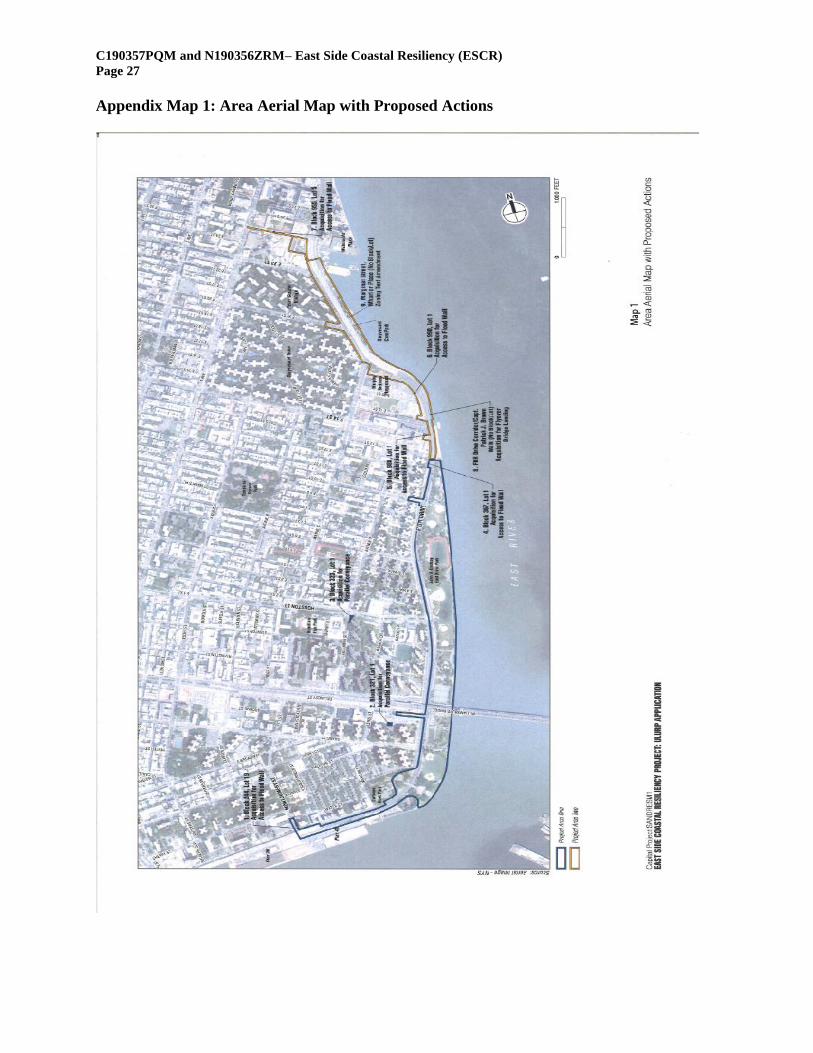
C190357PQM and N190356ZRM– East Side Coastal Resiliency (ESCR)
Page 27
Appendix Map 1: Area Aerial Map with Proposed Actions
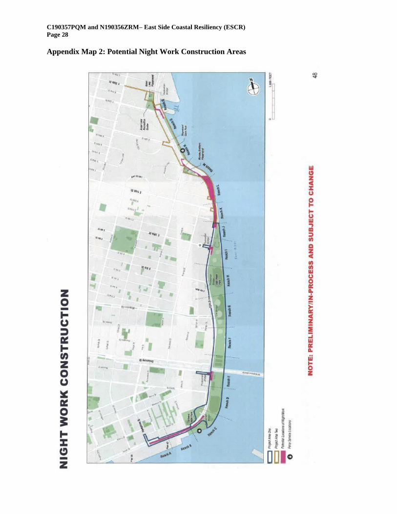
C190357PQM and N190356ZRM– East Side Coastal Resiliency (ESCR)
Page 28
Appendix Map 2: Potential Night Work Construction Areas
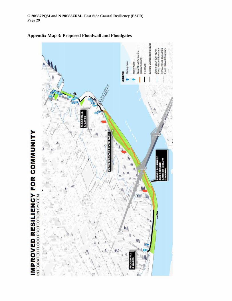
C190357PQM and N190356ZRM– East Side Coastal Resiliency (ESCR)
Page 29
Appendix Map 3: Proposed Floodwall and Floodgates
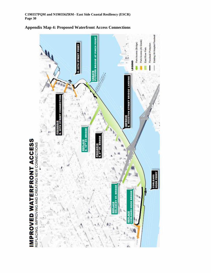
C190357PQM and N190356ZRM– East Side Coastal Resiliency (ESCR)
Page 30
Appendix Map 4: Proposed Waterfront Access Connections
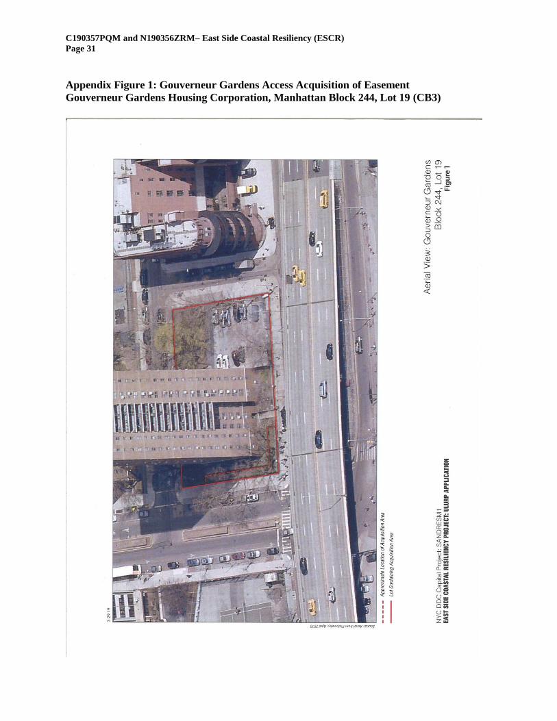
C190357PQM and N190356ZRM– East Side Coastal Resiliency (ESCR)
Page 31
Appendix Figure 1: Gouverneur Gardens Access Acquisition of Easement
Gouverneur Gardens Housing Corporation, Manhattan Block 244, Lot 19 (CB3)
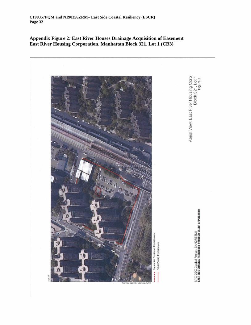
C190357PQM and N190356ZRM– East Side Coastal Resiliency (ESCR)
Page 32
Appendix Figure 2: East River Houses Drainage Acquisition of Easement
East River Housing Corporation, Manhattan Block 321, Lot 1 (CB3)
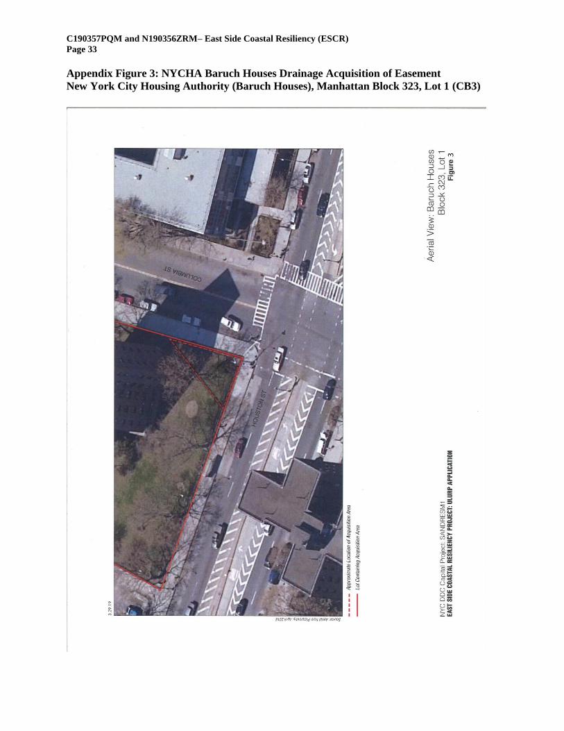
C190357PQM and N190356ZRM– East Side Coastal Resiliency (ESCR)
Page 33
Appendix Figure 3: NYCHA Baruch Houses Drainage Acquisition of Easement
New York City Housing Authority (Baruch Houses), Manhattan Block 323, Lot 1 (CB3)
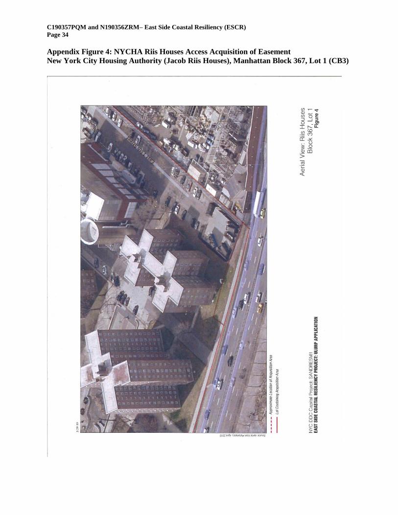
C190357PQM and N190356ZRM– East Side Coastal Resiliency (ESCR)
Page 34
Appendix Figure 4: NYCHA Riis Houses Access Acquisition of Easement
New York City Housing Authority (Jacob Riis Houses), Manhattan Block 367, Lot 1 (CB3)
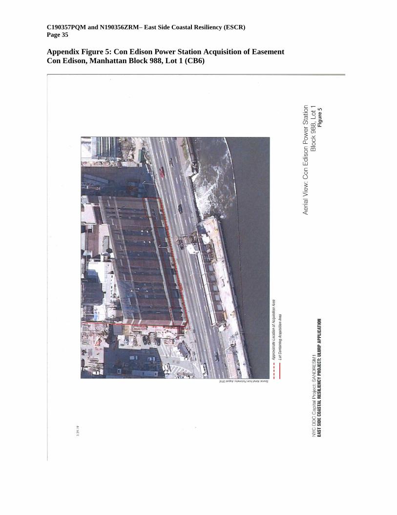
C190357PQM and N190356ZRM– East Side Coastal Resiliency (ESCR)
Page 35
Appendix Figure 5: Con Edison Power Station Acquisition of Easement
Con Edison, Manhattan Block 988, Lot 1 (CB6)
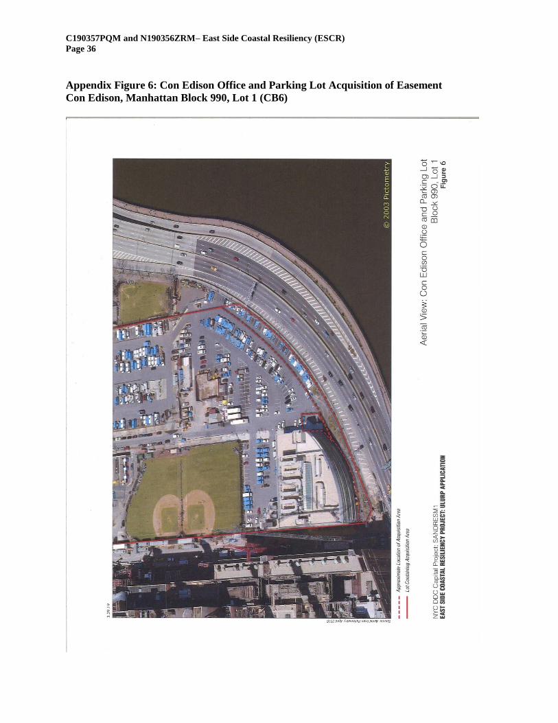
C190357PQM and N190356ZRM– East Side Coastal Resiliency (ESCR)
Page 36
Appendix Figure 6: Con Edison Office and Parking Lot Acquisition of Easement
Con Edison, Manhattan Block 990, Lot 1 (CB6)
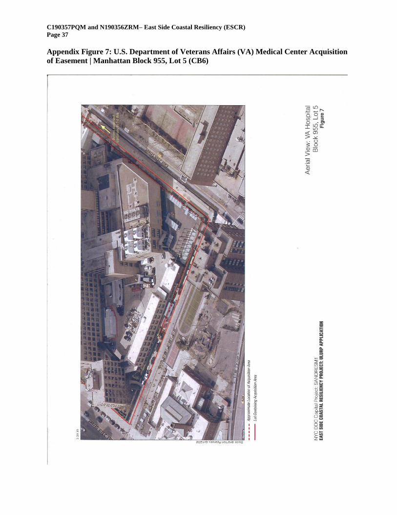
C190357PQM and N190356ZRM– East Side Coastal Resiliency (ESCR)
Page 37
Appendix Figure 7: U.S. Department of Veterans Affairs (VA) Medical Center Acquisition
of Easement | Manhattan Block 955, Lot 5 (CB6)
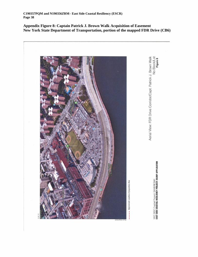
C190357PQM and N190356ZRM– East Side Coastal Resiliency (ESCR)
Page 38
Appendix Figure 8: Captain Patrick J. Brown Walk Acquisition of Easement
New York State Department of Transportation, portion of the mapped FDR Drive (CB6)
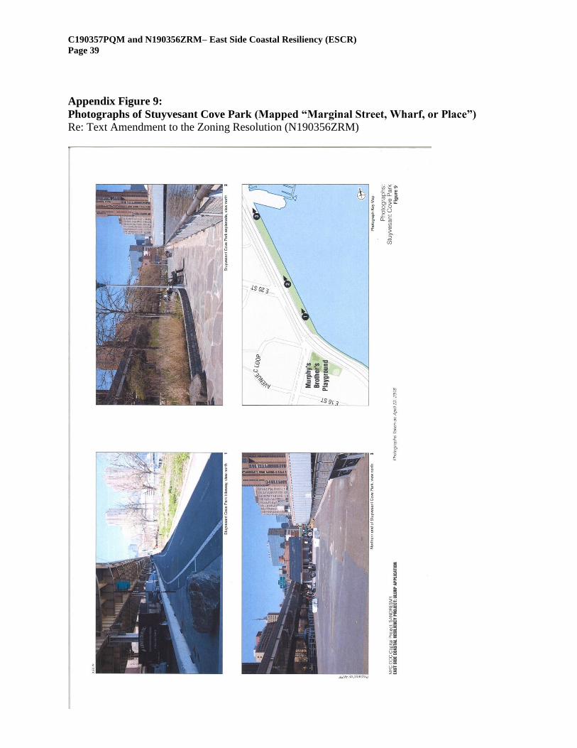
C190357PQM and N190356ZRM– East Side Coastal Resiliency (ESCR)
Page 39
Appendix Figure 9:
Photographs of Stuyvesant Cove Park (Mapped “Marginal Street, Wharf, or Place”)
Re: Text Amendment to the Zoning Resolution (N190356ZRM)


![MergedFile - Manhattan Community Board 8...C] Staten Island Direction of proposed newsstand from closest intersection: feet long Manhattan Dimensions: Borough: The newsstand will be](https://img.pdfslide.net/doc/110x75/600ec16211476d6a077eec4d/mergedfile-manhattan-community-board-8-c-staten-island-direction-of-proposed.jpg)