Embed Size (px)
Citation preview
medieval worlds • No. 1 • 2015 • 71-85
Archaeological data, combined with GIS analysis has given us new perspectives on eleventh century medieval period envoy missions from the Song Dynasty (960-1279 CE) to the Liao Empire (907-1125 CE). Lu Zhen and Wang Zhen were Song envoys sent in 1008 and 1012 by the Song to the Liao’s Middle Capital or Zhongjing, in present day Chifeng Inner Mongolia, the Peoples Republic of China (PRC). Lu Zhen recorded information about the route he tra-veled that allows us to locate it on administrative maps of the Song-Liao period and present day maps of the PRC. Viewshed analysis of the route combined with information Wang Zhen recorded about it lets us calculate population densities for an area that he passed through that can be used to extrapolate population density estimates from archaeological data for other areas in Chifeng. Viewshed analysis provides insights about the areal extent of the landscape and what man-made structures the envoys might have been able to see along the route during their travels. Combined, these analyses give us better insights into some of the concerns that the Liao had about these foreign missions crossing their territory and the steps they took to address them.
Keywords: Liao Empire, Song Dynasty, archaeology, GIS, China, landscape analysis, viewsheds, optimal routes.
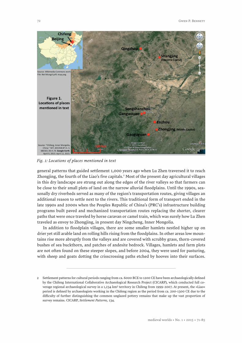
IntroductionChinese historical sources tell us that in 1008, Lu Zhen was sent as an envoy from the Song Dynasty capital at Bianjing (modern day Kaifeng) to the Liao Empire (907-1125), centered in what is now Chifeng, Inner Mongolia, China (Fig. 1).1 Lu Zhen not only kept a record of his route by naming the places he passed through, but he also recorded observations he made about the landscape and population en route to his destination. His route is described cle-arly enough that it can be plotted on present day maps of the region, traced out across the landscape, and could, if one wished, even be driven on newly laid asphalt roads.
As Lu Zhen’s route crosses from modern day Hebei Province into Inner Mongolia, the pre-sent day agricultural and pastoral landscape that it traverses is still settled according to the
»I Spy with my ›Little Eye‹«:GIS and Archaeological Perspectives on Eleventh-Century Song Envoy Routes in the Liao EmpireGwen P. Bennett*
* Correspondence details: Gwen P. Bennett, Assistant Professor, Departments of Anthropology and East Asian Studies, McGill University, 845 Sherbrooke Street West, Montreal, QC. H3A 2T7, Canada, email: [email protected].
1 Chifeng is classified as a city in the PRC’s administrative system, but at 34,855 mi2 or 90,275 km2, it is a vast area that is slightly larger than the US state of South Carolina at 32,020 mi2 or 82,931 km2 and slightly smaller than Portugal at 35,603 mi2 or 92,212 km2. The actual urban center of this »city« is in the Hongshan and eastern Songshan Districts, and is known as Chifeng as well. To a lesser extent, it is still also known by its Mongol name of Ulanhad. (Sources: http://en.wikipedia.org/wiki/Chifeng; http://en.wikipedia.org/wiki/South_Carolina; http://en.wikipe-dia.org/wiki/Portugal; accessed April 10, 2015.)
eISSN-Nr. [applied]DOI 10.1553/medievalworlds_no1_2015s72
72
general patterns that guided settlement 1,000 years ago when Lu Zhen traversed it to reach Zhongjing, the fourth of the Liao’s five capitals.2 Most of the present day agricultural villages in this dry landscape are strung out along the edges of the river valleys so that farmers can be close to their small plots of land on the narrow alluvial floodplains. Until the 1990s, sea-sonally dry riverbeds served as many of the region’s transportation routes, giving villages an additional reason to settle next to the rivers. This traditional form of transport ended in the late 1990s and 2000s when the Peoples Republic of China’s (PRC’s) infrastructure building programs built paved and mechanized transportation routes replacing the shorter, clearer paths that were once traveled by horse caravan or camel train, which was surely how Lu Zhen traveled as envoy to Zhongjing, in present day Ningcheng, Inner Mongolia.
In addition to floodplain villages, there are some smaller hamlets nestled higher up on drier yet still arable land on rolling hills rising from the floodplains. In other areas low moun-tains rise more abruptly from the valleys and are covered with scrubby grass, thorn-covered bushes of sea buckthorn, and patches of andesite bedrock. Villages, hamlets and farm plots are not often found on these steeper slopes, and before 2004, they were used for pasturing, with sheep and goats dotting the crisscrossing paths etched by hooves into their surfaces.
2 Settlement patterns for cultural periods ranging from ca. 6000 BCE to 1200 CE have been archaeologically defined by the Chifeng International Collaborative Archaeological Research Project (CICARP), which conducted full co-verage regional archaeological survey in a 1,234 km2 territory in Chifeng from 1999-2007. At present, the »Liao« period is defined by archaeologists working in the Chifeng region as the period from ca. 200-1300 CE due to the difficulty of further distinguishing the common unglazed pottery remains that make up the vast proportion of survey remains. CICARP, Settlement Patterns, 134.
Fig. 1: Locations of places mentioned in text
Gwen P. Bennett
medieval worlds • No. 1 • 2015 • 71-85
73
Now, the increased dust storms that Beijing and other northern cities experienced in the early 2000s has resulted in a ban on grazing in these marginal environments, bringing mo-mentous change to this millennia long custom. Villagers still keep sheep and goats, but herds are smaller now and pastured on the margins of the farm fields, no longer playing a major role in individual economic strategies.
Lu Zhen passed through territory that up until the 1990s must have looked much like what it did then. While towns have grown larger and paved roads are now more plentiful, tracing out his route over this landscape can still tell us much about the Liao Empire and its concerns as it interacted with an envoy from a potentially threatening neighbor who was also charged with gathering useful information on his travels. We can attempt to identify some of these concerns by looking at how the Liao guided this envoy and his retinue through their territory.
Traversing a landscape requires many choices to be made, some of which depend on mode of transportation, but others of which depend on different constraints. Railroad engineers, for instance, always seek out the most level terrain possible for laying rails, and will cut steep beds into or tunnel through mountains to avoid the climbs and dips in elevation that pose challenges to mechanical competence and fuel consumption. Premodern human transporta-tion, done by foot or animal, certainly would have also taken changes in elevation into consi-deration due to the technical difficulties of scaling some of these obstacles, or perhaps for the same reasons railroads do – to save energy. Analytical tools within Geographic Information Systems (GIS) software can be used to determine optimal routes in a topographic landscape that can then be compared to known routes across them so that the convergences and diver-gences in route can be identified and reasons can be found that might explain them. When these analyses can be correlated with known archaeological data from the region, additional nuances can be added to the interpretation of both the route choice and the archaeological landscape. Combining these analyses when Lu Zhen’s route is examined can end up telling us a considerable amount about both the Liao’s strategic considerations as they led the Song envoy across their territory, and also more generally about how residents of the Liao Empire lived and carried out their activities in this landscape.
The Kitans and the Liao EmpireThe Kitans (ca. fourth to thirteenth century+) lived north of the line of the Great Wall of China, and in the records kept in Chinese by the literate elite of their southern neighbors in the Yellow River region, were considered to be pastoral nomads. Recent archaeological in-vestigations have shown how this is an overbroad characterization and that the inhabitants of some Kitan-controlled areas practiced sedentary agriculture3 and could switch between this and pastoralism in certain circumstances.4 Sometime before 907, the Kitan leadership began to transform their fluidly organized, aristocratically based society into an imperial po-wer with bureaucratic administration. In 907, their leader Abaoji established the Liao Empire (907-1125), and through military and diplomatic action the Kitans achieved equal status with the Five Dynasties (907-960) and Song (960-1276) rulers of north China. The Liao has often been regarded as the first of several »alien« empires that incorporated increasingly large portions of territory claimed by Chinese states in China’s Middle Period, which culminated in the Mongol submergence of China into their empire and Mongol control of two-thirds of the Asian continent.
3 CICARP, Settlement Patterns; Wittfogel and Feng, History of Chinese Society, 121.
4 Toghto, History of Liao, 59: 923-924; Han, Grassland and Rurality.
Kitan-Liao Archaeological Survey and History
medieval worlds • No. 1 • 2015 • 71-85
74
The historical records surviving for the Kitan-Liao period – focusing on institutional structures, military and political events, and ruling elites – were compiled by officials of the southern, Chinese-style, dynasties who had complex political and sometimes cultural agendas regarding the northerners. Little to no mention is made in the records of individuals other than members of the Liao elite, or what the nature of life was like for commoners. Whi-le specifics are not spelled out, we do know that Kitan society developed into an empire in circumstances quite different from the better studied Xiongnu and Mongols. Unfortunately however, our current understandings of these processes do not take into account the effects of different ecozones and geographical locations, long-term intensive interaction with Yel-low River societies and other Inner Asian polities, and what existing states were available as models. Moreover, the Chinese language texts (as for the formative periods of most Inner Asian-based empires) are frustratingly lacking in detail about how these states came into existence, how they were structured, or about aspects of life within them that did not have implications for the Chinese record keepers. These difficulties highlight the suitability of in-tegrating archaeological, documentary, paleoecological and other evidence together in order to better understand the Liao period.
The Kitan homeland was within the current boundaries of Chifeng, Inner Mongolia, a vast region that in the first millennium was a borderland – a region between the undifferentiated Mongol, Tungusic, and Jurchen groups to the north, the Yellow River dynasties to the south, the Korean kingdoms to the east and the Turkic kingdoms to the west. Once the Liao dynas-ty was established, the Chifeng region became an important place for the Liao emperors to relocate populations captured from the Central Plains dynasties and the Bohai (Kr: Balhae) kingdom as farmers and artisans.5 When these groups joined the agricultural population that was already present, they made this region a crucial source of the tax revenue required to fund the institutions and personnel needed to run a developing state-level organization. But more than just being a place where populations with different cultural backgrounds mixed, Chifeng was also an ecological zone that required its diverse populations to practice varying economic activities based on where they lived in the region – and ones that might have differed from those they practiced in the places from whence they came. Chifeng has many ecozones, some of which were suitable for intensive or extensive agriculture, and others that were better for pastoral nomadism, or hunting, gathering and fishing. Depending on circum-stances, inhabitants might have plied any of these economic practices at different times in their lives. It was still possible in the mid-1990s to see families in the Chifeng region where, until land reforms were promulgated by Beijing in 2003, one member pursued each of these activities.6
The Kitan Liao Archaeological Survey and History Project Because Kitan heritage, manifested by standing monuments and abundant material culture remains, stretches across a vast region of present day northern China and Mongolia, and their political and economic influence lasted for centuries, better understandings of develop-ments emerging in the Chifeng region are vital to the study of not just China, but to all of northeast Asia, and for much of the pre-modern period. The Kitan Liao Archaeological
5 Toghto, History of Liao, 39.
6 Bennett, pers. observation.
Gwen P. Bennett
medieval worlds • No. 1 • 2015 • 71-85
75
Survey and History Project (KLASH),7 was established in 2012 to investigate the period from ca. 200 through 1400 when the Kitans emerged from the unnamed groups in the northern borderlands, first to become a confederacy and then an empire, and finally to be conquered and absorbed into the succeeding Jurchen Jin Empire (1115-1234).
KLASH is integrating methods from archaeology, history, and geophysics to investigate three Liao period walled city sites, along with their hinterlands in the Chifeng region. Song shanzhou, the first site we will examine, was a prefectural level town with walls measuring 510 × 510 m, whose one mention in the Liao History is a seven character description of it as »bordering on the Songmo region, a gathering place and crossroads for merchants«.8 This short description is enough to hint at its relationship with the large kiln complex 10 km away known as Gangwayao, which will also be included in the KLASH investigations so we can determine their relationship to each other. Enzhou was also a prefectural level town with walls measuring 285 × 285 m, but it may have started as a garrison town on the line of the Han period Great Wall running near it.9 The Liao History reports that it was one place where craftspeople and farmers from the neighboring kingdom of Bohai (Balhae) were relocated after the Liao conquered them in 926. Pottery roof tiles and fragments made in the Balhae style found at Enzhou hint at this heritage. The last of the three walled cities we will work at is Zhongjing, the Middle Capital, established in 1007, with exterior walls measuring 4 × 4,2 km.10 Zhongjing was composed of three nested sets of walls marking out the outer city pre-cinct, the inner city precinct and the palace precinct. All three sets of walls still stand, along with some gates, building foundations, and three pagodas, two of which were Liao and one of which may be very late Liao or Jin Dynasty (1115-1234).
KLASH’s methods are designed to give us data at many different scales of resolution, from those that are minute enough to give us insight into individual lives to those vast enough to inform about state formation processes. We are combining a number of nondestructive investigative methods, including systematic full coverage archaeological survey, geophysical prospecting, and a reexamination of the historical documents to gather evidence. Full cover-age survey will be done intensively on the sites and extensively around them in regions mea-suring approximately 200 km2. Fragments of fired clay – roof tiles, bricks, glazed porcelains, and the huge quantities of unglazed hard fired pottery are our primary source of evidence and are found in abundance both underneath and lying on the surfaces of farm fields that cover most of the sites’ surfaces.
Intensive archeological survey, involves crew members walking transects spaced at 20 meters apart and stopping every 20 meters to collect all the pottery fragments within a 2 meter diameter circle. Using this method on the city sites will give us finer control over our identifications of where things are located at the sites. We can also determine the differing
7 I am Principal Investigator of this project, and my co-PIs are Professor Naomi Standen, School of History and Cultures, University of Birmingham, UK, and Dr. Joshua Wright, Dept. of Anthropology, Oberlin College, USA.
8 Toghto, History of Liao, 39:458.
9 Toghto, History of Liao, 39:482.
10 The Liao established five capitals, which were all kept in use after their beginnings, and several of which continued in use after the fall of Liao in 1125. The first capital, Shangjing or the Supreme Capital, was built in 918 in Balinzuoqi, or Balin Left Banner, Chifeng. The second, Dongjing, the eastern capital, was built in 928 from a former Balhae walled city at modern day Liaoyang, Liaoning. The third capital, Nanjing, the southern capital, was established in 938 at what is now modern Beijing. The fourth capital, Zhongjing, the central capital, was built in 1007, in present day Ningcheng County, Chifeng. The fifth capital, Xijing, the western capital, was built in 1044 at present day Datong, Shanxi.
Kitan-Liao Archaeological Survey and History
medieval worlds • No. 1 • 2015 • 71-85
76
intensities of use at these locations by using the samples we have collected as proxy indi-cators of density, which in turn reflect upon intensity. The types of fired clay artifacts we find (roof tiles, bricks, fine porcelains and glazed and unglazed pottery), along with remnants of the pounded earth construction that was used to build walls and building foundations at each site, will help us to identify what types of structures stood where within the cities, and the activities that took place at them and around them and in open areas. For instance, concentrations of roof tiles and bricks point toward the presence of buildings of a particular nature, since it is clear from the artifact patterns we have already noted in initial walkovers at the sites that not all structures could have been roofed with them. Our initial impressions from these walkovers also noted that finer ceramics are associated with areas of roof tiles, which suggests that more elite members of society may have used these structures. Other areas at some of the sites have slag and kiln furniture that suggests ceramic or metal pro-duction activities took place in them. However, a common problem we will have at each of the city sites is that the fired clay artifacts found on their surfaces are so abundant that they create a logistical problem for collection, even though we are not collecting everything on the surface but just sampling them. We are solving this issue by buying a donkey to carry all the collection bags.
In addition to intensive survey on the city sites, their hinterlands will be investigated using full coverage extensive survey. Areas measuring approximately 200 km2 surrounding each of the city sites and bounded by features in the natural topography will be surveyed by crew members walking transects spaced approximately 40 m apart. If artifacts are encoun-tered on the ground surface, they are collected and bagged; with new collection units started every 50 m.11 Survey of the areas around the city sites will identify the smaller settlements located in their immediate vicinity, which will let us place the cities in a much more complete context that will contribute to understanding both the cities themselves, the smaller settle-ments, and how all of them were embedded within the larger context of the Liao Empire.
Geophysical investigations will be done on the city sites using a magnetometer, an in-strument that can measure disturbances in the earth’s magnetic fields that are caused by the presence of subsurface archaeological remains. Readings from the magnetometer can be used to create maps of these disturbances, whose layouts and shapes can indicate the presence of man-made structures or alterations to the landscape below the ground surface. Magnetometers react to burned soil, brick, rock, disturbed soil and decayed organic materi-als; which make them effective instruments to use on archaeological sites to identify buried features. We will also do systematic auger coring across the surfaces of each of the city sites. Sites are composed of stratigraphic layers of natural and anthropogenic deposits, and coring to appropriate depths gives us stratified soil samples from these different subsurface levels that we will use to create a three dimensional map of what is beneath the ground surface at each of the sites.
Our intensive archaeological survey at each city site will complement the findings from geophysical investigations and auger coring. Differently scaled architecture, its layouts and distribution within the city, and open spaces can all be identified using geophysical methods.
11 Extensive survey methodology follows that established by CICARP (2011), the first of the large scale regional sur-veys done in southeastern Inner Mongolia and western Liaoning, but with an adaptation initiated by Dr. Gideon Shelach (pers. comm. January 28, 2013) in his later Liaoning survey of making collection units smaller in size at 50 m, rather than CICARP’s 100 m collection units. This allows finer control over identifying spatial distribution of artifacts.
Gwen P. Bennett
medieval worlds • No. 1 • 2015 • 71-85
77
The archaeological materials gathered during surface survey and subsurface auger coring will be integrated with the geophysical information to identify potential uses and users of these areas of the sites. Combining the findings from these three methods should help us identify the subsurface remains of potential walls, roads, residential quarters for different social groups, markets, open plaza areas, craft workshops and cemeteries. Since Songshanz-hou and Enzhou have earlier artifacts on their surfaces in addition to Liao and later artifacts, and Zhongjing has earlier and later artifacts in certain areas within its 4 × 4,2 km walls, our finding will also let us look at how these cities developed through time, and how at particular time periods they may have had similar or different layouts and components. We will then be able to compare our fine-grained field results with the rather limited textual record.
GIS and archaeological perspectives on Song envoy routes to ZhongjingCities and towns can also be considered as nodes where intense activity took place within landscapes that are themselves the loci for other, no less important but often more diffusely evidenced activities such as agricultural fields, livestock corrals, or small hunting camps. Communication and transportation networks linked these nodes together within a region, as well as to smaller settlements and subsistence and raw material resources in their vici-nities and even farther. Examining the nature of the linkage between different centers by identifying probable transportation routes helps us to understand their relationships with each other, and their relative importance within the greater region. Each of the three walled cities that KLASH is investigating sat on the major transportation route between the Liao Supreme Capital, the first of the Liao’s five capital cities, located in northern Chifeng and the fourth capital, Zhongjing 270 km to the south in southern Chifeng. Lu Zhen’s envoy route, which ended at Zhongjing, tells us about the strategic decisions that Liao made about what to let him see as he crossed their territory. If we extrapolate from the information we have gathered about the territory Lu Zhen passed through and apply these observations to the landscape that our other two city sites are located on, we can then start to identify some of the choices made by settlers when they selected sites for the villages, towns and cities, and can also start to make initial estimates for the population that lived there.
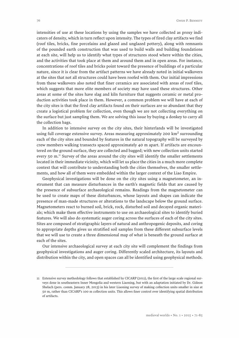
In preparation for KLASH’s summer 2014 field season, we prepared the initial map layers of our project GIS database by georeferencing maps of Liao administrative geography.12 We then plotted on these maps the locations that Lu Zhen noted he had passed through on his way to the Liao Middle Capital at Zhongjing as a case study for our integration of archaeolo-gical and historical methods. We then overlaid these maps onto regional topographic maps that were another data layer in our GIS to calculate the most efficient routes (based on the least expenditure of energy) across the landscape between the points Lu Zhen noted in his envoy report. We then compared this optimal route to the route Lu Zhen recorded (Fig. 2). In most instances, the optimal and probable routes both follow river valleys when they are pre-sent or otherwise seek out areas of lower elevation when they are not. But there are several instances where the two routes diverge and it is in these divergences that we can potentially see some of the considerations that Lu Zhen’s Kitan guides were making as they led him through this territory.
12 Tan, Historical Atlas of China, 3-6, 10-11.
Kitan-Liao Archaeological Survey and History
medieval worlds • No. 1 • 2015 • 71-85
78
By 1008, the Liao and the Song were already three years into the Treaty of Shanyuan, signed in 1005. This treaty ended several decades of warfare between the two polities, which had not achieved much to alter the balance of power between them. Because of this, they si-gned a treaty that succeeded in giving them a century of peace. Envoy visits between the two polities were a time-tested means of maintaining communications, and had a long history within the varied political frameworks that governed polities during this age and earlier. The Treaty of Shanyuan appears to have formalized an arrangement of visits between the two sta-tes, with three annual northbound visits, plus occasional ad hoc embassies, with responses and missions of thanks heading south.
Lu Zhen’s envoy mission to Liao was carried out in this context, and although peaceful relations were maintained between Song and Liao, his route through Liao territory exhibits some unexpected elements. One of the first of these is that Lu Zhen was guided on a route that did not pass through any urban centers, but rather followed a series of guan stations, which were official rest stops used by envoy missions, messengers, and internal imperial officials. The lack of urban centers along the route seems to imply that the guans along it, and perhaps the route itself might have been established for this thrice-yearly exchange of envoys. This apparently dedicated function would have meant that they would not have had the full array of common economic or political activities taking place at them that would have been occurring at other centers in the region, which would have denied the envoys any opportunity to observe and evaluate Liao economic strength.
Second, Lu Zhen’s route does not always follow the optimal one across the landscape. The guan stations he stopped at were arranged along a convoluted path that more than doubled the length of the optimal route to Zhongjing. Moreover, the position of the guans in the region’s narrow valleys would have emphasized the occasional danger any party traveling along these paths would have had from flash floods during the summer monsoon months.
Fig. 2: Liao period envoy routes: optimal and probable routes
Gwen P. Bennett
medieval worlds • No. 1 • 2015 • 71-85
79
The histories indicate that embassies were known opportunities to collect information that might be of military, political or economic use against neighboring states, especially ones that had been enemies in the past and might well be enemies again in the future. With these considerations, Liao might well have thought it prudent to limit envoy access to local popu-lations and the places they frequented, which may explain the isolated nature of the guan locations.
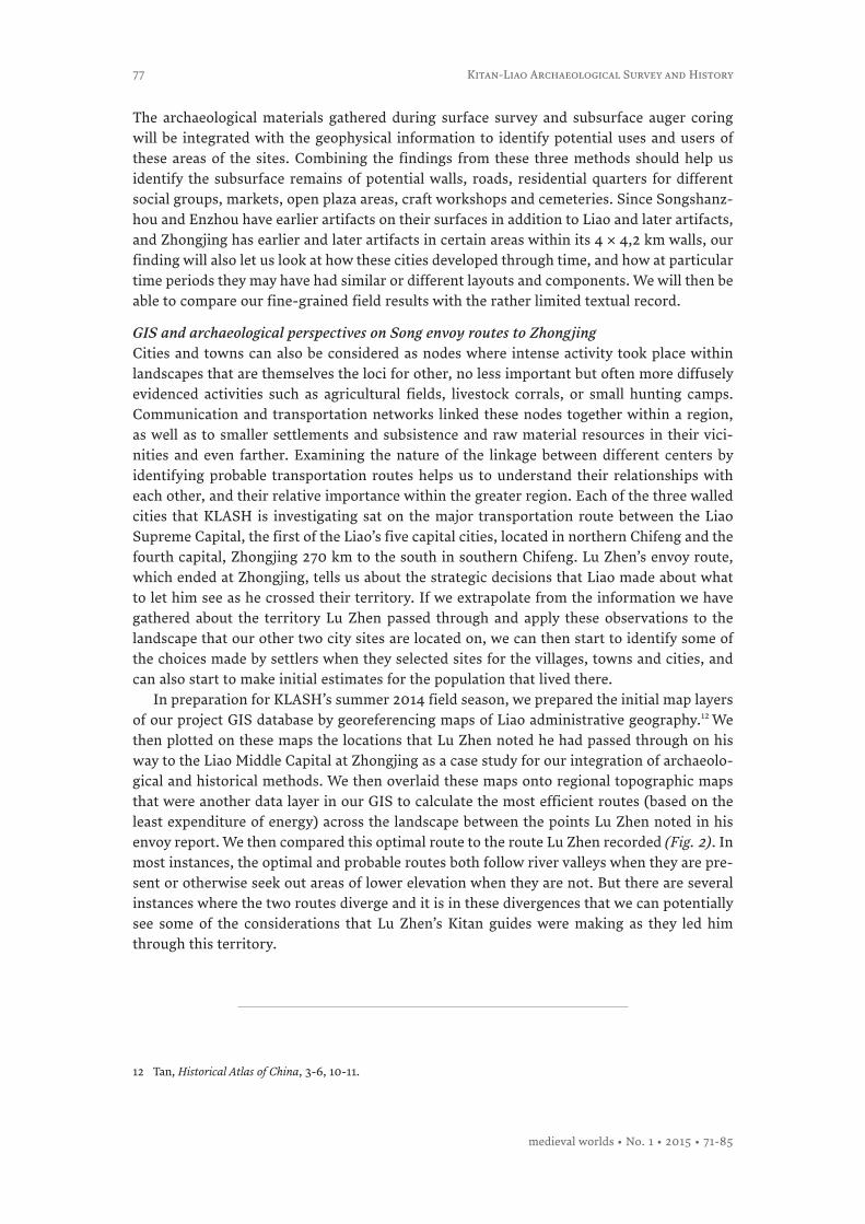
Wang Zeng was another Song envoy sent to Zhongjing in 1012 (Fig. 2 and 3). On his passing between the Liaoheguan and Dazaoguan guan stations, situated in a region with low mountains and occupied by Bohai (Balhae) groups, he noted that he only saw one hundred households in that stretch of the route. GIS software contains analytical tools that can cal-culate viewsheds – the areal extent of territory that can be seen from a particular vantage point. Viewsheds are concerned with the visibility of features, both natural and manmade, and are ways to provide a measurement of how much of the landscape that Wang Zhen might have seen on the stretch of route for which he made his observation. Viewshed analysis indi-cates that along the route he most probably took, he was able to see a total of approximately 68 km2 of the surrounding landscape. According to Wang Zhen, this 68 km2 contained 100 households, which gives us a population density of 1,5 households per km2 along this route. This low population density figure may be evidence of the effectiveness that Liao imperial institutions had in controlling what foreign envoys were able to observe on their journeys, as well as the degree of effort that the Liao exerted to avoid potential future war with Song. Combining the historical data with GIS analysis provides us with an informative observation on population density along one stage of the envoy route, from which we can then infer Liao concerns; but it also provides us with a figure against which to compare population densities calculated using archaeological data for other areas in Chifeng that were not on the envoy route. Because we have no reportage for these areas, the density of pottery finds within
Fig. 3: Liao period envoy routes: viewsheds, Wang Zhen’s route, and population estimates
Kitan-Liao Archaeological Survey and History
medieval worlds • No. 1 • 2015 • 71-85
80
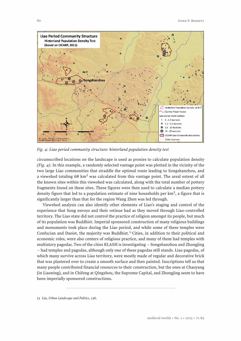
circumscribed locations on the landscape is used as proxies to calculate population density (Fig. 4). In this example, a randomly selected vantage point was plotted in the vicinity of the two large Liao communities that straddle the optimal route leading to Songshanzhou, and a viewshed totaling 68 km2 was calculated from this vantage point. The areal extent of all the known sites within this viewshed was calculated, along with the total number of pottery fragments found on these sites. These figures were then used to calculate a median pottery density figure that led to a population estimate of nine households per km2, a figure that is significantly larger than that for the region Wang Zhen was led through.
Viewshed analysis can also identify other elements of Liao’s staging and control of the experience that Song envoys and their retinue had as they moved through Liao-controlled territory. The Liao state did not control the practice of religion amongst its people, but much of its population was Buddhist. Imperial sponsored construction of many religious buildings and monuments took place during the Liao period, and while some of these temples were Confucian and Daoist, the majority was Buddhist.13 Cities, in addition to their political and economic roles, were also centers of religious practice, and many of them had temples with multistory pagodas. Two of the cities KLASH is investigating – Songshanzhou and Zhongjing – had temples and pagodas, although only one of these pagodas still stands. Liao pagodas, of which many survive across Liao territory, were mostly made of regular and decorative brick that was plastered over to create a smooth surface and then painted. Inscriptions tell us that many people contributed financial resources to their construction, but the ones at Chaoyang (in Liaoning), and in Chifeng at Qingzhou, the Supreme Capital, and Zhongjing seem to have been imperially sponsored constructions.
13 Lin, Urban Landscape and Politics, 136.
Fig. 4: Liao period community structure: hinterland population density test
Gwen P. Bennett
medieval worlds • No. 1 • 2015 • 71-85
81
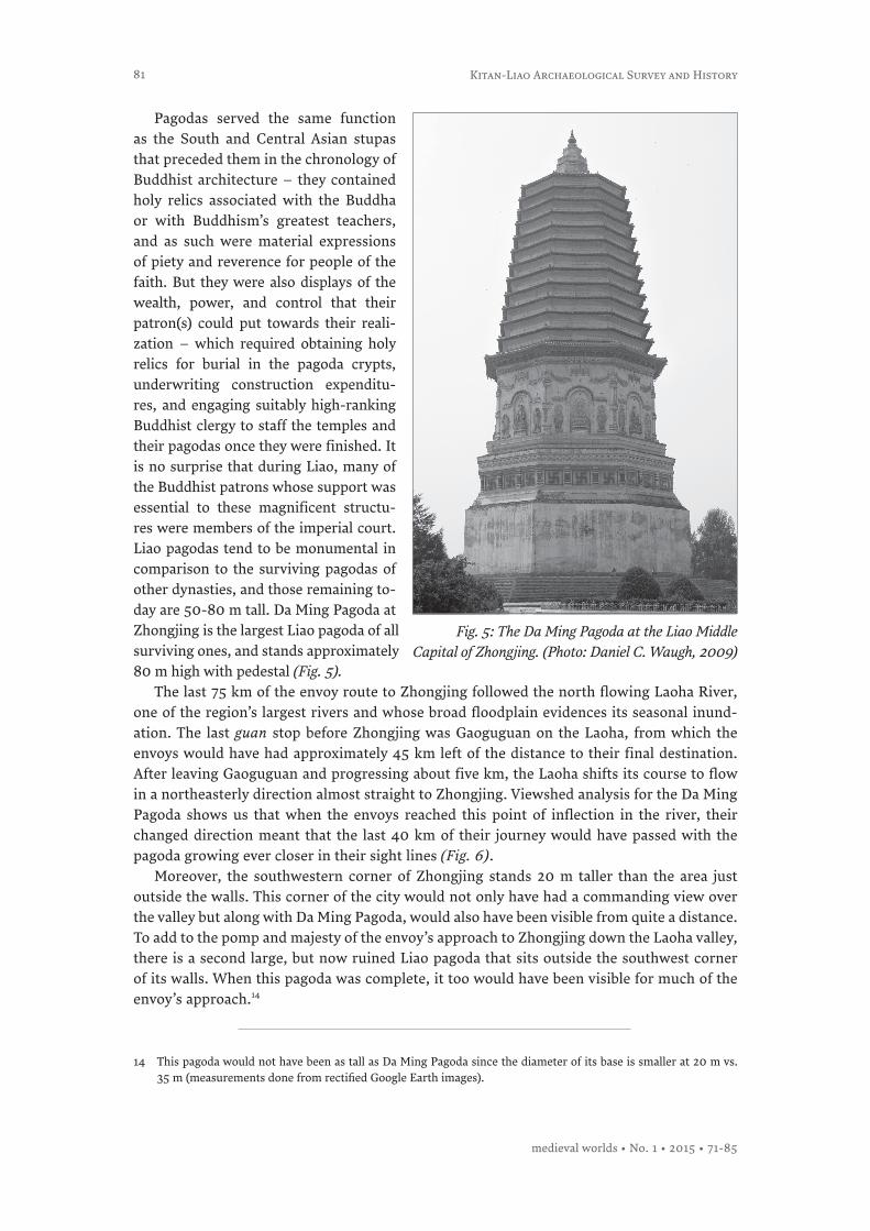
Pagodas served the same function as the South and Central Asian stupas that preceded them in the chronology of Buddhist architecture – they contained holy relics associated with the Buddha or with Buddhism’s greatest teachers, and as such were material expressions of piety and reverence for people of the faith. But they were also displays of the wealth, power, and control that their patron(s) could put towards their reali-zation – which required obtaining holy relics for burial in the pagoda crypts, underwriting construction expenditu-res, and engaging suitably high-ranking Buddhist clergy to staff the temples and their pagodas once they were finished. It is no surprise that during Liao, many of the Buddhist patrons whose support was essential to these magnificent structu-res were members of the imperial court. Liao pagodas tend to be monumental in comparison to the surviving pagodas of other dynasties, and those remaining to-day are 50-80 m tall. Da Ming Pagoda at Zhongjing is the largest Liao pagoda of all surviving ones, and stands approximately 80 m high with pedestal (Fig. 5).
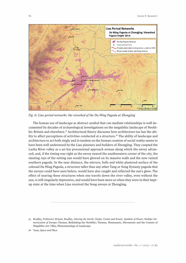
The last 75 km of the envoy route to Zhongjing followed the north flowing Laoha River, one of the region’s largest rivers and whose broad floodplain evidences its seasonal inund-ation. The last guan stop before Zhongjing was Gaoguguan on the Laoha, from which the envoys would have had approximately 45 km left of the distance to their final destination. After leaving Gaoguguan and progressing about five km, the Laoha shifts its course to flow in a northeasterly direction almost straight to Zhongjing. Viewshed analysis for the Da Ming Pagoda shows us that when the envoys reached this point of inflection in the river, their changed direction meant that the last 40 km of their journey would have passed with the pagoda growing ever closer in their sight lines (Fig. 6).
Moreover, the southwestern corner of Zhongjing stands 20 m taller than the area just outside the walls. This corner of the city would not only have had a commanding view over the valley but along with Da Ming Pagoda, would also have been visible from quite a distance. To add to the pomp and majesty of the envoy’s approach to Zhongjing down the Laoha valley, there is a second large, but now ruined Liao pagoda that sits outside the southwest corner of its walls. When this pagoda was complete, it too would have been visible for much of the envoy’s approach.14
Fig. 5: The Da Ming Pagoda at the Liao Middle Capital of Zhongjing. (Photo: Daniel C. Waugh, 2009)
14 This pagoda would not have been as tall as Da Ming Pagoda since the diameter of its base is smaller at 20 m vs. 35 m (measurements done from rectified Google Earth images).
Kitan-Liao Archaeological Survey and History
medieval worlds • No. 1 • 2015 • 71-85
82
The human use of landscape as abstract symbol that can mediate relationships is well do-cumented by decades of archaeological investigations on the megalithic landscape of Neolit-hic Britain and elsewhere.15 Architectural theory discusses how architecture too has the abi-lity to affect perceptions of activities conducted at a structure.16 The ability of landscape and architecture to act both singly and in tandem on the human creation of social reality seems to have been well understood by the Liao planners and builders of Zhongjing. They coopted the Laoha River valley as a 40 km processional approach avenue along which the envoy advan-ced; and, if the timing was right as the envoy neared the southwestern corner of the city, the slanting rays of the setting sun would have glowed on its massive walls and the now ruined southern pagoda. In the near distance, the mirrors, bells and white plastered surface of the colossal Da Ming Pagoda, a structure taller than any other Tang or Song Dynasty pagoda that the envoys could have seen before, would have also caught and reflected the sun’s glow. The effect of nearing these structures when one travels down the river valley, even without the sun, is still singularly impressive, and would have been more so when they were in their kept-up state at the time when Liao received the Song envoys at Zhongjing.
15 Bradley, Prehistoric Britain; Bradley, Altering the Earth; Clarke, Cowie and Foxon. Symbols of Power; Hodder Do-mestication of Europe; Thomas, Rethinking the Neolithic; Thomas, Monuments, Movements and the Context of Megalithic Art; Tilley, Phenomenology of Landscape.
16 Tuan, Space and Place.
Fig. 6: Liao period networks: the viewshed of the Da Ming Pagoda at Zhongjing
Gwen P. Bennett
medieval worlds • No. 1 • 2015 • 71-85
83
ConclusionHistorians, archaeologists, art historians and philologists of the Chinese Middle Period are often seeking better understandings of the Kitans and the Liao Empire that they created, and many valuable new contributions to knowledge have been made in recent years. Liao influ-ence on the cultural, religious, political and economic life of Inner and East Asia during the middle period reached far beyond the Liao homeland in Chifeng and shaped events for many centuries after their fall in 1125. KLASH’s integrated approach to the study of the middle period in the Chifeng region of Inner Mongolia is providing innovative new understandings that could only have been reached by combining archaeological and historical methods. Ap-plying GIS and archaeological perspectives to the study of the eleventh century Song envoy routes to Zhongjing have revealed the intentionality of the Liao’s staging of the envoys’ expe-rience as they traversed Liao territory.
Since part of the envoys’ role was to gather useful information of all sorts as they procee-ded along their route – from the locations of settled areas and their populations to the types of crops grown and animals raised in different regions – the Liao appeared to have made sure to keep the envoys in as great a state of visual deprivation as they could by leading them along under-populated and convoluted routes through difficult landscapes. That is, until the last stage of the route when the envoys were approaching Zhongjing. At this point everything about the route changed – former visual impressions of the dry, unpeopled scrub-covered floodplains and hillsides would have given way to scenes set in the broad, fertile valley of the Laoha River that ran straight for 40 km to the walls of Zhongjing.
At 80 m tall, the Da Ming Pagoda, covered with its reflective bronze mirrors and tinkling bells, was visible from a distance of more than 40 km away from the capital and it would have loomed over the envoys’ approach. Its mass, elevation, reflectivity and other architec-tural properties as the tallest pagoda in either Song or in Liao would have made it a presence that registered on the envoys and their retinues as it grew ever larger in their eyes as they approached. This pagoda, along with the massive walls that encircled the city, would have helped to frame the envoys’ perception of their reception by the Liao at the capital. Chinese city planners have long been known for using the built environment to enforce perceptions on the part of the people who used cities, and it is not unreasonable to assume that neigh-bors would have borrowed ideas from them, although perhaps not their associated symbolic meanings.17 At Zhongjing we can see the Liao coopting the landscape surrounding the city to use the Laoha River Valley as a processional approach to the massive walls of their city, and using the Da Ming Pagoda to dominate the landscape around it, leading all to the capital that lay at its feet.
Although the Treaty of Shanyuan was ostensibly between equals, the terms of the sett-lement and the flow of gifts from Song to Liao indicates otherwise. This unequal relations-hip was also reflected in the dominance that Liao wished to project over the Song envoys perceptions of their journey to Zhongjing. The pagoda’s dominance over the landscape and the envoys’ inability to escape this image during the last 40 km of their journey would have served Liao by reinforcing these impressions.
17 Wheatley, Pivot of the Four Quarters.
Kitan-Liao Archaeological Survey and History
medieval worlds • No. 1 • 2015 • 71-85

84
Acknowledgements:I would like to thank Dr. Joshua Wright, my KLASH Project co-PI, who made the four GIS- based maps used in this article, and Professor Naomi Standen, my other KLASH Project co-PI, for reading several drafts and providing comments on them that have immensely improved the article. I would also like to thank Dr. Michael Wiant, Director of the Dickson Mounds Museum of the Illinois State Museum system, who as a non-China specialist read the final draft to make sure I had succeeded in writing for readers outside of my own narrow area of specialty. Lastly, this work was supported by the Social Science Research Council of Canada under Grant 435-2012-0993, awarded to myself at McGill University.
Gwen P. Bennett
medieval worlds • No. 1 • 2015 • 71-85
85
Bradley, Richard, The Social Foundations of Prehistoric Britain (London, 1984).Bradley, Richard, Altering the Earth: the Origins of Monuments in Britain and Continental
Europe (Edinburgh, 1993).CICARP (Chifeng International Collaborative Archaeological Research Project), Settlement
Patterns in the Chifeng Region (Pittsburg, 2011).Clark, David Victor, Cowie, Trevor G., Foxon, Andrew, Symbols of Power at the Time of Stone-
henge (Edinburgh, 1985).Han, Maoli 韩茂莉, 草原与田园, 辽金时期西辽河流域农牧业与环境 (Grassland and Rurality: the
Recurrence of Agriculture and Livestock Raising and its Environment in the Area of the Liao River during Liao and Jin Dynasties), (Beijing, 2006).
Hodder, Ian, The Domestication of Europe (Oxford, 1990).Lin, Hu, Urban Landscape and Politics: the Making of Liao Cities in Southeast Inner Mongolia,
Unpublished PhD thesis (University of Chicago, 2009).Tan, Qixiang 谭其骧 et al. (eds.), 中国历史地图集5卷,隋唐五代十国时期 (The Historical
Atlas of China, Vol. 5, Sui, Tang, Five Dynasties and Ten Kingdoms Periods), (Shanghai, 1982).Tan, Qixiang 谭其骧 et al. (eds.), 中国历史地图集6卷, 宋辽金时期 (The Historical Atlas of Chi-
na, Vol. 6, Song, Liao, Jin Periods), (Shanghai, 1982)Thomas, Julian, Rethinking the Neolithic (Cambridge, 1991).Thomas, Julian, Monuments, Movement, and the Context of Megalithic Art, in: Niall Sharples
and Alison Sheridan (eds.), Vessels for the Ancestors: Essays on the Neolithic of Britain and Ireland in Honour of Audrey Henshall (Edinburgh, 1992).
Tilley, Christopher, A Phenomenology of Landscape: Places, Paths, and Monuments (Oxford, 1994).
Toghto 脱脱, Ouyang Xuan 歐陽玄 (comps.), 遼史 (History of Liao, 5 vols.), (Beijing, 1974).Tuan, Yifu, Space and Place: the Perspective of Experience (Minneapolis, 1977).Wheatley, Paul, Pivot of the Four Quarters: a Preliminary Examination into the Origins and
Character of the Ancient Chinese City (Chicago, 1971).Wittfogel, Karl and Feng, Jiasheng, History of Chinese Society: Liao (907-1125), American
Philosophical Society 36 (Philadelphia, 1949).
References
Kitan-Liao Archaeological Survey and History
medieval worlds • No. 1 • 2015 • 71-85